conservation area profiles - newcastle city council · environment and regeneration directorate ....
TRANSCRIPT

Contacts: Head of Development Management Tel 0191 211 5629 Team Manager Urban Design and Conservation Tel 0191 277 7190 Write to: Development Management Environment and Regeneration Directorate Civic Centre Barras Bridge Newcastle upon Tyne NE1 8PH Email: [email protected] Website: www.newcastle.gov.uk January 2011 If you need this information in another format or language, please phone the conservation team on 0191 277 7191 or email [email protected]
Conservation Area Profiles 1
Contents 02 Introduction Conservation areas in general Planning guidance Trees Article 4 Directions
Archaeology Listed Buildings Conservation Team
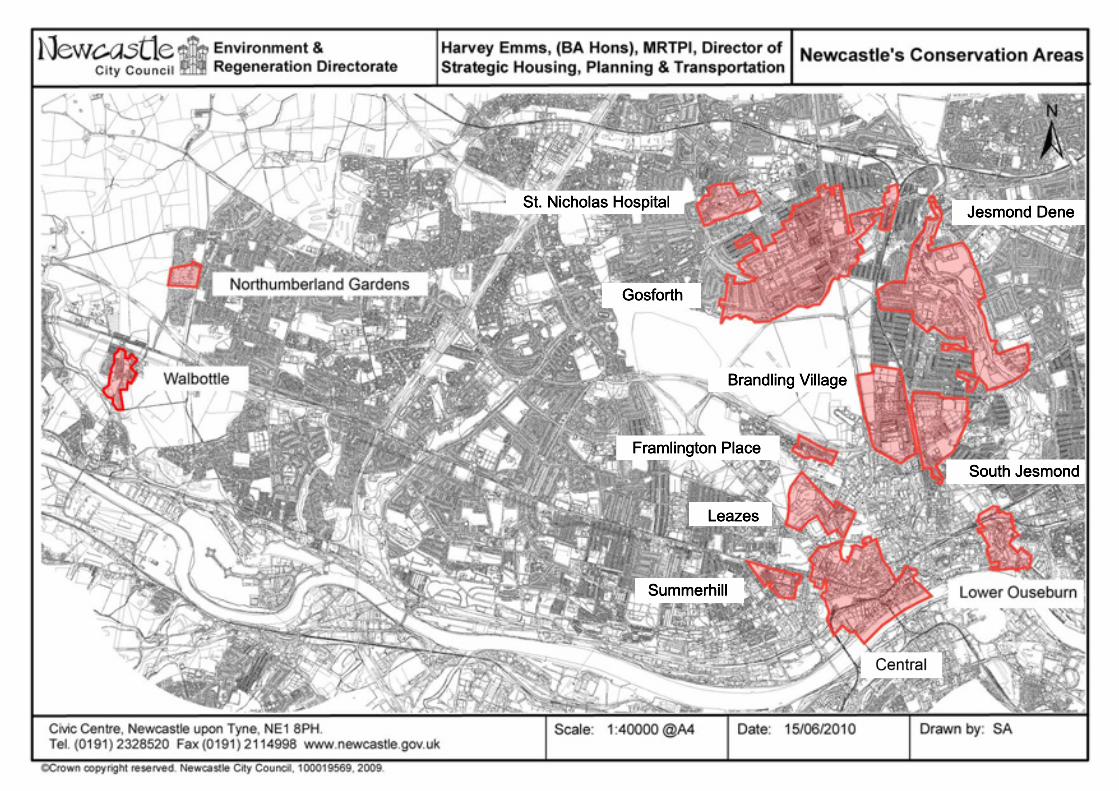
04 City-wide conservation area distribution map 05 Central Conservation Area 11 Brandling Village Conservation Area 14 Framlington Place Conservation Area 17 Gosforth Conservation Area 20 Jesmond Dene Conservation Area 23 Leazes Conservation Area 26 Lower Ouseburn Conservation Area 29 Northumberland Gardens Conservation Area 32 South Jesmond Conservation Area 35 St. Nicholas Hospital Conservation Area 38 Summerhill Conservation Area 43 Walbottle Conservation Area
Conservation Area Profiles 2
Conservation areas in general Conservation areas are areas of a city, town or village of ‘special architectural or historic interest’, the character or appearance of which merits protection or enhancement. While buildings, both listed and unlisted, make a large contribution to an area’s distinctive character or appearance and usually form the basis of a conservation area, designation recognises that buildings do not stand alone but are part of a bigger picture. The historic layout of roads and paths, characteristic building and paving materials, public and private spaces, green spaces and trees and the different uses of buildings all contribute to the charm and look of an area. When the council designates a conservation area additional planning procedures are introduced to make sure that any alterations do not detract from an area’s character and appearance, and to conserve and improve those qualities that form the ‘special interest’ of an area. The designation of a conservation area aims to manage, not prevent, change.
Planning guidance Conservation areas benefit from some additional planning controls and planning guidance. Living in a Conservation Area is a leaflet which outlines the relevant planning controls. It also provides guidance on alterations to, and maintenance of, buildings in conservation areas. The Unitary Development Plan sets out conservation policies for the city which are applied to applications for planning permission. Character Appraisals and Management Plans provide conservation area-specific guidance and can be found on the council’s website www.newcastle.gov.uk/hes
Article 4 Directions Some works to houses, such as changing windows or roof coverings, are “permitted development”, which means they do not require planning permission. An Article 4 Direction removes “permitted development rights” so that planning permission is required for works that previously did not require permission. This is to protect buildings of architectural and historic merit from inappropriate change. The council can make Article 4 Directions on properties within a conservation area if it considers that the properties are of such architectural and historic merit to warrant extra protection. The maps on the following pages show which properties in conservation areas have Article 4 Directions.
Conservation Area Profiles 3
Listed buildings For queries relating to all grade I and II* listed buildings contact: Peter Derham (Historic Buildings Officer) 0191 211 5626 [email protected] For queries about grade II listed buildings in conservation areas, please use the contact details provided in the following summaries for each area. You can check if a building is listed by visiting Newcastle Maps Online (NEMO) at http://www.newcastle.gov.uk/map and using the categories on the left hand side of the page to navigate. You can also check individual list descriptions at the Civic Centre, or online at www.heritagegateway.org.uk
Archaeology Sitelines is the Tyne and Wear Historic Environment Record (HER); it contains over 10,000 records about the archaeology of Tyne and Wear, including sites and finds ranging from prehistoric rock art to World War II pillboxes, listed buildings to burial mounds. You can access the HER at: www.twsitelines.info You can also access the HER at West Chapel, Jesmond Old Cemetery. Please note that although it is open from 9.30am - 5pm visits must be pre-arranged with Jennifer Morrison. For any other queries relating to archaeology in this area contact: Jennifer Morrison 0191 2816117 [email protected]
Trees in conservation areas All trees in conservation areas are protected and six weeks notice of all works to trees is required. Trees subject to Tree Preservation Orders remain protected under their individual order. For more information about please trees contact: Edwina Symmons (Landscape and Ecology) 0191 277 8950 [email protected] Ian Platais (Landscape and Ecology) 0191 278 3211 [email protected] Newcastle City Council Conservation Team For further information regarding the historic environment of the city in general please visit the council website: www.newcastle.gov.uk/hes or the Newcastle Heritage Partnership website: www.heritagepartnership.org.uk
Conservation Area Profiles 5
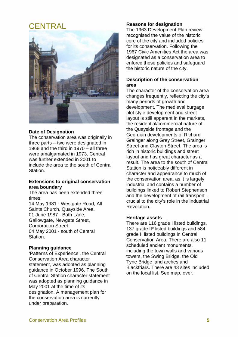
CENTRAL
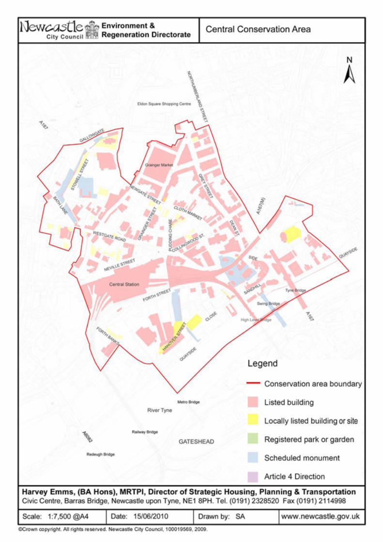
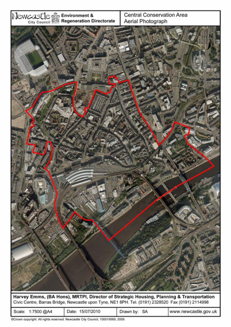
Date of Designation The conservation area was originally in three parts – two were designated in 1968 and the third in 1970 – all three were amalgamated in 1973. Central was further extended in 2001 to include the area to the south of Central Station. Extensions to original conservation area boundary The area has been extended three times: 14 May 1981 - Westgate Road, All Saints Church, Quayside Area. 01 June 1987 - Bath Lane, Gallowgate, Newgate Street, Corporation Street. 04 May 2001 - south of Central Station. Planning guidance ‘Patterns of Experience’, the Central Conservation Area character statement, was adopted as planning guidance in October 1996. The South of Central Station character statement was adopted as planning guidance in May 2001 at the time of its designation. A management plan for the conservation area is currently under preparation.
Reasons for designation The 1963 Development Plan review recognised the value of the historic core of the city and included policies for its conservation. Following the 1967 Civic Amenities Act the area was designated as a conservation area to enforce these policies and safeguard the historic nature of the city. Description of the conservation area The character of the conservation area changes frequently, reflecting the city’s many periods of growth and development. The medieval burgage plot style development and street layout is still apparent in the markets, the residential/commercial nature of the Quayside frontage and the Georgian developments of Richard Grainger along Grey Street, Grainger Street and Clayton Street. The area is rich in historic buildings and street layout and has great character as a result. The area to the south of Central Station is noticeably different in character and appearance to much of the conservation area, as it is largely industrial and contains a number of buildings linked to Robert Stephenson and the development of rail transport – crucial to the city’s role in the Industrial Revolution. Heritage assets There are 116 grade I listed buildings, 137 grade II* listed buildings and 584 grade II listed buildings in Central Conservation Area. There are also 11 scheduled ancient monuments, including the town walls and various towers, the Swing Bridge, the Old Tyne Bridge land arches and Blackfriars. There are 43 sites included on the local list. See map, over.

Conservation Area Profiles 6
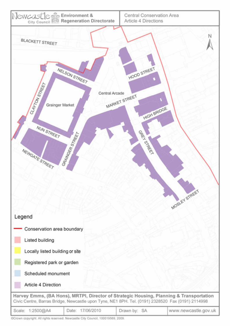
Article 4 Directions An Article 4 Direction applies to certain properties on 17 streets in Central Conservation Area. Please see attached schedule and map, over. The Grainger Town Project The Grainger Town Project covered roughly 35 hectares of the Central Conservation Area. Grainger Town is based around the Tyneside classical streets built by Richard Grainger between 1834 and 1839. 40% of buildings in the area are listed as being of special architectural or historic interest. In the 1980s and early 1990s this once prosperous area of the city was overtaken by new centres of retail and commercial activity which eroded the economic base and left properties to fall into disrepair. Around one million square foot of floor space was unoccupied (mainly upper floors) and the area's residential population was falling. The Grainger Town Project was established in 1997 in partnership with Newcastle City Council, English Partnerships and English Heritage with the aim of reversing this trend. A £120 million regeneration programme was begun and continued until the end of March 2003. It was anticipated that £40 million of public sector investment would be bolstered by a further £80 million from the private sector, but in fact achieved £145 million. Since the start of the project, great strides were made in regenerating the area, improving the environment and revitalising business, social and cultural life. On 31 March 2003, the project closed down, having achieved and far exceeded its objectives.
Old Newcastle – Where the Story Begins The 'Old Newcastle - Where the Story Begins' Project focuses on Newcastle’s social, cultural and creative heritage using the ancient Black Gate as a new portal to the City’s rich history, culture and character. The project will create an accessible, heritage-led education and interpretation centre in the vacant and closed Black Gate, transforming its current lifeless and substantially ignored presence into a hub of heritage activity that will be open and available to the entire community and visitors from near and far. The Black Gate will combine with medieval neighbours, the Castle Keep and the Cathedral Church of St Nicholas to provide an outstanding and dynamic heritage asset that will tell the story of the remarkable history of the City and the ingenuity of countless generations of its inhabitants. The Project is being taken forward by a partnership between Newcastle City Council, the Cathedral Church of St. Nicholas and the Society of Antiquaries of Newcastle upon Tyne. Contact information For further information about Central Conservation Area a useful starting point is the character statement. In addition, and for advice on development in the conservation area, contact: Fiona Cullen 0191 277 7192 [email protected]
Conservation Area Profiles 9
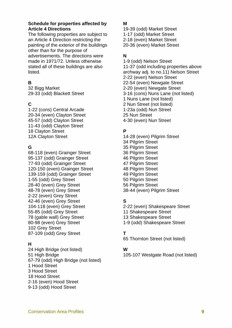
Schedule for properties affected by Article 4 Directions The following properties are subject to an Article 4 Direction restricting the painting of the exterior of the buildings other than for the purpose of advertisements. The directions were made in 1971/72. Unless otherwise stated all of these buildings are also listed. B 32 Bigg Market 29-33 (odd) Blackett Street C 1-22 (cons) Central Arcade 20-34 (even) Clayton Street 45-57 (odd) Clayton Street 11-43 (odd) Clayton Street 18 Clayton Street 12A Clayton Street G 68-118 (even) Grainger Street 95-137 (odd) Grainger Street 77-93 (odd) Grainger Street 120-150 (even) Grainger Street 139-159 (odd) Grainger Street 1-55 (odd) Grey Street 28-40 (even) Grey Street 48-78 (even) Grey Street 2-22 (even) Grey Street 42-46 (even) Grey Street 104-118 (even) Grey Street 55-85 (odd) Grey Street 78 (gable wall) Grey Street 80-98 (even) Grey Street 102 Grey Street 87-109 (odd) Grey Street H 24 High Bridge (not listed) 51 High Bridge 67-79 (odd) High Bridge (not listed) 1 Hood Street 3 Hood Street 18 Hood Street 2-16 (even) Hood Street 9-13 (odd) Hood Street
M 19-39 (odd) Market Street 1-17 (odd) Market Street 2-18 (even) Market Street 20-36 (even) Market Street N 1-9 (odd) Nelson Street 11-37 (odd including properties above archway adj. to no.11) Nelson Street 2-22 (even) Nelson Street 22-54 (even) Newgate Street 2-20 (even) Newgate Street 3-16 (cons) Nuns Lane (not listed) 1 Nuns Lane (not listed) 2 Nun Street (not listed) 1-23a (odd) Nun Street 25 Nun Street 4-30 (even) Nun Street P 14-28 (even) Pilgrim Street 34 Pilgrim Street 35 Pilgrim Street 36 Pilgrim Street 46 Pilgrim Street 47 Pilgrim Street 48 Pilgrim Street 49 Pilgrim Street 50 Pilgrim Street 56 Pilgrim Street 38-44 (even) Pilgrim Street S 2-22 (even) Shakespeare Street 11 Shakespeare Street 13 Shakespeare Street 1-9 (odd) Shakespeare Street T 65 Thornton Street (not listed) W 105-107 Westgate Road (not listed)
Conservation Area Profiles 11
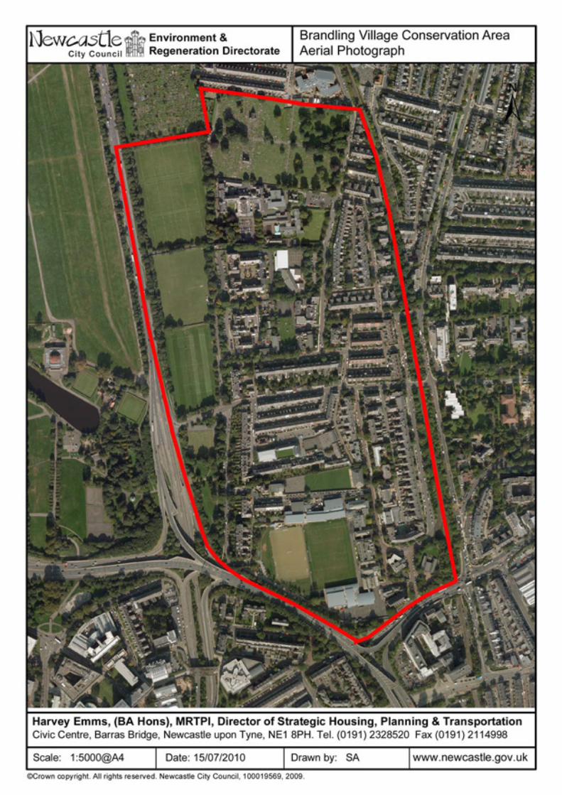
BRANDLING VILLAGE
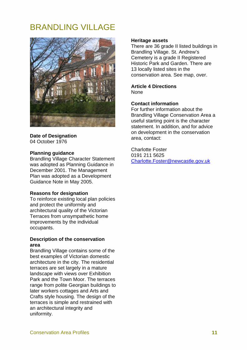
Date of Designation 04 October 1976 Planning guidance Brandling Village Character Statement was adopted as Planning Guidance in December 2001. The Management Plan was adopted as a Development Guidance Note in May 2005. Reasons for designation To reinforce existing local plan policies and protect the uniformity and architectural quality of the Victorian Terraces from unsympathetic home improvements by the individual occupants. Description of the conservation area Brandling Village contains some of the best examples of Victorian domestic architecture in the city. The residential terraces are set largely in a mature landscape with views over Exhibition Park and the Town Moor. The terraces range from polite Georgian buildings to later workers cottages and Arts and Crafts style housing. The design of the terraces is simple and restrained with an architectural integrity and uniformity.
Heritage assets There are 36 grade II listed buildings in Brandling Village. St. Andrew’s Cemetery is a grade II Registered Historic Park and Garden. There are 13 locally listed sites in the conservation area. See map, over. Article 4 Directions None Contact information For further information about the Brandling Village Conservation Area a useful starting point is the character statement. In addition, and for advice on development in the conservation area, contact: Charlotte Foster 0191 211 5625 [email protected]

Conservation Area Profiles 14
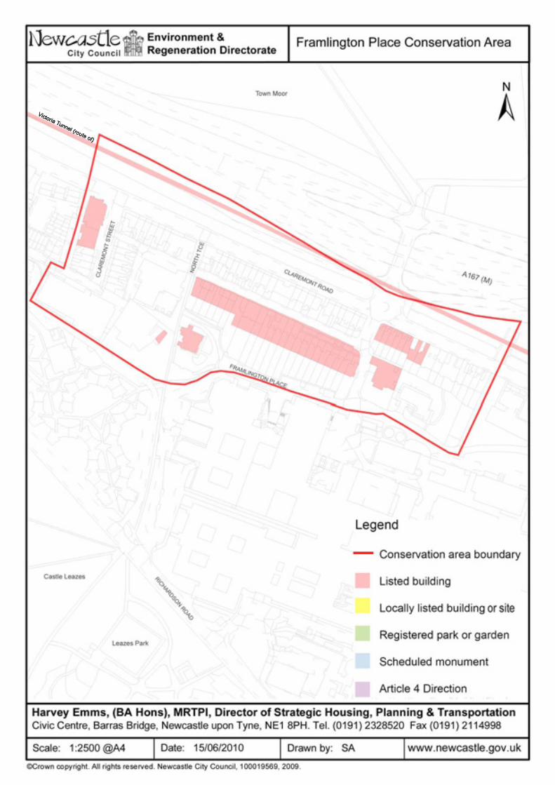
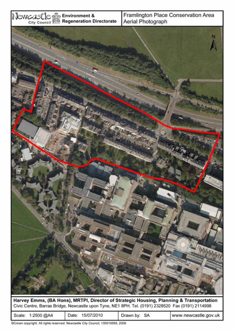
FRAMLINGTON PLACE
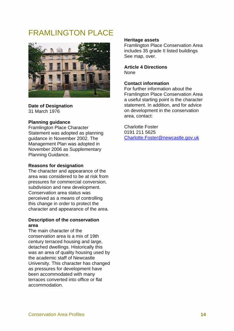
Date of Designation 31 March 1976 Planning guidance Framlington Place Character Statement was adopted as planning guidance in November 2002. The Management Plan was adopted in November 2006 as Supplementary Planning Guidance. Reasons for designation The character and appearance of the area was considered to be at risk from pressures for commercial conversion, subdivision and new development. Conservation area status was perceived as a means of controlling this change in order to protect the character and appearance of the area. Description of the conservation area The main character of the conservation area is a mix of 19th century terraced housing and large, detached dwellings. Historically this was an area of quality housing used by the academic staff of Newcastle University. This character has changed as pressures for development have been accommodated with many terraces converted into office or flat accommodation.
Heritage assets Framlington Place Conservation Area includes 35 grade II listed buildings See map, over. Article 4 Directions None Contact information For further information about the Framlington Place Conservation Area a useful starting point is the character statement. In addition, and for advice on development in the conservation area, contact: Charlotte Foster 0191 211 5625 [email protected]
Conservation Area Profiles 17
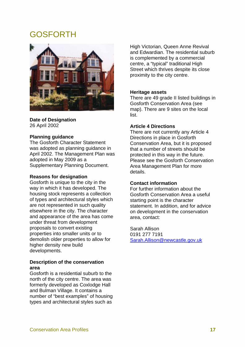
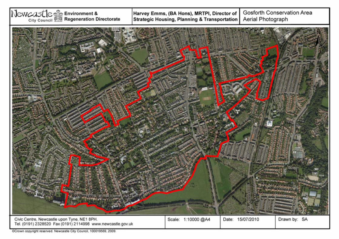
GOSFORTH
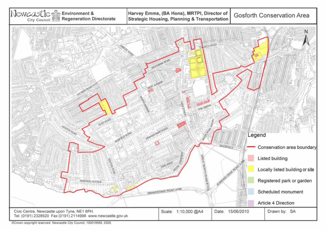
Date of Designation 26 April 2002 Planning guidance The Gosforth Character Statement was adopted as planning guidance in April 2002. The Management Plan was adopted in May 2009 as a Supplementary Planning Document. Reasons for designation Gosforth is unique to the city in the way in which it has developed. The housing stock represents a collection of types and architectural styles which are not represented in such quality elsewhere in the city. The character and appearance of the area has come under threat from development proposals to convert existing properties into smaller units or to demolish older properties to allow for higher density new build developments. Description of the conservation area Gosforth is a residential suburb to the north of the city centre. The area was formerly developed as Coxlodge Hall and Bulman Village. It contains a number of “best examples” of housing types and architectural styles such as
High Victorian, Queen Anne Revival and Edwardian. The residential suburb is complemented by a commercial centre, a “typical” traditional High Street which thrives despite its close proximity to the city centre. Heritage assets There are 49 grade II listed buildings in Gosforth Conservation Area (see map). There are 9 sites on the local list. Article 4 Directions There are not currently any Article 4 Directions in place in Gosforth Conservation Area, but it is proposed that a number of streets should be protected in this way in the future. Please see the Gosforth Conservation Area Management Plan for more details. Contact information For further information about the Gosforth Conservation Area a useful starting point is the character statement. In addition, and for advice on development in the conservation area, contact: Sarah Allison 0191 277 7191 [email protected]
Conservation Area Profiles 20
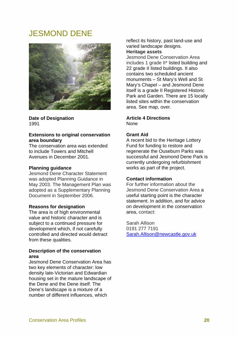
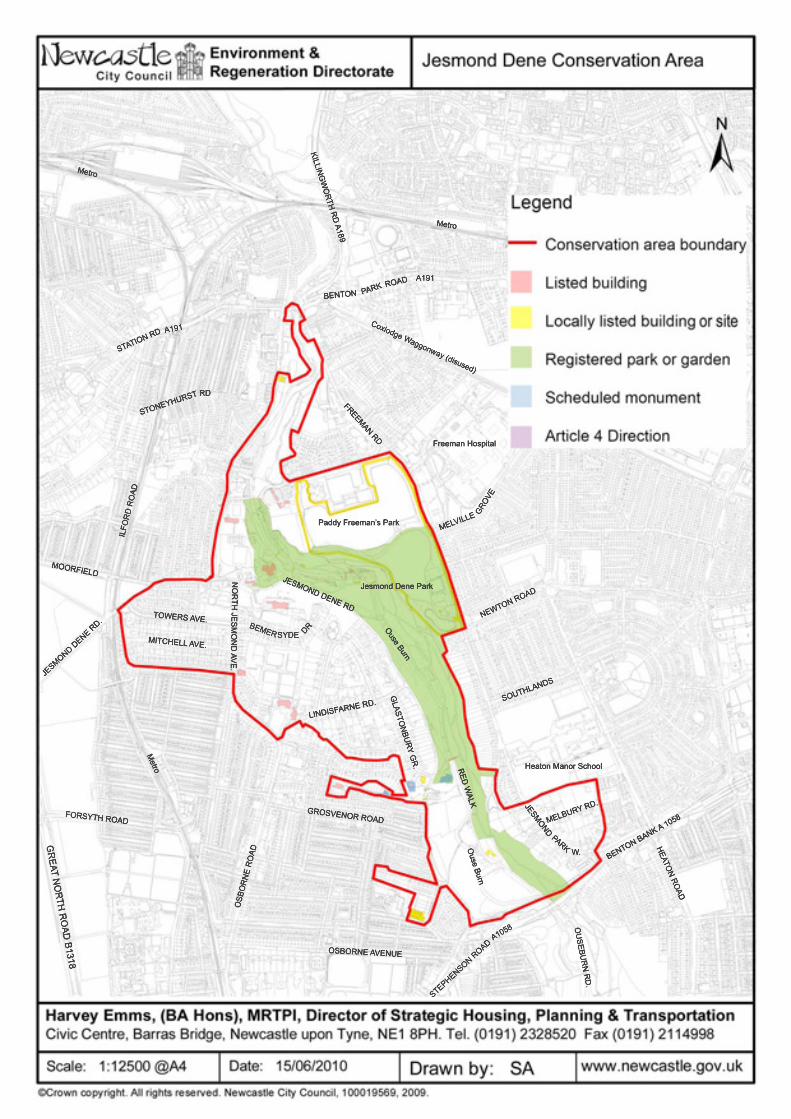
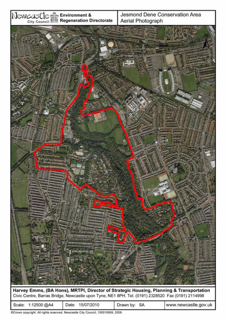
JESMOND DENE
Date of Designation 1991 Extensions to original conservation area boundary The conservation area was extended to include Towers and Mitchell Avenues in December 2001. Planning guidance Jesmond Dene Character Statement was adopted Planning Guidance in May 2003. The Management Plan was adopted as a Supplementary Planning Document in September 2006. Reasons for designation The area is of high environmental value and historic character and is subject to a continued pressure for development which, if not carefully controlled and directed would detract from these qualities. Description of the conservation area Jesmond Dene Conservation Area has two key elements of character: low density late-Victorian and Edwardian housing set in the mature landscape of the Dene and the Dene itself. The Dene’s landscape is a mixture of a number of different influences, which
reflect its history, past land-use and varied landscape designs. Heritage assets Jesmond Dene Conservation Area includes 1 grade II* listed building and 22 grade II listed buildings. It also contains two scheduled ancient monuments – St Mary’s Well and St Mary’s Chapel – and Jesmond Dene itself is a grade II Registered Historic Park and Garden. There are 15 locally listed sites within the conservation area. See map, over. Article 4 Directions None Grant Aid A recent bid to the Heritage Lottery Fund for funding to restore and regenerate the Ouseburn Parks was successful and Jesmond Dene Park is currently undergoing refurbishment works as part of the project. Contact information For further information about the Jesmond Dene Conservation Area a useful starting point is the character statement. In addition, and for advice on development in the conservation area, contact: Sarah Allison 0191 277 7191 [email protected]
Conservation Area Profiles 23
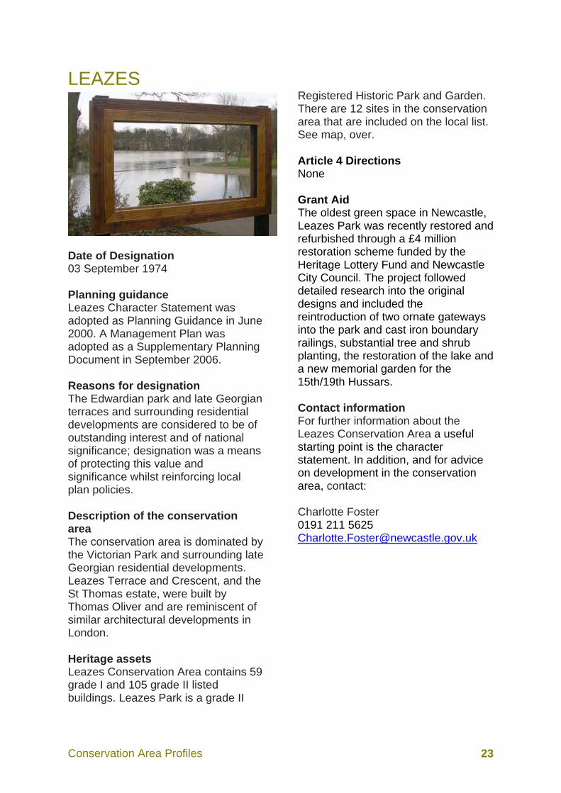
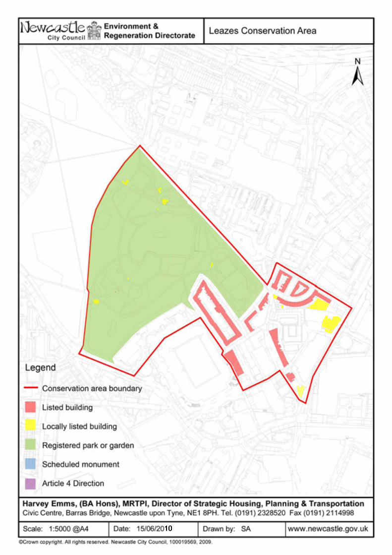
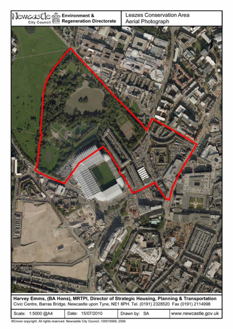
LEAZES
Date of Designation 03 September 1974 Planning guidance Leazes Character Statement was adopted as Planning Guidance in June 2000. A Management Plan was adopted as a Supplementary Planning Document in September 2006. Reasons for designation The Edwardian park and late Georgian terraces and surrounding residential developments are considered to be of outstanding interest and of national significance; designation was a means of protecting this value and significance whilst reinforcing local plan policies. Description of the conservation area The conservation area is dominated by the Victorian Park and surrounding late Georgian residential developments. Leazes Terrace and Crescent, and the St Thomas estate, were built by Thomas Oliver and are reminiscent of similar architectural developments in London. Heritage assets Leazes Conservation Area contains 59 grade I and 105 grade II listed buildings. Leazes Park is a grade II
Registered Historic Park and Garden. There are 12 sites in the conservation area that are included on the local list. See map, over. Article 4 Directions None Grant Aid The oldest green space in Newcastle, Leazes Park was recently restored and refurbished through a £4 million restoration scheme funded by the Heritage Lottery Fund and Newcastle City Council. The project followed detailed research into the original designs and included the reintroduction of two ornate gateways into the park and cast iron boundary railings, substantial tree and shrub planting, the restoration of the lake and a new memorial garden for the 15th/19th Hussars. Contact information For further information about the Leazes Conservation Area a useful starting point is the character statement. In addition, and for advice on development in the conservation area, contact: Charlotte Foster 0191 211 5625 [email protected]
Conservation Area Profiles 26
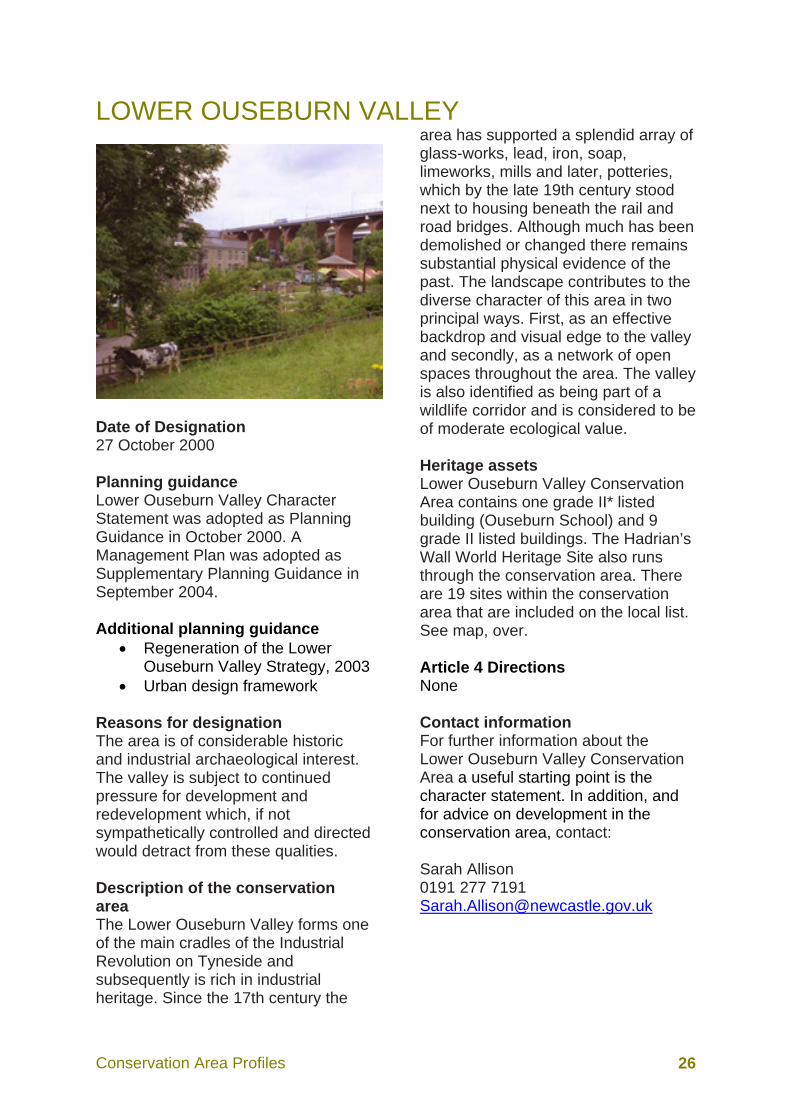
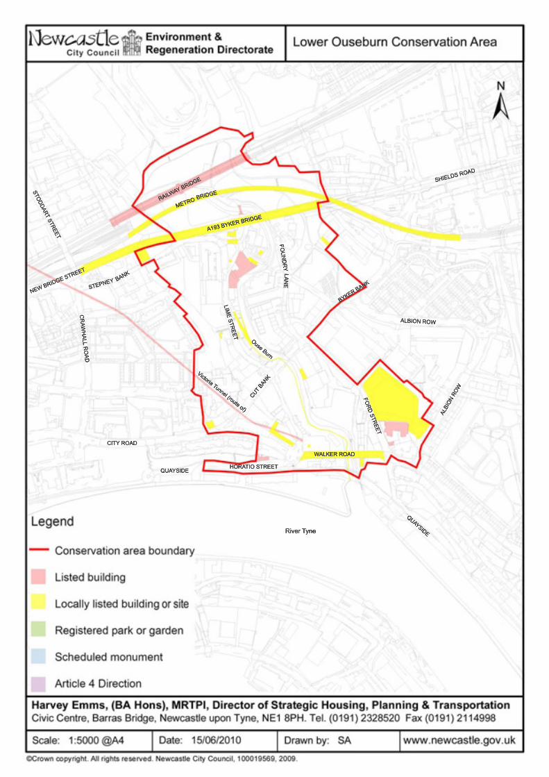
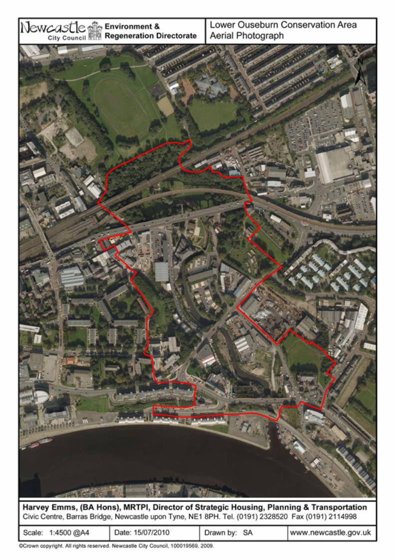
LOWER OUSEBURN VALLEY
Date of Designation 27 October 2000 Planning guidance Lower Ouseburn Valley Character Statement was adopted as Planning Guidance in October 2000. A Management Plan was adopted as Supplementary Planning Guidance in September 2004. Additional planning guidance
• Regeneration of the Lower Ouseburn Valley Strategy, 2003
• Urban design framework Reasons for designation The area is of considerable historic and industrial archaeological interest. The valley is subject to continued pressure for development and redevelopment which, if not sympathetically controlled and directed would detract from these qualities. Description of the conservation area The Lower Ouseburn Valley forms one of the main cradles of the Industrial Revolution on Tyneside and subsequently is rich in industrial heritage. Since the 17th century the
area has supported a splendid array of glass-works, lead, iron, soap, limeworks, mills and later, potteries, which by the late 19th century stood next to housing beneath the rail and road bridges. Although much has been demolished or changed there remains substantial physical evidence of the past. The landscape contributes to the diverse character of this area in two principal ways. First, as an effective backdrop and visual edge to the valley and secondly, as a network of open spaces throughout the area. The valley is also identified as being part of a wildlife corridor and is considered to be of moderate ecological value. Heritage assets Lower Ouseburn Valley Conservation Area contains one grade II* listed building (Ouseburn School) and 9 grade II listed buildings. The Hadrian’s Wall World Heritage Site also runs through the conservation area. There are 19 sites within the conservation area that are included on the local list. See map, over. Article 4 Directions None Contact information For further information about the Lower Ouseburn Valley Conservation Area a useful starting point is the character statement. In addition, and for advice on development in the conservation area, contact: Sarah Allison 0191 277 7191 [email protected]
Conservation Area Profiles 29
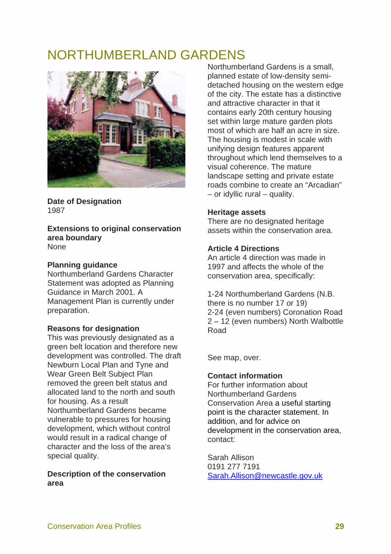
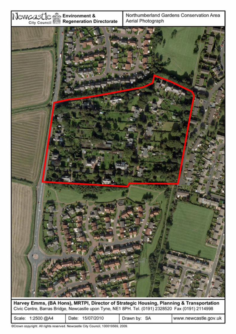
NORTHUMBERLAND GARDENS
Date of Designation 1987 Extensions to original conservation area boundary None Planning guidance Northumberland Gardens Character Statement was adopted as Planning Guidance in March 2001. A Management Plan is currently under preparation. Reasons for designation This was previously designated as a green belt location and therefore new development was controlled. The draft Newburn Local Plan and Tyne and Wear Green Belt Subject Plan removed the green belt status and allocated land to the north and south for housing. As a result Northumberland Gardens became vulnerable to pressures for housing development, which without control would result in a radical change of character and the loss of the area’s special quality. Description of the conservation area
Northumberland Gardens is a small, planned estate of low-density semi-detached housing on the western edge of the city. The estate has a distinctive and attractive character in that it contains early 20th century housing set within large mature garden plots most of which are half an acre in size. The housing is modest in scale with unifying design features apparent throughout which lend themselves to a visual coherence. The mature landscape setting and private estate roads combine to create an “Arcadian” – or idyllic rural – quality. Heritage assets There are no designated heritage assets within the conservation area. Article 4 Directions An article 4 direction was made in 1997 and affects the whole of the conservation area, specifically: 1-24 Northumberland Gardens (N.B. there is no number 17 or 19) 2-24 (even numbers) Coronation Road 2 – 12 (even numbers) North Walbottle Road See map, over. Contact information For further information about Northumberland Gardens Conservation Area a useful starting point is the character statement. In addition, and for advice on development in the conservation area, contact: Sarah Allison 0191 277 7191 [email protected]

Conservation Area Profiles 32
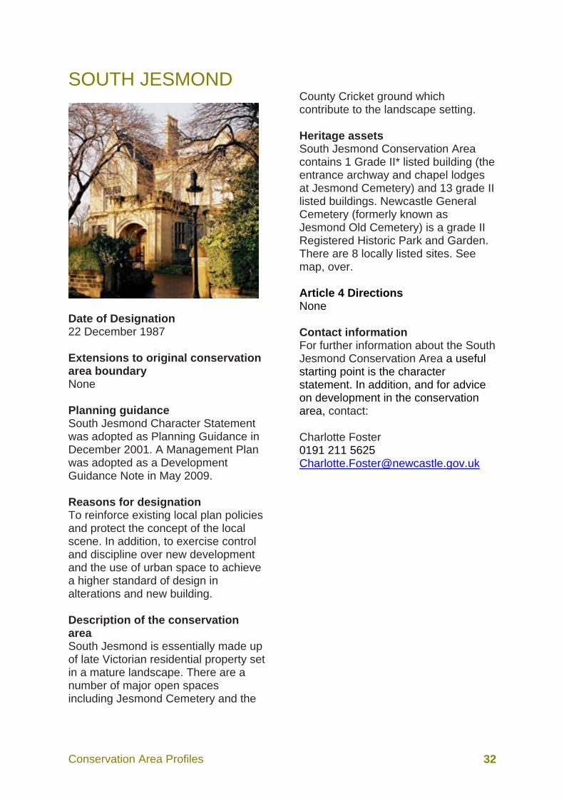
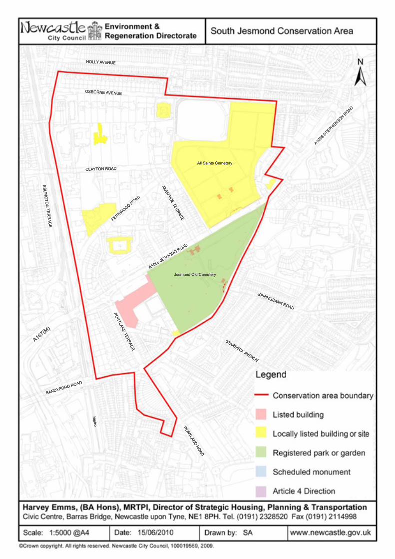
SOUTH JESMOND
Date of Designation 22 December 1987 Extensions to original conservation area boundary None Planning guidance South Jesmond Character Statement was adopted as Planning Guidance in December 2001. A Management Plan was adopted as a Development Guidance Note in May 2009. Reasons for designation To reinforce existing local plan policies and protect the concept of the local scene. In addition, to exercise control and discipline over new development and the use of urban space to achieve a higher standard of design in alterations and new building. Description of the conservation area South Jesmond is essentially made up of late Victorian residential property set in a mature landscape. There are a number of major open spaces including Jesmond Cemetery and the
County Cricket ground which contribute to the landscape setting. Heritage assets South Jesmond Conservation Area contains 1 Grade II* listed building (the entrance archway and chapel lodges at Jesmond Cemetery) and 13 grade II listed buildings. Newcastle General Cemetery (formerly known as Jesmond Old Cemetery) is a grade II Registered Historic Park and Garden. There are 8 locally listed sites. See map, over. Article 4 Directions None Contact information For further information about the South Jesmond Conservation Area a useful starting point is the character statement. In addition, and for advice on development in the conservation area, contact: Charlotte Foster 0191 211 5625 [email protected]

Conservation Area Profiles 35
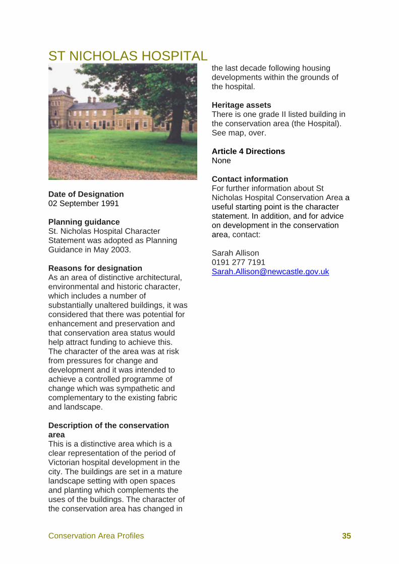
ST NICHOLAS HOSPITAL
Date of Designation 02 September 1991 Planning guidance St. Nicholas Hospital Character Statement was adopted as Planning Guidance in May 2003. Reasons for designation As an area of distinctive architectural, environmental and historic character, which includes a number of substantially unaltered buildings, it was considered that there was potential for enhancement and preservation and that conservation area status would help attract funding to achieve this. The character of the area was at risk from pressures for change and development and it was intended to achieve a controlled programme of change which was sympathetic and complementary to the existing fabric and landscape. Description of the conservation area This is a distinctive area which is a clear representation of the period of Victorian hospital development in the city. The buildings are set in a mature landscape setting with open spaces and planting which complements the uses of the buildings. The character of the conservation area has changed in
the last decade following housing developments within the grounds of the hospital. Heritage assets There is one grade II listed building in the conservation area (the Hospital). See map, over. Article 4 Directions None Contact information For further information about St Nicholas Hospital Conservation Area a useful starting point is the character statement. In addition, and for advice on development in the conservation area, contact: Sarah Allison 0191 277 7191 [email protected]


Conservation Area Profiles 38
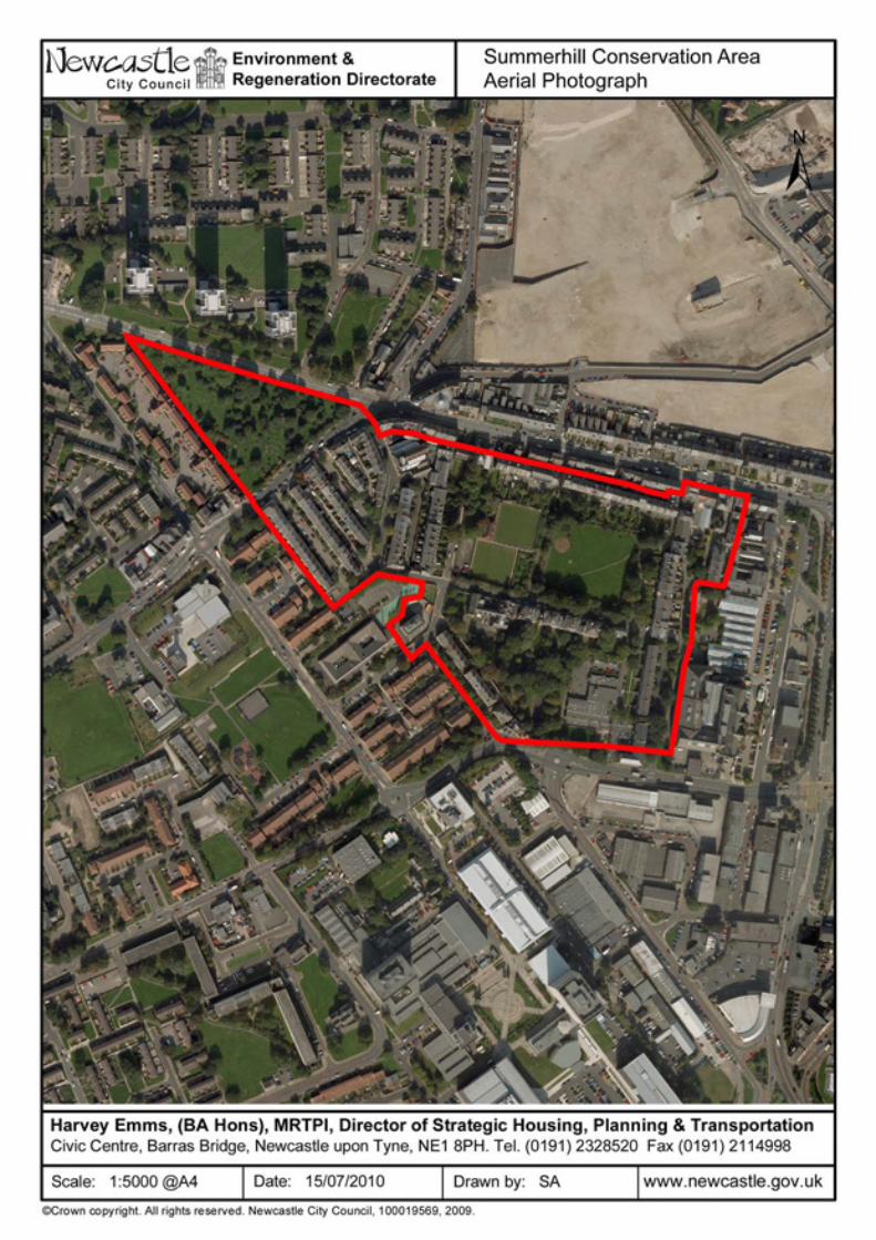
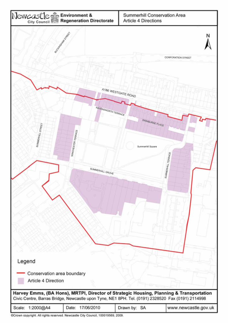
SUMMERHILL
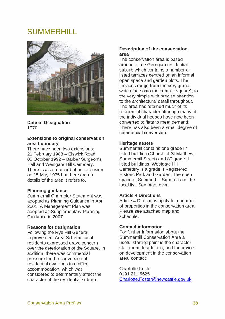
Date of Designation 1970 Extensions to original conservation area boundary There have been two extensions: 21 February 1988 – Elswick Road 05 October 1992 – Barber Surgeon’s Hall and Westgate Hill Cemetery. There is also a record of an extension on 15 May 1975 but there are no details of the area it refers to. Planning guidance Summerhill Character Statement was adopted as Planning Guidance in April 2001. A Management Plan was adopted as Supplementary Planning Guidance in 2007. Reasons for designation Following the Rye Hill General Improvement Area Scheme local residents expressed grave concern over the deterioration of the Square. In addition, there was commercial pressure for the conversion of residential dwellings into office accommodation, which was considered to detrimentally affect the character of the residential suburb.
Description of the conservation area The conservation area is based around a late Georgian residential suburb which contains a number of listed terraces centred on an informal open space and garden plots. The terraces range from the very grand, which face onto the central “square”, to the very simple with precise attention to the architectural detail throughout. The area has retained much of its residential character although many of the individual houses have now been converted to flats to meet demand. There has also been a small degree of commercial conversion. Heritage assets Summerhill contains one grade II* listed building (Church of St Matthew, Summerhill Street) and 80 grade II listed buildings. Westgate Hill Cemetery is a grade II Registered Historic Park and Garden. The open space of Summerhill Square is on the local list. See map, over. Article 4 Directions Article 4 Directions apply to a number of properties in the conservation area. Please see attached map and schedule. Contact information For further information about the Summerhill Conservation Area a useful starting point is the character statement. In addition, and for advice on development in the conservation area, contact: Charlotte Foster 0191 211 5625 [email protected]


Conservation Area Profiles 41
Schedule for properties affected by Article 4 Directions An Article 4 Direction controlling all works under Parts 1 & 2 of Schedule 2 of the 1988 General Development (Permitted) Order was made in 1990 and affects the following addresses within the conservation area: 1-6 Greenfield Place 1-4 High Swinburne Place
Coach House, Summerhill Grove St Anne’s Convent, Summerhill Grove 1-8 Summerhill Grove 1-12 Summerhill Terrace 2-9 incl. 4a Swinburne Place 1-10 Winchester Terrace 209, 269, 271, 273, 275 Westgate Road 5, 7-12 Ravensworth Terrace Harry Woods, 195 Westgate Road

Conservation Area Profiles 43
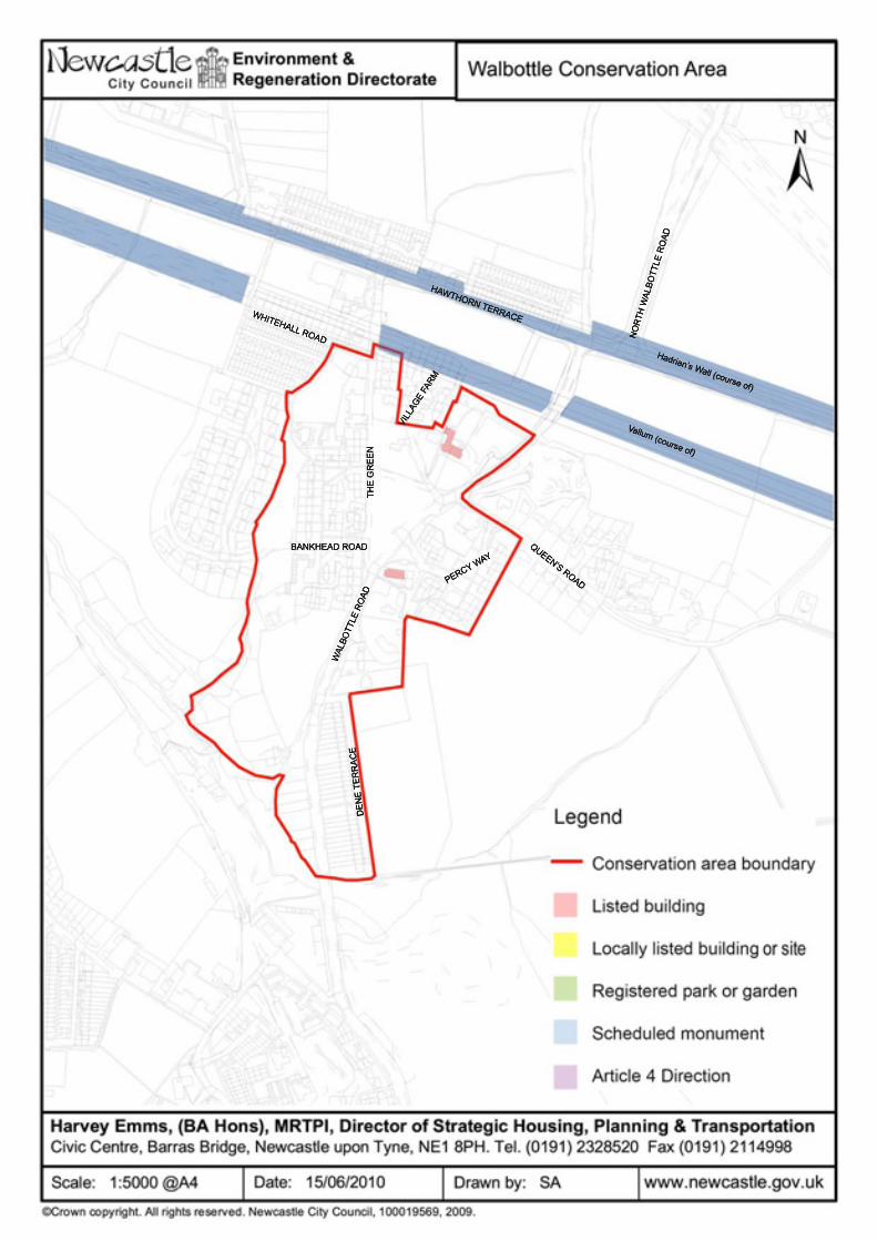
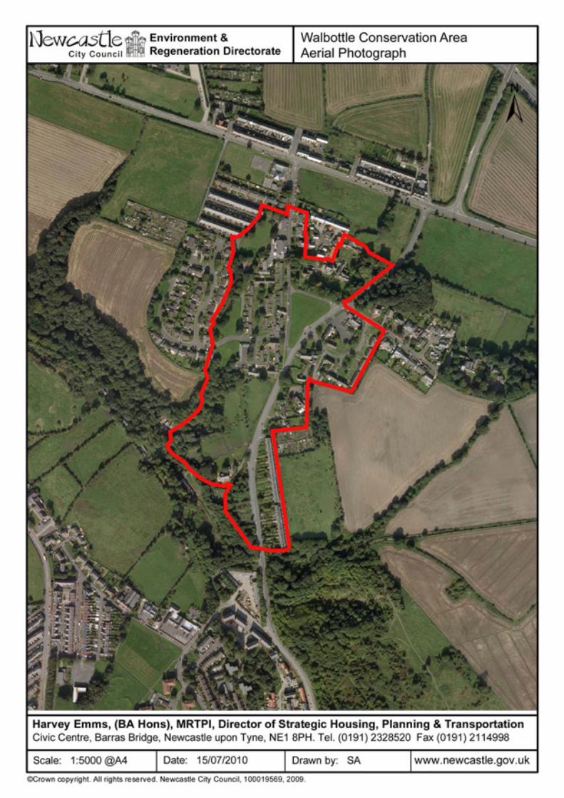
WALBOTTLE VILLAGE
Date of Designation The conservation area was designated in November 2009. Planning guidance Walbottle Village Character Statement and Management Plan was adopted as a Development Guidance Note in November 2009, at the same time as the conservation area was designated. Reasons for designation Walbottle Village Conservation Area lies approximately 6 miles west of the city centre. It has been suggested that the origins of Walbottle precede the Roman conquest. However, little of the village’s early development is visible today and traditional housing has been replaced by the 1960s redevelopment of the area. The retention of the original boundaries and incorporation of views of the surrounding greenbelt land, along with the use of cohesive materials and design create a unique character (with a hidden history) worthy of preservation. Conservation area status was perceived as a means of controlling change, to protect the character and appearance of the area.
Description of the conservation area The principal focus of the conservation area is the village green, which continues to be the centre of village life. The green was central to the redevelopment of the village in the 1960’s by Newburn Urban District Council. The importance of this area was recognised during the early 1960’s when the 10th Duke of Northumberland gave Newburn Urban District the land surrounding the green. Heritage assets Walbottle Village Conservation Area contains three grade II listed buildings. See map, over. Article 4 Directions None.
Contact information For further information about Walbottle Village Conservation Area a useful starting point is the character statement. In addition, and for advice on development in the conservation area, contact: Sarah Allison 0191 277 7191 [email protected]