computerised land information system as a tool of …
TRANSCRIPT

COMPUTERISED LAND INFORMATION SYSTEM AS A TOOL OF LAND RECORD MANAGEMENT.(A case study of the land rent section of the Department of Lands, Ministry of Lands and Settlement, Nairobi Kenya)
Obongo Awuor Monica B/50/8196/2001B.A (Land Economics) Hons, Nairobi University.
A project thesis submitted in partial fulfilment for the award of Master of Arts in Valuation and Property Management degree, Department of Land Development, Faculty of Architecture Design and Development, University of Nairobi.
October 2003

DECLARATION.I Monica Awuor Obongo, do hereby declare that this project thesis is my original work and has not been submitted for examination in any other University or published in any form.
Signature. Date 1 * 1Obongo Awuor Monica B/50/P/8196/2001
Supervisor.
This project paper has been submitted with my approval as a University supervisor.
Signature: Date 7-. 7 .Dr. Ing. W. H. A Olima
II

Dedication.To my two sons Leslie and Tony, "You are the wind beneath my wings"

Acknowledgements."No man is an Island, no man stands alone". I am eternally grateful to several people who contributed in one way or another towards the completion of my course and thesis. First and foremost, I would like to thank God for giving me the gift of life and enabling me to pursue this course to the end.
My sincere gratitude goes to the Directorate of Personnel Management for granting me the scholarship that catered for both the tuition and other expenses incurred in doing my post graduate studies. Without this scholarship, the dream to pursue my postgraduate studies may never have been fulfilled due to financial constraints.
I would also like to thank the Commissioner of Lands, Mrs. Judith Okungu for enabling me to undertake an academic tour to Germany with my other classmates in the departments of Land Development and Building Economics and Management, as part of the learning process.
I am grateful to the Chief Valuer, Mr. Mwinzi for releasing me from my normal duties as a government valuer to pursue this course full time.
My sincere gratitude goes to my supervisor, Dr. Ing. W.H.A Olima for guiding me through the research process and giving the much needed positive criticism for the refinement of this project thesis.
My two sons Leslie and Tony have been a constant source of strength and inspiration to me. In my endeavour to provide them with the finer things in life to the best of my ability, I have been propelled to rise above that which is comfortable and take risks aimed at improving my socio-economic status. This course was one such risk.
I would like to thank Casty Njoroge of the Ministry of Lands and Settlement, Nairobi for introducing me to GIS and being supportive as I make slow but sure steps towards my new world of GIS and its intricacies.
IV

A class would not be complete without classmates. I would like to thank my classmates, Chege Waiganjo, Joycelyn Makena, Jacqueline Nyaguthii and Rahab Wanjohi for being there to offer the much-needed teamwork for class discussions and the friendship needed to keep this noble task of knowledge acquisition humane.
1 take this opportunity to thank all those who offered words of encouragement, prayers, and emotional support as I undertook my postgraduate studies.
To you all, I wish you God's blessings and happiness all the days of your life.
V

Abstract.This project thesis presents a conceptual framework for a land information system that would result in increased revenue collection from the land rent section of the Department of Lands, Ministry of Lands and Settlement. It points out the need for a comprehensive database containing both physical and socio-economic data supported by powerful analytical capabilities as the basis for effective decision making on land rent for tax revenue collection.
The Government has admittedly a lot of untapped revenue in the form of unrevised land rents and land rent defaulters. The land rent section however is crippled by the manual system of record keeping in all its departments and lack of policy instruments for effective management of information. Information obtained from the land rent section reveals that there's an outstanding arrears in land rent to the tune of Kenya Shilling 4,800,000,000 (Four Billion, Eight Million Shillings) or US$ 60,000,000 (Forty eight million dollars). Land rent has not been taken seriously by many leaseholders due to the Government’s laxity in revising and collecting it.
The researcher has identified the type and nature of problems of land rent determination, record management and collection. A conceptual model showing the components of a computerised land information system has been analysed and potential benefits and possible solutions to the problems outlined using selected properties from the Nairobi hill area. The possibilities of using land information as a corporate resource have also been explored.
To achieve the above objectives, the researcher conducted oral interviews with personnel from the land rent section and other departments that influence the determination of land rent like the valuers and land officers. Several leaseholders were interviewed with the view of determining the level'of awareness of the need to pay land rent. The model for a computerised land information system was then developed using a digitised map of the selected area of study and available socio-economic data on these properties.
VI

The level of awareness of the need to pay land rent was analysed using statistical methods of data analysis. Capabilities of the computerised land information system were then analysed and the findings compared to the current manual system of record collection to draw results. Possible solutions to the problems identified in using the manual system have also been addressed.
The researcher recommends after analysis of the findings that there be a general rent review for all leasehold properties within the country using computer aided valuation methods with an emphasis on Multiple Regression Analysis. There is need to educate leaseholders on the importance of prompt payment of land rent. Automation of land rent records is the viable solution to the multiplicity of problems currently faced by the section as regards retrieval of information and management of land rent records. All these recommendations can only be implemented where there is a sound policy framework on land information management. The land information system generated would be beneficial to other government ministries and other departments within the ministry of land. There is therefore need to consider the use of the land information as a corporate resource.
\
VII

t a b l e o f c o n t e n t s pa g eDeclaration IIDedication IIIAcknowledgements IVAbstract VITable of contents VIIIList of tables XIIList of maps XIIList of Charts XIIList of abbreviations XII
CHAPTER 1INTRODUCTION AND PROBLEM STATEMENT1.0 Introduction 1
1.1 Problem statement 41.2 Objectives of the study 8
1.3 Research Hypothesis 8
1.4 Assumptions 8
1.5 Research Methodology 91.6 Significance of the study 91.7 Definitions of operational terms 11
1.8 Scope and organisation of the study 11
CHAPTER 2LITERATURE REVIEW AND THEORETICAL FRAMEWORK
2.0 Introduction ' 152.1 Land as a resource 152.1.1 Land tenure systems 15
VIII

2 l . 1.1 Government Land 162.1.1.2 Trust Land 172.1.1.3 Private Land 172.1.1.4 Legislation affecting Land Rent 192.1.2 Land ownership in Nairobi 192.1.3 Land rent theory and practices 212.1.3.1 Neo classical economic land rent theory 222.1.4 Land rent in relation to land values 232.1.5 Common land value model attributes 262.1.5.1 Amenity rent as a determinant of Land Value 282.1.5.2 Land Value Model Attributes in Kenya 292.1.6 Land taxation policy in Kenya 30
2.2 INFORMATION
2.2.1 Distinction between data and information 332.2.2 Information systems 332.2.3 Information management 342.2.4 Geographic information management 342.2.5 Land information systems 362.2.6 Conceptual model for a computerised 372.2.7 LIS for land rent record management 37
CHAPTER 3THE STUDY AREA3.0 Introduction 423.1 The Department of Lands 433.2 Intra Ministerial Linkages 443.3 Inter Ministerial Linkages 443.4 Land Rent Section 45
IX

3.5 The Structure of the Land Rent Section 453.6 Determination of land rent by the valuation section 473.7 Population growth in urban areas, an analysis by province 473.8 Market values and development in Nairobi Hill area 48
CHAPTER 4RESEARCH METHODOLOGY4.0 Introduction 504.1 The research process 504.2 Research design 524.3 Nature of data 524.4 Data Collection Procedures 544.4.1 Interview Data 544.4.2 Observation Data 544.4.3 Documentary Data 55
CHAPTER 5RESEARCH FINDINGS AND ANALYSIS
5.0 Introduction 595.1 Nature and type of problems of manual
Land rent record management 595.1.1 Difficulties in the Retrieval of Land Rent record cards 595.1.2 Outdated Land Rent Record Cards 595.1.3 Land Rent Arrears 605.1.4 Non-delivery of Land Rent Record Cards 61
X5.1.5 Manipulation of Land Rent Record Cards 615.1.6 Inequitable distribution of Annual Land Rent Payable 615.1.7 Un-revised Land Rent 62
X

5.1.8 Discrepancy in rates 625.2 Sample LIS for selected properties in Nairobi Hill 635.2.1 Demonstration of ease of retrieval of information using Arc-view GIS 66
5.2.2 Potentials in the use of Microsoft Excel 68
5.3 Sample LIS for rent review for selected properties 695.4 The use of LIS as a corporate resource 715.5 Potential users of land information 725.6 Hypothesis testing 73
CHAPTER 6CONCLUSIONS AND RECOMMENDATIONS6.0 Introduction 756.1 Conclusions 756.2 Recommendations 776.2.1 Construction of comprehensive Automated Database 776.2.2 The use of Computer aided Valuation Techniques 786.2.3 Strict Enforcement of Legislation 786.5 Areas of Further Research 80Bibliography 81Appendix 87
\
XI

List of TablesTable 2.1 Mills model for assessing value 27Table 2.2 Yeates model for assessing value 29Table 2.3 Regression model for value attributes in Kenya 30Table 4.1 Types and nature of data 53
List of FiguresFigure 2.1 Information for sustainable development 33Figure 2.2 Steps in implementing LIS 40Figure 2.3 Structure of the Land Rent Section 46Figure 4.1 Digitised map of Nairobi Hill 56Figure 4.2 Retrieval of information using Arc View GIS 57Figure 5.1 Plots layers 66
Figure 5.2 Syntax for Properties with Area >= 1 67Figure 5.3 Querying using Arc View GIS 68
Figure 5.4 Identification of Database contents 69
List of MansMap 1 Map of Study area, Nairobi Hill, block 1 13
List of ChartsChart 1 Variance in rent 74
Lists of AbbreviationsCAD Computer aided design \CBD Central business districtDBMS Database management systemsDCF Discounted cash flow
XII

DFD's Data flow diagramsFIG Federation Internationales des GeometresGDP Gross domestic productGIS Geographic information systemsGITIM Geographic information technology investment managementICT Information and communication technologyIT Information technologyLIS Land information systemLR Number Land reference numberMRA Multiple regression analysisNCC Nairobi city councilUN United NationsUNCHS United Nations Centre for Human Settlements

CHAPTER 1INTRODUCTION AND PROBLEM STATEMENT
1.0 IntroductionInformation management is crucial for sound decision making in every facet of life. Harrison (1987) says that information is the lifeblood, which flows into and out of an organisation. The success of any enterprise or organisation to a large extent depends on the accuracy and timing of the information supplied and its effective use. The Ministry of Lands and Settlement, being the custodian of the land resource must tap the potential benefits of information technology in order to improve its service delivery and revenue collection.
The 'Njonjo Commission of Inquiry into the Land Law System of Kenya on Principles of a National Land Policy Framework states that an efficient system of land delivery requires that capability should exist for the preparation and maintenance of a comprehensive land information system. The land information system should indicate not merely who owns what interest in what land but other details such as land capability, uses, size, distribution and topographical characteristics. A comprehensive land information system incorporates both geographical (spatial) and socio-economic (non- spatial) data in one easily accessible database. This ease of accessibility necessitates the use of information technology.
Land is a resource upon which all other resources are based and as such every aspect of it must be managed in a sustainable way to benefit both present and future generations. Of special interest is the management of the land information as a resource for economic growth and development. The goal of the 2002 - 2008 National Development plan is "Effective Management for Sustainable Growth and Poverty Reduction" It sets out the need for the development of a land information system that incorporates both spatial and non-spatial information for'efficient land resource administration. One of the major problems of manual land information management is difficulty in retrieval of data and incidences of loss or destruction of this data. These problems inhibit the level of
l

efficiency in revenue collection. The use of computerised land information management techniques would result in improved data access and manipulation resulting in increased revenue collection for the Government.
Revenue from land is obtained from several different sources, including but not limited to stamp duty payments, land rent and rates, and monies charged for other inquiries and transactions in land like searches, charges, cautions, survey fees, valuation fees, planning fees, and registration fees. Land rent; if properly administered would make significant revenue contributions. It is quite common to hear incidences of missing land rent cards and inability to obtain rent demand notes or lengthy periods of waiting to pay land rent. These problems could be reduced or eliminated by the use of information technology in storing land rent records. Periodically, names of land rent defaulters are published in local print media with huge debts owed to the Government. These lists are often not conclusive and do not indicate the total debt owed to the Government in terms of land rent defaulters. The reason for the inconclusive lists is the fact that there exist large volumes of land rent cards, some missing and some out of date. The published lists are often only of individual or corporations with very large debts. The small debts also contribute significantly to the total debt owed by landowners and if information regarding their actual position was readily available, and necessary measures were put in place to address the debt, more revenue would be collected.
The more transparent anfl efficient the land administration services, the higher the revenue collection. A computerised LIS plays a crucial role as an efficient instrument for land resource management (Barthurst Declaration, 1999). The UN with the support of FIG developed the Bogor Declaration on Land reform (UN-FIG 1996). This declaration deals with the importance of land - cadastre management. Several developed have employed the use of information technology for the management of their land resource. The use of computerised land information systems has resulted in significant increase in revenue collection within the government land office in Pretoria, South Africa. North Carolina state university also works closely with the state to research on new and improved ways of land information management for revenue creation. The Department of
2

Parks and Recreation Management, within the same University is working together with government authorities to expand the revenue base to include revenue from the consumption of natural resources.
Land records have often been defined as cadastre. The FIG statement on cadastre defines a cadastre as A parcel based and up-to date land information system containing records of interests in land". Such interests may include rights, restrictions, and responsibilities. Rights may include the land tenure system, ownership details and privileges allowed by law under which the parcel is registered. Restriction may include caution and caveats on the land and the geographical extent, while responsibilities may include land rent payment, and repayment of charges registered as an encumbrance on the specific parcel.
The Ministry of Lands and Settlement, which is the custodian of all land records, keeps large volumes of information needed in the administration of the land resource. However, most of these records are kept in manual form, and are susceptible to damage and destruction as a result of accidents such as flooding, bombing, fires and human errors. The manual system of record keeping is also very costly in terms of time taken to retrieve documents, staff employed to manually retrieve these documents and space taken by the files and cabinets used for storage.
Land in urban centers is particularly under intense pressure from the population competing for its use thus making it a very scarce commodity due to forces of demand and supply. Scarcity of land in urban centers results in inequitable distribution of income, high incidences of slums and informal settlements and high unimproved site value for the land and hence only the wealthy can- acquire it. Land rent if properly managed would collect from the wealthy and use the revenue obtained to promote economic growth and development. An optimal revenue collection from land rent is only achievable when there is an efficient land information management system, which enables easy access to data.
3

High-unimproved site values that characterise most urban centres and especially Nairobi can make significant revenue collection if land rent records are updated and their accessibility improved. This can only be done by the use of information technology, as the data involved is quite large. The revenue collected can then be used for development activities and shelter creation thus reducing the inequitable distribution of income and improving the housing conditions for the urban poor.
The study area, Nairobi hill area is situated close to the central business district and is characterised by rapid commercial developments and changes of user from residential to commercial and office space. Market values indicate that this is a high Value area with great revenue potential for the Government if the actual market values were to be used to derive the annual rents payable by the leaseholders. The study area however has been randomly selected for demonstration purposes and the results obtained can be generalised to other area within the whole country.
Efficient use of land related information is an area of global concern as indicated by the Barthurst declaration. The United Nations, land administration guidelines outline the need for efficient management of land information as a resource. A study done in 1999 by Habitat on LIS outlines the problem encountered by the Ministry of Lands and Settlement as regards the updating of land rent records. According to Konyimbi (1996) ' Land cadastres and information systems are not well developed at the moment in Kenya' There are numerous complaints by members of the public regarding the time taken to carry out any transaction at the Ministry of Lands and Settlement.
1.1 The Problem StatementInformation is vital if an organisation is to function effectively. Land information management includes the establishment, collection, maintenance and development of topographical, land use and cadastral data systems. For these activities to be done effectively, the country's land information must be stored in a computerised database. (Macoco, 1999). The success of the organisation in meeting its objectives depends to a large extent on sound information management principles. Developments in computer
4

technology have aided firms and organisations in sound management of their information for effective decision-making, Harrison (1987).
Most leaseholders are virtually unaware of their need to pay land rent. The payment of land rates is a more urgent issue as the penalties are stringent and leaseholders have been sensitised on the need for prompt payment. On the contrary, most leaseholders are lax about their need to pay land rent, despite the several warnings and penalties for nonpayment and late payment. Though there are penalties in land rent default, no property has been auctioned by the government to recover the rent arrears. Certain properties have rent arrears that are more than the market value of the property.
Many leaseholders only pay rent when they need to transfer the land as there is need for a rent clearance certificate before the transaction is finalised. Often, this amount is substantial and may hinder sale of such land. In cases where the rent arrears are a significant percentage of the market value of the property, the sale may be uneconomical. If the leaseholders were sensitised on the need for prompt payment of land rent and if the penalties were stiffer, then this problem could be reduced. It would also be reduced significantly if the records were up to date and easier to retrieve.
The land rent section of the department of lands has large volumes of land records. According to the Njonjo Commission of Inquiry (2002), the system of record keeping at the inland Registry in Nairobi and the Coast registry is manual. Records are either retrieved from deed files or old volumes, some of which are tom, tattered and/or illegible due to over use, age and poor storage conditions.
"The Ministry of Planning and Natural Resources has taken the initiative to plan the launching of a countrywide information and communications technology (ICT) awareness and ownership program targeted at senior management in private and public sector." Professor Anyang' Nyongo, (2003). This will require building the Government information structure, and implementing the information technology investment management (GITIM) framework.
5

The National Development Plan (2002 -2008) states that for proper management, productiveness and development of the land resource, there is need to update land rent records and to develop a computerised LIS. Sound management of the land resource may involve putting the land to its highest and best use. Highest and best use of the land information resource involves maximising its potential benefits in terms of optimal revenue collection and accessibility of records for sound decision making.
Annual rent payable on all Government leasehold properties has great potential in revenue collection. The use of information technology greatly improves the accessibility and update of this information. Ease of accessibility and update of land information would enable good information management principles to be employed resulting in optimal use of the land information resource. Though land rent has great potential in revenue collection, there is lack of policy instruments and sound information management principles for its administration.
The manual system of record keeping currently in use makes accessibility of information and management of this information very challenging. Land rent collection is therefore difficult resulting in large amounts of land rent arrears and loss of revenue for the Government. These losses are magnified by the fact the records are outdated. The amount payable as land rent is based on the unimproved site value of the properties. An examination of most lease documents shows that the rents indicated are far below what they should be. If all leaseholders were to pay annual rent at current unimproved site values, the amounts of revenue collected would be colossal and this revenue would contribute significantly towards the economic growth of the country.
Land rent arrears were estimated at Kshs. 48,000,000,000 (Forty eight Billion Shillings) or US$ 60, 000,000 (Forty Eight million Dollars) in 2001, as documented by the land rent section. A study carried out by the United Nations Centre for Human Settlements (UNCHS) revealed that there are high incidences of outdated records and inequitable distribution of annual rent payable for leasehold properties.
6

The revenue collected from land rent would be much higher if the land rent information was current. The making of land rent information current involves revaluation of all Government leasehold properties. This revaluation of all leasehold properties can only be possible by the use of computerised valuation techniques and especially, the use of multiple regression analysis. The study outlined the key problem crippling a general land rent revision exercise as the lack of an efficient LIS.
Cases of missing land rent cards and outdated records pose major challenges to the Ministry and frustration to members of the public who want to fulfil their obligation of annual rent payment. Proper record keeping and management of any kind must be based on knowledge, which depends on information. On the other hand, information depends on data collected and the manner in which the results are communicated. Automated databases enable faster retrieval and communication of information for sound decision making and sustainable development of the land information resource.
Land related information is an important and expensive resource that must be managed efficiently in order to maximise its potential benefits. FIG has defined Land information as a tool for legal, administrative and economic decision making and an aid for planning and development. It consists, on the one hand of a database containing spatially referenced land related data for a defined area and on the other hand, of procedures and techniques for systematic collection, updating, processing and distribution of data.
Information technology has been used by different sectors of the economy with admirable results in efficiency of service delivery and protection of records. Most commercial banks in Kenya are currently using information technology for the management of information on depositors and other data. All government agencies have employed the use of information technology for payroll administration because of the importance attached to this process. Land in general and land information specifically, being such an important resource must not be left behind by technological advancement. This is even more important considering that the use of information technology could result in increased revenue collected from land information as a resource.
7

One of the policy principles of the Njonjo Commission of Inquiry (2003) is, "the goal of a land policy in Kenya should be to establish a framework of values and institutions that would ensure that land and associated resources are held, used and managed efficiently, productively and sustainably". Computerisation of the land records is one solution to the efficient, productive and sustainable use of land information as a resource.
1.2 Objectives of the Study Main Objective> To identify the type and nature of problems of manual land rent record maintenance
and management.
Sub Objectives> To construct sample computerised land information system for selected properties
within the Nairobi Hill area with the view of using it to demonstrate how the same can be used to increase revenue collection and be applied to other parts of the country.
> To demonstrate how land information can be used as a corporate resource.
1.3 Research HypothesisA computerised LIS (Land Information System) will result in increased revenue collection and enable easy access to land rent information.
1.4 Assumptions1. There will be a digitised map or Geo referenced map of the area under study and the
relevant records from the valuation division of the department of lands.2. Land rent records are not up to date and most cases of rent defaulters result from
missing land rent cards.
8
1.5 Research MethodologyThe study design used was survey of records within the land rent section of the department of lands in the Ministry of Lands and Settlement. For demonstration purposes, Nairobi Hill area was selected. Results obtained from this demonstration can be generalised to any other area of the country. The study population is all land rent records, (both spatial and non-spatial) for all leasehold properties in the country. The selected properties within the Nairobi Hill area are the sample. Data collection was done using several data collection instruments including interviews, observation and map digitisation from available geo-referenced maps. Detailed research methodology has been covered in chapter 4.
1.6 Significance of the StudyLand rent is a key source of Government revenue and has untapped potentials as a revenue source. It however has not been given the importance it deserves, and most leaseholders are not sensitised on their obligation for prompt payment of debts owed in land rent. The land rent records are either out of date or in accessible due to the manual land information system, currently in use at the Ministry of Lands and Settlement.
According to the development plan (2002 - 2008), the Government plans to increase efficiency in revenue collection by the review of land rent and rates and the implementation of a National Geo-Spatial Information System. The computerisation of the functions of the Ministry of Lands and Settlement is currently an issue of priority both for the government and the ministry.
A Paper presented at the Strathmore Seminar on information technology by Dr. Owino (2003) on the Government policy on information technology outlined the Government's initiative in implementing e-govemment. E-govemment involves the computerisation of all government information and the electronic management of this information. Land information is vital for the strategic planning of different sectors of the economy. The high revenue anticipated as a result of the computerisation of the land rent records will contribute significantly to reducing the budgetary deficits currently faced by the
9

government. Land rent collected by the Ministry of Lands and Settlement goes straight to the treasury or exchequer for use as Government revenue.
The computerised land information system will also speed up the service delivery such that for every inquiry on land rent information for a specified parcel of land, the answer will be obtained faster and customer relations will improve. Accessibility of land information by all stakeholders will result in economic growth and development as decision making process will be much faster. Potential property owners would also benefit from being able to know the land rent payment position of a plot or parcel of land they are interested in buying much faster. Land rent arrears and inaccessibility of land rent information has posed quite a problem to purchasers and developers of land
The prioritisation of land information provision necessitates research into the actual components of the land information system and its potential benefits for the Government and other stakeholders. There is need to eliminate incidences of duplication of resources by examining how the land information system can be beneficial to all the five departments within the Ministry and for other service providers if the land information generated can be used as a corporate resource. A case study of land information system in Nepal indicates that the LIS generated by the Government is used by service providers like the Local Authorities and the Electricity selling firms to name a few.
A cost benefit analysis must also be done for the optimum allocation of funds towards the computerisation process. Policy issues must also be addressed. The researcher has analysed the legislation and policy regarding land rent and found these wanting. Results from the study will provide recommendations on policy issues that would enable sound decision making and formulation of a formal land information policy.
An effective system of land information management, especially in the land rent records is important because it will prevent wastage of scarce resources and tap the full potentials of land rent as a source of Government Revenue.
10

1.7 Definitions of Operational TermsLand rent: Land rent is defined in this study as the annual payments of specified sums of money by the leaseholders of government land to the government as the lessor. Land rent is determined as a percentage of the unimproved site value, which is determined by valuation.Computerised information system; this is defined as the use of computes in the storage, retrieval, and manipulation of land related information for the achievement of a desired goal.Tool: Computers as an instrument of land information management.Land rent record maintenance and management: This is defined as the storage, updating, protection, manipulation and provision of information related to land rent records
1.8 Scope and Organisation of the StudyA LIS involves all aspects of land related data. The development of a reliable LIS should ideally commence with the verification of plot boundaries by actual survey of each individual property. Examination of titles to verify the bona fide owners enables cases of duplication to be noted and acted on. Where cases of multiple owners exist, the relevant legal machinery is employed. The socio-economic data entered into the system must also be as comprehensive as possible and may include getting the current addresses of leaseholders, their Identification numbers, employment details, Personal identification numbers, actual residence, telephone numbers and a list of all properties owned by the same person.
All information recorded in the Computerised LIS database must be made current. For example, the current market values of the properties must be used as the basis for rent determination. This will involve a market valuation of all leasehold properties owned by the government.
Land rent records will be ljmited to those records from the land rent and valuation sections of the Department of Lands. These records will include rents payable, owners’ names, land reference numbers for the selected parcels, location of the properties and
11
market values of the properties. A digitised map will be obtained from the physical planning department of the ministry and used together with the socio-economic data from the department of lands to present a Computerised LIS. For purposes of demonstration, however, the researcher will use estimated current open market values and subsequent rental values for the selected properties to show the extent of rent losses incurred by the government as a result of out dated records.
Analysis of rent determination procedures using computer aided valuation techniques for rent reviews by the valuation section of the department of lands will be done and compared to the traditional valuation methods currently employed. A sample of properties within the Nairobi Hill area will be selected randomly and the study will be confined geographically to a section of the Nairobi Hill area.
The Nairobi Hill area is located approximately 1 Kilometre from the Central Business District. The physical boundaries of block 1 is Valley road to the North, Processional way-Haillesellasie Avenue and Upper Hill road to the East; Mara road to the south and Hospital Road/Ngong Road to the West. The following map shows the study area.
12

GEOGRAPHIC BOUNDARIES OF THE STUDY AREAMap 1
LEGENDRoads
1 R ots
BuHdinos
13

Summary of Structure of Project ThesisThe thesis is divided into six chapters as described below: -Chapter 1 presents the introduction and problem statement. In this chapter, the background to the research problem has been analysed using facts and figures from past studies and or present documented evidence of there being a problem in the current manual system of land rent record management. The research objectives, hypothesis, assumptions, significance and scope of the study have also been outlined in this chapter. Chapter 2 outlines the review of related literature, and this has been divided into two main categories; land and information. The Literature reviewed forms the basis for a conceptual framework for an ideal computerised LIS. This has been presented at the end of the chapter. In summary, the literature covers various issues of land as they apply to land rent and information management. Chapter 3 discusses the study area, which is the land rent section of the department of Lands in the ministry of Lands and Settlement. A brief insight into the Nairobi hill, from which selected properties have been used for demonstration purpose has also been made. Chapter 4 presents the research methodology in detail. Various data collection procedures and type and nature of data have been outlined. The research process from conception to reporting has been analysed in detail in this chapter. Chapter 5 covers the data analysis, and findings of the research. It outlines the different facts and figures that were obtained as a result of the data collected for the purpose of resolving the research question. The final chapter outlines the conclusions and recommendations of the project based on the research findings outlined in chapter 5. The researcher makes recommendations on what ought to be done to solve the research problem. Areas of further research are also identified in this chapter.
14

CHAPTER 2LITERATURE REVIEW AND CONCEPTUAL FRAMEWORK
2.0 IntroductionThis chapter discusses different aspects of land as it relates to land rent. Land information and land rent theory and practice is also presented and analysed with emphasis on land information management for efficient land rent record storage and maintenance. The chapter seeks to develop a theoretical framework for the development of a land information system within the Kenyan context.
2.1 LandLand as a resource maybe examined from many different points of view. For the purpose of this study, land has been defined as an economic good used in wealth creation. Land as an economic good is subject to the forces of demand and supply. Supply of land is inelastic and therefore its price keeps increasing with increased population, which increases demand. The price of the land affects its market value and if the land is leasehold, the annual rent payable. 'In short term, the stock of land will be completely inelastic in response to prices. An increase in demand and consequent increase in price may cause individuals to economise on the use of that particular type of property in the market at a particular time. This is what will determine its value and not the total stock in existence at that time. Due to the peculiar characteristics of real estate, especially the complicated legal procedures involved, it is difficult to increase the supply quickly in response to changes in value' (Syagga, 1994).
2.1.1 Land Tenure Systems in KenyaThe term land tenure is derived from the Latin word tenere, which means 'to hold'. Tenure essentially defines social relations between people in respect to the object of the tenure, in this case land. Tenure also refers to the methods by which individuals or groups acquire, hold, transfer or transmit property rights in land (Ogolla and Mugabe, 1996)
15

In 1915, all land in Kenya was declared 'Crown Land'. The Crown Lands Ordinance of 1915, defined crown land as 'all public land subject to the control of his majesty by virtue of his Majesty's protectorate and all land which shall have been acquired for the public service or otherwise, and shall include all land occupied by the native tribes of the protectorate and all land reserved for the use of any tribes'.
In 1926, the boundaries of all land occupied by the natives was redefined and gazetted. In 1930, these areas were declared to be native reserves 'for use and benefit of the natives of the colony forever'. Land that was categorised as native land in the colonial era is now referred to as trust land. There are essentially three categories of land in Kenya currently namely:Government Land Trust Land Private Land
2.1.1.1 Government LandGovernment land is land that is owned by the Government for its own use and includes unutilised or un alienated government land reserved for future use. The government may give leases to private individuals and corporations for pre-determined terms and at the payment of annual ground rents. The annual ground rent payable is determined as a percentage of the unimproved site value of the said property. This value is determined upon inspection and valuation of the property by government valuers and revaluation is done after every 10 years since property values increase over time.
In Nairobi, for instance, most of the leases are for 99 years or 50 years or other terms as specified by the lease documents. Government land is governed by the Government Lands Act, which is "an Act of Parliament to make further and better provision for regulating the leasing and other disposal of Government lands and for other purposes." (Cap 280, 1984 revision). It describes Government land as land for the time being vested in the Government by virtue of sections 204 and 205 of the Constitution. Section 5 of the Act states that the Commissioner of lands will be charged with the responsibility of sale,
16

letting, disposal and occupation of government land. Leases of town plots may be granted for a term not exceeding ninety-nine years.
The Commissioner of Lands who may be advised by Government valuers shall determine the rent payable on these leasehold plots. The leasehold interests within Nairobi are registered under the Registration of Titles Act, Cap 281 of the laws of Kenya.
2.1.1.2 Trust LandThe various local authorities for the benefit of the inhabitants of such land own this land in trusteeship. The residents occupy the land under their customary laws and rights and have no registered interest in it. This land was before independence known as the Native Lands Unit or Native Reserves or special area.
Trust Land is administered under the Trust Land Act, Cap 288 of the Laws of Kenya. Under section 53 of the Act, the Commissioner of Lands is empowered to administer the land as an agent for local authorities. After trust land is adjudicated, it is registered as under the Registered Land Act, Cap 300 of the laws of Kenya. Local Authorities are responsible for the collection of land rates.
2.1.1.3 Private LandThis land is owned privately in freehold or leasehold tenure after registration and issuance of title following Government or Trust Land allocations or as a result of land consolidation and resettlement programmes.
Freehold is the highest interest in land, and vests the right of perpetual ownership and use of the land. Leasehold interests, on the other hand, are for definite terms and may be granted by the freeholder subject to payment of rent and also subject to the conditions stipulated in the lease document. The Government in the case of Government land may grant leases, local authorities in cases of trust land and individuals or organisations holding freehold titles in the case of private land. A leaseholder may sub- lease the land but is still liable to payment of rent to the head lessor.
17

Leasehold is an interest in land for a definite term of years and may be granted subject to the payment of a fee or rent and is subject to specified conditions of use. The maximum lease that one can get in Kenya is 999 years for agricultural land and 99 years for urban properties. There are few cases of 33 years leases granted by the government in respect of urban trust lands. Local authorities also grant leases of 30 or 50 years as appropriate (GOK, 1996). At the expiry of the lease term, the lease reverts to the owner and the lessee ceases to have any rights in the property. In Kenya however, most leaseholders apply for extensions of the lease and there is no documented case where leasehold reverted back to the Government.
Section 74 of the Government Land Act, Cap 280 states that 'the rent, royalties and payments reserved under any lease or licence shall be a debt to the Government, and shall be paid by the lessee or licensee at the office of the commissioner or at such place as may be prescribed.' Section 75 lists down the penalty for the non-payment of rent as;♦ At the end of one hundred and twenty days after the rent becomes due, the
outstanding amount shall be paid and increases by a penalty equal to one fifth of such sum or fifty shilling, whichever is the greater;
♦ At the end of two hundred and forty days after the rent becomes due, the outstanding amount shall be increased by a penalty equal to one half of such sum or one hundred shillings whichever is the greater.
♦ A notice will be served to the leaseholder demanding payment and of the penalty in addition to other moneys then due.
♦ The Commissioner may sue in court for any rent, principle, and instalment, royalty or other payment, payable under any agreement lease or licence.
♦ There shall be forfeiture of lease'if the rent remains unpaid or for the breach of a covenant.
All leasehold properties are subject to the payment of annual ground rent at a percentage determined by their unimproved site value. There is great revenue potential if the annual rents are collected and if current unimproved site values are determined by valuation.
18

These optimal revenue determination and collection would contribute significantly towards economic growth and development for the entire country.
All the leasehold owners should put their properties to the highest and best use so that they can afford to pay the rent for their property. For each leasehold property, there is a development condition. Government leases cannot be transferred before they are developed. This condition is put in place to discourage speculation on land, which has characterised most land ownership in Kenya.
2.1.1.4 Legislation affecting Land RentThe Government Land Act, Cap 280 is the main act of parliament that deals with different issues of land rent. All leaseholds of government lands are subject to this Act. Section 27(b) of the Act states that annual ground rent shall be calculated at a rate of one per cent on unimproved site value of the land at the commencement of the term.
According to section 31 of the Act "The annual rent payable shall be payable in advance on the 1st of January in each year. A penalty accrues if the rent is not paid as stipulated. Generals rent reviews are done after every ten years as stipulated in the lease document. After each valuation provided for has been made and before the expiration of the year in which the valuation was made, the Commissioner shall cause a notice to be served upon the lessee setting forth the value of the land determined and the annual rent which in accordance with the valuation will be payable by him during the next following period, and calling upon the lessee to state in writing whether he objects to the valuation."
2.1.2 Land Ownership in NairobiNairobi is the capital city of Kenya. It'has a population of approximately 4,000,000 (Four billion) people according to the recent population census. This large population is as a result of the concentration of industrial and commercial activities in Nairobi. The land to people ratio in Nairobi is such that there is stiff competition for the land and this has affected the price and value of that land. Land in Nairobi is very costly and is held in very few hands, compared to the total population.
19

Most of the land in Nairobi including the CBD is owned by the government and leased to private individuals, usually for 99 years (Ondiege, 1989). A small portion of the land in Nairobi is under the freehold tenure. This is confined to the Western and Northwestern Suburbs of Karen, Dagoretti, Mwimuto, Runda and Gigiri. It also covers the Kahawa area to the North. According to Karuga (1993), approximately half of the land in Nairobi is in private ownership. Government owned land forms approximately 40 per cent of the total area and includes National parks, forests and public institutions like Universities and airports.
Access and ownership of land in Nairobi is governed by various acts of Parliament, including the Government Land Act, Sectional Properties Act, Registration of Documents Act, The Physical Planning Act, Registration of Titles Act, and legislation including the zoning regulation, and land use regulation. The government has leased out a large portion of its land in Nairobi, and as such should collect large amounts of money in annual rents. The leases are basically for a term of 99 years and the Commissioner of Land determines the annual rent payable. This annual rent payable is indicated both on the lease certificate and on the white card, which is a record of all entries on a specific parcel of land. The annual rent payable is also reflected on a rent card, which is kept in the land rent section of the department of lands. Amounts of rent paid are marked on the card annually. The land rent section use this card to make rent demand notes to leaseholders and to issue rent clearance certificates in cases of sale or when these are demanded for other reasons.
Government land leased to Nairobi City Council requires that the council collects rent from the subleases and remit the same to the Government. This is mostly the case with the site and service schemes in Umoja,- Komarock and Kayole among others.
Land in Nairobi is subject to zoning regulations, which determine the uses to which different properties should be put. However, if the holder of an interest in land wishes to change or extend the user, he may apply for the same to the Commissioner of Lands. Such applications may arise out of a need to place the land to its highest and best use and
20

maximise returns. An extension of use is the process of extending a restricted use of a plot. For example, if the use is restricted to the building of a single dwelling house, one may extend it to include two or more dwelling houses. An example of incidences involving extension of lease has been seen in the Kileleshwa area of Nairobi where the user has been extended from one dwelling house to apartments.
The study area is characterised by rezoning and change of user from residential to commercial use. These changes in use have a direct bearing on land values. For example a change from residential user to commercial user will push the land value for the land upward hence raising the amount of revenue payable in terms of annual ground rent to the Government. Where change of user involves freehold land, the owner loses freehold interest but at a peppercorn or minimal rent.
2.1.3 Land Rent Theory and PracticeThe concern of economists with rent dates back to the time of the physiocrats during the 18th Century. They believed in a natural order of economic activities that was not supposed to be interfered with by man. According to them, the role of government was that of upholding natural order, and of preserving property.
In modem colloquial terms, the word rent can refer to periodic payment for the hire of a good. One can pay the rent for an appliance, a vehicle, houses, shops and even land. In economic terms, the word rent has different meaning, namely, the payment for factors of production, which has an inelastic supply curve. Land is an example of this kind of factor of production.
The uniqueness of land as an economic asset stems from its fixed supply and immobility. It is an indispensable part of all economic activity. Land rent is the price paid for the exclusive right of use of a certain location, piece of land or other natural resource.
\In agrarian economies, land rent is a prime source of revenue for the state exchequer. However with the advent of the Industrial era and the subsequent emerges of concepts
21

such as 'welfare state' and 'knowledge economies', the importance of land rent as a source of government revenue has declined.
2.1.3.1 Neo Classical Economic Land Rent TheoryNeo-classical theories suggest that land values are dependent upon the forces of demand and supply, inflationary trends and changes in real incomes, population factors, the availability of and cost of credit and the institutional framework affecting transactions in land. The works of David Ricardo and Von Thunnen have contributed significantly to land rent theory development.
David Ricardo (1772 -1823) defined rent as a payment for the original and indestructible power of the soil. This rent accrued to land not because of efforts of the landowner but because of the scarcity of land as a factor of production. Land, as a factor of production is demanded for other economic activities and hence it is a derived demand. Ricardo argued that due to increased population, the demand for land increases, and the land rent increases as well. As result of this, land that was not previously economically viable is brought to the market for investment. Increased demand on land and the subsequent increase in land rent increases the cost of production and hence goods produced on it are sold at higher prices. Since all entrepreneurs are assumed to be rational, even the owner of the advantaged piece of land increases his product price to create uniformity in the market. In so doing, he receives an unearned benefit. In any economy, this trend continues until the extensive margin of production is reached and it becomes uneconomical to bring more land into production.
Von Thunnen (1783 - 1850), like Ricardo, attempted to explain land value in an agricultural economy. Von Thunnen contended that farmers would tend to locate near the market place. They did this in order to reduce on the transport costs of both inputs and outputs. There was therefore competition for land closest to the market place. The competition among farmers* implied that only the highest bidder for the land would possess that land. The amount that a farmer would be willing to pay for land was based on his technology and how much he paid for combination of factors of production and the
22

amount he expected as profit. The surplus represented what the farmer would be willing to pay for a piece of land. According to Kingoriah 1987:124, people with the highest financial surpluses from their agricultural enterprises could afford to bid highest, so they ended up occupying land nearest to the market.
Financial surpluses therefore formed the basis for economic rent and value. According to Von Thunnen, who assumed a landscape of uniform fertility, the decline in financial surpluses would be gradual, interrupted only by natural factors like rivers, or differences in modes of production. It is from this model, that Land Economists draw the assumption that land value decreases with distance from the CBD.
Von Thunnen's and Ricardo's work indicate that the value of land is dependent on the economic forces of demand and supply and on the assumption that these forces are in perfect market situations. In reality though, markets are not perfect but are characterised by imperfect knowledge of buyers and sellers, uniqueness of each individual land parcel, the limited number of properties on the market at any given time, the unwillingness of some owners to sell land despite potential monetary gain, the high cost of transactions and Government policy (Balchin and Kieve, 1985).
2.1.4 Land Rent In Relation To Land ValuesLand rent is often a proportion of the land value. Land value is a monetary value of an individual parcel of land. This value is determined in the market by forces of demand and supply such that, the higher, the demand, the higher the value and vice versa. For land rent purposes, the unimproved site value of the land is determined by valuation.
Valuation has been referred to as the process of allocating value to an object based on a systematic analysis of the different factors that determine value. In the case of land, some of the factors that determine value include but are not limited to, distance from the Central Business District, the availability of services and infrastructure, soil type, land tenure system, the type of developments in the neighbourhood, zoning regulations and market forces of demand and supply. Each individual land parcel is unique and as such
23

requires specific assessment to determine value. Trained land economists or real estate appraisers or valuers do valuation on land. For the determination of land rent, valuers or appraisers who are employees of the government are involved.
Valuation practices in Kenya generally and at the Ministry of Lands and Settlement specifically is carried out using the following valuation methods.♦ The Allocation Method. This is based on the contention that there is a proportional
relationship between the value attributed to land and that attributed to improvements on land, on the same property. This proportion varies from one site to another depending on the age of the building, physical condition, neighbourhood quality, environmental quality, accessibility and the building materials used in the construction of the building.
♦ Market Data or Comparative Approach. In this method, land values are deduced from the known values through comparison to similar properties that have recently changed hands in the property market. The assessor compares (weighs and relates) sales date to the land being appraised and sets value through extrapolation.
♦ Discounted Cash Flow Analysis (DCF). This technique establishes the present capital value of a project to a given rate of return. DCF analysis as used in land valuation assumes that land will be developed to its highest and best use, which is not necessarily the case.
Regression AnalysisThis is a relatively new method of valuation in the Kenyan property market. Regression analysis is an econometric/statistical technique used for making predictions on a sample of observations of dependent and independent variables.
It has however been used with some degree of success for land valuation in many western cities. In the past ten years, the most notable contribution in incorporating regression analysis to valuation practice in Kenya has been the works of Ndwiga, (1988). Multiple regression analysis is a computer aided valuation technique that could help in overcoming the problem of subjectivity in carrying out valuation exercise. Valuation is not an exact

science and each valuer is entitled to an opinion so long as he can support the figures obtained based on that opinion.
There are essentially two types of regression analysis namely;a) Simple Regression Analysis. This explores the relationship between one or two
independent variables and one dependent variable. It can be graphically expressed using a straight line and is expressed by the mathematical model Y =a + Bx
b) Multiple Regression Analysis. This measures the relative influence of independent variables on a dependent variable. It is an extension of a simple linear regression analysis. It measures and determines whether or not a relationship exists between several independent variables and dependent variable, to confidently predict the occurrence. It is represented by the mathematical model Y = a 1+ b] xi + b2 X2 ....bn Xn +e
Where Y is the dependent variable or the property value.a is the regression constant or the intercept. It shows the value of y when x is 0 x i- xn this is the explanatory/ independent variables like location, monthly rent,
neighbourhood quality, roads, un expired lease terms and other factors that affect value.b |.b n are the value rating for the independent variables or the slopes (coefficient
of correlation) or the contribution of each coefficient of the slope, e is the random error.
Multiple regression analysis enables a valuer to develop a model or an equation (Adair and Me Greal, 1987).In carrying out a valuation, the variables to be analysed using the regression analysis may either be quantitative or qualitative. When regression analysis is used for value estimation, it shows variation of the sales comparison technique of the paired data analysis. It produces estimates, which represent the average point in the market.
Traditional valuation techniques produce a point estimate of the valuation or the central tendency. Regression analysis on the other hand produces both the point estimates or mean and the standard deviation. These results show an objectively determined measure
25

of dispersion around the point estimate. Multiple regression analysis will enable the valuers to be objective in carrying out valuations because a model developed can be applied to several valuations.
2.1. 5 Common Land Value Model AttributesValuers have been accused of having different values for the same property. The differences in value have arisen as a result of the subjective nature of valuation exercise. Valuation is not an exact science. The lack of widespread agreement has resulted in diverse range of variables entered in a valuation Regression model (Orford (1999).
Multiple Regression Analysis with regard to location theory can be viewed as an extension and statistical documenting of the neo-classical woks of scholars like David Ricardo and Von Thunnen. One scholar who attempted this documentation was Edward Mills (1970).
Value has often been determined based on comparables from recent sales or using the contractor's test or allocation method, where the cost of building materials is separated from the cost of land. Accessibility, neighbourhood quality, environmental quality, land use patterns and zoning regulations have contributed significantly to land values in Nairobi.
Mills (1970) was of the opinion that the values of land were a function of the location of a site within a given area. Rent was paid for the use of that site depending on how near it was to certain specified points of reference for example, the market place. Land rent therefore was solely attributed to location. Rent attributable to location or location rent was ascertained with regard to transport costs. It is however assumed that these transport costs increased as the distance from the point of reference increased. Based on the foregoing argument, Mills developed a model for assessing value as follows;
26

R(u) = R 0e (Au)Where:R (u) is the land rent at a distance (u) from the city centre.R,, is the constant of integration interpreted as land rent at the city centre E is the natural base of logarithms A exponent, andD is the distance from the city centre. Mills tested this model in Chicago and came up with the following model.
Table 2.1 Mill's Model for Assigning Value.YEAR TYPE OF
REGRESSIONCONSTANT CO-EFFICIENT
OFREGRESSION
R2
Linear 1016 -101.6 0.05031856 Log 5.799 -0.3986 0.7836
Linear 6011 -575.1 0.19111857 Log 8.792 -0.4874 0.8597
Linear 24920 -2333 0.20091873 Log 10.2 -0.3300 0.7066
Linear 139800 -19220 0.13851910 Log 10.84 -0.3275 0.5867
Linear 182400 -15590 0.11501928 Log 11.85 -0.2184 0.4985
Source; Berry et al, 1970, 300
Mills successfully showed fhe evidence that land values are affected by location in relation to specified centres of economic interest. There are however other factors that
27

affect land values. Yeates (1965) proposed amenity rent as a better determinant of land values.
2.1.5.1 Amenity rent as a determinant of Land ValuesYeates (1965) suggested that in order to determine land value, it was important to determine the factors influencing amenity rent and consequently land value. According to him these factors included distance to the CBD, distance to the nearest regional shopping centre, distance to the nearest recreation facility, distance to the nearest elevated train or sub-way station, population density and percentage of non-white population.
He developed the following model as an assessment tool for residential land value.
Log V|=a + bjlog Ci+b2logRi +b3logMi + b4logEi+b5logPi + b6Ni+ e Where:Vi is the frontfoot land valueCi Distance from the CBDRi Distance to the nearest shopping centre M| Distance to Lake MichiganEi Distance to the nearest elevated train or subway station Pi Population DensityN| Percentage of non-white populationE ErrorI "ith" sampling pointThe findings from the subsequent regression are contained in table 2.2
28

T ab le 2 .2 Y ea te s M o d e l o f L and V a lu e D e te rm in a tio n
Year b1 b2 b3 b4 b5 b6 R2
1910 -.837 -.038 -.450 -.248 +.105 +.005 77
1920 -.637 -.122 -.414 -.246 -.008 +.001 65
1930 -.268 -.156 -.367 -.214 +.039 -.003 37
1940 -.275 -.134 -.285 -.410 +.044 -.002 34
1950 -.268 -.080 -.227 -.152 -.016 -.002 24
1960 -.173 -.092 -.146 -.050 -.317 -.002 18
Source: Barry et al, 1970, 301
The explanatory power of this model has been diminishing over a time period, as did the co-efficient for distance. This can be explained by the diminishing effect of distance on land value (four of the six variables in the model are based on distance). Yeates found that only within a radius of 2.41 Km from the City Centre, were land values strongly related to distance.
2.1.5.2 Land Value Model attributes in KenyaNdwiga (1988) developed a regression model with nine independent variables including; Zoning, time in years, distance in Kilometres, area in square Metres, land policy decisions, economic effects,% gross domestic products (GDP) in Kenya million pounds, population density and political events.
29

The results of her model are contained in table 2.3 below:
Table 2.3 Regression Model for Land Value Attributes in Kenya
Dependent Variable Regression Coefficient
Constant 1053.79168Zoning -259.73505Time in Years -9.73130Distance in Kilometres -72.25109Area in Square Metres 0.004493Land Policy Decisions 63.23638Economic Effects -45.44398Gross Domestic Product(GDP)(Kenya Million Shillings) 0.07162Population -0.00029Political Events -16.41468
Source: Ndwiga, 1988, 158
The model was able to explain up to 68 per cent of the changes in land values in Nairobi. The dependent variable, land sales was averaged and presented as land value per square metre. The model is, however, not perfect in land value modelling since the figures used were derived from local newspapers and these are not a true representative of actual sales but asking prices. Ndwiga's work is however an indication that regression analysis can be used competently to assess land value.
2.1.6 Land Taxation Policy in KenyaOne of the instruments of land use management is the land taxation policy. There is no literature that addresses land policy taxation in Kenya. A review of existing literature,
30

from the following researchers and writers, addresses only the unimproved site value rating as an aspect of land tax in Kenya. Hicks (1959), Aritho (1980), Olima and Syagga (1996), and Gachuru and Olima (1998). It also reveals that there is no comprehensive policy framework for land taxation in the country. As much as Unimproved Site Value (USV) rating is predominant in Kenya, it is worth noting that it is not the only land tax levied or the only tax option available in Kenya.
In Kenya, land values continue to increase, especially in urban area owing to socioeconomic factors induced by rapid urbanisation or rapid economic growth thereby providing unearned increments to land owners which should be subject to tax (Bird, 1974). The tax revenue is then made available for other economic activities, resulting in economic development. Taxation of land is also justified by benefits consideration.
Provision of indivisible public goods and services like roads, street lighting, piped water and sewers etc directly lead to increases in land value, which the land owners should pay for in terms of taxes or betterment levies. The landowners are also the main beneficiaries of government protection and the expense incurred by the government in terms of security should be reimbursed in land tax revenue.
Land is a physical and immovable asset and cannot be hidden form the tax collector. It may therefore be the only reliable tax source and a workable substitute to other taxes on capital income (Due, 1963). Land also provides a good indicator of ability to pay tax, especially in urban area. It has been a general trend in Kenya that people who amass wealth start by first acquiring land. Taxing land therefore is a sure way of taxing the upper income bracket that can afford to pay the tax. This system results to some extent in distribution of wealth.
Taxation of land holds as a strategic policy instrument for overall economic management. In Kenya, land is a moajon factor of production. Land therefore maintains a heavy influence in economic production hence by mere fiscal control of land use (factor input); the policy maker can directly influence the trend of economic performance for better
31

results. Comprehensive land use planning requires a computerised land information system (Njonjo Commission of Inquiry) 2003
2.2 InformationInformation is a collection of processed data, which are used for decision making by organisations. Barton (1985) has stated that information represents data or knowledge evaluated for a specific use. The concept of information relates to the organisation of facts into a reliable database, which is readily accessible to provide knowledge. Knowledge is the ability to use facts or data in a way that provides utility to the user whenever he needs it. Information is only useful when it can be communicated to different parties who need it to satisfy some want or need.
The use of computers in information management is commonly referred to as information technology. Information technology (IT) is defined as computer based information systems, which include electronic communication such as document transfer and Computer, Aided Design (CAD) (Baxendale, 1999)
IT is the fastest growing and most important industry in the world today. IT is the convergence of office automation, data communication and data processing Hanson (1987). According to Macoco (1999), "This is the information age. Wealth and Development will therefore be found on those who have information, those who control its processing and those who control its disposal and dissemination'.
Information is crucial for the existence of any kind of interaction between two or more people. Land information is needed by many stakeholders varying from the owners of the land to banks to utility providers and even the officers employed by the Government to use this information in decision making. It is therefore very important that land information be efficiently managed for it to be beneficial to all stakeholders.
%
According to Williamson (2000), good information results in better policy formulation, better land administration and sustainable development.
32

F igu re 2.1 In fo rm atio n and S u s ta in ab le D ev e lo p m en t.
Good Information Better Policy Better Land Sustainableformulation Administration Development.
Source: Ian Williamson, Technical University of Munich
2.2.1 Distinction between Data and InformationInformation and data are distinctively different (Burch et al, 1979 and Lucey 1991; 14). Data are numerical representatives or symbolic surrogates that characterise people, organisations, objects, events or concepts. Information, on the other hand, is data that is structured (By way of organising or converting) so as to improve insight or knowledge regarding a certain phenomenon (Njikamp, 1984:4). Processed data becomes information only when it influences the decision making pattern of the recipient (Lucey: 1991).
Data is assorted facts, figures, names and addresses. Data is meaningless and requires to be converted to usable format. Data only becomes useful when converted to information. Ahituv and Newman (1990).
2.2.2 Information SystemsInformation systems are means through which society or its components are able to collect, organise, store, process and display information in all its forms (raw data, interpreted data, knowledge and expertise) and formats (Goetze, 1990:561). Any record keeping system may be regarded as an information system. Information technology facilitates the process of transforming raw data into information that is useful to the recipient. The purpose and role of information systems is to support organisational levels (Davis and Oslon, 1984:10 - 11).
33

Information systems are diverse in terms of structure and functions and are still evolving. Some structural differences include;a) Manual and automatedb) Interactive onlinec) Real time and batch processing.
2.2.3 Information ManagementInformation management is the process whereby management principles are applied to information. The information must be planned to avoid unnecessary duplication or redundant data, organised into readily useable format, co-ordinated, such that it is available for use to all stakeholders as and when they need it, and necessary changes made so that it is current and not outdated.
2.2.4 Geographic Information ManagementAronoff (1989) describes a Geographic Information System (GIS) as any manual or computer based set of procedures to store and manipulate geographically referenced data. He further defines a GIS as computer based system that provides the following sets of capabilities to handle georeferenced data:1. Input2. Data Management (Storage and Retrieval)3. Manipulation and Analysis and;4. Output of useful information
Kjeme (1989:8 - 9) defined a GIS as a 'system of hardware, software, data, people organisations and institutional arrangements for collecting, storing, analysing, and disseminating information about areas of.the earth.' GIS differs significantly from general Database Management Systems (DBMS). DBMS do adequately handle the spatial data requirements of land. Spatial data have two components; a geographic reference and an attribute.
34
A GIS frequently is described in terms of hardware and software, but it should be thought of as a general system with inputs, outputs and a context. The input component is the most expensive part of computerised land information development. Capturing, registering, interpreting, and converting spatial data frequently comprises up to 60 - 90 per cent of the expense of operating a GIS. Advantages of GIS over other databases include efficient and effective means of storing and retrieving both attribute and geographically reference of spatial data stored in the system. This new information includes such things as the distance to the nearest stream, road, or the continuos blocks of forest land.
Often the application of GIS is termed Land Information System (LIS). Duecker and Kjeme (1989) described Land Information System (LIS) and Geographic Information System (GIS) as containing data primarily describing land records. Vonderohe et al. (1991) described the process of maintaining records on land as having a Land information system. A Land Information System does not necessarily have to be computerised but can be manual as well. A GIS on the other hand must apply computer technology in its use.
A GIS is an approximate model of the real world that uses computer systems to abstract three key pieces of information about features of the land required for management decisions. For every land feature, the GIS must know:Where it is What it is andHow it relates to other features (Walker and Miller, 1990)
GIS therefore provides a mechanism for maintaining information about land. Gathering information is the first and most important step in developing a GIS, followed closely by updating and maintaining information as features of land change.
UNN#*,W5!TY r ’r M/UROBf ADO
35

2.2.5 Land Information SystemsSeveral formal definitions of LIS have been proposed. Best known is the one adopted by FIG (Federation Internationales des Geometres). A land information system is a tool for legal, administrative and economic decision making and an aid in planning and development. It consists, on the one hand, of a database containing spatially referenced land related data for a defined area, and on the other hand of procedures and techniques for the systematic collection, updating, processing and distribution of data. The basis of a land information system is a uniform spatial referencing system for the data in the system, which also facilitates the linking of data within the system with other land-related data. Since automation has greatly increased the ability to handle masses of data, the challenge is to develop a good and computerised Land Information system (LIS) as opposed to a manual one.
2.2.5.1 The Origin of Land information systemThe origin of land record management can be traced back to antiquity. Units of measurement of land date back from earlier than 4000 BC in Egypt. The emergence of a computerised land information system began in the 1960's. The 1960's show the first developments in digital mapping. During the 13th congress of the Federation Internationales Des Geometres (FIG), a study group was set up to engage in the problematic nature of LIS (Eichom, 1981). In 1978, fifty papers were presented to the FIG international symposium in Darmstadt in Germany. These papers covered such topics as data acquisition and data processing through the reorganisation of rural areas and urban development, to the management of environmental resources in both the developed and developing countries. In 1981, a special commission of the FIG was established to handle the whole question of LIS and it adopted the definition given in section 2.2.5 above.
In more recent times, LIS has been defined as a combination of human and technical resources together with a set of organising procedures, which result in the collection, storage, retrieval, dissemination and use of land information in a systematic manner.
36

2.2.5.2 LIS Costs and BenefitsAn efficient LIS relies on the availability of good records. Where available records are either inaccurate or out of date, the LIS will not be efficient. One of the functions of LIS is to improve efficiency and make financial savings through the prevention of duplication of data and speedy retrieval of the stored data. The initial cost of implementing a LIS may be high but this initial cost may be offset by savings that come from reducing the number of land disputes or by increasing the rate of land tax collection using updated records.
LIS must be capable of handling data with high demonstrable degree of reliability; hence, the technical operations must be subject to quality controls. Attributes of spatial data such as their accuracy and precision, their completeness and currency, their unit cots, their security from interference and the speed with which they can be handled can to an extent be quantified. Other qualities of the data such as their clarity and their suitability tot he purpose of the user are less definite but are equally important.
2.2.6 Conceptual model for a computerised LIS for land rent records ManagementThe implementation of a computerised LIS for the collection, review and management of land rent records will provide proper planning and definition of data requirements at preliminary stages.
Steps in implementing a Country -wide LIS Step 1A pilot study would be mandatory to define the technological requirements, cost implications, data requirements, user-needs and training requirements for personnel involved in the implementation of the LIS. An area is selected and a data model created and tested on real life situations to ensure the feasibility of implementing LIS in Nairobi and eventually to the whole cquntry.
37

Step 2Once the pilot study for the project has been carried out and the results are deemed to be feasible, the user needs are studied and data dictionary defined. LIS data needs study is important in providing the information about, data requirements (resources), applications and their priorities (products), database design, Implementation methods and Training requirements. LIS user needs involve conducting interviews with staff and evaluations of where and how LIS could make valuable contributions. It describes how geographic and socio-economic data are currently accessed, and what potential applications would benefit the users. Sets of Data Flow Diagrams (DFDs) that depict the current flows of Geographic and Non-Geographic data within the agency are then generated.
Data dictionary is prepared by the users to clearly define the kind of data that should be included in the database, what each data item is called, how the data is assembled and structured, how accurate it is and so on. All potential users of the LIS must be involved in this stage to build a comprehensive database that meets all user requirements. Such information is very crucial in electronically exchanging the data from one department to another. After the type and nature of the data has been identified and agreed upon, one department or section is then selected to be responsible for the collection, maintenance and sharing of the data with others. This ensures the order and discipline in the collection, data entry, data management and other procedures. In addition, it minimises the incidences of data redundancy, improves quality of data, communication, field service, inventory maintenance, programming and a variety of associated activities.
Step 3LIS Data (Spatial and Non-Spatial Automation)The development of the geographic data, both the spatial and the non-spatial is very important for the success of any LIS implementation cycle. According to estimates, spatial data capturing and updating techniques that are used to make data digitally available constitutes about 80 per cent of the total resources required for LIS implementation. The data digitisation and preparation requires high initial investments in
38

money and time. There is normally a substantial time lag before the real benefits start reaching the user. LIS implementation warrants that the departments and personnel change from the traditional systems of land information management and adapt the new tools and methodology. The paper maps are eventually phased out from the racks and mush less office space needed for storage.
Step 4ImplementationAutomation of records is the most important phase preceding LIS implementation. There are certain issues that must be taken into account by authorities in the implementation of LIS. These include;1. Elimination of duplication of efforts which cause wastage of resources by avoiding
data redundancy and by enhancing inter-departmental co-ordination.2. Availing of the right information at the right time to the decision making for efficient
planning and management.3. Foster teamwork among government agencies, especially those involved in physical
and infrastructure planning, environmental protection and local authorities so that they all work towards a common goal.
4. Achieve consistency in and uniformity in policies, standards and regulations for the whole country.
5. Enable preparation of physical plans that are dynamic, flexible, easy to update, monitor and implement.
39

These steps are presented graphically as follows;
Figure 2.2 Steps in implementing a countrywide LIS
Source: (Researchers construct)
This chapter has outlined the different aspects of land as it relates to value and rent. Theories of land rent determination and computer-aided valuation of land have been analysed giving strengths and weaknesses of value modelling. So far there is not set attributes for a comprehensive land value model and the variables to be included are at
40

the discretion of the valuer developing the model. Information Technology has also been analysed in the context of land information management and advantages of this method over the manual system of record management outlined. The next chapter will discuss the study area, which is the Land Rent Section of the Ministry of Lands and Settlement. An overview of the Nairobi Hill area will also be discussed, as it is the selected area for the construction of the sample LIS.
41

CHAPTER 3THE STUDY AREA
3.0 IntroductionThe Ministry of Lands and Settlement is one of the Government Ministries charged with the responsibility of managing land as a resource. The Permanent Secretary is the accounting officer and as such is in charge with the day to day administration of the Ministry. The Ministry is currently divided into six departments namely;1. The Department of Lands, which is headed by the Commissioner of Lands and is
charged with the responsibilities of land administration, valuation, registration and control of all activities of the department.
2. The Department of Physical Planning, which is headed by the director of Physical Planning. The activities of the physical planing department are aimed at safeguarding public interest, ensuring stable and orderly use of land, safeguarding property values, and planning for future development for all human settlements (both rural and urban) in Kenya.
3. The Department of Surveys, which is headed by the Director of surveys. The role of the department is to collect land survey data for the production of maps, plans, charts and aerial photographs required for use in the registration of titles, provincial administration, tourism, defence, education, planning, agricultural and industrial development.
4. Department of Land Adjudication and Settlement, which is headed by a Director. In 1962, the Government created the Department of Settlement to undertake land transfer from European to African farmers without disrupting agricultural production. Its aim was to relieve land pressure in the more densely populated area and to alleviate poverty by providing and to the landless and providing employment. The Land Adjudication Division was created in 1954 as the Land Consolidation division under the Provincial Administration. In 1962, it was transferred to the Ministry of Lands Settlement. In 1988 the Divisions of Land Adjudication and Settlement were merged into one department.
42

5. The Kenya Building Research centre, which is headed by a Director and is charged with the responsibility of building research issues including management, supervision and direction of the centre.
6. Rent Restriction Tribunal. This tribunal is headed by a Chief Executive and is responsible for the management, supervision and direction of personnel matters of the tribunal. The chairman of the tribunal is from the Judiciary and deals with rent restriction cases pursuant to the Rent Restriction Act (Cap 296) of the Laws of Kenya
3.1 Department of LandsThe functions of the department are as follows;1. Alienation of all Government and Trust Lands under the provisions of the
Government Land Act, Cap 280 and Trust Land Act, Cap 288, respectively.2. Approval of Development and Part Development Plans under the Town Planning
Ordinance of 1948 in respect of all categories of Land3. Preparation, registration and issuance of titles for all categories of land under the
following Acts:a) The Registered Land Act, Cap 300;b) The Government Land Act, Cap 280;c) The Registration of titles Act, Cap 281;d) Land Titles Act, Cap 282e) Sectional Properties Act.
4. Considerations and or approvals of building plans in respect of leasehold Government lands.
5. Considerations and/or approval of extension of use applications in respect of all categories of land.
6. Considerations and/or approval of change of user applications in respect of all categories of land as provided for in the Land Planning Act and Town Planning Act.
7. Establishment and operations of Land Control Boards8. Setting apart of Trust Land.9. Extension of lease in respect of Government leaseholds.
43

10. Valuation for alienation of both Government and trust lands for commercial, industrial, residential, agricultural purposes, lease extension and changes of users.
11. Valuation for stamp duty in respect of transfers for all categories of land12. Valuation for compulsory acquisition of private land.13. Valuation for public trustee purposes.14. Valuation for rental purposes for Government leasehold properties.15. Valuation for negotiated purchases/sales.16. Valuation for rating rolls for local authorities17. General valuation to all quasi-Govemment and statutory bodies.
The Department of Lands works closely with the following ministries/departments and organisations at inter and intra-ministerial levels.
3.2 Intra-ministerial LinkagesIn order to carry out its functions effectively, the department liases with such other departments as; Physical Planning, Survey, Land Adjudication and Settlement. The department of Physical Planning prepares development and part development plans for approval by the Commissioner of Lands and on which plans alienation of Government and Trust land are based. The Director of Survey then surveys the plot in accordance with the approved plans to enable the Department of Lands to prepare and issue Titles. The valuation section of the department also determines leasehold annual rentals and the rents collected by the land rent section.
3.3 Inter-ministerial LinkagesWhen considering approvals for subdivision, changes of user and building plans, the Department of Lands liases with the following:a) Local Authoritiesb) Ministry of Water Developmentc) Ministry of Agriculture %d) Ministry of Healthe) Ministry of Roads and Public Works.
44

3.4 Land Rent SectionLand rent determination and collection is one of the functions of the Department Lands. The valuation section determines the annual rent payable on each Government land. The land rent section is charged with the responsibility of keeping and using land rent for the effective collection of land rent. The section is also charged with the responsibility of reporting progress on rent payment or non-payment to the Permanent Secretary through the Commissioner of Lands. Demand notes are served to the leaseholders and these are then used for the payment of land rent. Upon payment of the land rent, an entry is marked on the leaseholder’s record card to show the date and amounts paid.
The study area, the land rent section has potential revenue generating capabilities if only it were to manage its information resource effectively. A brief insight into the potential revenue capacity from land rent in the Nairobi Hill area shows that there is great potential in revenue increases that can be attributed to computerised land information management systems. The land rent section is also linked with several Government departments and other ministries and institutions, showing the potentials for the use of land information as a corporate resource.
3.5 The Structure of the Land Rent SectionThe accounting officer for the land rent section is the permanent secretary of the Ministry of Lands and Settlement. He ensures that all revenues collected from the land rent section are deposited at the exchequer or the treasury for planning and allocation as government revenue.
The Chief Accountant of the Ministry of Lands and Settlement obtains a report from the Officer in charge of land rent collection through the Commissioner of Lands of monies collected and corresponding receipts. He uses this to prepare a cheque to the exchequer or treasury, where the revenue collected should be deposited.
\
The Commissioner of Lands is the technical officer involved in lease administration, determination of land rent and is overall incharge of the land rent section.
45

The officer in charge of land rent co-ordinates staff within the land rent section and ensures that land rent demand notes are sent to leaseholders, rent is paid, notices served to defaulters and accounts of monies collected are sent to both the Commissioner of lands and Permanent Secretary or their representative. This structure can be graphically presented as follows.Figure 2.3
The Permanent Secretary
4The Chief Accountant
The Commissi oner of Lands
The officer inrcharge of Land Rent Collection
Clerical staff (▼Counter clerks)
Source; (Researcher’s own construct)
\
46

3.6 Determination of Land Rent by the Valuation SectionThe valuation section of the department of lands determines the annual rent payable for all Government leasehold properties. The valuation is based on the Freehold Capital value of the property, determined by comparable sales derived from similar properties in the same neighbourhood. A rate of 5 per cent of the Freehold capital value is reserved as annual rent.
General rent reviews for all leasehold properties within the country is done at ten-year intervals as stipulated by the lease document. The last rent review was done in 1989 but only for commercial properties. Population growth rates in town significantly affect land values in urban centres. Most of the land in urban centres is leaseholder and subject to land rent payment.
3.7 Population Growth in urban areas; An Analysis by Province
1969 1979 1999N airob i 5 0 92 86 82 7775 2 1 4 3 2 5 6
C entra l 45 9 9 5 128932 1714343
C oast 2 8 36 52 406991 4 9 5 7 1 9
E aste rn 37965 2 3 3 3 1 6 1115382
N orth E as te rn 60 13 9 4 2 9 4 5 8
N yanza 4 3 8 2 9 2 0 77 57 1351426
R ift V a lle y 148576 338141 1796431
W e s te rn 10645 105743 858013
1 ,07 9,9 08 2 ,3 0 8 ,1 94 9 ,90 6,0 27
Source; (Physical Planning Department)
47

percentage change in Urban Population in Urban areas of Kenya (Centres with over 2000 Population)
Province 1969 1979 1999N a iro b i 47.2% 35.9% 21.6%C e n tra l 4.3 5.6% 17.3%C o a s t 26.3% 17.6% 5%E a s te rn 3.5% 10.1% 11.2%N o rth E a s te rn 2.6% 4.3%N y a n z a 4.1% 9% 13.6%R ift V a lle y 13.8% 14.6% 18.1%W e s te rn 1% 4.6% 8.6%Source; Physical Planning Department
Number of Towns with Population above 2000
Province 1969 1979 1999N airob i 1 1 1C entra l 6 13 21C oast 8 11 18E aste rn 7 15 33N orth E as te rn 7 14N yanza 4 7 28Rift V a lle y 19 31 56W e s te rn 2 6 2347 91 194Source; Physical Planning Department3.8 Market Values and Developments in Nairobi Hill areaThere are three categories of land ownership in the Nairobi hill area viz. Government land, Kenya Railways Corporation land, and private land (leasehold). It is characterised by mixed developments of residential and high-rise office blocks. Residential user is low density with large plots of between 0,2 ha and 1 ha. It is on the basis of availability of the residential plots that allocation of land for office development has been done, paving way for the change of user and re-development to the intensive use of high rise office developments. Accommodated in this area are public and social facilities. There are two hospitals; Kenyatta National Hospital and Nairobi hospital; three recreational area, viz. Nairobi Club, Public Service Club, and Railway Club. In addition there's one primary school and a secondary school. Uhuru and Central parks are also located here.
48

Land values in this area are very high due to its proximity to the city centre and the availability of essential services. Sources from the valuation section of the Ministry indicate an average land value for this area at approximately Kenya Shillings 25,000,000 (Twenty five Million Shillings) or US$ 312,500 (Three hundred and Twelve Thousand and Five hundred US Dollars per acre. This implies a rental potential of Kenya shillings1,200,000 (One Million Two Hundred Thousand) or US$ 15,000 (Fifteen Thousand US Dollars) given the Government rate of 5 per cent of land value as rent payable per annum.
The next chapter will outline the research process in detail, specifying the types and nature of data and their treatment in an effort to resolve the research problem. A research design will be developed in order to provide the format for the detailed steps in the research process. The design is relatively specific consisting of a series of guidelines for systematic data gathering. The type of design used depends on the statement of the problem.
%
49

CHAPTER 4RESEARCH METHODOLOGY
4.0 Introduction'Methodology is merely an operational framework within which certain facts are placed so that their meaning may be seen more clearly' Leedy (1996) This chapter describes in detail how the research process was conducted and outlines data collection procedures, measurement and analysis used to accomplish the research objectives.
4.1 The Research ProcessThe first step in the research process was the identification of the research problem. Once the research problem was identified and stated, the researcher reviewed related literature to enable the formulation of a theoretical framework for the study. The literature formed the secondary data for the research process. The primary data was collected based on the research objectives.
For the researcher to identify the nature and type of problems of the current system of land information management, a descriptive survey or normative survey method of data collection was employed. The descriptive survey method or normative survey method is appropriate for data derived from simple observational situations, where these are either physically observed through the benefit of questionnaires or direct interviews Leedy (1996).
The analytical survey method was used in the development of a sample LIS using selected properties within the Nairobi hill area. The steps in developing the LIS are as follows;
50

Figure 2 • 4- Steps involved in constructing a LIS
Source; The researcher's own construct\
51

4.2 Research DesignLeedy (1996) has defined research design as the visualisation of the data and the problems associated with the employment of these data in the entire research project. Research design requires the researcher to have some structural concept, some idea of the nianner in which the data will be secured and how they will be interpreted so that the principle problem under research will be resolved.
This study is a survey. A survey investigates occurrences in real life situations without introducing treatments or controls over any of the interacting variables. The results of the random sample, the Nairobi hill area are generalised to the target population.
The target population in this study is all leasehold properties in the country that are subject to annual rent payment to the Government. The sample, Nairobi Hill area was selected randomly and any other area would be as useful for the study as the selected area. According to Leedy, (1998) the sample should be so carefully chosen that through it, the researcher sees all the characteristics of the total population.
The output of the study is as follows;1. A descriptive exposition of the type and nature of problems experienced by the land
rent section in using the manual system of land information management. Statistical analysis of data obtained from interviews conducted in the land rent section has also been presented.
2. A graphical representation using certain computer software.3. A descriptive exposition of the use of LIS as a corporate resource derived from
certain case studies of areas where computerised LIS has worked in the past.
4.3 Data Needed to Resolve the Research ProblemEach research objective dictates the data needed to resolve the research problem. Interview data on the type and nature of the problems of a manual LIS will be needed for the main objective. Interviewee response to well planned questions is the actual data needed.
52

In the development of the computerised LIS, both observation data and documentary data js required. Observation data takes the form of direct observation of the type and content of land rent cards and valuation registers. The documentary data is the digital map, road names and Land Reference numbers for the study area.
The data for the study was collected using different data collection instruments namely, direct interviews, observation of records, and digitisation of maps.
Table 4.1 Type, Location and Nature of Data
Type of data Location Nature of the data
Interview Data Land Rent section and the valuation section of the department of Lands, Ministry of Lands and Settlement, Ardhi House.
Interviewee response to well formulated questions on problems of land rent record management
DirectObservation
Land Rent record cards from the land rent section, valuation registers, and observation of land rent section clients.
Information recorded in each land rent card including, land rent amounts, owners names and addresses, area of property, and dates of last review
DocumentaryData
Department* of Physical Planning, Ardhi House.
Digital map of the demonstration area of study
53

DocumentaryData
Real Estate Valuation firms and the valuation section of the department of Lands, Ministry of Lands and Settlement, Ardhi House
Current market values for the Nairobi hill area and the percentage of value used for rent determination
Documentary Literature from books and the internet
Countries using LIS developed by the Government as a corporate resource
Source: The researcher's own construct 2003
4.4. Data Collection Procedures4.4.1 Interview DataThis was done using structured interview technique. In this technique, the interview date is set in advance sending an agenda of the questions to be asked in the interview. An appointment is made prior to the interview time to avoid inconveniencing both the researcher and the interviewee. At the appointed time, the researcher went for the interview with a summary of the questions to be asked and conducted the interview. Answers to the interview questions were noted in a notebook and later transferred to the research report. Before such transfer, approval and permission was sought for the use of the information in the report.
4.4.2 Observation DataThis involved the observation of land rent record cards and the valuation registers. The researcher set time for such observations after seeking approval and permission from the relevant authorities. The direct 'observations were carried out within a period of two weeks and results recorded in a notebook.
54

4.4.3 Documentary DataA digital map was obtained from the Department of Physical Planning and this stored in a compact disk (CD). The digital map was later used for the development of the computerised land information system using Arc View GIS software. The following steps were used in the development of the computerised LIS.
Step 1Information was sought about user requirements for the computerised LIS, data requirements, applications and their priorities and capabilities. Once the user needs were established, in this case the need to provide up to date land rent records and to supply this to all stakeholders, a data dictionary was prepared. The data dictionary was prepared to indicate the kind of data needed in the LIS and to locate where the data was located within the land registry. In our case, the data required was located in the valuation section of the land registry and the maps were obtained from the physical planning department.
The map digitisation process involved tracing out boundary lines of geo-referenced maps to define the boundaries of the area of interest. Different layers of the spatial data were formed and then merged. In this study, the layers needed were the roads, plots, parcels and buildings. Four layers were therefore created and the associated attribute data entered into each corresponding table.
For example the following map shows three layers namely; plots roads and buildings and parcels. The parcel layer is not active and its graphical features are hidden in this picture. An example of the layers of the map is represented graphically as follows. One can choose to make only one theme active by de activating the other themes.
55

Figure 4.1 Digitised Map of Nairobi Hill
Step 2Building the databaseThe researcher will design a database by determining the study area boundaries, what coordinate system will be used and what data layers (or coverage is needed). The features in each layer are also determined and the attributes needed are coded and organised. The database will be derived from land rent records as observed from the land rent record cards and other documentary data obtained from either the valuation section of the land registry or valuation firms within the city. -
The database enables the interpretation of the graphical data since each land parcel has accompanying attribute data. On %the computer screen, this is depicted as follows
56

Figure 4.2 Attribute Table for the Plot Map
A rcV iew GIS 3.2a
file Edit Iable Fjeld Window Help
H i m 0 O ( D SD H M S e E H O E E EOof 287 selected
>5? A ttribu tes o f P lots, shp
S/fdpe. ' it— fd Rartf I Lr_f}umb&r Aiaa1 Polygon J 131 3600 4982 1.29500 120000000
Polygon 85 53590 5006 1.15300 57650000|Polygon 203 126410 30872 0.90000 36500000 2/5/74Polygon 192 960 6719 0.67300 33650000|Polygon j 2 0 2 | 880000| 308/3 0.65190 1 28400000 19/4/99Polygon j 63. 4254351297 1.99300! 17500000 12/2/90Polygon j 76 720000 i 209/315 1.99200 15000000 31/5/82Polygon I 290| oj 300 1.99300' 9665000 1.993Polygon j 6 3472! 37/46 0.67340! 8316490 23/10^70Polygon ; 64. 581296/1 0.80400! 7000000 12/2/90Polygon ! 1071 466201305/2 1.61600 1 5290000 24/12/99Polygon | 204 | 491308/1 0.68111 ] 3405500Polygon j 4 166501: 37/43 1.602001 3000000 31/5/82Polygon j 91 | 72! 291 2.00000 j 2200000 15/3/84Polygon j 90 72! 292 4.00000! 2200000 15/3/84
PoteSKSl-] 201 | 280! 37/17 0.58700! 2000000 14/11/97.P?!v9on..; 98 46200! 290/6 0.98200 j 1200000 11/11/99Polygon j 99 46200! 290/5 0.98600 j 1200000 11/11/99
- * 1_ ------ I ----------------- kJ—
d
(Source: The researcher’s own construct)
After the automation of the data, it is available for use for the graphical display of land rent records with their accompanying attribute records. The system can be updated by changing both the map and the tables or the development of another layer.
The valuation is done using computer aided valuation techniques for mass appraisal and rent reviews is done using computer spreadsheets like Microsoft Excel.
For the use of land information as a corporate resource, literature was obtained on different countries that have successfully implemented LIS in the public sector. An analysis was then done and results applied to the Kenyan scenario.
57

1 The research methodology, once clearly stated enables the researcher to collect relevant data for the study. The treatment of the data is made easier by the formulation of the research design since each data is needed for a specific purpose in the resolution of the research problem.
%
58

CHAPTER 5RESEARCH FINDINGS AND DATA ANALYSIS
5.0 IntroductionThe main objective of the study was to identify type and nature of problems encountered in land rent record management. In order to identify these problems direct interviews and were conducted with personnel from the land rent section and the following results were obtained. Observation of the clients making payments of land rent was also conducted to get first hand information on the problems.
5.1 Nature and Problems of Land Rent Record Management5.1.1 Difficulties in the retrieval of Land Rent record cardsLand rent records are recorded in small cards, approximately 10cm by 12 cm and these are kept in metal cabinets. The cards are filed according to land reference numbers and location of the properties. Details recorded in the card include the name and address of the leaseholder, the area the land; dates of commencement and lease duration, rent reserved and date of last revision, changes of user and extension of leases. All these entries are written manually on the rent record cards and each time there is any for of transaction or change in the details, these are recorded on the card.
Section 29 of the Government land Act states that the annual ground rent payable under the lease shall be payable in advance on the 1st of January in each year. Each leaseholder comes personally to the land rent office on the ground floor of Ardhi house to pay this rent upon getting a rent demand note. For the rent demand note to be written, the personnel within the land rent section retrieve the card and make rent demands as indicated in the cards. The cards also have to be retrieved each time the leaseholder pays rent in order for the payment to be recorded.
The manual nature of land rent record keeping makes the whole process of information retrieval extremely difficult. The problem is made worse should one of the cards be misplaced or wrongly placed in the metal trays. Retrieval of each card takes long periods
59
V

of time resulting in wastage of time and employee fatigue, which in turn makes the susceptible to further mistakes.
5.1.2 Outdated Land Rent records.Most land rent records at the Ministry of Lands and Settlement are outdated. Observation of some of the land rent cards indicated that entry of new values and subsequently new reserved rents were not recorded in the cards immediately. There is therefore out dated information and sometimes this is used to serve clients resulting in under collection of revenue and misrepresentation of facts. For example, rent reviews were carried out for commercial properties in 1989. The new reserved rents are still yet to be entered into the cards and rates used for rent payment are those that were recorded before the review exercise. Each time a property is valued for change of user and extension of lease, new rents are reserved yet these are not reflected in the rent record cards. There are properties with annual reserved rents dated as early as the 1960's. Records entered in the cards are also not comprehensive, contact details of the owners were found to either be missing or inaccurate.
5.1.3 Land Rent ArrearsInformation obtained from the land rent section of the Ministry reveals that land rent arrears outstanding as at 30lh April 2002 was Kshs3, 849,557,428.80 (Three Billion, Eight Hundred and Forty Nine Million Five Hundred and Fifty Seven Thousand, Four Hundred and Twenty Shillings and Eighty Cents) or approximately US $ 48,000,000 (Forty Eight Million US dollars). Two months later, the figure had risen to Kshs. 3, 984,205,031.40 (Three Billion, Nine Hundred and Eighty Four Million, Two Hundred and Five Thousand, thirty-one Shillings and Forty Cents) or US $ 50, 000,000 (Fifty Million US Dollars). The reason for this non-payment of land rent is the difficulty faced by the leaseholders in getting demand notes and sometimes cases of ignorance. Some leaseholders do not even know that they are supposed to pay rent annually to the Government. Penalties of 2 per Gent per month are charged on the rent arrears according to section 75 of the Government Land Act, as amended by the Finance Act, 1999. Prior to this amendment, the penalties were charged at a rate of 1 per cent. This increase in
60

penalty has increased the incidence of non-payment of rent as indicated by an internal circular from the land rent section to the Permanent Secretary.
5.1.4 Non-Delivery of Land Rent Demand Notes.Rent demand notes, showing amounts of rents payable are not sent to the leaseholders by post or through any other method. It is upto the leaseholder to ask for their demand notes in order for them to make payments of land rent. This however has resulted to nonpayment of rents. An interview with personnel at the land rent section cites difficulties in delivery of land rent demand notes due to the large number of leaseholders and lack of finances for postage of these notes. The entries on the land rent cards do not indicate current addresses of the leaseholders. Addresses given for the postage of demand notes therefore not always correct. Changes in address are not communicated to the land rent section, hence broken lines of communication between the office and the leaseholders. Most leaseholders of Government properties are unaware of their obligation to pay annual rent for these properties.
5.1.5 Manipulation of Land Rent Record CardsThe manual nature of land rent record entries make them susceptible to abuse and manipulation. There are several incidences of missing cards where the rent arrears were very high. Fictitious payments of land rent are also sometimes recorded in the land rent card resulting in accounting problems as monies collected do not tally with monies recorded in the cards. The large number of cards makes the discovery of such manipulation slow. The Government loses a lot of revenue due to such cases of manipulation of records.
5.1.6 Inequitable Distribution of Annual land Rent PayableA perusal of the land rent record cards reveals large discrepancies in rent reserved for properties with similar features and within the same location. Land rent reserved is based on market valuation for each* property. Valuation applies similar land values to comparable properties and therefore the rents reserved for comparable properties should be approximately the same. This however is not the case as indicated by the land rent
61

records. Observation of records of properties within the Nairobi hill area indicates that comparable properties have major rent differences. Property A for instance has reserved rent of Kenya Shillings 200,000/= (Two Hundred Thousand Kenya Shillings per annum, whereas a similar and comparable property within the same area has reserved annual land rent of 14/= per annum. This inequitable distribution of annual rent payable has resulted in high incidences of complaints by the leaseholders and manipulation of the land rent records.
5.1.7 Unrevised Land RentAccording to the lease documents, the rent reviews should be carried out at intervals of ten years to harmonise the annual reserved rents for each property. The last rent review was done in 1989 and this only for commercial properties. The rents reserved for most residential properties are based on valuations carried out before 1989, some as old as 1960's. The rents reserved therefore are not a reflection of current market values hence revenue loss in terms of under payment of rents. Valuation of all leasehold properties in Nairobi would require the inspection of and calculation of values for each property. This is not only impractical but also time consuming.
5.1.8 Discrepancy in RatesThe Government Land Act Cap 280 section 27b states that the land rent is calculated at the rate of one percent on the unimproved site value. Records from the valuation section of the Ministry indicate that the rent reserved is 5 per cent of the freehold capital value. There needs to be an amendment to section 27b of the Government Land Act to reflect a more practical rate of Value reserved as rent.
A sub-objective of the study was to develop a sample Land Information System for selected properties within the Nairobi hill area with the view of using it to demonstrate how the same can be used to increase revenue collection and be applied to other parts of the country. %
62

5.2 Sample Land Information system for selected Properties within the Nairobi hill using Arc View GISThe second objective was the construction of a sample LIS for demonstration purposes. To achieve this objective, sample properties were selected from the Nairobi hill area and a database created and joined to the spatial data to create a comprehensive system where both the graphical and non-spatial information can easily be retrieved and managed. This was done using the Arc-View GIS software. A step by step insight into how this has been done is described below;
Step 1User Needs Study and Data DictionaryData requirements for the sample land information system include;1. Digitised map of the area.2. Names and contact addresses of plot owners3. Areas of plots in acres or hectares.4. Names of roads within the digitised map5. Value of each property within the LIS6. A rent reserved and dates of last review.7. Commencement dates of the leases, and their duration.8. User specification of the property.9. Zoning regulations if any for the area.
Potential Users Land Information
The Department of Physical Planning The Department of Surveys Ministry of Water Resources Ministry of Public Works and Housing Kenya Power and Lighting Corporation Nairobi City Council %Ministry of Planning and Natural Resources Ministry of Finance
63
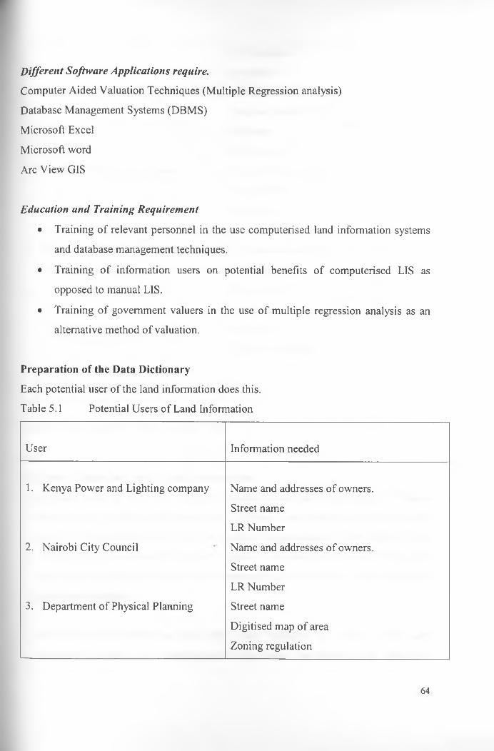
Different Software Applications require.
Computer Aided Valuation Techniques (Multiple Regression analysis)Database Management Systems (DBMS)Microsoft Excel Microsoft word Arc View GIS
Education and Training Requirement
• Training of relevant personnel in the use computerised land information systems and database management techniques.
• Training of information users on potential benefits of computerised LIS as opposed to manual LIS.
• Training of government valuers in the use of multiple regression analysis as an alternative method of valuation.
Preparation of the Data DictionaryEach potential user of the land information does this. Table 5.1 Potential Users of Land Information
User Information needed
1. Kenya Power and Lighting company Name and addresses of owners.Street nameLR Number
2. Nairobi City Council Name and addresses of owners.Street nameLR Number
3. Department of Physical Planning Street name Digitised map of area Zoning regulation
64

LR NumbersPlot areas
4. Department of Surveys Street nameDigitised map of areaPlot areaLR Numbers
5. Ministry of Water Resources Digitised map of areaLR numbersPlot areasStreet name
6. Ministry of Roads, Public Works and Digitised map of areaHousing LR Numbers
Street nameStreet sizePlot ratiosZoning regulations
Source: The Researcher's own construct, 2003
Step 2LIS Data (Spatial and Non-Spatial) Automation1. Digitised map of the study area was obtained from the Department of Physical
planning and digitised to incorporate the different layers that the researcher would need to construct the sample LIS. The graphical representation of the Digitised map of the study area is shown in Figure 5.1 below. Each land parcel is well demarcated and its non-spatial data entered in the corresponding attribute table derived form the automated database. %
Each layer incorporated on the digital map represents an aspect of the land information needed for a comprehensive data bank. The layers on the map have
65

subsequent attribute tables that enable the spatial and the non-spatial information to be accesses simultaneously. This makes land information retrieval much easier compared to the manual method of record storage currently in use.
Figure 5.1 Plots layer
5.2.1 Demonstration of the ease of Retrieval of Information using Arc-view GISThe following examples show data retrieval capabilities using Arc-view GIS.When one wants to identify all the properties that are equal or more than one acre in area, the syntax area > or = to 1 is entered using the query builder built in the system and the graphical representation of the same are shown as above. The properties marked in yellow are those that have areas equal to or greater than 1 acre. Figures 5.1 and 5.2 below show the syntax and the resultant map giving the specified properties in yellow. It is possible for one to view the non-spatial information for each selected property by merely clicking onto it.
66

Figure 5.2 Syntax for Properties with Area>= 1
Figure 5.3 Querying using Arc View GIS
>5 ArcView GIS 3.2a |E y |s s |[a ll» l3 d l^ N ia iM lf f |e ]Eile Edit View Iheme Surface Graphics Window HelpLg HMD EBB) lIBBlIBBSga HE] ®eTitlM-bl<aialf?i^l/i;«iHTi -j i n sc* r 65.164.44 ~
472.867.12 t
V R o jd s 1 .s _ t
A/_J Parcel bd
A/i f BuildingsCDi f Plots.shp
2:34 PM
Microsoft Word • PJ ^ A ic V ie w GIS 3.2a
ij^ S ta r t l £ 1 Google Search: informatio... 0 1 information management •...
67

Clicking on one specific property shows all the non-spatial attributes of the property, the officer dealing with the client seeking to pay their rents can use this.Example of this is shown here below;
Figure 5.4 Identification of database contents
V ' R o a d s l . s h p _±.
/V_| Parce l bdy.shp
/V ,V Buildings l .s h p
d e n tify R e su lts
Plots, shp • 6610 4k Shape I PolygonId ! 72Rent i oLr number 1 6610Area i 2.37000Value | 0Date rev — I
i— Owner I xxxxx— Usv rate ! 10066606
Clear | Clear All Lii_____ _____I I T1--------------------------n-----------m S tart | Google Search: informatio... | information management 2:41 PM
5.2.2 Potentials in the use of Microsoft Excel spreadsheets for Rent ReviewMicrosoft Excel can be used for rent reviews because of the ease in calculation as opposed to the manual methods of arithmetic calculations. The value per acre is obtained using multiple regression analysis. The different attributes affecting value are entered into a Regression model and the value for each property derived. After the value per property has been determined using the multiple regression value modeling, the land reference number, value of land, area, current rents payable, rate of vale to be reserved as rent are entered into an Excel spreadsheet. The new rents can then be reviewed periodically by using the arithmetic functions of the software. This has been done for selected properties within the Nairobi Hill area and the following results obtained;
68

5.3 Sample Land Information system for rent review for selected properties in Nairobi Hill.
LR NO. Area Value per acre % Value Current New Rent Differenc<Acr.) of Value Rents e
A 1.046 25.000.000 5% 26150000 0 1307500 1307500B 0.577 25.000.000 5% 14425000 0 721250 721250C 05 25.000.000 5% 12500000 0 625000 625000D 1.208 25,000.000 5% 30200000 14.5 1510000 1509986E 0.952
925,000.000 5% 23805000 11.4 1190250 1190239
F£
0.986 25.000.000 5% 24650000 46.200 1232500 1186300G 0.982 25.000.000 5% 24550000 46.200 1227500 1181300H 4 25,000.000 5% 100000000 72 5000000 4999928I 2 25.000.000 5% 50000000 144 2500000 2499856J 0.804 25.000.000 5% 20100000 58 1005000 1004942K 1.202 25.000.000 5% 30050000 86 1502500 1502414L 1.993 25.000.000 5% 49825000 425.435 2491250 2065815M 1.616 25.000.000 5% 40400000 0 2020000 2020000N 1.058 25.000.000 5% 26450000 70.5 1322500 13224300 0.659
<25.000.000 5% 16487500 46,620 824375 777755
PJ
0.902 25.000.000 5% 22550000 1420 1127500 1126080Q 1.144 25.000.000 5% 28600000 72 1430000 1429928R 0.91 25.000.000 5% 22750000 47.360 1137500 1090140S 2 25.000.000 .. 5% 50000000 126.410 2500000 23735901 1.992 25.000.000 5% 49800000 2 2490000 2489998U 0.932 25.000.000 5% 23300000 720.000 1165000 445000V 0.917 25.000.000 5% 22925000 86.000 1146250 1060250w 1.987 25.000.000 5% 49675000 72 2483750 2483678X 1.991 25.000.000 5% 49775000 101.225 2488750 2387525
69

Y 5 25.000.000 5% 125000000 144 6250000 6249856Z 3.71 25.000.000 5% 92750000 72 4637500 4637428AA 2.73 25.000.000 5% 68250000 0 3412500 3412500BB 0.587 25.000.000 5% 14675000 238 733750 733512CC 1.601 25.000.000 5% 40025000 280 2001250 2000970DP 1.56 25.000.000 5% 39000000 1100 1950000 1948900EE 1.53 ' 25.000.000 5% 38250000 79.990 1912500 1832510FF 23 25.000.000 5% 57500000 144 2875000 2874856GG 1.53 25.000.000 5% 38250000 144 1912500 1912356HH 0.763 25.000.000 5% 19075000 142.470 953750 811280II 1.538 25.000.000 5% 38450000 36 1922500 1922464JJ 1.503 25.000.000 5% 37575000 72 1878750 1878678KK 1.602 25.000.000 5% 40050000 72 2002500 2002428LL 1.663 25.000.000 5% 41575000 72 2078750 2078678MM 2.74 25.000.000 5% 68500000 16.650 3425000 3408350NN 1.067 25.000.000 5% 26675000 57 1333750 13336930 0 I 25.000.000 5% 25000000 810 1250000 1249190PP 0.903 25.000.000 5% 22575000 24 1128750 1128726QQ JL5 25.000.000 5% 37500000 16.396 1875000 1858604RR 0.783 25.000.000 5% 19575000 72 978750 978678SS L5 25.000.000 5% 37500000 36 1875000 1874964TJ 0.25 25.000.000 5% 6250000 22 312500 312428u u i 25.000.000 5% 25000000 18.390 1250000 1231610v v 1.484 25.000.000 5% 37100000 19.885 1855000 1835115w w 1.295 25.000.000 5% 32375000 1750 1618750 1617000XX 1.153 25.000.000 -• 5% 28825000 3600 1441250 1437650YY 0.854 25.000.000 5% 21350000 53.590 1067500 1013910ZZ 3.55 25.000.000 5% 88750000 2880 4437500 4434620
% Total 2006518.4 98818375 96811857
70
Assuming that the value for properties in Nairobi Hill area is approximately Kenya Shillings25, 000,000 or US $ 312,500 per acre. This rate has been used on pro rata basis to obtain Freehold Capital Market Value for each individual property. Using Microsoft Excel, the loss in rent has been calculated and this stands at KShs. 96, 811,856.60 (Ninety Six Million, Eight Hundred and Eleven Thousand, Eight Hundred and fifty Six and Sixty Cents.) or US$ 1,210,148 (US Dollars One Million, Two Hundred and Ten Thousand, One Hundred and Forty Eight, for a sample Fifty-five Properties selected.
5.4 The use of LIS as a corporate ResourceOne of the objectives of this study is to examine how LIS can be used as a corporate resource. This was done by analysing situations where LIS has been used successfully as a corporate resource. Several countries with remarkable results have applied the use of LIS as a corporate resource. The experiences of Qatar and Nepal have been used to analyse the potentials for the use of LIS as a corporate resource in Kenya.
Kenya can learn several lessons from Qatar and use these to implement her own Corporate LIS.The key lessons that can be learnt from Qatar are;
□ The need for Government support in LIS implementation□ Setting up a data control center to collect all relevant data and be responsible for
the updating of this data□ To involve all LIS users at the initial stage to enable comprehensive data
collection that will take into account all user needs□ The elimination of duplication of the LIS by avoiding data redundancy and
sharing the data generated by the data-controlling agency.□ Many Government ministries and quasi government agencies will benefit from a
nationwide Corporate LIS. As such, teamwork needs to be fostered among these Government agencies, especially those involved in physical and infrastructure planning and environmental protection.
□ Policy governing LIS must be consistent and uniform for all government agencies
71

□ A reliable digitised mapping system that is uniform for all government agencies is crucial for the development of a reliable LIS
□ Continual updating of information such that all information contained in the LIS is current and user friendly
□ Online transmission of LIS to all stakeholders□ Educate staff on technology needs for a LIS implementation and maintenance.
The Land rent section of the Ministry of Lands and Settlement has linkages with several departments within the Ministry and other Ministries and Institutions. This fact enables the possibility of LIS use as a corporate resource in the following ways.
5.5 Potential Users of the Land Information The Department of Physical PlanningThe Department of Physical Planning would have the potential revenue base of different area within the City and this would be beneficial in planning for optimal use.
The Department of Surveys The available maps and socio-economic data developed by the department of lands would be beneficial to the Department of Survey in their different functions.
Ministry of Water Resources;The Ministry of Water resources would also benefit from the spatial and non-spatial data contained in the land information system as they strive to provide water for all. The Nairobi city council can then collect manage the water consumption and collect revenue in the form of water bills. The names and contacts of the landowners and tenants if need be will be available in the land information system.
Ministry of Public Works and Housingwould also use the information contained in the LIS to ensure good road network within\the Country. The spatial data shows the location of available roads and the flow of traffic anticipated.
72

Kenya Power and Lighting Corporation can also provide electricity and bill effectively using the common information. The use of LIS as a corporate resource will save the country a lot of resources that would otherwise be used as each organisation develops their own independent information system. A Common LIS ensures consistency of information used by the different service providers and government ministries.
5.6 Hypothesis TestingThe research hypothesis was, "A computerised LIS (Land information system) will result in potential of revenue collection and enable easy access to land rent land rent information".The result findings and analysis of data indicate that the hypothesis can be accepted based on the following;
The first aspect of the Hypothesis has been tested using the Microsoft Excel spreadsheet for rent review. The total amount reserved currently as annual rent payable stands at Kshs. 2,006,518 or US $ 25,018. The amount expected to be the reserved annual rent payable after harmonization of the figures is Kshs. 98,818,375 or US $ 1,235,000. The potential increase in land rent reserved as a result of ease of rent review using Microsoft Excel spreadsheets of annual rent payable is 5000 per cent above the current reserved rents. These figures can easily be revised periodically and made current because once the data is entered into the computers, they become easier to access and manage. A graphical representation of the current rents payable and potential rents is shown in Chart one below. This large difference in the current and potential rents payable can be attributed to the use of Computers for Land rent review. The hypothesis that a computerized LIS will result in the increased potential in revenue collection is therefore true.
The second aspect of the hypothesis, that computerized LIS will enable easier access to land rent record can be accepted based on the observation made in the ease of rent records retrieval using Arc-view XGIS described using Figures 5.1 - 5.4 above.
73

Variance in Rent
LR Numbers
■ N e w R e
□ C u rre n t
Chart 1
CHAPTER 6CONCLUSIONS AND RECOMMENDATIONS
6.0 IntroductionAt the onset of this study, the various aspects of problems of manual land information system at the land rent section and the rising concern for computerisation was discussed. The end result was there being a need for computerisation of land information systems at the land rent section of the department of lands at the Ministry of Lands and Settlement. The benefits of good information management were carefully analysed and the potentials in revenue collection were outlined.
The conceptual framework behind land rent determination and land information management was analysed using relevant related literature and different models that have been developed by certain scholars.
An overview of the functions of the Ministry of Lands and Settlement generally and the land rent section specifically were outlined and their importance in land information management observed. An overview of the Nairobi Hill area, selected for the demonstration of the sample LIS, was also made a brief insight into potential land value patterns indicated. The importance of the land rent section in revenue collection for the Government and its linkages with other Government departments and other ministries and organisations have been highlighted
6.1 ConclusionsThe research findings and analysis of data have brought to light several factors relating to the research problem.
The fact that the manual systpm of record keeping is inefficient as regard ease of information retrieval has come out very clearly. There is therefore a need for change to a more efficient means of information management in order to tap the full potentials of the
75

use of land information resource. The demonstration done using the Arc-View GIS software for land information retrieval shows the ease with which information can be retrieved from an automated database. The Arc-View GIS software has awesome capabilities of displaying both the spatial and the non-spatial aspects of land information for the benefit of both the literate and the illiterate members of the public.An analysis done using Microsoft Excel spreadsheet reveals the potentials in revenue that could be collected from the government leasehold properties in terms of land rent. The revenue so obtained would be beneficial in bridging the budgetary deficits currently faced in the country.
The study findings also revealed the fact the land rent records are not current. Outdated land rent records result in loss of revenue for the Government resulting from underpayment of annual rents since the rents reserved are much lower percentage of market values. There is therefore the need to review these records and harmonise the annual amounts reserved as land rent payment. The harmonisation of these amounts would result in equitable distribution of the rents payable by leaseholders with similar properties.
One of the study findings revealed that there are large amounts of monies owed to the Government in terms of un paid annual rents for leasehold properties. There is therefore need educate the leaseholders on the need to pay land rents annually. The research findings indicate that one of the reasons for these arrears is a lack of awareness of the need to pay annual land rents promptly. Another reason cited was the non-delivery of rent demand notes to the leaseholders due to inaccurate contact information.
Leaseholders do not pay their rents on time because the process of rent payment is very slow and cumbersome. Rather than spend a lot of time at the Land registry waiting in cue to pay land rents, they would rather not pay since there are no stringent penalties for nonpayment. This problem can be solved by the computerisation of land rent records which will make the process of rent payment less frustrating and will result in increased revenue collection.
76

There is an urgent need to solve the myriad problems associated with the current manual LIS to save the Government loss in untapped revenue and generate revenue by making the land records upto date. A policy framework must also support the LIS and legislation that would enable the enforcement of annual land rent payment. The issue of land information management is an area of global concern. Most countries in the developed world and some countries in the developing world have already computerised their LIS and are reaping benefits of efficient technology as a result.
6.2 RecommendationsSeveral research findings were arrived at after carefully analysis of the data collected. Several recommendations have been made based on those findings.
6.2.1 Construction of a Comprehensive Automated DatabaseThe importance of sound information management principles cannot be underscored. Computerisation of data and the processing of that data to form relevant information for use in land rent record management can solve the difficulties currently faced in the retrieval of land information. The computerised database can be made available for use by the different departments within the Ministry of Lands and Settlement and other organisations by the use of Intranet and Internet respectively. Each user of the land information would therefore have easy access to this information each time it is needed and many users can access the information simultaneously.
There is however a danger of making information readily available. The danger is that it would be susceptible to use by unaothorised persons. This danger can however be curbed by the use of data protection mechanisms like user names and passwords.
An automated and comprehensive database would enable the ease of preparing accurate statement of land rent accounts. *
77

6.2.2 The use of computer Aided Valuation TechniquesThe problem of outdated land rent records can be solved by the use of computer aided valuation techniques and land rent review using Excel spreadsheets. Land value modeling can be done with the development of a land value map for every area in the country to guide valuers on property values for specific areas. The use of mass appraisal techniques can also be used as it enables the valuation of larger geographic areas within relatively shorter time periods.
6.2.3 Strict Enforcement of LegislationImplementing strict Laws on non-payment can solve the problem of leaseholders not paying their rents on time. Frequent reminders should also be made in the media to create awareness of the need for annual land rent payment. Implementation of the law- stipulating auction of properties should also be done to serve as an example to leaseholders that do not pay their rents. The Government should embark on rent arrears collection campaign and issue out deadlines for such payment and stiff penalties for failure to pay within the stipulated time period.
6.2.4 Improved Communication NetworkThe problem of rent demand notes communication to the leaseholder can be solved by electronic communication. Each leaseholder should give the names of their employers or e-mail addresses or banks, where the information on land rent demand can be sent electronically.
6.2.5 Staff Training in the use of Computerised LISChange is not easy. Many people have* eyed computers with a lot of suspicion. The personnel employed in the land rent section must be educated in the use of computers so that they will be able to perform their functions efficiently. A computerised LIS cannot bring about change unless there is competent personnel to use it. Computers will cut down the need for many clerical staff, especially those employed to manually retrieve land rent records. With the advent of computerisation, these employees will be rendered
78

should therefore be re-deployed or trained in other fields like maintenance of the computers or inputting of data into the databases.
6.2.6 Decentralisation of Land Rent PaymentCurrently, the payment of land rent is limited to land offices or their respective revenue offices all over the country. The use of alternative payment points should be established to reduce over crowding at the land offices, especially as the deadline approaches. These alternative payment points could include commercial banks, grocery stores, parastatal offices and other convenient places.
6.3 Policy ImplicationsFor the effective collection of land rent, policies must be formulated that ensure stringent penalties for non-payment. The present penalty of interest rates payment per period for non-payment has failed to prompt leaseholders to pay their rents on time. The legislation on land rent payment recommends that only 1% of Unimproved Site Value should be reserved as rent. This figure is quite low and requires to be revised. The current rate used by the valuation section of the Ministry of Lands for land rent determination is actually 5%.
Land being a common Heritage for all Kenyans must be managed effectively and optimise its productivity. Legislation enforcing the payment of annual land rent must be put in place so that incidences of non-payment are reduced or eradicated completely.
A National Land Authority and Land Information Management Department needs to be established so that the land resource can be managed effectively.
6.5 Areas for Further ResearchAreas of further research would include;
1. Land value modelling for land rent determination and digital mapping of all spatial information contained within the land registries.
79

2. The viability of the concept of e-government can also be investigated and the potential costs and benefits addressed.
3. The costs and benefits ogf digital mapping by the survey department.4. The use of multiple regression analysis for stamp duty and land rent revision
valuation in comparison to the current valuation methods
80

BIBLIOGRAPHY
Abbot, D. M., (1987) Encyclopaedia of Real Estate Terms. England: Gower Technical Press,
Ahituv, N., and Newman, S. (1990). Principles of International systems for management. C Brown Publishing Dubuque Wm.
Amami, M and Bethink, G (2000) Project Management and Communication of Product Development through electronic document Management. Project Management Journal, PP 19
Anyang Nyongo (2003), the Way Forward in It Policy; A Paper presented at the Strathmore University It Conference: Emerging Trends in IT, Nairobi Kenya.
Barton, P (1985): Information systems in Construction Management’ London Bastford Academic Educational Press.
Berry, B.J. L and Horten F. E., (1965) Spatial Analysis: A Reader in Statistical Geography. New Jersey: Prentice Hall, Inc.
Brutton, W., Davies, K. and Johnson, T., (1980) Modern Methods of Valuation. London:\the Estates Gazette Limited.
81

Charjee (1997) Regression Analysis by Example; New York, John Wiley and Sons.
Groot and Molen, P. (2000), Workshop on Capacity Building in Land Administration for Developign Countries, ITC, Eschnede, the Netherlands.
Hartubise, R (1984) Applied Linear Regression Models, Chicago Times Mirror Education Group Inc.
Hicks, U.(1970). "Can Land be Assessed for Purposes of site Value Taxation?' in Holland D. M. (ed.), The Assessment of Land Value. London: The University of Wisconsin Press.
Hunger, D. J. and Wheelen, T. L. (1997), Essentials of Strategic Management: Addison Wesley, Boston USA.
Kingoriah, G. K., (1987). Introduction to Land Economics, University of Nairobi Press.
Konyimbih Tom M, (1996) Aspects of Rating Practice in Kenya, (An Agenda for Panel Discussion), March 4 - 7 , Regional Pilot workshop on Property Tax in Anglophone Africa. Harare Zimbabwe.
Leedy P D (1993) Practical Research Planning and Design Fifth Ed. Macmillan Publishing Press. '
82

Macoco, D. K., Geomatics in the 3rd Millennium: A Paper presented at the ISK Seminar: The Surveying Profession in the year 2002 and Beyond.
Mugenda Abel (1996) Research Methods, Acts Press.
Miles, C.W.N. and Seabrooke, W., (1977) Recreation Land Management. London: E.F.N. Spon Limited.
Mills, E., 'the Value of Land' (1970) in Harvey, S.P (ed.), the Quality of the Urban environment. Baltimore: John Hopkins University Press for Resources for the Future, Inc. Murphy, L. T. (1989) ^Determining Appropriate Equation in Multiple Regression Analysis”, the Appraisal Journal; October 1989, pp498 -517
Nairobi Town Planning Committee, 1993, Proposed Replanning and rezoning of Hill and Kilimani areas, Published by the Ministry of Lands and Settlement.
Neter et al (1996) Applied Linear Regression Models, Chicago, Times Mirror Education Group Inc.
Obudho, R.A 1997; Nairobi: National Capital and Regional Hub.
Olima, W.H.A., 2001; The Dynamics and Implications of Sustaining Urban Spatial Segregation in Kenya: experience from the Nairobi Metroplis; paper presented at the
83

international seminar on segregation in the City, Lincoln Institute of Land Policy Cambridge MA.
Ondiege, P.0 1989; Urban Land and residential market analysis in Kenya; Urbari Management programme. UNCHS (Habitat) report, Nairobi Kenya.
Racodi C. 1997; The Urban Challenge in Africa; the Growth and Management of its large cities; United Nations University Press; New York USA
Republic of Kenya (1981) Handbook on Land use planning. Administration and procedures.; Government printers
Republic of Kenya, Government Land Act. Cap 280 of the Laws of Kenya; Government Printers.
Republic of Kenya, Registration of Titles Act Cap 281 of the Laws of Kenya Government Printers.
Republic of Kenya., Land Titles Act Cap 282 of the Laws of Kenya. Government Printers.
Republic of Kenya., (2002 - 2008) National Development Plan, Government Printers.
84
Republic of Kenya., (2002) Report of the Commission of Inquiry into the Land Law system of Kenya on the Principles of a National Land Policy Framework for Land Administration. Government Printers.
Racodi, C.,' Land Markets in sub-Saharan African Cities: A Review'., University of Wales. Cardiff, 199.
Syagga, P. M., 1994; Real Estate Valuation Handbook with special reference to Kenya; Nairobi University Printing Press.
Tuladhar, A. M. (2002) Developing a Framework for Cadastre and Land Registration Systems in Land Administration Organisations, A Paper Presented at the FIG XXII International Congress, Washington D.C., USA.
United Nations, Land Administration Guidelines.. (1999), United Nations Publications.
UN-FIG., (1996)., the Bogor Declaration, United Nations Publication.
United Nations Centre for Human Settlements (UNCHS)., (1999) Land Information systems for Developing Countries. United Nations Publications.
Williamson, I., and Ting L.'(2001). Land Administration and Cadastral Trend - A Framework for re-engineering. Computer Environment and Urban Systems, an
85

International Journal; Cadastral Systems. Edited by C. Lemmen and P. van Oosterome’ Elsevier Science Limited.
Yeates, M. (1965) "Some Factors affecting the Spatial Distribution of Chicago Land Values'. Economic Geography XLI: 55 - 70
86

AppendixCase Study 1LIS AS A CORPORATE RESOURCE IN QATARIntroductionQatar lies in the Middle East in the Asian Continent. It sits on the East Coast of Saudi Arabia, on the Arabian Gulf. Qatar is a small country falling between Latitudes 24° 27' North and Longitudes 50° 45’ and 51° 40’ East covering an area of 11,521 sq. km. The peninsula is approximately 165 km in length and 75 km in width. Qatar is the first country to implement a comprehensive and nationwide GIS, internationally recognised as one of the finest GIS implementations in the World. The GISnet links all agencies using GIS in Qatar, which is a dedicated 100 megabytes per secede FDDI fibre optic network. To date there are nineteen Government Agencies and Quasi Government agencies using fully integrated GIS in their day-to-day activities. This is a remarkable achievement considering that not even street names and addresses, which are central blocks for any Georefrenced information, were in place prior to the implementation of GIS. The foundation stone for this remarkable success was laid down, in 1989, by the then Government Official Sheikh Ahmed bin Hamd al Thani refered to as the champion o GIS in Qatar.
Information is becoming vital day by day in making sound decisions at the local, state, national level planning in infrastructure development. Disaster management, natural resource management, business development, implementation of action plans etc. and many more fields incorporating spatial data in their analysis. GIS have emerged as a great technology dealing with spatial data. The advancement of Computer hardware and software technology with lowering costs and availability of more and more hard disk space and memory available to users at nominal cast has led to the increased production of spatial information and making it digitally available and compatible with other databases to satisfy specific needs.
87

The efforts of organisations however lead to duplication of efforts. The cost of creating and maintaining digital data is high and therefore it is important for organisations to share data and technology so as to avoid duplication and at the same time, ensure full utilisation of data. The spatial data in most of the countries is controlled by the Government sector; therefore, the federal laws concerning data sharing and interagency co-operation are most important. Further, the data sharing can be viewed in terms of organisational and technological data sharing. The organisational data sharing is seen as the free use of another entity’s data sets, in manual or automated form.
The technological data sharing is the capability to have one agencies data used by another entity's automated system. Qatar has experienced great success in using Ls as a corporate resource.
The Benefits of Using LIS as Corporate Resource as Experienced by QatarOne of the benefits experienced by Qatar in using LIS as a corporate resource is in theeffective planning and better co-operation between Government agencies. Agencies havebecome aware of each other’s needs and potential capabilities of technologies that can betapped have been addressed. The policy for data sharing as resulted in the availability ofOnlilne around the clock Common Spatial ReferenceIdentified Core agency for MappingFibre Optic Network physically connecting the agenciesQuick delivery of servicesPreserving the National FleritageGlobal Outreach through the World wide WebEffective planning and better co-ordination of the Government Agencies Resource savings by many departments "in developing a digital database for Qatar.
Some of the agencies involved in the LIS Corporate resource sharing include; the area referencing system, Real Estate Agencies, Qatar Telecommunication, Drainage, Electricity and Water Database. It is also used in the conducting of censuses and socio
88

economic surveys. Public Utility tasks, which previously used to take 6 - 8 weeks, is now completed in as early as a day resulting in time savings.Qatar LIS Corporate Resource Sharing - Governing Forces and ChallengesIn an article, published in the Geo Info systems magazine by Nancy Tosta, 1997, a director of forecasting and growth strategy PSRC, Seattle, Washington has asserted that the following factors made the nationwide LIS co-ordination possible in Qatar:Highest level Political supportPolitical will an authority to mandate and enforce standards Outstanding technical leadershipSmall and relatively uncomplicated geography ot the areaFew InstitutionsAdequate fundingLittle Existing GIS activity.
In spite of the remarkable achievements in setting up a countrywide shared geographic data policy, strictly based on principles ot following same standards and norms set forth for each agency, Qatar GIS still faces challenges in areas such as data capturing, data updating, demand for processed data, trends in data_concepts, adaptation of technology, data security, advanced GIS tools and trained motivated manpower.
/
U\/M/frp ^ Ou i
89