comparative accuracies of artiï¬cial neural networks and
TRANSCRIPT

Computers and Electronics in Agriculture
24 (1999) 131–151
Comparative accuracies of artificial neuralnetworks and discriminant analysis in
predicting forest cover types from cartographicvariables
Jock A. Blackard 1, Denis J. Dean*Remote Sensing and GIS Program, Department of Forest Sciences, 113 Forestry Building,
Colorado State Uni6ersity, Fort Collins, CO 80523, USA
Received 29 October 1998; received in revised form 12 February 1999; accepted 3 August 1999
Abstract
This study compared two alternative techniques for predicting forest cover types fromcartographic variables. The study evaluated four wilderness areas in the Roosevelt NationalForest, located in the Front Range of northern Colorado. Cover type data came from USForest Service inventory information, while the cartographic variables used to predict covertype consisted of elevation, aspect, and other information derived from standard digitalspatial data processed in a geographic information system (GIS). The results of thecomparison indicated that a feedforward artificial neural network model more accuratelypredicted forest cover type than did a traditional statistical model based on Gaussiandiscriminant analysis. © 1999 Elsevier Science B.V. All rights reserved.
Keywords: Artificial intelligence; Discriminant analysis; Forest cover types; Geographic informationsystems (GIS); Neural networks; Spatial modeling
www.elsevier.com/locate/compag
* Corresponding author. Tel.: +1-970-4912378; fax: +1-970-4916754.E-mail address: [email protected] (D.J. Dean)1 Present address: US Forest Service, Ecosystem Management Analysis Center, 3825 East Mulberry
Street, Fort Collins, CO 80524, USA.
0168-1699/99/$ - see front matter © 1999 Elsevier Science B.V. All rights reserved.
PII: S0168 -1699 (99 )00046 -0

J.A. Blackard, D.J. Dean / Computers and Electronics in Agriculture 24 (1999) 131–151132
1. Introduction
Accurate natural resource inventory information is vital to any private, state, orfederal land management agency. Forest cover type is one of the most basiccharacteristics recorded in such inventories. Generally, cover type data is eitherdirectly recorded by field personnel or estimated from remotely sensed data. Bothof these techniques may be prohibitively time consuming and/or costly in somesituations. Furthermore, an agency may find it useful to have inventory informationfor adjoining lands that are not directly under its control, where it is ofteneconomically or legally impossible to collect inventory data. Predictive modelsprovide an alternative method for obtaining such data.
Compared to statistical models, artificial neural networks (ANNs) represent arelatively new approach to developing predictive models. Artificial neural networksare ‘‘computing devices that use design principles similar to the design of theinformation-processing system of the human brain’’ (Bharath and Drosen, 1993, p.xvii). Several recent textbooks describe the mechanics of ANNs (Hertz et al., 1991;Haykin, 1994; Masters, 1994; Bishop, 1995; Ripley, 1996). Recent publicationsinvolving artificial neural networks being applied to natural resources topicsinclude: modeling complex biophysical interactions for resource planning applica-tions (Gimblett and Ball, 1995); generating terrain textures from a digital elevationmodel and remotely sensed data (Alvarez, 1995); modeling individual tree survivalprobabilities (Guan and Gertner, 1995); and Harvey and Dean (1996), who usedgeographic information systems (GIS) in developing computer-aided visualizationof proposed road networks. Recent comparisons in which ANNs performedfavorably against conventional statistical approaches include Reibnegger et al.(1991), Patuwo et al. (1993), Yoon et al. (1993), Marzban and Stumpf (1996),Paruelo and Tomasel (1996), Pattie and Haas (1996), and Marzban et al. (1997).
However, artificial neural networks do not always outperform traditional predic-tive models. For example, Jan (1997) found a traditional maximum-likelihoodclassifier outperformed artificial neural network models when classifying remotelysensed crop data. Also, using their best artificial neural network model, Vega-Gar-cia et al. (1996) obtained only a slight improvement in predicting human-causedwildfire occurrences as compared to their best logit model.
This study examined the ability of an ANN model to predict forest cover typeclasses in forested areas that have experienced relatively little direct human manage-ment activities in the recent past. The predictions produced by the ANN modelwere evaluated based on how well they corresponded with observed cover types(absolute accuracy), and on their relative accuracy compared to predictions madeby a more conventional model based on discriminant analysis (DA).
2. Data description
The study area for this project consisted of the Rawah (29 628 hectares or 73 213acres), Comanche Peak (27 389 hectares or 67 680 acres), Neota (3904 hectares or

J.A. Blackard, D.J. Dean / Computers and Electronics in Agriculture 24 (1999) 131–151 133
9647 acres), and Cache la Poudre (3817 hectares or 9433 acres) wilderness areas ofthe Roosevelt National Forest in northern Colorado. As shown in Fig. 1, theseareas are located �70 miles northwest of Denver, Colorado. These wildernessareas were selected because they contained forested lands that have experiencedrelatively little direct human management disturbances. As a consequence, thecurrent composition of forest cover types within these areas are primarily a resultof natural ecological processes rather than the product of active forest management.
In this study, the ANN and DA models utilized a supervised classificationprocedure to classify each observation into one of seven mutually exclusive forestcover type classes. The seven forest cover type classes used in this study werelodgepole pine (Pinus contorta), spruce/fir (Picea engelmannii and Abies lasiocarpa),ponderosa pine (Pinus ponderosa), Douglas-fir (Pseudotsuga menziesii ), aspen (Pop-ulus tremuloides), cottonwood/willow (Populus angustifolia, Populus deltoides, Salixbebbiana, Salix amygdaloides), and krummholz. The krummholz forest cover typeclass is composed primarily of Engelmann spruce (Picea engelmannii ), subalpine fir(Abies lasiocarpa), and Rocky Mountain bristlecone pine (Pinus aristata) in thesewilderness areas. These seven cover type classes were chosen for this research sincethey represent the primary dominant tree species currently found in the fourwilderness areas. A few other forest cover types exist in small patches within thestudy area, however, these relatively minor cover types have been ignored in thisanalysis. Cover type maps for these areas were created by the US Forest Service,and are based on homogeneous stands varying in size from 2 to 80 hectares (from5 to 200 acres) that were derived from large-scale aerial photography.
Fig. 1. Study area location map.

J.A. Blackard, D.J. Dean / Computers and Electronics in Agriculture 24 (1999) 131–151134
For this study, digital spatial data obtained from the US Geological Survey(USGS) and the US Forest Service (USFS) were used to derive independentvariables for the predictive models. The following 12 variables (with their units ofmeasure) were used:
1. Elevation (m),2. Aspect (azimuth from true north),3. Slope (°),4. Horizontal distance to nearest surface water feature (m),5. Vertical distance to nearest surface water feature (m),6. Horizontal distance to nearest roadway (m),7. A relative measure of incident sunlight at 09:00 h on the summer solstice
(index),8. A relative measure of incident sunlight at noon on the summer solstice (index),9. A relative measure of incident sunlight at 15:00 h on the summer solstice
(index),10. Horizontal distance to nearest historic wildfire ignition point (m),11. Wilderness area designation (four binary values, one for each wilderness area),
and12. Soil type designation (40 binary values, one for each soil type).
Elevation was obtained directly from USGS digital elevation model (DEM) data,based on 30×30-m raster cells (1:24 000 scale). This DEM data was used tostandardize all remaining data, so each observation in this study represents aunique 30×30-m raster cell that corresponds to USGS DEM data. Aspect, slope,and the three relative measures of incident sunlight were developed from this DEMusing standard GIS-based surface analysis and hillshading procedures (Environ-mental Systems Research Institute, 1991). Horizontal distance to the nearest surfacewater feature and horizontal distance to the nearest roadway were obtained byapplying Euclidean distance analyses to USGS hydrologic and transportation data.Horizontal distance to the nearest historic wildfire ignition point was determined byusing Euclidean distance analyses with a USFS wildfire ignition point coverage,which identified ignition points of forest wildfires occurring over the past 20 years.Vertical distance above or below the nearest surface water feature were calculatedusing a combination of the DEM, hydrologic data, and a simple custom-builtspatial analysis program.
Both soil type information and wilderness area designation were obtained fromthe USFS. These qualitative variables were treated as multiple binary values. Thisresulted in a series of variables for each raster cell, where a value of ‘0’ wouldrepresent an ‘absence’ and a value of ‘1’ would represent a ‘presence’ of a specificwilderness area or soil type (Huberty, 1994, p. 151; Bishop, 1995, p. 300). A totalof four wilderness areas and 40 soil type classes were used in this study, producingfour wilderness area designator variables, forty soil type designator variables, andten continuous variables for a total of 54 possible independent variables availablefor each model.
The data used in this study were produced primarily by using standard GISprocedures with ARC/INFO software, version 7.2.1, and the GRID module

J.A. Blackard, D.J. Dean / Computers and Electronics in Agriculture 24 (1999) 131–151 135
(Environmental Systems Research Institute, 1991). Several software packages wereused within a UNIX Sun Sparc workstation environment for data analysis andmodel development. The feedforward artificial neural network models were devel-oped using PROPAGATOR software, version 1.0 (ARD Corporation, 1993). Inaddition, the discriminant analysis models were created using the statistical proce-dures available from SAS software, version 6.11 (SAS Institute, Inc., 1989). Thesepredictive models were then implemented using custom-built GIS macros andembedded ‘C’ programs.
3. Data set selection
For this study, three mutually exclusive and distinct data sets were created totrain, validate, and test the predictive models. A training data set was used todevelop classifiers for both the artificial neural network and the discriminantanalysis predictive models. The validation data set was used in the development ofthe feedforward artificial neural network models, to identify the point in thetraining process where the network begins to ‘overfit’ (memorize) the training dataset, and consequently loses its ability to generalize against unforeseen data inputs.The validation data set, however, is not required in the development of discriminantanalysis models, and consequently was not utilized for that purpose in this study.Finally, for both the artificial neural network and the discriminant analysis models,the test data set was used to determine how well each classifier would performagainst a data set that was not used in the creation of the predictive model.
These three data sets were selected from a total of 581 012 observations (30×30-m raster cells) encompassing �52 291 hectares (129 213 acres) of the study area.Each observation contained information for every independent and response vari-able used in the study (e.g. no observations contain ‘missing data’).
All observations were initially pooled into one very large data set for the wholestudy area. Then two subsets were extracted from the full data set. The firstextracted set contained 1620 randomly selected observations for each of the sevencover types (11 340 total observations) and became the training data set. Thisnumber (1620 observations per cover type) was chosen because it represented�60% of the number of observations available in the least numerous cover type(cottonwood/willow), and utilizing �60% of the available data for training is aneffective use of data (Anderson, Department of Computer Science, Colorado StateUniversity, 1996, personal communication).
The second data set extracted from the remaining data contained 540 randomlyselected observations for each cover type (3780 total observations) and became thevalidation data set. This number (540) of observations represents �20% of theobservations available for the cottonwood/willow cover type. Finally, all remainingobservations (565 892) were placed in the testing data set. Table 1 lists the numberof observations within each cover type for the three data sets. As shown in Table1, the training and validation data sets are represented by an equal number ofrandomly selected observations per cover type, while the test data set reflects themore realistic proportions of cover types found in the study area.

J.A. Blackard, D.J. Dean / Computers and Electronics in Agriculture 24 (1999) 131–151136
Table 1Number of observations within each forest cover type class for each data set
Training data setForest cover Validation data Total observationsTest data setper cover typeobservationsset observationsobservationstype class
209 680 211 840Spruce/fir 1620 540281 141 283 301540Lodgepole pine 1620
5401620 33 594 35 754Ponderosa pine1620Cottonwood/ 540 587 2747
willow73331620 9493540Aspen
1620 540 15 207 17 367Douglas-fir18 350 20 5105401620Krummholz
Total observa- 11 340 3780 565 892 581 012tions per dataset
All variables in the three data sets used by the artificial neural network modelwere linearly scaled to lie in the range between zero and one. This scaling tookplace across all three data sets combined, not individually within each data set.Scaling is highly recommended in the development of artificial neural networkswhere the ranges of values among independent variables are not similar (Marzbanand Stumpf, 1996). In addition, the response (dependent) variables in the threeartificial neural network data sets were coded as a series of seven binary variables,much like the soil type and wilderness area designator variables described previ-ously. This was done so that the response variables would conform to thearchitecture of the artificial neural network (seven output nodes). In contrast, theresponse variable in the discriminant analysis data set was coded as a single variablethat assumed integer values from one to seven. Other than this, the data sets usedfor discriminant and artificial neural network analyses were identical.
4. Artificial neural network specifications
Artificial neural network models require several architectural and trainingparameters to be selected prior to analysis. The optimal number of hidden layersand the number of nodes per hidden layer are generally not known a priori for aspecific data set, and must be empirically determined through an examination ofdifferent parameter settings (Haykin, 1994; Marzban and Stumpf, 1996). In thisstudy one hidden layer was used, which past studies have found to be sufficient inmost situations (Wong et al., 1995; Fowler and Clarke, 1996).
Determining the optimal number of nodes to place in this single hidden layer isa difficult process. Although several ‘rules of thumb’ exist concerning the optimalnumber of hidden nodes for a network, no method is universally appropriate sincethe number of nodes depends on the complexity of the problem to be solved(Fowler and Clarke, 1996). By systematically experimenting with the number of

J.A. Blackard, D.J. Dean / Computers and Electronics in Agriculture 24 (1999) 131–151 137
hidden nodes in a network, the best fit may be found without making any a prioriassumptions (Marzban and Stumpf, 1996).
In addition to parameters defining the network’s architecture, training parame-ters are also required to initialize the learning algorithm used by the network.Backpropagation was the learning algorithm chosen for this study, for no otherreason than it is the best known and most common algorithm in use today (Hertzet al., 1991; Gimblett and Ball, 1995; Guan and Gertner, 1995; Markham andRagsdale, 1995; Wong et al., 1995). Backpropagation requires two initializationparameters, termed the learning rate and the momentum rate. Once again, it is notpossible to know a priori optimal values for these parameters for a specific data set,so another trial-and-error process is needed to determine acceptable values.
Once the network architecture and training parameters are selected, an artificialneural network is trained iteratively. Each iteration represents one complete passthrough a training data set (an epoch). At the conclusion of each iteration, ameasure of discrepancy between observed and predicted values of the dependentvariable is calculated. This discrepancy is often expressed as a mean square error(MSE), which for this study was the error function:
E(w)=1
2N%N
n=1
%k
i=1
(di(n)−yi(n))2 (1)
where E(w) is the mean square error term, w are the synaptic weights to beestimated, N is the number of observation (input) vectors presented to the network,n is a single observation vector, k is the number of output nodes, i is a single outputnode, di(n) is the observed response and yi(n) is the predicted response forobservation n and output node i (Rumelhart et al., 1986; Hertz et al., 1991; Jan,1997; Marzban et al., 1997). The N observation vectors constitute a training dataset, which is used specifically to ‘teach’ the network to recognize the relationshipsbetween the independent and dependent variables (e.g. to develop a classifier). Thisclassifier will consequently be used to predict class membership for other vectors ofinput variables not included in the training data set. Theoretically, the backpropa-gation algorithm ultimately finds a set of weights w that minimizes E(w).
All artificial neural network models in this study had fully connected input,hidden, and output layers (i.e. each node in layer m was connected to all nodes inlayer m+1). The generalized delta rule with gradient descent (commonly used withthe backpropagation learning algorithm) was utilized in each network’s learningprocess. The activation function for each network’s input layer was linear [ f(x)=x ], while hidden and output layers utilized logistic activation functions [ f(x)=1/(1+ exp(−x))]. Initial synaptic weights were randomly selected between negativeone and positive one, based on a random seed and no input noise. All inputvariables were linearly scaled to lie in the range between zero and one.
Training patterns were presented to the network in a random order, with anupdate of the validation data set MSE at an interval of every ten epochs throughthe training data set. Training was halted after either (1) a minimum of 1000training epochs had been completed, (2) a validation MSE of 0.05 was reached, or(3) it was subjectively determined that the validation MSE would not significantly

J.A. Blackard, D.J. Dean / Computers and Electronics in Agriculture 24 (1999) 131–151138
decrease with further training epochs. The stopping criteria listed above are basedon previous experience in the development of artificial neural network models witha similar data set (Blackard and Dean, 1996), training results obtained from severalpreliminary networks utilizing the same data set employed in this current study, andavailable computer resources.
Finally, after the network parameters were chosen via experimentation, thoseparameters that produced the artificial neural network judged to be ‘best’ were usedto produce an additional 30 networks, each with the same parameters but with adifferent set of initial random synaptic weights. These additional networks weredeveloped since artificial neural network methods are, to a degree, based onrandom processes (e.g. each ANN model is developed based in part on a set ofrandomly chosen initial synaptic weights). In addition, the method of gradientdescent commonly used in artificial neural network strategy does not alwaysprovide for the global minimum in error space. Thus, an indication of the nature ofthe response surface may be obtained from analyzing the results of these 30networks.
5. Discriminant analysis considerations
Extensive discussions of discriminant analysis may be found in Johnson andWichern (1992), McLachlan (1992)and Huberty (1994). Discriminant analysis isbased upon two main assumptions. The first is that the distributions of allindependent variables are normal (Gaussian), which encourages the use of continu-ous rather than discrete data in the predictive model. The second assumptionapplies only for linear discriminant analysis, in which the covariance matrices forthe different groups of observations are assumed to be equal (homoscedasticity)(Marzban et al., 1997). The second assumption is very restrictive and in practicerarely applies in full (Curram and Mingers, 1994). As McLachlan (1992) points outon p. 132, ‘‘…in practice, it is perhaps unlikely that homoscedasticity will holdexactly’’.
In practice, some amount of violation of these assumptions is common andappears to have minimal impact on results. McLachlan (1992), on p. 132, supportsthe use of the linear discriminant analysis model in situations where its assumptionsare violated: ‘‘…its good performance for discrete or mixed data in many situationsexplains the versatility and consequent popularity of linear discriminant analy-sis…’’. McLachlan (1992), on p. 16, also states: ‘‘In practical situations, somevariables in the feature vector X may be discrete. Often treating the discretevariables, in particular binary variables, as if they were normal in the formulationof the discriminant rule is satisfactory’’.
For linear discriminant analysis problems having both equal costs and equalprior probabilities between groups (or classes), each observation or unit will beclassified into that group which it is nearest in terms of some distance measureapplied within the space defined by the independent variables (Johnson andWichern, 1992, p. 535). Huberty (1994), on p. 55, describes a frequently used

J.A. Blackard, D.J. Dean / Computers and Electronics in Agriculture 24 (1999) 131–151 139
distance measure termed the Mahalanobis index, which determines the squareddistance between an observation vector unit u and the centroid for group g as:
Dug2 = (Xu−Xg)%Sg
−1(Xu−Xg) (2)
where Xu is the p×1 vector for observation u, Xg is the p×1 vector of means forgroup g, and Sg is the p×p covariance matrix for group g. This approach wasadapted in this study.
Both linear discriminant analysis (LDA) and quadratic discriminant analysis(QDA) were investigated in this study. However, the QDA model became unstablewhen qualitative or discrete variables were considered. The LDA model did notexhibit this type of behavior, and therefore was used more extensively than theQDA model.
6. Experimental design
One hidden layer was used in all of the artificial neural networks developed inthis study. The number of nodes in this single hidden layer was systematicallychanged across 14 possible values while holding constant the learning rate (LR) andmomentum rate (MR) training parameters. This procedure identified the number ofhidden nodes which produced the minimum error (MSE) of the validation data setunder the original LR and MR values. The number of hidden nodes was then heldconstant and the LR and MR parameters were sequentially changed to find the bestcombination of network architecture and training parameter values for this dataset. While a parallel approach would have been preferable to this sequentialapproach for determining ANN parameter values (to compensate for interdepen-dent effects), a parallel approach was not practical due to the length of timerequired for each computer run and the number of runs involved (one run isnecessary for each unique combination of network parameter values). Therefore, asequential approach was selected as a reasonable compromise between complete-ness and practicality. Table 2 lists the various architectural and training parametervalues investigated in this study.
Once the network parameters for the predictive model containing all 54 indepen-dent variables were selected, a number of other models with fewer input variableswere investigated. The same set of reduced models were investigated via discrimi-nant analysis. This was done to determine if fewer input variables would producemodels with similar predictive abilities, thereby identifying variables that did notcontribute to the overall predictive capability of the system.
One variable examined in this reduction process was the ‘horizontal distance tothe nearest wildfire ignition point’ measure, since it only provided an ignition pointand not a delineation of overall wildfire boundary nor an indication of fireintensity. Another variable investigated was the ‘wilderness area designation’ indi-cator, since it was a qualitative measure which may not reflect any true differencesbetween the wilderness areas. Also, the ‘soil type designation’ variables were eithergeneralized to produce 11 soil types rather than the original 40 types, or excluded

J.A.
Blackard,
D.J.
Dean
/C
omputers
andE
lectronicsin
Agriculture
24(1999)
131–
151140
Table 2Artificial neural network architectural and training parameter values
ANN model with 54 6ariables
Step 1: Select the optimal number of hidden nodes parameter from 14 possible values while holding constant LR=0.05 and MR=0.960 90 120 150 180 210Number of hidden nodes 2406 270 30012 18 24 30
Step 2: Hold the optimal number of hidden nodes parameter value (selected from step 1) constant, and determine the optimal learning rate (LR) andmomentum rate (MR) parameter values by systematically altering between their 42 possible combined values
0.30 –0.10 0.150.05Learning rates 0.20 0.250.8 0.9Momentum rates 0.3 0.4 0.5 0.6 0.7
ANN model with 53 or fewer 6ariables
Step 1: Select the optimal number of hidden nodes parameter from 14 possible values while holding constant LR=0.05 and MR=0.560 90 120 150 180Number of hidden nodes 2106 240 270 30012 18 24 30
Step 2: Hold the optimal number of hidden nodes parameter value (selected from step 1) constant, and determine the optimal learning rate (LR) andmomentum rate (MR) parameter values by systematically altering between their 30 possible combined values
0.30 –Learning rates 0.05 0.10 0.15 0.20 0.25– –0.7Momentum rates 0.3 0.4 0.60.5

J.A. Blackard, D.J. Dean / Computers and Electronics in Agriculture 24 (1999) 131–151 141
Table 3Number of input variable subsets examined in this study
Description of variablesNumber of independentvariables
Ten quantitative variables+four wilderness areas+40 soil types54Same as ‘54’ but excluding distance-to-wildfire-ignition-points53Ten quantitative variables+11 generalized soil types21
20 Same as ‘21’ but excluding distance-to-wildfire-ignition-points10 Ten quantitative variables only
Same as ‘10’ but excluding distance-to-wildfire-ignition-points9
from the model altogether. This was accomplished by objectively grouping those 40soil types into more generalized categories based solely on their climatic andgeologic associations. Table 3 lists the six sets of independent variables examined inthis study.
7. Results
The MSE values across all 14 different numbers of hidden nodes from the 54variable ANN models are shown in Fig. 2. Each of these networks held the LR and
Fig. 2. MSE for the different numbers of hidden nodes for the 54 variable ANN models (optimal valuefor this model is 120 hidden nodes).

J.A. Blackard, D.J. Dean / Computers and Electronics in Agriculture 24 (1999) 131–151142
Fig. 3. MSE of the validation data set for the 54 variable ANN model with 120 hidden nodes (optimalvalues for this model are a learning rate of 0.05 and a momentum rate of 0.5). MSE values are shownby momentum rates (spokes) and learning rates (symbols), and are equal along concentric lines of theplot.
MR values constant at 0.05 and 0.9, respectively. This figure shows that roughly120 hidden nodes were necessary to minimize the MSE in these networks.
Once the ‘best’ number of hidden nodes was identified, the learning rates andmomentum rates were sequentially changed to determine optimal values for theseparameters. Fig. 3 displays a radar plot of the resulting MSE values for 42 differentcandidate networks, all with 120 hidden nodes. As shown, a learning rate of 0.05generally produced the lowest MSE for each possible momentum rate. In addition,momentum rate values of 0.3, 0.4, and 0.5 appeared to have the lowest averageMSE among the various learning rates. The network model with the lowest MSEwas produced with an LR of 0.05 and an MR of 0.5.
From these results, a ANN design of 54 input nodes, 120 hidden nodes, andseven output nodes (symbolized as 54-120-7) with an LR=0.05 and MR=0.5 waschosen as ‘optimal’ for this data set. Optimal parameters for each of the reducedartificial neural network models were found in a similar fashion, and are shown inTable 4.
Classification accuracies produced by each model as calculated from the test dataset were also examined. As shown in Table 5, the ANN predictions of forest covertype produced an overall classification accuracy of 70.58%.

J.A. Blackard, D.J. Dean / Computers and Electronics in Agriculture 24 (1999) 131–151 143
Table 4Artificial neural network parameter values in this studya
Learning rate Momentum rateNetwork archi- Validation dataNumber of independentset MSEtecturevariables
54-120-7 0.05 0.5 0.2747540.5 0.29080.0553-120-753
0.0521-60-7 0.5 0.3061210.0520-60-7 0.5 0.336320
0.5 0.33120.1010 10-90-70.059-60-7 0.6 0.36999
a Network architecture values represent the number of input nodes, number of hidden nodes, and thenumber of output nodes (respectively) present in the network.
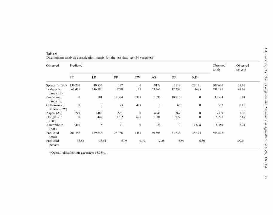
In comparison, Table 6 presents the LDA results obtained from the test data set.The overall classification accuracy for the DA model was 58.38%.
The ANN model was recreated an additional 30 times with randomly selectedinitial weights to evaluate the nature of the ANN’s response surface. The resultingmean classification accuracy was 70.52%, with a 95% confidence interval of70.26–70.80% and a standard deviation of 0.7293. This narrow confidence intervalindicates that the response surface is fairly smooth in the region surrounding thesolution found by the ANN.
The classification accuracies of each reduced model for both the ANN and theDA models were also determined. Fig. 4 compares these classification results for the
Fig. 4. Comparison of artificial neural network and discriminant analysis classification results (ann=ar-tificial neural network; lda= linear discriminant analysis; qda=quadratic discriminant analysis).

J.A.
Blackard,
D.J.
Dean
/C
omputers
andE
lectronicsin
Agriculture
24(1999)
131–
151144
Table 5Artificial neural network classification matrix for the test data set (54 variables)a
ObservedPredicted ObservedObservedpercenttotals
DF KRASSF CWPPLP
0 6683 481 12 244 209 680 37.05Spruce/fir (SF) 39 435150 397 44027 391 8796 2263 281 141 49.687350 871Lodgepole 186 050 5697
pine (LP)20122 625 5402 0 33 594 5.94258 25 295Ponderosa
pine (PP)0 563 0 9 0 587 0.100Cottonwood/ 15
willow (CW)56 1 7333 1.300 673713838120Aspen (AS)
161 12 802 0 15 207 2.69Douglas-fir 0 126 1672 446(DF)
6 0 17 577 18 3501 3.240128638Krummholz(KR)
33 258 3094 41 603 27 546 32 085 565 892Predicted 201 928 226 378totals
7.35 4.87 5.675.88 100.035.68 0.55Predicted 40.00percent
a Network architecture: 54-120-7 (LR=0.05, MR=0.5). Overall classification accuracy: 70.58%.
J.A.
Blackard,
D.J.
Dean
/C
omputers
andE
lectronicsin
Agriculture
24(1999)
131–
151145
Table 6Discriminant analysis classification matrix for the test data set (54 variables)a
ObservedPredicted ObservedObservedpercenttotals
DF KRASSF CWPPLP
0 9178 1119 22 171 209 680 37.05Spruce/fir (SF) 40 835136 200 17753 262 12 239 1495 281 141 49.6812161 466Lodgepole 146 780 5778
pine (LP)33030 1090 10 716 0 33 594 5.94101 18 384Ponderosa
pine (PP)0 429 0 65 0 587 0.100Cottonwood/ 93
willow (CW)367 0 7333 1.300 46485811488249Aspen (AS)
1301 9127 0 15 207 2.69Douglas-fir 0 449 3702 628(DF)
26 0 14 808 18 35071 3.24053440Krummholz(KR)
28 786 4481 69 505 33 633 38 474 565 892Predicted 201 355 189 658totals
12.28 5.94 6.805.09 100.035.58 0.79Predicted 33.51percent
a Overall classification accuracy: 58.38%.

J.A. Blackard, D.J. Dean / Computers and Electronics in Agriculture 24 (1999) 131–151146
ANN, LDA, and QDA methods. The QDA accuracies are only provided for thepredictive variables subsets which produced valid results (i.e. set including onlyquantitative variables). As this figure shows, the ANN models outperform thecorresponding DA methods across all predictive variable subsets for this data set.
8. Discussion
The ANN models consistently outperformed the DA models in the prediction offorest cover types. One reason for this result may be the assumptions associatedwith most statistical analysis techniques, including DA. In discriminant analysis, thedistributions of both the dependent and independent variables are assumed to benormal (Gaussian), and for LDA the covariance matrices for each group areassumed to be equal (homoscedasticity).
The data set investigated in this study contained both qualitative and quantitativevariables, some of which were clearly not normally distributed. This factor couldhave effected the LDA results. However, previous studies have found that LDA isvery robust to mixed data types. As Yoon et al. (1993) states:
In applied research, data are seldom compatible with the underlying assump-tions needed to perform statistical inferences. In many fields, like social andbehavioral sciences, business, and biomedical sciences, measurement of hard datais still a problem. Measurements are, at best, of nominal or ordinal nature.Usually, research workers ignore the discrete nature of the data and proceed withclassification using Fisher’s LDF. In such situations they get a useful, but not anoptimal rule of classification.
The non-optimality of the LDA results in mixed data type situations wasobvious; in this study, the non-optimality lowered the accuracy of the LDA resultsto a level lower than that produced by the artificial neural networks.
In addition to parametric discriminant analysis, a single form of non-parametricdiscriminant analysis was also evaluated in this study. This non-parametric versiondid not perform noticeably differently from the parametric DA versions. However,there are many forms of non-parametric DA available, each with their own uniquestrengths and weaknesses. Thus, the single non-parametric DA conducted in thisstudy cannot be considered to be representative of all possible non-parametric DAs.
The ANN model produced higher classification accuracies than the DA ap-proach, both in cases where only quantitative independent variables were used andwhere both qualitative and quantitative independent variables were employed. Thismay be due to the fact that the artificial neural network approach makes no explicitassumptions regarding the underlying distributions of the variables involved(Marzban et al., 1997). Another benefit is the ability of the artificial neural networkstructure to partitioning the input space into regions that allow for classification oflinearly inseparable data (Yoon et al., 1993). Consequently, one would expect an

J.A. Blackard, D.J. Dean / Computers and Electronics in Agriculture 24 (1999) 131–151 147
ANN model to outperform a LDA model for most classification tasks involvingnon-linear data. Non-linearity was certainly present in the data used in this study.
When comparing the individual classification matrices of the best ANN modelagainst that of the best DA model (the two 54 independent variables models), asshown in Tables 5 and 6, many insights may be drawn concerning the respectiveclassification strategies of the two models. In general, both the ANN and DAmodels seemed to misclassify ponderosa pine, Douglas-fir, and cottonwood/willowcover types primarily with each other. These misclassifications may be due to theactual geographic proximity of the cover types, since they are all principally foundin the Cache la Poudre wilderness area. Both predictive models also seemed tomisrepresent krummholz as spruce/fir and to a lesser extent as lodgepole pine. Allthree of these forest cover types are typically considered high elevational species,which might have caused the classification confusion in some instances. The aspencover type was generally misclassified by both the ANN and DA models aslodgepole pine, but these misclassifications were much more frequent in the DAmodel (381 observations misclassified for the ANN model and 1488 observationsfor the DA model). In addition, the lodgepole pine cover type was primarilymisrepresented by both the ANN and DA models as either spruce/fir or aspen.However, the DA model misclassified a much larger number of actual lodgepolepine observations as aspen (53 262 observations misclassified for the DA model and27 391 observations for the ANN model). This classification confusion for thelodgepole pine and aspen cover types and disparity of numbers of misclassificationsby the DA model may be due in part to its inability to take advantage of thepresumably non-linear influence of the horizontal distance to the nearest wildfireignition point variable. Another likely factor would be that lodgepole pine andaspen cover types are generally located within the same altitudinal zone (Whitney,1992) and are frequently found as neighboring forest stands within the study area.
In addition to overall classification accuracies, Tables 5 and 6 also showprediction accuracies for each forest cover type. When comparing correct predic-tions for each cover type (the major diagonal through each classification matrix)between the ANN model and the corresponding DA model, the ANN modelproduces more accurate predictions for every cover type.
Furthermore, when considering percent of predicted forest cover types (columntotals) against percent of observed forest cover types (row totals), the ANN modelwas superior to the DA model. Although this measure does include omission andcommission errors, the ANN model was closer to the observed percentage of eachforest cover type than the corresponding DA model. Overall, these detailedmeasures of classification accuracy indicate that the ANN model outperformed theDA model for overall classification accuracy, individual forest cover type accuracy,and the percent of predicted forest cover type totals.
An obvious burden of the artificial neural network approach is the need to dividethe data into three separate sets for analysis rather than the traditional two setsused in most conventional statistical methods. Fortunately, this was not a problemin this study; a very large number observations were available for analysis andhence all three data sets contained adequate numbers of observations. However,this fact may pose a problem for other applications where data is not so plentiful.

J.A. Blackard, D.J. Dean / Computers and Electronics in Agriculture 24 (1999) 131–151148
Another consideration when comparing the two classification techniques involvesthe amount of computational time required to develop each model. The ANNmodel outperformed the DA model in classification accuracy, but also demanded agreater amount of time to generate a set of network parameters. For example, theANN model with 54 independent variables required 56 computer runs (i.e. differentnetworks) to determine the ‘best’ set of network parameter values, with each runtaking roughly 45 h to complete (using a UNIX Sun Sparc workstation). Incontrast, the DA model with 54 independent variables (using the same workstation)required only a single computer run that lasted only �5 min. This major timedifference should be considered by those analysts comparing these two techniques.
In a previous paper (Blackard and Dean, 1996), we described an earlier attemptto predict forest cover types from cartographic variables. In contrast to the findingsreported here, this earlier attempt concluded that both the ANN and DA methodsperformed rather poorly. We feel that these earlier findings reflected the sensitivityof the DA approach to the manner in which the available data is divided intotraining, validation and testing sets, and to some of the characteristics of the datasets themselves. In the earlier study, the training and validation data sets werecreated by including every raster cell located within one or more subjectively chosengeographically contiguous areas. Attempts were made to ensure that these contigu-ous regions represented the full range of variability throughout the study area, butsuch full representation was not completely possible. Some amount of analyst biaswas undoubtedly present by using this type of procedure to develop training andvalidation data sets. In contrast, this current study randomly assigned raster cells tothe various data sets, thereby ensuring a truly random (and presumably representa-tive) sample within each set.
In addition, the sampling scheme used in the current study ensured that withinboth the training and validation data sets, each forest cover type was represented byan equal number of observations. No effort was made to equalize cover typerepresentations in the data sets used in the previous study. By incorporating arandom sampling system along with minor refinement of the predictive variables,this study produced ANN models with greater predictive accuracy than comparableDA models.
9. Conclusions
This study evaluated the ability of an artificial neural network (ANN) model topredict forest cover type classes in forested areas that have experienced relativelylittle direct human management activities in the recent past. The ANN model wasevaluated based both on its absolute accuracy and on its ability relative to a modelbased on discriminant analysis (DA). In general, the ANN model producedgood classification results, with greater accuracies than those produced by the DAmodel.
For comparison purposes, a study involving land cover classification fromremotely sensed data was recently conducted for the Colorado State Forest, which
J.A. Blackard, D.J. Dean / Computers and Electronics in Agriculture 24 (1999) 131–151 149
lies along the western edge of the study area used in this research project. TheColorado State Forest study (Croteau, 1994) used Landsat Thematic Mapperdata to classify 30×30-m observations into one of 11 relatively broad landcover classes (water, conifer, aspen, willow/wet meadow, mountain meadow,alpine vegetation, clearcut, range, non-vegetation, sand, and snow). By usingremotely sensed data describing actual landforms and vegetation, rather than thecartographic data used in this study that describes only site characteristics, pre-dictive accuracies of 71.1% were achieved (Croteau, 1994). The classificationaccuracy achieved with the artificial neural network model in this study com-pares very favorably with this remote sensing accuracy. Along with those resultsobtained from previous ANN studies, these findings suggest that while the ANNapproach does have its own drawbacks, it can still be a viable alternative totraditional approaches to developing predictive models.
References
Alvarez, S., 1995. Generation of terrain textures using neural networks. Unpublished masters thesis.Department of Computer Science, Colorado State University, 44 pp.
ARD Corporation, 1993. Propagator Neural Network Development Software — A User’s Manualfor Sun. Version 1. ARD Corporation, Columbia, MD.
Bharath, R., Drosen, J., 1993. Neural Network Computing. Windcrest/McGraw-Hill, New York188 pp.
Bishop, C.M., 1995. Neural Networks for Pattern Recognition. Clarendon, Oxford 482 pp.Blackard, J.A., Dean, D.J., 1996. Evaluating integrated artificial neural network and GIS techniques
for predicting likely vegetative cover types. In: First Southern Forestry GIS Conference. G.J.Arthaud, W.C. Hubbard (Eds.). University of Georgia, Athens, GA, 416 pp.
Croteau, K., 1994. Integrating Landsat Thematic Mapper data and ancillary spatial data for map-ping land cover in the Colorado State Forest. Unpublished masters thesis. Department of ForestSciences, Colorado State University, 137 pp.
Curram, S.P., Mingers, J., 1994. Neural networks, decision tree induction and discriminant analysis:an empirical comparison. J. Oper. Res. Soc. 45 (4), 440–450.
Environmental Systems Research Institute, 1991. Cell-Based Modeling with GRID. EnvironmentalSystems Research Institute, Redlands, CA.
Fowler, C.J., Clarke, B.J., 1996. Corporate distress prediction: a comparison of the classificationpower of a neural network and a multiple discriminant analysis model. Accounting Forum 20(3–4), 251–269.
Gimblett, R.H., Ball, G.L., 1995. Neural network architectures for monitoring and simulatingchanges in forest resource management. AI Appl. 9 (2), 103–123.
Guan, B.T., Gertner, G.Z., 1995. Modeling individual tree survival probability with a random opti-mization procedure: an artificial neural network approach. AI Appl. 9 (2), 39–52.
Harvey, W., Dean, D.J., 1996. Computer-aided visualization of proposed road networks using GISand neural networks. In: First Southern Forestry GIS Conference. G.J. Arthaud, W.C. Hubbard(Eds.). University of Georgia, Athens, GA, 416 pp.
Haykin, S., 1994. Neural Networks — A Comprehensive Foundation. MacMillan College, NewYork 696 pp.
Hertz, J., Krogh, A., Palmer, R.G., 1991. Introduction to the Theory of Neural Computation.Addison-Wesley, Reading, MA 429 pp.
Huberty, C.J., 1994. Applied Discriminant Analysis. Wiley, New York 466 pp.

J.A. Blackard, D.J. Dean / Computers and Electronics in Agriculture 24 (1999) 131–151150
Jan, J.-F., 1997. Classification of remote sensing data using adaptive machine learning techniques.Unpublished dissertation paper. Department of Forest Sciences, Colorado State University,140 pp.
Johnson, R.A., Wichern, D.W., 1992. Applied Multivariate Statistical Analysis, 3rd ed. Prentice-Hall,Englewood Cliffs, NJ 642 pp.
Markham, I.S., Ragsdale, C.T., 1995. Combining neural networks and statistical predictions to solve theclassification problem in discriminant analysis. Decis. Sci. 26 (2), 229–242.
Marzban, C., Stumpf, G., 1996. A neural network for tornado prediction based on Doppler radar-derived attributes. J. Appl. Meteorol. 35, 617–626.
Marzban, C., Paik, H., Stumpf, G., 1997. Neural networks versus Gaussian discriminant analysis. AIAppl. 11 (1), 49–58.
Masters, T., 1994. Signal and Image Processing with Neural Networks: A C+ + Sourcebook. Wiley,New York 417 pp.
McLachlan, G.J., 1992. Discriminant Analysis and Statistical Pattern Recognition. Wiley, New York526 pp.
Paruelo, J.M., Tomasel, F., 1996. Prediction of functional characteristics of ecosystems: a comparison ofartificial neural networks and regression models. Unpublished research paper. Department ofRangeland Ecosystem Science, Colorado State University, 33 pp.
Pattie, D.C., Haas, G., 1996. Forecasting wilderness recreation use: neural network versus regression. AIAppl. 10 (1), 67–74.
Patuwo, E., Hu, M.Y., Hung, M.S., 1993. Two-group classification using neural networks. Decis. Sci. 24(4), 825–845.
Reibnegger, G., Weiss, G., Werner-Felmayer, G., Judmaier, G., Wachter, H., 1991. Neural networks asa tool for utilizing laboratory information: comparison with linear discriminant analysis and withclassification and regression trees. Proc. Natl. Acad. Sci. 88, 11426–11430.
Ripley, B.D., 1996. Pattern Recognition and Neural Networks. Cambridge University Press, New York403 pp.
Rumelhart, D.E., Hinton, G.E., Williams, R.J., 1986. Learning internal representations by errorpropagation. In: Rumelhart, D.E., McClelland, J.L. (Eds.), Parallel Distributed Processing: Explo-rations in the Microstructure of Cognition, vol. 1. MIT Press, Cambridge, MA Chapter 8.
SAS Institute, Inc., 1989. SAS/STAT User’s Guide, Version 6, 4th ed. SAS Institute, Cary, NC Volume1.
Vega-Garcia, C., Lee, B.S., Woodard, P.M., Titus, S.J., 1996. Applying neural network technology tohuman-caused wildfire occurrence prediction. AI Appl. 10 (3), 9–18.
Whitney, S., 1992. Western Forests. Knopf, New York 672 pp.Wong, P.M., Taggart, I.J., Gedeon, T.D., 1995. Use of neural network methods to predict porosity and
permeability of a petroleum reservoir. AI Appl. 9 (2), 27–37.Yoon, Y., Swales, G., Margavio, T.M., 1993. A comparison of discriminant analysis versus artificial
neural networks. J. Oper. Res. Soc. 44 (1), 51–60.
Biographies
Jock A. Blackard is a GIS Analyst with the Ecosystem Management AnalysisCenter for the USDA Forest Service at Fort Collins, CO. His work places emphasison the role of GIS in the development of forest planning models, with researchinterests in the application of GIS to natural resource planning issues and theextension of geographic analysis capabilities. He received a Ph.D. degree from theRemote Sensing and GIS Program, Department of Forest Sciences at ColoradoState University in 1998.

J.A. Blackard, D.J. Dean / Computers and Electronics in Agriculture 24 (1999) 131–151 151
Denis J. Dean is an Associate Professor of Natural Resource Information Systemsin the Remote Sensing and GIS Program, Department of Forest Sciences, ColoradoState University. He teaches introductory to advanced courses in the area of spatialdata capture, analysis and visualization. His research interests are focused on thedevelopment of new methods and techniques of utilizing spatial data in naturalresource management.
.