clearcreek township master plan master land... · dan puthoff charles schaeffer elizabeth simms...
TRANSCRIPT

April 2, 2005
Prepared for:
The Clearcreek Township Warren County, Ohio
Board of Trustees
7593 Bunnell Hill Road Springboro, Ohio 45066
(937)748-1267
Clearcreek Township Master Plan
Prepared by: Wilbur Smith Associates 6600 Clough Pike Cincinnati, OH 45244-4028 513-233-3700

������������� ������ ���������
Acknowledgements:
Township Trustees:
G. Edward Wade – Chair Gregory A. McDonald, D.D.S. – Vice-Chair R. Dale Lamb
Township Clerk
James A. Dalton
Township Administrator
Dennis Pickett
Assistant Administrator/Safety Director
Ronald L. Wilhelm
Director of Planning and Zoning
Jeffrey D. Palmer, MCP
Township Zoning Commission
John Edelmann – Chairperson Roger Rhude – Vice Chairperson Scott Miller Wayne Snider William Yoakam Cathy Lawson (alt.) Dan Puthoff (alt.)
Master Plan Steering Committee
Robert Abernathy Dr. David Baker Peggy Clark Robert Craig Carol Endres Tom Isaacs John Jonson Daniel Kahmann Cathy Lawson William Perkins
Consultant Staff
Caleb A. Faux, AICP, Scott LeCount, AICP, Tim Rosenthal
Dan Puthoff Charles Schaeffer Elizabeth Simms Laura Skujins Tim Smith Susan Starner Christine Thompson Joseph Wearly Robert White

������������� ������ ���������
Table of Contents
Introduction .........................................................................1 Regional Context .................................................................2
Existing Conditions and Trends Existing Community Character..................................... 4 Existing Land Use......................................................... 6 Committed Development Approvals ............................ 8
Public Facilities and Services Sanitary Sewer ............................................................ 12 Parks & Recreation Facilities ..................................... 14 Fire Protection ............................................................ 14 Police Protection ........................................................ 16 Roads & Transportation.............................................. 17 Administrative............................................................. 20 Schools ....................................................................... 20
Natural Development Constraints..................................... 21
Demographic History and Trends..................................... 25
Current Zoning.................................................................. 27
Planning Analysis .............................................................29
Goals and Objectives Related to Desired Community Character .................. 32 Related to Natural Environment ................................. 33 Related to Man-made Environment ............................ 35
Land Use Plan ................................................................... 41
Implementation Steps........................................................ 45
Conclusion ........................................................................ 49

������������� ������ ���������
Maps Map 1 – Location ............................................................... 3 Map 2 – Existing Land Use ................................................ 7 Map 3 – Committed New Projects.......................................9 Map 4 – Sewer Service Areas ........................................... 13 Map 5 – Fire Station Locations......................................... 15 Map 6 – Road Functional Classification........................... 18 Map 7 – Septic Suitability..................................................23 Map 8 – Topography and Flood Plain .............................. 24 Map 9 – Current Zoning ................................................... 28 Map 10 – Planning Areas...................................................31 Map 11 – Future Land Use Plan ....................................... 43 Map 12 – Red Lion - Detail ..............................................44
Tables Table 1 – Existing Land Use............................................... 6 Table 2 – List of Major Subdivisions ............................... 10 Table 3 – Development Proposals in “Pipeline”................11 Table 4 – Census of Population ....................................... 25

1
������������� ������ ���������
Introduction This Master Plan for Clearcreek Township has been prepared at the request of the Clearcreek Township Trustees. Its purpose is to serve as a basic statement of Township policy regarding its growth and development in future years. Under the existing decision making system, the final determination regarding Zoning and land use in Clearcreek Township resides in the hands of the Clearcreek Township Trustees. It is therefore appropriate that the Township publicly state the goals, objectives & policis it intends to follow and identify how this may affect property owners in the future. This Plan has been developed with the assistance of a Steering Committee made up of Township residents who met over a six month period to review data and to discuss what the future of the Township should be. The makeup of the Steering Committee reflected a broad cross section of view points and interests, intentionally so, such that the resulting recommendations might be somewhat representative of the Township as a whole. A Plan such as this should not be seen as a static, unchanging document. Changes in circumstances occur constantly and all plans must be periodically adjusted to reflect such changes. Typically, a Master Plan for a community should be revisited and updated at intervals of roughly five years to incorporate new information and changes in opinion. This Plan is no different and is in fact an update of a Plan completed in 1999 under the auspices of the Warren County Regional Planning Commission. Many of the Goals and Policies contained in the 1999 Plan have been carried forward and remain an integral part of this Plan. Clearcreek Township is in a dynamic period of change. Decisions made during the next two decades will establish the character of Clearcreek Township far into the future. Once made, decisions on the subdivision of property and the location of roads and other public facilities will remain as enduring parts of the landscape for long periods of time, in some cases for centuries. For example, the locations of primary roads today in the Township are the result of decisions made in the 19th century, well more than 100 years ago.

2
������������� ������ ���������
Warren CountySingle Family Building Permits
By Township 1997-2003
0
100
200
300
400
500
600
700
800
900
1997 1998 1999 2000 2001 2002 2003
Clearcreek Deerfield Franklin Hamilton Harlan Massie
Salem Turtlecreek Union Washington Wayne
Regional Context Map 1 identifies the general location of Clearcreek Township in its regional context. The Township is located in one of the fastest growing areas of the State of Ohio, that being the area located between Dayton and Cincinnati. Overall, the State of Ohio has not been in a growth phase for the past three decades. Demographic trends in the State are more representative of a redistribution of population rather than increases in population. Generally, the primary growth areas in Ohio have been on the fringes of the metropolitan areas including the area between Cincinnati and Dayton, north and east of Columbus, south and east of Cleveland between Cleveland and Akron, and south of Toledo. Clearcreek Township is located on the edge of the Interstate 75 corridor between Cincinnati and Dayton and thus has been influenced by this trend. On the broader scale, this redistribution trend has been present in Ohio for at least forty years or more and there is no reason to expect it to change. Warren County, within which Clearcreek Township is located, has grown faster than any other County in Ohio over the last decade with the exception of Delaware County just north of Columbus. Within Warren County, Clearcreek Township has been the third fastest
growing Township, trailing only Hamilton and Deerfield Townships which are located in the southern end of the County. The chart to the left illustrates this trend based on the issuance of single family building permits by Township in Warren County during a seven year period between 1997 and 2003.


4
������������� ������ ���������
Existing Conditions and Trends A sound planning process must begin with a careful assessment of the current situation and the trends which are affecting change. The following section describes the findings of an assessment of these factors in Clearcreek Township. Existing Community Character Today, Clearcreek Township is in a state of transition. Historically, the landscape in the Township has been typified by rolling open fields and a rural, agricultural character. Small crossroads residential hamlets, sometimes incorporating modest local commercial, uses have been the historic pattern. Scattered around the Township are historic farmstead homes that bespeak the Township’s historic agricultural heritage. The rural character of the Township, while highly valued, is difficult to define. But the elements most commonly cited as typical of “rural character” include two lane roads, open fields, barns and other agricultural structures, woodlots, and long open vistas The rolling topography found in the Township, especially around the Clearcreek Valley, creates one of its most distinctive characteristics. Over the last two decades, the Township has begun to evolve gradually from that largely rural community to one in which suburban style development is increasingly taking place. This change is primarily occurring in the northern areas of the
Open fields and long vistas are common characteristics found today in Clearcreek Township.
New subdivisions are an increasingly common feature in Clearcreek Township.
Historic farmsteads are physical evidence of the Township’s agricultural heritage.
5
������������� ������ ���������
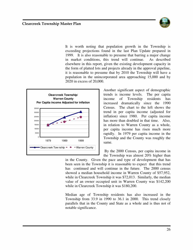
Township, but is gradually moving south as time goes on. This type of residential development is in contrast to that which occurred in earlier decades, which usually involved splitting off frontage lots on local roads and building homes either individually or a few at a time. Thus the change in pattern represents a significant acceleration in residential development. As residential development increases agriculture is declining as the major economic activity in the Township. Increasing land values make it difficult economically for farmers to continue. Increasing traffic brings with it clashes between automobiles and farm equipment on local roads. Assembling large tracts of land suitable for conventional row crop farming becomes more difficult. At the current rate, this process of transition will continue for many more years, as there still remains a large quantity of land in the Township that has development capability. In much of the Township, its character remains typified by open agricultural land, two lane rural roads, wooded hillsides and creek beds and scattered residential development. Aside from agriculture, commercial and industrial activity is very limited in Clearcreek Township. This reflects a policy on the part of Township government not to encourage commercial development in particular. Industrial growth in the Township is to some degree restricted due to a lack of easy access to the Interstate Highway system. Industrially zoned land is primarily located in the southwestern corner of the Township in the vicinity of Red Lion. The largest industrial operation in the Township is a peline terminal facility associated with a pipeline that passes
A pipeline terminal facility is the largest industrial facility in the Township.
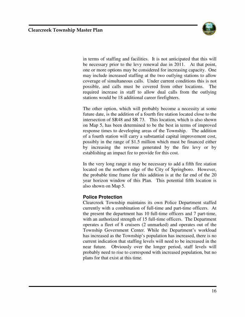
Frontage lots on local roads have been a common method of development.
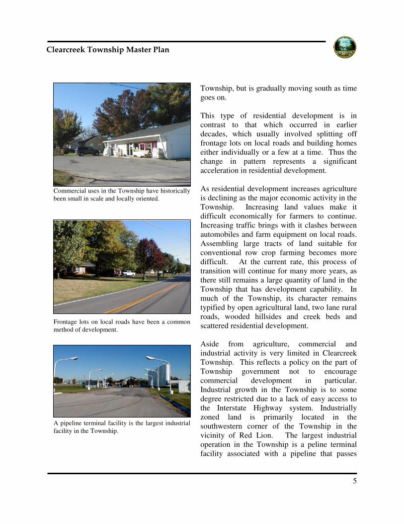
Commercial uses in the Township have historically been small in scale and locally oriented.

6
������������� ������ ���������
through the Township. This facility is located just to the east of Red Lion. Existing Land Use Clearcreek Township contains roughly 28,294 acres; of these presently 23, 886 are found in the unincorporated area. As part of the work program for the development of this plan, mapping of existing land use in the unincorporated area was reviewed, updated and tabulated. The results are shown on Map #2. Statistically, as shown below in Table 1, roughly 11,500 acres or 48% of the land in the Township remains in some form of agricultural use. Residential development (almost exclusively single family) occupies roughly 7,900 acres or 33% of the land area of the Township. Combined, commercial, industrial and office uses represent less than 2% of the land area of the Township. Some parcels have no clearly identifiable use and these were classified as vacant; these represent around 2,600 acres or roughly 11% of the Township.
Land Use Acres Percentageagricultural/rur 11,526 48.3%commercial 99 0.4%industrial 227 1.0%office 1 0.0%public 246 1.0%rec/open 493 2.1%single-family 7,921 33.2%utilities 4 0.0%vacant 2,618 11.0%ROW 751 3.1%TOTAL 23,886 100%
Table 1 - Clearcreek Township Existing Land Use


8
������������� ������ ���������
Committed Development Approvals In addition to an inventory of current land use it is also important to understand other factors should be taken into consideration as well. These are the developments that have all ready been approved and platted, or in some sense have already entered the approval process and thus are not subject to future changes in land use policy. At the beginning of this planning process, the Township Trustees put in place a moratorium on consideration of new development proposals. However the moratorium has no effect on proposals already in the approval process. At the time this plan was being developed there existed more than 2,000 platted single family lots in subdivisions already under development in Clearcreek Township that had yet to be built on. These are listed in Table 2. In addition, as of this writing, there are a significant number of new residential development projects in Clearcreek Township that have already received approval in some sense. These are listed in Table 3. In some cases this means final subdivision approval, in others it means preliminary subdivision approval, in yet others it merely means that subdivision approval was applied for. Under the current process, these projects would not be affected by any future modifications of zoning requirements. In effect, these projects are part of the “given” that must be assumed as a base line for future planning. The proposed projects are almost exclusively residential and cumulatively they will occupy approximately 2,069 acres or slightly less than 8% of the land area of the Township. Map # 3 indicates the location of these proposed developments. Combining the existing platted lots with the lots that will be contained in the projects already in the approval pipeline, a total of more than 4,400 residential lots are somewhere in the development “pipeline” in Clearcreek Township. The 2000 Census showed an average family size of 3.16 in Clearcreek Township. Assuming this pattern continues, this “pipeline” capacity represents an additional population in the Township of roughly 13,900 persons; at current rates, this is at least a ten year supply. The significance of this number is that regardless of any changes in policy or in development regulations by the Township that may occur as an outgrowth of this Plan, the stage is already set for population in the Township to more than double in coming years.


10
������������� ������ ���������
Permits issued
Permits issued
Permits issued
Total Built
Total Remaining
Subdivsion
Year of Most Recent Plat/Stage 1
Preliminary date/lots after1/1/04
Number of Lots
1-1-90 to 5-31-01
6-1-01 to 04-30-03
5-1-03 to 2-29-04
1 Applecreek Reserve 2001 55 22 21 18 61 -6
2 Belle Terrace 1997 20 14 4 2 20 03 Center Springs Estates 1992 48 24 0 2 26 22
4 Clear Creek Trails 1992 18 23 0 0 23 -5
5 Clear Springs Estates 2002 56 0 5 2 7 49
6 Clearview Estates 1999 27 11 0 3 14 13
7 Cotterill Estates 1996 10 5 1 1 7 38 Country Brook 2002 29 0 4 15 19 10
9 Country Brook North 2004 220 0 0 0 0 220
10 Crow n Point 2003 72 43 9 7 59 13
11 Crow n Point Meadow s 2002 84 13 45 39 97 -1312 Cypress Ridge 2004 103 0 8 19 27 76
13 Deer Hollow 1992 12 9 0 0 9 3
14 Deer Wood 1992 30 27 0 0 27 3
15 Deerfield Reserve 2001 20 0 8 8 16 4
16 Dover Run 2000 37 6 15 11 32 517 Dugans Run 1993 22 19 0 1 20 2
18 Earnhart Estates 1994 35 14 6 7 27 8
19 Emerald Lakes 2004 91 0 0 0 0 91
20 Emerald Point 1999 36 22 8 3 33 321 Fox Dale Farms 2003 39 6 5 11 22 17
22 Frye Estates 2000 42 0 5 4 9 33
23 Gander Run Estaes 2002 28 15 0 0 15 13
24 Glenridge 2003 241 2 20 30 52 189
25 Hathaw ay Estates 1992 18 13 0 2 15 326 Hidden Valley Estates 1997 16 4 1 0 5 11
27 Highland Meadow s 1989 14 0 0 14
28 Hillcreek 2003 63 0 0 0 0 63
29 Magnolia Farms 2001 29 1 25 9 35 -630 Oakland Hills 1990 20 16 0 0 16 4
31 Pine Brook Estates 2001 37 21 4 2 27 10
32 Pine Lane Farm 2002 40 9 10 8 27 13
33 Presw ick 1991 303 0 0 0 0 303
34 Quail Meadow s 1994 31 30 0 1 31 035 Rio Vista 1995 25 9 1 2 12 13
36 Routsong 1995 28 0 0 28
37 Saddlebrook Farm 1998 45 13 12 6 31 14
38 Sandridge Subdivision 2003 6 0 0 0 0 639 Saramy Acres 1994 36 33 0 0 33 3
40 Shady Creek 1993 19 9 2 2 13 6
41 Sheehan Acres 1993 14 9 0 0 9 5
42 Sky View Farms 1991 21 19 0 0 19 243 Soraya Farms 2002 379 0 0 0 0 379
44 Spring Meadow s Estates 1999 55 12 14 12 38 17
45 Springboro Station 2003 56 0 0 0 0 56
46 Stokes Reserve 1999 39 16 7 3 26 13
47 Stone Ridge 2003 401 176 57 59 292 10948 Stoney Point 1997 41 41 0 0 41 0
49 Summerfield 1994 44 40 1 0 41 3
50 Summit Point 2002 75 0 28 42 70 5
51 Sycamore Trails 1999 259 196 18 9 223 3652 Terrace Creek Estates 1996 31 25 3 1 29 2
53 The Greens 2000 194 0 0 0 0 194
54 Waynesboro Farms 1998 29 15 14 4 33 -4
55 Woodland Greens 1988 231 11 0 0 11 0
Totals 3974 993 361 345 1699 2055
Table 2 Clearcreek Township- List of Major Subdivisions

11
������������� ������ ���������
Table 3 –
Clearcreek Township Development Proposals in “Pipeline”
List of Major Subdivisions Year of Preliminary Submittal
Lots Not Finalized as of 5-10-04
1 Bello Vista 2004 25 2 Clearcreek Estates 2004 20 3 Clearwater Woods 2004 32 4 Deuer Estates 2004 33 5 Springboro Station II 2004 31 6 Auteur Estates 2004 34 7 Ullrich 2004 23 8 Wynbrooke 2004 85
9 Locust Grove 2004 31 10 Oakland Hills (Phase 2) 2004 23 Total 337
List of Major Subdivisions Year of Preliminary Approval
Lots Not Finalized as of 5-10-04
1 Country Brook North 2004 220 2 Crown Point 1995 29 3 Cypress Ridge 2002 84 4 Emerald Lakes 2004 118 5 Glenridge 2002 167 6 Hillcreek 2003 58 7 Sandridge Subdivision 2003 6 8 Springboro Station 2003 56 9 Stone Ridge 2002 38
10 Summit Point 2000 84 Total 860
List of Major Subdivisions Year of PUD Stage 1 Lots Not Finalized as of 5-10-04
1 Villages of Winding Creek 2004 746 2 Soraya Farms 2002 379 3 The Greens 2000 194
1319 Grand Total 2,516

12
������������� ������ ���������
Sanitary Sewer The presence of a public sanitary sewer system probably has more influence on development patterns than any other single factor. Without sanitary sewers, new development of any substantial size or density is not feasible. Outside of sewer service areas, waste water must be treated with on-site treatment systems, which at the moment are primarily septic systems. These systems are significantly constrained by soil conditions in Warren County, which do not lend themselves well to percolation and thus larger lot sizes are often necessary. The areas of the Township where sanitary sewer service is either currently available or anticipated by service providers are illustrated in Map 4. Under current arrangements, decision making about where and when sanitary sewer service is provided is done at the County level, often with little input from the Township officials. However as a policy position, it is the Township’s desire that no decisions be made regarding extension of sanitary sewers that are inconsistent with this Township Plan. If revisions to the Plan are necessary, those should be considered before decisions are made to extend sanitary sewers. Sanitary sewer service in Clearcreek Township is presently confined to relatively small areas of the Township bordering the City of Springboro and is governed by an agreement between the City of Springboro and Warren County. Within this area, higher density residential development is feasible. A service agreement also exists under which sanitary sewer service will eventually be provided in the northernmost areas of the Township by Montgomery County, though when that may happen remains unclear. Capacity limitations at the treatment plant in Sugarcreek Township (Greene County) may delay extension of sewers into this area for an unknown period of time. In the southwestern corner of the Township, in the area around the unincorporated hamlet of Red Lion, a service area has been designated by Warren County that will receive sanitary sewer service in the future. This area has only recently been modified in shape and extent; the timing and financing of service extension is not a settled
Public Facilities


14
������������� ������ ���������
issue. Financing will likely be dependent on and tied to new development proposals in the Red Lion area.
Water Public water is currently available virtually throughout the Township and is thus not a factor or constraint to development in the Township Parks & Recreation Facilities Clearcreek Township maintains the Patricia Allyn Park located on roughly 100 acres on SR 48 just south of SR 73. This facility includes several soccer fields, trails and other recreation opportunities. It is the Township’s primary park and recreation facility. In addition the Township has received land adjacent to the Park known as the Hoffmann Reserve. This land, comprised of approximately 97 acres, was received from William and Elizabeth Hoffmann and is currently being maintained in a natural state. It may eventually be developed for passive recreational uses after 2009, with the exception of a defined “homestead area” of slightly less than 10 acres where the Hoffmanns continue to reside.
As the Township population grows it is likely that additional park and recreation facilities will become necessary. Floodplain areas are often good sites for such facilities, partly because they are not suited for other uses. In Clearcreek Township, the largest flood plain areas are very centrally located. Thus, it may make good sense, when opportunity arises that the Township acquire through purchase additional land for park and recreation facilities.
Fire Protection Clearcreek Township maintains a joint fire protection agreement with the City of Springboro through the Clearcreek Fire District. The Fire District maintains three stations at locations scattered around the Township. The main station is in the City of Springboro, south of the main business district on SR 741. Two outlying stations exist, one located in the north central area of the Township on Lytle Five Points Road and the other in the south central area of the Township on SR 48. Fire Station locations are shown on Map 5
The Fire District operates on the proceeds of a fire levy that is renewed every 10 years. In 2000, the District prepared and adopted a Strategic Plan for operations. As population in the Township increases it will become necessary to add firefighting capacity both

16
������������� ������ ���������
in terms of staffing and facilities. It is not anticipated that this will be necessary prior to the levy renewal due in 2011. At that point, one or more options may be considered for increasing capacity. One may include increased staffing at the two outlying stations to allow coverage of simultaneous calls. Under current conditions this is not possible, and calls must be covered from other locations. The required increase in staff to allow dual calls from the outlying stations would be 18 additional career firefighters. The other option, which will probably become a necessity at some future date, is the addition of a fourth fire station located close to the intersection of SR48 and SR 73. This location, which is also shown on Map 5, has been determined to be the best in terms of improved response times to developing areas of the Township. The addition of a fourth station will carry a substantial capital improvement cost, possibly in the range of $1.5 million which must be financed either by increasing the revenue generated by the fire levy or by establishing an impact fee to provide for this cost. In the very long range it may be necessary to add a fifth fire station located on the northern edge of the City of Springboro. However, the probable time frame for this addition is at the far end of the 20 year horizon window of this Plan. This potential fifth location is also shown on Map 5. Police Protection Clearcreek Township maintains its own Police Department staffed currently with a combination of full-time and part-time officers. At the present the department has 10 full-time officers and 7 part-time, with an authorized strength of 15 full-time officers. The Department operates a fleet of 8 cruisers (2 unmarked) and operates out of the Township Government Center. While the Department’s workload has increased as the Township’s population has increased, there is no current indication that staffing levels will need to be increased in the near future. Obviously over the longer period, staff levels will probably need to rise to correspond with increased population, but no plans for that exist at this time.

17
������������� ������ ���������
Roads & Transportation Roads are classified by the function they perform within the overall transportation system. This classification system has bearing on priorities assigned to improvements and the right-of-way necessary to be preserved when development occurs. Map 6 shows the functional classification of roadways in Clearcreek Township as established by the Ohio Kentucky Indiana Regional Council of Governments, the designated Metropolitan Planning Organization (MPO) responsible for Warren County.
The road system in Clearcreek Township is maintained under the jurisdiction of three different agencies. The Ohio Department of Transportation (ODOT) has responsibility for six designated State Routes that pass through Clearcreek Township, they are: The Warren County Engineer has responsibility for portions of seven roads in the Township which are listed below:
• Lower Springboro Road (CR 22) • Springboro Road (CR 41) • Lytle Five Points Road (CR 46) • Township Line Road (CR134) • Red Lion Five Points Road (CR126) • Old State Route 122 (CR 230) • Hart Road (CR 278)
The remaining roads in the Township including local streets are the responsibility of the Township. With few minor exceptions all roads in the Township are now two lane thoroughfares, a characteristic that is viewed by Township residents as one of the defining features of the rural character of the area.
Intersection improvements are currently being made to add turning lanes and improve geometry along SR 73 through the Township.
The intersection of State Routes 123, 122 & 741 in the center of Red Lion is a source of growing traffic congestion and should be reconfigured.
• US 42 • SR 122 • SR 48 • SR 123 • SR 73 • SR 741


19
������������� ������ ���������
Currently there are a series of intersection improvements being made along State Route 73 in the Township that involve widening at intersections to provide turning lanes. At various points in the Township the current road system exhibits characteristics that will become problems in coming years. A road system that was sufficient to support a rural community will not be sufficient to support the level of growth now occurring in the Township. One point in particular, the five points intersection in the center of Red Lion is especially problematic. This substandard intersection of State Routes 122,123 & 741 causes substantial peak hour traffic backups today. Additional road connections around Red Lion that will provide alternative routes to passing through this intersection will be important in the future. As development occurs it is important that street interconnection between adjoining developments be maintained. Failure to do this will force additional traffic onto the existing road system, eventually causing a need for widening and/or intersection improvements. This in turn will alter the character of existing two lane roads which are perceived as an integral part of the rural character in the Township today. Road improvements will certainly be the largest category of necessary infrastructure capital improvements in the coming years. Funding of those improvements will be difficult as no sufficient dedicated revenue stream is now available for that purpose. Establishment of an impact fee system should be considered as a way of generating the necessary revenue for construction of improvements to existing roads. The current Transportation Plan for the Township shows a future bikeway extending east to west along Lower Springboro Road and through the City of Springboro. The development of this facility as part of a larger county-wide system is desirable and should be retained.

20
������������� ������ ���������
Administrative The Township offices are located in the Township Government Center which is at the corner of SR 73 and Bunnell Hill Road. Built in 1994, this building currently houses the Township Police
Department, Planning and Zoning office, Administrative offices and Trustees meeting space. Within the next five years it will become desirable to construct a new building housing the Township’s administrative functions, at which time the existing building will be devoted exclusively to the Township Police Department. At this time no specific plans exist for a new building, nor has a funding source for its construction been identified.
Schools Clearcreek Township is served by three different public school districts. These are the Springboro Community School District, which serves the majority of the Township; the Lebanon City School District which serves an area in the southern end of the Township and the Wayne Local School District, which serves some small areas on the eastern edge of the Township. Of the three, only the Springboro Community School District actually maintains school facilities located in the Township; at the moment two new elementary schools are under construction in the Township. Development taking place in Township increases the burden on each of these districts to provide facilities and staff.
The Warren County Career Center is also located in the southern part of Clearcreek Township. This facility provides vocational education to students drawn from a number of high schools located in Warren County. They include Franklin High School, Kings High School, Lebanon High School, Little Miami High School, Springboro High School and Waynesville High School. In addition, the Warren County Career Center provides a wide variety of adult education opportunities on a tuition basis.

21
������������� ������ ���������
Natural Development Constraints The primary natural development constraints found in the Township are soil characteristics, steep slopes and flood plains. Like much of Southwestern Ohio, soil types found in Clearcreek Township have a high clay content and for this reason they are often not well suited to the use of onsite waste water treatment systems due to their resistance to fluid percolation. The Warren County Soil Survey identifies 56 soil types as being present in Clearcreek Township. Of these, 41 are indicated as having severe restrictions with respect to use of septic systems, and 7 more are known to have exceptionally severe restrictions due to shallow depth to bedrock. Map 7 indicates the locations of soil types in relation to suitability for use of septic systems. As can be seen, most soils in the Township are considered poorly suited to the use of septic systems. As a general rule, the Warren County Health Department assumes a 1 ¼ acre minimum lot size for a residence, however potential sites are analyzed on a case by case basis to determine the specific requirements of on-site septic systems. Aside from percolation rates, other factors enter into this analysis such as depth to bedrock. For example, among others soils in the Eden Complex are often associated with a very shallow depth to bedrock The County Health Department’s minimum in this regard is 2 ft., and Eden soils are often more shallow, in some instances less than 1 ft. County standards also prohibit on-site treatment systems where slopes exceed 12%. Soils located in flood prone areas are also considered unsuitable for the installation of on site wastewater treatment systems. Steep slopes are found in the Township primarily along the course of Clear Creek and its tributaries. Generally these areas are in the in the center of the Township. The topography of the Township is illustrated in Map 8. The location of the 100 year flood plain is also illustrated in Map 8. As can be seen flood plain areas in the Township are not extensive. The largest area of flood plain is concentrated near the southeastern side of the City of Springboro south� ��� Lower Springboro Road���

22
������������� ������ ���������
Generally the flood plain areas cross larger tracts of land which are still in use for agriculture. As development continues and agriculture becomes less viable, it may be advisable to consider public uses of these tracts in the future either for park or recreations facilities, which are often the most feasible uses for flood plain areas in developed areas. Flood plains and creek beds also provide valuable green space and wildlife habitat areas. As such, preservation of these areas in a relatively natural state makes a major contribution to maintaining the overall character of the Township.


25
������������� ������ ���������
Demographic History and Trends The US Census taken in the year 2000 showed that the population of the unincorporated areas of Clearcreek Township was 8,747. This represents an increase of 2,172 over the population found in the 1990 Census. Historically, population in the Township increased sharply during the 1960’s, leveled off during the 1970’s, then began a steady increase that has accelerated in recent years.
Population added since the 2000 Census can only be estimated, primarily based on the number of zoning permits issued in the Township. However, based on permits issued, and on typical household size, it is estimated that since 2000 at least another 2,400 residents and possibly more have been added to the Township. While this is an acceleration over the pace of construction seen prior to 2000, it is still substantially lower than the rates seen in other Townships in Warren County. Given the number of platted lots that exist in the Township there is no reason to believe this rate of increase will slow in the near future unless dictated by changes in the residential real estate market. Since 2002, single family zoning permits have averaged slightly less than 240 per year. This trend is likely to continue for at least another 8-10 years, given the availability of buildable lots. Policy changes made as a result of this Plan may eventually slow that rate and also result in a change in the development types seen in the Township. But that effect will not be immediate. Overall, though, the likelihood is that the pressure for new population growth in Clearcreek Township will remain for the foreseeable future.
Clearcreek Township Population Trend
1960 - 2004
0
2,000
4,000
6,000
8,000
10,000
12,000
14,000
1960 1970 1980 1990 2000 2004est
Clearcreek Township
(uninc)City of
SpringboroWarren County
1960 3,937 917 65,7111970 5,847 2,729 85,5051980 5,644 4,962 99,2761990 6,575 6,590 113,9272000 8,747 12,380 158,3832004 est 11,500 15,000 NA
Table 4 - Census of Population
26
������������� ������ ���������
It is worth noting that population growth in the Township is exceeding projections found in the last Plan Update prepared in 1999. It is also reasonable to presume that barring a major change in market conditions, this trend will continue. As described elsewhere in this report, given the existing development capacity in the form of platted lots and projects already in the approval pipeline, it is reasonable to presume that by 2010 the Township will have a population in the unincorporated area approaching 15,000 and by 2020 in excess of 20,000.
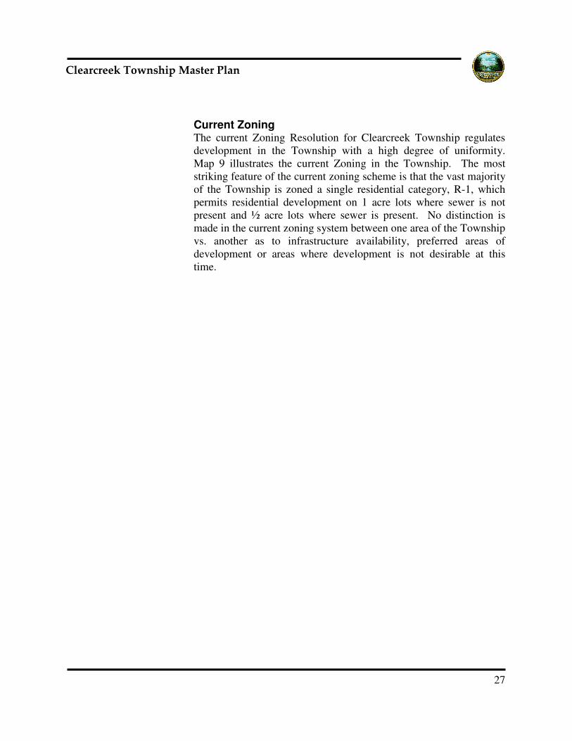
Another significant aspect of demographic trends is income levels. The per capita income of Township residents has increased dramatically since the 1990 Census. The chart to the left shows the trend in per capita income (adjusted for inflation) since 1980. Per capita income has more than doubled in that time. Also, in relation to Warren County as a whole, per capita income has risen much more rapidly. In 1979 per capita income in the Township and the County was roughly the same. By the 2000 Census, per capita income in the Township was almost 20% higher than
in the County. Given the pace and type of development that has been seen in the Township it is reasonable to expect that this trend has continued and will continue in the future. The 2000 census showed a median household income in Warren County of $57,952, while in Clearcreek Township it was $72,013. Similarly, the median value of an owner occupied unit in Warren County was $142,200 while in Clearcreek Township it was $180,200. Median age of Township residents has also increased in the Township from 33.9 in 1990 to 36.1 in 2000. This trend closely parallels that in the County and State as a whole and is thus not of notable significance.
Clearcreek Township/Warren County
Per Capita income Adjusted for inflation
0
5000
10000
15000
20000
25000
30000
35000
1979 1989 1999
Clearcreek Tow nship Warren County
27
������������� ������ ���������
Current Zoning The current Zoning Resolution for Clearcreek Township regulates development in the Township with a high degree of uniformity. Map 9 illustrates the current Zoning in the Township. The most striking feature of the current zoning scheme is that the vast majority of the Township is zoned a single residential category, R-1, which permits residential development on 1 acre lots where sewer is not present and ½ acre lots where sewer is present. No distinction is made in the current zoning system between one area of the Township vs. another as to infrastructure availability, preferred areas of development or areas where development is not desirable at this time.


29
������������� ������ ���������
Planning Analysis Based on a variety of factors, including current land use development patterns, topography, and utility service areas, eight planning policy analysis areas were defined within the Township. These planning policy analysis areas, which are illustrated in Map 10, became the conceptual basis upon which the future land use plan was developed. The unique character of each of the eight areas is described below.
Planning Area #1 - Northern Tier The Northern Tier is an area where a commitment exists for
the provision of public sanitary sewer at some point in the foreseeable future. It is also an area that is already either substantially developed, or where approval commitment for future development has already taken place. Thus the future character of the Northern Tier has already largely been established.
Planning Area #2 - Middle Belt Combined existing development or committed developments
represent more than 75% of this area, with medium density (1- 3 acre lots) using onsite treatment systems.
Planning Area #3 - Springboro Buffer Mixture of agricultural land, residential road frontage
development. Sewers not present but potentially available.
Planning Area #4 – Western Fringe Mixture of smaller agricultural parcels and residential road frontage development, with 2 small subdivisions mixed in. At least 50% built out. Sewers not present and not anticipated.
Planning Area #5 - Central Agricultural Lands Largest concentration of undivided agricultural land in the
Township, well known vistas found, little residential development currently present.

30
������������� ������ ���������
Planning Area #6 Central Mixed Belt More rolling topography, mixture of large agricultural tracts, rural residential road frontage development and large lot rural subdivisions – roughly 50% built out. No sanitary sewer present and none anticipated. Agricultural, but changing.
Planning Area #7 Southeastern Agricultural Lands Existing Character- Large tracts of agricultural land, some
frontage residential development found but still less than 30% built out.
Planning Area #8 – Red Lion Village Area Small rural crossroads hamlet, smaller homes on smaller lots,
small scale commercial uses, industrial uses to the east. Sanitary sewer not present but expected in the future.


32
������������� ������ ���������
Goals and Objectives The following Goals, Objectives and Policies were established as the basis for this Plan and for overall land use planning decisions in the future. They are a statement of the Township’s purpose and intent regarding decisions on these issues. Related to Desired Community Character
• GOAL: Retention of appearance and feel of rural character in Clearcreek Township
• Objective: Modify development regulation and approval process to assure retention of rural character.
POLICIES: • Continue to serve as a geographical area of rural relief
to the sprawl of the surrounding metropolitan areas. • Seek to encourage residential development types
which incorporate preservation of private and public open space (conservation design subdivisions, large lot zoning classifications).
• The history of frontage subdivisions has set a character that continues to be desirable, but access to properties needs to be guided by access management plan.
• Encourage the retention of large agricultural tracts throughout the Township (bequests, fee simple, purchase of development rights, agricultural easements). Large tracts help to distinguish the Township from adjoining jurisdictions. These tracts help to break up the view from the road right-of-way and perpetuate a sense of place that is desirable.
• Maintain rural lot size in the Township which contributes to the quality of life for property owners, neighbors as well as drivers, through an establishment or perpetuation of rural icons (homes surrounded by open space, barns, fence rows, vegetation).
• Identify and retain important scenic views, such as hilltops and rolling fields (bequests, fee simple, purchase of development rights, agricultural

33
������������� ������ ���������
easements). An open space levy should be explored to help fund purchases.
• Develop future road system that can retain two lane typical cross section and character. This cross section has a lower carrying capacity that is suitable for the anticipated rural lot sizes. When this cross section is established care must be taken by staff to balance the following elements: retention or removal of existing vegetation, landscape regulations, vertical and horizontal curves, speed and scenic views. Drivers through the Township should benefit from the views acknowledging that natural elements have been sought over urban elements.
• Review current screening and buffering regulations to determine compliance with perpetuation of character.
• Identify migration corridors for wildlife must be identified. Innovative designs should be sought to separate the migration of animals from the road network.
• GOAL: Minimize development infrastructure cost
burden to existing Township residents POLICY
• Develop impact fee system to finance infrastructure development.
Related to the Natural Environment
• GOAL: Sufficient quantities of ground and surface water--safe, suitable and adequate for multi-purpose uses--free of excessive surpluses or shortages, providing high quality, potable water for both human consumption and economic development, at moderate cost.
• OBJECTIVE: Maintain policies that will ensure water quality. POLICIES:
• Identify location of aquifers, aquifer recharge areas and public drinking water wells. Protect from development, which may be detrimental to surface
34
������������� ������ ���������
and underground supplies. Establish overlay protection zone.
• With the aid of Warren County Soil and Water Conservation District, Warren County Health District and the Warren County Engineers Office, adopt and enforce regulations protecting the sole source aquifer and public water wells from contamination.
• Encourage adequate water treatment and distribution facilities within the City of Springboro and by the Warren County Water Department.
• Encourage the on-going study of public water sources, thereby ensuring adequate supply to meet anticipated residential, commercial, industrial and institutional needs.
• GOAL: Air quality which is not harmful or offensive to
the natural or man-made environment. OBJECTIVE: Encourage the improvement and maintenance of air quality at levels necessary to protect the public health and welfare of the citizens of the Township and Warren County.
POLICIES: • Review land use decisions to determine the impact of
land use on air quality. • Advise agencies responsible for establishing and
enforcing air quality standards of actions which may adversely impact air quality within the Township and County.
• Support the establishment and enforcement of minimal air quality standards.
• Work with neighboring jurisdictions to reduce air pollution.
• GOAL: Establish a balance between development and
growth management which will protect the natural environment, allow for the maximum opportunity to pursue recreational activities and the enjoyment of the benefits of an integrated open space system.

35
������������� ������ ���������
OBJECTIVE: Encourage and promote an open space system capable of providing the amenities of the natural environment, offering relief from urbanization. POLICIES:
• Identify actively farmed prime agricultural land. Establish system to protect it from unwanted development (bequests, fee simple, purchase of development rights, agricultural easements).
• Prohibit development in flood plains, stream channels and drainage ways.
• Identify manner in which creeks can be preserved. Develop education program for property owners to responsibly maintain this resource.
• Support the preservation of unique geological and biological areas, such as marshes, swamps, wetlands, woodlands, wildlife habitat, etc.
Related to the Man-Made Environment
• GOAL: A pattern of land use capable of serving and meeting the social, economic and environmental needs of the residents of the Township, now and in the future. OBJECTIVE: Encourage the prudent development of residential areas with housing types and densities to meet the needs of Township residents, ensuring that a healthy, safe and attractive environment is maintained.
POLICIES: • Discourage small, isolated subdivisions where soil
conditions and lot size are not conducive to on-site wastewater disposal systems, where applicable.
• Encourage a logical pattern of residential development in the designated Urban Service Areas that transition from an urban density to a rural density.
• Encourage a logical pattern of residential development outside of the Urban Service Areas that is a rural density.

36
������������� ������ ���������
• Place a stronger emphasis on establishing open space/green belt areas, separating developing residential areas from incompatible uses.
• Establish a system to encourage housing maintenance through a coordinated, on-going inspection program by County and local officials.
• Encourage the repair or removal of dilapidated/substandard structures.
• Identify and document older homes or residential areas of historical and/or architectural significance. These should be protected from unwanted, incompatible land uses.
• Explore the establishment of historical zoning district to protect individual structures or neighborhoods of historical and/or architectural significance.
OBJECTIVE: Establish areas of commercial activity,
ensuring a convenient, safe and pleasant environment in meeting the retail and business needs of Township residents.
POLICIES: • Perpetuate rural living by encouraging development
only on a neighborhood-oriented basis. Commercial development should be either nestled in the interior of a Planned Unit Development along a collector road or along an arterial road network that has a design suitable for the intensity of use. An access management plan should be imposed.
• Review home occupation definition. Identify uses that are compatible with the rural residential character. Establish these commercial uses as a by-right or conditional use.
• Encourage commercial growth equal to what the market will bear. Over-commercialization should be avoided.
• Encourage cluster-type development for commercial areas. Establish an overlay for these clusters to further encourage use, scale and materials.
• Avoid strip commercial development and "spot zoning."

37
������������� ������ ���������
OBJECTIVE: Encourage quality industrial development, necessary to the overall economic growth of the Township.
POLICIES: • Discourage introduction of industrial uses outside of
defined areas because it would destroy the rural residential character of the Township.
• Support the allocation of an adequate supply of suitable land to accommodate a range of industrial uses.
• Ensure adequate soil conditions, topography, water and sewer service, roadway, and public facilities are available to industrial sites.
• Use industrial park concepts in promoting and attracting new industry in conjunction with individual industrial sites.
• GOAL: Provide community services adequate to fulfill
the social, environmental and economic needs of the residents, now and in the future. OBJECTIVE: To encourage the provision of a full range of community facilities and services within the Urban Service Areas of the Township. POLICIES:
• Avoid overloading of any particular sewer system. • Coordinate Water and sewer extensions to urban
service areas with the Township Trustees. • As sanitary sewer lines are extended into developing
areas served by private or onsite wastewater disposal systems encourage connection. Provide a high level of governmental and community facilities and services, such as police and fire protection, public transit facilities, health and social services, libraries, cultural, educational and recreational facilities to adequately meet the increased demand created by the intensity of development.

38
������������� ������ ���������
OBJECTIVE: To encourage the provision of a full range of community facilities and services with-in the Urban Service Areas of the Township. (Note: Onsite wastewater disposal systems are dependent on Warren County Health Department and/or Ohio Environmental Protection Agency Approval. POLICIES:
• Onsite wastewater disposal systems are dependent on Warren County Health Department and/or Ohio Environmental Protection Agency Approval.
• Discourage expansion of water lines. • Discourage expansion of sanitary sewer lines. • Provide a high level of governmental and community
facilities and services, such as police and fire protection, educational and recreational facilities to adequately meet the increased demand created by the intensity of development and population outside of the Urban Service Areas of the Township.
• GOAL: An inter-modal transportation system allowing
for convenient access for all residents, both inside and outside the Township. OBJECTIVE: Provide a variety of transportation modes, designated and designed to meet the various needs of different people, activities and purposes of travel. POLICIES:
• Support Warren County Engineer and Ohio Department of Transportation regulations that control access points.
• Integrate road improvements based upon recent traffic study into a capital improvements program
• Thoroughly review impact upon the road system prior to any land use decision being made.
• Require new subdivisions to have stub streets to adjoining properties in order to provide interconnection between existing as well as future subdivisions. These road stubs function to reduce trips on to collector and arterial roads as well as function as alternative road networks for the entire road system.

39
������������� ������ ���������
• GOAL: An environment with a broad choice of multi-use recreational opportunities, available to all citizens of the Township. OBJECTIVE: Encourage the preservation of an open space greenbelt to control urban sprawl and at the same time meet the recreational needs of all age groups in the Township. POLICIES:
• Discourage the extension of water and sewer facilities into designated open space areas and in areas outside Urban Service Areas.
• Correlate the type and size of facilities with the major characteristics of the area.
• Identify potential park land according to Warren County Park Plan and standard planning practices. Establish system to protect it from unwanted development (bequests, fee simple, purchase of development rights, park levy).
• GOAL: Physical development which provides a balance
between the man-made and natural environments. OBJECTIVE: To encourage development practices appropriate to existing topographic, soil and geologic characteristics. POLICIES:
• Encourage development in areas of slight to moderate slope, assuming no additional undesirable characteristics are present.
• Discourage development on steep slopes unless properly planned and engineered, to eliminate potential problems due to run-off, sedimentation, erosion, sloughing, or similar problems.
• Prohibit development on impervious soils, or in areas with seasonally high water tables, unless sanitary sewers are provided.
• Minimize drainage and/or filling of natural wetland areas and the destruction of significant wildlife habitats should be minimized.
• Discourage development in areas of soils exhibiting poor load bearing capacity.

40
������������� ������ ���������
• GOAL: Coordination and cooperation among local, State and Federal officials in matters relating to land use planning, to create a well-balanced, compatible and complementary arrangement of land uses. OBJECTIVE: To resolve problems in a rapidly growing area of the Township, land use decisions should be made in a logical and meaningful fashion. POLICIES:
• Continue to rely on the Warren County Regional Planning Commission to provide technical assistance to the Township.
• Base land use and zoning decisions on input from local citizens and officials, adopted Land Use Plans and sound planning principles.

41
������������� ������ ���������
Land Use Plan The Future Land Use Plan for Clearcreek Township is shown in Map 11. The basic framework of this Land Use Plan creates a three tiered approach to new residential development. It envisions that in the immediate future, new residential development will be concentrated in the northern and central areas of the Township where sewer service either exists or is planned, or in areas where substantial development has already taken place using onsite waste water disposal systems. In the southern areas of the Township residential development will still be permitted but only on larger lots and with significant incentives given for making use of conservation subdivisions as the preferred method of development. The area around Red Lion is also anticipated as being developed at higher densities consistent with the presence of sewers. Zoning densities in this area should also be retained at the current minimums of ½ acre with sewer and 1 acre without. However the Plan specifically designates this area differently to encourage mixed use developments using the PUD process. It is envisioned that PUD proposals may include higher residential densities than now permitted and that limited commercial and or office uses may also be appropriate. One desirable aspect of allowing such projects is that it can provide the vehicle for financing the needed sewer improvements in the area. Map 12 illustrates in detail the area around Red Lion. It also indicates, in a conceptual fashion, roadway linkages that would be desirable in conjunction with new development so as to relieve the existing choke point where the three State Routes, 122, 123 and 741 come together. Commercial development will be limited in scale and confined to a few key locations in the Township. The intent of the commercial areas identified is to provide services to local Township residents and to avoid larger scale commercial developments that have a regional market draw. To effectuate the land use plan as shown it will be necessary to make substantial revisions to the Township Zoning Resolution and Zoning

42
������������� ������ ���������
Map. The specifics of the recommended changes are detailed in the following section discussing implementation steps. The Land Use Plan also illustrates areas of the Township that are included in the riparian corridors along the major creeks and streams in the Township. These areas have particular value as part of the scenic natural character of the Township and as wildlife habitat. Kept in a natural state, they also contribute significantly to the preservation of water quality in the Township. One of the recommendations of this Plan is that these areas should be protected by establishment of an overlay zoning district designed to keep the riparian corridors in a naturally vegetated condition and unblocked by fencing.


45
������������� ������ ���������
Implementation Steps Revision of Zoning Resolution The Zoning Resolution is the primary vehicle through which land use policy is implemented in the Township. The Zoning Resolution and the Zoning Map should be revised to reflect the policies delineated by this Plan. This should involve the addition of new districts with larger minimum lots sizes in certain areas and a new chapter that provides for the conservation subdivision option with sufficient built-in incentives to interest developers in making use of the option. The incentives should be provided in the form of density abatements that allow bonus lots, which exceed the number of lots permitted in a conventionally platted subdivision. It is recommended that minimum lot sizes in the R-1 district be maintained at current levels, ½ acre where sewer is present and 1 acre where it is not. These zoning densities are generally appropriate in the areas shown on the Land Use Plan as Suburban Residential and in the Red Lion Village area. Two new residential zoning classifications should be established to correspond to the other two classifications shown on the Land Use Plan. One, corresponding with the areas shown as Township Residential, should provide for a minimum lot size of 1 ½ acres only, with no provision for lot sizes where sewer is present. The areas shown in Plan as Township Residential do not include any areas where it is expected that sewers will be extended, and this minimum lot size is intended to be consistent with development patterns already in existence. The second should correspond with the area shown in the Land Use Plan as “Rural Residential.” In this area, the minimum residential lot size should be set at 5 acres. Also in this area an Agricultural Zone should be established that allows individual residential uses on a “conditional use” basis and also allows residential development by right if it is done using the conservation subdivision concept. The conservation subdivision option in this area should require a minimum of 30% of permanently protected open space and allow for density abatement of up to 115%.

46
������������� ������ ���������
An overlay district should also be added to the Zoning Resolution that regulates development activity in identified riparian corridors in the Township. The intent of this overlay district should be to protect to the greatest degree possible natural vegetation in the riparian corridors and to limit the extent to which these corridors are blocked by fencing. A technical study may be required to identify exactly where these areas are before such an overlay district can be adopted. Modification of Development Review & Approval Process The conventional zoning process as practiced in Clearcreek Township allows development to proceed so long as it conforms to the basic requirements of the Zoning Resolution. With the exception of conditional uses, the only opportunity for case-by-case review occurs at the County level as part of the subdivision approval process. Many communities use a technique that allows local review of proposed development through a site plan review and approval process. Municipalities do this as a standard part of Zoning Ordinances. Townships in Ohio sometimes tie a site plan review and approval process to broader definitions of conditional uses. Consideration should be given to incorporating such a process into the Township’s Zoning Resolution. Design Guidelines Preparation of a set of design guidelines is a method of defining the preferred development types that a community would like to see. Design guidelines may address site planning principles and standards, building types and materials, landscape design and materials, and in some instances the nature of signage. To some extent, adherence to design guidelines can be enforced through a review and approval process. To some extent, adherence to design guidelines is voluntary. Nonetheless, the establishment of design guidelines can be an effective way for a community to define the development types that will receive favorable consideration when proposed. Clearcreek Township should undertake the preparation of design guidelines to define the character of development that is preferred in the Township. One aspect of site planning should receive particular attention; that is the areas along road frontages in new subdivisions and the desirability of retaining natural vegetation along road frontages.

47
������������� ������ ���������
Revision of Transportation Plan This Master Plan represents a substantial change in policy direction from the current plan and from the current zoning scheme. While transportation planning has been done in the past for Clearcreek Township, it has been done using the existing Land Use Plan as the basis for planning. Transportation planning must be updated to reflect the changed assumptions that form the basis of this Plan. In particular, the reduced development densities in the southern end of the Township will mean less demand for roadway capacity. Particular emphasis should also be paid to creating new links that will relieve future pressure on the existing roadway system. Establishment of Impact Fee System An ongoing problem for many Townships in the State of Ohio is lack of revenue to make the capital improvements necessary to support rapid growth. In many areas of the nation, the method used to address this deficiency is the establishment of Impact Fees. Impact Fees, properly done, create a fair and equitable method of assessing a fair share fee to new development that can be used to put in place the required infrastructure. In Clearcreek Township, such fees might be applied to the construction of roads, acquisition and improvement of land for parks and open space, or acquisition and/or improvement of police and fire facilities and/or vehicles. Before any such fees can be enacted, it is important that supporting study and documentation be performed so that fees are clearly based on documented consequences of development. Access Management Recent changes in Ohio Law have authorized Counties and Townships to establish regulation of access points to public roadways. Under that legislation, if the County Engineer chooses to establish such regulations, Townships must defer to the regulations established. The Warren County Engineer has chosen to undertake this task on a County-wide basis and is in that process now. Once County access management regulations are finalized, the Clearcreek Township Zoning Resolution should be reviewed to determine where changes are necessary to make the appropriate citations. If the County Engineer’s efforts do not result in the adoption of access management regulations, the Township should

48
������������� ������ ���������
undertake this effort itself. Unregulated access points cause significant degradation of the traffic carrying capacity of the public roadway endangering public safety and making necessary expensive capacity improvements. Establishment of Open Space Acquisition Methodology As development proceeds in the Township green open space will increasingly disappear. This will be particularly true in the northern areas of the Township over the next twenty years. Many communities have realized that the only way to preserve open space in this circumstance is to purchase land to be set aside for the purpose of retaining green space. Such purchases should be thoughtfully done and strategic in nature. To provide a revenue stream for this purpose it is not uncommon to establish a small tax levy that goes towards a land purchase fund. Such a levy, of course, requires the approval of the voters before it can be enacted. However in areas like Clearcreek Township, approval of the voters has often been granted in recognition of the need to preserve open space. Consideration should be given to establishing such a program in Clearcreek Township.

49
������������� ������ ���������
Conclusion The decisions made in the coming two decades will play a major role in determining the character of Clearcreek Township for generations to come. Once established, the patterns created by subdivision of property and the layout of the road system will be difficult to change. Wise and thoughtful decision making can mean that Clearcreek Township remains a desirable community to live in for many years to come. The recommendations included in this plan are intended to provide the basis for creating and maintaining that desirable character and quality of life. But a plan with no implementation is nothing more
than an idea. Once the Plan is adopted, the Township should move forward aggressively with the implementation process. It is worth noting that the Township’s voters have recently approved adoption of Limited Home Rule Government in the Township This variation of Township Government, provided for under Ohio law, will provide the Township with added flexibility in dealing with growth in the future. Among the tools this form of government may make available are added authority in legislative decision making, the possible use of impact
fees for financing infrastructure improvement, and more control over infrastructure and utility systems within the Township.