city council conference municipal building conference room ... city... · city council conference ....
TRANSCRIPT
CITY COUNCIL CONFERENCE
MUNICIPAL BUILDING CONFERENCE ROOM 201 WEST GRAY, NORMAN, OK
APRIL 11, 2017
5:30 P.M.
1. DISCUSSION REGARDING PROPOSED AMENDMENTS TO THE
FLOODPLAIN ORDINANCE.

Floodplain Ordinance City Council Conference
April 11, 2017

Floodplain: The Basics

What is floodplain? Any land susceptible to being inundated by water from
any natural resource (also called flood prone areas)
Regulatory floodplain – land that is subject to a 1% or greater chance of flooding in any given year (often called the 100 year flood, or 1% Chance Flood)

Why regulate development in the floodplain? To reduce future flood risks to new construction in certain
flood prone areas
Required to participate in the National Flood Insurance Program (NFIP) Created by Congress in 1968 Mitigates future flood losses through sound, community enforced
building and zoning ordinances Provides access to affordable, federally backed flood insurance
protection for property owners

Requirements for Participating in NFIP Flood Hazard Identification FEMA maps the flood prone areas (“Special Flood Hazards Areas”) Designates areas as floodplain (potential for flooding in the 100 year storm) Designates floodway areas (channel of a watercourse and the adjacent land
that must be reserved to discharge the base flood without increasing the water surface elevation more than a designated height)
Designates the Base Flood Elevation (BFE) – the elevation above sea level of the 1% chance flood
Local floodplain management regulations designed to reduced flooding
risk for property owners and insurers.

•

Why is participating in NFIP important for Norman?
539 active flood insurance policies
113 claims paid since 1979
$137,153,200 – value of flood insurance in Norman
Over $2.3 million paid out for flood related losses
Federal disaster assistance for flood related damages

History of NFIP Participation in Norman July 8, 1975: First floodplain ordinance/City joins the program Nov 1, 1979: First FIRM/FIS (FEMA floodplain map) August 1987: Revised FIRM/FIS issued January 1999: Revised FIRM/FIS issued September 2008: DFIRM/FIS issued February 2013: Revised DFIRM issued
Floodplain Ordinance – Revisions in 1978, 1981, 1986, 1987, 1989,
1997, 2003, 2004, 2007, 2008, 2013

FEMA’s Community Rating System Norman accepted into NFIP Community Rating System (CRS)
October 1, 2011 as a Class 5 community 21,180 U.S. communities participate in the NFIP 1,090 (5.1%) of those communities participate in the CRS program 12 of those communities are in Oklahoma
52 communities in the U.S. (0.25%)of the NFIP communities have received a CRS class rating of 5 or better on a scale of 10 with1 being the highest rating

Norman’s Floodplain Regulations Flood Hazard District in the Zoning Ordinance Functions as an overlay district - underlying zoning designation still applies with
floodplain restrictions
Floodplain permit committee reviews applications for development in the flood hazard district Floodplain Administrator (Public Works Director) Director of Planning City Engineer Subdivision Development Manager Principal Planner Two citizen members with OWRB’s floodplain training

Floodplain Regulations
General Rules:
• You can build in the portion of the floodplain that is not floodway (flood fringe) if the structure is elevated at least 2 feet above the BFE
• You cannot build anything or apply fill in the floodway
• Fill can be applied in the flood fringe in limited circumstances – no rise in BFE downstream, compensatory storage provided, etc.
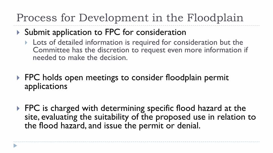
Process for Development in the Floodplain Submit application to FPC for consideration Lots of detailed information is required for consideration but the
Committee has the discretion to request even more information if needed to make the decision.
FPC holds open meetings to consider floodplain permit
applications
FPC is charged with determining specific flood hazard at the site, evaluating the suitability of the proposed use in relation to the flood hazard, and issue the permit or denial.

Changes to the FEMA Floodplain Maps Correcting mistakes in the map Letter of Map Amendment (LOMA) - corrects an error in the maps
– City is not involved in the application process unless we are requesting the correction
Changing the designated floodplain on the map due to
proposed or actual manmade alterations within the floodplain Placement of fill; modification of a channel; construction or
modification of a bridge; construction of single or multiple residential or commercial structures on single or multiple lots
Application is made thru the local community; applicant pays the fee for FEMA review

Changing the Maps Due to Development Before developing - Applicant can seek FEMA’s comments
Conditional Letter of Map Amendment (CLOMA) – FEMA’s comment on a proposed structure(s) that would, upon construction, be located on existing natural ground above the BFE in floodplain
Conditional Letter of Map Revision (CLOMR) – FEMA’s comment on a proposed project that would, upon construction, affect the hydrologic or hydraulic characteristics of a flooding source and result in modification of floodplain.
Conditional Letter of Map Revision Based on Fill (CLOMR-F) – FEMA’s comment on a proposed project that would, upon construction, result in the modification of the SFHA through the placement of fill outside the existing regulatory floodway
After Developing - Changing the Map Letter of Map Revision (LOMR) – changes the map based on the implementation of physical measures that
affect the hydrologic or hydraulic characteristics of a flooding source and result in modification of existing regulatory floodway, BFE, or the SFHA. Officially revises the map.
Letter of Map Revision Based on Fill (LOMR-F) – changes the map’s SFHA based on the placement of fill
outside the existing regulatory floodway

Proposed Ordinance Amendments

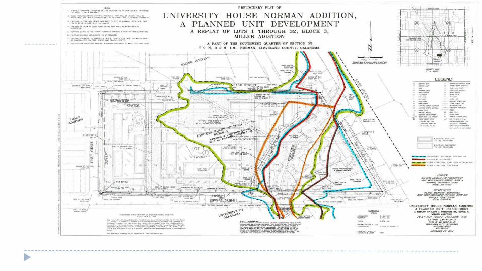
Background University House Norman Project (2014/2015)
Summary: Project entailed razing existing apartment structures north of the Duck Pond and constructing new apartments
Property Description: There is a stream going through the property and a number of buildings that predated the FP ordinance were constructed in the floodplain and floodway.
Project Description: Remove structures from the floodplain; add 1.3 acre feet of FP storage by excavating the side of a creek channel with no change to depth or flow line of stream, construct new apartments outside of the floodway
During the review and approval process, some areas of “clean-up” in the FP ordinance were identified Council Oversight Committee discussed possible ordinance amendments at multiple meetings during 2015
City Council discussed the changes at a Study Session in February 2016 and in August 2016
Developer and FPC (via citizen members) input sought

Proposed Change - Intersection of FEMA and City Process City’s current process (in our ordinance) – Owner of land requests review of flood boundaries on his property
– presents info to the Planning Commission for review – PC obtains technical analysis – PC recommends to Council whether boundaries should be changed and whether City should request a LOMR. Not based on development - correcting mistakes on map – LOMA City is not involved in the LOMA process
Proposed Change:
Modify language to clarify the process for incorporating LOMRs approved by FEMA into the FP ordinance
Remove language related to LOMAs.

Proposed Change – When is Fill Restricted? Current language – Fill is limited to:
Elevation of individual residential and non-residential structures Construction or repair of public roads and bridges River or stream bank stabilization or reinforcement projects, and where authorized, fill
must be the minimum necessary to accomplish the permitted development
Proposed Change – Modification of the floodplain, including fill, excavation, dredging, channelizing and paving limited to: Elevation of individual residential structures and non-residential structures Construction of ponds less than 5 acres for farm/ranch activity Stabilization/reinforcement of river or stream bank Construction/repair of public roads and bridges “Redevelopment or reclamation projects”
Proposed language also references LOMR process to ensure clarity.

Proposed Change – Define “Redevelopment or Reclamation Projects”
Addresses projects like University House that disturb the floodplain more than a typical project, but actually improve its function
Allows projects (with FPC approval) that propose to reduce flood hazards through the removal of existing non-compliant development and which provide beneficial improvements to the function of the floodplain.

Proposed Change – Clarify approval process Current language –
City Council must approve the following floodplain modifications Modification that would change the width of the FP 10% or more Construction of a pond with a water surface area of 5 acres or more Modification of stream banks or flow line within the regulatory floodway unless work is
done by the City Report made to Council with platting; if not platting, prior to FPC permit
issuance
Proposed language Redevelopment or reclamation projects added to the list of modifications
Council must approve New language requiring a project report and the recommendations of the FPC
to be provided to Council at time of its consideration of the FP permit.
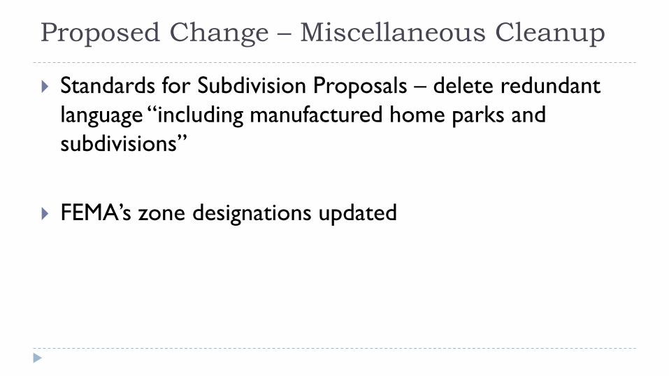
Proposed Change – Miscellaneous Cleanup
Standards for Subdivision Proposals – delete redundant language “including manufactured home parks and subdivisions”
FEMA’s zone designations updated
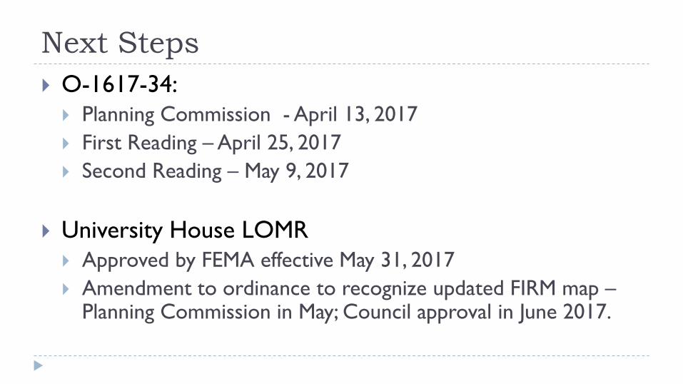
Next Steps O-1617-34: Planning Commission - April 13, 2017 First Reading – April 25, 2017 Second Reading – May 9, 2017
University House LOMR Approved by FEMA effective May 31, 2017 Amendment to ordinance to recognize updated FIRM map –
Planning Commission in May; Council approval in June 2017.

Univ. House Norman (Bishops Landing Apts)
'•-K- .. ...,_ ...... _ ... ...,..,.~_..,. .. .,. __ ~ ...... .,_ .. _..,.
4. -•-tU•••--.Ol•t-ur.::.t......,h _, .......... ..._..__, -...k -lCO,-Oll[WtAtoe.> .. -..•OIO ..... 'O .ct:--~,.•
l ,,...,_. t• µ ... u..rrwe ,,..~,JG or- tl'N(l!N....., ~ • ., P..ar •z• n "CJ• a.-Jt """' "'-"•!--.~
• ~~~-llOa ...... ~--·"'-.co"-..
',_-..,,..,.-:'< m--ncM'IUI ,.__,r..- ..-: .,,_-n.....,_ • QJN<._it.) .IN~ ~,_., <H>MXKS _._.
.. '""'_.._ -...-~ - _.., • ..: ~- 1'lo'4'.C' "'"" - ~
-~s-.i='
PRRUMTN.lRY PU.'f OF
UNIVE R S ITY HOUS E N ORMAN ADDITION, U NIT D EVELO PM EN T A PLANNED
A REPLAT 01" L OT S 1 T H R OU GH 3 2, B L OCK 3 , MILLER ADDITION
A PART OF THE SOtJTHW"KS'T QUARTER OP SECTION 32 T g N. R 2 lf. l .M .• NORMAN. CIEVELAND COUNTY. OKLAHOMA
--.--·--______ _. __ .....,.,_ ,. __
LEGEND
-----~ --. ~ .. =.-:=.. ____ _..
... -..-·-·-
"WWX'
-·--·--
-~,I·~ MA.011/17,~l.a/T,r.6UIA
~---,,-l'Olld:ll JUS-14.U
,.,-,a....,. _....,_,,_,,....~All'7
.- c::TTMI#~,--': .-.r"__ _, ,,,,_ P'IU~,,
UNJYZRSlTY HOUSB NORJilA.N' ADDmON A PlAM~ ll'I" nll:T'Ft .tlPVRNT
• -..,.,. or =.:i = -. -.- ' l"l:Ar4r. l"/Clt'rr-~l""'S ~ ""'"""' c,p,.,...,,,
,N,g ,r •JNllltr•.et °"-- "'~ "~ ____...., --~.,,.,,.,,.,,,,.,,
----------------------------------------------------------------------------------------------------------------------------~

J
" ,..,. ARCHITECTURAL SITE PLAN
GROUND FLOOR PLAN
UNIT
El Al
Bl
82
Cl 01
02
03 04
UNIT UNIT
TYPE COUNT
1 -1 90
1-1 88 2 -2 66
2-2 41
3-3 22 ..... 38
4-4 9 4-4TH 30
4- 4 46
TOTALS 430
""""l'Ct. .. ~ TOTAL f'MKINO &l"ACD
Units
" 21" 21%
15%
10%
5%
9%
2%
7" 11%
BED Beds N .R.
COUNT " AREA
90 9" 475
88 9 " 600 132 14" 828
82 9" 858
66 7" 1100 152 16% 1 360
36 4 " 1538 1.20 "" 1499
184 19% 149.5
950 904 . , .. tr
,., ....,,.. ,, .....,. 11'~•
A202.1
BISHOP'S LANDING -·-.. • · ........ INLAND AMERICAN ~ HlJMPH_RE"'.S & PART NE.RS AR_CHITEC,:TS L P
11110,?014 NORMAN, OKll\HOMI\ HPAHH'>'>R "'''.. , , , , ... ' __ , _. _

DATE: April 6, 2017 TO: Honorable Mayor and Council members THROUGH: Jeff H. Bryant, City Attorney FROM: Kathryn L. Walker, Assistant City Attorney RE: Ordinance No. O-1617-34 Amendments to the Floodplain Ordinance The City Council Oversight Committee met in January and February of 2015 to discuss the floodplain ordinance after concerns were raised regarding how the current ordinance applied to the University House Norman Project. Concerns expressed included the level of modifications to the floodplain that should be allowed, whether current language allowed residential structures other than single family dwellings to be constructed in the floodplain, and how to accommodate projects that improve the floodplain’s function. Additionally, some members of Council expressed a desire to clarify the process for Planning Commission and City Council approval of floodplain permits, particularly related to how the City approval processes coincide with Federal Emergency Management Agency (FEMA) Conditional Letter of Map Revision (CLOMR) and Letter of Map Revision (LOMR) processes. The Oversight Committee discussed the floodplain ordinance again on November 19, 2015. Staff presented draft changes to the Committee. During the discussions, Harold Heiple, on behalf of the Norman Developer’s Council, and Sean Reiger, on behalf of the Builder’s Association of South Central Oklahoma (BASCO) stated that they had some objections to the ordinance. At the request of Chairperson Miller, Staff met with Mr. Heiple and Mr. Reiger to discuss the proposed amendments. Chairperson Miller asked that the ordinance draft be presented to City Council at a Study Session. Staff also met with citizen members of the Floodplain Permit Committee in March 2016. City Council discussed potential amendments to the floodplain ordinance at a Study Session in February 2016 and again on August 2, 2016. There appeared to be consensus on some, but not all, of the potential amendments. Because many of the amendments were cleanup items, the amendments on which there appeared to be consensus are being brought forward for Council discussion. Potential Floodplain Ordinance Amendments Section 3(a) - clarifies that the FEMA FIRM maps referenced in the floodplain ordinance may be updated time to time when Letters of Map Change (including Letters of Map Revision) are approved by FEMA. Approval of Letters of Map Change that have already been approved by FEMA are ministerial in nature and the

O-1617-34 FP Ordinance
amendments to this section more accurately reflect the role of the City in adopting these changes to the maps. Section 3(c) – modifying the language to clarify that the process described in this section is for incorporating Letters of Map Revisions (LOMR) approved by FEMA into the City’s local floodplain ordinance for local regulatory jurisdiction. Language that relates to Letters of Map Amendments (LOMAs) is recommended to be removed. LOMAs are for the purpose of correcting FIRM mapping errors for individual properties and structures and do not relate to changes in the floodplain or floodway boundaries due to development or construction activity. LOMA requests can be made directly to FEMA, are not reviewed by the Floodplain Permit Committee because no development activity is proposed with a LOMA application, and are not previewed by Planning Commission or City Council. The language regarding the LOMA process that is recommended to be removed has created a lot of confusion regarding the role of Planning Commission and the City Council in the LOMA process. Because approval of LOMR’s are ministerial in nature after FEMA has approved them, this section is proposed to be revised consistent with subsection (a). When the FEMA map has been changed as a result of a LOMR, adoption of the revised maps will come forward directly to Council for approval. Section 4(b)(1) – modifying the language to more clearly state what may be permitted, as opposed to what is permitted as an exception to a blanket prohibition, removing language considered redundant, and adding language to clarify how the LOMR process fits into the Floodplain Permit Committee and City Council review processes on projects proposing to modify the floodplain through development activity. Section 4(b)(1) renumbering subparagraphs as (i) – (v) instead of (a) – (e) to be consistent with designation of other subparagraphs in the floodplain ordinance and adding the following lead in language “The proposed modification is” to each subparagraph; Section 4(b)(1)(i) keeps current language allowing modification of the floodplain for “individual residential and non-residential structures”. Language was previously proposed that would allow modification of the floodplain for the purpose of elevating “single-family residential structures and any associated non-residential structures”, while leaving intact the existing language referring to other “non-residential structures” to allow latitude to consider such municipal projects as improvements to the Water Reclamation Facility or potential locations for the Senior Citizen Center. Under the language previously proposed, these modifications would have been allowed only if there was no reasonable location for the structures outside of the floodplain. Concern was expressed that this change would not allow for any elevation of multi-family residential structures. Additionally, concern was expressed about the qualifying phrase “provided there is no reasonable location for the structures outside of the floodplain” because of the difficulty in defining “reasonable”. Consensus was not reached on this point so no changes are proposed to the current language at this time. Section 4(b)(1)(v) – adding modifications to the floodplain that are part of a
2

O-1617-34 FP Ordinance
redevelopment or reclamation project, which is more specifically discussed in Section 4(b)(17); Section 4(b)(16) – clean-up to reflect FEMA’s current zone designations; Section 4(b)(17) – adding language to specify that redevelopment or reclamation projects that reduce flood hazards through removal of non-compliant development and which provide beneficial improvements to the floodplain through modifications to the floodplain may be permitted. Section 4(b)(18) [formerly (17)] – Adds language to clarify the existing process of forwarding a limited list of floodplain projects to Council for approval subsequent to approval by the Floodplain Permit Committee, clean up redundant language in subsection (iii), clarify that a redevelopment or reclamation project under 4(b)(17) will require Council approval regardless of whether the project changes 10% or more of the width of the floodplain (subsection iv). Section 4(f) Standards for Subdivision Proposals – This was identified as another potential area for cleanup as the current language “All subdivision proposals including manufactured home parks and subdivisions” is redundant. Staff will be available at the Study Session on Tuesday to discuss these changes further and answer any questions you may have. Reviewed by: Shawn O’Leary, Director of Public Works Susan Connors, Director of Planning and Community Development Carrie Evenson, Stormwater Engineer
3

O-1617-34
AN ORDINANCE OF THE CITY OF NORMAN, OKLAHOMA AMENDING SECTION 429.1(3) AND CLARIFYING THE PROCESS FOR AMENDMENTS TO DISTRICT BOUNDARIES BASED ON APPROVAL BY FEMA OF LETTERS OF MAP CHANGE INCLUDING LETTERS OF MAP REVISION; SECTION 429.1(4) TO CLARIFY WHEN A FLOODPLAIN PERMIT IS REQUIRED AND WHEN COUNCIL APPROVAL IS REQUIRED; AND REMOVING REDUNDANT LANGUAGE RELATED TO SUBDIVSION STANDARDS, ALL IN CHAPTER 22 OF THE CODE OF THE CITY OF NORMAN OKLAHOMA; AND PROVIDING FOR THE SEVERABILITY THEREOF.
BE IT ORDAINED BY THE COUNCIL OF THE CITY OF NORMAN, OKLAHOMA: § 1. That Section 22:429.1(3) of Chapter 22 of the Code of the City of Norman, Oklahoma, be amended to read as follows:
3. Identification, Establishment and Amendment of the District.
(a) Flood Hazard Lands Governed by this Section: The areas of special flood hazard identified by the Federal Emergency Management Agency in a scientific and engineering report entitled, “The Flood Insurance Study for Cleveland County, Oklahoma and Incorporated areas” dated February 20, 2013, as may be updated time to time by Letters of Map Change adopted by City Council, with accompanying Flood Insurance Rate Map (FIRM) are hereby adopted by reference and declared to be a part of this ordinance. The Conditional Letter of Map Revision (CLOMR) for the Ten Mile Flat Creek Area dated December, 2005, shall also be considered a part of the Special Flood Hazard Area until such time it is adopted by FEMA. This “Flood Insurance Study” with its accompanying FIRM, also known as the Official Flood Hazard District Maps, are hereby adopted by reference and declared to be part of this ordinance and may be amended or revised from time to time by the City Council according to procedures established by FEMA. The Official Flood Hazard District Maps shall be placed on file with the City Clerk and copies shall be maintained in the Planning Department and the Public Works Department for public review.
(b) Establishment of Flood Hazard District as an Overlay: The mapped special flood hazard areas shall be designated as the Flood Hazard District. This district overlays other Zoning districts and the regulations of the Flood Hazard District apply in addition to the district regulations of the underlying district. Whenever a conflict
1

O-1617-34
in requirements results, the most stringent requirements shall apply.
(c) Amendments to the District Boundaries [Letter of Map Revision
(LOMR)]: The boundaries of the Flood Hazard District may be amended from time to time when later more current or precise technical flood hazard information becomes available and approved by FEMA. The Planning Commission shall review such later information and recommend to the City Council any changes to the district boundaries. An owner of land located in the Flood Hazard District may request a review of the location of the district boundaries affecting his land. He shall present such surveys and studies as he desires to the Planning Commission for the review. The Planning Commission shall obtain a technical analysis of the information from an appropriate agency. Where there is a fee required, the analysis and reports shall be made at the expense of the applicant. Based upon the technical analysis approved by FEMA, the Planning Commission shall recommend to the City Council whether or not shall formally amendments to the flood hazard zoning district boundaries consistent with should be effected and whether to request a letter of map revision from FEMA.
(d) The degree of flood protection required by this ordinance is c
considered reasonable for regulatory purposes and is based on scientific and engineering considerations. On rare occasions greater floods can and will occur and flood heights may be increased by man-made or material causes.
This ordinance does not imply that land outside the special flood
hazard areas or uses permitted within such areas will be free from flooding or flood damages. This ordinance shall not create liability on the part of the community or any official or employee thereof for any flood damages that result from reliance on this ordinance or any administrative decision lawfully made thereunder.
§ 2. That Section 22:429.1(4) of Chapter 22 of the Code of the City of Norman Oklahoma, be amended to read as follows:
4. Flood Hazard District Land Uses. (a) Uses Allowed without a Flood Plain Permit: The uses listed below
having a low flood-damage potential and posing little obstruction to flood flows, if allowed in the underlying district, shall be allowed provided they do not require structures, fill or storage of materials or equipment. In addition, no use shall adversely affect the efficiency or
2

O-1617-34
restrict the capacity of the channels or floodways of any tributary to the main stream, drainage ditch, or any other drainage facility or system.
(1) Agricultural uses such as general farming, pasture, grazing, outdoor plant nurseries, horticulture, viticulture, truck farming, forestry, sod farming, and wild crop harvesting;
(2) Private and public recreational uses such as golf courses, bikeways, tennis courts, driving ranges, archery ranges, picnic grounds, boat launching ramps, swimming areas, parks, wildlife and nature preserves, game farms, fish hatcheries, shooting preserves, target ranges, trap and skeet ranges, hunting and fishing areas, hiking and horseback riding trails;
(3) Accessory residential uses such as lawns, gardens and play
areas.
(b) General Standards. In all special flood hazard areas the following provisions are required for all new construction and substantial improvements and a floodplain permit is required:
(1) Fill is restricted because storage capacity is removed from the
floodplains, natural drainage patterns are adversely altered and erosion problems can develop. The use of fill shall be limited to:
(1) Modification of the floodplain, including, but not limited to,
excavating, filling, dredging, channelizing and paving may be permitted under the following circumstances. Any permit granted for the modification of the floodplain hereunder shall be limited to the minimum amount of modification necessary to achieve the permitted outcome. Permits for such modifications shall be required from the Floodplain Permit Committee as outlined in Section 5 herein and may require a Letter of Map Revision (LOMR) from FEMA. An application for a LOMR will be forwarded to FEMA by the Floodplain Administrator upon approval of the Floodplain Permit Committee except as provided in subsection 18 herein.
(a) (i) The proposed modification is being done for the purpose of the elevatingon of individual residential and non-residential structures, including driveways providing access to those structures,; or
(b) the construction or repair of public roads and bridges,
3

O-1617-34
(c) the river or stream bank stabilization or reinforcement projects, and in any case where fill is authorized, only the minimum amount necessary to accomplish the permitted floodplain development shall be used.
(ii) The proposed modification is for the purpose of
constructing ponds less than five (5) acres associated with farming and ranching activity; or
(iii) The proposed modification is part of a river or
stream bank stabilization or reinforcement project; or
(iv) The proposed modification is required to
construct or repair public roads or bridges; or
(v) The proposed modification is proposed as part of a redevelopment or reclamation project outlined in Section 4(b)(17) herein.
(2) All new construction or substantial improvements shall be
designed (or modified) and adequately anchored to prevent flotation, collapse or lateral movement of the structure resulting from hydrodynamic and hydrostatic loads, including the effects of buoyancy;
(3) Any new construction or substantial improvement which would individually or when combined with all other existing and anticipated development expose additional upstream, downstream or adjacent properties to adverse flood effects that would otherwise not be exposed to such effects due to the regulatory flood shall not be permitted;
(4) Any new construction or substantial improvement which
would increase velocities or volumes of flood waters to the extent that significant erosion of floodplain soils would occur either on the subject property or on some other property either upstream or downstream shall not be permitted;
(5) Compensatory storage must be provided within the general
location of any storage that is displaced by fill or other development activity and must serve the equivalent hydrologic function as the portion which is displaced with respect to the area and elevation of the floodplain;
4
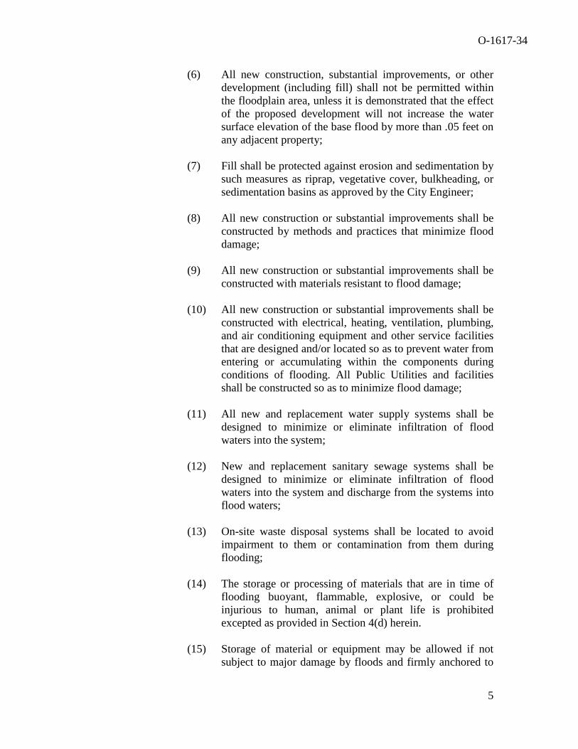
O-1617-34
(6) All new construction, substantial improvements, or other development (including fill) shall not be permitted within the floodplain area, unless it is demonstrated that the effect of the proposed development will not increase the water surface elevation of the base flood by more than .05 feet on any adjacent property;
(7) Fill shall be protected against erosion and sedimentation by
such measures as riprap, vegetative cover, bulkheading, or sedimentation basins as approved by the City Engineer;
(8) All new construction or substantial improvements shall be
constructed by methods and practices that minimize flood damage;
(9) All new construction or substantial improvements shall be
constructed with materials resistant to flood damage;
(10) All new construction or substantial improvements shall be constructed with electrical, heating, ventilation, plumbing, and air conditioning equipment and other service facilities that are designed and/or located so as to prevent water from entering or accumulating within the components during conditions of flooding. All Public Utilities and facilities shall be constructed so as to minimize flood damage;
(11) All new and replacement water supply systems shall be
designed to minimize or eliminate infiltration of flood waters into the system;
(12) New and replacement sanitary sewage systems shall be
designed to minimize or eliminate infiltration of flood waters into the system and discharge from the systems into flood waters;
(13) On-site waste disposal systems shall be located to avoid
impairment to them or contamination from them during flooding;
(14) The storage or processing of materials that are in time of
flooding buoyant, flammable, explosive, or could be injurious to human, animal or plant life is prohibited excepted as provided in Section 4(d) herein.
(15) Storage of material or equipment may be allowed if not
subject to major damage by floods and firmly anchored to
5

O-1617-34
prevent flotation or if readily removable from the area within the time available after the issuance of flood warning by The National Weather Service.
(16) Recreational vehicles placed on sites within Zones A1-30,
AH, and AE on the community’s FIRM either
(i) Be on the site for fewer than 180 consecutive days, (ii) Be fully licensed and ready for highway use, or (iii) Meet the permit requirements of (b)(2) of this
section and the elevation and anchoring requirements for “manufactured homes” in (c)(1) in this section.
(17) Redevelopment or Reclamation Projects – Projects that
propose to reduce flood hazards through the removal of existing non-compliant development and which provide beneficial improvements to the function of the floodplain, including increased storage capacity, reduced velocities and erosion, restored natural functions of the floodplain, and improved discharge efficiency, through appropriate modifications to the existing character and topography of the floodplain.
(18) The following floodplain modifications approved by the
Floodplain Permit Committee shall also require approval by the City Council. A project report and the recommendations of the Floodplain Permit Committee’s conditional approval will be provided to City Council at the time of Council’s consideration of approval of such a Floodplain Permit. For projects that require platting, this information will be presented at the time Council considers the preliminary plat. For projects that do not require platting, the report will be made to Council prior to issuance of the floodplain permit.
(i) A modification of the floodplain that results in a
change of ten percent (10%) or more in the width of the floodplain.
(ii) The construction of a pond with a water surface area of 5 acres or more.
(iii) Any modifications of the stream banks or flow line
within the area that would be regulatory floodway whether that channel has a regulatory floodplain,
6

O-1617-34
unless the work is being done by the City of Norman staff as part of a routine maintenance activity.
(iv) Any redevelopment or reclamation project, as provided for above in Section 4(b)(17).
* * * *
(f) Standards for Subdivision Proposals: (1) All subdivision proposals including manufactured home parks and
subdivisions shall be consistent with Section 4(b) of this ordinance;
(2) All proposals for the development of subdivisions including manufactured home parks and subdivisions shall meet all applicable permitting requirements of this ordinance.
(3) Base flood elevation data shall be generated for any subdivision proposals and other proposed land development activity including manufactured home parks and subdivisions, if not otherwise provided pursuant to Section 3 and 4 of this ordinance;
(4) All subdivision proposals, including manufactured home parks and subdivisions, shall have adequate drainage provided to reduce exposure to flood hazards;
(5) All subdivisions proposals including manufactured home parks and subdivisions shall have public utilities and facilities such as sewer, gas, electrical and water systems located and constructed to minimize or eliminate infiltration or flood damage;
(6) Whenever possible, a proposed subdivision which contains some land within the floodplain shall be developed using the Planned Unit Development process, so that dwelling units could be located out of the floodplain and such areas left undeveloped or without residential structures.
§ 3. SEVERABILITY. If any section, subsection, sentence, clause, phrase or portion of this ordinance is, for any reason, held invalid or unconstitutional by any court of competent jurisdiction, such portion shall be deemed a separate, distinct, and independent provision, and such holding shall not affect the ability of the remaining portions of this ordinance. ADOPTED this day of NOT ADOPTED this day of , 2017. , 2017.
7

O-1617-34
Lynne Miller, Mayor Lynne Miller, Mayor ATTEST: Brenda Hall, City Clerk
8
CITY COUNCfL CONFERENCE MINUTES
August 9, 2016
The City Council of the City of Norman, Cleveland County, State of Oklahoma, met in a conference at 5:35 p.m. in the Municipal Building Conference Room on the 9th day of August, 2016, and notice and agenda of the meeting were posted at the Municipal Building at 201 West Gray, and the Norman Public Library at 225 North Webster 24 hours prior to the beginning of the meeting.
PRESENT:
ABSENT:
Item 1, being:
Councilmembers Allison, Castleberry, Chappel, Clark, Heiple, Hickman, Holman, Karjala, Mayor Miller
None
DISCUSSION REGARDING THE FLOODPLAIN ORDINANCE.
Mayor Miller said Staff is not bringing forward any amendments and/or changes to the Floodplain (FP) ordinance at this time. She said tonight's meeting is only a review of the FP ord inance and she felt providing background as wel l as discussing the basics of the FP ordinance wou ld be very helpful to new Councilmembers .
Mr. Shawn O' Leary, Director of Public Works, said Staff has been working on new amendments to the FP ord inance with the Council Oversight Committee for over a year. He said he will provide basic information on the FP ordinance and City Attorney Staff wil l highlight possible amendments to the FP ordinance that Council may consider in the future.
Floodplain: The Basics
Mr. O'Leary said a floodplain is any land susceptible to being inundated by water from any natural resource and regulatory floodplain is land that is subject to a one percent ( 1 % ) or greater chance of flooding in any given year (often ca lled the I 00 year flood and/or I% Chance Flood).
Mr. O'Leary said development in the floodplain needs to be regulated to reduce future flood risks to new construction in ce1tain flood prone areas. He said Norman is required to participate in the National Flood Insurance Program (NFIP) created by Congress in 1968. The NFIP mitigates future flood losses through sound, community enforced building and zoning ordinances and provides access to affordable, federal ly backed fl ood in surance protection for prope1ty owners.
Mr. O'Leary said the Federal Emergency Management Agency (FEMA) prov ides the maps of the flood prone areas (Special Flood Hazard Areas) and designates areas as floodplain or has potential for flooding in the I 00 year storm. The maps also designate floodway areas, i.e., channel of a watercourse and the adjacent land that must be reserved to discharge the base flood w ithout increasing the water surface elevation more than a designated height and the Base Flood Elevation (BFE) which is the elevation above sea level of the I% chance flood. Mr. O'Leary said the local floodplain management regulations are designed to reduce flooding risk for propetty owners and insurers.

City Council Conference Minutes August 9, 2016 Page 2
Participating in the NFI P is impo1tant for Norman because Norman has 546 active flood insurance policies; 109 claims have been paid since 1979; 894 insurable structures are located in the floodplain; and federa l disaster assistance can be received for flood related damages. Mr. O'Leary highlighted the history of the NFIP participation in Norman as follows:
• July 8, 1975: • November 1, 1979: • August, 1987: • January, 1999: • September, 2008: • February, 2013:
First FP ordinance/City joins the program; First FIRM/FIS (FEMA floodplain map); Revised FIRM/FIS issued ; Revised FIRM/FIS issued; DFIRM/ FJS issued; and Revised DFIRM issued.
Mr. O' Leary said Council approved revisions to the FP ordinance in 1978, I 981 , 1986, 1987, 1989, I 997, 2003 , 2004, 2007, and 2013.
Mr. O'Leary said Norman was accepted into the NFIP Community Rating System (CRS) on October 1, 2011 , as a Class 5 community, stating on ly 52 communities in the U.S . (0.25%) of the NFIP communities have received a CRS class rating of five (5) or better on a scale of I 0 with one (I) being the highest rating. He sa id Norman takes floodplain management very seriously and every point on the CRS rating sca le reduces floodplain insurance 5% for citizens/constituents. Mr. O'Leary said 21 , 180 U.S. communities participate in the NFIP; I ,090 (5.1 %) of those communities participate in the CRS program; and 12 of the communities are in Oklahoma.
Mr. O'Leary said the Flood Hazard District is in the Zoning Ordinance and functions as an overlay di strict whereas, the underlying zoning designation sti ll applies with floodplain restrictions. He said a Floodplain Permit Committee reviews applications for development in the Flood Hazard District and the Committee is comprised of a Floodplain Administrator (Publ ic Works Director); Director of Planning; City Engineer; Subdivision Development Manager; Principal Planner; and two (2) citizen members with Oklahoma Water Resource Board 's (OWRB) floodplain training.
The genera l rules for floodplain regulation include allowing prope1ty owners to build in the portion of the floodplain that is not in the floodway (flood fringe), if the structure is elevated at least two (2) feet above the BFE. No structures can be built and/or no fill can be applied in the floodway. Fill can be applied in the flood fringe in limited circumstances, i.e., no rise in BFE downstream, compensatory storage provided, etc.
Mr. O'Leary highlighted the process for development in the floodplain as follows:
• Applicants submit application to Floodplain Permit Committee for consideration: lots of detailed information is required for consideration but the Committee has the option to request even more information if needed to make the decision;
• Floodplain Permit Committee holds open meetings to consider floodplain permit applications; and
• Floodplain Permit Committee is charged with determining specific flood hazard at the site, evaluating the suitability of the proposed use in relation to the flood hazard, and issues or denies the floodplain permit.

City Council Conference Minutes August 9, 2016 Page 3
Changes to the FEMA floodplain maps include:
• Correcting mistakes in the map: Letter of Map Amendment (LOMA) - corrects an error in the maps and the City is not involved in the application process unless the City is requesting the correction; and
• Changing the designated floodplain on the map due to proposed or actual manmade alterations within the floodplain: placement of fill; modification of a channel; construction or modification of a bridge; construction of single or multiple residential or commercial structures on single or multiple lots. The application is made through the local community and applicant pays for the FEMA review.
Mr. O'Leary said the applicants can also request FEMA to change maps due to development. He said before developing begins, the applicant can submit a Conditional Letter of Map Amendment (CLOMR) and request FEMA's comments on the proposed structure(s) and/or project(s) that would, upon construction:
• Be located on existing natural ground above the BFE in the floodplain ; • Affect the hydrologic or hydraulic characteristics of a flooding source and result in modification
of floodplain ; and • Based on fill - result in the modification of the SFHA through the placement of fill outside the
existing regulatory fl oodway.
Mr. O ' Leary said a Letter of Map Revision (LOMR) would change the fl oodplain map based on the implementation of phys ical measures that affect the hydro logic or hydraulic characteristics of a flood ing source and result in modification of existing regulatory tloodway, BFE or the SFHA. A LOMR officially revises the map. Mr. O'Leary said a Letter of Map Revi sion Based on Fill (LOMR-F) changes the map's SFHA based on the placement of fill outside the existing regulatory floodway.
Proposed Ordinance Amendments
Ms. Kathryn Walker, Assistant City Attorney, said in 2014, a developer approached the City about the Bishops Landing Project which entailed razing an existing apartment structure and constructing new apa1tments. She said the property had a stream going through the property and a number of buildings that predated the FP ordinance were constructed in the floodplain and floodway. The developer removed the structures from the floodplain; added 1.3 acre feet of FP storage by excavating the side of a creek channel with no change to the depth or flow line of the stream; and constructed new apartments outside of the flood way.
Ms . Walker said during the Bishops Landing Project review and approval process, Staff identified some ordinance amendments that could be done to make the process work better should another similar application/project be submitted. She said the Councilmembers did not want to discourage these types of projects; however, Counci l also wanted to make ce1tain the process covered the City and the projects were done correctly. Ms. Walker said the Council Oversight Committee discussed possible ordinance amendments at multiple meetings during 2015 at the Committee's direction, and full Council discussed the proposed amendments at a study session in February, 2016. She said Staff met with Sean Rieger, Harold Heiple, Neil Suneson, and Shari Stansel to gather input regarding the proposed changes.

City Council Conference Minutes August 9, 2016 Page 4
Ms. Walker said the developer did seek a CLOMR from F EMA and FEMA granted the CLOMR stating they would change the fl oodplain boundaries based on what the developer said they would do . She said the Floodplain Permit Committee also reviewed the project and issued a Conditional Letter of Approval conditioned upon FEMA coming back stating the CLOMR was okay. The developer has received the CLOMR from FEMA and is in the process of installing the improvements/making changes to the property.
Intersection of FEMA and City Process Ms. Walker highlighted the C ity's current process as outlined in the ordinance stating the owner of land requests a review of fl ood boundaries on his property and presents the information to the Planning Commission for review; the Planning Commi ssion obtains technical analysis and recommends to Council whether boundaries should be changed as well as whether the City should request a LOMR. She said the City ' s current floodplain process directs the land owner to have corrections made on the floodplain map via the LOMA and reminded Council that the C ity is not invo lved in the LOMA process. Ms. Walker said the proposed amendment(s) would modify the language to clarify the process for incorporating LOMRs approved by FEMA into the FP ordinance and remove language related to LOMAs.
Wizen is Fill Restricted Ms. Walker said another issue that was identified from the Bishops Landing Project review process was regarding fill restrictions. She said current ordinance language reads fill is limited to elevation of individual res idential and non-residential structures; construction or repair of public roads and bridges; and river or stream bank stabilization or reinforcement projects and, where authorized, fill must be the minimum necessary to accomplish the permitted development.
Ms. Walker said the proposed language refers to the LOMR process to ensure clarity and also references modification of the floodplain, including fill , excavation, dredging, channelizing and paving limited to:
• Elevation of single-family residential structures (and associated structures) and non-res idential structures if no other reasonable location outside of fl oodplain. Structures cannot be located in the fl oodway;
• Construction of ponds less than five (5) acres for farm/ranch activity; • Stab ii ization/re inforcement of river or stream bank; • Construction/repair of public roads and bridges; and • " Redevelopment or reclamation projects."
Mr. O'Leary said one of the attractions of the Bishops Landing Project was that the developer wanted to remove approximately seven (7) buildings that were located in the floodplain and modify the property before reconstructing new buildings that would no longer be in the floodplain.
Define "Redevelopment or Reclamation Projects" Ms. Walker said the next proposed change will define " redevelopment or reclamation projects." She said this definition will address projects like Bishops Landing that disturb the floodplain more than a typical project, but actually improve its function . It will allow projects, w ith Floodplain Permit Committee's approval, that propose to reduce flood hazards through the removal of existing non-compliant development and which provide beneficial improvements to the functi on of the floodplain.
ClarifY Approval Process Ms. Walker said the current ordinance language states Council must approve the following floodplain modifications: modifications that would change the width of the floodplain 10% or more; construction of
City Council Conference Minutes August 9, 2016 Page 5
a pond with a water surface area of five (5) acres or more; and modification of stream banks or flow line within the regulatory floodway unless work is done by the City. She said repo1ts regarding floodplain modifications will be given to Council when plats are scheduled as agenda items for Council consideration. If no platting is involved, the repo1ts will be given to Council prior to the issuance of the Floodplain Permit Committee permit.
Proposed language will add "redevelopment or reclamation projects" to the list of modifications Council must approve. New language will require a project repo1t and the recommendations of the Floodplain Permit Committee be provided to Council at the time of its consideration for the floodplain permit.
Mr. O'Lea1y said Council has dealt with a couple of these recently; the first was the Lindsey Street/Imhoff Creek Project and the second was the West Main Street/Brookhaven Creek Project, when the stream banks were modified.
Miscellaneous Cleanup Items Ms. Walker said " including manufactured home parks and subdivision" is proposed to be deleted from the current ordinance and changed to "standards for subdivision proposals" because it is redundant. She said the FEMA's zone designations will be updated as well.
Council Comments
Mayor Miller said the Bishops Landing Project was so different from any project ever brought before Council. She said the project included removing the existing apa1tments located in the core area of Norman that were also next to a stream. Some of the apa1tment buildings were located in the floodplain. Mayor Miller said the developer proposed not only to remove the existing structures, but to change/modify the entire contour of the eaith and add storage to the property before they reconstructed the apartment building.
Mayor Miller said currently the Center City Visioning Committee is discussing the considerable amount of floodplain areas within core Norman as well as the number of buildings that are constructed within the floodplain. She said it would be difficult to continue the Center City Visioning Committee process unless the FP ordinance language is amended.
Council member Clark asked what areas of Norman would see this utilized and asked if there are areas we would not want to rebuild. Mayor Miller said it is primarily the core area and Ms. Walker agreed, stating the older core area(s) which includes the downtown shopping center. Ms. Walker said the FP ordinance was not adopted until the late 1970s; therefore, any structure built in the core area before that time could theoretically be impacted by the floodplain because there were not any regulations to prevent it.
Counci lmember Hickman asked whether other cities allowed redevelopment or reclamation projects. Ms. Walker said Tulsa approved one of the first and best FP ordinances after a significant flood event in the 1980s and would be surprised if Tulsa did not allow redevelopments. She said although she does not have a list of cities who allow redevelopments, many, including Tulsa, may not address it as a redevelopment project but rather address through their General Standards.
Councilmember Hickman said he is concerned about being able to remove a structure in the floodplain and replace it with something larger. Ms. Walker said there is language in the FP ordinance that talks about "substantial damage"; however, looking at a purely zoning perspective, it would be a nonconforming use until the land use is changed. Mr. O'Leary said the "substantial damage" language states

City Council Conference Minutes August 9, 20 I 6 Page 6
all floodplain regulations would have to be met if more than 50% is damaged during redevelopment. Ms. Walker said a larger structure could replace a smaller structure if it meets the FP ord inance.
Mr. Jeff Bryant, City Attorney, said the FP ordinance is an overl ay focusi ng specifical ly as to what types of structures can be in the floodway and floodplain. He said the underlying zoning of the property wi ll dictate what type of use can be built. Mr. Bryant said if a developer totally tore down a structu re, the nonconformi ng use would be gone and the developer would have to comply with the existing, underlying zoning and would only be able to build what is allowed under the zoning.
Counc ilmember Cast lebeny would like something to address pipeline in the floodplain and/or floodway and Counci lmember Hickman agreed. Councilmember Hickman asked whether the City had any notice requirements for homes that have flooding problems and Mr. O'Leary said notices are sent for every floodplain permit application; Staff does public education, i.e., sends floodplain information to the 894 owners with insurable structures located in the floodplain; and notifies the repetitive loss properties (currently six properties) located in Norman.
Counci lmember Karjala felt wildlife and/or environmental analysis should be part of the Floodplain Permit Committee appl ication process.
Councilmember Allison said he felt the verbiage " reasonable" was a subjective term in the proposed change regarding fill stating " ... Elevation of single-fami ly residential structures (and associated structures) and non-residential structures if no other reasonable location outside of FP ... ". He said what may be reasonable to one may be totally different to another and asked whether this could be quantified. Ms. Walker said this has been discussed before; however, "better" terminology was not determined. She fe lt leaving the verbiage "reasonable" may be both favorable and un-favorable; however, good projects may be overlooked if it is defined a ce1tain way in the ordinance. Councilmember Allison said he preferred hard, fast rules rather than broad.
Items submitted for the record I. PowerPoint presentation entitled, "Floodplain Ordinance," dated August 9, 2016
The meeting adjourned at 6:28 p.m.
ATTEST:
City Clerk Mayor

CITY COUNCIL STUDY SESSION MINUTES
February 16, 2016 The City Council of the City of Norman, Cleveland County, State of Oklahoma, met in a Study Session at 5:30 p.m. in the Municipal Building Conference Room on the 16th day of February, 2016, and notice and agenda of the meeting were posted at the Municipal Building at 201 West Gray, and the Norman Public Library at 225 North Webster 24 hours prior to the beginning of the meeting.
PRESENT: Councilmembers Castleberry, Heiple, Holman, Jungman, Lang, Miller, Mayor Rosenthal
ABSENT: Councilmembers Allison and Williams
Item 1, being: DISCUSSION REGARDING POSSIBLE AMENDMENTS TO THE CITY OF NORMAN FLOODPLAIN ORDINANCE. Ms. Kathryn Walker, Assistant City Attorney, said the City of Norman is part of the National Flood Insurance Program (NFIP) which is a program that provides affordable flood insurance for properties located in the floodplain. She said the City had to adopt floodplain management regulations in order to join the NFIP. She said the City monitors the floodplain utilizing three (3) mechanisms.
1) Flood Hazard Identification (mapping); 2) Floodplain Management (building codes and zoning regulations); and, 3) Flood Insurance (provision of reasonable priced insurance for property owners in participating communities).
Ms. Walker presented a City of Norman Floodplain map to Council reflecting the 100 year flood including the floodways and floodplains located in Norman. She highlighted Norman’s approach to floodway regulation as follows:
• No adverse impact regulatory approach: o Structures at least two (2) feet above the base flood elevation (BFE); FEMA requires one (1) foot; o Certification of no more than .05 feet rise in BFE on any adjacent property as a result of the proposed
work; o Engineering Design Criteria – requires unimproved drainage ways left in a natural state to dedicate to the
public and platted to include the floodplain width; and o Engineering Design Criteria – prevents any and all drainage interferences, obstructions, blockages, or
other adverse effects upon drainage, into, through, or out of property. Ms. Walker said when someone wants to construct in the floodplain they must obtain a floodplain permit and highlighted the procedure(s) as follows: Floodplain permit committee process: 1) the FC hears all applications for floodplain permits; 2) the FC meets on an as-needed basis on the first or third Monday of each month and shall post a public notice accordingly; and 3) property owners adjacent to a proposed development will be notified before a floodplain permit is issued. Appeals and variances may be granted by the Board of Adjustment (BOA) in limited circumstances: 1) new construction and substantial improvements on lots contiguous to and surrounded by lots with existing structures below BFE; 2) reconstruction, repair, restoration or rehabilitation of historic structures if exception is the minimum necessary to preserve historic character; and 3) no variances in designated floodways if any increase in flood levels during the base flood discharge would result.

City Council Study Session Minutes February 16, 2016 Page 2 Ms. Walker said the City requires at least two (2) members of the BOA to successfully complete the Oklahoma Water Resources Board (OWRB) basic floodplain training, an eight (8) hour course, so they have some technical knowledge with which to review the applications. Councilmember Castleberry asked what would happen if Staff did not like the outcome of the Floodplain Committee; he said obviously the applicant can appeal to the BOA, but asked if there is a process where Staff can object if the applicant appeals to the BOA. Ms. Walker said Staff makes up the majority of the Floodplain Permit Committee and only in limited circumstances does the floodplain permit application come to Council; therefore, it is not often that Council is aware of the application or involved in the floodplain permit process. She did not believe this particular scenario has happened before, but they could appeal the BOA. Councilmember Castleberry said having Staff on the Floodplain Permit Committee, ultimately making the decision whether or not to approve the application, seemed biased and possibly unfair to the applicant. Ms. Walker felt the ordinance was adopted to include Staff on the Floodplain Permit Committee so there would be members with technical expertise to review the applications. Mr. Shawn O’Leary, Public Works Director, said he serves as the Floodplain Administrator and is Chair of the Floodplain Permit Committee and other Staff members include: Scott Sturtz, City Engineer; Susan Connors, Planning and Community Development Director; Jane Hudson, Principal Planner; and Ken Danner, Subdivision Development Manager. Mayor Rosenthal said the remaining three (3) citizen members are also required to complete the eight (8) hour OWRB basic floodplain training; however, most of the citizen members have gone further and also completed the Certified Floodplain Managers (CFM) course. Mr. O’Leary felt many Floodplain Committees in other cities, locally and around the nation; include Staff because it is a very detailed and technical process and ultimately making certain there is no harm done to the floodplain. Ms. Walker highlighted the special circumstances requiring approval by City Council to include: 1) a modification of the floodplain that results in a change of ten percent (10%) or more in the width of the floodplain; 2) the construction of a pond with a water surface area of five (5) acres or more; and 3) any modifications of the stream banks or flow line within the area that would be regulatory floodway whether that channel has a regulatory floodplain or not, unless the work is being done by the City Staff as part of a routine maintenance activity. Staff highlighted the FEMA Regulatory Map Amendments are as follows:
• Letter of Map Amendment (LOMA): 1) correcting errors or mistakes; 2) Applicant: City and property owner; and 3) must be supported by engineering studies. The LOMA process (single lot, small corrections) includes a letter by property owner to FEMA.
• Letter of Map Revision (LOMR): 1) development that modifies floodplain/floodway; 2) Applicant is both the City and the Developer; and 3) must be supported by engineering studies. The LOMR process includes a floodplain permit (conditioned on FEMA approval) and advises FEMA if Community Administrator supports the request;
• Conditional Letter of Map Revision (CLOMR): advises FEMA of the development plan; if approved, then construction can begin; following construction, the planned improvements must be fully documented with FEMA.
Councilmember Lang asked whether there would be a reason a property owner would ever look at the floodplain unless they were developing the property, and Ms. Walker said it would be unlikely unless it is already impacting their property. She said an example might be if the property owner had a structure on the property and a new floodplain map was established reflecting the structure and/or property was now located in the floodplain. He asked how the City informed the property owner in such an instance and Ms. Walker said anytime the floodplain map(s) are proposed to be revised, the City gives public notice to any property owners that may be impacted. She said those property owners would have an opportunity to address their concerns, if any, with Staff before any revision(s) to the floodplain map were completed.

City Council Study Session Minutes February 16, 2016 Page 3 Ms. Walker said following FEMA review and approval of either a LOMA affecting multiple properties or a LOMR application, the City’s FH Overlay Zoning District must be amended by Ordinance per Section 22:429.1(3). The Planning Commission reviews and makes recommendations to Council and the Council reviews and approves by adopting an Ordinance. Section 3(a): District Boundaries: Current language requires individual property owners to pursue technical corrections to floodplain via the Planning Commission. A LOMA is the process to correct technical errors for individual properties and is initiated and granted wholly outside the City process. Revised language clarifies the process for LOMRs in that they would come to the City for revision of the maps via a zoning ordinance amendment after FEMA approval. Section 3(c): modifying language to clarify that the process described in this section is for incorporating a LOMR approved by FEMA into the City’s local floodplain ordinance for local regulatory jurisdiction. Language that relates to LOMAs is recommended to be removed. LOMAs are for the purpose of correcting a Flood Insurance Rate Map (FIRM) mapping errors and do not relate to changes in the floodplain or floodway due to development or construction activity. LOMA requests can be made directly to FEMA and are not reviewed by the Floodplain Permit Committee because no development activity is proposed with a LOMA application and are not reviewed by the Planning Commission or City Council. The language regarding the LOMA process that is recommended to be removed has created a lot of confusion regarding the role of the Planning Commission and the City Council in the LOMA process. Section 4(b)(1): modifying the language to more clearly state what may be permitted, as opposed to what is permitted as an exception to a blank prohibition, removing language considered redundant, and adding language to clarify how the LOMR process fits into the Floodplain Permit Committee and City Council review processes on projects proposing to modify the floodplain through development activity. Section 4(b)(1): renumbering subparagraphs as (i) – (v) instead of (a) – (e) to be consistent with designation of other subparagraphs in the floodplain ordinance and adding the following lead in language “the proposed modification is” to each subparagraph; Section 4(b)(1)(i): Current language states the use of fill is limited to the elevation of individual residential and non-residential structures; construction or repairs of public roads and bridges; and/or river or stream bank stabilization or reinforcement projects – only the minimum amount necessary. She said proposed language states: minimum amount of floodplain modification is allowed with a permit in limited circumstances to include: elevation of single-family residential and non-residential structures (if no reasonable location outside of the floodplain); farming ponds less than five (5) acres; river or stream bank revitalization or reinforcement projects; construction or repair of public roads and bridges; and/or redevelopment or reclamation projects. Section 4(b)(1)(v): adding modifications to the floodplain that are part of a redevelopment or reclamation project, which is more defined in Section 4(b)(17). Ms. Walker said the big change to this section is the elevation of single family residential and non-residential structures and there was a lot of discussion on this topic at recent Oversight Committee meetings. She said discussions really centered on “how much” modification to the floodplain does the City want to allow, i.e., does the City want to allow large-scale projects or limit the modification(s) to single family type homes. Section 4(b)(16): clean-up to reflect FEMA’s current zone designations. Section 4(b)(17): adding new language to specify that redevelopment or reclamation projects that reduce flood hazards through removal of non-compliant development and which provide beneficial improvements to the floodplain through modifications to the floodplain may be permitted. This will reduce flood hazards by removing existing non-compliant development AND provide beneficial improvements to the function of the floodplain including: increase storage capacity; reduced velocities and erosion; restored natural functions of the floodplain; and improve discharge efficiency.
City Council Study Session Minutes February 16, 2016 Page 4 Section 4(b)(17), continued: Ms. Walker said this new language is due to the Bishops Landing process because it was a non-compliant property in the floodplain and the redevelopment project allowed the developer to get the property out of the floodplain/floodway. She said Staff wanted to create a circumstance by which Council and/or the Floodplain Permit Committee could approve similar projects that actually bettered the original floodplain properties, such as properties in the core area that were built before the City had floodplain regulations. Section 4(b)(18) [formerly 17]: clean up redundant language in subsection (iii), clarify that a redevelopment or reclamation project under 4(b)(17) will require Council approval regardless of whether the project changes 10% or more of the width of the floodplain (subsection iv). Ms. Walker said the proposed language clarifies the current practice of obtaining Council approval after the Floodplain Permit Committee reviews the proposal. She said this requires a project report and recommendation of the Floodplain Permit Committee’s conditional approval to be given to Council and adds one additional type of floodplain modification requiring Council approval – the redevelopment and/or reclamation projects. Section 4(b)(18)(iii): Ms. Walker said the proposal will remove the redundant language in this section. Section 4(f): Standards for Subdivision Proposals – During Oversight Committee discussions, Chairman Miller identified this as another potential area for cleanup as the current language “all subdivision proposals include manufactured home parks and subdivisions” is redundant. Ms. Walker said this proposal will remove redundant language. The Council Oversight Committee met in January and February, 2015, to discuss the floodplain ordinance after concerns were raised regarding how the current ordinance applied to the Bishops Landing project. Concerns expressed included some members of Council expressing a desire to clarify the process for Planning Commission and Council approval of floodplain permits, particularly related to how the City approval processes coincide with FEMA CLOMR and LOMR processes. Additional concerns include the level of modifications to the floodplain that should be allowed, whether current language allowed residential structures other than single family dwellings to be constructed in the floodplain, and how to accommodate projects that improve the floodplain’s function. Ms. Walker said the Committee recently discussed the floodplain ordinance again on November 19, 2015, and Staff presented draft changes to the Committee. During the discussions, Harold Heiple, on behalf of the Norman Developer’s Council, and Sean Rieger, on behalf of the Builder’s Association of South Central Oklahoma (BASCO) stated they had objections to the ordinance. Ms. Walker said Chairman Miller requested Staff meet with Mr. Heiple and Mr. Rieger to discuss the proposed amendments and requested Staff bring the ordinance draft to full Council at a Study Session. Council comments: Councilmember Castleberry asked whether or not the Developers Representatives’ concerns were addressed and whether or not their suggestions were added to the proposed Floodplain Ordinance amendments. Mayor Rosenthal said the Oversight Committee requested Staff bring this issue to full Council in order to gain Council input before they made any proposed changes to the ordinance amendments. She suggested Council look at each of the sections/proposals one at a time and discuss them. Councilmember Miller requested Staff provide clarification of a CLOMR versus a LOMR, as well as “who” sends map revisions to FEMA. Mr. O’Leary said the Floodplain Ordinance directs the floodplain administrator, i.e., City Staff, to take floodplain map revisions to FEMA; however, floodplain map revisions can be derived from a number of resources. He said both a LOMR and CLOMR are developments that modify the floodplain/floodway, must be supported by engineering studies, and the floodplain administrator advises FEMA that they support the request(s). The CLOMR allows construction to begin and when finished it must be fully inspected/documented with FEMA.

City Council Study Session Minutes February 16, 2016 Page 5 Council comments, continued: Section 4(b)(1) regarding “minimum amount of modification necessary”: Councilmember Castleberry said the proposal as written does not allow a developer to do more (improvements), only the minimum within the floodplain and Ms. Walker said the proposal is written as such to discourage unnecessary modifications to the floodplain. Mr. O’Leary said the principle is to leave the river and/or stream as natural as possible unless a compelling reason can be established and there is a science concept that natural streams are better off left alone rather than cutting up or changing them. Councilmember Castleberry questioned if that means improving or making the river and/or stream better and Mr. O’Leary said “improving and/or making it better” would take you back to the “minimum amount of modification necessary.” Mayor Rosenthal said Section 4(b)(17) regarding redevelopment and/or reclamation projects addresses the scenario of what can be done in the floodplain to achieve the developers’ and/or City’s goal and she felt that neither the developer nor the City would want to do more than is necessary. Councilmember Miller agreed and felt the ideal standard is not to impede the floodplain any more than is necessary. Councilmember Castleberry said he would feel better if “at least” was added before the language “minimum amount of modification necessary” and Ms. Walker stated the applicant would indicate the goal which they desired to reach on their floodplain permit application and if/when approved, Staff would require the applicant, according to the proposed amendment, to use the “minimum amount of modification” or “disturb the minimum amount of floodplain” to achieve that particular goal. She said the proposal will not inhibit the applicant from making improvements, but rather require only the minimum amount to achieve the applicant’s goal. Councilmember Jungman said the City does not state or determine the applicant’s project. He said the applicant comes to the City with a project located in the floodplain, submits an application for a floodplain permit, after receiving a floodplain permit and approval, the City would tie the applicant’s actions to their project stating they have to do only the minimum modification necessary to accomplish the project they submitted to the City. Section 4(b)(1) regarding “allowing the use of fill for individual residential and non-residential structures”: Staff said the current ordinance states “individual structures and non-residential structures,” but after discussions at the Oversight Committee Staff was requested to change verbiage to “single-family structures” rather than “individual structures.” Councilmember Castleberry asked why not use the word “structure” regardless of its use and Ms. Walker said concern expressed at the Oversight Committee included whether or not the City would want to allow large-scale developments versus a single family home on a single family lot. Councilmember Miller said a huge multi-family complex is considered a single structure. Councilmember Castleberry said he did not see the difference if a developer wanted to build a multi-family structure or a single-family structure if they were willing to make the necessary modifications and improvements to the floodplain. Mayor Rosenthal asked if there would be issues if property is located in the existing RM-6, Multi-Family Dwelling District, with a Flood Hazard District Overlay and Staff said yes. Ms. Walker said construction would not be allowed on property in the Flood Hazard District Overlay without a building variance and building variances are only allowed in certain circumstances. Ms. Walker said this issue may need to be addressed in this language/section. Mayor Rosenthal felt the City did not need to be encouraging intense development within the floodplain. She said the purpose of adding this language is because Staff did not want to restrict improvements to the floodplain because there are many non-conforming structures located in Norman that pre-date the floodplain regulations. Councilmember Castleberry asked how a project would become a redevelopment or reclamation project as opposed to a new project and Ms. Walker said redevelopment and/or reclamation projects are directed more towards the Norman core areas because they pre-date floodplain regulations.

City Council Study Session Minutes February 16, 2016 Page 6 Council comments, continued: Section 4(b)(1) regarding “allowing the use of fill for individual residential and non-residential structures”, continued: Councilmember Lang asked what the verbiage “fix it” (in the floodplain) meant; and asked whether it would apply to individuals who make application to construct within the floodplain on a one-on-one basis. Ms. Walker said the standard for “fixing” or redevelopment/reclamation projects is located in the next section and states what the applicant would need to do in order to “fix” or improve the function of the floodplain. Mayor Rosenthal said that is why the first principal of this section is so very important (minimum amount of modification necessary) and wants to make certain the language clarifies construction for either new development in green open space versus redevelopment. Councilmember Miller said she was also concerned about property currently zoned multi-family and asked if the proposed language “single-family” would eliminate this issue. Councilmember Jungman did not feel like there were a lot of vacant properties zoned multi-family that are also located in the floodplain. Section 4(b)(1) regarding “if no reasonable location outside the floodplain”: Councilmember Lang and Councilmember Castleberry said they were concerned about the word “reasonable.” Mayor Rosenthal restated she felt the City should not encourage more structures in the floodplain and felt it was a very practical policy to encourage construction outside the floodplain if there is a reasonable alternative. Councilmember Castleberry said some citizens felt the City is not reasonable and he is not certain any entity can determine the meaning of the word “reasonable,” i.e., Council, Developer, and/or BOA, etc. Ms. Walker said reasonable is hard to define because it varies from circumstance to circumstance. Councilmembers Jungman and Miller suggested striking the word “reasonable.” Councilmember Holman asked if the proposal would change to “…if no location outside of the floodplain…” and Mayor Rosenthal suggested replacing “reasonable” with “structurally feasible.” Councilmember Jungman felt “structurally feasible” could become problematic. Section 4(b)(17) regarding Redevelopment or Reclamation Projects: Mayor Rosenthal said this is a new section designed to make it possible to redevelop properties such as in the downtown core area. She said concerns have been raised as to what constitutes as beneficial improvements to the floodplain when referring to the four points in the proposal 1) storage capacity; 2) reduced velocities and erosion; 3) restored natural functions of the floodplain; and 4) improved discharge efficiency. Councilmember Castleberry asked how the City would handle a scenario if one or two of the points did not need to be completed, i.e., storage capacity was acceptable and did not need to be improved. Ms. Walker said the Developers’ Representatives recommended adding “...but not limited to… increased storage…” and also adding verbiage “or” because leaving only “and” rather than “and/or” would still indicate the applicant(s) still has to fulfill all four points. Mayor Rosenthal said adding “but not limited to” is useful addition; however, she felt leaving only “and” was sufficient. Section 4(b)(18) regarding Process and Council Review: Mayor Rosenthal said she has no issue if floodplain modifications come to Council for consideration. Councilmember Jungman asked Staff if there would be a situation where an application was denied by the Floodplain Permit Committee, then come to Council where it might be approved and Ms. Walker said currently, if the floodplain permit is denied the next step would be to appeal to the BOA; however, the Developers’/Builders’ Representatives would like the ability to move the floodplain permit directly to Council, not to the BOA, along with a project report and the recommendations of the Floodplain Permit Committee. Staff said the ordinance would need to be amended if Council desires this change.

City Council Study Session Minutes February 16, 2016 Page 7 Section 4(b)(18) regarding Process and Council Review, continued: Councilmember Jungman said he did not agree with taking the BOA step out of the process and wondered what was trying to be addressed with the suggestion. Councilmember Jungman asked what issues the BOA is having and Mr. Steve Lewis, City Manager, said the BOA is comprised of five (5) members and regular attendance has been down. Mayor Rosenthal said a concern that has been expressed is if there are only three (3) BOA members in attendance, essentially one (1) vote can veto the BOA as opposed when all five (5) BOA members are present. She said Council will have a new and reappointment BOA member on the next Council agenda to consider. Mr. Sean Rieger, representing BASCO, said the BOA process has become more and more difficult over time, but was aware of changes being made to address the issues. He felt the BOA members are not as qualified, i.e., floodplain certified, etc., as the Floodplain Permit Committee members to make recommendations regarding floodplain issues. He said when a project is in the flow of development, it is awkward to sidestep and go to the BOA and the recommended process would be similar to the Planning Commission process, i.e., if an application is denied at Planning Commission, the project moves forward for Council consideration. Likewise, if an application is denied by the Floodplain Permit Committee, it would move forward to the Council for appeal instead of the BOA. Councilmember Miller said she feels it is up to Council to deal with and solve the problematic issues, whether they are political or not. She asked Staff, in terms of frequency, how many items this “new” provision might be used over the years and Mr. O’Leary said in the last nine (9) years there have been only three (3) instances out of 100 applications. Ms. Walker reminded Council the provision would be used if one (1) of the applications coming forward is one (1) of the floodplain projects outlined in Section 4(b)(18). Mayor Rosenthal said trying to streamline the processes has been a goal so adding another step to go to the BOA when the application will be coming to Council anyway would not be persuasive to her. Councilmember Lang felt if there is no way to appeal a process then the public’s perception is that the City does not care. He said citizens feel like they have better influence dealing with someone they can vote in or out of office versus citizen volunteer committees. Developer Representative’s Concerns: Mr. Rieger said he would appreciate Council’s consideration of the following suggestions for the possible ordinance amendments:
• Section 4(b)(1): has concerns about adding the language limiting modifications of the floodplain to the “minimum amount of modification necessary” would now apply to all modifications of the floodplain, not just river or stream bank stabilization or reinforcement projects;
• Section 4(b)(1)(i): has concerns that this change would not allow for any elevation of individual residential structures that are not single-family, i.e., multi-family, duplex, etc., would no longer be allowed and elevation structures in the floodplain would only be allowed if there is “no reasonable location for structures outside of the floodplain,” i.e., it is difficult to define “reasonable” because what may be reasonable to one, may be unreasonable to another;
• Section 4(b)(17): has concern that the list of things that could be done to make beneficial improvements to the floodplain was all inclusive and did not include all floodplain improvements that could be considered beneficial. Mr. Rieger said leaving the word “and” in the verbiage states the applicant will still have to fulfill all four points. and
• Section 4(b)(18) [formerly 17]: would like the language to allow for a mechanism to allow Council review in the limited circumstances set forth, even if the Floodplain Committee denies the application. Currently, denials from the Floodplain Committee are appealed to the BOA.
Mr. Harold Heiple, Norman Developer’s Council (NDC), said he is concerned about the process of Council’s study on the issues, i.e., not having all the people with skin in the game at the table, etc., and he is concerned that Council has not heard all the reasons that support the NDC’s concerns.

City Council Study Session Minutes February 16, 2016 Page 8 Audience Participation Mr. Steve Ellis, 633 Reed Avenue, asked Staff what happened to the use of fill in the floodplain language in Section 4(c)(1). Mr. O’Leary said the City of Norman’s ordinance is a “no net fill” ordinance; however, in the case of the Bishops Landing project and many similar cases as well, dirt was being moved around but the net difference was zero and met the ‘no net fill” requirement. He said the Floodplain Permit Committee discussed it and felt “no net fill” was satisfactory. Ms. Cindy Rogers, 633 Reed Avenue, said she is concerned about Council reviewing appeals without technical expertise and Mayor Rosenthal said the process will still include the expertise of the Floodplain Committee which will also include the Floodplain Committee’s recommendation to Council. Mayor Rosenthal said this process was suggested by the Developer’s Representatives and still allows the applicant appeal options. Items submitted for the record
1. Memorandum dated February 12, 2016, from Kathryn L. Walker, Assistant City Attorney III, to Honorable Mayor and Councilmembers
2. Proposed Ordinance Amendments to Section 22:429.1, Flood Hazard District 3. City Council Oversight Committee minutes of January 22, 2015, and February 19, 2015 4. Memorandum dated November 18, 2015, from Kathryn L. Walker, Assistant City Attorney III,
through Jeff Bryant, City Attorney, to Members of the City Council Oversight Committee 5. PowerPoint presentation entitled, “Norman Flood Plain Ordinance, City Council Study Session,”
dated February 16, 2016
* * * * * The meeting adjourned at 6:46 p.m. ATTEST: City Clerk Mayor
.
CITY COUNCIL OVERSIGHT COMMITTEE MINUTES
November 19, 2015
The City Council Oversight Committee of the City of Norman, Cleveland County, State of Oklahoma, met at
5:03 p.m. in the City Council Conference Room on the 19th day of November, 2015, and notice and agenda
of the meeting were posted in the Municipal Building at 201 West Gray 48 hours prior to the beginning of
the meeting.
PRESENT: Councilmember Holman, Williams and
Chairman Miller
ABSENT: Councilmember Jungman
OTHERS STAFF PRESENT: Mayor Cindy Rosenthal
Mr. Jeff Bryant, City Attorney
Mr. Terry Floyd, Development Coordinator
Mr. Todd McLellan, Development Engineer
Mr. Shawn O’Leary, Public Works Director
Mr. Scott Sturtz, City Engineer
Ms. Kathryn Walker, Assistant City Attorney
Ms. Karla Chapman, Administrative Technician III
OTHERS PRESENT: Ms. Sophie Chevreaux, OU Student
Ms. Joy Hampton, The Norman Transcript
Mr. Harold Heiple, Attorney representing the Norman
Developer’s Council
Ms. Katelyn Nelson, OU Student
Mr. Sean Rieger, Attorney representing Builders
Associations of South Central Oklahoma
Item 1, being:
CONTINUED DISCUSSION OF NORMAN’S FLOODPLAIN ORDINANCE.
Chairman Miller said the Oversight Committee (Committee) met in January and February, 2015, to discuss
the floodplain ordinance after concerns were raised regarding how the current ordinance applied to the
Bishops Landing project. Concerns included the level of modifications to the floodplain that should be
allowed; whether current language allowed residential structures other than single family dwellings to be
constructed in the floodplain; and how to accommodate projects that improve the floodplain’s function.
Additionally, some Councilmembers expressed a desire to clarify the process for Planning Commission (PC)
and Council approval of floodplain permits, particularly related to how the City approval process coincides
with the Federal Emergency Management Agency (FEMA), Conditional Letter of Map Revision (CLOMR),
and Letter of Map Revision (LOMR) processes.
Background and Bishops Landing Application:
Over 200 floodplain permits have been issued since the 2007 Floodplain Ordinance Amendment without
significant debate and/or controversy; however, the Bishops Landing application sparked renewed interest by
Council in reviewing the Floodplain Ordinance provisions. The applicant proposed changes within the
floodplain area of Bishop Creek. The project proposed to remove multiple existing structures from the
floodway and floodplain and construct a multi-family residential structure with a wrapped parking garage.

City Council Oversight Committee Minutes
November 19, 2015
Page 2
Item 1, continued:
The City’s Floodplain Ordinance requires that the floodplain permits resulting in a change of 10% or more of
the width of the floodplain must be approved by Council. The Bishops Landing project fell into this category
requiring Council review, and actually reduces the floodplain area through use of a compensatory storage
technique. On February 10, 2015, Council approved the preliminary plat and proposed modification of the
floodplain outline in Floodplain permit No. 553 and the applicant then submitted a CLOMR to FEMA.
The applicant for the Bishops Landing project received a CLOMR from FEMA on September 29, 2015, and
the CLOMR allowed the floodplain modification work to proceed, including the work that was already
ongoing. The applicant will request FEMA to move forward to formally issue the LOMR once the work is
completed. For the City to be able to continue to provide local regulatory enforcement authority over the
area designated by FEMA as floodplain, the LOMR approved by FEMA should then be adopted by
Ordinance. Under the applicant’s current construction timeline, it is anticipated that the proposed floodplain
modifications approved by FEMA in the CLOMR will be completed in January or February, 2016, and the
anticipated request to finalize the LOMR application will be under review by FEMA in mid-March, 2016.
Potential Floodplain Ordinance Amendments:
Ms. Kathryn Walker, Assistant City Attorney, said the proposed language was submitted by
Mr. Marion Hutchinson, who was part of the original Floodplain Committee that drafted the 2007-2008
amendments to the Floodplain Ordinance. She said Staff tweaked the submitted language as follows:
Section 3(c): modifying language to clarify that the process described in this section is for incorporating
Letter of Map Revisions (LOMR) approved by FEMA into the City’s local floodplain ordinance for local
regulatory jurisdiction. Language that relates to Letters of Map Amendments (LOMAs) is recommended to
be removed. LOMAs are for the purpose of correcting FIRM mapping error and do not relate to changes in
the floodplain or floodway due to development or construction activity. LOMA requests can be made
directly to FEMA, are not reviewed by the Floodplain Permit Committee because no development activity is
proposed with a LOMA application, and are not reviewed by the Planning Commission or City Council. The
language regarding the LOMA process that is recommended to be removed has created a lot of confusion
regarding the role of the Planning Commission and the City Council in the LOMA process.
Chairman Miller stated this exception would only come for Council approval as a preliminary plat if it is
more than 10% of the width of the floodplain and Ms. Walker said yes, that is correct. Ms. Walker said
redevelopment or reclamation projects would need Council approval, separate from consideration of
approving the preliminary plat, regardless of whether the project changes 10% or more of the width of the
floodplain, which she will speak more about in Section 4(b)(18).
Mayor Rosenthal asked in the case of the LOMR issues and the Bishops Landing application that have been
debated; specifically, whether the project should have been approved by FEMA first before Council action
has not changed with this amendment and Ms. Walker said that is correct. Ms. Walker said the City (local
regulatory body) becomes the co-applicant on the Conditional Letter of Map Revision (CLOMR), and/or a
Letter of Map Revision (LOMR); therefore, before submitting the application to FEMA, Council would have
an opportunity to “weigh in” before the City would be a co-applicant on the proposed change in floodplain.
Mayor Rosenthal asked why the application to FEMA could not come directly from the Floodplain
Committee, before coming to the Planning Commission and/or Council. Ms. Walker said the application
requires action from the Floodplain Administrator; however, the current ordinance requires Council action if
the proposed changes affect more than 10% of the floodplain.

City Council Oversight Committee Minutes
November 19, 2015
Page 3
Item 1, continued:
Mr. Jeff Bryant, City Attorney, said part of the confusion has to do with the Letters of Map Amendments
(LOMAs) and Letter of Map Revisions (LOMR). He said LOMA is correcting an error, no development is
occurring, and rarely do they come through the Floodplain Committee, rather they go directly to FEMA. He
said Council action is not necessary until the end of the process whereas it would be incorporated into the
City ordinance so that the City will have local regulatory jurisdiction. Chairman Miller asked why the
developer could not acquire the CLOMR directly from FEMA, before obtaining Council action but possibly
after the Planning Commission action. Mayor Rosenthal agreed and said Staff and Council are investing a
lot of time, energy, and analysis before we even know whether FEMA will accept the application.
Mr. Bryant said once the developer has a development plan for land and it does not change the floodplain
more than 10% it will go through the regular process; however, it may still require a CLOMR that needs to
be reviewed by the Floodplain Permit Committee and forwarded to FEMA, without any Council action. He
said Council will still review it as part of the development of that particular plat via the preliminary plat. If
Council approves the preliminary plat, the development is allowed to move forward with the public
improvements, to include any floodplain modifications. When the development has been built according to
the approved FEMA CLOMR, a final plat will be scheduled as an agenda item for Council consideration and
approval, as well as have a final survey conducted by FEMA.
Mr. Shawn O’Leary, Public Works Director, said to give a little clarification to this issue, only three
(3) CLOMRs have been submitted to FEMA in the last ten years; therefore, it is a rare process. He said more
than half of the LOMRs and CLOMRs are initiated by the City because Staff has seen a change in the
floodplain relative to working on an issue, project, etc. Mr. O’Leary said the Bishops Landing applicant has
spent the majority of time and money because this is a private development and the reason the Floodplain
Administrator needs to approve the application is due to the fact the applicant is proposing to revise the
City’s Floodplain map(s).
Section 4(b)(1): modifying the language to more clearly state what may be permitted, as opposed to what is
permitted as an exception to a blank prohibition, removing language considered redundant, and adding
language to clarify how the LOMR process fits into the Floodplain Permit Committee and City Council
review processes on projects proposing to modify the floodplain through development activity.
Section 4(b)(1): renumbering subparagraphs as (i) – (v) instead of (a) – (e) to be consistent with designation
of other subparagraphs in the floodplain ordinance and adding the following lead in language “the proposed
modification is” to each subparagraph;
Section 4(b)(1)(i): modifying current language allowing the use of fill for “individual residential and non-
residential structures” to allow modification of the floodplain for the purpose of elevating “single-family
residential structures and any associated non-residential structures”, while leaving intact the existing
language referring to other “non-residential structures” to allow latitude to consider such municipal projects
as improvements to the Water Reclamation Facility or potential locations for the Senior Citizen Center.
The word “structures” (plural) is consistent with the current language; however, language was
presented to the Oversight Committee in January that proposed to change the word to its singular
form. The Committee offered varying opinions regarding the plurality of this word and language
attached hereto mirrors the language in the current ordinance, “structures”. An example came to
Staff by means of non-residential structures, such as the proposed future Senior Citizens Center and
the Water Reclamation Facility, that have gone through the Floodplain Committee; therefore if
stricken the City could run into issues. It has been suggested to change the verbiage to “single-family
residential” and Staff requests additional guidance on this particular point.
City Council Oversight Committee Minutes
November 19, 2015
Page 4
Item 1, continued:
Section 4(b)(1)(i), continued:
Mr. Harold Heiple, Attorney representing the Norman Developer’s Council, said changing to single-family only
will not allow floodplain permits to be obtained for duplexes, apartments, commercial, or industrial projects.
Chairman Miller said the language came from the original Floodplain Committee and Mr. Bryant said the
original language did not have single-family in the proposal.
Mayor Rosenthal felt the language Staff has drafted allows for a subdivision with single-family residential
structures where the spacing and type of capacity need can be achieved. She said the “non-residential
structures” provides an option; however, the language that follows is very important “…provided that there is
no reasonable location for the structures outside of the floodplain and such structures are not located in the
floodway…”. Mayor Rosenthal felt that Staff has struck a reasonable balance.
Councilmember Holman asked whether this would allow the Downtown Shopping Center to be redeveloped
into a four-story mixed use building or multi-story office building and Staff said it could be; however, it
would fall under the redevelopment provision (Section 4(b)(17).
Section 4(b)(1)(v): adding modifications to the floodplain that are part of a redevelopment or reclamation
project, which is more defined in Section 4(b)(17);
Section 4(b)(16): clean-up to reflect FEMA’s current zone designations;
Section 4(b)(17): adding language to specify that redevelopment or reclamation projects that reduce flood
hazards through removal of non-compliant development and which provide beneficial improvements to the
floodplain through modifications to the floodplain may be permitted.
Mayor Rosenthal said the proposed amendments to the ordinance need to be more clear that structures are
not allowed in the floodway and felt Council needed some guidance on how much beneficial improvements
are required. Ms. Walker said a previous draft included the verbiage “and/or” and based on feedback from
the Committee, “or” was struck; therefore, the proposal as written would require all of the improvements
which can differ in percentage depending on the area and project. Mayor Rosenthal felt the amendment
should state that improvements should be “significant” because it can be argued that Council must approve
even a small percentage of improvements and Councilmember Williams agreed.
Chairman Miller asked Staff what amount of improvements is looked for on floodplain projects and
Mr. O’Leary could not state the specific number/percentage. He agreed the notion of having measurable
improvements stated in the ordinance would/could be vital, specifically the measures of storage capacity,
reduced velocities, and improved discharge. The Committee requested Staff research and bring back
language for review.
Section 4(b)(18) [formerly 17]: clean up redundant language in subsection (iii), clarify that a redevelopment
or reclamation project under 4(b)(17) will require Council approval regardless of whether the project changes
10% or more of the width of the floodplain (subsection iv).
Although modifications to the floodplain due to development activity is presented to the Planning
Commission and the City Council when considering whether to approve a preliminary plat under the
City’s subdivision regulations, there was discussion in the minutes about requiring a vote, separate
from consideration of approving a preliminary plat, to consider a floodplain modification under the
circumstances listed. As this appears to duplicate review already required under existing subdivision
regulations, the language attached hereto does not modify existing language. Staff would appreciate
additional guidance on this particular point.

City Council Oversight Committee Minutes
November 19, 2015
Page 5
Item 1, continued:
Section 4(b)(18) [formerly 17] continued,
Mayor Rosenthal said she cannot imagine a case where the plat would be approved and the floodplain permit
would not be approved; however, she can imagine a case where the floodplain permit would be approved and
nothing happens afterwards. She said the projects should be treated similarly regardless if they come to
Council or not, i.e., those projects less than 10%. Chairman Miller said her concern as a Councilmember is
making certain she understands all the amendments and sections of the Floodplain Ordinance and a matter of
good communication before the project gets to a certain point rather than the wording of the verbiage.
Section 4(f): Standards for Subdivision Proposals – Chairman Miller identified this as another potential area
for cleanup as the current language “all subdivision proposals include manufactured home parks and
subdivisions” is redundant.
Mr. Bryant said the amendments proposed are targeted at specific sections of the Floodplain Ordinance and
requested Committee direction on whether they would like more of a broad review of the ordinance. The
Committee discussed and agreed a broad review is not needed at this time; the issues that were brought to
Staff and Council’s attention have been addressed.
Chairman Miller requested this topic be brought to full Council at a future Study Session and the Committee
agreed.
Items submitted for the record
1. Memorandum dated November 18, 2015, from Kathryn L. Walker, Assistant City Attorney,
through Jeff Bryant, City Attorney, to Members of City Council Oversight Committee
2. Proposed Ordinance Amendments to Section 22:429.1 Flood Hazard District
3. City Council Oversight Committee minutes dated January 22, 2015, and February 19, 2015.
*
Item 2, being:
MISCELLANEOUS DISCUSSION.
None
*
The meeting adjourned at 5:51 p.m.

CITY COUNCIL OVERSIGHT COMMITTEE MINUTES
June 18, 2015
The City Council Oversight Committee of the City of Norman, Cleveland County, State of Oklahoma, met at
5:03 p.m. in the City Council Conference Room on the 18th day of June, 2015, and notice and agenda of the
meeting were posted in the Municipal Building at 201 West Gray 48 hours prior to the beginning of the meeting.
PRESENT: Councilmember Holman, Jungman, and Chairman Miller
ABSENT: Councilmember Williams
OTHERS STAFF PRESENT: Mayor Cindy Rosenthal
Councilmember Castleberry
Mr. Jeff Bryant, City Attorney
Ms. Susan Connors, Planning & Community
Development Director
Mr. Steve Lewis, City Manager
Mr. Todd McLellan, Development Engineer
Mr. Shawn O’Leary, Director of Public Works
Mr. Scott Sturtz, City Engineer
Ms. Kathryn Walker, Assistant City Attorney
Ms. Karla Chapman, Administrative Technician III
OTHERS PRESENT: Mr. Roger Gallagher, Concerned Citizen
Ms. Joy Hampton, The Norman Transcript
Ms. Carol Lindblad, Concerned Citizen
Ms. Jeanne Parker, Concerned Citizen
Ms. Sherri Stansel, Floodplain Committee Member
Ms. Sandy Taylor, Concerned Citizen
Ms. MaryAnne Tullius, Concerned Citizen
Item 1, being:
CONTINUED DISCUSSION REGARDING A POSSIBLE AMENDMENT TO THE NORMAN FLOODPLAIN
ORDINANCE.
Chairman Miller said the Oversight Committee began discussions regarding possible amendments to the Norman
Floodplain Ordinance in January and February, 2015, primarily due to Council approval of a land use and zoning
change and a preliminary plat (including proposed floodplain modifications) for the Bishops Landing Project. She
said this particular floodplain application raised an issue with the current ordinance.
Chairman Miller said the Oversight Committee has not met since February due to a Citizens’ Quality of Life
Initiative entitled “Norman Forward” presenting quality of life projects to Council in April and May, 2015;
however, she felt this was a very good time to take up the floodplain discussion because of the recent record
rainfall Norman has experienced.
Mr. Shawn O’Leary, Director of Public Works, said Norman had historic rainfall for both May and June, 2015,
and stated current development criteria requires storm water systems to handle the 100 year frequency rainfall
event. Mayor Rosenthal said she had a constituent make a statement that Norman is over-engineered regarding
storm water criteria and that is why storm water does not discharge from the property correctly. Mr. O’Leary said
he disagreed with that statement and said Norman can handle the 100 year frequency rainfall; however, at times,
the rainfall intensity in May and June exceeded the 100 year frequency rainfall. He said storm water detention
basins are designed to empty within a 24-hour period but many development detention basins ran over because the
rate of rainfall exceeded the rate of discharge. Mayor Rosenthal asked if other cities utilize the 100 year
frequency rainfall and Mr. O’Leary said yes, many cities do.

City Council Oversight Committee Minutes
June 19, 2015
Page 2
Item 1, continued:
Mr. O’Leary said Norman citizens typically get a 25% discount on their homeowner’s insurance because Norman
is a National Flood Insurance Program (NFIP) community. He said private insurance does not cover flood
damage but flood insurance is available to homeowners who live in NFIP communities through Federal
Emergency Management Agency (FEMA); however, floodplain insurance is not required and only 15% of
property owners located in the floodplain have flood insurance. Mr. O’Leary said this percentage is the national
average and is not unique to Norman.
Mr. O’Leary said during the May and June rain events, Staff has followed-up on 300+ citizen service requests; has
performed basic repair and cleanup of storm water channels, pipelines, and inlets; is actively working the Imhoff
Creek Capital Improvement Plan (CIP) Project approved by Council in May, 2015; and is currently performing a
Vineyard Addition Flooding Analysis.
Mr. O’Leary said historic intense rainfalls in the past two (2) months and Norman’s recent flooding experience
validates the recommendations in the Storm Water Master Plan and confirms the need for a Storm Water (SW)
Utility Fee to fund storm water projects. He felt floodplain solutions are embedded in the SWMP.
Mr. O’Leary said there are two (2) basic watersheds in Norman - Lake Thunderbird and the Canadian River. He
provided a floodplain map for the city of Norman depicting the two (2) watersheds, as well as the many
urban water channels that are located in Norman, e.g., Ten Mile Flat Creek, Brookhaven Creek, Merkle Creek,
Imhoff Creek, Bishop Creek, etc. Mr. O’Leary said basically any rainfall runoff west of the railroad will drain to
the Canadian River and any rainfall runoff east of the railroad will drain to Lake Thunderbird. Staff performed a
rating system of Lower Bishop Creek during the rain events giving each channel a good, fair, or poor rating.
Mr. O’Leary said modifications are needed for the channels that received a rating of poor. He highlighted a map
from the 2009 SWMP identifying drainage and/or potential flooding problems, e.g., creek flooding, erosion
problems, and local flooding.
Mr. O’Leary said capital improvement solutions were investigated in the SWMP and highlighted areas depicted
on a map for the following:
Buildings within the 100 year future floodplain;
Detention solutions;
Road solutions;
Channel stabilization solutions; and
Channel improvement solutions.
Mr. O’Leary said in 2013 and 2014, Staff presented a summary of proposed storm water projects to Council and
discussed a proposed SW Utility Fee. The 59 different projects presented to Council are estimated to cost
$82,530,490 and include improvements to Imhoff Creek that will assist with the flooding that occurs at Lindsey
Street and McGee, as well as buyout projects.
Mr. O’Leary said the SWMP identifies properties that are located in the floodplain that the City could potentially
buy versus improvements to infrastructure. He said there are 12 projects that include some entire buyout
components; 62 properties city-wide (conceptually) which is estimated to cost approximately $10.4 million. He
said the cost of acquisition of the properties is likely less than infrastructure improvements needed to protect these
homes.
Ms. Kathryn Walker, Assistant City Attorney, said in 2011 Norman took a proactive approach and purchased
flood prone properties in the floodplain. She said Staff identified four (4) properties in the Bishop Creek
Watershed that were scheduled for a sheriff’s sale. She said one of Norman’s goals is to protect environmentally
sensitive lands that are generally the least suitable for development, especially flood prone areas. Ms. Walker said
acquisition is an eligible expenditure of the Greenbelt Acquisition Fund.

City Council Oversight Committee Minutes
June 19, 2015
Page 3
Item 1, continued:
Ms. Walker said the property seller approached the City to negotiate a price for the five (5) properties to include
the foreclosure acquisition and the City negotiated $185,000 for the five (5) properties. She said the 2007
appraised value for the five properties was $223,000 and the demolition of the properties and clearing the land
cost approximately $10,000 to $15,000.
Councilmember Castleberry asked if making the wall located at the intersection of Cockrell Street and Comanche
Street a couple of feet higher would assist with flood control on the street. Mr. O’Leary said he was not certain
that heightening the wall would make any significant difference since it might contain the water rather than letting
the water flow naturally. He said it should be noted that the demolition of the five (5) properties allowed for more
water storage in the area, thus helping to reduce flooding. Mayor Rosenthal agreed and felt further channelization
of water will increase water velocity. Councilmember Miller asked whether the City could sell any of the land
acquisitioned and Staff said the City would not allow structures to be built and felt it could be a prime location for
a future park.
Ms. Walker said recent flooding motivated owners of two East Main Street properties to approach the City asking
for their property to be purchased. She said the two properties are as follows:
1. 820 East Main Street: Owners initial offer is $119,000 and the 2015 Market Value (MV) (assessor) is
$53,017; and
2. 822 East Main Street: Owners initial offer is $90,000 and the 2015 MV is $51,328.
Ms. Walker said currently there is $296,488 in the Greenbelt Acquisition Fund; however, she wanted to let the
Committee know that the Greenbelt Commission (GC) has scheduled an agenda item to discuss trail funding at
the June 25, 2015, Community Planning and Transportation Committee (CPTC) that may go forward for Council
consideration in the near future. She said trail funding is also a priority of the Greenbelt Acquisition Fund.
The Committee asked if the owner’s offers included private property and Mr. Jeff Bryant, City Attorney, said the
offers may include personal property but that would be discussed in a future executive session if Council
determines this issue should move forward.
Councilmember Jungman asked if the Greenbelt Acquisition Fund gets replenished from year to year and
Ms. Susan O’Connor, Planning and Community Development Director, said yes, there is a $50,000 line item each
year for the Greenbelt Acquisition Fund in the annual budget.
Ms. Walker requested Committee guidance as to whether or not Staff should pursue acquisition of the Main Street
properties by obtaining an appraisal of the properties, contacting the property owners to begin negotiations, and/or
looking for different funding mechanisms (other than the Greenbelt Acquisition Fund) to buy-out the properties.
Councilmember Jungman felt Staff should begin working with the property owners since money is funded into the
Greenbelt Acquisition Fund on an annual basis. He said trails are important, but felt obtaining flood prone areas
through buy-outs are a higher priority for the City and Mayor Rosenthal agreed. Mayor Rosenthal said another
priority of the Greenbelt Acquisition Fund is to purchase property that can become a greenbelt for the City. She
felt this property, along with the 2011 acquisitioned property, would be ideal greenbelt land for the City. Mayor
Rosenthal asked whether other cities develop funding for flood prone areas to be utilized as possible greenbelts.
Chairman Miller asked if the two property owners would qualify for FEMA assistance and Mr. O’Leary said
possibly, however he does not know if the property owners have applied for FEMA assistance. She felt Staff
should look at the property to determine a fair price and begin working with the owners. Chairman Miller said
purchasing the property may be the most economical for the City as well as help out the citizens, but felt the
Greenbelt Acquisition Fund should not be depleted to do so.

City Council Oversight Committee Minutes
June 19, 2015
Page 4
Item 1, continued:
Councilmember Castleberry agreed the City should look into buying/assisting the two (2) property owners but at
the same time be good stewards of the taxpayers’ money. He agreed Staff should move forward and reach out to
the property owners.
Councilmember Holman said Staff should begin negotiating with the property owners and agreed the City should
look at other funding ways to buy this and similar property. He said the 2011 land acquisition, this possible land
acquisition, and the future options regarding Griffin State Hospital land would create a wonderful greenbelt area
for Norman.
The Committee directed Staff to contact the property owners, obtain appraisals, and look at all available funding
options. The Committee will resume discussions regarding a possible amendment to the Norman Floodplain
Ordinance at the next meeting.
Items submitted for the record
1. PowerPoint Presentation entitled “Norman Floodplain Ordinance,” Council Oversight
Committee, presented by Shawn O’Leary, Director of Public Works, (Norman Flood Plain
Administrator), dated June 18, 2015
********
Item 2, being:
MISCELLANEOUS PUBLIC COMMENTS.
Councilmember Castleberry said recently, in Norman, a young person was severely bitten by a dog and felt
Norman has a lack of rules and/or ordinances regarding dogs. He requested the Oversight Committee schedule an
ordinance review regarding dogs in the near future.
********
ADJOURNMENT.
The meeting adjourned at 5:45 p.m.
ATTEST:
City Clerk Mayor

CITY COUNCIL OVERSIGHT COMMITTEE MINUTES
February 19, 2015 The City Council Oversight Committee of the City of Norman, Cleveland County, State of Oklahoma, met at 5:00 p.m. in the City Council Conference Room on the 19th day of February, 2015, and notice and agenda of the meeting were posted in the Municipal Building at 201 West Gray 48 hours prior to the beginning of the meeting.
PRESENT: Councilmember Holman, Jungman, Williams, and Chairman Miller
ABSENT: None
OTHERS STAFF PRESENT: Mayor Cindy Rosenthal Councilmember Allison Councilmember Castleberry Mr. Jeff Bryant, City Attorney Ms. Susan Connors, Planning & Community Development Director Mr. Ken Danner, Subdivision Development Manager Ms. Jane Hudson, Principal Planner Mr. Terry Floyd, Development Coordinator Mr. Steve Lewis, City Manager Mr. Todd McLellan, Development Engineer Mr. Shawn O’Leary, Director of Public Works Mr. Scott Sturtz, City Engineer Ms. Kathryn Walker, Assistant City Attorney Ms. Karla Chapman, Administrative Technician III OTHERS PRESENT: Ms. Tessa Breder, Chamber of Commerce Mr. Roger Gallagher, Concerned Citizen Mr. Harold Heiple, Attorney representing the Norman
Developer’s Council Ms. Erica Millar, Chamber of Commerce Mr. Sean Rieger, Attorney representing Builders
Associations of South Central Oklahoma Mr. Bobby Stevens, Concerned Citizen Mr. John Woods, Chamber of Commerce
Item 1, being: CONTINUED DISCUSSION REGARDING A POSSIBLE AMENDMENT TO THE NORMAN FLOODPLAIN ORDINANCE. Chairman Miller said tonight’s meeting will be a continued discussion regarding possible amendments to the Norman Floodplain Ordinance. She said on February 10, 2015, Council approved a land use change, zoning change, and preliminary plat (including proposed floodplain modifications) for Floodplain Permit #553 (Bishops Landing Project) and this particular floodplain application raised an issue with the current ordinance. Chairman Miller said concern was expressed by citizen members of the Floodplain Committee (FPC) and former Councilmember and Council FPC member Rachel Butler that the Bishop Landings Project exceeded the level of floodplain modifications the ordinance was intended to allow. Specifically, current ordinance language approach is a “no fill under any circumstance,” despite the fact the applicant’s proposal will benefit the community, improve floodplain, and remove prior impediments.

City Council Oversight Committee Minutes February 19, 2015 Page 2 Item 1, continued: Chairman Miller said this is an important and complex issue for public safety and felt it behooves all to be familiar with the topic. She said she wanted to make a statement before turning the meeting over to Staff; stating, that it had recently been pointed out to her that flood plain issues are philosophical issues and after some thinking she agreed. Chairman Miller said in the broad sense, flood plain issues are issues about safety, technology, and legalities, and are governed by mindsets and belief systems as well as “what is the right thing to do?” She felt the City needed to look for a continuum regarding the topic of the Floodplain Ordinance, i.e., if the City is thinking about amending the ordinance; 1) the City can choose to move one direction making the ordinance more environmentally cautious by keeping as much natural floodplain as possible and/or restrict building in the floodplain so that the City can minimize some of the risk OR 2) the City can choose to move in another direction by maximizing land use and construction in floodplain areas utilizing new technologies and engineering. She felt the City needed to decide where it wanted to be (regarding the continuum of the Floodplain Ordinance) in dealing with the floodplain issue and possible amendments. Mr. Shawn O’Leary, Public Works Director, said Staff was directed to take comments from the January 22, 2015, Oversight Committee and provide additional amendment(s) to the City’s Floodplain Ordinance. He highlighted the National Flood Insurance Program (NFIP) which includes: Flood Hazard Identification (mapping); Floodplain Management (regulations such as building codes and zoning); and Flood Insurance (provision of reasonable priced insurance for property owners in participating communities. He said the Federal Emergency Management Agency (FEMA) agrees to make flood insurance available within a community when that community agrees to adopt and enforce floodplain management regulations. Mr. O’Leary said a floodplain permit is required for all new construction and substantial improvements proposed for a Flood Hazard Area. Floodplain permits are reviewed by a Floodplain Permit Review Committee and forwarded to Council for approval when necessary. Mr. O’Leary highlighted the NFIP history in Norman as follows:
• July 8, 1975: The City of Norman joined the NFIP and adopted its first floodplain regulations; Section 22:429.1 of the Zoning Ordinance;
• November 1, 1979: Flood hazard areas of Norman, which are subject to periodic or occasional flooding during a one percent chance flood, i.e., 100-year flood, were identified by Norman’s first FEMA Flood Insurance Rate Map (FIRM) Flood Insurance Study (FIS) and the provisions of the Floodplain Ordinance are applied as an overlay district;
• Norman revised FIRM/FIS in August, 1987; January, 1999; September, 2008; and February, 2013; and • Norman revised the Floodplain Ordinance: 1978, 1981, 1986, 1987, 1989, 1997, 2003, 2004, 2007, 2008,
and 2013. Mr. O’Leary said there are two (2) basic watersheds in Norman, Lake Thunderbird and Canadian River. He provided a Floodplain Map for the City of Norman depicting the two (2) watersheds, as well as the many urban water channels that are located in Norman, e.g., Ten Mile Flat Creek, Brookhaven Creek, Merkle Creek, Imhoff Creek, Bishop Creek, etc. Mr. O’Leary highlighted approaches to Floodplain Management as follows:
• In 1975, Norman adopted Federal Emergency Management Agency (FEMA) minimum standards for inclusion in the National Flood Insurance Program (NFIP);
• In 2007, Norman implemented the No Adverse Impact (NAI) Regulatory Approach: Approach endorsed by the Association of State Floodplain Managers – Norman is a member of
the Association; Goal is to ensure development in the floodplain will cause no harm to adjacent properties thereby
reducing national flood losses; Typically results in regulations that are more stringent than FEMA’s standards; and
• In 2011, Norman took a proactive approach and purchased flood prone properties in the floodplain.
City Council Oversight Committee Minutes February 19, 2015 Page 3 Item 1, continued: Mr. O’Leary provided the Committee with a summary of Norman’s approach to Floodplain Regulation as follows:
• No Adverse Impact Regulatory Approach; Structures at least 2 feet above the base flood elevation (BFE) - FEMA requires 1 foot; Certification of no more than .05 feet rise in BFE on any adjacent property as a result of the proposed
work, i.e., the proposed development must prove no rise; Norman Engineering Design Criteria (EDC) - requires unimproved drainage ways left in a natural
state be dedicated to the public and platted to include the floodplain width; prevents any and all drainage interferences, obstructions, blockages, or other adverse effects upon drainage, into, through, or out-of-property;
2011: Adopted the Norman Storm Water Master Plan (SWMP) - Action Plan items include: water quality initiatives, FEMA map updates, easement acquisition, dam improvements, and low impact development (LID) design criteria;
Norman Water Quality Protection Zone (WQPZ) Ordinance – Stream buffers required in new developments in Lake Thunderbird watershed; and
June 2011: City purchased a block of flood prone properties in the floodway - recognized as a goal in the SWMP -intersection of Cockrel and Comanche: $185,000 to purchase (foreclosure) and $40,000 to clear it of structures.
Councilmember Williams asked what type of rain event would have to occur to cause a flood in Norman and Mr. O’Leary said seven (7) inches of rain in a 24 hour period. Mayor Rosenthal asked Staff to explain the “no more than .05 feet rise” in Base Flood Elevation (BFE) because it is a very important concept. Mr. O’Leary said the certification of “no rise” in BFE is a term that is used in the industry even though the regulatory language states .05 feet rise in BFE. He said there is not a zero (0) in floodplain management; therefore, the .05 feet is effectively “no-rise”. Mr. O’Leary said whenever a development wants to do something in or adjacent to the floodplain, the developer must prove there is NO RISE in the BFE on the adjacent property as a result of that work. The proof the developer gives is an engineered calculation and/or engineered certificate. Mayor Rosenthal said she was not at the February 10, 2015, Council meeting when the Bishops Landing Project was approved; however, as she understands, the project was allowed engineered calculations that show a two (2) foot rise above the property. She said she would like to make a point; she lives in a home close to Imhoff Creek and a two foot rise in the BFE would mean her entire first floor of her home will be flooded by an upstream development. Mayor Rosenthal said the importance of having a zero rise in the BFE is because hundreds of property owners, especially those living very close to urban channels/creeks, can be affected by a minuscule rise in the BFE. Mayor Rosenthal said if the City starts messing with the BFE it can be detrimental to homeowners. Mr. O’Leary explained the Floodplain Permit (FPP) Committee process to include:
• FPP Committee hears all applications for Floodplain Permits; • FPP Committee meets on an as needed basis on the first or third Monday of each month and shall post a
public notice accordingly; and • Property owners adjacent to a proposed development will be notified before a floodplain permit is issued.
If the FPP Committee denies the Floodplain Permit there is an appeals process. He said the applicant can appeal and request a variance by the Board of Adjustment, which may be granted in limited circumstances. Those limited circumstances include:
• New construction and substantial improvements on lots contiguous to and surrounded by lots with existing structures below BFE; and
• Reconstruction, repair, restoration or rehabilitation of historic structures if exception is the minimum necessary to preserve historic character.
Staff said no variances are granted in designated floodways if any increase in flood levels would result during the base flood discharge.

City Council Oversight Committee Minutes February 19, 2015 Page 4 Item 1, continued: Mr. O’Leary said the 2007 amendment to the Floodplain Ordinance required that two (2) members of the Board of Adjustment must successfully complete the Oklahoma Water Resources Board basic floodplain training, which is an eight (8) hour, one (1) day training session. Chairman Miller asked if Norman met this requirement and Staff said yes. He also noted that several members of the FPP Committee have taken a one week course and become certified flood plain managers. Mr. O’Leary said there are special circumstances that require Council approval as follows:
• A modification of the floodplain that results in a change of ten percent (10%) or more in the width of the floodplain;
• The construction of a pond with a water surface area of five (5) acres or more; • Any modification of the stream banks or flow line within the area that would be regulatory floodway
whether that channel has a regulatory floodplain or not, unless the work is being done by the City of Norman staff as part of a routine maintenance activity.
Chairman Miller said the Bishops Landing Project was allowed to cut into the top of the creek since they were not doing anything to the stream corridor; however, the ordinance states no modification to the stream bank will be allowed. She said according to the ordinance, allowing the developer to cut into the top of the creek was a modification to the stream bank. Mr. O’Leary said that area of the ordinance may need to be improved and/or need more clarification. Mr. O’Leary highlighted the FEMA Regulatory Map Amendments to include:
• Letter of Map Amendment (LOMA): very common and tend to be parcel by parcel Correcting errors or mistakes Applicant: City/Property owner Must be supported by engineering studies LOMA Process: for single lot, small corrections: Property owner sends letter to FEMA LOMA Process for larger areas affecting multiple properties: Planning Commission and City
Council, submission to FEMA, and FEMA Technical review. • Letter of Map Revision (LOMR): (Example - Bishops Landing Project) Development that modified the floodplain/floodway; Applicant: City/Developer Must be supported by engineering studies LOMR Process: Floodplain Permit (conditioned on FEMA approval) (3 to 6 month process) Advise FEMA if Community Administrator supports the request
Conditional Letter of Map Revision (CLOMR) Advise FEMA if the development plan If approved, then construction can begin
Planning Commission review and recommendation City Council review and approval by adopting an ordinance. Following FEMA review and approval of either a LOMA affecting multiple properties or a
LOMR application, the City’s Flood Hazard (FH) Overlay Zoning District must be amended by Ordinance per 22:429.1(3)
Councilmember Holman asked hypothetically, if the owner of the Bishops Landing Apartments decided to not sell the land, but instead demolish the buildings and not rebuild, would merely demolishing the buildings be a positive effect. Mr. O’Leary said yes, but the owner would make application for a demolition permit and erosion control would be a requirement of the demolition permit. Mayor Rosenthal said the Staff’s interpretation of the LOMA and LOMR processes are not consistent with what is currently in the ordinance and there is no distinction between LOMAs and LOMRs in the current ordinance. She said it is also not clear in the ordinance that the Planning Commission review comes after the FEMA approval as indicated by Staff. Mayor Rosenthal asked what advice was given to Council at the Council meeting regarding the Bishops Landing Project because she felt this was a gray area. Mr. Bryant said he did not give a legal analysis

City Council Oversight Committee Minutes February 19, 2015 Page 5 Item 1, continued: but rather Staff researched FEMA regulations, specifically the LOMA and LOMR processes; researched the City’s current ordinance and tried to mesh the two. Mr. Bryant said part of today’s presentation is getting the Committee’s and/or Council’s recommendation as to whether more clarification was needed for Section 22:429.1(3) a, b, and c. He said a) refers to flood insurance maps that Council would adopt; b) establishing the Flood Hazard (FH) District as an overlay district in a zoning process which would have to be adopted by ordinance; and c) refers to amendments for the district boundaries, which would have to be done by ordinance since it would be a zoning overlay district. Mr. Bryant said the paragraph under these sections explaining the roles of the Planning Commission and Council created a lot of confusion on applications such as the Bishops Landing project. He said typically a LOMR is done by the owner through the Floodplain Permit application process and had it not affected 10% of the width of the floodplain, as stated in the current ordinance, it would have never gone before Planning Commission and/or Council. Mr. Bryant said since the application did affect 10% of the width of the floodplain, there is another section that required the application to go before Council. Mr. Bryant said Staff tried to make sense of this second paragraph and felt the way to give effect to all provisions of this ordinance was to liken it to a situation where the community would be requesting a LOMA. He said rather than being a development request to FEMA; the request would be looking at one or two panels of the flood hazard district map and requesting FEMA change the map due to errors. He said in order for the paragraph to make sense, Staff felt this is how to give FEMA the input that the community supported this type of change and that was the reasoning behind the advice given to Council. Mr. Bryant requested Council guidance if the intention (of the paragraph) is different or if it is Council’s desire for Staff to do something different. Councilmember Jungman said regardless what Council decides to do or have Staff to do, the flip-flopping on “what is intended” and “what is literal” needs to stop. He said an intention of the Citizen’s Floodplain Permit (FPP) Committee was that the term structure was to apply to “smaller” structures; however, then Council was told that intention did not count. Mayor Rosenthal said she was a member on the Citizen’s FPP Committee and there are no doubts that the intent was for single family homes (example: in the Ten-Mile Flats and similar areas) and not wanting to prohibit residents who owned acreage to be able to construct a home on it. Chairman Miller said there is considerable consensus among citizen members, as well as past Councilmembers, who served on the Citizen’s FPP Committee, as most have also stated the intent of the ordinance was for single family homes. Councilmember Holman says he understands the intent the past members are making, but the ordinance states “single structure” and does not state “single family residential unit.” He said technically, Bishops Landing is a single large structure and Chairman Miller said that is the very point of this process. Chairman Miller said Council needs to determine whether the ordinance needs to be amended since its interpretation is unclear. Mr. O’Leary said he came to the City of Norman after this amended ordinance was approved, has since issued over 200 permits in the past eight (8) years, and this is the only permit to his knowledge that has had a lot of debate and controversy. He felt the Citizen’s FPP Committee did a great job and the Floodplain ordinance has worked really well; however, occasional amendments and adjustments are typical and part of the process. Mayor Rosenthal said it is apparent the process needs to be delineated much more clearly so everyone is on the same page regarding how these amendments to the district boundaries are made. Councilmember Jungman said he would like to add language to the ordinance as to what is not allowed. Mr. O’Leary highlighted the proposed Floodplain Ordinance amendment Section 22:429.1(b)(1) & (17) as follows:
• Clarify that projects that function to improve the floodplain in areas of risk may be considered; • Clarify that projects that modify the floodplain for reclamation or redevelopment projects that reduce
flood hazards by removing existing non-compliant development and/or which are designed to improve the function of the floodplain may be considered; and
• Clarify that projects that proposed modification of the floodplain to improve floodplain functioning and that will mitigate flood risk may be considered.
City Council Oversight Committee Minutes February 19, 2015 Page 6 Item, 1 continued: Staff highlighted points expressed at the January 22, 2015, Oversight Committee meeting to include:
• Marion Hutchison, former Citizen FPP Committee member, proposed language and the Committee members appeared to support “special case” projects that will improve the floodplain;
• Proposed “special case” language for 4(b)(1)(d) may be too broad and need further discussion; change “and/or” to “and”; not broad enough;
• Include reference to repair of public roads and bridges in current 4(b)(1)(b); • Make “structure” plural in proposed 4(b)(1)(b) to provide for subdivision development as appropriate; and • Process for Council consideration of permits described in proposed 4(b)(17)(iv) may need additional
clarification. Staff said additional issues that will need discussion and/or clarification include the following:
• This Committee is also discussing the Oil and Gas Well Ordinance and propose to include a
Stream Planning Corridors Section; if so, then the Floodplain Ordinance will also need to be changed as follows:
• Section 22:429.1 4(d): insert (i) and renumber to (ii) to (iv): (i) no floodplain permits shall be issued shall be issued for oil and gas wells proposed to be
located within a Stream Planning Corridor as defined in Chapter 19, Section 19-210(PP); • Section 22:429.1 (3)(c) second paragraph Second paragraph of (c) recently created confusion; Appears to be applicable to a LOMA process where no development is occurring; With no topographical changes, there is no requirement for a Floodplain Permit; Process when LOMA affects multiple properties in the community via Planning Commission and
Council; and Proposed Revision: 1) designate that paragraph as “(d) LOMA Process” and 2) Re-letter current “(d)”
to “(e)”. Councilmember Williams felt the proposed verbiage “and/or” in Section 22:429.1 4 (b)(1)(d) should only be “and.” Mr. Bryant said the intent was/is that the verbiage “and” implies to everything and the verbiage “or” implies one or the other. Mayor Rosenthal agreed and said furthermore, there should also be a benchmark standard for the “beneficial improvements” because by what measure do we agree that something is better/beneficial? Chairman Miller wondered if the proposed language was specific enough to ensure No Adverse Impact (NAI) and Mr. Bryant said the NAI is already stated in the City’s Engineering Guidelines. He said this additional language will not relieve the developer of complying with the Engineering Guidelines requirement. Councilmember Williams said Section 22:429.1 4 (b)(1) was a statement and wondered whether it needed to be in the ordinance and Staff said Mr. Hutchison proposed this language at the January 22, 2015, Oversight Committee meeting. Councilmember Williams felt the proposed language is redundant and Councilmembers Castleberry and Jungman agreed. Mayor Rosenthal felt the proposed language applies to the general principles that are currently not listed in the ordinance. She said the intent of this language is to provide for an opportunity to re-develop and improve areas that currently have restrictions and allow re-development going forward to occur under clear and concise conditions without creating conditions that are problematic downstream. Councilmember Jungman felt there are two goals that need to be reached during these discussions: 1) make the floodplain permit process more clear and 2) determine what is and what is not allowed in the floodplain. He said the proposed amendments to the Floodplain Permit ordinance do neither of these. Mayor Rosenthal said maybe there needs to be a re-development section in the Floodplain Ordinance. Councilmember Jungman felt engineering solutions are appropriate for most areas in the City; however, they are not as appropriate for areas such as the Ten Mile Flats area. Councilmember Miller said the City needs a way to address these issues and allow improvements to floodplain areas.
City Council Oversight Committee Minutes February 19, 2015 Page 7 Item 1, continued: Councilmember Allison asked if certain rules/regulations should be created that would apply only to certain areas of the City where floodplains are already developed, i.e., core area, urban service area, etc., and Mayor Rosenthal, Chairman Miller, and Councilmember Jungman agreed. Councilmember Jungman said there should be rules for floodplain areas that are currently developed as well as rules that would apply for undeveloped land and Chairman Miller said developed and undeveloped areas should be defined in the ordinance. Mayor Rosenthal said as development continues, non-compliant circumstances will need to be addressed. Chairman Miller said she is concerned about the proposal to make the verbiage “structure” plural in Section 22:429.1(b)(1)(a) because it could raise the questions of how many structures and Councilmember Jungman agreed, stating the proposal would make the number of structures unlimited. Councilmember Castleberry felt it would not matter if more than one structure was built, just as long as they are built properly. Chairman Miller said the point of a Floodplain Ordinance discourages such practice and Mayor Rosenthal agreed stating that doing so would increase the flooding for everyone and put houses at risk. Mayor Rosenthal stated the natural floodway is the preferred floodway and she felt the construction that has been allowed in the Ten Mile Flat area resulted in people losing their homes, as well as, the City and County spending a lot of money to rescue people. Mr. O’Leary said Staff has had many conversations regarding the notion of new developments/subdivisions being constructed in the floodplain areas and Staff cannot think of a single development that has filled the floodplain for any lots in the last eight (8) years. He said there have been a dozen or more developments that have constructed subdivision up to the floodplain areas, but developers have been very thoughtful not to construct the lots and/or buildings in the floodplain. Councilmember Jungman said he would not want the proposed amendment to change this statement or amend the practice and Mayor Rosenthal said prior to the last floodplain ordinance amendment there are several areas allowed to develop/construct in the floodplain, e.g., Arbor Lakes and Cambridge Additions, which has caused problems and have the potential to be very costly to the City. Councilmember Castleberry felt the flood ways are not properly maintained for Arbor Lakes and Cambridge Additions and stated the storage capacity is not present anymore due to natural fill which has been addressed in the Storm Water Master Plan (SWMP); however, the areas should be maintained until they are done according to the SWMP. Councilmember Jungman agreed that engineering can be effective and the City should take advantage of re-development; however, he felt it would not be effective to engineer outlying areas that are already functioning floodplains to something that is not any better. Mayor Rosenthal requested alternative language from Legal Staff and felt more clarification of the amendments was needed before debating the proposed ordinance. Chairman Miller felt, even with different philosophies and mindsets, if everyone keeps working together and respecting one another’s opinions the right proposal will be done for the community. Mr. Harold Heiple, Attorney representing the Norman Developer’s Council (NDC), said the 200+ floodplain permits issued by Staff have proved that subsections (a), (b), and (c) of the current Floodplain Ordinance do not need to be amended. He felt the proposed language for subsection (d) is acceptable because it basically what Council did under the Bishops Landing project. Mr. Heiple said a main concern he has is the statement made at the beginning of the meeting regarding if the Floodplain Ordinance is amended the City will need to either move toward environmentally sensitive conditions or maximizing land use and construction and the issue with that statement is there is no middle ground. Chairman Miller said her exact word was “cautious” and Councilmember Jungman agreed, stating Chairman Miller precisely said “there is infinite middle ground.” Mr. Heiple did not want to rush to judgment in getting this proposal scheduled as an agenda item before all considerations are considered to include public input and Chairman Miller stated there would not be a rush to judgment.

City Council Oversight Committee Minutes February 19, 2015 Page 8 Item 1, continued: Mr. Sean Rieger, Attorney representing Builders Associations of South Central Oklahoma (BASCO), said a lot of comments tonight spoke to the “intent” of the Floodplain Ordinance and he said all that matters is the “written word”; therefore, going to people to find out the “intent” would not/should not have to occur. He felt if the Citizen’s Floodplain Committee intended the ordinance to be for single-family residential – that is not what was written or adopted – therefore, their intent does not matter. Mr. Rieger said if the proposal now is to include single-family residential structures, it would significantly change the current ordinance. Mr. Rieger said regarding the comment made at the beginning of the meeting regarding maximizing land use, that developers are criticized all the time for using the land. He said a lot of people speak of land efficiency and felt if a solution can be engineered that can efficiently use the land in a way that causes no harm then why would the City want to regulate and/or prohibit that? Mr. Rieger requested the Committee heed to the FEMA standards “the goal is to ensure development in floodplain will cause no harm or no adverse impact,” because the goal is not to prohibit fill or development in floodplains, the goal is to ensure that it causes no harm. He said the City should allow development if engineers it create a way that makes property better. Mr. Bobby Stevens, concerned citizen, said he picked up on a few comments during the meeting that are not legal terms, i.e., spirit and intent. He felt debating the intent of the ordinance would not be needed if it had been more clear in the beginning. Mr. Stevens said one person’s intent is different than other person’s intent. Chairman Miller requested Staff to work on the proposed language and bring back to the March, 2015 Oversight Committee meeting. Items submitted for the record
1. Memorandum dated February 16, 2015, from Shawn O’Leary, Director of Public Works, to Members of the Council Oversight Committee
2. Proposed Ordinance Amendments to Section 22:429.1 Flood Hazard District 3. PowerPoint Presentation entitled “Proposed Norman Flood Plain Ordinance,” Council Oversight
Committee, presented by Shawn O’Leary, Director of Public Works, (Norman Flood Plain Administrator), dated February 19, 2015
4. National Flood Insurance Program, Answers to Questions About the NFIP, FEMA F-084/March 2011
******** MISCELLANEOUS PUBLIC COMMENTS. None.
******** ADJOURNMENT. The meeting adjourned at 6:21 p.m. ATTEST: City Clerk Mayor

CITY COUNCIL OVERSIGHT COMMITTEE MINUTES
January 22, 2015 The City Council Oversight Committee of the City of Norman, Cleveland County, State of Oklahoma, met at 4:30 p.m. in the City Council Conference Room on the 22nd day of January, 2015, and notice and agenda of the meeting were posted in the Municipal Building at 201 West Gray 48 hours prior to the beginning of the meeting.
PRESENT: Councilmember Holman, Jungman, Williams, and Chairman Miller
ABSENT: None
OTHERS PRESENT: Mayor Cindy Rosenthal Councilmember Allison Councilmember Heiple Mr. Jeff Bryant, City Attorney Ms. Susan Connors, Planning & Community Development Director Mr. Ken Danner, Subdivision Development Manager Mr. Terry Floyd, Development Coordinator Mr. Todd McLellan, Development Engineer Mr. Shawn O’Leary, Director of Public Works Mr. Scott Sturtz, City Engineer Ms. Kathryn Walker, Assistant City Attorney Ms. Karla Chapman, Administrative Technician III
Item 1, being: DISCUSSION REGARDING A POSSIBLE AMENDMENT TO THE NORMAN FLOODPLAIN ORDINANCE. Chairman Miller said some citizen members (past and present) of the Floodplain Permit Committee (FPC) are at today’s meeting. She introduced Marion Hutchison, Neil Suneson, and Sherri Stansel and stated they were very much a part of, and assisted with, writing the City’s current Floodplain Ordinance. Chairman Miller said the Council Oversight Committee may have questions for the FPC members after Staff’s presentation, as well as, FPC members may want to comment later in the meeting. Mr. Shawn O’Leary, Public Works Director, highlighted the National Flood Insurance Program (NFIP) which includes: Flood Hazard Identification (mapping); Floodplain Management (regulations such as building codes and zoning); and Flood Insurance (provision of reasonable priced insurance for property owners in participating communities. He said the Federal Emergency Management Agency (FEMA) agrees to make flood insurance available within a community when that community agrees to adopt and enforce floodplain management regulations. Mr. O’Leary said a floodplain permit is required for all new construction and substantial improvements proposed for a Flood Hazard Area. Floodplain permits are reviewed by a Floodplain Permit Review Committee and forwarded to Council for approval when necessary. Mr. O’Leary highlighted the NFIP history in Norman as follows:
• July 8, 1975: The City of Norman joined the NFIP and adopted its first floodplain regulations; Section 22:429.1 of the Zoning Ordinance;
• November 1, 1979: Flood hazard areas of Norman, which are subject to periodic or occasional flooding during a one percent chance flood, i.e., 100-year flood, were identified by Norman’s first FEMA Flood Insurance Rate Map (FIRM) Flood Insurance Study (FIS) and the provisions of the Floodplain Ordinance are applied as an overlay district;
• Norman revised FIRM/FIS in August, 1987; January, 1999; September, 2008; and February, 2013; • Norman revised the Floodplain Ordinance: 1978, 1981, 1986, 1987, 1989, 1997, 2003, 2004, 2007, 2008,
and 2013;
City Council Oversight Committee Minutes January 22, 2015 Page 2 Item 1, continued:
• December 1. 2014: A Floodplain Permit Application (#553) was heard by the FPC proposing to demolish structures that predate the Floodplain Ordinance and are located in the floodplain and floodway. The FPC agreed the proposed project would greatly improve the site and unanimously approved the floodplain permit. The proposal included removing the offending structures that pre-existed the Ordinance at least two (2) feet above the base flood elevation; add 1.3 acre-feet of floodplain storage by excavating the east side of the creek channel on the property with no change to depth or flow line of stream. The FPC approved the application on condition of approval by Council (10% rule);
• December 10, 2014: The Planning Commission did not pass a motion on the preliminary plat by a vote of 4-4; and
• February 10, 2015: City Council will consider a Land Use change, Zoning change, and Preliminary Plat (including proposed floodplain modifications) for Floodplain Permit #553.
Mr. O’Leary said concern was expressed by citizen members of the FPC and former Councilmember and Council FPC member Rachel Butler that this project exceeds the level of floodplain modifications the ordinance was intended to allow. Specifically, current ordinance language approach is a “no fill under any circumstance,” despite the fact the applicant’s proposal will benefit the community, improve floodplain, and remove prior impediments. Mr. O’Leary said since this particular floodplain application has raised an issue with the ordinance; Staff felt the Floodplain Ordinance language may need to be modified for clarification and is now requesting guidance from the Committee. He said Staff proposes the following ordinance amendment should the Committee desire to move this issue forward for Council consideration: Section 429.1.4(b)1: (d) special-case floodplain reclamation or redevelopment projects that reduce flood
hazards through the removal of existing non-compliant development and/or which provide beneficial improvements to the function of the floodplain, including increased storage capacity, reduced velocities and erosion, and improved discharge efficiency, through appropriate modifications to the existing character and topography of the floodplain.
Section 4.29.1.4(b)17(iv): requires Council approval for “special case” noted above. Mr. O’Leary said that the Floodplain Permit Application #553 and proposed project will stay under the current floodplain ordinance and noted there is no urgency to the proposed ordinance amendments. He said if Council should approve the proposed project on February 10, 2015, the Developer will still to obtain a Conditional Letter of Map Revision (CLOMR) and a Letter of Map Revision from FEMA; a Final Plat approved by Council; and a building permit issued. Chairman Miller felt if the Floodplain Ordinance is left as is, Council could be setting precedence if the proposed project is approved by Council. Mr. Jeff Bryant, City Attorney, said each application has to be looked at individually and was not concerned with setting precedence. Chairman Miller felt the current floodplain ordinance language and approach of “no fill under any circumstance” was done so that single-family dwelling(s) could not be constructed in a floodplain area. Mr. Bryant said the verbiage in the current ordinance did not specify single family dwelling and he does not feel it would be an issue. Mayor Rosenthal disagreed; stating she sat in many of the FPC meetings regarding amending the Ordinance and the verbiage “individual residential and non-residential structures” were implied to be houses - not apartment complexes. Chairman Miller said the applicant proposed to not change the flow line and wondered how/what would keep the sides from eroding into the channel. Mr. O’Leary said it is a careful process of construction that includes erosion control, fill dirt, compaction, vegetative cover, and possible retaining walls. He said a FEMA representative that has looked over the applicant’s development proposal has stated that it is model floodplain managed project taking out old buildings blocking the floodplain and constructing new development in such a manner is something they wished all communities would abide by.
City Council Oversight Committee Minutes January 22, 2015 Page 3 Item 1, continued: Councilmember Jungman said the proposed language in Section (d) is very broad regarding the standards. He said if a project will reduce flood hazards by the removal of existing non-compliant development and/or which will provide beneficial improvements to the function of a floodplain, the applicant can in-fill whatever they desire. He said he was not sure what would be out of bounds in terms of in-fill; however, he did feel the key would be to make certain the ordinance language stated if a proposed project were to improve the floodplain then the City should allow it. Mayor Rosenthal asked Councilmember Jungman if he thought more specific language was needed to identify the standard for judging whether or not a proposed reclamation or re-development project would be acceptable and he said yes, because as written, the amendment does not prohibit an applicant from proposing to build a subdivision within the floodplain as long as non-compliant structures were torn down and in-fill was used. Mayor Rosenthal agreed and felt the verbiage should be more specific, meeting all criteria rather than just one. Councilmember Jungman said scope limitations may also need to be considered because he does not think the intent would be to allow a floodplain to be built out with in-fill. Mayor Rosenthal and Councilmember Allison agreed if a developer/applicant’s project proposes to change and better the floodplain area then the City should not deter them. Mr. O’Leary said the proposed language was merely a starting point and that the language could definitely be modified. Councilmember Heiple said the language about elevating a single-family residential structure needs to be tightened, as well having specific and separate language for both single-family structures and multi-family structures. He felt if a project proposed to improve the floodway that the City should have tool(s) to allow it rather than having a blanket standard or message of no more building at all in the floodplain. Councilmember Heiple said building in the floodplain should be allowed if there is an engineered resolution and felt careful thought was needed regarding taking personal property and/or personal rights away. Mayor Rosenthal said the language in Section 17 is unclear how Council “will act to approve” and felt the approval of the Plat and Council consideration of a Flood Plain Permit are different actions. Mr. Bryant said Staff left the existing language “…for projects that require platting, this information will be presented at the time Council considers the preliminary plat…” He said for projects that do not require platting, the report will be made to Council prior to issuance of the floodplain permit. Mayor Rosenthal felt it would be appropriate to separate the two (2) actions because different thought processes are used when considering a plat versus a floodplain permit and Staff said they would do so. Councilmember Williams asked Staff how many examples of existing non-compliant developments would require changing the flood plain and Mr. O’Leary said there are probably dozens of candidates; however, the City will probably only see one (1) to two (2) a year, at best. He said many developers will not want to take on such projects due to the fact that these types of projects are difficult, expensive, and complicated. Mr. O’Leary felt a dozen such projects over the next forty years would be a good estimate. Councilmember Williams said if a developer is willing to put time and energy to improving the floodplain, the City should make that possible so long as it does not deter the natural flow of the creek itself. Mr. Marion Hutchison said FEMA standards are the minimum standards nationally and have been around for decades. He said FEMA and flood plain managers began to realize that offering suggestions and/or ideas of how to build in the flood plain would be better practice than the (old) routine idea of encouraging people to stay out of the flood plain. Mr. Hutchison said when the FPC amended the flood plain ordinance in 2006, the Committee researched dozens of flood plain management policies and ordinances from municipalities across the country that had already adopted new recommendations beyond FEMA standards. He said in 2006, he felt a large part of the effort was use the same policy of encouraging the least amount of change to the flood plain. Mr. Hutchison said the intent of the in-fill restrictions was, in essence, stating that “a project cannot be built in the flood plain if the project had to use in-fill.” He said the FPC did not want to go so far as to say absolutely no development in the flood plain, but rather allow someone who owned a parcel within a flood plain the ability to construct or add to residential or non-residential structures, e.g., a detached garage on an existing house. Mr. Hutchison encouraged Staff and the Oversight Committee to take their time with proposed amendments and look for any conflicts the Floodplain Ordinance would have regarding other current and/or proposed City Ordinances, e.g., proposed Oil and Gas Ordinance, etc.

City Council Oversight Committee Minutes January 22, 2015 Page 4 Item 1, continued: Mr. Harold Heiple, attorney representing the Norman Developer’s Council, said whether Council approves the proposed Bishops Landing project or not, he felt it was a very fine project and should be approved. He said initially he felt the proposed language in Section 22:429.1 (d) was appropriate because it explicitly hands Council the authority to approve projects such as the one proposed on Bishop. Mr. Heiple said after re-reading proposed sub-paragraphs (a) and (b), it will simply take out existing sub-paragraphs (a) and (b) and it will not allow infill in the flood plain in the development of residential subdivisions and/or construction or repair of bridges and roads. He said the language will make it impossible to develop subdivisions. Mayor Rosenthal said the intent of the original language was so that subdivisions in the ten-mile flat area could not be developed and said Council has allowed and approved several subdivisions with modifications in the floodplain since 2006. Mr. Hutchison said Council has not approved a subdivision in the flood plain, since the last ordinance amendment, unless the land was pre-platted prior to the ordinance amendment. Mr. O’Leary said the 2006 amendment to the Flood Plain Ordinance was a model ordinance; however, he felt that there is never a perfect Flood Plain Ordinance and the opportunity to improve it might be now. Chairman Miller said concerns regarding the current flood plain ordinance have been brought to light; it is obvious pieces are missing and the ordinance needs work/amendments. The Committee agreed today’s presentation was a good starting point and requested Staff begin working/tweaking the proposed amendment. Items submitted for the record
1. Memorandum dated January 16, 2015, from Shawn O’Leary, Director of Public Works, to Members of the Council Oversight Committee
2. Proposed Amendments to Section 22:429.1 Flood Hazard District 3. PowerPoint Presentation entitled “Proposed Norman Flood Plain Ordinance Amendment,”
Council Oversight Committee, presented by Shawn O’Leary, Director of Public Works, and Scott Sturtz, City Engineer, dated January 22, 2015
******** MISCELLANEOUS PUBLIC COMMENTS. None.
******** ADJOURNMENT. The meeting adjourned at 5:32 p.m. ATTEST: City Clerk Mayor