charlotte murphy landscape architecture portfolio
DESCRIPTION
ÂTRANSCRIPT


2

3
CONTENTS
DESIGNLAB 4
Eden Project New Zealand 4
Lake Ellesmere / Te Waihora 8
Ngai Tahu Farming Dairy Conversion 12
Experience-driven Design Process 14
THESIS 14
Intervention: Brick Secret Gardens 16Intervention: Nurturing Moss Roof 16Intervention: CTV Site 16Intervention: Pioneer Meadows 17Intervention: Poplar Structures 17
TEACHING 18
Visual Communication 18
Design 20
Theory 21
DESIGN WORK 22
Memorial 22
Analysis 24
Re-imagining the Garden City 26
Construction 28
Planting 30
EVENTS 32
DRAWING 33

4
EDEN PROJECT NEW ZEALANDA regenerative eco-tourism project
A new iteration of the iconic Eden Project in Cornwall, UK, Eden NZ proposes a development for the earthquake-damaged land near the Avon River. The project specifically explores the role of water in sustaining life on this planet in an eco-tourism.
The Designlab was engaged to developed a concept for the Water for Life Trust, including: building concept, site programme, regional and site analysis, and a preliminary masterplan.
Community collaboration was a key part of our approach during the concept development process. Rather than only seeking feedback once the concept was finished, we ran workshop sessions with a range of groups throughout the design process These groups ranged from student volunteer groups, to Ngai Tahu (key local indigenous community and business stakeholders), through to the Mayor and Council members.
Key tasks included:
• Stakeholder & decision-maker engagement and collaboration
• Extensive concept generation
• Critique and direction of concept development
• Model making - prototyping and final construction
• Collaborating on content and style of presentation images
• Communications writing for launch
• Hosted Eden Cornwall founder, Tim Smit
• Supervision of junior team members
DESIGN WORK: DESIGNLAB
www.designlab.ac.nz
Explaining concepts to Sir Tim Smit, Founder, and David Harland CEO, Eden Project Cornwall, during launch week July 2015
Model of the site and structure
Concept work for Eden Project published in The Press, July 2015

5
Aerial view of the proposed Eden project and its relationship to the Eastern suburbs of Christchurch, the ocean, and the mountains.

6 eden projectTe Wai Pounamu
www.designlab.ac.nz
EDEN PRESCHOOL
ECO INNOVATION PARK
WHARF
ALLOTMENT GARDENS/BHU/EDEN KITCHEN GARDENS ZONE
EXISTING WILLOWS KEPT, DECIDUOUS SO WINTER GROWING SUPPORTED
WETLAND, THAT ACTS AS AS A STORM VALVE IN RAIN EVENTS
WETLAND, THAT ACTS AS AS A STORM VALVE IN RAIN EVENTS
ABORETUM OF NATIVE PLANTS OF AOTEAROA NEW ZEALAND (MAP OF COUNTRY)
MAHINGA KAI ZONE
POUNAMU ROOM
RAIN ROOM
RAINBOW ROOM
ARTISAN WALK
MOSS ROOM
ENTRANCE/CAFE/SHOP
CONFERENCE
DROP OFF ZONE
OUTDOOR MUSIC VENUE
FERNERY/GRAPE VINES/KIWI FRUIT
SOUNDSHELL
INDOOR VENUE
GLOBAL CLIMATE
KARST WORLD
ICE ROOMNATIVE RAINFOREST
NATIVE ALPINE SHRUBLAND
WATERFALL & VIEWING PLATFORM
UC/LU WATERWAYS CENTRE
DESERT BIOME
TROPICAL RAINFOREST BIOME
FIORDLAND BIOME
WATER WAY LOCKS/POOLS
WHARF
EDEN PRESCHOOL
ECO INNOVATION PARK
MY LIFE IN WATER WALKWAY
SPRINGS
INNOVATION CORE
POWHIRI / ENTRANCE PLAZA
NURSERIES
CAPARKING
EDEN SERVICES BUILDING & CORE CLASSROOM
CAFES/EDEN KITCHEN
RESTORED HISTORIC FOOT BRIDGE
Aerial view of the proposed Eden project and its relationship to the Eastern suburbs of Christchurch, the ocean, and the mountains.
EDEN PROJECT NEW ZEALAND MASTERPLAN 1:2000

7
Rainbow roomMoss room concept Wetland DesignRain room concept
eden projectTe Wai Pounamu
www.designlab.ac.nz
EDEN PRESCHOOL
ECO INNOVATION PARK
WHARF
ALLOTMENT GARDENS/BHU/EDEN KITCHEN GARDENS ZONE
EXISTING WILLOWS KEPT, DECIDUOUS SO WINTER GROWING SUPPORTED
WETLAND, THAT ACTS AS AS A STORM VALVE IN RAIN EVENTS
WETLAND, THAT ACTS AS AS A STORM VALVE IN RAIN EVENTS
ABORETUM OF NATIVE PLANTS OF AOTEAROA NEW ZEALAND (MAP OF COUNTRY)
MAHINGA KAI ZONE
POUNAMU ROOM
RAIN ROOM
RAINBOW ROOM
ARTISAN WALK
MOSS ROOM
ENTRANCE/CAFE/SHOP
CONFERENCE
DROP OFF ZONE
OUTDOOR MUSIC VENUE
FERNERY/GRAPE VINES/KIWI FRUIT
SOUNDSHELL
INDOOR VENUE
GLOBAL CLIMATE
KARST WORLD
ICE ROOMNATIVE RAINFOREST
NATIVE ALPINE SHRUBLAND
WATERFALL & VIEWING PLATFORM
UC/LU WATERWAYS CENTRE
DESERT BIOME
TROPICAL RAINFOREST BIOME
FIORDLAND BIOME
WATER WAY LOCKS/POOLS
WHARF
EDEN PRESCHOOL
ECO INNOVATION PARK
MY LIFE IN WATER WALKWAY
SPRINGS
INNOVATION CORE
POWHIRI / ENTRANCE PLAZA
NURSERIES
CAPARKING
EDEN SERVICES BUILDING & CORE CLASSROOM
CAFES/EDEN KITCHEN
RESTORED HISTORIC FOOT BRIDGE
Evening view of the performance area with sails reflecting in shallow pools.

8
LAKE ELLESMERE / TE WAIHORAArarira Wetland participatory design
One of New Zealand’s most pressing environmental challenges lies in juggling exceptionally productive landscapes with environmental sustainability.
The ‘Living Water’ partnership is a scheme under which Fonterra works with New Zealand’s Department of Conservation (DOC) to manage dairy-effected waterways on public conservation land. Lincoln University’s Designlab were engaged by the Living Water team along with Waihora Ellesmere Trust to develop a masterplan proposal, planting strategy and community engagement tool for their stage one site, ‘Yarrs Flat Wildlife Management Reserve’ (WMR), Te Waihora.
Beyond site remediation, the opportunity presented in this project was a focus on generating social value. The agricultural / environmental tension driving this proposal is both illustrative of a 21st Century global issue, and the local situation at Te Waihora. As such this project presented a unique opportunity to engage the catchment population with the challenges of their setting. Rather than simply acting as a band-aid solution at the end of the pipe, how could conservation land at the periphery of the LII productive landscapes become a generator of social acceptance within, and affinity for the catchment? What sort of intervention might foster a place-based connection with Te Waihora, and inspire the changes that might be required to not pollute it?
Key tasks included concept development work, client manage-ment, stakeholder and community engagement, & plant spe-cies selection.
www.designlab.ac.nz
Te Ara Kakariki Plant Out September 2015 Site Analysis, L2 Catchment Agribase
Lincoln Primary School Plant out, October 2015

9
RAPID CONCEPT GENERATION SKETCHES

10
Intermediate Plan for Ararira Wetland. 1:500 @ A2Spatial Masterplan for Ararira Wetland. 1:2000 @ A1

11
Planting begins
Planting matures
Site development
12
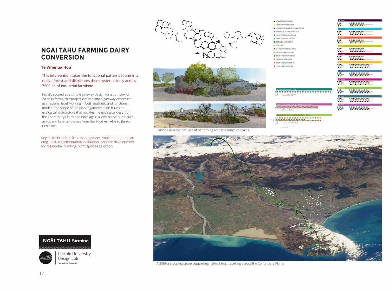
NGAI TAHU FARMING DAIRY CONVERSIONTe Whenua Hou
This intervention takes the functional patterns found in a native forest and distributes them systematically across 7500 ha of industrial farmland.
Initially scoped as a simple gateway design for a complex of 20 dairy farms, this project evolved into a gateway expressed at a regional level, working in both aesthetic and functional modes. The scope of the planting/intervention builds an ecological architecture that negates the ecological desert of the Canterbury Plains and once again allows native birds, such as tui, and kereru, to cross from the Southern Alps to Banks Peninsula.
Key tasks included client management, implementation plan-ning, post-implementation evaluation, concept development for residential planting, plant species selection.
www.designlab.ac.nz
1B 1235m
1B 543m
1B 615m
3A 362m
3A 300m
3A 717m
3A 750m
3A 1143m
3A 460m
3A 350m
1D 785m
1F 500m
1F 1680m
2F 510m
2F 300m
1F 378m
1A 450m
2E 552m
1B 265m
1B 250m
1B 250m
2B 530m2B 250m
1C 700m
1C 1133m
1C 538m
1C 760m
1C 1015m
2C 1190m
1A 200m
1A 200m
1D 978m
2A 410m
1A 315m
1A 235m
1D 675m
1D 560m
1D 385m
1D 590m
1D 642m
2D 476m
2D 412m
2D 250m
2D 1175m
2D 523m
2D 430m
2D 622m
1D 546m
Farm 1 driveway
Farm 2 driveway
Farm 3 driveway
Farm 4 driveway
2C 162m
PRUNUS SPECIES
RED TUSSOCK (CHIONOCHLOA RUBRA)
KOROKIO (COROKIA COTONESTER)
MIKIMIKI (COPROSMA CRASSIFOLIA)
KOROMIKO (HEBE SALICIFOLIA)
MIKIMIKI (COPROSMA PROPINQUA)
KARAMU (COPROSMA ROBUSTA)
TOTARA (PODOCARPUS TOTARA)
KOWHAI (SOPHORA MICROPHYLLA)
NARROW-LEAVED LACEBARK (HOHERIA ANGUSTIFOLIA)
LEMONWOOD (PITTOSPORUM EUGENIOIDES)
KOHUHU (PITTOSPORUM TENUIFOLIUM)
BROADLEAF (GRISELINIA LITTORALIS)
ITALIAN ALDER (ALNUS CORDATA)
FARM 1 DRIVEWAY
FARM 2 DRIVEWAY
FARM 3 DRIVEWAY
FARM 4 DRIVEWAY
4B 100m
4B 100m
4A 36m
4A 36m4A 36m
4A 36m
4A 36m
4A 36m
4A 36m
4A 36m
4B 40m
4B 170m4B 94m
4B 94m4B 84m
4B 144m
4B 144m4B 92m
4B 94m4B 52m
4B 50m
4B 125m
4B 44m
4B 143m4B 193m
4A 36m
4A 36m
4A 36m
4A 36m
4A 36m
4A 36m
4A 36m
4A 36m
Chionochloa rubra @ 0.75mPrunus spp. @ 4.5m
4A EXOTIC WINDOW BAND - DAIRY SHED DRIVEWAYS 36M STRETCHES
4B LOW GROWING MIX (ALONG DRIVEWAYS/INFRONT OF HOUSES)
3A SECONDARY SHELTERBELT - 1 WIDE
1A 1410m
1B 2860m
1C 4146m
1D 5167m
1F 2558m
2A 410m
2B 780m
2C 1356m
2D 3888m
2E 552m
2F 810m
Alnus cordata Podocarpus totara
Hoheria angustifolia
Corokia cotonesterCoprosma propinqua
Coprosma crassifolia
Coprosma robusta
Hebe salicifolia
1.25m
1.25m
1.25m
A 350Ha stepping stone supporting native birds travelling across the Canterbury Plains
Planting as a system: use of patterning across a range of scales.

13
3-Ca t
5-Ca v
9-Ca v
5-Ca v9-Ca t
6-Ca t
3-Ca s
2-Ca s
4-Ca f
4-Ca f
17-Ca f
12-Ca t
16-Ca t
11-Ca t
15-Ca d
4-Ca d
11-Ca co
5-Ca co
26-Ca co
9-Ca co
5-Ca c
9-Ca c
8-Ca c
12-Ca c
10-Ca c
13-Ca c
4-Ca c
6-Ca b
4-Ca b
4-Ca b
9-Ca b
8-Ca b
9-Ca b
4-Ca b
8-Ca b
7-Ca b
9-Ca b
9-Ca b
5-Ca b13-Ca b
5-Ca b
4-As f
5-As f
3-As f
6-As f
4-Ap s
5-Ap s
3-Ap s
3-Ap s7-Ap s
3-An l
3-An l
4-An l
3-An l
4-An l
13-Ca t
17-Ca t
13-Ca c
9-Ca c
8-Ca b
17-Ca b
2-Ca s
3-As f
6-Ca d
5-Ca f
3-Ap s
1-Ap s5-Ca c
6-Ca c
4-Ca v
3-Ca s
1-An l
3-Ap s
9-Ca b10-Ca t
10-Ca co
3-Ca v
9-Ca f
8-Ca c
3-Ca f
3-Ca s4-Ca d
8-Ca f7-Ca co
5-Ca s
4-Ca v5-Ca t
4-An l2-As f
7-Ca b
11-Ca c3-Ap s
7-Ca d
28-Ca f
29-Ca c4-An l
8-Ca s
5-Ca v
8-Ca v
6-An l
8-Ca b3-Ca t
15-Ca b
14-Ca f
8-Ca t
5-Ca d
5-Ap s
7-As f
4-An l
2-An l
GrassesID Qty Latin Name Common NameAn l 38 Anemanthele lessoniana Bamboo TussockAp s 37 Apodasmia similis OioiAs f 30 Astelia fragrans Bush FlaxCa b 164 Carex buchananii Grass/SedgeCa c 142 Carex comans 'Bronze' Carex 'Bronze'Ca co 68 Carex comans 'Green' Carex 'Green'Ca d 41 Carex dipsacea Carex dipsaceaCa f 92 Carex flagellifera Carex flagelliferaCa s 26 Carex secta Green sedgeCa t 113 Carex testacea Carex testaceaCa v 43 Carex virgata Carex virgataCo b 6 Corokia 'Bronze King' Bronze CorokiaCo bu 7 Corokia buddlejoides KorokioCo g 10 Corokia 'Geenty's Green' Green CorokiaCo r 13 Coprosma 'Roys Red' Coprosma 'Roys Red'Gr 1 Grapefrut 'Golden Special' Grapefruit TreeHa e 25 Haloragis erecta 'Purpurea' ToatoaHe d 6 Hebe decumbens Hebe decumbensHe g 8 Hebe gracillima HebeHe o 17 Hebe odora Boxwood HebeHe s 8 Hebe strictissima Banks Peninsula KoromikoKu e 20 Kunzea ericoides KanukaPl d 12 Plagianthus divaricatus Swamp RibbonwoodPo t 3 Podocarpus totara TotaraPr 1 Prunus Peach RedhavenPr 1 1 Plum 'Santa Rosa' Plum TreePr 2 1 Apricot 'Moorpark' Apricot TreePr 3 1 Apple 'Initial' Apple TreePs c 11 Pseudopanax crassifolius LancewoodPs co 8 Pseudowintera colorata Horopito / Pepper TreeSo m 1 Sophora microphylla South Island KowhaiSo mo 7 Sophora molloyii 'Dragon's Gold' KowhaiSo p 13 Sophora prostrata Dwarf Kowhai
0 5 10 15 20 MN
350Ha distributed native forest project across Ngai Tahu Farming’s North Canterbury dairy development
Planting on site at Te Whenua Hou
Te Runanga o Ngai Tahu social housing development
Hard elements
Planting plan

14
EXPERIENCE-DRIVEN DESIGN PROCESSMaster’s Thesis: Christchurch CBD Eastern Frame
My research explored the recent movement in landscape architecture towards phenomenological design, and investigated what possibilities could be generated through a process that places primacy on embodied experience.
The resulting design process is performative in that the majority of work takes place on site, in direct engagement with the landscape. As part of its experiential focus, the design process places importance on what the landscape is doing: materially, operationally, and temporally.
In addition, in order to design landscapes that provide for more grounded experiences, techniques of strangemaking are used. In particular, cut-up methods are adopted in order to create design briefs that de-familiarise the familiar in the landscape. In doing so, habitual design conventions are disrupted.
In order to maintain a focus on embodied experience, perspectival, rather than bird’s-eye viewpoints, are employed in representing the design work. In this process, representation acts as a generative, as well as communicative, tool.
How could a designer working within an experiential process approach the world?
I came to this project wanting to consider the nature of embodied experience, and its potential role within a practice of landscape design. Phenomenological theory concerns itself with the nature of the world’s being: both the landscape and its inhabitants. I was intrigued by the possibilities of adopting a phenomenological approach to design. In this exploration, design was both a means of investigation and a potential outcome of the research.
Examiners’ comments: “[A]n outstanding piece of work”, which, “captures the thoughtful and deep research process that has characterised her approach throughout. The theoretical rigour in relation to the philosophical perspective of phenomenology is balanced by an ability and desire to use design as a vehicle for discovery.... Charlotte’s thesis adds to both methodological understandings as well as to aspects of innovation, representation, and critique.
Full thesis available at: http://hdl.handle.net/10182/6464
2. Strangemake
1. Observe
4. Communicate
3. Storyboard
DESIGN WORK: THESIS

15
DESIGNING THREADS IN THE EASTERN FRAME
My research explored the possibilities that arose when I assumed an experiential perspective to design.
Through a short series of design sessions on the ground in sites in Christchurch, I found that being fixed to the spot became a frustration and hindrance and that I felt the need to move while I designed. Not just around the site, but around the wider city: to explore ‘site’ as a series of flowing threads, rather than a demarcated chunk of ground. From an experiential perspective, incorporating such modulating sites in this process may make more sense because they emphasise the movement of the participant observer through the movement of the world.
Site and Programme: Christchurch
My explorations of a phenomenological approach to landscape architecture (through reading/writing/observing/designing) have indicated that perspectival experience is key. Within this experience there are certain moments of distinctive inflection. For instance, dramatic weather events (such as flooding or the freezing of a waterfall), unusual juxtapositions of sensory-rich material (caked mud with seedlings and fallen leaves). For Christchurch, the earthquakes for 2011-2012 were unusually powerful moments of inflection that are still strongly reverberating. From these moments, new opportunities for addressing the design of the city have arisen. Namely because of the large tracts of land that have opened up through demolition and because of the latent seismic features which have become apparent. Therefore, a new set of constraints have emerged and there is a need to directly address the effect of the disaster.
Communication
Both in the process images and the final conceptual images, hand rendering and an expressive gestural style were employed to imbue the images with atmosphere, rather than ‘realism’. Watercolours were used for their ability to create amorphous stains of tone and colour which suggest qualities of space, rather than prescribe. By presenting sketches which showed phased snapshots of the interventions over time, the sense of continual change and movement already suggested by the storyboard images was transferred, thus laying out a series of potential design outcomes with which participants could imaginatively engage.
Agriculture
Memorial
EnclosureMeditation
Lightness
Kenton Chambers
Shadow-Light
Irrigation Channels
Brick Incubators
Mud Hills
Golden Totara
MeadowTotara Forest
Parterre
Ephemeral Pools
FerneryWillow
Plantation
Artesian Baths Complex
Colour-Block Pioneer Meadows
Brick Enclosures
Nurturing Moss Roof
Indoor and Outdoor Theatre
PoplarStructures
SOONER
Agriculture
Memorial
EnclosureMeditation
Lightness
Kenton Chambers
Shadow-Light
Irrigation Channels
Brick Incubators
Mud Hills
Golden Totara
MeadowTotara Forest
Parterre
Ephemeral Pools
FerneryWillow
Plantation
Artesian Baths Complex
Colour-Block Pioneer Meadows
Brick Enclosures
Nurturing Moss Roof
Indoor and Outdoor Theatre
PoplarStructures
LATER
1:2000 @ A1

16
INTERVENTION: BRICK SECRET GARDENSNetwork of square brick courtyards acting as incubators for native species to establish. While the plants remain small, the courtyards can be used as flexible-use areas for activities such as pop-up food vendors. As the canopy grows, a series of ‘secret gardens’ will develop on the site. The walls additionally have the affect of providing an increased range of plant habitats, by intensifying Northern and Southerly aspect microclimates.
INTERVENTION: NURTURING MOSS ROOFIntervention to provide recreational and spectator seating in the form of a magnified moss plant. The moss capsules gather together at the top of copper rods, to form an intermittent shelter. The undulating leaf forms are consolidated into a series of rippling rows of seats.
INTERVENTION: CTV SITEThe memorial at the CTV Site will feature a field of grass that will be mown twice a year with scythes, as a community event. Fifteen desiccated Totara trunks will be relocated from Banks Peninsula to the meadow and place in the arrangement indicated in the perspective below. This number and arrangement have been designed to create a pattern of openness and clustering across the meadow. Networks of the three different memorial strands will weave outwards from the meadow and through the Eastern Frame. The ‘Closeness’ plant grouping will nestle around the edge of the CTV site, with pathways wending their way through the plantings and outwards. The carparks that remain visible at the edge of the CTV site will remain unplanted.
Year 20Year 3 Year 10
Phased sketches of development of native plants within the brick secret gardens
Seating
Macro photo of moss form
Seating and Roof Pods
Plan ViewConcept development using strangemaking techniques
Day 1 Year 30

17
INTERVENTION: PIONEER MEADOWSThis area would be planted with a series of pioneer plots of a single species to form blocks of colour in the overall form of a meadow. The key colours are yellow, red, purple, blue, light-green and mid-green. Over time, the colour-blocking effect is likely to unravel and the species will mingle and blur. Additionally, opportunistic species will take root and add themselves to the mix. The pioneer species may need to be supplemented annually by seed balls or extra plantings.
The footprints of the buildings that previously occupied some of these sites will be marked by a parterre border of Coprosma crassifolia.
Meadows
Pioneer plots would be planted, supplemented by annual sowing of seed balls. Both of these planting methods would take place from the centre of each meadow zone, allowing the zones to mingle at their edges.
Parterre
The strict formality of parterre will be intensified by the chaotic knotted tangle that is produced by Coprosma crassifolia. The plants will form a dense, low hedge that will be largely be characterized by the intertwining of the branches, rather than the presence of foliage.
INTERVENTION: POPLAR STRUCTURESLatex moulds will be taken around the circumference of poplar trees along the Northern Bank of the Avon. These moulds will then be turned inside out and cast in a sepia acrylic. In this way, the oddness of familiar elements in the landscape will be highlighted. The inversion of the form of the Poplars into a three dimensional skin will allow participants to move in and around the shapes and textures of the trees in a way that would not normally be possible.
Within the variety of forms displayed by the Poplar trees, some will lend themselves to acting as seating alcoves, by the nature of their contours. Others that are more buttressed in form will perhaps create nooks for leaning against, while people sit on the ground itself.
Perspective from the Avon River looking into the Pioneer Meadow.
Thumnails of parterre species (left) and meadow species (right).
Poplar Trees line the northern bank of the Avon River
Poplar trunk with buttress form
Proposed Poplar tree structure example
Poplar trunk with grotesque form

18
TEACHING: VISUAL COMMUNICATION
he Confusion of ConinementA Token for Christchurch
With the demolition the fate for many of Christchurch city’s earthquake damaged resi-dential houses the odd exception still remains. his is the case for 19 Admiral Way, who’s materials are being used to provide sculptural interest on the Pine Mound in the Botanical gardens. he proposed sculpture retains the essence of its parent, but its function is the opposite, although it has the form of a house, the wires that provide the structure give only a sense of shelter without providing it, this highlights the primary role of structure as a provider of shelter by removing the elements that make its function so. he materials of the house are placed on the wire ‘walls’ to give a sense of the original dwelling.
Axonometric view of proposal
Above; A series of sections displaying various angles of the structure.
Below; A two-point perspective.
Plan of site 1:100 @ A3
Section elevation
One-point perspective
SYLVIA ROBINSON:1120404DESN103
Divergent Building is a sculpture that has been de-signed in order to reflect the idea of shelter. This idea has been portrayed through the use of re-cylced material's, salvaged from a house in New Brighton which was destroyed during the February 2011 Earthquake. The sculpture reflects the rebuild of Christchurch, it is a simple yet organic form which works effectively on the Pine Mound. The poles repre-sent an enclosement of some form, and the offset cor-rugated iron sail's represent a roof. The way these elements work together creates a peaceful still atmos-phere with a slight uncanny and questionable edge. It will be a space that people are able to visit to re-lax, enjoy and reflect.
D I V E R G E N T B U I L D I N G
s h e l t e r
e l e v a t i o n s s c a l e 1:200 @ A2
topsy steele 1113825
PAGE 1/10
Students’ concept work (top) and presentation work (above).
TEACHING PROJECT: DRAWING AS PROCESS100-Level Visual Communication Paper (lead tutor - primary responsibility)
This project was formed to help students develop their ability to use drawing to drive a design process. Particular focus was placed on transferring ideas from the imaginative realm onto paper and then learning to iterate these concepts and forms.
Students learned to alter their ideas in a range of ways, from subtly inflecting them, to disrupting them completely with strangemaking techniques. The project also taught students how to use drawing to communicate their final concept. The task was to design a small-scale intervention at Pine Mound at the Botanic Gardens, Christchurch, NZ. The materials palette will come from the materials salvaged from a single house in New Brighton, Christchurch (http://www.wholehousereuse.co.nz)
The design was to explore the theme of ‘shelter’. This may have been in the form of a physical shelter, but it may also have explored the idea of shelter in other forms: spiritual, psychological, political, social. Part of the initial design phases was to hone in on students’ individual approach to a ‘shelter’ intervention in this place. The interventions could adopt conceptual, functional, or narrative forms. They could be static or interactive, contemplative or arresting. Key questions included:
• How do you represent elements that only exist imaginatively?• How do you use drawing to continue to develop imaginative elements?• How do your imaginative constructs relate to the space? Are they a
counterpoint? Are they harmonious?• What experiences do the intervention and the site each offer individually?• What experiences do the intervention and the site offer when put together?
Comments from Student Evaluations:
“Charlotte is awesome! She expressed her passion for LA, drawing and process in a really professional and friendly manner. She was keen for us to learn and would help anyone who is keen to learn.”
“Really clear briefs and really clear, supportive explanations in class and via email. “
“Always went out of her way to clearly explain what is required and how to effectively produce the standard of work required.”

19
TEACHING PROJECT: DRAWING AS CREATIVE100-Level Visual Communication Paper (lead tutor - primary responsibility)
This project challenges students to stretch the boundaries of their expressive drawing repertoire. This project provided a framework within which students can begin to experiment and document new techniques.
Students began by deconstructing other artists’ images and identifying the different marks, lines, and gestures that made up a particular drawing. Students then mimicked that style in the creation of a new drawing. As part of the development of their analysis skills, students had to describe the overall mood of the image, as well as the mood of each of the different line styles within the image.
Students were also challenged to generate several experimental palettes of new and unique gestures of their own, using a range of drawing materials. Their explorations included tone, mark-making, hatching, stippling, and use of colour. They then drew on these palettes to create a drawing in their own expressive style.
The scope of the requirements meant that even already capable students were stretched outside their area of familiarity and prompted to focus less on technical finesse and more on the power of drawing to communicate emotionally. Regular whole-class discussions gave students the opportunity to become comfortable talking about their work, and hearing how others responded to it. These reflective classroom practices familiarised students with critique and fostered a culture of visual literacy.
Comments from Student Evaluations:
“Always encouraged drawing and sketching and designing to get the most out of a concept. Really constructive and positive feedback and was always able to explain and pinpoint quickly where I could improve things. Always approachable and opened up a whole new world to me.”
“Charlotte was really thorough and professional about what was required. If I was unclear about something she was really approachable and was able to clarify things quickly.”
“Asked questions about work, when critiquing was done in a positive manner which made me feel more relaxed and more open and willing to try new ideas and push the design further.”
Edvard Munch(nd)
The drawing has a very gloomy look about it. The hills in the horizon are one of the darkest parts in the picture and that makes them feel a bit frightening. It is as if the hills are all covered in an intimidating shadow. There are four really dark areas with hard strokes in the drawing, and that makes your eye seek out these parts at the first glance. The rest of the picture kind of fades away, not being that important, into what I see as a flat, open and misty field, because the strokes gradually decreases in thickness backwards in the picture until they reach the hills. The overall feel of the picture is calm and quiet even though many of the strokes are actually very energetic. It feels dark and misty because almost all the strokes faces approximately the same direction and are all pretty hard but with a slight decrease in thickness towards the background.
Gloomy
Dark
Disquieting
Silent
Lonely
Adoptig the style of Evard Munch Greyscale, my own style with fine-tipped pens
Edvard Munch(nd)
The drawing has a very gloomy look about it. The hills in the horizon are one of the darkest parts in the picture and that makes them feel a bit frightening. It is as if the hills are all covered in an intimidating shadow. There are four really dark areas with hard strokes in the drawing, and that makes your eye seek out these parts at the first glance. The rest of the picture kind of fades away, not being that important, into what I see as a flat, open and misty field, because the strokes gradually decreases in thickness backwards in the picture until they reach the hills. The overall feel of the picture is calm and quiet even though many of the strokes are actually very energetic. It feels dark and misty because almost all the strokes faces approximately the same direction and are all pretty hard but with a slight decrease in thickness towards the background.
Gloomy
Dark
Disquieting
Silent
LonelyEdvard Munch(nd)
The drawing has a very gloomy look about it. The hills in the horizon are one of the darkest parts in the picture and that makes them feel a bit frightening. It is as if the hills are all covered in an intimidating shadow. There are four really dark areas with hard strokes in the drawing, and that makes your eye seek out these parts at the first glance. The rest of the picture kind of fades away, not being that important, into what I see as a flat, open and misty field, because the strokes gradually decreases in thickness backwards in the picture until they reach the hills. The overall feel of the picture is calm and quiet even though many of the strokes are actually very energetic. It feels dark and misty because almost all the strokes faces approximately the same direction and are all pretty hard but with a slight decrease in thickness towards the background.
Gloomy
Dark
Disquieting
Silent
Lonely
Students’: analysis work (column 1), artist imitation sketch (column 2), individual expressive palette (column 3) and individual style sketch (column 4).

20
TEACHING: DESIGN
TEACHING: DESIGN STUDIO AND PLANTING PRACTICE100-level Introduction to 3D Design Studio (lead tutor)
Designed, taught and evaluated introductory projects to,
• explore the technical and experiential aspects of contours and landforms.
• design a Sonic Garden, where landscapes were to create narratives based on the affect of sound
100-, 200-, 300- and 400-level Design Studios (tutor)
Collaboratively designed and delivered a series of studio projects exploring the concept development for the Eden Project with 200-400 level students. Tailored each project within the series to the level and learning outcomes required for each cohort. Evaulated, graded, and moderated student assessments.
200-level Planting Practice (tutor)
Assisted and guided students during planting practice learning exercises, including plant walks and plant-out days at native reserves. Evaulated, graded, and moderated student assessments.
Students’ 200-level planting practice (top) and 100-200-level studio exercises (above).

21
TEACHING: THEORY
TEACHING: HISTORY, CULTURE AND DESIGN THEORY
100-level History of Design and Culture and 300-level Design Theory (tutor)
Prepared and lead small group discussions and exercises. Reviewed lecture materials and readings, in order to research and present new material. Oversaw student presentations, preparation for examinations and assignments. Provided critical feedback and guidance throughout students’ coursework. Evaluated, graded and moderated student assessments.
100-level History of Design and Culture (Guest Lecturer, 2014 and 2015)
Researched, prepared and delivered original lecture, entitled “The Landscapes of Health: empires, conquests and commodities.”
Lecture available at: http://bit.ly/landscapesofhealth
Students’ 100-level history of design and culture tutorial exercises (top) and 100-level studio drawing exercises (above).

22
DESIGN WORK: MEMORIAL COMPETITION
CONCEPT DEVELOPMENT: EARTHQUAKE MEMORIALIdeas to Remember: The Christchurch Earthquake Memorial
This competition entry developed a memorial for victims of the Canterbury, NZ earthquakes of 2010-2011.
A dry-stone wall and cairns will provide key forms, carefully built-up from the materials of Canterbury’s damaged buildings and landscape. Blocks, bricks and other stone elements, including those contributed by affected families, will commemorate and carry the region’s heritage and community identity forward. As a new form created from old materials, it will be re-generative, restorative and replete with opportunity as Canterbury forges its future.
The tactile vertical surfaces will provide a focus for contemplation. Intricate forms allow visitors to encounter with their hands and eyes, grounding them in a time of potential grief.
Inclusive in its multiplicity, the site will acknowledge specific and private loss, recognize the selfless and brave acts of those who responded, and also provide spaces for those with less well-known losses, hardships or shared-traumas.
Families may inscribe stones with the names of loved ones, while others may choose to anonymously include their stone on site, or at another closely connected commemorative site where associated cairns may be established.
The gentle movement of the wall from the site’s high western end to its entry into the water, near Rhododendron Island, can signify the passing of time. When encountered from the opposite direction, the movement is uplifting.
The rendering techniques are intended to evoke a sense of the experience of the intervention, rather than a photorealistic impression the visual qualities.
Steps moving down between sections of the wall and then to the Avon River.
Section sketch showing movement from grassed slopes, to steps leading down 0.5m, to stone steps on the bank, and then into the Avon River.
Plans showing effect of growth of Totara near stone cairns over 50 years to succeed the existing Oriental Plane trees.
Stone niche within the wall, with space for a name to be inscribed.

23
Compressed aggregate path
Cambridge Terrace
Plan view of memorial site at time of installation 1 : 500 @ A3
Oxford Terra
ce
Cairns with Podocarpus totara, Pseudowintera colorata, and Coprosma crassifolia planted around,
To the Bridge of Remembrance
Rhododendron Island
Steps
Sketches exploring site context and initial design ideas.
First Year Ten Years Fifty Years
Plans showing effect of growth of Totara near stone cairns over 50 years to succeed the existing Oriental Plane trees.

24
DESIGN WORK: ANALYSIS & DESIGN
Christchurch Central City 30 Year Strategic Plan 1:5000 @ A1
STUDY: CENTRAL CITY 30 YEAR STRATEGIC PLANA rich topography of communities connected to each other and to a unique Landscape.
Analysis: Christchurch’s residential community suffers from low density, poor cycle and pedestrian connections and a lack of connection to the landscape and local biodiversity. Public transport connections are infrequent and inefficient. Many native bird species have not been present in the city for some time as there are few food sources for them. The Avon River is interrupted by roads crossings and it is not possible to walk continuously along the river bank. The South of the Central city is a predominantly industrial area with few street trees, no open space and extremely poor pedestrian and cycle connections.
Model: In The Image of the City, Keith Lynch describes how nodes can act as “strategic points in the city, which are the intensive foci to and from which [a person] is travelling.” [1960, in Wall 2011, 152]. Two or more paths come from each node, create a network across the city. The ‘concentration nodes’ invigorate the surrounding area.
Very High Density Living
High Density Living
Medium Density Living
Passive Open Space
Active Open Space
Mixed Use
Civic Space
Education
Health Institution
Bellbird Habitat Patch
Cultural & Religious Spaces
Water Way
Housing Type Area (km2) Residential Density (dph) Storeys Residents
Apartments 0.618832 100 4-5 14,233High Density 0.978264 70 2-3 15,750Medium Density 0.502224 50 1-2 5,775Mixed Use 0.446003 20 4-5 2,051
TOTAL 37,809

25
Transport
Balance automobile needs with ped/cyclist needs (short and long term) with efficient and safe connections between residential and work areas
Park and Ride on edge of Central City. To be adapted to Light Rail hub if wider population grows beyond 80 u/h.
Priority pedestrian lane network throughout Central city, concentrated in CBD.
Cycle lane network providing efficient routes throughout Central City, connecting residential, work and open spaces.
Landscape
Enhance architectural and experiential connection between built environment and landscape.
Avon Green-Blue way Open Space to function both as an ecological and cycle/pedestrian corridor
Connect cycle and pedestrian networks to Avon Green-Blue way and Hagley Park.
Green corridors crossing the city with appropriate food-rich plantings for Bellbird as demanding species (plants to be matched to three primary soil types).
Minimum habitat patch of 1ha to support Tui as demanding species
3. Community
To provide housing suitable for a wide range of demographics.
Neighbourhood hubs to be developed to provide essential amenties within a five minute walk.
Mix of housing available to attract a diverse residential population.
More schools to be located near residential hubs.
Linear Greenways
Linear Greenways will provide attractive and safe spaces for cyclists and pedestrians, while connecting to public transport. Food-rich plantings provide habitat corridors for Tui as demanding species, throughout the Central City.
Linear open spaces can “provide long “edges” and offer a close relationship between built-up areas and open spaces.” [Whyte (1968) in Groome, 1990, p384]. As well as offering relief from the urban environment, these spaces can both nurture and connect ecology and community (Hoşgör, p343).
Path Cycle Lane
Bus Island Bus Lane
Road Path
Residential
Retail
Office
Residential
Open Space NetworkResidents’ Tuam Street Entrance

26
RE-IMAGINING THE GARDEN CITYMixed-use Urban Development, Christchurch, NZ.
This project developed a master plan for a facility that would foster a sense of community as well as provide private places of retreat and improve inner-city biodiversity.
Design StrategyTransport Choice: To provide pedestrian, cycle, public transport routes from residential development to key amenities. Open Space: To provide a range of open spaces catering for public to private uses. Stormwater: To treat as much grey, storm and first flush water as possible on site. Housing: To provide housing suitable for a wide range of demographics. Planting: To include food-rich planting for tui as demanding species.
A. Four-storey residential
• Lower two levels combined to comprise larger two-level apartments with first floor raised up 1.5m above ground level to provide private courtyards open space.
• Upper two levels are single storey apartments.
• Each level is 6.5m wide x 10m deep, dual aspect.
B. Three-storey Residential
• Lower two levels combined to comprise larger two-level apartments with ground level private courtyards.
• Third level is single storey apartments.
• Each level is between 6.5 - 7m wide x 10m deep, dual aspect.
C. Three-storey Mixed Use
• Ground level is for Childcare Center with access from Eastern access-way (for staff) or through the front play-area, facing Tuam Street for parents and children.
• Upper two levels are single storey apartments, each of which are 6.5m wide x 10m deep, dual aspect
D. Two-storey Mixed Use
• Designed as Live/Work units where lower storey is commercial/studio space and the upper level is a connected single storey apartment, 10m wide x 6.5m deep, dual aspect
• Single-storey Retail/Commercial use
• Street-fronting units of various widths and 10m deep.
KEY
Rain Garden
Grass Parterre
Roof Top Gardens
Tree Planting
Stone Sett Paving
Existing Trees
Stabilised Aggregate
S1
P1→
S2
S3
Community Garden & Orchard
P2
→
Childcare Play Area/ Courtyard
for Cafe
Basketball half-court Volleyball
Court
Carshare Parking
Underground utility area
Greywater Channel
1:250 @ A1

27
A
A
BB
D
C ED
D E
Steel Table Tennis Table
Children’s Play Area
Private Court-yard Garden
Bal-cony
Communal Bar-beque Area
Basement 1.5m below ground level, 3m high for carparking; rubbish and re-cycling collection; bicycle storage.
Steps up 1.5m to first floor, 200m high steps
Steps down 1.5m to basement, 200m high steps
Private Court-yard Garden
Disabled Parking Spaces:3.6 x 5m
Totara Grove with seating for warmer days
Central path providing access from carpark to Community Garden. Stone setts provide stable surface in all weathers.
Sequence of clipped, pencil totara and low 1m high walls provide a rhyth-mic entrance avenue.
Sloped grass lawn in shade of building.
Two large 0.5m deep concrete steps lead down to the grassed Volleyball court 0.4m below.
Open half- round concrete pipe to con-vey water to sports area in large storm events, up to 1/50 year.
Solid Stone Wall separating park-ing level from lower play and sports levels
Step edged with basalt cobble, down 0.2m to play area.
Courtyard ad-jacent to first floor apartments, raised 1.5m from ground level
S3
D1
Greywa-ter Rill.
Perspective of Complex from South-East
Residents’ Shared Park 1:100 @ A11:250 @ A1

28
DESIGN WORK: CONSTRUCTION
This grate is designed to give access to pedestrians where pathways meet the rill conveying greywater from the buildings at the South end of the site to the community garden in the North-East.
The perforations in the grate repeat the motif of the Port Hills contours used in the public courtyard on Tuam Street.
RILL GRATE
Site Layout
Revised Drawn By Page 2 of 2
Scale 1:250 @ A2Charlotte Murphy14 Jan 2013
Tuam Street Residential Development Existing Tree
Proposed Plant
Datum (AMSL)
Proposed Spot Height
+17.6m
+17.6m
Private Courtyards
+17.6m
+17.6m
+ LP 16.1m
+17.6m
+17.6m
+17.6m
+17.6m
+17.6m
+17.4m
+17.6m
Tuam Street
St Asaph Street
Residents’Vehicle Access
ExistingCommercial
Building
ExistingCommercial
Building
ExistingCommercial
Building
Residents’Parking
Residents’Parking
Residents’Vegetable Garden and
Orchard
BBQ Area
PlaygroundStabilisedAggregate
Volleyball CourtTurf Surface
Basketball Half-Court
Plexipave Surface
PathsGranite Setts
Turf
Residents’ ParkingStabilised Aggregate
UndergroundUtility Area& Parking
Private Courtyards
Private Courtyards
Private Balconies
Childcare Play Area/ Courtyard for Cafe
Four-storey residential Three-storey Residential
Three-storey Residential
Two-storey Mixed Use
Four-storey residential
Two-storey Mixed Use
Two-storey Mixed Use
Three-storey Mixed Use
Single-storey Retail/Commercial Use
Single-storey Retail/Commercial Use
Public Footpath
Public Footpath
Sunken Public Courtyard
+ HP 19.1m
+18.1m
+18.1m 12%
+16.6m +16.8m +17.4m
+17.1m
+18.1m
+18.1m
+17.6m
+17.6m
+17.6m
+17.6m
+17.1m
+16.4m
+16.8m
29
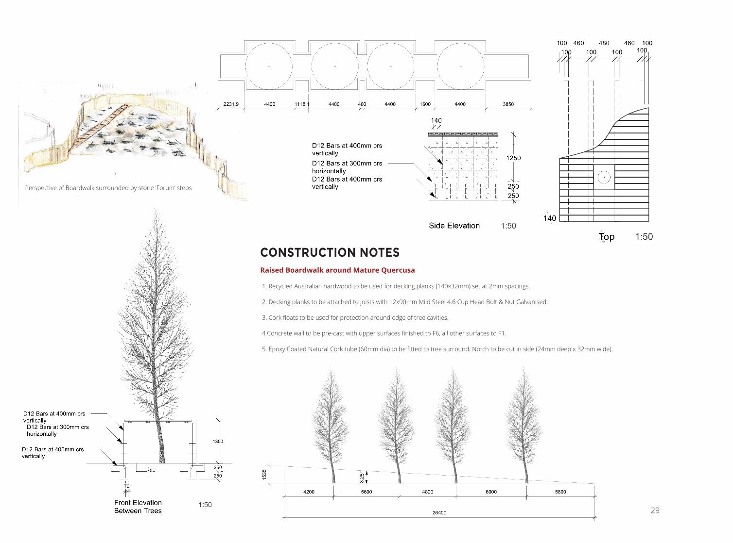
Perspective of Boardwalk surrounded by stone ‘Forum’ steps
CONSTRUCTION NOTESRaised Boardwalk around Mature Quercusa
1. Recycled Australian hardwood to be used for decking planks (140x32mm) set at 2mm spacings.
2. Decking planks to be attached to joists with 12x90mm Mild Steel 4.6 Cup Head Bolt & Nut Galvanised.
3. Cork floats to be used for protection around edge of tree cavities.
4.Concrete wall to be pre-cast with upper surfaces finished to F6, all other surfaces to F1.
5. Epoxy Coated Natural Cork tube (60mm dia) to be fitted to tree surround. Notch to be cut in side (24mm deep x 32mm wide).

30
DESIGN WORK: PLANTING
PLANTING STRATEGY FOR CHRISTCHURCH’S EASTERN FRAMEPlanted Meadows
These meadows will be predominately planted in Hierochloe redolens, to provide a mid-green base to the colour palette and the feeling of luxurious vast expanses. The sweet scent of the grass when it is crushed will also be a further dimension of possible experience. The monotony of the green will be interrupted by the delicate, spreading Anemanthele lessoniana, with its gossamer-like seed heads. Purple and yellow Echinaceas will offer bright seasonal colour in the Spring and Summer, before dying off for the Winter. The blood-red spikes of Imperata cylindrical ‘Red Baron’, planted in drifts will provide dramatic articulation in and around the meadow.
Enclosure (Totara Mix)
A selection of native trees that will provide a dense, dramatic canopy, suited to the moist and deep Waimakariri soil type. These groupings, with a predominance of Totara, will act as markers of an intimate and quiet journey through the landscape, offering spaces where light is reduced and noise is softened. Plants will be introduced as large juveniles to offer better possibility of withstanding colder winter conditions. Group 1 will be planted immediately, while Group 2 will be planted from the second year onwards).
Meditation
These areas will be populated by relocating volcanic stones from Banks Peninsula and allowing the debris and seed material to germinate and populate the immediate area. When the stones are ‘planted’, a 10L bucket of soil from its original site will also be added around the stone. A fence of wire netting will be placed around the stones to reduce interference by wildlife and humans for five years. The areas will be left to grow regardless of whether weeds at first predominate. It is hoped that in a similar pattern as at Hinewai Reserve, plants such as Coprosma crassifolia, Pseudowintera colorata (Horopito, Peppertree), Podocarpus totara (Totara), and Sophora microphylla (Kōwhai) will succeed the weed plants. If this does not occur, weeding and direct planting may need to take place.
Hierochloe redolensAnemanthele lessonianaEchinacea paradoxaEchinacea purpurea ‘Magnus Superior’Imperata cylindrical ‘Red Baron’
Hoheria angustifolia (1)Pittosporum eugenioides (1)Plagianthus regius (1)Podocarpus totara (2)Pseudopanax crassifolius (2)
Stones – material from peninsulaLikely to include:Coprosma crassifoliaPseudowintera colorata (Horopito, Peppertree)Podocarpus totaraMossLichen

31
190-Pod to
468-Cop cr
524-Cop cr
3-Pod to
2-Pod to
4-Pla re
3-Pse cr
3-Pse cr
4-Pod to
3-Pit eu
4-Hoh au
3-Pod to
2-Pod to
3-Pod to
3-Hoh au
3-Pse cr
2-Pod to
364-Imp cy
446-Imp cy
698-Imp cy
516-Imp cy
632-Imp cy
315-Imp cy
Landscape Area-1996.123 sq m60%-Hie re20%-Ane le10%-Ech pa10%-Ech pu
Man
ches
ter S
tree
t
Gloucester Street
Worcester Street
ID Quan-tity Botanical name Common name Scheduled
size
Ane le 399 Anemanthele lessoniana Wind Grass PB 3
Cop cr 992 Coprosma crassifolia NZ Coprosma PB 2
Ech pa 1,796 Echinacea paradoxa Yellow Coneflower PB 2
Ech pu 798 Echinacea purpurea ‘Magnus Superior’
Purple Coneflower PB 2
Hie re 10,779 Hierochloe redolens Karetu, Holy Grass PB 3
Hoh au 13 Hoheria augustifolia Narrow Leaved Lacebark
PB 6
Imp cy 2,971 Imperata cylindrica ‘Red Baron’
Japanese Blood Grass 1.3 L
Pit eu 3 Pittosporum eugenioides Tarata, Lemonwood PB 9
Pla re 4 Plagianthus regius NZ Ribbonwood PB 2
Pod to 241 Podocarpus totara Totara PB 2
Pse cr 15 Pseudopanax crassifolius Lancewood PB 2
Planting Plan for meadow within Eastern Frame, Master’s Thesis Research 1:200 @ A1

32
EVENTS: EXHIBITIONS AND FIELD TRIPSDrew upon project- and event-management skills and experience to contribute to:
• creating diverse students’ learning experiences
• overall vibrancy of the School of Landscape Architecture
• international and inter-institutional academic relationships
Inner City Christchurch Drawing Excursion (2014 & 2015 Led group of thirty-five 100-level students on field trips in which they were tasked with on-site drawing tasks to develop a range of techniques.
Eden proposed site visit (2015) Assisted in leading 200- and 400-level students to the proposed site for the Eden project development.
Banks Peninsula site visit (2014) Assisted in leading a group of 300-level students on a local field trip.
Euroleague of LIfe Sciences (ELLS) summer school field trip (2014) Assisted in running a four day field trip to the Mackenzie Country region to study water resource management issues with a group of ten 400- and 600-level students. Engagement with local officials, stakeholders and landowners.
International delegation from Tsinghua University (China) (2014) Hosted a two-week visit to to the School of Landscape Architecture by a delegation of twenty-two academics and officials from China’s top University. Began with a five-day workshop, held at Lincoln University. Planned, coordinated and guided a study tour around the South Island meeting with staff from the New Zealand Department of Conservation, and local tourism operators. Provided expert commentary and discussion on conservation lands in New Zealand.
Design for Conservation Conference, Lincoln University (2014) Assisted with planning, coordinating and running multi-day conference held at the School of Landscape Architecture
Final Year (400-level) Student Exhibition of final project (2012 and 2015) Project managed event. Undertook event space design and installation.
Final Year Exhibition (top), Field tour and Site visits (bottom)

33
DRAWING