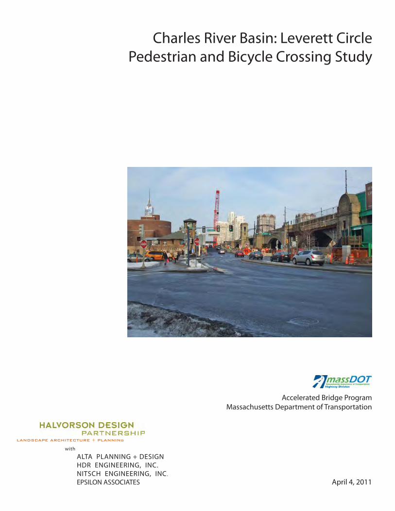
charles river basin: leverett circle pedestrian and …. background leverett circle is located at...
TRANSCRIPT
June 11 2010
Charles River Basin Leverett Circle Pedestrian and Bicycle Crossing Study
Accelerated Bridge Program Massachusetts Department of Transportation
LANDSCAPE ARCHITECTURE + PLANNINg
with
ALTA PLANNING + DESIGN HDR ENGINEERING INC NITSCH ENGINEERING INC
EPSILON ASSOCIATES April 4 2011
June 11 2010
Charles River Basin Leverett Circle Pedestrian and Bicycle Crossing Study
LANDSCAPE ARCHITECTURE + PLANNINg Accelerated Bridge Program
with Massachusetts Department of Transportation ALTA PLANNING + DESIGN
HDR ENGINEERING INC NITSCH ENGINEERING INC
EPSILON ASSOCIATES April 4 2011
Table of Contents
1 Background 1
2 Existing Conditions Analysis 5
3 Regulatory Permitting and Jurisdictional Issues 21
4 Best Practices And Case Studies For PedestrianBike Overpasses 25
5 Conceptual Design Options 31
6 Summary 59
Appendices 61
1 BACKGROUND
1 Background
Leverett circle is located at the eastern terminus of Storrow Drive and the Boston-end of the ldquooldrdquo charles River Dam
The Leverett circle area has been a major multi-modal gateway to Boston since the early 1900rsquos when the Dam and
the roadway which it carries (charles River Dam Road now OrsquoBrien HighwayState Route 28) as well as the adjacent
elevated streetcar viaduct were completed
with the construction of Storrow Drive the Mystic River (now Tobin) Bridge and central Artery in the mid-20th century
Leverett circle became a major node in both the local and regional roadway networks and became dominated by
vehicular traffic with the exception of the original charlesbank Park the section of the charles River adjacent to
Leverett circle was still heavily industrialized and neighborhoods such as the west End were not particularly oriented
towards the river as a recreational resource Pedestrian amenities at Leverett circle were adequate to serve what was
seen as a secondary need
As the 20th century progressed however the charles River became de-industrialized and increasing numbers
of people traveling by transit bicycle and on foot began to seek access to such attractions as the Esplanade
the Museum of Science and newly expanded parklands downstream of the dam In addition new residential
development in East cambridge as well as revitalized residential development in Bostonrsquos west End and the presence
of important institutions such as Mass General Hospital and TD Garden resulted in a growing number of people
commuting along and across the charles River using non-vehicular modes
By the end of the century it had become clear that Leverett circle was an important nucleus not only in the vehicular
network but in the local and regional pedestrian transit and bicycle networks as well Major infrastructure projects
at the end of the 20th century and the beginning of the 21st including the central ArteryTunnel (cAT) Accelerated
Bridge Program (ABP) DcR charles River Basin and MBTA Accessibility Improvements all had as one of their common
goals the upgrading of conditions for non-vehicular travel at Leverett circle and a move away from vehicular
domination and towards multi-modal balance safety and convenience
11 Introduction and Purpose of the Pedestrian and Bicycle Study
In September 2010 Halvorson Design Partnership and its consultants (the team currently working on the Pedestrian
+ Bicycle Study for the charles River Basin associated with the Accelerated Bridge Program) was asked by MassDOT to
undertake a detailed Pedestrian and Bicycle crossing Study for the Leverett circle area
The goal of this effort at Leverett circle was to provide MassDOT with planning and design services to help identify
operational and safety issues for pedestrians and cyclists at Leverett circle based on current conditions Initiated
by MassDOT the study was undertaken as a response to ongoing concerns expressed by west End neighborhood
residents and other stakeholders related to the safety and ease of circulation for all modes of transportation within
Leverett circle The study also identified regulatory permitting commitments pertaining to this location
The scope of the study included the development of concepts and an initial feasibility assessment of pedestrian and
cyclist improvements at Leverett circle including evaluation of existing conditions and circulation patterns evaluation
HALVORSON DESIGN PARTNERSHIP with ALTA | HDR | NITScH | EPSILON
AccELERATED BRIDGE PROGRAM | PEDESTRIAN + BIcycLE STuDy fOR PATHwAyS + BRIDGES | cHARLES RIVER BASIN 1
of potential enhancements to existing at-grade crossings potential new grade-separated crossings and associated
elimination of at-grade connections and some combinations of at-grade and grade-separated crossings based on
current MassDOT standards
12 Brief Historical Context for the Study
Most of information in this section comes from two sources Inventing the Charles River by Karl Haglund The MIT
Press 2003 and Gaining Ground ndash A History of Landmaking in Boston by Nancy S Seasholes The MIT Press 2003
a 1800rsquos
Throughout the nineteenth century the narrow segment of the charles River between Boston charlestown and
cambridge in the vicinity of the current Leverett circle was spanned by several bridges a causeway and a viaduct
Miscellaneous landfills over time and the construction of the ldquooldrdquo charles River dam transformed this transition zone
between the river and the harbor into a threshold between the more park-like charles River Reservation and the
remaining industrial character that still remained at the mouth of the river
b 1900rsquos
In the early decades of the 1900rsquos the original charles River dam (including a strip of parkland over the river) was
completed The Boston Elevated Railwayrsquos Lechmere Viaduct (now the MBTA Green Line) was opened in 1910
although without a station at Leverett circle Leverett circle in 1946 was still more of a traditional New England Rotary
with surface roads including charles Street charles River Dam Road and Nashua Street converging at a formal circle
By mid-century many of the industrial uses along the river were rapidly disappearing
c Mid 20th Century ndash Pre-conditions to Central Artery
The infrastructure and character of the Leverett circle area began to change dramatically in the late 1940rsquos and early
1950rsquos within the span of a few years the Mystic River (now Tobin) Bridge the elevated central Artery (I-93) and its
double-deck crossing of the charles River
and Storrow Drive were opened To facilitate
movement among these roadways an
underpass was constructed beneath Leverett
circle to allow traffic from the Tobin the
Artery and later from I-93 north of Boston to
flow directly onto Storrow Drive westbound
without entering the circle All eastbound
traffic from Storrow Drive continued to use
the surface roadways at the circle before
entering the elevated ramp system behind
North Station
In 1951 the first portion of the Museum of
Science opened at the charles River Dam (from wwwbingmapscom)
Central Artery construction view of the Leverett Circle Overpass
MASSAcHuSETTS DEPARTMENT Of TRANSPORTATION
LEVERETT cIRcLE PEDESTRIAN AND BIcycLE cROSSING STuDy | APRIL 2011 2
and in 1955 the present MBTA (Green Line) Science Park station was added to the existing viaduct in the center of
Leverett circle
Also in the early 1950rsquos in conjunction with the major infrastructure projects described above a pedestrian overpass
was constructed to link the MBTA Station Esplanade and west End neighborhood The overpass was similar in
character to other pedestrian crossings of Storrow Drive which were built in this period
d Central ArteryTunnel Design and Construction Impacts to Leverett Circle
The pedestrian roadway and transit infrastructure at Leverett circle remained essentially unchanged from the midshy
1950rsquos until the beginnings of the central ArteryTunnel (cAT) Project As part of the cAT Project the new Leonard
Zakim and Leverett circle connector Bridges were constructed and the interchange between I-93 the Tobin Bridge
Storrow Drive and the local surface street network was substantially reconfigured
As before highway traffic destined to Storrow Drive westbound bypassed the surface of Leverett circle via the
existing (now reconstructed) underpass In addition a new eastbound underpass was constructed to take traffic from
Storrow Drive directly to the Tobin Bridge I-93 North and charlestown Eastbound local traffic from charles circle and
the Massachusetts General Hospital complex still uses the surface intersection to access the Tobin Bridge and I-93
North and South and Storrow Drive eastbound traffic still uses the surface to access I-93 Southbound Route 28 to
Somerville and local streets in the west End and North Station area
The cAT Project also reconfigured the surface intersection eliminating the last vestiges of the traditional ldquocirclerdquo
configuration and extended the riverbank parkland northward to the area now known as the New charles River Basin
downstream of the old Dam Overall Leverett circle continues to be a complicated and congested intersection
e Removal of the Pedestrian Overpass and the ldquoPost CATrdquo Era
During the cAT Project the existing Leverett circle Pedestrian Overpass was modified several times to facilitate
phased construction The structure was ultimately removed in 2005 when the new infrastructure and roadway
configurations made it infeasible to maintain it in its original location
At the time that cAT construction began in Leverett circle the final configuration of the surface intersection had not
yet been finalized cAT contract c19E6 which was essentially the final surface restoration contract for Leverett circle
originally included a replacement pedestrian overpass designed by HNTB Inc while cAT construction progressed
in Leverett circle the former Massachusetts Highway Department (now MassDOT) and its consultant team studied a
number of alternatives for restoration of pedestrian access It was ultimately concluded that a system of signalized at-
grade crosswalks could be accommodated within the basic intersection geometry and the final roadway construction
performed under cAT contract c19E6 included these signalized crosswalks in lieu of a pedestrian overpass
After the substantial completion of the cAT Project in the Leverett circle area in 2006 discussions continued among
city and State officials and the public regarding the adequacy of the new signalized crosswalks and the potential for
replacement of the pedestrian overpass
In March of 2006 (subsequent to removal of the overpass) walkBoston a pedestrian and multi-modal advocacy
group wrote a memorandum to various public officials neighborhood advocates and state agency representatives
HALVORSON DESIGN PARTNERSHIP with ALTA | HDR | NITScH | EPSILON
AccELERATED BRIDGE PROGRAM | PEDESTRIAN + BIcycLE STuDy fOR PATHwAyS + BRIDGES | cHARLES RIVER BASIN 3
outlining ldquoPossible Pedestrian Surface Improvements to Leverett circlerdquo (see Appendix) By that time many of the cAT
roadway improvements had been completed although there were a still a number of contractor punch-list items
outstanding including several which walkBoston had identified in their letter Based on the memorandum and
more detailed consultant engineering and an October 24 2007 public meeting led by cAT Project Director Michael
Lewis to discuss the status of Leverett circle improvements Massachusetts Highway Department and later MassDOT
implemented several of the recommended surface improvements during the years 2007-2010
f Rosales + Partners Bridge Design and Ongoing Community Advocacy
In 2007 the transportation architectural design firm Rosales + Partners prepared a pedestrian overpass concept on
behalf of the west End Neighborhood Association and the community at large Large segments of the community
had continued to express concern that the at-grade crossings were not adequate and had also not fully embraced
the proposed c19E6 overpass design due to functional and aesthetic considerations Rosales + Partners performed
the work on a pro bono basis at the request of city council President Michael Ross and others The concept was well
received by the community but was not fully evaluated as to its technical feasibility and cost by MassDOT
g MBTA Science Park Station Improvements
In 2010 the MBTA began the construction of accessibility improvements at the Science Park station The MBTA scope
of work includes new accessible entry lobbies and elevator towers on both the inbound and outbound sides of the
viaduct and will result in new physical constraints that must be considered when evaluating the feasibility of at-grade
and overpass concepts
MASSAcHuSETTS DEPARTMENT Of TRANSPORTATION
LEVERETT cIRcLE PEDESTRIAN AND BIcycLE cROSSING STuDy | APRIL 2011 4
2 EXISTING CONDITIONS ANALYSIS
2 Existing Conditions Analysis
This section of the report describes existing conditions at Leverett Circle including both physical conditions and
operational characteristics for all modes A description of data collection and analysis performed for this study is also
included as well as a discussion on the currently planned and funded improvements to the MBTA Science Park station
and to Charles River Dam Road (ie the Craigie Bridge and Drawbridge) as part of MassDOTrsquos Accelerated Bridge
Program
21 Field Observations
Much was learned from observations on site during multiple field visits and by reviewing the videos filmed during
Saturday October 2 and Tuesday October 5 The three-hour and eleven-hour videos respectively were filmed
facing both the Nashua StreetOrsquoBrien highway intersection and the Charles StreetOrsquoBrien highwayMartha
Road intersection Clearly visible from these two angles were vehicle bicycle and pedestrian movements as well
as the vehicular and pedestrian indications displayed on traffic signals further detail on traffic counts and turning
movements can be found in the appendix of this report
Motor vehicle movement
Despite the tens of thousands of vehicles that pass through Leverett Circle daily traffic flows reasonably smoothly
and well-designed signal phasing limits the blockage of the two adjacent intersections and Interstate 93 access
ramps Traffic count figures include 6434 vehicles per hour (vph) during morning peak (730 ndash 830AM) 5929 vph
during evening peak (500- 600PM) and 5405 vph during Saturday mid-day peak (1200 ndash 100PM) The highest three
movements at all times were Charles Street NB to I-93 ramp Nashua Street SB to Storrow Drive wB and OrsquoBrien
highway EB
There is currently a three-phase split for traffic movement within the two Leverett Circle intersections functioning as
a single cycle of approximately 100 seconds in length The diagram below illustrates the motor vehicle and pedestrian
crossing movements for each of the phases
Despite the generally efficient operation of the intersection there are several areas where conflicts frequently occur
between vehicle traffic and pedestrian movements including
1 OrsquoBrien highway EB right-turn-on-red vehicle movement conflicts with pedestrians crossing Storrow
Drive westbound during the Charles Street (Storrow Drive Eastbound) NBL green phase (Phase 1 on the
accompanying diagram) and with vehicles traveling through from Nashua Street to Storrow Drive during
the Nashua Street SB green phase (Phase 2) During this latter phase the flow of right-on-red turning traffic is
nearly constant
2 The MBTA station is a major origindestination point Pedestrians traversing between the station and Martha
Road tend to cross between the station and the island that splits the Charles Street NBL and NBR approaches
on a diagonal essentially bypassing crosswalks ldquoDrdquo and ldquofrdquo (see graphic on previous page) This is possible
hALVORSON DESIGN PARTNERShIP with ALTA | hDR | NITSCh | EPSILON
ACCELERATED BRIDGE PROGRAM | PEDESTRIAN + BICyCLE STuDy fOR PAThwAyS + BRIDGES | ChARLES RIVER BASIN 5
during Phase 1 and is particularly attractive as it allows pedestrians to skip the concurrent crossing of
crosswalk ldquoDrdquo during Phase 2 which many users describe as very problematic Based on video observations
nearly all pedestrians followed this desire line during the AM and PM commute while on Saturday there was
a relatively even split between those crossing within the crosswalks and those jaywalking on the diagonal
3 After the OrsquoBrien highway EBwB Phase 3 completes many pedestrians cross OrsquoBrien highway halfway on
the ldquoDonrsquot walkrdquo phase and gather in the vicinity of the median island while the Charles Street NBL Phase 1 is
operating They then are able to complete crossing on a ldquowalkrdquo phase during the Nashua Street SB Phase 2
Based on video and field observations the intersection phasing scheme works as well as possible given the
constraints with one possible exception The 47 seconds of time during Phase 2mdashwhile needed for right-turning
traffic from Charles Street (Storrow Drive Eastbound) to the I-93 ramps and Martha Roadmdashmay be excessive for
the volume of Nashua Street traffic heading southbound to Storrow Drive westbound This provides the potential
opportunity to split Phase 2 into two parts and provide additional times for other vehicle or pedestrian movements
in exchange for less green time for the Nashua Street SB traffic without limiting the right-turning capacity from
Charles Street (Storrow Drive Eastbound) Also because I-93 off-ramp traffic receives green time during Phase 3 when
east-west traffic on OrsquoBrien highway is green the two traffic lanes directly to the south of the MBTA station may be
excessive Traffic proceeding from the off ramp rarely encounters a red signal at the Nashua Street intersection leading
to very short queues if any at all within the two thru lanes adjacent to the station Based on this there may be an
opportunity to remove one of these traffic lanes to accommodate a wider sidewalk or median within that short block
MASSAChuSETTS DEPARTMENT Of TRANSPORTATION
LEVERETT CIRCLE PEDESTRIAN AND BICyCLE CROSSING STuDy | APRIL 2011 6
Pedestrian and Bicycle Movement
while motor vehicle traffic flow remains relatively constant throughout Saturdayrsquos three-hour period and Tuesdayrsquos
eleven-hour period (traffic volumes fluctuate by only 30-35 between AMPM peak hours and mid-day levels)
pedestrian and bicycle traffic fluctuates far more dramatically between AMPM peak hours and mid-day Over one
thousand pedestrians were counted during both morning and evening weekday peak hours while between 9am and
2pm fewer than 600 people per hour passed through the intersection on foot
Much of the demand for pedestrian movement at Leverett
Circle is driven by the Science Park MBTA station The majority
of movement is tofrom the southwest ie connections to
the Esplanade and the Museum of Science There is also
considerable movement from the MBTA station across Nashua
Street to the Nashua Street Park and to the southeast with
connections to the west End neighborhood Many of these
trips may be discretionary as the highest levels of pedestrian
activity are during the Saturday ldquopeakrdquo mid-day hour field
observations and video analysis indicated very few people
with disabilities using the intersection Though the at-grade
connections are all ADA accessible the lack of accessibility to
the Science Park MBTA station is likely the primary reason why few pedestrians using mobility aids were observed
This is likely to change after the elevator is installed and the station is made fully accessible
Numbers of bicyclists varied even more significantly as over 50
cyclists passed through the intersection during the weekday
morning peak while no more than 20 per hour passed through
after 10am even during the PM peak hour This is not unexpected
given that access to Leverett Circle from the financial District or
the North Station area requires bicyclists to access the Esplanade
or Cambridge via Nashua Street Despite that some cyclists still
pass through the intersection from east to west riding the wrong
way on Martha Road or along the sidewalk A few cyclists coming
from downtown Boston positioned themselves at the head of the
left-turn queue from Charles Street and continued into Cambridge
with the flow of traffic along OrsquoBrien highway
for all intents and purposes Leverett Circle functions as a one-way inbound intersection for bicyclists During
weekday mornings dozens commute through the intersection heading into downtown Boston while few return in
the opposite direction in the evening Based on video observations most approach the intersection using the OrsquoBrien
highway and pass through the signal with motor vehicle traffic weekend observations however imply that far more
cross through Leverett Circle using the sidewalks islands and pedestrian signals This is due to the higher percentage
of more-casual recreational cyclists riding to and from the Esplanade into Boston This route takes far longer than
remaining on the street and riding with vehicular traffic however and explains why most rushed commuters currently
avoid the crosswalks and traffic islands
MBTA Science Park Station view from Police Station
A cyclist heads towards Government Center along Martha Road
hALVORSON DESIGN PARTNERShIP with ALTA | hDR | NITSCh | EPSILON
ACCELERATED BRIDGE PROGRAM | PEDESTRIAN + BICyCLE STuDy fOR PAThwAyS + BRIDGES | ChARLES RIVER BASIN 7
Typical group of pedestrians crossing OrsquoBrien Hwy after departing from the Green Line
(Crosswalk D)
Behavioral Observations at Leverett Circle
while area residents perceive Leverett Circle to be a traffic snarl within inner Bostonrsquos roadway network it functions
reasonably well given the high volumes of motor vehicle and pedestrian traffic and the complex geometry of the
multiple legs of the dual intersection Vehicle traffic remains relatively consistent throughout the weekday and
weekends while pedestrians tend to come in spurts The latter is coordinated primarily with the arrival of outbound
Green Line trains and secondarily inbound trains This is most
apparent during the AM and PM peaks and especially weekends
when large groups of people frequently with children in
tow depart the MBTA station on their way to the Museum
of Science This activity is likely to remain somewhat steady
for outbound trains in the future Alightings at the Science
Park station from inbound trains however will probably rise
significantly when the Green Line Extension through Somerville
is complete in 2016 (A similar spike in bicycle traffic is expected
as well due to planned bike lanes along OrsquoBrien highway
Craigie Bridge continued residential development at North
Point and elsewhere in East Cambridge and potential bike lane
extension to Martha Road in Boston)
when groups of pedestrians approach the intersection from the MBTA station those wishing to cross to the
southwest (to the Esplanade or Museum of Science) typically cross either Nashua Street (crosswalk ldquoBrdquo) or OrsquoBrien
highway (crosswalk ldquoDrdquo) depending on which one provides a wALK signal at that particular moment from
observations those heading directly south from the station in crosswalk ldquoDrdquo typically do so without looking to their
right to watch for left-turning traffic from Nashua Street fortunately this left turn volume is relatively small (between
25-30 in the AM PM and Saturday peak hours) so conflicts during this concurrent movement are somewhat rare
This conflict however was cited on numerous occasions during the stakeholder interviews and by residents during
the community meeting for this study A number of people
claimed it as one of the reasons they avoid walking across the
intersection altogether to access the Green Line If the Nashua
Street wALK signal (crosswalk ldquoBrdquo) was activated pedestrians
heading to the southwest would cross at that leg instead The
adjacent traffic island is large enough for the typical queues
and there is no right turning vehicle conflict because of the
slip lane between the island and the north sidewalk along
OrsquoBrien highway
Groups of pedestrians approaching the intersection from the
MBTA station and heading to the southeast (the west End or
towards Government Center) behaved somewhat differently
during weekday commute hours vs weekends Video
observations of weekday peaks hours showed that nearly
100 of pedestrian traffic crossed tofrom the MBTA station to the southeast outside of the established crosswalks
Most walked at an angle during signal phase 1 to avoid crosswalks ldquoDrdquo and ldquofrdquo while Charles Street traffic turned left
onto OrsquoBrien highway and some crossed during signal phase 2 that allows southbound traffic from Nashua Street
Pedestrians heading to the West End from the MBTA station usually cross at an angle during
signal Phase 1 (Crosswalk D)
MASSAChuSETTS DEPARTMENT Of TRANSPORTATION
LEVERETT CIRCLE PEDESTRIAN AND BICyCLE CROSSING STuDy | APRIL 2011 8
Due to the low volume of left turns from Nashua Street conflicts were not observed during either of the phases
when pedestrians ldquojaywalkedrdquo During weekends however there was a relatively even split among pedestrians using
the existing crosswalks and signals and those cutting off the angle to save time Presumably those walking on the
weekends are in less of a hurry as weekday commuters and because it is not their daily routine may not be aware
of the relatively safe opportunity to jaywalk during the Charles Street left turn phase Also notable during weekends
is the prevalence of joggers passing through the intersections we observed that the average runner does not like to
wait for traffic signals so many were observed crossing during a DONrsquoT wALK phase usually across OrsquoBrien highway
tofrom Nashua Street Park or back and forth from the west End to the Esplanade
Urban Design Context and Analysis
Leverett Circle is not a rotary nor is it a traditional urban intersection The graceful arches of the Green Line viaduct
cut through the center of it and the proximity to parkway and interstate on and off ramps is quite clear Buildings of
all shapes and sizes are nearby but none of them front the Circle There are no street trees public art or benches It is
clearly a utilitarian space within the urban landscape
This context and prevailing traffic conditions put the space in an awkward position of being part of the city fabric
yet also divorced from the city fabric Depending on the direction of travel for many motorists it is a gateway to the
world of high-speed traffic and limited access while
for others itrsquos the transition between the freeway
world and the dense walkable city of Boston Tens
of thousands pass by on the elevated rail line
looking down on the urban space that is divorced
from the trainrsquos plane of movement Pedestrians
pass through in significant numbers but there is no
lounging around people watching no comfortable
places to sit no storefronts to look at One thing truly
dominates the Circle currently flow All modes of
transportation are simply flowing through people on
their way from one place to another This is not the
only location in Boston where movement and flow
predominate but it may be the one with the highest
demands for space and time from all user groups
22 Analysis of Existing Pedestrian Facilities
Currently there are seven crosswalks that provide access to all corners of the Leverett Circle intersection except the
north-east corner where on and off ramps to I-93 prohibit pedestrian and bicycle access (see graphic on following
page) Most of these crosswalks provide an exclusive pedestrian crossing phase but two in particular experience
significant conflicts between motor vehicles and pedestrians Crosswalk E across Storrow Drive westbound
experiences conflict because of the permitted right turn on red (RTOR) movement from OrsquoBrien highwayRoute 28
In addition pedestrians using crosswalk D do so concurrently with south-bound traffic from Nashua Street some of
Leverett Circle a part of the city still looking for a
coherent identity
hALVORSON DESIGN PARTNERShIP with ALTA | hDR | NITSCh | EPSILON
ACCELERATED BRIDGE PROGRAM | PEDESTRIAN + BICyCLE STuDy fOR PAThwAyS + BRIDGES | ChARLES RIVER BASIN 9
which turns left to access downtown Boston or the I-93 on ramps This crosswalk was the one cited most frequently
by community members as a potential conflict zone In addition because of the Green Line viaduct overhead southshy
bound motorists on Nashua street have poor sight lines to the crosswalk Providing an enhancement at this location
is one of the primary goals of the recommended at-grade crossing improvements presented within this Study
Pedestrian Crossing Time Analysis
The Study team developed a theoretical model of legal pedestrian crossing times between the three major origin
destination points of the Leverett Circle study area (shown in graphic as points 1 2 and 3) Point 1 is the corner of
OrsquoBrien highwayRoute 28 and Storrow Drive It is used frequently by people traveling to and from Cambridge the
Museum of Science and the Esplanade Point 2 is at the entrance to the MBTA Science Park station Pedestrians can
access the elevated platform via a stairway or an elevator (currently under construction) from this point Point 3 is the
corner of Charles Street and Martha Road This is used frequently by people traveling to and from the North Station
Boston Garden area and the west End
The model incorporated a walking speed of 35 feet per second per current MuTCD standards The ldquominimumrdquo legal
crossing times were determined by assuming that pedestrians arrived at the originating sidewalk location while the
walk interval was in progress The ldquomaximumrdquo legal crossing times were determined by assuming that pedestrians
arrived at the originating sidewalk just as the walk interval ended and therefore had to wait until the beginning of the
next walk interval The existing signal timing and phasing at the intersection was verified in the field and used as the
basis of the model The following crossing movements were studied
1 Point 1 to 2 using
crosswalks C to B
2 Point 2 to 1 using
crosswalks B to C
3 Point 1 to 2 using
crosswalks E to D
4 Point 2 to 1 using
crosswalks D to E
5 Point 1 to 3 using
crosswalks E f G
6 Point 3 to 1 using
crosswalks G f E
7 Point 2 to 3 using
crosswalks D f G
8 Point 3 to 2 using
crosswalks G f D
MASSAChuSETTS DEPARTMENT Of TRANSPORTATION
LEVERETT CIRCLE PEDESTRIAN AND BICyCLE CROSSING STuDy | APRIL 2011 10
In addition to the theoretical model of legal pedestrian crossing times actual crossing times were observed from
videos which were taken on Saturday October 2 2010 (3-hours) and Tuesday October 5 2010 (11-hours) Average
morning and evening observed pedestrian crossing times for each crossing were determined from the video Most
observed crossing times during AMPM peak hours were lower than the minimum legal crossing times determined
in the theoretical model This indicates that some pedestrians are crossing on ldquodonrsquot walkrdquo or flashing ldquodonrsquot walkrdquo
designations at those locations Pedestrian volumes were relatively consistent between AM and PM peak periods with
a roughly equal number crossing to and from points 1 and 2 with somewhat fewer pedestrians crossing between
points 1 and 3 and points 2 and 3 A similar dynamic occurred during Saturday mid-day peak (for more detail see
Nitsch Engineeringrsquos report that is included in the Appendix)
The following graphics illustrate the pedestrian crossing times for each of the eight movements listed above based
on the theoretical minmax crossing times and the observed crossing times per the 11 hour video recordings
hALVORSON DESIGN PARTNERShIP with ALTA | hDR | NITSCh | EPSILON
ACCELERATED BRIDGE PROGRAM | PEDESTRIAN + BICyCLE STuDy fOR PAThwAyS + BRIDGES | ChARLES RIVER BASIN 11
Not enough observations or video unclear
MASSAChuSETTS DEPARTMENT Of TRANSPORTATION
LEVERETT CIRCLE PEDESTRIAN AND BICyCLE CROSSING STuDy | APRIL 2011 12
Not enough observations or video unclear
hALVORSON DESIGN PARTNERShIP with ALTA | hDR | NITSCh | EPSILON
ACCELERATED BRIDGE PROGRAM | PEDESTRIAN + BICyCLE STuDy fOR PAThwAyS + BRIDGES | ChARLES RIVER BASIN 13
MASSAChuSETTS DEPARTMENT Of TRANSPORTATION
LEVERETT CIRCLE PEDESTRIAN AND BICyCLE CROSSING STuDy | APRIL 2011 14
23 Underground Utilities and Infrastructure
One of the potential solutions to improved pedestrian access at Leverett Circle is a new overpass structure Given this
possibility an understanding of the existing underground utilities and other infrastructure is needed Infrastructure
location will have an impact on the design of any overpass solution as elements such as tunnels and utilities will
present constraints on the potential locations of overpass and ramp structural supports
CAT construction at Leverett Circle included the addition of the eastbound Storrow Drive to I-93 underpass and this
in turn required the relocation of many utilities to a relatively narrow corridor beneath the Charles Street sidewalk
In the vicinity of a potential overpass the following major facilities will need to be taken into account
bull Storrow Drive eastbound and westbound underpass tunnels
bull 48rdquocombined sewer overflow along Charles Street
bull 12rdquo storm drain along Charles Street
bull 30rdquoMartha Road storm drain and twin 42rdquo storm drain siphon south of MBTA Station
bull Low service water main along Charles Street
bull Major electrical and MBTA AC power duct banks along Charles Street
hALVORSON DESIGN PARTNERShIP with ALTA | hDR | NITSCh | EPSILON
ACCELERATED BRIDGE PROGRAM | PEDESTRIAN + BICyCLE STuDy fOR PAThwAyS + BRIDGES | ChARLES RIVER BASIN 15
24 MBTA Science ParkWest End Station Accessibility Improvements
Science Park Station is part of the MBTA Green Linersquos ldquoErdquo service between Lechmere and heath Street and sits in the
center of Leverett Circle Once the proposed Green Line extension to Medford is completed in 2016 (approximately)
the ldquoErdquo line will be extended to union Square in Somerville and the station will also be served by an extension of the
ldquoDrdquo line to Medford
According to the MBTArsquos 2009 Blue Book average weekday boardings at the station ranged from 808-1047 during
the years of 2007-08 Currently Science Park is an elevated station that is not fully accessible but construction has
recently begun to include two new elevators a renovated mezzanine sitting 85rsquo above sidewalk grade and other
platform improvements After the $135 million project is complete the station will fully comply with the Americans
with Disabilities Act According to the MBTA the design did not specifically take into account the development of
a potential pedestrianbike overpass adjacent to it however except for some constraints discussed in this report
it does not appear that the new configuration precludes the attachment of a spur from the primary section of a
potential bridge over Leverett Circle
Sketch view of the proposed Science Park Station entry area and elevator tower
(from MBTArsquos ENf Environmental Assessment 4-f Statement report cover)
MASSAChuSETTS DEPARTMENT Of TRANSPORTATION
LEVERETT CIRCLE PEDESTRIAN AND BICyCLE CROSSING STuDy | APRIL 2011 16
25 Craigie Bridge and Drawbridge Rehabilitation project
As part of MassDOTrsquos Accelerated Bridge Program (ABP) the Craigie Bridge and Drawbridge Rehabilitation project
is currently under construction Expected completion date is late summer of 2011 At the time of this report all
eastbound traffic along the OrsquoBrien highwayRoute 28 between the Museum of Sciencersquos entry drive and the Nashua
Street intersection has been closed to motor vehicle traffic westbound traffic and pedestrian and bicycles in both
directions is still permitted however It is important to note that all traffic counts analysis and videotaping for this
project was performed before the eastbound traffic restrictions were put into effect
Previous conditions along OrsquoBrien highway included three traffic lanes in each direction with 5rsquo to 6rsquo sidewalks along
both sides of the roadway Bicyclists shared the travel lanes with motor vehicles and the sidewalks with pedestrians
while the core of this ABP project is the rehabilitation of the bridge and drawbridge along this stretch of roadway
numerous pedestrian and bicycle accessibility and safety improvements are included in the design The sidewalk
along the south side of the roadway has been maintained at 8rsquo to allow for the inclusion of bike lanes Though not
finalized as of this date the preferred approach for bicycle travel through Leverett Circle is for a hybrid facility that
includes a mix of an eastbound bicycle lane and a marked bikeway across some of the traffic islands and parallel with
crosswalks There would be no direct westbound access for bicyclists through Leverett Circle though itrsquos understood
that somemdashespecially recreational riders on the weekendmdashwill cross from Martha Road to the Esplanade using the
sidewalk crosswalks and traffic islands along the south edge of the circle
The series of potential pedestrianbike bridge options studied in section 5 of this report incorporate the hybrid bike
facility as described above and continues it through the intersection for consistency
Proposed bike facility through Leverett Circle as currently planned (from howard Stein hudson)
hALVORSON DESIGN PARTNERShIP with ALTA | hDR | NITSCh | EPSILON
ACCELERATED BRIDGE PROGRAM | PEDESTRIAN + BICyCLE STuDy fOR PAThwAyS + BRIDGES | ChARLES RIVER BASIN 17
26 Traffic Capacity and LOS Analysis
The current level of service (LOS) for all vehicle movements within Leverett Circle is presented in the table below
Additional detail can be found January 24 2011 study by Nitsch Engineering found in the appendix Location 1mdashthe
Nashua StreetOrsquoBrien highwayStorrow Drive intersectionmdashfunctions at LOS ldquoErdquo for weekday morning peak hour LOS
ldquoCrdquo during weekday evening peak hour and LOS ldquoDrdquo during the Saturday mid-day peak hour Location 2mdashthe Charles
StreetOrsquoBrien highwayMartha Road intersectionmdashfunctions at LOS ldquofrdquo during weekday morning and evening peak
hour and Saturday mid-day peak hour
One element that is important to note from the table above is the relatively high LOS of the Nashua Street
southbound through left-turn and right-turn movements in Location 1 This represents a potential opportunity to
experiment with providing less green time for motor vehicles approaching Leverett Circle along Nashua Street In
section 5 of this report the reallocation of some of this green time to benefit pedestrians is proposed and analyzed
MASSAChuSETTS DEPARTMENT Of TRANSPORTATION
LEVERETT CIRCLE PEDESTRIAN AND BICyCLE CROSSING STuDy | APRIL 2011 18
27 Crash Data and Analysis
MassDOTrsquos crash data from the years 2006-2008 was analyzed for this report During this period the present
intersection geometry with at-grade crosswalk improvements was complete The data is summarized in the table
below
In this three-year period there was an average of 23 and 9 reported crashes per year at Locations 1 and 2
respectively A total of 97 crashes were reported of which 60 crashes involved property damage and 28 involved
personal injury Though the reports for 39 crashes did not indicate what type of collision occurred there were only
three reported collisions involving pedestrians and one involving a bicyclist There were no reported fatalities within
Leverett Circle in this time period The crash rate at location 1 was 177 accidents per million entering vehicles
Crash rate at location 2 was 085 accidents per million entering vehicles Given that the statewide crash average for
signalized intersections is 082 this suggests that safety improvements for all users of Leverett Circlemdashespecially at
intersection 1mdashshould be considered
hALVORSON DESIGN PARTNERShIP with ALTA | hDR | NITSCh | EPSILON
ACCELERATED BRIDGE PROGRAM | PEDESTRIAN + BICyCLE STuDy fOR PAThwAyS + BRIDGES | ChARLES RIVER BASIN 19
3
REGULATORY PERMITTING AND JURISDICTIONAL ISSUES
3 Regulatory Permitting And Jurisdictional Issues
The Study team was tasked with researching the regulatory and permitting commitments pertaining to
the ldquoreplacementrdquo of the former pedestrian overpass at Leverett circle The team reviewed relevant historic
correspondence files provided by MassDOT and met with MEPA officials february 15 2011 The following sections
provide a summary of our findings to date
31 Identification of legal commitments to provide pedestrian overpass
The construction of a pedestrianbike overpass at Leverett circle is a mitigation commitment of the central Artery
Tunnel (cAT) and charles River crossing projects The commitment is memorialized in project documents developed
pursuant to the Massachusetts Environmental Policy Act (MEPA) the National Environmental Policy Act (NEPA) and
Massachusetts Department of Environmental Protection (MassDEP) chapter 91 authorizations as well as formal
interagency Memorandums of Agreement Key references include the following
The Massachusetts Department of Public works (DPw) Section 61 findings on the 1990 Supplemental final
Environmental Impact Report dated September 5 1991
Leverett Circle will be reconfigured re-landscaped and enlarged Pedestrian overpasses will be reconstructed with
one or two new overpasses on the Nashua Street parcel Historic buildings will be improved at the old dam and site
improvements including new walkways will be made on each side [p10]
The Amendment and Restatement of the Memorandum of Agreement (MOA) among the Executive Office of
Transportation and construction the Executive Office of Environmental Affairs the Massachusetts Highway
Department and the Metropolitan District commission Section 1B4 Leverett circleStorrow Drive dated December
30 1993
Provide new pedestrian overpass between Leverett CircleScience Park MBTA Station and Nashua Street Park [p9]
The Metropolitan District commission (MDc) consolidated chapter 91 License Application dated January 1995
The present Leverett CircleStorrow Drive intersection is to be reconfigured under the Central ArteryTunnel Highway
Program and includes replacing the existing pedestrian overpasses [Application Attachments for BRP WW 01 for
Leverett CircleStorrow Drive 2]
The Section 61 findings on the charles River crossing final Environmental Impact Report dated November 1995 and
submitted to MEPA on December 18 1995
Improved green spaces at Leverett Circle appropriate architectural treatment of the roadway underpass and boat
section and a pedestrian overpass between the MBTA Station and Nashua Street Park Design refinements since the
FSEIR have shortened the length of the required boat section in this area and provided for more attractive and safer
pedestrian crossing at OrsquoBrien Highway in the vicinity of the historic Street Railway viaduct [p3-2]
The Massachusetts MassDEP chapter 91 License 7611 dated July 16 1998 addresses the pedestrian footbridge by
reference HALVORSON DESIGN PARTNERSHIP with ALTA | HDR | NITScH | EPSILON
AccELERATED BRIDGE PROGRAM | PEDESTRIAN + BIcycLE STuDy fOR PATHwAyS + BRIDGES | cHARLES RIVER BASIN 21
The MHD shall restore all existing walkways public open spaces and roadway surfaces within Chapter 91 jurisdiction
impacted by any project activities to pre-construction conditions Said restoration shall be completed within 60 days
after the area is no longer needed for CAT construction purposes unless otherwise approved by the DEP [Special
Condition 15]
The pedestrian footbridge will require additional chapter 91review and approval from MassDEP pursuant to a Project
Modification to License 7611 issued on June 28 2002 The terms of the authorization restate Special condition 15
and state additionally that
hellipthe Licensee shall submit to the Department (Waterways Regulation Program) for approval with a copy to all
commenters pursuant to Special condition No 5 the final plans for the ldquoLeverett Circle Pedestrian Bridgerdquo to ensure
consistency with the conditions of [License 7611]
The commitment is also reflected in federal documents including the charles River crossing final Supplemental
Environmental Impact Statement Report dated December 1993 (Volume 1 pp 4-54 Table 6-1 p 4(f )-19) and
the federal Highway Administration charles River crossing Record of Decision (p16 and Section 33 Long - Term
Measures 34)
32 MEPA Office perspective (Section 61 findings)
On review of the above referenced project materials the MEPA Office has communicated that the record clearly
establishes the requirement to replace the pedestrian footbridge as a mitigation commitment The MEPA Office also
indicated that it recognizes that the proponent (MassDOT) may choose to reevaluate the proposed design solution
based on comprehensive planning that reflects analysis of current conditions and consultation with the charles
River crossing citizens Advisory committee and other commenting parties If alternative pedestrian crossing options
were to be proposed as the result of such ongoing analysis additional MEPA review in the form of a Notice of Project
change would be required
A Notice of Project change for lapse of time pursuant to the MEPA regulations at 301 cMR 301 1110(2) is not
required based on 301 cMR 301 1110(2)(b)2 (lapse of more than three years between notice of availability of the
SfEIR and commencement of construction) MassDOT and predecessor agencies as the project proponents have
continued to take major steps in a continuous sequence to advance the project as evidenced by interim street-level
site improvements project planning and public process associated with the proposed pedestrian footbridge and
continued notification to MassDEP by way of public meeting otices and ch 91 License 7611 construction period
extension requests pursuant to the chapter 91 license (see above)
a Point in permitting when commitment was made
As listed above the initial regulatory commitment occurs in the Massachusetts Department of Public works (DPw)
Section 61 findings on the 1990 Supplemental final Environmental Impact Report dated September 5 1991 The
commitment was maintained and incorporated in subsequent project documents as referenced above
MASSAcHuSETTS DEPARTMENT Of TRANSPORTATION
LEVERETT cIRcLE PEDESTRIAN AND BIcycLE cROSSING STuDy | APRIL 2011 22
b Changes to the commitment made over time
The commitment to provide a pedestrian footbridge has not been modified since the Section 61 finding issued in
1991
c Identification of legal commitments re design of pedestrian footbridge
Section 31 above references cAT project authorizations that identify the location of the pedestrian footbridge
These materials also address required design standards but do not explicitly specify dimensional requirements Rather
MassDEP regulatory requirements regarding design standards including the requirement that the width of the
pedestrian footbridge be a minimum of twelve feet clear are addressed by reference to design guidelines established
under the 1993 MOA as described below
The MHD Section 61 finding for the Area North of causeway issued in 1995 in reference to the pedestrian footbridge
as one of several components of mitigation identified in the MOA states that
Performance standards for these components require a path adequate for anticipated use with a minimum width of 10
to 12 feet and standards of quality typical of other parks in the Charles River Reservation [p3-3]
The MassDEP consolidated written Determination (cwD) on the charles River crossing issued in 1996 identifies
and incorporates parkland mitigation measures and design standards applicable to the pedestrian footbridge by
reference to the 1993 MOA stating that ldquothe MOA outlines the specific parkland mitigation measures and minimum
performance standards to be achievedrdquo [p31] The MOA does not specify a design standard for the pedestrian
footbridge by name but states that
hellipthe level of quality that is to be achieved shall be typical of other parks in the Charles River ReservationhellipPedestrian
and bicycle access shall be continuous along both banks of the river shall meet all applicable guidelines for accessibility
and shall provide for separation of pedestrians and bicycles where appropriate Path widths shall be adequate for
anticipated use with a minimum width of 10 ndash 12 feet for principal paths [IB2]
The cwD identifies special conditions applicable to both MHD and MDc under MHD Special condition 23b the cwD
requires that pedestrian pathways be a minimum of twelve feet clear along the waterrsquos edge eight feet clear along
roadways and that bicycle pathways be a minimum of ten feet clear In addition the cwD specifically states that
Pedestrian bridges shall be a minimum of twelve (12) feet clear and designed in consultation with the MBTA DEP may
allow reduced widths upon a clear documentation by the MDC or MHD demonstrating that design constraints preclude
the full clear width from being achieved [p41]
under MDc Special condition 21a the cwD states that mitigation described in the MOA ldquohellipshall meet the minimum
parkland design standards described in the MOA and as further described hereinrdquo The special condition repeats the
dimensional standards specified in MHD Special condition 23b does not include the reference to pedestrian bridges
HALVORSON DESIGN PARTNERSHIP with ALTA | HDR | NITScH | EPSILON
AccELERATED BRIDGE PROGRAM | PEDESTRIAN + BIcycLE STuDy fOR PATHwAyS + BRIDGES | cHARLES RIVER BASIN 23
while the MassDEP cwD does not require that the Leverett circle footbridge be designed with a minimum width
of twelve feet clear by name the special conditions clearly establish the regulatory expectation that the MOA
commitment to twelve feet clear is the applicable and required design standard
33 Identification of legal commitments regarding timing of pedestrian footbridge construction
As discussed above the MassDEP chapter 91 License 7611 does not specifically reference the pedestrian footbridge
but does impose the general condition that
hellipall existing walkways public open spaces and roadway surfaces within Chapter 91 jurisdiction impacted by any
project activities to pre-construction conditionshellipwithin 60 days after the area is no longer needed for CAT construction
purposes unless otherwise approved by the DEP
A MassDEP Project Modification for License 7611 issued to the Massachusetts Turnpike Authority (MTA) on June 28
2002 related to surface restoration elements (including among other elements demolition of the existing footbridge
and construction of a temporary footbridge) established two conditions related to the timing of construction of the
pedestrian footbridge
first MassDEP requires that the surface restoration elements comply with Special condition 15 described
above and the condition therein that all restoration be completed and open to the public within sixty days of the
completed construction contract If construction of the pedestrian footbridge does not meet this schedule a license
modification is required pursuant to Special condition 5 of License 7611 which specifies that MHD [now MassDOT]
provide a written request and plans associated with proposed modifications to MassDEP the MDc [now DcR] the
Mayor and city council of the city of Boston the Boston conservation commission the Massachusetts coastal Zone
Management Office the MBTA and interveners for a ten day comment period
Second the License Modification requires that final plans for the pedestrian footbridge be submitted to MassDEP also
pursuant to Special condition 5 as described under Section 30 above
Last Special condition 3 of License 7611 states that the construction period for work authorized under the license
(ten years from date of issuance on July 16 1998) can be extended by MassDEP without public notice for one or more
one-year periods based on written request from the licensee MassDOT provided MassDEP with such notification
most recently on May 4 2010
MASSAcHuSETTS DEPARTMENT Of TRANSPORTATION
LEVERETT cIRcLE PEDESTRIAN AND BIcycLE cROSSING STuDy | APRIL 2011 24
4 BEST PRACTICES AND CASE STUDIES FOR
PEDESTRIANBIKE OVERPASSES
4 Best Practices And Case Studies For PedestrianBike Overpasses
As described above one of the potential solutions to improve pedestrian conditions at Leverett circle is an overpass
either with or without supplemental at-grade crossings The Study Team used a number of documents for guidance
in developing and analyzing alternatives including the following
bull Design and Safety of Pedestrian Facilities ndash A Recommended Practice the Institute of Transportation
Engineers (ITE) chapter 10 esp pages 77-78 March 1998
bull Florida Pedestrian Planning and Design Handbook Chapter 20 ndash Grade Separated Crossings pages 169-172
bull City of Madison Wisconsin PedestrianBicycle Grade Separation Worksheet (Based on Design and Safety of
Pedestrian facilities a Proposed Recommended Practice of the Institute of Transportation Engineers chapter
10 ldquoGrade Separated crossingsrdquo December 1994)
o This excerpt is of particular note Perceived ease of accessibility convenience factor R = ratio of
time to travel on the over- or underpass divided by time to travel at grade level 1985 study
indicated 95 of pedestrians would use an underpass and 70 would use an overpass if R=1 (no
time difference) It also found that very few would us an overpass if R=15 (50 time difference)
bull Pedestrian Crossing Guidelines for Texas Texas Transportation Institute December 2000
It should be noted that all of these documents are based on the ITE guide listed above Below is the typical language
used in the guides This language was excerpted from Texas
Past research has shown the effectiveness of grade-separated pedestrian crossings depends upon the perceived effort
and time to use it For example Figure 41 (not shown) defines a convenience measure R and compares it to the
percentage of pedestrians likely to use a grade-separated crossing The figure shows that 95 percent of pedestrians will
likely use an underpass and 70 percent will likely use an overpass if the travel times at-grade and grade-separated are
equal (ie R=1) Similarly less than 5 percent would use either an overpass or an underpass if it takes 50 percent longer
(R=15)
Other studies have shown that pedestrians use grade-separated crossings more often if the elevation change can be
minimized or worked into the normal path of pedestrian movement For example switchback ramps are often used
for ADA compliance but provide a time-consuming approach for some pedestrians Although more right-of-way may
be required the site topography at the approaches to the crossing may be able to be modified to better accomplish
the elevation change without especially long andor switchback ramps
A 1988 synthesis by Zegeer and Zegeer suggested that grade-separated pedestrian crossings are most beneficial
under the following conditions
bull where there is moderate to high pedestrian demand to cross a freeway or expressway
bull where there is a large number of young children (ie particularly near schools) who must regularly cross a
high-speed or high-volume roadway
HALVORSON DESIGN PARTNERSHIP with ALTA | HDR | NITScH | EPSILON
AccELERATED BRIDGE PROGRAM | PEDESTRIAN + BIcycLE STuDy fOR PATHwAyS + BRIDGES | cHARLES RIVER BASIN 25
bull on streets having high vehicle volumes and high pedestrian crossing volumes and where there is an extreme
hazard for pedestrians (eg on wide streets with high-speed traffic and poor sight distance) and
bull where one or more of the conditions stated above exists in conjunction with a well-defined pedestrian
origin and destination (eg residential neighborhood across a busy street from a school a parking structure
affiliated with a university or apartment complex near a shopping mall)
(Zeeger CV and Zeeger SF ldquoPedestrians and Traffic-Control Measuresrdquo Synthesis of Highway Practice 139 Transportation
research Board November 1988)
The document Warrants for Pedestrian Over and Underpasses suggests more specific criteria and other general
considerations for grade-separated pedestrian crossings
bull The pedestrian hourly volume should be more than 300 in the four highest continuous hour periods if
the vehicle speed is more than 40 mph and the proposed sites are in urban areas and not over or under
a freeway Otherwise the pedestrian volume should be more than 100 pedestrians in the four highest
continuous hour periods
bull vehicle volume should be more than 10000 in the same four-hour period used for the pedestrian volume
warrant or have an ADT volume greater than 35000 if vehicle speed is over 40 mph and the proposed site(s)
are in urban areas If these two conditions are not met the vehicle volume should be more than 7500 in the
four hours or have an ADT greater than 25000
bull The proposed site should be at least 600 feet from the nearest alternative ldquosaferdquo crossing A ldquosaferdquo crossing is
defined as a location where a traffic control device stops vehicles to create adequate gaps for pedestrians to
cross Another ldquosaferdquo crossing is an existing overpass or underpass near the proposed facility
bull A physical barrier is desirable to prohibit at-grade crossing of the roadway as part of the overpass or
underpass design plan
bull Artificial lighting should be provided to reduce potential crime against users of the underpasses or
overpasses It may be appropriate to light underpasses 24 hours a day and overpasses at night
bull Topography of the proposed site should be such as to minimize changes in elevation for users of overpasses
and underpasses and to help ensure that construction costs are not excessive Elevation change is a factor
that affects the convenience of users
bull A specific need may exist for a grade-separated crossing based on the existing or proposed land use(s)
adjoining the proposed development site that generates pedestrian trips This land use should have a direct
access to the grade-separated facility
bull Funding for construction of underpass or overpass must be available prior to a commitment to construct it
(Axler EA Warrants for Pedestrian Over and Underpasses Report No FHWARD-84-082 US DOT Washington DC July 1984)
In addition to the traffic and pedestrian volume considered in these warrants a benefit-cost analysis is often also
desirable for grade-separated pedestrian crossings Details on conducting a benefit-cost analysis can be found in
MASSAcHuSETTS DEPARTMENT Of TRANSPORTATION
leveReTT CIRCle PeDeSTRIAn AnD BICyCle CRoSSInG STuDy | APRIl 2011 26
NcHRP Report 189 (ldquoQuantifying the Benefits of Separating Pedestrians and Vehiclesrdquo 1978) and nCHRP Report 240 (ldquoA
Manual to Determine the Benefits of Separating Pedestrians and Vehiclesrdquo 1981)rdquo
41 Case Studies of pedestrianbike overpasses adjacent to at-grade connections
To also help the team understand the optimal conditions for pedestrian and bicycle overpasses case studies from
other communities were investigated There are thousands of pedestrianbike overpasses throughout the united
States most passing over busy highways expressways and railroad tracks These are not relevant for this study If
an overpass is ultimately located at leverett Circle it will be in conjunction with at-grade pedestrian facilities that
connect some or all legs of the complex intersection while finding a precise precedent proved difficult there are a
handful of locations of pedestrian and bike overpasses that exist in close proximity to a signalized intersection with
functioning at-grade pedestrian crossings Examples presented below include
bull Bunker Hill Community College Charlestown MA bull Route 9A46th Street new york ny
bull Route 9AChambers Street new york ny bull Aurora Avenue n155th Street Shoreline WA
Bunker Hill Community College Charlestown MA
The pedestrianbike overpass at this location
was developed to provide an enhanced link from
charlestown to the BHcc Main campus The
Rutherford Avenue overpass connects directly to
an elevated plaza adjacent to the A Building which
houses the campus auditorium and art gallery This
plaza also provides a direct connection (via a second
pedestrian bridge) to the MBTA community college
station along the Orange Line station The east end of
the bridge features a stairway and switchback stair to
connect to the sidewalk and an adjacent parking lot
(from wwwbingmapscom)
Route 9AChambers Street Lower Manhattan New York NY
The pedestrian overpass is a long-span arched bridge
over Route 9A in the Battery Park City section of lower
Manhattan Though an at-grade crosswalk also exists
at the chambers Street intersection the overpass
was developed in conjunction with Stuyvesant High
School which lies on the west side of Route 9A
Though accessible from the sidewalk the bridge also
connects directly to the second floor of the school
Connections to the sidewalk include both stairs and
an elevator There are no ramps
HALVORSON DESIGN PARTNERSHIP with ALTA | HDR | NITScH | EPSILON
Aerial View of Rutherford Avenue overpass
Chambers Street view to the east across Route 9A (from wwwmapsgooglecom)
AccELERATED BRIDGE PROGRAM | PEDESTRIAN + BIcycLE STuDy fOR PATHwAyS + BRIDGES | cHARLES RIVER BASIN 27
Route 9AWest 46th Street Lower Manhattan New York NY
The pedestrianbike bridge at the end of West 46th
Street in Manhattan spans over Route 9A adjacent
to a signalized intersection with well-designed
crosswalk Both provide connections to the Intrepid
Sea Air amp Space Museum consisting of a small
museum building and the retired world war II-era
Intrepid aircraft carrier (not docked in the photo
at right) under normal conditions the overpass
connects directly to a large landing in front of the
main entry to the aircraft carrier During spring and
summer the Intrepid is one of the largest tourist
attractions in new york drawing nearly one million
visitors a year according to the museumrsquos web site (from wwwbingmapscom)
Aurora AvenueN 155th Street Shoreline WA
This pedestrianbike overpass project was
recently completed as part of the Aurora corridor
Project the reconstruction of the three miles of
Aurora Avenue North (State Route 99) that run
through the city of Shoreline Shorelinersquos section
of SR-99 carries 40000 - 45000 vehicles per day
and is a major transit route
According to the cityrsquos web site the ldquogoal of the
project was to improve pedestrian and vehicle
safety pedestrian and disabled access vehicular
capacity traffic flow transit speed and reliability
nighttime visibility and safety stormwater
quality and management economic investment
potential and streetscape amenitiesrdquo Paralleling
Aurora Avenue is the Interurban Trail a three-
mile multi-use path developed along the former
Interurban Rail Line where the trail crossed N
155th Street a new overpass was developed
in conjunction with at-grade pedestrian
improvements including decorative crosswalks
new sidewalks and the removal or free right-turn
lanes and their accompanying pork-chop islands BeforeAfter aerial view of the Aurora155 Street intersection (from wwwbingmapscom)
Aerial View of Route 9A and West 46 th Street intersection
th
MASSAcHuSETTS DEPARTMENT Of TRANSPORTATION
leveReTT CIRCle PeDeSTRIAn AnD BICyCle CRoSSInG STuDy | APRIl 2011 28
Summary of Case Studies
The examples above show a range of pedestrianbike overpasses over busy roadways adjacent to intersections with
at-grade pedestrian facilities unlike a potential overpass at leverett Circle none of them passed over the entire
intersection itself Instead they provided connectivity along one edge in order to connect to existing attractions or
to maintain the alignment of a multi-use trail Of particular note all of the examples provide direct connectivity to
a facility or space that is above the grade of the roadway below In other words the team was not able to find any
examples of overpasses adjacent to at-grade connections that required users to ascend one side of the overpass cross
the structure then descend on the other side other than connections to the MBTA Science Park station mezzanine
this would be the necessary movement for those wishing to cross a potential pedestrianbike overpass over leverett
circle
42 Evaluation Criteria for Potential PedestrianBike Overpass
The Best Practices and case Studies research described above were used to inform a series of criteria that is used to
evaluate the pedestrian and bike connectivity options presented in the next section These options include multiple
overpass alternatives with or without at-grade connectivity improvements as well as an option where only at-grade
improvements are incorporated The criteria also derive from meetings with various stakeholders and were presented
in draft form at the December 2010 public meeting held in conjunction with this study The criteria include
1 Safety for all users
2 Security of all users
3 Perception of Required out-of-direction Travel
4 Length of Travel for Non-Motorized users
5 Time of Travel for Non-Motorized users (including expected wait time at signals)
6 Cost and Constructability (bridge structure utilities signals etc)
7 Sight Line considerations (obstruction issues shadows etc)
8 Overall Pedestrian Accommodation and convenience
9 Overall Bicycle Accommodation and convenience
10 functionality of Intersection for all users
11 Operational Impacts on Vehicular Movements
12 Aesthetic Impacts to Intersection
Evaluation results of the various options are presented at the end of the next section It is important to note that
evaluation results should be used for advisory purposes only They are not intended to be a ldquofinal scorerdquo that makes
the ultimate decision which of the options is the right one for Leverett circle
HALVORSON DESIGN PARTNERSHIP with ALTA | HDR | NITScH | EPSILON
AccELERATED BRIDGE PROGRAM | PEDESTRIAN + BIcycLE STuDy fOR PATHwAyS + BRIDGES | cHARLES RIVER BASIN 29
5 CONCEPTUAL DESIGN OPTIONS
5 Conceptual Design Options
The primary purpose of this report is to provide MassDOT with information and analysis that will help to inform the
agencyrsquos final decision about the type of pedestrianbicycle crossing facilities to provide at Leverett circle As such
three options were studied
bull An ldquoat-grade onlyrdquo option that includes at-grade intersection improvements for the benefit of pedestrian and
bicyclist safety
bull Three overpass alternatives that include some or all of the at-grade improvements developed above
bull Three overpass alternatives that retain only the minimum at-grade pedestrian connections required to cross
OrsquoBrien Highway andor Nashua Street to and from the MBTA station
51 Option 1 ldquoAt-Grade Onlyrdquo with improvements
The suggested improvements for pedestrian at-grade connectivity derive from two sources MassDOTrsquos review of
recommendations made originally by walkBoston and additional recommendations developed as part of this Study
Bicycle improvements have primarily been incorporated from the recent craigie Bridge design work by a separate
consulting team with input from the Leverett circle team
Proposed at-grade improvements for pedestrians and bicyclists at Leverett Circle
HALVORSON DESIGN PARTNERSHIP with ALTA | HDR | NITScH | EPSILON
AccELERATED BRIDGE PROGRAM | PEDESTRIAN + BIcycLE STuDy fOR PATHwAyS + BRIDGES | cHARLES RIVER BASIN 31
The combined recommendations for enhancements to the existing at-grade crossings still require a final review
by MassDOT and may be implemented after the completion of the craigie Bridge rehabilitation project which
is currently under construction The proposed program of recommended enhancements will be communicated
to the cities of Boston and cambridge DcR the MBTA adjacent neighborhoods and other stakeholders prior to
implementation
The at-grade improvements include both physical infrastructure changesmdashstriping new crosswalks revised curbs
signage and new bicycle signal headsmdashand changes to the signal operations Infrastructure improvements are
summarized in the diagram on page 31 above
Arguably the most significant improvement for pedestrian safety and connectivity is the shifting of the east crosswalk
at the Nashua StreetOrsquoBrien HighwayStorrow Drive intersection further to the east of the charles Street double left
turn lanes This accommodates the general ldquodesire linerdquo movement that many pedestrians currently use when going
to and from the MBTA station (see section 21) Shifting this crosswalk east eliminates one of the primary accessibility
concerns that many in the community have had since the intersection was complete in 2006 left-turning vehicles
from Nashua Street conflicting with pedestrians who have the right of way while crossing OrsquoBrien Highway The new
crosswalk location will be signaled to allow crossing movement during the first phase of the signal cycle when traffic
from charles Street is turning left to OrsquoBrien Highway The current timing of Phase 1 of the cycle is only 19 seconds
however not enough for a slow-moving pedestrian to safely cross to and from Science Park station on the angled
crosswalk In consequence new signal phasing is proposed to give more crossing time for those on foot To do so
Phase 2 of the cycle is proposed to be split in order to give 12 fewer seconds of green time for southbound right-
through- and left-turning traffic along Nashua Street (where LOS grades range from ldquoBrdquo to ldquoCrdquo during AM PM and
Saturday mid-day peaks) Right-turning traffic from Charles Street continues its movement during both portions of
the split 2nd phase however
In addition the splitting of Phase 2 provides the opportunity to restrict right turn on red (RTOR) movement for
eastbound traffic on OrsquoBrien Highway A right-turn signal is proposed for this movement This signal would display
a solid red arrow for the 19 seconds of Phase 1 along with the shorter portion of the split 2nd phase combined this
provides 31 seconds of exclusive pedestrian and bicycle crossing time at three of the legs of the NashuaOrsquoBrien
Storrow intersection During the subsequent 35 seconds of Phase 2 the red arrow would be flashing and permit
RTOR to Storrow Drive wB during gaps in Nashua Streetrsquos through traffic (Please note the full impact of this partial
restriction to RTOR movement onto Storrow Drive is still being studied for its impact) The proposed traffic signal
timing and phasing is shown in the two diagrams on the following pages
MASSAcHuSETTS DEPARTMENT Of TRANSPORTATION
LEVERETT cIRcLE PEDESTRIAN AND BIcycLE cROSSING STuDy | APRIL 2011 32
HALVORSON DESIGN PARTNERSHIP with ALTA | HDR | NITScH | EPSILON
AccELERATED BRIDGE PROGRAM | PEDESTRIAN + BIcycLE STuDy fOR PATHwAyS + BRIDGES | cHARLES RIVER BASIN 33
MASSAcHuSETTS DEPARTMENT Of TRANSPORTATION
LEVERETT cIRcLE PEDESTRIAN AND BIcycLE cROSSING STuDy | APRIL 2011 34
52 Option 2 PedestrianBike Overpass with Improved At-Grade Crossing Alternatives
Three design alternatives were studied to determine multiple options to create a fully-accessible pedestrianbike
overpass at Leverett Circle The three alternatives all assumed the incorporation of the at-grade improvements and
signal-phase adjustments described in section 51 above The themes for the three alternatives include
bull Curving Overpass A single curving overpass connecting the SW corner of the NashuaOrsquoBrienStorrow
intersection with the SE corner of the charlesOrsquoBrienMartha intersection and a spur to the MBTA station
(similar in concept to the Rosales + Partners proposal)
bull Three-legged Overpass A three-legged overpass connecting the SW corner of the NashuaOrsquoBrienStorrow
intersection with the SE corner of the charlesOrsquoBrienMartha intersection and a spur to the MBTA station
(similar in concept to the HNTBc19E6 design)
bull Partial Connection A partial curving overpass connecting the SW corner of the NashuaOrsquoBrienStorrow
intersection with the MBTA station only
To varying degrees all overpass options improve mobility for pedestrians and bicyclists in the Leverett circle area
by providing a grade-separated alternative The Curving and Three-legged options in particular allow people to pass
over one of the busiest intersections in the city of Boston without waiting for pedestrian crossing signals This option
also provides an alternative for those who are uncomfortable crossing concurrently with turning vehicles
for the west End community this would provide a major benefit to the elderly those with disabilities and families
with young children A grade-separated connection to the MBTA station might also induce a greater level of use of
the Science Park station as a number of west End residents have reported that they currently walk the extra distance
to the North Station MBTA station to avoid having to cross Leverett circle at grade All overpass options will also
enhance connections between Science Park Station and the charles River Reservation and the Museum of Science
for many large school groups and families with young children this will be viewed as a major mobility improvement
There are a number of design criteria that were used when developing a conceptual design for the three overpass
alternatives These included
1 12rsquo-0rdquo minimum bridge width for consistency with MassDEP Consolidated Written Determination on the
Charles River Crossing issued in 1996 (AASHTO guideline for pedestrian bicycle overpasses is 10rsquo-0rdquo)
2 16rsquo-6rdquo clear height of structure above roadway (note that trucks are unrestricted along Charles Street EB and
Craigie Bridge to I-93 and Martha Road connection)
3 Depth of overpass structure 14rdquo from top of walking surface to outside bottom of structure (It was assumed
that the structure would consist of integral precast concrete walkway girder and railing system)
4 ADAAG and MassAAB Accessible Route Requirements (lt5 running slope without landings 5-8 running
slope designed as a ramp with landings)
5 Limit of Work to remain within existing State ROW and easements
6 Limited impacts to intersection vehicular capacity
7 Limited impacts to intersection geometry (minor changes to geometry only)
8 Limited impacts to underground utilities
9 compatible with MBTA Science Park Station improvements and ideally providing a connection to the
HALVORSON DESIGN PARTNERSHIP with ALTA | HDR | NITScH | EPSILON
AccELERATED BRIDGE PROGRAM | PEDESTRIAN + BIcycLE STuDy fOR PATHwAyS + BRIDGES | cHARLES RIVER BASIN 35
mezzanine level ldquounpaidrdquo area as well as access to the sidewalk below
10 compatible with craigie Bridge and Drawbridge final roadway conditions
11 Maintain or improve connectivity to Charles River Basin parkland for non-motorized users
12 Compatible with existing or potentially improved at-grade pedestrian connections
When developing the conceptual alternatives based on the three themes it quickly became clear that it would be
difficult to satisfy all twelve of the design criteria Of the three ldquobaserdquo alternatives presented on the following pages
only Alternative 2 the Three-legged Overpass has the potential to completely satisfy the design criteria
Alternatives 1 and 3 are not able to satisfy key criteria and are presented for informational purposes for these
schemes to be fully functional and meet more of the key criteria listed above alterations to the designs were required
and therefore sub-alternatives 1A 1B 3A and 3B were developed for additional evaluation These sub-alternatives
illustrate how overpass designs based on base Alternatives 1 and 3 could work if there was flexibility in at least one of
the criteria
Alternative 1 Curving Overpass
This alternative attempted to provide access from both the southwest StorrowOrsquoBrien corner (ldquoState Police cornerrdquo)
and the Martha Road corner to the mezzanine level of the MBTA Green Line Science Park Station It is similar to
the Rosales + Partners concept with the important difference that the MBTA spur is located on the west side of
the mezzanine rather than the east due to the new elevator lobby Issues concerning this alternative include the
following
bull The controlling MBTA mezzanine elevation of 12765 results in a vertical clearance of only 124 feet over the
intersection In the Rosales + Partners design the spur to the Science Park station mezzanine approached
from the east but this does not appear feasible given the locations of the proposed MBTA lobby and elevator
tower An ldquoeasterly spurrdquo could not vertically clear the elevator lobby while maintaining ADA-compliant ramp
slopes It should also be noted that the Rosales + Partners concept assumed a minimum clearance of 14rsquo-6rdquo
over roadways versus the 16rsquo-6rdquo criteria used in this study
bull The 124rsquo vertical clearance is substandard and could represent a potential ldquofatal flawrdquo for this alternative The
available clearance would not meet even a relaxed criterion such as 14-feet which is sometimes used for
local roadways in urban areas
In addition to the above significant problems with Alternative 1 the following issues were also identified
bull The junction of the MBTA spur and the main overpass structure would occur above the roadway As a
structural support cannot be located at this location the complexity of the design and construction would
be increased perhaps significantly along with the cost
bull Structural piers will have to be constructed over the Storrow Drive Westbound tunnel at the MBTA island
bull At the Charles StreetMartha Road corner foundations for the ramp support columns may be in conflict with
utilities
MASSAcHuSETTS DEPARTMENT Of TRANSPORTATION
LEVERETT cIRcLE PEDESTRIAN AND BIcycLE cROSSING STuDy | APRIL 2011 36
bull The required length of ramp on the Esplanade results in the ramp switchback being located very close to
the State Police driveway onto Storrow Drive This may present sight distance issues at the driveway and also
results in the Storrow Drive sidewalk being relocated to the edge of Storrow Drive with no buffer
On the following page is a conceptual plan diagram showing the alignment of pedestrianbike overpass
Alternative 1 with areas of concern highlighted Additionally included is a diagram and matrix illustrating
the pedestrian walking distance and time for overpass Alternative 1 versus the distance and time required to
cross Leverett Circle using the Study Teamrsquos proposed at-grade improvements
HALVORSON DESIGN PARTNERSHIP with ALTA | HDR | NITScH | EPSILON
AccELERATED BRIDGE PROGRAM | PEDESTRIAN + BIcycLE STuDy fOR PATHwAyS + BRIDGES | cHARLES RIVER BASIN 37
MASSAcHuSETTS DEPARTMENT Of TRANSPORTATION
LEVERETT cIRcLE PEDESTRIAN AND BIcycLE cROSSING STuDy | APRIL 2011 38
HALVORSON DESIGN PARTNERSHIP with ALTA | HDR | NITScH | EPSILON
AccELERATED BRIDGE PROGRAM | PEDESTRIAN + BIcycLE STuDy fOR PATHwAyS + BRIDGES | cHARLES RIVER BASIN 39
MASSAcHuSETTS DEPARTMENT Of TRANSPORTATION
LEVERETT cIRcLE PEDESTRIAN AND BIcycLE cROSSING STuDy | APRIL 2011 40
Alternative 2 Three-Legged Overpass
This concept is similar to the pedestrian overpass design originally included in contract c19E6 The concept has three
branches which meet at the Charles Street median island All horizontal and vertical clearances are met however the
following issues were indentified
bull The required length of ramp on the Esplanade results in the ramp switchback being located very close to
the State Police driveway onto Storrow Drive This may present sight distance issues at the driveway and also
results in the Storrow Drive sidewalk being relocated to the edge of Storrow Drive with no buffer
bull Structural piers will have to be constructed over the Storrow Drive Westbound tunnel at the MBTA island
bull At the Charles StreetMartha Road corner foundations for the ramp support columns may be in conflict with
utilities
On the following page is a conceptual plan diagram showing the alignment of pedestrianbike overpass Alternative
2 with areas of concern highlighted Additionally included is a diagram and matrix illustrating the pedestrian walking
distance and time for overpass Alternative 2 versus the distance and time required to cross Leverett Circle using the
Study Teamrsquos proposed at-grade improvements
HALVORSON DESIGN PARTNERSHIP with ALTA | HDR | NITScH | EPSILON
AccELERATED BRIDGE PROGRAM | PEDESTRIAN + BIcycLE STuDy fOR PATHwAyS + BRIDGES | cHARLES RIVER BASIN 41
HALVORSON DESIGN PARTNERSHIP with ALTA | HDR | NITScH | EPSILON
AccELERATED BRIDGE PROGRAM | PEDESTRIAN + BIcycLE STuDy fOR PATHwAyS + BRIDGES | cHARLES RIVER BASIN 42
MASSAcHuSETTS DEPARTMENT Of TRANSPORTATION
LEVERETT cIRcLE PEDESTRIAN AND BIcycLE cROSSING STuDy | APRIL 2011 43
MASSAcHuSETTS DEPARTMENT Of TRANSPORTATION
LEVERETT cIRcLE PEDESTRIAN AND BIcycLE cROSSING STuDy | APRIL 2011 44
Alternative 3 Partial Connection
This alternative takes the same approach as Alternative 1 but only provides access between the T station and the
ldquoPolice Stationrdquo corner Unlike Alternative 1 this concept provides the required 165 foot vertical clearance above the
roadway Doing so however results in what appears to be a fatal flaw The ramps required to meet the controlling
mezzanine elevation must approach the mezzanine from the east and there is insufficient vertical clearance above
the new MBTA elevator lobby structure to do so
In addition to the above the following issues were also identified
bull Structural piers will have to be constructed over the Storrow Drive Westbound tunnel at the MBTA island
bull The required length of ramp on the Esplanade results in the ramp switchback being located very close to
the State Police driveway onto Storrow Drive This may present sight distance issues at the driveway and also
results in the Storrow Drive sidewalk being relocated to the edge of Storrow Drive with no buffer
On the following page is a conceptual plan diagram showing the alignment of pedestrianbike overpass Alternative
3 with areas of concern highlighted Additionally included is a diagram and matrix illustrating the pedestrian walking
distance and time for overpass Alternative 3 versus the distance and time required to cross Leverett Circle using the
Study Teamrsquos proposed at-grade improvements
HALVORSON DESIGN PARTNERSHIP with ALTA | HDR | NITScH | EPSILON
AccELERATED BRIDGE PROGRAM | PEDESTRIAN + BIcycLE STuDy fOR PATHwAyS + BRIDGES | cHARLES RIVER BASIN 45
MASSAcHuSETTS DEPARTMENT Of TRANSPORTATION
LEVERETT cIRcLE PEDESTRIAN AND BIcycLE cROSSING STuDy | APRIL 2011 46
HALVORSON DESIGN PARTNERSHIP with ALTA | HDR | NITScH | EPSILON
AccELERATED BRIDGE PROGRAM | PEDESTRIAN + BIcycLE STuDy fOR PATHwAyS + BRIDGES | cHARLES RIVER BASIN 47
As noted on previous pages overpass Alternatives 1 and 3 include a number of flaws which preclude the ability to
serve their primary purpose These include the inability to achieve a 165rsquo (or even a 14rsquo) clearance over the roadway
and the difficulty of developing a functional connection to the MBTA stationrsquos mezzanine Because of this two sub-
options were developed for both alternatives that required a slight rethinking of the connectivity of each alternative
bull Alternatives 1A and 3A ndash provide connections to the MBTA inbound platform (rather than mezzanine)
bull Alternatives 1B and 3B ndash premised on the removal of one WB traffic lane in front of the MBTA station to
provide additional space for a ramp connection to the mezzanine (see section 21 of this Study for
discussion)
Alternative 1A Curving Overpass with Inbound Platform Access
To remedy the low vertical clearance of Alternative 1 Alternative 1A provides access to the inbound platform level of
the MBTA Science Park station which is 20 feet above the mezzanine Issues with this concept include
bull Sight distance will be affected at the State Police station driveway onto Storrow Drive
bull Structural foundations will have to be constructed over Storrow Drive Westbound tunnel
bull Structural foundations may conflict with the pump house building adjacent to the MBTA station
bull Structural foundations may conflict with combined sewer storm drain and other utilities
bull Provisions for fare-control will need to be provided either on the overpass structure itself or on the inbound
platform Both of these options are very space-constrained and this may not be feasible Further investigation
of this possibility will need to be explored with the MBTA
bull The overpass by only serving the inbound platform has significantly less functionality than is desirable
Access to and from the outbound platform would be technically available but would require a circuitous
trip via the ldquopaid siderdquo of the mezzanine level lobby
MASSAcHuSETTS DEPARTMENT Of TRANSPORTATION
LEVERETT cIRcLE PEDESTRIAN AND BIcycLE cROSSING STuDy | APRIL 2011 48
HALVORSON DESIGN PARTNERSHIP with ALTA | HDR | NITScH | EPSILON
AccELERATED BRIDGE PROGRAM | PEDESTRIAN + BIcycLE STuDy fOR PATHwAyS + BRIDGES | cHARLES RIVER BASIN 49
Alternative 1B Curving Overpass with WB Lane Removal
This alternative is able to provide access to the mezzanine level while meeting MassDOTrsquos minimum vertical clearance
of 165rsquo To do so one WB travel lane along the short block in front of the MBTA station would need to be removed in
order to relocate the curb to the south The pedestrian ramp would span parallel along the proposed widened curb
and then loop under the pedestrian overpass thus avoiding the lobby roof Issues with this alternative include
bull Sight distance will be affected at the State Police station driveway to Storrow Drive
bull Structural foundations may conflict with combined sewer storm drain and other utilities
MASSAcHuSETTS DEPARTMENT Of TRANSPORTATION
LEVERETT cIRcLE PEDESTRIAN AND BIcycLE cROSSING STuDy | APRIL 2011 50
HALVORSON DESIGN PARTNERSHIP with ALTA | HDR | NITScH | EPSILON
AccELERATED BRIDGE PROGRAM | PEDESTRIAN + BIcycLE STuDy fOR PATHwAyS + BRIDGES | cHARLES RIVER BASIN 51
Alternative 3A Partial Connection to MBTA Inbound Platform
In this concept ADA access is provided to the inbound platform level and also stairwell access to the mezzanine level
All vertical clearances are met in this alternative Issues include
bull Sight distance will be affected at the State Police station driveway to Storrow Drive
bull Structural foundations may conflict with combined sewer and other utilities
bull Structural foundations may be required over Storrow Drive Westbound tunnel
bull Provisions for fare-control will need to be provided either on the overpass structure itself or on the inbound
platform Both of these options are very space-constrained and this may not be feasible Further investigation
of this possibility will need to be explored with the MBTA
bull The overpass by providing ADA access to only the inbound platform has significantly less functionality than
is desirable Access to and from the outbound platform would be technically available but would require a
circuitous trip via the ldquopaid siderdquo of the mezzanine level lobby
MASSAcHuSETTS DEPARTMENT Of TRANSPORTATION
LEVERETT cIRcLE PEDESTRIAN AND BIcycLE cROSSING STuDy | APRIL 2011 52
HALVORSON DESIGN PARTNERSHIP with ALTA | HDR | NITScH | EPSILON
AccELERATED BRIDGE PROGRAM | PEDESTRIAN + BIcycLE STuDy fOR PATHwAyS + BRIDGES | cHARLES RIVER BASIN 53
Alternative 3B Partial Connection with WB Lane Removal
Like Alternative 1B this alternative is able to provide access to the mezzanine level while meeting the required
minimum vertical clearance of 165rsquo To do so one WB travel lane along the short block in front of the MBTA station
would need to be removed in order to relocate the curb to the south The pedestrian ramp would span parallel along
the proposed widened curb and then loop under the pedestrian overpass to avoid the lobby roof Issues include
bull Sight distance will be affected at the State Police station driveway to Storrow Drive
bull Structural foundations may conflict with storm drain and other utilities
bull Structural foundations may be required over the Storrow Drive WB tunnel
MASSAcHuSETTS DEPARTMENT Of TRANSPORTATION
LEVERETT cIRcLE PEDESTRIAN AND BIcycLE cROSSING STuDy | APRIL 2011 54
HALVORSON DESIGN PARTNERSHIP with ALTA | HDR | NITScH | EPSILON
AccELERATED BRIDGE PROGRAM | PEDESTRIAN + BIcycLE STuDy fOR PATHwAyS + BRIDGES | cHARLES RIVER BASIN 55
Based on the criteria discussed in section 42 of this report the five workable design alternatives (1A 1B 2 3A
and 3B) were evaluated using a 1-5 scale with 1 as poor 3 as fair and 5 as excellent The evaluation assumes that the
proposed at-grade improvements would be incorporated in all five potential overpass alternatives
Criteria At-grade only Alt 1A amp 1B Alt 2 Alt 3A amp 3B
Safety for all Users 4 5 5 5
Security of all Users 5 3 3 4
Perception of Required Out-of-direction Travel 5 4 2 4
Length of Travel for Non-motorized Users 5 4 3 4
Time of Travel for Non-Motorized Users 3-5 4 4 3-5
(including expected wait time at signals)
Constructability and cost (bridge structure utilities signals etc) 5 1 1 3
Sight Line Considerations (obstruction issues shadows etc) 5 3 3 4
Overall Pedestrian Accommodation and Convenience 3 5 5 5
Overall Bicycle Accommodation and Convenience 3 5 5 3
Functionality of Intersection for all Users 4 5 4 5
Operational Impacts on Vehicular Movements 4 4 4 4
Aesthetic Impacts to Intersection 5 3 2 3
TOTAL 51-53 46 41 47-49
MASSAcHuSETTS DEPARTMENT Of TRANSPORTATION
LEVERETT cIRcLE PEDESTRIAN AND BIcycLE cROSSING STuDy | APRIL 2011 56
53 Option 3 PedestrianBike Overpass with minimal at-grade pedestrian connections
The third option for Leverett circle is to develop a new pedestrianbike overpass (based on workable alternatives
1A 1B and 2 discussed above) and retain only the minimum at-grade pedestrian connections This would require
the removal of most of the existing crosswalks curb-cuts and pedestrian crossing signal heads within the two
intersections The crosswalkscurb cuts retained would be those that cross OrsquoBrien Highway (on the west side of the
intersection) and Nashua Street These two crosswalks would provide pedestrian and bike connections from Nashua
Street Park to the charles River Esplanade and to the MBTA station The pair would also provide a secondary route
tofrom the southwest corner of the intersection in front of the State Police Station to the MBTA station for those
who chose to remain at-grade To mitigate the desire to cross at-grade after pedestrian facilities have been removed
barriers (fencing and dense landscaping) will be needed to ensure that pedestrians use the overpass structure
It is important to note that with the removal of most at-grade pedestrian connections there will be no apparent
benefit to traffic capacity or LOS This is because none of the existing WALK signals prevent potential non-conflicting
traffic movements from occurring The most apparent benefit of removing most at-grade pedestrian facilities would
be to reduce conflicts between pedestrian and motor vehicles If all walkers (and some bicyclists) were to use the
potential overpass the number of pedestrianvehiclebicycle crashes would be expected to decrease This would
need to be balanced against 1) the additional walking time required to cross Leverett Circle and 2) the potential that
even with efforts to physically discourage or prevent inappropriate at-grade crossing (with fencing or landscaping for
example) some jaywalking would be likely
Option 3 diagram showing potential removal of at-grade pedestrian connections
HALVORSON DESIGN PARTNERSHIP with ALTA | HDR | NITScH | EPSILON
AccELERATED BRIDGE PROGRAM | PEDESTRIAN + BIcycLE STuDy fOR PATHwAyS + BRIDGES | cHARLES RIVER BASIN 57
6 SUMMARY
6 Summary
The key goals of the Leverett circle Pedestrian and Bicycle crossing Study were to analyze the conditions at Leverett
circle and study both at-grade and grade-separated bicycle and pedestrian safety enhancements The scope of
the study included the development of concepts and an initial feasibility assessment of pedestrian and cyclist
improvements at Leverett circle including evaluation of existing conditions and circulation patterns evaluation of
potential enhancements to existing at-grade crossings potential new grade-separated crossings and associated
elimination of at-grade connections and some combinations of at-grade and grade-separated crossings based on
current MassDOT standards
Based on the existing conditions analysis crash data and field observations of motorist bicyclist and pedestrian
behavior it is clear that a number of potentially feasible at-grade improvements are possible These would enhance
connectivity and safety for non-motorized users of Leverett circle with no or minimal impacts to vehicle circulation or
intersection LOS These low and modest-cost improvements could be done relatively quickly and include
bull Signal enhancements
bull Pedestrian count-down timers in a number of locations
bull Better signage
bull Updated crosswalk markings
bull Relocation of the OrsquoBrien Hwy crosswalk in front of the MBTA Science Park station to the east of the double
left turn lanes from charles Street
bull Potential movement of curb line in front of the MBTA station
Even with the incorporation of the enhancements listed above concern over pedestrian safety is likely to remain
The cities of Boston and cambridge and community groups may still express the desire for a grade-separated
environment for the elderly the disabled and groups of children crossing Leverett circle tofrom the west End the
Esplanade and the MBTA station
for users whose route requires them to cross completely from the Police Station corner to the west End corner (ie
for whom the MBTA station is not a destination) it is difficult to predict what percentage would choose the overpass
option if an at-grade option was also available
As discussed in Section 4 available research suggests that a perceived ldquoconvenience factorrdquo can be calculated
to consider usersrsquo perceptions of how long the at-grade route would take compared with the grade-separated
alternative In analyzing the several Leverett circle overpass options presented in Section 5 this perceived
ldquoconveniencerdquo of an overpass is relatively low when compared with the minimum duration of crossing at-grade
However the overpass convenience values are considerably higher if the maximum likely at-grade crossing time is
considered In other words if someone arriving at the intersection just misses the crossing signal theyrsquore more likely
to choose the overpass because travel time across the intersection will be very similar to waiting for the next at-grade
opportunity conversely there are times in the signal cycle when a pedestrian arriving at the intersection will be able
to cross at-grade up to 3 times faster (depending on overpass option) than using an overpass
If a pedestrianbike overpass is built at this location case studies from other communities and the pedestrian crossing
distance and time analysis implies that the most likely user of the overpass would be those traveling to and from the
MBTA station Because the final destination is elevatedmdashthe station mezzanine levelmdashand the travel time would be
HALVORSON DESIGN PARTNERSHIP with ALTA | HDR | NITScH | EPSILON
AccELERATED BRIDGE PROGRAM | PEDESTRIAN + BIcycLE STuDy fOR PATHwAyS + BRIDGES | cHARLES RIVER BASIN 59
comparable to crossing at-grade many people of all abilities are likely to use the overpass especially if coming to or
from the southwest corner of the intersection
The primary beneficiaries of the proposed at-grade improvements are those wishing to travel between the MBTA
station and the west End Additionally the evaluation matrix at the end of section 52 points to the possibility of
satisfying nearly all of the connectivity and safety goals with a partial overpass over Leverett circle
MASSAcHuSETTS DEPARTMENT Of TRANSPORTATION
LEVERETT cIRcLE PEDESTRIAN AND BIcycLE cROSSING STuDy | APRIL 2011 60
- LeverettCirRept-Cover-etc
- Dividerspdf
- LeverettCirRept-Chapt1
-
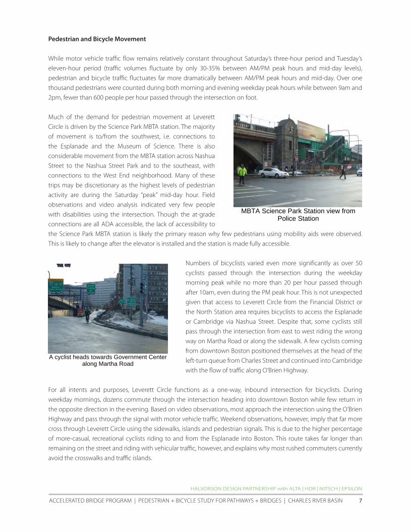
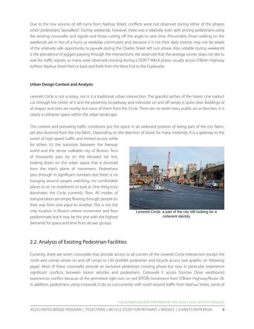

Not enough observations or video unclear
MASSAChuSETTS DEPARTMENT Of TRANSPORTATION
LEVERETT CIRCLE PEDESTRIAN AND BICyCLE CROSSING STuDy | APRIL 2011 12
Not enough observations or video unclear
hALVORSON DESIGN PARTNERShIP with ALTA | hDR | NITSCh | EPSILON
ACCELERATED BRIDGE PROGRAM | PEDESTRIAN + BICyCLE STuDy fOR PAThwAyS + BRIDGES | ChARLES RIVER BASIN 13
MASSAChuSETTS DEPARTMENT Of TRANSPORTATION
LEVERETT CIRCLE PEDESTRIAN AND BICyCLE CROSSING STuDy | APRIL 2011 14
23 Underground Utilities and Infrastructure
One of the potential solutions to improved pedestrian access at Leverett Circle is a new overpass structure Given this
possibility an understanding of the existing underground utilities and other infrastructure is needed Infrastructure
location will have an impact on the design of any overpass solution as elements such as tunnels and utilities will
present constraints on the potential locations of overpass and ramp structural supports
CAT construction at Leverett Circle included the addition of the eastbound Storrow Drive to I-93 underpass and this
in turn required the relocation of many utilities to a relatively narrow corridor beneath the Charles Street sidewalk
In the vicinity of a potential overpass the following major facilities will need to be taken into account
bull Storrow Drive eastbound and westbound underpass tunnels
bull 48rdquocombined sewer overflow along Charles Street
bull 12rdquo storm drain along Charles Street
bull 30rdquoMartha Road storm drain and twin 42rdquo storm drain siphon south of MBTA Station
bull Low service water main along Charles Street
bull Major electrical and MBTA AC power duct banks along Charles Street
hALVORSON DESIGN PARTNERShIP with ALTA | hDR | NITSCh | EPSILON
ACCELERATED BRIDGE PROGRAM | PEDESTRIAN + BICyCLE STuDy fOR PAThwAyS + BRIDGES | ChARLES RIVER BASIN 15
24 MBTA Science ParkWest End Station Accessibility Improvements
Science Park Station is part of the MBTA Green Linersquos ldquoErdquo service between Lechmere and heath Street and sits in the
center of Leverett Circle Once the proposed Green Line extension to Medford is completed in 2016 (approximately)
the ldquoErdquo line will be extended to union Square in Somerville and the station will also be served by an extension of the
ldquoDrdquo line to Medford
According to the MBTArsquos 2009 Blue Book average weekday boardings at the station ranged from 808-1047 during
the years of 2007-08 Currently Science Park is an elevated station that is not fully accessible but construction has
recently begun to include two new elevators a renovated mezzanine sitting 85rsquo above sidewalk grade and other
platform improvements After the $135 million project is complete the station will fully comply with the Americans
with Disabilities Act According to the MBTA the design did not specifically take into account the development of
a potential pedestrianbike overpass adjacent to it however except for some constraints discussed in this report
it does not appear that the new configuration precludes the attachment of a spur from the primary section of a
potential bridge over Leverett Circle
Sketch view of the proposed Science Park Station entry area and elevator tower
(from MBTArsquos ENf Environmental Assessment 4-f Statement report cover)
MASSAChuSETTS DEPARTMENT Of TRANSPORTATION
LEVERETT CIRCLE PEDESTRIAN AND BICyCLE CROSSING STuDy | APRIL 2011 16
25 Craigie Bridge and Drawbridge Rehabilitation project
As part of MassDOTrsquos Accelerated Bridge Program (ABP) the Craigie Bridge and Drawbridge Rehabilitation project
is currently under construction Expected completion date is late summer of 2011 At the time of this report all
eastbound traffic along the OrsquoBrien highwayRoute 28 between the Museum of Sciencersquos entry drive and the Nashua
Street intersection has been closed to motor vehicle traffic westbound traffic and pedestrian and bicycles in both
directions is still permitted however It is important to note that all traffic counts analysis and videotaping for this
project was performed before the eastbound traffic restrictions were put into effect
Previous conditions along OrsquoBrien highway included three traffic lanes in each direction with 5rsquo to 6rsquo sidewalks along
both sides of the roadway Bicyclists shared the travel lanes with motor vehicles and the sidewalks with pedestrians
while the core of this ABP project is the rehabilitation of the bridge and drawbridge along this stretch of roadway
numerous pedestrian and bicycle accessibility and safety improvements are included in the design The sidewalk
along the south side of the roadway has been maintained at 8rsquo to allow for the inclusion of bike lanes Though not
finalized as of this date the preferred approach for bicycle travel through Leverett Circle is for a hybrid facility that
includes a mix of an eastbound bicycle lane and a marked bikeway across some of the traffic islands and parallel with
crosswalks There would be no direct westbound access for bicyclists through Leverett Circle though itrsquos understood
that somemdashespecially recreational riders on the weekendmdashwill cross from Martha Road to the Esplanade using the
sidewalk crosswalks and traffic islands along the south edge of the circle
The series of potential pedestrianbike bridge options studied in section 5 of this report incorporate the hybrid bike
facility as described above and continues it through the intersection for consistency
Proposed bike facility through Leverett Circle as currently planned (from howard Stein hudson)
hALVORSON DESIGN PARTNERShIP with ALTA | hDR | NITSCh | EPSILON
ACCELERATED BRIDGE PROGRAM | PEDESTRIAN + BICyCLE STuDy fOR PAThwAyS + BRIDGES | ChARLES RIVER BASIN 17
26 Traffic Capacity and LOS Analysis
The current level of service (LOS) for all vehicle movements within Leverett Circle is presented in the table below
Additional detail can be found January 24 2011 study by Nitsch Engineering found in the appendix Location 1mdashthe
Nashua StreetOrsquoBrien highwayStorrow Drive intersectionmdashfunctions at LOS ldquoErdquo for weekday morning peak hour LOS
ldquoCrdquo during weekday evening peak hour and LOS ldquoDrdquo during the Saturday mid-day peak hour Location 2mdashthe Charles
StreetOrsquoBrien highwayMartha Road intersectionmdashfunctions at LOS ldquofrdquo during weekday morning and evening peak
hour and Saturday mid-day peak hour
One element that is important to note from the table above is the relatively high LOS of the Nashua Street
southbound through left-turn and right-turn movements in Location 1 This represents a potential opportunity to
experiment with providing less green time for motor vehicles approaching Leverett Circle along Nashua Street In
section 5 of this report the reallocation of some of this green time to benefit pedestrians is proposed and analyzed
MASSAChuSETTS DEPARTMENT Of TRANSPORTATION
LEVERETT CIRCLE PEDESTRIAN AND BICyCLE CROSSING STuDy | APRIL 2011 18
27 Crash Data and Analysis
MassDOTrsquos crash data from the years 2006-2008 was analyzed for this report During this period the present
intersection geometry with at-grade crosswalk improvements was complete The data is summarized in the table
below
In this three-year period there was an average of 23 and 9 reported crashes per year at Locations 1 and 2
respectively A total of 97 crashes were reported of which 60 crashes involved property damage and 28 involved
personal injury Though the reports for 39 crashes did not indicate what type of collision occurred there were only
three reported collisions involving pedestrians and one involving a bicyclist There were no reported fatalities within
Leverett Circle in this time period The crash rate at location 1 was 177 accidents per million entering vehicles
Crash rate at location 2 was 085 accidents per million entering vehicles Given that the statewide crash average for
signalized intersections is 082 this suggests that safety improvements for all users of Leverett Circlemdashespecially at
intersection 1mdashshould be considered
hALVORSON DESIGN PARTNERShIP with ALTA | hDR | NITSCh | EPSILON
ACCELERATED BRIDGE PROGRAM | PEDESTRIAN + BICyCLE STuDy fOR PAThwAyS + BRIDGES | ChARLES RIVER BASIN 19
3
REGULATORY PERMITTING AND JURISDICTIONAL ISSUES
3 Regulatory Permitting And Jurisdictional Issues
The Study team was tasked with researching the regulatory and permitting commitments pertaining to
the ldquoreplacementrdquo of the former pedestrian overpass at Leverett circle The team reviewed relevant historic
correspondence files provided by MassDOT and met with MEPA officials february 15 2011 The following sections
provide a summary of our findings to date
31 Identification of legal commitments to provide pedestrian overpass
The construction of a pedestrianbike overpass at Leverett circle is a mitigation commitment of the central Artery
Tunnel (cAT) and charles River crossing projects The commitment is memorialized in project documents developed
pursuant to the Massachusetts Environmental Policy Act (MEPA) the National Environmental Policy Act (NEPA) and
Massachusetts Department of Environmental Protection (MassDEP) chapter 91 authorizations as well as formal
interagency Memorandums of Agreement Key references include the following
The Massachusetts Department of Public works (DPw) Section 61 findings on the 1990 Supplemental final
Environmental Impact Report dated September 5 1991
Leverett Circle will be reconfigured re-landscaped and enlarged Pedestrian overpasses will be reconstructed with
one or two new overpasses on the Nashua Street parcel Historic buildings will be improved at the old dam and site
improvements including new walkways will be made on each side [p10]
The Amendment and Restatement of the Memorandum of Agreement (MOA) among the Executive Office of
Transportation and construction the Executive Office of Environmental Affairs the Massachusetts Highway
Department and the Metropolitan District commission Section 1B4 Leverett circleStorrow Drive dated December
30 1993
Provide new pedestrian overpass between Leverett CircleScience Park MBTA Station and Nashua Street Park [p9]
The Metropolitan District commission (MDc) consolidated chapter 91 License Application dated January 1995
The present Leverett CircleStorrow Drive intersection is to be reconfigured under the Central ArteryTunnel Highway
Program and includes replacing the existing pedestrian overpasses [Application Attachments for BRP WW 01 for
Leverett CircleStorrow Drive 2]
The Section 61 findings on the charles River crossing final Environmental Impact Report dated November 1995 and
submitted to MEPA on December 18 1995
Improved green spaces at Leverett Circle appropriate architectural treatment of the roadway underpass and boat
section and a pedestrian overpass between the MBTA Station and Nashua Street Park Design refinements since the
FSEIR have shortened the length of the required boat section in this area and provided for more attractive and safer
pedestrian crossing at OrsquoBrien Highway in the vicinity of the historic Street Railway viaduct [p3-2]
The Massachusetts MassDEP chapter 91 License 7611 dated July 16 1998 addresses the pedestrian footbridge by
reference HALVORSON DESIGN PARTNERSHIP with ALTA | HDR | NITScH | EPSILON
AccELERATED BRIDGE PROGRAM | PEDESTRIAN + BIcycLE STuDy fOR PATHwAyS + BRIDGES | cHARLES RIVER BASIN 21
The MHD shall restore all existing walkways public open spaces and roadway surfaces within Chapter 91 jurisdiction
impacted by any project activities to pre-construction conditions Said restoration shall be completed within 60 days
after the area is no longer needed for CAT construction purposes unless otherwise approved by the DEP [Special
Condition 15]
The pedestrian footbridge will require additional chapter 91review and approval from MassDEP pursuant to a Project
Modification to License 7611 issued on June 28 2002 The terms of the authorization restate Special condition 15
and state additionally that
hellipthe Licensee shall submit to the Department (Waterways Regulation Program) for approval with a copy to all
commenters pursuant to Special condition No 5 the final plans for the ldquoLeverett Circle Pedestrian Bridgerdquo to ensure
consistency with the conditions of [License 7611]
The commitment is also reflected in federal documents including the charles River crossing final Supplemental
Environmental Impact Statement Report dated December 1993 (Volume 1 pp 4-54 Table 6-1 p 4(f )-19) and
the federal Highway Administration charles River crossing Record of Decision (p16 and Section 33 Long - Term
Measures 34)
32 MEPA Office perspective (Section 61 findings)
On review of the above referenced project materials the MEPA Office has communicated that the record clearly
establishes the requirement to replace the pedestrian footbridge as a mitigation commitment The MEPA Office also
indicated that it recognizes that the proponent (MassDOT) may choose to reevaluate the proposed design solution
based on comprehensive planning that reflects analysis of current conditions and consultation with the charles
River crossing citizens Advisory committee and other commenting parties If alternative pedestrian crossing options
were to be proposed as the result of such ongoing analysis additional MEPA review in the form of a Notice of Project
change would be required
A Notice of Project change for lapse of time pursuant to the MEPA regulations at 301 cMR 301 1110(2) is not
required based on 301 cMR 301 1110(2)(b)2 (lapse of more than three years between notice of availability of the
SfEIR and commencement of construction) MassDOT and predecessor agencies as the project proponents have
continued to take major steps in a continuous sequence to advance the project as evidenced by interim street-level
site improvements project planning and public process associated with the proposed pedestrian footbridge and
continued notification to MassDEP by way of public meeting otices and ch 91 License 7611 construction period
extension requests pursuant to the chapter 91 license (see above)
a Point in permitting when commitment was made
As listed above the initial regulatory commitment occurs in the Massachusetts Department of Public works (DPw)
Section 61 findings on the 1990 Supplemental final Environmental Impact Report dated September 5 1991 The
commitment was maintained and incorporated in subsequent project documents as referenced above
MASSAcHuSETTS DEPARTMENT Of TRANSPORTATION
LEVERETT cIRcLE PEDESTRIAN AND BIcycLE cROSSING STuDy | APRIL 2011 22
b Changes to the commitment made over time
The commitment to provide a pedestrian footbridge has not been modified since the Section 61 finding issued in
1991
c Identification of legal commitments re design of pedestrian footbridge
Section 31 above references cAT project authorizations that identify the location of the pedestrian footbridge
These materials also address required design standards but do not explicitly specify dimensional requirements Rather
MassDEP regulatory requirements regarding design standards including the requirement that the width of the
pedestrian footbridge be a minimum of twelve feet clear are addressed by reference to design guidelines established
under the 1993 MOA as described below
The MHD Section 61 finding for the Area North of causeway issued in 1995 in reference to the pedestrian footbridge
as one of several components of mitigation identified in the MOA states that
Performance standards for these components require a path adequate for anticipated use with a minimum width of 10
to 12 feet and standards of quality typical of other parks in the Charles River Reservation [p3-3]
The MassDEP consolidated written Determination (cwD) on the charles River crossing issued in 1996 identifies
and incorporates parkland mitigation measures and design standards applicable to the pedestrian footbridge by
reference to the 1993 MOA stating that ldquothe MOA outlines the specific parkland mitigation measures and minimum
performance standards to be achievedrdquo [p31] The MOA does not specify a design standard for the pedestrian
footbridge by name but states that
hellipthe level of quality that is to be achieved shall be typical of other parks in the Charles River ReservationhellipPedestrian
and bicycle access shall be continuous along both banks of the river shall meet all applicable guidelines for accessibility
and shall provide for separation of pedestrians and bicycles where appropriate Path widths shall be adequate for
anticipated use with a minimum width of 10 ndash 12 feet for principal paths [IB2]
The cwD identifies special conditions applicable to both MHD and MDc under MHD Special condition 23b the cwD
requires that pedestrian pathways be a minimum of twelve feet clear along the waterrsquos edge eight feet clear along
roadways and that bicycle pathways be a minimum of ten feet clear In addition the cwD specifically states that
Pedestrian bridges shall be a minimum of twelve (12) feet clear and designed in consultation with the MBTA DEP may
allow reduced widths upon a clear documentation by the MDC or MHD demonstrating that design constraints preclude
the full clear width from being achieved [p41]
under MDc Special condition 21a the cwD states that mitigation described in the MOA ldquohellipshall meet the minimum
parkland design standards described in the MOA and as further described hereinrdquo The special condition repeats the
dimensional standards specified in MHD Special condition 23b does not include the reference to pedestrian bridges
HALVORSON DESIGN PARTNERSHIP with ALTA | HDR | NITScH | EPSILON
AccELERATED BRIDGE PROGRAM | PEDESTRIAN + BIcycLE STuDy fOR PATHwAyS + BRIDGES | cHARLES RIVER BASIN 23
while the MassDEP cwD does not require that the Leverett circle footbridge be designed with a minimum width
of twelve feet clear by name the special conditions clearly establish the regulatory expectation that the MOA
commitment to twelve feet clear is the applicable and required design standard
33 Identification of legal commitments regarding timing of pedestrian footbridge construction
As discussed above the MassDEP chapter 91 License 7611 does not specifically reference the pedestrian footbridge
but does impose the general condition that
hellipall existing walkways public open spaces and roadway surfaces within Chapter 91 jurisdiction impacted by any
project activities to pre-construction conditionshellipwithin 60 days after the area is no longer needed for CAT construction
purposes unless otherwise approved by the DEP
A MassDEP Project Modification for License 7611 issued to the Massachusetts Turnpike Authority (MTA) on June 28
2002 related to surface restoration elements (including among other elements demolition of the existing footbridge
and construction of a temporary footbridge) established two conditions related to the timing of construction of the
pedestrian footbridge
first MassDEP requires that the surface restoration elements comply with Special condition 15 described
above and the condition therein that all restoration be completed and open to the public within sixty days of the
completed construction contract If construction of the pedestrian footbridge does not meet this schedule a license
modification is required pursuant to Special condition 5 of License 7611 which specifies that MHD [now MassDOT]
provide a written request and plans associated with proposed modifications to MassDEP the MDc [now DcR] the
Mayor and city council of the city of Boston the Boston conservation commission the Massachusetts coastal Zone
Management Office the MBTA and interveners for a ten day comment period
Second the License Modification requires that final plans for the pedestrian footbridge be submitted to MassDEP also
pursuant to Special condition 5 as described under Section 30 above
Last Special condition 3 of License 7611 states that the construction period for work authorized under the license
(ten years from date of issuance on July 16 1998) can be extended by MassDEP without public notice for one or more
one-year periods based on written request from the licensee MassDOT provided MassDEP with such notification
most recently on May 4 2010
MASSAcHuSETTS DEPARTMENT Of TRANSPORTATION
LEVERETT cIRcLE PEDESTRIAN AND BIcycLE cROSSING STuDy | APRIL 2011 24
4 BEST PRACTICES AND CASE STUDIES FOR
PEDESTRIANBIKE OVERPASSES
4 Best Practices And Case Studies For PedestrianBike Overpasses
As described above one of the potential solutions to improve pedestrian conditions at Leverett circle is an overpass
either with or without supplemental at-grade crossings The Study Team used a number of documents for guidance
in developing and analyzing alternatives including the following
bull Design and Safety of Pedestrian Facilities ndash A Recommended Practice the Institute of Transportation
Engineers (ITE) chapter 10 esp pages 77-78 March 1998
bull Florida Pedestrian Planning and Design Handbook Chapter 20 ndash Grade Separated Crossings pages 169-172
bull City of Madison Wisconsin PedestrianBicycle Grade Separation Worksheet (Based on Design and Safety of
Pedestrian facilities a Proposed Recommended Practice of the Institute of Transportation Engineers chapter
10 ldquoGrade Separated crossingsrdquo December 1994)
o This excerpt is of particular note Perceived ease of accessibility convenience factor R = ratio of
time to travel on the over- or underpass divided by time to travel at grade level 1985 study
indicated 95 of pedestrians would use an underpass and 70 would use an overpass if R=1 (no
time difference) It also found that very few would us an overpass if R=15 (50 time difference)
bull Pedestrian Crossing Guidelines for Texas Texas Transportation Institute December 2000
It should be noted that all of these documents are based on the ITE guide listed above Below is the typical language
used in the guides This language was excerpted from Texas
Past research has shown the effectiveness of grade-separated pedestrian crossings depends upon the perceived effort
and time to use it For example Figure 41 (not shown) defines a convenience measure R and compares it to the
percentage of pedestrians likely to use a grade-separated crossing The figure shows that 95 percent of pedestrians will
likely use an underpass and 70 percent will likely use an overpass if the travel times at-grade and grade-separated are
equal (ie R=1) Similarly less than 5 percent would use either an overpass or an underpass if it takes 50 percent longer
(R=15)
Other studies have shown that pedestrians use grade-separated crossings more often if the elevation change can be
minimized or worked into the normal path of pedestrian movement For example switchback ramps are often used
for ADA compliance but provide a time-consuming approach for some pedestrians Although more right-of-way may
be required the site topography at the approaches to the crossing may be able to be modified to better accomplish
the elevation change without especially long andor switchback ramps
A 1988 synthesis by Zegeer and Zegeer suggested that grade-separated pedestrian crossings are most beneficial
under the following conditions
bull where there is moderate to high pedestrian demand to cross a freeway or expressway
bull where there is a large number of young children (ie particularly near schools) who must regularly cross a
high-speed or high-volume roadway
HALVORSON DESIGN PARTNERSHIP with ALTA | HDR | NITScH | EPSILON
AccELERATED BRIDGE PROGRAM | PEDESTRIAN + BIcycLE STuDy fOR PATHwAyS + BRIDGES | cHARLES RIVER BASIN 25
bull on streets having high vehicle volumes and high pedestrian crossing volumes and where there is an extreme
hazard for pedestrians (eg on wide streets with high-speed traffic and poor sight distance) and
bull where one or more of the conditions stated above exists in conjunction with a well-defined pedestrian
origin and destination (eg residential neighborhood across a busy street from a school a parking structure
affiliated with a university or apartment complex near a shopping mall)
(Zeeger CV and Zeeger SF ldquoPedestrians and Traffic-Control Measuresrdquo Synthesis of Highway Practice 139 Transportation
research Board November 1988)
The document Warrants for Pedestrian Over and Underpasses suggests more specific criteria and other general
considerations for grade-separated pedestrian crossings
bull The pedestrian hourly volume should be more than 300 in the four highest continuous hour periods if
the vehicle speed is more than 40 mph and the proposed sites are in urban areas and not over or under
a freeway Otherwise the pedestrian volume should be more than 100 pedestrians in the four highest
continuous hour periods
bull vehicle volume should be more than 10000 in the same four-hour period used for the pedestrian volume
warrant or have an ADT volume greater than 35000 if vehicle speed is over 40 mph and the proposed site(s)
are in urban areas If these two conditions are not met the vehicle volume should be more than 7500 in the
four hours or have an ADT greater than 25000
bull The proposed site should be at least 600 feet from the nearest alternative ldquosaferdquo crossing A ldquosaferdquo crossing is
defined as a location where a traffic control device stops vehicles to create adequate gaps for pedestrians to
cross Another ldquosaferdquo crossing is an existing overpass or underpass near the proposed facility
bull A physical barrier is desirable to prohibit at-grade crossing of the roadway as part of the overpass or
underpass design plan
bull Artificial lighting should be provided to reduce potential crime against users of the underpasses or
overpasses It may be appropriate to light underpasses 24 hours a day and overpasses at night
bull Topography of the proposed site should be such as to minimize changes in elevation for users of overpasses
and underpasses and to help ensure that construction costs are not excessive Elevation change is a factor
that affects the convenience of users
bull A specific need may exist for a grade-separated crossing based on the existing or proposed land use(s)
adjoining the proposed development site that generates pedestrian trips This land use should have a direct
access to the grade-separated facility
bull Funding for construction of underpass or overpass must be available prior to a commitment to construct it
(Axler EA Warrants for Pedestrian Over and Underpasses Report No FHWARD-84-082 US DOT Washington DC July 1984)
In addition to the traffic and pedestrian volume considered in these warrants a benefit-cost analysis is often also
desirable for grade-separated pedestrian crossings Details on conducting a benefit-cost analysis can be found in
MASSAcHuSETTS DEPARTMENT Of TRANSPORTATION
leveReTT CIRCle PeDeSTRIAn AnD BICyCle CRoSSInG STuDy | APRIl 2011 26
NcHRP Report 189 (ldquoQuantifying the Benefits of Separating Pedestrians and Vehiclesrdquo 1978) and nCHRP Report 240 (ldquoA
Manual to Determine the Benefits of Separating Pedestrians and Vehiclesrdquo 1981)rdquo
41 Case Studies of pedestrianbike overpasses adjacent to at-grade connections
To also help the team understand the optimal conditions for pedestrian and bicycle overpasses case studies from
other communities were investigated There are thousands of pedestrianbike overpasses throughout the united
States most passing over busy highways expressways and railroad tracks These are not relevant for this study If
an overpass is ultimately located at leverett Circle it will be in conjunction with at-grade pedestrian facilities that
connect some or all legs of the complex intersection while finding a precise precedent proved difficult there are a
handful of locations of pedestrian and bike overpasses that exist in close proximity to a signalized intersection with
functioning at-grade pedestrian crossings Examples presented below include
bull Bunker Hill Community College Charlestown MA bull Route 9A46th Street new york ny
bull Route 9AChambers Street new york ny bull Aurora Avenue n155th Street Shoreline WA
Bunker Hill Community College Charlestown MA
The pedestrianbike overpass at this location
was developed to provide an enhanced link from
charlestown to the BHcc Main campus The
Rutherford Avenue overpass connects directly to
an elevated plaza adjacent to the A Building which
houses the campus auditorium and art gallery This
plaza also provides a direct connection (via a second
pedestrian bridge) to the MBTA community college
station along the Orange Line station The east end of
the bridge features a stairway and switchback stair to
connect to the sidewalk and an adjacent parking lot
(from wwwbingmapscom)
Route 9AChambers Street Lower Manhattan New York NY
The pedestrian overpass is a long-span arched bridge
over Route 9A in the Battery Park City section of lower
Manhattan Though an at-grade crosswalk also exists
at the chambers Street intersection the overpass
was developed in conjunction with Stuyvesant High
School which lies on the west side of Route 9A
Though accessible from the sidewalk the bridge also
connects directly to the second floor of the school
Connections to the sidewalk include both stairs and
an elevator There are no ramps
HALVORSON DESIGN PARTNERSHIP with ALTA | HDR | NITScH | EPSILON
Aerial View of Rutherford Avenue overpass
Chambers Street view to the east across Route 9A (from wwwmapsgooglecom)
AccELERATED BRIDGE PROGRAM | PEDESTRIAN + BIcycLE STuDy fOR PATHwAyS + BRIDGES | cHARLES RIVER BASIN 27
Route 9AWest 46th Street Lower Manhattan New York NY
The pedestrianbike bridge at the end of West 46th
Street in Manhattan spans over Route 9A adjacent
to a signalized intersection with well-designed
crosswalk Both provide connections to the Intrepid
Sea Air amp Space Museum consisting of a small
museum building and the retired world war II-era
Intrepid aircraft carrier (not docked in the photo
at right) under normal conditions the overpass
connects directly to a large landing in front of the
main entry to the aircraft carrier During spring and
summer the Intrepid is one of the largest tourist
attractions in new york drawing nearly one million
visitors a year according to the museumrsquos web site (from wwwbingmapscom)
Aurora AvenueN 155th Street Shoreline WA
This pedestrianbike overpass project was
recently completed as part of the Aurora corridor
Project the reconstruction of the three miles of
Aurora Avenue North (State Route 99) that run
through the city of Shoreline Shorelinersquos section
of SR-99 carries 40000 - 45000 vehicles per day
and is a major transit route
According to the cityrsquos web site the ldquogoal of the
project was to improve pedestrian and vehicle
safety pedestrian and disabled access vehicular
capacity traffic flow transit speed and reliability
nighttime visibility and safety stormwater
quality and management economic investment
potential and streetscape amenitiesrdquo Paralleling
Aurora Avenue is the Interurban Trail a three-
mile multi-use path developed along the former
Interurban Rail Line where the trail crossed N
155th Street a new overpass was developed
in conjunction with at-grade pedestrian
improvements including decorative crosswalks
new sidewalks and the removal or free right-turn
lanes and their accompanying pork-chop islands BeforeAfter aerial view of the Aurora155 Street intersection (from wwwbingmapscom)
Aerial View of Route 9A and West 46 th Street intersection
th
MASSAcHuSETTS DEPARTMENT Of TRANSPORTATION
leveReTT CIRCle PeDeSTRIAn AnD BICyCle CRoSSInG STuDy | APRIl 2011 28
Summary of Case Studies
The examples above show a range of pedestrianbike overpasses over busy roadways adjacent to intersections with
at-grade pedestrian facilities unlike a potential overpass at leverett Circle none of them passed over the entire
intersection itself Instead they provided connectivity along one edge in order to connect to existing attractions or
to maintain the alignment of a multi-use trail Of particular note all of the examples provide direct connectivity to
a facility or space that is above the grade of the roadway below In other words the team was not able to find any
examples of overpasses adjacent to at-grade connections that required users to ascend one side of the overpass cross
the structure then descend on the other side other than connections to the MBTA Science Park station mezzanine
this would be the necessary movement for those wishing to cross a potential pedestrianbike overpass over leverett
circle
42 Evaluation Criteria for Potential PedestrianBike Overpass
The Best Practices and case Studies research described above were used to inform a series of criteria that is used to
evaluate the pedestrian and bike connectivity options presented in the next section These options include multiple
overpass alternatives with or without at-grade connectivity improvements as well as an option where only at-grade
improvements are incorporated The criteria also derive from meetings with various stakeholders and were presented
in draft form at the December 2010 public meeting held in conjunction with this study The criteria include
1 Safety for all users
2 Security of all users
3 Perception of Required out-of-direction Travel
4 Length of Travel for Non-Motorized users
5 Time of Travel for Non-Motorized users (including expected wait time at signals)
6 Cost and Constructability (bridge structure utilities signals etc)
7 Sight Line considerations (obstruction issues shadows etc)
8 Overall Pedestrian Accommodation and convenience
9 Overall Bicycle Accommodation and convenience
10 functionality of Intersection for all users
11 Operational Impacts on Vehicular Movements
12 Aesthetic Impacts to Intersection
Evaluation results of the various options are presented at the end of the next section It is important to note that
evaluation results should be used for advisory purposes only They are not intended to be a ldquofinal scorerdquo that makes
the ultimate decision which of the options is the right one for Leverett circle
HALVORSON DESIGN PARTNERSHIP with ALTA | HDR | NITScH | EPSILON
AccELERATED BRIDGE PROGRAM | PEDESTRIAN + BIcycLE STuDy fOR PATHwAyS + BRIDGES | cHARLES RIVER BASIN 29
5 CONCEPTUAL DESIGN OPTIONS
5 Conceptual Design Options
The primary purpose of this report is to provide MassDOT with information and analysis that will help to inform the
agencyrsquos final decision about the type of pedestrianbicycle crossing facilities to provide at Leverett circle As such
three options were studied
bull An ldquoat-grade onlyrdquo option that includes at-grade intersection improvements for the benefit of pedestrian and
bicyclist safety
bull Three overpass alternatives that include some or all of the at-grade improvements developed above
bull Three overpass alternatives that retain only the minimum at-grade pedestrian connections required to cross
OrsquoBrien Highway andor Nashua Street to and from the MBTA station
51 Option 1 ldquoAt-Grade Onlyrdquo with improvements
The suggested improvements for pedestrian at-grade connectivity derive from two sources MassDOTrsquos review of
recommendations made originally by walkBoston and additional recommendations developed as part of this Study
Bicycle improvements have primarily been incorporated from the recent craigie Bridge design work by a separate
consulting team with input from the Leverett circle team
Proposed at-grade improvements for pedestrians and bicyclists at Leverett Circle
HALVORSON DESIGN PARTNERSHIP with ALTA | HDR | NITScH | EPSILON
AccELERATED BRIDGE PROGRAM | PEDESTRIAN + BIcycLE STuDy fOR PATHwAyS + BRIDGES | cHARLES RIVER BASIN 31
The combined recommendations for enhancements to the existing at-grade crossings still require a final review
by MassDOT and may be implemented after the completion of the craigie Bridge rehabilitation project which
is currently under construction The proposed program of recommended enhancements will be communicated
to the cities of Boston and cambridge DcR the MBTA adjacent neighborhoods and other stakeholders prior to
implementation
The at-grade improvements include both physical infrastructure changesmdashstriping new crosswalks revised curbs
signage and new bicycle signal headsmdashand changes to the signal operations Infrastructure improvements are
summarized in the diagram on page 31 above
Arguably the most significant improvement for pedestrian safety and connectivity is the shifting of the east crosswalk
at the Nashua StreetOrsquoBrien HighwayStorrow Drive intersection further to the east of the charles Street double left
turn lanes This accommodates the general ldquodesire linerdquo movement that many pedestrians currently use when going
to and from the MBTA station (see section 21) Shifting this crosswalk east eliminates one of the primary accessibility
concerns that many in the community have had since the intersection was complete in 2006 left-turning vehicles
from Nashua Street conflicting with pedestrians who have the right of way while crossing OrsquoBrien Highway The new
crosswalk location will be signaled to allow crossing movement during the first phase of the signal cycle when traffic
from charles Street is turning left to OrsquoBrien Highway The current timing of Phase 1 of the cycle is only 19 seconds
however not enough for a slow-moving pedestrian to safely cross to and from Science Park station on the angled
crosswalk In consequence new signal phasing is proposed to give more crossing time for those on foot To do so
Phase 2 of the cycle is proposed to be split in order to give 12 fewer seconds of green time for southbound right-
through- and left-turning traffic along Nashua Street (where LOS grades range from ldquoBrdquo to ldquoCrdquo during AM PM and
Saturday mid-day peaks) Right-turning traffic from Charles Street continues its movement during both portions of
the split 2nd phase however
In addition the splitting of Phase 2 provides the opportunity to restrict right turn on red (RTOR) movement for
eastbound traffic on OrsquoBrien Highway A right-turn signal is proposed for this movement This signal would display
a solid red arrow for the 19 seconds of Phase 1 along with the shorter portion of the split 2nd phase combined this
provides 31 seconds of exclusive pedestrian and bicycle crossing time at three of the legs of the NashuaOrsquoBrien
Storrow intersection During the subsequent 35 seconds of Phase 2 the red arrow would be flashing and permit
RTOR to Storrow Drive wB during gaps in Nashua Streetrsquos through traffic (Please note the full impact of this partial
restriction to RTOR movement onto Storrow Drive is still being studied for its impact) The proposed traffic signal
timing and phasing is shown in the two diagrams on the following pages
MASSAcHuSETTS DEPARTMENT Of TRANSPORTATION
LEVERETT cIRcLE PEDESTRIAN AND BIcycLE cROSSING STuDy | APRIL 2011 32
HALVORSON DESIGN PARTNERSHIP with ALTA | HDR | NITScH | EPSILON
AccELERATED BRIDGE PROGRAM | PEDESTRIAN + BIcycLE STuDy fOR PATHwAyS + BRIDGES | cHARLES RIVER BASIN 33
MASSAcHuSETTS DEPARTMENT Of TRANSPORTATION
LEVERETT cIRcLE PEDESTRIAN AND BIcycLE cROSSING STuDy | APRIL 2011 34
52 Option 2 PedestrianBike Overpass with Improved At-Grade Crossing Alternatives
Three design alternatives were studied to determine multiple options to create a fully-accessible pedestrianbike
overpass at Leverett Circle The three alternatives all assumed the incorporation of the at-grade improvements and
signal-phase adjustments described in section 51 above The themes for the three alternatives include
bull Curving Overpass A single curving overpass connecting the SW corner of the NashuaOrsquoBrienStorrow
intersection with the SE corner of the charlesOrsquoBrienMartha intersection and a spur to the MBTA station
(similar in concept to the Rosales + Partners proposal)
bull Three-legged Overpass A three-legged overpass connecting the SW corner of the NashuaOrsquoBrienStorrow
intersection with the SE corner of the charlesOrsquoBrienMartha intersection and a spur to the MBTA station
(similar in concept to the HNTBc19E6 design)
bull Partial Connection A partial curving overpass connecting the SW corner of the NashuaOrsquoBrienStorrow
intersection with the MBTA station only
To varying degrees all overpass options improve mobility for pedestrians and bicyclists in the Leverett circle area
by providing a grade-separated alternative The Curving and Three-legged options in particular allow people to pass
over one of the busiest intersections in the city of Boston without waiting for pedestrian crossing signals This option
also provides an alternative for those who are uncomfortable crossing concurrently with turning vehicles
for the west End community this would provide a major benefit to the elderly those with disabilities and families
with young children A grade-separated connection to the MBTA station might also induce a greater level of use of
the Science Park station as a number of west End residents have reported that they currently walk the extra distance
to the North Station MBTA station to avoid having to cross Leverett circle at grade All overpass options will also
enhance connections between Science Park Station and the charles River Reservation and the Museum of Science
for many large school groups and families with young children this will be viewed as a major mobility improvement
There are a number of design criteria that were used when developing a conceptual design for the three overpass
alternatives These included
1 12rsquo-0rdquo minimum bridge width for consistency with MassDEP Consolidated Written Determination on the
Charles River Crossing issued in 1996 (AASHTO guideline for pedestrian bicycle overpasses is 10rsquo-0rdquo)
2 16rsquo-6rdquo clear height of structure above roadway (note that trucks are unrestricted along Charles Street EB and
Craigie Bridge to I-93 and Martha Road connection)
3 Depth of overpass structure 14rdquo from top of walking surface to outside bottom of structure (It was assumed
that the structure would consist of integral precast concrete walkway girder and railing system)
4 ADAAG and MassAAB Accessible Route Requirements (lt5 running slope without landings 5-8 running
slope designed as a ramp with landings)
5 Limit of Work to remain within existing State ROW and easements
6 Limited impacts to intersection vehicular capacity
7 Limited impacts to intersection geometry (minor changes to geometry only)
8 Limited impacts to underground utilities
9 compatible with MBTA Science Park Station improvements and ideally providing a connection to the
HALVORSON DESIGN PARTNERSHIP with ALTA | HDR | NITScH | EPSILON
AccELERATED BRIDGE PROGRAM | PEDESTRIAN + BIcycLE STuDy fOR PATHwAyS + BRIDGES | cHARLES RIVER BASIN 35
mezzanine level ldquounpaidrdquo area as well as access to the sidewalk below
10 compatible with craigie Bridge and Drawbridge final roadway conditions
11 Maintain or improve connectivity to Charles River Basin parkland for non-motorized users
12 Compatible with existing or potentially improved at-grade pedestrian connections
When developing the conceptual alternatives based on the three themes it quickly became clear that it would be
difficult to satisfy all twelve of the design criteria Of the three ldquobaserdquo alternatives presented on the following pages
only Alternative 2 the Three-legged Overpass has the potential to completely satisfy the design criteria
Alternatives 1 and 3 are not able to satisfy key criteria and are presented for informational purposes for these
schemes to be fully functional and meet more of the key criteria listed above alterations to the designs were required
and therefore sub-alternatives 1A 1B 3A and 3B were developed for additional evaluation These sub-alternatives
illustrate how overpass designs based on base Alternatives 1 and 3 could work if there was flexibility in at least one of
the criteria
Alternative 1 Curving Overpass
This alternative attempted to provide access from both the southwest StorrowOrsquoBrien corner (ldquoState Police cornerrdquo)
and the Martha Road corner to the mezzanine level of the MBTA Green Line Science Park Station It is similar to
the Rosales + Partners concept with the important difference that the MBTA spur is located on the west side of
the mezzanine rather than the east due to the new elevator lobby Issues concerning this alternative include the
following
bull The controlling MBTA mezzanine elevation of 12765 results in a vertical clearance of only 124 feet over the
intersection In the Rosales + Partners design the spur to the Science Park station mezzanine approached
from the east but this does not appear feasible given the locations of the proposed MBTA lobby and elevator
tower An ldquoeasterly spurrdquo could not vertically clear the elevator lobby while maintaining ADA-compliant ramp
slopes It should also be noted that the Rosales + Partners concept assumed a minimum clearance of 14rsquo-6rdquo
over roadways versus the 16rsquo-6rdquo criteria used in this study
bull The 124rsquo vertical clearance is substandard and could represent a potential ldquofatal flawrdquo for this alternative The
available clearance would not meet even a relaxed criterion such as 14-feet which is sometimes used for
local roadways in urban areas
In addition to the above significant problems with Alternative 1 the following issues were also identified
bull The junction of the MBTA spur and the main overpass structure would occur above the roadway As a
structural support cannot be located at this location the complexity of the design and construction would
be increased perhaps significantly along with the cost
bull Structural piers will have to be constructed over the Storrow Drive Westbound tunnel at the MBTA island
bull At the Charles StreetMartha Road corner foundations for the ramp support columns may be in conflict with
utilities
MASSAcHuSETTS DEPARTMENT Of TRANSPORTATION
LEVERETT cIRcLE PEDESTRIAN AND BIcycLE cROSSING STuDy | APRIL 2011 36
bull The required length of ramp on the Esplanade results in the ramp switchback being located very close to
the State Police driveway onto Storrow Drive This may present sight distance issues at the driveway and also
results in the Storrow Drive sidewalk being relocated to the edge of Storrow Drive with no buffer
On the following page is a conceptual plan diagram showing the alignment of pedestrianbike overpass
Alternative 1 with areas of concern highlighted Additionally included is a diagram and matrix illustrating
the pedestrian walking distance and time for overpass Alternative 1 versus the distance and time required to
cross Leverett Circle using the Study Teamrsquos proposed at-grade improvements
HALVORSON DESIGN PARTNERSHIP with ALTA | HDR | NITScH | EPSILON
AccELERATED BRIDGE PROGRAM | PEDESTRIAN + BIcycLE STuDy fOR PATHwAyS + BRIDGES | cHARLES RIVER BASIN 37
MASSAcHuSETTS DEPARTMENT Of TRANSPORTATION
LEVERETT cIRcLE PEDESTRIAN AND BIcycLE cROSSING STuDy | APRIL 2011 38
HALVORSON DESIGN PARTNERSHIP with ALTA | HDR | NITScH | EPSILON
AccELERATED BRIDGE PROGRAM | PEDESTRIAN + BIcycLE STuDy fOR PATHwAyS + BRIDGES | cHARLES RIVER BASIN 39
MASSAcHuSETTS DEPARTMENT Of TRANSPORTATION
LEVERETT cIRcLE PEDESTRIAN AND BIcycLE cROSSING STuDy | APRIL 2011 40
Alternative 2 Three-Legged Overpass
This concept is similar to the pedestrian overpass design originally included in contract c19E6 The concept has three
branches which meet at the Charles Street median island All horizontal and vertical clearances are met however the
following issues were indentified
bull The required length of ramp on the Esplanade results in the ramp switchback being located very close to
the State Police driveway onto Storrow Drive This may present sight distance issues at the driveway and also
results in the Storrow Drive sidewalk being relocated to the edge of Storrow Drive with no buffer
bull Structural piers will have to be constructed over the Storrow Drive Westbound tunnel at the MBTA island
bull At the Charles StreetMartha Road corner foundations for the ramp support columns may be in conflict with
utilities
On the following page is a conceptual plan diagram showing the alignment of pedestrianbike overpass Alternative
2 with areas of concern highlighted Additionally included is a diagram and matrix illustrating the pedestrian walking
distance and time for overpass Alternative 2 versus the distance and time required to cross Leverett Circle using the
Study Teamrsquos proposed at-grade improvements
HALVORSON DESIGN PARTNERSHIP with ALTA | HDR | NITScH | EPSILON
AccELERATED BRIDGE PROGRAM | PEDESTRIAN + BIcycLE STuDy fOR PATHwAyS + BRIDGES | cHARLES RIVER BASIN 41
HALVORSON DESIGN PARTNERSHIP with ALTA | HDR | NITScH | EPSILON
AccELERATED BRIDGE PROGRAM | PEDESTRIAN + BIcycLE STuDy fOR PATHwAyS + BRIDGES | cHARLES RIVER BASIN 42
MASSAcHuSETTS DEPARTMENT Of TRANSPORTATION
LEVERETT cIRcLE PEDESTRIAN AND BIcycLE cROSSING STuDy | APRIL 2011 43
MASSAcHuSETTS DEPARTMENT Of TRANSPORTATION
LEVERETT cIRcLE PEDESTRIAN AND BIcycLE cROSSING STuDy | APRIL 2011 44
Alternative 3 Partial Connection
This alternative takes the same approach as Alternative 1 but only provides access between the T station and the
ldquoPolice Stationrdquo corner Unlike Alternative 1 this concept provides the required 165 foot vertical clearance above the
roadway Doing so however results in what appears to be a fatal flaw The ramps required to meet the controlling
mezzanine elevation must approach the mezzanine from the east and there is insufficient vertical clearance above
the new MBTA elevator lobby structure to do so
In addition to the above the following issues were also identified
bull Structural piers will have to be constructed over the Storrow Drive Westbound tunnel at the MBTA island
bull The required length of ramp on the Esplanade results in the ramp switchback being located very close to
the State Police driveway onto Storrow Drive This may present sight distance issues at the driveway and also
results in the Storrow Drive sidewalk being relocated to the edge of Storrow Drive with no buffer
On the following page is a conceptual plan diagram showing the alignment of pedestrianbike overpass Alternative
3 with areas of concern highlighted Additionally included is a diagram and matrix illustrating the pedestrian walking
distance and time for overpass Alternative 3 versus the distance and time required to cross Leverett Circle using the
Study Teamrsquos proposed at-grade improvements
HALVORSON DESIGN PARTNERSHIP with ALTA | HDR | NITScH | EPSILON
AccELERATED BRIDGE PROGRAM | PEDESTRIAN + BIcycLE STuDy fOR PATHwAyS + BRIDGES | cHARLES RIVER BASIN 45
MASSAcHuSETTS DEPARTMENT Of TRANSPORTATION
LEVERETT cIRcLE PEDESTRIAN AND BIcycLE cROSSING STuDy | APRIL 2011 46
HALVORSON DESIGN PARTNERSHIP with ALTA | HDR | NITScH | EPSILON
AccELERATED BRIDGE PROGRAM | PEDESTRIAN + BIcycLE STuDy fOR PATHwAyS + BRIDGES | cHARLES RIVER BASIN 47
As noted on previous pages overpass Alternatives 1 and 3 include a number of flaws which preclude the ability to
serve their primary purpose These include the inability to achieve a 165rsquo (or even a 14rsquo) clearance over the roadway
and the difficulty of developing a functional connection to the MBTA stationrsquos mezzanine Because of this two sub-
options were developed for both alternatives that required a slight rethinking of the connectivity of each alternative
bull Alternatives 1A and 3A ndash provide connections to the MBTA inbound platform (rather than mezzanine)
bull Alternatives 1B and 3B ndash premised on the removal of one WB traffic lane in front of the MBTA station to
provide additional space for a ramp connection to the mezzanine (see section 21 of this Study for
discussion)
Alternative 1A Curving Overpass with Inbound Platform Access
To remedy the low vertical clearance of Alternative 1 Alternative 1A provides access to the inbound platform level of
the MBTA Science Park station which is 20 feet above the mezzanine Issues with this concept include
bull Sight distance will be affected at the State Police station driveway onto Storrow Drive
bull Structural foundations will have to be constructed over Storrow Drive Westbound tunnel
bull Structural foundations may conflict with the pump house building adjacent to the MBTA station
bull Structural foundations may conflict with combined sewer storm drain and other utilities
bull Provisions for fare-control will need to be provided either on the overpass structure itself or on the inbound
platform Both of these options are very space-constrained and this may not be feasible Further investigation
of this possibility will need to be explored with the MBTA
bull The overpass by only serving the inbound platform has significantly less functionality than is desirable
Access to and from the outbound platform would be technically available but would require a circuitous
trip via the ldquopaid siderdquo of the mezzanine level lobby
MASSAcHuSETTS DEPARTMENT Of TRANSPORTATION
LEVERETT cIRcLE PEDESTRIAN AND BIcycLE cROSSING STuDy | APRIL 2011 48
HALVORSON DESIGN PARTNERSHIP with ALTA | HDR | NITScH | EPSILON
AccELERATED BRIDGE PROGRAM | PEDESTRIAN + BIcycLE STuDy fOR PATHwAyS + BRIDGES | cHARLES RIVER BASIN 49
Alternative 1B Curving Overpass with WB Lane Removal
This alternative is able to provide access to the mezzanine level while meeting MassDOTrsquos minimum vertical clearance
of 165rsquo To do so one WB travel lane along the short block in front of the MBTA station would need to be removed in
order to relocate the curb to the south The pedestrian ramp would span parallel along the proposed widened curb
and then loop under the pedestrian overpass thus avoiding the lobby roof Issues with this alternative include
bull Sight distance will be affected at the State Police station driveway to Storrow Drive
bull Structural foundations may conflict with combined sewer storm drain and other utilities
MASSAcHuSETTS DEPARTMENT Of TRANSPORTATION
LEVERETT cIRcLE PEDESTRIAN AND BIcycLE cROSSING STuDy | APRIL 2011 50
HALVORSON DESIGN PARTNERSHIP with ALTA | HDR | NITScH | EPSILON
AccELERATED BRIDGE PROGRAM | PEDESTRIAN + BIcycLE STuDy fOR PATHwAyS + BRIDGES | cHARLES RIVER BASIN 51
Alternative 3A Partial Connection to MBTA Inbound Platform
In this concept ADA access is provided to the inbound platform level and also stairwell access to the mezzanine level
All vertical clearances are met in this alternative Issues include
bull Sight distance will be affected at the State Police station driveway to Storrow Drive
bull Structural foundations may conflict with combined sewer and other utilities
bull Structural foundations may be required over Storrow Drive Westbound tunnel
bull Provisions for fare-control will need to be provided either on the overpass structure itself or on the inbound
platform Both of these options are very space-constrained and this may not be feasible Further investigation
of this possibility will need to be explored with the MBTA
bull The overpass by providing ADA access to only the inbound platform has significantly less functionality than
is desirable Access to and from the outbound platform would be technically available but would require a
circuitous trip via the ldquopaid siderdquo of the mezzanine level lobby
MASSAcHuSETTS DEPARTMENT Of TRANSPORTATION
LEVERETT cIRcLE PEDESTRIAN AND BIcycLE cROSSING STuDy | APRIL 2011 52
HALVORSON DESIGN PARTNERSHIP with ALTA | HDR | NITScH | EPSILON
AccELERATED BRIDGE PROGRAM | PEDESTRIAN + BIcycLE STuDy fOR PATHwAyS + BRIDGES | cHARLES RIVER BASIN 53
Alternative 3B Partial Connection with WB Lane Removal
Like Alternative 1B this alternative is able to provide access to the mezzanine level while meeting the required
minimum vertical clearance of 165rsquo To do so one WB travel lane along the short block in front of the MBTA station
would need to be removed in order to relocate the curb to the south The pedestrian ramp would span parallel along
the proposed widened curb and then loop under the pedestrian overpass to avoid the lobby roof Issues include
bull Sight distance will be affected at the State Police station driveway to Storrow Drive
bull Structural foundations may conflict with storm drain and other utilities
bull Structural foundations may be required over the Storrow Drive WB tunnel
MASSAcHuSETTS DEPARTMENT Of TRANSPORTATION
LEVERETT cIRcLE PEDESTRIAN AND BIcycLE cROSSING STuDy | APRIL 2011 54
HALVORSON DESIGN PARTNERSHIP with ALTA | HDR | NITScH | EPSILON
AccELERATED BRIDGE PROGRAM | PEDESTRIAN + BIcycLE STuDy fOR PATHwAyS + BRIDGES | cHARLES RIVER BASIN 55
Based on the criteria discussed in section 42 of this report the five workable design alternatives (1A 1B 2 3A
and 3B) were evaluated using a 1-5 scale with 1 as poor 3 as fair and 5 as excellent The evaluation assumes that the
proposed at-grade improvements would be incorporated in all five potential overpass alternatives
Criteria At-grade only Alt 1A amp 1B Alt 2 Alt 3A amp 3B
Safety for all Users 4 5 5 5
Security of all Users 5 3 3 4
Perception of Required Out-of-direction Travel 5 4 2 4
Length of Travel for Non-motorized Users 5 4 3 4
Time of Travel for Non-Motorized Users 3-5 4 4 3-5
(including expected wait time at signals)
Constructability and cost (bridge structure utilities signals etc) 5 1 1 3
Sight Line Considerations (obstruction issues shadows etc) 5 3 3 4
Overall Pedestrian Accommodation and Convenience 3 5 5 5
Overall Bicycle Accommodation and Convenience 3 5 5 3
Functionality of Intersection for all Users 4 5 4 5
Operational Impacts on Vehicular Movements 4 4 4 4
Aesthetic Impacts to Intersection 5 3 2 3
TOTAL 51-53 46 41 47-49
MASSAcHuSETTS DEPARTMENT Of TRANSPORTATION
LEVERETT cIRcLE PEDESTRIAN AND BIcycLE cROSSING STuDy | APRIL 2011 56
53 Option 3 PedestrianBike Overpass with minimal at-grade pedestrian connections
The third option for Leverett circle is to develop a new pedestrianbike overpass (based on workable alternatives
1A 1B and 2 discussed above) and retain only the minimum at-grade pedestrian connections This would require
the removal of most of the existing crosswalks curb-cuts and pedestrian crossing signal heads within the two
intersections The crosswalkscurb cuts retained would be those that cross OrsquoBrien Highway (on the west side of the
intersection) and Nashua Street These two crosswalks would provide pedestrian and bike connections from Nashua
Street Park to the charles River Esplanade and to the MBTA station The pair would also provide a secondary route
tofrom the southwest corner of the intersection in front of the State Police Station to the MBTA station for those
who chose to remain at-grade To mitigate the desire to cross at-grade after pedestrian facilities have been removed
barriers (fencing and dense landscaping) will be needed to ensure that pedestrians use the overpass structure
It is important to note that with the removal of most at-grade pedestrian connections there will be no apparent
benefit to traffic capacity or LOS This is because none of the existing WALK signals prevent potential non-conflicting
traffic movements from occurring The most apparent benefit of removing most at-grade pedestrian facilities would
be to reduce conflicts between pedestrian and motor vehicles If all walkers (and some bicyclists) were to use the
potential overpass the number of pedestrianvehiclebicycle crashes would be expected to decrease This would
need to be balanced against 1) the additional walking time required to cross Leverett Circle and 2) the potential that
even with efforts to physically discourage or prevent inappropriate at-grade crossing (with fencing or landscaping for
example) some jaywalking would be likely
Option 3 diagram showing potential removal of at-grade pedestrian connections
HALVORSON DESIGN PARTNERSHIP with ALTA | HDR | NITScH | EPSILON
AccELERATED BRIDGE PROGRAM | PEDESTRIAN + BIcycLE STuDy fOR PATHwAyS + BRIDGES | cHARLES RIVER BASIN 57
6 SUMMARY
6 Summary
The key goals of the Leverett circle Pedestrian and Bicycle crossing Study were to analyze the conditions at Leverett
circle and study both at-grade and grade-separated bicycle and pedestrian safety enhancements The scope of
the study included the development of concepts and an initial feasibility assessment of pedestrian and cyclist
improvements at Leverett circle including evaluation of existing conditions and circulation patterns evaluation of
potential enhancements to existing at-grade crossings potential new grade-separated crossings and associated
elimination of at-grade connections and some combinations of at-grade and grade-separated crossings based on
current MassDOT standards
Based on the existing conditions analysis crash data and field observations of motorist bicyclist and pedestrian
behavior it is clear that a number of potentially feasible at-grade improvements are possible These would enhance
connectivity and safety for non-motorized users of Leverett circle with no or minimal impacts to vehicle circulation or
intersection LOS These low and modest-cost improvements could be done relatively quickly and include
bull Signal enhancements
bull Pedestrian count-down timers in a number of locations
bull Better signage
bull Updated crosswalk markings
bull Relocation of the OrsquoBrien Hwy crosswalk in front of the MBTA Science Park station to the east of the double
left turn lanes from charles Street
bull Potential movement of curb line in front of the MBTA station
Even with the incorporation of the enhancements listed above concern over pedestrian safety is likely to remain
The cities of Boston and cambridge and community groups may still express the desire for a grade-separated
environment for the elderly the disabled and groups of children crossing Leverett circle tofrom the west End the
Esplanade and the MBTA station
for users whose route requires them to cross completely from the Police Station corner to the west End corner (ie
for whom the MBTA station is not a destination) it is difficult to predict what percentage would choose the overpass
option if an at-grade option was also available
As discussed in Section 4 available research suggests that a perceived ldquoconvenience factorrdquo can be calculated
to consider usersrsquo perceptions of how long the at-grade route would take compared with the grade-separated
alternative In analyzing the several Leverett circle overpass options presented in Section 5 this perceived
ldquoconveniencerdquo of an overpass is relatively low when compared with the minimum duration of crossing at-grade
However the overpass convenience values are considerably higher if the maximum likely at-grade crossing time is
considered In other words if someone arriving at the intersection just misses the crossing signal theyrsquore more likely
to choose the overpass because travel time across the intersection will be very similar to waiting for the next at-grade
opportunity conversely there are times in the signal cycle when a pedestrian arriving at the intersection will be able
to cross at-grade up to 3 times faster (depending on overpass option) than using an overpass
If a pedestrianbike overpass is built at this location case studies from other communities and the pedestrian crossing
distance and time analysis implies that the most likely user of the overpass would be those traveling to and from the
MBTA station Because the final destination is elevatedmdashthe station mezzanine levelmdashand the travel time would be
HALVORSON DESIGN PARTNERSHIP with ALTA | HDR | NITScH | EPSILON
AccELERATED BRIDGE PROGRAM | PEDESTRIAN + BIcycLE STuDy fOR PATHwAyS + BRIDGES | cHARLES RIVER BASIN 59
comparable to crossing at-grade many people of all abilities are likely to use the overpass especially if coming to or
from the southwest corner of the intersection
The primary beneficiaries of the proposed at-grade improvements are those wishing to travel between the MBTA
station and the west End Additionally the evaluation matrix at the end of section 52 points to the possibility of
satisfying nearly all of the connectivity and safety goals with a partial overpass over Leverett circle
MASSAcHuSETTS DEPARTMENT Of TRANSPORTATION
LEVERETT cIRcLE PEDESTRIAN AND BIcycLE cROSSING STuDy | APRIL 2011 60
- LeverettCirRept-Cover-etc
- Dividerspdf
- LeverettCirRept-Chapt1
-

Not enough observations or video unclear
hALVORSON DESIGN PARTNERShIP with ALTA | hDR | NITSCh | EPSILON
ACCELERATED BRIDGE PROGRAM | PEDESTRIAN + BICyCLE STuDy fOR PAThwAyS + BRIDGES | ChARLES RIVER BASIN 13
MASSAChuSETTS DEPARTMENT Of TRANSPORTATION
LEVERETT CIRCLE PEDESTRIAN AND BICyCLE CROSSING STuDy | APRIL 2011 14
23 Underground Utilities and Infrastructure
One of the potential solutions to improved pedestrian access at Leverett Circle is a new overpass structure Given this
possibility an understanding of the existing underground utilities and other infrastructure is needed Infrastructure
location will have an impact on the design of any overpass solution as elements such as tunnels and utilities will
present constraints on the potential locations of overpass and ramp structural supports
CAT construction at Leverett Circle included the addition of the eastbound Storrow Drive to I-93 underpass and this
in turn required the relocation of many utilities to a relatively narrow corridor beneath the Charles Street sidewalk
In the vicinity of a potential overpass the following major facilities will need to be taken into account
bull Storrow Drive eastbound and westbound underpass tunnels
bull 48rdquocombined sewer overflow along Charles Street
bull 12rdquo storm drain along Charles Street
bull 30rdquoMartha Road storm drain and twin 42rdquo storm drain siphon south of MBTA Station
bull Low service water main along Charles Street
bull Major electrical and MBTA AC power duct banks along Charles Street
hALVORSON DESIGN PARTNERShIP with ALTA | hDR | NITSCh | EPSILON
ACCELERATED BRIDGE PROGRAM | PEDESTRIAN + BICyCLE STuDy fOR PAThwAyS + BRIDGES | ChARLES RIVER BASIN 15
24 MBTA Science ParkWest End Station Accessibility Improvements
Science Park Station is part of the MBTA Green Linersquos ldquoErdquo service between Lechmere and heath Street and sits in the
center of Leverett Circle Once the proposed Green Line extension to Medford is completed in 2016 (approximately)
the ldquoErdquo line will be extended to union Square in Somerville and the station will also be served by an extension of the
ldquoDrdquo line to Medford
According to the MBTArsquos 2009 Blue Book average weekday boardings at the station ranged from 808-1047 during
the years of 2007-08 Currently Science Park is an elevated station that is not fully accessible but construction has
recently begun to include two new elevators a renovated mezzanine sitting 85rsquo above sidewalk grade and other
platform improvements After the $135 million project is complete the station will fully comply with the Americans
with Disabilities Act According to the MBTA the design did not specifically take into account the development of
a potential pedestrianbike overpass adjacent to it however except for some constraints discussed in this report
it does not appear that the new configuration precludes the attachment of a spur from the primary section of a
potential bridge over Leverett Circle
Sketch view of the proposed Science Park Station entry area and elevator tower
(from MBTArsquos ENf Environmental Assessment 4-f Statement report cover)
MASSAChuSETTS DEPARTMENT Of TRANSPORTATION
LEVERETT CIRCLE PEDESTRIAN AND BICyCLE CROSSING STuDy | APRIL 2011 16
25 Craigie Bridge and Drawbridge Rehabilitation project
As part of MassDOTrsquos Accelerated Bridge Program (ABP) the Craigie Bridge and Drawbridge Rehabilitation project
is currently under construction Expected completion date is late summer of 2011 At the time of this report all
eastbound traffic along the OrsquoBrien highwayRoute 28 between the Museum of Sciencersquos entry drive and the Nashua
Street intersection has been closed to motor vehicle traffic westbound traffic and pedestrian and bicycles in both
directions is still permitted however It is important to note that all traffic counts analysis and videotaping for this
project was performed before the eastbound traffic restrictions were put into effect
Previous conditions along OrsquoBrien highway included three traffic lanes in each direction with 5rsquo to 6rsquo sidewalks along
both sides of the roadway Bicyclists shared the travel lanes with motor vehicles and the sidewalks with pedestrians
while the core of this ABP project is the rehabilitation of the bridge and drawbridge along this stretch of roadway
numerous pedestrian and bicycle accessibility and safety improvements are included in the design The sidewalk
along the south side of the roadway has been maintained at 8rsquo to allow for the inclusion of bike lanes Though not
finalized as of this date the preferred approach for bicycle travel through Leverett Circle is for a hybrid facility that
includes a mix of an eastbound bicycle lane and a marked bikeway across some of the traffic islands and parallel with
crosswalks There would be no direct westbound access for bicyclists through Leverett Circle though itrsquos understood
that somemdashespecially recreational riders on the weekendmdashwill cross from Martha Road to the Esplanade using the
sidewalk crosswalks and traffic islands along the south edge of the circle
The series of potential pedestrianbike bridge options studied in section 5 of this report incorporate the hybrid bike
facility as described above and continues it through the intersection for consistency
Proposed bike facility through Leverett Circle as currently planned (from howard Stein hudson)
hALVORSON DESIGN PARTNERShIP with ALTA | hDR | NITSCh | EPSILON
ACCELERATED BRIDGE PROGRAM | PEDESTRIAN + BICyCLE STuDy fOR PAThwAyS + BRIDGES | ChARLES RIVER BASIN 17
26 Traffic Capacity and LOS Analysis
The current level of service (LOS) for all vehicle movements within Leverett Circle is presented in the table below
Additional detail can be found January 24 2011 study by Nitsch Engineering found in the appendix Location 1mdashthe
Nashua StreetOrsquoBrien highwayStorrow Drive intersectionmdashfunctions at LOS ldquoErdquo for weekday morning peak hour LOS
ldquoCrdquo during weekday evening peak hour and LOS ldquoDrdquo during the Saturday mid-day peak hour Location 2mdashthe Charles
StreetOrsquoBrien highwayMartha Road intersectionmdashfunctions at LOS ldquofrdquo during weekday morning and evening peak
hour and Saturday mid-day peak hour
One element that is important to note from the table above is the relatively high LOS of the Nashua Street
southbound through left-turn and right-turn movements in Location 1 This represents a potential opportunity to
experiment with providing less green time for motor vehicles approaching Leverett Circle along Nashua Street In
section 5 of this report the reallocation of some of this green time to benefit pedestrians is proposed and analyzed
MASSAChuSETTS DEPARTMENT Of TRANSPORTATION
LEVERETT CIRCLE PEDESTRIAN AND BICyCLE CROSSING STuDy | APRIL 2011 18
27 Crash Data and Analysis
MassDOTrsquos crash data from the years 2006-2008 was analyzed for this report During this period the present
intersection geometry with at-grade crosswalk improvements was complete The data is summarized in the table
below
In this three-year period there was an average of 23 and 9 reported crashes per year at Locations 1 and 2
respectively A total of 97 crashes were reported of which 60 crashes involved property damage and 28 involved
personal injury Though the reports for 39 crashes did not indicate what type of collision occurred there were only
three reported collisions involving pedestrians and one involving a bicyclist There were no reported fatalities within
Leverett Circle in this time period The crash rate at location 1 was 177 accidents per million entering vehicles
Crash rate at location 2 was 085 accidents per million entering vehicles Given that the statewide crash average for
signalized intersections is 082 this suggests that safety improvements for all users of Leverett Circlemdashespecially at
intersection 1mdashshould be considered
hALVORSON DESIGN PARTNERShIP with ALTA | hDR | NITSCh | EPSILON
ACCELERATED BRIDGE PROGRAM | PEDESTRIAN + BICyCLE STuDy fOR PAThwAyS + BRIDGES | ChARLES RIVER BASIN 19
3
REGULATORY PERMITTING AND JURISDICTIONAL ISSUES
3 Regulatory Permitting And Jurisdictional Issues
The Study team was tasked with researching the regulatory and permitting commitments pertaining to
the ldquoreplacementrdquo of the former pedestrian overpass at Leverett circle The team reviewed relevant historic
correspondence files provided by MassDOT and met with MEPA officials february 15 2011 The following sections
provide a summary of our findings to date
31 Identification of legal commitments to provide pedestrian overpass
The construction of a pedestrianbike overpass at Leverett circle is a mitigation commitment of the central Artery
Tunnel (cAT) and charles River crossing projects The commitment is memorialized in project documents developed
pursuant to the Massachusetts Environmental Policy Act (MEPA) the National Environmental Policy Act (NEPA) and
Massachusetts Department of Environmental Protection (MassDEP) chapter 91 authorizations as well as formal
interagency Memorandums of Agreement Key references include the following
The Massachusetts Department of Public works (DPw) Section 61 findings on the 1990 Supplemental final
Environmental Impact Report dated September 5 1991
Leverett Circle will be reconfigured re-landscaped and enlarged Pedestrian overpasses will be reconstructed with
one or two new overpasses on the Nashua Street parcel Historic buildings will be improved at the old dam and site
improvements including new walkways will be made on each side [p10]
The Amendment and Restatement of the Memorandum of Agreement (MOA) among the Executive Office of
Transportation and construction the Executive Office of Environmental Affairs the Massachusetts Highway
Department and the Metropolitan District commission Section 1B4 Leverett circleStorrow Drive dated December
30 1993
Provide new pedestrian overpass between Leverett CircleScience Park MBTA Station and Nashua Street Park [p9]
The Metropolitan District commission (MDc) consolidated chapter 91 License Application dated January 1995
The present Leverett CircleStorrow Drive intersection is to be reconfigured under the Central ArteryTunnel Highway
Program and includes replacing the existing pedestrian overpasses [Application Attachments for BRP WW 01 for
Leverett CircleStorrow Drive 2]
The Section 61 findings on the charles River crossing final Environmental Impact Report dated November 1995 and
submitted to MEPA on December 18 1995
Improved green spaces at Leverett Circle appropriate architectural treatment of the roadway underpass and boat
section and a pedestrian overpass between the MBTA Station and Nashua Street Park Design refinements since the
FSEIR have shortened the length of the required boat section in this area and provided for more attractive and safer
pedestrian crossing at OrsquoBrien Highway in the vicinity of the historic Street Railway viaduct [p3-2]
The Massachusetts MassDEP chapter 91 License 7611 dated July 16 1998 addresses the pedestrian footbridge by
reference HALVORSON DESIGN PARTNERSHIP with ALTA | HDR | NITScH | EPSILON
AccELERATED BRIDGE PROGRAM | PEDESTRIAN + BIcycLE STuDy fOR PATHwAyS + BRIDGES | cHARLES RIVER BASIN 21
The MHD shall restore all existing walkways public open spaces and roadway surfaces within Chapter 91 jurisdiction
impacted by any project activities to pre-construction conditions Said restoration shall be completed within 60 days
after the area is no longer needed for CAT construction purposes unless otherwise approved by the DEP [Special
Condition 15]
The pedestrian footbridge will require additional chapter 91review and approval from MassDEP pursuant to a Project
Modification to License 7611 issued on June 28 2002 The terms of the authorization restate Special condition 15
and state additionally that
hellipthe Licensee shall submit to the Department (Waterways Regulation Program) for approval with a copy to all
commenters pursuant to Special condition No 5 the final plans for the ldquoLeverett Circle Pedestrian Bridgerdquo to ensure
consistency with the conditions of [License 7611]
The commitment is also reflected in federal documents including the charles River crossing final Supplemental
Environmental Impact Statement Report dated December 1993 (Volume 1 pp 4-54 Table 6-1 p 4(f )-19) and
the federal Highway Administration charles River crossing Record of Decision (p16 and Section 33 Long - Term
Measures 34)
32 MEPA Office perspective (Section 61 findings)
On review of the above referenced project materials the MEPA Office has communicated that the record clearly
establishes the requirement to replace the pedestrian footbridge as a mitigation commitment The MEPA Office also
indicated that it recognizes that the proponent (MassDOT) may choose to reevaluate the proposed design solution
based on comprehensive planning that reflects analysis of current conditions and consultation with the charles
River crossing citizens Advisory committee and other commenting parties If alternative pedestrian crossing options
were to be proposed as the result of such ongoing analysis additional MEPA review in the form of a Notice of Project
change would be required
A Notice of Project change for lapse of time pursuant to the MEPA regulations at 301 cMR 301 1110(2) is not
required based on 301 cMR 301 1110(2)(b)2 (lapse of more than three years between notice of availability of the
SfEIR and commencement of construction) MassDOT and predecessor agencies as the project proponents have
continued to take major steps in a continuous sequence to advance the project as evidenced by interim street-level
site improvements project planning and public process associated with the proposed pedestrian footbridge and
continued notification to MassDEP by way of public meeting otices and ch 91 License 7611 construction period
extension requests pursuant to the chapter 91 license (see above)
a Point in permitting when commitment was made
As listed above the initial regulatory commitment occurs in the Massachusetts Department of Public works (DPw)
Section 61 findings on the 1990 Supplemental final Environmental Impact Report dated September 5 1991 The
commitment was maintained and incorporated in subsequent project documents as referenced above
MASSAcHuSETTS DEPARTMENT Of TRANSPORTATION
LEVERETT cIRcLE PEDESTRIAN AND BIcycLE cROSSING STuDy | APRIL 2011 22
b Changes to the commitment made over time
The commitment to provide a pedestrian footbridge has not been modified since the Section 61 finding issued in
1991
c Identification of legal commitments re design of pedestrian footbridge
Section 31 above references cAT project authorizations that identify the location of the pedestrian footbridge
These materials also address required design standards but do not explicitly specify dimensional requirements Rather
MassDEP regulatory requirements regarding design standards including the requirement that the width of the
pedestrian footbridge be a minimum of twelve feet clear are addressed by reference to design guidelines established
under the 1993 MOA as described below
The MHD Section 61 finding for the Area North of causeway issued in 1995 in reference to the pedestrian footbridge
as one of several components of mitigation identified in the MOA states that
Performance standards for these components require a path adequate for anticipated use with a minimum width of 10
to 12 feet and standards of quality typical of other parks in the Charles River Reservation [p3-3]
The MassDEP consolidated written Determination (cwD) on the charles River crossing issued in 1996 identifies
and incorporates parkland mitigation measures and design standards applicable to the pedestrian footbridge by
reference to the 1993 MOA stating that ldquothe MOA outlines the specific parkland mitigation measures and minimum
performance standards to be achievedrdquo [p31] The MOA does not specify a design standard for the pedestrian
footbridge by name but states that
hellipthe level of quality that is to be achieved shall be typical of other parks in the Charles River ReservationhellipPedestrian
and bicycle access shall be continuous along both banks of the river shall meet all applicable guidelines for accessibility
and shall provide for separation of pedestrians and bicycles where appropriate Path widths shall be adequate for
anticipated use with a minimum width of 10 ndash 12 feet for principal paths [IB2]
The cwD identifies special conditions applicable to both MHD and MDc under MHD Special condition 23b the cwD
requires that pedestrian pathways be a minimum of twelve feet clear along the waterrsquos edge eight feet clear along
roadways and that bicycle pathways be a minimum of ten feet clear In addition the cwD specifically states that
Pedestrian bridges shall be a minimum of twelve (12) feet clear and designed in consultation with the MBTA DEP may
allow reduced widths upon a clear documentation by the MDC or MHD demonstrating that design constraints preclude
the full clear width from being achieved [p41]
under MDc Special condition 21a the cwD states that mitigation described in the MOA ldquohellipshall meet the minimum
parkland design standards described in the MOA and as further described hereinrdquo The special condition repeats the
dimensional standards specified in MHD Special condition 23b does not include the reference to pedestrian bridges
HALVORSON DESIGN PARTNERSHIP with ALTA | HDR | NITScH | EPSILON
AccELERATED BRIDGE PROGRAM | PEDESTRIAN + BIcycLE STuDy fOR PATHwAyS + BRIDGES | cHARLES RIVER BASIN 23
while the MassDEP cwD does not require that the Leverett circle footbridge be designed with a minimum width
of twelve feet clear by name the special conditions clearly establish the regulatory expectation that the MOA
commitment to twelve feet clear is the applicable and required design standard
33 Identification of legal commitments regarding timing of pedestrian footbridge construction
As discussed above the MassDEP chapter 91 License 7611 does not specifically reference the pedestrian footbridge
but does impose the general condition that
hellipall existing walkways public open spaces and roadway surfaces within Chapter 91 jurisdiction impacted by any
project activities to pre-construction conditionshellipwithin 60 days after the area is no longer needed for CAT construction
purposes unless otherwise approved by the DEP
A MassDEP Project Modification for License 7611 issued to the Massachusetts Turnpike Authority (MTA) on June 28
2002 related to surface restoration elements (including among other elements demolition of the existing footbridge
and construction of a temporary footbridge) established two conditions related to the timing of construction of the
pedestrian footbridge
first MassDEP requires that the surface restoration elements comply with Special condition 15 described
above and the condition therein that all restoration be completed and open to the public within sixty days of the
completed construction contract If construction of the pedestrian footbridge does not meet this schedule a license
modification is required pursuant to Special condition 5 of License 7611 which specifies that MHD [now MassDOT]
provide a written request and plans associated with proposed modifications to MassDEP the MDc [now DcR] the
Mayor and city council of the city of Boston the Boston conservation commission the Massachusetts coastal Zone
Management Office the MBTA and interveners for a ten day comment period
Second the License Modification requires that final plans for the pedestrian footbridge be submitted to MassDEP also
pursuant to Special condition 5 as described under Section 30 above
Last Special condition 3 of License 7611 states that the construction period for work authorized under the license
(ten years from date of issuance on July 16 1998) can be extended by MassDEP without public notice for one or more
one-year periods based on written request from the licensee MassDOT provided MassDEP with such notification
most recently on May 4 2010
MASSAcHuSETTS DEPARTMENT Of TRANSPORTATION
LEVERETT cIRcLE PEDESTRIAN AND BIcycLE cROSSING STuDy | APRIL 2011 24
4 BEST PRACTICES AND CASE STUDIES FOR
PEDESTRIANBIKE OVERPASSES
4 Best Practices And Case Studies For PedestrianBike Overpasses
As described above one of the potential solutions to improve pedestrian conditions at Leverett circle is an overpass
either with or without supplemental at-grade crossings The Study Team used a number of documents for guidance
in developing and analyzing alternatives including the following
bull Design and Safety of Pedestrian Facilities ndash A Recommended Practice the Institute of Transportation
Engineers (ITE) chapter 10 esp pages 77-78 March 1998
bull Florida Pedestrian Planning and Design Handbook Chapter 20 ndash Grade Separated Crossings pages 169-172
bull City of Madison Wisconsin PedestrianBicycle Grade Separation Worksheet (Based on Design and Safety of
Pedestrian facilities a Proposed Recommended Practice of the Institute of Transportation Engineers chapter
10 ldquoGrade Separated crossingsrdquo December 1994)
o This excerpt is of particular note Perceived ease of accessibility convenience factor R = ratio of
time to travel on the over- or underpass divided by time to travel at grade level 1985 study
indicated 95 of pedestrians would use an underpass and 70 would use an overpass if R=1 (no
time difference) It also found that very few would us an overpass if R=15 (50 time difference)
bull Pedestrian Crossing Guidelines for Texas Texas Transportation Institute December 2000
It should be noted that all of these documents are based on the ITE guide listed above Below is the typical language
used in the guides This language was excerpted from Texas
Past research has shown the effectiveness of grade-separated pedestrian crossings depends upon the perceived effort
and time to use it For example Figure 41 (not shown) defines a convenience measure R and compares it to the
percentage of pedestrians likely to use a grade-separated crossing The figure shows that 95 percent of pedestrians will
likely use an underpass and 70 percent will likely use an overpass if the travel times at-grade and grade-separated are
equal (ie R=1) Similarly less than 5 percent would use either an overpass or an underpass if it takes 50 percent longer
(R=15)
Other studies have shown that pedestrians use grade-separated crossings more often if the elevation change can be
minimized or worked into the normal path of pedestrian movement For example switchback ramps are often used
for ADA compliance but provide a time-consuming approach for some pedestrians Although more right-of-way may
be required the site topography at the approaches to the crossing may be able to be modified to better accomplish
the elevation change without especially long andor switchback ramps
A 1988 synthesis by Zegeer and Zegeer suggested that grade-separated pedestrian crossings are most beneficial
under the following conditions
bull where there is moderate to high pedestrian demand to cross a freeway or expressway
bull where there is a large number of young children (ie particularly near schools) who must regularly cross a
high-speed or high-volume roadway
HALVORSON DESIGN PARTNERSHIP with ALTA | HDR | NITScH | EPSILON
AccELERATED BRIDGE PROGRAM | PEDESTRIAN + BIcycLE STuDy fOR PATHwAyS + BRIDGES | cHARLES RIVER BASIN 25
bull on streets having high vehicle volumes and high pedestrian crossing volumes and where there is an extreme
hazard for pedestrians (eg on wide streets with high-speed traffic and poor sight distance) and
bull where one or more of the conditions stated above exists in conjunction with a well-defined pedestrian
origin and destination (eg residential neighborhood across a busy street from a school a parking structure
affiliated with a university or apartment complex near a shopping mall)
(Zeeger CV and Zeeger SF ldquoPedestrians and Traffic-Control Measuresrdquo Synthesis of Highway Practice 139 Transportation
research Board November 1988)
The document Warrants for Pedestrian Over and Underpasses suggests more specific criteria and other general
considerations for grade-separated pedestrian crossings
bull The pedestrian hourly volume should be more than 300 in the four highest continuous hour periods if
the vehicle speed is more than 40 mph and the proposed sites are in urban areas and not over or under
a freeway Otherwise the pedestrian volume should be more than 100 pedestrians in the four highest
continuous hour periods
bull vehicle volume should be more than 10000 in the same four-hour period used for the pedestrian volume
warrant or have an ADT volume greater than 35000 if vehicle speed is over 40 mph and the proposed site(s)
are in urban areas If these two conditions are not met the vehicle volume should be more than 7500 in the
four hours or have an ADT greater than 25000
bull The proposed site should be at least 600 feet from the nearest alternative ldquosaferdquo crossing A ldquosaferdquo crossing is
defined as a location where a traffic control device stops vehicles to create adequate gaps for pedestrians to
cross Another ldquosaferdquo crossing is an existing overpass or underpass near the proposed facility
bull A physical barrier is desirable to prohibit at-grade crossing of the roadway as part of the overpass or
underpass design plan
bull Artificial lighting should be provided to reduce potential crime against users of the underpasses or
overpasses It may be appropriate to light underpasses 24 hours a day and overpasses at night
bull Topography of the proposed site should be such as to minimize changes in elevation for users of overpasses
and underpasses and to help ensure that construction costs are not excessive Elevation change is a factor
that affects the convenience of users
bull A specific need may exist for a grade-separated crossing based on the existing or proposed land use(s)
adjoining the proposed development site that generates pedestrian trips This land use should have a direct
access to the grade-separated facility
bull Funding for construction of underpass or overpass must be available prior to a commitment to construct it
(Axler EA Warrants for Pedestrian Over and Underpasses Report No FHWARD-84-082 US DOT Washington DC July 1984)
In addition to the traffic and pedestrian volume considered in these warrants a benefit-cost analysis is often also
desirable for grade-separated pedestrian crossings Details on conducting a benefit-cost analysis can be found in
MASSAcHuSETTS DEPARTMENT Of TRANSPORTATION
leveReTT CIRCle PeDeSTRIAn AnD BICyCle CRoSSInG STuDy | APRIl 2011 26
NcHRP Report 189 (ldquoQuantifying the Benefits of Separating Pedestrians and Vehiclesrdquo 1978) and nCHRP Report 240 (ldquoA
Manual to Determine the Benefits of Separating Pedestrians and Vehiclesrdquo 1981)rdquo
41 Case Studies of pedestrianbike overpasses adjacent to at-grade connections
To also help the team understand the optimal conditions for pedestrian and bicycle overpasses case studies from
other communities were investigated There are thousands of pedestrianbike overpasses throughout the united
States most passing over busy highways expressways and railroad tracks These are not relevant for this study If
an overpass is ultimately located at leverett Circle it will be in conjunction with at-grade pedestrian facilities that
connect some or all legs of the complex intersection while finding a precise precedent proved difficult there are a
handful of locations of pedestrian and bike overpasses that exist in close proximity to a signalized intersection with
functioning at-grade pedestrian crossings Examples presented below include
bull Bunker Hill Community College Charlestown MA bull Route 9A46th Street new york ny
bull Route 9AChambers Street new york ny bull Aurora Avenue n155th Street Shoreline WA
Bunker Hill Community College Charlestown MA
The pedestrianbike overpass at this location
was developed to provide an enhanced link from
charlestown to the BHcc Main campus The
Rutherford Avenue overpass connects directly to
an elevated plaza adjacent to the A Building which
houses the campus auditorium and art gallery This
plaza also provides a direct connection (via a second
pedestrian bridge) to the MBTA community college
station along the Orange Line station The east end of
the bridge features a stairway and switchback stair to
connect to the sidewalk and an adjacent parking lot
(from wwwbingmapscom)
Route 9AChambers Street Lower Manhattan New York NY
The pedestrian overpass is a long-span arched bridge
over Route 9A in the Battery Park City section of lower
Manhattan Though an at-grade crosswalk also exists
at the chambers Street intersection the overpass
was developed in conjunction with Stuyvesant High
School which lies on the west side of Route 9A
Though accessible from the sidewalk the bridge also
connects directly to the second floor of the school
Connections to the sidewalk include both stairs and
an elevator There are no ramps
HALVORSON DESIGN PARTNERSHIP with ALTA | HDR | NITScH | EPSILON
Aerial View of Rutherford Avenue overpass
Chambers Street view to the east across Route 9A (from wwwmapsgooglecom)
AccELERATED BRIDGE PROGRAM | PEDESTRIAN + BIcycLE STuDy fOR PATHwAyS + BRIDGES | cHARLES RIVER BASIN 27
Route 9AWest 46th Street Lower Manhattan New York NY
The pedestrianbike bridge at the end of West 46th
Street in Manhattan spans over Route 9A adjacent
to a signalized intersection with well-designed
crosswalk Both provide connections to the Intrepid
Sea Air amp Space Museum consisting of a small
museum building and the retired world war II-era
Intrepid aircraft carrier (not docked in the photo
at right) under normal conditions the overpass
connects directly to a large landing in front of the
main entry to the aircraft carrier During spring and
summer the Intrepid is one of the largest tourist
attractions in new york drawing nearly one million
visitors a year according to the museumrsquos web site (from wwwbingmapscom)
Aurora AvenueN 155th Street Shoreline WA
This pedestrianbike overpass project was
recently completed as part of the Aurora corridor
Project the reconstruction of the three miles of
Aurora Avenue North (State Route 99) that run
through the city of Shoreline Shorelinersquos section
of SR-99 carries 40000 - 45000 vehicles per day
and is a major transit route
According to the cityrsquos web site the ldquogoal of the
project was to improve pedestrian and vehicle
safety pedestrian and disabled access vehicular
capacity traffic flow transit speed and reliability
nighttime visibility and safety stormwater
quality and management economic investment
potential and streetscape amenitiesrdquo Paralleling
Aurora Avenue is the Interurban Trail a three-
mile multi-use path developed along the former
Interurban Rail Line where the trail crossed N
155th Street a new overpass was developed
in conjunction with at-grade pedestrian
improvements including decorative crosswalks
new sidewalks and the removal or free right-turn
lanes and their accompanying pork-chop islands BeforeAfter aerial view of the Aurora155 Street intersection (from wwwbingmapscom)
Aerial View of Route 9A and West 46 th Street intersection
th
MASSAcHuSETTS DEPARTMENT Of TRANSPORTATION
leveReTT CIRCle PeDeSTRIAn AnD BICyCle CRoSSInG STuDy | APRIl 2011 28
Summary of Case Studies
The examples above show a range of pedestrianbike overpasses over busy roadways adjacent to intersections with
at-grade pedestrian facilities unlike a potential overpass at leverett Circle none of them passed over the entire
intersection itself Instead they provided connectivity along one edge in order to connect to existing attractions or
to maintain the alignment of a multi-use trail Of particular note all of the examples provide direct connectivity to
a facility or space that is above the grade of the roadway below In other words the team was not able to find any
examples of overpasses adjacent to at-grade connections that required users to ascend one side of the overpass cross
the structure then descend on the other side other than connections to the MBTA Science Park station mezzanine
this would be the necessary movement for those wishing to cross a potential pedestrianbike overpass over leverett
circle
42 Evaluation Criteria for Potential PedestrianBike Overpass
The Best Practices and case Studies research described above were used to inform a series of criteria that is used to
evaluate the pedestrian and bike connectivity options presented in the next section These options include multiple
overpass alternatives with or without at-grade connectivity improvements as well as an option where only at-grade
improvements are incorporated The criteria also derive from meetings with various stakeholders and were presented
in draft form at the December 2010 public meeting held in conjunction with this study The criteria include
1 Safety for all users
2 Security of all users
3 Perception of Required out-of-direction Travel
4 Length of Travel for Non-Motorized users
5 Time of Travel for Non-Motorized users (including expected wait time at signals)
6 Cost and Constructability (bridge structure utilities signals etc)
7 Sight Line considerations (obstruction issues shadows etc)
8 Overall Pedestrian Accommodation and convenience
9 Overall Bicycle Accommodation and convenience
10 functionality of Intersection for all users
11 Operational Impacts on Vehicular Movements
12 Aesthetic Impacts to Intersection
Evaluation results of the various options are presented at the end of the next section It is important to note that
evaluation results should be used for advisory purposes only They are not intended to be a ldquofinal scorerdquo that makes
the ultimate decision which of the options is the right one for Leverett circle
HALVORSON DESIGN PARTNERSHIP with ALTA | HDR | NITScH | EPSILON
AccELERATED BRIDGE PROGRAM | PEDESTRIAN + BIcycLE STuDy fOR PATHwAyS + BRIDGES | cHARLES RIVER BASIN 29
5 CONCEPTUAL DESIGN OPTIONS
5 Conceptual Design Options
The primary purpose of this report is to provide MassDOT with information and analysis that will help to inform the
agencyrsquos final decision about the type of pedestrianbicycle crossing facilities to provide at Leverett circle As such
three options were studied
bull An ldquoat-grade onlyrdquo option that includes at-grade intersection improvements for the benefit of pedestrian and
bicyclist safety
bull Three overpass alternatives that include some or all of the at-grade improvements developed above
bull Three overpass alternatives that retain only the minimum at-grade pedestrian connections required to cross
OrsquoBrien Highway andor Nashua Street to and from the MBTA station
51 Option 1 ldquoAt-Grade Onlyrdquo with improvements
The suggested improvements for pedestrian at-grade connectivity derive from two sources MassDOTrsquos review of
recommendations made originally by walkBoston and additional recommendations developed as part of this Study
Bicycle improvements have primarily been incorporated from the recent craigie Bridge design work by a separate
consulting team with input from the Leverett circle team
Proposed at-grade improvements for pedestrians and bicyclists at Leverett Circle
HALVORSON DESIGN PARTNERSHIP with ALTA | HDR | NITScH | EPSILON
AccELERATED BRIDGE PROGRAM | PEDESTRIAN + BIcycLE STuDy fOR PATHwAyS + BRIDGES | cHARLES RIVER BASIN 31
The combined recommendations for enhancements to the existing at-grade crossings still require a final review
by MassDOT and may be implemented after the completion of the craigie Bridge rehabilitation project which
is currently under construction The proposed program of recommended enhancements will be communicated
to the cities of Boston and cambridge DcR the MBTA adjacent neighborhoods and other stakeholders prior to
implementation
The at-grade improvements include both physical infrastructure changesmdashstriping new crosswalks revised curbs
signage and new bicycle signal headsmdashand changes to the signal operations Infrastructure improvements are
summarized in the diagram on page 31 above
Arguably the most significant improvement for pedestrian safety and connectivity is the shifting of the east crosswalk
at the Nashua StreetOrsquoBrien HighwayStorrow Drive intersection further to the east of the charles Street double left
turn lanes This accommodates the general ldquodesire linerdquo movement that many pedestrians currently use when going
to and from the MBTA station (see section 21) Shifting this crosswalk east eliminates one of the primary accessibility
concerns that many in the community have had since the intersection was complete in 2006 left-turning vehicles
from Nashua Street conflicting with pedestrians who have the right of way while crossing OrsquoBrien Highway The new
crosswalk location will be signaled to allow crossing movement during the first phase of the signal cycle when traffic
from charles Street is turning left to OrsquoBrien Highway The current timing of Phase 1 of the cycle is only 19 seconds
however not enough for a slow-moving pedestrian to safely cross to and from Science Park station on the angled
crosswalk In consequence new signal phasing is proposed to give more crossing time for those on foot To do so
Phase 2 of the cycle is proposed to be split in order to give 12 fewer seconds of green time for southbound right-
through- and left-turning traffic along Nashua Street (where LOS grades range from ldquoBrdquo to ldquoCrdquo during AM PM and
Saturday mid-day peaks) Right-turning traffic from Charles Street continues its movement during both portions of
the split 2nd phase however
In addition the splitting of Phase 2 provides the opportunity to restrict right turn on red (RTOR) movement for
eastbound traffic on OrsquoBrien Highway A right-turn signal is proposed for this movement This signal would display
a solid red arrow for the 19 seconds of Phase 1 along with the shorter portion of the split 2nd phase combined this
provides 31 seconds of exclusive pedestrian and bicycle crossing time at three of the legs of the NashuaOrsquoBrien
Storrow intersection During the subsequent 35 seconds of Phase 2 the red arrow would be flashing and permit
RTOR to Storrow Drive wB during gaps in Nashua Streetrsquos through traffic (Please note the full impact of this partial
restriction to RTOR movement onto Storrow Drive is still being studied for its impact) The proposed traffic signal
timing and phasing is shown in the two diagrams on the following pages
MASSAcHuSETTS DEPARTMENT Of TRANSPORTATION
LEVERETT cIRcLE PEDESTRIAN AND BIcycLE cROSSING STuDy | APRIL 2011 32
HALVORSON DESIGN PARTNERSHIP with ALTA | HDR | NITScH | EPSILON
AccELERATED BRIDGE PROGRAM | PEDESTRIAN + BIcycLE STuDy fOR PATHwAyS + BRIDGES | cHARLES RIVER BASIN 33
MASSAcHuSETTS DEPARTMENT Of TRANSPORTATION
LEVERETT cIRcLE PEDESTRIAN AND BIcycLE cROSSING STuDy | APRIL 2011 34
52 Option 2 PedestrianBike Overpass with Improved At-Grade Crossing Alternatives
Three design alternatives were studied to determine multiple options to create a fully-accessible pedestrianbike
overpass at Leverett Circle The three alternatives all assumed the incorporation of the at-grade improvements and
signal-phase adjustments described in section 51 above The themes for the three alternatives include
bull Curving Overpass A single curving overpass connecting the SW corner of the NashuaOrsquoBrienStorrow
intersection with the SE corner of the charlesOrsquoBrienMartha intersection and a spur to the MBTA station
(similar in concept to the Rosales + Partners proposal)
bull Three-legged Overpass A three-legged overpass connecting the SW corner of the NashuaOrsquoBrienStorrow
intersection with the SE corner of the charlesOrsquoBrienMartha intersection and a spur to the MBTA station
(similar in concept to the HNTBc19E6 design)
bull Partial Connection A partial curving overpass connecting the SW corner of the NashuaOrsquoBrienStorrow
intersection with the MBTA station only
To varying degrees all overpass options improve mobility for pedestrians and bicyclists in the Leverett circle area
by providing a grade-separated alternative The Curving and Three-legged options in particular allow people to pass
over one of the busiest intersections in the city of Boston without waiting for pedestrian crossing signals This option
also provides an alternative for those who are uncomfortable crossing concurrently with turning vehicles
for the west End community this would provide a major benefit to the elderly those with disabilities and families
with young children A grade-separated connection to the MBTA station might also induce a greater level of use of
the Science Park station as a number of west End residents have reported that they currently walk the extra distance
to the North Station MBTA station to avoid having to cross Leverett circle at grade All overpass options will also
enhance connections between Science Park Station and the charles River Reservation and the Museum of Science
for many large school groups and families with young children this will be viewed as a major mobility improvement
There are a number of design criteria that were used when developing a conceptual design for the three overpass
alternatives These included
1 12rsquo-0rdquo minimum bridge width for consistency with MassDEP Consolidated Written Determination on the
Charles River Crossing issued in 1996 (AASHTO guideline for pedestrian bicycle overpasses is 10rsquo-0rdquo)
2 16rsquo-6rdquo clear height of structure above roadway (note that trucks are unrestricted along Charles Street EB and
Craigie Bridge to I-93 and Martha Road connection)
3 Depth of overpass structure 14rdquo from top of walking surface to outside bottom of structure (It was assumed
that the structure would consist of integral precast concrete walkway girder and railing system)
4 ADAAG and MassAAB Accessible Route Requirements (lt5 running slope without landings 5-8 running
slope designed as a ramp with landings)
5 Limit of Work to remain within existing State ROW and easements
6 Limited impacts to intersection vehicular capacity
7 Limited impacts to intersection geometry (minor changes to geometry only)
8 Limited impacts to underground utilities
9 compatible with MBTA Science Park Station improvements and ideally providing a connection to the
HALVORSON DESIGN PARTNERSHIP with ALTA | HDR | NITScH | EPSILON
AccELERATED BRIDGE PROGRAM | PEDESTRIAN + BIcycLE STuDy fOR PATHwAyS + BRIDGES | cHARLES RIVER BASIN 35
mezzanine level ldquounpaidrdquo area as well as access to the sidewalk below
10 compatible with craigie Bridge and Drawbridge final roadway conditions
11 Maintain or improve connectivity to Charles River Basin parkland for non-motorized users
12 Compatible with existing or potentially improved at-grade pedestrian connections
When developing the conceptual alternatives based on the three themes it quickly became clear that it would be
difficult to satisfy all twelve of the design criteria Of the three ldquobaserdquo alternatives presented on the following pages
only Alternative 2 the Three-legged Overpass has the potential to completely satisfy the design criteria
Alternatives 1 and 3 are not able to satisfy key criteria and are presented for informational purposes for these
schemes to be fully functional and meet more of the key criteria listed above alterations to the designs were required
and therefore sub-alternatives 1A 1B 3A and 3B were developed for additional evaluation These sub-alternatives
illustrate how overpass designs based on base Alternatives 1 and 3 could work if there was flexibility in at least one of
the criteria
Alternative 1 Curving Overpass
This alternative attempted to provide access from both the southwest StorrowOrsquoBrien corner (ldquoState Police cornerrdquo)
and the Martha Road corner to the mezzanine level of the MBTA Green Line Science Park Station It is similar to
the Rosales + Partners concept with the important difference that the MBTA spur is located on the west side of
the mezzanine rather than the east due to the new elevator lobby Issues concerning this alternative include the
following
bull The controlling MBTA mezzanine elevation of 12765 results in a vertical clearance of only 124 feet over the
intersection In the Rosales + Partners design the spur to the Science Park station mezzanine approached
from the east but this does not appear feasible given the locations of the proposed MBTA lobby and elevator
tower An ldquoeasterly spurrdquo could not vertically clear the elevator lobby while maintaining ADA-compliant ramp
slopes It should also be noted that the Rosales + Partners concept assumed a minimum clearance of 14rsquo-6rdquo
over roadways versus the 16rsquo-6rdquo criteria used in this study
bull The 124rsquo vertical clearance is substandard and could represent a potential ldquofatal flawrdquo for this alternative The
available clearance would not meet even a relaxed criterion such as 14-feet which is sometimes used for
local roadways in urban areas
In addition to the above significant problems with Alternative 1 the following issues were also identified
bull The junction of the MBTA spur and the main overpass structure would occur above the roadway As a
structural support cannot be located at this location the complexity of the design and construction would
be increased perhaps significantly along with the cost
bull Structural piers will have to be constructed over the Storrow Drive Westbound tunnel at the MBTA island
bull At the Charles StreetMartha Road corner foundations for the ramp support columns may be in conflict with
utilities
MASSAcHuSETTS DEPARTMENT Of TRANSPORTATION
LEVERETT cIRcLE PEDESTRIAN AND BIcycLE cROSSING STuDy | APRIL 2011 36
bull The required length of ramp on the Esplanade results in the ramp switchback being located very close to
the State Police driveway onto Storrow Drive This may present sight distance issues at the driveway and also
results in the Storrow Drive sidewalk being relocated to the edge of Storrow Drive with no buffer
On the following page is a conceptual plan diagram showing the alignment of pedestrianbike overpass
Alternative 1 with areas of concern highlighted Additionally included is a diagram and matrix illustrating
the pedestrian walking distance and time for overpass Alternative 1 versus the distance and time required to
cross Leverett Circle using the Study Teamrsquos proposed at-grade improvements
HALVORSON DESIGN PARTNERSHIP with ALTA | HDR | NITScH | EPSILON
AccELERATED BRIDGE PROGRAM | PEDESTRIAN + BIcycLE STuDy fOR PATHwAyS + BRIDGES | cHARLES RIVER BASIN 37
MASSAcHuSETTS DEPARTMENT Of TRANSPORTATION
LEVERETT cIRcLE PEDESTRIAN AND BIcycLE cROSSING STuDy | APRIL 2011 38
HALVORSON DESIGN PARTNERSHIP with ALTA | HDR | NITScH | EPSILON
AccELERATED BRIDGE PROGRAM | PEDESTRIAN + BIcycLE STuDy fOR PATHwAyS + BRIDGES | cHARLES RIVER BASIN 39
MASSAcHuSETTS DEPARTMENT Of TRANSPORTATION
LEVERETT cIRcLE PEDESTRIAN AND BIcycLE cROSSING STuDy | APRIL 2011 40
Alternative 2 Three-Legged Overpass
This concept is similar to the pedestrian overpass design originally included in contract c19E6 The concept has three
branches which meet at the Charles Street median island All horizontal and vertical clearances are met however the
following issues were indentified
bull The required length of ramp on the Esplanade results in the ramp switchback being located very close to
the State Police driveway onto Storrow Drive This may present sight distance issues at the driveway and also
results in the Storrow Drive sidewalk being relocated to the edge of Storrow Drive with no buffer
bull Structural piers will have to be constructed over the Storrow Drive Westbound tunnel at the MBTA island
bull At the Charles StreetMartha Road corner foundations for the ramp support columns may be in conflict with
utilities
On the following page is a conceptual plan diagram showing the alignment of pedestrianbike overpass Alternative
2 with areas of concern highlighted Additionally included is a diagram and matrix illustrating the pedestrian walking
distance and time for overpass Alternative 2 versus the distance and time required to cross Leverett Circle using the
Study Teamrsquos proposed at-grade improvements
HALVORSON DESIGN PARTNERSHIP with ALTA | HDR | NITScH | EPSILON
AccELERATED BRIDGE PROGRAM | PEDESTRIAN + BIcycLE STuDy fOR PATHwAyS + BRIDGES | cHARLES RIVER BASIN 41
HALVORSON DESIGN PARTNERSHIP with ALTA | HDR | NITScH | EPSILON
AccELERATED BRIDGE PROGRAM | PEDESTRIAN + BIcycLE STuDy fOR PATHwAyS + BRIDGES | cHARLES RIVER BASIN 42
MASSAcHuSETTS DEPARTMENT Of TRANSPORTATION
LEVERETT cIRcLE PEDESTRIAN AND BIcycLE cROSSING STuDy | APRIL 2011 43
MASSAcHuSETTS DEPARTMENT Of TRANSPORTATION
LEVERETT cIRcLE PEDESTRIAN AND BIcycLE cROSSING STuDy | APRIL 2011 44
Alternative 3 Partial Connection
This alternative takes the same approach as Alternative 1 but only provides access between the T station and the
ldquoPolice Stationrdquo corner Unlike Alternative 1 this concept provides the required 165 foot vertical clearance above the
roadway Doing so however results in what appears to be a fatal flaw The ramps required to meet the controlling
mezzanine elevation must approach the mezzanine from the east and there is insufficient vertical clearance above
the new MBTA elevator lobby structure to do so
In addition to the above the following issues were also identified
bull Structural piers will have to be constructed over the Storrow Drive Westbound tunnel at the MBTA island
bull The required length of ramp on the Esplanade results in the ramp switchback being located very close to
the State Police driveway onto Storrow Drive This may present sight distance issues at the driveway and also
results in the Storrow Drive sidewalk being relocated to the edge of Storrow Drive with no buffer
On the following page is a conceptual plan diagram showing the alignment of pedestrianbike overpass Alternative
3 with areas of concern highlighted Additionally included is a diagram and matrix illustrating the pedestrian walking
distance and time for overpass Alternative 3 versus the distance and time required to cross Leverett Circle using the
Study Teamrsquos proposed at-grade improvements
HALVORSON DESIGN PARTNERSHIP with ALTA | HDR | NITScH | EPSILON
AccELERATED BRIDGE PROGRAM | PEDESTRIAN + BIcycLE STuDy fOR PATHwAyS + BRIDGES | cHARLES RIVER BASIN 45
MASSAcHuSETTS DEPARTMENT Of TRANSPORTATION
LEVERETT cIRcLE PEDESTRIAN AND BIcycLE cROSSING STuDy | APRIL 2011 46
HALVORSON DESIGN PARTNERSHIP with ALTA | HDR | NITScH | EPSILON
AccELERATED BRIDGE PROGRAM | PEDESTRIAN + BIcycLE STuDy fOR PATHwAyS + BRIDGES | cHARLES RIVER BASIN 47
As noted on previous pages overpass Alternatives 1 and 3 include a number of flaws which preclude the ability to
serve their primary purpose These include the inability to achieve a 165rsquo (or even a 14rsquo) clearance over the roadway
and the difficulty of developing a functional connection to the MBTA stationrsquos mezzanine Because of this two sub-
options were developed for both alternatives that required a slight rethinking of the connectivity of each alternative
bull Alternatives 1A and 3A ndash provide connections to the MBTA inbound platform (rather than mezzanine)
bull Alternatives 1B and 3B ndash premised on the removal of one WB traffic lane in front of the MBTA station to
provide additional space for a ramp connection to the mezzanine (see section 21 of this Study for
discussion)
Alternative 1A Curving Overpass with Inbound Platform Access
To remedy the low vertical clearance of Alternative 1 Alternative 1A provides access to the inbound platform level of
the MBTA Science Park station which is 20 feet above the mezzanine Issues with this concept include
bull Sight distance will be affected at the State Police station driveway onto Storrow Drive
bull Structural foundations will have to be constructed over Storrow Drive Westbound tunnel
bull Structural foundations may conflict with the pump house building adjacent to the MBTA station
bull Structural foundations may conflict with combined sewer storm drain and other utilities
bull Provisions for fare-control will need to be provided either on the overpass structure itself or on the inbound
platform Both of these options are very space-constrained and this may not be feasible Further investigation
of this possibility will need to be explored with the MBTA
bull The overpass by only serving the inbound platform has significantly less functionality than is desirable
Access to and from the outbound platform would be technically available but would require a circuitous
trip via the ldquopaid siderdquo of the mezzanine level lobby
MASSAcHuSETTS DEPARTMENT Of TRANSPORTATION
LEVERETT cIRcLE PEDESTRIAN AND BIcycLE cROSSING STuDy | APRIL 2011 48
HALVORSON DESIGN PARTNERSHIP with ALTA | HDR | NITScH | EPSILON
AccELERATED BRIDGE PROGRAM | PEDESTRIAN + BIcycLE STuDy fOR PATHwAyS + BRIDGES | cHARLES RIVER BASIN 49
Alternative 1B Curving Overpass with WB Lane Removal
This alternative is able to provide access to the mezzanine level while meeting MassDOTrsquos minimum vertical clearance
of 165rsquo To do so one WB travel lane along the short block in front of the MBTA station would need to be removed in
order to relocate the curb to the south The pedestrian ramp would span parallel along the proposed widened curb
and then loop under the pedestrian overpass thus avoiding the lobby roof Issues with this alternative include
bull Sight distance will be affected at the State Police station driveway to Storrow Drive
bull Structural foundations may conflict with combined sewer storm drain and other utilities
MASSAcHuSETTS DEPARTMENT Of TRANSPORTATION
LEVERETT cIRcLE PEDESTRIAN AND BIcycLE cROSSING STuDy | APRIL 2011 50
HALVORSON DESIGN PARTNERSHIP with ALTA | HDR | NITScH | EPSILON
AccELERATED BRIDGE PROGRAM | PEDESTRIAN + BIcycLE STuDy fOR PATHwAyS + BRIDGES | cHARLES RIVER BASIN 51
Alternative 3A Partial Connection to MBTA Inbound Platform
In this concept ADA access is provided to the inbound platform level and also stairwell access to the mezzanine level
All vertical clearances are met in this alternative Issues include
bull Sight distance will be affected at the State Police station driveway to Storrow Drive
bull Structural foundations may conflict with combined sewer and other utilities
bull Structural foundations may be required over Storrow Drive Westbound tunnel
bull Provisions for fare-control will need to be provided either on the overpass structure itself or on the inbound
platform Both of these options are very space-constrained and this may not be feasible Further investigation
of this possibility will need to be explored with the MBTA
bull The overpass by providing ADA access to only the inbound platform has significantly less functionality than
is desirable Access to and from the outbound platform would be technically available but would require a
circuitous trip via the ldquopaid siderdquo of the mezzanine level lobby
MASSAcHuSETTS DEPARTMENT Of TRANSPORTATION
LEVERETT cIRcLE PEDESTRIAN AND BIcycLE cROSSING STuDy | APRIL 2011 52
HALVORSON DESIGN PARTNERSHIP with ALTA | HDR | NITScH | EPSILON
AccELERATED BRIDGE PROGRAM | PEDESTRIAN + BIcycLE STuDy fOR PATHwAyS + BRIDGES | cHARLES RIVER BASIN 53
Alternative 3B Partial Connection with WB Lane Removal
Like Alternative 1B this alternative is able to provide access to the mezzanine level while meeting the required
minimum vertical clearance of 165rsquo To do so one WB travel lane along the short block in front of the MBTA station
would need to be removed in order to relocate the curb to the south The pedestrian ramp would span parallel along
the proposed widened curb and then loop under the pedestrian overpass to avoid the lobby roof Issues include
bull Sight distance will be affected at the State Police station driveway to Storrow Drive
bull Structural foundations may conflict with storm drain and other utilities
bull Structural foundations may be required over the Storrow Drive WB tunnel
MASSAcHuSETTS DEPARTMENT Of TRANSPORTATION
LEVERETT cIRcLE PEDESTRIAN AND BIcycLE cROSSING STuDy | APRIL 2011 54
HALVORSON DESIGN PARTNERSHIP with ALTA | HDR | NITScH | EPSILON
AccELERATED BRIDGE PROGRAM | PEDESTRIAN + BIcycLE STuDy fOR PATHwAyS + BRIDGES | cHARLES RIVER BASIN 55
Based on the criteria discussed in section 42 of this report the five workable design alternatives (1A 1B 2 3A
and 3B) were evaluated using a 1-5 scale with 1 as poor 3 as fair and 5 as excellent The evaluation assumes that the
proposed at-grade improvements would be incorporated in all five potential overpass alternatives
Criteria At-grade only Alt 1A amp 1B Alt 2 Alt 3A amp 3B
Safety for all Users 4 5 5 5
Security of all Users 5 3 3 4
Perception of Required Out-of-direction Travel 5 4 2 4
Length of Travel for Non-motorized Users 5 4 3 4
Time of Travel for Non-Motorized Users 3-5 4 4 3-5
(including expected wait time at signals)
Constructability and cost (bridge structure utilities signals etc) 5 1 1 3
Sight Line Considerations (obstruction issues shadows etc) 5 3 3 4
Overall Pedestrian Accommodation and Convenience 3 5 5 5
Overall Bicycle Accommodation and Convenience 3 5 5 3
Functionality of Intersection for all Users 4 5 4 5
Operational Impacts on Vehicular Movements 4 4 4 4
Aesthetic Impacts to Intersection 5 3 2 3
TOTAL 51-53 46 41 47-49
MASSAcHuSETTS DEPARTMENT Of TRANSPORTATION
LEVERETT cIRcLE PEDESTRIAN AND BIcycLE cROSSING STuDy | APRIL 2011 56
53 Option 3 PedestrianBike Overpass with minimal at-grade pedestrian connections
The third option for Leverett circle is to develop a new pedestrianbike overpass (based on workable alternatives
1A 1B and 2 discussed above) and retain only the minimum at-grade pedestrian connections This would require
the removal of most of the existing crosswalks curb-cuts and pedestrian crossing signal heads within the two
intersections The crosswalkscurb cuts retained would be those that cross OrsquoBrien Highway (on the west side of the
intersection) and Nashua Street These two crosswalks would provide pedestrian and bike connections from Nashua
Street Park to the charles River Esplanade and to the MBTA station The pair would also provide a secondary route
tofrom the southwest corner of the intersection in front of the State Police Station to the MBTA station for those
who chose to remain at-grade To mitigate the desire to cross at-grade after pedestrian facilities have been removed
barriers (fencing and dense landscaping) will be needed to ensure that pedestrians use the overpass structure
It is important to note that with the removal of most at-grade pedestrian connections there will be no apparent
benefit to traffic capacity or LOS This is because none of the existing WALK signals prevent potential non-conflicting
traffic movements from occurring The most apparent benefit of removing most at-grade pedestrian facilities would
be to reduce conflicts between pedestrian and motor vehicles If all walkers (and some bicyclists) were to use the
potential overpass the number of pedestrianvehiclebicycle crashes would be expected to decrease This would
need to be balanced against 1) the additional walking time required to cross Leverett Circle and 2) the potential that
even with efforts to physically discourage or prevent inappropriate at-grade crossing (with fencing or landscaping for
example) some jaywalking would be likely
Option 3 diagram showing potential removal of at-grade pedestrian connections
HALVORSON DESIGN PARTNERSHIP with ALTA | HDR | NITScH | EPSILON
AccELERATED BRIDGE PROGRAM | PEDESTRIAN + BIcycLE STuDy fOR PATHwAyS + BRIDGES | cHARLES RIVER BASIN 57
6 SUMMARY
6 Summary
The key goals of the Leverett circle Pedestrian and Bicycle crossing Study were to analyze the conditions at Leverett
circle and study both at-grade and grade-separated bicycle and pedestrian safety enhancements The scope of
the study included the development of concepts and an initial feasibility assessment of pedestrian and cyclist
improvements at Leverett circle including evaluation of existing conditions and circulation patterns evaluation of
potential enhancements to existing at-grade crossings potential new grade-separated crossings and associated
elimination of at-grade connections and some combinations of at-grade and grade-separated crossings based on
current MassDOT standards
Based on the existing conditions analysis crash data and field observations of motorist bicyclist and pedestrian
behavior it is clear that a number of potentially feasible at-grade improvements are possible These would enhance
connectivity and safety for non-motorized users of Leverett circle with no or minimal impacts to vehicle circulation or
intersection LOS These low and modest-cost improvements could be done relatively quickly and include
bull Signal enhancements
bull Pedestrian count-down timers in a number of locations
bull Better signage
bull Updated crosswalk markings
bull Relocation of the OrsquoBrien Hwy crosswalk in front of the MBTA Science Park station to the east of the double
left turn lanes from charles Street
bull Potential movement of curb line in front of the MBTA station
Even with the incorporation of the enhancements listed above concern over pedestrian safety is likely to remain
The cities of Boston and cambridge and community groups may still express the desire for a grade-separated
environment for the elderly the disabled and groups of children crossing Leverett circle tofrom the west End the
Esplanade and the MBTA station
for users whose route requires them to cross completely from the Police Station corner to the west End corner (ie
for whom the MBTA station is not a destination) it is difficult to predict what percentage would choose the overpass
option if an at-grade option was also available
As discussed in Section 4 available research suggests that a perceived ldquoconvenience factorrdquo can be calculated
to consider usersrsquo perceptions of how long the at-grade route would take compared with the grade-separated
alternative In analyzing the several Leverett circle overpass options presented in Section 5 this perceived
ldquoconveniencerdquo of an overpass is relatively low when compared with the minimum duration of crossing at-grade
However the overpass convenience values are considerably higher if the maximum likely at-grade crossing time is
considered In other words if someone arriving at the intersection just misses the crossing signal theyrsquore more likely
to choose the overpass because travel time across the intersection will be very similar to waiting for the next at-grade
opportunity conversely there are times in the signal cycle when a pedestrian arriving at the intersection will be able
to cross at-grade up to 3 times faster (depending on overpass option) than using an overpass
If a pedestrianbike overpass is built at this location case studies from other communities and the pedestrian crossing
distance and time analysis implies that the most likely user of the overpass would be those traveling to and from the
MBTA station Because the final destination is elevatedmdashthe station mezzanine levelmdashand the travel time would be
HALVORSON DESIGN PARTNERSHIP with ALTA | HDR | NITScH | EPSILON
AccELERATED BRIDGE PROGRAM | PEDESTRIAN + BIcycLE STuDy fOR PATHwAyS + BRIDGES | cHARLES RIVER BASIN 59
comparable to crossing at-grade many people of all abilities are likely to use the overpass especially if coming to or
from the southwest corner of the intersection
The primary beneficiaries of the proposed at-grade improvements are those wishing to travel between the MBTA
station and the west End Additionally the evaluation matrix at the end of section 52 points to the possibility of
satisfying nearly all of the connectivity and safety goals with a partial overpass over Leverett circle
MASSAcHuSETTS DEPARTMENT Of TRANSPORTATION
LEVERETT cIRcLE PEDESTRIAN AND BIcycLE cROSSING STuDy | APRIL 2011 60
- LeverettCirRept-Cover-etc
- Dividerspdf
- LeverettCirRept-Chapt1
-
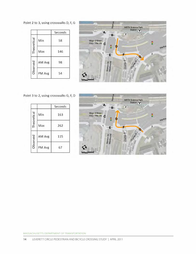
MASSAChuSETTS DEPARTMENT Of TRANSPORTATION
LEVERETT CIRCLE PEDESTRIAN AND BICyCLE CROSSING STuDy | APRIL 2011 14
23 Underground Utilities and Infrastructure
One of the potential solutions to improved pedestrian access at Leverett Circle is a new overpass structure Given this
possibility an understanding of the existing underground utilities and other infrastructure is needed Infrastructure
location will have an impact on the design of any overpass solution as elements such as tunnels and utilities will
present constraints on the potential locations of overpass and ramp structural supports
CAT construction at Leverett Circle included the addition of the eastbound Storrow Drive to I-93 underpass and this
in turn required the relocation of many utilities to a relatively narrow corridor beneath the Charles Street sidewalk
In the vicinity of a potential overpass the following major facilities will need to be taken into account
bull Storrow Drive eastbound and westbound underpass tunnels
bull 48rdquocombined sewer overflow along Charles Street
bull 12rdquo storm drain along Charles Street
bull 30rdquoMartha Road storm drain and twin 42rdquo storm drain siphon south of MBTA Station
bull Low service water main along Charles Street
bull Major electrical and MBTA AC power duct banks along Charles Street
hALVORSON DESIGN PARTNERShIP with ALTA | hDR | NITSCh | EPSILON
ACCELERATED BRIDGE PROGRAM | PEDESTRIAN + BICyCLE STuDy fOR PAThwAyS + BRIDGES | ChARLES RIVER BASIN 15
24 MBTA Science ParkWest End Station Accessibility Improvements
Science Park Station is part of the MBTA Green Linersquos ldquoErdquo service between Lechmere and heath Street and sits in the
center of Leverett Circle Once the proposed Green Line extension to Medford is completed in 2016 (approximately)
the ldquoErdquo line will be extended to union Square in Somerville and the station will also be served by an extension of the
ldquoDrdquo line to Medford
According to the MBTArsquos 2009 Blue Book average weekday boardings at the station ranged from 808-1047 during
the years of 2007-08 Currently Science Park is an elevated station that is not fully accessible but construction has
recently begun to include two new elevators a renovated mezzanine sitting 85rsquo above sidewalk grade and other
platform improvements After the $135 million project is complete the station will fully comply with the Americans
with Disabilities Act According to the MBTA the design did not specifically take into account the development of
a potential pedestrianbike overpass adjacent to it however except for some constraints discussed in this report
it does not appear that the new configuration precludes the attachment of a spur from the primary section of a
potential bridge over Leverett Circle
Sketch view of the proposed Science Park Station entry area and elevator tower
(from MBTArsquos ENf Environmental Assessment 4-f Statement report cover)
MASSAChuSETTS DEPARTMENT Of TRANSPORTATION
LEVERETT CIRCLE PEDESTRIAN AND BICyCLE CROSSING STuDy | APRIL 2011 16
25 Craigie Bridge and Drawbridge Rehabilitation project
As part of MassDOTrsquos Accelerated Bridge Program (ABP) the Craigie Bridge and Drawbridge Rehabilitation project
is currently under construction Expected completion date is late summer of 2011 At the time of this report all
eastbound traffic along the OrsquoBrien highwayRoute 28 between the Museum of Sciencersquos entry drive and the Nashua
Street intersection has been closed to motor vehicle traffic westbound traffic and pedestrian and bicycles in both
directions is still permitted however It is important to note that all traffic counts analysis and videotaping for this
project was performed before the eastbound traffic restrictions were put into effect
Previous conditions along OrsquoBrien highway included three traffic lanes in each direction with 5rsquo to 6rsquo sidewalks along
both sides of the roadway Bicyclists shared the travel lanes with motor vehicles and the sidewalks with pedestrians
while the core of this ABP project is the rehabilitation of the bridge and drawbridge along this stretch of roadway
numerous pedestrian and bicycle accessibility and safety improvements are included in the design The sidewalk
along the south side of the roadway has been maintained at 8rsquo to allow for the inclusion of bike lanes Though not
finalized as of this date the preferred approach for bicycle travel through Leverett Circle is for a hybrid facility that
includes a mix of an eastbound bicycle lane and a marked bikeway across some of the traffic islands and parallel with
crosswalks There would be no direct westbound access for bicyclists through Leverett Circle though itrsquos understood
that somemdashespecially recreational riders on the weekendmdashwill cross from Martha Road to the Esplanade using the
sidewalk crosswalks and traffic islands along the south edge of the circle
The series of potential pedestrianbike bridge options studied in section 5 of this report incorporate the hybrid bike
facility as described above and continues it through the intersection for consistency
Proposed bike facility through Leverett Circle as currently planned (from howard Stein hudson)
hALVORSON DESIGN PARTNERShIP with ALTA | hDR | NITSCh | EPSILON
ACCELERATED BRIDGE PROGRAM | PEDESTRIAN + BICyCLE STuDy fOR PAThwAyS + BRIDGES | ChARLES RIVER BASIN 17
26 Traffic Capacity and LOS Analysis
The current level of service (LOS) for all vehicle movements within Leverett Circle is presented in the table below
Additional detail can be found January 24 2011 study by Nitsch Engineering found in the appendix Location 1mdashthe
Nashua StreetOrsquoBrien highwayStorrow Drive intersectionmdashfunctions at LOS ldquoErdquo for weekday morning peak hour LOS
ldquoCrdquo during weekday evening peak hour and LOS ldquoDrdquo during the Saturday mid-day peak hour Location 2mdashthe Charles
StreetOrsquoBrien highwayMartha Road intersectionmdashfunctions at LOS ldquofrdquo during weekday morning and evening peak
hour and Saturday mid-day peak hour
One element that is important to note from the table above is the relatively high LOS of the Nashua Street
southbound through left-turn and right-turn movements in Location 1 This represents a potential opportunity to
experiment with providing less green time for motor vehicles approaching Leverett Circle along Nashua Street In
section 5 of this report the reallocation of some of this green time to benefit pedestrians is proposed and analyzed
MASSAChuSETTS DEPARTMENT Of TRANSPORTATION
LEVERETT CIRCLE PEDESTRIAN AND BICyCLE CROSSING STuDy | APRIL 2011 18
27 Crash Data and Analysis
MassDOTrsquos crash data from the years 2006-2008 was analyzed for this report During this period the present
intersection geometry with at-grade crosswalk improvements was complete The data is summarized in the table
below
In this three-year period there was an average of 23 and 9 reported crashes per year at Locations 1 and 2
respectively A total of 97 crashes were reported of which 60 crashes involved property damage and 28 involved
personal injury Though the reports for 39 crashes did not indicate what type of collision occurred there were only
three reported collisions involving pedestrians and one involving a bicyclist There were no reported fatalities within
Leverett Circle in this time period The crash rate at location 1 was 177 accidents per million entering vehicles
Crash rate at location 2 was 085 accidents per million entering vehicles Given that the statewide crash average for
signalized intersections is 082 this suggests that safety improvements for all users of Leverett Circlemdashespecially at
intersection 1mdashshould be considered
hALVORSON DESIGN PARTNERShIP with ALTA | hDR | NITSCh | EPSILON
ACCELERATED BRIDGE PROGRAM | PEDESTRIAN + BICyCLE STuDy fOR PAThwAyS + BRIDGES | ChARLES RIVER BASIN 19
3
REGULATORY PERMITTING AND JURISDICTIONAL ISSUES
3 Regulatory Permitting And Jurisdictional Issues
The Study team was tasked with researching the regulatory and permitting commitments pertaining to
the ldquoreplacementrdquo of the former pedestrian overpass at Leverett circle The team reviewed relevant historic
correspondence files provided by MassDOT and met with MEPA officials february 15 2011 The following sections
provide a summary of our findings to date
31 Identification of legal commitments to provide pedestrian overpass
The construction of a pedestrianbike overpass at Leverett circle is a mitigation commitment of the central Artery
Tunnel (cAT) and charles River crossing projects The commitment is memorialized in project documents developed
pursuant to the Massachusetts Environmental Policy Act (MEPA) the National Environmental Policy Act (NEPA) and
Massachusetts Department of Environmental Protection (MassDEP) chapter 91 authorizations as well as formal
interagency Memorandums of Agreement Key references include the following
The Massachusetts Department of Public works (DPw) Section 61 findings on the 1990 Supplemental final
Environmental Impact Report dated September 5 1991
Leverett Circle will be reconfigured re-landscaped and enlarged Pedestrian overpasses will be reconstructed with
one or two new overpasses on the Nashua Street parcel Historic buildings will be improved at the old dam and site
improvements including new walkways will be made on each side [p10]
The Amendment and Restatement of the Memorandum of Agreement (MOA) among the Executive Office of
Transportation and construction the Executive Office of Environmental Affairs the Massachusetts Highway
Department and the Metropolitan District commission Section 1B4 Leverett circleStorrow Drive dated December
30 1993
Provide new pedestrian overpass between Leverett CircleScience Park MBTA Station and Nashua Street Park [p9]
The Metropolitan District commission (MDc) consolidated chapter 91 License Application dated January 1995
The present Leverett CircleStorrow Drive intersection is to be reconfigured under the Central ArteryTunnel Highway
Program and includes replacing the existing pedestrian overpasses [Application Attachments for BRP WW 01 for
Leverett CircleStorrow Drive 2]
The Section 61 findings on the charles River crossing final Environmental Impact Report dated November 1995 and
submitted to MEPA on December 18 1995
Improved green spaces at Leverett Circle appropriate architectural treatment of the roadway underpass and boat
section and a pedestrian overpass between the MBTA Station and Nashua Street Park Design refinements since the
FSEIR have shortened the length of the required boat section in this area and provided for more attractive and safer
pedestrian crossing at OrsquoBrien Highway in the vicinity of the historic Street Railway viaduct [p3-2]
The Massachusetts MassDEP chapter 91 License 7611 dated July 16 1998 addresses the pedestrian footbridge by
reference HALVORSON DESIGN PARTNERSHIP with ALTA | HDR | NITScH | EPSILON
AccELERATED BRIDGE PROGRAM | PEDESTRIAN + BIcycLE STuDy fOR PATHwAyS + BRIDGES | cHARLES RIVER BASIN 21
The MHD shall restore all existing walkways public open spaces and roadway surfaces within Chapter 91 jurisdiction
impacted by any project activities to pre-construction conditions Said restoration shall be completed within 60 days
after the area is no longer needed for CAT construction purposes unless otherwise approved by the DEP [Special
Condition 15]
The pedestrian footbridge will require additional chapter 91review and approval from MassDEP pursuant to a Project
Modification to License 7611 issued on June 28 2002 The terms of the authorization restate Special condition 15
and state additionally that
hellipthe Licensee shall submit to the Department (Waterways Regulation Program) for approval with a copy to all
commenters pursuant to Special condition No 5 the final plans for the ldquoLeverett Circle Pedestrian Bridgerdquo to ensure
consistency with the conditions of [License 7611]
The commitment is also reflected in federal documents including the charles River crossing final Supplemental
Environmental Impact Statement Report dated December 1993 (Volume 1 pp 4-54 Table 6-1 p 4(f )-19) and
the federal Highway Administration charles River crossing Record of Decision (p16 and Section 33 Long - Term
Measures 34)
32 MEPA Office perspective (Section 61 findings)
On review of the above referenced project materials the MEPA Office has communicated that the record clearly
establishes the requirement to replace the pedestrian footbridge as a mitigation commitment The MEPA Office also
indicated that it recognizes that the proponent (MassDOT) may choose to reevaluate the proposed design solution
based on comprehensive planning that reflects analysis of current conditions and consultation with the charles
River crossing citizens Advisory committee and other commenting parties If alternative pedestrian crossing options
were to be proposed as the result of such ongoing analysis additional MEPA review in the form of a Notice of Project
change would be required
A Notice of Project change for lapse of time pursuant to the MEPA regulations at 301 cMR 301 1110(2) is not
required based on 301 cMR 301 1110(2)(b)2 (lapse of more than three years between notice of availability of the
SfEIR and commencement of construction) MassDOT and predecessor agencies as the project proponents have
continued to take major steps in a continuous sequence to advance the project as evidenced by interim street-level
site improvements project planning and public process associated with the proposed pedestrian footbridge and
continued notification to MassDEP by way of public meeting otices and ch 91 License 7611 construction period
extension requests pursuant to the chapter 91 license (see above)
a Point in permitting when commitment was made
As listed above the initial regulatory commitment occurs in the Massachusetts Department of Public works (DPw)
Section 61 findings on the 1990 Supplemental final Environmental Impact Report dated September 5 1991 The
commitment was maintained and incorporated in subsequent project documents as referenced above
MASSAcHuSETTS DEPARTMENT Of TRANSPORTATION
LEVERETT cIRcLE PEDESTRIAN AND BIcycLE cROSSING STuDy | APRIL 2011 22
b Changes to the commitment made over time
The commitment to provide a pedestrian footbridge has not been modified since the Section 61 finding issued in
1991
c Identification of legal commitments re design of pedestrian footbridge
Section 31 above references cAT project authorizations that identify the location of the pedestrian footbridge
These materials also address required design standards but do not explicitly specify dimensional requirements Rather
MassDEP regulatory requirements regarding design standards including the requirement that the width of the
pedestrian footbridge be a minimum of twelve feet clear are addressed by reference to design guidelines established
under the 1993 MOA as described below
The MHD Section 61 finding for the Area North of causeway issued in 1995 in reference to the pedestrian footbridge
as one of several components of mitigation identified in the MOA states that
Performance standards for these components require a path adequate for anticipated use with a minimum width of 10
to 12 feet and standards of quality typical of other parks in the Charles River Reservation [p3-3]
The MassDEP consolidated written Determination (cwD) on the charles River crossing issued in 1996 identifies
and incorporates parkland mitigation measures and design standards applicable to the pedestrian footbridge by
reference to the 1993 MOA stating that ldquothe MOA outlines the specific parkland mitigation measures and minimum
performance standards to be achievedrdquo [p31] The MOA does not specify a design standard for the pedestrian
footbridge by name but states that
hellipthe level of quality that is to be achieved shall be typical of other parks in the Charles River ReservationhellipPedestrian
and bicycle access shall be continuous along both banks of the river shall meet all applicable guidelines for accessibility
and shall provide for separation of pedestrians and bicycles where appropriate Path widths shall be adequate for
anticipated use with a minimum width of 10 ndash 12 feet for principal paths [IB2]
The cwD identifies special conditions applicable to both MHD and MDc under MHD Special condition 23b the cwD
requires that pedestrian pathways be a minimum of twelve feet clear along the waterrsquos edge eight feet clear along
roadways and that bicycle pathways be a minimum of ten feet clear In addition the cwD specifically states that
Pedestrian bridges shall be a minimum of twelve (12) feet clear and designed in consultation with the MBTA DEP may
allow reduced widths upon a clear documentation by the MDC or MHD demonstrating that design constraints preclude
the full clear width from being achieved [p41]
under MDc Special condition 21a the cwD states that mitigation described in the MOA ldquohellipshall meet the minimum
parkland design standards described in the MOA and as further described hereinrdquo The special condition repeats the
dimensional standards specified in MHD Special condition 23b does not include the reference to pedestrian bridges
HALVORSON DESIGN PARTNERSHIP with ALTA | HDR | NITScH | EPSILON
AccELERATED BRIDGE PROGRAM | PEDESTRIAN + BIcycLE STuDy fOR PATHwAyS + BRIDGES | cHARLES RIVER BASIN 23
while the MassDEP cwD does not require that the Leverett circle footbridge be designed with a minimum width
of twelve feet clear by name the special conditions clearly establish the regulatory expectation that the MOA
commitment to twelve feet clear is the applicable and required design standard
33 Identification of legal commitments regarding timing of pedestrian footbridge construction
As discussed above the MassDEP chapter 91 License 7611 does not specifically reference the pedestrian footbridge
but does impose the general condition that
hellipall existing walkways public open spaces and roadway surfaces within Chapter 91 jurisdiction impacted by any
project activities to pre-construction conditionshellipwithin 60 days after the area is no longer needed for CAT construction
purposes unless otherwise approved by the DEP
A MassDEP Project Modification for License 7611 issued to the Massachusetts Turnpike Authority (MTA) on June 28
2002 related to surface restoration elements (including among other elements demolition of the existing footbridge
and construction of a temporary footbridge) established two conditions related to the timing of construction of the
pedestrian footbridge
first MassDEP requires that the surface restoration elements comply with Special condition 15 described
above and the condition therein that all restoration be completed and open to the public within sixty days of the
completed construction contract If construction of the pedestrian footbridge does not meet this schedule a license
modification is required pursuant to Special condition 5 of License 7611 which specifies that MHD [now MassDOT]
provide a written request and plans associated with proposed modifications to MassDEP the MDc [now DcR] the
Mayor and city council of the city of Boston the Boston conservation commission the Massachusetts coastal Zone
Management Office the MBTA and interveners for a ten day comment period
Second the License Modification requires that final plans for the pedestrian footbridge be submitted to MassDEP also
pursuant to Special condition 5 as described under Section 30 above
Last Special condition 3 of License 7611 states that the construction period for work authorized under the license
(ten years from date of issuance on July 16 1998) can be extended by MassDEP without public notice for one or more
one-year periods based on written request from the licensee MassDOT provided MassDEP with such notification
most recently on May 4 2010
MASSAcHuSETTS DEPARTMENT Of TRANSPORTATION
LEVERETT cIRcLE PEDESTRIAN AND BIcycLE cROSSING STuDy | APRIL 2011 24
4 BEST PRACTICES AND CASE STUDIES FOR
PEDESTRIANBIKE OVERPASSES
4 Best Practices And Case Studies For PedestrianBike Overpasses
As described above one of the potential solutions to improve pedestrian conditions at Leverett circle is an overpass
either with or without supplemental at-grade crossings The Study Team used a number of documents for guidance
in developing and analyzing alternatives including the following
bull Design and Safety of Pedestrian Facilities ndash A Recommended Practice the Institute of Transportation
Engineers (ITE) chapter 10 esp pages 77-78 March 1998
bull Florida Pedestrian Planning and Design Handbook Chapter 20 ndash Grade Separated Crossings pages 169-172
bull City of Madison Wisconsin PedestrianBicycle Grade Separation Worksheet (Based on Design and Safety of
Pedestrian facilities a Proposed Recommended Practice of the Institute of Transportation Engineers chapter
10 ldquoGrade Separated crossingsrdquo December 1994)
o This excerpt is of particular note Perceived ease of accessibility convenience factor R = ratio of
time to travel on the over- or underpass divided by time to travel at grade level 1985 study
indicated 95 of pedestrians would use an underpass and 70 would use an overpass if R=1 (no
time difference) It also found that very few would us an overpass if R=15 (50 time difference)
bull Pedestrian Crossing Guidelines for Texas Texas Transportation Institute December 2000
It should be noted that all of these documents are based on the ITE guide listed above Below is the typical language
used in the guides This language was excerpted from Texas
Past research has shown the effectiveness of grade-separated pedestrian crossings depends upon the perceived effort
and time to use it For example Figure 41 (not shown) defines a convenience measure R and compares it to the
percentage of pedestrians likely to use a grade-separated crossing The figure shows that 95 percent of pedestrians will
likely use an underpass and 70 percent will likely use an overpass if the travel times at-grade and grade-separated are
equal (ie R=1) Similarly less than 5 percent would use either an overpass or an underpass if it takes 50 percent longer
(R=15)
Other studies have shown that pedestrians use grade-separated crossings more often if the elevation change can be
minimized or worked into the normal path of pedestrian movement For example switchback ramps are often used
for ADA compliance but provide a time-consuming approach for some pedestrians Although more right-of-way may
be required the site topography at the approaches to the crossing may be able to be modified to better accomplish
the elevation change without especially long andor switchback ramps
A 1988 synthesis by Zegeer and Zegeer suggested that grade-separated pedestrian crossings are most beneficial
under the following conditions
bull where there is moderate to high pedestrian demand to cross a freeway or expressway
bull where there is a large number of young children (ie particularly near schools) who must regularly cross a
high-speed or high-volume roadway
HALVORSON DESIGN PARTNERSHIP with ALTA | HDR | NITScH | EPSILON
AccELERATED BRIDGE PROGRAM | PEDESTRIAN + BIcycLE STuDy fOR PATHwAyS + BRIDGES | cHARLES RIVER BASIN 25
bull on streets having high vehicle volumes and high pedestrian crossing volumes and where there is an extreme
hazard for pedestrians (eg on wide streets with high-speed traffic and poor sight distance) and
bull where one or more of the conditions stated above exists in conjunction with a well-defined pedestrian
origin and destination (eg residential neighborhood across a busy street from a school a parking structure
affiliated with a university or apartment complex near a shopping mall)
(Zeeger CV and Zeeger SF ldquoPedestrians and Traffic-Control Measuresrdquo Synthesis of Highway Practice 139 Transportation
research Board November 1988)
The document Warrants for Pedestrian Over and Underpasses suggests more specific criteria and other general
considerations for grade-separated pedestrian crossings
bull The pedestrian hourly volume should be more than 300 in the four highest continuous hour periods if
the vehicle speed is more than 40 mph and the proposed sites are in urban areas and not over or under
a freeway Otherwise the pedestrian volume should be more than 100 pedestrians in the four highest
continuous hour periods
bull vehicle volume should be more than 10000 in the same four-hour period used for the pedestrian volume
warrant or have an ADT volume greater than 35000 if vehicle speed is over 40 mph and the proposed site(s)
are in urban areas If these two conditions are not met the vehicle volume should be more than 7500 in the
four hours or have an ADT greater than 25000
bull The proposed site should be at least 600 feet from the nearest alternative ldquosaferdquo crossing A ldquosaferdquo crossing is
defined as a location where a traffic control device stops vehicles to create adequate gaps for pedestrians to
cross Another ldquosaferdquo crossing is an existing overpass or underpass near the proposed facility
bull A physical barrier is desirable to prohibit at-grade crossing of the roadway as part of the overpass or
underpass design plan
bull Artificial lighting should be provided to reduce potential crime against users of the underpasses or
overpasses It may be appropriate to light underpasses 24 hours a day and overpasses at night
bull Topography of the proposed site should be such as to minimize changes in elevation for users of overpasses
and underpasses and to help ensure that construction costs are not excessive Elevation change is a factor
that affects the convenience of users
bull A specific need may exist for a grade-separated crossing based on the existing or proposed land use(s)
adjoining the proposed development site that generates pedestrian trips This land use should have a direct
access to the grade-separated facility
bull Funding for construction of underpass or overpass must be available prior to a commitment to construct it
(Axler EA Warrants for Pedestrian Over and Underpasses Report No FHWARD-84-082 US DOT Washington DC July 1984)
In addition to the traffic and pedestrian volume considered in these warrants a benefit-cost analysis is often also
desirable for grade-separated pedestrian crossings Details on conducting a benefit-cost analysis can be found in
MASSAcHuSETTS DEPARTMENT Of TRANSPORTATION
leveReTT CIRCle PeDeSTRIAn AnD BICyCle CRoSSInG STuDy | APRIl 2011 26
NcHRP Report 189 (ldquoQuantifying the Benefits of Separating Pedestrians and Vehiclesrdquo 1978) and nCHRP Report 240 (ldquoA
Manual to Determine the Benefits of Separating Pedestrians and Vehiclesrdquo 1981)rdquo
41 Case Studies of pedestrianbike overpasses adjacent to at-grade connections
To also help the team understand the optimal conditions for pedestrian and bicycle overpasses case studies from
other communities were investigated There are thousands of pedestrianbike overpasses throughout the united
States most passing over busy highways expressways and railroad tracks These are not relevant for this study If
an overpass is ultimately located at leverett Circle it will be in conjunction with at-grade pedestrian facilities that
connect some or all legs of the complex intersection while finding a precise precedent proved difficult there are a
handful of locations of pedestrian and bike overpasses that exist in close proximity to a signalized intersection with
functioning at-grade pedestrian crossings Examples presented below include
bull Bunker Hill Community College Charlestown MA bull Route 9A46th Street new york ny
bull Route 9AChambers Street new york ny bull Aurora Avenue n155th Street Shoreline WA
Bunker Hill Community College Charlestown MA
The pedestrianbike overpass at this location
was developed to provide an enhanced link from
charlestown to the BHcc Main campus The
Rutherford Avenue overpass connects directly to
an elevated plaza adjacent to the A Building which
houses the campus auditorium and art gallery This
plaza also provides a direct connection (via a second
pedestrian bridge) to the MBTA community college
station along the Orange Line station The east end of
the bridge features a stairway and switchback stair to
connect to the sidewalk and an adjacent parking lot
(from wwwbingmapscom)
Route 9AChambers Street Lower Manhattan New York NY
The pedestrian overpass is a long-span arched bridge
over Route 9A in the Battery Park City section of lower
Manhattan Though an at-grade crosswalk also exists
at the chambers Street intersection the overpass
was developed in conjunction with Stuyvesant High
School which lies on the west side of Route 9A
Though accessible from the sidewalk the bridge also
connects directly to the second floor of the school
Connections to the sidewalk include both stairs and
an elevator There are no ramps
HALVORSON DESIGN PARTNERSHIP with ALTA | HDR | NITScH | EPSILON
Aerial View of Rutherford Avenue overpass
Chambers Street view to the east across Route 9A (from wwwmapsgooglecom)
AccELERATED BRIDGE PROGRAM | PEDESTRIAN + BIcycLE STuDy fOR PATHwAyS + BRIDGES | cHARLES RIVER BASIN 27
Route 9AWest 46th Street Lower Manhattan New York NY
The pedestrianbike bridge at the end of West 46th
Street in Manhattan spans over Route 9A adjacent
to a signalized intersection with well-designed
crosswalk Both provide connections to the Intrepid
Sea Air amp Space Museum consisting of a small
museum building and the retired world war II-era
Intrepid aircraft carrier (not docked in the photo
at right) under normal conditions the overpass
connects directly to a large landing in front of the
main entry to the aircraft carrier During spring and
summer the Intrepid is one of the largest tourist
attractions in new york drawing nearly one million
visitors a year according to the museumrsquos web site (from wwwbingmapscom)
Aurora AvenueN 155th Street Shoreline WA
This pedestrianbike overpass project was
recently completed as part of the Aurora corridor
Project the reconstruction of the three miles of
Aurora Avenue North (State Route 99) that run
through the city of Shoreline Shorelinersquos section
of SR-99 carries 40000 - 45000 vehicles per day
and is a major transit route
According to the cityrsquos web site the ldquogoal of the
project was to improve pedestrian and vehicle
safety pedestrian and disabled access vehicular
capacity traffic flow transit speed and reliability
nighttime visibility and safety stormwater
quality and management economic investment
potential and streetscape amenitiesrdquo Paralleling
Aurora Avenue is the Interurban Trail a three-
mile multi-use path developed along the former
Interurban Rail Line where the trail crossed N
155th Street a new overpass was developed
in conjunction with at-grade pedestrian
improvements including decorative crosswalks
new sidewalks and the removal or free right-turn
lanes and their accompanying pork-chop islands BeforeAfter aerial view of the Aurora155 Street intersection (from wwwbingmapscom)
Aerial View of Route 9A and West 46 th Street intersection
th
MASSAcHuSETTS DEPARTMENT Of TRANSPORTATION
leveReTT CIRCle PeDeSTRIAn AnD BICyCle CRoSSInG STuDy | APRIl 2011 28
Summary of Case Studies
The examples above show a range of pedestrianbike overpasses over busy roadways adjacent to intersections with
at-grade pedestrian facilities unlike a potential overpass at leverett Circle none of them passed over the entire
intersection itself Instead they provided connectivity along one edge in order to connect to existing attractions or
to maintain the alignment of a multi-use trail Of particular note all of the examples provide direct connectivity to
a facility or space that is above the grade of the roadway below In other words the team was not able to find any
examples of overpasses adjacent to at-grade connections that required users to ascend one side of the overpass cross
the structure then descend on the other side other than connections to the MBTA Science Park station mezzanine
this would be the necessary movement for those wishing to cross a potential pedestrianbike overpass over leverett
circle
42 Evaluation Criteria for Potential PedestrianBike Overpass
The Best Practices and case Studies research described above were used to inform a series of criteria that is used to
evaluate the pedestrian and bike connectivity options presented in the next section These options include multiple
overpass alternatives with or without at-grade connectivity improvements as well as an option where only at-grade
improvements are incorporated The criteria also derive from meetings with various stakeholders and were presented
in draft form at the December 2010 public meeting held in conjunction with this study The criteria include
1 Safety for all users
2 Security of all users
3 Perception of Required out-of-direction Travel
4 Length of Travel for Non-Motorized users
5 Time of Travel for Non-Motorized users (including expected wait time at signals)
6 Cost and Constructability (bridge structure utilities signals etc)
7 Sight Line considerations (obstruction issues shadows etc)
8 Overall Pedestrian Accommodation and convenience
9 Overall Bicycle Accommodation and convenience
10 functionality of Intersection for all users
11 Operational Impacts on Vehicular Movements
12 Aesthetic Impacts to Intersection
Evaluation results of the various options are presented at the end of the next section It is important to note that
evaluation results should be used for advisory purposes only They are not intended to be a ldquofinal scorerdquo that makes
the ultimate decision which of the options is the right one for Leverett circle
HALVORSON DESIGN PARTNERSHIP with ALTA | HDR | NITScH | EPSILON
AccELERATED BRIDGE PROGRAM | PEDESTRIAN + BIcycLE STuDy fOR PATHwAyS + BRIDGES | cHARLES RIVER BASIN 29
5 CONCEPTUAL DESIGN OPTIONS
5 Conceptual Design Options
The primary purpose of this report is to provide MassDOT with information and analysis that will help to inform the
agencyrsquos final decision about the type of pedestrianbicycle crossing facilities to provide at Leverett circle As such
three options were studied
bull An ldquoat-grade onlyrdquo option that includes at-grade intersection improvements for the benefit of pedestrian and
bicyclist safety
bull Three overpass alternatives that include some or all of the at-grade improvements developed above
bull Three overpass alternatives that retain only the minimum at-grade pedestrian connections required to cross
OrsquoBrien Highway andor Nashua Street to and from the MBTA station
51 Option 1 ldquoAt-Grade Onlyrdquo with improvements
The suggested improvements for pedestrian at-grade connectivity derive from two sources MassDOTrsquos review of
recommendations made originally by walkBoston and additional recommendations developed as part of this Study
Bicycle improvements have primarily been incorporated from the recent craigie Bridge design work by a separate
consulting team with input from the Leverett circle team
Proposed at-grade improvements for pedestrians and bicyclists at Leverett Circle
HALVORSON DESIGN PARTNERSHIP with ALTA | HDR | NITScH | EPSILON
AccELERATED BRIDGE PROGRAM | PEDESTRIAN + BIcycLE STuDy fOR PATHwAyS + BRIDGES | cHARLES RIVER BASIN 31
The combined recommendations for enhancements to the existing at-grade crossings still require a final review
by MassDOT and may be implemented after the completion of the craigie Bridge rehabilitation project which
is currently under construction The proposed program of recommended enhancements will be communicated
to the cities of Boston and cambridge DcR the MBTA adjacent neighborhoods and other stakeholders prior to
implementation
The at-grade improvements include both physical infrastructure changesmdashstriping new crosswalks revised curbs
signage and new bicycle signal headsmdashand changes to the signal operations Infrastructure improvements are
summarized in the diagram on page 31 above
Arguably the most significant improvement for pedestrian safety and connectivity is the shifting of the east crosswalk
at the Nashua StreetOrsquoBrien HighwayStorrow Drive intersection further to the east of the charles Street double left
turn lanes This accommodates the general ldquodesire linerdquo movement that many pedestrians currently use when going
to and from the MBTA station (see section 21) Shifting this crosswalk east eliminates one of the primary accessibility
concerns that many in the community have had since the intersection was complete in 2006 left-turning vehicles
from Nashua Street conflicting with pedestrians who have the right of way while crossing OrsquoBrien Highway The new
crosswalk location will be signaled to allow crossing movement during the first phase of the signal cycle when traffic
from charles Street is turning left to OrsquoBrien Highway The current timing of Phase 1 of the cycle is only 19 seconds
however not enough for a slow-moving pedestrian to safely cross to and from Science Park station on the angled
crosswalk In consequence new signal phasing is proposed to give more crossing time for those on foot To do so
Phase 2 of the cycle is proposed to be split in order to give 12 fewer seconds of green time for southbound right-
through- and left-turning traffic along Nashua Street (where LOS grades range from ldquoBrdquo to ldquoCrdquo during AM PM and
Saturday mid-day peaks) Right-turning traffic from Charles Street continues its movement during both portions of
the split 2nd phase however
In addition the splitting of Phase 2 provides the opportunity to restrict right turn on red (RTOR) movement for
eastbound traffic on OrsquoBrien Highway A right-turn signal is proposed for this movement This signal would display
a solid red arrow for the 19 seconds of Phase 1 along with the shorter portion of the split 2nd phase combined this
provides 31 seconds of exclusive pedestrian and bicycle crossing time at three of the legs of the NashuaOrsquoBrien
Storrow intersection During the subsequent 35 seconds of Phase 2 the red arrow would be flashing and permit
RTOR to Storrow Drive wB during gaps in Nashua Streetrsquos through traffic (Please note the full impact of this partial
restriction to RTOR movement onto Storrow Drive is still being studied for its impact) The proposed traffic signal
timing and phasing is shown in the two diagrams on the following pages
MASSAcHuSETTS DEPARTMENT Of TRANSPORTATION
LEVERETT cIRcLE PEDESTRIAN AND BIcycLE cROSSING STuDy | APRIL 2011 32
HALVORSON DESIGN PARTNERSHIP with ALTA | HDR | NITScH | EPSILON
AccELERATED BRIDGE PROGRAM | PEDESTRIAN + BIcycLE STuDy fOR PATHwAyS + BRIDGES | cHARLES RIVER BASIN 33
MASSAcHuSETTS DEPARTMENT Of TRANSPORTATION
LEVERETT cIRcLE PEDESTRIAN AND BIcycLE cROSSING STuDy | APRIL 2011 34
52 Option 2 PedestrianBike Overpass with Improved At-Grade Crossing Alternatives
Three design alternatives were studied to determine multiple options to create a fully-accessible pedestrianbike
overpass at Leverett Circle The three alternatives all assumed the incorporation of the at-grade improvements and
signal-phase adjustments described in section 51 above The themes for the three alternatives include
bull Curving Overpass A single curving overpass connecting the SW corner of the NashuaOrsquoBrienStorrow
intersection with the SE corner of the charlesOrsquoBrienMartha intersection and a spur to the MBTA station
(similar in concept to the Rosales + Partners proposal)
bull Three-legged Overpass A three-legged overpass connecting the SW corner of the NashuaOrsquoBrienStorrow
intersection with the SE corner of the charlesOrsquoBrienMartha intersection and a spur to the MBTA station
(similar in concept to the HNTBc19E6 design)
bull Partial Connection A partial curving overpass connecting the SW corner of the NashuaOrsquoBrienStorrow
intersection with the MBTA station only
To varying degrees all overpass options improve mobility for pedestrians and bicyclists in the Leverett circle area
by providing a grade-separated alternative The Curving and Three-legged options in particular allow people to pass
over one of the busiest intersections in the city of Boston without waiting for pedestrian crossing signals This option
also provides an alternative for those who are uncomfortable crossing concurrently with turning vehicles
for the west End community this would provide a major benefit to the elderly those with disabilities and families
with young children A grade-separated connection to the MBTA station might also induce a greater level of use of
the Science Park station as a number of west End residents have reported that they currently walk the extra distance
to the North Station MBTA station to avoid having to cross Leverett circle at grade All overpass options will also
enhance connections between Science Park Station and the charles River Reservation and the Museum of Science
for many large school groups and families with young children this will be viewed as a major mobility improvement
There are a number of design criteria that were used when developing a conceptual design for the three overpass
alternatives These included
1 12rsquo-0rdquo minimum bridge width for consistency with MassDEP Consolidated Written Determination on the
Charles River Crossing issued in 1996 (AASHTO guideline for pedestrian bicycle overpasses is 10rsquo-0rdquo)
2 16rsquo-6rdquo clear height of structure above roadway (note that trucks are unrestricted along Charles Street EB and
Craigie Bridge to I-93 and Martha Road connection)
3 Depth of overpass structure 14rdquo from top of walking surface to outside bottom of structure (It was assumed
that the structure would consist of integral precast concrete walkway girder and railing system)
4 ADAAG and MassAAB Accessible Route Requirements (lt5 running slope without landings 5-8 running
slope designed as a ramp with landings)
5 Limit of Work to remain within existing State ROW and easements
6 Limited impacts to intersection vehicular capacity
7 Limited impacts to intersection geometry (minor changes to geometry only)
8 Limited impacts to underground utilities
9 compatible with MBTA Science Park Station improvements and ideally providing a connection to the
HALVORSON DESIGN PARTNERSHIP with ALTA | HDR | NITScH | EPSILON
AccELERATED BRIDGE PROGRAM | PEDESTRIAN + BIcycLE STuDy fOR PATHwAyS + BRIDGES | cHARLES RIVER BASIN 35
mezzanine level ldquounpaidrdquo area as well as access to the sidewalk below
10 compatible with craigie Bridge and Drawbridge final roadway conditions
11 Maintain or improve connectivity to Charles River Basin parkland for non-motorized users
12 Compatible with existing or potentially improved at-grade pedestrian connections
When developing the conceptual alternatives based on the three themes it quickly became clear that it would be
difficult to satisfy all twelve of the design criteria Of the three ldquobaserdquo alternatives presented on the following pages
only Alternative 2 the Three-legged Overpass has the potential to completely satisfy the design criteria
Alternatives 1 and 3 are not able to satisfy key criteria and are presented for informational purposes for these
schemes to be fully functional and meet more of the key criteria listed above alterations to the designs were required
and therefore sub-alternatives 1A 1B 3A and 3B were developed for additional evaluation These sub-alternatives
illustrate how overpass designs based on base Alternatives 1 and 3 could work if there was flexibility in at least one of
the criteria
Alternative 1 Curving Overpass
This alternative attempted to provide access from both the southwest StorrowOrsquoBrien corner (ldquoState Police cornerrdquo)
and the Martha Road corner to the mezzanine level of the MBTA Green Line Science Park Station It is similar to
the Rosales + Partners concept with the important difference that the MBTA spur is located on the west side of
the mezzanine rather than the east due to the new elevator lobby Issues concerning this alternative include the
following
bull The controlling MBTA mezzanine elevation of 12765 results in a vertical clearance of only 124 feet over the
intersection In the Rosales + Partners design the spur to the Science Park station mezzanine approached
from the east but this does not appear feasible given the locations of the proposed MBTA lobby and elevator
tower An ldquoeasterly spurrdquo could not vertically clear the elevator lobby while maintaining ADA-compliant ramp
slopes It should also be noted that the Rosales + Partners concept assumed a minimum clearance of 14rsquo-6rdquo
over roadways versus the 16rsquo-6rdquo criteria used in this study
bull The 124rsquo vertical clearance is substandard and could represent a potential ldquofatal flawrdquo for this alternative The
available clearance would not meet even a relaxed criterion such as 14-feet which is sometimes used for
local roadways in urban areas
In addition to the above significant problems with Alternative 1 the following issues were also identified
bull The junction of the MBTA spur and the main overpass structure would occur above the roadway As a
structural support cannot be located at this location the complexity of the design and construction would
be increased perhaps significantly along with the cost
bull Structural piers will have to be constructed over the Storrow Drive Westbound tunnel at the MBTA island
bull At the Charles StreetMartha Road corner foundations for the ramp support columns may be in conflict with
utilities
MASSAcHuSETTS DEPARTMENT Of TRANSPORTATION
LEVERETT cIRcLE PEDESTRIAN AND BIcycLE cROSSING STuDy | APRIL 2011 36
bull The required length of ramp on the Esplanade results in the ramp switchback being located very close to
the State Police driveway onto Storrow Drive This may present sight distance issues at the driveway and also
results in the Storrow Drive sidewalk being relocated to the edge of Storrow Drive with no buffer
On the following page is a conceptual plan diagram showing the alignment of pedestrianbike overpass
Alternative 1 with areas of concern highlighted Additionally included is a diagram and matrix illustrating
the pedestrian walking distance and time for overpass Alternative 1 versus the distance and time required to
cross Leverett Circle using the Study Teamrsquos proposed at-grade improvements
HALVORSON DESIGN PARTNERSHIP with ALTA | HDR | NITScH | EPSILON
AccELERATED BRIDGE PROGRAM | PEDESTRIAN + BIcycLE STuDy fOR PATHwAyS + BRIDGES | cHARLES RIVER BASIN 37
MASSAcHuSETTS DEPARTMENT Of TRANSPORTATION
LEVERETT cIRcLE PEDESTRIAN AND BIcycLE cROSSING STuDy | APRIL 2011 38
HALVORSON DESIGN PARTNERSHIP with ALTA | HDR | NITScH | EPSILON
AccELERATED BRIDGE PROGRAM | PEDESTRIAN + BIcycLE STuDy fOR PATHwAyS + BRIDGES | cHARLES RIVER BASIN 39
MASSAcHuSETTS DEPARTMENT Of TRANSPORTATION
LEVERETT cIRcLE PEDESTRIAN AND BIcycLE cROSSING STuDy | APRIL 2011 40
Alternative 2 Three-Legged Overpass
This concept is similar to the pedestrian overpass design originally included in contract c19E6 The concept has three
branches which meet at the Charles Street median island All horizontal and vertical clearances are met however the
following issues were indentified
bull The required length of ramp on the Esplanade results in the ramp switchback being located very close to
the State Police driveway onto Storrow Drive This may present sight distance issues at the driveway and also
results in the Storrow Drive sidewalk being relocated to the edge of Storrow Drive with no buffer
bull Structural piers will have to be constructed over the Storrow Drive Westbound tunnel at the MBTA island
bull At the Charles StreetMartha Road corner foundations for the ramp support columns may be in conflict with
utilities
On the following page is a conceptual plan diagram showing the alignment of pedestrianbike overpass Alternative
2 with areas of concern highlighted Additionally included is a diagram and matrix illustrating the pedestrian walking
distance and time for overpass Alternative 2 versus the distance and time required to cross Leverett Circle using the
Study Teamrsquos proposed at-grade improvements
HALVORSON DESIGN PARTNERSHIP with ALTA | HDR | NITScH | EPSILON
AccELERATED BRIDGE PROGRAM | PEDESTRIAN + BIcycLE STuDy fOR PATHwAyS + BRIDGES | cHARLES RIVER BASIN 41
HALVORSON DESIGN PARTNERSHIP with ALTA | HDR | NITScH | EPSILON
AccELERATED BRIDGE PROGRAM | PEDESTRIAN + BIcycLE STuDy fOR PATHwAyS + BRIDGES | cHARLES RIVER BASIN 42
MASSAcHuSETTS DEPARTMENT Of TRANSPORTATION
LEVERETT cIRcLE PEDESTRIAN AND BIcycLE cROSSING STuDy | APRIL 2011 43
MASSAcHuSETTS DEPARTMENT Of TRANSPORTATION
LEVERETT cIRcLE PEDESTRIAN AND BIcycLE cROSSING STuDy | APRIL 2011 44
Alternative 3 Partial Connection
This alternative takes the same approach as Alternative 1 but only provides access between the T station and the
ldquoPolice Stationrdquo corner Unlike Alternative 1 this concept provides the required 165 foot vertical clearance above the
roadway Doing so however results in what appears to be a fatal flaw The ramps required to meet the controlling
mezzanine elevation must approach the mezzanine from the east and there is insufficient vertical clearance above
the new MBTA elevator lobby structure to do so
In addition to the above the following issues were also identified
bull Structural piers will have to be constructed over the Storrow Drive Westbound tunnel at the MBTA island
bull The required length of ramp on the Esplanade results in the ramp switchback being located very close to
the State Police driveway onto Storrow Drive This may present sight distance issues at the driveway and also
results in the Storrow Drive sidewalk being relocated to the edge of Storrow Drive with no buffer
On the following page is a conceptual plan diagram showing the alignment of pedestrianbike overpass Alternative
3 with areas of concern highlighted Additionally included is a diagram and matrix illustrating the pedestrian walking
distance and time for overpass Alternative 3 versus the distance and time required to cross Leverett Circle using the
Study Teamrsquos proposed at-grade improvements
HALVORSON DESIGN PARTNERSHIP with ALTA | HDR | NITScH | EPSILON
AccELERATED BRIDGE PROGRAM | PEDESTRIAN + BIcycLE STuDy fOR PATHwAyS + BRIDGES | cHARLES RIVER BASIN 45
MASSAcHuSETTS DEPARTMENT Of TRANSPORTATION
LEVERETT cIRcLE PEDESTRIAN AND BIcycLE cROSSING STuDy | APRIL 2011 46
HALVORSON DESIGN PARTNERSHIP with ALTA | HDR | NITScH | EPSILON
AccELERATED BRIDGE PROGRAM | PEDESTRIAN + BIcycLE STuDy fOR PATHwAyS + BRIDGES | cHARLES RIVER BASIN 47
As noted on previous pages overpass Alternatives 1 and 3 include a number of flaws which preclude the ability to
serve their primary purpose These include the inability to achieve a 165rsquo (or even a 14rsquo) clearance over the roadway
and the difficulty of developing a functional connection to the MBTA stationrsquos mezzanine Because of this two sub-
options were developed for both alternatives that required a slight rethinking of the connectivity of each alternative
bull Alternatives 1A and 3A ndash provide connections to the MBTA inbound platform (rather than mezzanine)
bull Alternatives 1B and 3B ndash premised on the removal of one WB traffic lane in front of the MBTA station to
provide additional space for a ramp connection to the mezzanine (see section 21 of this Study for
discussion)
Alternative 1A Curving Overpass with Inbound Platform Access
To remedy the low vertical clearance of Alternative 1 Alternative 1A provides access to the inbound platform level of
the MBTA Science Park station which is 20 feet above the mezzanine Issues with this concept include
bull Sight distance will be affected at the State Police station driveway onto Storrow Drive
bull Structural foundations will have to be constructed over Storrow Drive Westbound tunnel
bull Structural foundations may conflict with the pump house building adjacent to the MBTA station
bull Structural foundations may conflict with combined sewer storm drain and other utilities
bull Provisions for fare-control will need to be provided either on the overpass structure itself or on the inbound
platform Both of these options are very space-constrained and this may not be feasible Further investigation
of this possibility will need to be explored with the MBTA
bull The overpass by only serving the inbound platform has significantly less functionality than is desirable
Access to and from the outbound platform would be technically available but would require a circuitous
trip via the ldquopaid siderdquo of the mezzanine level lobby
MASSAcHuSETTS DEPARTMENT Of TRANSPORTATION
LEVERETT cIRcLE PEDESTRIAN AND BIcycLE cROSSING STuDy | APRIL 2011 48
HALVORSON DESIGN PARTNERSHIP with ALTA | HDR | NITScH | EPSILON
AccELERATED BRIDGE PROGRAM | PEDESTRIAN + BIcycLE STuDy fOR PATHwAyS + BRIDGES | cHARLES RIVER BASIN 49
Alternative 1B Curving Overpass with WB Lane Removal
This alternative is able to provide access to the mezzanine level while meeting MassDOTrsquos minimum vertical clearance
of 165rsquo To do so one WB travel lane along the short block in front of the MBTA station would need to be removed in
order to relocate the curb to the south The pedestrian ramp would span parallel along the proposed widened curb
and then loop under the pedestrian overpass thus avoiding the lobby roof Issues with this alternative include
bull Sight distance will be affected at the State Police station driveway to Storrow Drive
bull Structural foundations may conflict with combined sewer storm drain and other utilities
MASSAcHuSETTS DEPARTMENT Of TRANSPORTATION
LEVERETT cIRcLE PEDESTRIAN AND BIcycLE cROSSING STuDy | APRIL 2011 50
HALVORSON DESIGN PARTNERSHIP with ALTA | HDR | NITScH | EPSILON
AccELERATED BRIDGE PROGRAM | PEDESTRIAN + BIcycLE STuDy fOR PATHwAyS + BRIDGES | cHARLES RIVER BASIN 51
Alternative 3A Partial Connection to MBTA Inbound Platform
In this concept ADA access is provided to the inbound platform level and also stairwell access to the mezzanine level
All vertical clearances are met in this alternative Issues include
bull Sight distance will be affected at the State Police station driveway to Storrow Drive
bull Structural foundations may conflict with combined sewer and other utilities
bull Structural foundations may be required over Storrow Drive Westbound tunnel
bull Provisions for fare-control will need to be provided either on the overpass structure itself or on the inbound
platform Both of these options are very space-constrained and this may not be feasible Further investigation
of this possibility will need to be explored with the MBTA
bull The overpass by providing ADA access to only the inbound platform has significantly less functionality than
is desirable Access to and from the outbound platform would be technically available but would require a
circuitous trip via the ldquopaid siderdquo of the mezzanine level lobby
MASSAcHuSETTS DEPARTMENT Of TRANSPORTATION
LEVERETT cIRcLE PEDESTRIAN AND BIcycLE cROSSING STuDy | APRIL 2011 52
HALVORSON DESIGN PARTNERSHIP with ALTA | HDR | NITScH | EPSILON
AccELERATED BRIDGE PROGRAM | PEDESTRIAN + BIcycLE STuDy fOR PATHwAyS + BRIDGES | cHARLES RIVER BASIN 53
Alternative 3B Partial Connection with WB Lane Removal
Like Alternative 1B this alternative is able to provide access to the mezzanine level while meeting the required
minimum vertical clearance of 165rsquo To do so one WB travel lane along the short block in front of the MBTA station
would need to be removed in order to relocate the curb to the south The pedestrian ramp would span parallel along
the proposed widened curb and then loop under the pedestrian overpass to avoid the lobby roof Issues include
bull Sight distance will be affected at the State Police station driveway to Storrow Drive
bull Structural foundations may conflict with storm drain and other utilities
bull Structural foundations may be required over the Storrow Drive WB tunnel
MASSAcHuSETTS DEPARTMENT Of TRANSPORTATION
LEVERETT cIRcLE PEDESTRIAN AND BIcycLE cROSSING STuDy | APRIL 2011 54
HALVORSON DESIGN PARTNERSHIP with ALTA | HDR | NITScH | EPSILON
AccELERATED BRIDGE PROGRAM | PEDESTRIAN + BIcycLE STuDy fOR PATHwAyS + BRIDGES | cHARLES RIVER BASIN 55
Based on the criteria discussed in section 42 of this report the five workable design alternatives (1A 1B 2 3A
and 3B) were evaluated using a 1-5 scale with 1 as poor 3 as fair and 5 as excellent The evaluation assumes that the
proposed at-grade improvements would be incorporated in all five potential overpass alternatives
Criteria At-grade only Alt 1A amp 1B Alt 2 Alt 3A amp 3B
Safety for all Users 4 5 5 5
Security of all Users 5 3 3 4
Perception of Required Out-of-direction Travel 5 4 2 4
Length of Travel for Non-motorized Users 5 4 3 4
Time of Travel for Non-Motorized Users 3-5 4 4 3-5
(including expected wait time at signals)
Constructability and cost (bridge structure utilities signals etc) 5 1 1 3
Sight Line Considerations (obstruction issues shadows etc) 5 3 3 4
Overall Pedestrian Accommodation and Convenience 3 5 5 5
Overall Bicycle Accommodation and Convenience 3 5 5 3
Functionality of Intersection for all Users 4 5 4 5
Operational Impacts on Vehicular Movements 4 4 4 4
Aesthetic Impacts to Intersection 5 3 2 3
TOTAL 51-53 46 41 47-49
MASSAcHuSETTS DEPARTMENT Of TRANSPORTATION
LEVERETT cIRcLE PEDESTRIAN AND BIcycLE cROSSING STuDy | APRIL 2011 56
53 Option 3 PedestrianBike Overpass with minimal at-grade pedestrian connections
The third option for Leverett circle is to develop a new pedestrianbike overpass (based on workable alternatives
1A 1B and 2 discussed above) and retain only the minimum at-grade pedestrian connections This would require
the removal of most of the existing crosswalks curb-cuts and pedestrian crossing signal heads within the two
intersections The crosswalkscurb cuts retained would be those that cross OrsquoBrien Highway (on the west side of the
intersection) and Nashua Street These two crosswalks would provide pedestrian and bike connections from Nashua
Street Park to the charles River Esplanade and to the MBTA station The pair would also provide a secondary route
tofrom the southwest corner of the intersection in front of the State Police Station to the MBTA station for those
who chose to remain at-grade To mitigate the desire to cross at-grade after pedestrian facilities have been removed
barriers (fencing and dense landscaping) will be needed to ensure that pedestrians use the overpass structure
It is important to note that with the removal of most at-grade pedestrian connections there will be no apparent
benefit to traffic capacity or LOS This is because none of the existing WALK signals prevent potential non-conflicting
traffic movements from occurring The most apparent benefit of removing most at-grade pedestrian facilities would
be to reduce conflicts between pedestrian and motor vehicles If all walkers (and some bicyclists) were to use the
potential overpass the number of pedestrianvehiclebicycle crashes would be expected to decrease This would
need to be balanced against 1) the additional walking time required to cross Leverett Circle and 2) the potential that
even with efforts to physically discourage or prevent inappropriate at-grade crossing (with fencing or landscaping for
example) some jaywalking would be likely
Option 3 diagram showing potential removal of at-grade pedestrian connections
HALVORSON DESIGN PARTNERSHIP with ALTA | HDR | NITScH | EPSILON
AccELERATED BRIDGE PROGRAM | PEDESTRIAN + BIcycLE STuDy fOR PATHwAyS + BRIDGES | cHARLES RIVER BASIN 57
6 SUMMARY
6 Summary
The key goals of the Leverett circle Pedestrian and Bicycle crossing Study were to analyze the conditions at Leverett
circle and study both at-grade and grade-separated bicycle and pedestrian safety enhancements The scope of
the study included the development of concepts and an initial feasibility assessment of pedestrian and cyclist
improvements at Leverett circle including evaluation of existing conditions and circulation patterns evaluation of
potential enhancements to existing at-grade crossings potential new grade-separated crossings and associated
elimination of at-grade connections and some combinations of at-grade and grade-separated crossings based on
current MassDOT standards
Based on the existing conditions analysis crash data and field observations of motorist bicyclist and pedestrian
behavior it is clear that a number of potentially feasible at-grade improvements are possible These would enhance
connectivity and safety for non-motorized users of Leverett circle with no or minimal impacts to vehicle circulation or
intersection LOS These low and modest-cost improvements could be done relatively quickly and include
bull Signal enhancements
bull Pedestrian count-down timers in a number of locations
bull Better signage
bull Updated crosswalk markings
bull Relocation of the OrsquoBrien Hwy crosswalk in front of the MBTA Science Park station to the east of the double
left turn lanes from charles Street
bull Potential movement of curb line in front of the MBTA station
Even with the incorporation of the enhancements listed above concern over pedestrian safety is likely to remain
The cities of Boston and cambridge and community groups may still express the desire for a grade-separated
environment for the elderly the disabled and groups of children crossing Leverett circle tofrom the west End the
Esplanade and the MBTA station
for users whose route requires them to cross completely from the Police Station corner to the west End corner (ie
for whom the MBTA station is not a destination) it is difficult to predict what percentage would choose the overpass
option if an at-grade option was also available
As discussed in Section 4 available research suggests that a perceived ldquoconvenience factorrdquo can be calculated
to consider usersrsquo perceptions of how long the at-grade route would take compared with the grade-separated
alternative In analyzing the several Leverett circle overpass options presented in Section 5 this perceived
ldquoconveniencerdquo of an overpass is relatively low when compared with the minimum duration of crossing at-grade
However the overpass convenience values are considerably higher if the maximum likely at-grade crossing time is
considered In other words if someone arriving at the intersection just misses the crossing signal theyrsquore more likely
to choose the overpass because travel time across the intersection will be very similar to waiting for the next at-grade
opportunity conversely there are times in the signal cycle when a pedestrian arriving at the intersection will be able
to cross at-grade up to 3 times faster (depending on overpass option) than using an overpass
If a pedestrianbike overpass is built at this location case studies from other communities and the pedestrian crossing
distance and time analysis implies that the most likely user of the overpass would be those traveling to and from the
MBTA station Because the final destination is elevatedmdashthe station mezzanine levelmdashand the travel time would be
HALVORSON DESIGN PARTNERSHIP with ALTA | HDR | NITScH | EPSILON
AccELERATED BRIDGE PROGRAM | PEDESTRIAN + BIcycLE STuDy fOR PATHwAyS + BRIDGES | cHARLES RIVER BASIN 59
comparable to crossing at-grade many people of all abilities are likely to use the overpass especially if coming to or
from the southwest corner of the intersection
The primary beneficiaries of the proposed at-grade improvements are those wishing to travel between the MBTA
station and the west End Additionally the evaluation matrix at the end of section 52 points to the possibility of
satisfying nearly all of the connectivity and safety goals with a partial overpass over Leverett circle
MASSAcHuSETTS DEPARTMENT Of TRANSPORTATION
LEVERETT cIRcLE PEDESTRIAN AND BIcycLE cROSSING STuDy | APRIL 2011 60
- LeverettCirRept-Cover-etc
- Dividerspdf
- LeverettCirRept-Chapt1
-
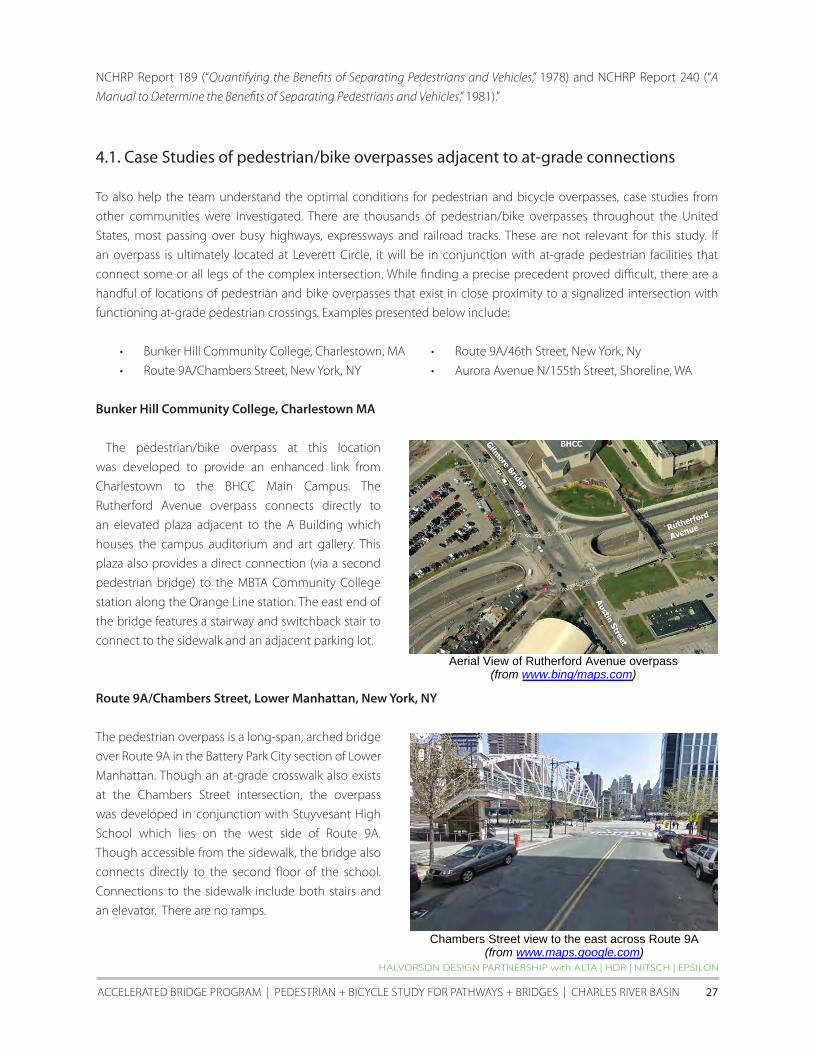

HALVORSON DESIGN PARTNERSHIP with ALTA | HDR | NITScH | EPSILON
AccELERATED BRIDGE PROGRAM | PEDESTRIAN + BIcycLE STuDy fOR PATHwAyS + BRIDGES | cHARLES RIVER BASIN 33
MASSAcHuSETTS DEPARTMENT Of TRANSPORTATION
LEVERETT cIRcLE PEDESTRIAN AND BIcycLE cROSSING STuDy | APRIL 2011 34
52 Option 2 PedestrianBike Overpass with Improved At-Grade Crossing Alternatives
Three design alternatives were studied to determine multiple options to create a fully-accessible pedestrianbike
overpass at Leverett Circle The three alternatives all assumed the incorporation of the at-grade improvements and
signal-phase adjustments described in section 51 above The themes for the three alternatives include
bull Curving Overpass A single curving overpass connecting the SW corner of the NashuaOrsquoBrienStorrow
intersection with the SE corner of the charlesOrsquoBrienMartha intersection and a spur to the MBTA station
(similar in concept to the Rosales + Partners proposal)
bull Three-legged Overpass A three-legged overpass connecting the SW corner of the NashuaOrsquoBrienStorrow
intersection with the SE corner of the charlesOrsquoBrienMartha intersection and a spur to the MBTA station
(similar in concept to the HNTBc19E6 design)
bull Partial Connection A partial curving overpass connecting the SW corner of the NashuaOrsquoBrienStorrow
intersection with the MBTA station only
To varying degrees all overpass options improve mobility for pedestrians and bicyclists in the Leverett circle area
by providing a grade-separated alternative The Curving and Three-legged options in particular allow people to pass
over one of the busiest intersections in the city of Boston without waiting for pedestrian crossing signals This option
also provides an alternative for those who are uncomfortable crossing concurrently with turning vehicles
for the west End community this would provide a major benefit to the elderly those with disabilities and families
with young children A grade-separated connection to the MBTA station might also induce a greater level of use of
the Science Park station as a number of west End residents have reported that they currently walk the extra distance
to the North Station MBTA station to avoid having to cross Leverett circle at grade All overpass options will also
enhance connections between Science Park Station and the charles River Reservation and the Museum of Science
for many large school groups and families with young children this will be viewed as a major mobility improvement
There are a number of design criteria that were used when developing a conceptual design for the three overpass
alternatives These included
1 12rsquo-0rdquo minimum bridge width for consistency with MassDEP Consolidated Written Determination on the
Charles River Crossing issued in 1996 (AASHTO guideline for pedestrian bicycle overpasses is 10rsquo-0rdquo)
2 16rsquo-6rdquo clear height of structure above roadway (note that trucks are unrestricted along Charles Street EB and
Craigie Bridge to I-93 and Martha Road connection)
3 Depth of overpass structure 14rdquo from top of walking surface to outside bottom of structure (It was assumed
that the structure would consist of integral precast concrete walkway girder and railing system)
4 ADAAG and MassAAB Accessible Route Requirements (lt5 running slope without landings 5-8 running
slope designed as a ramp with landings)
5 Limit of Work to remain within existing State ROW and easements
6 Limited impacts to intersection vehicular capacity
7 Limited impacts to intersection geometry (minor changes to geometry only)
8 Limited impacts to underground utilities
9 compatible with MBTA Science Park Station improvements and ideally providing a connection to the
HALVORSON DESIGN PARTNERSHIP with ALTA | HDR | NITScH | EPSILON
AccELERATED BRIDGE PROGRAM | PEDESTRIAN + BIcycLE STuDy fOR PATHwAyS + BRIDGES | cHARLES RIVER BASIN 35
mezzanine level ldquounpaidrdquo area as well as access to the sidewalk below
10 compatible with craigie Bridge and Drawbridge final roadway conditions
11 Maintain or improve connectivity to Charles River Basin parkland for non-motorized users
12 Compatible with existing or potentially improved at-grade pedestrian connections
When developing the conceptual alternatives based on the three themes it quickly became clear that it would be
difficult to satisfy all twelve of the design criteria Of the three ldquobaserdquo alternatives presented on the following pages
only Alternative 2 the Three-legged Overpass has the potential to completely satisfy the design criteria
Alternatives 1 and 3 are not able to satisfy key criteria and are presented for informational purposes for these
schemes to be fully functional and meet more of the key criteria listed above alterations to the designs were required
and therefore sub-alternatives 1A 1B 3A and 3B were developed for additional evaluation These sub-alternatives
illustrate how overpass designs based on base Alternatives 1 and 3 could work if there was flexibility in at least one of
the criteria
Alternative 1 Curving Overpass
This alternative attempted to provide access from both the southwest StorrowOrsquoBrien corner (ldquoState Police cornerrdquo)
and the Martha Road corner to the mezzanine level of the MBTA Green Line Science Park Station It is similar to
the Rosales + Partners concept with the important difference that the MBTA spur is located on the west side of
the mezzanine rather than the east due to the new elevator lobby Issues concerning this alternative include the
following
bull The controlling MBTA mezzanine elevation of 12765 results in a vertical clearance of only 124 feet over the
intersection In the Rosales + Partners design the spur to the Science Park station mezzanine approached
from the east but this does not appear feasible given the locations of the proposed MBTA lobby and elevator
tower An ldquoeasterly spurrdquo could not vertically clear the elevator lobby while maintaining ADA-compliant ramp
slopes It should also be noted that the Rosales + Partners concept assumed a minimum clearance of 14rsquo-6rdquo
over roadways versus the 16rsquo-6rdquo criteria used in this study
bull The 124rsquo vertical clearance is substandard and could represent a potential ldquofatal flawrdquo for this alternative The
available clearance would not meet even a relaxed criterion such as 14-feet which is sometimes used for
local roadways in urban areas
In addition to the above significant problems with Alternative 1 the following issues were also identified
bull The junction of the MBTA spur and the main overpass structure would occur above the roadway As a
structural support cannot be located at this location the complexity of the design and construction would
be increased perhaps significantly along with the cost
bull Structural piers will have to be constructed over the Storrow Drive Westbound tunnel at the MBTA island
bull At the Charles StreetMartha Road corner foundations for the ramp support columns may be in conflict with
utilities
MASSAcHuSETTS DEPARTMENT Of TRANSPORTATION
LEVERETT cIRcLE PEDESTRIAN AND BIcycLE cROSSING STuDy | APRIL 2011 36
bull The required length of ramp on the Esplanade results in the ramp switchback being located very close to
the State Police driveway onto Storrow Drive This may present sight distance issues at the driveway and also
results in the Storrow Drive sidewalk being relocated to the edge of Storrow Drive with no buffer
On the following page is a conceptual plan diagram showing the alignment of pedestrianbike overpass
Alternative 1 with areas of concern highlighted Additionally included is a diagram and matrix illustrating
the pedestrian walking distance and time for overpass Alternative 1 versus the distance and time required to
cross Leverett Circle using the Study Teamrsquos proposed at-grade improvements
HALVORSON DESIGN PARTNERSHIP with ALTA | HDR | NITScH | EPSILON
AccELERATED BRIDGE PROGRAM | PEDESTRIAN + BIcycLE STuDy fOR PATHwAyS + BRIDGES | cHARLES RIVER BASIN 37
MASSAcHuSETTS DEPARTMENT Of TRANSPORTATION
LEVERETT cIRcLE PEDESTRIAN AND BIcycLE cROSSING STuDy | APRIL 2011 38
HALVORSON DESIGN PARTNERSHIP with ALTA | HDR | NITScH | EPSILON
AccELERATED BRIDGE PROGRAM | PEDESTRIAN + BIcycLE STuDy fOR PATHwAyS + BRIDGES | cHARLES RIVER BASIN 39
MASSAcHuSETTS DEPARTMENT Of TRANSPORTATION
LEVERETT cIRcLE PEDESTRIAN AND BIcycLE cROSSING STuDy | APRIL 2011 40
Alternative 2 Three-Legged Overpass
This concept is similar to the pedestrian overpass design originally included in contract c19E6 The concept has three
branches which meet at the Charles Street median island All horizontal and vertical clearances are met however the
following issues were indentified
bull The required length of ramp on the Esplanade results in the ramp switchback being located very close to
the State Police driveway onto Storrow Drive This may present sight distance issues at the driveway and also
results in the Storrow Drive sidewalk being relocated to the edge of Storrow Drive with no buffer
bull Structural piers will have to be constructed over the Storrow Drive Westbound tunnel at the MBTA island
bull At the Charles StreetMartha Road corner foundations for the ramp support columns may be in conflict with
utilities
On the following page is a conceptual plan diagram showing the alignment of pedestrianbike overpass Alternative
2 with areas of concern highlighted Additionally included is a diagram and matrix illustrating the pedestrian walking
distance and time for overpass Alternative 2 versus the distance and time required to cross Leverett Circle using the
Study Teamrsquos proposed at-grade improvements
HALVORSON DESIGN PARTNERSHIP with ALTA | HDR | NITScH | EPSILON
AccELERATED BRIDGE PROGRAM | PEDESTRIAN + BIcycLE STuDy fOR PATHwAyS + BRIDGES | cHARLES RIVER BASIN 41
HALVORSON DESIGN PARTNERSHIP with ALTA | HDR | NITScH | EPSILON
AccELERATED BRIDGE PROGRAM | PEDESTRIAN + BIcycLE STuDy fOR PATHwAyS + BRIDGES | cHARLES RIVER BASIN 42
MASSAcHuSETTS DEPARTMENT Of TRANSPORTATION
LEVERETT cIRcLE PEDESTRIAN AND BIcycLE cROSSING STuDy | APRIL 2011 43
MASSAcHuSETTS DEPARTMENT Of TRANSPORTATION
LEVERETT cIRcLE PEDESTRIAN AND BIcycLE cROSSING STuDy | APRIL 2011 44
Alternative 3 Partial Connection
This alternative takes the same approach as Alternative 1 but only provides access between the T station and the
ldquoPolice Stationrdquo corner Unlike Alternative 1 this concept provides the required 165 foot vertical clearance above the
roadway Doing so however results in what appears to be a fatal flaw The ramps required to meet the controlling
mezzanine elevation must approach the mezzanine from the east and there is insufficient vertical clearance above
the new MBTA elevator lobby structure to do so
In addition to the above the following issues were also identified
bull Structural piers will have to be constructed over the Storrow Drive Westbound tunnel at the MBTA island
bull The required length of ramp on the Esplanade results in the ramp switchback being located very close to
the State Police driveway onto Storrow Drive This may present sight distance issues at the driveway and also
results in the Storrow Drive sidewalk being relocated to the edge of Storrow Drive with no buffer
On the following page is a conceptual plan diagram showing the alignment of pedestrianbike overpass Alternative
3 with areas of concern highlighted Additionally included is a diagram and matrix illustrating the pedestrian walking
distance and time for overpass Alternative 3 versus the distance and time required to cross Leverett Circle using the
Study Teamrsquos proposed at-grade improvements
HALVORSON DESIGN PARTNERSHIP with ALTA | HDR | NITScH | EPSILON
AccELERATED BRIDGE PROGRAM | PEDESTRIAN + BIcycLE STuDy fOR PATHwAyS + BRIDGES | cHARLES RIVER BASIN 45
MASSAcHuSETTS DEPARTMENT Of TRANSPORTATION
LEVERETT cIRcLE PEDESTRIAN AND BIcycLE cROSSING STuDy | APRIL 2011 46
HALVORSON DESIGN PARTNERSHIP with ALTA | HDR | NITScH | EPSILON
AccELERATED BRIDGE PROGRAM | PEDESTRIAN + BIcycLE STuDy fOR PATHwAyS + BRIDGES | cHARLES RIVER BASIN 47
As noted on previous pages overpass Alternatives 1 and 3 include a number of flaws which preclude the ability to
serve their primary purpose These include the inability to achieve a 165rsquo (or even a 14rsquo) clearance over the roadway
and the difficulty of developing a functional connection to the MBTA stationrsquos mezzanine Because of this two sub-
options were developed for both alternatives that required a slight rethinking of the connectivity of each alternative
bull Alternatives 1A and 3A ndash provide connections to the MBTA inbound platform (rather than mezzanine)
bull Alternatives 1B and 3B ndash premised on the removal of one WB traffic lane in front of the MBTA station to
provide additional space for a ramp connection to the mezzanine (see section 21 of this Study for
discussion)
Alternative 1A Curving Overpass with Inbound Platform Access
To remedy the low vertical clearance of Alternative 1 Alternative 1A provides access to the inbound platform level of
the MBTA Science Park station which is 20 feet above the mezzanine Issues with this concept include
bull Sight distance will be affected at the State Police station driveway onto Storrow Drive
bull Structural foundations will have to be constructed over Storrow Drive Westbound tunnel
bull Structural foundations may conflict with the pump house building adjacent to the MBTA station
bull Structural foundations may conflict with combined sewer storm drain and other utilities
bull Provisions for fare-control will need to be provided either on the overpass structure itself or on the inbound
platform Both of these options are very space-constrained and this may not be feasible Further investigation
of this possibility will need to be explored with the MBTA
bull The overpass by only serving the inbound platform has significantly less functionality than is desirable
Access to and from the outbound platform would be technically available but would require a circuitous
trip via the ldquopaid siderdquo of the mezzanine level lobby
MASSAcHuSETTS DEPARTMENT Of TRANSPORTATION
LEVERETT cIRcLE PEDESTRIAN AND BIcycLE cROSSING STuDy | APRIL 2011 48
HALVORSON DESIGN PARTNERSHIP with ALTA | HDR | NITScH | EPSILON
AccELERATED BRIDGE PROGRAM | PEDESTRIAN + BIcycLE STuDy fOR PATHwAyS + BRIDGES | cHARLES RIVER BASIN 49
Alternative 1B Curving Overpass with WB Lane Removal
This alternative is able to provide access to the mezzanine level while meeting MassDOTrsquos minimum vertical clearance
of 165rsquo To do so one WB travel lane along the short block in front of the MBTA station would need to be removed in
order to relocate the curb to the south The pedestrian ramp would span parallel along the proposed widened curb
and then loop under the pedestrian overpass thus avoiding the lobby roof Issues with this alternative include
bull Sight distance will be affected at the State Police station driveway to Storrow Drive
bull Structural foundations may conflict with combined sewer storm drain and other utilities
MASSAcHuSETTS DEPARTMENT Of TRANSPORTATION
LEVERETT cIRcLE PEDESTRIAN AND BIcycLE cROSSING STuDy | APRIL 2011 50
HALVORSON DESIGN PARTNERSHIP with ALTA | HDR | NITScH | EPSILON
AccELERATED BRIDGE PROGRAM | PEDESTRIAN + BIcycLE STuDy fOR PATHwAyS + BRIDGES | cHARLES RIVER BASIN 51
Alternative 3A Partial Connection to MBTA Inbound Platform
In this concept ADA access is provided to the inbound platform level and also stairwell access to the mezzanine level
All vertical clearances are met in this alternative Issues include
bull Sight distance will be affected at the State Police station driveway to Storrow Drive
bull Structural foundations may conflict with combined sewer and other utilities
bull Structural foundations may be required over Storrow Drive Westbound tunnel
bull Provisions for fare-control will need to be provided either on the overpass structure itself or on the inbound
platform Both of these options are very space-constrained and this may not be feasible Further investigation
of this possibility will need to be explored with the MBTA
bull The overpass by providing ADA access to only the inbound platform has significantly less functionality than
is desirable Access to and from the outbound platform would be technically available but would require a
circuitous trip via the ldquopaid siderdquo of the mezzanine level lobby
MASSAcHuSETTS DEPARTMENT Of TRANSPORTATION
LEVERETT cIRcLE PEDESTRIAN AND BIcycLE cROSSING STuDy | APRIL 2011 52
HALVORSON DESIGN PARTNERSHIP with ALTA | HDR | NITScH | EPSILON
AccELERATED BRIDGE PROGRAM | PEDESTRIAN + BIcycLE STuDy fOR PATHwAyS + BRIDGES | cHARLES RIVER BASIN 53
Alternative 3B Partial Connection with WB Lane Removal
Like Alternative 1B this alternative is able to provide access to the mezzanine level while meeting the required
minimum vertical clearance of 165rsquo To do so one WB travel lane along the short block in front of the MBTA station
would need to be removed in order to relocate the curb to the south The pedestrian ramp would span parallel along
the proposed widened curb and then loop under the pedestrian overpass to avoid the lobby roof Issues include
bull Sight distance will be affected at the State Police station driveway to Storrow Drive
bull Structural foundations may conflict with storm drain and other utilities
bull Structural foundations may be required over the Storrow Drive WB tunnel
MASSAcHuSETTS DEPARTMENT Of TRANSPORTATION
LEVERETT cIRcLE PEDESTRIAN AND BIcycLE cROSSING STuDy | APRIL 2011 54
HALVORSON DESIGN PARTNERSHIP with ALTA | HDR | NITScH | EPSILON
AccELERATED BRIDGE PROGRAM | PEDESTRIAN + BIcycLE STuDy fOR PATHwAyS + BRIDGES | cHARLES RIVER BASIN 55
Based on the criteria discussed in section 42 of this report the five workable design alternatives (1A 1B 2 3A
and 3B) were evaluated using a 1-5 scale with 1 as poor 3 as fair and 5 as excellent The evaluation assumes that the
proposed at-grade improvements would be incorporated in all five potential overpass alternatives
Criteria At-grade only Alt 1A amp 1B Alt 2 Alt 3A amp 3B
Safety for all Users 4 5 5 5
Security of all Users 5 3 3 4
Perception of Required Out-of-direction Travel 5 4 2 4
Length of Travel for Non-motorized Users 5 4 3 4
Time of Travel for Non-Motorized Users 3-5 4 4 3-5
(including expected wait time at signals)
Constructability and cost (bridge structure utilities signals etc) 5 1 1 3
Sight Line Considerations (obstruction issues shadows etc) 5 3 3 4
Overall Pedestrian Accommodation and Convenience 3 5 5 5
Overall Bicycle Accommodation and Convenience 3 5 5 3
Functionality of Intersection for all Users 4 5 4 5
Operational Impacts on Vehicular Movements 4 4 4 4
Aesthetic Impacts to Intersection 5 3 2 3
TOTAL 51-53 46 41 47-49
MASSAcHuSETTS DEPARTMENT Of TRANSPORTATION
LEVERETT cIRcLE PEDESTRIAN AND BIcycLE cROSSING STuDy | APRIL 2011 56
53 Option 3 PedestrianBike Overpass with minimal at-grade pedestrian connections
The third option for Leverett circle is to develop a new pedestrianbike overpass (based on workable alternatives
1A 1B and 2 discussed above) and retain only the minimum at-grade pedestrian connections This would require
the removal of most of the existing crosswalks curb-cuts and pedestrian crossing signal heads within the two
intersections The crosswalkscurb cuts retained would be those that cross OrsquoBrien Highway (on the west side of the
intersection) and Nashua Street These two crosswalks would provide pedestrian and bike connections from Nashua
Street Park to the charles River Esplanade and to the MBTA station The pair would also provide a secondary route
tofrom the southwest corner of the intersection in front of the State Police Station to the MBTA station for those
who chose to remain at-grade To mitigate the desire to cross at-grade after pedestrian facilities have been removed
barriers (fencing and dense landscaping) will be needed to ensure that pedestrians use the overpass structure
It is important to note that with the removal of most at-grade pedestrian connections there will be no apparent
benefit to traffic capacity or LOS This is because none of the existing WALK signals prevent potential non-conflicting
traffic movements from occurring The most apparent benefit of removing most at-grade pedestrian facilities would
be to reduce conflicts between pedestrian and motor vehicles If all walkers (and some bicyclists) were to use the
potential overpass the number of pedestrianvehiclebicycle crashes would be expected to decrease This would
need to be balanced against 1) the additional walking time required to cross Leverett Circle and 2) the potential that
even with efforts to physically discourage or prevent inappropriate at-grade crossing (with fencing or landscaping for
example) some jaywalking would be likely
Option 3 diagram showing potential removal of at-grade pedestrian connections
HALVORSON DESIGN PARTNERSHIP with ALTA | HDR | NITScH | EPSILON
AccELERATED BRIDGE PROGRAM | PEDESTRIAN + BIcycLE STuDy fOR PATHwAyS + BRIDGES | cHARLES RIVER BASIN 57
6 SUMMARY
6 Summary
The key goals of the Leverett circle Pedestrian and Bicycle crossing Study were to analyze the conditions at Leverett
circle and study both at-grade and grade-separated bicycle and pedestrian safety enhancements The scope of
the study included the development of concepts and an initial feasibility assessment of pedestrian and cyclist
improvements at Leverett circle including evaluation of existing conditions and circulation patterns evaluation of
potential enhancements to existing at-grade crossings potential new grade-separated crossings and associated
elimination of at-grade connections and some combinations of at-grade and grade-separated crossings based on
current MassDOT standards
Based on the existing conditions analysis crash data and field observations of motorist bicyclist and pedestrian
behavior it is clear that a number of potentially feasible at-grade improvements are possible These would enhance
connectivity and safety for non-motorized users of Leverett circle with no or minimal impacts to vehicle circulation or
intersection LOS These low and modest-cost improvements could be done relatively quickly and include
bull Signal enhancements
bull Pedestrian count-down timers in a number of locations
bull Better signage
bull Updated crosswalk markings
bull Relocation of the OrsquoBrien Hwy crosswalk in front of the MBTA Science Park station to the east of the double
left turn lanes from charles Street
bull Potential movement of curb line in front of the MBTA station
Even with the incorporation of the enhancements listed above concern over pedestrian safety is likely to remain
The cities of Boston and cambridge and community groups may still express the desire for a grade-separated
environment for the elderly the disabled and groups of children crossing Leverett circle tofrom the west End the
Esplanade and the MBTA station
for users whose route requires them to cross completely from the Police Station corner to the west End corner (ie
for whom the MBTA station is not a destination) it is difficult to predict what percentage would choose the overpass
option if an at-grade option was also available
As discussed in Section 4 available research suggests that a perceived ldquoconvenience factorrdquo can be calculated
to consider usersrsquo perceptions of how long the at-grade route would take compared with the grade-separated
alternative In analyzing the several Leverett circle overpass options presented in Section 5 this perceived
ldquoconveniencerdquo of an overpass is relatively low when compared with the minimum duration of crossing at-grade
However the overpass convenience values are considerably higher if the maximum likely at-grade crossing time is
considered In other words if someone arriving at the intersection just misses the crossing signal theyrsquore more likely
to choose the overpass because travel time across the intersection will be very similar to waiting for the next at-grade
opportunity conversely there are times in the signal cycle when a pedestrian arriving at the intersection will be able
to cross at-grade up to 3 times faster (depending on overpass option) than using an overpass
If a pedestrianbike overpass is built at this location case studies from other communities and the pedestrian crossing
distance and time analysis implies that the most likely user of the overpass would be those traveling to and from the
MBTA station Because the final destination is elevatedmdashthe station mezzanine levelmdashand the travel time would be
HALVORSON DESIGN PARTNERSHIP with ALTA | HDR | NITScH | EPSILON
AccELERATED BRIDGE PROGRAM | PEDESTRIAN + BIcycLE STuDy fOR PATHwAyS + BRIDGES | cHARLES RIVER BASIN 59
comparable to crossing at-grade many people of all abilities are likely to use the overpass especially if coming to or
from the southwest corner of the intersection
The primary beneficiaries of the proposed at-grade improvements are those wishing to travel between the MBTA
station and the west End Additionally the evaluation matrix at the end of section 52 points to the possibility of
satisfying nearly all of the connectivity and safety goals with a partial overpass over Leverett circle
MASSAcHuSETTS DEPARTMENT Of TRANSPORTATION
LEVERETT cIRcLE PEDESTRIAN AND BIcycLE cROSSING STuDy | APRIL 2011 60
- LeverettCirRept-Cover-etc
- Dividerspdf
- LeverettCirRept-Chapt1
-

MASSAcHuSETTS DEPARTMENT Of TRANSPORTATION
LEVERETT cIRcLE PEDESTRIAN AND BIcycLE cROSSING STuDy | APRIL 2011 34
52 Option 2 PedestrianBike Overpass with Improved At-Grade Crossing Alternatives
Three design alternatives were studied to determine multiple options to create a fully-accessible pedestrianbike
overpass at Leverett Circle The three alternatives all assumed the incorporation of the at-grade improvements and
signal-phase adjustments described in section 51 above The themes for the three alternatives include
bull Curving Overpass A single curving overpass connecting the SW corner of the NashuaOrsquoBrienStorrow
intersection with the SE corner of the charlesOrsquoBrienMartha intersection and a spur to the MBTA station
(similar in concept to the Rosales + Partners proposal)
bull Three-legged Overpass A three-legged overpass connecting the SW corner of the NashuaOrsquoBrienStorrow
intersection with the SE corner of the charlesOrsquoBrienMartha intersection and a spur to the MBTA station
(similar in concept to the HNTBc19E6 design)
bull Partial Connection A partial curving overpass connecting the SW corner of the NashuaOrsquoBrienStorrow
intersection with the MBTA station only
To varying degrees all overpass options improve mobility for pedestrians and bicyclists in the Leverett circle area
by providing a grade-separated alternative The Curving and Three-legged options in particular allow people to pass
over one of the busiest intersections in the city of Boston without waiting for pedestrian crossing signals This option
also provides an alternative for those who are uncomfortable crossing concurrently with turning vehicles
for the west End community this would provide a major benefit to the elderly those with disabilities and families
with young children A grade-separated connection to the MBTA station might also induce a greater level of use of
the Science Park station as a number of west End residents have reported that they currently walk the extra distance
to the North Station MBTA station to avoid having to cross Leverett circle at grade All overpass options will also
enhance connections between Science Park Station and the charles River Reservation and the Museum of Science
for many large school groups and families with young children this will be viewed as a major mobility improvement
There are a number of design criteria that were used when developing a conceptual design for the three overpass
alternatives These included
1 12rsquo-0rdquo minimum bridge width for consistency with MassDEP Consolidated Written Determination on the
Charles River Crossing issued in 1996 (AASHTO guideline for pedestrian bicycle overpasses is 10rsquo-0rdquo)
2 16rsquo-6rdquo clear height of structure above roadway (note that trucks are unrestricted along Charles Street EB and
Craigie Bridge to I-93 and Martha Road connection)
3 Depth of overpass structure 14rdquo from top of walking surface to outside bottom of structure (It was assumed
that the structure would consist of integral precast concrete walkway girder and railing system)
4 ADAAG and MassAAB Accessible Route Requirements (lt5 running slope without landings 5-8 running
slope designed as a ramp with landings)
5 Limit of Work to remain within existing State ROW and easements
6 Limited impacts to intersection vehicular capacity
7 Limited impacts to intersection geometry (minor changes to geometry only)
8 Limited impacts to underground utilities
9 compatible with MBTA Science Park Station improvements and ideally providing a connection to the
HALVORSON DESIGN PARTNERSHIP with ALTA | HDR | NITScH | EPSILON
AccELERATED BRIDGE PROGRAM | PEDESTRIAN + BIcycLE STuDy fOR PATHwAyS + BRIDGES | cHARLES RIVER BASIN 35
mezzanine level ldquounpaidrdquo area as well as access to the sidewalk below
10 compatible with craigie Bridge and Drawbridge final roadway conditions
11 Maintain or improve connectivity to Charles River Basin parkland for non-motorized users
12 Compatible with existing or potentially improved at-grade pedestrian connections
When developing the conceptual alternatives based on the three themes it quickly became clear that it would be
difficult to satisfy all twelve of the design criteria Of the three ldquobaserdquo alternatives presented on the following pages
only Alternative 2 the Three-legged Overpass has the potential to completely satisfy the design criteria
Alternatives 1 and 3 are not able to satisfy key criteria and are presented for informational purposes for these
schemes to be fully functional and meet more of the key criteria listed above alterations to the designs were required
and therefore sub-alternatives 1A 1B 3A and 3B were developed for additional evaluation These sub-alternatives
illustrate how overpass designs based on base Alternatives 1 and 3 could work if there was flexibility in at least one of
the criteria
Alternative 1 Curving Overpass
This alternative attempted to provide access from both the southwest StorrowOrsquoBrien corner (ldquoState Police cornerrdquo)
and the Martha Road corner to the mezzanine level of the MBTA Green Line Science Park Station It is similar to
the Rosales + Partners concept with the important difference that the MBTA spur is located on the west side of
the mezzanine rather than the east due to the new elevator lobby Issues concerning this alternative include the
following
bull The controlling MBTA mezzanine elevation of 12765 results in a vertical clearance of only 124 feet over the
intersection In the Rosales + Partners design the spur to the Science Park station mezzanine approached
from the east but this does not appear feasible given the locations of the proposed MBTA lobby and elevator
tower An ldquoeasterly spurrdquo could not vertically clear the elevator lobby while maintaining ADA-compliant ramp
slopes It should also be noted that the Rosales + Partners concept assumed a minimum clearance of 14rsquo-6rdquo
over roadways versus the 16rsquo-6rdquo criteria used in this study
bull The 124rsquo vertical clearance is substandard and could represent a potential ldquofatal flawrdquo for this alternative The
available clearance would not meet even a relaxed criterion such as 14-feet which is sometimes used for
local roadways in urban areas
In addition to the above significant problems with Alternative 1 the following issues were also identified
bull The junction of the MBTA spur and the main overpass structure would occur above the roadway As a
structural support cannot be located at this location the complexity of the design and construction would
be increased perhaps significantly along with the cost
bull Structural piers will have to be constructed over the Storrow Drive Westbound tunnel at the MBTA island
bull At the Charles StreetMartha Road corner foundations for the ramp support columns may be in conflict with
utilities
MASSAcHuSETTS DEPARTMENT Of TRANSPORTATION
LEVERETT cIRcLE PEDESTRIAN AND BIcycLE cROSSING STuDy | APRIL 2011 36
bull The required length of ramp on the Esplanade results in the ramp switchback being located very close to
the State Police driveway onto Storrow Drive This may present sight distance issues at the driveway and also
results in the Storrow Drive sidewalk being relocated to the edge of Storrow Drive with no buffer
On the following page is a conceptual plan diagram showing the alignment of pedestrianbike overpass
Alternative 1 with areas of concern highlighted Additionally included is a diagram and matrix illustrating
the pedestrian walking distance and time for overpass Alternative 1 versus the distance and time required to
cross Leverett Circle using the Study Teamrsquos proposed at-grade improvements
HALVORSON DESIGN PARTNERSHIP with ALTA | HDR | NITScH | EPSILON
AccELERATED BRIDGE PROGRAM | PEDESTRIAN + BIcycLE STuDy fOR PATHwAyS + BRIDGES | cHARLES RIVER BASIN 37
MASSAcHuSETTS DEPARTMENT Of TRANSPORTATION
LEVERETT cIRcLE PEDESTRIAN AND BIcycLE cROSSING STuDy | APRIL 2011 38
HALVORSON DESIGN PARTNERSHIP with ALTA | HDR | NITScH | EPSILON
AccELERATED BRIDGE PROGRAM | PEDESTRIAN + BIcycLE STuDy fOR PATHwAyS + BRIDGES | cHARLES RIVER BASIN 39
MASSAcHuSETTS DEPARTMENT Of TRANSPORTATION
LEVERETT cIRcLE PEDESTRIAN AND BIcycLE cROSSING STuDy | APRIL 2011 40
Alternative 2 Three-Legged Overpass
This concept is similar to the pedestrian overpass design originally included in contract c19E6 The concept has three
branches which meet at the Charles Street median island All horizontal and vertical clearances are met however the
following issues were indentified
bull The required length of ramp on the Esplanade results in the ramp switchback being located very close to
the State Police driveway onto Storrow Drive This may present sight distance issues at the driveway and also
results in the Storrow Drive sidewalk being relocated to the edge of Storrow Drive with no buffer
bull Structural piers will have to be constructed over the Storrow Drive Westbound tunnel at the MBTA island
bull At the Charles StreetMartha Road corner foundations for the ramp support columns may be in conflict with
utilities
On the following page is a conceptual plan diagram showing the alignment of pedestrianbike overpass Alternative
2 with areas of concern highlighted Additionally included is a diagram and matrix illustrating the pedestrian walking
distance and time for overpass Alternative 2 versus the distance and time required to cross Leverett Circle using the
Study Teamrsquos proposed at-grade improvements
HALVORSON DESIGN PARTNERSHIP with ALTA | HDR | NITScH | EPSILON
AccELERATED BRIDGE PROGRAM | PEDESTRIAN + BIcycLE STuDy fOR PATHwAyS + BRIDGES | cHARLES RIVER BASIN 41
HALVORSON DESIGN PARTNERSHIP with ALTA | HDR | NITScH | EPSILON
AccELERATED BRIDGE PROGRAM | PEDESTRIAN + BIcycLE STuDy fOR PATHwAyS + BRIDGES | cHARLES RIVER BASIN 42
MASSAcHuSETTS DEPARTMENT Of TRANSPORTATION
LEVERETT cIRcLE PEDESTRIAN AND BIcycLE cROSSING STuDy | APRIL 2011 43
MASSAcHuSETTS DEPARTMENT Of TRANSPORTATION
LEVERETT cIRcLE PEDESTRIAN AND BIcycLE cROSSING STuDy | APRIL 2011 44
Alternative 3 Partial Connection
This alternative takes the same approach as Alternative 1 but only provides access between the T station and the
ldquoPolice Stationrdquo corner Unlike Alternative 1 this concept provides the required 165 foot vertical clearance above the
roadway Doing so however results in what appears to be a fatal flaw The ramps required to meet the controlling
mezzanine elevation must approach the mezzanine from the east and there is insufficient vertical clearance above
the new MBTA elevator lobby structure to do so
In addition to the above the following issues were also identified
bull Structural piers will have to be constructed over the Storrow Drive Westbound tunnel at the MBTA island
bull The required length of ramp on the Esplanade results in the ramp switchback being located very close to
the State Police driveway onto Storrow Drive This may present sight distance issues at the driveway and also
results in the Storrow Drive sidewalk being relocated to the edge of Storrow Drive with no buffer
On the following page is a conceptual plan diagram showing the alignment of pedestrianbike overpass Alternative
3 with areas of concern highlighted Additionally included is a diagram and matrix illustrating the pedestrian walking
distance and time for overpass Alternative 3 versus the distance and time required to cross Leverett Circle using the
Study Teamrsquos proposed at-grade improvements
HALVORSON DESIGN PARTNERSHIP with ALTA | HDR | NITScH | EPSILON
AccELERATED BRIDGE PROGRAM | PEDESTRIAN + BIcycLE STuDy fOR PATHwAyS + BRIDGES | cHARLES RIVER BASIN 45
MASSAcHuSETTS DEPARTMENT Of TRANSPORTATION
LEVERETT cIRcLE PEDESTRIAN AND BIcycLE cROSSING STuDy | APRIL 2011 46
HALVORSON DESIGN PARTNERSHIP with ALTA | HDR | NITScH | EPSILON
AccELERATED BRIDGE PROGRAM | PEDESTRIAN + BIcycLE STuDy fOR PATHwAyS + BRIDGES | cHARLES RIVER BASIN 47
As noted on previous pages overpass Alternatives 1 and 3 include a number of flaws which preclude the ability to
serve their primary purpose These include the inability to achieve a 165rsquo (or even a 14rsquo) clearance over the roadway
and the difficulty of developing a functional connection to the MBTA stationrsquos mezzanine Because of this two sub-
options were developed for both alternatives that required a slight rethinking of the connectivity of each alternative
bull Alternatives 1A and 3A ndash provide connections to the MBTA inbound platform (rather than mezzanine)
bull Alternatives 1B and 3B ndash premised on the removal of one WB traffic lane in front of the MBTA station to
provide additional space for a ramp connection to the mezzanine (see section 21 of this Study for
discussion)
Alternative 1A Curving Overpass with Inbound Platform Access
To remedy the low vertical clearance of Alternative 1 Alternative 1A provides access to the inbound platform level of
the MBTA Science Park station which is 20 feet above the mezzanine Issues with this concept include
bull Sight distance will be affected at the State Police station driveway onto Storrow Drive
bull Structural foundations will have to be constructed over Storrow Drive Westbound tunnel
bull Structural foundations may conflict with the pump house building adjacent to the MBTA station
bull Structural foundations may conflict with combined sewer storm drain and other utilities
bull Provisions for fare-control will need to be provided either on the overpass structure itself or on the inbound
platform Both of these options are very space-constrained and this may not be feasible Further investigation
of this possibility will need to be explored with the MBTA
bull The overpass by only serving the inbound platform has significantly less functionality than is desirable
Access to and from the outbound platform would be technically available but would require a circuitous
trip via the ldquopaid siderdquo of the mezzanine level lobby
MASSAcHuSETTS DEPARTMENT Of TRANSPORTATION
LEVERETT cIRcLE PEDESTRIAN AND BIcycLE cROSSING STuDy | APRIL 2011 48
HALVORSON DESIGN PARTNERSHIP with ALTA | HDR | NITScH | EPSILON
AccELERATED BRIDGE PROGRAM | PEDESTRIAN + BIcycLE STuDy fOR PATHwAyS + BRIDGES | cHARLES RIVER BASIN 49
Alternative 1B Curving Overpass with WB Lane Removal
This alternative is able to provide access to the mezzanine level while meeting MassDOTrsquos minimum vertical clearance
of 165rsquo To do so one WB travel lane along the short block in front of the MBTA station would need to be removed in
order to relocate the curb to the south The pedestrian ramp would span parallel along the proposed widened curb
and then loop under the pedestrian overpass thus avoiding the lobby roof Issues with this alternative include
bull Sight distance will be affected at the State Police station driveway to Storrow Drive
bull Structural foundations may conflict with combined sewer storm drain and other utilities
MASSAcHuSETTS DEPARTMENT Of TRANSPORTATION
LEVERETT cIRcLE PEDESTRIAN AND BIcycLE cROSSING STuDy | APRIL 2011 50
HALVORSON DESIGN PARTNERSHIP with ALTA | HDR | NITScH | EPSILON
AccELERATED BRIDGE PROGRAM | PEDESTRIAN + BIcycLE STuDy fOR PATHwAyS + BRIDGES | cHARLES RIVER BASIN 51
Alternative 3A Partial Connection to MBTA Inbound Platform
In this concept ADA access is provided to the inbound platform level and also stairwell access to the mezzanine level
All vertical clearances are met in this alternative Issues include
bull Sight distance will be affected at the State Police station driveway to Storrow Drive
bull Structural foundations may conflict with combined sewer and other utilities
bull Structural foundations may be required over Storrow Drive Westbound tunnel
bull Provisions for fare-control will need to be provided either on the overpass structure itself or on the inbound
platform Both of these options are very space-constrained and this may not be feasible Further investigation
of this possibility will need to be explored with the MBTA
bull The overpass by providing ADA access to only the inbound platform has significantly less functionality than
is desirable Access to and from the outbound platform would be technically available but would require a
circuitous trip via the ldquopaid siderdquo of the mezzanine level lobby
MASSAcHuSETTS DEPARTMENT Of TRANSPORTATION
LEVERETT cIRcLE PEDESTRIAN AND BIcycLE cROSSING STuDy | APRIL 2011 52
HALVORSON DESIGN PARTNERSHIP with ALTA | HDR | NITScH | EPSILON
AccELERATED BRIDGE PROGRAM | PEDESTRIAN + BIcycLE STuDy fOR PATHwAyS + BRIDGES | cHARLES RIVER BASIN 53
Alternative 3B Partial Connection with WB Lane Removal
Like Alternative 1B this alternative is able to provide access to the mezzanine level while meeting the required
minimum vertical clearance of 165rsquo To do so one WB travel lane along the short block in front of the MBTA station
would need to be removed in order to relocate the curb to the south The pedestrian ramp would span parallel along
the proposed widened curb and then loop under the pedestrian overpass to avoid the lobby roof Issues include
bull Sight distance will be affected at the State Police station driveway to Storrow Drive
bull Structural foundations may conflict with storm drain and other utilities
bull Structural foundations may be required over the Storrow Drive WB tunnel
MASSAcHuSETTS DEPARTMENT Of TRANSPORTATION
LEVERETT cIRcLE PEDESTRIAN AND BIcycLE cROSSING STuDy | APRIL 2011 54
HALVORSON DESIGN PARTNERSHIP with ALTA | HDR | NITScH | EPSILON
AccELERATED BRIDGE PROGRAM | PEDESTRIAN + BIcycLE STuDy fOR PATHwAyS + BRIDGES | cHARLES RIVER BASIN 55
Based on the criteria discussed in section 42 of this report the five workable design alternatives (1A 1B 2 3A
and 3B) were evaluated using a 1-5 scale with 1 as poor 3 as fair and 5 as excellent The evaluation assumes that the
proposed at-grade improvements would be incorporated in all five potential overpass alternatives
Criteria At-grade only Alt 1A amp 1B Alt 2 Alt 3A amp 3B
Safety for all Users 4 5 5 5
Security of all Users 5 3 3 4
Perception of Required Out-of-direction Travel 5 4 2 4
Length of Travel for Non-motorized Users 5 4 3 4
Time of Travel for Non-Motorized Users 3-5 4 4 3-5
(including expected wait time at signals)
Constructability and cost (bridge structure utilities signals etc) 5 1 1 3
Sight Line Considerations (obstruction issues shadows etc) 5 3 3 4
Overall Pedestrian Accommodation and Convenience 3 5 5 5
Overall Bicycle Accommodation and Convenience 3 5 5 3
Functionality of Intersection for all Users 4 5 4 5
Operational Impacts on Vehicular Movements 4 4 4 4
Aesthetic Impacts to Intersection 5 3 2 3
TOTAL 51-53 46 41 47-49
MASSAcHuSETTS DEPARTMENT Of TRANSPORTATION
LEVERETT cIRcLE PEDESTRIAN AND BIcycLE cROSSING STuDy | APRIL 2011 56
53 Option 3 PedestrianBike Overpass with minimal at-grade pedestrian connections
The third option for Leverett circle is to develop a new pedestrianbike overpass (based on workable alternatives
1A 1B and 2 discussed above) and retain only the minimum at-grade pedestrian connections This would require
the removal of most of the existing crosswalks curb-cuts and pedestrian crossing signal heads within the two
intersections The crosswalkscurb cuts retained would be those that cross OrsquoBrien Highway (on the west side of the
intersection) and Nashua Street These two crosswalks would provide pedestrian and bike connections from Nashua
Street Park to the charles River Esplanade and to the MBTA station The pair would also provide a secondary route
tofrom the southwest corner of the intersection in front of the State Police Station to the MBTA station for those
who chose to remain at-grade To mitigate the desire to cross at-grade after pedestrian facilities have been removed
barriers (fencing and dense landscaping) will be needed to ensure that pedestrians use the overpass structure
It is important to note that with the removal of most at-grade pedestrian connections there will be no apparent
benefit to traffic capacity or LOS This is because none of the existing WALK signals prevent potential non-conflicting
traffic movements from occurring The most apparent benefit of removing most at-grade pedestrian facilities would
be to reduce conflicts between pedestrian and motor vehicles If all walkers (and some bicyclists) were to use the
potential overpass the number of pedestrianvehiclebicycle crashes would be expected to decrease This would
need to be balanced against 1) the additional walking time required to cross Leverett Circle and 2) the potential that
even with efforts to physically discourage or prevent inappropriate at-grade crossing (with fencing or landscaping for
example) some jaywalking would be likely
Option 3 diagram showing potential removal of at-grade pedestrian connections
HALVORSON DESIGN PARTNERSHIP with ALTA | HDR | NITScH | EPSILON
AccELERATED BRIDGE PROGRAM | PEDESTRIAN + BIcycLE STuDy fOR PATHwAyS + BRIDGES | cHARLES RIVER BASIN 57
6 SUMMARY
6 Summary
The key goals of the Leverett circle Pedestrian and Bicycle crossing Study were to analyze the conditions at Leverett
circle and study both at-grade and grade-separated bicycle and pedestrian safety enhancements The scope of
the study included the development of concepts and an initial feasibility assessment of pedestrian and cyclist
improvements at Leverett circle including evaluation of existing conditions and circulation patterns evaluation of
potential enhancements to existing at-grade crossings potential new grade-separated crossings and associated
elimination of at-grade connections and some combinations of at-grade and grade-separated crossings based on
current MassDOT standards
Based on the existing conditions analysis crash data and field observations of motorist bicyclist and pedestrian
behavior it is clear that a number of potentially feasible at-grade improvements are possible These would enhance
connectivity and safety for non-motorized users of Leverett circle with no or minimal impacts to vehicle circulation or
intersection LOS These low and modest-cost improvements could be done relatively quickly and include
bull Signal enhancements
bull Pedestrian count-down timers in a number of locations
bull Better signage
bull Updated crosswalk markings
bull Relocation of the OrsquoBrien Hwy crosswalk in front of the MBTA Science Park station to the east of the double
left turn lanes from charles Street
bull Potential movement of curb line in front of the MBTA station
Even with the incorporation of the enhancements listed above concern over pedestrian safety is likely to remain
The cities of Boston and cambridge and community groups may still express the desire for a grade-separated
environment for the elderly the disabled and groups of children crossing Leverett circle tofrom the west End the
Esplanade and the MBTA station
for users whose route requires them to cross completely from the Police Station corner to the west End corner (ie
for whom the MBTA station is not a destination) it is difficult to predict what percentage would choose the overpass
option if an at-grade option was also available
As discussed in Section 4 available research suggests that a perceived ldquoconvenience factorrdquo can be calculated
to consider usersrsquo perceptions of how long the at-grade route would take compared with the grade-separated
alternative In analyzing the several Leverett circle overpass options presented in Section 5 this perceived
ldquoconveniencerdquo of an overpass is relatively low when compared with the minimum duration of crossing at-grade
However the overpass convenience values are considerably higher if the maximum likely at-grade crossing time is
considered In other words if someone arriving at the intersection just misses the crossing signal theyrsquore more likely
to choose the overpass because travel time across the intersection will be very similar to waiting for the next at-grade
opportunity conversely there are times in the signal cycle when a pedestrian arriving at the intersection will be able
to cross at-grade up to 3 times faster (depending on overpass option) than using an overpass
If a pedestrianbike overpass is built at this location case studies from other communities and the pedestrian crossing
distance and time analysis implies that the most likely user of the overpass would be those traveling to and from the
MBTA station Because the final destination is elevatedmdashthe station mezzanine levelmdashand the travel time would be
HALVORSON DESIGN PARTNERSHIP with ALTA | HDR | NITScH | EPSILON
AccELERATED BRIDGE PROGRAM | PEDESTRIAN + BIcycLE STuDy fOR PATHwAyS + BRIDGES | cHARLES RIVER BASIN 59
comparable to crossing at-grade many people of all abilities are likely to use the overpass especially if coming to or
from the southwest corner of the intersection
The primary beneficiaries of the proposed at-grade improvements are those wishing to travel between the MBTA
station and the west End Additionally the evaluation matrix at the end of section 52 points to the possibility of
satisfying nearly all of the connectivity and safety goals with a partial overpass over Leverett circle
MASSAcHuSETTS DEPARTMENT Of TRANSPORTATION
LEVERETT cIRcLE PEDESTRIAN AND BIcycLE cROSSING STuDy | APRIL 2011 60
- LeverettCirRept-Cover-etc
- Dividerspdf
- LeverettCirRept-Chapt1
-
bull The required length of ramp on the Esplanade results in the ramp switchback being located very close to
the State Police driveway onto Storrow Drive This may present sight distance issues at the driveway and also
results in the Storrow Drive sidewalk being relocated to the edge of Storrow Drive with no buffer
On the following page is a conceptual plan diagram showing the alignment of pedestrianbike overpass
Alternative 1 with areas of concern highlighted Additionally included is a diagram and matrix illustrating
the pedestrian walking distance and time for overpass Alternative 1 versus the distance and time required to
cross Leverett Circle using the Study Teamrsquos proposed at-grade improvements
HALVORSON DESIGN PARTNERSHIP with ALTA | HDR | NITScH | EPSILON
AccELERATED BRIDGE PROGRAM | PEDESTRIAN + BIcycLE STuDy fOR PATHwAyS + BRIDGES | cHARLES RIVER BASIN 37
MASSAcHuSETTS DEPARTMENT Of TRANSPORTATION
LEVERETT cIRcLE PEDESTRIAN AND BIcycLE cROSSING STuDy | APRIL 2011 38
HALVORSON DESIGN PARTNERSHIP with ALTA | HDR | NITScH | EPSILON
AccELERATED BRIDGE PROGRAM | PEDESTRIAN + BIcycLE STuDy fOR PATHwAyS + BRIDGES | cHARLES RIVER BASIN 39
MASSAcHuSETTS DEPARTMENT Of TRANSPORTATION
LEVERETT cIRcLE PEDESTRIAN AND BIcycLE cROSSING STuDy | APRIL 2011 40
Alternative 2 Three-Legged Overpass
This concept is similar to the pedestrian overpass design originally included in contract c19E6 The concept has three
branches which meet at the Charles Street median island All horizontal and vertical clearances are met however the
following issues were indentified
bull The required length of ramp on the Esplanade results in the ramp switchback being located very close to
the State Police driveway onto Storrow Drive This may present sight distance issues at the driveway and also
results in the Storrow Drive sidewalk being relocated to the edge of Storrow Drive with no buffer
bull Structural piers will have to be constructed over the Storrow Drive Westbound tunnel at the MBTA island
bull At the Charles StreetMartha Road corner foundations for the ramp support columns may be in conflict with
utilities
On the following page is a conceptual plan diagram showing the alignment of pedestrianbike overpass Alternative
2 with areas of concern highlighted Additionally included is a diagram and matrix illustrating the pedestrian walking
distance and time for overpass Alternative 2 versus the distance and time required to cross Leverett Circle using the
Study Teamrsquos proposed at-grade improvements
HALVORSON DESIGN PARTNERSHIP with ALTA | HDR | NITScH | EPSILON
AccELERATED BRIDGE PROGRAM | PEDESTRIAN + BIcycLE STuDy fOR PATHwAyS + BRIDGES | cHARLES RIVER BASIN 41
HALVORSON DESIGN PARTNERSHIP with ALTA | HDR | NITScH | EPSILON
AccELERATED BRIDGE PROGRAM | PEDESTRIAN + BIcycLE STuDy fOR PATHwAyS + BRIDGES | cHARLES RIVER BASIN 42
MASSAcHuSETTS DEPARTMENT Of TRANSPORTATION
LEVERETT cIRcLE PEDESTRIAN AND BIcycLE cROSSING STuDy | APRIL 2011 43
MASSAcHuSETTS DEPARTMENT Of TRANSPORTATION
LEVERETT cIRcLE PEDESTRIAN AND BIcycLE cROSSING STuDy | APRIL 2011 44
Alternative 3 Partial Connection
This alternative takes the same approach as Alternative 1 but only provides access between the T station and the
ldquoPolice Stationrdquo corner Unlike Alternative 1 this concept provides the required 165 foot vertical clearance above the
roadway Doing so however results in what appears to be a fatal flaw The ramps required to meet the controlling
mezzanine elevation must approach the mezzanine from the east and there is insufficient vertical clearance above
the new MBTA elevator lobby structure to do so
In addition to the above the following issues were also identified
bull Structural piers will have to be constructed over the Storrow Drive Westbound tunnel at the MBTA island
bull The required length of ramp on the Esplanade results in the ramp switchback being located very close to
the State Police driveway onto Storrow Drive This may present sight distance issues at the driveway and also
results in the Storrow Drive sidewalk being relocated to the edge of Storrow Drive with no buffer
On the following page is a conceptual plan diagram showing the alignment of pedestrianbike overpass Alternative
3 with areas of concern highlighted Additionally included is a diagram and matrix illustrating the pedestrian walking
distance and time for overpass Alternative 3 versus the distance and time required to cross Leverett Circle using the
Study Teamrsquos proposed at-grade improvements
HALVORSON DESIGN PARTNERSHIP with ALTA | HDR | NITScH | EPSILON
AccELERATED BRIDGE PROGRAM | PEDESTRIAN + BIcycLE STuDy fOR PATHwAyS + BRIDGES | cHARLES RIVER BASIN 45
MASSAcHuSETTS DEPARTMENT Of TRANSPORTATION
LEVERETT cIRcLE PEDESTRIAN AND BIcycLE cROSSING STuDy | APRIL 2011 46
HALVORSON DESIGN PARTNERSHIP with ALTA | HDR | NITScH | EPSILON
AccELERATED BRIDGE PROGRAM | PEDESTRIAN + BIcycLE STuDy fOR PATHwAyS + BRIDGES | cHARLES RIVER BASIN 47
As noted on previous pages overpass Alternatives 1 and 3 include a number of flaws which preclude the ability to
serve their primary purpose These include the inability to achieve a 165rsquo (or even a 14rsquo) clearance over the roadway
and the difficulty of developing a functional connection to the MBTA stationrsquos mezzanine Because of this two sub-
options were developed for both alternatives that required a slight rethinking of the connectivity of each alternative
bull Alternatives 1A and 3A ndash provide connections to the MBTA inbound platform (rather than mezzanine)
bull Alternatives 1B and 3B ndash premised on the removal of one WB traffic lane in front of the MBTA station to
provide additional space for a ramp connection to the mezzanine (see section 21 of this Study for
discussion)
Alternative 1A Curving Overpass with Inbound Platform Access
To remedy the low vertical clearance of Alternative 1 Alternative 1A provides access to the inbound platform level of
the MBTA Science Park station which is 20 feet above the mezzanine Issues with this concept include
bull Sight distance will be affected at the State Police station driveway onto Storrow Drive
bull Structural foundations will have to be constructed over Storrow Drive Westbound tunnel
bull Structural foundations may conflict with the pump house building adjacent to the MBTA station
bull Structural foundations may conflict with combined sewer storm drain and other utilities
bull Provisions for fare-control will need to be provided either on the overpass structure itself or on the inbound
platform Both of these options are very space-constrained and this may not be feasible Further investigation
of this possibility will need to be explored with the MBTA
bull The overpass by only serving the inbound platform has significantly less functionality than is desirable
Access to and from the outbound platform would be technically available but would require a circuitous
trip via the ldquopaid siderdquo of the mezzanine level lobby
MASSAcHuSETTS DEPARTMENT Of TRANSPORTATION
LEVERETT cIRcLE PEDESTRIAN AND BIcycLE cROSSING STuDy | APRIL 2011 48
HALVORSON DESIGN PARTNERSHIP with ALTA | HDR | NITScH | EPSILON
AccELERATED BRIDGE PROGRAM | PEDESTRIAN + BIcycLE STuDy fOR PATHwAyS + BRIDGES | cHARLES RIVER BASIN 49
Alternative 1B Curving Overpass with WB Lane Removal
This alternative is able to provide access to the mezzanine level while meeting MassDOTrsquos minimum vertical clearance
of 165rsquo To do so one WB travel lane along the short block in front of the MBTA station would need to be removed in
order to relocate the curb to the south The pedestrian ramp would span parallel along the proposed widened curb
and then loop under the pedestrian overpass thus avoiding the lobby roof Issues with this alternative include
bull Sight distance will be affected at the State Police station driveway to Storrow Drive
bull Structural foundations may conflict with combined sewer storm drain and other utilities
MASSAcHuSETTS DEPARTMENT Of TRANSPORTATION
LEVERETT cIRcLE PEDESTRIAN AND BIcycLE cROSSING STuDy | APRIL 2011 50
HALVORSON DESIGN PARTNERSHIP with ALTA | HDR | NITScH | EPSILON
AccELERATED BRIDGE PROGRAM | PEDESTRIAN + BIcycLE STuDy fOR PATHwAyS + BRIDGES | cHARLES RIVER BASIN 51
Alternative 3A Partial Connection to MBTA Inbound Platform
In this concept ADA access is provided to the inbound platform level and also stairwell access to the mezzanine level
All vertical clearances are met in this alternative Issues include
bull Sight distance will be affected at the State Police station driveway to Storrow Drive
bull Structural foundations may conflict with combined sewer and other utilities
bull Structural foundations may be required over Storrow Drive Westbound tunnel
bull Provisions for fare-control will need to be provided either on the overpass structure itself or on the inbound
platform Both of these options are very space-constrained and this may not be feasible Further investigation
of this possibility will need to be explored with the MBTA
bull The overpass by providing ADA access to only the inbound platform has significantly less functionality than
is desirable Access to and from the outbound platform would be technically available but would require a
circuitous trip via the ldquopaid siderdquo of the mezzanine level lobby
MASSAcHuSETTS DEPARTMENT Of TRANSPORTATION
LEVERETT cIRcLE PEDESTRIAN AND BIcycLE cROSSING STuDy | APRIL 2011 52
HALVORSON DESIGN PARTNERSHIP with ALTA | HDR | NITScH | EPSILON
AccELERATED BRIDGE PROGRAM | PEDESTRIAN + BIcycLE STuDy fOR PATHwAyS + BRIDGES | cHARLES RIVER BASIN 53
Alternative 3B Partial Connection with WB Lane Removal
Like Alternative 1B this alternative is able to provide access to the mezzanine level while meeting the required
minimum vertical clearance of 165rsquo To do so one WB travel lane along the short block in front of the MBTA station
would need to be removed in order to relocate the curb to the south The pedestrian ramp would span parallel along
the proposed widened curb and then loop under the pedestrian overpass to avoid the lobby roof Issues include
bull Sight distance will be affected at the State Police station driveway to Storrow Drive
bull Structural foundations may conflict with storm drain and other utilities
bull Structural foundations may be required over the Storrow Drive WB tunnel
MASSAcHuSETTS DEPARTMENT Of TRANSPORTATION
LEVERETT cIRcLE PEDESTRIAN AND BIcycLE cROSSING STuDy | APRIL 2011 54
HALVORSON DESIGN PARTNERSHIP with ALTA | HDR | NITScH | EPSILON
AccELERATED BRIDGE PROGRAM | PEDESTRIAN + BIcycLE STuDy fOR PATHwAyS + BRIDGES | cHARLES RIVER BASIN 55
Based on the criteria discussed in section 42 of this report the five workable design alternatives (1A 1B 2 3A
and 3B) were evaluated using a 1-5 scale with 1 as poor 3 as fair and 5 as excellent The evaluation assumes that the
proposed at-grade improvements would be incorporated in all five potential overpass alternatives
Criteria At-grade only Alt 1A amp 1B Alt 2 Alt 3A amp 3B
Safety for all Users 4 5 5 5
Security of all Users 5 3 3 4
Perception of Required Out-of-direction Travel 5 4 2 4
Length of Travel for Non-motorized Users 5 4 3 4
Time of Travel for Non-Motorized Users 3-5 4 4 3-5
(including expected wait time at signals)
Constructability and cost (bridge structure utilities signals etc) 5 1 1 3
Sight Line Considerations (obstruction issues shadows etc) 5 3 3 4
Overall Pedestrian Accommodation and Convenience 3 5 5 5
Overall Bicycle Accommodation and Convenience 3 5 5 3
Functionality of Intersection for all Users 4 5 4 5
Operational Impacts on Vehicular Movements 4 4 4 4
Aesthetic Impacts to Intersection 5 3 2 3
TOTAL 51-53 46 41 47-49
MASSAcHuSETTS DEPARTMENT Of TRANSPORTATION
LEVERETT cIRcLE PEDESTRIAN AND BIcycLE cROSSING STuDy | APRIL 2011 56
53 Option 3 PedestrianBike Overpass with minimal at-grade pedestrian connections
The third option for Leverett circle is to develop a new pedestrianbike overpass (based on workable alternatives
1A 1B and 2 discussed above) and retain only the minimum at-grade pedestrian connections This would require
the removal of most of the existing crosswalks curb-cuts and pedestrian crossing signal heads within the two
intersections The crosswalkscurb cuts retained would be those that cross OrsquoBrien Highway (on the west side of the
intersection) and Nashua Street These two crosswalks would provide pedestrian and bike connections from Nashua
Street Park to the charles River Esplanade and to the MBTA station The pair would also provide a secondary route
tofrom the southwest corner of the intersection in front of the State Police Station to the MBTA station for those
who chose to remain at-grade To mitigate the desire to cross at-grade after pedestrian facilities have been removed
barriers (fencing and dense landscaping) will be needed to ensure that pedestrians use the overpass structure
It is important to note that with the removal of most at-grade pedestrian connections there will be no apparent
benefit to traffic capacity or LOS This is because none of the existing WALK signals prevent potential non-conflicting
traffic movements from occurring The most apparent benefit of removing most at-grade pedestrian facilities would
be to reduce conflicts between pedestrian and motor vehicles If all walkers (and some bicyclists) were to use the
potential overpass the number of pedestrianvehiclebicycle crashes would be expected to decrease This would
need to be balanced against 1) the additional walking time required to cross Leverett Circle and 2) the potential that
even with efforts to physically discourage or prevent inappropriate at-grade crossing (with fencing or landscaping for
example) some jaywalking would be likely
Option 3 diagram showing potential removal of at-grade pedestrian connections
HALVORSON DESIGN PARTNERSHIP with ALTA | HDR | NITScH | EPSILON
AccELERATED BRIDGE PROGRAM | PEDESTRIAN + BIcycLE STuDy fOR PATHwAyS + BRIDGES | cHARLES RIVER BASIN 57
6 SUMMARY
6 Summary
The key goals of the Leverett circle Pedestrian and Bicycle crossing Study were to analyze the conditions at Leverett
circle and study both at-grade and grade-separated bicycle and pedestrian safety enhancements The scope of
the study included the development of concepts and an initial feasibility assessment of pedestrian and cyclist
improvements at Leverett circle including evaluation of existing conditions and circulation patterns evaluation of
potential enhancements to existing at-grade crossings potential new grade-separated crossings and associated
elimination of at-grade connections and some combinations of at-grade and grade-separated crossings based on
current MassDOT standards
Based on the existing conditions analysis crash data and field observations of motorist bicyclist and pedestrian
behavior it is clear that a number of potentially feasible at-grade improvements are possible These would enhance
connectivity and safety for non-motorized users of Leverett circle with no or minimal impacts to vehicle circulation or
intersection LOS These low and modest-cost improvements could be done relatively quickly and include
bull Signal enhancements
bull Pedestrian count-down timers in a number of locations
bull Better signage
bull Updated crosswalk markings
bull Relocation of the OrsquoBrien Hwy crosswalk in front of the MBTA Science Park station to the east of the double
left turn lanes from charles Street
bull Potential movement of curb line in front of the MBTA station
Even with the incorporation of the enhancements listed above concern over pedestrian safety is likely to remain
The cities of Boston and cambridge and community groups may still express the desire for a grade-separated
environment for the elderly the disabled and groups of children crossing Leverett circle tofrom the west End the
Esplanade and the MBTA station
for users whose route requires them to cross completely from the Police Station corner to the west End corner (ie
for whom the MBTA station is not a destination) it is difficult to predict what percentage would choose the overpass
option if an at-grade option was also available
As discussed in Section 4 available research suggests that a perceived ldquoconvenience factorrdquo can be calculated
to consider usersrsquo perceptions of how long the at-grade route would take compared with the grade-separated
alternative In analyzing the several Leverett circle overpass options presented in Section 5 this perceived
ldquoconveniencerdquo of an overpass is relatively low when compared with the minimum duration of crossing at-grade
However the overpass convenience values are considerably higher if the maximum likely at-grade crossing time is
considered In other words if someone arriving at the intersection just misses the crossing signal theyrsquore more likely
to choose the overpass because travel time across the intersection will be very similar to waiting for the next at-grade
opportunity conversely there are times in the signal cycle when a pedestrian arriving at the intersection will be able
to cross at-grade up to 3 times faster (depending on overpass option) than using an overpass
If a pedestrianbike overpass is built at this location case studies from other communities and the pedestrian crossing
distance and time analysis implies that the most likely user of the overpass would be those traveling to and from the
MBTA station Because the final destination is elevatedmdashthe station mezzanine levelmdashand the travel time would be
HALVORSON DESIGN PARTNERSHIP with ALTA | HDR | NITScH | EPSILON
AccELERATED BRIDGE PROGRAM | PEDESTRIAN + BIcycLE STuDy fOR PATHwAyS + BRIDGES | cHARLES RIVER BASIN 59
comparable to crossing at-grade many people of all abilities are likely to use the overpass especially if coming to or
from the southwest corner of the intersection
The primary beneficiaries of the proposed at-grade improvements are those wishing to travel between the MBTA
station and the west End Additionally the evaluation matrix at the end of section 52 points to the possibility of
satisfying nearly all of the connectivity and safety goals with a partial overpass over Leverett circle
MASSAcHuSETTS DEPARTMENT Of TRANSPORTATION
LEVERETT cIRcLE PEDESTRIAN AND BIcycLE cROSSING STuDy | APRIL 2011 60
- LeverettCirRept-Cover-etc
- Dividerspdf
- LeverettCirRept-Chapt1
-
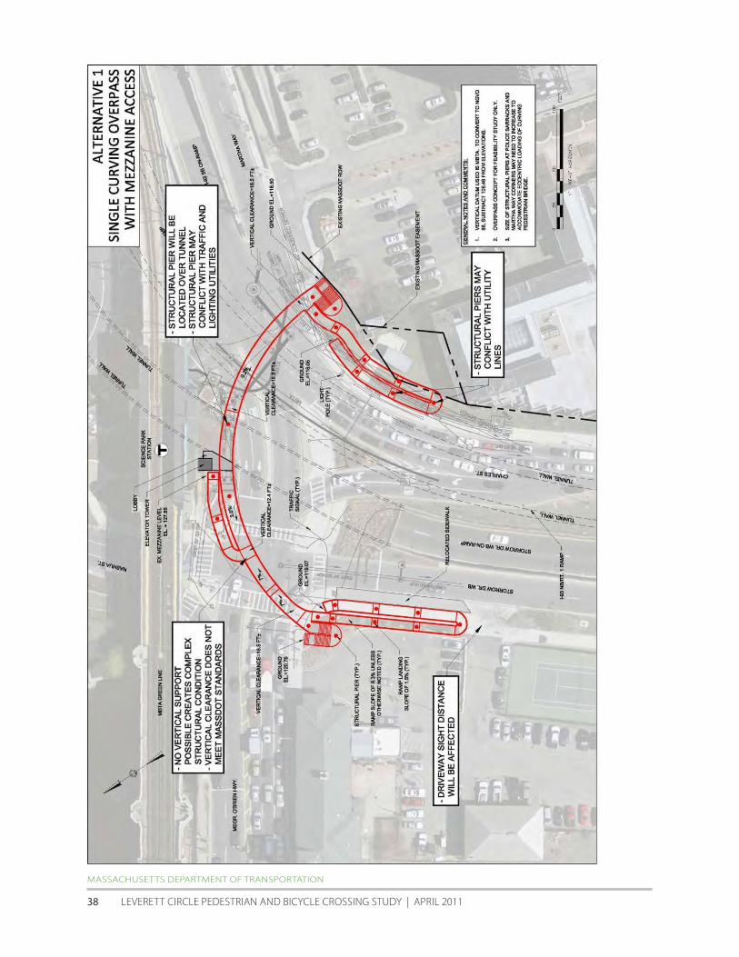
MASSAcHuSETTS DEPARTMENT Of TRANSPORTATION
LEVERETT cIRcLE PEDESTRIAN AND BIcycLE cROSSING STuDy | APRIL 2011 38
HALVORSON DESIGN PARTNERSHIP with ALTA | HDR | NITScH | EPSILON
AccELERATED BRIDGE PROGRAM | PEDESTRIAN + BIcycLE STuDy fOR PATHwAyS + BRIDGES | cHARLES RIVER BASIN 39
MASSAcHuSETTS DEPARTMENT Of TRANSPORTATION
LEVERETT cIRcLE PEDESTRIAN AND BIcycLE cROSSING STuDy | APRIL 2011 40
Alternative 2 Three-Legged Overpass
This concept is similar to the pedestrian overpass design originally included in contract c19E6 The concept has three
branches which meet at the Charles Street median island All horizontal and vertical clearances are met however the
following issues were indentified
bull The required length of ramp on the Esplanade results in the ramp switchback being located very close to
the State Police driveway onto Storrow Drive This may present sight distance issues at the driveway and also
results in the Storrow Drive sidewalk being relocated to the edge of Storrow Drive with no buffer
bull Structural piers will have to be constructed over the Storrow Drive Westbound tunnel at the MBTA island
bull At the Charles StreetMartha Road corner foundations for the ramp support columns may be in conflict with
utilities
On the following page is a conceptual plan diagram showing the alignment of pedestrianbike overpass Alternative
2 with areas of concern highlighted Additionally included is a diagram and matrix illustrating the pedestrian walking
distance and time for overpass Alternative 2 versus the distance and time required to cross Leverett Circle using the
Study Teamrsquos proposed at-grade improvements
HALVORSON DESIGN PARTNERSHIP with ALTA | HDR | NITScH | EPSILON
AccELERATED BRIDGE PROGRAM | PEDESTRIAN + BIcycLE STuDy fOR PATHwAyS + BRIDGES | cHARLES RIVER BASIN 41
HALVORSON DESIGN PARTNERSHIP with ALTA | HDR | NITScH | EPSILON
AccELERATED BRIDGE PROGRAM | PEDESTRIAN + BIcycLE STuDy fOR PATHwAyS + BRIDGES | cHARLES RIVER BASIN 42
MASSAcHuSETTS DEPARTMENT Of TRANSPORTATION
LEVERETT cIRcLE PEDESTRIAN AND BIcycLE cROSSING STuDy | APRIL 2011 43
MASSAcHuSETTS DEPARTMENT Of TRANSPORTATION
LEVERETT cIRcLE PEDESTRIAN AND BIcycLE cROSSING STuDy | APRIL 2011 44
Alternative 3 Partial Connection
This alternative takes the same approach as Alternative 1 but only provides access between the T station and the
ldquoPolice Stationrdquo corner Unlike Alternative 1 this concept provides the required 165 foot vertical clearance above the
roadway Doing so however results in what appears to be a fatal flaw The ramps required to meet the controlling
mezzanine elevation must approach the mezzanine from the east and there is insufficient vertical clearance above
the new MBTA elevator lobby structure to do so
In addition to the above the following issues were also identified
bull Structural piers will have to be constructed over the Storrow Drive Westbound tunnel at the MBTA island
bull The required length of ramp on the Esplanade results in the ramp switchback being located very close to
the State Police driveway onto Storrow Drive This may present sight distance issues at the driveway and also
results in the Storrow Drive sidewalk being relocated to the edge of Storrow Drive with no buffer
On the following page is a conceptual plan diagram showing the alignment of pedestrianbike overpass Alternative
3 with areas of concern highlighted Additionally included is a diagram and matrix illustrating the pedestrian walking
distance and time for overpass Alternative 3 versus the distance and time required to cross Leverett Circle using the
Study Teamrsquos proposed at-grade improvements
HALVORSON DESIGN PARTNERSHIP with ALTA | HDR | NITScH | EPSILON
AccELERATED BRIDGE PROGRAM | PEDESTRIAN + BIcycLE STuDy fOR PATHwAyS + BRIDGES | cHARLES RIVER BASIN 45
MASSAcHuSETTS DEPARTMENT Of TRANSPORTATION
LEVERETT cIRcLE PEDESTRIAN AND BIcycLE cROSSING STuDy | APRIL 2011 46
HALVORSON DESIGN PARTNERSHIP with ALTA | HDR | NITScH | EPSILON
AccELERATED BRIDGE PROGRAM | PEDESTRIAN + BIcycLE STuDy fOR PATHwAyS + BRIDGES | cHARLES RIVER BASIN 47
As noted on previous pages overpass Alternatives 1 and 3 include a number of flaws which preclude the ability to
serve their primary purpose These include the inability to achieve a 165rsquo (or even a 14rsquo) clearance over the roadway
and the difficulty of developing a functional connection to the MBTA stationrsquos mezzanine Because of this two sub-
options were developed for both alternatives that required a slight rethinking of the connectivity of each alternative
bull Alternatives 1A and 3A ndash provide connections to the MBTA inbound platform (rather than mezzanine)
bull Alternatives 1B and 3B ndash premised on the removal of one WB traffic lane in front of the MBTA station to
provide additional space for a ramp connection to the mezzanine (see section 21 of this Study for
discussion)
Alternative 1A Curving Overpass with Inbound Platform Access
To remedy the low vertical clearance of Alternative 1 Alternative 1A provides access to the inbound platform level of
the MBTA Science Park station which is 20 feet above the mezzanine Issues with this concept include
bull Sight distance will be affected at the State Police station driveway onto Storrow Drive
bull Structural foundations will have to be constructed over Storrow Drive Westbound tunnel
bull Structural foundations may conflict with the pump house building adjacent to the MBTA station
bull Structural foundations may conflict with combined sewer storm drain and other utilities
bull Provisions for fare-control will need to be provided either on the overpass structure itself or on the inbound
platform Both of these options are very space-constrained and this may not be feasible Further investigation
of this possibility will need to be explored with the MBTA
bull The overpass by only serving the inbound platform has significantly less functionality than is desirable
Access to and from the outbound platform would be technically available but would require a circuitous
trip via the ldquopaid siderdquo of the mezzanine level lobby
MASSAcHuSETTS DEPARTMENT Of TRANSPORTATION
LEVERETT cIRcLE PEDESTRIAN AND BIcycLE cROSSING STuDy | APRIL 2011 48
HALVORSON DESIGN PARTNERSHIP with ALTA | HDR | NITScH | EPSILON
AccELERATED BRIDGE PROGRAM | PEDESTRIAN + BIcycLE STuDy fOR PATHwAyS + BRIDGES | cHARLES RIVER BASIN 49
Alternative 1B Curving Overpass with WB Lane Removal
This alternative is able to provide access to the mezzanine level while meeting MassDOTrsquos minimum vertical clearance
of 165rsquo To do so one WB travel lane along the short block in front of the MBTA station would need to be removed in
order to relocate the curb to the south The pedestrian ramp would span parallel along the proposed widened curb
and then loop under the pedestrian overpass thus avoiding the lobby roof Issues with this alternative include
bull Sight distance will be affected at the State Police station driveway to Storrow Drive
bull Structural foundations may conflict with combined sewer storm drain and other utilities
MASSAcHuSETTS DEPARTMENT Of TRANSPORTATION
LEVERETT cIRcLE PEDESTRIAN AND BIcycLE cROSSING STuDy | APRIL 2011 50
HALVORSON DESIGN PARTNERSHIP with ALTA | HDR | NITScH | EPSILON
AccELERATED BRIDGE PROGRAM | PEDESTRIAN + BIcycLE STuDy fOR PATHwAyS + BRIDGES | cHARLES RIVER BASIN 51
Alternative 3A Partial Connection to MBTA Inbound Platform
In this concept ADA access is provided to the inbound platform level and also stairwell access to the mezzanine level
All vertical clearances are met in this alternative Issues include
bull Sight distance will be affected at the State Police station driveway to Storrow Drive
bull Structural foundations may conflict with combined sewer and other utilities
bull Structural foundations may be required over Storrow Drive Westbound tunnel
bull Provisions for fare-control will need to be provided either on the overpass structure itself or on the inbound
platform Both of these options are very space-constrained and this may not be feasible Further investigation
of this possibility will need to be explored with the MBTA
bull The overpass by providing ADA access to only the inbound platform has significantly less functionality than
is desirable Access to and from the outbound platform would be technically available but would require a
circuitous trip via the ldquopaid siderdquo of the mezzanine level lobby
MASSAcHuSETTS DEPARTMENT Of TRANSPORTATION
LEVERETT cIRcLE PEDESTRIAN AND BIcycLE cROSSING STuDy | APRIL 2011 52
HALVORSON DESIGN PARTNERSHIP with ALTA | HDR | NITScH | EPSILON
AccELERATED BRIDGE PROGRAM | PEDESTRIAN + BIcycLE STuDy fOR PATHwAyS + BRIDGES | cHARLES RIVER BASIN 53
Alternative 3B Partial Connection with WB Lane Removal
Like Alternative 1B this alternative is able to provide access to the mezzanine level while meeting the required
minimum vertical clearance of 165rsquo To do so one WB travel lane along the short block in front of the MBTA station
would need to be removed in order to relocate the curb to the south The pedestrian ramp would span parallel along
the proposed widened curb and then loop under the pedestrian overpass to avoid the lobby roof Issues include
bull Sight distance will be affected at the State Police station driveway to Storrow Drive
bull Structural foundations may conflict with storm drain and other utilities
bull Structural foundations may be required over the Storrow Drive WB tunnel
MASSAcHuSETTS DEPARTMENT Of TRANSPORTATION
LEVERETT cIRcLE PEDESTRIAN AND BIcycLE cROSSING STuDy | APRIL 2011 54
HALVORSON DESIGN PARTNERSHIP with ALTA | HDR | NITScH | EPSILON
AccELERATED BRIDGE PROGRAM | PEDESTRIAN + BIcycLE STuDy fOR PATHwAyS + BRIDGES | cHARLES RIVER BASIN 55
Based on the criteria discussed in section 42 of this report the five workable design alternatives (1A 1B 2 3A
and 3B) were evaluated using a 1-5 scale with 1 as poor 3 as fair and 5 as excellent The evaluation assumes that the
proposed at-grade improvements would be incorporated in all five potential overpass alternatives
Criteria At-grade only Alt 1A amp 1B Alt 2 Alt 3A amp 3B
Safety for all Users 4 5 5 5
Security of all Users 5 3 3 4
Perception of Required Out-of-direction Travel 5 4 2 4
Length of Travel for Non-motorized Users 5 4 3 4
Time of Travel for Non-Motorized Users 3-5 4 4 3-5
(including expected wait time at signals)
Constructability and cost (bridge structure utilities signals etc) 5 1 1 3
Sight Line Considerations (obstruction issues shadows etc) 5 3 3 4
Overall Pedestrian Accommodation and Convenience 3 5 5 5
Overall Bicycle Accommodation and Convenience 3 5 5 3
Functionality of Intersection for all Users 4 5 4 5
Operational Impacts on Vehicular Movements 4 4 4 4
Aesthetic Impacts to Intersection 5 3 2 3
TOTAL 51-53 46 41 47-49
MASSAcHuSETTS DEPARTMENT Of TRANSPORTATION
LEVERETT cIRcLE PEDESTRIAN AND BIcycLE cROSSING STuDy | APRIL 2011 56
53 Option 3 PedestrianBike Overpass with minimal at-grade pedestrian connections
The third option for Leverett circle is to develop a new pedestrianbike overpass (based on workable alternatives
1A 1B and 2 discussed above) and retain only the minimum at-grade pedestrian connections This would require
the removal of most of the existing crosswalks curb-cuts and pedestrian crossing signal heads within the two
intersections The crosswalkscurb cuts retained would be those that cross OrsquoBrien Highway (on the west side of the
intersection) and Nashua Street These two crosswalks would provide pedestrian and bike connections from Nashua
Street Park to the charles River Esplanade and to the MBTA station The pair would also provide a secondary route
tofrom the southwest corner of the intersection in front of the State Police Station to the MBTA station for those
who chose to remain at-grade To mitigate the desire to cross at-grade after pedestrian facilities have been removed
barriers (fencing and dense landscaping) will be needed to ensure that pedestrians use the overpass structure
It is important to note that with the removal of most at-grade pedestrian connections there will be no apparent
benefit to traffic capacity or LOS This is because none of the existing WALK signals prevent potential non-conflicting
traffic movements from occurring The most apparent benefit of removing most at-grade pedestrian facilities would
be to reduce conflicts between pedestrian and motor vehicles If all walkers (and some bicyclists) were to use the
potential overpass the number of pedestrianvehiclebicycle crashes would be expected to decrease This would
need to be balanced against 1) the additional walking time required to cross Leverett Circle and 2) the potential that
even with efforts to physically discourage or prevent inappropriate at-grade crossing (with fencing or landscaping for
example) some jaywalking would be likely
Option 3 diagram showing potential removal of at-grade pedestrian connections
HALVORSON DESIGN PARTNERSHIP with ALTA | HDR | NITScH | EPSILON
AccELERATED BRIDGE PROGRAM | PEDESTRIAN + BIcycLE STuDy fOR PATHwAyS + BRIDGES | cHARLES RIVER BASIN 57
6 SUMMARY
6 Summary
The key goals of the Leverett circle Pedestrian and Bicycle crossing Study were to analyze the conditions at Leverett
circle and study both at-grade and grade-separated bicycle and pedestrian safety enhancements The scope of
the study included the development of concepts and an initial feasibility assessment of pedestrian and cyclist
improvements at Leverett circle including evaluation of existing conditions and circulation patterns evaluation of
potential enhancements to existing at-grade crossings potential new grade-separated crossings and associated
elimination of at-grade connections and some combinations of at-grade and grade-separated crossings based on
current MassDOT standards
Based on the existing conditions analysis crash data and field observations of motorist bicyclist and pedestrian
behavior it is clear that a number of potentially feasible at-grade improvements are possible These would enhance
connectivity and safety for non-motorized users of Leverett circle with no or minimal impacts to vehicle circulation or
intersection LOS These low and modest-cost improvements could be done relatively quickly and include
bull Signal enhancements
bull Pedestrian count-down timers in a number of locations
bull Better signage
bull Updated crosswalk markings
bull Relocation of the OrsquoBrien Hwy crosswalk in front of the MBTA Science Park station to the east of the double
left turn lanes from charles Street
bull Potential movement of curb line in front of the MBTA station
Even with the incorporation of the enhancements listed above concern over pedestrian safety is likely to remain
The cities of Boston and cambridge and community groups may still express the desire for a grade-separated
environment for the elderly the disabled and groups of children crossing Leverett circle tofrom the west End the
Esplanade and the MBTA station
for users whose route requires them to cross completely from the Police Station corner to the west End corner (ie
for whom the MBTA station is not a destination) it is difficult to predict what percentage would choose the overpass
option if an at-grade option was also available
As discussed in Section 4 available research suggests that a perceived ldquoconvenience factorrdquo can be calculated
to consider usersrsquo perceptions of how long the at-grade route would take compared with the grade-separated
alternative In analyzing the several Leverett circle overpass options presented in Section 5 this perceived
ldquoconveniencerdquo of an overpass is relatively low when compared with the minimum duration of crossing at-grade
However the overpass convenience values are considerably higher if the maximum likely at-grade crossing time is
considered In other words if someone arriving at the intersection just misses the crossing signal theyrsquore more likely
to choose the overpass because travel time across the intersection will be very similar to waiting for the next at-grade
opportunity conversely there are times in the signal cycle when a pedestrian arriving at the intersection will be able
to cross at-grade up to 3 times faster (depending on overpass option) than using an overpass
If a pedestrianbike overpass is built at this location case studies from other communities and the pedestrian crossing
distance and time analysis implies that the most likely user of the overpass would be those traveling to and from the
MBTA station Because the final destination is elevatedmdashthe station mezzanine levelmdashand the travel time would be
HALVORSON DESIGN PARTNERSHIP with ALTA | HDR | NITScH | EPSILON
AccELERATED BRIDGE PROGRAM | PEDESTRIAN + BIcycLE STuDy fOR PATHwAyS + BRIDGES | cHARLES RIVER BASIN 59
comparable to crossing at-grade many people of all abilities are likely to use the overpass especially if coming to or
from the southwest corner of the intersection
The primary beneficiaries of the proposed at-grade improvements are those wishing to travel between the MBTA
station and the west End Additionally the evaluation matrix at the end of section 52 points to the possibility of
satisfying nearly all of the connectivity and safety goals with a partial overpass over Leverett circle
MASSAcHuSETTS DEPARTMENT Of TRANSPORTATION
LEVERETT cIRcLE PEDESTRIAN AND BIcycLE cROSSING STuDy | APRIL 2011 60
- LeverettCirRept-Cover-etc
- Dividerspdf
- LeverettCirRept-Chapt1
-

HALVORSON DESIGN PARTNERSHIP with ALTA | HDR | NITScH | EPSILON
AccELERATED BRIDGE PROGRAM | PEDESTRIAN + BIcycLE STuDy fOR PATHwAyS + BRIDGES | cHARLES RIVER BASIN 39
MASSAcHuSETTS DEPARTMENT Of TRANSPORTATION
LEVERETT cIRcLE PEDESTRIAN AND BIcycLE cROSSING STuDy | APRIL 2011 40
Alternative 2 Three-Legged Overpass
This concept is similar to the pedestrian overpass design originally included in contract c19E6 The concept has three
branches which meet at the Charles Street median island All horizontal and vertical clearances are met however the
following issues were indentified
bull The required length of ramp on the Esplanade results in the ramp switchback being located very close to
the State Police driveway onto Storrow Drive This may present sight distance issues at the driveway and also
results in the Storrow Drive sidewalk being relocated to the edge of Storrow Drive with no buffer
bull Structural piers will have to be constructed over the Storrow Drive Westbound tunnel at the MBTA island
bull At the Charles StreetMartha Road corner foundations for the ramp support columns may be in conflict with
utilities
On the following page is a conceptual plan diagram showing the alignment of pedestrianbike overpass Alternative
2 with areas of concern highlighted Additionally included is a diagram and matrix illustrating the pedestrian walking
distance and time for overpass Alternative 2 versus the distance and time required to cross Leverett Circle using the
Study Teamrsquos proposed at-grade improvements
HALVORSON DESIGN PARTNERSHIP with ALTA | HDR | NITScH | EPSILON
AccELERATED BRIDGE PROGRAM | PEDESTRIAN + BIcycLE STuDy fOR PATHwAyS + BRIDGES | cHARLES RIVER BASIN 41
HALVORSON DESIGN PARTNERSHIP with ALTA | HDR | NITScH | EPSILON
AccELERATED BRIDGE PROGRAM | PEDESTRIAN + BIcycLE STuDy fOR PATHwAyS + BRIDGES | cHARLES RIVER BASIN 42
MASSAcHuSETTS DEPARTMENT Of TRANSPORTATION
LEVERETT cIRcLE PEDESTRIAN AND BIcycLE cROSSING STuDy | APRIL 2011 43
MASSAcHuSETTS DEPARTMENT Of TRANSPORTATION
LEVERETT cIRcLE PEDESTRIAN AND BIcycLE cROSSING STuDy | APRIL 2011 44
Alternative 3 Partial Connection
This alternative takes the same approach as Alternative 1 but only provides access between the T station and the
ldquoPolice Stationrdquo corner Unlike Alternative 1 this concept provides the required 165 foot vertical clearance above the
roadway Doing so however results in what appears to be a fatal flaw The ramps required to meet the controlling
mezzanine elevation must approach the mezzanine from the east and there is insufficient vertical clearance above
the new MBTA elevator lobby structure to do so
In addition to the above the following issues were also identified
bull Structural piers will have to be constructed over the Storrow Drive Westbound tunnel at the MBTA island
bull The required length of ramp on the Esplanade results in the ramp switchback being located very close to
the State Police driveway onto Storrow Drive This may present sight distance issues at the driveway and also
results in the Storrow Drive sidewalk being relocated to the edge of Storrow Drive with no buffer
On the following page is a conceptual plan diagram showing the alignment of pedestrianbike overpass Alternative
3 with areas of concern highlighted Additionally included is a diagram and matrix illustrating the pedestrian walking
distance and time for overpass Alternative 3 versus the distance and time required to cross Leverett Circle using the
Study Teamrsquos proposed at-grade improvements
HALVORSON DESIGN PARTNERSHIP with ALTA | HDR | NITScH | EPSILON
AccELERATED BRIDGE PROGRAM | PEDESTRIAN + BIcycLE STuDy fOR PATHwAyS + BRIDGES | cHARLES RIVER BASIN 45
MASSAcHuSETTS DEPARTMENT Of TRANSPORTATION
LEVERETT cIRcLE PEDESTRIAN AND BIcycLE cROSSING STuDy | APRIL 2011 46
HALVORSON DESIGN PARTNERSHIP with ALTA | HDR | NITScH | EPSILON
AccELERATED BRIDGE PROGRAM | PEDESTRIAN + BIcycLE STuDy fOR PATHwAyS + BRIDGES | cHARLES RIVER BASIN 47
As noted on previous pages overpass Alternatives 1 and 3 include a number of flaws which preclude the ability to
serve their primary purpose These include the inability to achieve a 165rsquo (or even a 14rsquo) clearance over the roadway
and the difficulty of developing a functional connection to the MBTA stationrsquos mezzanine Because of this two sub-
options were developed for both alternatives that required a slight rethinking of the connectivity of each alternative
bull Alternatives 1A and 3A ndash provide connections to the MBTA inbound platform (rather than mezzanine)
bull Alternatives 1B and 3B ndash premised on the removal of one WB traffic lane in front of the MBTA station to
provide additional space for a ramp connection to the mezzanine (see section 21 of this Study for
discussion)
Alternative 1A Curving Overpass with Inbound Platform Access
To remedy the low vertical clearance of Alternative 1 Alternative 1A provides access to the inbound platform level of
the MBTA Science Park station which is 20 feet above the mezzanine Issues with this concept include
bull Sight distance will be affected at the State Police station driveway onto Storrow Drive
bull Structural foundations will have to be constructed over Storrow Drive Westbound tunnel
bull Structural foundations may conflict with the pump house building adjacent to the MBTA station
bull Structural foundations may conflict with combined sewer storm drain and other utilities
bull Provisions for fare-control will need to be provided either on the overpass structure itself or on the inbound
platform Both of these options are very space-constrained and this may not be feasible Further investigation
of this possibility will need to be explored with the MBTA
bull The overpass by only serving the inbound platform has significantly less functionality than is desirable
Access to and from the outbound platform would be technically available but would require a circuitous
trip via the ldquopaid siderdquo of the mezzanine level lobby
MASSAcHuSETTS DEPARTMENT Of TRANSPORTATION
LEVERETT cIRcLE PEDESTRIAN AND BIcycLE cROSSING STuDy | APRIL 2011 48
HALVORSON DESIGN PARTNERSHIP with ALTA | HDR | NITScH | EPSILON
AccELERATED BRIDGE PROGRAM | PEDESTRIAN + BIcycLE STuDy fOR PATHwAyS + BRIDGES | cHARLES RIVER BASIN 49
Alternative 1B Curving Overpass with WB Lane Removal
This alternative is able to provide access to the mezzanine level while meeting MassDOTrsquos minimum vertical clearance
of 165rsquo To do so one WB travel lane along the short block in front of the MBTA station would need to be removed in
order to relocate the curb to the south The pedestrian ramp would span parallel along the proposed widened curb
and then loop under the pedestrian overpass thus avoiding the lobby roof Issues with this alternative include
bull Sight distance will be affected at the State Police station driveway to Storrow Drive
bull Structural foundations may conflict with combined sewer storm drain and other utilities
MASSAcHuSETTS DEPARTMENT Of TRANSPORTATION
LEVERETT cIRcLE PEDESTRIAN AND BIcycLE cROSSING STuDy | APRIL 2011 50
HALVORSON DESIGN PARTNERSHIP with ALTA | HDR | NITScH | EPSILON
AccELERATED BRIDGE PROGRAM | PEDESTRIAN + BIcycLE STuDy fOR PATHwAyS + BRIDGES | cHARLES RIVER BASIN 51
Alternative 3A Partial Connection to MBTA Inbound Platform
In this concept ADA access is provided to the inbound platform level and also stairwell access to the mezzanine level
All vertical clearances are met in this alternative Issues include
bull Sight distance will be affected at the State Police station driveway to Storrow Drive
bull Structural foundations may conflict with combined sewer and other utilities
bull Structural foundations may be required over Storrow Drive Westbound tunnel
bull Provisions for fare-control will need to be provided either on the overpass structure itself or on the inbound
platform Both of these options are very space-constrained and this may not be feasible Further investigation
of this possibility will need to be explored with the MBTA
bull The overpass by providing ADA access to only the inbound platform has significantly less functionality than
is desirable Access to and from the outbound platform would be technically available but would require a
circuitous trip via the ldquopaid siderdquo of the mezzanine level lobby
MASSAcHuSETTS DEPARTMENT Of TRANSPORTATION
LEVERETT cIRcLE PEDESTRIAN AND BIcycLE cROSSING STuDy | APRIL 2011 52
HALVORSON DESIGN PARTNERSHIP with ALTA | HDR | NITScH | EPSILON
AccELERATED BRIDGE PROGRAM | PEDESTRIAN + BIcycLE STuDy fOR PATHwAyS + BRIDGES | cHARLES RIVER BASIN 53
Alternative 3B Partial Connection with WB Lane Removal
Like Alternative 1B this alternative is able to provide access to the mezzanine level while meeting the required
minimum vertical clearance of 165rsquo To do so one WB travel lane along the short block in front of the MBTA station
would need to be removed in order to relocate the curb to the south The pedestrian ramp would span parallel along
the proposed widened curb and then loop under the pedestrian overpass to avoid the lobby roof Issues include
bull Sight distance will be affected at the State Police station driveway to Storrow Drive
bull Structural foundations may conflict with storm drain and other utilities
bull Structural foundations may be required over the Storrow Drive WB tunnel
MASSAcHuSETTS DEPARTMENT Of TRANSPORTATION
LEVERETT cIRcLE PEDESTRIAN AND BIcycLE cROSSING STuDy | APRIL 2011 54
HALVORSON DESIGN PARTNERSHIP with ALTA | HDR | NITScH | EPSILON
AccELERATED BRIDGE PROGRAM | PEDESTRIAN + BIcycLE STuDy fOR PATHwAyS + BRIDGES | cHARLES RIVER BASIN 55
Based on the criteria discussed in section 42 of this report the five workable design alternatives (1A 1B 2 3A
and 3B) were evaluated using a 1-5 scale with 1 as poor 3 as fair and 5 as excellent The evaluation assumes that the
proposed at-grade improvements would be incorporated in all five potential overpass alternatives
Criteria At-grade only Alt 1A amp 1B Alt 2 Alt 3A amp 3B
Safety for all Users 4 5 5 5
Security of all Users 5 3 3 4
Perception of Required Out-of-direction Travel 5 4 2 4
Length of Travel for Non-motorized Users 5 4 3 4
Time of Travel for Non-Motorized Users 3-5 4 4 3-5
(including expected wait time at signals)
Constructability and cost (bridge structure utilities signals etc) 5 1 1 3
Sight Line Considerations (obstruction issues shadows etc) 5 3 3 4
Overall Pedestrian Accommodation and Convenience 3 5 5 5
Overall Bicycle Accommodation and Convenience 3 5 5 3
Functionality of Intersection for all Users 4 5 4 5
Operational Impacts on Vehicular Movements 4 4 4 4
Aesthetic Impacts to Intersection 5 3 2 3
TOTAL 51-53 46 41 47-49
MASSAcHuSETTS DEPARTMENT Of TRANSPORTATION
LEVERETT cIRcLE PEDESTRIAN AND BIcycLE cROSSING STuDy | APRIL 2011 56
53 Option 3 PedestrianBike Overpass with minimal at-grade pedestrian connections
The third option for Leverett circle is to develop a new pedestrianbike overpass (based on workable alternatives
1A 1B and 2 discussed above) and retain only the minimum at-grade pedestrian connections This would require
the removal of most of the existing crosswalks curb-cuts and pedestrian crossing signal heads within the two
intersections The crosswalkscurb cuts retained would be those that cross OrsquoBrien Highway (on the west side of the
intersection) and Nashua Street These two crosswalks would provide pedestrian and bike connections from Nashua
Street Park to the charles River Esplanade and to the MBTA station The pair would also provide a secondary route
tofrom the southwest corner of the intersection in front of the State Police Station to the MBTA station for those
who chose to remain at-grade To mitigate the desire to cross at-grade after pedestrian facilities have been removed
barriers (fencing and dense landscaping) will be needed to ensure that pedestrians use the overpass structure
It is important to note that with the removal of most at-grade pedestrian connections there will be no apparent
benefit to traffic capacity or LOS This is because none of the existing WALK signals prevent potential non-conflicting
traffic movements from occurring The most apparent benefit of removing most at-grade pedestrian facilities would
be to reduce conflicts between pedestrian and motor vehicles If all walkers (and some bicyclists) were to use the
potential overpass the number of pedestrianvehiclebicycle crashes would be expected to decrease This would
need to be balanced against 1) the additional walking time required to cross Leverett Circle and 2) the potential that
even with efforts to physically discourage or prevent inappropriate at-grade crossing (with fencing or landscaping for
example) some jaywalking would be likely
Option 3 diagram showing potential removal of at-grade pedestrian connections
HALVORSON DESIGN PARTNERSHIP with ALTA | HDR | NITScH | EPSILON
AccELERATED BRIDGE PROGRAM | PEDESTRIAN + BIcycLE STuDy fOR PATHwAyS + BRIDGES | cHARLES RIVER BASIN 57
6 SUMMARY
6 Summary
The key goals of the Leverett circle Pedestrian and Bicycle crossing Study were to analyze the conditions at Leverett
circle and study both at-grade and grade-separated bicycle and pedestrian safety enhancements The scope of
the study included the development of concepts and an initial feasibility assessment of pedestrian and cyclist
improvements at Leverett circle including evaluation of existing conditions and circulation patterns evaluation of
potential enhancements to existing at-grade crossings potential new grade-separated crossings and associated
elimination of at-grade connections and some combinations of at-grade and grade-separated crossings based on
current MassDOT standards
Based on the existing conditions analysis crash data and field observations of motorist bicyclist and pedestrian
behavior it is clear that a number of potentially feasible at-grade improvements are possible These would enhance
connectivity and safety for non-motorized users of Leverett circle with no or minimal impacts to vehicle circulation or
intersection LOS These low and modest-cost improvements could be done relatively quickly and include
bull Signal enhancements
bull Pedestrian count-down timers in a number of locations
bull Better signage
bull Updated crosswalk markings
bull Relocation of the OrsquoBrien Hwy crosswalk in front of the MBTA Science Park station to the east of the double
left turn lanes from charles Street
bull Potential movement of curb line in front of the MBTA station
Even with the incorporation of the enhancements listed above concern over pedestrian safety is likely to remain
The cities of Boston and cambridge and community groups may still express the desire for a grade-separated
environment for the elderly the disabled and groups of children crossing Leverett circle tofrom the west End the
Esplanade and the MBTA station
for users whose route requires them to cross completely from the Police Station corner to the west End corner (ie
for whom the MBTA station is not a destination) it is difficult to predict what percentage would choose the overpass
option if an at-grade option was also available
As discussed in Section 4 available research suggests that a perceived ldquoconvenience factorrdquo can be calculated
to consider usersrsquo perceptions of how long the at-grade route would take compared with the grade-separated
alternative In analyzing the several Leverett circle overpass options presented in Section 5 this perceived
ldquoconveniencerdquo of an overpass is relatively low when compared with the minimum duration of crossing at-grade
However the overpass convenience values are considerably higher if the maximum likely at-grade crossing time is
considered In other words if someone arriving at the intersection just misses the crossing signal theyrsquore more likely
to choose the overpass because travel time across the intersection will be very similar to waiting for the next at-grade
opportunity conversely there are times in the signal cycle when a pedestrian arriving at the intersection will be able
to cross at-grade up to 3 times faster (depending on overpass option) than using an overpass
If a pedestrianbike overpass is built at this location case studies from other communities and the pedestrian crossing
distance and time analysis implies that the most likely user of the overpass would be those traveling to and from the
MBTA station Because the final destination is elevatedmdashthe station mezzanine levelmdashand the travel time would be
HALVORSON DESIGN PARTNERSHIP with ALTA | HDR | NITScH | EPSILON
AccELERATED BRIDGE PROGRAM | PEDESTRIAN + BIcycLE STuDy fOR PATHwAyS + BRIDGES | cHARLES RIVER BASIN 59
comparable to crossing at-grade many people of all abilities are likely to use the overpass especially if coming to or
from the southwest corner of the intersection
The primary beneficiaries of the proposed at-grade improvements are those wishing to travel between the MBTA
station and the west End Additionally the evaluation matrix at the end of section 52 points to the possibility of
satisfying nearly all of the connectivity and safety goals with a partial overpass over Leverett circle
MASSAcHuSETTS DEPARTMENT Of TRANSPORTATION
LEVERETT cIRcLE PEDESTRIAN AND BIcycLE cROSSING STuDy | APRIL 2011 60
- LeverettCirRept-Cover-etc
- Dividerspdf
- LeverettCirRept-Chapt1
-

MASSAcHuSETTS DEPARTMENT Of TRANSPORTATION
LEVERETT cIRcLE PEDESTRIAN AND BIcycLE cROSSING STuDy | APRIL 2011 40
Alternative 2 Three-Legged Overpass
This concept is similar to the pedestrian overpass design originally included in contract c19E6 The concept has three
branches which meet at the Charles Street median island All horizontal and vertical clearances are met however the
following issues were indentified
bull The required length of ramp on the Esplanade results in the ramp switchback being located very close to
the State Police driveway onto Storrow Drive This may present sight distance issues at the driveway and also
results in the Storrow Drive sidewalk being relocated to the edge of Storrow Drive with no buffer
bull Structural piers will have to be constructed over the Storrow Drive Westbound tunnel at the MBTA island
bull At the Charles StreetMartha Road corner foundations for the ramp support columns may be in conflict with
utilities
On the following page is a conceptual plan diagram showing the alignment of pedestrianbike overpass Alternative
2 with areas of concern highlighted Additionally included is a diagram and matrix illustrating the pedestrian walking
distance and time for overpass Alternative 2 versus the distance and time required to cross Leverett Circle using the
Study Teamrsquos proposed at-grade improvements
HALVORSON DESIGN PARTNERSHIP with ALTA | HDR | NITScH | EPSILON
AccELERATED BRIDGE PROGRAM | PEDESTRIAN + BIcycLE STuDy fOR PATHwAyS + BRIDGES | cHARLES RIVER BASIN 41
HALVORSON DESIGN PARTNERSHIP with ALTA | HDR | NITScH | EPSILON
AccELERATED BRIDGE PROGRAM | PEDESTRIAN + BIcycLE STuDy fOR PATHwAyS + BRIDGES | cHARLES RIVER BASIN 42
MASSAcHuSETTS DEPARTMENT Of TRANSPORTATION
LEVERETT cIRcLE PEDESTRIAN AND BIcycLE cROSSING STuDy | APRIL 2011 43
MASSAcHuSETTS DEPARTMENT Of TRANSPORTATION
LEVERETT cIRcLE PEDESTRIAN AND BIcycLE cROSSING STuDy | APRIL 2011 44
Alternative 3 Partial Connection
This alternative takes the same approach as Alternative 1 but only provides access between the T station and the
ldquoPolice Stationrdquo corner Unlike Alternative 1 this concept provides the required 165 foot vertical clearance above the
roadway Doing so however results in what appears to be a fatal flaw The ramps required to meet the controlling
mezzanine elevation must approach the mezzanine from the east and there is insufficient vertical clearance above
the new MBTA elevator lobby structure to do so
In addition to the above the following issues were also identified
bull Structural piers will have to be constructed over the Storrow Drive Westbound tunnel at the MBTA island
bull The required length of ramp on the Esplanade results in the ramp switchback being located very close to
the State Police driveway onto Storrow Drive This may present sight distance issues at the driveway and also
results in the Storrow Drive sidewalk being relocated to the edge of Storrow Drive with no buffer
On the following page is a conceptual plan diagram showing the alignment of pedestrianbike overpass Alternative
3 with areas of concern highlighted Additionally included is a diagram and matrix illustrating the pedestrian walking
distance and time for overpass Alternative 3 versus the distance and time required to cross Leverett Circle using the
Study Teamrsquos proposed at-grade improvements
HALVORSON DESIGN PARTNERSHIP with ALTA | HDR | NITScH | EPSILON
AccELERATED BRIDGE PROGRAM | PEDESTRIAN + BIcycLE STuDy fOR PATHwAyS + BRIDGES | cHARLES RIVER BASIN 45
MASSAcHuSETTS DEPARTMENT Of TRANSPORTATION
LEVERETT cIRcLE PEDESTRIAN AND BIcycLE cROSSING STuDy | APRIL 2011 46
HALVORSON DESIGN PARTNERSHIP with ALTA | HDR | NITScH | EPSILON
AccELERATED BRIDGE PROGRAM | PEDESTRIAN + BIcycLE STuDy fOR PATHwAyS + BRIDGES | cHARLES RIVER BASIN 47
As noted on previous pages overpass Alternatives 1 and 3 include a number of flaws which preclude the ability to
serve their primary purpose These include the inability to achieve a 165rsquo (or even a 14rsquo) clearance over the roadway
and the difficulty of developing a functional connection to the MBTA stationrsquos mezzanine Because of this two sub-
options were developed for both alternatives that required a slight rethinking of the connectivity of each alternative
bull Alternatives 1A and 3A ndash provide connections to the MBTA inbound platform (rather than mezzanine)
bull Alternatives 1B and 3B ndash premised on the removal of one WB traffic lane in front of the MBTA station to
provide additional space for a ramp connection to the mezzanine (see section 21 of this Study for
discussion)
Alternative 1A Curving Overpass with Inbound Platform Access
To remedy the low vertical clearance of Alternative 1 Alternative 1A provides access to the inbound platform level of
the MBTA Science Park station which is 20 feet above the mezzanine Issues with this concept include
bull Sight distance will be affected at the State Police station driveway onto Storrow Drive
bull Structural foundations will have to be constructed over Storrow Drive Westbound tunnel
bull Structural foundations may conflict with the pump house building adjacent to the MBTA station
bull Structural foundations may conflict with combined sewer storm drain and other utilities
bull Provisions for fare-control will need to be provided either on the overpass structure itself or on the inbound
platform Both of these options are very space-constrained and this may not be feasible Further investigation
of this possibility will need to be explored with the MBTA
bull The overpass by only serving the inbound platform has significantly less functionality than is desirable
Access to and from the outbound platform would be technically available but would require a circuitous
trip via the ldquopaid siderdquo of the mezzanine level lobby
MASSAcHuSETTS DEPARTMENT Of TRANSPORTATION
LEVERETT cIRcLE PEDESTRIAN AND BIcycLE cROSSING STuDy | APRIL 2011 48
HALVORSON DESIGN PARTNERSHIP with ALTA | HDR | NITScH | EPSILON
AccELERATED BRIDGE PROGRAM | PEDESTRIAN + BIcycLE STuDy fOR PATHwAyS + BRIDGES | cHARLES RIVER BASIN 49
Alternative 1B Curving Overpass with WB Lane Removal
This alternative is able to provide access to the mezzanine level while meeting MassDOTrsquos minimum vertical clearance
of 165rsquo To do so one WB travel lane along the short block in front of the MBTA station would need to be removed in
order to relocate the curb to the south The pedestrian ramp would span parallel along the proposed widened curb
and then loop under the pedestrian overpass thus avoiding the lobby roof Issues with this alternative include
bull Sight distance will be affected at the State Police station driveway to Storrow Drive
bull Structural foundations may conflict with combined sewer storm drain and other utilities
MASSAcHuSETTS DEPARTMENT Of TRANSPORTATION
LEVERETT cIRcLE PEDESTRIAN AND BIcycLE cROSSING STuDy | APRIL 2011 50
HALVORSON DESIGN PARTNERSHIP with ALTA | HDR | NITScH | EPSILON
AccELERATED BRIDGE PROGRAM | PEDESTRIAN + BIcycLE STuDy fOR PATHwAyS + BRIDGES | cHARLES RIVER BASIN 51
Alternative 3A Partial Connection to MBTA Inbound Platform
In this concept ADA access is provided to the inbound platform level and also stairwell access to the mezzanine level
All vertical clearances are met in this alternative Issues include
bull Sight distance will be affected at the State Police station driveway to Storrow Drive
bull Structural foundations may conflict with combined sewer and other utilities
bull Structural foundations may be required over Storrow Drive Westbound tunnel
bull Provisions for fare-control will need to be provided either on the overpass structure itself or on the inbound
platform Both of these options are very space-constrained and this may not be feasible Further investigation
of this possibility will need to be explored with the MBTA
bull The overpass by providing ADA access to only the inbound platform has significantly less functionality than
is desirable Access to and from the outbound platform would be technically available but would require a
circuitous trip via the ldquopaid siderdquo of the mezzanine level lobby
MASSAcHuSETTS DEPARTMENT Of TRANSPORTATION
LEVERETT cIRcLE PEDESTRIAN AND BIcycLE cROSSING STuDy | APRIL 2011 52
HALVORSON DESIGN PARTNERSHIP with ALTA | HDR | NITScH | EPSILON
AccELERATED BRIDGE PROGRAM | PEDESTRIAN + BIcycLE STuDy fOR PATHwAyS + BRIDGES | cHARLES RIVER BASIN 53
Alternative 3B Partial Connection with WB Lane Removal
Like Alternative 1B this alternative is able to provide access to the mezzanine level while meeting the required
minimum vertical clearance of 165rsquo To do so one WB travel lane along the short block in front of the MBTA station
would need to be removed in order to relocate the curb to the south The pedestrian ramp would span parallel along
the proposed widened curb and then loop under the pedestrian overpass to avoid the lobby roof Issues include
bull Sight distance will be affected at the State Police station driveway to Storrow Drive
bull Structural foundations may conflict with storm drain and other utilities
bull Structural foundations may be required over the Storrow Drive WB tunnel
MASSAcHuSETTS DEPARTMENT Of TRANSPORTATION
LEVERETT cIRcLE PEDESTRIAN AND BIcycLE cROSSING STuDy | APRIL 2011 54
HALVORSON DESIGN PARTNERSHIP with ALTA | HDR | NITScH | EPSILON
AccELERATED BRIDGE PROGRAM | PEDESTRIAN + BIcycLE STuDy fOR PATHwAyS + BRIDGES | cHARLES RIVER BASIN 55
Based on the criteria discussed in section 42 of this report the five workable design alternatives (1A 1B 2 3A
and 3B) were evaluated using a 1-5 scale with 1 as poor 3 as fair and 5 as excellent The evaluation assumes that the
proposed at-grade improvements would be incorporated in all five potential overpass alternatives
Criteria At-grade only Alt 1A amp 1B Alt 2 Alt 3A amp 3B
Safety for all Users 4 5 5 5
Security of all Users 5 3 3 4
Perception of Required Out-of-direction Travel 5 4 2 4
Length of Travel for Non-motorized Users 5 4 3 4
Time of Travel for Non-Motorized Users 3-5 4 4 3-5
(including expected wait time at signals)
Constructability and cost (bridge structure utilities signals etc) 5 1 1 3
Sight Line Considerations (obstruction issues shadows etc) 5 3 3 4
Overall Pedestrian Accommodation and Convenience 3 5 5 5
Overall Bicycle Accommodation and Convenience 3 5 5 3
Functionality of Intersection for all Users 4 5 4 5
Operational Impacts on Vehicular Movements 4 4 4 4
Aesthetic Impacts to Intersection 5 3 2 3
TOTAL 51-53 46 41 47-49
MASSAcHuSETTS DEPARTMENT Of TRANSPORTATION
LEVERETT cIRcLE PEDESTRIAN AND BIcycLE cROSSING STuDy | APRIL 2011 56
53 Option 3 PedestrianBike Overpass with minimal at-grade pedestrian connections
The third option for Leverett circle is to develop a new pedestrianbike overpass (based on workable alternatives
1A 1B and 2 discussed above) and retain only the minimum at-grade pedestrian connections This would require
the removal of most of the existing crosswalks curb-cuts and pedestrian crossing signal heads within the two
intersections The crosswalkscurb cuts retained would be those that cross OrsquoBrien Highway (on the west side of the
intersection) and Nashua Street These two crosswalks would provide pedestrian and bike connections from Nashua
Street Park to the charles River Esplanade and to the MBTA station The pair would also provide a secondary route
tofrom the southwest corner of the intersection in front of the State Police Station to the MBTA station for those
who chose to remain at-grade To mitigate the desire to cross at-grade after pedestrian facilities have been removed
barriers (fencing and dense landscaping) will be needed to ensure that pedestrians use the overpass structure
It is important to note that with the removal of most at-grade pedestrian connections there will be no apparent
benefit to traffic capacity or LOS This is because none of the existing WALK signals prevent potential non-conflicting
traffic movements from occurring The most apparent benefit of removing most at-grade pedestrian facilities would
be to reduce conflicts between pedestrian and motor vehicles If all walkers (and some bicyclists) were to use the
potential overpass the number of pedestrianvehiclebicycle crashes would be expected to decrease This would
need to be balanced against 1) the additional walking time required to cross Leverett Circle and 2) the potential that
even with efforts to physically discourage or prevent inappropriate at-grade crossing (with fencing or landscaping for
example) some jaywalking would be likely
Option 3 diagram showing potential removal of at-grade pedestrian connections
HALVORSON DESIGN PARTNERSHIP with ALTA | HDR | NITScH | EPSILON
AccELERATED BRIDGE PROGRAM | PEDESTRIAN + BIcycLE STuDy fOR PATHwAyS + BRIDGES | cHARLES RIVER BASIN 57
6 SUMMARY
6 Summary
The key goals of the Leverett circle Pedestrian and Bicycle crossing Study were to analyze the conditions at Leverett
circle and study both at-grade and grade-separated bicycle and pedestrian safety enhancements The scope of
the study included the development of concepts and an initial feasibility assessment of pedestrian and cyclist
improvements at Leverett circle including evaluation of existing conditions and circulation patterns evaluation of
potential enhancements to existing at-grade crossings potential new grade-separated crossings and associated
elimination of at-grade connections and some combinations of at-grade and grade-separated crossings based on
current MassDOT standards
Based on the existing conditions analysis crash data and field observations of motorist bicyclist and pedestrian
behavior it is clear that a number of potentially feasible at-grade improvements are possible These would enhance
connectivity and safety for non-motorized users of Leverett circle with no or minimal impacts to vehicle circulation or
intersection LOS These low and modest-cost improvements could be done relatively quickly and include
bull Signal enhancements
bull Pedestrian count-down timers in a number of locations
bull Better signage
bull Updated crosswalk markings
bull Relocation of the OrsquoBrien Hwy crosswalk in front of the MBTA Science Park station to the east of the double
left turn lanes from charles Street
bull Potential movement of curb line in front of the MBTA station
Even with the incorporation of the enhancements listed above concern over pedestrian safety is likely to remain
The cities of Boston and cambridge and community groups may still express the desire for a grade-separated
environment for the elderly the disabled and groups of children crossing Leverett circle tofrom the west End the
Esplanade and the MBTA station
for users whose route requires them to cross completely from the Police Station corner to the west End corner (ie
for whom the MBTA station is not a destination) it is difficult to predict what percentage would choose the overpass
option if an at-grade option was also available
As discussed in Section 4 available research suggests that a perceived ldquoconvenience factorrdquo can be calculated
to consider usersrsquo perceptions of how long the at-grade route would take compared with the grade-separated
alternative In analyzing the several Leverett circle overpass options presented in Section 5 this perceived
ldquoconveniencerdquo of an overpass is relatively low when compared with the minimum duration of crossing at-grade
However the overpass convenience values are considerably higher if the maximum likely at-grade crossing time is
considered In other words if someone arriving at the intersection just misses the crossing signal theyrsquore more likely
to choose the overpass because travel time across the intersection will be very similar to waiting for the next at-grade
opportunity conversely there are times in the signal cycle when a pedestrian arriving at the intersection will be able
to cross at-grade up to 3 times faster (depending on overpass option) than using an overpass
If a pedestrianbike overpass is built at this location case studies from other communities and the pedestrian crossing
distance and time analysis implies that the most likely user of the overpass would be those traveling to and from the
MBTA station Because the final destination is elevatedmdashthe station mezzanine levelmdashand the travel time would be
HALVORSON DESIGN PARTNERSHIP with ALTA | HDR | NITScH | EPSILON
AccELERATED BRIDGE PROGRAM | PEDESTRIAN + BIcycLE STuDy fOR PATHwAyS + BRIDGES | cHARLES RIVER BASIN 59
comparable to crossing at-grade many people of all abilities are likely to use the overpass especially if coming to or
from the southwest corner of the intersection
The primary beneficiaries of the proposed at-grade improvements are those wishing to travel between the MBTA
station and the west End Additionally the evaluation matrix at the end of section 52 points to the possibility of
satisfying nearly all of the connectivity and safety goals with a partial overpass over Leverett circle
MASSAcHuSETTS DEPARTMENT Of TRANSPORTATION
LEVERETT cIRcLE PEDESTRIAN AND BIcycLE cROSSING STuDy | APRIL 2011 60
- LeverettCirRept-Cover-etc
- Dividerspdf
- LeverettCirRept-Chapt1
-

HALVORSON DESIGN PARTNERSHIP with ALTA | HDR | NITScH | EPSILON
AccELERATED BRIDGE PROGRAM | PEDESTRIAN + BIcycLE STuDy fOR PATHwAyS + BRIDGES | cHARLES RIVER BASIN 42
MASSAcHuSETTS DEPARTMENT Of TRANSPORTATION
LEVERETT cIRcLE PEDESTRIAN AND BIcycLE cROSSING STuDy | APRIL 2011 43
MASSAcHuSETTS DEPARTMENT Of TRANSPORTATION
LEVERETT cIRcLE PEDESTRIAN AND BIcycLE cROSSING STuDy | APRIL 2011 44
Alternative 3 Partial Connection
This alternative takes the same approach as Alternative 1 but only provides access between the T station and the
ldquoPolice Stationrdquo corner Unlike Alternative 1 this concept provides the required 165 foot vertical clearance above the
roadway Doing so however results in what appears to be a fatal flaw The ramps required to meet the controlling
mezzanine elevation must approach the mezzanine from the east and there is insufficient vertical clearance above
the new MBTA elevator lobby structure to do so
In addition to the above the following issues were also identified
bull Structural piers will have to be constructed over the Storrow Drive Westbound tunnel at the MBTA island
bull The required length of ramp on the Esplanade results in the ramp switchback being located very close to
the State Police driveway onto Storrow Drive This may present sight distance issues at the driveway and also
results in the Storrow Drive sidewalk being relocated to the edge of Storrow Drive with no buffer
On the following page is a conceptual plan diagram showing the alignment of pedestrianbike overpass Alternative
3 with areas of concern highlighted Additionally included is a diagram and matrix illustrating the pedestrian walking
distance and time for overpass Alternative 3 versus the distance and time required to cross Leverett Circle using the
Study Teamrsquos proposed at-grade improvements
HALVORSON DESIGN PARTNERSHIP with ALTA | HDR | NITScH | EPSILON
AccELERATED BRIDGE PROGRAM | PEDESTRIAN + BIcycLE STuDy fOR PATHwAyS + BRIDGES | cHARLES RIVER BASIN 45
MASSAcHuSETTS DEPARTMENT Of TRANSPORTATION
LEVERETT cIRcLE PEDESTRIAN AND BIcycLE cROSSING STuDy | APRIL 2011 46
HALVORSON DESIGN PARTNERSHIP with ALTA | HDR | NITScH | EPSILON
AccELERATED BRIDGE PROGRAM | PEDESTRIAN + BIcycLE STuDy fOR PATHwAyS + BRIDGES | cHARLES RIVER BASIN 47
As noted on previous pages overpass Alternatives 1 and 3 include a number of flaws which preclude the ability to
serve their primary purpose These include the inability to achieve a 165rsquo (or even a 14rsquo) clearance over the roadway
and the difficulty of developing a functional connection to the MBTA stationrsquos mezzanine Because of this two sub-
options were developed for both alternatives that required a slight rethinking of the connectivity of each alternative
bull Alternatives 1A and 3A ndash provide connections to the MBTA inbound platform (rather than mezzanine)
bull Alternatives 1B and 3B ndash premised on the removal of one WB traffic lane in front of the MBTA station to
provide additional space for a ramp connection to the mezzanine (see section 21 of this Study for
discussion)
Alternative 1A Curving Overpass with Inbound Platform Access
To remedy the low vertical clearance of Alternative 1 Alternative 1A provides access to the inbound platform level of
the MBTA Science Park station which is 20 feet above the mezzanine Issues with this concept include
bull Sight distance will be affected at the State Police station driveway onto Storrow Drive
bull Structural foundations will have to be constructed over Storrow Drive Westbound tunnel
bull Structural foundations may conflict with the pump house building adjacent to the MBTA station
bull Structural foundations may conflict with combined sewer storm drain and other utilities
bull Provisions for fare-control will need to be provided either on the overpass structure itself or on the inbound
platform Both of these options are very space-constrained and this may not be feasible Further investigation
of this possibility will need to be explored with the MBTA
bull The overpass by only serving the inbound platform has significantly less functionality than is desirable
Access to and from the outbound platform would be technically available but would require a circuitous
trip via the ldquopaid siderdquo of the mezzanine level lobby
MASSAcHuSETTS DEPARTMENT Of TRANSPORTATION
LEVERETT cIRcLE PEDESTRIAN AND BIcycLE cROSSING STuDy | APRIL 2011 48
HALVORSON DESIGN PARTNERSHIP with ALTA | HDR | NITScH | EPSILON
AccELERATED BRIDGE PROGRAM | PEDESTRIAN + BIcycLE STuDy fOR PATHwAyS + BRIDGES | cHARLES RIVER BASIN 49
Alternative 1B Curving Overpass with WB Lane Removal
This alternative is able to provide access to the mezzanine level while meeting MassDOTrsquos minimum vertical clearance
of 165rsquo To do so one WB travel lane along the short block in front of the MBTA station would need to be removed in
order to relocate the curb to the south The pedestrian ramp would span parallel along the proposed widened curb
and then loop under the pedestrian overpass thus avoiding the lobby roof Issues with this alternative include
bull Sight distance will be affected at the State Police station driveway to Storrow Drive
bull Structural foundations may conflict with combined sewer storm drain and other utilities
MASSAcHuSETTS DEPARTMENT Of TRANSPORTATION
LEVERETT cIRcLE PEDESTRIAN AND BIcycLE cROSSING STuDy | APRIL 2011 50
HALVORSON DESIGN PARTNERSHIP with ALTA | HDR | NITScH | EPSILON
AccELERATED BRIDGE PROGRAM | PEDESTRIAN + BIcycLE STuDy fOR PATHwAyS + BRIDGES | cHARLES RIVER BASIN 51
Alternative 3A Partial Connection to MBTA Inbound Platform
In this concept ADA access is provided to the inbound platform level and also stairwell access to the mezzanine level
All vertical clearances are met in this alternative Issues include
bull Sight distance will be affected at the State Police station driveway to Storrow Drive
bull Structural foundations may conflict with combined sewer and other utilities
bull Structural foundations may be required over Storrow Drive Westbound tunnel
bull Provisions for fare-control will need to be provided either on the overpass structure itself or on the inbound
platform Both of these options are very space-constrained and this may not be feasible Further investigation
of this possibility will need to be explored with the MBTA
bull The overpass by providing ADA access to only the inbound platform has significantly less functionality than
is desirable Access to and from the outbound platform would be technically available but would require a
circuitous trip via the ldquopaid siderdquo of the mezzanine level lobby
MASSAcHuSETTS DEPARTMENT Of TRANSPORTATION
LEVERETT cIRcLE PEDESTRIAN AND BIcycLE cROSSING STuDy | APRIL 2011 52
HALVORSON DESIGN PARTNERSHIP with ALTA | HDR | NITScH | EPSILON
AccELERATED BRIDGE PROGRAM | PEDESTRIAN + BIcycLE STuDy fOR PATHwAyS + BRIDGES | cHARLES RIVER BASIN 53
Alternative 3B Partial Connection with WB Lane Removal
Like Alternative 1B this alternative is able to provide access to the mezzanine level while meeting the required
minimum vertical clearance of 165rsquo To do so one WB travel lane along the short block in front of the MBTA station
would need to be removed in order to relocate the curb to the south The pedestrian ramp would span parallel along
the proposed widened curb and then loop under the pedestrian overpass to avoid the lobby roof Issues include
bull Sight distance will be affected at the State Police station driveway to Storrow Drive
bull Structural foundations may conflict with storm drain and other utilities
bull Structural foundations may be required over the Storrow Drive WB tunnel
MASSAcHuSETTS DEPARTMENT Of TRANSPORTATION
LEVERETT cIRcLE PEDESTRIAN AND BIcycLE cROSSING STuDy | APRIL 2011 54
HALVORSON DESIGN PARTNERSHIP with ALTA | HDR | NITScH | EPSILON
AccELERATED BRIDGE PROGRAM | PEDESTRIAN + BIcycLE STuDy fOR PATHwAyS + BRIDGES | cHARLES RIVER BASIN 55
Based on the criteria discussed in section 42 of this report the five workable design alternatives (1A 1B 2 3A
and 3B) were evaluated using a 1-5 scale with 1 as poor 3 as fair and 5 as excellent The evaluation assumes that the
proposed at-grade improvements would be incorporated in all five potential overpass alternatives
Criteria At-grade only Alt 1A amp 1B Alt 2 Alt 3A amp 3B
Safety for all Users 4 5 5 5
Security of all Users 5 3 3 4
Perception of Required Out-of-direction Travel 5 4 2 4
Length of Travel for Non-motorized Users 5 4 3 4
Time of Travel for Non-Motorized Users 3-5 4 4 3-5
(including expected wait time at signals)
Constructability and cost (bridge structure utilities signals etc) 5 1 1 3
Sight Line Considerations (obstruction issues shadows etc) 5 3 3 4
Overall Pedestrian Accommodation and Convenience 3 5 5 5
Overall Bicycle Accommodation and Convenience 3 5 5 3
Functionality of Intersection for all Users 4 5 4 5
Operational Impacts on Vehicular Movements 4 4 4 4
Aesthetic Impacts to Intersection 5 3 2 3
TOTAL 51-53 46 41 47-49
MASSAcHuSETTS DEPARTMENT Of TRANSPORTATION
LEVERETT cIRcLE PEDESTRIAN AND BIcycLE cROSSING STuDy | APRIL 2011 56
53 Option 3 PedestrianBike Overpass with minimal at-grade pedestrian connections
The third option for Leverett circle is to develop a new pedestrianbike overpass (based on workable alternatives
1A 1B and 2 discussed above) and retain only the minimum at-grade pedestrian connections This would require
the removal of most of the existing crosswalks curb-cuts and pedestrian crossing signal heads within the two
intersections The crosswalkscurb cuts retained would be those that cross OrsquoBrien Highway (on the west side of the
intersection) and Nashua Street These two crosswalks would provide pedestrian and bike connections from Nashua
Street Park to the charles River Esplanade and to the MBTA station The pair would also provide a secondary route
tofrom the southwest corner of the intersection in front of the State Police Station to the MBTA station for those
who chose to remain at-grade To mitigate the desire to cross at-grade after pedestrian facilities have been removed
barriers (fencing and dense landscaping) will be needed to ensure that pedestrians use the overpass structure
It is important to note that with the removal of most at-grade pedestrian connections there will be no apparent
benefit to traffic capacity or LOS This is because none of the existing WALK signals prevent potential non-conflicting
traffic movements from occurring The most apparent benefit of removing most at-grade pedestrian facilities would
be to reduce conflicts between pedestrian and motor vehicles If all walkers (and some bicyclists) were to use the
potential overpass the number of pedestrianvehiclebicycle crashes would be expected to decrease This would
need to be balanced against 1) the additional walking time required to cross Leverett Circle and 2) the potential that
even with efforts to physically discourage or prevent inappropriate at-grade crossing (with fencing or landscaping for
example) some jaywalking would be likely
Option 3 diagram showing potential removal of at-grade pedestrian connections
HALVORSON DESIGN PARTNERSHIP with ALTA | HDR | NITScH | EPSILON
AccELERATED BRIDGE PROGRAM | PEDESTRIAN + BIcycLE STuDy fOR PATHwAyS + BRIDGES | cHARLES RIVER BASIN 57
6 SUMMARY
6 Summary
The key goals of the Leverett circle Pedestrian and Bicycle crossing Study were to analyze the conditions at Leverett
circle and study both at-grade and grade-separated bicycle and pedestrian safety enhancements The scope of
the study included the development of concepts and an initial feasibility assessment of pedestrian and cyclist
improvements at Leverett circle including evaluation of existing conditions and circulation patterns evaluation of
potential enhancements to existing at-grade crossings potential new grade-separated crossings and associated
elimination of at-grade connections and some combinations of at-grade and grade-separated crossings based on
current MassDOT standards
Based on the existing conditions analysis crash data and field observations of motorist bicyclist and pedestrian
behavior it is clear that a number of potentially feasible at-grade improvements are possible These would enhance
connectivity and safety for non-motorized users of Leverett circle with no or minimal impacts to vehicle circulation or
intersection LOS These low and modest-cost improvements could be done relatively quickly and include
bull Signal enhancements
bull Pedestrian count-down timers in a number of locations
bull Better signage
bull Updated crosswalk markings
bull Relocation of the OrsquoBrien Hwy crosswalk in front of the MBTA Science Park station to the east of the double
left turn lanes from charles Street
bull Potential movement of curb line in front of the MBTA station
Even with the incorporation of the enhancements listed above concern over pedestrian safety is likely to remain
The cities of Boston and cambridge and community groups may still express the desire for a grade-separated
environment for the elderly the disabled and groups of children crossing Leverett circle tofrom the west End the
Esplanade and the MBTA station
for users whose route requires them to cross completely from the Police Station corner to the west End corner (ie
for whom the MBTA station is not a destination) it is difficult to predict what percentage would choose the overpass
option if an at-grade option was also available
As discussed in Section 4 available research suggests that a perceived ldquoconvenience factorrdquo can be calculated
to consider usersrsquo perceptions of how long the at-grade route would take compared with the grade-separated
alternative In analyzing the several Leverett circle overpass options presented in Section 5 this perceived
ldquoconveniencerdquo of an overpass is relatively low when compared with the minimum duration of crossing at-grade
However the overpass convenience values are considerably higher if the maximum likely at-grade crossing time is
considered In other words if someone arriving at the intersection just misses the crossing signal theyrsquore more likely
to choose the overpass because travel time across the intersection will be very similar to waiting for the next at-grade
opportunity conversely there are times in the signal cycle when a pedestrian arriving at the intersection will be able
to cross at-grade up to 3 times faster (depending on overpass option) than using an overpass
If a pedestrianbike overpass is built at this location case studies from other communities and the pedestrian crossing
distance and time analysis implies that the most likely user of the overpass would be those traveling to and from the
MBTA station Because the final destination is elevatedmdashthe station mezzanine levelmdashand the travel time would be
HALVORSON DESIGN PARTNERSHIP with ALTA | HDR | NITScH | EPSILON
AccELERATED BRIDGE PROGRAM | PEDESTRIAN + BIcycLE STuDy fOR PATHwAyS + BRIDGES | cHARLES RIVER BASIN 59
comparable to crossing at-grade many people of all abilities are likely to use the overpass especially if coming to or
from the southwest corner of the intersection
The primary beneficiaries of the proposed at-grade improvements are those wishing to travel between the MBTA
station and the west End Additionally the evaluation matrix at the end of section 52 points to the possibility of
satisfying nearly all of the connectivity and safety goals with a partial overpass over Leverett circle
MASSAcHuSETTS DEPARTMENT Of TRANSPORTATION
LEVERETT cIRcLE PEDESTRIAN AND BIcycLE cROSSING STuDy | APRIL 2011 60
- LeverettCirRept-Cover-etc
- Dividerspdf
- LeverettCirRept-Chapt1
-

MASSAcHuSETTS DEPARTMENT Of TRANSPORTATION
LEVERETT cIRcLE PEDESTRIAN AND BIcycLE cROSSING STuDy | APRIL 2011 44
Alternative 3 Partial Connection
This alternative takes the same approach as Alternative 1 but only provides access between the T station and the
ldquoPolice Stationrdquo corner Unlike Alternative 1 this concept provides the required 165 foot vertical clearance above the
roadway Doing so however results in what appears to be a fatal flaw The ramps required to meet the controlling
mezzanine elevation must approach the mezzanine from the east and there is insufficient vertical clearance above
the new MBTA elevator lobby structure to do so
In addition to the above the following issues were also identified
bull Structural piers will have to be constructed over the Storrow Drive Westbound tunnel at the MBTA island
bull The required length of ramp on the Esplanade results in the ramp switchback being located very close to
the State Police driveway onto Storrow Drive This may present sight distance issues at the driveway and also
results in the Storrow Drive sidewalk being relocated to the edge of Storrow Drive with no buffer
On the following page is a conceptual plan diagram showing the alignment of pedestrianbike overpass Alternative
3 with areas of concern highlighted Additionally included is a diagram and matrix illustrating the pedestrian walking
distance and time for overpass Alternative 3 versus the distance and time required to cross Leverett Circle using the
Study Teamrsquos proposed at-grade improvements
HALVORSON DESIGN PARTNERSHIP with ALTA | HDR | NITScH | EPSILON
AccELERATED BRIDGE PROGRAM | PEDESTRIAN + BIcycLE STuDy fOR PATHwAyS + BRIDGES | cHARLES RIVER BASIN 45
MASSAcHuSETTS DEPARTMENT Of TRANSPORTATION
LEVERETT cIRcLE PEDESTRIAN AND BIcycLE cROSSING STuDy | APRIL 2011 46
HALVORSON DESIGN PARTNERSHIP with ALTA | HDR | NITScH | EPSILON
AccELERATED BRIDGE PROGRAM | PEDESTRIAN + BIcycLE STuDy fOR PATHwAyS + BRIDGES | cHARLES RIVER BASIN 47
As noted on previous pages overpass Alternatives 1 and 3 include a number of flaws which preclude the ability to
serve their primary purpose These include the inability to achieve a 165rsquo (or even a 14rsquo) clearance over the roadway
and the difficulty of developing a functional connection to the MBTA stationrsquos mezzanine Because of this two sub-
options were developed for both alternatives that required a slight rethinking of the connectivity of each alternative
bull Alternatives 1A and 3A ndash provide connections to the MBTA inbound platform (rather than mezzanine)
bull Alternatives 1B and 3B ndash premised on the removal of one WB traffic lane in front of the MBTA station to
provide additional space for a ramp connection to the mezzanine (see section 21 of this Study for
discussion)
Alternative 1A Curving Overpass with Inbound Platform Access
To remedy the low vertical clearance of Alternative 1 Alternative 1A provides access to the inbound platform level of
the MBTA Science Park station which is 20 feet above the mezzanine Issues with this concept include
bull Sight distance will be affected at the State Police station driveway onto Storrow Drive
bull Structural foundations will have to be constructed over Storrow Drive Westbound tunnel
bull Structural foundations may conflict with the pump house building adjacent to the MBTA station
bull Structural foundations may conflict with combined sewer storm drain and other utilities
bull Provisions for fare-control will need to be provided either on the overpass structure itself or on the inbound
platform Both of these options are very space-constrained and this may not be feasible Further investigation
of this possibility will need to be explored with the MBTA
bull The overpass by only serving the inbound platform has significantly less functionality than is desirable
Access to and from the outbound platform would be technically available but would require a circuitous
trip via the ldquopaid siderdquo of the mezzanine level lobby
MASSAcHuSETTS DEPARTMENT Of TRANSPORTATION
LEVERETT cIRcLE PEDESTRIAN AND BIcycLE cROSSING STuDy | APRIL 2011 48
HALVORSON DESIGN PARTNERSHIP with ALTA | HDR | NITScH | EPSILON
AccELERATED BRIDGE PROGRAM | PEDESTRIAN + BIcycLE STuDy fOR PATHwAyS + BRIDGES | cHARLES RIVER BASIN 49
Alternative 1B Curving Overpass with WB Lane Removal
This alternative is able to provide access to the mezzanine level while meeting MassDOTrsquos minimum vertical clearance
of 165rsquo To do so one WB travel lane along the short block in front of the MBTA station would need to be removed in
order to relocate the curb to the south The pedestrian ramp would span parallel along the proposed widened curb
and then loop under the pedestrian overpass thus avoiding the lobby roof Issues with this alternative include
bull Sight distance will be affected at the State Police station driveway to Storrow Drive
bull Structural foundations may conflict with combined sewer storm drain and other utilities
MASSAcHuSETTS DEPARTMENT Of TRANSPORTATION
LEVERETT cIRcLE PEDESTRIAN AND BIcycLE cROSSING STuDy | APRIL 2011 50
HALVORSON DESIGN PARTNERSHIP with ALTA | HDR | NITScH | EPSILON
AccELERATED BRIDGE PROGRAM | PEDESTRIAN + BIcycLE STuDy fOR PATHwAyS + BRIDGES | cHARLES RIVER BASIN 51
Alternative 3A Partial Connection to MBTA Inbound Platform
In this concept ADA access is provided to the inbound platform level and also stairwell access to the mezzanine level
All vertical clearances are met in this alternative Issues include
bull Sight distance will be affected at the State Police station driveway to Storrow Drive
bull Structural foundations may conflict with combined sewer and other utilities
bull Structural foundations may be required over Storrow Drive Westbound tunnel
bull Provisions for fare-control will need to be provided either on the overpass structure itself or on the inbound
platform Both of these options are very space-constrained and this may not be feasible Further investigation
of this possibility will need to be explored with the MBTA
bull The overpass by providing ADA access to only the inbound platform has significantly less functionality than
is desirable Access to and from the outbound platform would be technically available but would require a
circuitous trip via the ldquopaid siderdquo of the mezzanine level lobby
MASSAcHuSETTS DEPARTMENT Of TRANSPORTATION
LEVERETT cIRcLE PEDESTRIAN AND BIcycLE cROSSING STuDy | APRIL 2011 52
HALVORSON DESIGN PARTNERSHIP with ALTA | HDR | NITScH | EPSILON
AccELERATED BRIDGE PROGRAM | PEDESTRIAN + BIcycLE STuDy fOR PATHwAyS + BRIDGES | cHARLES RIVER BASIN 53
Alternative 3B Partial Connection with WB Lane Removal
Like Alternative 1B this alternative is able to provide access to the mezzanine level while meeting the required
minimum vertical clearance of 165rsquo To do so one WB travel lane along the short block in front of the MBTA station
would need to be removed in order to relocate the curb to the south The pedestrian ramp would span parallel along
the proposed widened curb and then loop under the pedestrian overpass to avoid the lobby roof Issues include
bull Sight distance will be affected at the State Police station driveway to Storrow Drive
bull Structural foundations may conflict with storm drain and other utilities
bull Structural foundations may be required over the Storrow Drive WB tunnel
MASSAcHuSETTS DEPARTMENT Of TRANSPORTATION
LEVERETT cIRcLE PEDESTRIAN AND BIcycLE cROSSING STuDy | APRIL 2011 54
HALVORSON DESIGN PARTNERSHIP with ALTA | HDR | NITScH | EPSILON
AccELERATED BRIDGE PROGRAM | PEDESTRIAN + BIcycLE STuDy fOR PATHwAyS + BRIDGES | cHARLES RIVER BASIN 55
Based on the criteria discussed in section 42 of this report the five workable design alternatives (1A 1B 2 3A
and 3B) were evaluated using a 1-5 scale with 1 as poor 3 as fair and 5 as excellent The evaluation assumes that the
proposed at-grade improvements would be incorporated in all five potential overpass alternatives
Criteria At-grade only Alt 1A amp 1B Alt 2 Alt 3A amp 3B
Safety for all Users 4 5 5 5
Security of all Users 5 3 3 4
Perception of Required Out-of-direction Travel 5 4 2 4
Length of Travel for Non-motorized Users 5 4 3 4
Time of Travel for Non-Motorized Users 3-5 4 4 3-5
(including expected wait time at signals)
Constructability and cost (bridge structure utilities signals etc) 5 1 1 3
Sight Line Considerations (obstruction issues shadows etc) 5 3 3 4
Overall Pedestrian Accommodation and Convenience 3 5 5 5
Overall Bicycle Accommodation and Convenience 3 5 5 3
Functionality of Intersection for all Users 4 5 4 5
Operational Impacts on Vehicular Movements 4 4 4 4
Aesthetic Impacts to Intersection 5 3 2 3
TOTAL 51-53 46 41 47-49
MASSAcHuSETTS DEPARTMENT Of TRANSPORTATION
LEVERETT cIRcLE PEDESTRIAN AND BIcycLE cROSSING STuDy | APRIL 2011 56
53 Option 3 PedestrianBike Overpass with minimal at-grade pedestrian connections
The third option for Leverett circle is to develop a new pedestrianbike overpass (based on workable alternatives
1A 1B and 2 discussed above) and retain only the minimum at-grade pedestrian connections This would require
the removal of most of the existing crosswalks curb-cuts and pedestrian crossing signal heads within the two
intersections The crosswalkscurb cuts retained would be those that cross OrsquoBrien Highway (on the west side of the
intersection) and Nashua Street These two crosswalks would provide pedestrian and bike connections from Nashua
Street Park to the charles River Esplanade and to the MBTA station The pair would also provide a secondary route
tofrom the southwest corner of the intersection in front of the State Police Station to the MBTA station for those
who chose to remain at-grade To mitigate the desire to cross at-grade after pedestrian facilities have been removed
barriers (fencing and dense landscaping) will be needed to ensure that pedestrians use the overpass structure
It is important to note that with the removal of most at-grade pedestrian connections there will be no apparent
benefit to traffic capacity or LOS This is because none of the existing WALK signals prevent potential non-conflicting
traffic movements from occurring The most apparent benefit of removing most at-grade pedestrian facilities would
be to reduce conflicts between pedestrian and motor vehicles If all walkers (and some bicyclists) were to use the
potential overpass the number of pedestrianvehiclebicycle crashes would be expected to decrease This would
need to be balanced against 1) the additional walking time required to cross Leverett Circle and 2) the potential that
even with efforts to physically discourage or prevent inappropriate at-grade crossing (with fencing or landscaping for
example) some jaywalking would be likely
Option 3 diagram showing potential removal of at-grade pedestrian connections
HALVORSON DESIGN PARTNERSHIP with ALTA | HDR | NITScH | EPSILON
AccELERATED BRIDGE PROGRAM | PEDESTRIAN + BIcycLE STuDy fOR PATHwAyS + BRIDGES | cHARLES RIVER BASIN 57
6 SUMMARY
6 Summary
The key goals of the Leverett circle Pedestrian and Bicycle crossing Study were to analyze the conditions at Leverett
circle and study both at-grade and grade-separated bicycle and pedestrian safety enhancements The scope of
the study included the development of concepts and an initial feasibility assessment of pedestrian and cyclist
improvements at Leverett circle including evaluation of existing conditions and circulation patterns evaluation of
potential enhancements to existing at-grade crossings potential new grade-separated crossings and associated
elimination of at-grade connections and some combinations of at-grade and grade-separated crossings based on
current MassDOT standards
Based on the existing conditions analysis crash data and field observations of motorist bicyclist and pedestrian
behavior it is clear that a number of potentially feasible at-grade improvements are possible These would enhance
connectivity and safety for non-motorized users of Leverett circle with no or minimal impacts to vehicle circulation or
intersection LOS These low and modest-cost improvements could be done relatively quickly and include
bull Signal enhancements
bull Pedestrian count-down timers in a number of locations
bull Better signage
bull Updated crosswalk markings
bull Relocation of the OrsquoBrien Hwy crosswalk in front of the MBTA Science Park station to the east of the double
left turn lanes from charles Street
bull Potential movement of curb line in front of the MBTA station
Even with the incorporation of the enhancements listed above concern over pedestrian safety is likely to remain
The cities of Boston and cambridge and community groups may still express the desire for a grade-separated
environment for the elderly the disabled and groups of children crossing Leverett circle tofrom the west End the
Esplanade and the MBTA station
for users whose route requires them to cross completely from the Police Station corner to the west End corner (ie
for whom the MBTA station is not a destination) it is difficult to predict what percentage would choose the overpass
option if an at-grade option was also available
As discussed in Section 4 available research suggests that a perceived ldquoconvenience factorrdquo can be calculated
to consider usersrsquo perceptions of how long the at-grade route would take compared with the grade-separated
alternative In analyzing the several Leverett circle overpass options presented in Section 5 this perceived
ldquoconveniencerdquo of an overpass is relatively low when compared with the minimum duration of crossing at-grade
However the overpass convenience values are considerably higher if the maximum likely at-grade crossing time is
considered In other words if someone arriving at the intersection just misses the crossing signal theyrsquore more likely
to choose the overpass because travel time across the intersection will be very similar to waiting for the next at-grade
opportunity conversely there are times in the signal cycle when a pedestrian arriving at the intersection will be able
to cross at-grade up to 3 times faster (depending on overpass option) than using an overpass
If a pedestrianbike overpass is built at this location case studies from other communities and the pedestrian crossing
distance and time analysis implies that the most likely user of the overpass would be those traveling to and from the
MBTA station Because the final destination is elevatedmdashthe station mezzanine levelmdashand the travel time would be
HALVORSON DESIGN PARTNERSHIP with ALTA | HDR | NITScH | EPSILON
AccELERATED BRIDGE PROGRAM | PEDESTRIAN + BIcycLE STuDy fOR PATHwAyS + BRIDGES | cHARLES RIVER BASIN 59
comparable to crossing at-grade many people of all abilities are likely to use the overpass especially if coming to or
from the southwest corner of the intersection
The primary beneficiaries of the proposed at-grade improvements are those wishing to travel between the MBTA
station and the west End Additionally the evaluation matrix at the end of section 52 points to the possibility of
satisfying nearly all of the connectivity and safety goals with a partial overpass over Leverett circle
MASSAcHuSETTS DEPARTMENT Of TRANSPORTATION
LEVERETT cIRcLE PEDESTRIAN AND BIcycLE cROSSING STuDy | APRIL 2011 60
- LeverettCirRept-Cover-etc
- Dividerspdf
- LeverettCirRept-Chapt1
-

MASSAcHuSETTS DEPARTMENT Of TRANSPORTATION
LEVERETT cIRcLE PEDESTRIAN AND BIcycLE cROSSING STuDy | APRIL 2011 46
HALVORSON DESIGN PARTNERSHIP with ALTA | HDR | NITScH | EPSILON
AccELERATED BRIDGE PROGRAM | PEDESTRIAN + BIcycLE STuDy fOR PATHwAyS + BRIDGES | cHARLES RIVER BASIN 47
As noted on previous pages overpass Alternatives 1 and 3 include a number of flaws which preclude the ability to
serve their primary purpose These include the inability to achieve a 165rsquo (or even a 14rsquo) clearance over the roadway
and the difficulty of developing a functional connection to the MBTA stationrsquos mezzanine Because of this two sub-
options were developed for both alternatives that required a slight rethinking of the connectivity of each alternative
bull Alternatives 1A and 3A ndash provide connections to the MBTA inbound platform (rather than mezzanine)
bull Alternatives 1B and 3B ndash premised on the removal of one WB traffic lane in front of the MBTA station to
provide additional space for a ramp connection to the mezzanine (see section 21 of this Study for
discussion)
Alternative 1A Curving Overpass with Inbound Platform Access
To remedy the low vertical clearance of Alternative 1 Alternative 1A provides access to the inbound platform level of
the MBTA Science Park station which is 20 feet above the mezzanine Issues with this concept include
bull Sight distance will be affected at the State Police station driveway onto Storrow Drive
bull Structural foundations will have to be constructed over Storrow Drive Westbound tunnel
bull Structural foundations may conflict with the pump house building adjacent to the MBTA station
bull Structural foundations may conflict with combined sewer storm drain and other utilities
bull Provisions for fare-control will need to be provided either on the overpass structure itself or on the inbound
platform Both of these options are very space-constrained and this may not be feasible Further investigation
of this possibility will need to be explored with the MBTA
bull The overpass by only serving the inbound platform has significantly less functionality than is desirable
Access to and from the outbound platform would be technically available but would require a circuitous
trip via the ldquopaid siderdquo of the mezzanine level lobby
MASSAcHuSETTS DEPARTMENT Of TRANSPORTATION
LEVERETT cIRcLE PEDESTRIAN AND BIcycLE cROSSING STuDy | APRIL 2011 48
HALVORSON DESIGN PARTNERSHIP with ALTA | HDR | NITScH | EPSILON
AccELERATED BRIDGE PROGRAM | PEDESTRIAN + BIcycLE STuDy fOR PATHwAyS + BRIDGES | cHARLES RIVER BASIN 49
Alternative 1B Curving Overpass with WB Lane Removal
This alternative is able to provide access to the mezzanine level while meeting MassDOTrsquos minimum vertical clearance
of 165rsquo To do so one WB travel lane along the short block in front of the MBTA station would need to be removed in
order to relocate the curb to the south The pedestrian ramp would span parallel along the proposed widened curb
and then loop under the pedestrian overpass thus avoiding the lobby roof Issues with this alternative include
bull Sight distance will be affected at the State Police station driveway to Storrow Drive
bull Structural foundations may conflict with combined sewer storm drain and other utilities
MASSAcHuSETTS DEPARTMENT Of TRANSPORTATION
LEVERETT cIRcLE PEDESTRIAN AND BIcycLE cROSSING STuDy | APRIL 2011 50
HALVORSON DESIGN PARTNERSHIP with ALTA | HDR | NITScH | EPSILON
AccELERATED BRIDGE PROGRAM | PEDESTRIAN + BIcycLE STuDy fOR PATHwAyS + BRIDGES | cHARLES RIVER BASIN 51
Alternative 3A Partial Connection to MBTA Inbound Platform
In this concept ADA access is provided to the inbound platform level and also stairwell access to the mezzanine level
All vertical clearances are met in this alternative Issues include
bull Sight distance will be affected at the State Police station driveway to Storrow Drive
bull Structural foundations may conflict with combined sewer and other utilities
bull Structural foundations may be required over Storrow Drive Westbound tunnel
bull Provisions for fare-control will need to be provided either on the overpass structure itself or on the inbound
platform Both of these options are very space-constrained and this may not be feasible Further investigation
of this possibility will need to be explored with the MBTA
bull The overpass by providing ADA access to only the inbound platform has significantly less functionality than
is desirable Access to and from the outbound platform would be technically available but would require a
circuitous trip via the ldquopaid siderdquo of the mezzanine level lobby
MASSAcHuSETTS DEPARTMENT Of TRANSPORTATION
LEVERETT cIRcLE PEDESTRIAN AND BIcycLE cROSSING STuDy | APRIL 2011 52
HALVORSON DESIGN PARTNERSHIP with ALTA | HDR | NITScH | EPSILON
AccELERATED BRIDGE PROGRAM | PEDESTRIAN + BIcycLE STuDy fOR PATHwAyS + BRIDGES | cHARLES RIVER BASIN 53
Alternative 3B Partial Connection with WB Lane Removal
Like Alternative 1B this alternative is able to provide access to the mezzanine level while meeting the required
minimum vertical clearance of 165rsquo To do so one WB travel lane along the short block in front of the MBTA station
would need to be removed in order to relocate the curb to the south The pedestrian ramp would span parallel along
the proposed widened curb and then loop under the pedestrian overpass to avoid the lobby roof Issues include
bull Sight distance will be affected at the State Police station driveway to Storrow Drive
bull Structural foundations may conflict with storm drain and other utilities
bull Structural foundations may be required over the Storrow Drive WB tunnel
MASSAcHuSETTS DEPARTMENT Of TRANSPORTATION
LEVERETT cIRcLE PEDESTRIAN AND BIcycLE cROSSING STuDy | APRIL 2011 54
HALVORSON DESIGN PARTNERSHIP with ALTA | HDR | NITScH | EPSILON
AccELERATED BRIDGE PROGRAM | PEDESTRIAN + BIcycLE STuDy fOR PATHwAyS + BRIDGES | cHARLES RIVER BASIN 55
Based on the criteria discussed in section 42 of this report the five workable design alternatives (1A 1B 2 3A
and 3B) were evaluated using a 1-5 scale with 1 as poor 3 as fair and 5 as excellent The evaluation assumes that the
proposed at-grade improvements would be incorporated in all five potential overpass alternatives
Criteria At-grade only Alt 1A amp 1B Alt 2 Alt 3A amp 3B
Safety for all Users 4 5 5 5
Security of all Users 5 3 3 4
Perception of Required Out-of-direction Travel 5 4 2 4
Length of Travel for Non-motorized Users 5 4 3 4
Time of Travel for Non-Motorized Users 3-5 4 4 3-5
(including expected wait time at signals)
Constructability and cost (bridge structure utilities signals etc) 5 1 1 3
Sight Line Considerations (obstruction issues shadows etc) 5 3 3 4
Overall Pedestrian Accommodation and Convenience 3 5 5 5
Overall Bicycle Accommodation and Convenience 3 5 5 3
Functionality of Intersection for all Users 4 5 4 5
Operational Impacts on Vehicular Movements 4 4 4 4
Aesthetic Impacts to Intersection 5 3 2 3
TOTAL 51-53 46 41 47-49
MASSAcHuSETTS DEPARTMENT Of TRANSPORTATION
LEVERETT cIRcLE PEDESTRIAN AND BIcycLE cROSSING STuDy | APRIL 2011 56
53 Option 3 PedestrianBike Overpass with minimal at-grade pedestrian connections
The third option for Leverett circle is to develop a new pedestrianbike overpass (based on workable alternatives
1A 1B and 2 discussed above) and retain only the minimum at-grade pedestrian connections This would require
the removal of most of the existing crosswalks curb-cuts and pedestrian crossing signal heads within the two
intersections The crosswalkscurb cuts retained would be those that cross OrsquoBrien Highway (on the west side of the
intersection) and Nashua Street These two crosswalks would provide pedestrian and bike connections from Nashua
Street Park to the charles River Esplanade and to the MBTA station The pair would also provide a secondary route
tofrom the southwest corner of the intersection in front of the State Police Station to the MBTA station for those
who chose to remain at-grade To mitigate the desire to cross at-grade after pedestrian facilities have been removed
barriers (fencing and dense landscaping) will be needed to ensure that pedestrians use the overpass structure
It is important to note that with the removal of most at-grade pedestrian connections there will be no apparent
benefit to traffic capacity or LOS This is because none of the existing WALK signals prevent potential non-conflicting
traffic movements from occurring The most apparent benefit of removing most at-grade pedestrian facilities would
be to reduce conflicts between pedestrian and motor vehicles If all walkers (and some bicyclists) were to use the
potential overpass the number of pedestrianvehiclebicycle crashes would be expected to decrease This would
need to be balanced against 1) the additional walking time required to cross Leverett Circle and 2) the potential that
even with efforts to physically discourage or prevent inappropriate at-grade crossing (with fencing or landscaping for
example) some jaywalking would be likely
Option 3 diagram showing potential removal of at-grade pedestrian connections
HALVORSON DESIGN PARTNERSHIP with ALTA | HDR | NITScH | EPSILON
AccELERATED BRIDGE PROGRAM | PEDESTRIAN + BIcycLE STuDy fOR PATHwAyS + BRIDGES | cHARLES RIVER BASIN 57
6 SUMMARY
6 Summary
The key goals of the Leverett circle Pedestrian and Bicycle crossing Study were to analyze the conditions at Leverett
circle and study both at-grade and grade-separated bicycle and pedestrian safety enhancements The scope of
the study included the development of concepts and an initial feasibility assessment of pedestrian and cyclist
improvements at Leverett circle including evaluation of existing conditions and circulation patterns evaluation of
potential enhancements to existing at-grade crossings potential new grade-separated crossings and associated
elimination of at-grade connections and some combinations of at-grade and grade-separated crossings based on
current MassDOT standards
Based on the existing conditions analysis crash data and field observations of motorist bicyclist and pedestrian
behavior it is clear that a number of potentially feasible at-grade improvements are possible These would enhance
connectivity and safety for non-motorized users of Leverett circle with no or minimal impacts to vehicle circulation or
intersection LOS These low and modest-cost improvements could be done relatively quickly and include
bull Signal enhancements
bull Pedestrian count-down timers in a number of locations
bull Better signage
bull Updated crosswalk markings
bull Relocation of the OrsquoBrien Hwy crosswalk in front of the MBTA Science Park station to the east of the double
left turn lanes from charles Street
bull Potential movement of curb line in front of the MBTA station
Even with the incorporation of the enhancements listed above concern over pedestrian safety is likely to remain
The cities of Boston and cambridge and community groups may still express the desire for a grade-separated
environment for the elderly the disabled and groups of children crossing Leverett circle tofrom the west End the
Esplanade and the MBTA station
for users whose route requires them to cross completely from the Police Station corner to the west End corner (ie
for whom the MBTA station is not a destination) it is difficult to predict what percentage would choose the overpass
option if an at-grade option was also available
As discussed in Section 4 available research suggests that a perceived ldquoconvenience factorrdquo can be calculated
to consider usersrsquo perceptions of how long the at-grade route would take compared with the grade-separated
alternative In analyzing the several Leverett circle overpass options presented in Section 5 this perceived
ldquoconveniencerdquo of an overpass is relatively low when compared with the minimum duration of crossing at-grade
However the overpass convenience values are considerably higher if the maximum likely at-grade crossing time is
considered In other words if someone arriving at the intersection just misses the crossing signal theyrsquore more likely
to choose the overpass because travel time across the intersection will be very similar to waiting for the next at-grade
opportunity conversely there are times in the signal cycle when a pedestrian arriving at the intersection will be able
to cross at-grade up to 3 times faster (depending on overpass option) than using an overpass
If a pedestrianbike overpass is built at this location case studies from other communities and the pedestrian crossing
distance and time analysis implies that the most likely user of the overpass would be those traveling to and from the
MBTA station Because the final destination is elevatedmdashthe station mezzanine levelmdashand the travel time would be
HALVORSON DESIGN PARTNERSHIP with ALTA | HDR | NITScH | EPSILON
AccELERATED BRIDGE PROGRAM | PEDESTRIAN + BIcycLE STuDy fOR PATHwAyS + BRIDGES | cHARLES RIVER BASIN 59
comparable to crossing at-grade many people of all abilities are likely to use the overpass especially if coming to or
from the southwest corner of the intersection
The primary beneficiaries of the proposed at-grade improvements are those wishing to travel between the MBTA
station and the west End Additionally the evaluation matrix at the end of section 52 points to the possibility of
satisfying nearly all of the connectivity and safety goals with a partial overpass over Leverett circle
MASSAcHuSETTS DEPARTMENT Of TRANSPORTATION
LEVERETT cIRcLE PEDESTRIAN AND BIcycLE cROSSING STuDy | APRIL 2011 60
- LeverettCirRept-Cover-etc
- Dividerspdf
- LeverettCirRept-Chapt1
-

HALVORSON DESIGN PARTNERSHIP with ALTA | HDR | NITScH | EPSILON
AccELERATED BRIDGE PROGRAM | PEDESTRIAN + BIcycLE STuDy fOR PATHwAyS + BRIDGES | cHARLES RIVER BASIN 47
As noted on previous pages overpass Alternatives 1 and 3 include a number of flaws which preclude the ability to
serve their primary purpose These include the inability to achieve a 165rsquo (or even a 14rsquo) clearance over the roadway
and the difficulty of developing a functional connection to the MBTA stationrsquos mezzanine Because of this two sub-
options were developed for both alternatives that required a slight rethinking of the connectivity of each alternative
bull Alternatives 1A and 3A ndash provide connections to the MBTA inbound platform (rather than mezzanine)
bull Alternatives 1B and 3B ndash premised on the removal of one WB traffic lane in front of the MBTA station to
provide additional space for a ramp connection to the mezzanine (see section 21 of this Study for
discussion)
Alternative 1A Curving Overpass with Inbound Platform Access
To remedy the low vertical clearance of Alternative 1 Alternative 1A provides access to the inbound platform level of
the MBTA Science Park station which is 20 feet above the mezzanine Issues with this concept include
bull Sight distance will be affected at the State Police station driveway onto Storrow Drive
bull Structural foundations will have to be constructed over Storrow Drive Westbound tunnel
bull Structural foundations may conflict with the pump house building adjacent to the MBTA station
bull Structural foundations may conflict with combined sewer storm drain and other utilities
bull Provisions for fare-control will need to be provided either on the overpass structure itself or on the inbound
platform Both of these options are very space-constrained and this may not be feasible Further investigation
of this possibility will need to be explored with the MBTA
bull The overpass by only serving the inbound platform has significantly less functionality than is desirable
Access to and from the outbound platform would be technically available but would require a circuitous
trip via the ldquopaid siderdquo of the mezzanine level lobby
MASSAcHuSETTS DEPARTMENT Of TRANSPORTATION
LEVERETT cIRcLE PEDESTRIAN AND BIcycLE cROSSING STuDy | APRIL 2011 48
HALVORSON DESIGN PARTNERSHIP with ALTA | HDR | NITScH | EPSILON
AccELERATED BRIDGE PROGRAM | PEDESTRIAN + BIcycLE STuDy fOR PATHwAyS + BRIDGES | cHARLES RIVER BASIN 49
Alternative 1B Curving Overpass with WB Lane Removal
This alternative is able to provide access to the mezzanine level while meeting MassDOTrsquos minimum vertical clearance
of 165rsquo To do so one WB travel lane along the short block in front of the MBTA station would need to be removed in
order to relocate the curb to the south The pedestrian ramp would span parallel along the proposed widened curb
and then loop under the pedestrian overpass thus avoiding the lobby roof Issues with this alternative include
bull Sight distance will be affected at the State Police station driveway to Storrow Drive
bull Structural foundations may conflict with combined sewer storm drain and other utilities
MASSAcHuSETTS DEPARTMENT Of TRANSPORTATION
LEVERETT cIRcLE PEDESTRIAN AND BIcycLE cROSSING STuDy | APRIL 2011 50
HALVORSON DESIGN PARTNERSHIP with ALTA | HDR | NITScH | EPSILON
AccELERATED BRIDGE PROGRAM | PEDESTRIAN + BIcycLE STuDy fOR PATHwAyS + BRIDGES | cHARLES RIVER BASIN 51
Alternative 3A Partial Connection to MBTA Inbound Platform
In this concept ADA access is provided to the inbound platform level and also stairwell access to the mezzanine level
All vertical clearances are met in this alternative Issues include
bull Sight distance will be affected at the State Police station driveway to Storrow Drive
bull Structural foundations may conflict with combined sewer and other utilities
bull Structural foundations may be required over Storrow Drive Westbound tunnel
bull Provisions for fare-control will need to be provided either on the overpass structure itself or on the inbound
platform Both of these options are very space-constrained and this may not be feasible Further investigation
of this possibility will need to be explored with the MBTA
bull The overpass by providing ADA access to only the inbound platform has significantly less functionality than
is desirable Access to and from the outbound platform would be technically available but would require a
circuitous trip via the ldquopaid siderdquo of the mezzanine level lobby
MASSAcHuSETTS DEPARTMENT Of TRANSPORTATION
LEVERETT cIRcLE PEDESTRIAN AND BIcycLE cROSSING STuDy | APRIL 2011 52
HALVORSON DESIGN PARTNERSHIP with ALTA | HDR | NITScH | EPSILON
AccELERATED BRIDGE PROGRAM | PEDESTRIAN + BIcycLE STuDy fOR PATHwAyS + BRIDGES | cHARLES RIVER BASIN 53
Alternative 3B Partial Connection with WB Lane Removal
Like Alternative 1B this alternative is able to provide access to the mezzanine level while meeting the required
minimum vertical clearance of 165rsquo To do so one WB travel lane along the short block in front of the MBTA station
would need to be removed in order to relocate the curb to the south The pedestrian ramp would span parallel along
the proposed widened curb and then loop under the pedestrian overpass to avoid the lobby roof Issues include
bull Sight distance will be affected at the State Police station driveway to Storrow Drive
bull Structural foundations may conflict with storm drain and other utilities
bull Structural foundations may be required over the Storrow Drive WB tunnel
MASSAcHuSETTS DEPARTMENT Of TRANSPORTATION
LEVERETT cIRcLE PEDESTRIAN AND BIcycLE cROSSING STuDy | APRIL 2011 54
HALVORSON DESIGN PARTNERSHIP with ALTA | HDR | NITScH | EPSILON
AccELERATED BRIDGE PROGRAM | PEDESTRIAN + BIcycLE STuDy fOR PATHwAyS + BRIDGES | cHARLES RIVER BASIN 55
Based on the criteria discussed in section 42 of this report the five workable design alternatives (1A 1B 2 3A
and 3B) were evaluated using a 1-5 scale with 1 as poor 3 as fair and 5 as excellent The evaluation assumes that the
proposed at-grade improvements would be incorporated in all five potential overpass alternatives
Criteria At-grade only Alt 1A amp 1B Alt 2 Alt 3A amp 3B
Safety for all Users 4 5 5 5
Security of all Users 5 3 3 4
Perception of Required Out-of-direction Travel 5 4 2 4
Length of Travel for Non-motorized Users 5 4 3 4
Time of Travel for Non-Motorized Users 3-5 4 4 3-5
(including expected wait time at signals)
Constructability and cost (bridge structure utilities signals etc) 5 1 1 3
Sight Line Considerations (obstruction issues shadows etc) 5 3 3 4
Overall Pedestrian Accommodation and Convenience 3 5 5 5
Overall Bicycle Accommodation and Convenience 3 5 5 3
Functionality of Intersection for all Users 4 5 4 5
Operational Impacts on Vehicular Movements 4 4 4 4
Aesthetic Impacts to Intersection 5 3 2 3
TOTAL 51-53 46 41 47-49
MASSAcHuSETTS DEPARTMENT Of TRANSPORTATION
LEVERETT cIRcLE PEDESTRIAN AND BIcycLE cROSSING STuDy | APRIL 2011 56
53 Option 3 PedestrianBike Overpass with minimal at-grade pedestrian connections
The third option for Leverett circle is to develop a new pedestrianbike overpass (based on workable alternatives
1A 1B and 2 discussed above) and retain only the minimum at-grade pedestrian connections This would require
the removal of most of the existing crosswalks curb-cuts and pedestrian crossing signal heads within the two
intersections The crosswalkscurb cuts retained would be those that cross OrsquoBrien Highway (on the west side of the
intersection) and Nashua Street These two crosswalks would provide pedestrian and bike connections from Nashua
Street Park to the charles River Esplanade and to the MBTA station The pair would also provide a secondary route
tofrom the southwest corner of the intersection in front of the State Police Station to the MBTA station for those
who chose to remain at-grade To mitigate the desire to cross at-grade after pedestrian facilities have been removed
barriers (fencing and dense landscaping) will be needed to ensure that pedestrians use the overpass structure
It is important to note that with the removal of most at-grade pedestrian connections there will be no apparent
benefit to traffic capacity or LOS This is because none of the existing WALK signals prevent potential non-conflicting
traffic movements from occurring The most apparent benefit of removing most at-grade pedestrian facilities would
be to reduce conflicts between pedestrian and motor vehicles If all walkers (and some bicyclists) were to use the
potential overpass the number of pedestrianvehiclebicycle crashes would be expected to decrease This would
need to be balanced against 1) the additional walking time required to cross Leverett Circle and 2) the potential that
even with efforts to physically discourage or prevent inappropriate at-grade crossing (with fencing or landscaping for
example) some jaywalking would be likely
Option 3 diagram showing potential removal of at-grade pedestrian connections
HALVORSON DESIGN PARTNERSHIP with ALTA | HDR | NITScH | EPSILON
AccELERATED BRIDGE PROGRAM | PEDESTRIAN + BIcycLE STuDy fOR PATHwAyS + BRIDGES | cHARLES RIVER BASIN 57
6 SUMMARY
6 Summary
The key goals of the Leverett circle Pedestrian and Bicycle crossing Study were to analyze the conditions at Leverett
circle and study both at-grade and grade-separated bicycle and pedestrian safety enhancements The scope of
the study included the development of concepts and an initial feasibility assessment of pedestrian and cyclist
improvements at Leverett circle including evaluation of existing conditions and circulation patterns evaluation of
potential enhancements to existing at-grade crossings potential new grade-separated crossings and associated
elimination of at-grade connections and some combinations of at-grade and grade-separated crossings based on
current MassDOT standards
Based on the existing conditions analysis crash data and field observations of motorist bicyclist and pedestrian
behavior it is clear that a number of potentially feasible at-grade improvements are possible These would enhance
connectivity and safety for non-motorized users of Leverett circle with no or minimal impacts to vehicle circulation or
intersection LOS These low and modest-cost improvements could be done relatively quickly and include
bull Signal enhancements
bull Pedestrian count-down timers in a number of locations
bull Better signage
bull Updated crosswalk markings
bull Relocation of the OrsquoBrien Hwy crosswalk in front of the MBTA Science Park station to the east of the double
left turn lanes from charles Street
bull Potential movement of curb line in front of the MBTA station
Even with the incorporation of the enhancements listed above concern over pedestrian safety is likely to remain
The cities of Boston and cambridge and community groups may still express the desire for a grade-separated
environment for the elderly the disabled and groups of children crossing Leverett circle tofrom the west End the
Esplanade and the MBTA station
for users whose route requires them to cross completely from the Police Station corner to the west End corner (ie
for whom the MBTA station is not a destination) it is difficult to predict what percentage would choose the overpass
option if an at-grade option was also available
As discussed in Section 4 available research suggests that a perceived ldquoconvenience factorrdquo can be calculated
to consider usersrsquo perceptions of how long the at-grade route would take compared with the grade-separated
alternative In analyzing the several Leverett circle overpass options presented in Section 5 this perceived
ldquoconveniencerdquo of an overpass is relatively low when compared with the minimum duration of crossing at-grade
However the overpass convenience values are considerably higher if the maximum likely at-grade crossing time is
considered In other words if someone arriving at the intersection just misses the crossing signal theyrsquore more likely
to choose the overpass because travel time across the intersection will be very similar to waiting for the next at-grade
opportunity conversely there are times in the signal cycle when a pedestrian arriving at the intersection will be able
to cross at-grade up to 3 times faster (depending on overpass option) than using an overpass
If a pedestrianbike overpass is built at this location case studies from other communities and the pedestrian crossing
distance and time analysis implies that the most likely user of the overpass would be those traveling to and from the
MBTA station Because the final destination is elevatedmdashthe station mezzanine levelmdashand the travel time would be
HALVORSON DESIGN PARTNERSHIP with ALTA | HDR | NITScH | EPSILON
AccELERATED BRIDGE PROGRAM | PEDESTRIAN + BIcycLE STuDy fOR PATHwAyS + BRIDGES | cHARLES RIVER BASIN 59
comparable to crossing at-grade many people of all abilities are likely to use the overpass especially if coming to or
from the southwest corner of the intersection
The primary beneficiaries of the proposed at-grade improvements are those wishing to travel between the MBTA
station and the west End Additionally the evaluation matrix at the end of section 52 points to the possibility of
satisfying nearly all of the connectivity and safety goals with a partial overpass over Leverett circle
MASSAcHuSETTS DEPARTMENT Of TRANSPORTATION
LEVERETT cIRcLE PEDESTRIAN AND BIcycLE cROSSING STuDy | APRIL 2011 60
- LeverettCirRept-Cover-etc
- Dividerspdf
- LeverettCirRept-Chapt1
-
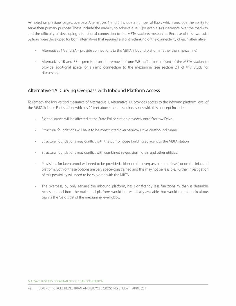

HALVORSON DESIGN PARTNERSHIP with ALTA | HDR | NITScH | EPSILON
AccELERATED BRIDGE PROGRAM | PEDESTRIAN + BIcycLE STuDy fOR PATHwAyS + BRIDGES | cHARLES RIVER BASIN 49
Alternative 1B Curving Overpass with WB Lane Removal
This alternative is able to provide access to the mezzanine level while meeting MassDOTrsquos minimum vertical clearance
of 165rsquo To do so one WB travel lane along the short block in front of the MBTA station would need to be removed in
order to relocate the curb to the south The pedestrian ramp would span parallel along the proposed widened curb
and then loop under the pedestrian overpass thus avoiding the lobby roof Issues with this alternative include
bull Sight distance will be affected at the State Police station driveway to Storrow Drive
bull Structural foundations may conflict with combined sewer storm drain and other utilities
MASSAcHuSETTS DEPARTMENT Of TRANSPORTATION
LEVERETT cIRcLE PEDESTRIAN AND BIcycLE cROSSING STuDy | APRIL 2011 50
HALVORSON DESIGN PARTNERSHIP with ALTA | HDR | NITScH | EPSILON
AccELERATED BRIDGE PROGRAM | PEDESTRIAN + BIcycLE STuDy fOR PATHwAyS + BRIDGES | cHARLES RIVER BASIN 51
Alternative 3A Partial Connection to MBTA Inbound Platform
In this concept ADA access is provided to the inbound platform level and also stairwell access to the mezzanine level
All vertical clearances are met in this alternative Issues include
bull Sight distance will be affected at the State Police station driveway to Storrow Drive
bull Structural foundations may conflict with combined sewer and other utilities
bull Structural foundations may be required over Storrow Drive Westbound tunnel
bull Provisions for fare-control will need to be provided either on the overpass structure itself or on the inbound
platform Both of these options are very space-constrained and this may not be feasible Further investigation
of this possibility will need to be explored with the MBTA
bull The overpass by providing ADA access to only the inbound platform has significantly less functionality than
is desirable Access to and from the outbound platform would be technically available but would require a
circuitous trip via the ldquopaid siderdquo of the mezzanine level lobby
MASSAcHuSETTS DEPARTMENT Of TRANSPORTATION
LEVERETT cIRcLE PEDESTRIAN AND BIcycLE cROSSING STuDy | APRIL 2011 52
HALVORSON DESIGN PARTNERSHIP with ALTA | HDR | NITScH | EPSILON
AccELERATED BRIDGE PROGRAM | PEDESTRIAN + BIcycLE STuDy fOR PATHwAyS + BRIDGES | cHARLES RIVER BASIN 53
Alternative 3B Partial Connection with WB Lane Removal
Like Alternative 1B this alternative is able to provide access to the mezzanine level while meeting the required
minimum vertical clearance of 165rsquo To do so one WB travel lane along the short block in front of the MBTA station
would need to be removed in order to relocate the curb to the south The pedestrian ramp would span parallel along
the proposed widened curb and then loop under the pedestrian overpass to avoid the lobby roof Issues include
bull Sight distance will be affected at the State Police station driveway to Storrow Drive
bull Structural foundations may conflict with storm drain and other utilities
bull Structural foundations may be required over the Storrow Drive WB tunnel
MASSAcHuSETTS DEPARTMENT Of TRANSPORTATION
LEVERETT cIRcLE PEDESTRIAN AND BIcycLE cROSSING STuDy | APRIL 2011 54
HALVORSON DESIGN PARTNERSHIP with ALTA | HDR | NITScH | EPSILON
AccELERATED BRIDGE PROGRAM | PEDESTRIAN + BIcycLE STuDy fOR PATHwAyS + BRIDGES | cHARLES RIVER BASIN 55
Based on the criteria discussed in section 42 of this report the five workable design alternatives (1A 1B 2 3A
and 3B) were evaluated using a 1-5 scale with 1 as poor 3 as fair and 5 as excellent The evaluation assumes that the
proposed at-grade improvements would be incorporated in all five potential overpass alternatives
Criteria At-grade only Alt 1A amp 1B Alt 2 Alt 3A amp 3B
Safety for all Users 4 5 5 5
Security of all Users 5 3 3 4
Perception of Required Out-of-direction Travel 5 4 2 4
Length of Travel for Non-motorized Users 5 4 3 4
Time of Travel for Non-Motorized Users 3-5 4 4 3-5
(including expected wait time at signals)
Constructability and cost (bridge structure utilities signals etc) 5 1 1 3
Sight Line Considerations (obstruction issues shadows etc) 5 3 3 4
Overall Pedestrian Accommodation and Convenience 3 5 5 5
Overall Bicycle Accommodation and Convenience 3 5 5 3
Functionality of Intersection for all Users 4 5 4 5
Operational Impacts on Vehicular Movements 4 4 4 4
Aesthetic Impacts to Intersection 5 3 2 3
TOTAL 51-53 46 41 47-49
MASSAcHuSETTS DEPARTMENT Of TRANSPORTATION
LEVERETT cIRcLE PEDESTRIAN AND BIcycLE cROSSING STuDy | APRIL 2011 56
53 Option 3 PedestrianBike Overpass with minimal at-grade pedestrian connections
The third option for Leverett circle is to develop a new pedestrianbike overpass (based on workable alternatives
1A 1B and 2 discussed above) and retain only the minimum at-grade pedestrian connections This would require
the removal of most of the existing crosswalks curb-cuts and pedestrian crossing signal heads within the two
intersections The crosswalkscurb cuts retained would be those that cross OrsquoBrien Highway (on the west side of the
intersection) and Nashua Street These two crosswalks would provide pedestrian and bike connections from Nashua
Street Park to the charles River Esplanade and to the MBTA station The pair would also provide a secondary route
tofrom the southwest corner of the intersection in front of the State Police Station to the MBTA station for those
who chose to remain at-grade To mitigate the desire to cross at-grade after pedestrian facilities have been removed
barriers (fencing and dense landscaping) will be needed to ensure that pedestrians use the overpass structure
It is important to note that with the removal of most at-grade pedestrian connections there will be no apparent
benefit to traffic capacity or LOS This is because none of the existing WALK signals prevent potential non-conflicting
traffic movements from occurring The most apparent benefit of removing most at-grade pedestrian facilities would
be to reduce conflicts between pedestrian and motor vehicles If all walkers (and some bicyclists) were to use the
potential overpass the number of pedestrianvehiclebicycle crashes would be expected to decrease This would
need to be balanced against 1) the additional walking time required to cross Leverett Circle and 2) the potential that
even with efforts to physically discourage or prevent inappropriate at-grade crossing (with fencing or landscaping for
example) some jaywalking would be likely
Option 3 diagram showing potential removal of at-grade pedestrian connections
HALVORSON DESIGN PARTNERSHIP with ALTA | HDR | NITScH | EPSILON
AccELERATED BRIDGE PROGRAM | PEDESTRIAN + BIcycLE STuDy fOR PATHwAyS + BRIDGES | cHARLES RIVER BASIN 57
6 SUMMARY
6 Summary
The key goals of the Leverett circle Pedestrian and Bicycle crossing Study were to analyze the conditions at Leverett
circle and study both at-grade and grade-separated bicycle and pedestrian safety enhancements The scope of
the study included the development of concepts and an initial feasibility assessment of pedestrian and cyclist
improvements at Leverett circle including evaluation of existing conditions and circulation patterns evaluation of
potential enhancements to existing at-grade crossings potential new grade-separated crossings and associated
elimination of at-grade connections and some combinations of at-grade and grade-separated crossings based on
current MassDOT standards
Based on the existing conditions analysis crash data and field observations of motorist bicyclist and pedestrian
behavior it is clear that a number of potentially feasible at-grade improvements are possible These would enhance
connectivity and safety for non-motorized users of Leverett circle with no or minimal impacts to vehicle circulation or
intersection LOS These low and modest-cost improvements could be done relatively quickly and include
bull Signal enhancements
bull Pedestrian count-down timers in a number of locations
bull Better signage
bull Updated crosswalk markings
bull Relocation of the OrsquoBrien Hwy crosswalk in front of the MBTA Science Park station to the east of the double
left turn lanes from charles Street
bull Potential movement of curb line in front of the MBTA station
Even with the incorporation of the enhancements listed above concern over pedestrian safety is likely to remain
The cities of Boston and cambridge and community groups may still express the desire for a grade-separated
environment for the elderly the disabled and groups of children crossing Leverett circle tofrom the west End the
Esplanade and the MBTA station
for users whose route requires them to cross completely from the Police Station corner to the west End corner (ie
for whom the MBTA station is not a destination) it is difficult to predict what percentage would choose the overpass
option if an at-grade option was also available
As discussed in Section 4 available research suggests that a perceived ldquoconvenience factorrdquo can be calculated
to consider usersrsquo perceptions of how long the at-grade route would take compared with the grade-separated
alternative In analyzing the several Leverett circle overpass options presented in Section 5 this perceived
ldquoconveniencerdquo of an overpass is relatively low when compared with the minimum duration of crossing at-grade
However the overpass convenience values are considerably higher if the maximum likely at-grade crossing time is
considered In other words if someone arriving at the intersection just misses the crossing signal theyrsquore more likely
to choose the overpass because travel time across the intersection will be very similar to waiting for the next at-grade
opportunity conversely there are times in the signal cycle when a pedestrian arriving at the intersection will be able
to cross at-grade up to 3 times faster (depending on overpass option) than using an overpass
If a pedestrianbike overpass is built at this location case studies from other communities and the pedestrian crossing
distance and time analysis implies that the most likely user of the overpass would be those traveling to and from the
MBTA station Because the final destination is elevatedmdashthe station mezzanine levelmdashand the travel time would be
HALVORSON DESIGN PARTNERSHIP with ALTA | HDR | NITScH | EPSILON
AccELERATED BRIDGE PROGRAM | PEDESTRIAN + BIcycLE STuDy fOR PATHwAyS + BRIDGES | cHARLES RIVER BASIN 59
comparable to crossing at-grade many people of all abilities are likely to use the overpass especially if coming to or
from the southwest corner of the intersection
The primary beneficiaries of the proposed at-grade improvements are those wishing to travel between the MBTA
station and the west End Additionally the evaluation matrix at the end of section 52 points to the possibility of
satisfying nearly all of the connectivity and safety goals with a partial overpass over Leverett circle
MASSAcHuSETTS DEPARTMENT Of TRANSPORTATION
LEVERETT cIRcLE PEDESTRIAN AND BIcycLE cROSSING STuDy | APRIL 2011 60
- LeverettCirRept-Cover-etc
- Dividerspdf
- LeverettCirRept-Chapt1
-

HALVORSON DESIGN PARTNERSHIP with ALTA | HDR | NITScH | EPSILON
AccELERATED BRIDGE PROGRAM | PEDESTRIAN + BIcycLE STuDy fOR PATHwAyS + BRIDGES | cHARLES RIVER BASIN 51
Alternative 3A Partial Connection to MBTA Inbound Platform
In this concept ADA access is provided to the inbound platform level and also stairwell access to the mezzanine level
All vertical clearances are met in this alternative Issues include
bull Sight distance will be affected at the State Police station driveway to Storrow Drive
bull Structural foundations may conflict with combined sewer and other utilities
bull Structural foundations may be required over Storrow Drive Westbound tunnel
bull Provisions for fare-control will need to be provided either on the overpass structure itself or on the inbound
platform Both of these options are very space-constrained and this may not be feasible Further investigation
of this possibility will need to be explored with the MBTA
bull The overpass by providing ADA access to only the inbound platform has significantly less functionality than
is desirable Access to and from the outbound platform would be technically available but would require a
circuitous trip via the ldquopaid siderdquo of the mezzanine level lobby
MASSAcHuSETTS DEPARTMENT Of TRANSPORTATION
LEVERETT cIRcLE PEDESTRIAN AND BIcycLE cROSSING STuDy | APRIL 2011 52
HALVORSON DESIGN PARTNERSHIP with ALTA | HDR | NITScH | EPSILON
AccELERATED BRIDGE PROGRAM | PEDESTRIAN + BIcycLE STuDy fOR PATHwAyS + BRIDGES | cHARLES RIVER BASIN 53
Alternative 3B Partial Connection with WB Lane Removal
Like Alternative 1B this alternative is able to provide access to the mezzanine level while meeting the required
minimum vertical clearance of 165rsquo To do so one WB travel lane along the short block in front of the MBTA station
would need to be removed in order to relocate the curb to the south The pedestrian ramp would span parallel along
the proposed widened curb and then loop under the pedestrian overpass to avoid the lobby roof Issues include
bull Sight distance will be affected at the State Police station driveway to Storrow Drive
bull Structural foundations may conflict with storm drain and other utilities
bull Structural foundations may be required over the Storrow Drive WB tunnel
MASSAcHuSETTS DEPARTMENT Of TRANSPORTATION
LEVERETT cIRcLE PEDESTRIAN AND BIcycLE cROSSING STuDy | APRIL 2011 54
HALVORSON DESIGN PARTNERSHIP with ALTA | HDR | NITScH | EPSILON
AccELERATED BRIDGE PROGRAM | PEDESTRIAN + BIcycLE STuDy fOR PATHwAyS + BRIDGES | cHARLES RIVER BASIN 55
Based on the criteria discussed in section 42 of this report the five workable design alternatives (1A 1B 2 3A
and 3B) were evaluated using a 1-5 scale with 1 as poor 3 as fair and 5 as excellent The evaluation assumes that the
proposed at-grade improvements would be incorporated in all five potential overpass alternatives
Criteria At-grade only Alt 1A amp 1B Alt 2 Alt 3A amp 3B
Safety for all Users 4 5 5 5
Security of all Users 5 3 3 4
Perception of Required Out-of-direction Travel 5 4 2 4
Length of Travel for Non-motorized Users 5 4 3 4
Time of Travel for Non-Motorized Users 3-5 4 4 3-5
(including expected wait time at signals)
Constructability and cost (bridge structure utilities signals etc) 5 1 1 3
Sight Line Considerations (obstruction issues shadows etc) 5 3 3 4
Overall Pedestrian Accommodation and Convenience 3 5 5 5
Overall Bicycle Accommodation and Convenience 3 5 5 3
Functionality of Intersection for all Users 4 5 4 5
Operational Impacts on Vehicular Movements 4 4 4 4
Aesthetic Impacts to Intersection 5 3 2 3
TOTAL 51-53 46 41 47-49
MASSAcHuSETTS DEPARTMENT Of TRANSPORTATION
LEVERETT cIRcLE PEDESTRIAN AND BIcycLE cROSSING STuDy | APRIL 2011 56
53 Option 3 PedestrianBike Overpass with minimal at-grade pedestrian connections
The third option for Leverett circle is to develop a new pedestrianbike overpass (based on workable alternatives
1A 1B and 2 discussed above) and retain only the minimum at-grade pedestrian connections This would require
the removal of most of the existing crosswalks curb-cuts and pedestrian crossing signal heads within the two
intersections The crosswalkscurb cuts retained would be those that cross OrsquoBrien Highway (on the west side of the
intersection) and Nashua Street These two crosswalks would provide pedestrian and bike connections from Nashua
Street Park to the charles River Esplanade and to the MBTA station The pair would also provide a secondary route
tofrom the southwest corner of the intersection in front of the State Police Station to the MBTA station for those
who chose to remain at-grade To mitigate the desire to cross at-grade after pedestrian facilities have been removed
barriers (fencing and dense landscaping) will be needed to ensure that pedestrians use the overpass structure
It is important to note that with the removal of most at-grade pedestrian connections there will be no apparent
benefit to traffic capacity or LOS This is because none of the existing WALK signals prevent potential non-conflicting
traffic movements from occurring The most apparent benefit of removing most at-grade pedestrian facilities would
be to reduce conflicts between pedestrian and motor vehicles If all walkers (and some bicyclists) were to use the
potential overpass the number of pedestrianvehiclebicycle crashes would be expected to decrease This would
need to be balanced against 1) the additional walking time required to cross Leverett Circle and 2) the potential that
even with efforts to physically discourage or prevent inappropriate at-grade crossing (with fencing or landscaping for
example) some jaywalking would be likely
Option 3 diagram showing potential removal of at-grade pedestrian connections
HALVORSON DESIGN PARTNERSHIP with ALTA | HDR | NITScH | EPSILON
AccELERATED BRIDGE PROGRAM | PEDESTRIAN + BIcycLE STuDy fOR PATHwAyS + BRIDGES | cHARLES RIVER BASIN 57
6 SUMMARY
6 Summary
The key goals of the Leverett circle Pedestrian and Bicycle crossing Study were to analyze the conditions at Leverett
circle and study both at-grade and grade-separated bicycle and pedestrian safety enhancements The scope of
the study included the development of concepts and an initial feasibility assessment of pedestrian and cyclist
improvements at Leverett circle including evaluation of existing conditions and circulation patterns evaluation of
potential enhancements to existing at-grade crossings potential new grade-separated crossings and associated
elimination of at-grade connections and some combinations of at-grade and grade-separated crossings based on
current MassDOT standards
Based on the existing conditions analysis crash data and field observations of motorist bicyclist and pedestrian
behavior it is clear that a number of potentially feasible at-grade improvements are possible These would enhance
connectivity and safety for non-motorized users of Leverett circle with no or minimal impacts to vehicle circulation or
intersection LOS These low and modest-cost improvements could be done relatively quickly and include
bull Signal enhancements
bull Pedestrian count-down timers in a number of locations
bull Better signage
bull Updated crosswalk markings
bull Relocation of the OrsquoBrien Hwy crosswalk in front of the MBTA Science Park station to the east of the double
left turn lanes from charles Street
bull Potential movement of curb line in front of the MBTA station
Even with the incorporation of the enhancements listed above concern over pedestrian safety is likely to remain
The cities of Boston and cambridge and community groups may still express the desire for a grade-separated
environment for the elderly the disabled and groups of children crossing Leverett circle tofrom the west End the
Esplanade and the MBTA station
for users whose route requires them to cross completely from the Police Station corner to the west End corner (ie
for whom the MBTA station is not a destination) it is difficult to predict what percentage would choose the overpass
option if an at-grade option was also available
As discussed in Section 4 available research suggests that a perceived ldquoconvenience factorrdquo can be calculated
to consider usersrsquo perceptions of how long the at-grade route would take compared with the grade-separated
alternative In analyzing the several Leverett circle overpass options presented in Section 5 this perceived
ldquoconveniencerdquo of an overpass is relatively low when compared with the minimum duration of crossing at-grade
However the overpass convenience values are considerably higher if the maximum likely at-grade crossing time is
considered In other words if someone arriving at the intersection just misses the crossing signal theyrsquore more likely
to choose the overpass because travel time across the intersection will be very similar to waiting for the next at-grade
opportunity conversely there are times in the signal cycle when a pedestrian arriving at the intersection will be able
to cross at-grade up to 3 times faster (depending on overpass option) than using an overpass
If a pedestrianbike overpass is built at this location case studies from other communities and the pedestrian crossing
distance and time analysis implies that the most likely user of the overpass would be those traveling to and from the
MBTA station Because the final destination is elevatedmdashthe station mezzanine levelmdashand the travel time would be
HALVORSON DESIGN PARTNERSHIP with ALTA | HDR | NITScH | EPSILON
AccELERATED BRIDGE PROGRAM | PEDESTRIAN + BIcycLE STuDy fOR PATHwAyS + BRIDGES | cHARLES RIVER BASIN 59
comparable to crossing at-grade many people of all abilities are likely to use the overpass especially if coming to or
from the southwest corner of the intersection
The primary beneficiaries of the proposed at-grade improvements are those wishing to travel between the MBTA
station and the west End Additionally the evaluation matrix at the end of section 52 points to the possibility of
satisfying nearly all of the connectivity and safety goals with a partial overpass over Leverett circle
MASSAcHuSETTS DEPARTMENT Of TRANSPORTATION
LEVERETT cIRcLE PEDESTRIAN AND BIcycLE cROSSING STuDy | APRIL 2011 60
- LeverettCirRept-Cover-etc
- Dividerspdf
- LeverettCirRept-Chapt1
-

HALVORSON DESIGN PARTNERSHIP with ALTA | HDR | NITScH | EPSILON
AccELERATED BRIDGE PROGRAM | PEDESTRIAN + BIcycLE STuDy fOR PATHwAyS + BRIDGES | cHARLES RIVER BASIN 53
Alternative 3B Partial Connection with WB Lane Removal
Like Alternative 1B this alternative is able to provide access to the mezzanine level while meeting the required
minimum vertical clearance of 165rsquo To do so one WB travel lane along the short block in front of the MBTA station
would need to be removed in order to relocate the curb to the south The pedestrian ramp would span parallel along
the proposed widened curb and then loop under the pedestrian overpass to avoid the lobby roof Issues include
bull Sight distance will be affected at the State Police station driveway to Storrow Drive
bull Structural foundations may conflict with storm drain and other utilities
bull Structural foundations may be required over the Storrow Drive WB tunnel
MASSAcHuSETTS DEPARTMENT Of TRANSPORTATION
LEVERETT cIRcLE PEDESTRIAN AND BIcycLE cROSSING STuDy | APRIL 2011 54
HALVORSON DESIGN PARTNERSHIP with ALTA | HDR | NITScH | EPSILON
AccELERATED BRIDGE PROGRAM | PEDESTRIAN + BIcycLE STuDy fOR PATHwAyS + BRIDGES | cHARLES RIVER BASIN 55
Based on the criteria discussed in section 42 of this report the five workable design alternatives (1A 1B 2 3A
and 3B) were evaluated using a 1-5 scale with 1 as poor 3 as fair and 5 as excellent The evaluation assumes that the
proposed at-grade improvements would be incorporated in all five potential overpass alternatives
Criteria At-grade only Alt 1A amp 1B Alt 2 Alt 3A amp 3B
Safety for all Users 4 5 5 5
Security of all Users 5 3 3 4
Perception of Required Out-of-direction Travel 5 4 2 4
Length of Travel for Non-motorized Users 5 4 3 4
Time of Travel for Non-Motorized Users 3-5 4 4 3-5
(including expected wait time at signals)
Constructability and cost (bridge structure utilities signals etc) 5 1 1 3
Sight Line Considerations (obstruction issues shadows etc) 5 3 3 4
Overall Pedestrian Accommodation and Convenience 3 5 5 5
Overall Bicycle Accommodation and Convenience 3 5 5 3
Functionality of Intersection for all Users 4 5 4 5
Operational Impacts on Vehicular Movements 4 4 4 4
Aesthetic Impacts to Intersection 5 3 2 3
TOTAL 51-53 46 41 47-49
MASSAcHuSETTS DEPARTMENT Of TRANSPORTATION
LEVERETT cIRcLE PEDESTRIAN AND BIcycLE cROSSING STuDy | APRIL 2011 56
53 Option 3 PedestrianBike Overpass with minimal at-grade pedestrian connections
The third option for Leverett circle is to develop a new pedestrianbike overpass (based on workable alternatives
1A 1B and 2 discussed above) and retain only the minimum at-grade pedestrian connections This would require
the removal of most of the existing crosswalks curb-cuts and pedestrian crossing signal heads within the two
intersections The crosswalkscurb cuts retained would be those that cross OrsquoBrien Highway (on the west side of the
intersection) and Nashua Street These two crosswalks would provide pedestrian and bike connections from Nashua
Street Park to the charles River Esplanade and to the MBTA station The pair would also provide a secondary route
tofrom the southwest corner of the intersection in front of the State Police Station to the MBTA station for those
who chose to remain at-grade To mitigate the desire to cross at-grade after pedestrian facilities have been removed
barriers (fencing and dense landscaping) will be needed to ensure that pedestrians use the overpass structure
It is important to note that with the removal of most at-grade pedestrian connections there will be no apparent
benefit to traffic capacity or LOS This is because none of the existing WALK signals prevent potential non-conflicting
traffic movements from occurring The most apparent benefit of removing most at-grade pedestrian facilities would
be to reduce conflicts between pedestrian and motor vehicles If all walkers (and some bicyclists) were to use the
potential overpass the number of pedestrianvehiclebicycle crashes would be expected to decrease This would
need to be balanced against 1) the additional walking time required to cross Leverett Circle and 2) the potential that
even with efforts to physically discourage or prevent inappropriate at-grade crossing (with fencing or landscaping for
example) some jaywalking would be likely
Option 3 diagram showing potential removal of at-grade pedestrian connections
HALVORSON DESIGN PARTNERSHIP with ALTA | HDR | NITScH | EPSILON
AccELERATED BRIDGE PROGRAM | PEDESTRIAN + BIcycLE STuDy fOR PATHwAyS + BRIDGES | cHARLES RIVER BASIN 57
6 SUMMARY
6 Summary
The key goals of the Leverett circle Pedestrian and Bicycle crossing Study were to analyze the conditions at Leverett
circle and study both at-grade and grade-separated bicycle and pedestrian safety enhancements The scope of
the study included the development of concepts and an initial feasibility assessment of pedestrian and cyclist
improvements at Leverett circle including evaluation of existing conditions and circulation patterns evaluation of
potential enhancements to existing at-grade crossings potential new grade-separated crossings and associated
elimination of at-grade connections and some combinations of at-grade and grade-separated crossings based on
current MassDOT standards
Based on the existing conditions analysis crash data and field observations of motorist bicyclist and pedestrian
behavior it is clear that a number of potentially feasible at-grade improvements are possible These would enhance
connectivity and safety for non-motorized users of Leverett circle with no or minimal impacts to vehicle circulation or
intersection LOS These low and modest-cost improvements could be done relatively quickly and include
bull Signal enhancements
bull Pedestrian count-down timers in a number of locations
bull Better signage
bull Updated crosswalk markings
bull Relocation of the OrsquoBrien Hwy crosswalk in front of the MBTA Science Park station to the east of the double
left turn lanes from charles Street
bull Potential movement of curb line in front of the MBTA station
Even with the incorporation of the enhancements listed above concern over pedestrian safety is likely to remain
The cities of Boston and cambridge and community groups may still express the desire for a grade-separated
environment for the elderly the disabled and groups of children crossing Leverett circle tofrom the west End the
Esplanade and the MBTA station
for users whose route requires them to cross completely from the Police Station corner to the west End corner (ie
for whom the MBTA station is not a destination) it is difficult to predict what percentage would choose the overpass
option if an at-grade option was also available
As discussed in Section 4 available research suggests that a perceived ldquoconvenience factorrdquo can be calculated
to consider usersrsquo perceptions of how long the at-grade route would take compared with the grade-separated
alternative In analyzing the several Leverett circle overpass options presented in Section 5 this perceived
ldquoconveniencerdquo of an overpass is relatively low when compared with the minimum duration of crossing at-grade
However the overpass convenience values are considerably higher if the maximum likely at-grade crossing time is
considered In other words if someone arriving at the intersection just misses the crossing signal theyrsquore more likely
to choose the overpass because travel time across the intersection will be very similar to waiting for the next at-grade
opportunity conversely there are times in the signal cycle when a pedestrian arriving at the intersection will be able
to cross at-grade up to 3 times faster (depending on overpass option) than using an overpass
If a pedestrianbike overpass is built at this location case studies from other communities and the pedestrian crossing
distance and time analysis implies that the most likely user of the overpass would be those traveling to and from the
MBTA station Because the final destination is elevatedmdashthe station mezzanine levelmdashand the travel time would be
HALVORSON DESIGN PARTNERSHIP with ALTA | HDR | NITScH | EPSILON
AccELERATED BRIDGE PROGRAM | PEDESTRIAN + BIcycLE STuDy fOR PATHwAyS + BRIDGES | cHARLES RIVER BASIN 59
comparable to crossing at-grade many people of all abilities are likely to use the overpass especially if coming to or
from the southwest corner of the intersection
The primary beneficiaries of the proposed at-grade improvements are those wishing to travel between the MBTA
station and the west End Additionally the evaluation matrix at the end of section 52 points to the possibility of
satisfying nearly all of the connectivity and safety goals with a partial overpass over Leverett circle
MASSAcHuSETTS DEPARTMENT Of TRANSPORTATION
LEVERETT cIRcLE PEDESTRIAN AND BIcycLE cROSSING STuDy | APRIL 2011 60
- LeverettCirRept-Cover-etc
- Dividerspdf
- LeverettCirRept-Chapt1
-

HALVORSON DESIGN PARTNERSHIP with ALTA | HDR | NITScH | EPSILON
AccELERATED BRIDGE PROGRAM | PEDESTRIAN + BIcycLE STuDy fOR PATHwAyS + BRIDGES | cHARLES RIVER BASIN 55
Based on the criteria discussed in section 42 of this report the five workable design alternatives (1A 1B 2 3A
and 3B) were evaluated using a 1-5 scale with 1 as poor 3 as fair and 5 as excellent The evaluation assumes that the
proposed at-grade improvements would be incorporated in all five potential overpass alternatives
Criteria At-grade only Alt 1A amp 1B Alt 2 Alt 3A amp 3B
Safety for all Users 4 5 5 5
Security of all Users 5 3 3 4
Perception of Required Out-of-direction Travel 5 4 2 4
Length of Travel for Non-motorized Users 5 4 3 4
Time of Travel for Non-Motorized Users 3-5 4 4 3-5
(including expected wait time at signals)
Constructability and cost (bridge structure utilities signals etc) 5 1 1 3
Sight Line Considerations (obstruction issues shadows etc) 5 3 3 4
Overall Pedestrian Accommodation and Convenience 3 5 5 5
Overall Bicycle Accommodation and Convenience 3 5 5 3
Functionality of Intersection for all Users 4 5 4 5
Operational Impacts on Vehicular Movements 4 4 4 4
Aesthetic Impacts to Intersection 5 3 2 3
TOTAL 51-53 46 41 47-49
MASSAcHuSETTS DEPARTMENT Of TRANSPORTATION
LEVERETT cIRcLE PEDESTRIAN AND BIcycLE cROSSING STuDy | APRIL 2011 56
53 Option 3 PedestrianBike Overpass with minimal at-grade pedestrian connections
The third option for Leverett circle is to develop a new pedestrianbike overpass (based on workable alternatives
1A 1B and 2 discussed above) and retain only the minimum at-grade pedestrian connections This would require
the removal of most of the existing crosswalks curb-cuts and pedestrian crossing signal heads within the two
intersections The crosswalkscurb cuts retained would be those that cross OrsquoBrien Highway (on the west side of the
intersection) and Nashua Street These two crosswalks would provide pedestrian and bike connections from Nashua
Street Park to the charles River Esplanade and to the MBTA station The pair would also provide a secondary route
tofrom the southwest corner of the intersection in front of the State Police Station to the MBTA station for those
who chose to remain at-grade To mitigate the desire to cross at-grade after pedestrian facilities have been removed
barriers (fencing and dense landscaping) will be needed to ensure that pedestrians use the overpass structure
It is important to note that with the removal of most at-grade pedestrian connections there will be no apparent
benefit to traffic capacity or LOS This is because none of the existing WALK signals prevent potential non-conflicting
traffic movements from occurring The most apparent benefit of removing most at-grade pedestrian facilities would
be to reduce conflicts between pedestrian and motor vehicles If all walkers (and some bicyclists) were to use the
potential overpass the number of pedestrianvehiclebicycle crashes would be expected to decrease This would
need to be balanced against 1) the additional walking time required to cross Leverett Circle and 2) the potential that
even with efforts to physically discourage or prevent inappropriate at-grade crossing (with fencing or landscaping for
example) some jaywalking would be likely
Option 3 diagram showing potential removal of at-grade pedestrian connections
HALVORSON DESIGN PARTNERSHIP with ALTA | HDR | NITScH | EPSILON
AccELERATED BRIDGE PROGRAM | PEDESTRIAN + BIcycLE STuDy fOR PATHwAyS + BRIDGES | cHARLES RIVER BASIN 57
6 SUMMARY
6 Summary
The key goals of the Leverett circle Pedestrian and Bicycle crossing Study were to analyze the conditions at Leverett
circle and study both at-grade and grade-separated bicycle and pedestrian safety enhancements The scope of
the study included the development of concepts and an initial feasibility assessment of pedestrian and cyclist
improvements at Leverett circle including evaluation of existing conditions and circulation patterns evaluation of
potential enhancements to existing at-grade crossings potential new grade-separated crossings and associated
elimination of at-grade connections and some combinations of at-grade and grade-separated crossings based on
current MassDOT standards
Based on the existing conditions analysis crash data and field observations of motorist bicyclist and pedestrian
behavior it is clear that a number of potentially feasible at-grade improvements are possible These would enhance
connectivity and safety for non-motorized users of Leverett circle with no or minimal impacts to vehicle circulation or
intersection LOS These low and modest-cost improvements could be done relatively quickly and include
bull Signal enhancements
bull Pedestrian count-down timers in a number of locations
bull Better signage
bull Updated crosswalk markings
bull Relocation of the OrsquoBrien Hwy crosswalk in front of the MBTA Science Park station to the east of the double
left turn lanes from charles Street
bull Potential movement of curb line in front of the MBTA station
Even with the incorporation of the enhancements listed above concern over pedestrian safety is likely to remain
The cities of Boston and cambridge and community groups may still express the desire for a grade-separated
environment for the elderly the disabled and groups of children crossing Leverett circle tofrom the west End the
Esplanade and the MBTA station
for users whose route requires them to cross completely from the Police Station corner to the west End corner (ie
for whom the MBTA station is not a destination) it is difficult to predict what percentage would choose the overpass
option if an at-grade option was also available
As discussed in Section 4 available research suggests that a perceived ldquoconvenience factorrdquo can be calculated
to consider usersrsquo perceptions of how long the at-grade route would take compared with the grade-separated
alternative In analyzing the several Leverett circle overpass options presented in Section 5 this perceived
ldquoconveniencerdquo of an overpass is relatively low when compared with the minimum duration of crossing at-grade
However the overpass convenience values are considerably higher if the maximum likely at-grade crossing time is
considered In other words if someone arriving at the intersection just misses the crossing signal theyrsquore more likely
to choose the overpass because travel time across the intersection will be very similar to waiting for the next at-grade
opportunity conversely there are times in the signal cycle when a pedestrian arriving at the intersection will be able
to cross at-grade up to 3 times faster (depending on overpass option) than using an overpass
If a pedestrianbike overpass is built at this location case studies from other communities and the pedestrian crossing
distance and time analysis implies that the most likely user of the overpass would be those traveling to and from the
MBTA station Because the final destination is elevatedmdashthe station mezzanine levelmdashand the travel time would be
HALVORSON DESIGN PARTNERSHIP with ALTA | HDR | NITScH | EPSILON
AccELERATED BRIDGE PROGRAM | PEDESTRIAN + BIcycLE STuDy fOR PATHwAyS + BRIDGES | cHARLES RIVER BASIN 59
comparable to crossing at-grade many people of all abilities are likely to use the overpass especially if coming to or
from the southwest corner of the intersection
The primary beneficiaries of the proposed at-grade improvements are those wishing to travel between the MBTA
station and the west End Additionally the evaluation matrix at the end of section 52 points to the possibility of
satisfying nearly all of the connectivity and safety goals with a partial overpass over Leverett circle
MASSAcHuSETTS DEPARTMENT Of TRANSPORTATION
LEVERETT cIRcLE PEDESTRIAN AND BIcycLE cROSSING STuDy | APRIL 2011 60
- LeverettCirRept-Cover-etc
- Dividerspdf
- LeverettCirRept-Chapt1
-
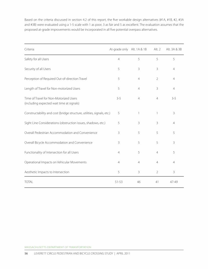