character appraisal study and boundary review of the
TRANSCRIPT
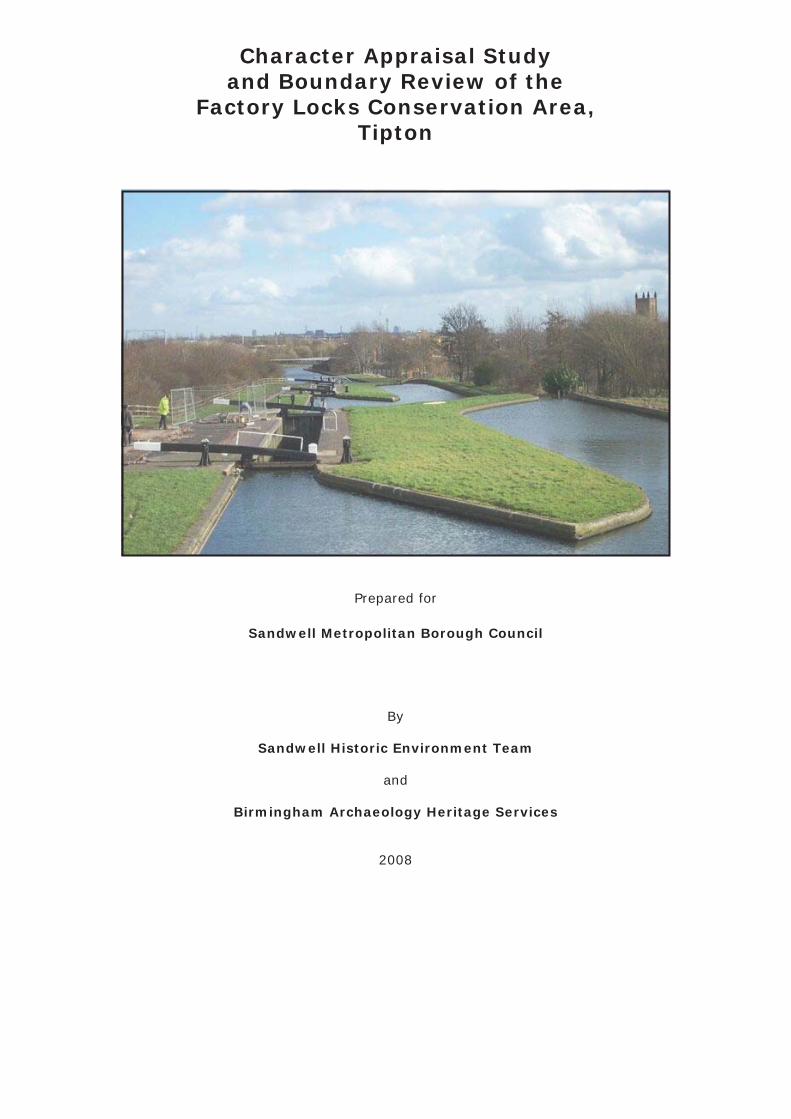
Character Appraisal Studyand Boundary Review of the
Factory Locks Conservation Area,Tipton
Prepared for
Sandwell Metropolitan Borough Council
By
Sandwell Historic Environment Team
and
Birmingham Archaeology Heritage Services
2008
Character Appraisal Study and Boundary Review of the Factory Locks Conservation Area, Tipton
CONTENTS
1.0 INTRODUCTION
2.0 PLANNING POLICY CONTEXT
3.0 LOCATION AND SETTING
3.1 Location and Context3.2 General Character and Plan Form3.3 Landscape Setting
4.0 HISTORIC DEVELOPMENT AND ARCHAEOLOGY
4.1 The Origins and Historic Development of the Area 4.2 The Factory Locks Conservation Area 4.3 The Morphology of the Area 4.4 Archaeology
5.0 SPATIAL ANALYSIS
5.1 The Character and Interrelationship of Spaces within the Area 5.2 Key Views and Vistas
6.0 CHARACTER ANALYSIS
6.1 Defi nition of the Character Areas (Zones)6.2 Activity within the Area, and its Infl uences6.3 Architectural and Historic Qualities of the Buildings 6.4 The Contribution of Key Unlisted Buildings6.5 Local Details6.6 Prevalent and Traditional Building Materials6.7 Audit of Heritage Assets6.8 Contribution made by Greenery and Green Spaces6.9 Negative Factors 6.10 Neutral Areas6.11 General Condition6.12 Problems, Pressures and Capacity for Change
7.0 SUGGESTED BOUNDARY CHANGES
8.0 LOCAL GENERIC GUIDANCE
8.1 Opportunities for Enhancement8.2 Planning Policy and Guidance8.3 Protection, Restoration and Enhancement8.4 Potential HERS and THI Projects8.5 Research Strategy for Archaeological Evaluation and Historic Building Recording
APPENDICES
1 Audit of Heritage Assets 2 SMR Summary Sheet
ILLUSTRATIONS
Maps
1. Factory Locks Conservation Area2. Appraisal and Boundary Review Study Area3. 1826 Tipton Parish4. 1849 Fowler5. 1887 Ordnance Survey6. 1904 Ordnance Survey7. 1920 Ordnance Survey8. 1947 Ordnance Survey9. 1967 Ordnance Survey10. Study Area Zone Divisions11. Heritage Audit12. Green Areas
Plates
Frontispiece1. Factory Locks from the west2. Factory Footbridge3. Wood Street Footbridge4. Factory Road Bridge 5. Boat Gauging House6. Cantilever Footbridge7. Boatmen’s Mission8. Old Malthouse Stables9. The Old Line from Factory Road Bridge10. Factory Locks from Wood Street Footbridge11. New Line from Waterloo Road Footbridge12. Owen Street Bridge and Fountain Inn from the south13. Coronation Gardens from Owen Street Bridge14. Tipton Green Bridge from the south15. Line of Former Tipton Green Branch Canal from the east16. Line of Former Tipton Green Branch Canal from the west17. Area A from the south18. New Line from Waterloo Road Footbridge19. Tipton Railway Station20. Zone 3 from the southeast21. Fountain Inn22. Rounds Wharf House23. Anchor House, Castle Street24. Dudley Junction25. Former Tipton Green Branch Canal26. Tipton Conservative Club27. Wood Street Footbridge28. Factory Road Bridge29. Factory Footbridge30. Three Furnaces Roving Bridge31. Cast Iron Footbridge Approx 150m west of Waterloo Road32. Toll End Communication Canal Roving Bridge33. Watery Lane Junction Roving Bridge34. Tipton Green Bridge35. Birmingham New Road Bridge36. Boatmen’s Mission37. Barge and Barrel Public House38. Tipton Railway Station39. Canalside House, Factory Road40. Owen Street Public Conveniences41. 7 Castle Street42. Tipton Green Branch Lock Chamber43. Green Space 244. Green Space 3

45. Green Space 446. Green Space 547. Rubbish in canal48. Wood Street Footbridge49. Dudley Junction50. Pitchfork Bridge51. Watery Lane Bridge52. Boat Gauging House53. New Buildings on the Old Line54. The Old Malthouse Stables55. Boatmen’s Mission Dedication Stone56. Boat Gauging House57. Wood Street Footbridge
1.0 INTRODUCTION
This study report has been prepared by Graham Eyre-Morgan of Sandwell Historic Environment Team, and Malcolm Hislop and Shane Kelleher of Birmingham Archaeology Heritage Services in accordance with the requirements of Sandwell Metropolitan Borough Council entitled Brief for a Character Appraisal Study and Boundary Review of the Factory Locks, Tipton Conservation Area.
The purpose of the study to which this report relates has been to provide a comprehensive character assessment and objective appraisal of the current conservation area and surrounding area. The area of study, as defi ned within the briefi ng documentation, was therefore greater than the area covered by the current conservation area. The principal aim of this study has been to establish a conservation area boundary that is based upon robust defendable reasoning.
This study has been carried out in accordance with the guidelines set out by English Heritage in their publication entitled Guidance on Conservation Area Appraisals, dated August 2005. It has been framed by policies contained in the Unitary Development Plan for the Borough, (UDP 2004), and local policies and proposals set out in the Tipton Area Action Plan Submission Document.
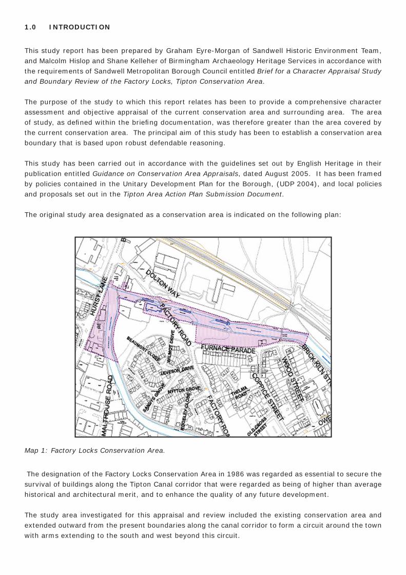
The original study area designated as a conservation area is indicated on the following plan:
Map 1: Factory Locks Conservation Area.
The designation of the Factory Locks Conservation Area in 1986 was regarded as essential to secure the survival of buildings along the Tipton Canal corridor that were regarded as being of higher than average historical and architectural merit, and to enhance the quality of any future development.
The study area investigated for this appraisal and review included the existing conservation area and extended outward from the present boundaries along the canal corridor to form a circuit around the town with arms extending to the south and west beyond this circuit.

Map 2: Appraisal and Boundary Review Study Area.
The study area boundaries were drawn by the Council, in their briefi ng documentation, more widely than the present conservation area to allow a full evaluation of the designated area. The Council were not aware of any problems, and had not received any objections, relating to the present boundary as set in 1986.
2.0 PLANNING POLICY CONTEXT
A conservation area is defi ned, by Section 69 (1) (a) of the Planning (Listed Buildings and Conservation Areas) Act 1990, as “an area of special architectural or historic interest the character or appearance of which it is desirable to preserve or enhance”.
Section 71 of the same Act places a duty of local planning authorities to formulate and publish proposals for the preservation and enhancement of conservation areas, to identify what it is about the character or appearance of the area which should be preserved or enhanced, and set out the means by which that objective is to be pursued.
Government policy on planning issues in relation to listed buildings and conservation areas is set out in Planning Policy Guidance: Planning and the Historic Environment (PPG 15). Section 4 deals with conservation areas.
English Heritage is the government’s statutory advisor on archaeology and the historic environment. They have produced a number of relevant guidance documents, two of their most recent statements being Guidance on Conservation Area Appraisals (2005) and Guidance on the Management of Conservation Areas (2005).
Relevant Council policy for conservation of the historic environment of Tipton is contained in the Unitary
Development Plan, which was formally adopted in April 2004 following a process of review. Conservation and Heritage policy C4 in the UDP (2004) declares that the Council will seek to retain and preserve “noteworthy buildings and structures which are a vital part of the local architecture and history and which contribute to the uniqueness of the locality. This will be achieved through a Local List of Buildings”. The Local List is being introduced for each of the six towns of the borough: Smethwick, Oldbury, Rowley Regis, Tipton, Wednesbury, and West Bromwich. The criteria for the selection of buildings for local listing has been approved by Cabinet, (minute 65/03, Cabinet Member for Urban Form refers). Local policies and proposals are set out in the Tipton Inset to the UDP (2004).
Under the new development plan regulations the Council has commenced its Local Development Framework. Of particular relevance to the study area is the Tipton A(rea) A(ction) P(lan) Submission Document, which lists under Strategic Objective No. 6: Safeguard and enhance local heritage assets, a clause to “protect and enhance the local heritage in the form of the canal network as a whole, especially that part within the designated Factory Locks Conservation Area.” The AAP Development Framework lays further emphasis on the signifi cance of canals and the linear open space network, which is largely based on former canals and railway lines, and acknowledges the need to maintain and enhance these areas. The character appraisal and boundary review of the Factory Locks Conservation Area is a specifi c aim of the Tipton AAP.
Tipton is expected to experience signifi cant growth and regeneration over the next few years with a number of planned and committed schemes identifi ed. The overall strategic policy approach being put forward through the Tipton AAP will be to build on this planned growth to re-establish the town centre as a Sub-Regional Town Centre. Thus the framework that will be established by the AAP is likely to identify further signifi cant opportunities for change.
3.0 LOCATION AND SETTING
3.1 Location and context
Tipton is a town with a population of around 47,000, one of the six towns that make up Sandwell Metropolitan Borough. Located halfway between Birmingham and Wolverhampton, it is part of the Black Country and the West Midlands conurbation. Much of the remaining historic fabric of the town bears testament to the part it played during the industrial age.
3.2 General character and plan form
The physical character of the present conservation area derives from its relationship with the extent of the Factory Locks run ning from Hurst Lane approximately 55m beyond Wood Street canal footbridge along the side of Brick Kiln Street. The length of the conservation area takes in part of the Birmingham Canal (Wolverhampton Level or Old Line) and Birmingham Canal (Birmingham Level or New Line). The present conservation area extends to protect historically signifi cant areas surrounding and connected to the length of the Factory Locks. Tipton was once known as the Venice of the Midlands because it had so many canals, although some of the ‘minor’ canals in the town were fi lled-in during the 1970s. The canals today form a vital cycling, wildlife and leisure facility.
3.3 Landscape setting
This conservation area is bounded to the north by industrial and warehouse buildings that are sandwiched between the canal and the railway. Some scrub and green space also manages to exist to the east of the
factory units and beyond the railway. Within the loop of the canals is mainly the modern development of the town of Tipton with two small areas of green space/scrubland adjacent to the canal.
The study area extends to the former canal that linked the Wolverhampton Level with the Birmingham Canal now forming a green walkway. The general area comprises mixed use industrial and domestic/residential with many of the industrial elements sitting directly along the canal side.
4.0 HISTORIC DEVELOPMENT OF THE STUDY AREA
4.1 The Origins and Historic Development of the Area
Until the 18th century, Tipton was a collection of small hamlets. A number of canals were built through the town, Tipton gained its fi rst canal in 1769 and the network grew to serve the expanding industries to such an extent that 13 miles of waterway ran within the parish boundary. This earned Tipton the epithet “Venice of the Midlands” or, as it is known locally, “Tip’n on the cut”. However, in the post-Second World War era with the loss of so much of its canal mileage the phrase was hijacked by Birmingham and the wider West Midlands.
It was this great canal system and later the arrival of the railways which greatly accelerated the pace of industrialization. Industrial growth started in the town when ironstone and coal were discovered in the 1770s. Coal from Tipton helped to keep Britain’s wheels moving for many years and, as a tribute to its importance, a huge lump of coal (weighing some 6 tons) was displayed at the Great Exhibition of 1851.
The engineer James Watt built his fi rst steam engine in or very near Tipton in the 1770s, which was used to pump water from the mines. In 1780, James Kier and Alexander Blair set up a chemical works there, making vast quantities of alkali and soap.
Tiptonians are proud of their history for they can boast many achievements. The most notable was the production of the world’s fi rst iron steamship, the Aaron Manby, which was constructed at the Horsley ironworks in 1822, and which spent many years plying the River Seine in France. The Horsley Ironworks was also noted for the manufacture of iron bridges which were sent all over the world.
In the 1830s the Tipton “Iron Master” Joseph Hall, pioneered a new process of making iron at the Bloomfi eld ironworks, later celebrated for its superior brand of iron known as BBH.
The massive expansion in iron and coal industries led to the population of Tipton expanding rapidly through the 19th century, going from 4,000 at the beginning of the century to 30,000 at the end. Tipton gained a reputation as being “the quintessence of the Black Country” because chimneys of local factories belched heavy pollution into the air, whilst houses and factories were built side by side. Most of the traditional industries which once dominated the town have since disappeared.
4.2 The Factory Locks Conservation Area
The present conservation area sits on Telford’s New Line (Birmingham Level) of the Birmingham Canal which was constructed in 1826. This new main line runs from near Smethwick Locks and rejoins the Old Line at Hurst Lane, Tipton, immediately after passing through Factory Top Lock. The name ‘Factory’ refers to the James Kier alkali works adjacent on Factory Road. The Factory Locks have served as a major focus for canal life, with its canal function and locks slowing the boats, and its many large and important industrial sites adjacent.
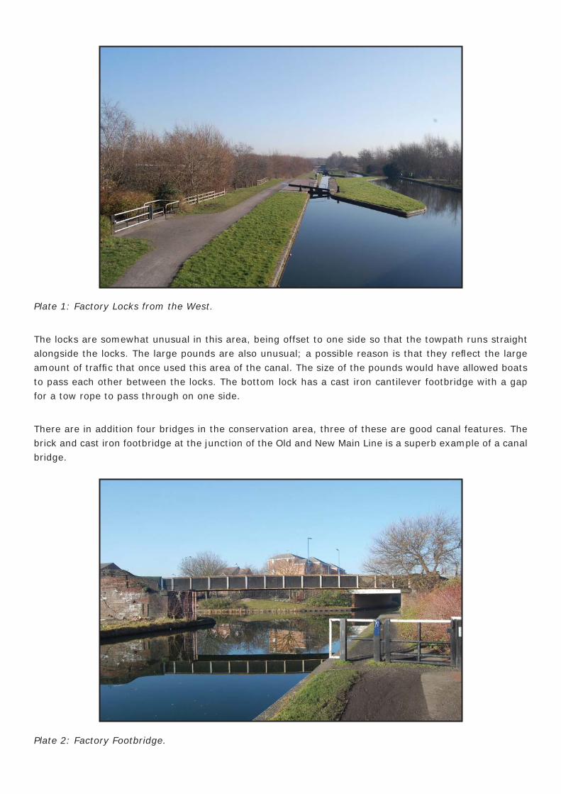
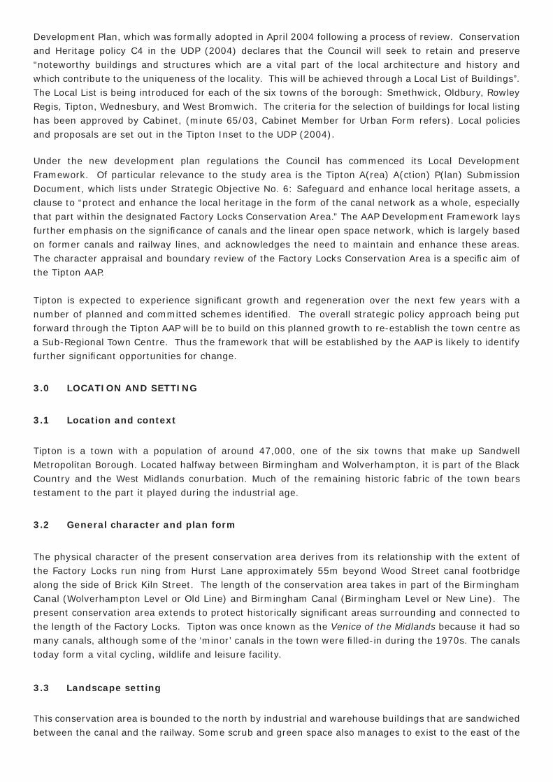
Plate 1: Factory Locks from the West.
The locks are somewhat unusual in this area, being offset to one side so that the towpath runs straight alongside the locks. The large pounds are also unusual; a possible reason is that they refl ect the large amount of traffi c that once used this area of the canal. The size of the pounds would have allowed boats to pass each other between the locks. The bottom lock has a cast iron cantilever footbridge with a gap for a tow rope to pass through on one side.
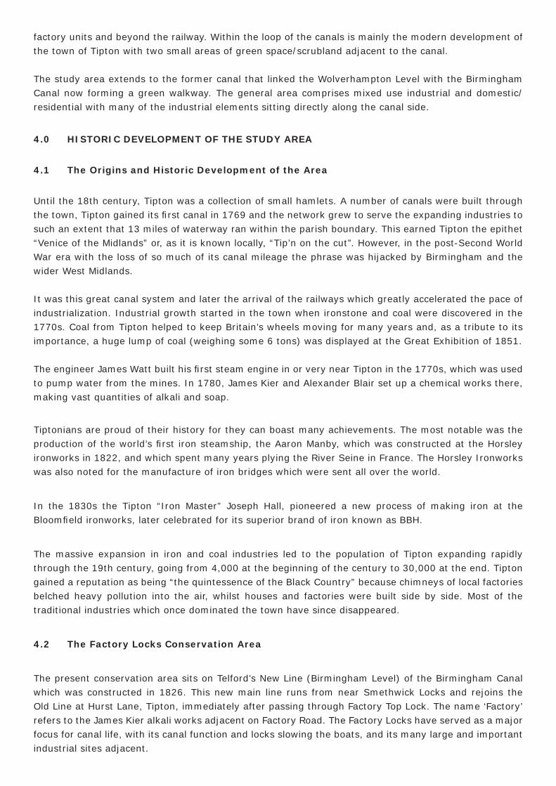
There are in addition four bridges in the conservation area, three of these are good canal features. The brick and cast iron footbridge at the junction of the Old and New Main Line is a superb example of a canal bridge.
Plate 2: Factory Footbridge.
The Wood Street footbridge is of cast iron lattice work sat on brick abutments, not unique but another excellent example of a canal bridge.
Plate 3: Wood Street Footbridge.
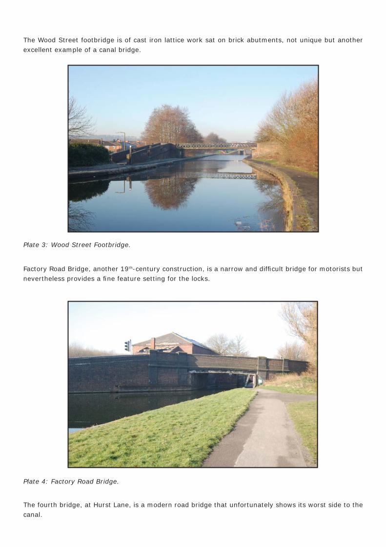
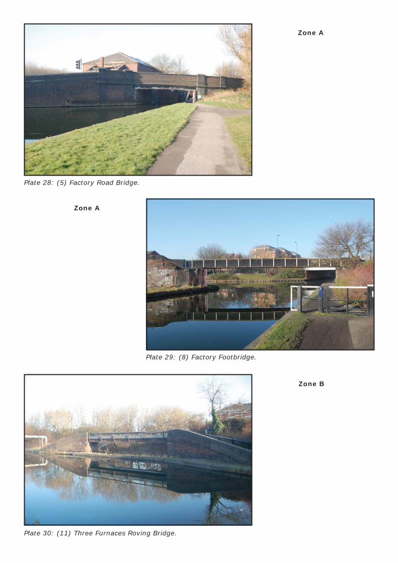
Factory Road Bridge, another 19th-century construction, is a narrow and diffi cult bridge for motorists but nevertheless provides a fi ne feature setting for the locks.
Plate 4: Factory Road Bridge.
The fourth bridge, at Hurst Lane, is a modern road bridge that unfortunately shows its worst side to the canal.
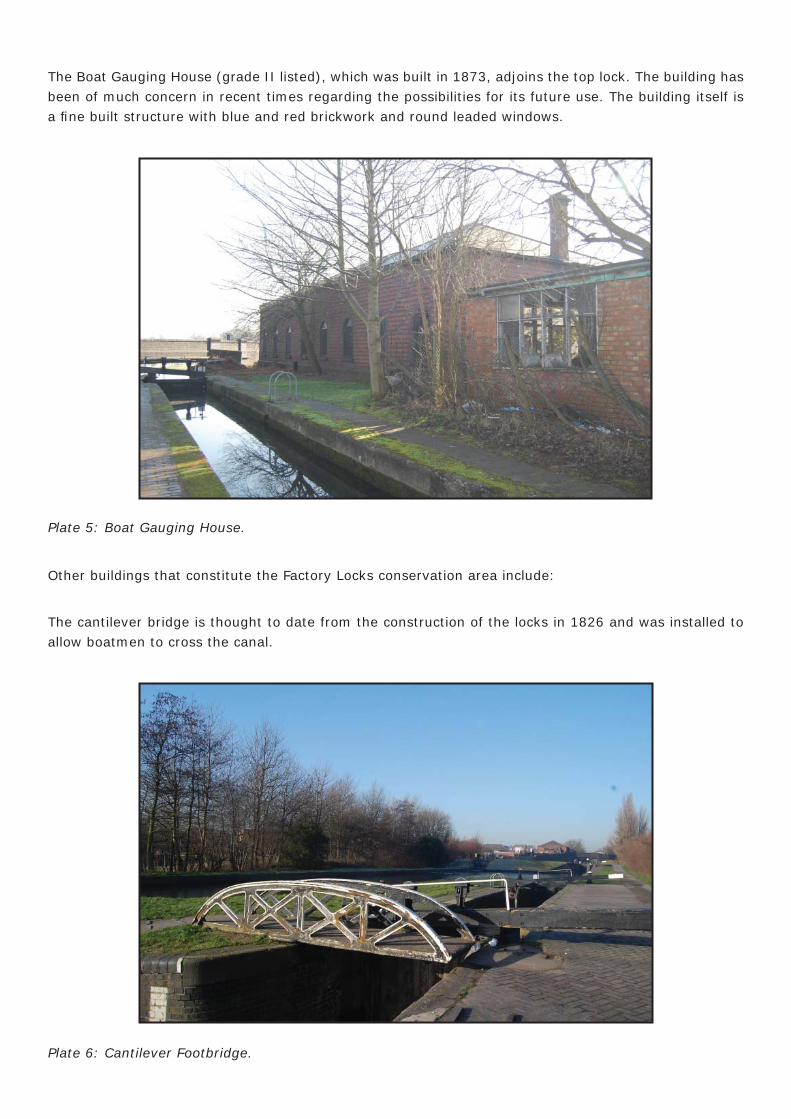
The Boat Gauging House (grade II listed), which was built in 1873, adjoins the top lock. The building has been of much concern in recent times regarding the possibilities for its future use. The building itself is a fi ne built structure with blue and red brickwork and round leaded windows.
Plate 5: Boat Gauging House.
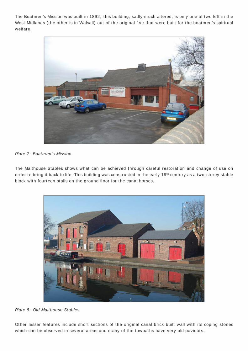
Other buildings that constitute the Factory Locks conservation area include:
The cantilever bridge is thought to date from the construction of the locks in 1826 and was installed to allow boatmen to cross the canal.
Plate 6: Cantilever Footbridge.
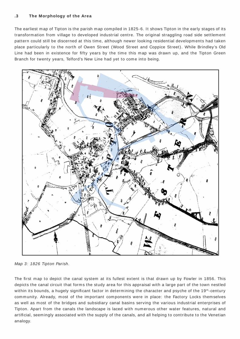
The Boatmen’s Mission was built in 1892; this building, sadly much altered, is only one of two left in the West Midlands (the other is in Walsall) out of the original fi ve that were built for the boatmen’s spiritual welfare.
Plate 7: Boatmen’s Mission.
The Malthouse Stables shows what can be achieved through careful restoration and change of use on order to bring it back to life. This building was constructed in the early 19th century as a two-storey stable block with fourteen stalls on the ground fl oor for the canal horses.
Plate 8: Old Malthouse Stables.
Other lesser features include short sections of the original canal brick built wall with its coping stones which can be observed in several areas and many of the towpaths have very old paviours.
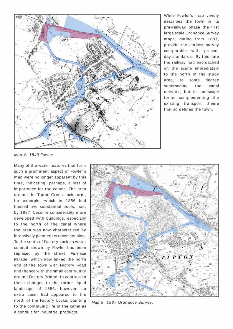
.3 The Morphology of the Area
The earliest map of Tipton is the parish map compiled in 1825-6. It shows Tipton in the early stages of its transformation from village to developed industrial centre. The original straggling road side settlement pattern could still be discerned at this time, although newer looking residential developments had taken place particularly to the north of Owen Street (Wood Street and Coppice Street). While Brindley’s Old Line had been in existence for fi fty years by the time this map was drawn up, and the Tipton Green Branch for twenty years, Telford’s New Line had yet to come into being.
Map 3: 1826 Tipton Parish.
The fi rst map to depict the canal system at its fullest extent is that drawn up by Fowler in 1856. This depicts the canal circuit that forms the study area for this appraisal with a large part of the town nestled within its bounds, a hugely signifi cant factor in determining the character and psyche of the 19th-century community. Already, most of the important components were in place: the Factory Locks themselves as well as most of the bridges and subsidiary canal basins serving the various industrial enterprises of Tipton. Apart from the canals the landscape is laced with numerous other water features, natural and artifi cial, seemingly associated with the supply of the canals, and all helping to contribute to the Venetian analogy.
Map 4: 1849 Fowler.
While Fowler’s map vividly describes the town in its pre-railway phase the fi rst large scale Ordnance Survey maps, dating from 1887, provide the earliest survey comparable with present day standards. By this date the railway had encroached on the scene immediately to the north of the study area, to some degree superseding the canal network, but in landscape terms complementing the existing transport theme that so defi nes the town.
Many of the water features that form such a prominent aspect of Fowler’s map were no longer apparent by this time, indicating, perhaps, a loss of importance for the canals. The area around the Tipton Green Locks arm, for example, which in 1856 had housed two substantial pools, had, by 1887, become considerably more developed with buildings, especially to the north of the canal where the area was now characterised by intensively planned terraced housing. To the south of Factory Locks a water conduit shown by Fowler had been replaced by the street, Furnace Parade, which now linked the north end of the town with Factory Road and thence with the small community around Factory Bridge. In contrast to these changes to the rather liquid landscape of 1856, however, an extra basin had appeared to the north of the Factory Locks, pointing to the continuing life of the canal as a conduit for industrial products.
Map 5: 1887 Ordnance Survey.
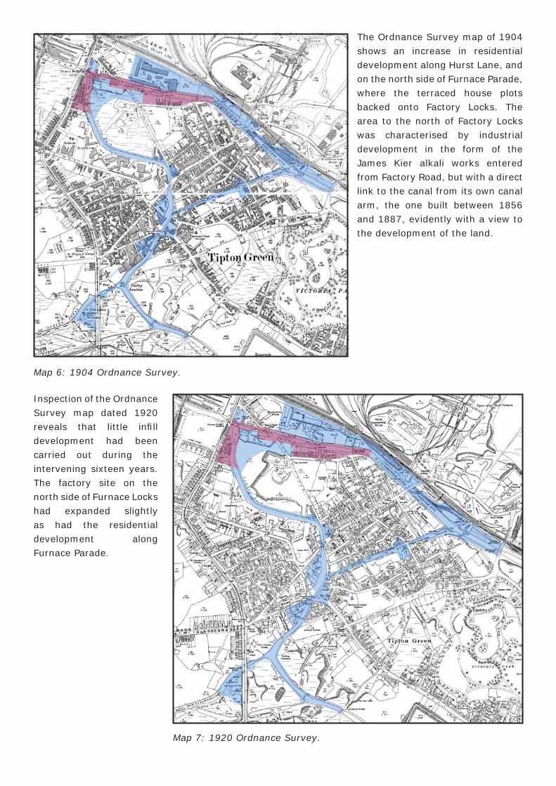
Map 6: 1904 Ordnance Survey.
The Ordnance Survey map of 1904 shows an increase in residential development along Hurst Lane, and on the north side of Furnace Parade, where the terraced house plots backed onto Factory Locks. The area to the north of Factory Locks was characterised by industrial development in the form of the James Kier alkali works entered from Factory Road, but with a direct link to the canal from its own canal arm, the one built between 1856 and 1887, evidently with a view to the development of the land.
Map 7: 1920 Ordnance Survey.
Inspection of the Ordnance Survey map dated 1920 reveals that little infi ll development had been carried out during the intervening sixteen years. The factory site on the north side of Furnace Locks had expanded slightly as had the residential development along Furnace Parade.
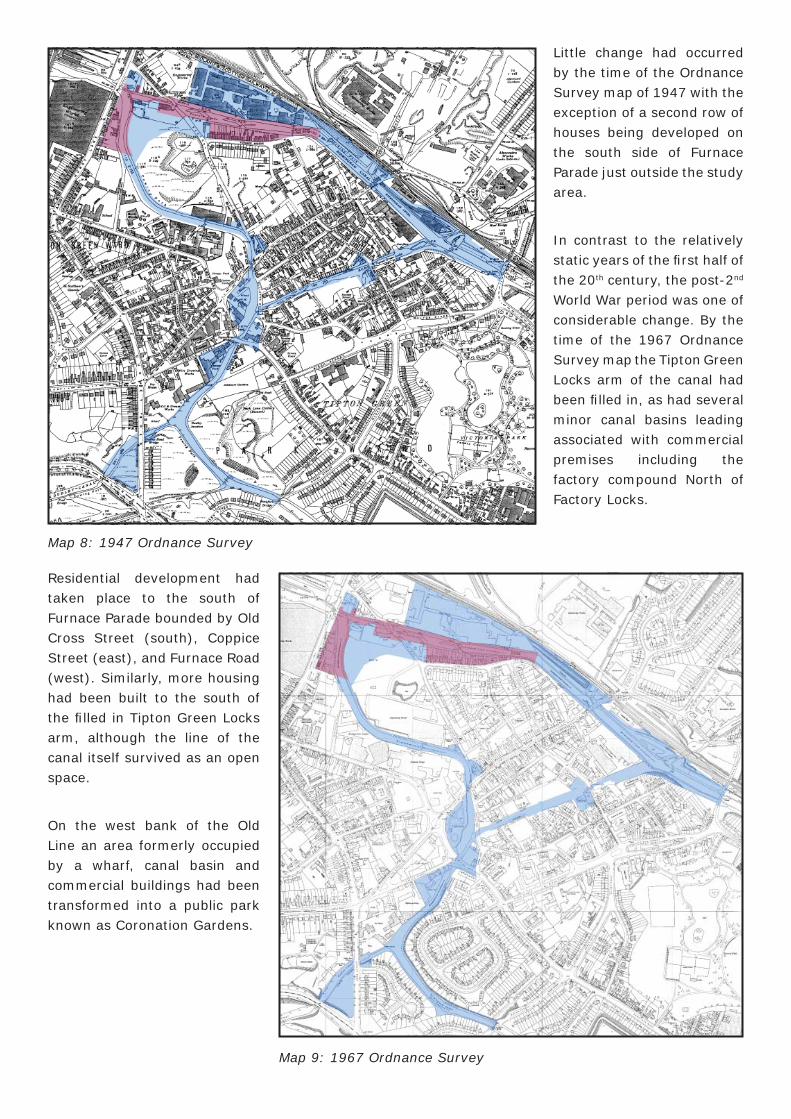
Little change had occurred by the time of the Ordnance Survey map of 1947 with the exception of a second row of houses being developed on the south side of Furnace Parade just outside the study area.
In contrast to the relatively static years of the fi rst half of the 20th century, the post-2nd World War period was one of considerable change. By the time of the 1967 Ordnance Survey map the Tipton Green Locks arm of the canal had been fi lled in, as had several minor canal basins leading associated with commercial premises including the factory compound North of Factory Locks.
Map 8: 1947 Ordnance Survey
Residential development had taken place to the south of Furnace Parade bounded by Old Cross Street (south), Coppice Street (east), and Furnace Road (west). Similarly, more housing had been built to the south of the fi lled in Tipton Green Locks arm, although the line of the canal itself survived as an open space.
On the west bank of the Old Line an area formerly occupied by a wharf, canal basin and commercial buildings had been transformed into a public park known as Coronation Gardens.
Map 9: 1967 Ordnance Survey
4.4 Archaeology, including scheduled monuments
A search of Sandwell Historic Environment Record (HER) has revealed that there are no Scheduled Ancient Monuments (SAMs) within or in the vicinity of the current or proposed extension to the Factory Locks Conservation Area. Neither is there a record of any previous archaeological work carried out here. There are a number of listed buildings and structures; these will be dealt with in section 6.3 below.
5.0 SPATIAL ANALYSIS
5.1 The Character and Interrelationship of Spaces within the Area
The canal corridor within the conservation area constitutes a narrow, clearly-defi ned, powerful linear space that effectively forms the backbone of the whole area. The development of the modern town refl ects the development of the canal system. Initially a late 18th/ 19th century industrial town, the settlement has now lost most of its industrial power base.
Much of the canal corridor has changed from a conduit for transporting the produce of industrial manufacture to a green backdrop for new housing schemes. Whilst the atmosphere of Tipton’s streets is pervaded by the bustle associated with vehicular and pedestrian traffi c, the canal corridor and its environs are substantially more serene in nature – providing an oasis of tranquillity for the inhabitants.
Apart from being a heritage asset in its own right, the canal is also an environment asset, a designated cycle route and wildlife corridor. There is also considerable nature conservation value in the canal network and its associated green space, which provide valuable habitats for fl ora and fauna, including a number of priority species.
5.2 Key Views and Vistas
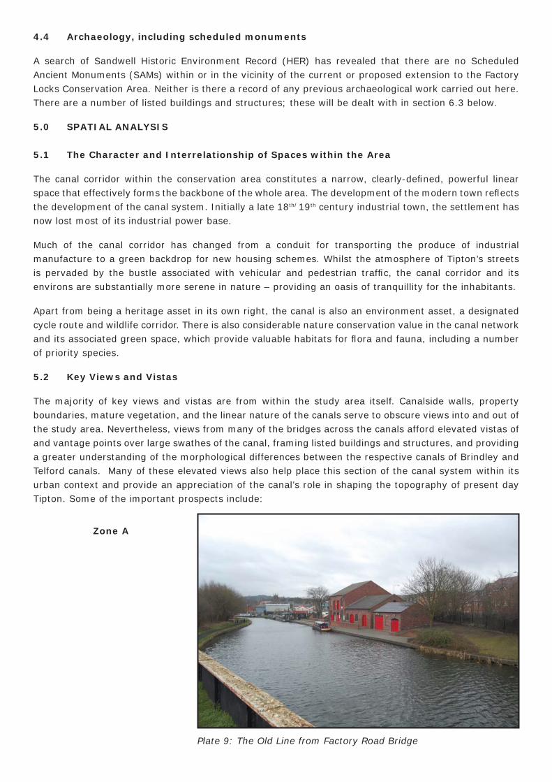
The majority of key views and vistas are from within the study area itself. Canalside walls, property boundaries, mature vegetation, and the linear nature of the canals serve to obscure views into and out of the study area. Nevertheless, views from many of the bridges across the canals afford elevated vistas of and vantage points over large swathes of the canal, framing listed buildings and structures, and providing a greater understanding of the morphological differences between the respective canals of Brindley and Telford canals. Many of these elevated views also help place this section of the canal system within its urban context and provide an appreciation of the canal’s role in shaping the topography of present day Tipton. Some of the important prospects include:
Plate 9: The Old Line from Factory Road Bridge
Zone A

Zone C
Plate 10: Factory Locks from Wood Street Footbridge.
Plate 11: New Line from Waterloo Road Footbridge.
Plate 12: Owen Street Bridge and Fountain Inn from the South.
Zone B
Zone A
Zone C
Zone D
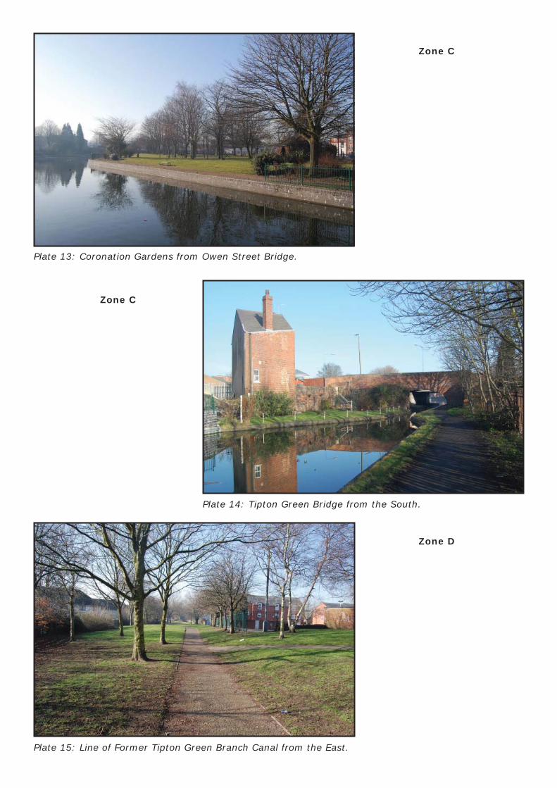
Plate 13: Coronation Gardens from Owen Street Bridge.
Plate 14: Tipton Green Bridge from the South.
Plate 15: Line of Former Tipton Green Branch Canal from the East.
Zone C
6.0 CHARACTER ANALYSIS
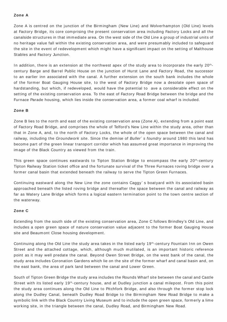
6.1 Defi nition of the Character Areas (Zones)
In a sense the study area may be said to comprise a single character zone by virtue of its former function, history and topography. However, it does fall naturally into a number of different components, which assists in the organization of this appraisal and boundary review.
Map 10: Study Area Zone Divisions.
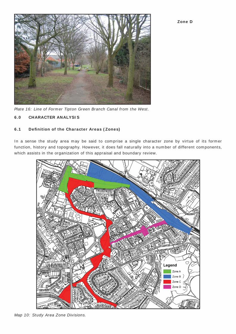
Plate 16: Line of Former Tipton Green Branch Canal from the West.
Zone D
Zone A
Zone A is centred on the junction of the Birmingham (New Line) and Wolverhampton (Old Line) levels at Factory Bridge, its core comprising the present conservation area including Factory Locks and all the canalside structures in that immediate area. On the west side of the Old Line a group of industrial units of no heritage value fall within the existing conservation area, and were presumably included to safeguard the site in the event of redevelopment which might have a signifi cant impact on the setting of Malthouse Stables and Factory Junction.
In addition, there is an extension at the northwest apex of the study area to incorporate the early 20th-century Barge and Barrel Public House on the junction of Hurst Lane and Factory Road, the successor to an earlier inn associated with the canal. A further extension on the south bank includes the whole of the former Boat Gauging House site, to the west of Factory Bridge now a desolate open space of hardstanding, but which, if redeveloped, would have the potential to ave a considerable effect on the setting of the existing conservation area. To the east of Factory Road Bridge between the bridge and the Furnace Parade housing, which lies inside the conservation area, a former coal wharf is included.
Zone B
Zone B lies to the north and east of the existing conservation area (Zone A), extending from a point east of Factory Road Bridge, and comprises the whole of Telford’s New Line within the study area, other than that in Zone A, and, to the north of Factory Locks, the whole of the open space between the canal and railway, including the Groundwork site. Since the demise of Buller`s foundry around 1980 this land has become part of the green linear transport corridor which has assumed great importance in improving the image of the Black Country as viewed from the train.
This green space continues eastwards to Tipton Station Bridge to encompass the early 20th-century Tipton Railway Station ticket offi ce and the fortunate survival of the Three Furnaces roving bridge over a former canal basin that extended beneath the railway to serve the Tipton Green Furnaces.
Continuing eastward along the New Line the zone contains Caggy`s boatyard with its associated basin approached beneath the listed roving bridge and thereafter the space between the canal and railway as far as Watery Lane Bridge which forms a logical eastern termination point to the town centre section of the waterway.
Zone C
Extending from the south side of the existing conservation area, Zone C follows Brindley’s Old Line, and includes a open green space of nature conservation value adjacent to the former Boat Gauging House site and Beaumont Close housing development.
Continuing along the Old Line the study area takes in the listed early 19th-century Fountain Inn on Owen Street and the attached cottage, which, although much mutilated, is an important historic reference point as it may well predate the canal. Beyond Owen Street Bridge, on the west bank of the canal, the study area includes Coronation Gardens which lie on the site of the former wharf and canal basin and, on the east bank, the area of park land between the canal and Lower Green.
South of Tipton Green Bridge the study area includes the Rounds Wharf site between the canal and Castle Street with its listed early 19th-century house, and at Dudley junction a canal milepost. From this point the study area continues along the Old Line to Pitchfork Bridge, and also through the former stop lock along the Dudley Canal, beneath Dudley Road Bridge to the Birmingham New Road Bridge to make a symbolic link with the Black Country Living Museum and to include the open green space, formerly a lime working site, in the triangle between the canal, Dudley Road, and Birmingham New Road.
Zone D
The fi nal zone within the study area consists of the route of the Tipton Green Branch which operated between the Old (west) and New (east) lines, and which survives as a green space and public walkway conveniently linking the two historic canals.
6.2 Activity within the Area, and its Infl uences
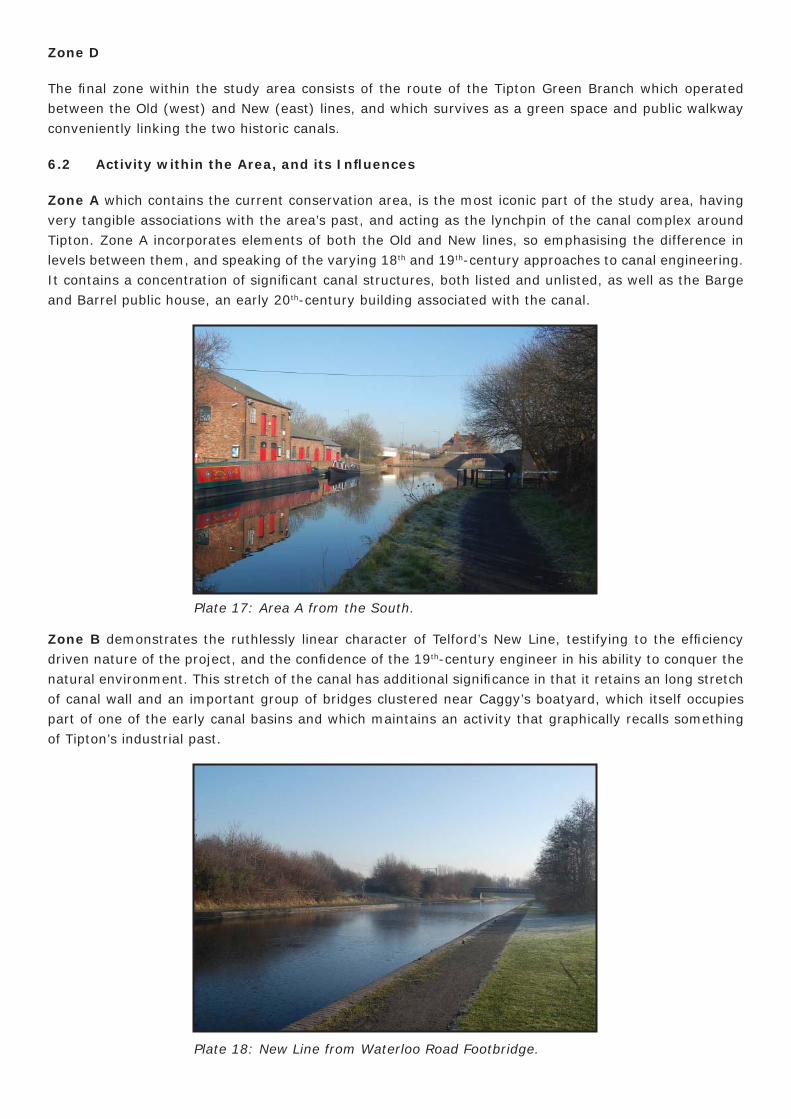
Zone A which contains the current conservation area, is the most iconic part of the study area, having very tangible associations with the area’s past, and acting as the lynchpin of the canal complex around Tipton. Zone A incorporates elements of both the Old and New lines, so emphasising the difference in levels between them, and speaking of the varying 18th and 19th-century approaches to canal engineering. It contains a concentration of signifi cant canal structures, both listed and unlisted, as well as the Barge and Barrel public house, an early 20th-century building associated with the canal.
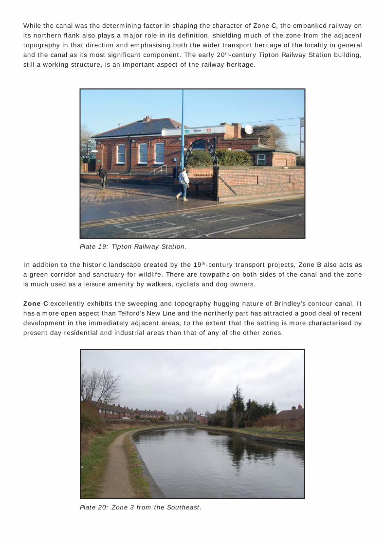
Zone B demonstrates the ruthlessly linear character of Telford’s New Line, testifying to the effi ciency driven nature of the project, and the confi dence of the 19th-century engineer in his ability to conquer the natural environment. This stretch of the canal has additional signifi cance in that it retains an long stretch of canal wall and an important group of bridges clustered near Caggy’s boatyard, which itself occupies part of one of the early canal basins and which maintains an activity that graphically recalls something of Tipton’s industrial past.
Plate 17: Area A from the South.
Plate 18: New Line from Waterloo Road Footbridge.
While the canal was the determining factor in shaping the character of Zone C, the embanked railway on its northern fl ank also plays a major role in its defi nition, shielding much of the zone from the adjacent topography in that direction and emphasising both the wider transport heritage of the locality in general and the canal as its most signifi cant component. The early 20th-century Tipton Railway Station building, still a working structure, is an important aspect of the railway heritage.
In addition to the historic landscape created by the 19th-century transport projects, Zone B also acts as a green corridor and sanctuary for wildlife. There are towpaths on both sides of the canal and the zone is much used as a leisure amenity by walkers, cyclists and dog owners.
Zone C excellently exhibits the sweeping and topography hugging nature of Brindley’s contour canal. It has a more open aspect than Telford’s New Line and the northerly part has attracted a good deal of recent development in the immediately adjacent areas, to the extent that the setting is more characterised by present day residential and industrial areas than that of any of the other zones.
Plate 19: Tipton Railway Station.
Plate 20: Zone 3 from the Southeast.
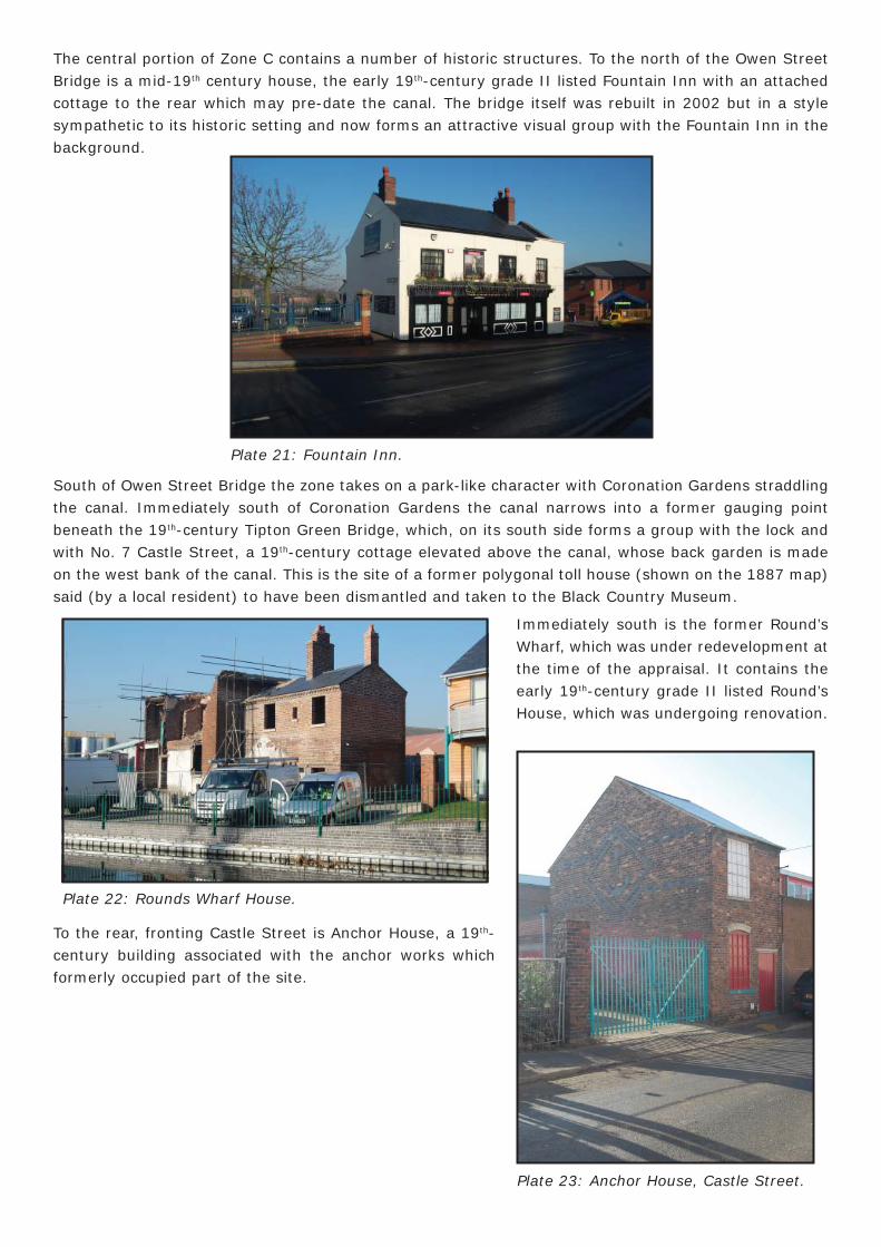
The central portion of Zone C contains a number of historic structures. To the north of the Owen Street Bridge is a mid-19th century house, the early 19th-century grade II listed Fountain Inn with an attached cottage to the rear which may pre-date the canal. The bridge itself was rebuilt in 2002 but in a style sympathetic to its historic setting and now forms an attractive visual group with the Fountain Inn in the background.
South of Owen Street Bridge the zone takes on a park-like character with Coronation Gardens straddling the canal. Immediately south of Coronation Gardens the canal narrows into a former gauging point beneath the 19th-century Tipton Green Bridge, which, on its south side forms a group with the lock and with No. 7 Castle Street, a 19th-century cottage elevated above the canal, whose back garden is made on the west bank of the canal. This is the site of a former polygonal toll house (shown on the 1887 map) said (by a local resident) to have been dismantled and taken to the Black Country Museum.
Plate 21: Fountain Inn.
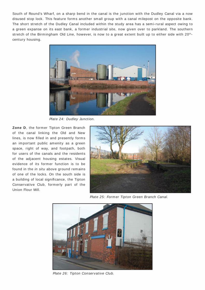
Immediately south is the former Round’s Wharf, which was under redevelopment at the time of the appraisal. It contains the early 19th-century grade II listed Round’s House, which was undergoing renovation.
Plate 22: Rounds Wharf House.
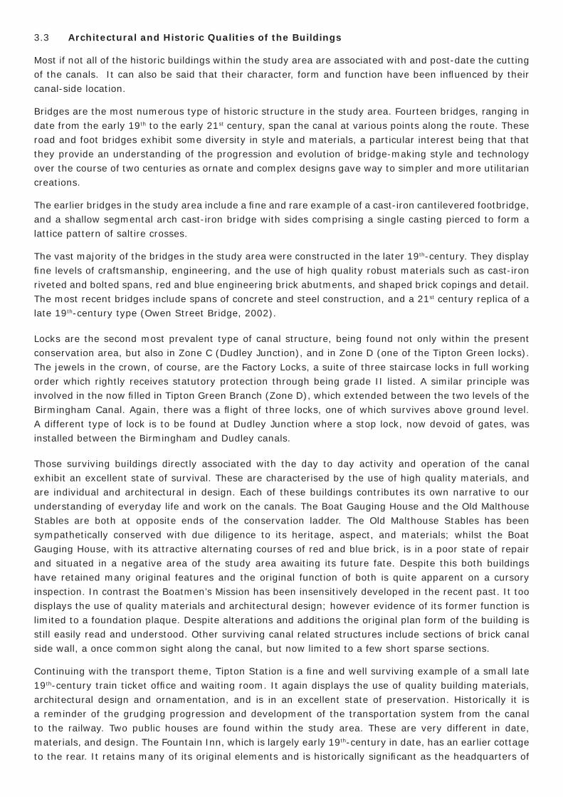
To the rear, fronting Castle Street is Anchor House, a 19th-century building associated with the anchor works which formerly occupied part of the site.
Plate 23: Anchor House, Castle Street.
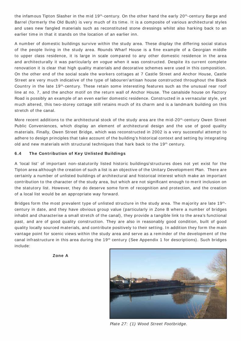
South of Round’s Wharf, on a sharp bend in the canal is the junction with the Dudley Canal via a now disused stop lock. This feature forms another small group with a canal milepost on the opposite bank. The short stretch of the Dudley Canal included within the study area has a semi-rural aspect owing to a green expanse on its east bank, a former industrial site, now given over to parkland. The southern stretch of the Birmingham Old Line, however, is now to a great extent built up to either side with 20th-century housing.
Plate 24: Dudley Junction.
Zone D, the former Tipton Green Branch of the canal linking the Old and New lines, is now fi lled in and presently forms an important public amenity as a green space, right of way, and footpath, both for users of the canals and the residents of the adjacent housing estates. Visual evidence of its former function is to be found in the in situ above ground remains of one of the locks. On the south side is a building of local signifi cance, the Tipton Conservative Club, formerly part of the Union Flour Mill.
Plate 25: Former Tipton Green Branch Canal.
Plate 26: Tipton Conservative Club.
3.3 Architectural and Historic Qualities of the Buildings
Most if not all of the historic buildings within the study area are associated with and post-date the cutting of the canals. It can also be said that their character, form and function have been infl uenced by their canal-side location.
Bridges are the most numerous type of historic structure in the study area. Fourteen bridges, ranging in date from the early 19th to the early 21st century, span the canal at various points along the route. These road and foot bridges exhibit some diversity in style and materials, a particular interest being that that they provide an understanding of the progression and evolution of bridge-making style and technology over the course of two centuries as ornate and complex designs gave way to simpler and more utilitarian creations.
The earlier bridges in the study area include a fi ne and rare example of a cast-iron cantilevered footbridge, and a shallow segmental arch cast-iron bridge with sides comprising a single casting pierced to form a lattice pattern of saltire crosses.
The vast majority of the bridges in the study area were constructed in the later 19th-century. They display fi ne levels of craftsmanship, engineering, and the use of high quality robust materials such as cast-iron riveted and bolted spans, red and blue engineering brick abutments, and shaped brick copings and detail. The most recent bridges include spans of concrete and steel construction, and a 21st century replica of a late 19th-century type (Owen Street Bridge, 2002).
Locks are the second most prevalent type of canal structure, being found not only within the present conservation area, but also in Zone C (Dudley Junction), and in Zone D (one of the Tipton Green locks). The jewels in the crown, of course, are the Factory Locks, a suite of three staircase locks in full working order which rightly receives statutory protection through being grade II listed. A similar principle was involved in the now fi lled in Tipton Green Branch (Zone D), which extended between the two levels of the Birmingham Canal. Again, there was a fl ight of three locks, one of which survives above ground level. A different type of lock is to be found at Dudley Junction where a stop lock, now devoid of gates, was installed between the Birmingham and Dudley canals.
Those surviving buildings directly associated with the day to day activity and operation of the canal exhibit an excellent state of survival. These are characterised by the use of high quality materials, and are individual and architectural in design. Each of these buildings contributes its own narrative to our understanding of everyday life and work on the canals. The Boat Gauging House and the Old Malthouse Stables are both at opposite ends of the conservation ladder. The Old Malthouse Stables has been sympathetically conserved with due diligence to its heritage, aspect, and materials; whilst the Boat Gauging House, with its attractive alternating courses of red and blue brick, is in a poor state of repair and situated in a negative area of the study area awaiting its future fate. Despite this both buildings have retained many original features and the original function of both is quite apparent on a cursory inspection. In contrast the Boatmen’s Mission has been insensitively developed in the recent past. It too displays the use of quality materials and architectural design; however evidence of its former function is limited to a foundation plaque. Despite alterations and additions the original plan form of the building is still easily read and understood. Other surviving canal related structures include sections of brick canal side wall, a once common sight along the canal, but now limited to a few short sparse sections.
Continuing with the transport theme, Tipton Station is a fi ne and well surviving example of a small late 19th-century train ticket offi ce and waiting room. It again displays the use of quality building materials, architectural design and ornamentation, and is in an excellent state of preservation. Historically it is a reminder of the grudging progression and development of the transportation system from the canal to the railway. Two public houses are found within the study area. These are very different in date, materials, and design. The Fountain Inn, which is largely early 19th-century in date, has an earlier cottage to the rear. It retains many of its original elements and is historically signifi cant as the headquarters of
the infamous Tipton Slasher in the mid 19th-century. On the other hand the early 20th-century Barge and Barrel (formerly the Old Bush) is very much of its time. It is a composite of various architectural styles and uses new fangled materials such as reconstituted stone dressings whilst also harking back to an earlier time in that it stands on the location of an earlier inn.
A number of domestic buildings survive within the study area. These display the differing social status of the people living in the study area. Rounds Wharf House is a fi ne example of a Georgian middle to upper class residence, it is large in scale compared to any other domestic residence in the area and architecturally it was particularly en vogue when it was constructed. Despite its current complete renovation it is clear that high quality materials and decorative schemes were used in this composition. On the other end of the social scale the workers cottages at 7 Castle Street and Anchor House, Castle Street are very much indicative of the type of labourer/artisan house constructed throughout the Black Country in the late 19th-century. These retain some interesting features such as the unusual rear roof line at no. 7, and the anchor motif on the return wall of Anchor House. The canalside house on Factory Road is possibly an example of an even earlier domestic residence. Constructed in a vernacular style, yet much altered, this two-storey cottage still retains much of its charm and is a landmark building on this stretch of the canal.
More recent additions to the architectural stock of the study area are the mid-20th-century Owen Street Public Conveniences, which display an element of architectural design and the use of good quality materials. Finally, Owen Street Bridge, which was reconstructed in 2002 is a very successful attempt to adhere to design principles that take account of the building’s historical context and setting by integrating old and new materials with structural techniques that hark back to the 19th century.
6.4 The Contribution of Key Unlisted Buildings
A ‘local list’ of important non-statutorily listed historic buildings/structures does not yet exist for the Tipton area although the creation of such a list is an objective of the Unitary Development Plan. There are certainly a number of unlisted buildings of architectural and historical interest which make an important contribution to the character of the study area, but which are not signifi cant enough to merit inclusion on the statutory list. However, they do deserve some form of recognition and protection, and the creation of a local list would be an appropriate way forward.
Bridges form the most prevalent type of unlisted structure in the study area. The majority are late 19th-
century in date, and they have obvious group value (particularly in Zone B where a number of bridges inhabit and characterise a small stretch of the canal), they provide a tangible link to the area’s functional past, and are of good quality construction. They are also in reasonably good condition, built of good quality locally sourced materials, and contribute positively to their setting. In addition they form the main vantage point for scenic views within the study area and serve as a reminder of the development of the canal infrastructure in this area during the 19th century (See Appendix 1 for descriptions). Such bridges include:
Zone A
Plate 27: (1) Wood Street Footbridge.
Zone A
Plate 28: (5) Factory Road Bridge.
Plate 29: (8) Factory Footbridge.
Plate 30: (11) Three Furnaces Roving Bridge.
Zone A
Zone B
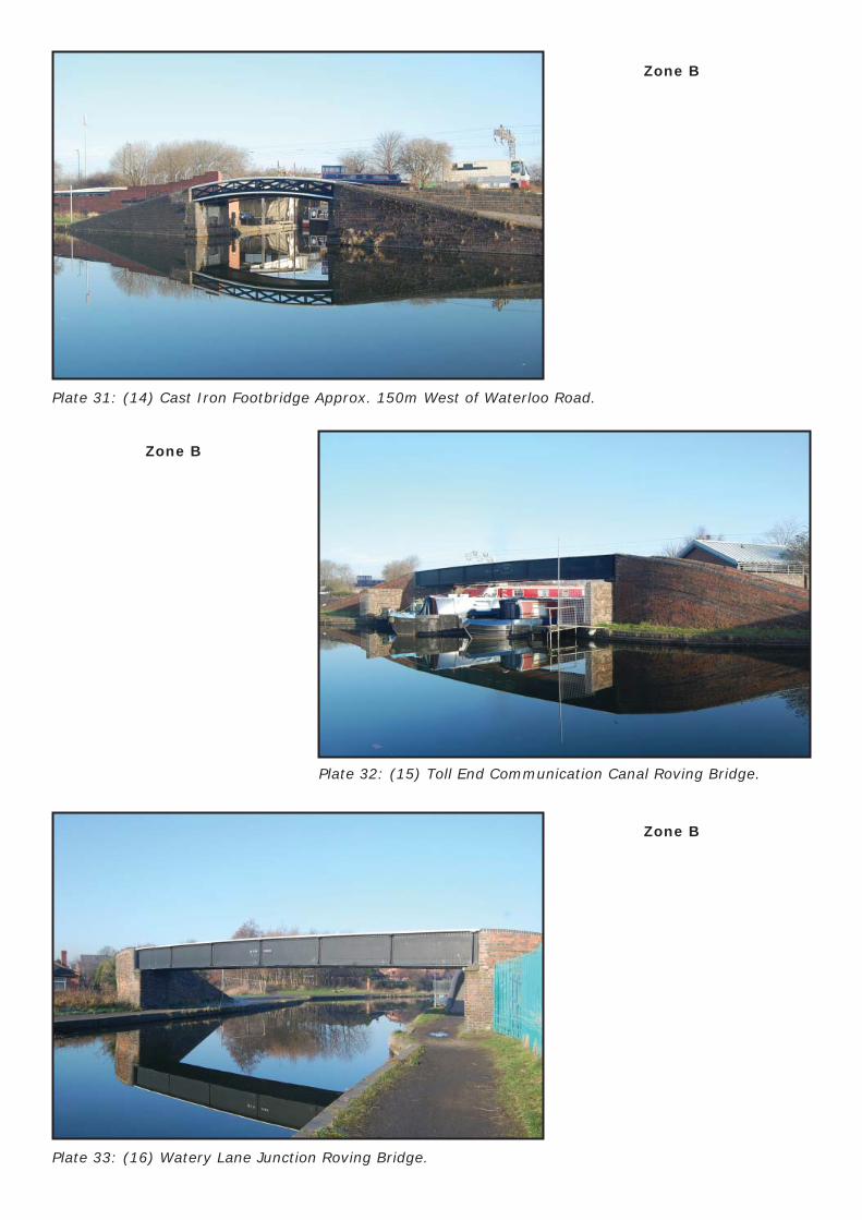
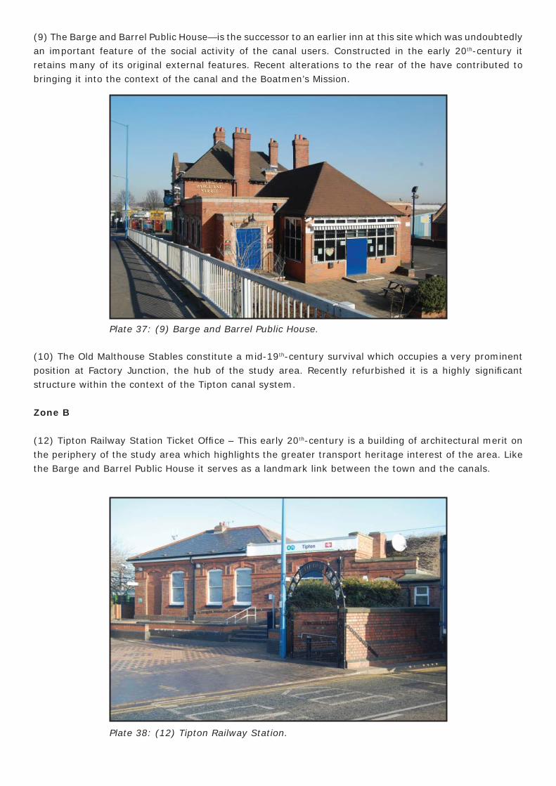
Plate 31: (14) Cast Iron Footbridge Approx. 150m West of Waterloo Road.
Plate 32: (15) Toll End Communication Canal Roving Bridge.
Plate 33: (16) Watery Lane Junction Roving Bridge.
Zone B
Zone B
Zone B
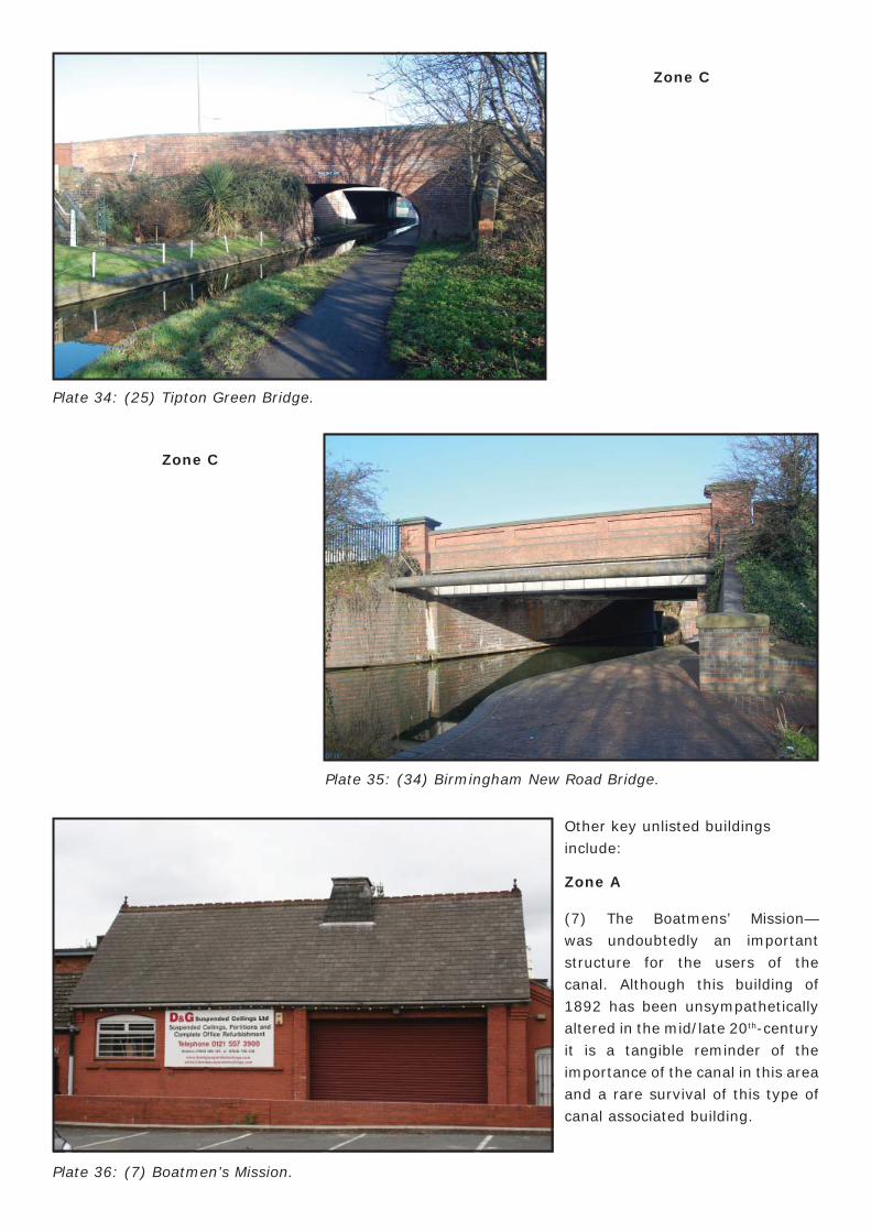
Plate 34: (25) Tipton Green Bridge.
Plate 35: (34) Birmingham New Road Bridge.
Other key unlisted buildings include:
Zone A
(7) The Boatmens’ Mission—was undoubtedly an important structure for the users of the canal. Although this building of 1892 has been unsympathetically altered in the mid/late 20th-century it is a tangible reminder of the importance of the canal in this area and a rare survival of this type of canal associated building.
Zone C
Zone C
Plate 36: (7) Boatmen’s Mission.
(9) The Barge and Barrel Public House—is the successor to an earlier inn at this site which was undoubtedly an important feature of the social activity of the canal users. Constructed in the early 20th-century it retains many of its original external features. Recent alterations to the rear of the have contributed to bringing it into the context of the canal and the Boatmen’s Mission.
(10) The Old Malthouse Stables constitute a mid-19th-century survival which occupies a very prominent position at Factory Junction, the hub of the study area. Recently refurbished it is a highly signifi cant structure within the context of the Tipton canal system.
Zone B
(12) Tipton Railway Station Ticket Offi ce – This early 20th-century is a building of architectural merit on the periphery of the study area which highlights the greater transport heritage interest of the area. Like the Barge and Barrel Public House it serves as a landmark link between the town and the canals.
Plate 37: (9) Barge and Barrel Public House.
Plate 38: (12) Tipton Railway Station.
Zone C
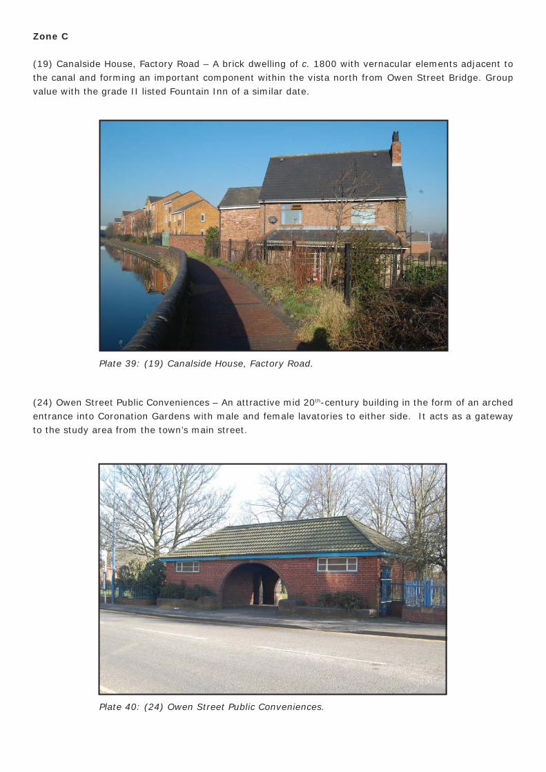
(19) Canalside House, Factory Road – A brick dwelling of c. 1800 with vernacular elements adjacent to the canal and forming an important component within the vista north from Owen Street Bridge. Group value with the grade II listed Fountain Inn of a similar date.
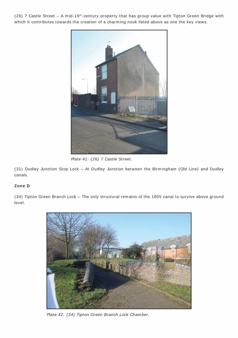
(24) Owen Street Public Conveniences – An attractive mid 20th-century building in the form of an arched entrance into Coronation Gardens with male and female lavatories to either side. It acts as a gateway to the study area from the town’s main street.
Plate 39: (19) Canalside House, Factory Road.
Plate 40: (24) Owen Street Public Conveniences.
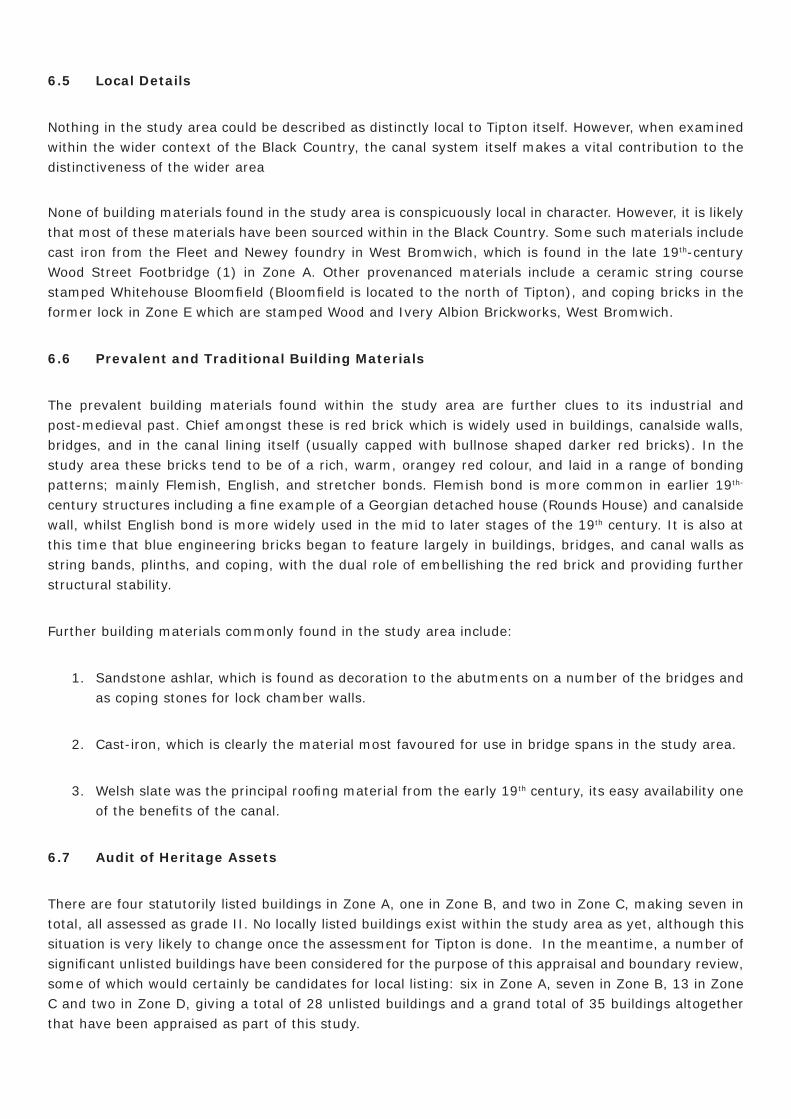
(26) 7 Castle Street – A mid-19th-century property that has group value with Tipton Green Bridge with which it contributes towards the creation of a charming nook listed above as one the key views.
(31) Dudley Junction Stop Lock – At Dudley Junction between the Birmingham (Old Line) and Dudley canals.
Zone D
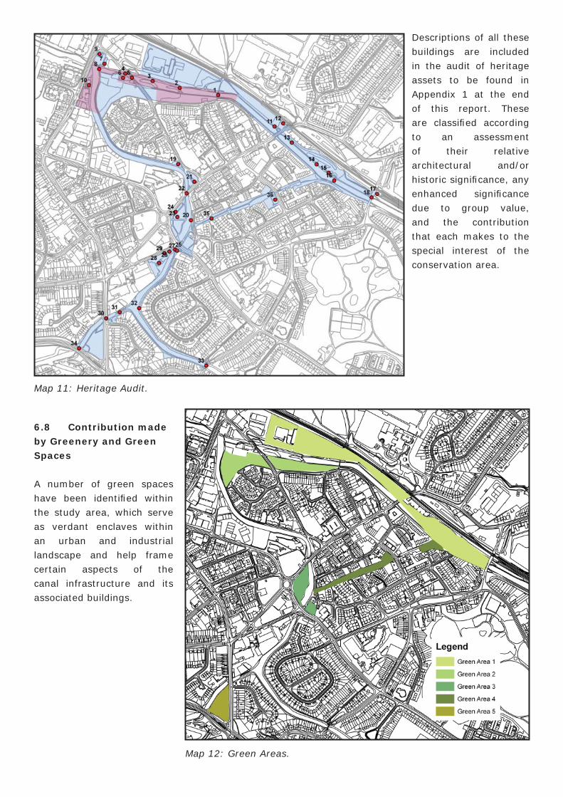
(34) Tipton Green Branch Lock – The only structural remains of the 1805 canal to survive above ground level.
Plate 41: (26) 7 Castle Street.
Plate 42: (34) Tipton Green Branch Lock Chamber.
6.5 Local Details
Nothing in the study area could be described as distinctly local to Tipton itself. However, when examined within the wider context of the Black Country, the canal system itself makes a vital contribution to the distinctiveness of the wider area
None of building materials found in the study area is conspicuously local in character. However, it is likely that most of these materials have been sourced within in the Black Country. Some such materials include cast iron from the Fleet and Newey foundry in West Bromwich, which is found in the late 19th-century Wood Street Footbridge (1) in Zone A. Other provenanced materials include a ceramic string course stamped Whitehouse Bloomfi eld (Bloomfi eld is located to the north of Tipton), and coping bricks in the former lock in Zone E which are stamped Wood and Ivery Albion Brickworks, West Bromwich.
6.6 Prevalent and Traditional Building Materials
The prevalent building materials found within the study area are further clues to its industrial and post-medieval past. Chief amongst these is red brick which is widely used in buildings, canalside walls, bridges, and in the canal lining itself (usually capped with bullnose shaped darker red bricks). In the study area these bricks tend to be of a rich, warm, orangey red colour, and laid in a range of bonding patterns; mainly Flemish, English, and stretcher bonds. Flemish bond is more common in earlier 19th-
century structures including a fi ne example of a Georgian detached house (Rounds House) and canalside wall, whilst English bond is more widely used in the mid to later stages of the 19th century. It is also at this time that blue engineering bricks began to feature largely in buildings, bridges, and canal walls as string bands, plinths, and coping, with the dual role of embellishing the red brick and providing further structural stability.
Further building materials commonly found in the study area include:
1. Sandstone ashlar, which is found as decoration to the abutments on a number of the bridges and as coping stones for lock chamber walls.
2. Cast-iron, which is clearly the material most favoured for use in bridge spans in the study area.
3. Welsh slate was the principal roofi ng material from the early 19th century, its easy availability one of the benefi ts of the canal.
6.7 Audit of Heritage Assets
There are four statutorily listed buildings in Zone A, one in Zone B, and two in Zone C, making seven in total, all assessed as grade II. No locally listed buildings exist within the study area as yet, although this situation is very likely to change once the assessment for Tipton is done. In the meantime, a number of signifi cant unlisted buildings have been considered for the purpose of this appraisal and boundary review, some of which would certainly be candidates for local listing: six in Zone A, seven in Zone B, 13 in Zone C and two in Zone D, giving a total of 28 unlisted buildings and a grand total of 35 buildings altogether that have been appraised as part of this study.
6.8 Contribution made by Greenery and Green Spaces
A number of green spaces have been identifi ed within the study area, which serve as verdant enclaves within an urban and industrial landscape and help frame certain aspects of the canal infrastructure and its associated buildings.
Descriptions of all these buildings are included in the audit of heritage assets to be found in Appendix 1 at the end of this report. These are classifi ed according to an assessment of their relative architectural and/or historic signifi cance, any enhanced signifi cance due to group value, and the contribution that each makes to the special interest of the conservation area.
Map 11: Heritage Audit.
Map 12: Green Areas.
Green Space 1 (Zone B)
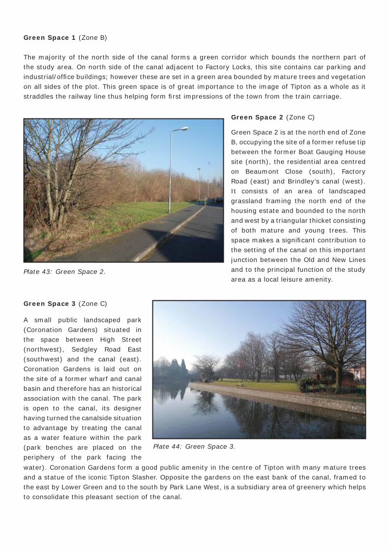
The majority of the north side of the canal forms a green corridor which bounds the northern part of the study area. On north side of the canal adjacent to Factory Locks, this site contains car parking and industrial/offi ce buildings; however these are set in a green area bounded by mature trees and vegetation on all sides of the plot. This green space is of great importance to the image of Tipton as a whole as it straddles the railway line thus helping form fi rst impressions of the town from the train carriage.
Plate 43: Green Space 2.
Green Space 2 (Zone C)
Green Space 2 is at the north end of Zone B, occupying the site of a former refuse tip between the former Boat Gauging House site (north), the residential area centred on Beaumont Close (south), Factory Road (east) and Brindley’s canal (west). It consists of an area of landscaped grassland framing the north end of the housing estate and bounded to the north and west by a triangular thicket consisting of both mature and young trees. This space makes a signifi cant contribution to the setting of the canal on this important junction between the Old and New Lines and to the principal function of the study area as a local leisure amenity.
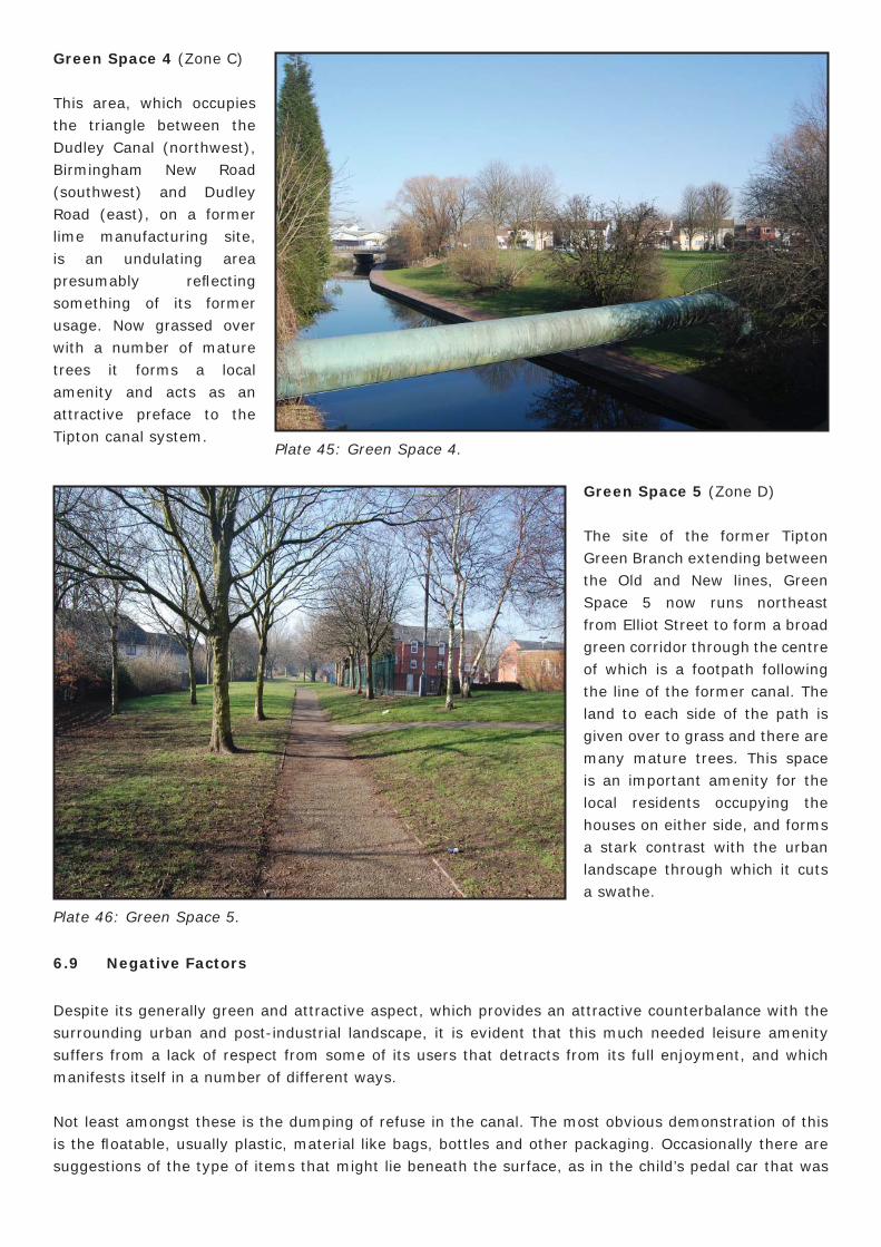
Green Space 3 (Zone C)
A small public landscaped park (Coronation Gardens) situated in the space between High Street (northwest), Sedgley Road East (southwest) and the canal (east). Coronation Gardens is laid out on the site of a former wharf and canal basin and therefore has an historical association with the canal. The park is open to the canal, its designer having turned the canalside situation to advantage by treating the canal as a water feature within the park (park benches are placed on the periphery of the park facing the
water). Coronation Gardens form a good public amenity in the centre of Tipton with many mature trees and a statue of the iconic Tipton Slasher. Opposite the gardens on the east bank of the canal, framed to the east by Lower Green and to the south by Park Lane West, is a subsidiary area of greenery which helps to consolidate this pleasant section of the canal.
Plate 44: Green Space 3.
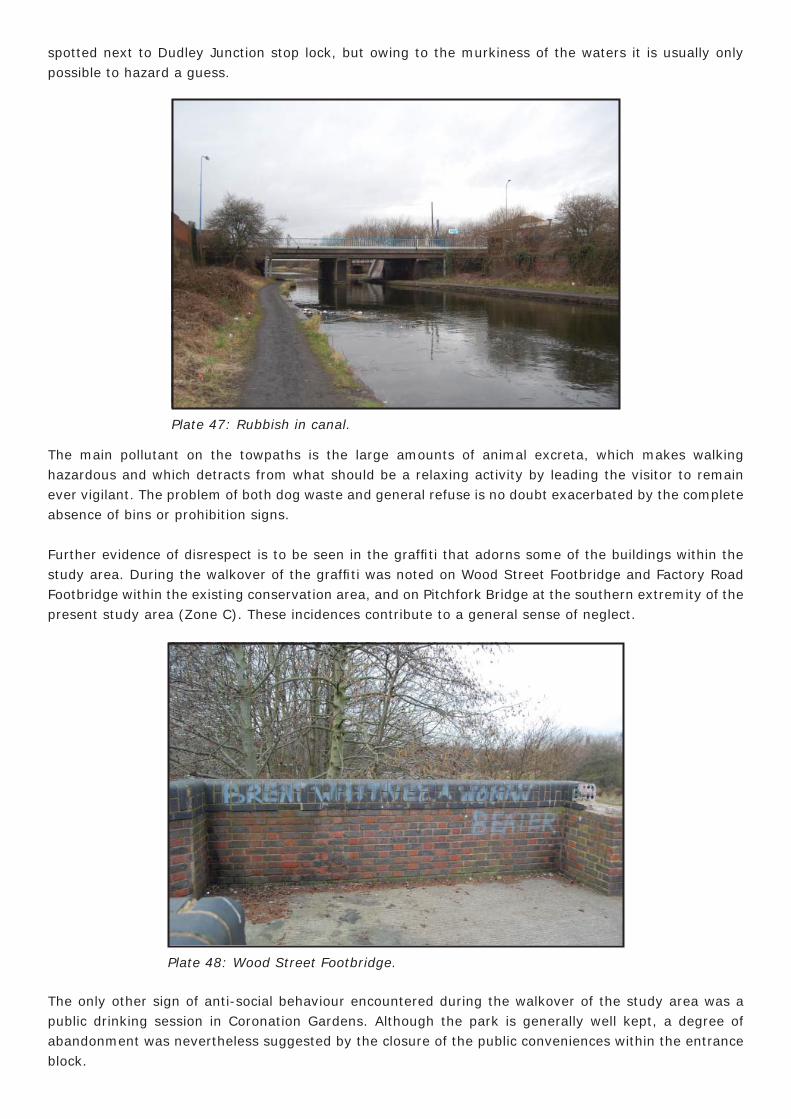
Green Space 4 (Zone C)
This area, which occupies the triangle between the Dudley Canal (northwest), Birmingham New Road (southwest) and Dudley Road (east), on a former lime manufacturing site, is an undulating area presumably refl ecting something of its former usage. Now grassed over with a number of mature trees it forms a local amenity and acts as an attractive preface to the Tipton canal system.
Green Space 5 (Zone D)
The site of the former Tipton Green Branch extending between the Old and New lines, Green Space 5 now runs northeast from Elliot Street to form a broad green corridor through the centre of which is a footpath following the line of the former canal. The land to each side of the path is given over to grass and there are many mature trees. This space is an important amenity for the local residents occupying the houses on either side, and forms a stark contrast with the urban landscape through which it cuts a swathe.
Plate 45: Green Space 4.
Plate 46: Green Space 5.
6.9 Negative Factors
Despite its generally green and attractive aspect, which provides an attractive counterbalance with the surrounding urban and post-industrial landscape, it is evident that this much needed leisure amenity suffers from a lack of respect from some of its users that detracts from its full enjoyment, and which manifests itself in a number of different ways.
Not least amongst these is the dumping of refuse in the canal. The most obvious demonstration of this is the fl oatable, usually plastic, material like bags, bottles and other packaging. Occasionally there are suggestions of the type of items that might lie beneath the surface, as in the child’s pedal car that was
spotted next to Dudley Junction stop lock, but owing to the murkiness of the waters it is usually only possible to hazard a guess.
The main pollutant on the towpaths is the large amounts of animal excreta, which makes walking hazardous and which detracts from what should be a relaxing activity by leading the visitor to remain ever vigilant. The problem of both dog waste and general refuse is no doubt exacerbated by the complete absence of bins or prohibition signs.
Further evidence of disrespect is to be seen in the graffi ti that adorns some of the buildings within the study area. During the walkover of the graffi ti was noted on Wood Street Footbridge and Factory Road Footbridge within the existing conservation area, and on Pitchfork Bridge at the southern extremity of the present study area (Zone C). These incidences contribute to a general sense of neglect.
Plate 47: Rubbish in canal.
Plate 48: Wood Street Footbridge.
The only other sign of anti-social behaviour encountered during the walkover of the study area was a public drinking session in Coronation Gardens. Although the park is generally well kept, a degree of abandonment was nevertheless suggested by the closure of the public conveniences within the entrance block.
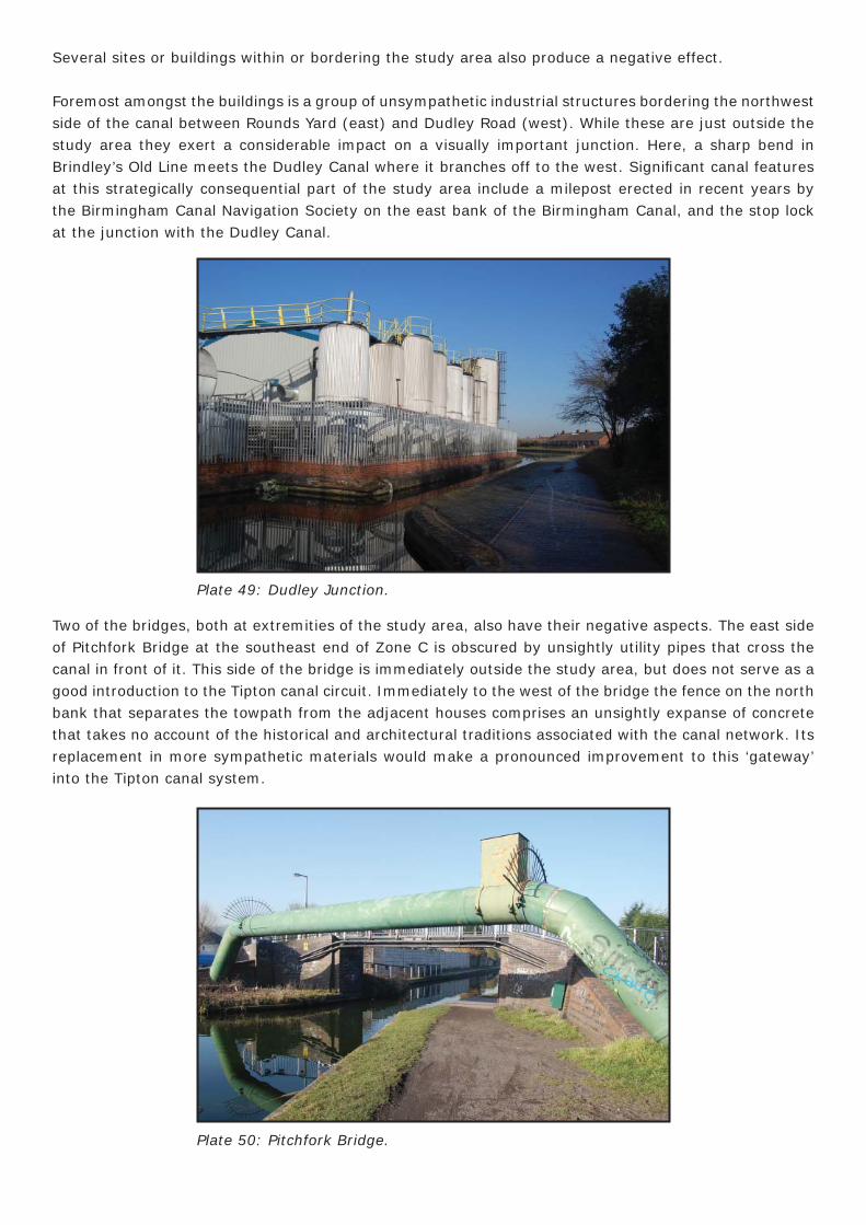
Several sites or buildings within or bordering the study area also produce a negative effect.
Foremost amongst the buildings is a group of unsympathetic industrial structures bordering the northwest side of the canal between Rounds Yard (east) and Dudley Road (west). While these are just outside the study area they exert a considerable impact on a visually important junction. Here, a sharp bend in Brindley’s Old Line meets the Dudley Canal where it branches off to the west. Signifi cant canal features at this strategically consequential part of the study area include a milepost erected in recent years by the Birmingham Canal Navigation Society on the east bank of the Birmingham Canal, and the stop lock at the junction with the Dudley Canal.
Two of the bridges, both at extremities of the study area, also have their negative aspects. The east side of Pitchfork Bridge at the southeast end of Zone C is obscured by unsightly utility pipes that cross the canal in front of it. This side of the bridge is immediately outside the study area, but does not serve as a good introduction to the Tipton canal circuit. Immediately to the west of the bridge the fence on the north bank that separates the towpath from the adjacent houses comprises an unsightly expanse of concrete that takes no account of the historical and architectural traditions associated with the canal network. Its replacement in more sympathetic materials would make a pronounced improvement to this ‘gateway’ into the Tipton canal system.
Plate 49: Dudley Junction.
Plate 50: Pitchfork Bridge.
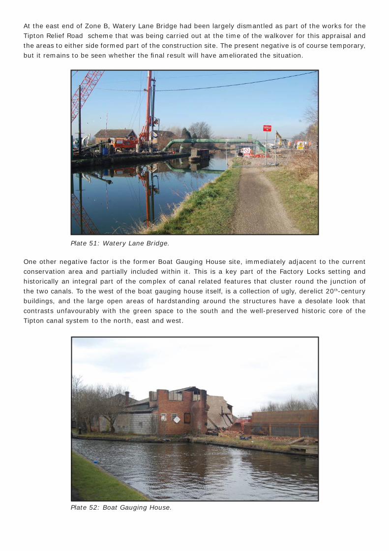
At the east end of Zone B, Watery Lane Bridge had been largely dismantled as part of the works for the Tipton Relief Road scheme that was being carried out at the time of the walkover for this appraisal and the areas to either side formed part of the construction site. The present negative is of course temporary, but it remains to be seen whether the fi nal result will have ameliorated the situation.
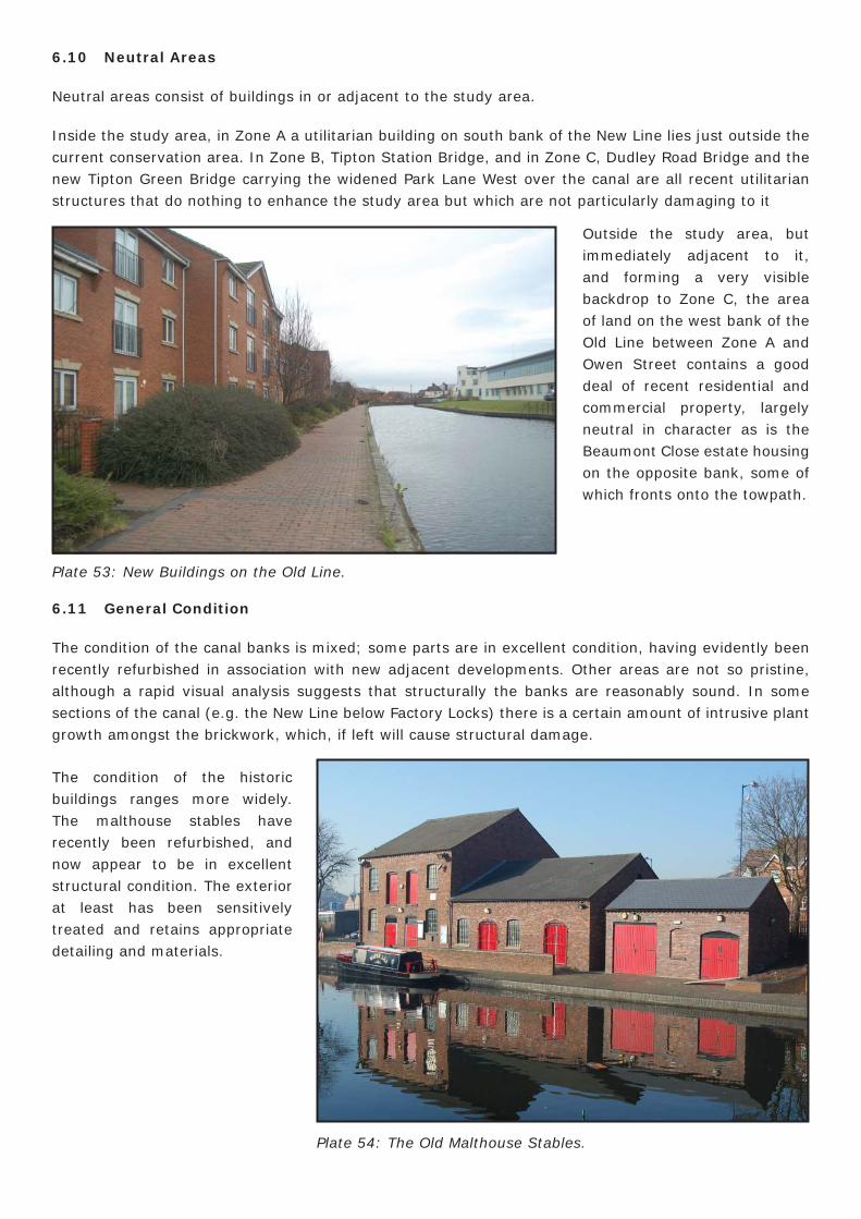
One other negative factor is the former Boat Gauging House site, immediately adjacent to the current conservation area and partially included within it. This is a key part of the Factory Locks setting and historically an integral part of the complex of canal related features that cluster round the junction of the two canals. To the west of the boat gauging house itself, is a collection of ugly, derelict 20th-century buildings, and the large open areas of hardstanding around the structures have a desolate look that contrasts unfavourably with the green space to the south and the well-preserved historic core of the Tipton canal system to the north, east and west.
Plate 51: Watery Lane Bridge.
Plate 52: Boat Gauging House.
6.10 Neutral Areas
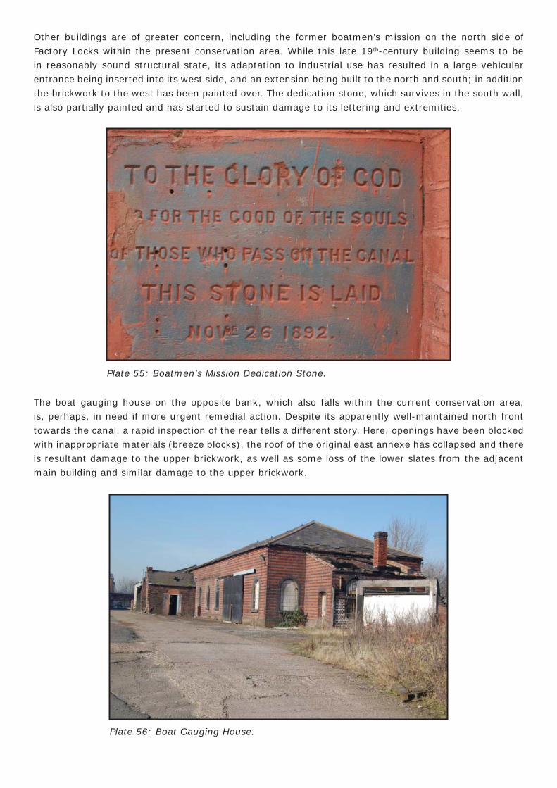
Neutral areas consist of buildings in or adjacent to the study area.
Inside the study area, in Zone A a utilitarian building on south bank of the New Line lies just outside the current conservation area. In Zone B, Tipton Station Bridge, and in Zone C, Dudley Road Bridge and the new Tipton Green Bridge carrying the widened Park Lane West over the canal are all recent utilitarian structures that do nothing to enhance the study area but which are not particularly damaging to it
6.11 General Condition
The condition of the canal banks is mixed; some parts are in excellent condition, having evidently been recently refurbished in association with new adjacent developments. Other areas are not so pristine, although a rapid visual analysis suggests that structurally the banks are reasonably sound. In some sections of the canal (e.g. the New Line below Factory Locks) there is a certain amount of intrusive plant growth amongst the brickwork, which, if left will cause structural damage.
Plate 53: New Buildings on the Old Line.
Outside the study area, but immediately adjacent to it, and forming a very visible backdrop to Zone C, the area of land on the west bank of the Old Line between Zone A and Owen Street contains a good deal of recent residential and commercial property, largely neutral in character as is the Beaumont Close estate housing on the opposite bank, some of which fronts onto the towpath.
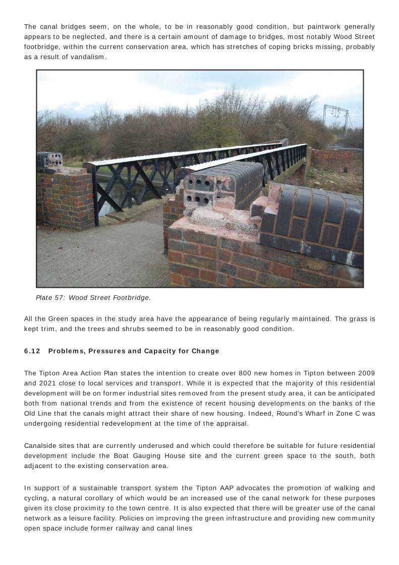
The condition of the historic buildings ranges more widely. The malthouse stables have recently been refurbished, and now appear to be in excellent structural condition. The exterior at least has been sensitively treated and retains appropriate detailing and materials.
Plate 54: The Old Malthouse Stables.
Other buildings are of greater concern, including the former boatmen’s mission on the north side of Factory Locks within the present conservation area. While this late 19th-century building seems to be in reasonably sound structural state, its adaptation to industrial use has resulted in a large vehicular entrance being inserted into its west side, and an extension being built to the north and south; in addition the brickwork to the west has been painted over. The dedication stone, which survives in the south wall, is also partially painted and has started to sustain damage to its lettering and extremities.
The boat gauging house on the opposite bank, which also falls within the current conservation area, is, perhaps, in need if more urgent remedial action. Despite its apparently well-maintained north front towards the canal, a rapid inspection of the rear tells a different story. Here, openings have been blocked with inappropriate materials (breeze blocks), the roof of the original east annexe has collapsed and there is resultant damage to the upper brickwork, as well as some loss of the lower slates from the adjacent main building and similar damage to the upper brickwork.
Plate 55: Boatmen’s Mission Dedication Stone.
Plate 56: Boat Gauging House.
The canal bridges seem, on the whole, to be in reasonably good condition, but paintwork generally appears to be neglected, and there is a certain amount of damage to bridges, most notably Wood Street footbridge, within the current conservation area, which has stretches of coping bricks missing, probably as a result of vandalism.
All the Green spaces in the study area have the appearance of being regularly maintained. The grass is kept trim, and the trees and shrubs seemed to be in reasonably good condition.
6.12 Problems, Pressures and Capacity for Change
The Tipton Area Action Plan states the intention to create over 800 new homes in Tipton between 2009 and 2021 close to local services and transport. While it is expected that the majority of this residential development will be on former industrial sites removed from the present study area, it can be anticipated both from national trends and from the existence of recent housing developments on the banks of the Old Line that the canals might attract their share of new housing. Indeed, Round’s Wharf in Zone C was undergoing residential redevelopment at the time of the appraisal.
Canalside sites that are currently underused and which could therefore be suitable for future residential development include the Boat Gauging House site and the current green space to the south, both adjacent to the existing conservation area.
In support of a sustainable transport system the Tipton AAP advocates the promotion of walking and cycling, a natural corollary of which would be an increased use of the canal network for these purposes given its close proximity to the town centre. It is also expected that there will be greater use of the canal network as a leisure facility. Policies on improving the green infrastructure and providing new community open space include former railway and canal lines
Plate 57: Wood Street Footbridge.
7.0 SUGGESTED BOUNDARY CHANGES
While the current conservation area boundary encapsulates the hub of the Tipton canal system, and includes a number of buildings of historic interest directly associated with the use of the canals, it is considered that the line is drawn too tightly, and ought to be extended to the whole of the study area in order to enhance this important heritage asset by preserving it within its historic setting, and relating it to the greater community of Tipton.
In Zone A, at the northwest apex of the present conservation area, the small proposed extension will bring in another signifi cant building: the early 20th-century Barge and Barrel Public House, the successor to an earlier inn that stood closer to the canal. The latter is in largely original external condition and has good townscape value in its location at the junction of Factory Road and Hurst Lane. Improvements at the rear of the Barge and Barrel in 1996 helped to integrate the premises into the canal environment, so that it serves as a link between the conservation area and the town. On the south side of the Factory Locks, extension will include the whole of the Boat Gauging House site rather than just the building itself as well as the adjacent former coal wharf.
Zone B is both a green corridor with nature conservation signifi cance, and a part of the New Line with considerable heritage value. There are several buildings of historic interest including small clusters at Tipton railway station (station building and Three Furnaces Bridge), and at Caggy’s boatyard (three roving bridges). The boatyard itself adds to the value of Zone B. The proposed relief road underpass, will force the new boundary to be drawn on the southern limit of the new road but it would be hoped that the brick wall to the canal towpath, which probably dates from the 1850s, would survive the new development.
While Zone B represents Telford’s New Line, the inclusion of Zone C embodies Brindley’s meandering Old Line. It is the contrast between these two canals that give the greater study area its unusual character. Both have their individual charm, but the combination of the two enriches the study area by increasing its diversity. Zone C also contains a number of historic buildings related to the use of the canal, many with group value.
The area described so far would be incomplete without Zone D which links the Old and New lines. Despite having lost much of its historic character through the fi lling in of the canal Zone D retains at least one of its locks so that there is no doubt about its former function, and, in having been turned into a green corridor with much nature conservation benefi t, it maintains the former line of the canal.
8.0 LOCAL GENERIC GUIDANCE
8.1 Opportunities for Enhancement
Opportunities for enhancement are offered by the condition of some of the buildings. The Boat Gauging House site has already been highlighted as a negative area, but the building itself is, along with the Boatmen’s Mission, one of two important canal buildings that are not contributing their full potential to the existing conservation area, and indeed tend to detract from it. Improvements to both would greatly raise the standard of preservation around the Factory Locks which form the centrepiece of the conservation and study areas.
Other buildings that would benefi t from greater attention to general maintenance are the Factory Locks themselves and the historic bridges generally, where a neglectful air has been created by unrepaired defects and old paintwork. The inappropriate use of materials for some of the repairs to bridges, locks and canals also suggests a policy that has not always refl ected the value of the historic structures. Addressing the maintenance issue could have a considerable effect on the quality of the study area.
There is, too, an enormous opportunity for the improvement of the environment by tackling the problem of refuse & dog waste, and dealing with other aspects of anti-social behaviour. At the moment these things detract from the enjoyment of this leisure and transport facility.
8.2 Planning Policy and Guidance
While the general policy on conservation areas is set out in the Unitary Development Plan (Policy C3) and Development Control Policy DC8, the emphasis is on new build and alterations rather than repair, and there are no stipulations, nor detailed guidance, on the use of traditional materials for maintenance to existing buildings.
The issue of inappropriate repair materials for the historic canal structures (principally bridges, locks, and boundary and revetment walls) is one that could be usefully addressed through the provision of a design guide to repairing period canal structures. Such a document would be a constructive step towards the preservation of the historic character not just of this particular section of the canal network but also those of other areas in Sandwell and the West Midlands.
8.3 Protection, Restoration and Enhancement
The extension of the conservation area to the whole of the study area described in this report would have the effect of extending a degree of protection to this signifi cant part of the canal network. Individual recognition of certain of the contributory elements, however, would help to pin down their intrinsic heritage value and identify their contributions to the wider complex.
To this end it is considered that the planned compilation of a local list of buildings should be set in motion. Many of the non-listed buildings identifi ed during the appraisal would be obvious candidates for consideration, as described above (6.4 The Contribution of Key Unlisted Buildings).
Zone A: Wood Street Footbridge; Factory Road bridge; Factory Footbridge; Boatmen’s Mission; Barge & Barrel; Malthouse Stables.
Zone B: Three Furnaces roving bridge; Tipton Railway Station; boundary wall between Owen Street and Caggy’s boatyard; Watery Lane Junction roving bridge; Toll End Communication Canal roving bridge.
Zone C: Canalside House, Factory Road; wall between Old Line and Elliots Road; William Perry statue (Tipton Slasher), Coronation Gardens; Owen Street Public Conveniences; Wall at junction of Castle Street and Park Lane West; Tipton Green Bridge; No. 7 Castle Street; Dudley Road Bridge; Dudley Junction stop lock.
Zone D: Lock chamber, Tipton Green Locks.
The priority for restoration of the historic character of the proposed new conservation area is the Boat Gauging House which sits right in the heart of the present conservation area and whose highly visible presence makes a major contribution to the historic scene. This building is at risk from neglect and has already started to deteriorate; its loss would be greatly to the detriment of this collection of historic structures.
The Boatmen’s Mission is in better repair, but also in a highly sensitive position close to the hub of the study area. Restoration of this building including demolition of inappropriate extensions, and change of use to one more suitable to the sustainability of the structure is also believed to be crucial to the enhancement of the area.
Regarding the canal structures in general, it is believed that the replacement of inappropriate repair materials with those of more traditional quality would contribute to a greater sense of history, to the forging of a more emphatic identify, and to the installation of a note of pride into the area.
One canal building that has now gone, but whose former position is known, is the toll house from Tipton Green Bridge, which is said to have been taken to the Black Country Museum with the intention of re-erecting it, although it is understood that no such reconstruction has taken place. Investigation of this building, its appearance, whereabouts and intentions for its future would assist in the interpretation of the proposed conservation area, and perhaps provide an opportunity for establishing a link with the Black Country Museum.
A much more ambitious measure of restoration would be the transformation of Area D to its former function as a canal linking the Old and New lines. This is not a project that could be undertaken lightly, but it is one that ought to be considered in any discussion about restoration and enhancement of the study area, or regeneration of the wider area based on the reinforcement of a distinct identity for Tipton. Quite apart from the raising of Tipton’s profi le that such a scheme would engender it would provide the opportunity for revitalising the community spirit not least as the basis for a very exciting community archaeology project.
Regarding the general environment, the litter and dog waste problem, could be to some extent ameliorated by the introduction of sympathetically designed, regularly serviced, designated bins, as well as enforcement notices, to engender an ambience of custodial care rather than the current sense of laissez faire. Given that the study area is largely a leisure facility, often park like in its character, consideration should be given to the appointment of a warden to regularly monitor and report on conditions.
8.4 Potential HERS and THI Projects
The study area has the potential to form the basis of a Townscape Heritage Initiative scheme or a Heritage Economic Regeneration Scheme aimed at making the Tipton area in general a more attractive place in which to live, work and invest through the restoration of the canal heritage of the proposed enlarged conservation area. The canal loop is geographically as well as historically entwined with the town and now acts as one of its principal open leisure areas, linking several green spaces of conservation value. In a regeneration context, placing an emphasis on the canal, one of the distinctive features of Tipton, would help in raising the profi le of the town in the public consciousness.
At the heart of such a project would be the restoration of the key Boat Gauging House site, which might include the demolition of some of the recent unsightly semi-derelict structures and the sensitive refurbishment of the listed building in order to bring it back into use. The site has a commercial use at present, and there is no reason why this should change, indeed a commercial role for the canal is an aim to be fostered for the sake of diversity and sustainability. The existence of Claggy’s boatyard within the study area, for instance, exudes a hopeful message of economic vitality and viability, and business concerns should be encouraged where they can help to enhance and maintain the historic environment.
The other main focus of a THI scheme would be the Boatmen’s Mission, which is also in commercial use, although it is arguable whether the present business represents an appropriate function. At the moment the building is divorced from the canal and needs opening up to give the proposed extended conservation area the full benefi t of its presence. The restoration of both these sites could revitalise this neglected and less attractive part of the Factory Locks site and greatly enhance the impact of the whole.
In concert with this main focus would be the replacement of inappropriate modern materials in some of the key canal structures with those in sympathy with the original fabric. These works would differ from the general maintenance that is the responsibility of the owner; rather they would replace existing repairs with more fi tting materials. Subsequent repairs could be controlled by the provision of guidance on suitable repair materials and techniques in this historic context.
8.5 Research Strategy for Archaeological Evaluation and Historic Building Recording
This character appraisal of the Tipton Conservation Area has revealed an area characterised by its canal infrastructure and associated buildings. Prior to the construction of the canals the area was very sparsely developed, and in fact the topography and urban morphology of Tipton appears to have been shaped by the canals. In addition to this a search of Sandwell HER has revealed no archaeological evidence for activity within the study area prior to the cutting of the canals. The area itself has been mapped extensively and accurately from the early/mid 19th-century thus providing an understanding of the development of the study area over a period of c. 200 years. These maps should be consulted extensively prior to any future development works in the study area.
Archaeological Evaluation
Any programme of archaeological evaluation must be carried out with the above in mind. It is diffi cult to pinpoint any specifi c locations for archaeological evaluation which would provide us with a further and greater understanding of the study area. However, if the fi lled-in section of canal in Zone D is to be reopened it would be pertinent that this would have some form of archaeological mitigation attached. The main research area here would likely be to provide a greater understanding of the construction of the canal. In addition it would be prescient to attach a watching brief condition to any future development works within the revised conservation area. Historic Building Recording
The vast majority of buildings in the study area are not statutorily listed and as such are not statutorily protected from obtuse development. It is recommended that many of these are considered to be added to a ‘local list’ when such a resource is set up. It does not appear that any of these structures is under any specifi c threat at the present time, but if such a threat were to occur it is important that a programme of archaeological and assessment recording be carried out prior to any decisions being made on future development works. This would help provide an understanding of the development of and signifi cance of the structure enabling an informed decision to be made regarding its future.
Each of the buildings afforded statutory protection within the study area are Grade II listed. The fact that these buildings are included on the statutory list means that Listed Building Consent is required for any future development works.
Of all the structures mentioned and highlighted in this appraisal the Boat Gauging House in Zone A which is a Grade II listed building is at most risk from specifi c and current threats. It lies derelict on a negative site and is in a poor state of repair. It is highly important that an in-depth understanding of this building is gained prior to any future decisions being made on the sympathetic development of this important building. This understanding will aid in assessing not only the signifi cance of the building, which has already been evaluated due to inclusion on the statutory lists, but also of signifi cant elements of the building, such as fi xtures and fi ttings, original plan forms and internal decoration schemes.
In order to realise this signifi cance and understanding, a Historic Building Assessment of the structure should be carried out by a skilled historic buildings archaeologist. This will help provide an in-depth understanding of the architectural history, structural phasing, and signifi cance of the building. It will also provide recommendations for future historic building mitigation such as the need for the future recording, the level of which will be determined following such an assessment.
APPENDIX 1: AUDIT OF HERITAGE ASSETS
Zone A
Buildings are described in sequence from east to west.
1. Wood Street Footbridge (Unlisted)
Late 19th-century footbridge with red brick abutments laid in English bond, the south abutment has been rebuilt during the course of the 20th century. The bridge has a riveted cast iron lattice/ fretwork with a concrete span which seems to have replaced a wooden deck which would have been supported by structural ironwork underneath, which still survives in a decorative capacity. The bridge bears a maker’s plaque stating “Fleet and Newey Makers, West Bromwich”.
Factory Locks
2. Bottom Lock and Cantilever Footbridge (Grade II listed)
Listed Building Description:
One of fl ight of three locks and attached footbridge. Circa 1829. Engineer Thomas Telford. Brick with sandstone kerbs to lock chambers, now partly replaced by concrete. Cast-iron sluice gear at upper side. Single gates. Across the lower end of the lock chamber is a cast-iron footbridge cantilevered from the southern bank, so allowing a tow rope to pass through the gap between it and the northern bank. The sides are each cast in one piece, with a handrail curving up from a fl at deck, and are pierced to form a cross-braced pattern. This fl ight of locks raises Telford’s New Main Line, on the Birmingham Level, up to the 473 feet Wolverhampton Level.
3. Middle Lock (Grade II listed)
Listed Building Description:
One of fl ight of three locks. Circa 1829. Engineer Thomas Telford. Brick with sandstone kerbs to lock chambers, now partly replaced by concrete. Cast iron sluice gear at upper side. Single gates. This fl ight of locks raises Telford’s New Main Line, on the Birmingham Level, up to the 473 feet Wolverhampton Level.
4. Top Lock (Grade II listed)
Listed Building Description:
Circa 1829. Engineer Thomas Telford. Brick with sandstone kerbs to lock chambers, now partly replaced by concrete. Cast iron sluice gear at upper side. Single gates. This fl ight of locks raises Telford’s New Main Line, on the Birmingham Level, up to the 473 feet Wolverhampton Level.
5. Factory Road Bridge (Unlisted)
Late 19th-century road bridge with abutments of brownish red brick laid in English bond carrying a single span cambered cast iron arch with ashlar imposts. The bridge has a semi-circular projecting ceramic string course stamped “Whitehouse Bloomfi eld”. It also has blue brick piers with ashlar caps.
6. Boat Gauging house (Grade II listed)
Listed Building Description:
Barge gauging house, now factory. 1873. Brick, with alternate courses of red stretchers and blue headers, and hipped slate roof. Facing the canal are eight windows with chamfered blue brick surrounds and round heads. Adjoining to the left is a lean-to which has a blocked doorway with segmental head. The right hand return wall has two blocked round-headed boat entrances, two small round-headed windows above, a plaque dated “1873” and a chimney. Originally contained gauging mechanisms used to assess canal tolls. This station dealt with two boats at a time and registered over 10,000 boats between 1873 and 1900.
7. The Boatmen’s Mission (Unlisted)
Canal mission house of 1892, with later alterations and additions. Of reddish orange brick laid in English bond. Originally a single cell building with pitched gables with raised brick decoration. The slate roof survives along with its terracotta ridge tiles and fi nials. Dedication stone at the south end reads: “TO THE GLORY OF GOD/(AND) FOR THE GOOD OF THE SOULS/ OF THOSE WHO PASS ON THE CANAL/THIS STONE IS LAID/NOV r 26 1892”. Later extensions to the rear.
8. Factory Footbridge (Unlisted)
Early to mid 19th-century footbridge, with red brick laid in English bond ashlar capped abutments. The cast iron span is a girder bridge with structural struts and rivets. The red brick ramps to either side have shaped brick coping and original fl oor surface of brick setts.
9. The Barge and Barrel Public House (Unlisted)
Formerly the Old Bush, this public house was constructed in the early 20th century. It is of red brick laid in Flemish bond with reconstituted stone ashlar-style dressings and a plain tile roof. It has decorative gables and two main frontages with a corner position and entrances to Factory Road and Hurst Lane. Stylistically the building is a pastiche of Tudor and classical elements with a Queen Anne Style roof.
10. Old Malthouse Stables (Unlisted)
Mid/ late 19th-century stables constructed in red brick laid in English bond, with a slate roof, and characterised by segmental arch headed openings with blue brick relieving arches, and a dentilated eaves course. The two-storey four-bay main block has doors to the central bays at ground-fl oor and fi rst-fl oor level fl anked by small pane cast-iron framed windows. The one-storey annexe which is identical in style has four bays of alternating double doors and windows. A further addition to the side is a late 20th-century copy.
Zone B
Buildings are described in sequence from west to east
11. Three Furnaces Roving Bridge (Unlisted)
A late 19th-century roving bridge carrying the tow path over the canal basin that served the Tipton Furnaces. Red brick ramped abutments laid in English bond with stone ashlar dressings and sloping brickwork. The span is a poorly preserved cast iron girder bridge with structural struts, fl anges and rivets.
12. Tipton Station Ticket Offi ce (Unlisted)
Early 20th-century railway station ticket offi ce and waiting room. Constructed in red brick laid in English bond on blue brick plinth, with a hipped slate roof. One storey and fi ve bays consisting of a blocked doorway to the left, three plate glass windows and a further doorway to the right. All of which are under segmental arches with roll moulded surrounds and hoodmoulds with raised keys. A lower annexe to the right consist of a single bay with a stone coped parapet.
13. Canalside Wall between Owen Street and Caggy’s Boatyard (Unlisted)
19th-century canal boundary wall of red brick laid in Flemish bond with occasional blue brick headers. 14. Cast Iron Footbridge Approx 150m West of Watery Lane (Grade II listed)
Listed Building Description:
Towpath bridge. Mid-C19. Cast iron with brick abutments which have some sandstone dressings. Single shallow segmental arch. Sides are a single casting pierced to form lattice pattern of saltire crosses. Spans the entrance to a boat yard which was formerly Tipton railway interchange basin, one of 26 such transhipment depots constructed on the Birmingham Canal from the 1850’s onwards. (Paget-Tomlinson, E W: The Complete Book of Canal and River Navigations, 1978, p 96).
15. Toll End Communication Canal Roving Bridge (Unlisted)
Late 19th-century roving bridge carrying the tow path over the former entrance to the Toll End Communication Canal, now an entrance to Caggy’s boatyard. It bears the plaque “The Tipton Green and Toll End communication formally closed the Birmingham Level at this point 1880-1940”. Identical in date and design to Watery Lane Junction Roving Bridge (16 below).
16. Watery Lane Junction Roving Bridge (Unlisted)
This late 19th-century footbridge over the New Line has red and blue brick abutments laid in English bond with sandstone ashlar dressings. The cast iron span is slightly cambered with structural struts and fl anges with bolts and rivets. The brick-built access ramps to the northwest on both sides of the canal have domed coping, large sections of which have been replaced in the late 20th-century by blue bullnose shaped bricks. In addition the original fl oor surface of these has been completely replaced with sympathetic brickwork.
17. Watery Lane Shunt Frame Signal Box (Unlisted)
This mid-20th-century two-storey signal box, which lies just outside the study area at the side of the railway line, is of red brick laid in English bond with a blue brick plinth and bands. It is pierced by multi-pane steel framed windows at fi rst fl oor level and has a projecting fl at concrete roof and concrete window dressings.
18. Watery Lane Bridge (Unlisted)
A late 19th-century road bridge constructed in red and blue brick laid in English bond with ashlar facing to cutwater. This bridge is currently under extensive works and only the pedestal survives.
Zone C
Buildings are described in sequence from north to south
19. Canalside House, Factory Road (Unlisted)
Early 19th-century two-storey red brick house. Now much altered with steeply pitched slate roof and inserted later 20th-century timber window frames replacing small-pane horizontal sashes. Outshots to canalside and rear.
20. Canal Boundary Wall with Elliots Road (Unlisted)
Surviving section of canal side wall of red brick laid in Flemish bond with occasional blue brick headers.
21. Fountain Inn and No 52 Owen Street (Grade II listed)
Listed Building Description:
Early C19. Brick, rendered at front and painted at rear, with slate roof. Two storeys, two bays. Facade has boxed sashes with glazing bars on fi rst fl oor. On the ground fl oor is a timber public house front, probably later C19, with pilasters and an entablature, and with a narrow window at the right, possibly replacing a door. The doorway, with a mid-C20 surround, is between the two main ground fl oor windows. The facade overlaps with No 52 to the right, which has a shop front on the ground fl oor and two boxed sashes with glazing bars on the fi rst fl oor. Chimneys on gables of Fountain Inn, and to right of No 52, which has a lower roof line. At the rear are two wings, with brick dentil eaves and with some sashed windows with glazing bars. From 1836 the Inn served as the headquarters of William Perry, the “Tipton Slasher”, boxing champion of England 1850-57. Internally the Fountain Inn extends above part of No 52.
To the rear of the Public House is a low much altered building, now serving as a rear wing, but possibly an earlier building against which the Inn abuts.
22. Owen Street Bridge (Unlisted)
Road bridge constructed in 2002 of red and blue brick abutments and span carried on cambered cast iron bridge arch with struts and fl anges.
23. William Perry (Tipton Slasher) Statue, Coronation Gardens (Unlisted)
Late 20th-century bronze statue on a square brick pedestal.
24. Owen Street Public Conveniences, Coronation Gardens (Unlisted)
Park gatehouse incorporating public lavatories constructed in the mid 20th-century of red brick laid in stretcher bond with interlocking tile roof. A wide central semi-circular arched entrance is fl anked by the single windows of the male and female lavatories which are entered from the two ends.
25. Tipton Green Bridge (Unlisted)
Early/mid 19th-century road bridge built of red brick laid in English bond with blue shaped brick coping with gate slots underneath. Partially blocked by a later blue brick wall. A local resident said that this was the spot of octagonal-shape Toll House removed to the Black Country Museum in the 20th century.
26. 7, Castle Street (Unlisted)
Two storey, 2 bay cottage, constructed in red brick laid in stretcher bond with a pitched slate roof and brick stack. Ground fl oor level has a segmental arch window to the left and a segmental arch doorway to the right now both with uPVC inserts. It appears to have been previously part of a terrace.
27. Wall at junction of Castle Street and Park Lane West (north side) (Unlisted)
Section canal wall in red brick laid in English bond and shaped blue brick coping.
27. Wall at junction of Castle Street and Park Lane West (north side) (Unlisted)
Section canal wall in red brick laid in English bond and shaped blue brick coping.
28. Rounds Wharf House (Grade II listed)
Listed building description:
House, now offi ces. Circa 1800. Brick in Flemish bond with stone dressings and hipped slate roof. Main block symmetrical, of two storeys and three bays. Windows sashed with glazing bars. Stone sills, and lintels with false chamfered voussoirs and keystones. Eight-panelled door in doorcase with panelled reveals, engaged Tuscan columns, paterae, and open pediment with fanlight. Dentilled eaves. Chimneys at both ends of ridge. At the left is a lower two-storey wing of two bays. The right-hand ground fl oor window has a lintel with chamfered false voussoirs. The left-hand bay is covered by later additions on the ground fl oor. Between fi rst fl oor windows is a blank recess. Chimney on left-hand gable and between bays.
29. Anchor House Castle Street (Unlisted)
House/offi ce. Mid to late 19th-century with later alterations. Two-storey, two-bay building constructed of red brick laid in English garden wall bond with a pitched slate roof. At ground fl oor level the door has an inserted timber lintel whilst the window to the left of this has a segmental arch head and painted stone sill with an inserted window frame. Anchor motif on left return gable picked out in blue bricks.
30. Dudley Junction Stop Lock (Unlisted)
Former stop lock. Late 18th-century in origin with later alterations. Red brick with blue brick dressings incorporating ashlar gate slots.
31. Canal Milepost (Unlisted)
Later 20th-century tubular steel canal milepost at junction of three arms of the canal erected by the Birmingham Canal Navigation Society.
32. Pitchfork Bridge (Unlisted)
Late 19th-century bridge with red brick abutments laid in English bond, and late 20th-century balustrading.
33. Birmingham New Road Bridge (Unlisted)
Mid to late 19th-century road bridge with alternating red and blue brick abutments laid in English bond. Red brick span with terminating pillars with late 19th/ early 20th-century concrete coping. This is supported by a series of riveted cast iron I-beams carrying brick vaulting.
Zone D
34. Former Lock Chamber (Unlisted)
Former canal lock chamber in fi lled-in section of canal. C. 1805 in origin with alter alterations. Constructed in red brick with ashlar and blue brick coping with the remains of iron fi tments. Some coping brick stamped Wood and Ivery Albion Brickworks, West Bromwich.
35. Tipton Conservative Club (unlisted)
Late 19th-century/early 20th-century building on site of former premises of the Union Flour Mill. Occupied by the Tipton Conservative Club from the early 20th-century. It is a two storey eight bay building of red brick laid in Flemish stretcher bond with a hipped roof. Ground fl oor windows include a group of three oeil-de-beouf windows and gauged brick headed segmental arch windows with wedged keys. The fi fth bay has a semi-circular arch doorway with busted key. The eaves are of moulded and dentilated brick.