area character appraisal cannonborough-elliottborough
TRANSCRIPT

Area Character Appraisal
Cannonborough-Elliottborough
Prepared for:
The City of Charleston, South Carolina
August 2009

Area Character Appraisal
Cannonborough-Elliottborough
Prepared for:The City of Charleston, South Carolina
August 2009
Robert and Company • 229 Peachtree Street NE • International Tower, Suite 2000 • Atlanta, Georgia 30303 • P: 404.577.4000 • F: 404.577.7119 • www.robertandcompany.com

Area Character Appraisal
Cannonborough-Elliottborough
Table of ContentsChapter 1: Introduction 1
Chapter 2: Neighborhood Background 5
Chapter 3: History 9
Chapter 4: Urban Form 20
Chapter 5: Architecture 42
Chapter 6: Landscape 72
Chapter 7: Preservation & Integrity 95
Chapter 8: Adjacent Conditions 112
Appendix A: Bibliography 122

CANNONBOROUGH-ELLIOTTBOROUGH ACA iv
Acknowledgements
Acknowledgements
This signature project was made possible because of the vision of the City of Charleston and the Depart-
ment of Planning, Preservation and Sustainability.
This project was also made possible by the efforts of citizens and members of the Cannonborough-Elliott-
borough Neighborhood Association who provided the consultants with an introductory walk through the
neighborhood, were instrumental in generating interest about the project, and provided valuable infor-
mation about the history, opportunities, and challenges of the neighborhood. The Karpeles Museum staff
should also be thanked for allowing the City of Charleston and the consultant team to use their space for
public workshops.
The project received a great amount of support from individuals and organizations that provided resources
and research aid during this project. These include:
Historic Charleston Foundation •
Preservation Society of Charleston•
Dr. Nicholas Butler, Archivist - Charleston County Library•
South Carolina Historical Society•
Dale Rosengarten, Curator – Special Collections, College of Charleston Libraries•
Finally, all the participants of the public workshops held at Karpeles Museum in February and May 2009
should be thanked for taking their personal time to become involved in the development of the document.
Their input was well received and crucial to developing a more comprehensive and thorough document
thatreflectstheirconcernsandtheirprideinCannonborough-Elliottborough.
Client TeamYvonne Fortenberry, AICP• Deputy Director,
Planning, Preservation, and Sustainability
Eddie Bello, AIA, LEED AP• Director, Urban De-
sign and Preservation Division
Debbi Rhoad Hopkins• Senior Preservation
Planner
Consultant TeamRobert and Company
Jim Cothran, FASLA • Principal-in-Charge
Nick Pergakes, AICP • Project Manager
Scott Brown, AICP•
Andrew Kohr, ASLA•
Glenn Keyes Architects
Glenn Keyes, AIA • President
Adrienne Jacobsen•

CANNONBOROUGH-ELLIOTTBOROUGH ACA v
Acknowledgements
Theactivitythatisthesubjectofthispublicationhasbeenfinanced,inpart,withFederalfundsfromtheNationalParkService,U.S.DepartmentoftheInterior.How-
ever,thecontentsandopinionsdonotnecessarilyreflecttheviewsorpoliciesoftheDepartmentoftheInterior.
ThisprogramreceivesFederalfinancialassistanceforidentificationandprotectionofhistoricproperties.UnderTitleVIoftheCivilRightsActof1964,Section504of
the Rehabili tation Act of 1973, and the Age Discrimination Act of 1975, as amended, the U. S. Department of the Interior prohibits discrimination on the basis of race,
color, national origin, disability or age in its federally assisted programs. If you believe you have been discriminated against in any program, activity, or facility as
describedabove,orifyoudesirefurtherinformationpleasewriteto:OfficeofEqualOpportunity,NationalParkService,1849CStreet,N.W.,WashingtonDC20240.
Federal funds were administered by the South Carolina Department of Archives and History.

CANNONBOROUGH-ELLIOTTBOROUGH ACA 1
IntroductionI
Chapter 1:Introduction
Most planning studies tend to focus on land
use rather than the actual physical devel-
opment patterns of a community. This of-
ten results in a lack of attention given to the
overall characteristics and qualities of what
makes a community or neighborhood unique.
Itisimportanttodefinetheurbandesignelements
that make up a particular neighborhood so that
any future development will be compatible with
and strengthen the established context. This is
particularly important in historic neighborhoods
expected to undergo future developmental pres-
sure.
FIGURE 1.1. THE CORNER STORE: A NEIGHBORHOOD ICON.

CANNONBOROUGH-ELLIOTTBOROUGH ACA 2
IntroductionI
PurposeArea Character Appraisals (ACA) are one method
of assessing and documenting the physical char-
acteristics of a place. By assessing and under-
standing the patterns of development and their
uniquecomponents,characterdefiningelements
that make a neighborhood special can be docu-
mented for future generations.
Not only do the ACAs serve a planning function,
but also an educational and outreach function as
well. ACAs should also be accessible to lay citi-
zens toexplorehoweachneighborhoodfits into
the historical and architectural development of
Charleston and the elements that make the city
special.
Charleston’s recent annexation policies give it
manyofthequalitiesanddiversityofalargecity:
very different areas within a short distance of each
other,alargeandgrowinglandarea,andsignifi-
cant development prospects. Balancing historic
preservation with development pressure makes
Area Character Appraisals for many neighbor-
hoods an exercise that is especially worthwhile
and relevant.
ACAs broaden the view of preservation from spe-
cificbuildingstothefabricofthesurroundingcom-
munity. It is a neighborhood-based approach to
preservation, in which elements that make up
neighborhood character are articulated and pre-
served. ACAs describe the context of a neighbor-
hood and the key components that characterize
a place. This includes the scale, mass, and rhythm
of structures, as well as streetscape and landscape
elements. In addition, the current uses and historic
andculturalelementsaredefinedinthecommu-
nity.
ACAswillhelpensurehigh-qualitydevelopmentin
the City of Charleston, especially areas under heavy
development pressure. Although some neighbor-
hoods may not be regarded now as particularly
historic, it is important to document the character
of an area before substantial change renders it un-
recognizable.ThefirstACAsarebeingconducted
for the historic neighborhoods of Cannonborough-
Elliottborough on Charleston’s peninsula and Old
WindermereandByrnesDowns intheWestAshley
area.

CANNONBOROUGH-ELLIOTTBOROUGH ACA 3
IntroductionI
How Area Character Appraisals WorkArea Character Appraisals (ACAs) are not a road
map for how a place should look, but rather a re-
flectionofwhatexistsandaguideforcontinuing
established development patterns. ACAs have
the ability to provide a neighborhood-specific
framework for citizens, developers, Board of Ar-
chitectural Review (BAR) members, and City staff
to ensure that new development strengthens the
established context.
Once completed, ACAs will provide a neighbor-
hood-specificframeworkwithinwhichtoevaluate
new development. The information gathered from
the ACAs will serve as a resource for future surveys
and survey updates and as a basis for evaluating
current zoning regulations. The ACA produced for
these neighborhoods will provide guidance for po-
tential zoning ordinance revisions governing new
constructionandmayeventuallyserveasjustifica-
tion in establishing a future Conservation District for
those areas.
The ACA for Cannonborough-Elliottborough will be
a vital resource for the neighborhood by providing
guidance for City staff and architectural review
boards. An immediate result of the ACA will be a
comprehensive documentation of neighborhood
characteristics that will guide City staff when re-
viewing projects and renovations in the neighbor-
hood.
To be effective, Area Character Appraisals must
adapt as areas change. City staff should initiate
periodic updates to the ACAs as needed. ACA
updates might be conducted in conjunction with
survey updates. The appraisals should be succinct
and straightforward, enabling easier updates.
Articulate a historic context and statement of significance for the study area•
Describe the urban design of the area •
Identify character-defining features (building height, scale, mass, setbacks, etc. )•
Define neighborhood boundaries•
Identify areas which are intact and transitional•
Evaluate the unique qualities of the neighborhood•
ACA’s Purpose
CANNONBOROUGH-ELLIOTTBOROUGH ACA 4
IntroductionI
ProcessThis Area Character Appraisal (ACA) for Cannon-
borough-Elliottborough has been prepared by
Robert and Company, an Atlanta-based engi-
neering, architecture, andplanning firm. InDe-
cember 2008, Robert and Company was selected
by a panel of City of Charleston staff and local
preservation professionals to prepare Area Char-
acter Appraisals for three neighborhoods. Includ-
ed on the Robert and Company team was Glenn
Keyes Architects. Glenn Keyes Architects is an ar-
chitectureandhistoricpreservationfirmlocatedin
Charleston, SC.
Between January and July 2009, Robert and Com-
panymade five trips toCharleston to complete
field work and research, participate in public
meetings, collect community input, and consult
with local experts. Throughout the development
of the ACAs, close and regular communication
with the client group has helped ensure that the
researchand finalproduct reflectedcommunity
concerns, priorities, and visions.
Robert and Company initiated the project by col-
lecting relevant studies, historical maps, and pho-
tographs of Cannonborough-Elliottborough and
the Lower Peninsula. Guided by the Charleston
Department of Planning, Preservation, and Sustain-
ability, Robert and Company reviewed copies of
major surveys conducted in Charleston and plans
preparedforspecificareasofthecityandthecity
as a whole. Robert and Company also obtained
copies of relevant National Register nominations
and researched local archives, including the South
Carolina Room at the Charleston County Public Li-
brary, Historic Charleston Foundation Archives, the
South Carolina Historical Society, and the Charles-
ton Library Society.
In January 2009, the consultant team conducted
a walking tour of the neighborhood with City of
Charleston staff, community residents, and stake-
holders of Cannonborough-Elliottborough. Robert
andCompanystaffalsoconductedextensivefield
survey work of the Cannonborough-Elliottborough
neighborhood throughout the process. Staff pho-
tographedandtookfieldnotestogatherinforma-
tion on existing conditions and significant cultural
resources in the neighborhood. This included a
detailed inventory of land use, transportation, open
space, historic resources, and architecture.
As community involvement is key to developing
successful ACAs, a public meeting and workshop
was held for the Cannonborough-Elliottborough
neighborhood.Thefirstpublicworkshopwasheld
on February 18, 2009 at the Karpeles Manuscript
Museum. This meeting’s purpose was to explain the
intent of Area Character Appraisals and provide
a framework for the completion of this study. This
meeting focused on what the residents of the study
area value about their neighborhood, the project
team’s initial thoughts about the existing conditions
and surrounding context, and determining what ur-
ban design and cultural elements contribute most
to the neighborhood’s character.
The Area Character Appraisal was publicly present-
edinameetinginJune2009,withsubsequentop-
portunities for public feedback.

CANNONBOROUGH-ELLIOTTBOROUGH ACA 5
Neighborhood BackgroundII
Chapter 2: Neighborhood Background
Cannonborough-Elliottborough is composed of
two adjacent neighborhoods that together func-
tion as one. The neighborhood is located on the
Charleston Peninsula, part of the Old City Historic
District. The northern boundary of the area is the
Septima Clark “Crosstown” Expressway (US 17),
while Bee Street and Morris Street collectively
form the southern boundary. President Street is
the western boundary, and the eastern boundary
is considered to be either King Street or Meeting
Street, depending on the source. For the purpos-
es of this study, King Street will be considered the
eastern boundary. The boundaries of the Can-
nonborough-Elliottborough study area are shown
in Figure 2.1.
MEETIN
G
CO
MIN
G KIN
G
RU
TLED
GE
SPRING
US-17
US-17
FOLL
Y CO
NN
ECTO
R
CANNON
ASH
LEY
I-26
CANNONBOROUGH/ELLIOTTBOROUGH
DOWNTOWNCHARLESTON
CHARLESTONHARBOR
COOPERRIVER
ASHLEYRIVER
WESTASHLEY
TO NORTH CHARLESTON
TO MOUNTPLEASANT
FIGURE 2.1. LOCATIONMAPSHOWINGCANNONBOROUGH-ELLIOTTBOROUGHANDITSRELATIONSHIPTOTHECHARLESTONPENINSULA.
The boundary between Cannonborough-Elliott-
borough is roughly equivalent to Rutledge Av-
enue, with Cannonborough being Rutledge and
west, and Elliottborough being everything east of
Rutledge. As mentioned before, the two areas are
functionally one larger neighborhood, and there
are no clear distinctions between the two in char-
acter.

CANNONBOROUGH-ELLIOTTBOROUGH ACA 6
Neighborhood BackgroundII
General Context Although not well documented, the neighbor-
hoodshasbeensignificantinCharleston’shistory.
Whenfirstdeveloped,thisareabecamehometo
the ‘common Charlestonian’ – a diverse mix of im-
migrants, freed slaves, and lower class workers of
the time.
Despite its lack of published history, the area has
arichandflavorfulpast,andiscurrentlyenjoying
a resurgence of vitality. Unlike parts of Charles-
ton south of Broad St. where the trend is turning
towards second homes for owners from all parts of
the country; this neighborhood exhibits a ‘close-
knit’communityqualityofmultiplegenerationsof
native residents.
Businesses in the community, nearly all of which
arelocal,independentoperationsfrequentedby
neighborhood residents, are interspersed among
residences. Cannonborough-Elliottborough is a
truly diverse area.
FIGURES 2.2-2.4. NARROWSTREETS,DIVERSEHOUSINGSTOCK,AND
CHURCHES ARE ALL COMMON FEATURES OF CANNONBOROUGH-
ELLIOTTBOROUGH.

CANNONBOROUGH-ELLIOTTBOROUGH ACA 7
Neighborhood BackgroundII
Planning StudiesAs the mid-peninsula area has experienced a re-
newed interest to new residents and businesses,
it has also become the focus of several planning
studies.
Spring & Cannon Corridor Plan (1998)
Peter Drey & Company put together this plan for
the Spring and Cannon Street corridors in order to
help direct planning efforts in the area in order to
improve the area’s conditions which are heavily
influenced by the Crosstown Expressway, Medi-
cal University of South Carolina, and the gateway
commercial area between the neighborhood and
the Ashley River. The inset below shows the nu-
merous local challenges addressed by the plan.
The barrier created by the Crosstown Expressway, severing neighborhoods that were once linked together•
Discontinuity created by radically different land uses on the east and west ends of the corridor•
Heavy traffic volumes on the Expressway, Spring Street and Cannon Street, causing stress for local residents•
The size and growth of the Medical University of South Carolina, generating adverse impacts on quality of life•
The lack of a clear plan for recovery in the neighborhoods, leading to uncertainty for residents and owners•
City of Charleston Century V Plan (1999)
The Century V Plan is a comprehensive develop-
ment plan for the City of Charleston. This City Plan
presents a picture of Charleston today and rec-
ommends five areas of emphasis for the future.
Charleston Century V is drafted as a working docu-
ment for the citizens of the city. The Department
of Planning will present an update of this plan later
in 2010.
Charleston Century V will become more compre-
hensiveovertimeasthecitystudiesspecificissuesin
more detail. Future plans conducted by the City of
Charleston will represent additions to the Century V
Plan. The goal of this effort is to make city planning
more accessible and easier to understand for the
citizens of Charleston.
Local Challenges, From the 1998 Spring & Cannon Corridor Plan:
FIGURE 2.5. TRAFFIC IS A SIGNIFICANT CHALLENGE ALONG THE
SPRING AND CANNON STREET CORRIDORS.

CANNONBOROUGH-ELLIOTTBOROUGH ACA 8
Neighborhood BackgroundII
The Charleston Downtown Plan (1999)
The Charleston Downtown Plan: Achieving Bal-
ance Through Strategic Growth was completed in
1999 by Urban Strategies, Inc. with Development
Strategies, Inc. and SBF Design. The plan’s focus is
to provide the Charleston Peninsula with a growth
management strategy that allows the city to re-
vitalize and grow where appropriate, and restrict
growth where it is not appropriate. The scope of
the plan is a 20-year vision.
ThePlanidentifiesSpring,CannonandUpperKing
Street as transitional corridors – areas where the
city fabric still exists, but has been eroded by sur-
face parking lots and demolition. It recommends
new development along these streets in available
parcels that will reinforce the existing character.
The rest of the Cannonborough-Elliottborough
areaisidentifiedasstable,meaningtheplanrec-
ognizes this area as a residential neighborhood
that should remain largely as it is in terms of form
and land use.
Vision/Community/Heritage: A Preservation Plan
for Charleston, SC (2008)
A new Preservation Plan was developed to address
emerging preservation issues in the City of Charles-
ton. The first preservation planwas developed
in 1974 and a majority of that plan’s recommen-
dations have been implemented. The updated
Preservation Plan is an extremely comprehensive
document created with extensive public involve-
ment and input. The community interaction cul-
minated in over 600 recommendations, covering
a wide range of issues from traffic concerns to
expansion of the historic districts to the issue of
affordable housing to the importance of cultural
preservation. As the new Plan is intended to guide
the City into the next 40 years, the recommenda-
Vision | Community | HeritageA Preservation Plan for Charleston, South Carolina
FIGURE 2.6. CHARLESTON’SMOSTRECENTPRESERVATIONEFFORT.
tions are categorized as Immediate, Intermediate,
Long Term, and Ongoing. This Area Character Ap-
praisal process and document is one of the imme-
diate recommendations of the 2008 Preservation
Plan, and should serve as a vital resource for future
preservation efforts in the neighborhood.
One of the major recommendations of the Plan con-
cerning the Cannonborough-Elliottborough neigh-
borhood is the expansion of the City of Charleston’s
National Register Historic District north of its current
boundaries to the Crosstown Expressway. A 1985
survey by Geier-Brown-Renfrow recognized that the
areas north of the current District and south of the
Crosstown, which includes Cannonborough-Elliott-
borough, are worthy and eligible for listing on the
National Register.

CANNONBOROUGH-ELLIOTTBOROUGH ACA 9
HistoryIII
FIGURE 3.1. 1844MAPOFTHECHARLESTONNECK,WITHAPPROxIMATEMODERNBOUNDARyOF
CANNONBOROUGH-ELLIOTTBOROUGHSHOWNByTHEREDDASHEDLINE.
Chapter 3:History
In order to evaluate the existing conditions and
qualitiesofaneighborhood,especially those ina
city so steeped in history as Charleston, it is impor-
tant to review the past to understand the present.
This chapter provides a brief history of Cannonbor-
ough-Elliottborough. It is not intended as a com-
plete and thorough history, but rather as a review of
past development and characteristics that helped
form the foundation of the present-day commu-
nity.

CANNONBOROUGH-ELLIOTTBOROUGH ACA 10
HistoryIII
Chapter 3 Summary
General HistoryCannonborough-Elliottborough originally be-•
gan as two separate neighborhoods, but are
today considered one community.
Cannonborough-Elliottborough’s history is •
of blue-collar workers, ethnic groups, and
vernacular architecture, rather than famous
historical figures, premier families and high-
style mansions. It is a history of the common
Charlestonian, rather than the elite.
Compared to some other areas of Charles-•
ton, Cannonborough-Elliottborough’s history
is not well-documented.
The construction of the Septima Clark Express-•
way through Cannonborough-Elliottborough
in 1967 has been detrimental to the neighbor-
hood.
The neighborhood exhibits a rich culture and •
wide variety of land uses, small businesses
and architectural styles.
Development HistoryHistoric physical development in the neigh-•
borhood is well-documented by several his-
toric maps, including Sanborn Fire Insurance
Maps.
Early development in Cannonborough-Elliott-•
borough was restricted by wetlands that were
laterfilled.
LineStreet isnamedafteraWarof1812for-•
tificationthatexistedparallel to thepresent-
day road. There are no visible remnants of this
fortification.
Most of Cannonborough-Elliottborough is •
within the Old City District (locally designat-
ed), but outside of the Old & Historic District
and National Register District.
Local LandmarksLocal landmarks include National Register •
properties, churches, iconic buildings, local
gathering places, and other properties with
significanceorwiderecognition.
Freedman’s cottages represent an important •
local vernacular architectural type and are
common in the neighborhood.
Recommendations will appear at the end of this chapter and are denoted in the text by this symbol. R

CANNONBOROUGH-ELLIOTTBOROUGH ACA 11
HistoryIII
FIGURE 3.2. 1855 CHARLESTON MAP.
General HistoryTheCannonborough-ElliottboroughneighborhoodisdefinedbyUSHighway17onthe
north, King Street on the east, President Street on the west, and Bee and Morris Streets
on the south. Situated in Charleston’s mid-peninsula, the Cannonborough-Elliottbor-
oughneighborhoodincludesthehistoric6thand8thWardsofCharleston.
Cannonborough was named for Daniel Cannon, a carpenter and mechanic who
ownedseveral lumbermills in thearea. Cannonacquireda largeamountof land
north of Calhoun Street (then Boundary Street) and west of Comings Creek. Much of
thislandwasmarshlandatthetime,buthassincebeenfilledin.
ElliottboroughwasnamedafterColonelBarnardElliott,aRevolutionaryWareraplant-
er and member of the Provincial Congress. The original Elliottborough was bounded
by Spring Street, Ashley Avenue, Line Street and Coming Street.1 The area was settled
as early as 1785 and was comprised of the northernmost neighborhoods. The Ashley
River’s marshlands bordered the neighborhood’s boundaries at that time.
Significantdevelopment in theCannonborough-Elliottboroughneighborhooddates
to the mid-nineteenth century, when rice production was experiencing a decline and
commercial shipping and small-scale industries were developing as the economic
base. Principal industries included rice and lumber mills, shipping and rail facilities, as
well as small foundries and tanneries. The region’s transition from an agricultural-orient-
ed economy to a more diverse economic base was accompanied by an increased
immigrant population of Irish and German families, who migrated to the area primarily
fromnortheasterncitiestofilltheincreaseddemandforlabor.ManyofCharleston’s
new industrial and manufacturing activities were located in the mid-peninsula, where
land was cheap and housing was affordable.2

CANNONBOROUGH-ELLIOTTBOROUGH ACA 12
HistoryIII
In addition to Irish and German populations, freed
blacks, unskilled native-born whites, and a size-
able Jewish contingent also settled in the area.
The oldest Jewish burial ground in Charleston,
known as Beth Elohim Coming Street Cemetery, is
located in the Elliottborough neighborhood at 189
Coming Street. Most of the graves in the cemetery
date from the eighteenth and nineteenth centu-
ries, while a small number of burials occurred in the
twentieth century.3
Although the Cannonborough-Elliottborough
neighborhood represents an important aspect of
Charleston’s mid-nineteenth and twentieth cen-
tury history, the area has largely been undocu-
mented and remains well off the “beaten path”
ofmost tourism inCharleston. While there isnot
the concentration of grand mansions or histori-
cal markers found elsewhere on the peninsula,
Cannonborough-Elliottborough provides a history
of the common citizen, local commerce and ver-
nacular architecture of Charleston. As it remains
today, the community is a place of residence and
business for genuine Charlestonians.
The Cannonborough-Elliottborough neighborhood
is made up of a diversity of building types, the ma-
jority of which are structures of typical Charleston
singlehouseconstruction.Whileresidencesinthe
area vary greatly in size, some of the larger homes
are located along Spring and Cannon Streets,
and along Ashley and Rutledge Avenues. Smaller
homes are dispersed throughout the neighbor-
hoods on narrow streets including Kracke, Sires,
Rose, Ashe, and Percy, as well as on the numerous
courts and alleys in the area.
In addition to a mixture of small and medium sized
businesses operating in the Cannonborough-Elliott-
borough neighborhood, numerous religious institu-
tions are scattered throughout the area. Some of
the largest of these include the Brith Shalom Beth
Israel synagogue on Rutledge Avenue (just outside
the neighborhood boundaries), the Francis Brown
AME Church on Ashe Street, and the Holy Commu-
nion Church located at Cannon and Ashley. The
area’s largest contiguous land owner is the Medi-
cal University of South Carolina, located along the
western boundary of Cannonborough.4
In 1967, the Crosstown Expressway was complete,
establishing a connection between Interstate 26
and the Ashley and Cooper River Bridges. The
expansive freeway effectively severed portions of
Cannonborough-Elliottborough. This severance,
alongwithheaviertrafficvolumesandthenational
trendof “white flight”movement to suburbanar-
eas, caused severe decline in Cannonborough-
Elliottborough during the 1970s and 1980s. The lin-
gering effects of this decline are still evident despite
somesignificantrevitalization.Thisismostapparent
in the number of abandoned and/or dilapidated
buildings in the neighborhood.

CANNONBOROUGH-ELLIOTTBOROUGH ACA 13
HistoryIII
Corner stores represent a distinctive building type
in the Cannonborough-Elliottborough neighbor-
hood. The historical use of corner properties for
small neighborhood businesses has played an im-
portant role in adding life and vitality to the area.
Today, the Cannonborough-Elliottborough neigh-
borhood exists as one of the most diverse residen-
tial areas in Charleston. Blue-collar workers, col-
lege students, older residents and young families
live side-by-side in this evolving section of the city.
As noted in an article in the Post & Courier (Octo-
ber 12, 2000), the changes that are taking place in
the Cannonborough-Elliottborough neighborhood
is dynamic in nature:
To understand the stresses on residents in
Cannonborough-Elliottborough, one needs
look no further than the neighborhoods’
boundaries. At its north is the peninsula’s
busiest traffic artery – the Crosstown Express-
way – feeding thousands of cars daily to city
streets and river bridges. The ever-reaching
arms of the Medical University of South Caro-
lina (MUSC) continue to grab land to the south
and west. Along the area’s eastern end is the
recent darling of peninsular prosperity – Up-
per King Street. Throw in bus loads of college
students – forced out of areas further south by
skyrocketing rents – and the collective forces
spell change. “It’s a two edged sword,” said
the neighborhood’s former president, the Rev.
Sidney Davis. “The positive side is people are
taking dilapidated homes and fixing them
up. The negatives of the desirability are rising
property values, traffic congestion and park-
ing shortages.”5
-Post & Courier, October 12, 2000
In 1997, the City and the residents of Cannonbor-
ough-Elliottborough perceived a need to create a
plan that would direct the future of their commu-
nity. Around the same time, the Medical University
of South Carolina (MUSC) was considering a major
redevelopment effort with potential impacts to the
neighborhood. This threat precipitated the need
for the preparation of a development plan that
would involve input from the community.
The result, known as the “Spring and Cannon Cor-
ridor Plan,” addressed everything from building
height restrictions to resident-friendly business hours.
In the development of the plan, the neighborhoods
focused on working with the City of Charleston to
address zoning, infrastructure, development and
preservation issues in an effort to promote positive
community development that would not encour-
age gentrification. With the completion of the
plan, planning efforts have continued between the
neighborhoods and the City to promote collabora-
tive measures that will improve the area while pre-
servingitsviabilityanduniquehistoriccharacter.

CANNONBOROUGH-ELLIOTTBOROUGH ACA 14
HistoryIII
Development History Historic MapsSanborn Fire Insurance Maps are an invaluable
resource for researching historical development.
These detailed maps of buildings and land parcels
are well known for their accuracy, and are there-
fore an excellent window into past neighborhood
development. The Cannonborough-Elliottbor-
ough neighborhood has Sanborn Maps preserved
from 1888, 1902, 1920, 1944, 1951, and 1955. As
a result, one can see the changing landscape of
these neighborhoods over time.
Alfred O. Halsey’s 1949 Historic Charleston On a
Map, ‘The Halsey Map’, contains a vast amount
of information. In addition to street and neighbor-
hood locations, the map shows the peninsula’s
original high-tide water lines, locations of natural
disasters (hurricanes, fires, and earthquakes), and
numerous historic sites, with supplemental informa-
tion. Although there are very few historic events or
sites labeled in Cannonborough-Elliottborough, the
map does show that large areas of Elliottborough’s
northwestern and southeastern areas were original-
ly under water at high tide.
Another interesting feature noted on the Halsey
Map isa fortificationparallelingLineStreet,which
wasbuiltfortheWarof1812,locatedapproximately
where the Crosstown Expressway exists today. Line
Streetwasnamedafterthisfortification.Thoughno
visible remindersof thefortificationremain, it isan
interesting historical fact – one that should be incor-
porated into a historical marker in the future.
FIGURE 3.3. SECTIONOFHALSEy’S1949 HiSTORiC CHARLeSTOn On A MAP, WITHWAROF1812FORTIFICATIONLINELABELED.
1812Fort
ification
Line
R

CANNONBOROUGH-ELLIOTTBOROUGH ACA 15
HistoryIII
inclusion in Old City DistrictCharleston’s landmark preservation ordinance of
1931,thenation’sfirstpreservationordinance,es-
tablished the Board of Architectural Review (BAR).
Although the BAR began with limited powers in
1931, it has since expanded its powers of review in
both scope and area.
PartsofCannonborough-Elliottboroughfirstcame
under the BAR’s review in the 1970s following the
recommendations of the 1974 Historic Preserva-
tion Plan, which included a comprehensive archi-
tectural survey of most of the city below Calhoun
Street. The Geier-Brown-Renfroe survey in 1984-85
expanded the inventory to include areas south of
the Crosstown Expressway that were not covered in
the original 1974 survey.
The 1984-85 survey area became part of the Old
City District, and the BAR’s authority over the Can-
nonborough-Elliottborough area originated with
demolition review and repairs and alterations re-
viewofbuildingsidentifiedasover100yearsoldor
as highly-rated. Today, BAR also has review author-
ity over all new construction and review of demoli-
tions now includes structures over 75 years old.6
Cannonborough-Elliottborough below Line Street is
currently part of the Old City District, but is not in-
cluded within the Old & Historic District or Charles-
ton’s National Register District. King Street buildings
north of Morris Street are in the Old & Historic District,
but not in the National Register District. Chapter 7:
Preservation & Integrity, further explores the possi-
bility of expanding the National Register District to
include Cannonborough-Elliottborough, and the
associatedissuesandbenefits.
The Bridges and Allen Map of 1852 shows that de-
velopment in Cannonborough-Elliottborough was
very sparseat the time. WhileKing,Cannon,St.
Philip and Coming Streets were well developed,
most blocks north of Spring Street, or west of Com-
ing Street, were empty in 1852. Development in
the western portions of the neighborhood be-
tween Rutledge Avenue and President Street was
restricted by marsh and other wetlands. There ap-
pears tohavebeenawalled fortificationat the
edge of the marsh, running just south of and paral-
lel to Line Street, stretching from Ashley Avenue to
what would have been President Street.FIGURE 3.4. MAPPORTIONSHOWING
THEBOUNDARIESOFTHEOLDCITy
DISTRICT(BELOWTHEDASHEDLINE)AND
THE OLD & HISTORIC DISTRICT (IN BLUE).
CANNONBOROUGH-ELLIOTTBOROUGH
BOUNDARIESARESHOWNByTHERED
DASHED LINE.

CANNONBOROUGH-ELLIOTTBOROUGH ACA 16
HistoryIII
Local LandmarksThe map on the following page (Figure 3.7) shows
the location of various landmarks in Cannonbor-
ough-Elliottborough.Landmarkscanbedefinedin
several different ways, but usually include buildings
ofsignificanceorlocalgatheringplaces.Ingen-
eral, landmarks are locations that people identify
with, and usually everyone in the neighborhood
knows these locations by name. The landmarks
onthismapwereidentifiedthroughlocalinputat
the Area Character Appraisal public workshop in
February 2009. The map also includes the numer-
ous churches that are located in these neighbor-
hoods, several of which are certainly considered
landmarks.
Three properties in the neighborhood are listed
on the National Register of Historic Places, and
one – St. Luke’s Chapel - is located adjacent to
the neighborhood’s boundary. These buildings
are included in the landmark map. Additionally,
Freedman’s cottages, although not listed on the
National Register, are also noted on the map.
FIGURE 3.6. KARPELES MUSEUM: AN ICONIC LOCAL LANDMARK.
FIGURE 3.5. TWOFREEDMAN’SCOTTAGESONLINESTREET(155AND157).
Freedman’s cottages are a locally-originated build-
ing typology that appears primarily in the mid- and
upper-Charleston peninsula, and they are highly
valued in the Cannonborough-Elliottborough
neighborhood. This typology is discussed in more
detail in the chapters on Architecture (Chapter 5)
and Preservation (Chapter 7).

CANNONBOROUGH-ELLIOTTBOROUGH ACA 17
HistoryIII
KING
KINGSAINT PHILIP
COM
ING
PERCY
ASHERO
SE
ROSE
SIRES
IPSWIC
HRUTLEDG
E
ASHLEY
BEE
OLIVER
CANNON
REID
WOOLFE
BREWSTERPAYNE
RODGERS
ACKERMAN
CANNON
SPRING
SPRING
SPRING
COLUMBUS
BOGARD
BOGARD
US 17
US 1
7
LINE
HUMPHREY
TULLYSAINT PHILIPCO
MING
RUTLEDGE
ASHLEYKRAC
KE
KENNEDY
TODD
ASHE
BRACKYLEWIS
FELIX
DEREEF
SMITH
CARRERE
ISLINGTO
N
PRESIDENTS
ROSEMONT
PEECKSENS
PORTERS
MEETING
MORRIS
Cannonborough-Elliottborough
N
Legend
Landmarks
National Register Properties
Scale: Approximately 1” = 150’
Landmark
Freedman’s Cottage
Church
NeighborhoodBoundary
Calvary ChurchMemorial
And GroundsChrist Gospel
Church
Assemblies of God
Cemetery
HistoricBank
BuildingD’Allesandro’s
Five
Karpele’sMuseum
Tiny House
ImmaculateConception
School
Bluestein’s
Fire Station
Old Bank of America
Building
Read Brothers
Dereef Park
UnitedOrder
ofTents
HominyGrill
YMCA ComingStreet
Cemetery
JamesSparrow
House
New Cannon Street
Church
Morris St.BaptistChurch
MorrisBrown
AME
ClydeHouse
ShilohAME
Church
TempleBrith Shalom
Beth Israel
St. LukesCathedral
WilliamRobb
House
ElliottboroughPark
CentralRMUE
ZionPresbyterian
Church
The Wedding
Chapel
Church of Holy
Communion
PlymouthUnited
UnknownChurch
FrancisBrown
AME
MannaLife
CenterMichael
Michaelson
Lucca
FIGURE 3.7. NEIGHBORHOOD LANDMARKS.

CANNONBOROUGH-ELLIOTTBOROUGH ACA 18
HistoryIII
Chapter 3 RecommendationsConduct an in-depth survey and history of •
Cannonborough-Elliottborough, similar to
Between the Tracks or the Upper Peninsula
Survey.
Conduct oral histories with residents of the •
neighborhood to develop a more detailed
history of the area.
Add historical markers noting the location of •
theWarof1812fortificationthatexistednear
Line Street.

CANNONBOROUGH-ELLIOTTBOROUGH ACA 19
HistoryIII
Endnotes 1 Dorothy, Givens, “Uptown group gets new name, identity,” The Post and Courier, 10 October
1991.Page1“ThisWeek.”
2 Linda Stine, et al. (eds), Carolina’s Historical Landscapes. Knoxville, TN: University of Tennessee
Press, 1997. 172-184.
3 Solomo Breibart, explorations in Charleston’s Jewish History, Charleston, SC: The History Press,
2005. 171-172.
4 Ron, Menchaca, “Pressure Points,” The Post and Courier, 12 October 2000. Page 1
“Downtown.”
5 Ibid.
6 Debbi Rhoad, “The Board of Architectural Review in Charleston 1931-1993,” Preservation
Progress, special edition spring 1993. 13-18.

CANNONBOROUGH-ELLIOTTBOROUGH ACA 20
Urban FormIV
Chapter 4: Urban Form
FIGURE 4.1. THISVIEWALONGSIRESSTREETSHOWSTHECOMPACTPATTERNOFDEVELOPMENTINCANNONBOROUGH-ELLIOTTBOROUGH.
Like most of the Charleston Peninsula, Cannonbor-
ough-Elliottborough represents a denser, urban
development pattern. The neighborhood’s devel-
opment incorporated traditional features such as
a grid layout, but grew in a more organic pattern
defined by the neighborhood’s needs and cul-
ture. This chapter will examine this pattern, as well
as the land uses within the neighborhood.
Small, walkable bocks within a grid •
street pattern
A variety of uses including a signif-•
icant number of corner stores
A mix of housing types•
Prevailing Character

CANNONBOROUGH-ELLIOTTBOROUGH ACA 21
Urban FormIV
Chapter 4 Summary
edges, nodes, & CorridorsCannonborough-Elliottborough’s bound-•
aries are the Crosstown Expressway to the
north, King Street to the east, Bee and Morris
Streets to the south, and President Street to
the west.
The Crosstown Expressway is a hard edge •
boundary, while Morris Street is a soft edge
that provides a more seamless transition into
and out of the neighborhood.
Many of the neighborhood’s main corridors •
are grouped in pairs - Spring and Cannon,
Ashley and Rutledge, Bogard and Line - each
group having a different development char-
acter.
Upper King Street is a thriving district that pro-•
vides the neighborhood with local shopping
and nightlife.
neighborhood PatternsCannonborough-Elliottborough is a very high-•
density neighborhood with narrow lots, small
blocks, and multiple housing units per lot.
Lot sizes have a wide range throughout the •
neighborhood. Rutledge and Ashley Av-
enues, and Spring and Cannon Streets have
larger lots. Rose Lane and Sires Street have
very small lots.
Corridors with primarily single-style residences •
have minimal or no front yard setbacks. Cor-
ridorswithVictorian stylehouseshave larger
setbacks.
The neighborhood has maintained a fairly •
consistent development pattern and mix of
land uses throughout its fully-developed exis-
tence.
Land Use & ZoningAlthough a residential neighborhood, Cannon-•
borough-Elliottborough exhibits a wide variety
of land uses.
Numerous corner stores throughout the neigh-•
borhood add convenience and vibrancy to
the interior of the neighborhood.
There are no industrial uses in the neighbor-•
hood.
The neighborhood is lacking in park space - •
currently there are only two small parks at the
far north and south.
Most of the residential portion of the neighbor-•
hood is zoned DR-2F; most commercial areas
are zoned LB, Limited Business (Spring and Can-
non corridor), or GB, General Business (St. Philip
and King Street).
Height regulations are based on a height over-•
lay - most of the neighborhood has a maximum
height of 50 feet and a minimum of 25 feet.
In some areas, the zoning code is inconsistent •
with existing historic development.
Recommendations will appear at the end of this chapter and are denoted in the text by this symbol. R

CANNONBOROUGH-ELLIOTTBOROUGH ACA 22
Urban FormIV
Edges, Nodes, & CorridorsTheformofurbanareasiscommonlydescribedthroughidentificationof
its edges, nodes, and corridors. Edges form the boundary of a neighbor-
hood or district; Corridors are the main thoroughfares - the primary paths
that people take by car or foot through an area; and Nodes are the focal
points or gathering places of a community.
edgesNorthern Edge
The Crosstown Expressway forms a rigid northern edge for Cannonbor-
ough-Elliottborough.
Southern Edge
Morris and Bee Streets form the southern boundary of the neighborhood.
This is a soft edge boundary, because there is not an obvious transition
from Cannonborough to Radcliffeborough.
Nodes are central gathering places or focal
points of a community. Corridors are land uses
or activity centers that are concentrated along
a thoroughfare.
CorridorsCannonborough-Elliottborough is a dense, mixed
use community with a variety of different land use
types.Onagivenblock,youmightfindanapart-
ment building, next to a church, next to a single-
family building, next to a corner store with second-
and third-story apartments.
FIGURE 4.3. MORRISSTREET,THESOUTHERNBOUNDARy,CREATESASOFTEDGE.
Eastern Edge
Depending on the source, the eastern boundary is either be King Street or
Meeting Street.
Western Edge
President Street is generally recognized as the western boundary of the neigh-
borhood. Here there is a transition from a mix of residential and neighbor-
hood commercial uses to an area of more intense commercial and institu-
tional uses.
FIGURE 4.2. THECROSSTOWNExPRESSWAy(US17)FORMSAHARD.EDGEASTHENORTHERN
BOUNDARyOFCANNONBOROUGH-ELLIOTTBOROUGH.

CANNONBOROUGH-ELLIOTTBOROUGH ACA 23
Urban FormIV
FIGURE 4.4. LANASITSONONECORNEROFAVIBRANTNODEATCANNONSTREETANDRUTLEDGEAVENUE.
nodes Nodes are central gathering places and focal
points of a community. Usually these are central-
ized locations at a major intersection or around a
squareorplaza. CannonStreetatRutledgeAv-
enue is a vibrant node with popular restaurants
located on three of the four corners (currently
HominyGrill,Fuel,andLana)andofficeuseatthe
fourth corner.
The new “Midtown” residential district is part of
an emerging node on Cannon Street between St.
Philip and Coming Streets, which also includes the
very popular restaurant, Five Loaves.

CANNONBOROUGH-ELLIOTTBOROUGH ACA 24
Urban FormIV
CorridorsCannonborough-Elliottborough is a dense, mixed
use community with a variety of different land use
types.Onagivenblock,youmightfindanapart-
ment building, a church, single-family buildings,
and a corner store with second and third-story
apartments. Each corridor or group of corridors in
theneighborhoodhasitsownuniquecharacteris-
tics of development.
FIGURE 4.5. UPPERKINGSTREETDISTRICT:ATHRIVINGAREA.
King Street
The southern half of King Street in Elliottborough
(south of Spring Street) is made up of mixed-use
buildingsfrontingthestreetwithgroundfloorretail,
andtwoorthreestoriesofofficeorresidentialuses
above the ground level. A few buildings (Morris
Sokol furniture is an example) are either two story
retail, or two-story with a high parapet wall. This
area is part of the Upper King Street shopping dis-
trict and it contains many historic buildings with
outstanding architectural details.
North of Spring Street, King Street immediately los-
es the vibrancy and streetscape that exists to the
south. The first block north of Spring Street has a
storage and truck rental lot facing King Street on
the east side, and an empty lot on the west side of
the street. Temporarily, this is a “dead zone”; how-
ever, there is hope that the proposed “Midtown”
mixed use development will help spur development
furthernorthonKing Street to fill thevoidson the
street front.

CANNONBOROUGH-ELLIOTTBOROUGH ACA 25
Urban FormIV
Spring Street & Cannon Street
Spring Street and Cannon Street are the two pri-
mary east-west corridors in the neighborhood, not
including the Crosstown Expressway, which is a
limited access highway.
Spring and Cannon Streets have a variety of uses
and an eclectic collection of architectural types.
Although both are mixed-use, Spring Street is pri-
marily commercial, while Cannon Street is primar-
ily residential. Both are currently one-way streets
with opposite directions of traffic (Spring traffic
flowswest, Cannon flows east), butwill be con-
vertedtotwo-waytrafficinthenearfuture.
FIGURE 4.6. RESIDENTIALSCALEDEVELOPMENTONSPRINGSTREET,JUxTAPOSEDWITH
REGIONAL-SCALETRAFFICVOLUMES.
FIGURE 4.7. CANNONSTREETHASANECLECTICMIxOFRESIDENCES.
Spring Street is a corridor of primarily commercial
uses,butalsohasmanyresidencesandofficestruc-
tures. Spring Street is the one area in the neighbor-
hood where strip commercial development is fairly
common. However, there are also a large number
of businesses housed in former residential buildings
that are more characteristic of the neighborhood.
Heavy traffic is common on Spring Street, which
has harmed the residential character of this cor-
ridor. However, the street maintains a good stock
of buildings and a neighborhood scale that should
allow it to return to a vibrant street when convert-
edtotwo-waytraffic.
Cannon Street is the “sister” to Spring Street, anoth-
er one-way corridor paralleling it one block to the
south. From Ashley Avenue to Coming Street, Can-
non Street is primarily residential. East of Coming
Street, there are several businesses and other uses
mixed in; west of Ashley Avenue, Cannon Street
primarily serves the Medical University of South
Carolina. Unlike other streets in the neighborhood,
whichusuallyreflectaparticulararchitecturalform,
Cannon Street exhibits a scattered mix of Charles-
tonsingle-houseresidences,Victorianhouses,and
modern structures.

CANNONBOROUGH-ELLIOTTBOROUGH ACA 26
Urban FormIV
Bogard Street & Line Street
Bogard Street and Line Street are parallel streets in the northern section of the
neighborhood. They are the essence of the residential character of Cannon-
borough-Elliottborough. Each street is a narrow residential street with parallel
parking that serves tokeeptrafficataslowpaceconducive topedestrian
activity.
Bogard Street is characterized by modest-sized detached homes, often
Charlestonsinglehomestyle,throughoutthemid-blocks,andfrequentlywith
residences above corner stores at cross-street intersections. The ground level
of these corner buildings are cut diagonally to address the corner, making
them inviting to both Bogard and the corresponding cross street.
FIGURE 4.9. LINESTREETFREEDMAN’SCOTTAGEWITHNOFRONTSETBACKANDPLACEDONASMALLER
LOT.
FIGURE 4.8. DETACHED HOMES ON BOGARD STREET.
Line Street is comparable in form and land use to Bogard Street with a similar
characteristic of mid-block residences and corner stores. More civic uses
(churches, schools, etc.) are incorporated into the mix on Line Street. Line
Street is further behind Bogard Street in terms of revitalization, but retains its
historic character of development.

CANNONBOROUGH-ELLIOTTBOROUGH ACA 27
Urban FormIV
Rutledge Avenue is primarily residential and has
larger, grander homes along it – most of which are
Victorianstyle.UnliketheCharlestonsingle-house,
the homes along Rutledge and Ashley Avenues
have their entrances facing the street rather than
totheside.Whereasfrontyardsarerarethrough-
out most of Cannonborough-Elliottborough, there
are ample front yards aligning Rutledge and Ash-
ley Avenues throughout the neighborhood.
Rutledge Avenue & Ashley Avenue
Rutledge Avenue and Ashley Avenue are parallel
north-south avenues, separated one block apart.
AshleyAvenuehasone-waytrafficmovingnorth,
whileRutledgeAvenuehasone-waytrafficmov-
ing south.
They are very similar in architecture and lot front-
age, as they both typically have larger homes on
larger lots than most of Cannonborough-Elliottbor-
ough. There is a mix of residential and commercial
buildings on Rutledge Avenue and Ashley Avenue
from Spring Street south, but they are strictly resi-
dential corridors from Spring Street north to the
Crosstown Expressway.
FIGURE 4.10. ASHLEyAVENUEHASAMIxOFSINGLE-STyLEAND
VICTORIANHOMES
FIGURE 4.11. VICTORIANHOMESONRUTLEDGEAVENUE.
Ashley Avenue parallels Rutledge Avenue and is
similar in scale; however, there is more of a mix
betweenVictorian-inspiredhomesandCharleston
single-style buildings. There are several elegant
mansions on Ashley near the southern end of the
neighborhood, between Bee Street and Cannon
Street. Similar to Rutledge Avenue, most buildings
are set back from the street with a yard and have
street-facing porches.FIGURE 4.12. ONEOFASHLEyAVENUE’SGRANDMANSIONS
CANNONBOROUGH-ELLIOTTBOROUGH ACA 28
Urban FormIV
Neighborhood PatternsThe set of graphics on the next page (Figure 4.14)
shows a comparison between Cannonborough-
Elliottborough, two West Ashley neighborhoods
(ByrnesDownsandOldWindermere),andamod-
ern suburban community in North Charleston.
These graphics, each representing an area of 16
squareacres(836feetx836feet)insize,showthe
differences between the compact urban form of
early Charleston, early twentieth century suburban
developmentasrepresentedbyWestAshleysub-
divisions, and the low-density sprawl of modern-
day conventional suburban development.
Lot SizesAs with most high-density urban neighborhoods,
lot sizes in Cannonborough-Elliottborough are typi-
cally small and narrow. The lots throughout these
neighborhoods are far from uniform, however,
varying from street to street and block to block.
For example, Freedman’s cottages on Line Street
have lots as small as 23 feet wide by 31 feet deep
(justover700squarefeet).ManyofthegrandVic-
torian houses along Rutledge Avenue are on lots
ofapproximately60feetx140feet(8,400square
feet) – quite a difference. Even within a single
street block, there can be a great variation.
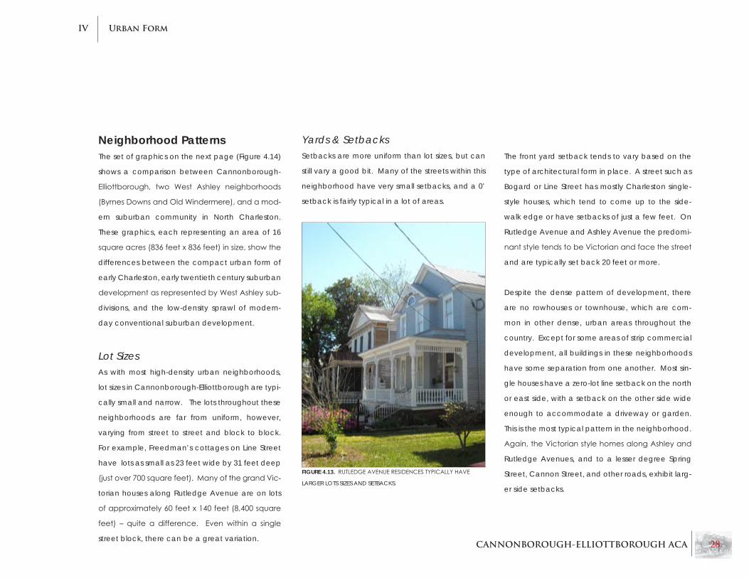
Yards & SetbacksSetbacks are more uniform than lot sizes, but can
still vary a good bit. Many of the streets within this
neighborhood have very small setbacks, and a 0’
setback is fairly typical in a lot of areas.
The front yard setback tends to vary based on the
type of architectural form in place. A street such as
Bogard or Line Street has mostly Charleston single-
style houses, which tend to come up to the side-
walk edge or have setbacks of just a few feet. On
Rutledge Avenue and Ashley Avenue the predomi-
nantstyletendstobeVictorianandfacethestreet
and are typically set back 20 feet or more.
Despite the dense pattern of development, there
are no rowhouses or townhouse, which are com-
mon in other dense, urban areas throughout the
country. Except for some areas of strip commercial
development, all buildings in these neighborhoods
have some separation from one another. Most sin-
gle houses have a zero-lot line setback on the north
or east side, with a setback on the other side wide
enough to accommodate a driveway or garden.
This is the most typical pattern in the neighborhood.
Again,theVictorianstylehomesalongAshleyand
Rutledge Avenues, and to a lesser degree Spring
Street, Cannon Street, and other roads, exhibit larg-
er side setbacks.
FIGURE 4.13. RUTLEDGEAVENUERESIDENCESTyPICALLyHAVE
LARGER LOTS SIzES AND SETBACKS.

CANNONBOROUGH-ELLIOTTBOROUGH ACA 29
Urban FormIV
OLDWINDERMERE ByRNESDOWNS
CANNONBOROUGH-ELLIOTTBOROUGH COOSAWCREEK,NORTHCHARLESTON
FIGURE 4.14.
DEVELOPMENT
COMPARISONS.

CANNONBOROUGH-ELLIOTTBOROUGH ACA 30
Urban FormIV
Lot CoverageCannonborough-Elliottborough exhibits a wide
range of lot sizes, with single lots ranging anywhere
fromunder1,000squarefeettogreaterthan11,000
square feet. Narrower, neighborhood-based
streets such as Rose Lane, Smith Street, Sires Street,
etc. have narrower and often shallower lots, while
main thoroughfares such as Rutledge and Ashley
Avenues and Spring and Cannon Streets on aver-
age have much larger lots.
In order to evaluate average lot sizes and lot cov-
erages in Cannonborough-Elliottborough, a sam-
pling of lots was taken from four different areas of
the neighborhood. These four areas are:
Area 1 - The block bounded by Bogard Street, •
Percy Street, Ashe Street and Line Street
Area 2 - The long block bounded by Spring •
Street, Coming Street, Cannon Street, and
Rutledge Avenue
Area 3 - Rose Lane and Sires Street, between •
Spring Street and Bogard Street
Area 4 - Rutledge Avenue, between Spring •
Street and Line Street
Eachtableshowstheapproximatesquarefootto-
tal of eachof the sampled lots, the square foot
total of the lot covered by buildings, and the as-
sociated lot coverage percentage. The range
and average lot coverage percentages given at
the bottom of each table represent the total of
the sampled properties minus anomalous lots that
weresignificantlyhigherorlowerthanthetypical
range of the sampled lots. In each area surveyed,
the two highest and lowest percentages were
thrown out of the calculations in order to prevent
skewing the averages.
Conclusions
The results of this survey show that the overall
neighborhood generally has an average lot cov-
erage of 35 to 45 percent. This of course varies
greatly. It appears that typically areas with larger
lot sizes tend to have smaller lot coverages, show-
ingthatbuildingsizesvarylessthanlotsizes.While
this survey is effective in showing typical lots, there
are many exceptions to the rule, including lots with
multiple buildings that would tend to have a much
higher lot coverage.
Area 1 - Bogard, Percy, Ashe, Line
No. of lots surveyed 13
Average lot size 2,857 s.f.
Typical Lot Coverage Range 37% - 56%
Average Lot Coverage 46%
Area 2 - Spring, Coming, Cannon, Rutledge
No. of lots surveyed 21
Average lot size 5,480 s.f.
Typical Lot Coverage Range 27% - 51%
Average Lot Coverage 38%
Area 3 - Rose, Sires, Spring, Bogard
No. of lots surveyed 15
Average lot size 5,536 s.f.
Typical Lot Coverage Range 28% - 45%
Average Lot Coverage 36%
Area 4 - Rutledge
No. of lots surveyed 15
Average lot size 2,434 s.f.
Typical Lot Coverage Range 39% - 50%
Average Lot Coverage 43%

CANNONBOROUGH-ELLIOTTBOROUGH ACA 31
Urban FormIV
Historic Density & Land UseCannonborough-Elliottborough developed in a
dense urbanpattern that squeezesmanybuild-
ings into a grid of small rectangular blocks. This
is achieved through narrow lots and the long,
narrow Charleston single house. Additionally, a
large percentage of the neighborhood’s residen-
tial buildings are subdivided into multiple housing
units, and tandem houses and carriage houses of-
ten provide additional units elsewhere on the lot.
In May 2009, College of Charleston and Clemson
University graduate students in historic preserva-
tion performed a survey and historical analysis of
density in Cannonborough-Elliottborough. The
survey area included all blocks within the bound-
aries of Cannon Street, Rutledge Avenue, Line
Street and Coming Street - the bulk of the neigh-
borhood’s interior.
Using historic maps and past surveys, the students
were able to evaluate the change in land uses and
building density throughout the built history of the
neighborhood. The study concludes that by 1925,
the neighborhood had achieved its highest den-
sities, which have since remained consistent with
present day conditions. It also found that densities
throughout the neighborhood are relatively ho-
mogenous, with the exception of the most densely
developed area of the neighborhood, which is the
block between Sires Street and Rose Lane.1
FIGURE 4.15. HISTORIC LANDUSEANDVACANCyCHARTFORCANNONBOROUGH-ELLIOTTBOROUGH,FROMTHECOLLEGEOFCHARLESTON/
CLEMSONUNIVERSITyLANDUSEANDDENSITySURVEy.
The chart below (Figure 4.15), from the students’
survey, shows historic proportions of land uses in the
survey area, as well as the number of vacant build-
ings. Although the data is incomplete, one can see
that the relative mix of residential and other types
of uses has remained approximately the same since
the 19th century. The biggest difference is perhaps
the proportion of multi-family residential units, which
has risen substantially.

CANNONBOROUGH-ELLIOTTBOROUGH ACA 32
Urban FormIV
Land UseCannonborough-Elliottborough exhibits a wide variety of uses mixed throughout the area (see Figure
4.18, next page), including a vertical mix of uses (different uses occupying different levels of the same
structure). This diversity of uses is one of the most important aspects of the neighborhood’s character.
Most housing, rental and owner-occupied, is provided by the Charleston single house. Some are indi-
vidual residences, but many are divided into separate multi-family units. Several lots also incorporate
tandem houses and other accessory dwelling units (such as garage apartments and carriage houses)
in the rear half of the property. Although not numerous, there are examples of apartment buildings or
other buildings that were originally intended as multi-unit structures.
Spring Street, Cannon Street and King Street are the district’s commercial corridors. There is very lit-
tle commercial use outside of these corridors, except for corner stores located at various intersections
throughouttheneighborhood.Thecornerstoreisoneofthedefiningcharacteristicsoftheneighbor-
hood.Mostcornerstorebuildingsaremixed-usestructures,withresidenceslocatedonupperfloors.
Currently there are no industrial or manufacturing uses within Cannonborough-Elliottbor-
ough, as industrial uses on the peninsula are primarily located along the Cooper River
adjacent to the ports, or further north in the Neck Area. One land use that is lacking and
sorely needed in the area is park space. Two parks – DeReef Park at the far south end
of the neighborhood, and the new Elliottborough Park on Line Street at the far north of
the neighborhood, are the only public parks serving local residents. Simonton Park in
theMorrisSquaredevelopmentisjustoutsidetheneighborhood’sboundaries.Although
large-scale regional and citywide parks are certainly provided by the City of Charleston
and the metropolitan region, small community parks are vital to city neighborhoods and
a major contributor to their vibrancy. More local parks are recommended in Cannonbor-
ough-Elliottborough, preferably within the interior of the neighborhoods.FIGURE 4.16. CHARLESTONSINGLEHOUSES-THEMOSTCOMMONDEVELOPMENTTyPEIN
CANNONBOROUGH-ELLIOTTBOROUGH.
FIGURE 4.17. VERTICALMIxINGOFUSESISCOMMONINTHEAREA.SHOWN:
RESIDENCEOVERCORNERSTOREONASHESTREET.
R

CANNONBOROUGH-ELLIOTTBOROUGH ACA 33
Urban FormIV
KING
KINGSAINT PHILIP
COM
ING
PERCY
ASHERO
SE
ROSE
SIRES
IPSWIC
HRUTLEDG
E
ASHLEYBEE
OLIVER
CANNON
REID
WOOLFE
BREWSTERPAYNE
RODGERS
ACKERMAN
CANNON
SPRING
SPRING
SPRING
COLUMBUS
BOGARD
BOGARD
US 17
US 1
7
LINE
HUMPHREY
TULLYSAINT PHILIPCO
MING
RUTLEDGE
ASHLEYKRAC
KE
KENNEDY
TODD
ASHE
BRACKYLEWIS
FELIX
DEREEF
SMITH
CARRERE
ISLINGTO
N
PRESIDENTS
ROSEMONT
PEECKSENS
PORTERS
MEETING
MORRIS
Cannonborough-Elliottborough
N
Legend
LAND USE CLASSIFICATIONS
Existing Land Use
Residential
Scale: Approximately 1” = 150’
Commercial/Retail
Office
Undeveloped/Parking Lot
Park Space/Open Space
Industrial/Utilities
Mixed Use
Public/Institutional
NeighborhoodBoundary
FIGURE 4.18. ExISTINGLANDUSEINCANNONBOROUGH-ELLIOTTBOROUGH.

CANNONBOROUGH-ELLIOTTBOROUGH ACA 34
Urban FormIV
ZoningWhereaslandusedescribesthecurrentusetaking
place on a property, zoning describes the regula-
tory framework for what is permitted on a proper-
ty. A map of current zoning in the neighborhood is
shown in Figure 4.19 on the next page.
Residential
In the residential areas of the neighborhood, most
of the land is zoned DR-2F, which is Diverse Resi-
dential(frontyardsrequired).PartsofMorrisand
St. Philip Streets have DR-2 zoning (front yards not
required); however, this district only comprises a
small percentage of the neighborhood.
located at the edges of the neighborhood along
President Street on the west and King Street on the
east. Planned Urban Developments (PUDs) in the
neighborhood include Morris Square, Peecksens
Court and the Midtown residential development.
These are areas that were zoned collectively, rather
than as individual parcels, and have their own spe-
cialized development plan with associated stan-
dards.
Height Regulations
Charleston’s Old City Height Ordinance was ad-
opted in 1978, establishing height overlay zones
throughout the peninsula. These overlay areas
supplement the underlying zoning by providing
a height maximum and height minimum in each
district. The majority of the neighborhood is in the
“50/25” height overlay, with a 50-foot maximum
and 25-foot minimum. The only area in a different
height overlay is east of St. Philip Street, where the
overlay sets a maximum of 55 feet and a minimum
of 30 feet. Taller zoning overlays border the neigh-
borhood between Meeting & King Streets and on
the Medical University of South Carolina (MUSC)
campus.
Non-Residential
General Business (GB) and Limited Business (LB) are
the predominant non-residential zoning districts in
the neighborhood. The King and St. Philip Street
corridors are almost entirely zoned GB. The Spring
and Cannon Street corridors are zoned LB, which
is a slightly less-intensive zoning category than GB.
Although GB and LB are business zoning districts,
they allow for residential uses, helping to maintain
a mixed-use environment along these corridors.
Mixed-Use & PUD
Therearethreecityzoningcategoriesspecifically
for mixed use development: MU-1, MU-2 and MU-2/
WH.Onlyafewsmallareasarezonedmixeduse,
Residential Zoning RegulationsDR-2F / DR-2
Front yard setback: 25 ft. (DR-2F); 0 Ft. (DR-2)•
Sideyard setbacks of 3 ft. and 7 ft.; 10 ft. total•
Max. lot coverage: 50% (DR-2F); 35% (DR-2)•
Height limits of 3.5 Stories•
LB – Residential
No front yard required•
Sideyards of 9 ft. and 3 ft.; 15 ft. total•
Maximum 35% lot coverage•
GB- Residential
No front yard required•
Sideyards of 9 ft. and 3 ft.; 15 ft. total•
35% lot coverage maximum•

CANNONBOROUGH-ELLIOTTBOROUGH ACA 35
Urban FormIV
LB
LI
GB
LI
MU-2
GB
DR-2F
DR-2F
PUD
GB
DR-2F
MU-2/WH
PUD
LB
DR-2
DR-2
DR-2
CTCT
LB
MU-2/WH
PUD
MU-1
MU-1 KING
KINGSAINT PHILIP
COM
ING
PERCY
ASHERO
SE
ROSE
SIRES
IPSWIC
HRUTLEDG
E
ASHLEYBEE
OLIVER
CANNON
REID
WOOLFE
BREWSTERPAYNE
RODGERS
ACKERMANS
CANNON
SPRING
SPRING
SPRING
COLUMBUS
BOGARD
BOGARD
US 17
US 1
7
LINE
HUMPHREY
TULLYSAINT PHILIPCO
MING
RUTLEDGE
ASHLEYKRAC
KE
KENNEDY
TODD
ASHE
BRACKYLEWIS
FELIX
DEREEF
SMITH
CARRERE
ISLINGTO
N
PRESIDENTS
ROSEMONT
PEECKSENS
PORTERS
MEETING
MORRIS
Cannonborough-Elliottborough
N
Legend
ZONING CLASSIFICATIONS
Existing Zoning
(CT) Commercial Transitional
Scale: Approximately 1” = 150’
(DR-2) Diverse Residential
(DR-2F) Diverse Residential (Front Yard Req.)
(LI) Light Industrial
(MU-1) Mixed Use
(MU-2) Mixed Use
(GB) General Business
(LB) Limited Business
NeighborhoodBoundary
(MU-2/WH) Mixed Use
Planned Urban Development
FIGURE 4.19. ExISTINGZONINGINCANNONBOROUGH-ELLIOTTBOROUGH.

CANNONBOROUGH-ELLIOTTBOROUGH ACA 36
Urban FormIV
quiresafrontyardwithaminimumdepthof25feet
andrequiressideyardsetbacksonbothsidesofthe
lot; whereas many historic lots lack a front yard and
have a zero lot line on one side of the property. The
ordinance provides exceptions for the front yard
requirementthatallowproposedbuildingstoalign
with the front yard setback of the closest building
on a block; however these exceptions would not
allow small or no front yards in all cases.2
Additionally, there is no exception for sideyards so
that new development may have a zero lot line
on one side, as is common with single houses. As a
general recommendation, it is suggested that the
zoning code be revised if and where it discourages
new development from matching the historic prec-
edent. Additionally, local zoning should encourage
the variety of use, scale, styles and materials that is
present in Cannonborough-Elliottborough.
Zoning CompatibilityOften problems may arise in older neighborhoods
when modern zoning regulations are inconsistent
with historic development of lots and buildings.
This can create a situation where the zoning code
is too restrictive, and would not permit new de-
velopment that follows the existing form in terms
ofheights, setbacks, lotwidth requirements,etc.
Similarly, zoning that is too loose will permit com-
FIGURE 4.20. MUCHOFTHENEIGHBORHOOD’SHISTORICALDEVELOPMENTISBUILTWITHOUTFRONTyARDS.
R
plementary development, but may also allow de-
velopment that is out of scale or out of character
with existing properties.
In some cases in Cannonborough-Elliottborough,
zoning is inconsistent with historic development,
and may prevent compatible future develop-
ment. The DR-2F zone is incompatible where it re-

CANNONBOROUGH-ELLIOTTBOROUGH ACA 37
Urban FormIV
Cornerstoresareauniqueandcharacter-defining
featureofthemid-Peninsula,andarefirmlyrooted
in the culture of Cannonborough-Elliottborough.
The loss of a long-standing corner store would be a
detriment to neighborhood. As a recommendation,
both thedownzoningof the first floor of a corner
store building to residential use, or the demolition
of a corner store should be prohibited. The map on
the next page (Figure 4.22) shows the location of
corner store buildings in the neighborhood.
FIGURE 4.21. CORNER STORE BUILDING AT CANNON AND COMING STREETS.
R

CANNONBOROUGH-ELLIOTTBOROUGH ACA 38
Urban FormIV
KING
KINGSAINT PHILIP
COM
ING
PERCY
ASHERO
SE
ROSE
SIRES
IPSWIC
HRUTLEDG
E
ASHLEY
BEE
OLIVER
CANNON
MORRIS
REID
WOOLFE
BREWSTERPAYNE
RODGERS
ACKERMANS
CANNON
SPRING
SPRING
SPRING
COLUMBUS
BOGARD
BOGARD
US 17
US 1
7
LINE
HUMPHREY
TULLYSAINT PHILIPCO
MING
RUTLEDGE
ASHLEYKRAC
KE
KENNEDY
TODD
ASHE
BRACKY
LEWIS
FELIX
DEREEF
SMITH
CARRERE
ISLINGTO
N
PRESIDENTS
ROSEMONT
PEECKSENS
PORTERS
MEETING
Cannonborough-Elliottborough
N
Legend
Corner Stores
Corner Store
Scale: Approximately 1” = 150’
NeighborhoodBoundary
FIGURE 4.22. LOCATIONS OF CORNER STORES.

CANNONBOROUGH-ELLIOTTBOROUGH ACA 39
Urban FormIV
Future Approaches to ZoningSome revisions to the city’s zoning code may be
warranted in order to more easily promote char-
acter-sensitive new development and redevelop-
ment. In a historic area such as Cannonborough-
Elliottborough, there is a precedent for a wide
variety of architectural styles, building heights, lot
widths, setbacks and other physical standards.
zoning codes need to encourage variety within
a range set by historically contributing structures,
while discouraging anomalous development that
is out of character and/or scale.
Revisions to the code should gear the ordinance
more towards utilizing existing ‘contributing struc-
tures’ as the reference point by which to judge
new development. This approach is used for set-
backs in the special exception for DR-2F front
yard setbacks where it allows new buildings to
have a front yard setback that is as small as the
smallest setback for a contributing building on the
same block or as large as the largest setback on
the block. In this case, the developer is allowed
theflexibilityofsettingthestructurewithinarange
determined by existing contributing structures – and
as long as it is within this range, the new develop-
ment will not be out of character with the rest of
the block. This approach should also be applied to
building heights, bulk, sideyards and rear setbacks,
sothatthesedimensionsalsoallowforflexibilityand
contextual appropriateness.
The neighborhood may benefit from height limits
that are based on the number of stories as is rec-
ommended in the Preservation Plan, rather than
a height measurement. Height provisions might
also be better served in a context-sensitive for-
mat, where the minimum and maximum heights
followed the corridor type. For instance, greater
heights would be allowed on a busier, wider cor-
ridor like Spring Street or Rutledge Avenue, while
lower heights would be in place for small residential
streets like Percy and Ashe Streets. Some informa-
tion on heights and number of stories throughout
the neighborhood is provided in the next chapter
on Architecture.FIGURE 4.23. HOMESALONGCANNONSTREETATTHESMITHSTREETINTERSECTION.AGOODExAMPLEOFTHEVARIETyOFDEVELOPMENT
WITHINTHENEIGHBORHOOD.
R
R
R

CANNONBOROUGH-ELLIOTTBOROUGH ACA 40
Urban FormIV
Chapter 4 RecommendationsPromote appropriate infill development on•
King Street above Spring Street.
Add more park space to Cannonborough-•
Elliottborough, particularly on the interior of
the neighborhood.
Revise the zoning ordinance where it may •
limit the ability of new development to match
historic development.
Prevent downzoning of corner store buildings •
to residentialon thegroundfloor inorder to
maintain a diversity of uses.
Base height regulations on the most common •
number of stories (corridor by corridor), rather
thanaspecificheightmeasurement.

CANNONBOROUGH-ELLIOTTBOROUGH ACA 41
Urban FormIV
Endnotes 1 Land Use and Building Density Study for a Section of the Cannonborough-elliottborough neighborhood.
College of Charleston & Clemson University, May 2009.
2 City of Charleston zoning Ordinance, Article 5, Part 2, Section 54-506(b).

CANNONBOROUGH-ELLIOTTBOROUGH ACA 42
ArchitectureV
Chapter 5:Architecture
Cannonborough-Elliottborough comprises an
area that is one of peninsular Charleston’s earliest
suburbs. It was annexed by the city in 1849, but
contains buildings dating to the early 1800s. The
neighborhood encompasses a variety of uses and
styles, and has recently become home to devel-
opments of traditional and modern architecture.
Bothmultipledwellingandsinglestructureinfillde-
velopmentmust adhere to current requirements
in building codes, yet also remain sympathetic to
the aesthetic of the surrounding area.
FIGURE 5.1. THE CHARLESTON SINGLE HOUSE.
Great variety of building typolo-•
gies because of the dynamic land
use conditions
a mix of old and new buildings, ma-•
terials, and heights exist within
the same block
Freedman’s cottages and Charles-•
ton single houses are present with-
in the neighborhood
Prevailing Character

CANNONBOROUGH-ELLIOTTBOROUGH ACA 43
ArchitectureV
Chapter 5 Summary
Forms & UsesThe single house Is the predominant form in •
Cannonborough-Elliottborough.
Multiple unit apartment houses and single-•
family dwellings occur with the greatest fre-
quency.
Neighborhood churches are also common •
and serve as civic as well as religious build-
ings.
The majority of buildings are two- or two-and-•
a-half stories.
Dwellings in the neighborhood usually range •
between2000and3000squarefeet.
Most houses feature a typical single house •
floorplanoravariationthereof.
Styles & TypologiesWiththeexceptionofafewlocalizedareas,•
high-style architecture does not exist in-mass
in the neighborhood.
There is a diversity of architectural styles within •
each block in the neighborhood.
Corner stores are a prevailing feature through-•
out the neighborhood.
Victorianisthepredominanthighstylearchi-•
tecture and is concentrated on Rutledge and
Ashley Avenues.
Corners stores, freedman’s cottages, and the •
Charleston single house are the prevailing
building types.
MaterialsMost commonly wood frame construction, •
typical materials and details on neighbor-
hood houses are as follows:
Gabled standing seam roof•
Six or two lite sash windows •
Front porch or double side piazza•
Turned balusters and columns•
Simplemouldingprofilesandcasings•
Woodpaneldoors,oftenwithtransom•
and hood above
Infill DevelopmentCompatiblecontemporary infill,bothmodern•
and traditional is present.
non-Contributing ArchitectureTwentieth-century medical buildings and inap-•
propriatecommercial infillarelocatedinand
around the neighborhood.
Bricked-in corner stores detract from the neigh-•
borhood.
Modern materials that replace historic mate-•
rials is present but detracts from the architec-
tural character of the building.
Recommendations will appear at the end of this chapter and are denoted in the text by this symbol. R

CANNONBOROUGH-ELLIOTTBOROUGH ACA 44
ArchitectureV
Forms & UsesThe eclectic variety in types of buildings from many stylistic categories is apparent
throughout Cannonborough-Elliottborough. Although forms reoccur, most notably
historic single houses, there is no one “look” of the neighborhood. One block may
contain single-family residences, a church, a business and an apartment house.
Local businesses are a familiar sight on corners and on well-traveled streets. The
neighborhood has an impressive array of historic buildings, and the fabric is gener-
ally intact, with a consistency of structures along the public right-of-way.
Single-Family Residential
Over time, the residences of Cannonborough-Elliottborough have evolved with
the demands of new owners. Changes are sometimes minimal; instead of making
majormodifications, long-timeownersconductednecessarymaintenance,sav-
ing many historic houses from irreversible changes. Throughout the neighborhood
are mid-twentieth century houses, most of which have belonged to the same fam-
ily since their construction.
Multi-Family
Somelargerhistorichomeshavebeendividedintomultiplecondominiums,oftenbyfloor.Du-
plexes are another building use; the single house at 11 Bogard Street has been divided into two
units, with a new rental cottage at the back of the property. Throughout the neighborhood, ad-
ditionaldwellingshavebeenconstructedwherethelotdepthissufficienttoaccommodatean
outbuilding.Inmanycasesthemoderninfillisminimallyvisiblefromthepublicright-of-way.
FIGURE 5.3. A SERIES OF SINGLE HOUSES.
FIGURE 5.2. MULTI-UNIT LOT ON BOGARD STREET.

CANNONBOROUGH-ELLIOTTBOROUGH ACA 45
ArchitectureV
Apartment Houses
Given the convenience and affordability of Cannonborough-Elliottborough,
college students choose to live in the neighborhood. Kitchens and bathrooms
have been added to large historic homes, compromising the integrity of their
interiors by adding plumbing and partition walls. A prime example is the three
story single house at 12 Bee Street that, with its dependency, contains twenty-
three apartments.
Ecclesiastical
Sizes and styles of various neighborhood churches are as diverse as the de-
nominationstheyserve.Housesofworshiparenotconfinedtobusierstreets;
many appear alongside residences in the heart of Cannonborough-Elliottbor-
ough. For example, Ashe, Percy and Morris Streets are all home to neighbor-
hood churches. Historic churches with more prominent locations include: The
Church of the Holy Communion at Ashley Avenue and Cannon Street, Mor-
ris Street Baptist Church, and zion-Olivet Presbyterian Church at 134 Cannon
Street. A historic church on Sires Street with a shingled steeple and gable end
has been converted into a residence.
FIGURE 5.4. THEWILLIAMROBBHOUSEAT12BEESTREETISAHISTORICMANSIONTHATISNOWDIVIDED
INTO MULTIPLE UNITS.
FIGURE 5.5. SHILOH AME CHURCH ON SMITH STREET.

CANNONBOROUGH-ELLIOTTBOROUGH ACA 46
ArchitectureV
Light Commercial
Most businesses in Cannonborough-Elliottborough are con-
centratedalongstreetswithhightraffic,suchastheeast-west
thoroughfares of Spring and Cannon Streets. However, some
stores and restaurants do not rely on high visibility, but instead
on word of mouth or neighborhood familiarity. New, or relocat-
ed,businesseshaveflourishedwiththeincreaseofinvestment
in the area. Retail, restaurants, and local businesses appear
throughouttheneighborhood.Afewstoresandofficesoccupy
what were originally built as single family dwellings. The south
side of Spring Street on either side of Rutledge Avenue includes
oneandtwo-storymodernbrick infilldevelopmentwith large
parking lots adjacent to the street.
FIGURE 5.7. RESIDENTIALLIVINGSPACEABOVEACOMMERCIALUSE.
Residential-Above-Commercial
Corner grocery stores are a common sight in the neighborhood and can serve up to a
four- block radius. Historically, many proprietors of neighborhood businesses lived above
the stores they owned. This organization of space still exists, even if the businesses them-
selveshavechanged.Firstfloorcommercialspaceshavetall,undividedfenestrationthat
addressestwostreets.Toaccommodatetrafficfromdifferentdirections,thefrontdoor
is at a 45 degree angle to both streets, with the overhanging corner supported by a
cast iron column. The new “Midtown” residential development maintains this historic ar-
rangement in its corner buildings at the intersections of Cannon and Coming Streets, and
Cannon and St. Philip Streets, providing space for new businesses below with apartments
above. FIGURE 5.6. FORMERRESIDENCE,CONVERTEDTOGROUNDFLOORRETAIL,ON
SPRING STREET.
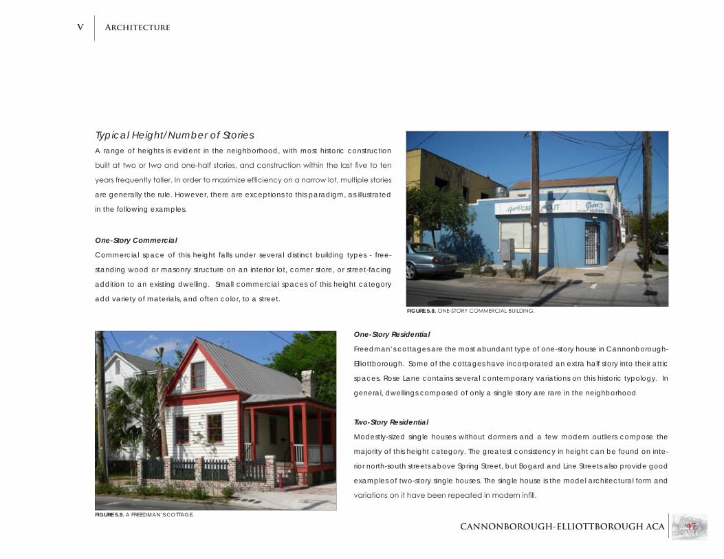
CANNONBOROUGH-ELLIOTTBOROUGH ACA 47
ArchitectureV
Typical Height/number of Stories A range of heights is evident in the neighborhood, with most historic construction
builtattwoortwoandone-halfstories,andconstructionwithinthelastfivetoten
yearsfrequentlytaller.Inordertomaximizeefficiencyonanarrowlot,multiplestories
are generally the rule. However, there are exceptions to this paradigm, as illustrated
in the following examples.
One-Story Commercial
Commercial space of this height falls under several distinct building types - free-
standing wood or masonry structure on an interior lot, corner store, or street-facing
addition to an existing dwelling. Small commercial spaces of this height category
add variety of materials, and often color, to a street.
One-Story Residential
Freedman’s cottages are the most abundant type of one-story house in Cannonborough-
Elliottborough. Some of the cottages have incorporated an extra half story into their attic
spaces. Rose Lane contains several contemporary variations on this historic typology. In
general, dwellings composed of only a single story are rare in the neighborhood
Two-Story Residential
Modestly-sized single houses without dormers and a few modern outliers compose the
majority of this height category. The greatest consistency in height can be found on inte-
rior north-south streets above Spring Street, but Bogard and Line Streets also provide good
examples of two-story single houses. The single house is the model architectural form and
variationsonithavebeenrepeatedinmoderninfill.
FIGURE 5.8. ONE-STORyCOMMERCIALBUILDING.
FIGURE 5.9. A FREEDMAN’S COTTAGE.

CANNONBOROUGH-ELLIOTTBOROUGH ACA 48
ArchitectureV
Two-and-a-Half-Story Residential
Buildingsofthisheightarecommonlyfoundalongwiderstreets,andarefrequentlyofalarger
single-houseorVictorian style. SpringandCannonStreetsandRutledgeandAshleyAvenues
contain the most examples of this type. There is a noticeable shift in height from interior streets to
the main one-way thoroughfares. Dormers are more common on the taller single houses along
the previously mentioned routes.
Three-Story Residential
Most new development falls into this height category, including new live/work spaces on Spring
Street west of St. Philip Street. Residences in the “Midtown” residential development along Can-
nonStreetappeartobetwostories;thethirdfloorstepsbackfromthestreetfaçade,sothatitis
primarily visible only from a distance. Residences within Brewster Court itself are three stories, but
are minimally visible from surrounding streets.
FIGURE 5.10. THREESTORyRESIDENCEONBREWSTERSCOURT.
Three-and-a-Half-Story Residential
Buildings of this height are outliers in the neighborhood, and
provide diversity of height on their respective streets. The tallest
historic buildings in the neighborhood are on wider one-way
streets, Rutledge Avenue and Cannon Street. Two examples
are 207 and 235 Rutledge Avenue, which are residential-over-
commercial and single-family, respectively. The building at 73
Cannon Street houses a social organization.
FIGURE 5.12. THISTHREE-AND-A-HALFSTORySTRUCTURE
AT235RUTLEDGEAVENUEISONEOFTHETALLESTINTHE
NEIGHBORHOOD.
FIGURE 5.11. TWO-AND-A-HALFSTORyVICTORIANRESIDENCESONRUTLEDGE
AVENUE.

CANNONBOROUGH-ELLIOTTBOROUGH ACA 49
ArchitectureV
SizeIn areas of the neighborhood where there is a consistency in architectural form
and massing, it is possible to convey an approximate size range of dwellings. A
typicaltwo-storysinglehousewithoutadditionsorenclosures,withanunfinished
attic,usuallyhasnomorethan2,500squarefeet.Atypicalfreedman’scottage
initsunalteredconditionmayprovideapproximately1,000squarefeetofliving
space.Itispossiblefortotallivingspaceinlargerhomestoexceed3,000square
feet,buthistorichomesofthissizearefrequentlydividedintoapartments.Foran
additional example, new homes in the Midtown residential development range
from1,900-2,300squarefeet,whilenewPeecksensCourthomesareonlyaround
1100squarefeet.
Floor PlansSingle House
Although variations may occur, the single house is the most commonly
repeatedfloorplantypologyinCannonborough-Elliottborough.Thedivi-
sion of space in a basic Single house is two rooms over two rooms, with a
centralstairhalldividingthehouse.Publicroomsareonthefirstfloor,with
bedroomsaboveandoftenathirdflooratticoradditionallivingspace.
Freedman’s Cottage
In its original condition, this house type provides approximately 1000
squarefeetoflivingspace.Itincludesonebedroom,onebathroom,aliv-
ing area and kitchen. The piazza is often a few steps up from the sidewalk
and is divided from the right-of-way by a screen wall containing a door.
The bedroom is closest to the street, followed by the living area into which
thefrontdooropens,withthekitchenandbathroomattheback.Varia-
tions to this plan exist, but the size and rooms are typically consistent from
one house to the next.
One-Story Commercial
One-story corner buildings are typically either brick veneer or concrete
block,occupymoresquarefootage,andhavereplacedhistoricwood
frame corner stores. The size and construction of the smallest commer-
cialbuildingson interior lotsallow thefloorplan tobeuninterruptedby
structural support. A few wood frame examples do not exceed nine or
ten feet wide.
FIGURE 5.13. FREEDMAN’SCOTTAGE.WITHREARADDITIONSONPRESIDENTSTREET.

CANNONBOROUGH-ELLIOTTBOROUGH ACA 50
ArchitectureV
Styles & TypologiesCannonborough-Elliottborough has an extremely diverse architectural fabric with examples of multiple styles from the Federal Period to Neo-Traditional. Most growth
occurredinthelate1800s,andtheVictorianinfluencecanbeseeninbuildingsofthatperiodaswellasindetailsofpreviouslyexistingbuildingsthatwereadapted
toreflecttheprevailingstyle.
Corner StoresCorner stores are inviting and add interest to the streetscape; their
detailsandconstructionallowthemtobeidentifiedstylistically.The
most commonly repeated corner business layout includes large,
minimally divided windows on two street-level elevations, a lower
bracketedcorniceandangledfrontdoor,However,asexemplified
in 114 Cannon Street, corner stores do not always have a 45º con-
figuration. The large twoover twodivided litewindowsandglass
and wood double entry doors face Cannon Street only. This struc-
ture is an earlier example of a corner store, in contrast with those fur-
ther into the neighborhood. The recently restored mixed-use frame
buildings at the corner of Bogard and Ashe Streets and Bogard and
Percy Streets have helped to re-establish the presence of the corner
business in Cannonborough-Elliottborough. As a result, several other
structuresareundergoingrehabilitation.Thereisafrequencyofcor-
ner markets and businesses seen in this neighborhood that is rarely
found elsewhere. They encourage pedestrian activity and promote
local business. For a map of corner store locations, refer to Figure
4.22 in Chapter 4.
FIGURE 5.14. CORNER STORE.
R

CANNONBOROUGH-ELLIOTTBOROUGH ACA 51
ArchitectureV
One-story CommercialBuildings of this size and use in Cannonborough-Elliottborough stand out not only for
their style, butmaterials, details and colors as well. Several twentieth-century filling
stations occupy valuable corner lots on Rutledge and Ashley Avenues and Cannon
Street. They have been rehabilitated to support a variety of new occupants, including
offices,retailandrestaurants.Additionalsingle-storycommercialspacesareconcrete
block structures, such as the bakery at 59 1/2 Cannon Street, and a former millinery
businesses at 85 1/2 Spring Street, which has a stepped parapet. Two buildings, 9 and
13 Cannon Street, are wood frame with high parapets concealing gabled standing
seam metal roofs beyond. At Sires and Spring Streets is a one-story modern brick con-
venience store and apparel shop with parking in front. A one-story building at 61 Can-
nonStreetwasbuiltforthedowntownbranchoftheyMCAintheearly1950s.
Filling StationsSeveralformercornergasstationsinhightrafficareasoftheneighborhoodhavebeen
adaptivelyusedandprovideofficeandretailspace.ThedesignofficeatSpringStreet
and Ashley Avenue rehabilitated the existing station and improved the surrounding
landscape. The business on the opposite corner also enclosed the station’s drive-
through bay and underwent an interior and exterior rehabilitation. In the case of the
restaurant at 211 Rutledge Avenue, more elements of the original station were re-
tained, including themetalgaragedoors,glassblockwallandconcretefloor. It is
notablethattheseremainingfillingstationsdiffergreatlyfromeachotherstylistically.
The streamlined modern design at 211 Rutledge Avenue contrasts with the Spanish
eclectic at 125 Spring Street and Georgian eclectic at 131 Spring Street.
FIGURE 5.16. GASSTATIONCONVERTEDINTOARESTAURANT-211RUTLEDGEAVENUE.
FIGURE 5.15. ONE-STORyBAKERyAT591/2CANNONSTREET.

CANNONBOROUGH-ELLIOTTBOROUGH ACA 52
ArchitectureV
Single HouseAs viewed from the street, the Charleston single house is composed of two
mainelements:thebodyofthehouseandaoneortwo-storypiazza.Thefirst
level of the piazza is separated from the sidewalk by a screen containing a
door. Massing is simple and often symmetrical, with two windows at street
level aligned with two windows above. The roof typically has a gable end,
sometimeswithafullreturncorniceorasinglesmallthirdfloorwindow.
Beginning in the late nineteenth century, a common variant of a single
housefaçadewastheenlargementofthefirstfloor,street-facingparlor,and
sometimes the bedroom above, achieved by adding a three-sided bay on
the front elevation. A good example is 129 Cannon Street. The location of
the front door could also be moved from the piazza to the opposite side of
the house, so that the front door accessed an interior stair hall and not an
exterior space. One example of this layout is 165 Spring Street.
Freedman’s CottageThis dwelling typology is typically a one-story wood frame structure with one
ormorefireplaces,astreet-facinggable,andsouthorwest-facingpiazza.
The piazza often has an end wall containing the door, maintaining privacy
between it and the sidewalk. Freedman’s cottages are usually one room
wide, and at least two rooms deep. Over time, additions may have been
constructed to the back, or part of the piazza enclosed, to provide addi-
tional living space.
FIGURE 5.18. FREEDMAN’S COTTAGE ON MORRIS STREET.
FIGURE 5.17. CHARLESTONSINGLEHOUSEONPERCySTREET.

CANNONBOROUGH-ELLIOTTBOROUGH ACA 53
ArchitectureV
American Victorian & Queen AnneCommononRutledgeandAshleyAvenues,theVictorianstyleisevidentat257,259,and261RutledgeAvenue.
Allhavestreet-facinggables,and257RutledgeAvenuehasintersectinggabledroofforms.Windowsashare
two-over-two lite double-hung and simply detailed. On these and other homes of this style, it is common to
findapedimentovertheentrybaytotheporch.Unlikeasinglehouse,porchesarefoundonthefrontofthe
structureandarefrequentlytwo-stories.54CannonStreetandthreeneighboringhousesat50,52and54Spring
Streetreflectthisconstructiondetail.Insteadofbeingclassicallydetailed,porchcolumnsareturnedandhave
smallerdiameters,sometimesrestingonasquarepier.Victorianhomes,liketheQueenAnnesub-category,may
include gingerbread detailing and decorative gable spandrels.
AswithotherVictorianstyles,CharlestonhasauniquewayofarticulatingtheQueenAnnestylewhileremaining
within theconfinesofanarrowanddeepurban lot. Eliminatingprojectingsidebaysandtowers,neighbor-
hood examples of this style feature patterned wood shingles in the gables and walls, compound roof forms and
decorative detailing. Front porches have spindlework, or gingerbread, ornamentation, and turned balusters and
columns. Examples are more often found on the more traveled streets; addresses of note include 82 1/2 Spring
Street, 236 Ashley Avenue and 78 Cannon Street.
italianateIdentifyingelementsofthissubsetoftheVictorianstyleincludetall,narrowwindows,paired
brackets at the eaves and projecting bays. 53 Bogard Street is a restored corner residence
that includes large two-over-two double-hung windows with hoods, detailed brackets un-
der the wide eaves and low pitch hipped roof.
FIGURE 5.20. ITALIANATE BUILDING,
SIRES STREET AT BOGARD STREET.
FIGURE 5.19. AMERICANVICTORIANHOMESONRUTLEDGE
AVENUE.

CANNONBOROUGH-ELLIOTTBOROUGH ACA 54
ArchitectureV
Outstanding examplesArchitecturally, the single house tends to define
the residential aspect of the neighborhood, al-
though within that subset are varying degrees of
detail that lend to the character of each dwell-
ing. Corner stores and businesses have become
neighborhood landmarks, but some original or
unaltered structures contribute most to Cannon-
borough-Elliottborough’s sense of place. Regard-
less of use, many buildings in the area stand out as
significantworksofarchitecture,ofwhichonlya
few are listed below.
James Sparrow House
65 Cannon Street, circa 1818
The Federal-style Sparrow House was built before
the area was annexed to the city in 1849. It is a two
and one half story single house of stucco on brick,
withstuccoquoiningatthecornersandafull-re-
turning dog-tooth cornice. A stucco belt course
delineates the first and second floors. Its original
9-over-9 lite windows and surviving interiors convey
a late-Federal style unique to thearea. Theone
story piazza was restored on its original footprint.
FIGURE 5.21. JAMESSPARROWHOUSE.

CANNONBOROUGH-ELLIOTTBOROUGH ACA 55
ArchitectureV
Karpeles Manuscript Museum
(formerly St. James United Methodist Church)
68 Spring Street, 1858
Occupying a prominent corner lot at Spring and
Coming, this impressive Roman Revival church
was based on a temple form. Like other churches
of the period, it lacks a steeple. It is two soaring
stories on a full height basement and features Co-
rinthian columns supporting a modillioned pedi-
ment.
FIGURE 5.22. KARPELES MANUSCRIPT MUSEUM.

CANNONBOROUGH-ELLIOTTBOROUGH ACA 56
ArchitectureV
Charleston Fire Department, Station 6,
7 Cannon Street, circa 1885
ConstructedintheItalianatestyle,thistwo-storyfire
station was completed around the same time as its
nearly identical sister stations on Meeting Street and
appears to be two identical buildings side by side. It
ishighlydetailed,withbrickquoinsatthecorners,a
belt course with one row of bright red bricks and al-
ternating arched and triangular window hoods. The
upper pediment, which conceals the gabled roof
beyond, has engaged piers and round, louvered
vents, emphasized by red bricks at the cardinal di-
rections.
FIGURE 5.23. CHARLESTON FIRE STATION #6.

CANNONBOROUGH-ELLIOTTBOROUGH ACA 57
ArchitectureV
Immaculate Conception School,
200 Coming Street, 1920
This monumental brick Gothic-inspired building at
200 Coming Street was used as a Catholic school
for African American students until it closed in
1973. The school is three stories on a raised foun-
dation with tall six over six double hung windows.
ThesymmetricalComingStreetfaçadefeaturesa
crenellated central entry towerwith ten equally
sized fenestrated bays on each side. Engaged
pilasters rise two stories and are capped with the
same stone that comprises the foundation base,
belt course and cross detailing. The building was
recently converted to senior residences.
FIGURE 5.24. IMMACULATE CONCEPTION SCHOOL BUILDING.

CANNONBOROUGH-ELLIOTTBOROUGH ACA 58
ArchitectureV
William Robb House,
12 Bee Street, 1858
The grand brick Italianate mansion at the northeast
corner of Bee Street and Ashley Avenue has main-
tained its original appearance, with the exception
of a metal egress stair on the west facade. The
Robb House is a three story single house with brick
quoins, three-tiered south-facingpiazzas,bracket-
ed cornice and highly detailed door surrounds. The
classical influenceprevails ineachofthethreepi-
azza levels, which are supported by columns of dif-
ferentorders;Tuscancolumnsareatthefirst level,
followedbyDoricandfinallyCorinthian.
FIGURE 5.25.WILLIAMROBBHOUSE.

CANNONBOROUGH-ELLIOTTBOROUGH ACA 59
ArchitectureV
216 Ashley Avenue, circa 1853
This three-and-a-half story wooden residence fea-
tures Italianate-style bracketed cornices on the
front gable. The double portico features wood
columns with cast iron Corinthian capitals.
FIGURE 5.26. 216ASHLEyAVENUE. FIGURE 5.27. 217ASHLEyAVENUE.
217 Ashley Avenue, circa 1805
This grand antebellum mansion has a two-story
portico with a Greek Revival parapet roof. It has
a raised basement and three-sided bays on each
side of the house.

CANNONBOROUGH-ELLIOTTBOROUGH ACA 60
ArchitectureV
MaterialsHistoric ConstructionNeighborhood dwellings are primarily wood frame
construction on a raised masonry foundation. Ex-
teriors are clad in wood siding, which are simple
sawn boards or feature a cove or bead. Siding
with a cove detail, called novelty siding, was fre-
quentlyusedaroundtheturnofthetwentiethcen-
tury. The added detail resulted in a play of light
and shadow on the elevations.
Most commonly reserved for churches and com-
mercial structures, exposed brick is found on few
residences in Cannonborough-Elliottborough.
One prominent brick structure is the former School
of Immaculate Conception at 200 Coming Street.
Built in 1920, the school was recently converted
into senior apartments. The most notable brick resi-
dence is a grand 19th century Italianate mansion
at 12 Bee Street.
FIGURE 5.28. ANExAMPLEOFANON-RESIDENTIALBRICKADDITIONTOAWOODFRAMERESIDENCESON
SPRING STREET.
R
Another notable application of brick was that of
one or two-story additions to the front of wood
singlehouses,orinfillconstructionatthefirstfloor,
typically added in the 1920’s and 1930’s. Examples
of this typeareauniquecharacteristicof Spring
Street, such as a recently rehabilitated barber
shop at 147 Spring Street, and a store at 162 Spring
Street. Some examples include details in a con-
trasting color brick, and when executed well, add
character to the original structure.
Stucco is a rare application in the area; the most
prominent historic examples are the public Karpeles
Museum and the Church of the Holy Communion,
and private residence at 65 Cannon Street.

CANNONBOROUGH-ELLIOTTBOROUGH ACA 61
ArchitectureV
Modern ConstructionCommercial structures built in the twentieth cen-
tury,suchasthefillingstationsandsimilarone-sto-
ry spaces, are typically concrete slab on grade.
Walls were frequently constructed of concrete
block, often painted or stuccoed.
Historic wood siding is often concealed under
modern materials that have been added in hopes
of limiting requiredmaintenance.One suchma-
terial is asbestos siding. A popular cladding ma-
terial beginning around mid-twentieth century,
asbestos commonly appears in the form of a tex-
tured tile, but may also be patterned to look like
coursedashlar.Durableand resistant to fireand
termites, asbestos often protects the original wood
siding beneath so when removed, the wood can
be restored. Other houses have been clad in alu-
minum or vinyl siding, which often traps moisture
between it and the wood, causing water dam-
age. These materials are no longer permitted on
existing or new construction. Modern structures,
suchasresidencesinMidtownorinfillsingle-family
homes, may feature brick veneer.
FIGURE 5.29. ASBESTOS SIDING. FIGURE 5.30. VINyLSIDING.

CANNONBOROUGH-ELLIOTTBOROUGH ACA 62
ArchitectureV
DetailsThe architectural diversity of Cannonborough-
Elliottborough can be seen not only in the large
scale variances - form, height and style - but in
the design elements that further differentiate one
building from another. For some buildings, detail
is expressed in the interaction of materials and
building components, while others convey detail
through turned balusters, carved brackets and
classical orders. The maintenance of historic wood
windows, doors, surrounds and ornament contrib-
utessignificantlytothecharacteroftheneighbor-
hood. Regardless of style or age, preservation of
all elements is important in keeping the integrity of
the neighborhood.
Shutters
Shutters add interest and contrast to the facade
of a structure with their colors and textures. The
absence of shutters on neighborhood homes is
sometimes due to either detioration or removal
by the owner. Cast iron shutter dogs and pintels
may still remain, indicating the presence of shut-
ters at one time. Louvered wood or vinyl operable
shutters may be found on homes throughout the
neighborhood. Some residences feature different
typesof shuttersat thefirstversus secondand, if
present,thirdfloor;shuttersatthefirstfloorlevelare
paneled, to provide security when closed; second
andthirdfloorshuttersarelouveredsothatwhen
closed,airflowwasmaintainedifthewindowwas
kept open. Louvered shutters, however, are the
mostcommonshutteronthefirstfloor.Boardand
batten shutters are also present in the neighbor-
hood.
Awnings
Metal awnings were most popular in area suburban
developments after World War II, but downtown
residences did not escape this trend. Historic houses
on which the awnings were installed did not neces-
sarily have their shutters removed, as illustrated in
Figure 5.30. Awnings protect windows and promote
energyefficiencyinwarmweather.Theneighbor-
hood features several styles of awnings. One ex-
ample at 253 Ashley Avenue features curved metal
awnings on two facades.
FIGURE 5.31. AWNINGS.
RR

CANNONBOROUGH-ELLIOTTBOROUGH ACA 63
ArchitectureV
Windows
WindowtypesinCannonborough-Elliottboroughareasvariedasthearchitecture.Thelackof
consistency in fenestration from house to house adds interest to each street. Often repeated
windowconfigurationsaresixoversix,twoovertwooroneoverone,nine-over-six,butreplace-
ment or added windows may not match the previous style. Some older homes in the neighbor-
hood that maintain their original windows have nine-over-nine lite sash, since larger sheets of
glass were not available until around 1850. Historic wood windows are single pane and unin-
sulated, allowing the house to breathe. Most modern replacement windows are double pane
and not true divided lite.
FIGURE 5.32. TWO-OVER-TWOLITEBAyWINDOW. FIGURE 5.33. SIx-OVER-SIxLITEWINDOW.
FIGURE 5.34. THISUNIQUEWINDOWARRANGEMENTISANExAMPLEOFTHE.VARIETy
OF DETAILS IN THE NEIGHBORHOOD.

CANNONBOROUGH-ELLIOTTBOROUGH ACA 64
ArchitectureV
Doors & Door Hoods
Each dwelling style addresses the street in a different manner. In their original forms, single
houses and freedman’s cottages feature two entries: one at the street and one into the house.
Doors are most often paneled wood and have a styled wood surround. More elaborate hous-
es featuredoorswitha transomandsidelites.AVictorian-stylehouse typicallyhasa single
door that may lead into a vestibule, or may lead into the house itself. If a front porch is absent,
a door hood provides shade and rain protection when entering a house from the street. A
hood seldom projects more than three feet, usually only enough to cover the landing. Door
hoodswerefrequentlyclad instandingseammetal,whichmayhavebeenreplacedwith
asphalt shingles. They are often hipped and supported by detailed wood brackets.
FIGURES 5.35 - 5.38. THESEIMAGESDISPLAyAVARIETyOFDOORSTHATExISTINCANNONBOROUGH-ELLIOTTBOROUGH.
MANyHAVEUNIQUEDETAILINGINBOTHTHEHOODANDTHEDOORITSELF.

CANNONBOROUGH-ELLIOTTBOROUGH ACA 65
ArchitectureV
Porches & Piazzas
In Cannonborough-Elliottborough, porches and
piazzas provide a semi-private, or semi-public,
space on which to interact with neighbors or pass-
ers-by. They are one of the most recognizable ele-
ments of a Charleston house, and provide an ad-
ditionallayerofdetailtothefaçade.Asideporch
would originally have run the full depth of the
dwelling, but subsequent enclosures may have
been added to create bathrooms, closets, or ad-
ditional living space. On a single house, the piazza
isdividedfromthestreetfaçadebyascreenwall
within which the door is found.
FIGURE 5.39. DOUBLE PORCH.
FIGURE 5.40. DOORHOODOVERTHEENTRANCETOASINGLE-
HOUSE PIAzzA.
FIGURE 5.41. ADETAILEDPORCHINTHEQUEENANNESTyLE.
FIGURE 5.42. A PIAzzA.

CANNONBOROUGH-ELLIOTTBOROUGH ACA 66
ArchitectureV
Roofs
Therooflinesareadefiningelementofhousesinthe
Cannonborough-Elliottborough neighborhood.
Adjacent street-facing gables on well-preserved
interior streets and sections of main thoroughfares
maintain a consistency in height and form. Roofs
frequentlyincludemultipledormers,andcanalso
be screened by a parapet.
FIGURE 5.44. SLATE ROOFING CAN BE SEEN ON THIS DORMER
WINDOW.
FIGURE 5.43. STANDING SEAM METAL ROOF IS THE MOST COMMON ROOFING MATERIAL IN THE NEIGHBORHOOD.
Metal standing seam roofs are the prevailing roof
type in the neighborhood. Historically, the most
common roof material was wood shake. As a re-
sultofthecity’sfiresandincreasedavailabilityof
standing seam metal, wood roofs were replaced
with the fire-resistant metal. In some cases, the
original wood shakes are still present under the
subsequently added metal roof. Standing seam
was economical, practical and easy to maintain.
Asphalt shingles are commonly applied to new
homes and have also been used as a replacement
for metal or other historic materials. Membrane
roofs can be found on modern masonry structures
withlowparapets,suchasfillingstationsandmost
contemporary one-story commercial buildings.
Although not as common, asbestos roofing and
slate roofingarealso found in theneighborhood.
Asbestos was installed on roofs, and often replaced
historic slate or metal roofs. Extremely durable, as-
bestos roofs can be seen throughout the neighbor-
hood today. Slate roofs can still be found on older
residences in the area. It is also applied as siding on
dormers, for example, on 101 Spring Street, which
was built circa 1852.

CANNONBOROUGH-ELLIOTTBOROUGH ACA 67
ArchitectureV
Chimneys
Chimneys in the neighborhood complement the architecture of the buildings. Typically stuccoed, chim-
neys are often exposed brick. For example, 210 Rutledge Avenue features two red brick chimneys dentilled
at the crown with a sloped masonry cap. The most common feature is the termination of the chimney at
oneormoregothicarchedcaps,thenumberofwhichmatchesthenumberoffireplacesthechimney
services.Otherchimneydesignsoccurlessfrequently,includingstraightorcorbelled.
Garages, Sheds, & Outbuildings
Cannonborough-Elliottborough residents typically rely on street or side driveway parking, so there currently
few garages. However, according to a 1944 Sanborn Map, “auto houses” did exist in the backyards of
neighborhood houses. Some homes are set back so there is room to park in front. Historic outbuildings have
frequentlybeenremovedandreplacedwithparkingformultipletenants,but insomecases,additional
rental units have been added at the rear of some properties.
FIGURE 5.48. ACHIMNEyWITHAGOTHICARCHCAP.
FIGURE 5.47. ExPOSEDBRICKCHIMNEyS.
FIGURE 5.45. OUTBUILDING LOCATED AT THE REAR OF A PARCEL. FIGURE 5.46. OUTBUILDING LOCATED AT THE REAR OF A PARCEL.

CANNONBOROUGH-ELLIOTTBOROUGH ACA 68
ArchitectureV
InfillDevelopmentThe neighborhood’s unique identity is a result of
many factors. Cannonborough-Elliottborough
contains buildings representing a remarkable ar-
ray of architectural styles, and even elements
within an individual house may originate from vari-
ous time periods. Additionally, the coexistence of
building types and uses contribute to the distinc-
tiveness of the neighborhood. Multiple inner-city
FIGURE 5.49. MIDTOWNRESIDENTIALDEVELOPMENT,CANNONSTREETATST.PHILIPSTREET.
R
churches, local businesses and the high number
of owner-occupied residences give this neighbor-
hoodavibrantquality.Thereisawiderrangeof
colors here than in most other peninsular areas.
The notable polychrome helps distinguish houses
and reinforces an already diverse palette. Signs
and advertising painted on the sides of buildings
also add interest to otherwise blank walls.
Midtown Residential DevelopmentUsing precedent from the surrounding area, Mid-
town uses common materials and detailing to main-
tain compatibility with Cannonborough-Elliottbor-
ough.Whileresemblingthesinglehousetypology,
the development does not duplicate it. Midtown
re-opened the one-block long east-west street of
Brewster Court, and is located between Coming
and St. Philip Streets.

CANNONBOROUGH-ELLIOTTBOROUGH ACA 69
ArchitectureV
Peecksens CourtThis workforce housing development off Bogard Street consists of a non-thru street
and small-scale two-story houses with front porches and side driveways. Styling is
traditional, with street-facing gables, one-over-one lite windows and standing seam
roofs.
Tully AlleyInspired by a variety of eclectic historic styles, this enclave of houses off St. Philip
Street presents a diversity of traditional architecture and historic construction tech-
niques.ThehomestakeastheirprecedenttheformoftheCharlestonsinglehouse,
but a few apply unconventional twists. A Moorish style portico appears on one
home, and the raised courtyard of another house conveys elements of Byzantine
architecture.Theorientationofthehomesonthesiteprovidesuniqueviewsintothe
area from both St. Phillip and Cannon Streets.
FIGURE 5.50. PEECKSENS COURT.
FIGURE 5.51. TULLyALLEy.

CANNONBOROUGH-ELLIOTTBOROUGH ACA 70
ArchitectureV
Non-Contributing ArchitectureTheevolutionofabuildingisreflectedinthema-
terials that are used to repair, replace and add to
the existing structure. In Cannonborough-Elliottbor-
ough, these changes can add to the character,
but in some cases are detrimental to the historic
fabric. Corner stores whose windows have been
brickedinorotherwiseenclosedconflictwiththe
use for which the buildings were intended. Modern
brick door screens that have replaced the original
wooddonotfitaestheticallywiththehouseand
do not have the street presence of a typical sur-
round and bracketed hood. On porches where
wood columns have failed, metal supports have
sometimes been added in their place. Typically,
when a material is not replaced in kind, it detracts
from the character of the building and ultimately
the neighborhood.
Most buildings on the Medical University (MUSC)
campus are limited to the area south of Bee Street
and west of Ashley Avenue. Some facilities built in
the 1960s and 1970s replaced neighborhood resi-
dences, and were not designed to be sympathet-
ic with the existing styles of the neighborhood; in
oneexample,theentirestreetfaçadeofawood
single house has been covered with brick veneer,
leaving only the door surround and attic window
preserved.
The area in need of the most improvement occurs
at the Rutledge and Spring intersection. Two of the
fourcornersfeatureinappropriate1970’sinfill,and
anothercontainsanunrestoredfillingstation.This
building is now used for automobile repairs and its
lotisconsistentlyfilledwithcars.Thiscornerispar-
ticularly unfriendly to pedestrians because it has
no green space, is paved from the sidewalk to
building edge and the businesses do not address
the street in the typical fashion. The designs do not
relate to the historic fabric, lack detail and use low
qualitymaterials.
In residential architecture, poorly detailed con-
temporary structures detract from the prevailing
styles and rhythm of the neighborhood. One and
two-story houses built in the mid-twentieth century
replaced some of the neighborhood’s historic ar-
chitecture.Thenewinfilldoesnotalwaysaddress
the streetscape in the manner of its neighbors, of-
ten being set back from the sidewalk to provide a
fenced front yard. They are commonly constructed
with brick veneer or vinyl siding and asphalt shin-
gleroofs.Officesbuiltinthesametimeperiodare
concrete block construction with brick veneer and
metal windows.
FIGURE 5.52. A NON-CONTRIBUTING BUILDING ON BEE STREET CUR-
RENTLyUSEDASAMUSCHEALTHCAREFACILITy.FIGURE 5.53. TWO-STORyCONTEMPORARyBRICKRESIDENCE.

CANNONBOROUGH-ELLIOTTBOROUGH ACA 71
ArchitectureV
Chapter 5 RecommendationsBecause of the existing diversity of archi-•
tectural styles, any design direction may be
considered, as long as they are compatible
with the height, scale, and mass of adjacent
structures.
Alterations to a structure can often establish •
significanceintheirownrightandshouldbe
considered for protection. Specifically, red
and yellow brick commercial spaces that
have been added to existing residences
along Spring Street are distinctive architectur-
ally and often worthy of preservation. Other
items such as metal awnings, applied tin win-
dow hoods, etc., have often achieved value
and should be retained. These items contrib-
ute to the vast architectural diversity of the
neighborhood.
Corner stores are an asset to Cannonbor-•
ough-Elliottborough; they appear more fre-
quently here than in any other peninsular
neighborhood and should be maintained. It
is important to rehabilitate those that have
been altered, enclosed or changed in use.
Similarly, small-scale commercial buildings are •
a defining characteristic in many instances.
Their value to the neighborhood as a whole
versus their individual integrity should be con-
sidered prior to redevelopment.
Consideration should be made to maintain-•
ing the interiors of all historic buildings in such
a manner that retains their original use. The di-
vision of interior space for apartments should
be limited to preserve the integrity of original
details and historic construction.
Whena larger property is developedat one•
time, a variety in design of new structures
should be encouraged in order to maintain the
neighborhood’s stylistic diversity.
Upper King Street storefronts have a diverse mix •
of architectural styles, materials and propor-
tions. This eclectic feel should be encouraged
as the area undergoes further rehabilitation.
Because the existing architecture includes a •
diversity of styles, elements, features, etc., new
development and redevelopment should re-
spect and relate to these features.

CANNONBOROUGH-ELLIOTTBOROUGH ACA 72
LandscapeVI
Chapter 6: Landscape
Cannonborough-Elliottborough can best be de-
scribed as diverse, and its diverse histories, people,
cultures, buildings, and streets are evident in its
landscape features. As a historic neighborhood
which impacted Charleston long before it was in-
corporated into the city limits, Cannonborough-
Elliottborough has seen a number of changes over
the years. These layers of history remain intact and
are visible in its street patterns, setbacks, driveways,
fencing, and walls, and parks.
FIGURE 6.1. ALARGERESIDENTIALGARDENONRUTLEDGEAVENUE.
Over 15 different kinds of driveway •
types and over 80 different kinds of
fences/walls
Minimal public open space with a •
need for more
Diversity of street typologies all •
with minimal tree canopy and land-
scape buffers
Prevailing Character

CANNONBOROUGH-ELLIOTTBOROUGH ACA 73
LandscapeVI
Chapter 6 Summary
Public SpaceBecause the neighborhood lacks public •
greenspace, greater emphasis is put on pri-
vate space and streetscapes.
Each streetscape conveys a different char-•
acter and scale of development.
There are five different streetscape types in•
the neighborhood: Highway, Major Roads,
Secondary Roads, Local Streets, Alleyways/
Courts.
Alleyways are an important part of Cannon-•
borough-Elliottborough’s character.
The new Elliottborough Park on Line Street •
and Simonton Park and Morris Square just
south of the neighborhood provide a sorely
needed public space. Additional community
parks are needed.
Urban gardens are an effective use of other-•
wise vacant properties.
The tree canopy throughout the neighbor-•
hood is inconsistent, but provides a nice can-
opy in some areas.
Rutledge Avenue’s distinctive slate sidewalks •
and brick drive aprons are different than the
rest of the neighborhood.
Brick stamped concrete patterns are present •
throughout the neighborhood. These mark
the historic location of driveways.
Private Open SpaceMuch of the private space in the neighbor-•
hood is used for utilitarian purposes.
Rutledge Avenue, Ashley Avenue, and Bee •
Street have greater setbacks and larger yards
and gardens spaces.
Most buildings have little or no setback with •
vegetation located to the rear or adjacent to
the buildings.
Two parallel strips of hardscape (typically) •
separated by vegetation (typically) is the
most common driveway pattern throughout
theneighborhood.Therearefifteendifferent
variations of this pattern involving a number
of materials.
The construction of walls, fences, and enclo-•
sures has been a vernacular tradition in the
neighborhood. There are over 80 different
variations of walls, fences, and enclosures in
Cannonborough-Elliottborough.
ViewshedsStreetscape viewsheds have been retained •
and have similar characteristics, including min-
imal building setbacks, no greenway buffers,
on-street parking, overhead utilities, and wider
sidewalks.
FloodplainsCannonborough-Elliottborough is located in ei-•
therthe100-500yearfloodplainorthe100year
floodplain.
Recommendations will appear at the end of this chapter and are denoted in the text by this symbol. R

CANNONBOROUGH-ELLIOTTBOROUGH ACA 74
LandscapeVI
Public SpaceWhatCannonborough-Elliottboroughlacks intra-
ditional greenspace, it makes up for in visible and
approachable streetscapes. The general lack of
setbacks and the close proximity of buildings to
the street provide a very public and community-
oriented feel to the neighborhood.
StreetscapesCannonborough-Elliottborough has multiple
streetscape patterns. Charleston streets do not
correspondexactlywithstandardroadclassifica-
tions because of limited setbacks/right-of-way and
a dense, interconnected neighborhood pattern.
As a result, the streetscapes in Cannonborough-
Elliottborough have been categorized based on
theiruseandtheirdesignusingmodifiedterminol-
ogy.
These include:
Highway:• regional connections offering limited
access with few at-grade crossings.
Major Roads: • connections throughout an ur-
ban area, which also serve as boundaries and
have signalized intersections. Typically the
right-of-way is greater on these roads.
Secondary Roads: • Primary feeder streets with
signalized intersections when needed, and
which occasionally serve as boundaries.
Local Streets: • Streets that provide local service
only.
Alleyways/Courts: • Roadways which provide
local services and access to rear lots. Many
of these are de-facto cul-de-sacs with dead
ends.
FIGURE 6.2. COMING STREET STREETSCAPE.

CANNONBOROUGH-ELLIOTTBOROUGH ACA 75
LandscapeVI
KING
KINGSAINT PHILIP
COM
ING
PERCY
ASHERO
SE
ROSE
SIRES
IPSWIC
HRUTLEDG
E
ASHLEY
BEE
OLIVER
CANNON
REID
WOOLFE
BREWSTERPAYNE
RODGERS
ACKERMANS
CANNON
SPRING
SPRING
SPRING
COLUMBUS
BOGARD
BOGARD
US 17
US 1
7
LINE
HUMPHREY
TULLYSAINT PHILIPCO
MING
RUTLEDGE
ASHLEYKRAC
KE
KENNEDY
TODD
ASHE
BRACKYLEWIS
FELIX
DEREEF
SMITH
CARRERE
ISLINGTO
N
PRESIDENTS ROSEMONT
PEECKSENS
PORTERS
MEETING
MORRIS
Cannonborough-Elliottborough
N
Legend
Road Classifications & Gateways
Highway
Scale: Approximately 1” = 150’
Major Road
Secondary Road Gateway
Local Street
Alleyway/Court
NeighborhoodBoundary
FIGURE 6.3. ROADCLASSIFICATIONSANDGATEWAySINCANNONBOROUGH-ELLIOTTBOROUGH.
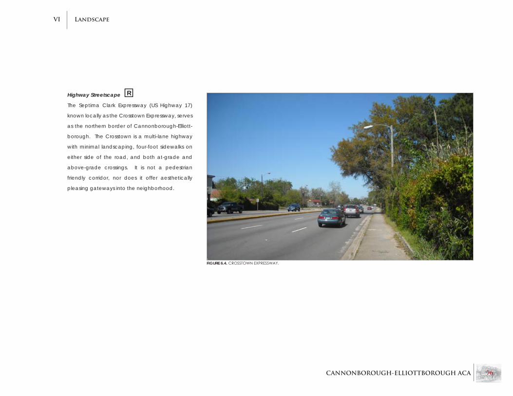
CANNONBOROUGH-ELLIOTTBOROUGH ACA 76
LandscapeVI
Highway Streetscape
The Septima Clark Expressway (US Highway 17)
known locally as the Crosstown Expressway, serves
as the northern border of Cannonborough-Elliott-
borough. The Crosstown is a multi-lane highway
with minimal landscaping, four-foot sidewalks on
either side of the road, and both at-grade and
above-grade crossings. It is not a pedestrian
friendly corridor, nor does it offer aesthetically
pleasing gateways into the neighborhood.
FIGURE 6.4. CROSSTOWNExPRESSWAy.
R

CANNONBOROUGH-ELLIOTTBOROUGH ACA 77
LandscapeVI
Major Roads Streetscape
KingStreet is theonly streetscapeclassifiedasa
“Major Road” within the neighborhood and serves
as the eastern boundary for Cannonborough-
Elliottborough, effectively dividing the neighbor-
hood from the East Side community. A major
commercial corridor with traditional street-front
commercial uses, the section of King Street within
the study area has been recently improved. Im-
provements include historically appropriate street
lights, street trees (palmettos), and brick cross-
walks.Althoughthetwolanesoftraffic,makefor
a busy street, on-street parking with the above-
mentioned improvements encourage pedestrian
movement.
FIGURE 6.5. KINGSTREET:MAJORROADWAy.

CANNONBOROUGH-ELLIOTTBOROUGH ACA 78
LandscapeVI
Secondary Roads Streetscape
In Cannonborough-Elliottborough there are a
number of secondary roads which can be con-
sidered feeder streets, transporting people and
traffic through theneighborhood. These streets
include:
Cannon Street•
Spring Street•
Morris Street•
Bee Street•
Coming Street•
Saint Philip Street•
President Street•
Rutledge Avenue•
Ashley Avenue•
Line Street•
FIGURE 6.6. SECONDARyROADCROSS-SECTIONSUCHASCANNONSTREET.
Three of these streets serve as partial boundaries for
the neighborhood:
Morris and Bee Streets (southern border)•
President Street (western border)•
Characteristics of these major roads include:
Road width is between 29 and 36 feet•
Sidewalks are seven to ten feet wide •
No consistent buffer strips, but there are street •
trees and tree wells
Tree canopy is mixed throughout the neigh-•
borhood; some portions of streets have an in-
tact tree canopy, others are lacking trees and
shade
Setbacks are minimal or none•
On-street parking is consistent •

CANNONBOROUGH-ELLIOTTBOROUGH ACA 79
LandscapeVI
FIGURE 6.7. BEESTREET:SOUTHERNBOUNDARy.
FIGURE 6.8. BLUESTONESIDEWALKSANDBRICKDRIVEAPRONSON
RUTLEDGEAVENUE.
Exceptions to the characteristics listed above in-
clude President Street, where there is no on-street
parking, and Ashley and Rutledge Avenues which
have consistent planting buffers separating the
pedestrian zone from the vehicular zone. Rutledge
Avenue is also distinctive because its sidewalks
are constructed of bluestone with brick driveway
aprons. This only occurs on the east side of Rut-
ledge Avenue between Bogard and Line Streets
(There is also one property on St. Philip Street with
a bluestone sidewalk). Rutledge and Ashley Av-
enues are also distinctive because the setbacks
on these streets are consistently 20 to 30 feet. This
isduetothefront-orientedVictorianhomesasop-
posed to the more traditional side-facing Charles-
ton single houses.

CANNONBOROUGH-ELLIOTTBOROUGH ACA 80
LandscapeVI
Local Streets Streetscape
Local streets serve to connect road networks to-
gether. These streets are residential (with the oc-
casional corner store) and exist only within the
Cannonborough-Elliottborough neighborhood.
These streets include:
Rose Lane•
Sires Street•
Kracke Street•
Felix Street•
Smith Street•
Percy Street•
Ashe Street•
Bogard Street•
These roads are narrower and generally give the
feeling of a dense residential neighborhood. They
have the following characteristics
15 to 30-foot road widths•
Five to seven-foot wide concrete sidewalks•
No permanent buffer strips with street trees •
and tree wells
Minimal if any setback•
There are a few exceptions to these character-
istics. Smith Street serves as a local street, but its
streetscape is more representative of a Secondary
Street such as Morris or Bee Streets. It has wider
road lanes (30 feet) and includes a buffer strip
with street trees (similar to Ashley and Rutledge
Avenues). It only extends two blocks south from
Cannon Street but continues into the adjacent
neighborhood, Radcliffeborough. It is a hybrid
streetwithnotrueclassification.
RoseLaneandSiresStreetalsodonotfittheabove
criteria.Whiletheyserveaslocalstreets,theyare
more narrow (Sires Street is 15 feet wide; Rose Lane
is 12 feet wide) and have no vegetation on them.
Rose Lane only provides a sidewalk on one side of
the street.
FIGURE 6.9.LINESTREET:ATyPICALLOCALSTREET.
FIGURE 6.10. ROSELANE:ANARROWLOCALSTREET.
R

CANNONBOROUGH-ELLIOTTBOROUGH ACA 81
LandscapeVI
Alleyway/Courts Streetscape
There are numerous small lanes, dead-end streets,
and alleys throughout Cannonborough-Elliottbor-
ough. Their conditions vary; some are comprised
of many vacant homes, others are associated
with new developments and high-end residential
enclaves. These small roads include:
Rosemont Street•
Islington Court•
Carrere Court•
Kennedy Street•
DeReef Court•
Tully Alley•
Bracky Court•
Brewster Court•
Payne Court•
Lewis Court•
Peecksens Court•
Ipswich Court•
Porters Court•
Humphrey Court•
Ackerman Court•
Rodgers Alley•
Todd Street•
Although all are very different, commonalities in-
clude:
Sidewalks are not always present•
They are often one-way streets•
Some are dead-ends with a common entry •
and exit point
FIGURE 6.11. ROSEMONTSTREET:ExISTINGHISTORICFABRIC.
FIGURE 6.12. BREWSTERCOURT:NEWDEVELOPMENT.
FIGURE 6.13. PEECKSENSCOURT:WORKFORCEHOUSING.
R
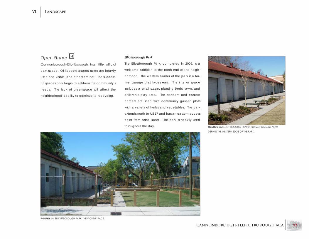
CANNONBOROUGH-ELLIOTTBOROUGH ACA 82
LandscapeVI
Open SpaceCannonborough-Elliottborough has little official
park space. Of its open spaces, some are heavily
used and visible, and others are not. The success-
ful spaces only begin to address the community’s
needs. The lack of greenspace will affect the
neighborhood’s ability to continue to redevelop.
Elliottborough Park
The Elliottborough Park, completed in 2009, is a
welcome addition to the north end of the neigh-
borhood. The western border of the park is a for-
mer garage that faces east. The interior space
includes a small stage, planting beds, lawn, and
children’s play area. The northern and eastern
borders are lined with community garden plots
with a variety of herbs and vegetables. The park
extends north to US 17 and has an eastern access
point from Ashe Street. The park is heavily used
throughout the day.
FIGURE 6.14. ELLIOTTBOROUGHPARK:NEWOPENSPACE.
FIGURE 6.15. ELLIOTTBOROUGHPARK:FORMERGARAGENOW
DEFINESTHEWESTERNEDGEOFTHEPARK.
R

CANNONBOROUGH-ELLIOTTBOROUGH ACA 83
LandscapeVI
KING
KINGSAINT PHILIP
COM
ING
PERCY
ASHERO
SE
ROSE
SIRES
IPSWIC
HRUTLEDG
E
ASHLEY
BEE
OLIVER
CANNON
REID
WOOLFE
BREWSTERPAYNE
RODGERS
ACKERMANS
CANNON
SPRING
SPRING
SPRING
COLUMBUS
BOGARD
BOGARD
US 17
US 1
7
LINE
HUMPHREY
TULLYSAINT PHILIPCO
MING
RUTLEDGE
ASHLEYKRAC
KE
KENNEDY
TODD
ASHE
BRACKYLEWIS
FELIX
DEREEF
SMITH
CARRERE
ISLINGTO
N
PRESIDENTS
ROSEMONT
PEECKSENS
PORTERS
MEETING
MORRIS
Cannonborough-Elliottborough
N
Legend
Parks & Open Space
Public Open Space
Scale: Approximately 1” = 150’
Open Space (Not Regularly Open to the Public)
Neighborhood BoundaryCalvary Church
Memorial And Grounds
ElliottboroughPark
Porter’s Court
CommunityGardens
ComingStreetJewish
Cemetery
DeReef Park
Simonton Park
MorrisSquare
FIGURE 6.16. OPENSPACEANDPARKSWITHINTHECANNONBOROUGH-ELLIOTTBOROUGHNEIGHBORHOOD.

CANNONBOROUGH-ELLIOTTBOROUGH ACA 84
LandscapeVI
FIGURE 6.18. BRICK PATH IN DEREEF PARK.
FIGURE 6.19. MORRISSQUARE.
FIGURE 6.17. REDEVELOPMENTPLANSFORDEREEFPARKANDMORRISSQUARE(COURTESyOFTHECITyOFCHARLESTON).
DeReef Park
At the southern end of Cannonborough-Elliottbor-
ough, facing Morris Street, is DeReef Park. DeReef
Court is a paved street that includes parking and
serves as the western border of the park. The park
has a number of mature trees including swamp
white oak, London plane tree, magnolia, elm,
crepe myrtle, and live oak. There is a formalized
brick walkway and patio in the middle of the park
witholderplayequipmenttothenorth.Thereare
also picnic tables scattered throughout. Although
the park is currently under-utilized, there are plans
for its redevelopment as the second phase of Mor-
risSquare. Ahistoricchurchwhichstandsat the
end of the park will be relocated within the de-
velopment and converted into a residence. Park
space will be relocated, central to residences.
Across the street to the south is the recently com-
pletedPhaseIofMorrisSquarewhichincludestwo
open spaces: Simonton Park and a smaller plaza,
MorrisSquare.Theseadditionscreateanidentity
for the southern portion of the neighborhood.
DeReef Park
morrissquare
simonton park

CANNONBOROUGH-ELLIOTTBOROUGH ACA 85
LandscapeVI
Coming Street Jewish Cemetery
The Coming Street Jewish Cemetery, located
south of Cannon Street, is the oldest Jewish cem-
etery in the region. It was established in the eigh-
teenth century and was originally associated with
the Kahal Kadosh Beth Elohim congregation. The
cemetery is surrounded by a high wall with two
entry gates. Unfortunately, the cemetery is open
only by appointment so there is no opportunity to
freely walk the grounds.
Porters Court Community Gardens
Porters Court is a narrow, one-way lane off Bogard
Street. The houses along this street are slowly be-
ing restoredalongwithnew infillconstruction. A
uniquefeatureofthisstreetisthecreationofcom-
munitygardens in twoof thevacant lots. While
these are small in size, they provide an opportu-
nity for community interaction and help to bring
a sense of identity to Porters Court. Efforts to con-
tinue the maintenance of these gardens should
be encouraged.
FIGURE 6.20. COMINGSTREETCEMETERyWALLSIGN. FIGURE 6.21. COMINGSTREETGRAVES.
R

CANNONBOROUGH-ELLIOTTBOROUGH ACA 86
LandscapeVI
Street Trees & Tree CanopyStreet trees are abundant throughout the neigh-
borhood, although the tree canopy is inconsistent.
Generally speaking, the tree canopy is more con-
sistent in the southern part of Cannonborough-
Elliottborough. Ashley Avenue, Rutledge Avenue,
portions of Cannon Street, eastern portions of Bee
Street, and Morris Street exemplify this consistent
canopy.WiththeexceptionofSmithStreet,Ash-
ley Avenue, and Rutledge Avenue, which have
grass buffer strips, trees are planted in tree wells
(with groundcovers in some instances). The most
common trees are live/willow oaks, crepe myrtles,
and palmettos. Some combination of these trees
appears on almost every street in the neighbor-
hood. Other trees present include Japanese ma-
ple, ginkgo, and eastern red cedar. Oleander, a
shrub, also appears in certain instances.
Drainage & UtilitiesGranite curbing is consistent throughout the
neighborhood, with periodic stormwater drainage
grates. Stormwater and sanitary sewer are sepa-
rate systems within the city.
Overhead utilities for telephone, electricity, and
telecommunications are present throughout the
neighborhood.
SidewalksWith the exception of a portion of RutledgeAv-
enue that has bluestone sidewalks (discussed
earlier), all sidewalks are concrete. The sidewalks
range in width from four feet to 11 feet. The side-
walks are heavily used and continue to be well
maintained.
Driveway ApronsA unique feature throughout Cannonborough-
Elliottborough is the presence of brick-stamped
patterns in concrete aprons. Many times these
appear within existing driveways, but they also re-
main where driveways are no longer present. This
pattern appears throughout the city, and there is
no known explanation as to why this was originally
done or in what time period it was completed.
FIGURE 6.22. MORRISSTREETTREECANOPy.
FIGURE 6.23. LOCALLyUNIQUEDRIVEWAyAPRON.
R
R

CANNONBOROUGH-ELLIOTTBOROUGH ACA 87
LandscapeVI
Private Open SpaceMuch of the private open space in Cannonbor-
ough-Elliottborough is devoted to utilitarian uses
such as driveways, storage, and trash. If private,
landscaped areas exist, most are very private, with
limitedvisibilityfromthestreet.Whattheneighbor-
hood lacks in private open space, it celebrates in
itsdiversityofdefiningthoseprivatespaces.There
are over 80 different types of fencing, walls, and
gates throughout the neighborhood, signifying
the vernacular development of the neighborhood
over time.
Designed LandscapesThere are few known designed landscapes in the
neighborhood with the exception of properties
along Rutledge Avenue, Bee Street, and Ashley
Avenue.TheseareashavebiggerVictorianstruc-
tures with larger setbacks, providing more space
for lawns and gardens. Many of these gardens
continue to be private, but visible vegetation in-
cludes shade trees and larger shrubs. In some in-
stances, where small front yards are present, there
are some plantings present.
FIGURE 6.24. DESIGNEDLANDSCAPEONASHLEyAVENUE.

CANNONBOROUGH-ELLIOTTBOROUGH ACA 88
LandscapeVI
DrivewaysLike other features of the neighborhood, the drive-
ways in Cannonborough-Elliottborough are diverse
with a wide range of materials and design. A survey
of the area indicates that there are at least 15 dif-
ferent types of driveway layouts. A majority of these
designs incorporate a similar pattern: two 1.5-foot
parallel lanes of a paver/hardscape material sepa-
rated by either grass, dirt, or some other paver. The
paver strips are designed with the following mate-
rials: exposed oyster-shell aggregate, brick pavers,
gravel, dirt, or granite cobblestones. Some designs
are more intricate than others. Despite the diversity
of material, future driveways should continue to in-
corporate this pattern.
FIGURES 6.25-6.28. ASAMPLEOFDRIVEWAyTyPESWHICHGENER-
ALLyINCORPORATETWOPARALLELSTRIPESOFHARDSCAPE
SEPARATEDByGRASS,OySTERSHELL,DIRT,ETC.
R

CANNONBOROUGH-ELLIOTTBOROUGH ACA 89
LandscapeVI
Walkways & entriesThelargerVictorianhousesonRutledgeandAsh-
leyAvenueshaveraisedfirstfloorswithanumber
ofsteps.Theremainingneighborhoodshavefirst
floors that are at street level or slightly above.
Many front entries have a front stoop with two
stairs and sometimes a small platform. These steps
are directly associated with the sidewalk because
of the lack of a setback.
A few detached homes have walkways laid out in
mulch or some other paving material. These lead
to the rear of the house or a rear entry; however,
they are not very common in the neighborhood.
Fences/WallsIn addition to the varying driveway designs, Can-
nonborough-Elliottborough has a tradition of ver-
nacular fencing and wall design. As noted ear-
lier, there are over 80 different types of fencing,
gates, and walls within the study area. Many of
these are variations of chain link fences, privacy
fences, retaining walls, freestanding walls, metal
fencing, picket fencing, wire fencing, brick/stuc-
co walls, etc. In many situations multiple building
materials were used to form a hybrid structure: for
example, cinder blocks with brick coping forming
a wall. Some piers, gates, and walls are high style
and complement the historic architecture. There
are also many situations where available materi-
als were used to create the desired outcome. This
has established a vernacular pattern/ethic of de-
velopment over the history of the neighborhood
that is focused on affordability/availability rather
than style or trends.
FIGURE 6.29. PORCHSTOOPWITHURNS.
FIGURE 6.30. LANDSCAPEDSIDEENTRy.
R

CANNONBOROUGH-ELLIOTTBOROUGH ACA 90
LandscapeVI
FIGURES 6.31-6.35. VARIETyOFFENCETyPESINCANNONBOROUGH-
ELLIOTTBOROUGH.DECORATIVEIRONRAILINGS,BRICKCOLUMNS,
STUCCOEDWALLS,VERNACULARCINDERBLOCKS,CHAINLINKFENC-
ING, AND PICKET FENCES ARE ALL COMMON.

CANNONBOROUGH-ELLIOTTBOROUGH ACA 91
LandscapeVI
ViewshedsCannonborough-Elliottborough has preserved the
streetscape viewsheds throughout the neighbor-
hood.Vistasalonganyofthemajorroadswithin
the neighborhood provide an image of a diverse/
transitional community that witnesses a heavy
amountofcut-throughtrafficaswellaspedestrian
traffic.
Continued efforts such as adding on-street parking
and improving the tree canopy, along with new
development that respects the neighborhood
form, will continue to ensure that these viewsheds
are preserved.
FIGURES 6.36-6.37. THEREAREAVARIETyOFSTREETSCAPE
VIEWSHEDSWITHINCANNONBOROUGH-ELLIOTTBOR-
OUGH.

CANNONBOROUGH-ELLIOTTBOROUGH ACA 92
LandscapeVI
FloodplainsFlooding is at times a major issue in Cannonbor-
ough-Elliottborough. A large portion of the neigh-
borhood lies within the 100-year floodplain, and
this becomes quite apparent during heavy rain
(see Figure 6.37).
The map on the following page (Figure 6.38) is a
floodzonemapoftheneighborhood.Thedarker
green indicates areas in zone AE, meaning they
aresubjecttoa100-yearfloodwithBaseFloodEl-
evationdetermined.Floodinsuranceisrequiredin
thisarea,andfloodmanagement standardsap-
ply.
TherestoftheneighborhoodiswithinZonexE(light
green), and the map indicates that it is not in the
100-year flood zone. It is between the 100-year
and500-yearfloodareaandsubjecttoa100year
floodwithaveragedepthslessthanonefoot.
US-17 Transportation Infrastructure Reinvestment
Project
The Crosstown Expressway (US 17) often experience
heavy trafficandgridlock. Whenfloodingoccurs
on the road, mobility is limited further. For pedes-
trians and emergency vehicles, this poses major
safety concerns.
The US 17 Septima Clark Transportation Infrastruc-
ture Reinvestment Project for Mobility, Efficiency,
Emergency Preparedness, and Community Livabil-
ity is a $130 million planned project aimed at allevi-
ating infrastructure and mobility concerns on and
around US 17 (Crosstown Expressway). The project
is slated to begin construction in 2010; however,
theCityiscurrentlyworkingtoacquirefederaland
statefinancialaidinordertofinancetheproject.
Additional details on the project, as well as a full
report, are available by contacting the City of
Charleston.
FIGURE 6.37. FLOODINGSITUATIONSREGULARLyOCCURALONGTHECROSSTOWNExPRESSWAy.

CANNONBOROUGH-ELLIOTTBOROUGH ACA 93
LandscapeVI
KING
KINGSAINT PHILIP
COM
ING
PERCY
ASHERO
SE
ROSE
SIRES
IPSWIC
HRUTLEDG
E
ASHLEY
BEE
OLIVER
CANNON
REID
WOOLFE
BREWSTERPAYNE
RODGERS
ACKERMANS
CANNON
SPRING
SPRING
SPRING
COLUMBUS
BOGARD
BOGARD
US 17
US 1
7
LINE
HUMPHREY
TULLYSAINT PHILIPCO
MING
RUTLEDGE
ASHLEYKRAC
KE
KENNEDY
TODD
ASHE
BRACKYLEWIS
FELIX
DEREEF
SMITH
CARRERE
ISLINGTO
N
PRESIDENTS
ROSEMONT
PEECKSENS
PORTERS
MEETING
MORRIS
Cannonborough-Elliottborough
N
Legend
Existing Floodplain Map
Scale: Approximately 1” = 150’
NeighborhoodBoundary
100-500 Year Floodplain
100 Year Floodplain
FIGURE 6.38. ExISTINGFLOODPLAINMAPFORCANNONBOROUGH-ELLIOTTBOROUGH.

CANNONBOROUGH-ELLIOTTBOROUGH ACA 94
LandscapeVI
Chapter 6 RecommendationsEfforts should be taken to improve the long-•
term aesthetic and psychological impact
the Crosstown Expressway has on the neigh-
borhood. Improved gateways, street trees,
crosswalks, pedestrian-scaled light fixtures,
and improved street access are suggested
alternatives.
Establishing clearly defined gateways into•
the neighborhood will more easily identify en-
trance into the neighborhood.
Many of the local streets, alleyways, and •
courts are in poor condition and need im-
provement. Certain streets, such as Rose
Lane, appear to have cobblestone under-
neath the asphalt, which would make for a
historically appropriate alternative if uncov-
ered.
Additional park space is needed for Cannon-•
borough-Elliottborough. Elliottborough Park
should be used as a precedent for future park
development.
Development of community gardens should •
be encouraged.
Trees should be replanted on streets where •
the canopy has been broken or no longer ex-
ists.
The history of the brick-stamped concrete •
driveway aprons should be investigated to
determine their origin and purpose.
A more in-depth study should be conducted •
of the driveway typologies and fence/enclo-
sure typologies in the neighborhood.

CANNONBOROUGH-ELLIOTTBOROUGH ACA 95
Preservation & IntegrityVII
FIGURE 7.1. THEFLORENCEALBERTACLyDEHOUSE(CIRCA1845),LOCATEDAT191SMITHSTREET,ISUNDERANHISTORICCOVENANT.
Chapter 7:Preservation & Integrity
This chapter provides an evaluation of how
well character elements have been preserved
throughout Cannonborough-Elliottborough. This
evaluation is based on first-hand observations,
supplemental research and discussions from the
public workshops.
CANNONBOROUGH-ELLIOTTBOROUGH ACA 96
Preservation & IntegrityVII
Chapter 7 Summary
Character integrityMost of the neighborhood is in sound condi-•
tion, but there are transitional areas, particu-
larly near the edges of the neighborhood.
Areas adjacent to the Crosstown Expressway •
have the most blight.
Vacant properties, surface parking lots, di-•
lapidated structures, and inappropriate con-
struction all contribute to character degrada-
tion.
Varietyofusesandstylesdefinetheneighbor-•
hood’s character.
Bogard Street is an excellent example of •
community character, exhibiting the pattern
of Charleston single-style residences with cor-
ner stores at intersections.
Corner stores are a vital part of the local de-•
velopment pattern and contribute to the va-
riety of uses.
BAR & Historic DistrictsThe Board of Architectural Review (BAR) and •
Charleston’s historic districts exist to protect
the city’s character and heritage.
As the Board of Architectural Review (BAR) •
has expanded its scope and powers, all of
Cannonborough-Elliottborough is under some
level of BAR review.
Most of the neighborhood is within the Old •
City District, but outside of the Old & Historic
District and the National Register district. King
Street is within the Old & Historic District.
Cannonborough-Elliottborough has enough •
historic value to be included in the National
Register District, but fears of gentrification
have halted expansion of the district to this
area in the past.
Local Preservation effortsThe Historic Charleston Foundation has helped •
restore several structures, and holds restrictive
covenants and easements on several neigh-
borhood properties.
Traffic on Spring and Cannon Streets will be•
converted from one-way to two-way, provid-
ing the opportunity for these corridors to return
to neighborhood-friendly corridors.
TheCrosstownExpresswaybeautificationproj-•
ect will attempt to alleviate some pedestrian
concerns and enhance the aesthetics of this
highway.
Parcel-by-parcel renovations and rehabs are •
crucial to neighborhood preservation.
Large-scale developments struggle to blend •
into Cannonborough-Elliottborough because
the neighborhood’s building stock spans so
many years of individual development.
Including the neighborhood in the National •
Register will provide incentives to rehabilitate
existing structures through tax credits.
notable PropertiesThree properties in the neighborhood are indi-•
vidually listed on the National Register of His-
toric Places. Several others are likely worthy of
this designation.
The freedman’s cottage is a locally-derived •
type of vernacular architecture that is impor-
tant to the neighborhood. Recommendations will appear at the end of this chapter and are denoted in the text by this symbol. R

CANNONBOROUGH-ELLIOTTBOROUGH ACA 97
Preservation & IntegrityVII
Character IntegrityIn general, historic integrity and character in most
of Cannonborough-Elliottborough is intact. How-
ever, there are trends and conditions that pose a
threat to the integrity of the neighborhood. As the
area has become a more desirable place to live
and work, development pressures have increased.
Several new developments have occurred, and
not all of them are sensitive to the previously exist-
ing character.
Additionally, there still remains an abundance of
dilapidated structures throughout the neighbor-
hood, several of which are uninhabitable. These
convey a lack of pride of ownership in the com-
munity, create eyesores, and can accommodate
undesirable activities within. For the most part
these properties are scattered throughout the
neighborhood, but in some cases they are con-
centrated in a smaller area.
A general appraisal of neighborhood conditions
was performed for this project. The map on the
following page (Figure 7.2) is a general appraisal
of neighborhood conditions for Cannonborough-
Elliottborough. Areas are categorized according
to the following criteria (and shown in the Figure
7.2 map on the next page):
Excellent Character:• These are areas where
the historic character of the neighborhood
is most cohesive. Historic structures are in
good condition, with preserved architecture;
streetscape elements are well maintained
with few to no exceptions.
Sound Character:• These areas have some
transitional properties (dilapidated buildings,
non-contributing buildings), but overall, the
streetscape and character of the area is in-
tact.
Transitional: • Areas with a fair amount of char-
acter degradation, but with some signs of re-
development and revitalization.
Deteriorating:• Areas that have experienced
significant decline or nearly total character
degradation. These areas have an abun-
dance of dilapidated buildings and/or non-
contributing buildings, and have a ‘run-down’
qualitywithlittletonostreetvibrancy.
Redeveloped:• These are areas that have been
completely redeveloped and do not exhibit
the characteristics of previous development.
Undeveloped: • Locations with large areas of un-
developed or underdeveloped land, including
parking lots, vacant space, or demolition.
Thesecategorizationsaremadebasedonfieldob-
servations and input from the public workshop, and
are general categories of an area as a whole. An
area’s categorization does not mean that each in-
dividualparcelfitsthecategory’sdescription.
Because the neighborhood is not homogenous and
there exist a variety of architectural styles, it is hard
to judge new buildings as “in character” or “out
of character.” Certainly, “out of scale” is easier to
judge because it is much less subjective.

CANNONBOROUGH-ELLIOTTBOROUGH ACA 98
Preservation & IntegrityVII
KING
KINGSAINT PHILIP
COM
ING
PERCY
ASHERO
SE
ROSE
SIRES
IPSWIC
HRUTLEDG
E
ASHLEYBEE
OLIVER
CANNON
REID
WOOLFE
BREWSTERPAYNE
RODGERS
ACKERMANS
CANNON
SPRING
SPRING
SPRING
COLUMBUS
BOGARD
BOGARD
US 17
US 1
7
LINE
HUMPHREY
TULLYSAINT PHILIPCO
MING
RUTLEDGE
ASHLEYKRAC
KE
KENNEDY
TODD
ASHE
BRACKYLEWIS
FELIX
DEREEF
SMITH
CARRERE
ISLINGTO
N
PRESIDENTS ROSEMONT
PEECKSENS
PORTERS
MEETING
MORRIS
Cannonborough-Elliottborough
N
Legend
Neighborhood Character
Excellent
Scale: Approximately 1” = 150’
Sound
Transitional
Deteriorating
Redeveloped
Undeveloped/Underdeveloped
NeighborhoodBoundary
FIGURE 7.2. NEIGHBORHOODASSESSMENTOFINTEGRITy.

CANNONBOROUGH-ELLIOTTBOROUGH ACA 99
Preservation & IntegrityVII
Areas in Good CharacterAshley Avenue south of Cannon Street is an area
of excellent preservation. Several original proper-
ties have been kept in pristine condition. This area
is one of the most attractive in the neighborhood.
Areas of Rutledge Avenue are similarly preserved.
ThereareseveralgrandVictorianresidencesinex-
cellent condition along Rutledge one block north
and south of Bogard Street.
FIGURE 7.3. ASHLEyAVENUE,BETWEENCANNONANDBEESTREETS,
ExEMPLIFIESExCELLENTPRESERVATION.
FIGURE 7.4.UPPERKINGSTREETDISPLAySAWIDEVARIETyOFWELLPRESERVEDCOMMERCIALBUILDINGS.
FIGURE 7.5.DETAILINGONUPPERLEVELSLENDSANAESTHETICQUAL-
ITyTHATENHANCESKINGSTREET’SCHARACTER.
Another area with a thriving and intact character
is Upper King Street, south of Spring Street. After a
period of decline, this area is once again vibrant.
Many historic commercial buildings in good con-
dition exist along this stretch of Upper King. The
detailing of many of the older buildings adds a re-
finedanddistinguishedqualitytothearea.Above
Spring Street, there is more vacant land and the
district loses its character.

CANNONBOROUGH-ELLIOTTBOROUGH ACA 100
Preservation & IntegrityVII
Bogard Street is in sound condition - it is not without some dilapidated structures
and vacant building - but overall it serves as an excellent example of Cannon-
borough-Elliottborough’s character. It is comprised mainly of Charleston single-
style residences with corner stores located at nearly every intersection. This pat-
ternisbestexemplifiedbetweenSt.PhilipandSiresStreets.
Thesepatternsarealsoexemplified,althoughlessconsistentlyalongLine,Ashe,
Percy, and Coming Streets. As the neighborhood continues to revitalize and
vacant corner stores become occupied, this pattern of development should
provide a wonderfully thriving area. As mentioned previously in Chapter 4, it is
extremelyimportantthatcornerstoresremainnon-residentialonthegroundfloor
in order to help maintain a mix of uses in convenient, walkable locations.
FIGURE 7.6. BOGARDSTREETISAWELLPRESERVEDRESIDENTIALSTREETTHATTyPIFIESTHENEIGHBORHOOD.
The southern portion of Cannonborough-Elliottborough, closest to Radcliffebor-
ough, also exhibits sound character. It is not without some blighted properties,
but for the most part retains good character and vibrancy. This includes Smith
Street, Morris Street, and Felix Street. Cannon Street, between Ashley Avenue
and Coming Street, also represents sound preservation of character.
As a general trend, the best preserved areas of the neighborhood are within the
interior. Closer to the outer edges, the neighborhood exhibits more transitional
qualities. Anexception to this is the southeastarea,whereCannonborough-
Elliottborough borders Radcliffeborough.
FIGURE 7.7. FELIxSTREETFEATURESAGOODMIxOFWELLPRESERVEDOLDERRESIDENCESANDNEW
CONSTRUCTION.
R

CANNONBOROUGH-ELLIOTTBOROUGH ACA 101
Preservation & IntegrityVII
The west end of the neighborhood exhibits loss of character due in part to the adjacent Medical
University of South Carolina campus and the proximity to the commercial gateway area along
US 17. There are several parking lots and architecturally non-contributing structures in this area
and it does exhibit the development characteristics of Cannonborough-Elliottborough. The city
should consider extending the existing accommodation overlay zone between Spring and Can-
non Streets eastward to Ashley or Rutledge Avenue. This may help encourage rehabilitation of
older buildings and provide more mix of uses by adding inns and bed & breakfasts.
Areas With Transitional or Deteriorated QualitiesThe most deteriorated areas exist adjacent to US 17. As much progress as has been
made in revitalizing Cannonborough-Elliottborough, properties near a major highway
remain undesirable for rehabilitation or redevelopment. Rosemont Street and Kennedy
Court are particularly blighted, given their status as dead-end streets with access only to
US 17. As a result, these two areas have a high percentage of vacant lots and severely
dilapidated buildings. Revitalization efforts should make these areas along the periph-
ery a top priority.
Ontheinterioroftheneighborhood,SpringStreethasalotoftransitionalqualities.Over
time, Spring Street has transformed from a neighborhood-serving commercial area to a
corridor of strip commercial that in some stretches resembles a highway rather than a lo-
cal service district. Additionally, there are several dilapidated and/or vacant structures
alongSpringStreet.Itishopedthattheconversionoftrafficfromone-waytotwo-way
will help this corridor return to a neighborhood-friendly street (discussed in more detail in
this chapter’s ‘Local Preservation Efforts’ section.
FIGURE 7.8. AREASADJACENTTOTHECROSSTOWNExPRESSWAyTENDTOHAVETHEMOST
BLIGHTED CONDITIONS.
FIGURE 7.9. STRIP COMMERCIAL, LIKE THIS ALONG SPRING STREET, DOES NOT
MATCHHISTORICALDEVELOPMENTOFTHEAREA.
R
R

CANNONBOROUGH-ELLIOTTBOROUGH ACA 102
Preservation & IntegrityVII
Undeveloped AreasThere are several vacant areas along the periphery of the neighborhood. Be-
tween Line Street, St. Philip Street, Spring Street, and King Street is a large area of
parking lots and undeveloped land. There are a few residences along Line and
St. Philip Streets, and a few scattered businesses on King Street, but otherwise this
areahasavacantqualitythatcreatesavoidintheneighborhood.
On the far west side of Cannonborough is a surface parking lot for MUSC that
takes up a large area between Spring Street and Cannon Street. Despite its
functionality in providing parking, it is an unattractive part of this transitional area
where MUSC and Cannonborough meet.
FIGURE 7.11.ALARGEVACANTAREAATKINGANDSPRINGSTREETS.
FIGURE 7.10. KINGSTREETNORTHOFSPRINGSTREETLACKSPEDESTRIANACTIVITy.

CANNONBOROUGH-ELLIOTTBOROUGH ACA 103
Preservation & IntegrityVII
Preservation of Character:Considerations Often local preservation is focused upon a partic-
ulartimeperiod,or“periodofsignificance.”Some
neighborhoods have a short significant period
when most of its buildings were built, and consist
of a particular style or two. In the case of Cannon-
borough-Elliottborough, there is no one time peri-
od or style that is of more importance than others,
and a variety of time periods and styles are ap-
preciated in this neighborhood. The public input
given at the Area Character Appraisal workshops
spoke to this appreciation of variety. The partici-
pants felt that some of the neighborhood’s newer
developments lacked variety, and as a result did
notfitinwellwithexistingdevelopment.Thecon-
The following characteristics were de-
scribed as either important or detrimen-
tal to Cannonborough-Elliottborough by
neighborhood residents at the Public Work-
shops.
Aspects important to the neighborhood’s
character:
Authentic building materials & details•
Variety of uses, architectural styles, •
building details, colors, materials, etc.
variety of uses that contribute to •
neighborhood vibrancy.
Aspects that detract from the neighbor-
hood’s character:
‘Cookie-cutter’ development, where a •
string of buildings were exactly alike
without variation of details or materi-
als.
Inauthentic building materials•
Ranch houses and concrete block resi-•
dences
Buildings with blank walls or walls •
with minimal fenestration that are vis-
ible from the public street.
FIGURES 7.12 & 7.13. VARIETyISTHEFOUNDATIONOFCANNONBOROUGH-ELLIOTTBOROUGH’SCHARACTER.
FIGURE 7.14. ALTHOUGHTHESEUNITSExHIBITQUALITyOFCON-
STRUCTION,THEIRLACKOFVARIETyDETRACTSFROMTHENEIGH-
BORHOOD’S CHARACTER.
sensus seemed to be that development with more
modern styles or features should seek to blend with
the neighborhood by incorporating more variety
of building elements, materials and details. R
Character Values
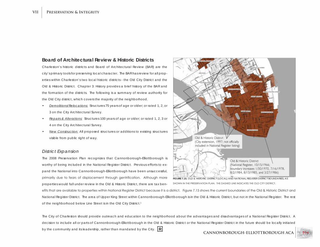
CANNONBOROUGH-ELLIOTTBOROUGH ACA 104
Preservation & IntegrityVII
Board of Architectural Review & Historic DistrictsCharleston’s historic districts and Board of Architectural Review (BAR) are the
city’s primary tools for preserving local character. The BAR has review for all prop-
erties within Charleston’s two local historic districts - the Old City District and the
Old & Historic District. Chapter 3: History provides a brief history of the BAR and
the formation of the districts. The following is a summary of review authority for
the Old City district, which covers the majority of the neighborhood.
Demolitions/Relocations:• Structures 75 years of age or older; or rated 1, 2, or
3 on the City Architectural Survey.
Repairs & Alterations:• Structures 100 years of age or older; or rated 1, 2, 3 or
4 on the City Architectural Survey.
new Construction:• All proposed structures or additions to existing structures
visible from public right of way.
District expansionThe 2008 Preservation Plan recognizes that Cannonborough-Elliottborough is
worthy of being included in the National Register District. Previous efforts to ex-
pand the National into Cannonborough-Elliottborough have been unsuccessful,
primarily due to fears of displacement throughgentrification. Althoughmore
properties would fall under review in the Old & Historic District, there are tax ben-
efitsthatareavailabletopropertieswithinNationalRegisterDistrictbecauseitisadistrict.Figure7.15showsthecurrentboundariesoftheOld&HistoricDistrictand
National Register District. The area of Upper King Street within Cannonborough-Elliottborough is in the Old & Historic District, but not in the National Register. The rest
of the neighborhood below Line Street is in the Old City District.1
The City of Charleston should provide outreach and education to the neighborhood about the advantages and disadvantages of a National Register District. A
decision to include all or parts of Cannonborough-Elliottborough in the Old & Historic District or the National Register District in the future should be locally initiated
by the community and its leadership, rather than mandated by the City.
FIGURE 7.15. OLD & HISTORIC DISTRICT (LOCAL) AND NATIONAL REGISTER DISTRICT BOUNDARIES, AS
SHOWNINTHEPRESERVATIONPLAN.THEDASHEDLINEINDICATESTHEOLDCITyDISTRICT.
R

CANNONBOROUGH-ELLIOTTBOROUGH ACA 105
Preservation & IntegrityVII
258 Ashley Avenue•
33 Bogard Street•
57 Cannon Street•
113 Line Street•
3 Porter’s Court•
6 Porter’s Court•
8 Porter’s Court•
12 Porter’s Court•
13 Porter’s Court•
27 Rose Lane•
185 Rutledge Avenue•
25 Sires Street•
174 Smith Street•
181 Smith Street•
191 Smith Street•
197 Smith Street•
218 St. Philip Street (easement)•
236 St. Philip Street•
12 Bee Street•
Covenants and EasementsLocal Preservation EffortsThe following are descriptions of prior, ongoing
and future preservation efforts within or including
the Cannonborough-Elliottborough community.
Historic Charleston Foundation’s neighborhood initiativeThis initiative by Historic Charleston Foundation
(HCF) was responsible for restoring the James Mor-
rison House, located at 236 St. Philip Street, funded
by a gift from the Post and Courier Foundation.
Two additional properties on St. Philip Street, 216
& 218, are currently undergoing restoration as part
of the same initiative.
FIGURE 7.17. FLORENCEALBERTACLyDEHOUSEONSMITHSTREET.
ONEOFSEVERALPROPERTIESWITHRESTRICTIVECOVENANTS.
easements and CovenantsThere are several properties located in Cannonbor-
ough-Elliottborough that have easements or cov-
enants through HCF. Easements and covenants
providetaxbenefitstotheowneroftheproperty,
but provide restrictions on alterations of the struc-
ture and/or property. Covenants are conveyed
through a property deed restriction, whereas
easements allow the easement holder to regulate
uses or alterations of the property. The list of prop-
erties in the sidebar are those with covenants or
easements in Elliottborough-Cannonborough. All
but one are covenants – 218 St. Philip Street is the
sole property that currently has an easement.
FIGURE 7.16. THE JAMES MORRISON HOUSE AT 236 ST. PHILIP STREET.
Historic Charleston Foundation
Preservation Society of Charleston

CANNONBOROUGH-ELLIOTTBOROUGH ACA 106
Preservation & IntegrityVII
Spring Street & Cannon StreetTwo-Way Traffic ConversionCurrently, Spring and Cannon Streets are one-way
corridorswithhightrafficspeedsandvolumes.As
one-way streets, Cannon Street, and especially
Spring Street, act more as dividers of the neighbor-
hood than thriving corridors, lending themselves
to dangerous pedestrian mobility and highway-
oriented strip commercial uses.
There are plans to convert both streets to two-way
traffic. This conversion should decrease traffic
speeds and help both streets return to neighbor-
hood-serving, pedestrian-oriented commercial
districts. The conversion will result in the removal
of approximately 15 on-street parking spaces, but
that will be more than offset by additional on-
street parking along St. Philip Street. This work is
expected to begin in Fall 2009 and be completed
sometime in early 2011. There is a possibility that
Coming Street may also be converted to two-way
traffic in the future. The City of Charleston has
hired a consultant to perform a study of the poten-
tial conversion.2
The city of Charleston has agreed to change Spring and Cannon streets to two-way tra�c, east of President Street (area in yellow). This change will take place when the city reworks the streets' sidewalks, curbs and street trees.
The neighborhood lobbied hard for the two-way change. About 15 parking spaces will be lost on Spring and Cannon streets, but the city plans to o�set that by adding 25 to 30 new spaces on St. Philip Street, between Morris and
Line streets. The city also plans to work with the state to allow northbound tra�c on President Street and Ashley Avenue to turn left on the Crosstown (which is now forbidden), to help ease late afternoon congestion on Spring
Street. Tra�c bound for West Ashley also could work its way south to Bee Street, which is getting an additional west-bound lane between Courtenay and Lockwood.
Cannon St.
Spring St.
Columbus St.
Woolfe St.
Reid St.Ashle
y Ave
.
King S
t.
Meet
ing St
.
St. Ph
ilip St
.
Com
ing St
.
Rutle
dge A
ve.
Pres
ident
St.
Cour
tenay
Dr.
Lock
wood
Dr.
Bee St.
Ashley River 17
SouthSouth17
NorthNorthNorth17
Converting Spring and Cannon streets to two-way tra�c
GILL GUERRY/STAFF
FIGURE 7.20. DIAGRAMOFTHESPRING-CANNONTWO-WAyTRAFFICPROJECT(COURTESyOFTHe POST & COURieR).
Crosstown BeautificationAdditionally, there is a planned infrastructure rein-
vestment project for the Crosstown Expressway that
will improve the safety and aesthetic conditions
along the corridor. See the next chapter for ad-
ditional information on this project.
FIGURES 7.18-7.19. CONDITIONSALONGPARTSOFSPRING(LEFT)ANDCANNONSTREETS(RIGHT)ARENOTCONDUCIVETOPEDESTRIANACTIVITy.
R

CANNONBOROUGH-ELLIOTTBOROUGH ACA 107
Preservation & IntegrityVII
Private DevelopmentThe biggest boon to revitalization in Cannon-
borough-Elliottborough is the individual investor/
owner. This type of revitalization effort occurs one
property at a time, thus requiring more time to
renew an area than a large-scale development.
However, individual rehabilitations tend to be
more context-sensitive and blend into the neigh-
borhood character better. Wholesale develop-
ments of a block or street section are often much
less successful, as it is hard to replicate a neighbor-
hood that has been built over time with buildings
spanning a wide range of years of construction.
Often new developments appear inauthentic or
‘cookie cutter’ evenwith a high quality of con-
struction.
Additionally, large scale developments are much
more likely to be new construction rather than
renovations; whereas an individual investor is
more likely to renovate an older building rather
than go through a process of demolition and new
construction. The preferred choice in Cannonbor-
ough-Elliottborough is the preservation of existing
development over large scale renewal.
FIGURE 7.21. RENOVATIONSONBOGARDSTREETBRINGARENEWEDLIFETOTHEAREA.
Although some fears exist that including the neigh-
borhood in the National Register District may lead
to higher housing costs and displacement, the tax
credits available to those renovating properties in
a National Register Historic District create an in-
centive for individual rehabilitation efforts.
This consideration should be made in any future
debates over whether or not to expand the Dis-
trict. Other incentives for individual property rehabs
should be explored should the neighborhood re-
main out of the National Register District. RR

CANNONBOROUGH-ELLIOTTBOROUGH ACA 108
Preservation & IntegrityVII
Notable Properties
national Register PropertiesAlthough Cannonborough-Elliottborough is not
within the National Register District, there are three
properties in the neighborhood listed individually
on the National Register of Historic Places - Com-
ingStreetCemetery,theWilliamRobbHouse(12
Bee Street), and the James Sparrow House (65
CannonStreet).FurtherinformationontheWilliam
Robb House and the James Sparrow House are
provided in the Outstanding Examples section of
Chapter 5: Architecture.
Located at 189 Coming Street, the Coming Street
Cemetery was established in 1762 and is the old-
est Jewish burial ground in the Southern U.S. It is
significant in its association with Kahal Kadesh
Beth Elohim, a congregation that was responsible
for Reform Judaism in the United States. The cem-
etery contains over 600 marble and brownstone
gravestones, many of which contain Hebrew mo-
tifs and are outstanding examples of late 18th and
early 19th century gravestone art. The original
stuccoed brick perimeter wall is still intact, and has
contributed towards the protection and preserva-
tion of the cemetery. It was listed on the Register
in 1996.
Freedman’s CottagesAs mentioned in previous chapters, the freed-
man’scottageisalocallysignificantarchitectural
type, and may be the only type of African-Amer-
ican associated vernacular architectural types.
These structures are important to the Cannonbor-
ough-Elliottborough neighborhood and the city as
a whole, both for historic value and because they
provide much needed affordable housing in a city
with continually rising housing prices. Known freed-
man’s cottages in the neighborhood include:
155 Line Street •
157 Line Street •
189 Smith Street•
277 Coming Street •
266 Ashley Avenue•
40 Morris Street•
44 Bogard Street•
145 President Street•
FIGURE 7.22. COMINGSTREETCEMETERy.
FIGURE 7.23. A CANNONBOROUGH-ELLIOTTBOROUGH FREEDMAN’S
COTTAGE ON BOGARD STREET.

CANNONBOROUGH-ELLIOTTBOROUGH ACA 109
Preservation & IntegrityVII
Other notable PropertiesThere are several properties within the study area
that are not currently listed on the National Reg-
ister of Historic Places, but which exhibit excep-
tional architecture, or have historical and local
significance.
Karpeles Manuscript Museum (formerly St. •
James Chapel), 68 Spring Street, built in 1856
209 Ashley Avenue, circa 1830•
217 Ashley Avenue, 1805•
Michael Michaelson House, 25 Sires Street, •
1890
235 Rutledge Avenue, 1852•
200 Coming Street (formerly Immaculate Con-•
ception School), 1930
197 Smith Street, 1852•
Florence Alberta Clyde House, 191 Smith •
Street, circa 1845
James Morrison House, 236 St. Philip Street, •
circa 1850
Ashley Inn, 201 Ashley Avenue, 1832.•
44 King Street (formerly Bank of America)•
565 King Street (currently occupied by Taylor’s •
Pawn Shop)
549 King Street•
Bluestein’s store, 494 King Street•
Charleston Fire Dept. Station #6, 5 Cannon •
Street, 1886
24 Bee Street, circa 1838•
216 Ashley Avenue, 1853 •
185 Rutledge Avenue, circa 1798•FIGURE 7.24. KARPELES MANUSCRIPT MUSEUM ON SPRING STREET AT CANNON STREET.
The following properties may warrant further inves-
tigation as to their potential for listing in the Na-
tional Register: R

CANNONBOROUGH-ELLIOTTBOROUGH ACA 110
Preservation & IntegrityVII
Chapter 7 RecommendationsFocuspublicornon-profitrevitalizationefforts•
on dilapidated areas, particularly areas close
to the Crosstown Expressway.
Expand the existing accommodation overlay •
zone to Ashley or Rutledge Avenue in order
to encourage rehabilitations and more mixed
use.
Ensure the preservation of corner store build-•
ings as commercial or mixed-use buildings
by discouraging downzoning that allows the
change of use to residential.
Consider expansion of the National Register •
District into Cannonborough-Elliottborough in
order to make tax credits available for historic
renovations.
Discourage large-scale developments that •
fail to provide an appropriate variety of archi-
tectural elements.
Continue to support and encourage ‘parcel-•
by-parcel’ revitalization efforts.
Continue efforts to convert or enhance road-•
waycorridorssothattheyfittheneighborhood
context.
Investigate the potential listing of additional •
Cannonborough-Elliottborough properties on
the National Register, using the list provided in
this chapter as a starting point.

CANNONBOROUGH-ELLIOTTBOROUGH ACA 111
Preservation & IntegrityVII
Endnotes 1 Page & Turnbull, Vision, Community, Heritage: A Preservation Plan for Charleston, South
Carolina, 2008, 54.
2RobertBehre,“Roadprojects toslowtrafficabit,” The Post and Courier, 28 February 2009.
Available online at http://archives.postandcourier.com.

CANNONBOROUGH-ELLIOTTBOROUGH ACA 112
Adjacent ConditionsVIII
Chapter 8: Adjacent Conditions
FIGURE 8.1. HIGH-RISEBUILDINGSSUCHASTHISONTHEMUSC(MEDICALUNIVERSITyOFSOUTHCAROLINA)CAMPUSSTANDINSTARKCONTRAST
TOTHESMALL-SCALECOMMERCIALANDRESIDENTIALDEVELOPMENTOFCANNONBOROUGH-ELLIOTTBOROUGH.
This section includes an assessment of conditions
and uses that occur at the edges of Cannonbor-
ough-Elliottborough’sboundaries.Whilepreserva-
tion is vital within a neighborhood itself, forces on
the periphery of a neighborhood can also have a
tremendous effect.

CANNONBOROUGH-ELLIOTTBOROUGH ACA 113
Adjacent ConditionsVIII
Chapter 8 Summary
Adjacent neighborhoods & DistrictsAdjacent neighborhoods and districts in-•
clude: Radcliffeborough to the south; King
Street & Meeting Street commercial districts
totheeast;Westside&NorthCentralneigh-
borhoods to the north.
The Crosstown Expressway presents a divide •
between Cannonborough-Elliottborough
and neighborhoods to the north, whereas
Morris Street provides a seamless transition
into Radcliffeborough.
The Upper King Street district provides the •
neighborhood with restaurants, shopping
and other local conveniences.
The proposed Midtown project will help Up-•
per King Street development.
The Medical University of South Carolina •
(MUSC) borders Cannonborough-Elliottbor-
ough to the south and west. It is a continu-
ally expanding institution that poses parking,
housing, and scale of development issues.
Threats & Benefits The Crosstown Expressway is a detrimental di-•
vide between Cannonborough-Elliottborough
and the Upper Peninsula.
The most blighted areas of the neighborhood •
are adjacent to Crosstown Expressway.
Planned improvements for the Crosstown •
Expressway include beautification enhance-
ments and pedestrian safety improvements.
Along the neighborhood edge, MUSC build-•
ings and parking structures differ in scale and
character from Cannonborough-Elliottbor-
ough.
The continued expansion of the MUSC cam-•
pus can be a deterrent for residential devel-
opment in this area of the neighborhood.
A ‘step-down’ in development scale is needed •
as the MUSC campus approaches the bound-
aries of Cannonborough-Elliottborough.
Recommendations will appear at the end of this chapter and are denoted in the text by this symbol. R

CANNONBOROUGH-ELLIOTTBOROUGH ACA 114
Adjacent ConditionsVIII
Adjacent Neighborhoods & DistrictsThe following areas are adjacent to the borders of
Cannonborough-Elliottborough. Given their prox-
imity, actions and developments in these areas
can have spillover effects on Cannonborough-
Elliottborough, and thus should be examined.
FIGURE 8.2.SIMONTONPARK,PARTOFTHEFIRSTPHASEOFTHEMORRISSQUARE,ONTHERADCLIFFEBOROUGHSIDEOFMORRISSTREET.PHASE
2WILLBEACROSSTHESTREETWITHINCANNONBOROUGH-ELLIOTTBOROUGH.
neighborhoodsAs diverse as Cannonborough-Elliottborough is, it
is also surrounded by a wide variety of neighbor-
hoods and districts. To the south is Radcliffebor-
ough. Radcliffeborough began revitalizing earlier
has been less susceptible to the continued blight
that Cannonborough-Elliottborough experiences
along its northern boundaries adjacent to the Cross-
town Expressway. Radcliffeborough is very similar
to Cannonborough-Elliottborough in urban form its
types of uses and architectural styles. One does not
experiencea significantandnoticeable transition
from one neighborhood to the other.

CANNONBOROUGH-ELLIOTTBOROUGH ACA 115
Adjacent ConditionsVIII
To the north, the North Central and Westside
neighborhoods are located on the other side of
the Crosstown Expressway. These areas include
portions of what was once part of Cannonbor-
ough-Elliottborough before the construction of
the Expressway. Because the Expressway creates
such a divide, these areas have less spillover po-
tential than does Radcliffeborough, which has a
more seamless boundary.
The Meeting Street and King Street commercial
corridors border the east side of Elliottborough.
The Upper King district provides nightlife, shopping
and neighborhood services below Spring Street.
North of Spring Street, there are parking areas and
tracts of undeveloped land. Redevelopment of
thesepropertiesshouldhaveabeneficialimpact
to the district, and will provide some compatibility
of character.FIGURE 8.3. THECROSSTOWNExPRESSWAySEPARATESPRESENTDAyCANNONBOROUGH-ELLIOTTBOROUGHFROMAREASONCEPARTOFTHE
NEIGHBORHOOD.

CANNONBOROUGH-ELLIOTTBOROUGH ACA 116
Adjacent ConditionsVIII
MidtownNot to be confused with the existing Midtown
residential development on Cannon Street, this
Midtown is a proposed mixed-use development,
that will occupy a mostly vacant block between
King Street and Meeting Street, bordering the
south sideof SpringStreet toWoolfe Street. The
development’s main components will be a condo
building, retail structures and hotel. These will step
down in scale to King Street where appropriately
scaled stores and other commercial buildings will
fillingapsbetweenexistingbuildings.Thepropos-
al preserves existing buildings such as the former
Bank of America building, recognized by commu-
nity residents as a landmark. Below is a massing
image of the proposed development from the
Post & Courier (Figure 8.4).1
FIGURE 8.4. IMAGESOFTHEPROPOSEDMIDTOWNDEVELOPMENT,(COURTESyOFTHe POST & COURieR.
R

CANNONBOROUGH-ELLIOTTBOROUGH ACA 117
Adjacent ConditionsVIII
Medical University of South CarolinaThe Medical University of South Carolina (MUSC) is
Charleston’s largest employer and is an expanding
institution of classrooms, hospitals, and research
facilities. It borders Cannonborough to the south
and west, and some university-related buildings
and housing are located within the community.
MUSC’s growth within and just outside of the com-
munity’s boundaries is significantly changing the
area where the campus and neighborhood mesh.
In the area near the intersections of President and
Bee Streets, and President and Cannon Streets,
there are several MUSC buildings and parking fa-
cilities. MUSC’s large E-Lot parking garage (Figure
8.5), located on the west side of President Street
between Bee and Cannon Streets, is 6 levels high
and much taller than historical development with-
in Cannonborough.
FIGURE 8.5. MUSC’S E-LOT PARKING GARAGE, LOCATED ON PRESIDENT STREET AT CANNON STREET.

CANNONBOROUGH-ELLIOTTBOROUGH ACA 118
Adjacent ConditionsVIII
Threats&Benefits
Crosstown expresswayThe Septima Clark “Crosstown” Expressway is and
will continue to be one of the biggest detriments
to the Cannonborough-Elliottborough neighbor-
hoods. The construction of the Expressway cre-
ated a hard barrier that separated the community
from the Upper Peninsula and destroyed the urban
fabric of the northernmost blocks of the neighbor-
hoods. Still today, many of the most blighted ar-
eas of the community are located adjacent to
the Crosstown. Unfortunately, the Expressway will
likely continue to inhibit good development in the
northernmost blocks of the neighborhood as long
as it exists.
A major infrastructure project for the Crosstown Ex-
pressway (US-17) is planned for construction begin-
ningin2010.Whilethemainpurposeoftheproj-
ectistoimprovedrainageoffloodwaters,another
effect will be to enhance the streetscape and
improvepedestriansafety.Whilethisisunlikelyto
eliminate all the negative aspects of the Express-
way’s presence, it should serve to provide an im-
proved pedestrian environment for the northern
edge of Cannonborough-Elliottborough. Below
(Figure 8.6) is a rendering of streetscape enhance-
ments from the project’s report, currently available
at City of Charleston’s website.2
Development PressuresNew development in the area has both good and
bad results. Development in the community has
increasedsignificantly in recentyears,bringingre-
investment and commercial opportunity. Several
new businesses have opened, new housing has
been built, and a number of older homes have
been renovated – all bringing up an area that has
dealt with various stages of blight since the 1960s.
Along with the new development, however, come
some associated problems. This includes the po-
tential displacement of low-income residents due
to higher home values. Also, new large scale de-
velopments often struggle to blend in with existing
development, and can harm local character.
FIGURE 8.6. FLOODINGSITUATIONSREGULARLyOCCURALONGTHECROSSTOWNExPRESSWAy.PHOTOFROMPROJECTREPORT.
R R

CANNONBOROUGH-ELLIOTTBOROUGH ACA 119
Adjacent ConditionsVIII
Medical University (MUSC)MUSC also represents a possible contributor to
character loss. As the school continues to ex-
pand, it stretches further into areas such as Radc-
liffeborough and Cannonborough. Often the ap-
pearance of large-scale modern public buildings
differs greatly from the historic character of these
neighborhoods. It is hard to stop the prosperity
and progress of a major medical university, and
often harder to create public buildings that match
the scale and style of older, smaller buildings.
As reported by the Spring and Corridor Plan, it is
difficultforresidentialdeveloperstoinvestinCan-
nonborough properties in proximity to MUSC be-
cause of the uncertainty of expansion plans and
the purchasing power of the university.3 The City
of Charleston and community leaders from ad-
jacent neighborhoods should continue to work
collaboratively with MUSC to produce character-
sensitive development.
FIGURE 8.7. ONEOFMUSC’SNEWERBUILDINGSONCANNONSTREET.
R
R
The Charleston Downtown Plan recommended
that the city’s institutions, including MUSC, define
a boundary and adhere to it in order to prevent
encroachment into low-intensity neighborhoods.
On the periphery where institutions abut neighbor-
hoods, there should be a transition in development
scale to create a smoother and more appropriate
transition into the neighborhood. Recent changes
to the height overlays provide lower height zones
adjacent to the neighborhoods, but the bulk of
buildings and the general pattern - large buildings
taking up most of a block, as compared to a se-
ries of small buildings - is still out of character with
Cannonborough-Elliottborough. An overlay zone
providing supplemental regulations for bulk, use
types, and development pattern for the fringe ar-
eas of campus could help provide a transition zone
suitable to both MUSC and the neighborhood.

CANNONBOROUGH-ELLIOTTBOROUGH ACA 120
Adjacent ConditionsVIII
Chapter 8 RecommendationsTake advantage of the proposed Midtown •
development as a catalyst for new and simi-
lar development northward on King Street in
order to fill the development gap between
Spring Street and Line Street.
Continue pedestrian safety improvements •
along the Crosstown Expressway.
Develop strategies to prevent displacement •
of low-income and long-tenured residents of
Cannonborough-Elliottborough as the neigh-
borhood continues to revitalize.
The neighborhood and MUSC should coordi-•
natetodefineanultimatecampusboundary,
and create methods to provide a step-down
in intensity as the campus approaches the
neighborhood.
Ensure that MUSC buildings match the scale •
and character of Cannonborough-Elliottbor-
ough where they are adjacent to or within the
neighborhood.
An overlay zone providing supplemental regu-•
lations for bulk, use types, and development
pattern for the fringe areas of campus could
help provide a transition zone between MUSC
and the surrounding neighborhoods.

CANNONBOROUGH-ELLIOTTBOROUGH ACA 121
Adjacent ConditionsVIII
Endnotes 1 Robert Behre, “Midtown blends old and new,” The Post and Courier, 15 September 2008. Available
online at http://archives.postandcourier.com.
2 Charleston Civic Design Center, Davis & Floyd Engineering, et. al., U.S. Highway 17 Transportation
infrastructure Project. Available online at http://charlestoncity.info.
3 Urban Strategies Inc., et al. The Charleston Downtown Plan: Achieving Balance Through Strategic
Growth, 1999, 57.

CANNONBOROUGH-ELLIOTTBOROUGH ACA 122
BibliographyA
Appendix A: Bibliography
General ResourcesBreibart, Solomon. explorations in Charleston’s Jewish History. Charleston, SC: The History Press, 2005.
City of Charleston, Department of Planning and Neighborhoods. City of Charleston Century V City Plan:
1670-2015. City of Charleston, SC, 2000.
Poston, Jonathan. The Buildings of Charleston: A Guide to the City’s Architecture. Columbia, S.C.:
University of South Carolina Press, 1997.
Page & Turnbull. Vision, Community, Heritage: A Preservation Plan for Charleston, South Carolina. 2008.
Stockton, Robert P. information For Guides of Historic Charleston. Charleston, SC: Tourism Commission,
1985.
Rhoad, Debbi. “The Board of Architectural Review in Charleston 1931-1993.” Preservation Progress.
(special edition spring 1993), 13-18.

CANNONBOROUGH-ELLIOTTBOROUGH ACA 123
BibliographyA
Cannonborough-Elliottborough ResourcesAdams,MartyWhaley.“AtreegrowsonBogardStreet.”The Post and Courier. 15 June 2003. Page D1.
Behre, Robert. “Homes don’t call attention to themselves.” The Post and Courier. 30 June 2008.
Available online at http://archives.postandcourier.com.
_____. “Midtown blends old and new.” The Post and Courier. 15 September 2008. Available online at
http://archives.postandcourier.com.
_____. “Old Jewish burial site gets renewed attention.” The Post and Courier. 20 April 1996. Available
online at http://archives.postandcourier.com.
_____. “On the hunt for answers about freedman’s cottages.” The Post and Courier. 24 July 2006.
Available online at http://archives.postandcourier.com.
_____.“Roadprojectstoslowtrafficabit.”The Post and Courier. 28 February 2009. Available online at
http://archives.postandcourier.com.
Charleston Civic Design Center, Davis & Floyd Engineering, et. al. U.S. Highway 17 Transportation
infrastructure Project. Available online at http://charlestoncity.info.
Feiss,CarlandRussellWright.Historic Architecture inventory, 1972–73, Peninsula City, Charleston, South
Carolina. [s.l., s.n.] 1974.
Felzer,LissaD’Aquisto.The Charleston “Freedman’s Cottage”: An Architectural Tradition. Charleston, SC:
The History Press, 2008.

CANNONBOROUGH-ELLIOTTBOROUGH ACA 124
BibliographyA
Ferrell, Adam. “How did ‘S’ become part of Elliottborough?” The Post and Courier. 20 February 2001.
Page 1 “Downtown.”
Fossi, Caroline. “Elliottborough rising.” The Post and Courier. 6 May 2006. Page 10B.
Francis, Charles. “13 communities on the peninsula have distinct identities.” The Post and Courier. 6 April
1989.Page1“ThisWeek.”
Givens, Dorothy. “Uptown group gets new name, identity.” The Post and Courier. 10 October 1991.
Page1“ThisWeek.”
Grimes, Kimberly, et al. “Between the Tracks: The Heritage of Charleston’s East Side Community.” n.d.
TheCharlestonMuseumLeafletNumber30.
Haglund, Noah. “From garbage to green.” The Post and Courier. 26 October 2008.
Hardin,James.“Definingdowntown’sblack`exodus’”. The Post and Courier. 15 April 2001. Available
online at http://archives.postandcourier.com.
_____. “The Gates of Charleston.” The Post and Courier. 5 April 2002. Available online at
http://archives.postandcourier.com.
Historic Charleston Foundation. “Elliottborough Houses Saved Through Neighborhood Initiative.”
Accessed 24 April 2009. Available online at
https://www.historiccharleston.org/preservation/stories_st_philip_st.html.

CANNONBOROUGH-ELLIOTTBOROUGH ACA 125
BibliographyA
King,Hillary.“PreservationandGentrificationinCharleston.”UnpublishedpaperforMSProgramin
Historic Preservation, 3 December 2007. Available in Historic Charleston Foundation Archives.
Lawrence, Stratton. “From Blight to Bright.” The Post and Courier. n.d. Page 19.
Leland,Jack.“’26WestSidePlanNeverSawLight.”The Post and Courier. 17 February 1986. Page 2B.
McAlester,VirginiaandLee.AFieldGuidetoAmericanHouses.AlfredA.Knopf,Newyork,Ny,1984.
Menchaca, Ron. “Pressure Points.” The Post and Courier. 12 October 2000. Page 1 “Downtown.”
Mould, David R and Missy Loewe. Historic Gravestone Art of Charleston, South Carolina, 1695-1802.
Charleston, SC: McFarland & Company, Inc, Publishers, 2006.
Olmstead, Frederick Law. “Objectives for the Civic Services Committee.” May 1940.
Peter Drey and Company. The Spring and Cannon Corridor Plan. 1998.
Robert M. Leary and Associates. east Side Design Guidelines. City of Charleston, SC. 1986. Available in
Historic Charleston Foundation Archives.
Slade, David. “Midtown moves ahead.” The Post and Courier. 24 January 2008. Available online at
http://archives.postandcourier.com.
Stine, Linda, et al. (eds). Carolina’s Historical Landscapes. Knoxville, TN: University of Tennessee Press,
1997.

CANNONBOROUGH-ELLIOTTBOROUGH ACA 126
BibliographyA
The Charleston Studo. “Land Use and Building Density Study for a Section of the Cannonborough and
Elliottborough Neighborhood.” Clemson University and College of Charleston Graduate
Program in Historic Preservation. 2009.
The Charleston Studio. east Side Patterns: A Guide for Urban Design, Charleston, SC. College of
Charleston, Clemson University, 1977. Available in Historic Charleston Foundation Archives.
Urban Strategies Inc., et al. The Charleston Downtown Plan: Achieving Balance Through Strategic
Growth. 1999.
Watson,CharlesW.“IntheNeighborhoods.”Preservation Progress. n.d.

CANNONBOROUGH-ELLIOTTBOROUGH ACA 127
BibliographyA
Maps/Drawings[Aerial Photography, City of Charleston, SC]. Digital. 1939. Department of Planning, Preservation, and
Sustainability, City of Charleston, SC.
Bridgens, R.P. and Robert Allen. “An Original Map of the City of Charleston, South Carolina.” Published
by Hayden Brother and Company. Digital. 1852. Department of Planning, Preservation, and
Sustainability, City of Charleston, SC.
Feiss,Carl,andRussellWright(CityPlanningandArchitecturalAssociates).“HistoricArchitecture
Inventory, Charleston, South Carolina, 1972-1973”. 8 sheets. 20 February 1974. Department of
Planning, Preservation, and Sustainability, City of Charleston, SC.
Halsey, Alfred O. “Historic Charleston on a Map.” 1 sheet. May 1949. Charleston County Public Library,
Charleston, SC.
Sanborn Fire Insurance Maps. Charleston, South Carolina. 1888, 1902, 1944, 1951. Available online at
http://www.ccpl.org.