chapter two roadway design process · chapter two: roadway design process page 2-2 while not part...
TRANSCRIPT
Nebraska Department of Transportation - Roadway Design Manual July 2006 Chapter Two: Roadway Design Process Page 2-1 The information contained in Chapter Two: Roadway Design Process, dated July 2006, has been updated to reflect the February 2020 Errata. The errata addresses errors, changes in procedure, changes in NDOT department titles, changes in other Roadway Design Manual chapters and other reference material citations occurring since the latest publication of this chapter. The designer should refer to the Design Process Outline for the current design process, activity order and activity numbers.
Chapter Two Roadway Design Process
1. DESIGN PROCESS OUTLINE (http://www.roads.nebraska.gov/business-center/design-consultant/) The Design Process Outline (DPO), (Ref. 2.1), summarizes the major activities to be completed during the course of project design. A copy of the current DPO, (Ref. 2.1), shall be used to track activities performed for each project. Activities in the DPO, (Ref. 2.1), are major work categories. Activities consist of groups of tasks. Tasks are steps to take to accomplish an activity. Upon completion of the tasks associated with a given activity, a major project benchmark is reached. Not all activities will be required for all projects. All applicable tasks within each activity should be completed. Some tasks may occur simultaneously. The order in which tasks are completed does not necessarily have to follow the order in which they appear in the outline; however, some critical path tasks will need to be completed before proceeding on to the next activity. The designer should look at the activities and tasks before starting a project (or an activity) and decide which tasks are appropriate for the project and the priority they have for completion. These design process activities are included in Clarity. Each activity number corresponds to an activity in Clarity. Clarity includes average times for completion of each activity associated with a project for project scheduling. The Project Scheduling and Program Management Division tracks the progress of all projects in Clarity, maintains this information and then updates the actual project schedule as activity completion dates are supplied. Estimated letting dates, based on the activity completion dates, are provided to other decision makers for prioritization and funding. Completion dates should be recorded on the DPO, (Ref. 2.1), beside each applicable activity as activities are completed. The last task listed under each activity signifies the official completion of that activity. The dates of completion for each activity should be entered in Clarity. Many of the activities in the DPO, (Ref. 2.1), seem to duplicate earlier tasks. This reflects the need to check and recheck information. This is especially true for projects that may extend over lengthy time periods. It is important to carefully check to be sure all items are included and nothing has been overlooked.
Nebraska Department of Transportation - Roadway Design Manual July 2006 Chapter Two: Roadway Design Process Page 2-2 While not part of Clarity, the same activity numbers are also used on time sheets for employee timekeeping and payroll purposes. Time sheets should reflect the activity worked on in two-hour increments. Work on an activity in shorter time increments should be lumped together at the end of the week. 2. ENGINEERING REVIEW (ACTIVITY 5202) The Project Development Division or the Roadway Design Division prepares an engineering review and scope determination for New and Reconstructed projects and for major 3R projects, (See EXHIBIT ‘O’ of the DPO, Ref. 2.1). For smaller safety projects and other projects of smaller scope, the Roadway Design Division may do the initial project review and setup under Activity 5308. See Chapter Thirteen: Planning and Project Development, Section 3, of this manual for additional discussion of the engineering review. 3. INITIAL PROJECT REVIEW AND SETUP (ACTIVITY 5308) (For projects without an Engineering Review) On safety projects, the District usually will request safety improvements for a specific location. The Roadway Design Division will obtain the as-built plans, scope the project, develop a cost estimate and forward this information to the Highway Safety Office for a benefit/ cost analysis. The Safety Committee will review the project to see if it meets the criteria for a safety project. If the appropriate criteria for a safety project are met, the Safety Committee reviews the request, may suggest recommendations, and approves the request. The District Engineer and others (e.g., City, County, etc.) must then approve the request. After approval, the District Engineer prepares the Highway Improvement Planning Request (NDOT Form 73) and forwards it to the Deputy Director-Engineering for approval. The last action in Activity 5308 occurs when the designer submits the initial project review to the Project Scheduling and Program Management Division for incorporation into Clarity.
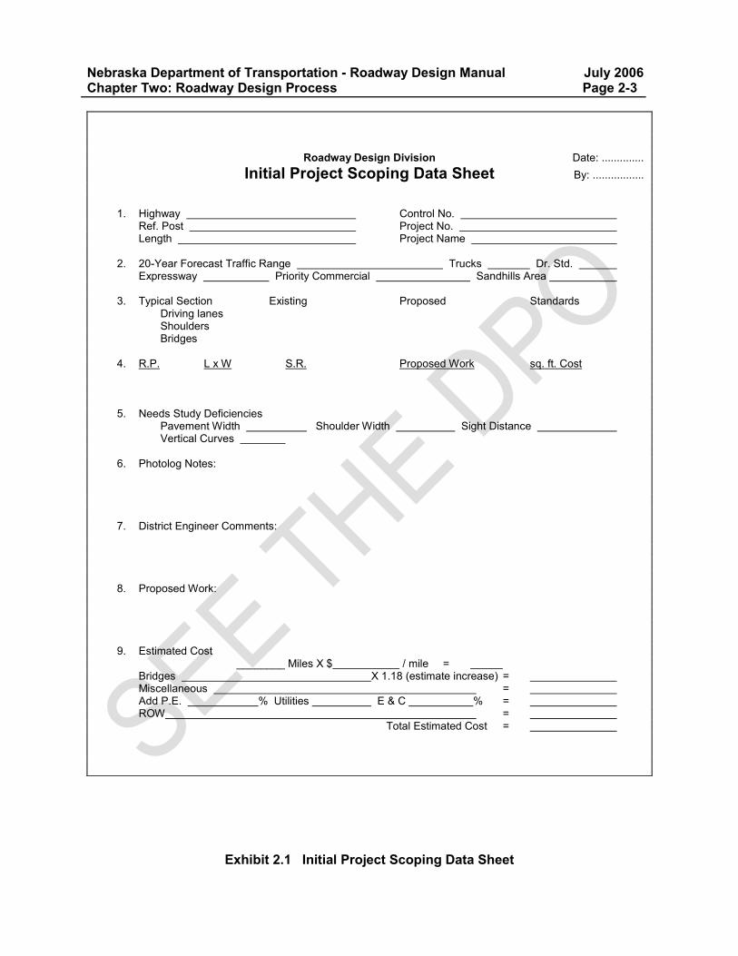
Nebraska Department of Transportation - Roadway Design Manual July 2006 Chapter Two: Roadway Design Process Page 2-3
Exhibit 2.1 Initial Project Scoping Data Sheet
Roadway Design Division Date: .............. Initial Project Scoping Data Sheet By: ................. 1. Highway Control No.
Ref. Post Project No. Length Project Name
2. 20-Year Forecast Traffic Range Trucks Dr. Std.
Expressway Priority Commercial Sandhills Area 3. Typical Section Existing Proposed Standards
Driving lanes Shoulders Bridges
4. R.P. L x W S.R. Proposed Work sq. ft. Cost 5. Needs Study Deficiencies
Pavement Width Shoulder Width Sight Distance Vertical Curves
6. Photolog Notes: 7. District Engineer Comments: 8. Proposed Work: 9. Estimated Cost
________ Miles X $ / mile = Bridges X 1.18 (estimate increase) = Miscellaneous = Add P.E. % Utilities E & C % = ROW =
Total Estimated Cost =
Nebraska Department of Transportation - Roadway Design Manual July 2006 Chapter Two: Roadway Design Process Page 2-4 4. PRELIMINARY ALIGNMENT DESIGN FOR BRIDGE HYDRAULICS (ACTIVITY 5306/ 5312) Activity 5306/ 5312 consists of the preliminary design of the horizontal and vertical alignments, through any bridge areas on a project, for submittal to the Bridge Division for use in hydraulic analysis. This activity only applies to projects with bridge structures. 5. PRELIMINARY ROADWAY DESIGN (ACTIVITY 5307/ 5309) Activity 5307/ 5309 consists of data collection, data analysis and preliminary design tasks. For some projects, the first four tasks of this activity may be completed prior to a designer being assigned to the projects. 5.A Obtain Preliminary Data During Activity 5307/ 5309, survey information is processed by the CADD Applications Unit and sent to the appropriate Roadway Design Unit Head. A designer will be assigned to review the survey and the project data sheet and to identify missing topographic items by viewing the photolog. If additional survey work is required, request a survey through the Highway Geodetic and Preliminary Survey Supervisor. If the survey information is sufficient, the survey is returned to the CADD Applications Unit for loading existing centerline(s) and cross-sections on the computer. If there is no surveyed alignment, the Roadway Design Unit Head sends as-built plans to the CADD Applications Unit. Terrain is only loaded on the workstation during the preliminary process if the project requires plan and profile sheets. The project is sent to the Roadway Design Plans Development Unit and the Roadway Design Unit Head so that the Roadway Design Plans Development Unit can create the base plans. Once the base plans are complete, the designer will then receive and review the plotted plans and/ or electronic files from the Roadway Design Plans Development Unit. The Roadway Design Unit Head will conduct a start-up meeting with the Roadway Design Plans Development Unit, Right-of-Way, and the designer to assign responsibilities for the development of preliminary plans. Either the designer or the design technician will be responsible for plan production and places the initial design in the file. Preliminary files are also made available, in electronic form, to the Right-of-Way Division so that they can begin Ownership right-of-way plans. The roadway designer will create a project file, including information obtained from the Project Development Division. The designer will maintain the file until the project is constructed. The designer should review the correspondence, the as-built plans and the engineering review or Highway Improvement Planning Request, (NDOT Form 73). Read the engineering review and/ or the Initial Project Data Form (NDOT Form 333), and check to see if any environmental documentation will be required (See Chapter Thirteen: Planning and Project Development, Section 4, of this manual). The most current photolog should be examined looking for safety hazards, utility discrepancies, posted speeds, school or pedestrian crossings, differences from the preliminary plans, etc.
Nebraska Department of Transportation - Roadway Design Manual July 2006 Chapter Two: Roadway Design Process Page 2-5 If conditions have changed in the field or the project scope has been changed from an overlay to a reconstructed section, a new survey will be needed. The request for new or expanded project surveys, right-of-way surveys, and utility surveys should be coordinated with the Survey Coordinator. At this time the designer should also determine the appropriate design standard and typical section for the project. He/ she should also contact the District Engineer to obtain the balance factor. 5.B Project Scope Review and Scoping Changes The designer should review the project scope and alignment with the Roadway Design Unit Head, Assistant Design Engineer, and, if necessary, the Roadway Design Division Engineer and the District Engineer. If considerable time has passed since the project was originally programmed there may have been changes in design guidance or roadway conditions which will impact the scope of the project. An updated cost estimate must be requested whenever a change in project scope occurs, (See Chapter Twelve: Cost Estimating & Funding, Section 6, of this manual). Because a change in project cost affects a District's budget, the District Engineer shall be involved in the decision making process regarding project scope changes. Any changes in project scope which are initiated by the roadway designer or Roadway Design Unit Head, which are not included in the Engineering Review, (See Section 2 of this chapter), and/ or the Plan-in-Hand Report, (See Section 8 of this chapter), require approval at different NDOT administrative levels depending upon the magnitude of the change in terms of funding required, length of project, etc. (changes from the Engineering Review that affect alignment or add temporary roads should be coordinated with the Project Development Division). Major scope changes, including changes to the project termini, will require a revised NDOT Form 73, “Highway Improvement Program Request”, (See Chapter Twelve: Cost Estimating & Funding, Section 3.B, of this manual for additional information). Copies of the approved changes in scope of the project which occur after the Engineering Review, (See Section 2 of this chapter), but before the Plan-In-Hand field inspection, (See Section 7.C of this chapter), shall be furnished to the Deputy Director-Engineering, Division Head, District Engineer, the Utilities Unit of Roadway Design, the Environmental Permits Units of the Project Development Division, and the Project Scheduling and Program Management Engineer. All additional Divisions/ Sections/ Units involved with the project shall be advised of the change in project scope. Any change in the scope of the project occurring after the routing of the Plan-In-Hand Report, (See Section 8 of this chapter), which would have been included in the P.I.H. Report, (e.g., a change in project length or alignment), should be handled as a supplement to the report. At the initiation of the scope change the roadway designer should inform the recipients of the Plan-In-Hand Report (See EXHIBIT ‘I’ of the Design Process Outline (DPO), Ref. 2.1), that a supplement to the Plan-In-Hand Report is being prepared, listing the basics of the change. When the scope change is approved, the supplement to the Plan-In-Hand Report should be sent directly to each of the recipients of the P.I.H. Report (the supplement does not need to be routed through the list).
Nebraska Department of Transportation - Roadway Design Manual July 2006 Chapter Two: Roadway Design Process Page 2-6
5.C Begin Preliminary Design The preliminary vertical and horizontal alignment is developed during Activity 5307/ 5309 including preliminary intersection and frontage road design, if applicable. The designer should discuss the alignment with the Traffic Engineering Division to coordinate lane configuration, signing, etc. Earthwork computations should be made after the horizontal and vertical alignment has been developed and surveys and balance factors have been obtained. If the Project Development Division has not prepared a location map, one should be drawn for public hearings and agreements. 5.D Request Information from Other Divisions An accident records report for the project for the previous three years should be requested from the Highway Safety Division. This will include such information as an accident rate analysis, collision diagram, spot map, etc., as appropriate. This information is for NDOT use only and shall not be shared with the general public. Obtain the load ratings for all bridges that are to remain in place from the Bridge Division. The Bridge Division will also provide structural analyses of bridge-size culverts (i.e., 20 feet in width measured along the roadway centerline) and a bridge data sheet. On reconstruction projects where the fill over an existing culvert (pipe or box) is to increase, the Bridge Division will provide, upon request, an analysis of structural capacity. Also, receive and review preliminary type, size and location (TS&L) sheets from the Bridge Division. Wetland delineation plans should be obtained from the Environmental Permits Unit (See Chapter Thirteen: Planning and Project Development, Section 4.B, of this manual).
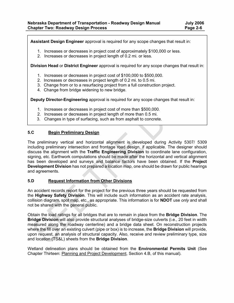
Assistant Design Engineer approval is required for any scope changes that result in: 1. Increases or decreases in project cost of approximately $100,000 or less. 2. Increases or decreases in project length of 0.2 mi. or less.
Division Head or District Engineer approval is required for any scope changes that result in: 1. Increases or decreases in project cost of $100,000 to $500,000. 2. Increases or decreases in project length of 0.2 mi. to 0.5 mi. 3. Change from or to a resurfacing project from a full construction project. 4. Change from bridge widening to new bridge.
Deputy Director-Engineering approval is required for any scope changes that result in:
1. Increases or decreases in project cost of more than $500,000. 2. Increases or decreases in project length of more than 0.5 mi. 3. Changes in type of surfacing, such as from asphalt to concrete.
Nebraska Department of Transportation - Roadway Design Manual July 2006 Chapter Two: Roadway Design Process Page 2-7 The Materials and Research Division will provide a preliminary pavement determination. Activity 5307/ 5309 also includes the task to request additional survey(s) as needed. This is a reminder to check for missing or incorrect information such as pivots, water lines, sewers, utilities, right-of-way, new drives, culvert size, shelter belts, etc., and for extending cross-sections, pavement shots, wetlands, etc. Check construction books for culvert sizes. Depending upon the type of project, the Traffic Engineering Division will provide special studies and recommendations for traffic engineering items. See Chapter Fourteen: Traffic, Section 1, of this manual for additional information. Ordinarily, the Utilities Unit of Roadway Design keeps track of utility locations and will check surveys they receive from the Project Development Division. Occasionally, a designer may want to do this independently. For example, a utility may be noted during the plan-in-hand inspection that was not on the preliminary survey and the designer can then check on it. To check the permits for utilities that are in the right-of-way, query the CICS1 program on IBM as follows:
1. Enter CICS1 by entering C1 and your DR# and password (the same process as accessing your time sheets.
2. Enter 8 to select Integrated Highway Inventory System. 3. Enter 22 to select Use and Occupancy Permits. 4. Enter 2 to Select Query. 5. Enter 3 to select Use and Occupancy Permit by Hwy/Cnty/Type/Status Query. 6. Enter the highway # and a reference post range – county, type and status may be left
blank. This shows a list of permits in the area selected. Check for any recently issued utility permits and also check to see that all of the utilities are accounted for on the utility survey. Note that the desired utility location shown on the permit may not be the actual location of the utility. The Utilities Unit makes a final check of the locations of all utilities. Contact the Permit Section of the Right-of-Way Division and the Utilities Unit for assistance with details about permits.
Nebraska Department of Transportation - Roadway Design Manual July 2006 Chapter Two: Roadway Design Process Page 2-8 5.E Drainage The Drainage Design and Erosion Control Manual, Chapter One: Drainage, (Ref. 2.2), describes drainage design procedures. This activity will begin with determining if the project is in the floodplain and what types of control and what the allowable headwater is. Draw a drainage map and compute the drainage areas. Determine the Q values and size drainage structures. Contact the Bridge Hydraulics Section or the Roadway Design Hydraulics Engineer to discuss bridge sizes and other structure issues. Begin the following designs:
Culverts and storm sewers. Special ditches. Median drains. Erosion and sedimentation control measures (preliminary).
5.F Initiate Special Investigations Some projects may require special investigations. Special investigations should be initiated during Activity 5307/ 5309. The following topics may require special investigation:
Drainage structures and box culverts requiring special design or special plans from the Bridge Division.
Railroad agreement information from Highway Liaison Manager in the Rail Unit in the Local Assistance Division.
Detours/ temporary roads (e.g., road shifts, temporary road construction, phasing, etc.). Retaining walls. Soils investigation by the Materials and Research Division for compaction requirements,
etc. Traffic signals and signing from the Traffic Engineering Division. Lighting from the Roadway Design Lighting Unit. Erosion control from the Roadside Development & Compliance Unit (RDC) of Project
Development. Hazardous materials, electric substations, underground storage tanks, etc. from the
Project Development Division. Assemble the special provisions related to the above topics as they apply to the project. 5.F.1 Additional Survey At any time throughout the design activities, additional survey work may be needed. For example, a special drainage structure may require additional survey information because right-of-way is affected. Request additional survey work through the Highway Geodetic and Preliminary Survey Supervisor. 5.F.2 Traffic Engineering Review Coordinate roadway design with the Traffic Engineering Division. They will review the plans for compatibility of geometrics with traffic requirements.
Nebraska Department of Transportation - Roadway Design Manual July 2006 Chapter Two: Roadway Design Process Page 2-9 5.G Aerial Photo Sheet Preparation Consider the time since the previous aerial photo sheets were developed prior to public hearings. If the aerial photos, from which the public hearing displays are made, are less than 18 months old, they may be used for the public hearing. If project stations run the same, aerial photo sheets from the Environmental Permits Unit may be used. The following information should be shown on the aerial photo sheets:
Alignment. Stationing. Shifted alignment, if any.
As a general rule, existing wetlands need to be shown on air photo plans. See Chapter Thirteen: Planning and Project Development, Section 4.B, of this manual for information regarding wetlands. 5.H Utilities on Urban Projects Cities are not required to have permits to occupy the right-of-way. Thus, it is important to determine any city-owned utility locations and possible conflicts by meeting with utility owners and the Utility Coordinators. 5.I Preliminary Access Control Determination Determine preliminary access control during Activity 5307/ 5309 by:
Obtaining relevant information from the District Engineer and others. Reviewing the zoning, existing and future land use. Conducting a field examination. Considering intersection sight distance, natural barriers, property lines, and the
development of future frontage roads. See Chapter Fifteen: Right-of-Way, Section 3, of this manual and the Access Control Policy to the State Highway System, (Ref. 2.3), (http://www.roads.nebraska.gov/media/3460/access-control-policy.pdf) 5.J Review Design Checklist The last step in Activity 5307/ 5309 is to review the design checklist (See EXHIBIT ‘B’ of the DPO, Ref. 2.1). Go through the checklist and mark off the completed or required tasks, note of the tasks that will continue into the next activity, and be certain that all applicable tasks have been completed. Once the checklist has been reviewed, Activity 5307 ends. Note the completion date on the DPO, (Ref. 2.1), for the project and enter the date in Clarity. When the design checklist has been reviewed for this activity, stop charging time to Activity 5307/ 5309.
Nebraska Department of Transportation - Roadway Design Manual July 2006 Chapter Two: Roadway Design Process Page 2-10 6. COST UPDATE 1 - STATUS 30 (ACTIVITY 5403) The cost estimate checklist (EXHIBIT ‘C’ of the DPO, Ref. 2.1) should be checked to be certain that all applicable items for the project are incorporated into the cost estimate. Funding splits should be verified with the Roadway Design Unit Heads for projects within city limits and/or within railroad rights-of-way. The Project Information Sheet, (NDOT Form 342) should be updated and quantities should be submitted to the Cost Estimating Unit on Project Quantity Sheets, (NDOT Form 343). Submit the completed project information sheet and cost estimate forms to the Roadway Design Unit Head for his/ her review. See Chapter Twelve: Cost Estimating & Funding, Section 4, of this manual for further details. Activity 5403 ends with the completion of the Roadway Design Unit Head review. Enter the date of completion in Clarity. Please note that Activity 5403 should not be used for annual cost updates in Clarity. Clarity does not schedule annual cost updates. 7. DESIGN PLAN-IN-HAND (PIH) (ACTIVITY 5315) Activity 5315 is always an NDOT activity. If a consultant is responsible for design, this activity is a joint Consultant/ NDOT activity. During Activity 5315, obtain right-of-way Ownership Plans from the Right-of-Way Division. See Chapter Fifteen: Right-of-Way, Section 2.C, of this manual for further information. 7.A Plan-in-Hand Plans The plan-in-hand plans are prepared consisting of the:
Location map. Typical section. Traffic data (on the typical section sheet). Wetland delineation plans sheets from the Environmental Permits Unit. Aerial sheets (if the project does not include wetlands). Plan and profile sheets. Large Scale sheets.
See Chapter Eleven: Highway Plans Assembly, Section 4, of this manual for an explanation of the various plan sheets. The plans should include the following preliminary details:
Earthwork balance points, quantities and balance factor. Line shifts (new geometrics). Limits of construction. Detailed limits of construction for urban areas. New grade line with vertical curve data and grades. Intersection designs, frontage roads, county road alignments, major commercial
driveways. Begin and end project stations. Proposed culvert sizes (include Drainage Area, Design Q, and Headwater). Channel changes, if any. Preliminary storm sewer design in urban areas.
Nebraska Department of Transportation - Roadway Design Manual July 2006 Chapter Two: Roadway Design Process Page 2-11
Edge of pavement, drives and walks in urban areas. Project centerline and surveyed baseline on an aerial photo sheet. Areas of impacted wetlands. All available aerial and underground utility facility locations (electrical, telephone,
pipelines, gas, cable TV, etc.). Plans submitted to the Utilities Coordinator will require the most up-to-date details on the items listed in EXHIBIT ‘G’ of the DPO, (Ref. 2.1). Contact the Utilities Unit to coordinate activities related to any utility conflicts. 7.B Plan-in-Hand Plan Distribution The plan-in-hand plans including location map and typical section, stamped preliminary and dated, should be distributed to the entities shown in EXHIBIT ‘F’ of the DPO, Ref. 2.1), at least two weeks prior to the inspection date. Use the Design Plans Transmittal form, (NDOT Form 135), and the Letter of Transmittal form, (NDOT Form 480), for submittal and notification of plan availability. NDOT Form 135 should be used for transmittals within NDOT, and NDOT Form 480 should be used for other agency transmittals, e.g., cities, counties, consultants, other state agencies, etc. 7.C Conduct the Plan-in-Hand Inspection The plan-in-hand inspection is a field inspection of the proposed project by the District Engineer, FHWA (if they have oversight, see Chapter One: Roadway Design Standards, Section 10.A, of this manual), City/ County Representatives, Utilities Coordinator, Roadway Design Unit Head, Assistant Design Engineer and the designer. Use the checklist shown in EXHIBIT ‘H’ of the DPO, (Ref. 2.1), as a reference to note any items that need to be addressed during the plan-in-hand inspection or may be noted during the inspection. The following items should be taken to the plan-in-hand inspection:
Camera, 100 foot tape, hand level. Safety vest, cap/ hard hat, strobe light. One set of half-size cross-sections. One set Stage II right-of-way plans. Four sets of half-size plans. Plan-in-hand checklist. Correspondence file(s). Contact aerial photos. Drainage maps/ worksheets. Erosion control checklist.
If there are changes to the project resulting from the plan-in-hand inspection, the designer will meet with the Environmental Program Manager to review the changes and to determine if changes to the pre-permit application consultation process will be necessary. Following the plan-in-hand inspection, consolidate all sets of comments into one set of plans, label the set as official plan-in-hand plans and place them on file. These plans are then a milestone document for the project. This activity is the end of Activity 5315. Enter the completion date in Clarity.
Nebraska Department of Transportation - Roadway Design Manual July 2006 Chapter Two: Roadway Design Process Page 2-12 8. PIH REPORT (ACTIVITY 5318/ 5338) This activity consists of the preparation and review of the plan-in-hand report. An optional meeting may be held with the Assistant Design Engineer and Division Head to discuss the plan-in-hand prior to the completion of the plan-in-hand report. The plan-in-hand report, location map, accident report, engineering review statement and other miscellaneous attachments, as appropriate, are routed to the appropriate individuals for review and approval as listed in EXHIBIT ‘I’ of the DPO, (Ref. 2.1). Please note the plan-in-hand report may go back and forth several times before the final report is approved. The Roadway Design Office Manager incorporates all the approved changes and then submits them for signatures. The plan-in-hand report outline should be followed (See EXHIBIT ‘I’ of the DPO, Ref. 2.1). An abbreviated report format may be used for off-system projects. Note that starred topics must have comments attached for all projects. A list of possible safety enhancements is shown in EXHIBIT ‘I’ of the DPO, (Ref. 2.1). On resurfacing projects, or projects not requiring additional right-of-way, add the following statement to the plan-in-hand report:
A special provision will be written to remove those trees that are inside the lateral obstacle clearance zone, but not beyond the limits of existing right-of-way.
Once the appropriate parties approve the plan-in-hand report, copies are released for additional distribution. Copies of the plan-in-hand report with location maps and any miscellaneous attachments are distributed to the individuals or agencies listed in EXHIBIT ‘I’ of the DPO, (Ref. 2.1). This marks the end of Activity 5318/ 5338. Enter the completion date in Clarity. 9. ROADWAY FUNCTIONAL DESIGN (ACTIVITY 5316/ 5326) Roadway functional design (activity 5316/ 5326), incorporating comments from the plan-in-hand field inspection and the Public Information Meeting, (if held), may begin while the plan-in-hand report is being circulated for approval. The designer may need to revise the plans based on comments from the Public Information Meeting and from the final plan-in-hand report. One of NDOT’s goals is to have as much of the final design accomplished as possible at the functional design stage (Activity 5316). The only changes to the project design after the functional design stage should be as a result of the design public hearing, unanticipated utility problems or changes as a result of right-of-way negotiations. The designer should conduct a post-plan-in-hand meeting (Meeting “B”) with the Roadway Design Plans Development Unit and Roadway Design Unit Head to coordinate making the necessary changes (See EXHIBIT ‘A’ of the DPO, Ref. 2.1). Design details to be considered may also include locations of borrow and/ or waste pit sites, guardrail locations, etc. Erosion control design should also be coordinated with the Roadside Design Section. The functional design plans should then be sent to the Environmental Permits Unit with the preliminary design showing impacted wetlands, possible mitigation sites, any proposed channel change locations including typicals and justification for both impacted wetland and channel changes, i.e., why avoidance was not possible. Plans for public hearing meetings should show existing wetland sites. The decision will be made at the dry run whether to show potential
Nebraska Department of Transportation - Roadway Design Manual July 2006 Chapter Two: Roadway Design Process Page 2-13 mitigation sites. The designer should search potential mitigation sites for the most appropriate site and make a recommendation at the dry run. Coordination with the Environmental Permits Unit is essential in determining the number of acres (hectares) impacted and the most appropriate mitigation site. See Chapter Thirteen: Planning and Project Development, Section 4.B, of this manual for further discussion of wetlands procedures. Special investigations may also be updated as needed during Activity 5316/ 5326 for such items as drainage structures, railroad agreement information, detour/ shoofly, retaining walls, stairs (from the Bridge Division), soils investigation, phasing, traffic, lighting, signing, erosion control. Again, additional surveys may be required for mitigation sites, borrow/ waste pits, etc. The Traffic Engineering Division may also need to review the updated plans. 9.A Special Provisions Activity 5316/ 5326 also includes the initial writing of any special provisions that may be needed for the project. This information accompanies the computations for the Plans, Specifications and Estimates (PS&E) package. 9.B Initiate Agreements The Roadway Design Division initiates agreements by completing the Request for Agreement form (NDOT Form 65). The request form is forwarded to the appropriate division for processing. The designer should keep track of the agreement progress and provide any necessary display information. Agreements go to the District Engineer to obtain signatures from other parties to the agreements. See DOT-OI 45-5, “Agreements” (Appendix B, “Selected NDOT Operating Instructions”) for further information regarding agreements. 9.B.1 City Agreements All projects within city/ municipal limits that are designed to 3R standards or higher will require a city agreement. The Project Development Division prepares city agreements based on information obtained from the Roadway Design Division. City agreements may be developed for such things as maintenance and operation of roadway lighting including poles beyond city limits. See Chapter Thirteen: Planning and Project Development, Section 5.A, of this manual for further information. On all city agreements city limits should be described by stationing or reference post, either prior to Section 1 of the agreement or on the cost estimate sheet. Also note if the city limits encompass the entire highway right-of-way or one side only. The transmittal letter for the agreement should be sent from the Roadway Design Unit Head through the Assistant Design Engineer to the District Engineer. City agreements will not be required, with the District Engineer’s approval, on Maintenance projects.
Nebraska Department of Transportation - Roadway Design Manual July 2006 Chapter Two: Roadway Design Process Page 2-14 9.B.2 Irrigation Agreements The Project Development Division works with the appropriate Water Districts regarding irrigation agreements. 9.B.3 Railroad Agreements The Highway Liaison Manager in the Rail Unit in the Local Assistance Division is responsible for all agreements, easement documents, and railroad special provisions. The designer should realize that some agreement and easement documents take considerable time to be executed. Early coordination is essential. When there is railroad involvement but an agreement and/ or easement are not needed, the Rail Unit in the Local Assistance Division will draft railroad special provisions to add to the letting package. See Chapter Ten: Miscellaneous Design Issues, Section 1, of this manual for further information. 9.C Design Access Control Once the roadway designer is prepared to make recommendations regarding access control, he/ she should contact the Highway Right-of-Way Associate in the Property Management Section of the Right-of-Way Division and request to be on the agenda for the next access control meeting. The designer presents his/ her recommendations to the Control Access and Permit Review Committee with the necessary supporting documentation. Access control is required on all Interstate, expressway and four-lane divided highways. The department will consider acquiring access rights on all other highways when:
1. The 20 year forecast traffic (ADT) is 3001 or greater, as shown on the department’s current 20 Year Forecast Traffic Map: or
2. The route is within the present or projected two mile zoning limits of first class cities (population 5,000 to 99,999) and within the present or projected three mile zoning limits of primary (population 100,000 to 299,999) and metropolitan class cities (population more than 300,000); or
3. There are three miles or less between the Interstate and the connecting or parallel highway.
4. At other locations deemed appropriate. The designer should provide an aerial photo with property lines and locations of access sites that meet the policy for the committee’s review and approval. The designer may need to take the project to several access control meetings throughout the design process. EXHIBIT ‘K’ of the DPO, (Ref. 2.1), lists the necessary documentation needed for access control meetings at various project stages. See Chapter Fifteen: Right-of-Way, Section 3, of this manual for additional discussion of access control. Document the results of the access control meetings in the project file and route the information through the Roadway Design Engineer, Project Development Engineer, Right-of-Way Manager and the Highway Right-of-Way Associate.
Nebraska Department of Transportation - Roadway Design Manual July 2006 Chapter Two: Roadway Design Process Page 2-15 9.D Receive Additional Documentation If the project has a Class I or Class III environmental classification, a draft environmental impact statement (DEIS) or draft environmental assessment (DEA), as appropriate, will be submitted to the Roadway Design Division from the Project Development Division. See Chapter Thirteen: Planning and Project Development, Section 4.A, of this manual for additional discussion. The Materials and Research Division will also submit an approved pavement determination to the designer, see Chapter Eight: Surfacing, Section 1.B, of this manual for additional information. This is an indicator that a cost update will be due. 9.E Notifications Notify the Public Hearings Officer of the availability of plans for projects that will not have public hearings. Plans will be available to the public in the District Engineer’s office. See Section 12 of this chapter for further information regarding public notification and public hearings. 9.F Design Relaxations If a design relaxation is necessary, the request for relaxation should be submitted to the Director-State Engineer, the Nebraska Board of Public Roads Classifications and Standards, and/ or the Federal Highway Administration, as appropriate. Chapter One: Roadway Design Standards, Section 10, of this manual, discusses the design relaxation process in further detail. 9.G Submit Functional Plans Functional plans, also known as hearing plans, should be submitted to the individuals and agencies shown in EXHIBIT ‘F’ of the DPO, (Ref. 2.1). If a public hearing is to be held, these plans shall be submitted to the appropriate entities five weeks prior to the public hearing. Functional plans should be stamped preliminary plans and dated. This is the end of Activity 5316/ 5326. Enter the completion date in Clarity.
Nebraska Department of Transportation - Roadway Design Manual July 2006 Chapter Two: Roadway Design Process Page 2-16 10. COVENANT RELINQUISHMENT AGREEMENT A covenant relinquishment agreement (CRA) is a signed agreement between NDOT and a City/ County in which NDOT maintains ownership of the right-of-way for utility easement purposes but relinquishes responsibility for the maintenance and operation of the roadway facility to the City/ County. In a CRA, NDOT agrees to bring the roadway surfacing up to an acceptable serviceability value. The designer will need to get a determination from the District Engineer and/ or the Project Scheduling and Program Management Division on whether the surfacing of the relinquishment should be added to the project or if a separate project should be programmed, unless the relinquishment is part or an expressway project, in which case the cost to improve the relinquishment will be a project cost. The scope of work on the segment to be relinquished must be justified and be approved on a scoping document, such as the plan-in-hand report or a revised NDOT Form 73 (“Highway Improvement Programming Request”). The designer should review any CRAs that may have been developed to determine if new or revised CRAs are needed. If a new CRA is required or revisions are needed, the designer shall provide the necessary information for the documents. The approximate location should be identified and a location map exhibit should be prepared by the Roadway Design Plans Development Unit. Submit the information for the CRA to the Materials and Research Division. Review the draft CRA and exchange comments. A signed agreement must be received prior to scheduling a dry run for a public hearing, (See Section 12 of this chapter for further information regarding public hearings). For further information on relinquishments see Section 21 of this chapter; Chapter Fifteen: Right-of-Way, Section 7.D, of this manual; and The Department of Transportation Operating Instruction 60-13, “Relinquishment of Roads from the Highway System” (Appendix B, “Selected NDOT Operating Instructions”, of this manual). 11. COST UPDATE 2 -STATUS 40 (ACTIVITY 5406) Review the cost estimate checklist (EXHIBIT ‘C’ of the DPO, Ref. 2.1) for the project. Check for funding splits on the Initial Project Data form, (NDOT Form 333), or the Project Data Revision form, (NDOT Form 334) and/ or on CICS1/ CICS3. Quantities should be submitted to the Cost Estimating Unit on Project Quantity Sheets, (NDOT Form 343), and the Project Information Sheet, (NDOT Form 342), should be updated. Submit the completed project information sheet and cost estimate forms to the Roadway Design Unit Head for his/ her review. The last task in Activity 5406 is the completion of the Roadway Design Unit Head’s review. Enter the completion date in Clarity. Do not sign off on Activity 5406 in Clarity when completing an annual cost update. See Chapter Twelve: Cost Estimating & Funding, Section 4, of this manual for further details.
Nebraska Department of Transportation - Roadway Design Manual July 2006 Chapter Two: Roadway Design Process Page 2-17 12. DESIGN PREPARATION FOR PUBLIC HEARINGS (ACTIVITY 5323/5324) 12.A Public Hearings A public hearing is an advertised formal meeting, presided over by a Highway Commissioner, to present the proposed project to the public and to obtain public input. Design functional plans (Activity 5316) and R.O.W. ownership plans are needed for this meeting. Before scheduling the public hearing the designer will need to obtain a signed city covenant agreement (if applicable), a signed covenant relinquishment agreement (if needed) and a signed draft environmental document and noise study, if a noise study was conducted. These documents are required before a public hearing may be scheduled. Hearing guidelines must be followed for proper public notice of the hearing, for information that must be presented, and for the hearing procedures. A transcript is made of the verbal and written testimony. Location public hearings and design public hearings may be held separately or they may be combined into one hearing. See “Guidelines for Public Hearing”, EXHIBIT ‘M’ of the Design Process Outline, (Ref. 2.1), for further information The following items should be collected and/ or prepared for the public hearing:
Comments from Public Information Meeting, if applicable. Design year traffic information (i.e., design year is 20 years after the year of construction
completion). Typical section display. Aerial photo display (less than 18 months old). Hearing plans (See EXHIBIT ‘F’ of the DPO, Ref. 2.1). Engineering statement (take 5-10 extra copies to the hearing for the Highway
Commissioner to give to the media). A dry run should be held six weeks prior to a proposed public hearing. EXHIBIT ‘L’ of the DPO, (Ref. 2.1) lists people who should be invited to a dry run. Contact the Design Standards Engineer for a current list of people who should be invited. Be sure that the Director-State Engineer, the Deputy-Director Engineering and the Roadway Design Division Engineer are available to attend. Others may be invited when appropriate. The District Engineer should also be contacted and asked if he/ she would like to attend the dry run. The dry run should simulate an actual public hearing. It provides the opportunity to practice and refine the presentations prior to an actual public hearing. The public hearing checklist (EXHIBIT ‘M’ of the DPO, Ref. 2.1) should be used to gather information and tools for the dry run and the public hearing. A “Public Hearing Notice Worksheet”, (EXHIBIT 2.2), a “Fact Sheet” (EXHIBIT ‘S’ of the Design Process Outline, Ref. 2.1), a detour map (if applicable) and a current location map is to be submitted to the Public Information Office in the Communications Division prior to the dry run. After the dry run is completed, the designer provides the Secretary of the Highway Commission and the Public Hearings Officer with a copy of the engineering statement. The Public Hearings Officer will provide the designer with a copy of the presentation including exhibits that will be used during the hearing. The Public Hearings Officer advertises the hearing in the official county newspaper and in general circulation newspapers in the project area at five and at two weeks prior to the hearing date.
Nebraska Department of Transportation - Roadway Design Manual July 2006 Chapter Two: Roadway Design Process Page 2-18 The designer is responsible for providing the District and City (if applicable) with a set of design functional plans at the same time as the advertising information is submitted to the Public Hearings Officer. After the hearing, the designer will submit a copy of the engineering statement to the Secretary of the Highway Commission. Public hearings will be held for all environmental Class I projects, (those requiring an environmental impact statement), and environmental Class III projects, (those having an environmental assessment) (See Chapter Thirteen: Planning and Project Development, Section 4, of this manual). All environmental Class II projects, (categorical exclusions), are reviewed on an individual basis to determine if a hearing will be held. The plan-in-hand report will note the decision made. All environmental Class I and III projects will require State Highway Commission recommendation and the Governor’s approval, as will any Class II project for which a public hearing is held. Public Hearing Statements should include some environmental statements, such as:
Thoughtful design and construction techniques are used to minimize the impacts to the environment, wetland areas will be avoided when possible and replaced when eliminated.
Temporary erosion and sediment control measures will be used to reduce soil erosion. Trees will be saved where consistent with good design. On this project some trees are located within the proposed construction limits and will be
removed. After construction, disturbed areas will be seeded with grasses and wildflowers chosen
based upon the soil type and compatibility with the surrounding vegetation. After the hearing is over, the designer reviews and consolidates comments that were made, and compiles the plans, displays and hearing statement for the permanent file as hearing plans. Comments from the afternoon informal session are put in one set of plans and stamped as public hearing documents. The completion date for Activity 5323 occurs at this point for solely roadway design tasks. Enter the completion date in Clarity at this time. Other divisions share responsibility for the rest of the tasks in Activity 5323. Designer time associated with public hearing tasks should be charged to Activity 5323 even after the completion date has been entered in Clarity.
Nebraska Department of Transportation - Roadway Design Manual July 2006 Chapter Two: Roadway Design Process Page 2-19 12.B Highway Commission Statement After the public hearing has been held, the designer or Roadway Design Unit Head shall prepare a Highway Commission statement, (forms may be obtained from the Roadway Design vault). The statement will be presented to the Highway Commission. The Assistant Design Engineer reads the statement into the Highway Commission proceedings, summarizes the comments received at the public hearing, and answers questions. A copy of the statement goes to the Highway Commission Secretary. Upon receipt of approval from the Highway Commission and the Governor, the project proceeds. Receipt of approval marks the end of Activity 5323 for time sheets. 12.C Public Meetings Communication between NDOT and the public is an important ongoing activity coordinated by the Public Hearings Officer in the Communications Division. Depending on the nature of the project, several types of contact may be made during the course of a project. The Public Hearings Officer publishes notices for hearings in general circulation newspapers in project areas to provide information about the proposed projects to the public. Types of public meetings that are held are:
Public Information Meetings. City and/ or County Officials Meetings. Property Owners Pre-Hearing Meetings. Pre-hearing Information Meetings. Location Public Hearings. Design Public Hearings.
For guidance on which type(s) of public meeting(s) should be held for a project see the “Public Meeting Checklist”, EXHIBIT ‘R’ of the Design Process Outline (Ref. 2.1). Plan and agreement requirements for the various types of public meetings may be found in EXHIBIT 2.2.
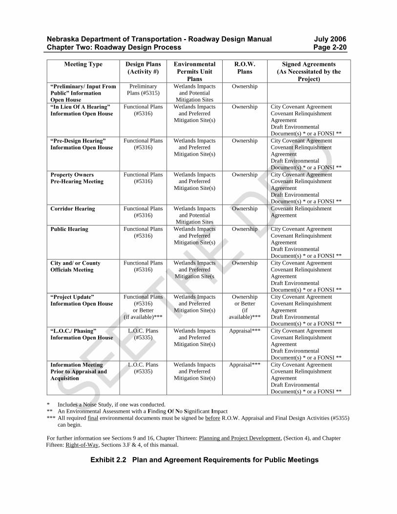
Nebraska Department of Transportation - Roadway Design Manual July 2006 Chapter Two: Roadway Design Process Page 2-20
Meeting Type Design Plans (Activity #)
Environmental Permits Unit
Plans
R.O.W. Plans
Signed Agreements (As Necessitated by the
Project) “Preliminary/ Input From Public” Information Open House
Preliminary
Plans (#5315)
Wetlands Impacts
and Potential
Mitigation Sites
Ownership
“In Lieu Of A Hearing” Information Open House
Functional Plans
(#5316)
Wetlands Impacts
and Preferred
Mitigation Site(s)
Ownership City Covenant Agreement
Covenant Relinquishment
Agreement
Draft Environmental
Document(s) * or a FONSI **
“Pre-Design Hearing” Information Open House
Functional Plans
(#5316)
Wetlands Impacts
and Preferred
Mitigation Site(s)
Ownership City Covenant Agreement
Covenant Relinquishment
Agreement
Draft Environmental
Document(s) * or a FONSI **
Property Owners Pre-Hearing Meeting
Functional Plans
(#5316)
Wetlands Impacts
and Preferred
Mitigation Site(s)
Ownership City Covenant Agreement
Covenant Relinquishment
Agreement
Draft Environmental
Document(s) * or a FONSI **
Corridor Hearing Functional Plans
(#5316)
Wetlands Impacts
and Potential
Mitigation Sites
Ownership Covenant Relinquishment
Agreement
Public Hearing Functional Plans
(#5316)
Wetlands Impacts
and Preferred
Mitigation Site(s)
Ownership City Covenant Agreement
Covenant Relinquishment
Agreement
Draft Environmental
Document(s) * or a FONSI **
City and/ or County Officials Meeting
Functional Plans
(#5316)
Wetlands Impacts
and Preferred
Mitigation Site(s
Ownership City Covenant Agreement
Covenant Relinquishment
Agreement
Draft Environmental
Document(s) * or a FONSI **
“Project Update” Information Open House
Functional Plans
(#5316)
or Better
(if available)***
Wetlands Impacts
and Preferred
Mitigation Site(s)
Ownership
or Better
(if
available)***
City Covenant Agreement
Covenant Relinquishment
Agreement
Draft Environmental
Document(s) * or a FONSI **
“L.O.C./ Phasing” Information Open House
L.O.C. Plans
(#5335)
Wetlands Impacts
and Preferred
Mitigation Site(s)
Appraisal*** City Covenant Agreement
Covenant Relinquishment
Agreement
Draft Environmental
Document(s) * or a FONSI **
Information Meeting Prior to Appraisal and Acquisition
L.O.C. Plans
(#5335)
Wetlands Impacts
and Preferred
Mitigation Site(s)
Appraisal*** City Covenant Agreement
Covenant Relinquishment
Agreement
Draft Environmental
Document(s) * or a FONSI **
* Includes a Noise Study, if one was conducted.
** An Environmental Assessment with a Finding Of No Significant Impact
*** All required final environmental documents must be signed be before R.O.W. Appraisal and Final Design Activities (#5355)
can begin.
For further information see Sections 9 and 16, Chapter Thirteen: Planning and Project Development, (Section 4), and Chapter
Fifteen: Right-of-Way, Sections 3.F & 4, of this manual.
Exhibit 2.2 Plan and Agreement Requirements for Public Meetings
Nebraska Department of Transportation - Roadway Design Manual July 2006 Chapter Two: Roadway Design Process Page 2-21 12.C.1 Public Information Meetings Public information meetings are advertised meetings held to inform the public of the proposed project location and/ or design, to obtain public input and to answer questions through one-on-one conversations with the public. These are not recorded meetings but citizen Comment Sheets are made available. The required plans and agreements for these meetings may be found in EXHIBIT 2.2. Items that should be taken to a public information meeting may be found on the “Public Meeting Checklist” in EXHIBIT ‘M’ of the Design Process Outline (Ref. 2.1). Items 5 through 9 and 11 through 26 are usually sufficient for a public information meeting, but items 2 through 4 may be added if a mosaic is available. The designer should create a “Project Fact Sheet”, EXHIBIT ‘M’ of the Design Process Outline (Ref. 2.1), for distribution at the public information meeting. Public information meetings are scheduled in coordination with the District Engineer and/ or the Project Development Division and the Communication Division. Meetings usually are held for major relocations and location studies, right-of-way appraisal, design and scope changes, wetlands impacts, projects in villages and cities, and sometimes for an engineering review. There are various types of public information meetings:
A “Preliminary/ Input from the Public” Information Meeting” is often scheduled to solicit public input prior to putting proposed design features on a map. This meeting may be held in concert with the plan-in-hand.
An “In Lieu of a Hearing” Information Meeting” is held when the public has indicated there is significant interest in the project but no public hearing is planned. This may also be used in the case of a Class II environmental classification project (See Chapter Thirteen: Planning and Project Development, Section 4, of this manual).
An “Information Open House” meeting is always held in the afternoon of a design hearing.
A “Project Update” Information Meeting is held when 18 months or more have elapsed since a design hearing was held or when there has been a change in the scope of the project.
A “Limits of Construction/ Phasing of Construction” Information Meeting is held to inform adjacent property owners of the possible impacts to their property. In metropolitan areas, these meetings are often held only with homeowner groups that are affected by the project. If there are fewer than four affected properties, and no public information meeting is held, LOC Design Plans (Activity 5335) will be sent to the District Engineer who will be asked to contact the property owners, showing them our proposed design and explaining its impact to their property.
An Information Meeting Prior to Appraisal and Acquisition is held to answer questions regarding the project and the Department of Transportation property acquisition process. Landowners impacted by the project are particularly encouraged to attend. The preliminary R.O.W. plans must have been completed before this meeting. This is a meeting held by the Roadway Design Division, which may be attended by appraisers from the R.O.W. Division. Factors considered in selecting a Pre-Appraisal Information Open House include: a decision by the Assistant Design Engineer, a request from the District Engineer or DOT Administration, elapsed time since a previous meeting with the public, etc.
Nebraska Department of Transportation - Roadway Design Manual July 2006 Chapter Two: Roadway Design Process Page 2-22 The designer should submit a “Public Hearing Notice Worksheet”, (EXHIBIT 2.3), a “Fact Sheet” (EXHIBIT ‘S’ of the Design Process Outline, Ref. 2.1), a detour map (if applicable) and a current location map to the Public Hearings Officer five weeks prior to a proposed information open house so that the required meeting advertising and official notifications may be produced. The first publication occurs three weeks prior to the meeting and the final publication will be one week prior to the meeting. The designer is responsible for providing the District and (if applicable) the City/Village office with a set of plans at the same time that the advertising information is sent to the Public Hearings Officer. See Section 12.A of this chapter for additional information. After each meeting all notes from the various plans and note pads shall be consolidated onto one set of plans and/ or one set of minutes. The minutes will become part of the project file and the plans shall be properly tagged as “Information Meeting” or “Public Hearing” plans and will be kept until the project has been built. It is the responsibility of the designer to ensure that all promises for studies, phasing, and/ or plan changes are honored and that any information received that affects other divisions is shared. 12.C.2 City and/ or County Officials Meeting The Assistant Design Engineer will determine when a City and/ or County officials meeting is to be held. While it is not necessary that the Roadway Design Division conduct all of the meetings and coordination, such as in utilities conflicts, they are responsible for seeing that it is accomplished. The plan and agreement requirements for this meeting may be found in EXHIBIT 2.2. 12.C.3 Property Owners Pre-Hearing Pre-hearing meetings may be held with impacted property owners on projects entailing major changes in access, parking, drop off lanes, right-of-way, driveways, relocation (especially of occupied residences), etc. The Assistant Design Engineer will determine when a property owner pre-hearing will be held. See EXHIBIT 2.2 for the required plans and agreements for this meeting.
Nebraska Department of Transportation - Roadway Design Manual July 2006 Chapter Two: Roadway Design Process Page 2-23
Public Hearing Notice Worksheet Please return to the Public Information Office in the Communication Division
prior to your hearing dry run or scheduling of your open house.
Your Name:
Division, Section, Unit:
Phone No.:
Fax No.:
Type of Hearing: (Check one)
Notice of highway corridor hearing Notice of highway design hearing Notice of information open house Pre-appraisal meeting Other (please specify)
Date of Hearing:
Time of Hearing or Information Meeting: Starting:___________ Ending:_________ (if appropriate)
Hearing Location: (Building, Address, and City)
Time of Preceding Information Discussions, if any: Starting Ending
Division(s) and/ or District(s) Providing Personnel for Informal Discussions:
Roadway Design Project Development Right-of-Way District
Project No(s). and “Known As” Descriptions: Control No.: (For internal referencing only)
Briefly Describe Location and Type of Proposed Improvement: (Major Elements)
Total Lanes in the Completed Project:
Project to be Constructed Under Traffic? Yes No
Highway Access Control Information:
NDOT Form 356, May 05/ (Continued)
Exhibit 2.3 Public Hearing Notice Worksheet
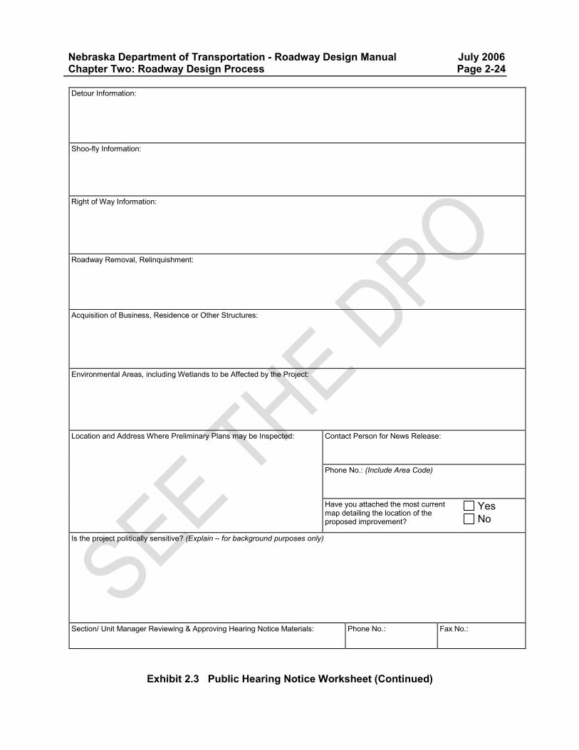
Nebraska Department of Transportation - Roadway Design Manual July 2006 Chapter Two: Roadway Design Process Page 2-24 Detour Information:
Shoo-fly Information:
Right of Way Information:
Roadway Removal, Relinquishment:
Acquisition of Business, Residence or Other Structures:
Environmental Areas, including Wetlands to be Affected by the Project:
Location and Address Where Preliminary Plans may be Inspected:
Contact Person for News Release:
Phone No.: (Include Area Code)
Have you attached the most current map detailing the location of the proposed improvement?
Yes No
Is the project politically sensitive? (Explain – for background purposes only)
Section/ Unit Manager Reviewing & Approving Hearing Notice Materials:
Phone No.:
Fax No.:
Exhibit 2.3 Public Hearing Notice Worksheet (Continued)
Nebraska Department of Transportation - Roadway Design Manual July 2006 Chapter Two: Roadway Design Process Page 2-25 13. ROADWAY DESIGN (ACTIVITY 5325/ 5327) Activity 5325/ 5327 begins with a review of the hearing plans and the public hearing transcript. Typical cross-sections should be updated as necessary. The Materials and Research Division will provide the final typical pavement cross-sections. Design of geometrics and grades for driveways, intersections, frontage roads and cross-sections should be completed during this activity. Compute impacted wetlands and submit them to the Environmental Permits Unit for recommendations regarding elevations and mitigation. Finalize any special investigations such as drainage structures, box culverts, railroad agreement information, detours/ temporary roads, construction phasing, retaining walls, soils investigations, traffic signals, lighting, signing, marking, wetlands mitigation plans, erosion and sedimentation control measures (both temporary and permanent). Review the design checklist (EXHIBIT ‘B’ of the DPO, Ref. 2.1). Order additional surveys, if necessary. Have the Traffic Engineering Division review any pertinent changes. Submit plans to the Roadway Design Plans Development Unit for final plan preparation upon completion of the special investigations. The end of Activity 5325 coincides with the scheduling of the Roadway Design Division review meeting (See Activity 5335). Enter the completion date in Clarity. 14. ROADWAY DESIGN REVIEW/ LIMITS OF CONSTRUCTION PLANS (ACTIVITY 5335/ 5336) The Roadway Design Division review meeting with the Roadway Design Unit Head is the first task in Activity 5335/ 5336 and is held to check the plans using the design checklist (EXHIBIT ‘B’ of the DPO, Ref. 2.1), the plan-in-hand plans, and the hearing plans. 14.A Limits of Construction Plans The limits of construction plans should show the final limits of construction including all culverts, driveways, intersections, dikes, etc. and taking into account the needs of Lighting, Utilities, RDC, Wetlands, and Traffic. Distribute the limits of construction plans with location maps and typical sections to the entities shown in EXHIBIT ‘F’ of the DPO, (Ref. 2.1). The plans should be stamped preliminary and dated. After L.O.C. plans have distributed, notice should be given when changes are made to the L.O.C. plans that may affect R.O.W. Design, Utilities, Bridge, Traffic, the Wetlands Unit or other divisions. Some examples of changes:
Construction Limits. Special Ditches (even if within the planned R.O.W., it may affect utilities). Vertical Profile. Intersection/ Drive Locations. Temporary Roadways, etc. Impacts to Wetlands areas.
Nebraska Department of Transportation - Roadway Design Manual July 2006 Chapter Two: Roadway Design Process Page 2-26 R.O.W. Design, Utilities and any other affected sections/ units shall be notified when work is beginning on a change. Send an E-mail to:
R.O.W. Design Engineer. ROW Designer. Utilities Unit ADE. Utility Coordinator. Wetlands Unit. Other affected sections.
The notification shall include the following information:
Project Name & Number. Control Number. Tract Numbers affected. A brief description of the changes. An approximate completion date.
14.B Other Tasks in Activity 5335 A meeting with the Traffic Engineering Division may be held to review any unusual situations related to traffic concerns, e.g., intersection, pavement marking plans, etc. Typically, the Traffic Engineering Division is simply notified that the limits of construction plans are available (See EXHIBIT ‘F’ of the DPO, Ref. 2.1). In addition, the Lighting Unit should be given a set of base plans if there is lighting involved. Any covenant city agreements should be completed and sent to the District Engineer to obtain signatures. The final task in Activity 5335 is a meeting of Right-of-Way, the Roadway Design Plans Development Unit, Roadway Design Unit Heads, Assistant Design Engineers and the Utilities Coordinator. Enter the completion date in Clarity. 15. COST UPDATE 3 - STATUS 45 (ACTIVITY 5408) Review the cost estimate checklist (EXHIBIT ‘C’ of the DPO, Ref. 2.1) for the project to be certain all items are included. Recheck the funding splits on the Initial Project Data form, (NDOT Form 333), the Project Data Revision form, (NDOT Form 334), and/ or on CICS1/ CICS3. The Project Information Sheet, (NDOT Form 342) should be updated and updated quantities should be submitted to the Cost Estimating Unit on Project Quantity Sheets, (NDOT Form 343). Submit the completed project information sheet and cost estimate forms to the Roadway Design Unit Head for his/ her review. See Chapter Twelve: Cost Estimating & Funding, Section 4, of this manual for further details. The last task in Activity 5408 is completion of the Roadway Design Unit Head review. Do not use Activity 5408 to record annual cost updates in Clarity.
Nebraska Department of Transportation - Roadway Design Manual July 2006 Chapter Two: Roadway Design Process Page 2-27 16. DESIGN REVIEW SUPPORT PROCESSES (ACTIVITY 5340) The designer should review the scheduled letting date, the anticipated time to construct the project, etc. in Clarity to be certain the schedule is still on track. Review the schedule, keeping the following (and other similar) activities and concerns in mind:
Agreements: city, county, irrigation, and railroad. Recognize that some city/ county councils may only meet once a month. Also be aware that irrigation modifications can only be done during that part of the year when there is no water in the systems. Railroad owners may be out of state, and agreements require extended lead-time.
Final Relinquishment Agreement: agreements must be executed prior to submittal of the plans package to PS&E (See Section 21 of this chapter).
Wetlands: permitting requires input from multiple agencies; mitigation should be done in winter months, if possible.
Utilities: seasons are also critical for utility relocation. Right-of-way: acquisition is a lengthy process (See Chapter Fifteen: Right-of-Way,
Section 5, of this manual). Soils: surcharge and settlement may need to be programmed into the construction schedule. Phasing: coordinate bridge and roadway construction phasing, etc. Promises: be aware of promises made, e.g., construction completed before football season. Logo signs: tourist-oriented directional (TOD) signs should be moved during the off- peak
tourist season, if possible. Miscellaneous: nesting seasons of birds that nest on bridges, trout migration, etc.
The estimated working days for construction should also be reviewed and the letting date should be confirmed. Lettings usually occur once a month. This is the end of Activity 5340. Enter the completion date in Clarity. 17. PRELIMINARY RIGHT-OF-WAY PLAN REVIEW (ACTIVITY 5345) At this stage, right-of-way design is on the critical path. In Activity 5345, the designer should review the Preliminary Right-of-Way plans (See Chapter Fifteen: Right-of-Way, Section 2.D, of this manual). Once the roadway designer has received and reviewed the plans, the roadway designer holds a Preliminary R.O.W. plan review meeting and invites those shown in EXHIBIT ‘Q’ of the DPO, (Ref. 2.1) to discuss design of the preliminary right-of-way. Right-of-Way Design provides a copy of the Preliminary Right-of-Way plans to the Roadway Design Division. Receipt of these plans marks the end of Activity 5345. Enter the completion date in Clarity. 17.A Removal Items and Notes Items which are to be removed from a tract, such as a well or a sign base, should be noted on either the plan-in-hand field inspection or during the appraisal process. Removal notes for these items will be added to the final design plans up to the time of the project turn-in to PS&E (approximately three months prior to the project letting). The removal should be handled as a contract item, with a special provision addressing the removal. The Right-of-Way Design Section should provide the roadway designer with a list of the removal items that will appear on the Right-of-Way Certificate during the Review Appraisal Process. There should be no plan changes or revisions for removal items discovered after the submittal of the final plans package; these items should be handled by the District with a change order and should be recorded on the as-built plans, if necessary.
Nebraska Department of Transportation - Roadway Design Manual July 2006 Chapter Two: Roadway Design Process Page 2-28 18. DESIGN PLANS TO UTILITIES UNIT (ACTIVITY 5600) At this stage of the project, the design is complete except for any changes from right-of-way negotiations and any unforeseen utility changes. Right-of-Way Design will send Appraisal Right-of-Way plans to the Roadway Design Division for review. The designer should transmit a set of the most recent reproducible plans to the Utilities Unit for them to distribute the plans to affected utilities. Contact the Utilities Coordinator to discuss the project further and to check for any other utility conflicts. Enter the completion date in Clarity. 19. INFORMATION MEETING PRIOR TO APPRAISAL AND ACQUISITION (ACTIVITY 5314) If information meetings prior to appraisal and acquisition are held, the designer should attend along with the Roadway Design Unit Head, the District Engineer, and sometimes the Construction Project Manager and Appraisers from the R.O.W. Division. These meetings will use Appraisal Right-of-Way plans, (See Chapter Fifteen: Right-of-Way, Section 2.E, of this manual). The Roadway Design Division handles the arrangements for these information meetings, (See Section 12.C of this chapter for further information). Make any required changes as a result of the appraisal and negotiations. Be sure that all parties, such as the Utility Coordinator, are notified of changes. 20. CHANGES TO FINAL DESIGN (ACTIVITY 5355/5357) The final design (Activity 5355/ 5357) begins with a review of the design checklist (EXHIBIT ‘B’ of the DPO, Ref. 2.1) for any uncompleted tasks. This is the beginning of the final compilation of all of the information for the PS&E package. It also includes pre-appraisal meetings, if the Chief Appraiser, with input from the roadway designer, deems them necessary. 20.A Check on Other Agreements The designer must also check on the status of all required permits and agreements so that all necessary documentation will be completed. Waterway permits, railroad agreements, status of utilities forms (that document all utilities negotiations have been settled and plans for relocation prior to construction are complete), county agreements, Natural Resource District (NRD) agreements, Irrigation District negotiations, etc. should all be obtained. The city utility conflicts cost estimates and plans (if required) should be obtained. The cost estimates are required for the financial portion of the covenant agreement and should include the percentage of betterment/ non-betterment work. As long as the work is non-betterment, NDOT pays the cost of relocation. Ordinarily, the city will provide its own plans for utility relocation, especially for sanitary sewers. The city utility rehabilitation plans may or may not be included in the NDOT project. In some cases, the city work is completed prior to NDOT construction. In other cases, particularly in smaller cities, the utility rehabilitation may be incorporated into NDOT plans. A meeting should be held during this stage between the designer and city-owned utilities to discuss relocation/ rehabilitation. Items to be discussed include such things as scheduling so the city can phase its work, betterment/ non-betterment, etc. Enter the completion date in Clarity.
Nebraska Department of Transportation - Roadway Design Manual July 2006 Chapter Two: Roadway Design Process Page 2-29 21. FINAL RELINQUISHMENT AGREEMENT (FRA) The Materials and Research Division provides the covenant relinquishment agreements (CRA) for the final relinquishment agreement (FRA). The designer should review the CRA prior to preparing information for the FRA. The exact limits of the relinquished segment are included in the FRA along with a location map exhibit from the Roadway Design Plans Development Unit, and a resolution and petition form (See EXHIBIT 2.4). The designer should review the completed FRA location map exhibit with his/ her supervisor, and then send all the information to the Materials and Research Division. The designer should review the draft FRA and then return it to the Materials and Research Division for processing. For further information on relinquishments see Section 10 of this chapter; Chapter Fifteen: Right-of-Way, Section 7.D, of this manual; and The Department of Transportation Operating Instruction 60-13, “Relinquishment of Roads from the Highway System” (Appendix B, “Selected NDOT Operating Instructions”, of this manual).
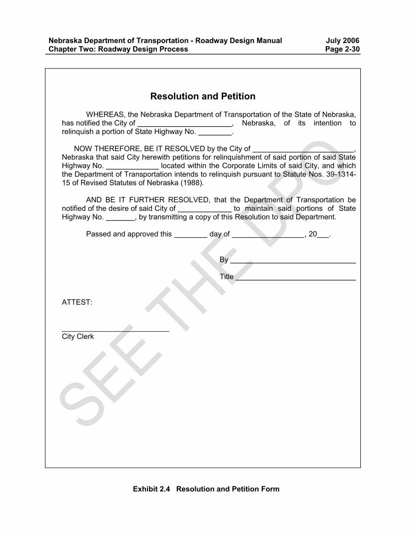
Nebraska Department of Transportation - Roadway Design Manual July 2006 Chapter Two: Roadway Design Process Page 2-30
Exhibit 2.4 Resolution and Petition Form
Resolution and Petition WHEREAS, the Nebraska Department of Transportation of the State of Nebraska,
has notified the City of , Nebraska, of its intention to relinquish a portion of State Highway No. .
NOW THEREFORE, BE IT RESOLVED by the City of ,
Nebraska that said City herewith petitions for relinquishment of said portion of said State Highway No. located within the Corporate Limits of said City, and which the Department of Transportation intends to relinquish pursuant to Statute Nos. 39-1314-15 of Revised Statutes of Nebraska (1988).
AND BE IT FURTHER RESOLVED, that the Department of Transportation be
notified of the desire of said City of to maintain said portions of State Highway No. , by transmitting a copy of this Resolution to said Department.
Passed and approved this day of , 20 .
By
Title ATTEST: __________________________ City Clerk

Nebraska Department of Transportation - Roadway Design Manual July 2006 Chapter Two: Roadway Design Process Page 2-31 22. PREPARATION OF FINAL PLANS PACKAGE/ FINAL PLAN REVIEW FOR PS&E
(ACTIVITY 5369/ 5368) This activity essentially is the assembly of the final plans package. Plans submitted to PS&E shall have all plan corrections completed by the Roadway Design Plans Development Unit prior to submission. The designer should complete any outstanding miscellaneous design plans, (i.e., guardrail). The design checklist (EXHIBIT ‘B’ of the DPO, Ref. 2.1) should once again be checked. Computations should be received from the Materials and Research Division and typical sections should be finalized. The computation sheets for each pay item should be completed, checked and rechecked, preferably by someone other than the one who did the original computations. Design details should be completed. For further information, see Chapter Eleven: Highway Plans Assembly, Section 4, of this manual. 22.A Assemble Project Data The designer should accumulate all project data including but not limited to the following:
Right-of-way certificate, (See Chapter Fifteen: Right-of-Way, Section 6, of this manual). Status of utilities. Seeding and erosion control special provisions and special plans. Agreements with city, county, Irrigation District, utilities, railroads, NRD, sanitary
improvement districts (in urban areas), (See Section 10 of this chapter and Chapter Thirteen: Planning and Project Development, Section 5.A, of this manual).
Final Relinquishment Agreement, (See Section 21 of this chapter). Waterway permits, e.g., 404 permit, nationwide permit (NWP), channel relocation,
floodplain certification, etc., (See Chapter Thirteen: Planning and Project Development, Section 4, of this manual).
The total design package including graphical presentation of plans, complete notes and details should be reviewed so that nothing has been forgotten. Again, use the design checklist (EXHIBIT ‘B’ of the DPO, Ref. 2.1). Any special provisions that have been compiled should be elaborated on and/ or finalized. The soils report should be reviewed and checked for the need for special provisions such as a compaction requirement sheet. Receive plans from:
Bridge Division. Traffic Engineering Division. Lighting Unit. Materials and Research Division. Right-of-Way Design (Ownership plans). Others , e.g., City, County, Utilities, NRD, etc.
Computer books for the District Engineer should be prepared including slope stake book, blue top book and paving grades.
Nebraska Department of Transportation - Roadway Design Manual July 2006 Chapter Two: Roadway Design Process Page 2-32 22.B Check Earthwork and Notes Use the earthwork checklist (EXHIBIT ‘N’ of the DPO, Ref. 2.1) to review earthwork information. Verify that a utility note is included that shows the contractor is responsible for notifying utilities prior to digging. Note that in some cases shoulder construction notes specify separate pay items by station. Check for:
Earthwork balance points and quantities. Covercrop seeding note: on expressway projects where traffic remains on the existing
roadway and then switches to new travel lanes, some areas may need seeding more than once.
Shoulder construction notes. Superelevation notes. Scale stamp on cross-sections: horizontal and vertical scales will differ. Grade alignment at project ends and crossings for detours and temporary roads. Special provisions, e.g., surcharge over winter. Sketches for construction items, e.g., typicals for dikes, guardrail, driveways on
Summary of Quantity sheets, etc. Be sure that project stationing is shown on plans, typical sheets and project length sheet. The final task of activity 5369 is the completion of a PS&E Required Sheet (NDOT Form 280). This form is a legal size sheet that should be completed to accompany the PS&E package. Enter the completion date in Clarity. 22.C Checking Plans for Conflicts The designer is responsible for checking plans generated by other divisions for conflicts with the Roadway Design plans. For example: Have light poles or overhead traffic signs been installed in front of the guardrail? Are there conflicts with existing or proposed utilities and the storm sewer design?
Nebraska Department of Transportation - Roadway Design Manual July 2006 Chapter Two: Roadway Design Process Page 2-33 22.D Final Plan Review For PS&E Activity 5369/ 5368 includes the final check of all construction notes with the computation sheets and includes a review of the PS&E plans with the Roadway Design Unit Head. The design checklist (EXHIBIT ‘B’ of the DPO, Ref. 2.1) should be used. The city financial agreement should be prepared and sent to the District Engineer to obtain signatures. See DOT-OI 45-5, “Agreements”, (Appendix B, “Selected NDOT Operating Instructions”, of this manual) for further information regarding agreements. The final task for this activity is the submittal of PS&E plans to the PS&E Section in the Construction Division. Enter the completion date in Clarity when the project is given to PS&E. PS&E checks the plans and quantities and informs the designer of any required plan changes. When the corrected plans are returned to PS&E, the CADD files are locked to prevent unauthorized changes to the contract plans. The roadway designer shall contact the Roadway Design Plans Manager to unlock the CADD files prior to making plan revisions, (See Section 23.A of this chapter and Chapter Eleven: Highway Plans Assembly, Section 7, of this manual for further information). During the period after a project has been advertised for letting until it has been let to contract, all questions from outside the Nebraska Department of Transportation (i.e. contractors or suppliers) regarding the project and plans shall be referred to the Highway Construction Scheduling Manager in the Construction Division. 23. POST LETTING SUPPORT AND PLAN REVISION (ACTIVITY 5375/5376) Activity 5375/ 5376 covers all post letting Design functions including the Pre-Construction Conference, construction review of any type, Plan Revisions, and the Post-Construction Conference. The project is not complete until construction is finished and NDOT has accepted the finished product. 23.A Changes to the Design Plans Any changes to the design plans which occur after the project has been let to contract will necessitate either a plan revision or a change order. Any changes which require engineering should be handled as plan revisions. Any changes which are adjustments to the existing plans (such as changing the culvert placement within the same drainage way) can be handled as change-orders and should be shown on the as-built plan set.
Nebraska Department of Transportation - Roadway Design Manual July 2006 Chapter Two: Roadway Design Process Page 2-34 23.A.1 Plan Revisions The Roadway Design Division may be involved in plan revisions at any time during the construction of a project. If the plans for a project are to be changed after the project has been submitted to PS&E but before it is advertised for letting, PS&E will send the plans back to the Roadway Design Division for the changes to be made. The changes are not considered to be a plan revision at this stage of the project. If, however, the project has been advertised and changes are necessary, the plan revision procedures should be used as outlined in Chapter Eleven: Highway Plans Assembly, Section 7. Notice should be given when plan revisions are anticipated. Any division that is involved in a project needs to be made aware of any changes or revisions that another division may make to the plans. For example, if a roadway project requires a bridge revision, the Bridge Division must inform the Roadway Design Division, Right-of-Way, Traffic, and any other involved divisions that they are initiating a revision to the plans. For plan revisions initiated in the Roadway Design Division, the roadway designer should send a notification, (which can be an e-mail), detailing the proposed revision to the Assistant Design Engineer and the Roadway Design Unit Head. The notification should include the following information:
Project Name & Number. Control Number. Revision Number. Tract Numbers affected. A brief description of the changes. An approximate completion date.
If the Assistant Design Engineer approves of the proposed revision, the Roadway Design Unit Head will forward the notification to the following:
District Engineer District Construction Engineer Roadway Design Plans Manager (responsible for unlocking CADD files) Construction Engineer District Project Manager Bridge (if applicable) Traffic ROW Design Engineer ADE for the Utilities Unit CADD Applications Engineer FHWA (on federal oversight projects only) Any other affected Divisions/ Sections
Plans will not be revised without written authorization from the Assistant Design Engineer. All federal oversight projects shall have FHWA approval to proceed before the plan revisions are made, (the Design Unit Head is responsible for informing the Roadway Design Plans Manager when FHWA approval has been received).
Nebraska Department of Transportation - Roadway Design Manual July 2006 Chapter Two: Roadway Design Process Page 2-35 All plan revisions must be signed and sealed by a P.E., (See Chapter Eleven: Highway Plans Assembly, Section 8, of this manual). The Roadway Design Unit Head and Assistant Design Engineer must be kept informed of all changes to the plans, regardless of whether the changes are made in the Roadway Design Division or in the District; it is the Assistant Design Engineer’s decision whether a plan change can be handled with a change order or is a plan revision requiring a signed and sealed document. If the District Engineer or the District Construction Engineer is willing to seal and sign plan revisions in the field that is acceptable, as long as the Roadway Design Unit Head and Assistant Design Engineer are consulted about the design of the proposed revisions before they are finalized. If the Roadway Design Division authorizes or transmits a plan revision to the District via fax, phone, or e-mail, the responsible Roadway Design Division Engineer’s seal and signature will be affixed to the transmittal, which will then be scanned and sent to the District. 24. ARCHIVING THE PROJECT FILE After the project is completed, the designer is responsible for archiving the project file in the vault. Archive instructions (transmitted by the vault to the designer) should be used to properly prepare the file for archives. This usually occurs two years after final computations are completed.
Nebraska Department of Transportation - Roadway Design Manual July 2006 Chapter Two: Roadway Design Process Page 2-36 25. REFERENCES 2.1 Nebraska Department of Transportation, Design Process Outline, Current Edition
(http://www.roads.nebraska.gov/business-center/design-consultant/) 2.2 Nebraska Department of Transportation, Drainage Design and Erosion Control Manual,
Current Edition 2.3 Nebraska Department of Transportation, Access Control Policy to the State Highway System, Current Edition. (http://www.roads.nebraska.gov/media/3460/access-control-policy.pdf)