chapter 7 · it discharges into okanagan lake (mp9). the second major withdrawal point (mp2)...
TRANSCRIPT

157
CHAPTER 7 Peachland Creek
7.1 GENERAL DESCRIPTION
Reference is made to the Key Map on Figure 7.1 and the schematic
creek diagram on Figure 7.2.
Peachland Creek, with an area of only 59 square miles is the
second smallest of the eight tributaries discussed in this chapter.
Although not as dry as its neighbour, Trout Creek, it occupies a
rainshadow area and exhibits an average runoff of only 4.8 inches over
its watershed compared to 3.5 inches for Trout Creek. The average
natural flow at creek mouth is estimated at 15,000 acre-feet.
In 1970, the area served a population of 1444 persons and an
irrigated area of 617 acres. Most of the people and irrigated acreage
are contained within the Peachland Irrigation District whose
boundaries extend far beyond the natural boundaries of Peachland
Creek. See Figure 7.1. The portion of the District Municipality of
Peachland which once received its water from nearby Trepanier Creek
now pumps all its domestic water from Okanagan Lake.
The headwaters of Peachland Creek are located some 17 miles
northwest of its mouth on the ridge separating the Nicola watershed
from that of the Okanagan. The elevation of this ridge is around 5500
to 6000 feet. Drainage from the headwaters of Peachland Creek is soon
joined by drainage from the headwaters of McDonald Creek. (MP1).
McDonald Creek is not a natural tributary of Peachland Creek but the
diversion of its headwaters makes an important contribution to flow.
The combined headwaters flow is next joined by outflow from Peachland
Lake (CPI) larger of the two controlled lakes in the sub-basin.
The important industrial water user, Brenda Mines Ltd., makes a
significant impact on the above described drainage pattern. By
diverting water from Brenda Lake (in the Nicola Watershed), flows in
the headwaters can be Increased. The facility and authority for
making such a diversion is in the hands of Brenda Mines but, it is
understood, they do not use it. Authority to divert McDonald Creek as
described, used to be with Peachland I.D. but is now with Brenda
Mines. The pattern followed is understood to be that all flow, up to
the 100 cfs capacity of the diversion ditch, is transferred

158
to Peachland Creek. A four mile long diversion ditch with a capacity
of 135 cfs can transfer water from Crescent Lake, in the Trout Creek
watershed, to Peachland Lake. This diversion was not operated in 1970,
and hence has not been included in the tributary model. It can be an
important source of water and should be considered in future studies.
Lastly, Brenda Mines have installed a diversion from Peachland Creek
into Peachland Lake for purposes of storing the above described
diverted flows. This diversion is operated as required to maintain
satisfactory levels in Peachland Lake whose recreational attributes are
also being exploited. The mine pumps water from Peachland Lake to meet
its needs and releases water downstream as required by other licencees
(DPI). Peachland Lake, which now has an active storage of 9575 acre-
feet, appears to have been developed considerably beyond immediate
actual need by Brenda Mines Ltd. and hence its capacity and potential
drawdown of 75 feet has never been used.
The headwaters of Wilson Lake (CP2) are on the ridge separating
Peach-land and Trepanier Creeks. Compared to Peachland Lake, it is of
little significance, having an active storage of only 81 acre-feet.
However, it is the only other controlled storage in the sub-basin and
was operated in 1970. Outflow from Wilson Lake forms Mile Creek which
flows southeast for about two miles to join Peachland Creek.
Glen Lake (MP5) is formed in the saddle separating the Peachland
and Trout Creek watersheds. Its outflow travels in a generally
easterly direction in Greata Creek for about six miles before joining
Peachland Creek.
No other tributaries of significance join Peachland Creek before
it discharges into Okanagan Lake (MP9). The second major withdrawal
point (MP2) diverts water to Peachland Irrigation District at a point
about 3 1/2 miles upstream from the creek mouth.
Reference to the area-elevation curves on Figure 14.2 (Chapter 14)
will show that the median elevation of Peachland Creek is 4100 feet.
Except for valley floors and benches, the land rises steeply out of
Okanagan Lake for 2000 vertical feet, reaching elevation 3000 feet with
only 13% of the sub-basin area below. The main body of the sub-basin
(71%) is a rugged upland plateau extending between elevation 3000 feet
and 5000 feet. The final 16% of the area extending to over 6000 feet
is comprised of local mountain tops and ridges.
Reference to Figure 14.3 will show that the course of Peachland Creek
rises steeply over almost its whole length. For the first two miles up-

159
KEY MAP PEACHLAND CR.
Figure 7.1
KEY MAP PEACHLAND CR.
Figure 7.1

160
PEACHLAND CR. SCHEMATIC Figure 7.2

161
stream from its mouth, it rises at a gradient of 364 feet per mile.
This is much steeper than any of the other creeks under study. For
the remaining 17 miles to its headwaters, Peachland Creek rises at a
less steep and fairly constant gradient averaging 197 feet per mile.
There are a number of hydrometric, meteorological and snowcourse
stations within the Peachland Creek system and these are located on
Figure 7.1.
Many of the hydrometric records are of short duration and often
cover only the summer months.
The most significant hydrometric station is 8NM159 near the creek
mouth. Hydrographs of mean monthly flows passing this station have
been plotted on Figure 14.4.
7.2 HISTORICAL BACKGROUND
Peachland was first developed by the Peachland Townsite Company.
This Company was incorporated in 1899, for the purpose of buying and
selling lands and supplying them with irrigation water.
The Company acquired lots and subdivided them into blocks of
various sizes which were sold for orchard land. A system of ditches,
wooden flumes and woodstave pipes, were constructed in 1906 to convey
water from Peach-land Creek.
Storage reservoirs with a combined storage of about 1000 acre-feet
were constructed, but even so, the water supply was deficient in
August to September. There were few measuring devices and no locks on
any of the sluices or gates, with the result that the distribution of
water was unsatisfactory.
In 1916 all the Company's lands were sold for taxes.
In 1917 a Commission was appointed to inquire into the affairs of
Peach-land Townsite Company. It was found that the Company was
practically bankrupt. The water distribution system was generally
efficient, but a shortage of water did occur during the end of the
irrigation season. Hence, the Company was not in a position to carry
on operations or fulfill its obligations to the water users. As a
result of this commission, an improvement district was formed on
October 28, 1920, under the name of "Peachland Irrigation District".
Later in November of the same year the Peachland Irrigation District
bought out all rights of the Peachland Townsite Company for $6,000.
Records from the year 1915 show that Peachland Creek was called Deep

162
Creek and that a reservoir existed at the headwaters of the South Fork.
This presumably, was the original Peachland Lake reservoir. It is
recorded to have had 8 1/2 feet of drawdown and 227 acre-feet of storage.
The catchment area was insufficient to fill the storage and
investigations were being made for possible diversion. On "the Main Deep
Creek" was situated another reservoir with a concrete dam and spillway, 8
1/2 feet of drawdown and a storage of 531 acre-feet.
The small storage (81 acre-feet) on Wilson Lake was of value to the
area until the enlargement of Peachland Lake to its present size of 9575
acre-feet by Brenda Mines. Now, because Peachland I.D. can call on an
assured 1000 acre-feet per year, Wilson Lake has become obsolete.
7.2.1 Brenda Mines Limited
Early in the 1960's, an interesting low grade copper prospect was
discovered near the headwaters of Peachland Creek, one mile east of
Brenda Lake. By 1967, sampling and concentrating tests on bulk samples
obtained from underground operations were completed in a pilot mill with
a capacity of 100 tons per day. The open-pit area and the proposed mill-
site were cleared and a power line brought to the property. By the end
of the year 170,000 tons of over burden had been removed.
Data from water licences shows that, in 1966, authority was given to
divert 1500 acre-feet per year from Brenda Creek and 2300 acre-feet per
year from McDonald Creek. In this year also, storage of 5800 acre-feet
was authorized for Peachland Lake.
In 1968, Brenda Mines were licenced to divert up to 3370 acre-feet
per year from Crescent Lake, Clamin Creek and Trout Creek. This involved
construction of over four miles of diversion ditch. Water thus diverted
is direct-into Peachland Lake.
Thus, a number of diversions into Peachland Lake are now possible.
The capacity of the lake has been greatly increased to a total of 9575
acre-feet. Utilization of this capacity would require a drawdown of 75
feet but through re-circulation it is fortunate that water requirements
are much less than anticipated. The reduced fluctuation in Peachland
Lake has improved the recreation potential.
7.3 LAND USE AND WATER REQUIREMENTS
Apart from a few smallholders, there are only two water users in the
Peachland Creek watershed, namely, Brenda Mines Ltd. and Peachland Irrigation

163
District. The mine occupies the headwaters area and pumps Us water
needs from Peachland Lake. The irrigated area occupies the lower
benches near Okanagan Lake and extends beyond the natural
boundaries of the watershed.
Peachland Irrigation District performed its function of water
supply with little change to its old system, built in 1906, until
financial assistance under ARDA became available in 1969. Between
1969 and 1972, a completely new system was built. At its intake,
this new system has a capacity of 5100 gpm and is designed to serve
up to 640 acres with an annual diversion duty of 3.4 feet. The
trunk supply line consists of 8075 feet of asbestos-cement pipe
ranging down from 24 inch to 12 inches in diameter. The lateral
distribution system is also of asbestos-cement and is comprised of
50,000 feet of pipe ranging in size from 12 inch to 4 inch
diameter. Pressures are maintained between 65 and 125 psi.
Because of the low pressure range and the wide range in elevation
of irrigated lands, the system is divided into five pressure zones,
two requiring booster pumping and three requiring pressure
reduction.
The entire system is chlorinated to provide a potable water.
The common pattern of residential development replacing previously
irrigated agricultural land is well advanced. In 1973 it is
estimated that, of all the land served, 510 acres are under
irrigation and 127 acres are residential.
Brenda Mines Ltd. is a large, Copper producing, open pit mining
operation. In 1967 a small 100 tons per day pilot mill proved the
economics of the venture. By 1971 a 24,000 tons per day mill was
working to capacity all year around. Copper concentrates are
trucked to Kelowna and thence out of the valley by rail. By
arrangement, the mine acquired the right to carry out a series of
diversions, the water from which they store in a greatly improved
Peachland Lake dam. Water is then pumped from the lake, as
required, to meet the needs of the mine for production of copper
concentrates and for local domestic purposes connected with the
mine. Because of the mine's originally estimated water requirement
(licensed diversion 13,513 acre-feet) greatly exceeds their current
need (1,548 acre-feet), there is a large over capacity in the
present Peachland Lake and diversions.
Water users in terms of population and areas irrigated are
shown on Table 7.1.
Consumptive use diversions as listed above are assumed to result in no
return flow within the Peachland Creek sub-basin. However, consumptive use
diversions are expected to provide a return flow to Okanagan Lake. The amount

164
of return flow varies with the type of use and is estimated as follows:
a) For "Irrigation" return flow = 50% of diversion.
b) For "Domestic and Waterworks", return flow = 65% of diversion.
c) For "Industry", return flow = 90% of diversion.
From the above, water utilization in terms of the amounts of
consumed water and return flow within the Okanagan Lake Basin may be
tabulated as shown on Table 7.2.
TABLE 7.1
WATER USERS IN THE PEACHLAND CREEK WATERSHED (1970)
TABLE 7.2
WATER UTILIZATION IN PEACHLAND CREEK (1970)
A detailed breakdown of the diversion requirements for the
major areas as the 1970 stage of development is as shown on Table 7.3

165
TABLE 7.3
DIVERSION REQUIREMENTS ON PEACHLAND CREEK (1970)
GIVEN IN ACRE FEET

166
PEACHLAND CR. DRY YEAR (NATURAL FLOW) Figure 7.3
PEACHLAND CR. AVERAGE YEAR (NATURAL FLOW) Figure 7.4
PEACHLAND CR. WET YEAR (NATURAL FLOW) Figure 7.5
167
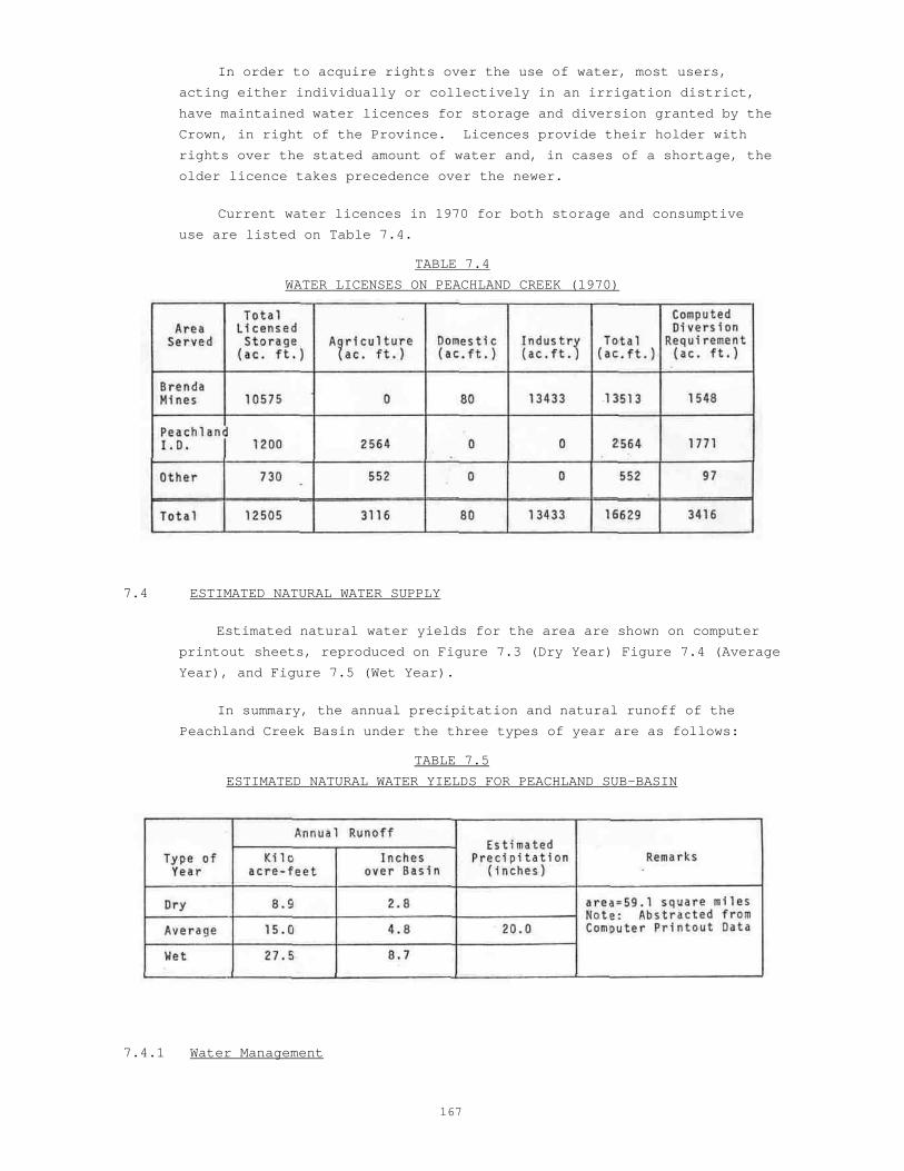
In order to acquire rights over the use of water, most users,
acting either individually or collectively in an irrigation district,
have maintained water licences for storage and diversion granted by the
Crown, in right of the Province. Licences provide their holder with
rights over the stated amount of water and, in cases of a shortage, the
older licence takes precedence over the newer.
Current water licences in 1970 for both storage and consumptive
use are listed on Table 7.4.
TABLE 7.4
WATER LICENSES ON PEACHLAND CREEK (1970)
7.4 ESTIMATED NATURAL WATER SUPPLY
Estimated natural water yields for the area are shown on computer
printout sheets, reproduced on Figure 7.3 (Dry Year) Figure 7.4 (Average
Year), and Figure 7.5 (Wet Year).
In summary, the annual precipitation and natural runoff of the
Peachland Creek Basin under the three types of year are as follows:
TABLE 7.5
ESTIMATED NATURAL WATER YIELDS FOR PEACHLAND SUB-BASIN
7.4.1 Water Management

168
Natural water yields as described in the previous section estimate
flows under pristine conditions. Under the influence of Man, water has
been diverted for various purposes and reservoirs have been created to
retard natural runoff. All these changes in natural conditions are
included under the general title of Water Management.
7.5 STORAGE
Reference is made to the schematic diagram on Figure 7.2.
In a climate of spring floods and summer droughts, it is necessary
to store a high proportion of total available water so that it may be
used when needed.
By nature, the Peachland watershed is in a rather unusual situation
with respect to storage potential. The two small lakes, Wilson (CP2)
and Glen (MP5) have watersheds with quite good water yields but poor dam
sites. Conversely, the best dam site is on Peachland Lake (CP1) which
has a small, low yield catchment. This problem has been overcome by
making a number of diversions to increase the potential catchment of
Peachland Lake.
7.5.1 Peachland Lake
Although the natural drainage area of Peachland Lake is only 2800
acres, several important diversions enhance its potential inflow
greatly. As detailed in section 7.1 diversions may be made from the
Trout and McDonald Creek watersheds and from Peachland Creek itself.
The present dam was built in 1968 and impounds 9575 acre feet of water
of which only a small proportion is required under normal operation.
The spillway of the earthfill dam is set at elevation 4150.0 feet and
the invert of the 36 inch diameter outlet culvert is at elevation 4075.0
feet. This provides for an unusually large drawdown of 75 feet. The
reservoir is owned and operated by Brenda Mines Limited who, by
agreement, release up to 1000 acre feet of water to meet the needs of
Peachland I.D.
7.5.2 Wilson Lake
This old earth and rock fill dam contains 81 acre feet of storage.
Its spillway elevation is at 4603 feet while the invert of its 12 inch
outlet culvert is at elevation 4590 feet. It is expected that the dam
will be breached soon.
Basin hydrologic information on the two reservoirs described
above is given in Table 7.6.

169
TABLE 7.6
1970 STORAGES IN THE PEACHLAND CREEK SYSTEM
Storages are currently operated in a manner which seems best to
the owners for the purposes of irrigation or ore concentration.
Methods of operation are by no means rigid and, for Peachland
Lake, are normally kept within narrow limits for recreational
purposes. Input data for purposes of computer programming is based on
the assumed pattern of storage operation as shown on Table 7.7.
TABLE 7.7
RULE CURVE VALUES
FOR PEACHLAND CREEK RESERVOIR
EXPLANATION: For any given month -
a) Percentages shown refer to active storage occupied by water at end of
month. e.g. 30% storage occupied by water at end of March.
b) When rule curve value is exceeded, all excess water is released.
c) When rule curve value is not achieved, only stated water requirements
are released.

170
Photo 31 PEACHLAND LAKE - Looking Southwest (Sept. 12, 1973)
Peach land Creek System
Photo 32 DOBBIN, ISLAHT AND WEST LAKES
Looking East (Sept. 12, 1973)
Powers Creek System

171
d) Information based on local records of water users.
At the 1970 stage of development little or no consideration is
given to the operation of storage for Fisheries or other non-
consumptive use.
7.5.3 Residual Flows
When natural flow is affected by storage changes, diversions to or
from the area and withdrawals for irrigation, domestic or industrial
purposes, the resulting creek flow is called the "residual flow".
These residual flows, for various selected points and three types of
weather year at 1970 development, are shown on computer print-outs.
They are reproduced as Figure 7.6 (Dry Year), Figure 7.7 (Average
Year), and Figure 7.8 (Wet Year),
Reference to the above figures will show that residual flows
immediately upstream and immediately downstream from the selected point
are given. The difference is the amount diverted at the point for
consumptive use. It will be noted that there are no "demand
deficiencies" at the 1970 stage of development, even in a "dry" year.
Reference to Figures 7.9 and 7.6 will show that, based on
Department of Fisheries estimates of need, there would be a considerable
shortage of water for non-consumptive use in both "dry" and "average"
years.
These water deficiencies are the product of storage operation based
on present or historic methods. Using the model for modified operation
of storage (described earlier) it becomes possible to eliminate all
deficiencies. This is shown graphically on Figure 7.9 and suggests that
refinements to the historic method of operating storage would result in
a more advantageous use of the water resource. On the negative side it
must be remembered that modified storage operation would require a wider
range of drawdown on Peachland Lake and, hence, would reduce its
recreational value.
In conclusion, the contribution which Peachland Creek makes to the
gross inflow to Okanagan Lake may be evaluated for various types of
year as shown on Table 7.8
TABLE 7.8
COMPARISON BETWEEN INFLOWS TO PEACHLAND CREEK AND OKANAGAN LAKE

172
PEACHLAND CR. DRY YEAR (1970) Figure 7.6
PEACHLAND CR. AVERAGE YEAR (1970) Figure 7.7

173
PEACHLAND CR. WET YEAR (1970) Figure 7.8

174
PEACHLAND CR. (1970) DEFICIENCY DIAGRAM Figure 7.9