chapter-01 introduction
TRANSCRIPT
Consultancy Services for Four Laning of existing Goa/Karnataka Border-Panaji Goa Section of NH-4A from Km 84.000 to Km 153.075 in the state of Goa on BOT (Toll) basis under NHDP-III (Anmod to Panaji Section)
Environmental Impact Assessment & Environmental
Management Plan
CHAPTER-01CHAPTER-01
INTRODUCTIONINTRODUCTION
1.0 INTRODUCTION
Highway projects are undertaken with a motive to improve the economic status and
social welfare of the people. At the same time, they may also create an adverse
impact on the surrounding environment. People and property in the direct path of the
road works may be affected. The environmental impact of highway projects include
damage to sensitive Eco-systems, soil erosion, changes to drainage pattern and
thereby affecting groundwater, interference with animal and plant life, loss of
productive agricultural lands, resettlement of people, disruption of local economic
activities, demographic changes, accelerated urbanization and increase in air pollution
and noise levels. Hence there is a greater importance for careful examination of
Highway developmental activities and operations should be planned and executed by
considering potential environmental impacts. The Public Works Department of
Government of Goa represented by the Secretary, Public Works Department is
engaged in the development of National highways on behalf of Ministry of Road
Transport and Highways (MoRTH) and as part of this endeavour, the Employer has
decided to undertake “Four Laning of existing Goa/Karnataka border- Panaji Goa
section of NH4A from Km 84/000 to 153/075(ANMOD TO PANAJI) UNDER NHDP-III”.
Public Works Department of Government of Goa engaged M/s Aarvee Associates
Architects Engineers & Consultants Pvt. Ltd as the Technical Consultant for preparation
of Feasibility Report for, development of the Project.
The project stretch excludes following reaches:
• From chainage 118 Km to 125 Km (Kandepar - Safa Maszid)
• From chainage 143.400 Km to 153.075 Km (Ella - Panaji).
1.1 Objectives
The principle objectives of Environmental Impact Assessment (EIA) and Environment
Management Plan (EMP) are:
To ensure the project complies with the National and State regulatory policies
and laws.
Generation of environmental baseline information related to the proposed
1
Consultancy Services for Four Laning of existing Goa/Karnataka Border-Panaji Goa Section of NH-4A from Km 84.000 to Km 153.075 in the state of Goa on BOT (Toll) basis under NHDP-III (Anmod to Panaji Section)
Environmental Impact Assessment & Environmental
Management Plan
project for various environmental attributes i.e., land, air, water, noise, soil,
socio-economic, ecological & bio-diversity of the project.
To identify and quantify the significance of impacts of various activities of the
proposed project with respect to the various environmental attributes.
To evaluate the impacts on an environmental quality scale.
To suggest necessary control measures to minimize the adverse affects.
To outline additional control measures to be adopted for mitigation of adverse
impacts. Integration of EMP to bid / contract documents and BoQ items for an
effective implementation.
To prepare a post-project monitoring programme for checking and regulating
the environmental quality within the limits stipulated by the Ministry of
Environment and Forests (MoEF) / Goa State Pollution Control Board (GSPCB).
To adopt the best environmental safeguards for an effective implementation.
1.2 Scope Of The Work
The scope of the environmental report is given below:
Review of National and state level environmental regulatory requirements on
environmental aspects, including assisting PWD, Goa in getting necessary
clearances from MoEF/ GSPCB in the context of proposed Goa/Karnataka
Border to Panaji Goa, if applicable.
An environmental screening and categorization framework for the proposed
project to include the environmental aspects from the planning stage of the
project.
Location of the project stretch with respect to environmentally sensitive areas,
and community concerns apart from the technical aspects.
Conduct environmental analysis of alternatives for highway bypasses and
provide specific inputs for analysis of alternatives and decision making.
Establishing environmental baseline for selected attributes, covering the specific
locations along the project alignment – such as major towns, junctions, existing
bypasses, proposed bypasses, forest stretches, proposed quarries, borrow
areas, sensitive locations (schools, temples, hospitals, archaeological sites
etc.).
To identify potential environmental aspects and detailed environmental
2

Consultancy Services for Four Laning of existing Goa/Karnataka Border-Panaji Goa Section of NH-4A from Km 84.000 to Km 153.075 in the state of Goa on BOT (Toll) basis under NHDP-III (Anmod to Panaji Section)
Environmental Impact Assessment & Environmental
Management Plan
assessment to be carried out as part of Detailed Project Report.
Impact assessment and prediction with respect to various environmental
attributes i.e., land, air, water, noise, soil, socio-economic, ecological & bio-
diversity aspects of the project.
Preparation of Implementable Environmental Management Plan with budgetary
provisions and suggesting post project monitoring plan.
The objectives of such analysis shall be to minimize environmental impacts and
provide specific inputs to the project during construction and maintenance.
1.3 Need For Environmental Impact Assessment
Highway developmental activities should be planned and executed after considering
the potential environmental impacts. To minimize these adverse impacts that may be
created by highway development projects, the techniques of Environmental Impact
Assessment (EIA) become necessary. Identification and assessment of potential
environmental impacts should be an integral part of the project life cycle. It should
commence early in the planning process of the project to enable a full consideration of
alternatives and to avoid later delays and complications. This EIA report is prepared
for Goa/Karnataka Border to Panaji, Goa project stretch for an existing length of
69.075 Kms (on NH-4A).
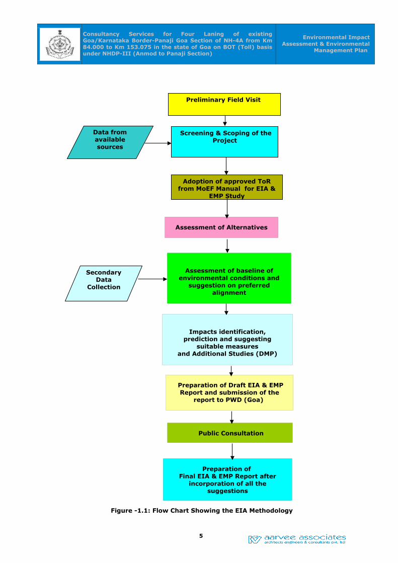
1.4 Approach and Methodology
The approach for the preparation of EIA involves the following steps:
Reconnaissance survey is undertaken in order to identify the environmental attributes
in and along the project activity. The environmental baseline data in the project impact
area was generated from both primary and secondary sources. During the site visits,
due importance is given to identify the impacts of the project taking into account the
contours of the project passing areas and other surrounding activities. Then, prediction
and evaluation of the impacts is based on available mathematical models, empirical
assessment and past experience in view of the net cost – benefit. Preparation of an
environmental management plan is to reduce the adverse impacts of the project to the
barest minimum. Conclusively, quantification of the financial cost of mitigation
measures and preparation of a monitoring plan for the implementation of mitigation
measures is undertaken.
The methodology adopted is presented in the form of a Flow chart given in
Figure -1.1.
3
Consultancy Services for Four Laning of existing Goa/Karnataka Border-Panaji Goa Section of NH-4A from Km 84.000 to Km 153.075 in the state of Goa on BOT (Toll) basis under NHDP-III (Anmod to Panaji Section)
Environmental Impact Assessment & Environmental
Management Plan
1.5 Project Proponent
The Public Works Department plays a major role in the economic, Commercial and
tourist development of the State of Goa. Being a service Department, it is entrusted
with all the developmental activities like Planning, Design, Construction, Operation and
Maintenance of all types of construction works in this State of Goa. The Public Works
Department of Government of Goa represented by the Secretary, Public Works
Department is engaged in the development of National highways on behalf of Ministry
of Road Transport and Highways (MoRTH) and as part of this endeavour, the Employer
has decided to undertake “Four Laning of existing Goa/Karnataka border- Panaji Goa
section of NH4A from Km 84/000 to 153/070 (ANMOD TO PANAJI) UNDER NHDP-III”.
4
Consultancy Services for Four Laning of existing Goa/Karnataka Border-Panaji Goa Section of NH-4A from Km 84.000 to Km 153.075 in the state of Goa on BOT (Toll) basis under NHDP-III (Anmod to Panaji Section)
Environmental Impact Assessment & Environmental
Management Plan
Figure -1.1: Flow Chart Showing the EIA Methodology
5
Preliminary Field Visit
Data from available sources
Screening & Scoping of the Project
Secondary Data
Collection
Assessment of baseline of environmental conditions and
suggestion on preferred alignment
Assessment of Alternatives
Impacts identification, prediction and suggesting
suitable measuresand Additional Studies (DMP)
Preparation of Draft EIA & EMP Report and submission of the
report to PWD (Goa)
Public Consultation
Preparation of Final EIA & EMP Report after
incorporation of all the suggestions
Adoption of approved ToR from MoEF Manual for EIA &
EMP Study
Consultancy Services for Four Laning of existing Goa/Karnataka Border-Panaji Goa Section of NH-4A from Km 84.000 to Km 153.075 in the state of Goa on BOT (Toll) basis under NHDP-III (Anmod to Panaji Section)
Environmental Impact Assessment & Environmental
Management Plan
1.6 Generic Structure Of Environmental Impact Assessment Document
In terms of the EIA notification of the MOEF dated 14th September 2006, the generic
structure of the EIA document shall be as under:
• Introduction
• Project Description
• Review of Environmental Regulatory Requirements, Policies & Guidelines
• Analysis of Alternatives (Technology and Site)
• Environmental Baseline Data Study
• Anticipated Environmental Impact & Mitigation Measures
• Additional Studies
• Environmental Management Plan
• Summary & Conclusions
• Disclosure of Consultants engaged
6
Consultancy Services for Four Laning of existing Goa/Karnataka Border-Panaji Goa Section of NH-4A from Km 84.000 to Km 153.075 in the state of Goa on BOT (Toll) basis under NHDP-III (Anmod to Panaji Section)
Environmental Impact Assessment & Environmental
Management Plan
CHAPTER -02CHAPTER -02
PROJECT DESCRIPTIONPROJECT DESCRIPTION
2.0 PROJECT DESCRIPTION
Public Works Department (PWD), Government of Goa has decided for the development
of “Four Laning of Existing Goa/Karnataka Border – Panaji Goa Section of NH-4A from
Km 84/000 to 153/075 on BOT (Toll) basis under NHDP-III (Anmod to Panaji Section)”.
The Project Highway is a section of NH-4A (Belgaum-Anmod-Ponda-Panaji) between
Anmod and Panaji, passing through villages Molem, Sangod, Dharbandora, Piliem,
Tiska, Candepar, Curti, Ambegal, Veling, Boma, Banastarim, Corlim, Ella, Velha goa,
Ribandar. It is observed that major ghat portion is from Km 84.000(Anmod) to Km
93.000 (Mollem) approximately. From end of the ghat road (Km 93.000) to Ponda the
project road is plain to rolling terrain and passing through the forest. From Ponda near
Km 126.000 to Km 138.000, the stretch again traverses through mountainous terrain.
There after the project road is passing through rolling terrain upto end of the stretch.
The entire stretch of NH-4A lies in the states of Karnataka and Goa, it provides an
important link between NH-4 and NH-17. It has a great potential of growth in the
passenger as well as freight movement in future due to agriculture and industrial
growth in the project influence area.
2.1. Location of the Project:
The project corridor runs from South-East to North-West direction. The project stretch
of NH-4A starts from Karnataka-Goa border (Anmod) at a chainage of Km. 84.000 and
ends at Panaj (Goa) at a chainage of Km. 153.075. The project stretch connects the
Capital city Panaji on Western side and Belgaum city in Karnataka state on eastern
side. It also links to Vasco Port and Airport via NH-17B and NH-17. The location map is
shown in Figure -2.1 and the location details of the project road is mentioned in
Table -2.1.
Table -2.1: Location details of the project road
Section Chainage (km) NH State Length (km)
Karnataka/Goa border (Anmod) to Panaji-Goa
Km 84.000 to Km 142.000
NH-4A Goa 51
7

Consultancy Services for Four Laning of existing Goa/Karnataka Border-Panaji Goa Section of NH-4A from Km 84.000 to Km 153.075 in the state of Goa on BOT (Toll) basis under NHDP-III (Anmod to Panaji Section)
Environmental Impact Assessment & Environmental
Management Plan
Fig.2.1: Index map showing the project stretch
8

Consultancy Services for Four Laning of existing Goa/Karnataka Border-Panaji Goa Section of NH-4A from Km 84.000 to Km 153.075 in the state of Goa on BOT (Toll) basis under NHDP-III (Anmod to Panaji Section)
Environmental Impact Assessment & Environmental
Management Plan
2.2 Salient and Engineering Features of the Project
The Salient features and engineering features of the project are given in Table -2.2
and Table -2.3.
Table 2.2: Salient Features of the Project road
S.No. Parameter(s) Description
1 Location of Project Located in the State of Goa from Goa/Karnataka Border Km 84.000 to Panaji -Goa Km 153.075 (Anmod-Panaji Section)
2 Terrain Mix of Hilly Terrain (Ghat Section), Rolling and Plain terrain to some extent.
3 Major Settlement along the
Project StretchFarmagudi, Boma, Corlim and Ella
4 Rivers/ Streams/ Canals Cumbarjuva
5 Forest area and Sanctuaries Reserve and Private Forests Area – 33.17 ha ; Bhagawan Mahaveer Wild Life Sanctuary Area – 31.015 ha
6 Length of the Existing and
Proposed Alignment
Existing Alignment is 69.075 Km and Proposed Alignment is 51 Km
7 Existing Carriageway Width 7m in two lane stretches and 14m in four lane stretches
8 Proposed Carriageway width The Paved Carriageway width shall be 18.0m, except in Built-up locations it is 19.0m
9 Administrative locations EE, Works Division VII, Patto Panaji, Goa and EE, Works Division XV, Ponda, Goa
10 State Goa
Table 2.3: Engineering Features of the Project Road
S.No Parameters Existing Proposed
1 Right of Way (RoW)(m) 8 to 35 30 to 45
2 Design Speed 60 100 (60 in WLS)
3 Major Bridges 1 1-New 2 Lane Bridge to be Constructed
4 Minor Bridges 7 7-New 2 Lane bridge to be Constructed
9

Consultancy Services for Four Laning of existing Goa/Karnataka Border-Panaji Goa Section of NH-4A from Km 84.000 to Km 153.075 in the state of Goa on BOT (Toll) basis under NHDP-III (Anmod to Panaji Section)
Environmental Impact Assessment & Environmental
Management Plan
S.No Parameters Existing Proposed
5 No. of Railway Crossings 0 -
6 Railway Over Bridge (ROB) 1 1-New 2 Lane ROB to be Constructed
7 Railway Under Bridge (RUB) 0 -
8 No. of Culverts SC/Box – 38HPC - 137
Upgradation as per four lane
9 Pedestrian / Cattle
Underpasses
- -
10 Vehicular Underpasses /
Overpasses
- 11
11 Fly Overs - 5
12 Foot Over Bridges - -
13 Bus Bayes - 20 locations (Both Sides)
14 Truck Lay Byes - 1 Location (Both Sides)
15 Rest Areas - -
16 Toll Plazas 1 1
17 Bypasses / Realignments 1 Not in our Scope
18 Total Number of trees
affected
10,000 (Approximately – Tree Enumeration is Pending)
19 Tree Plantation Proposed
(minimum 1:2)
20,000
20 Land to be Acquired (incl.
social Forestry)
136.67 ha
21 Project Cost INR 2,130.00 Crores
2.3 Study of Existing Amenities in the Project Stretch
The study has been conducted to know the existing amenities in the project road. The
Chainage wise features like terrain, land-use, pavement type & condition and
carriageway width, shoulder type, condition & width, nature of soil, curve geometry,
intersection details, location of water bodies, height of embankment or depth of cut,
cross drainage structures, existing utility services, general drainage conditions etc.,
have been recorded. The road inventory has been referenced to the existing kilometer
10

Consultancy Services for Four Laning of existing Goa/Karnataka Border-Panaji Goa Section of NH-4A from Km 84.000 to Km 153.075 in the state of Goa on BOT (Toll) basis under NHDP-III (Anmod to Panaji Section)
Environmental Impact Assessment & Environmental
Management Plan
& hectometer stones established along the roadside.
2.3.1 Terrain & Land use
Terrai is classified by the general slope of the country across the highway alignment.
Based on this criteria, major part of project stretch traverses through Hilly terrain and
some part of the project stretch passes through Rolling and Plain terrain. Below Figure
shows the typical plain terrain along the project stretch.
Fig. 2.2: Plain, Rolling & Mountainous Terrain
The project stretch passes through hilly terrain and majority of adjoining land is
Forest. Some of the stretch where industrial places and junction locations are built up.
The important crops grown along the project stretch are Cashew, Rice and Areca. The
type of land use pattern that exists along the project stretch is presented below.
Table-2.4: Land Use Pattern
S.No. Type of LandPercentage of Road
length
1 Forest 42.09
2 Agricultural 49.16
3 Built-up 7.07
4 Barren 0.84
2.3.2 Carriageway Width
The existing 2 lane flexible pavement with paved & earthen shoulders, where the
stretch is to be widened into four lane. The width of carriageway was measured at
every 100m interval from beginning to end of the project road. Width of shoulders on
either side was measured separately along with carriageway measurements. The
11
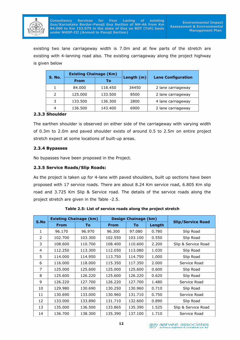
Consultancy Services for Four Laning of existing Goa/Karnataka Border-Panaji Goa Section of NH-4A from Km 84.000 to Km 153.075 in the state of Goa on BOT (Toll) basis under NHDP-III (Anmod to Panaji Section)
Environmental Impact Assessment & Environmental
Management Plan
existing two lane carriageway width is 7.0m and at few parts of the stretch are
existing with 4-lanning road also. The existing carriageway along the project highway
is given below
S. No.Existing Chainage (Km)
Length (m) Lane ConfigurationFrom To
1 84.000 118.450 34450 2 lane carriageway
2 125.000 133.500 8500 2 lane carriageway
3 133.500 136.300 2800 4 lane carriageway
4 136.500 143.400 6900 2 lane carriageway
2.3.3 Shoulder
The earthen shoulder is observed on either side of the carriageway with varying width
of 0.3m to 2.0m and paved shoulder exists of around 0.5 to 2.5m on entire project
stretch expect at some locations of built-up areas.
2.3.4 Bypasses
No bypasses have been proposed in the Project.
2.3.5 Service Roads/Slip Roads:
As the project is taken up for 4-lane with paved shoulders, built up sections have been
proposed with 17 service roads. There are about 8.24 Km service road, 6.805 Km slip
road and 3.725 Km Slip & Service road. The details of the service roads along the
project stretch are given in the Table -2.5.
Table 2.5: List of service roads along the project stretch
S.NoExisting Chainage (km) Design Chainage (km)
Slip/Service RoadFrom To From To Length
1 96.170 96.970 96.300 97.080 0.780 Slip Road
2 102.700 103.300 102.550 103.100 0.550 Slip Road
3 108.600 110.700 108.400 110.600 2.200 Slip & Service Road
4 112.250 113.300 112.050 113.080 1.030 Slip Road
5 114.000 114.950 113.750 114.750 1.000 Slip Road
6 116.000 118.000 115.350 117.350 2.000 Service Road
7 125.000 125.600 125.000 125.600 0.600 Slip Road
8 125.600 126.220 125.600 126.220 0.620 Slip Road
9 126.220 127.700 126.220 127.700 1.480 Service Road
10 129.980 130.690 130.250 130.960 0.710 Slip Road
11 130.690 133.000 130.960 131.710 0.750 Service Road
12 133.000 133.890 131.710 132.600 0.890 Slip Road
13 135.000 136.500 133.865 135.390 1.525 Slip & Service Road
14 136.700 138.300 135.390 137.100 1.710 Service Road
12

Consultancy Services for Four Laning of existing Goa/Karnataka Border-Panaji Goa Section of NH-4A from Km 84.000 to Km 153.075 in the state of Goa on BOT (Toll) basis under NHDP-III (Anmod to Panaji Section)
Environmental Impact Assessment & Environmental
Management Plan
S.NoExisting Chainage (km) Design Chainage (km)
Slip/Service RoadFrom To From To Length
15 138.700 139.400 137.100 137.725 0.625 Slip Road
16 140.300 140.700 139.600 141.070 1.470 Service Road
17 140.700 141.400 141.070 141.900 0.830 Service Road
2.3.6 Vehicular and Pedestrian Underpasses:
VUP's, LVUP's for four laning of road have been proposed at major At-grade
Intersections as shown in Table 2.6.
Table – 2.6: Proposed VUP/LVUP
Sl No.Existing
Chainage(Km)
Design Chainage
(Km)
Span / Opening (m)
Underpass Remarks
1 96.612 96.610 1 x 20.0 x 5.5 VUP MDR-33
2 102.950 102.830 1 x 10.5 x 4.5 LVUP Local
3 112.630 112.427 1 x 20.0 x 5.5 VUP Sugar Factory
4 114.380 114.160 1 x 20.0 x 5.5 VUP SH-3
5 126.375 125.380 1 x 20.0 x 5.5 VUP Link road to NH-
6 131.800 130.630 1 x 12.0 x 5.5 VUP Mardol-Priol
7 133.410 132.164 1 x 20.0 x 5.5 VUPMangesh Temple
Road
8 135.616 134.370 1 x 20.0 x 5.5 VUP Local
9 138.950 137.750 1 x 20.0 x 5.5 VUP MDR-29
10 142.650 141.200 1 x 10.5 x 4.5 LVUP Urban, near ROB
11 144.080 142.600 1 x 40.0 x 5.5 VUPMDR-1, Railway
Station Road
2.3.7 Toll Plazas
The Existing Toll Plaza will be modified as per the requirements of the proposed
project. The fee levied and collected for use of a National highway shall be due and
payable at the toll plazas. The toll revenue has been calculated considering the
existing and proposed projects from the toll plaza at the following location as shown
below.
Table – 2.7: Location of Toll Plazas and their tolling lengths
PackageToll Plaza Location
Existing Chainages (km)Bypass Length if
any (km)From
Bypass Length if any (km) Length
Total Package
Km 96.500 (Mollem)
84.000 143.400 59.4 -
13
Consultancy Services for Four Laning of existing Goa/Karnataka Border-Panaji Goa Section of NH-4A from Km 84.000 to Km 153.075 in the state of Goa on BOT (Toll) basis under NHDP-III (Anmod to Panaji Section)
Environmental Impact Assessment & Environmental
Management Plan
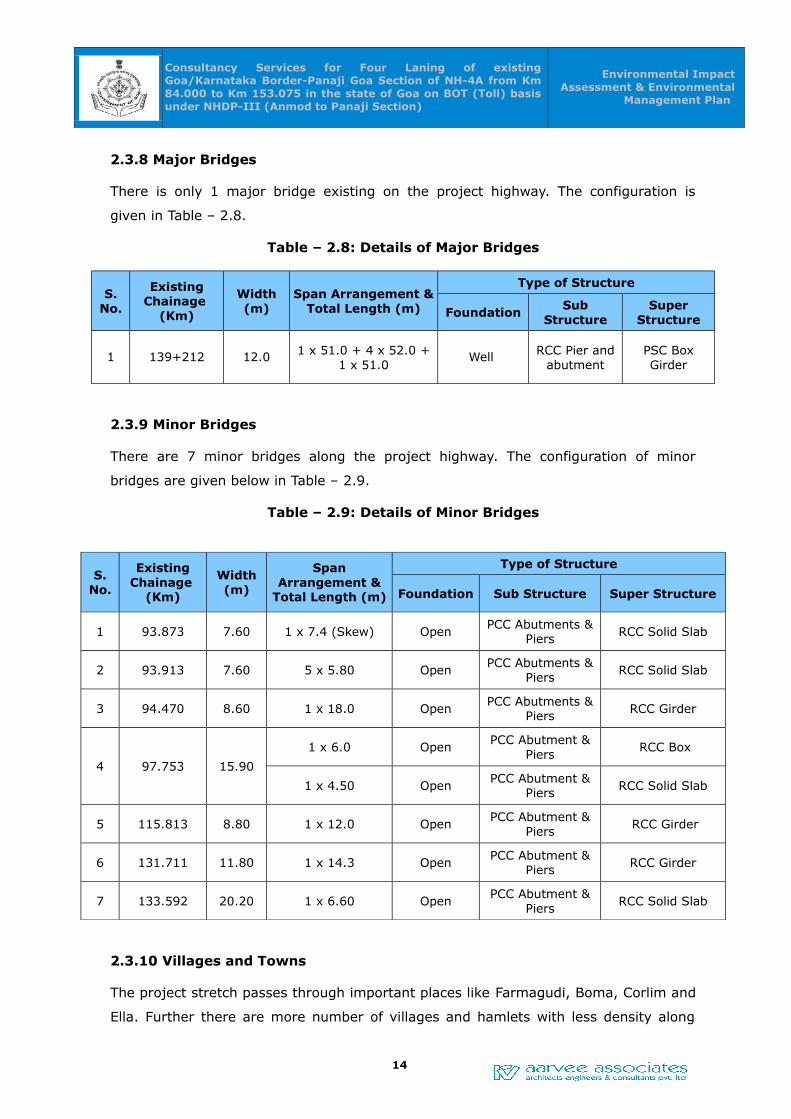
2.3.8 Major Bridges
There is only 1 major bridge existing on the project highway. The configuration is
given in Table – 2.8.
Table – 2.8: Details of Major Bridges
S. No.
Existing Chainage
(Km)
Width (m)
Span Arrangement & Total Length (m)
Type of Structure
FoundationSub
StructureSuper
Structure
1 139+212 12.0 1 x 51.0 + 4 x 52.0 + 1 x 51.0
Well RCC Pier and abutment
PSC Box Girder
2.3.9 Minor Bridges
There are 7 minor bridges along the project highway. The configuration of minor
bridges are given below in Table – 2.9.
Table – 2.9: Details of Minor Bridges
S. No.
Existing Chainage
(Km)
Width (m)
Span Arrangement &
Total Length (m)
Type of Structure
Foundation Sub Structure Super Structure
1 93.873 7.60 1 x 7.4 (Skew) OpenPCC Abutments &
Piers RCC Solid Slab
2 93.913 7.60 5 x 5.80 OpenPCC Abutments &
PiersRCC Solid Slab
3 94.470 8.60 1 x 18.0 OpenPCC Abutments &
Piers RCC Girder
4 97.753 15.90
1 x 6.0 OpenPCC Abutment &
Piers RCC Box
1 x 4.50 OpenPCC Abutment &
Piers RCC Solid Slab
5 115.813 8.80 1 x 12.0 OpenPCC Abutment &
Piers RCC Girder
6 131.711 11.80 1 x 14.3 OpenPCC Abutment &
Piers RCC Girder
7 133.592 20.20 1 x 6.60 OpenPCC Abutment &
PiersRCC Solid Slab
2.3.10 Villages and Towns
The project stretch passes through important places like Farmagudi, Boma, Corlim and
Ella. Further there are more number of villages and hamlets with less density along
14

Consultancy Services for Four Laning of existing Goa/Karnataka Border-Panaji Goa Section of NH-4A from Km 84.000 to Km 153.075 in the state of Goa on BOT (Toll) basis under NHDP-III (Anmod to Panaji Section)
Environmental Impact Assessment & Environmental
Management Plan
the project stretch and the list of villages and their locations in each section are given
in the below table 2.10.
Table 2.10: List of Villages and towns
S. No.Name of Township
Location (Km)Length (m)
From To
1 Mollem 96.300 96.900 0.6
2 Dharbandora 108.600 110.200 1.6
3 Pratapnagar 113.700 114.300 0.6
4 Dhatwada 115.500 116.700 1.2
5 Kurdsagar 116.700 118.000 1.3
6 Ponda 125.000 125.400 0.4
7 Shivnery 126.000 126.400 0.4
8 Farmagudi 126.400 127.100 0.7
9 Mardol 130.300 131.000 0.7
10 Cundaim 134.100 135.000 0.9
11 Boma 135.000 136.400 1.4
12 Muslimwada 136.400 137.100 0.7
13Dulaphi-Corlim 138.800 139.200 0.4
14 Corlim 139.200 141.300 2.1
15 Ella 141.300 141.900 0.6
2.3.11 Road Geometry
It is observed that the project highway has a straight and curved alignments and
traverses through a mix of hilly, highly rolling and plain terrains. All the horizontal
curves confirm to acceptable geometric standards in terms of super elevation. The
project stretch has horizontal and vertical curves at various locations in the stretch and
the same will be addressed in the current up gradation proposal.
2.3.12 Major Junctions
Along the project corridor, a number of access roads from adjacent towns / villages
lead to the existing highway, which may necessitate provision of at grade intersections
and flyovers. The Traffic profile along the sections under study is as given in Table–
2.11. and the list of major junctions identified are given in Table–2.12.
15

Consultancy Services for Four Laning of existing Goa/Karnataka Border-Panaji Goa Section of NH-4A from Km 84.000 to Km 153.075 in the state of Goa on BOT (Toll) basis under NHDP-III (Anmod to Panaji Section)
Environmental Impact Assessment & Environmental
Management Plan
Table 2.11: Summary of Annual Average Daily Traffic (AADT)
Vehicle TypeAnmod-Panaji
Km 96.600 Km 133.000 Km 140.000
Tollable Traffic (vehicles) 2734 9830 17545
Tollable Traffic (PCU's) 5120 15032 22893
Total Traffic (Vehicles) 3253 14664 29100
Total Traffic
(PCU's)5389 17498 28748
Table.2.12: Major Traffic Junctions along the Project Corridor
S.No.
LocationType
Category of Cross Road
From Km To Km NH SH MDR Others
1 96.600 X - Junction MDR-33
2 101.500 T - Junction Other
3 102.950 T - Junction Other
4 109.000 T - Junction SH-7
5 112.630 X - Junction Other
6 114.450 Y - Junction SH-3
7 116.000 Y – Junction Other
8 126.450 Y - JunctionLink Road to
NH-17B
9 127.100 Y - Junction NH-17B
10 127.800 Staggered Other
11 131.350 T - Junction Other
12 131.700 X - Junction MDR-31
13 133.400 Y - Junction Other
14 134.600 X - Junction Other
15 135.550 T - Junction Other
16 139.000 T - Junction MDR-29
17 140.400 Staggered Other
(NH: National Highway, SH: State Highway, MDR: Major District Road)
16

Consultancy Services for Four Laning of existing Goa/Karnataka Border-Panaji Goa Section of NH-4A from Km 84.000 to Km 153.075 in the state of Goa on BOT (Toll) basis under NHDP-III (Anmod to Panaji Section)
Environmental Impact Assessment & Environmental
Management Plan
2.3.13 Terrain Junctions:
The design speed given in the below table 2.13 shall be adopted for various conditions
as per IRC: SP: 84-2014.
Table – 2.13: Design Speed
Nature of TerrainCross slope of the
country (per cent)
Design Speed (kmph)
Ruling Minimum
Plain & Rolling Upto 25 100 80
Mountainous &
Steep
More than 25 60 40
2.3.14 ROB/RUB along the Project Corridor:
The project stretch consists of 1 ROB and no RUB's existing in the proposed sections.
2.3.15 Existing Alignment
It is observed that the project highway has a straight and curved alignments and
traverses through a mix of hilly, highly rolling and plain terrains. All the horizontal
curves confirm to acceptable geometric standards in terms of super elevation. The
project stretch has horizontal and vertical curves at various locations in the stretch and
the same will be addressed in the current up gradation proposal.
2.3.16 Right of Way:
The Right of Way pillars were observed at few locations along the project stretch. The
Right of Way details shall be ascertained from the revenue records to clarify on the
exact land availability for construction of 4/6-lane. Since it is passing through Wild Life
Sanctuary, Forest, an urban section acquiring 60 m land will be difficult, in that case
development will be made within the available right of way or in minimum right of way.
Considering the above constraints TCS is developed. Proposed Right of Way (PROW)
details as given in the table no. 2.14.
Table-2.14: Proposed Right of Way (PROW) details
S. No.Existing Chainage (Km)
PROW RemarksFrom To Length
1 84.000 96.000 12.000 26 Forest/WLS land2 96.000 118.000 22.000 45 Open/Industries Land3 126.120 127.670 1.550 45 VUP @ Km 125.380 to Bus-
stand & Road to NH-17B4 127.670 128.470 0.800 30 Formagudi Built-up area5 128.470 136.720 8.250 45 Open Land6 136.720 138.600 1.880 30 Boma Built-up area
17
Consultancy Services for Four Laning of existing Goa/Karnataka Border-Panaji Goa Section of NH-4A from Km 84.000 to Km 153.075 in the state of Goa on BOT (Toll) basis under NHDP-III (Anmod to Panaji Section)
Environmental Impact Assessment & Environmental
Management Plan
7 138.600 141.400 2.800 45 Open Land8 141.400 144.300 2.900 30 Old Goa, Corlim & Ella Built-up
areaAdditional land acquisition shall be proposed based on the project requirements and in
line with ToR/PWD, Goa guidelines. Some of the existing road assets/facilities along
project road may need to be re established based on the various up-gradation
proposals. Based on the field verification the existing RoW varies from 8.0 to 10.0 m in
Ghat area, 12.0 to 30 m in rural and urban area.
• Additional Land Acquisition
• Bus bays and lay bays (if required)
• Underpasses and Service roads (if required)
• Proposed Bypasses
• Realignment Under sections
• Toll Plaza
• Rest Areas
2.4 Traffic Study Report
The road network has been thoroughly studied during the reconnaissance stage. There
are four existing toll plazas along the project corridor. In order to capture the entire
traffic it may be necessary to allow more toll plazas or change the existing locations.
In order to assess the requirement of setting up additional/ new toll plazas, the
Consultants have carried out Classified Traffic Volume Count surveys at 3 strategic
points as given below.
• Mollem, Km. 96.600
• Mardol, Km. 133.000
• Old Goa, Km. 140.000
On NH-4A Trained personnel monitored the TVCs round the clock for 7 days. To
capture the traffic and travel characteristics of predominant category of vehicles,
Origin-Destination surveys by Road side Interview (RSI) method and Number Plate
(NP) method are conducted along the project stretch. Origin-Destination and
commodity movement surveys for Anmod-Panaji section are conducted at 2 locations
namely Km. 96.600, Km. and Km. 140.000 on NH-4A was conducted for a period of 24
hours.
18

Consultancy Services for Four Laning of existing Goa/Karnataka Border-Panaji Goa Section of NH-4A from Km 84.000 to Km 153.075 in the state of Goa on BOT (Toll) basis under NHDP-III (Anmod to Panaji Section)
Environmental Impact Assessment & Environmental
Management Plan
The traffic is projected for a design period of 30 years and the pavement is designed
for the same. In order to assess the future traffic, based on present traffic, traffic
surveys were carried out and analysis was done as per the stipulation of TOR. The
present annual average daily traffic pertaining to the year 2015-16 and the projected
traffic for the year 2045 – 46 is presented in Table -2.15.
19

Consultancy Services for Four Laning of existing Goa/Karnataka Border-Panaji Goa Section of NH-4A from Km 84.000 to Km 153.075 in the state of Goa on BOT (Toll) basis under NHDP-III (Anmod to Panaji Section)
Environmental Impact Assessment & Environmental Management Plan
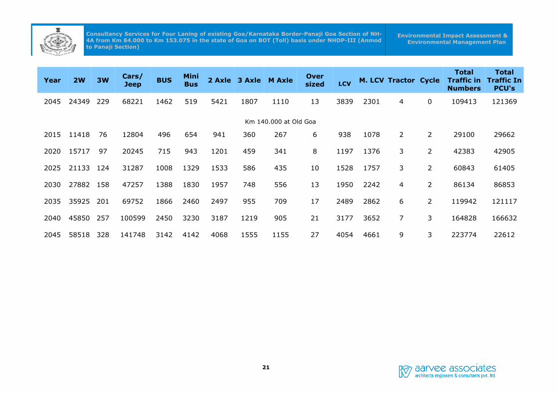
Table-2.15: Traffic Projections
Year 2W 3WCars/Jeep BUS
Mini Bus 2 Axle 3 Axle M Axle
Over sized LCV M. LCV Tractor Cycle
Total Traffic in Numbers
Total Traffic In
PCU's
Km 96.600 at Mollem
2015 513 1 1339 188 31 336 328 151 0 279 82 0 2 3249 5424
2020 706 1 2117 315 45 429 418 192 0 356 105 0 2 4642 7464
2025 949 2 3271 382 63 547 534 246 0 454 134 0 2 6584 10246
2030 1252 2 4941 527 87 698 681 314 0 579 171 0 2 9254 13996
2035 1613 3 7293 708 117 891 869 400 0 740 218 0 2 12854 18983
2040 2059 4 10517 930 153 1138 1109 511 0 944 278 0 3 17646 25528
2045 2627 4 14819 1192 196 1452 1416 652 0 1205 355 0 3 23923 33997
Km 133.000 at Mardol
2015 4751 53 6164 231 82 1254 418 257 3 888 532 1 0 14664 17583
2020 6540 68 9745 333 118 1601 534 328 4 1134 680 1 0 21122 24713
2025 8793 86 15060 469 167 2043 681 418 5 1447 867 2 0 30087 34566
2030 11601 110 22746 646 229 2607 869 534 6 1846 1107 2 0 42368 48022
2035 14948 141 33572 868 308 3328 1109 682 8 2357 1413 3 0 58818 66081
2040 19078 180 48417 1140 405 4247 1416 870 11 3008 1803 4 0 80684 90038
20
Consultancy Services for Four Laning of existing Goa/Karnataka Border-Panaji Goa Section of NH-4A from Km 84.000 to Km 153.075 in the state of Goa on BOT (Toll) basis under NHDP-III (Anmod to Panaji Section)
Environmental Impact Assessment & Environmental Management Plan
Year 2W 3WCars/Jeep BUS
Mini Bus 2 Axle 3 Axle M Axle
Over sized LCV M. LCV Tractor Cycle
Total Traffic in Numbers
Total Traffic In
PCU's
2045 24349 229 68221 1462 519 5421 1807 1110 13 3839 2301 4 0 109413 121369
Km 140.000 at Old Goa
2015 11418 76 12804 496 654 941 360 267 6 938 1078 2 2 29100 29662
2020 15717 97 20245 715 943 1201 459 341 8 1197 1376 3 2 42383 42905
2025 21133 124 31287 1008 1329 1533 586 435 10 1528 1757 3 2 60843 61405
2030 27882 158 47257 1388 1830 1957 748 556 13 1950 2242 4 2 86134 86853
2035 35925 201 69752 1866 2460 2497 955 709 17 2489 2862 6 2 119942 121117
2040 45850 257 100599 2450 3230 3187 1219 905 21 3177 3652 7 3 164828 166632
2045 58518 328 141748 3142 4142 4068 1555 1155 27 4054 4661 9 3 223774 22612
21
Consultancy Services for Four Laning of existing Goa/Karnataka Border-Panaji Goa Section of NH-4A from Km 84.000 to Km 153.075 in the state of Goa on BOT III (Anmod to Panaji Section)
Environmental Impact Assessment & Environmental
Management Plan
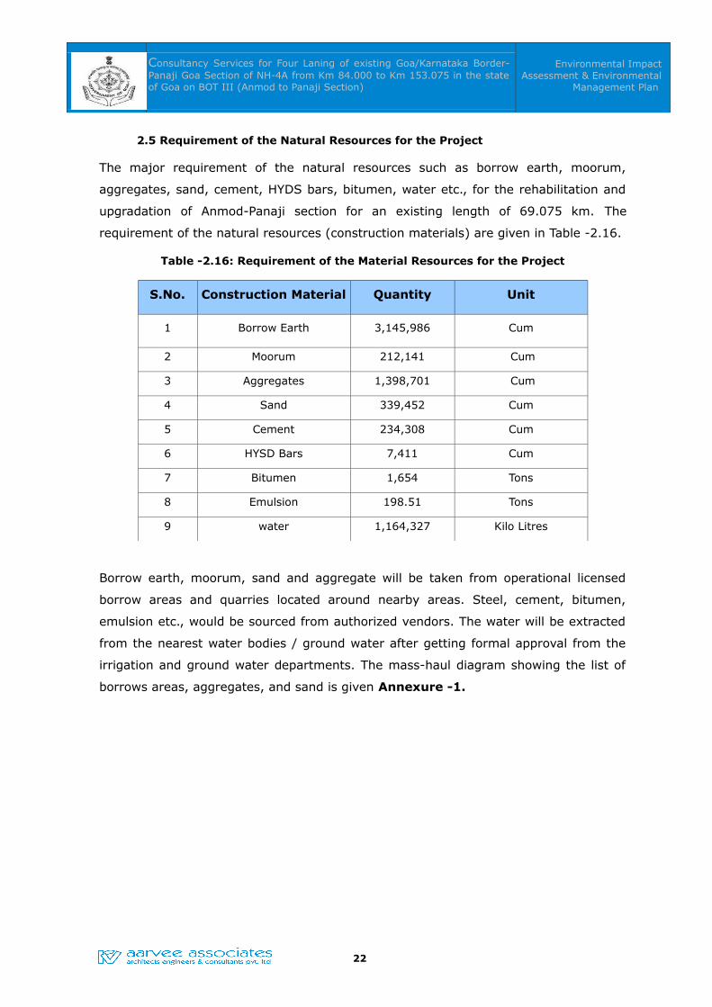
2.5 Requirement of the Natural Resources for the Project
The major requirement of the natural resources such as borrow earth, moorum,
aggregates, sand, cement, HYDS bars, bitumen, water etc., for the rehabilitation and
upgradation of Anmod-Panaji section for an existing length of 69.075 km. The
requirement of the natural resources (construction materials) are given in Table -2.16.
Table -2.16: Requirement of the Material Resources for the Project
S.No. Construction Material Quantity Unit
1 Borrow Earth 3,145,986 Cum
2 Moorum 212,141 Cum
3 Aggregates 1,398,701 Cum
4 Sand 339,452 Cum
5 Cement 234,308 Cum
6 HYSD Bars 7,411 Cum
7 Bitumen 1,654 Tons
8 Emulsion 198.51 Tons
9 water 1,164,327 Kilo Litres
Borrow earth, moorum, sand and aggregate will be taken from operational licensed
borrow areas and quarries located around nearby areas. Steel, cement, bitumen,
emulsion etc., would be sourced from authorized vendors. The water will be extracted
from the nearest water bodies / ground water after getting formal approval from the
irrigation and ground water departments. The mass-haul diagram showing the list of
borrows areas, aggregates, and sand is given Annexure -1.
22
Consultancy Services for Four Laning of existing Goa/Karnataka Border-Panaji Goa Section of NH-4A from Km 84.000 to Km 153.075 in the state of Goa on BOT III (Anmod to Panaji Section)
Environmental Impact Assessment & Environmental
Management Plan
CHAPTER -3CHAPTER -3
REVIEW OF ENVIRONMENTAL REGULATORY REQUIREMENTS,REVIEW OF ENVIRONMENTAL REGULATORY REQUIREMENTS,
POLICIES & GUIDELINESPOLICIES & GUIDELINES
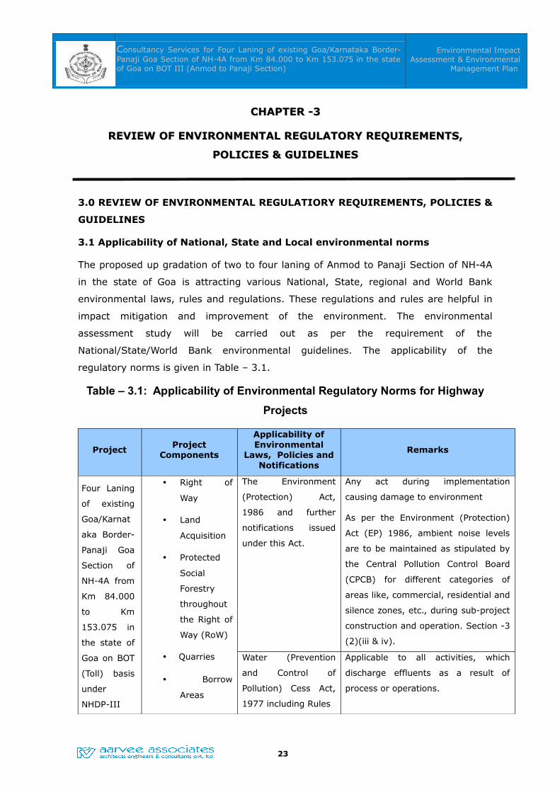
3.0 REVIEW OF ENVIRONMENTAL REGULATIORY REQUIREMENTS, POLICIES &
GUIDELINES
3.1 Applicability of National, State and Local environmental norms
The proposed up gradation of two to four laning of Anmod to Panaji Section of NH-4A
in the state of Goa is attracting various National, State, regional and World Bank
environmental laws, rules and regulations. These regulations and rules are helpful in
impact mitigation and improvement of the environment. The environmental
assessment study will be carried out as per the requirement of the
National/State/World Bank environmental guidelines. The applicability of the
regulatory norms is given in Table – 3.1.
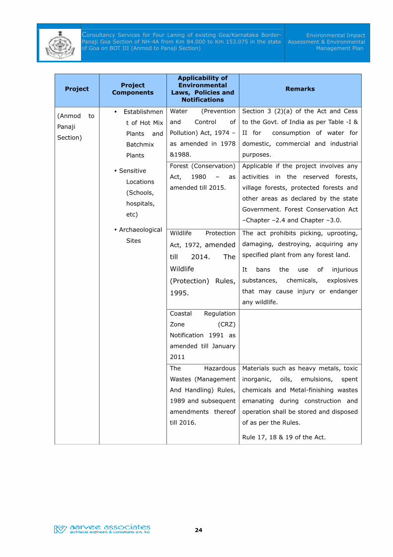
Table – 3.1: Applicability of Environmental Regulatory Norms for Highway
Projects
Project Project Components
Applicability of Environmental
Laws, Policies and Notifications
Remarks
Four Laning
of existing
Goa/Karnat
aka Border-
Panaji Goa
Section of
NH-4A from
Km 84.000
to Km
153.075 in
the state of
Goa on BOT
(Toll) basis
under
NHDP-III
• Right of
Way
• Land
Acquisition
• Protected
Social
Forestry
throughout
the Right of
Way (RoW)
• Quarries
• Borrow
Areas
The Environment
(Protection) Act,
1986 and further
notifications issued
under this Act.
Any act during implementation
causing damage to environment
As per the Environment (Protection)
Act (EP) 1986, ambient noise levels
are to be maintained as stipulated by
the Central Pollution Control Board
(CPCB) for different categories of
areas like, commercial, residential and
silence zones, etc., during sub-project
construction and operation. Section -3
(2)(iii & iv).
Water (Prevention
and Control of
Pollution) Cess Act,
1977 including Rules
Applicable to all activities, which
discharge effluents as a result of
process or operations.
23
Consultancy Services for Four Laning of existing Goa/Karnataka Border-Panaji Goa Section of NH-4A from Km 84.000 to Km 153.075 in the state of Goa on BOT III (Anmod to Panaji Section)
Environmental Impact Assessment & Environmental
Management Plan
ProjectProject
Components
Applicability of Environmental
Laws, Policies and Notifications
Remarks
(Anmod to
Panaji
Section)
• Establishmen
t of Hot Mix
Plants and
Batchmix
Plants
• Sensitive
Locations
(Schools,
hospitals,
etc)
• Archaeological
Sites
Section 3 (2)(a) of the Act and Cess
to the Govt. of India as per Table -I &
II for consumption of water for
domestic, commercial and industrial
purposes.
Water (Prevention
and Control of
Pollution) Act, 1974 –
as amended in 1978
&1988.
Forest (Conservation)
Act, 1980 – as
amended till 2015.
Applicable if the project involves any
activities in the reserved forests,
village forests, protected forests and
other areas as declared by the state
Government. Forest Conservation Act
–Chapter –2.4 and Chapter –3.0.
Wildlife Protection
Act, 1972, amended
till 2014. The
Wildlife
(Protection) Rules,
1995.
The act prohibits picking, uprooting,
damaging, destroying, acquiring any
specified plant from any forest land.
It bans the use of injurious
substances, chemicals, explosives
that may cause injury or endanger
any wildlife.
Coastal Regulation
Zone (CRZ)
Notification 1991 as
amended till January
2011
The Hazardous
Wastes (Management
And Handling) Rules,
1989 and subsequent
amendments thereof
till 2016.
Materials such as heavy metals, toxic
inorganic, oils, emulsions, spent
chemicals and Metal-finishing wastes
emanating during construction and
operation shall be stored and disposed
of as per the Rules.
Rule 17, 18 & 19 of the Act.
24

Consultancy Services for Four Laning of existing Goa/Karnataka Border-Panaji Goa Section of NH-4A from Km 84.000 to Km 153.075 in the state of Goa on BOT III (Anmod to Panaji Section)
Environmental Impact Assessment & Environmental
Management Plan
ProjectProject
Components
Applicability of Environmental
Laws, Policies and Notifications
Remarks
The Public Liability
Insurance Act, 1991.
Act enables the people to access legal
aid to claim compensation in the
event of an accident occurred while
handling any hazardous substance. So
insurance needs to be taken up by the
project implementing agencies or
contractors.
PLI Act: Act 6 of 1991 as amended by
Act 11 of 1992.
World Bank
Operational Directive
and Operational
Policies for
Environmental
Impact Assessment
(4.01), Operational
Policy on cultural
property (4.11) and
forestry (4.36) for
highways up
gradation projects.
Applicable in preparation of
Environmental assessment report,
protection of cultural property, forest
clearances etc.
WB OD and OP – 4.01, 411 & 4.36
Ministry of
Environment &
Forests (MoEF) EIA
Notification (New)
issued on 14th
September, 2006 and
subsequent
amendments thereof
till date.
Applicable
Noise Pollution
(Regulation and
Control) Rules, 2000
Applicable
Under Rule 3(1) & 4 (1) - Clause 2, 3
& 6.
25

Consultancy Services for Four Laning of existing Goa/Karnataka Border-Panaji Goa Section of NH-4A from Km 84.000 to Km 153.075 in the state of Goa on BOT III (Anmod to Panaji Section)
Environmental Impact Assessment & Environmental
Management Plan
ProjectProject
Components
Applicability of Environmental
Laws, Policies and Notifications
Remarks
Land Acquisition Act
1894
Land Acquisition,
Rehabilitation and
Resettlement Act,
2013
Applicable.
To set out rules for the acquisition of
land by Government.
Motor Vehicles Act,
1988
Rules of Road
Regulations, 1989
Applicable.
To enforce highway codes during
construction and operation.
3.2 Requirements of Environmental Clearance
Environmental Impact Assessment (EIA) Notification issued on 14th September 2006
(amended) by the MoEF, Govt., of India and as per the amended Notification of the
MoEF on 22nd August 2013 on Highway projects. New, expansion or modernization of
any activity falling within the 32 categories of developmental and industrial activities
shall be undertaken in any part of India only after it has been accorded environmental
clearance by the MoEF in accordance with the procedures specified in the notification.
Among the 32 categories listed in Schedule -1 of Notification, the proposed Four
Laning of existing Goa/Karnataka Border-Panaji Goa Section of NH-4A from Km 84.000
to Km 153.075 in the state of Goa on BOT (Toll) basis under NHDP-III (Anmod to
Panaji Section) project will not attract the Environmental Clearance from MoEF, as the
project is less than 100 Km length (See Box -1).
As per the amended Notification on 22nd August, 2013, the highways improvement/
up gradation project of this magnitude needs to prepare the EIA/EMP report as per the
model ToR given in MoEF website in order to safeguard the interests of the
environment and it will also acts as an environmental guide to the Project Proponent &
Environment Interested Groups/ NGOs. The World Bank operational policies also
suggest having an environmental assessment and management frame work in all the
development projects.
Box -1:
Categorization of projects and activities
26
Consultancy Services for Four Laning of existing Goa/Karnataka Border-Panaji Goa Section of NH-4A from Km 84.000 to Km 153.075 in the state of Goa on BOT III (Anmod to Panaji Section)
Environmental Impact Assessment & Environmental
Management Plan
i) All projects and activities are broadly categorized into two categories-Category A and Category B
ii) Category A: Expansion of National Highways greater than 30 Km involving additional right of way
greater than 20m involving land acquisition.
ii) Category B: All State Highway Projects & State Highway expansion projects in hilly terrain (above
1000m AMSL)
iii) & / or ecologically sensitive areas.
iv) All projects or activities included as Category ‘A’ shall require prior environmental
clearance from the Central Government in the MOEF on the recommendations of an Expert
Appraisal Committee (EAC).
v) All projects or activities included as Category ‘B’ will require prior environmental clearance from
the State/Union territory Environment Impact Assessment Authority (SEIAA).
Amended Notification:
As per the amended Notification of the MoEF on 22nd August 2013 on Highway projects - “Expansion
of National Highways greater than 100 Km involving additional Right of Way or land acquisition
greater than 40 m on existing alignment and 60 m on re-alignments or bypasses”.
The proposed highway up gradation / improvement project needs to get approvals
from Goa State Pollution Control Board (GSPCB) are i.e., No Objection Certificates
(NOC), Consent for Establishment (CFE) and Consent for Operation (CFO) for
establishment and operation of Hot mix plants, batch mix plants, quarries etc. during
the construction phase of the project.
3.3 Forest Clearances
Forest (Conservation) Act, 1980 (amended in 1988) enacted by Government of India,
restricts the de-reservation of forests for use of non-forest purposes. According to the
Act, State Government requires prior approval of GoI for the use of forest land for
non-forest purposes (means the breaking up or clearing of any forest land) or for
assigning least to any private person or agency not controlled by government. The
Forest (Conservation) Rules, 2003 issued under this Act, provide specific procedures to
be followed for conversion of forest land for non-forest purposes.
Limited sub-projects may require acquisition of forest land. The forest land conversion
will follow the “Guidelines for Diversion of Forest Lands for Non-Forest Purpose” under
Forest (Conservation) Act, 1980. Compensatory afforestation is one of the most
important conditions stipulated for diversion of forest land. The conditions of forest
diversion proposals are summarized in Table -3.2.
27
Consultancy Services for Four Laning of existing Goa/Karnataka Border-Panaji Goa Section of NH-4A from Km 84.000 to Km 153.075 in the state of Goa on BOT III (Anmod to Panaji Section)
Environmental Impact Assessment & Environmental
Management Plan
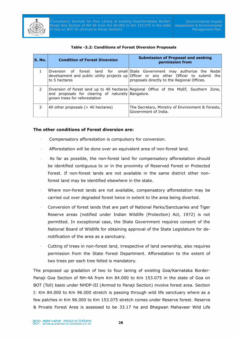
Table -3.2: Conditions of Forest Diversion Proposals
S. No. Condition of Forest Diversion Submission of Proposal and seeking permission from
1 Diversion of forest land for small development and public utility projects up to 5 hectares
State Government may authorize the Nodal Officer or any other Officer to submit the proposals directly to the Regional Offices.
2 Diversion of forest land up to 40 hectares and proposals for clearing of naturally grown trees for reforestation
Regional Office of the MoEF, Southern Zone, Bangalore.
3 All other proposals (> 40 hectares) The Secretary, Ministry of Environment & Forests, Government of India.
The other conditions of Forest diversion are:
Compensatory afforestation is compulsory for conversion.
Afforestation will be done over an equivalent area of non-forest land.
As far as possible, the non-forest land for compensatory afforestation should
be identified contiguous to or in the proximity of Reserved Forest or Protected
Forest. If non-forest lands are not available in the same district other non-
forest land may be identified elsewhere in the state.
Where non-forest lands are not available, compensatory afforestation may be
carried out over degraded forest twice in extent to the area being diverted.
Conversion of forest lands that are part of National Parks/Sanctuaries and Tiger
Reserve areas (notified under Indian Wildlife (Protection) Act, 1972) is not
permitted. In exceptional case, the State Government requires consent of the
National Board of Wildlife for obtaining approval of the State Legislature for de-
notification of the area as a sanctuary.
Cutting of trees in non-forest land, irrespective of land ownership, also requires
permission from the State Forest Department. Afforestation to the extent of
two trees per each tree felled is mandatory.
The proposed up gradation of two to four laning of existing Goa/Karnataka Border-
Panaji Goa Section of NH-4A from Km 84.000 to Km 153.075 in the state of Goa on
BOT (Toll) basis under NHDP-III (Anmod to Panaji Section) involve forest area. Section
I: Km 84.000 to Km 96.000 stretch is passing through wild life sanctuary where as a
few patches in Km 96.000 to Km 153.075 stretch comes under Reserve forest. Reserve
& Private Forest Area is assessed to be 33.17 ha and Bhagwan Mahaveer Wild Life
28
Consultancy Services for Four Laning of existing Goa/Karnataka Border-Panaji Goa Section of NH-4A from Km 84.000 to Km 153.075 in the state of Goa on BOT III (Anmod to Panaji Section)
Environmental Impact Assessment & Environmental
Management Plan
Sanctuary Area is assessed to be 31.01 ha. Hence, Forest land acquisition is greater
than 40 ha. Permission to be obtained from MoEF&CC, New Delhi.
3.3.1 Bhagwan Mahaveer Wild Life Sanctuary Clearance Requirements:
This protected area located in the Western Ghats of South India, in Sanguem taluk,
Goa along the eastern border with Karnataka with an area of 240 sq.km Initially, it
was notified as a Sanctuary (Molem Wildlife Sanctuary) in 1967. Subsequently an area
of 107 sq.km. of the said Sanctuary was notified as the Molem National Park in 1978.
Later, the name was changed to Bhagwan Mahaveer Wildlife Sanctuary and National
Park. It is located between 15°15"30' to 15°29"30' N and 74°10"15' to 74°20"15' E.
The area is situated near the town of Molem, 57 kilometres east of Panaji, the state
capital of Goa. National Highway 4A divides it into two parts and the Mormugao -
Londa railway line passes through the area. The Section I - stretch of the project is
passing through wild life sanctuary from Km. 84.000 to Km 96.000 and the sanctuary
area assessed to be diverted is 31.01 ha, hence, the NOC / permission is required
from the State Board of Wildlife (SBWL) and National Board of Wildlife (NBWL). At this
juncture, the Consultant is in the process of collection of data and preparation of the
Wild Life Sanctuary clearance proposal, which will be submitted to the Deputy
Conservator of Forests, Bhagwan Mahaveer wildlife division, Panaji and subsequently
to the SBWL, Goa and NBWL, New Delhi.
3.3.2 Coastal Regulation Zone (CRZ) Clearance
As per the CRZ Notification 1991 and subsequent amendments till January 2011, the
coastal stretches of seas, bays, estuaries, creeks, rivers and backwaters which are
influenced by tidal action (in the landward side) up to 500 metres from the High Tide
Line (HTL) and the land between the Low Tide Line (LTL) and the HTL as Coastal as
Regulation Zone; and imposes with effect from the date of this Notification, the
restrictions on the setting up and expansion of industries, operations or processes, etc.
in the said Coastal Regulation Zone (CRZ).
In the project, creek is falling at Kumbarjuwa canal along chainage 134.30 Km to
139.1 Km from Banastari Bridge at Dulab to Bhoma in Ponda Taluka. As per the NIO,
Goa study:
• Dense mangrove are seen along this bank. (Plates 22A, 22B, 23A, 23B, 24A, &
24B) (Fig. 2G).
• Coconut plantation is seen along the marsh land (Plate 25B).
29

Consultancy Services for Four Laning of existing Goa/Karnataka Border-Panaji Goa Section of NH-4A from Km 84.000 to Km 153.075 in the state of Goa on BOT III (Anmod to Panaji Section)
Environmental Impact Assessment & Environmental
Management Plan
• The chainage from 136.7 Km to 138.8 Km falls in CRZ area, hence it attract
CRZ legislation.
As per the Notification, the project stretch is falling under CRZ -I as; “National parks,
marine parks, sanctuaries, reserve forests, wildlife habitats and other protected areas
under the provisions of Wild Life (Protection) Act, 1972 (53 of 1972), the Forest
(Conservation) Act, 1980 (69 of 1980) or Environment (Protection) Act, 1986 (29 of
1986)”
The procedure for CRZ clearance of permissible activities of the proposed project will
be followed as per the Notification. At this juncture, the Consultant is already
submitted the Form-1 along with CRZ map covering 7Km radius around the project
site. The CRZ map indicating the CRZ-I, II, III and IV was done through the MoEF &
CC empanelled agency namely National Institute of Oceanography, Goa. The NIO, Goa
has prepared CRZ map along with the report as per the requirements of the MoEF&CC.
3.4 Other Permissions/Clearances
The project proposes to Four Laning of existing Goa/Karnataka Border-Panaji Goa
Section of NH-4A in the state of Goa, where the investments intervene with various
other utilities already in place. In such areas the project implementing agency will
ensure the following clearances before initiating the works.
Permission from I& CADD for new and widening cases and to draw water during
the construction period.
All the borrow areas, quarries, sand mines proposed to be utilized in the project
shall get the permissions from respective departments /owners.
Permission for breaking or shifting of public utilities like sewer lines or water
pipe lines from water supply and sewerage boards.
Permission and clearance from electricity board for shifting/ moving of
streetlights and transformers during widening of roads or construction of fly
over or pedestrian ways or any other likely sub projects.
30
Consultancy Services for Four Laning of existing Goa/Karnataka Border-Panaji Goa Section of NH-4A from Km 84.000 to Km 153.075 in the state of Goa on BOT III (Anmod to Panaji Section)
Environmental Impact Assessment & Environmental
Management Plan
CHAPTER -04CHAPTER -04
ANALYSIS OF ALTERNATIVES
4.0 ANALYSIS OF ALTERNATIVES
Proposed project is not having any bypasses except for realignments between the
stretch from Km 84.000 to Km 96.000 (Section 1). Thorough analysis of various
alternatives for realignment & widening of the project road is evaluated considering
various features such as Techno-economic feasibility, Geometric alignment,
Construction time, Environment & social aspects etc. The alternative analysis is mainly
aimed to mitigate the adverse social & environmental impacts in the project and make
technically feasible, economic & financially viable and social & environmentally
acceptable alternative.
Map studies and detailed investigations of the influence area were carried out for iden-
tifying the existing road network, land use pattern and industrial activities along the
project corridor. Different alignment options are considered, evaluated and recommen-
dations are presented in Table – 4.1. The improvement scheme of the options are
mentioned below. For the purpose of horizontal design, the project road is divided into
various sections out of which Section – I needs realignment.
Section – I: Km 84.000 to 96.000 (Mountainous/Steep terrain)
The Project Highway starts with mountainous/steep terrain form at Km 84+000 near
Goa/Karnataka border. Existing alignment has substandard horizontal as well as verti-
cal geometry due to steep terrain from Km 84.000 to Km 94+000. There are hairpin
bends, where the speed is about 20 kmph.
The consultants have studied in details for improving the horizontal geometry of exist-
ing 2 lane carriageway as well as new 2 lane carriageway in consultation with the
PWD, Goa. The stretch under consideration is passing through wild life sanctuary.
Hence, following options were studied for improvement proposal.
Option – 1: Widening on hill side
Hard rock outcrop is visible in this stretch. For widening new carriageway on hill side
requires blasting operations and frequent closing of live traffic. Further, blasting may
pose sever impact on wild life in surrounding area.
There are locations, where landslides also observed in this stretch. Widening on hill
31
Consultancy Services for Four Laning of existing Goa/Karnataka Border-Panaji Goa Section of NH-4A from Km 84.000 to Km 153.075 in the state of Goa on BOT III (Anmod to Panaji Section)
Environmental Impact Assessment & Environmental
Management Plan
side may result in heavy breast walls.
Option – 2: Widening on Valley side without improving the existing
Widening on valley side do not requires closing live traffic. It will have minimum im-
pact on wild life, since it do not requires any blasting operations.
Widening new carriageway on valley side requires construction of either retaining wall
or via-duct to support new carriageway.
To have minimum impact on local environment and ease of construction, the consul-
tants have proposed via-duct for the new carriageway. It be independent of existing
carriageway (no common median) and will comply with geometric standards stipulated
in 4 laning manual.
Option – 3: Widening on Valley side with realignments
Cost of viaduct is directly proportional to the length of via-duct. The consultants have
studied in detail for feasibility of shortening the length of via-duct within permissible
gradients. After detailed study at site, based on the topographical survey and prelimi-
nary design of vertical alignment, it was identified that from Km 89 to Km 92 can be
connected with smooth geometry within permissible gradients. Based on above three
options, Option 3 is most feasible, even though the construction cost is higher than the
options 1&2. Merits and demerits for the proposed options of re-alignment are given
in the table no. 4.1.
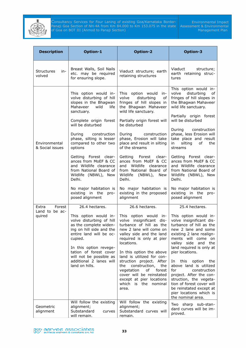
Table – 4.1: Merits and Demerits
Description Option-1 Option-2 Option-3
Traffic Management
Road closure during blasting and removal of debris operations
Road closure while form-ing ramps on the valley side
Road closure while forming ramps on the valley side
Stability issues
It would not be possi-ble to cut hill to the re-quired slope since that would disturb road on the hill side. Thus, ade-quate slope stabilizing structures are to be provided to prevent landslides.
Existing slopes on hill side are to be stabilized.
Construction of viaduct may not involve any sta-bility related concerns.
Existing slopes on hill side are to be stabi-lized.
Construction of viaduct may not involve any stability related con-cerns
32
Consultancy Services for Four Laning of existing Goa/Karnataka Border-Panaji Goa Section of NH-4A from Km 84.000 to Km 153.075 in the state of Goa on BOT III (Anmod to Panaji Section)
Environmental Impact Assessment & Environmental
Management Plan
Description Option-1 Option-2 Option-3
Structures in-volved
Breast Walls, Soil Nails etc. may be required for ensuring slope.
Viaduct structure; earth retaining structures
Viaduct structure; earth retaining struc-tures
Environmental & Social issues
This option would in-volve disturbing of hill slopes in the Bhagwan Mahaveer wild life sanctuary.
Complete origin forest will be disturbed
During construction phase, silting is lesser compared to other two options
Getting Forest clear-ances from MoEF & CC and Wildlife clearance from National Board of Wildlife (NBWL), New Delhi.
No major habitation is existing in the pro-posed alignment
This option would in-volve disturbing of fringes of hill slopes in the Bhagwan Mahaveer wild life sanctuary.
Partially origin forest will be disturbed
During construction phase, Erosion will take place and result in silting of the streams
Getting Forest clear-ances from MoEF & CC and Wildlife clearance from National Board of Wildlife (NBWL), New Delhi.
No major habitation is existing in the proposed alignment
This option would in-volve disturbing of fringes of hill slopes in the Bhagwan Mahaveer wild life sanctuary.
Partially origin forest will be disturbed
During construction phase, less Erosion will take place and result in silting of the streams
Getting Forest clear-ances from MoEF & CC and Wildlife clearance from National Board of Wildlife (NBWL), New Delhi.
No major habitation is existing in the pro-posed alignment
Extra Forest Land to be ac-quired
26.4 hectares.
This option would in-volve disturbing of hill as the complete widen-ing on hill side and the entire land will be oc-cupied.
In this option revege-tation of forest cover will not be possible as additional 2 lanes will land on hills.
26.6 hectares.
This option would in-volve insignificant dis-turbance of hill as the new 2 lane will come on valley side and the land required is only at pier locations.
In this option the above land is utilized for con-struction project. After the construction, the vegetation of forest cover will be reinstated except at pier locations which is the nominal area.
25.4 hectares.
This option would in-volve insignificant dis-turbance of hill as the new 2 lane and some existing 2 lane realign-ments will come on valley side and the land required is only at pier locations.
In this option the above land is utilized for construction project. After the con-struction, the vegeta-tion of forest cover will be reinstated except at pier locations which is the nominal area.
Geometric alignment
Will follow the existing alignment;Substandard curves will remain.
Will follow the existing alignment;Substandard curves will remain.
Two sharp sub-stan-dard curves will be im-proved.
33
Consultancy Services for Four Laning of existing Goa/Karnataka Border-Panaji Goa Section of NH-4A from Km 84.000 to Km 153.075 in the state of Goa on BOT III (Anmod to Panaji Section)
Environmental Impact Assessment & Environmental
Management Plan
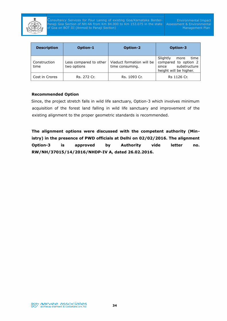
Description Option-1 Option-2 Option-3
Construction time
Less compared to other two options
Viaduct formation will be time consuming.
Slightly more time compared to option 2 since substructure height will be higher.
Cost in Crores Rs. 272 Cr. Rs. 1093 Cr. Rs 1126 Cr.
Recommended Option
Since, the project stretch falls in wild life sanctuary, Option-3 which involves minimum
acquisition of the forest land falling in wild life sanctuary and improvement of the
existing alignment to the proper geometric standards is recommended.
The alignment options were discussed with the competent authority (Min-
istry) in the presence of PWD officials at Delhi on 02/02/2016. The alignment
Option-3 is approved by Authority vide letter no.
RW/NH/37015/14/2016/NHDP-IV A, dated 26.02.2016.
34

Consultancy Services for Four Laning of existing Goa/Karnataka Border-Panaji Goa Section of NH-4A from Km 84.000 to Km 153.075 in the state of Goa on BOT III (Anmod to Panaji Section)
Environmental Impact Assessment & Environmental
Management Plan
35
Consultancy Services for Four Laning of existing Goa/Karnataka Border-Panaji Goa Section of NH-4A from Km 84.000 to Km 153.075 in the state of Goa on BOT III (Anmod to Panaji Section)
Environmental Impact Assessment & Environmental
Management Plan
CHAPTER -05CHAPTER -05
DESCRIPTION OF THE ENVIRONMENT
5.0 ENVIRONENTAL BASELINE STUDIES
This chapter provides an overall description of the existing environmental status in the
study region. Studies will be undertaken to generate baseline data within a 10 Km
radius study region along the proposed project on micro–meteorology, air quality,
ground and surface water quality, noise levels, land environment including soil quality,
geomorphology, land-use pattern, forest cover, biological environment and socio-
economic status of the population, etc. From these inputs, possible significant impacts
are identified. Impacts are quantified and an appropriate Environmental Management
Plan is prepared to manage and mitigate these impacts.
As a primary requirement of EIA process, the EIA report has been prepared based on
the standard ToR given in the “EIA Guidance Manual for Highways” by MoEF, dated
February 2010.
The Baseline Data was collected covering Summer Season from January 2016 to April
2016. M/s. Vison Labs, Hyderabad (A laboratory Recognized by Ministry of
Environment & Forests, Government of India, S.O. 1680 (E), Dated 01.07.2019) was
engaged for the field study of air, water, noise, soil etc. The environmental attributes
covered for the study include ambient air quality, ground and surface water quality,
noise levels, land environment including soil quality, land-use pattern, forest cover,
biological environment, socio-economic and health status of the population,
demography and quality of life. The primary and secondary data of the stated
parameters were collected and analyzed. The Team of Experts from M/s. Aarvee
Associates, approved by Quality Council of India (QCI) - National Accreditation Board
for Education and Training (NABET), visited the site during the study period.
5.1 Site and its Environs
The reconnaissance survey and subsequent field studies are carried out in the study
area and the major aspects emphasized with respect to the geographical, geology &
soil, hydro-geology, river basins, forests & wildlife sanctuaries, transportation, socio-
economic aspects, industries, and climatological conditions of the region are collected
and analyzed. The details of the same are given below:
36
Consultancy Services for Four Laning of existing Goa/Karnataka Border-Panaji Goa Section of NH-4A from Km 84.000 to Km 153.075 in the state of Goa on BOT III (Anmod to Panaji Section)
Environmental Impact Assessment & Environmental
Management Plan
5.1.1 Geographical features
This section contains a detailed description on existing environment of the proposed
project area including physical and biological environment particularly in the study
area. The project area passes through two districts namely North Goa and South Goa
in state of Goa.
Geography of Goa:
Goa encompasses an area of 3,702 km2 (1,429 sq.mi). It lies between the latitudes
14°53′54″ N and 15°40′00″ N and longitudes 73°40′33″ E and 74°20′13″ E. Most of
Goa is a part of the coastal country known as the Konkan, which is an escarpment
rising up to the Western Ghats range of mountains, which separate it from the Deccan
Plateau. The highest point is the Sonsogor, with an altitude of 1,167 metres (3,829 ft).
Goa has a coastline of 101 km (63 mi).
Goa's main rivers are Mandovi, Zuari, Terekhol, Chapora kushavati river and the Sal.
The Mormugao harbour on the mouth of the River Zuari is one of the best natural
harbours in South Asia. The Zuari and the Mandovi are the lifelines of Goa, with their
tributaries draining 69% of its geographic area. These rivers are some of the busiest
rivers in India. Goa has more than forty estuarine, eight marine and about ninety
riverine islands. The total navigable length of Goa's rivers is 253 km (157 mi).
5.1.2 Geology & Soil Characteristics
Geology: Geologically the state constitutes the northwesterly extension of the
granitoid-greenstone terrain of Karnataka, comprising rocks of Precambrian age viz.,
gneisses, migmatites, granitoids, granites, schists, meta-volcanics (both acid and
basic), meta-greywackes, banded ferruginous quartzites associated with
manganiferous phyllites / argillites, limestones, dolomites and thin bands of quartzite
intruded by granite and maficultramafic complex. Deccan Trap is exposed on the NE
border of Goa. Peninsular Gneisses are well exposed in Anmod Ghat section along the
Panaji-Ponda- Londa highway. Qupem in central Goa and Chauri in the south, when
Ranebennur Subgroup of Shimoga belt further extend north and northwesterly into
Goa in response to the variation in their litho-spectrum and in accordance to the
stratigraphic guidelines, they are assigned with the local name called 'Goa Group'
which is further divided into four formations. The rocks of Peninsular Gneissic Complex
and Goa Group are intruded by maficultramafic complexes.
Soil:
Most of Goa's soil cover is made up of laterites rich in ferric-aluminium oxides and
37

Consultancy Services for Four Laning of existing Goa/Karnataka Border-Panaji Goa Section of NH-4A from Km 84.000 to Km 153.075 in the state of Goa on BOT III (Anmod to Panaji Section)
Environmental Impact Assessment & Environmental
Management Plan
reddish in colour. Further inland and along the riverbanks, the soil is mostly alluvial
and loamy. The soil is rich in minerals and humus, thus conducive to agriculture.
South Goa
Soils of the district can be classified into 4 types namely (i) Laterite soil (ii) Saline soil
(iii) Marshy soil and (iv) Alluvial soil:
(i) Lateritic soil is the major soil type in the district. It is highly porous & permeable,
slightly acidic with low pH values, low in organic matter, Calcium and Phosphorus.
(ii) Saline soil in the district occurs in the flood plains of Zuari, Sal, Saleri, Talpona and
Galjibagh rivers in Salcete, Marmugao, Quepem and Canacona taluks. It also occurs to
a very limited extent in Sanguem taluk. The soil is deep, poorly drained and less
permeable. It is saline, high in pH and contains humus and organic matter.
(iii) Marshy soil occurs to a large extent in Salcete taluk and towards the western part
of Canacona taluk. It also occurs in Marmugao taluk. This type of soil occurs in low-
lying water logged and tidal affected areas.
(iv) Alluvial soil occurs as very thin strip along the coastline towards western part of
Salcete taluk and also a limited exposure occurs in Canacona taluk. It is reddish brown
to yellowish, coarse grained and confined to narrow valleys of rivers. It is well drained,
acidic with low pH and organic content.
North Goa
Soils of the district can be classified into 3 types namely (i) Laterite soil (ii) Saline soil
and (iii) Alluvial soil:
(i) Lateritic soil is the major soil type in the district. It is highly porous & permeable,
slightly acidic with low pH values, low in organic matter, Calcium and Phosphorus.
(ii) Saline soil in the district occurs in the flood plains of Zuari and Mandovi rivers in
Tiswadi, Bardez and Ponda taluks. It also occurs in Pernem taluk. The soil is deep,
poorly drained and less permeable. It is saline, high in pH and contains humus and
organic matter.
(iii) Alluvial soil occurs as very thin strip along the coastline towards western part of
the district. It is reddish brown to yellowish, coarse grained and confined to narrow
valleys of rivers. It is well drained, acidic with low pH and organic content.
38

Consultancy Services for Four Laning of existing Goa/Karnataka Border-Panaji Goa Section of NH-4A from Km 84.000 to Km 153.075 in the state of Goa on BOT (Toll) basis under NHDP-III (Anmod to Panaji Section)
Environmental Impact Assessment & Environmental Management Plan
Source: Reconnaissance soil map of forest area, by the French Institute, Pondicherry & Forest Dept, Govt of
Karnataka.
Figure -5.1: Soil map of the Goa State demarcated with the study area
5.1.3 Minerals
The State of Goa is endowed with Mineral Resources. Iron ore, Manganese ore, Bauxite
are minerals of economic importance. Besides there are minor minerals like Basalt,
39
STUDY AREA
Consultancy Services for Four Laning of existing Goa/Karnataka Border-Panaji Goa Section of NH-4A from Km 84.000 to Km 153.075 in the state of Goa on BOT (Toll) basis under NHDP-III (Anmod to Panaji Section)
Environmental Impact Assessment & Environmental Management Plan
Laterite stones and rubbles, River sand, Murrum etc., which are in great demand as
construction material. This industry is labour intensive and provides work to large
number of people.
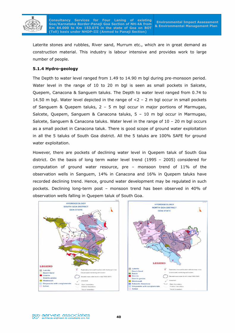
5.1.4 Hydro-geology
The Depth to water level ranged from 1.49 to 14.90 m bgl during pre-monsoon period.
Water level in the range of 10 to 20 m bgl is seen as small pockets in Salcete,
Quepem, Canacona & Sanguem taluks. The Depth to water level ranged from 0.74 to
14.50 m bgl. Water level depicted in the range of <2 – 2 m bgl occur in small pockets
of Sanguem & Quepem taluks, 2 – 5 m bgl occur in major portions of Marmugao,
Salcete, Quepem, Sanguem & Canacona taluks, 5 – 10 m bgl occur in Marmugao,
Salcete, Sanguem & Canacona taluks. Water level in the range of 10 – 20 m bgl occurs
as a small pocket in Canacona taluk. There is good scope of ground water exploitation
in all the 5 taluks of South Goa district. All the 5 taluks are 100% SAFE for ground
water exploitation.
However, there are pockets of declining water level in Quepem taluk of South Goa
district. On the basis of long term water level trend (1995 – 2005) considered for
computation of ground water resource, pre – monsoon trend of 11% of the
observation wells in Sanguem, 14% in Canacona and 16% in Quepem taluks have
recorded declining trend. Hence, ground water development may be regulated in such
pockets. Declining long-term post – monsoon trend has been observed in 40% of
observation wells falling in Quepem taluk of South Goa.
40

Consultancy Services for Four Laning of existing Goa/Karnataka Border-Panaji Goa Section of NH-4A from Km 84.000 to Km 153.075 in the state of Goa on BOT (Toll) basis under NHDP-III (Anmod to Panaji Section)
Environmental Impact Assessment & Environmental Management Plan
Source: Ground water information booklet,Goa State, CGWB
Figure -5.2: Hydro-geology maps of South Goa & North Goa
5.1.5 River basins, Flood and Cyclones
Goa region is drained by nine independent rivers flowing generally from East (Western
Ghats) to West (the Arabian Sea). An exception is the Sal river in south Goa which
follows a north-east to south-west course due to the west coast fault. Terekhol,
Mandovi, Zuari, Chapora, Sal, Talpona, Saleri, Canacona and Galgibagh are the major
rivers of Goa. These main nine rivers and their 42 tributaries play a significant role in
the lives of the people of the State. Of the nine rivers, the Mandovi and Zuari alone
together drain 2553 sq km, which is about 70% of the total geographical area.
5.1.6 Industries
In the state of Goa Iron ore and Pharmaceutical Formulations are the major items of
export. During the financial year 2011-2012 the MPT handled 29.37 million tonnes of
iron ore including iron ore pellets, 7.21 million tonnes of coal/coke and 1.39 million
tonnes of petroleum products and other liquid cargo. In Pharmaceutical Formulations
sector the export was Rs.200 crores in the year 2002-03 and has grown to Rs. 5,000
crores with the total employment of 8,800 people and with the total turnover of
Rs.10,000 crores. Though Goa Pharma Cluster is small & compact, it is very
progressive cluster. With half a percent of the total units in the country, about 12% of
the medicines are made in Goa. 90% of the units are WHO-GMP compliant. It is
growing at a healthy rate of 18-20%. Almost all prominent Indian Companies and
MNCs are having their production facilities in Goa and the cluster is self sustaining
5.1.7 Transportation
The study districts are having a good transport system in the State of Goa. These are
connected to all the major cities across the country through various major and local
highways, railways, waterways and air. There is a couple of major highways. State
Highways and MDRs, Panchayat roads etc. Common modes of road transport within
the cities /towns are city buses, cars and auto-rickshaws etc.
5.1.8 Infrastructure
The study region has well-developed and extensive infrastructural facilities in place.
The power supply position is good and almost all the villages in study districts are
electrified. The district head quarters such as Panjim and Margao have facilities like
housing, hospital, drinking water facility, school and technical education, universities,
medical college, etc. Emergency medical care and firefighting facilities are also
41

Consultancy Services for Four Laning of existing Goa/Karnataka Border-Panaji Goa Section of NH-4A from Km 84.000 to Km 153.075 in the state of Goa on BOT (Toll) basis under NHDP-III (Anmod to Panaji Section)
Environmental Impact Assessment & Environmental Management Plan
available at all Tehsils headquarters along the proposed project corridor.
5.1.9 Seismic Details of the Area
Goa falls in seismic zone IV that indicates that Goa has high probability for occurrence
of earthquakes. Goa forms part of the moderate seismic zone in the country, namely,
Zone IV of seismic zoning map of India. Though Goa has not directly witnessed any
earthquake it was affected by tremors from devastating earthquakes from neighboring
state.
Although Goa has not witnessed earthquakes directly, the tremors of the devastating
earthquakes with magnitude 5.0 or more that hitted “Koyana” and “Latur” in
Maharashtra in the year 1967 and 1993 respectively, affected the routine life of the
people in Goa as many of the residential as well as public structures, infrastructures
were damaged severely, although no casualties were taken place.
Earthquake Disaster Vulnerability of North Goa
Although the vulnerability is low, towns are more at risk than rural areas due to higher
density of population. Another concern is the large numbers of building both private
and public have been constructed without proper earthquake resistance features. Goa
being a tourist location has a number of heritage sites (No. of listed heritage buildings
is 431 as per Town and Country Planning Department Notification) that need to be
made earthquake resistant.
42
Study Area

Consultancy Services for Four Laning of existing Goa/Karnataka Border-Panaji Goa Section of NH-4A from Km 84.000 to Km 153.075 in the state of Goa on BOT (Toll) basis under NHDP-III (Anmod to Panaji Section)
Environmental Impact Assessment & Environmental Management Plan
Source: NIDM, Goa
Figure 5.3: Seismic zone map of India
5.1.10 Archeological Sites/Places of Tourist Interest
No archeological sites were present with in the Right of Way (ROW) of project highway.
5.1.11 Sources of Irrigation and Cropping Pattern
Agriculture is one of the important economic activities in the district. Rice is the staple
food and paddy is the principal agricultural crop. Gross cropped area under paddy in
2005 – 06 was 22572 ha, accounting for nearly 35.32% of the Gross Cropped Area
(63914 ha). Other crops grown are cereals, millets, pulses & oil seeds, which
constitute an area of 2147 ha (3.36%), sugarcane 870 ha (1.36%), coconut 14157 ha
(22.15%), arecanut 220 ha (0.34%) and cashewnut 14912 ha (23.33%). Irrigation
potential created as on March 2000 by the Salauli Irrigation Project was 4614 ha in
Sanguem, Quepem and Salcete taluks of Goa district.
5.2 Meteorology of the Region
In order to analyze the past meteorological data near to the proposed project site,
data from Indian Meteorological Department (IMD), Goa Station is considered. The
selected stations are located within the project site and the data collected for a period
of 30 years
(1964-990).
5.3 Climatic Conditions
The climate of the region is characterized as tropical. The climate, wind and wave
pattern are governed by the annually changing monsoons and transition periods
between them dividing the year into four seasons as given in Table -5.1.
Table – 5.1 Seasons of the region
Season Months Characteristics
Summer March–MayHottest part of the year, occurrence of dust
storms
South-West
monsoonJune-Sept
Characterized by predominantly SW winds.
Generally strong and persistent winds prevail.
North-East
monsoonOct-Nov
Characterized by predominantly NE winds. Fair
weather with the variable winds.
Winter Dec-Feb Cool season of the year
43

Consultancy Services for Four Laning of existing Goa/Karnataka Border-Panaji Goa Section of NH-4A from Km 84.000 to Km 153.075 in the state of Goa on BOT (Toll) basis under NHDP-III (Anmod to Panaji Section)
Environmental Impact Assessment & Environmental Management Plan
Temperature
The cold weather commences towards the end of December when the temperature
begins to fall down in Goa is observed as the coldest month, with the mean daily
maximum temperature at 32.6oC and the mean daily minimum at 19.8oC. The period
from April to June is the hottest month with the mean daily maximum temperature at
33.3oC and a mean daily minimum at 24.7oC. With the advance of south–west &
north-east monsoon by about mid of June there is an appreciable drop in
temperatures. By about 3rd week of November when the monsoon withdraws, the day
temperature begins to increase slightly but the night temperatures decrease steadily.
After November both day and night temperatures decrease rapidly.
Rainfall
The rainfall in Goa in general increases from the south-west towards the north east.
About 94.6 % of annual rainfall is received during the south-west monsoon season.
July being the peak rainy month with 899.8 mm, the variation in the Annual rainfall
from year is almost compatible with the base levels. The Annual rainfall of the
Kakinada station is observed as 2880.8 mm.
Relative Humidity
Due to proximity to the sea, the territory is generally humid, with a further rise in
humidity during the monsoon weather. Even during the summer months the relative
humidity is generally above 60 percent.
Wind Speed And Direction
Winds in morning are easterly to north-easterly during October to April backing to the
west or north-east in May while in the afternoon they tend towards west or north-
west, due to the sea breeze effect. During the monsoon months the winds are
generally westerly throughout the day.
5.3.1 On site Meteorological Conditions
As a part of the EIA study, an automatic weather station at Panjim (NH 4A and NH 17
Junction) has been installed and monitored for the months of 20th January 2016 to
19th April 2016. The micro-meteorological parameters observed are Temperature,
Relative Humidity, Wind speed, Wind direction and Rainfall. The summary of
meteorological conditions observed is presented in Table -5.2.
44
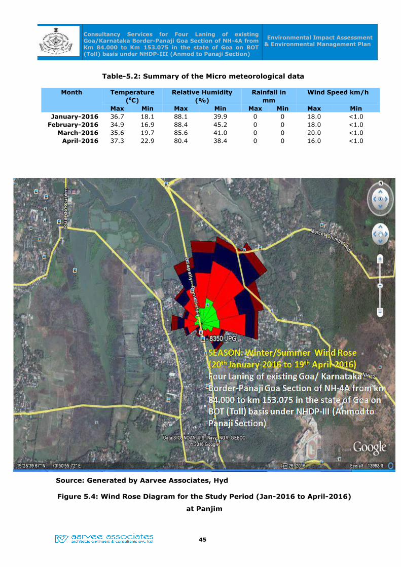
Consultancy Services for Four Laning of existing Goa/Karnataka Border-Panaji Goa Section of NH-4A from Km 84.000 to Km 153.075 in the state of Goa on BOT (Toll) basis under NHDP-III (Anmod to Panaji Section)
Environmental Impact Assessment & Environmental Management Plan
Table-5.2: Summary of the Micro meteorological data
Month Temperature (0C)
Relative Humidity (%)
Rainfall in mm
Wind Speed km/h
Max Min Max Min Max Min Max MinJanuary-2016 36.7 18.1 88.1 39.9 0 0 18.0 <1.0
February-2016 34.9 16.9 88.4 45.2 0 0 18.0 <1.0March-2016 35.6 19.7 85.6 41.0 0 0 20.0 <1.0
April-2016 37.3 22.9 80.4 38.4 0 0 16.0 <1.0
Source: Generated by Aarvee Associates, Hyd
Figure 5.4: Wind Rose Diagram for the Study Period (Jan-2016 to April-2016)
at Panjim
45
Consultancy Services for Four Laning of existing Goa/Karnataka Border-Panaji Goa Section of NH-4A from Km 84.000 to Km 153.075 in the state of Goa on BOT (Toll) basis under NHDP-III (Anmod to Panaji Section)
Environmental Impact Assessment & Environmental Management Plan
The predominant wind direction during this Study period is observed to be blowing
from NNW to SSE, N to S, NW to SE, WWN to SES, SW to NE and W to E. An average
Wind speed during this period is 2.71 m/s. Calm winds during this period 8.11 %.
5.4 Air Environment
In assessing the environmental impact, collection and interpretation of baseline data is
of prime importance. The primary data for the study period were collected 24 hourly
twice in a week for three months as per national guidelines. The criteria followed for
selecting the AAQM stations is recommended by IS: 5182 and CPCB.
They are:
• The sampling station had free exposure so that it did not collect air from
stagnant pockets.
• It was not obstructed by large structures including hills.
• The sampling point was not directly influenced by any local source of emission.
• It was located at a minimum height of 1.5 m from the ground level.
Monitoring and analytical procedure:
Ambient air quality was monitored for the presence of contaminants existing in the air.
In order to evaluate and quantify the air pollution problem, measurements were
carried out for various air pollutants mentioned above. This data was used not only to
evaluate the air quality in the study region but also as the basis to develop programs
aiming at preventing the spread of pollutants leading to a risk to human health and
general environment. Fine Dust Samplers (FDS) were used for ambient air sampling of
selected parameters. The method for the selected parameters are based on the
methods recommended by IS: 5182.
Selection of monitoring parameters:
The parameters selected for analyzing ambient air quality status were Sulphur dioxide
(SO2), Nitrogen dioxide (NO2), Respirable Particulate Matter (PM10), Fine Particulate
Matter (PM2.5), Carbon Monoxide (CO) and Hydro carbon (HC).
5.4.1 AAQ Assessment
After a preliminary reconnaissance of the study region and taking into account the
meteorological (predominant wind directions, wind speed) & topographic conditions,
traffic volume, major settlements and details on existing industrial activities in the
study region, three (03) stations are identified for carrying out Ambient Air Quality
Monitoring (AAQM) in the study area spread over an existing length of 69.075 kms.
46
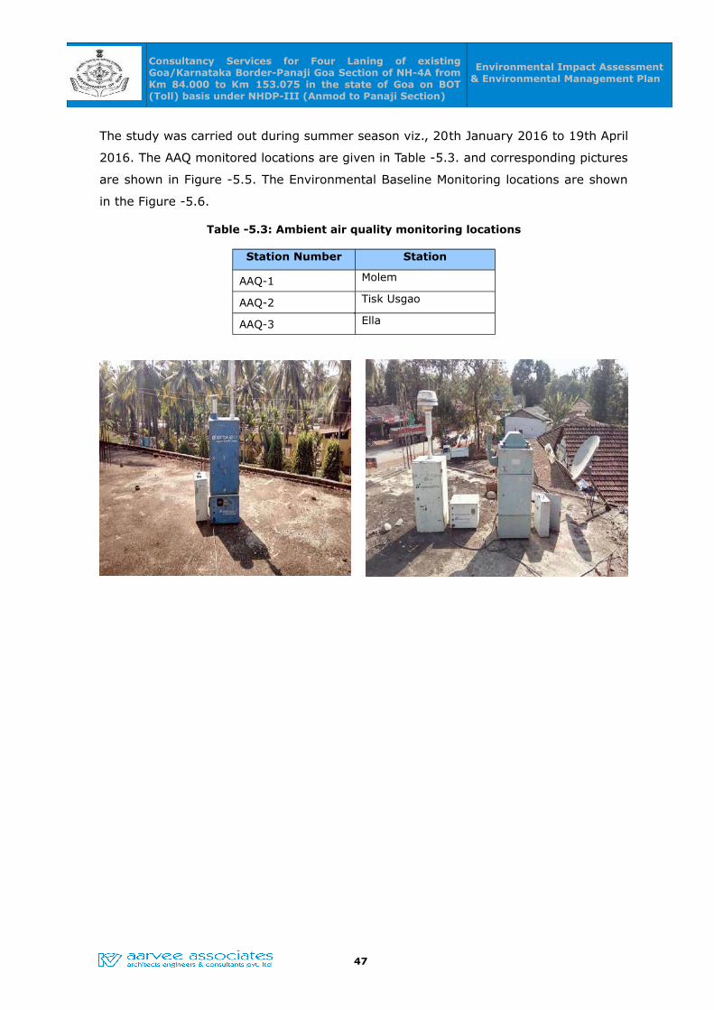
Consultancy Services for Four Laning of existing Goa/Karnataka Border-Panaji Goa Section of NH-4A from Km 84.000 to Km 153.075 in the state of Goa on BOT (Toll) basis under NHDP-III (Anmod to Panaji Section)
Environmental Impact Assessment & Environmental Management Plan
The study was carried out during summer season viz., 20th January 2016 to 19th April
2016. The AAQ monitored locations are given in Table -5.3. and corresponding pictures
are shown in Figure -5.5. The Environmental Baseline Monitoring locations are shown
in the Figure -5.6.
Table -5.3: Ambient air quality monitoring locations
Station Number Station
AAQ-1 Molem
AAQ-2 Tisk Usgao
AAQ-3 Ella
47
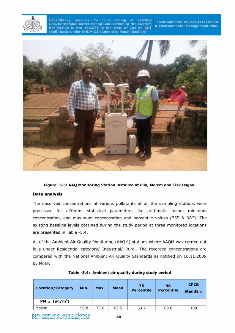
Consultancy Services for Four Laning of existing Goa/Karnataka Border-Panaji Goa Section of NH-4A from Km 84.000 to Km 153.075 in the state of Goa on BOT (Toll) basis under NHDP-III (Anmod to Panaji Section)
Environmental Impact Assessment & Environmental Management Plan
Figure -5.5: AAQ Monitoring Station installed at Ella, Molem and Tisk Usgao
Data analysis
The observed concentrations of various pollutants at all the sampling stations were
processed for different statistical parameters like arithmetic mean, minimum
concentration, and maximum concentration and percentile values (75th & 98th). The
existing baseline levels obtained during the study period at three monitored locations
are presented in Table -5.4.
All of the Ambient Air Quality Monitoring (AAQM) stations where AAQM was carried out
falls under Residential category/ Industrial/ Rural. The recorded concentrations are
compared with the National Ambient Air Quality Standards as notified on 16.11.2009
by MoEF.
Table -5.4: Ambient air quality during study period
Location/Category Min. Max. Mean75
Percentile98
Percentile
CPCB
Standard
PM 10 (µg/m3)
Molem 56.8 70.6 62.5 63.7 69.6 100
48
Consultancy Services for Four Laning of existing Goa/Karnataka Border-Panaji Goa Section of NH-4A from Km 84.000 to Km 153.075 in the state of Goa on BOT (Toll) basis under NHDP-III (Anmod to Panaji Section)
Environmental Impact Assessment & Environmental Management Plan
Location/Category Min. Max. Mean75
Percentile98
Percentile
CPCB
Standard
Tisk Usgao 58.9 73.4 66.2 69.0 73.1 100
Ella 58.7 71.3 64.3 66.2 70.8 100
PM 2.5 (µg/m3)
Molem 22.7 30.8 27.1 28.9 30.8 60
Tisk Usgao 24.6 34.8 30.1 31.9 34.8 60
Ella 28.1 35.6 31.5 33.1 35.5 60
SO2 (µg/m3)
Molem 9.8 14.3 12.4 13.4 14.1 80
Tisk Usgao 11.2 14.8 13.0 13.9 14.7 80
Ella 10.1 14.7 12.8 13.4 14.7 80
NO2 (µg/m3)
Molem 21.3 36.2 27.8 30.2 35.9 80
Tisk Usgao 28.0 33.5 30.9 31.9 33.3 80
Ella 24.3 31 27.7 29.2 30.7 80
CO (mg/m3)
Molem 1.0 1.6 1.3 1.5 1.6 4
Tisk Usgao 1.1 1.9 1.4 1.6 1.9 4
Ella 1.0 1.6 1.2 1.3 1.6 4
HC (µg/m3)
Molem <0.01 <0.01 <0.01 <0.01 <0.01 ---
Tisk Usgao <0.01 <0.01 <0.01 <0.01 <0.01 ---
Ella <0.01 <0.01 <0.01 <0.01 <0.01 ---
As can be seen from the above Table:
• The mean Respirable Particulate Matter (PM10) values observed in the range
between 62.5 –66.2 µg/m3 as against the CPCB standard of 100 µg/m3 for
residential / industrial category. The maximum and 98th percentile values found
to be well within the stipulated standards for all the locations.
• The mean Fine Particulate Matter (PM2.5) values were found in the range
between 27.1 – 31.5 µg/m3 as against the CPCB standard of 60 µg/m3 for
residential/industrial category. The maximum and 98th percentile values found
to be well within the stipulated standards for all the locations.
• The mean Sulfur dioxide values were found in the range between 12.4 – 13.0
49
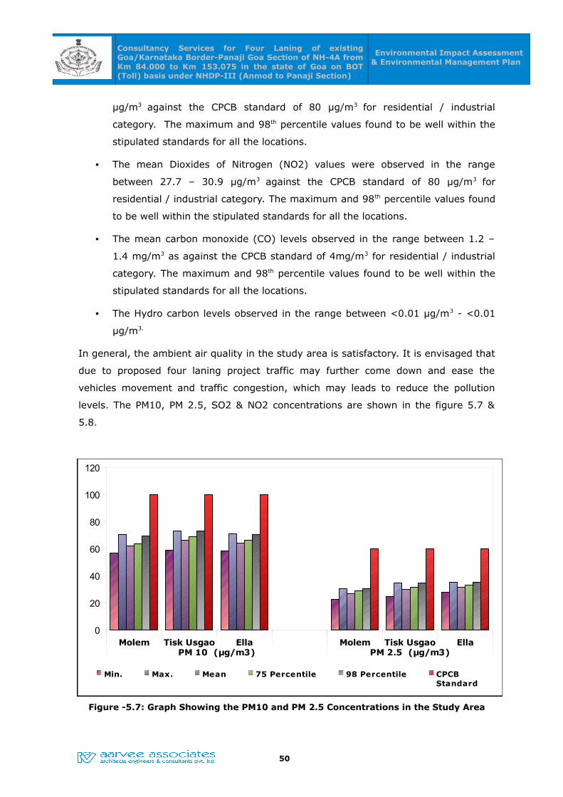
Consultancy Services for Four Laning of existing Goa/Karnataka Border-Panaji Goa Section of NH-4A from Km 84.000 to Km 153.075 in the state of Goa on BOT (Toll) basis under NHDP-III (Anmod to Panaji Section)
Environmental Impact Assessment & Environmental Management Plan
µg/m3 against the CPCB standard of 80 µg/m3 for residential / industrial
category. The maximum and 98th percentile values found to be well within the
stipulated standards for all the locations.
• The mean Dioxides of Nitrogen (NO2) values were observed in the range
between 27.7 – 30.9 µg/m3 against the CPCB standard of 80 µg/m3 for
residential / industrial category. The maximum and 98th percentile values found
to be well within the stipulated standards for all the locations.
• The mean carbon monoxide (CO) levels observed in the range between 1.2 –
1.4 mg/m3 as against the CPCB standard of 4mg/m3 for residential / industrial
category. The maximum and 98th percentile values found to be well within the
stipulated standards for all the locations.
• The Hydro carbon levels observed in the range between <0.01 µg/m3 - <0.01
µg/m3.
In general, the ambient air quality in the study area is satisfactory. It is envisaged that
due to proposed four laning project traffic may further come down and ease the
vehicles movement and traffic congestion, which may leads to reduce the pollution
levels. The PM10, PM 2.5, SO2 & NO2 concentrations are shown in the figure 5.7 &
5.8.
Figure -5.7: Graph Showing the PM10 and PM 2.5 Concentrations in the Study Area
50
Molem Tisk Usgao Ella Molem Tisk Usgao EllaPM 10 (µg/m3) PM 2.5 (µg/m3)
0
20
40
60
80
100
120
Min. Max. Mean 75 Percentile 98 Percentile CPCBStandard
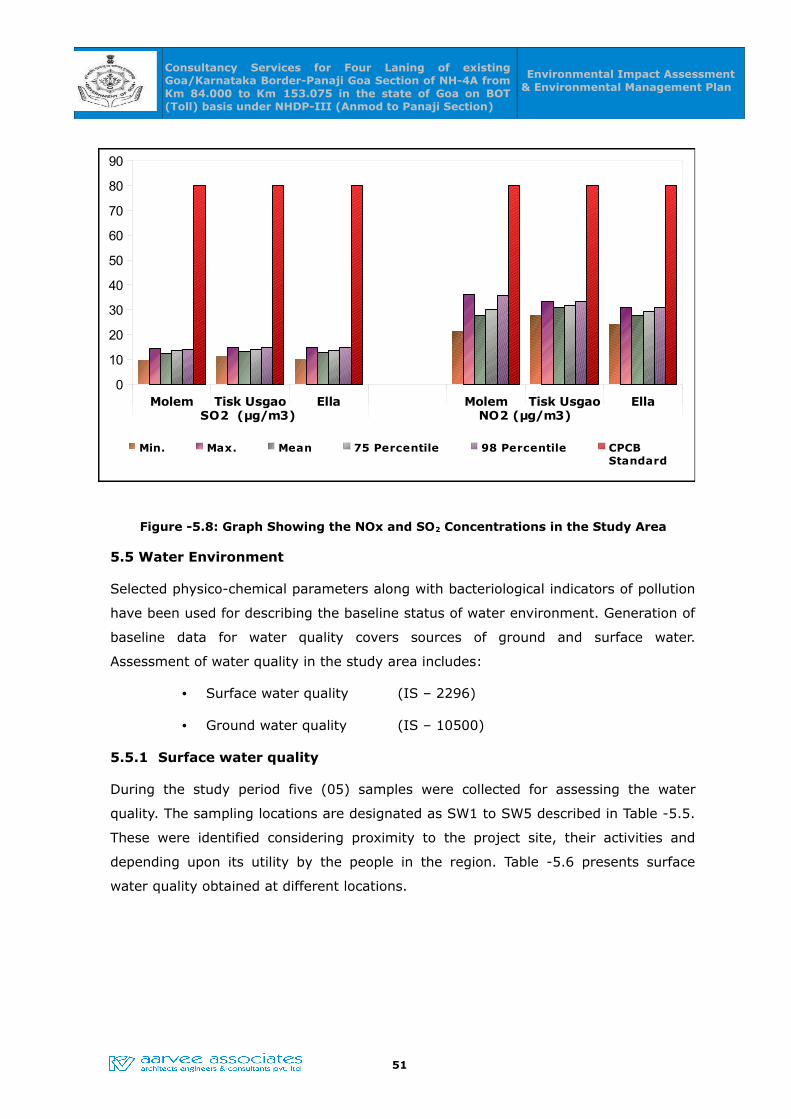
Consultancy Services for Four Laning of existing Goa/Karnataka Border-Panaji Goa Section of NH-4A from Km 84.000 to Km 153.075 in the state of Goa on BOT (Toll) basis under NHDP-III (Anmod to Panaji Section)
Environmental Impact Assessment & Environmental Management Plan
Figure -5.8: Graph Showing the NOx and SO2 Concentrations in the Study Area
5.5 Water Environment
Selected physico-chemical parameters along with bacteriological indicators of pollution
have been used for describing the baseline status of water environment. Generation of
baseline data for water quality covers sources of ground and surface water.
Assessment of water quality in the study area includes:
• Surface water quality (IS – 2296)
• Ground water quality (IS – 10500)
5.5.1 Surface water quality
During the study period five (05) samples were collected for assessing the water
quality. The sampling locations are designated as SW1 to SW5 described in Table -5.5.
These were identified considering proximity to the project site, their activities and
depending upon its utility by the people in the region. Table -5.6 presents surface
water quality obtained at different locations.
51
Molem Tisk Usgao Ella Molem Tisk Usgao EllaSO2 (µg/m3) NO2 (µg/m3)
0
10
20
30
40
50
60
70
80
90
Min. Max. Mean 75 Percentile 98 Percentile CPCBStandard
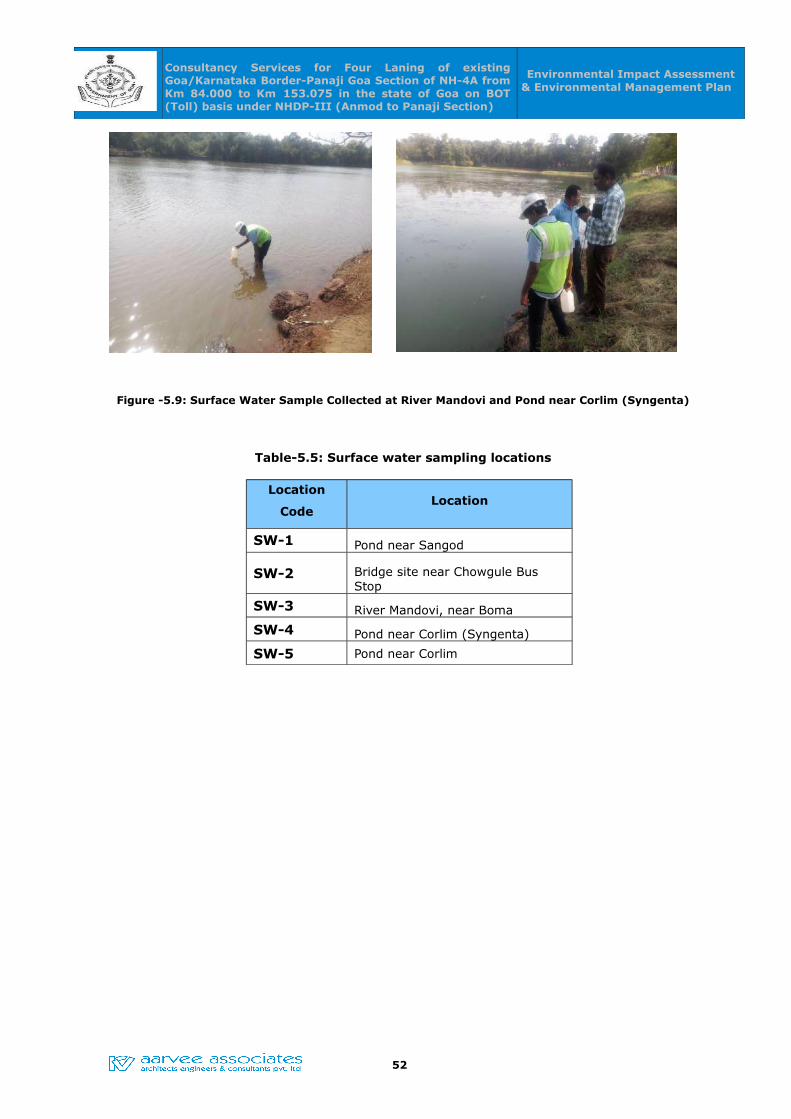
Consultancy Services for Four Laning of existing Goa/Karnataka Border-Panaji Goa Section of NH-4A from Km 84.000 to Km 153.075 in the state of Goa on BOT (Toll) basis under NHDP-III (Anmod to Panaji Section)
Environmental Impact Assessment & Environmental Management Plan
Figure -5.9: Surface Water Sample Collected at River Mandovi and Pond near Corlim (Syngenta)
Table-5.5: Surface water sampling locations
Location
CodeLocation
SW-1 Pond near Sangod
SW-2 Bridge site near Chowgule Bus Stop
SW-3 River Mandovi, near Boma
SW-4 Pond near Corlim (Syngenta)
SW-5 Pond near Corlim
52

Consultancy Services for Four Laning of existing Goa/Karnataka Border-Panaji Goa Section of NH-4A from Km 84.000 to Km 153.075 in the state of Goa on BOT (Toll) basis under NHDP-III (Anmod to Panaji Section)
Environmental Impact Assessment & Environmental Management Plan
Table -5.6: Surface water quality obtained at different locations
S.No Parameter Units
IS:2296
Class
C Limits
SW-1 SW-2 SW-3 SW-4 SW-5
1 Temperature oC -- 28.9 29.9 28.5 28.6 27.7
2 pH at 25 oC - 6.5 – 8.5 6.94 7.21 7.59 7.14 7.51
3 Color Hazen units 300 20 30 10 30 20
4 Odor U.O U.O U.O U.O U.O
5 Conductivity at 25 oC u.mhos/cm 2000 5986 12668 5902 228 5998
6 Turbidity NTU30 NTU (For Coastal
standards) 6.7 11.3 3.6 2.6 4.2
7 Dissolved Oxygen mg/L
4 min
5mg/l (For Coastal
standards)
4.3 5.1 5.4 6.3 5.9
8 BOD ( 3 days at 27oC) mg/L 3 32 4 8 3 7
9 COD mg/L -- 105 14 32 12 24
10 TKN mg/L -- 2.36 12.5 2.24 0.06 3.99
11 Total Suspended Solids mg/L -- 23.3 46.2 12.2 6.2 24.5
12 Total Dissolved Solids mg/L 1500 3864 8206 3796 144 3826
13 Total Hardness as CaCo3 mg/L -- 610 1450 590 50 600
14 Chloride as Cl- mg/L 600 380.1 3381.4 375.1 45.0 1800.7
15 Fluorides as F- mg/L 1.5 1.7 1.7 1.2 0.1 1.6
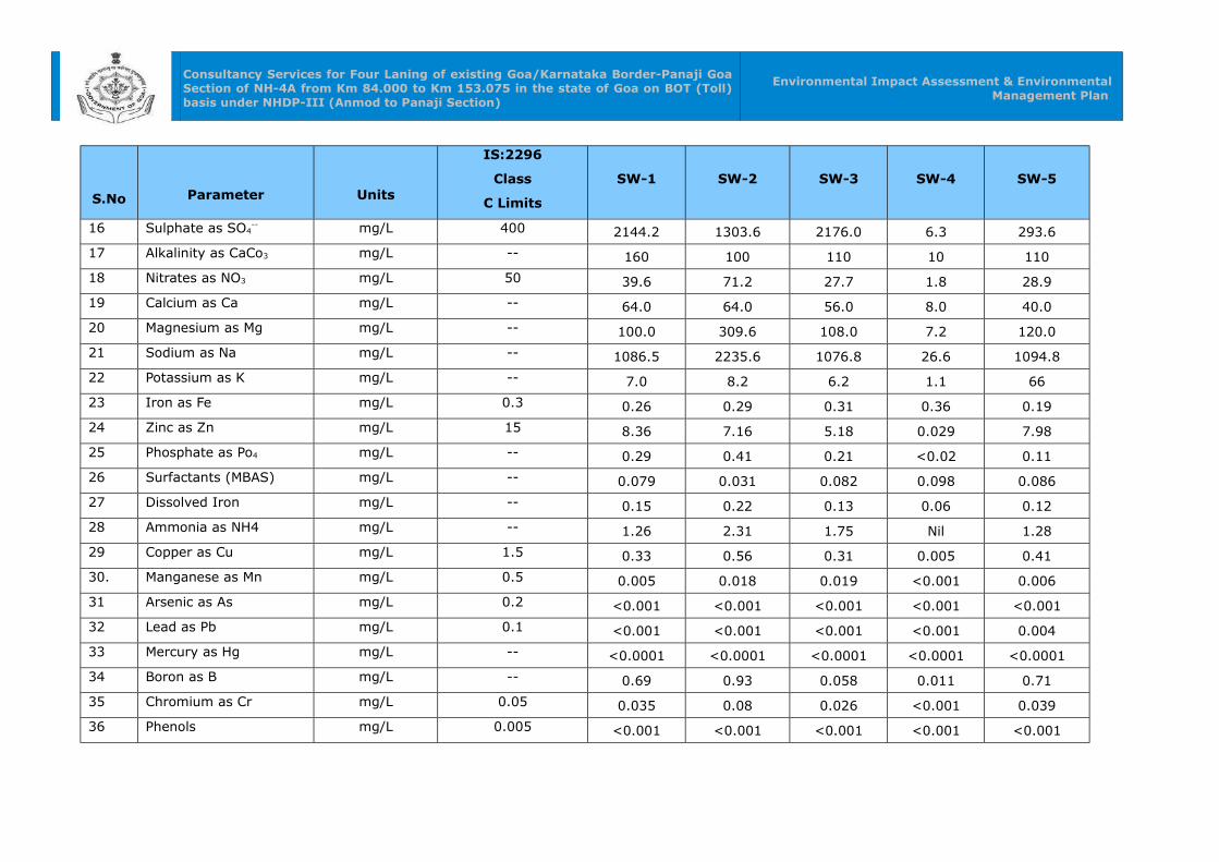
Consultancy Services for Four Laning of existing Goa/Karnataka Border-Panaji Goa Section of NH-4A from Km 84.000 to Km 153.075 in the state of Goa on BOT (Toll) basis under NHDP-III (Anmod to Panaji Section)
Environmental Impact Assessment & Environmental Management Plan
S.No Parameter Units
IS:2296
Class
C Limits
SW-1 SW-2 SW-3 SW-4 SW-5
16 Sulphate as SO4-- mg/L 400 2144.2 1303.6 2176.0 6.3 293.6
17 Alkalinity as CaCo3 mg/L -- 160 100 110 10 110
18 Nitrates as NO3 mg/L 50 39.6 71.2 27.7 1.8 28.9
19 Calcium as Ca mg/L -- 64.0 64.0 56.0 8.0 40.0
20 Magnesium as Mg mg/L -- 100.0 309.6 108.0 7.2 120.0
21 Sodium as Na mg/L -- 1086.5 2235.6 1076.8 26.6 1094.8
22 Potassium as K mg/L -- 7.0 8.2 6.2 1.1 66
23 Iron as Fe mg/L 0.3 0.26 0.29 0.31 0.36 0.19
24 Zinc as Zn mg/L 15 8.36 7.16 5.18 0.029 7.98
25 Phosphate as Po4 mg/L -- 0.29 0.41 0.21 <0.02 0.11
26 Surfactants (MBAS) mg/L -- 0.079 0.031 0.082 0.098 0.086
27 Dissolved Iron mg/L -- 0.15 0.22 0.13 0.06 0.12
28 Ammonia as NH4 mg/L -- 1.26 2.31 1.75 Nil 1.28
29 Copper as Cu mg/L 1.5 0.33 0.56 0.31 0.005 0.41
30. Manganese as Mn mg/L 0.5 0.005 0.018 0.019 <0.001 0.006
31 Arsenic as As mg/L 0.2 <0.001 <0.001 <0.001 <0.001 <0.001
32 Lead as Pb mg/L 0.1 <0.001 <0.001 <0.001 <0.001 0.004
33 Mercury as Hg mg/L -- <0.0001 <0.0001 <0.0001 <0.0001 <0.0001
34 Boron as B mg/L -- 0.69 0.93 0.058 0.011 0.71
35 Chromium as Cr mg/L 0.05 0.035 0.08 0.026 <0.001 0.039
36 Phenols mg/L 0.005 <0.001 <0.001 <0.001 <0.001 <0.001

Consultancy Services for Four Laning of existing Goa/Karnataka Border-Panaji Goa Section of NH-4A from Km 84.000 to Km 153.075 in the state of Goa on BOT (Toll) basis under NHDP-III (Anmod to Panaji Section)
Environmental Impact Assessment & Environmental Management Plan
S.No Parameter Units
IS:2296
Class
C Limits
SW-1 SW-2 SW-3 SW-4 SW-5
37 Cadmium as Cd mg/L 0.01 <0.001 <0.001 <0.001 <0.001 <0.001
38 Total Coli formMPN/
100 mL
Should not exceed
5000 1250 1400 2750 250 1140
39 Faecal Coli form cfu/1mL Absent N.D N.D N.D N.D N.DU.O – Un Objectionable, N.D – Not Detected

Consultancy Services for Four Laning of existing Goa/Karnataka Border-Panaji Goa Section of NH-4A from Km 84.000 to Km 153.075 in the state of Goa on BOT (Toll) basis under NHDP-III (Anmod to Panaji Section)
Environmental Impact Assessment & Environmental
Management Plan
Data analysis
The surface water collected from various sources are analyzed for physico-chemical
and bacteriological parameters. The results are compared with BIS- 2296 Class C Limit
(Drinking water source after conventional treatment). The detail description of sample
analyzed is given as below:
• Data on physical characteristics indicated variations in pH ranged between 6.94
– 7.59 as against IS standard of 6.5 – 8.5. Odour of water is un-objectionable.
The Colour of water found to be well within desirable limit.
• Data on chemical characteristics:
◦ The total hardness observed to be constant in all samples and is in the
range of 50 to 1450 mg/l.
◦ The total dissolved solids observed to be ranged between 144 mg/l to 8206
mg/l exceeding permissible limit of 1500 mg/l at all locations except at a
pond near corlim due to intrusion of sea water.
◦ The chlorides ranged between 45 – 3381.4 mg/l and are well within the
permissible limits except at chowgule bus stop and pond near corlim due to
intrusion of sea water.
◦ The Nitrates ranged between 1.8– 71.2 mg/l and the Sulphates ranged
between 6.3-2144.2 mg/l against permissible limits of 50mg/l and 400mg/l.
◦ The Fluoride values found to be in the range of 0.1 to 1.7mg/l as against
the permissible limits of 1.5 mg/l.
• Data on trace metals i.e., Fe, Zn, B, Cr & Cd concentrations found to be
consistent in all the analysed samples and found to be very well within
desirable limit.
• The Dissolved Oxygen in the sources is ranging between 4.3mg/l to 6.3 mg/l
as against the minimum requirement limit 4mg/l, which implies sustainability of
aquatic life in the tanks /lakes.
• Bio-chemical Oxidation Demand (BOD) is observed to be high and ranged
between 3-32mg/l as against the specified limit of 3mg/l. This may be due to
discharge of various effluents into the water bodies from Panjim city. The COD
is found to be ranged between 12-105 mg/l.
• Bacteriological samples were analysed for all the surface water sampling

Consultancy Services for Four Laning of existing Goa/Karnataka Border-Panaji Goa Section of NH-4A from Km 84.000 to Km 153.075 in the state of Goa on BOT (Toll) basis under NHDP-III (Anmod to Panaji Section)
Environmental Impact Assessment & Environmental
Management Plan
locations, the total coli form values are observed in the range of 250 to 2750
MPN/100ml, indicates the Total coliforms are present within the stipulated
standard of 5000MPN/100 ml. The Fecal Coliforms are not detected.
The Concentrations of BOD & DO, COD & BOD, TDS and TSS & Turbidity in the
study area are shown in the fig. 5.10, fig. 5.11, fig. 5.12 & fig. 5.13.
Figure -5.10: Graph Showing the BOD and DO Concentrations in the Study Area
Figure -5.11: Graph Showing the COD and BOD Concentrations in the Study Area
BOD DO0
5
10
15
20
25
30
35
Desirable Limits
Pond near Sangod
Bridge site near Chowgule Bus Stop
River Mandovi, near Boma
Pond near Corlim (Syngenta)
Pond near Corlim
mg/L
COD BOD0
20
40
60
80
100
120
Desirable Limits
Pond near Sangod
Bridge site near Chowgule Bus Stop
River Mandovi, near Boma
Pond near Corlim (Syngenta)
Pond near Corlim
mg/L

Consultancy Services for Four Laning of existing Goa/Karnataka Border-Panaji Goa Section of NH-4A from Km 84.000 to Km 153.075 in the state of Goa on BOT (Toll) basis under NHDP-III (Anmod to Panaji Section)
Environmental Impact Assessment & Environmental
Management Plan
Figure -5.12: Graph Showing the TDS Concentration in the Study Area
Figure -5.13: Graph Showing the TSS & Turbidity in the Study Area
TDS0
1000
2000
3000
4000
5000
6000
7000
8000
9000
Desirable Limits
Pond near Sangod
Bridge site near Chowgule Bus Stop
River Mandovi, near Boma
Pond near Corlim (Syngenta)
Pond near Corlim
mg/L
TSS Turbidity 0
5
10
15
20
25
30
35
40
45
50
Desirable Limits
Pond near Sangod
Bridge site near Chowgule Bus Stop
River Mandovi, near Boma
Pond near Corlim (Syngenta)
Pond near Corlim
TSS (
mg/L
) &
Turb
idity
(NTU
)
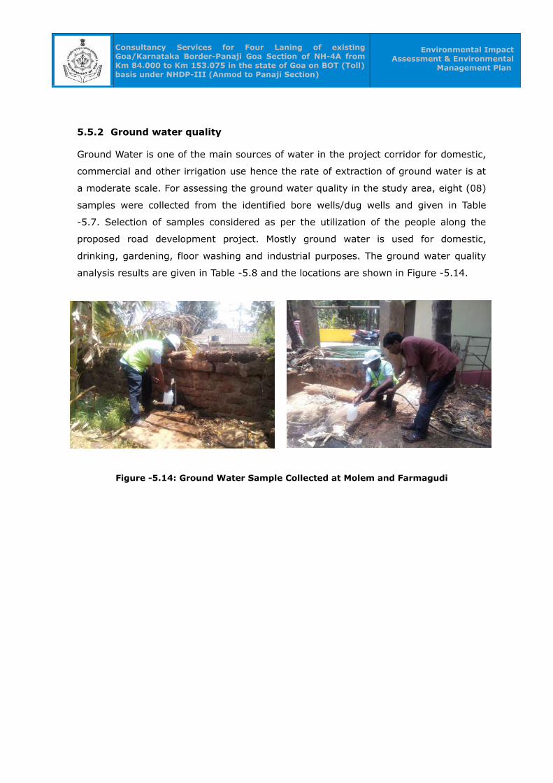
Consultancy Services for Four Laning of existing Goa/Karnataka Border-Panaji Goa Section of NH-4A from Km 84.000 to Km 153.075 in the state of Goa on BOT (Toll) basis under NHDP-III (Anmod to Panaji Section)
Environmental Impact Assessment & Environmental
Management Plan
5.5.2 Ground water quality
Ground Water is one of the main sources of water in the project corridor for domestic,
commercial and other irrigation use hence the rate of extraction of ground water is at
a moderate scale. For assessing the ground water quality in the study area, eight (08)
samples were collected from the identified bore wells/dug wells and given in Table
-5.7. Selection of samples considered as per the utilization of the people along the
proposed road development project. Mostly ground water is used for domestic,
drinking, gardening, floor washing and industrial purposes. The ground water quality
analysis results are given in Table -5.8 and the locations are shown in Figure -5.14.
Figure -5.14: Ground Water Sample Collected at Molem and Farmagudi

Consultancy Services for Four Laning of existing Goa/Karnataka Border-Panaji Goa Section of NH-4A from Km 84.000 to Km 153.075 in the state of Goa on BOT (Toll) basis under NHDP-III (Anmod to Panaji Section)
Environmental Impact Assessment & Environmental Management Plan
Table-5.8: Ground water quality analysis results
S.
No.Parameter
IS:10500
Units GW-01 GW-02 GW-03 GW-04 GW-05 GW-06 GW-07 GW-08Desirable
Limits
Permissible Limits in
the Absence of Alternate
Source
1 Temperature at site -- -- oC 25.3 25.6 24.9 24.6 25.6 25.3 25.8 26.7
2 pH at 25 oC 6.5 – 8.5 NR - 5.57 6.06 5.76 5.46 5.61 6.69 6.21 6.95
3 Color (Hazen units) 5 25 Hazen 20 15 10 <01 20 25 16 18
4 Taste Agreeable NR - Agreeabl
e
Agreeable Agreeabl
e
Agreea
ble
Agreeabl
e
Agreeab
le
Agreeab
le
Agreeab
le5 Odor U.O NR - U.O U.O U.O U.O U.O U.O U.O U.O
6 Conductivity at 25 oC
-- -- µmhos/c
m
318 2786 66 236 316 1666 164 262
7 Turbidity (NTU) 5.0 10 NTU <1.0 <1.0 <1.0 <1.0 <1.0 <1.0 <1.0 <1.0
8 TKN (Total Nitrogen) 0.5 NR mg/L 0.09 1.15 0.13 0.26 0.35 0.48 0.29 0.36
9 Dissolved Oxygen -- -- mg/L <0.1 5.3 6.1 5.6 6.1 4.9 5.6 5.8
10 Total Suspended
Solids
-- -- mg/L Nil Nil Nil Nil Nil Nil Nil Nil

Consultancy Services for Four Laning of existing Goa/Karnataka Border-Panaji Goa Section of NH-4A from Km 84.000 to Km 153.075 in the state of Goa on BOT (Toll) basis under NHDP-III (Anmod to Panaji Section)
Environmental Impact Assessment & Environmental Management Plan
S.
No.Parameter
IS:10500
Units GW-01 GW-02 GW-03 GW-04 GW-05 GW-06 GW-07 GW-08Desirable
Limits
Permissible Limits in
the Absence of Alternate
Source
11 Total Dissolve solids 500 2000 mg/L 200 1798 42 150 202 1048 102 166
12 Total Hardness as
CaCO3
200 600 mg/L 20 480 20 40 50 320 50 90
13 Total Alkalinity 200 600 mg/L 20 40 20 30 20 50 30 60
14 Calcium as Ca 75 200 mg/L 4.0 48.0 4.0 4.0 8.0 80.0 8.0 28.0
15 Magnesium as Mg 30 100 mg/L 2.4 74.4 2.4 7.2 7.2 28.8 7.2 4.8
16 Chloride as Cl 250 1000 mg/L 25.0 610.2 5.0 50.0 47.3 460.2 25.0 20.0
17 Sulphate as SO4 200 400 mg/L 92.9 455.5 3.8 13.0 33.0 111.2 11.3 34.4
18 Fluorides as F- 1.0 1.5 mg/L 0.2 1.7 <0.1 0.2 0.1 1.2 0.1 0.2
19 Nitrates as NO3 45 100 mg/L 3.7 11.3 0.6 1.9 2.5 11.6 2.5 3.7
20 Sodium as Na -- -- mg/L 60.2 435.6 4.1 33.5 47.3 230.0 25.0 15.1
23 Potassium as K -- -- mg/L 1.9 5.1 0.4 0.8 0.8 3.9 1.1 1.9
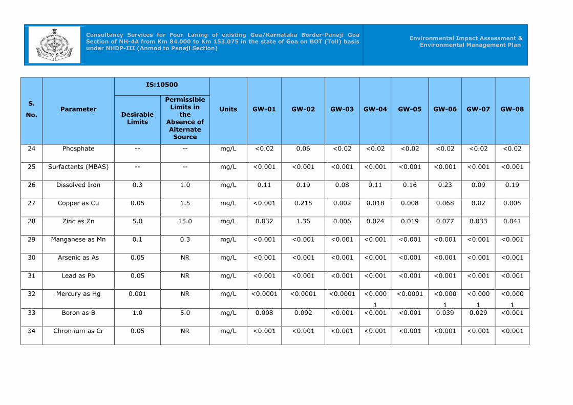
Consultancy Services for Four Laning of existing Goa/Karnataka Border-Panaji Goa Section of NH-4A from Km 84.000 to Km 153.075 in the state of Goa on BOT (Toll) basis under NHDP-III (Anmod to Panaji Section)
Environmental Impact Assessment & Environmental Management Plan
S.
No.Parameter
IS:10500
Units GW-01 GW-02 GW-03 GW-04 GW-05 GW-06 GW-07 GW-08Desirable
Limits
Permissible Limits in
the Absence of Alternate
Source
24 Phosphate -- -- mg/L <0.02 0.06 <0.02 <0.02 <0.02 <0.02 <0.02 <0.02
25 Surfactants (MBAS) -- -- mg/L <0.001 <0.001 <0.001 <0.001 <0.001 <0.001 <0.001 <0.001
26 Dissolved Iron 0.3 1.0 mg/L 0.11 0.19 0.08 0.11 0.16 0.23 0.09 0.19
27 Copper as Cu 0.05 1.5 mg/L <0.001 0.215 0.002 0.018 0.008 0.068 0.02 0.005
28 Zinc as Zn 5.0 15.0 mg/L 0.032 1.36 0.006 0.024 0.019 0.077 0.033 0.041
29 Manganese as Mn 0.1 0.3 mg/L <0.001 <0.001 <0.001 <0.001 <0.001 <0.001 <0.001 <0.001
30 Arsenic as As 0.05 NR mg/L <0.001 <0.001 <0.001 <0.001 <0.001 <0.001 <0.001 <0.001
31 Lead as Pb 0.05 NR mg/L <0.001 <0.001 <0.001 <0.001 <0.001 <0.001 <0.001 <0.001
32 Mercury as Hg 0.001 NR mg/L <0.0001 <0.0001 <0.0001 <0.000
1
<0.0001 <0.000
1
<0.000
1
<0.000
133 Boron as B 1.0 5.0 mg/L 0.008 0.092 <0.001 <0.001 <0.001 0.039 0.029 <0.001
34 Chromium as Cr 0.05 NR mg/L <0.001 <0.001 <0.001 <0.001 <0.001 <0.001 <0.001 <0.001
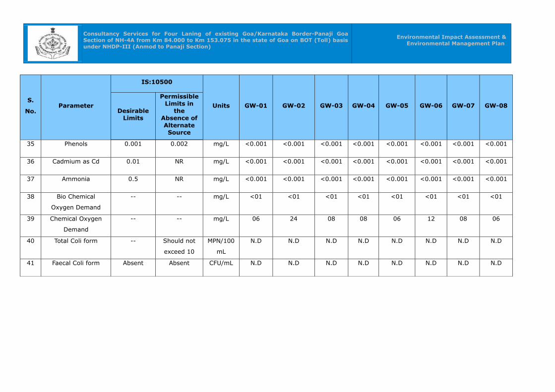
Consultancy Services for Four Laning of existing Goa/Karnataka Border-Panaji Goa Section of NH-4A from Km 84.000 to Km 153.075 in the state of Goa on BOT (Toll) basis under NHDP-III (Anmod to Panaji Section)
Environmental Impact Assessment & Environmental Management Plan
S.
No.Parameter
IS:10500
Units GW-01 GW-02 GW-03 GW-04 GW-05 GW-06 GW-07 GW-08Desirable
Limits
Permissible Limits in
the Absence of Alternate
Source
35 Phenols 0.001 0.002 mg/L <0.001 <0.001 <0.001 <0.001 <0.001 <0.001 <0.001 <0.001
36 Cadmium as Cd 0.01 NR mg/L <0.001 <0.001 <0.001 <0.001 <0.001 <0.001 <0.001 <0.001
37 Ammonia 0.5 NR mg/L <0.001 <0.001 <0.001 <0.001 <0.001 <0.001 <0.001 <0.001
38 Bio Chemical
Oxygen Demand
-- -- mg/L <01 <01 <01 <01 <01 <01 <01 <01
39 Chemical Oxygen
Demand
-- -- mg/L 06 24 08 08 06 12 08 06
40 Total Coli form -- Should not
exceed 10
MPN/100
mL
N.D N.D N.D N.D N.D N.D N.D N.D
41 Faecal Coli form Absent Absent CFU/mL N.D N.D N.D N.D N.D N.D N.D N.D
Consultancy Services for Four Laning of existing Goa/Karnataka Border-Panaji Goa Section of NH-4A from Km 84.000 to Km 153.075 in the state of Goa on BOT (Toll) basis under NHDP-III (Anmod to Panaji Section)
Environmental Impact Assessment & Environmental Management Plan
Data analysis:
The ground water collected from various sources are analysed for physico-chemical
and bacteriological parameters. The results are compared with BIS: 10500 Drinking
Water Standards. The detail description of sample analysed is given as below:
• Data on physical characteristics indicated variations in pH ranged between 5.46
– 6.95 as against IS standard of 6.5 – 8.5. The physical Taste of water is
agreeable and Odour of water found to be un-objectionable.
Data on chemical characteristics:
• The Total Hardness observed to be varying in all samples and is in the range of
20 to 480mg/l as against the standard limits of 200 -600 mg/l.
• The Total Dissolved Solids observed to be high and ranged between 42 mg/l to
1798 mg/l as against the desirable limits 500 mg/l and well within the
permissible limits 2000 mg/l.
• The chlorides ranged between 5 to 610.2 mg/l and are well within the desirable
and permissible limits of 250 mg/l – 1000 mg/l.
• The Nitrates and Sulphates values observed to be ranging between 0.6 – 11.6
mg/l and 3.8 – 455.5 mg/l. Nitrates are well within the permissible limits of
100mg/l but sulphates are exceeding permissible limit of 400mg/l. This may be
due to sea water influx into the groundwater.
• The Fluoride values found to be in the range of <0.1 – 1.7 mg/l. Flouride
content is found to be exceeding permissible limit of 1.5 mg/l at Darbondora
location.
• Data on trace metal concentration found to be consistent in all the analyzed
samples and very well within permissible limit.
The ground water quality in the study area is satisfactory as compared with BIS:
10500 standards except at Darbandora. The water can be used for domestic,
commercial and agriculture purposes. It can also be used for drinking after treatment.
The Concentrations of Total hardness & Total Alkalinity, Flouride, Nitrates, Chloride &
Sulphate and Manganese in the study area are shown in the figure nos 5.15, 5.16,
5.17, 5.18 & 5.19.
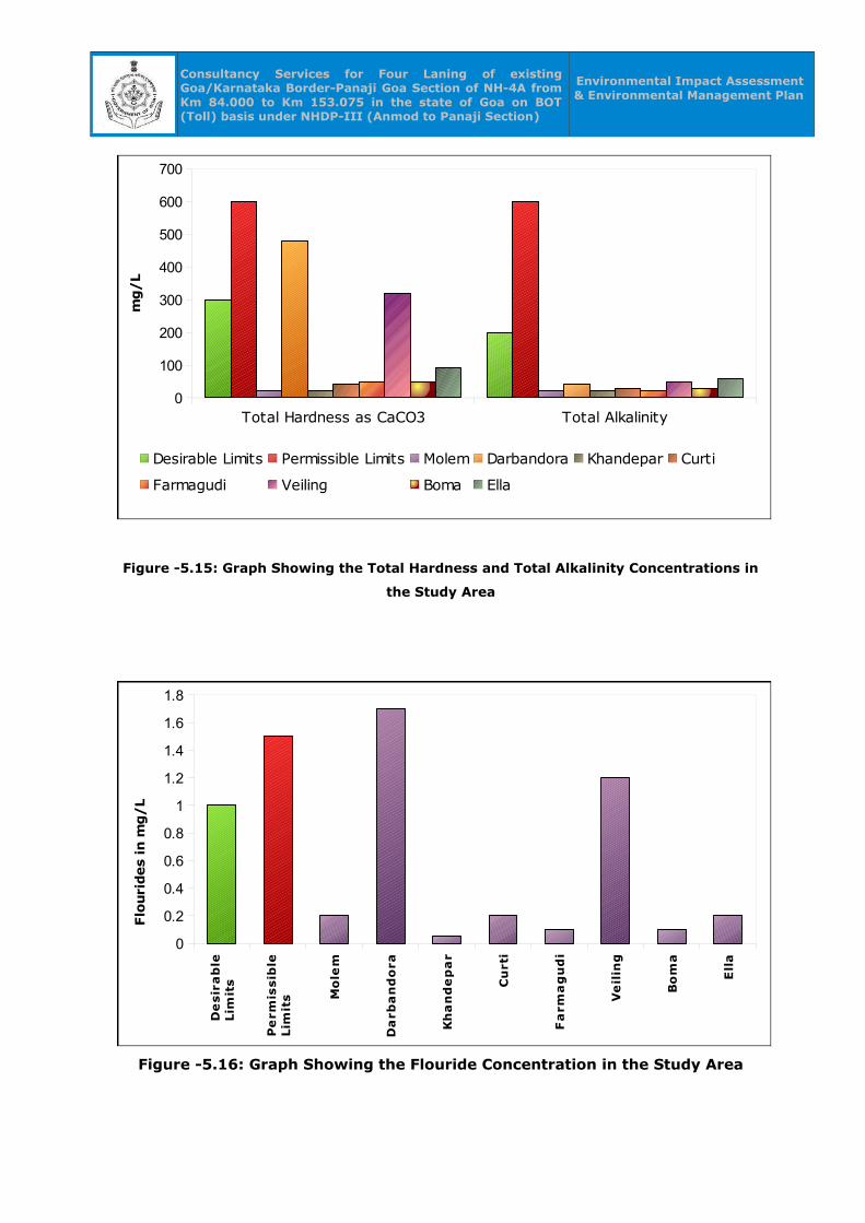
Consultancy Services for Four Laning of existing Goa/Karnataka Border-Panaji Goa Section of NH-4A from Km 84.000 to Km 153.075 in the state of Goa on BOT (Toll) basis under NHDP-III (Anmod to Panaji Section)
Environmental Impact Assessment & Environmental Management Plan
Figure -5.15: Graph Showing the Total Hardness and Total Alkalinity Concentrations in
the Study Area
Figure -5.16: Graph Showing the Flouride Concentration in the Study Area
Total Hardness as CaCO3 Total Alkalinity0
100
200
300
400
500
600
700
Desirable Limits Permissible Limits Molem Darbandora Khandepar Curti
Farmagudi Veiling Boma Ella
mg/L
De
sir
ab
leLim
its
Pe
rmis
sib
leLim
its M
ole
m
Da
rba
nd
ora
Kh
an
de
pa
r
Cu
rti
Fa
rma
gu
di
Ve
ilin
g
Bo
ma
Ell
a
0
0.2
0.4
0.6
0.8
1
1.2
1.4
1.6
1.8
Flo
uri
des
in m
g/L

Consultancy Services for Four Laning of existing Goa/Karnataka Border-Panaji Goa Section of NH-4A from Km 84.000 to Km 153.075 in the state of Goa on BOT (Toll) basis under NHDP-III (Anmod to Panaji Section)
Environmental Impact Assessment & Environmental Management Plan
Figure -5.17: Graph Showing the Nitrate Concentration in the Study Area
Figure -5.18: Graph Showing the Chloride & Sulphate Concentration in the
Study Area
De
sir
ab
leLim
its
Pe
rmis
sib
leLim
its M
ole
m
Da
rba
nd
ora
Kh
an
de
pa
r
Cu
rti
Fa
rma
gu
di
Ve
lin
g
Bo
ma
Ell
a
0
20
40
60
80
100
120
45
100
3.711.3
0.6 1.9 2.511.6
2.5 3.7
Nitrates as NO3
Nit
rate
s in
mg/L
De
sir
ab
leLim
its
Pe
rmis
sib
leLim
its M
ole
m
Da
rba
nd
ora
Kh
an
de
pa
r
Cu
rti
Fa
rma
gu
di
Ve
lin
g
Bo
ma
Ell
a
0
200
400
600
800
1000
1200
Chloride
Sulphate
Chlo
ride a
nd S
ulp
hate
in m
g/L
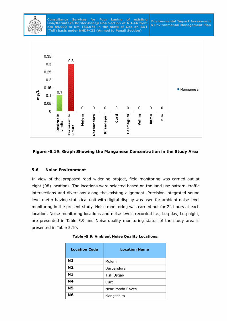
Consultancy Services for Four Laning of existing Goa/Karnataka Border-Panaji Goa Section of NH-4A from Km 84.000 to Km 153.075 in the state of Goa on BOT (Toll) basis under NHDP-III (Anmod to Panaji Section)
Environmental Impact Assessment & Environmental Management Plan
Figure -5.19: Graph Showing the Manganese Concentration in the Study Area
5.6 Noise Environment
In view of the proposed road widening project, field monitoring was carried out at
eight (08) locations. The locations were selected based on the land use pattern, traffic
intersections and diversions along the existing alignment. Precision integrated sound
level meter having statistical unit with digital display was used for ambient noise level
monitoring in the present study. Noise monitoring was carried out for 24 hours at each
location. Noise monitoring locations and noise levels recorded i.e., Leq day, Leq night,
are presented in Table 5.9 and Noise quality monitoring status of the study area is
presented in Table 5.10.
Table -5.9: Ambient Noise Quality Locations:
Location Code Location Name
N1 Molem
N2 Darbandora
N3 Tisk Usgao
N4 Curti
N5 Near Ponda Caves
N6 Mangeshim
De
sir
ab
leLim
its
Pe
rmis
sib
leLim
its M
ole
m
Da
rba
nd
ora
Kh
an
de
pa
r
Cu
rti
Fa
rma
gu
di
Ve
lin
g
Bo
ma
Ell
a
0
0.05
0.1
0.15
0.2
0.25
0.3
0.35
0.1
0.3
0 0 0 0 0 0 0 0
Manganese
mg/L

Consultancy Services for Four Laning of existing Goa/Karnataka Border-Panaji Goa Section of NH-4A from Km 84.000 to Km 153.075 in the state of Goa on BOT (Toll) basis under NHDP-III (Anmod to Panaji Section)
Environmental Impact Assessment & Environmental Management Plan
Location Code Location Name
N7 Banastari Corlim bridge
N8 Road junction near Ella
Table -5.10: Noise Quality Monitoring Status in the Study Area
Station No.
Location CategoryLeq day
dB(A)
Leq Night
dB(A)
N1 Molem Commercial 62.2 50.6
N2 Darbandora Residential 59.8 49.7
N3 Tisk Usgao Industrial 70.1 57.3
N4 Curti Residential 63.9 54.1
N5 Near Ponda Caves Commercial 60.4 48.1
N6 Mangeshim Residential 63.9 53.3
N7 Banastari Corlim bridge Residential 65.8 53.6
N8 Road junction near Ella Residential 59.5 48.0
Data analysis
As is seen from Table -5.9, noise monitoring was carried out at eight
locations, all the locations fall under various categories such as Residential,
Commercial and Industrial.
Eight noise monitoring locations are identified covering major junctions, residential
areas and commercial activities i.e., Molem, Curti, Ponda, Corlim bridge, Ella Junction
and Tisk Usgao etc. The day and night noise levels of Commercial category are
observed to be in the range of 60.4 to 62.2 dB (A) & 48.1 to 50.6 dB(A) as against the
CPCB Standard of 65.0 & 55.0 dB(A). Similarly, The day and night noise levels of
Residential category are observed to be in the range of 59.5 to 65.8 dB (A) & 48.0 to
54.1 dB(A) as against the CPCB Standard of 55.0 & 45.0 dB(A). Whereas The day and
night noise levels of Industrial category are observed to be 70.1 dB (A) & 57.3 dB(A)
as against the CPCB Standard of 75.0 & 70.0 dB(A). The noise levels are found to be
well within the limits in Commercial and Industrial categories bu they have exceeded
the limits in Residential category. The Noise quality levels of the study are shown in
the fig. 5.20, fig. 5.21 & fig. 5.22.

Consultancy Services for Four Laning of existing Goa/Karnataka Border-Panaji Goa Section of NH-4A from Km 84.000 to Km 153.075 in the state of Goa on BOT (Toll) basis under NHDP-III (Anmod to Panaji Section)
Environmental Impact Assessment & Environmental Management Plan
Figure -5.20: Noise Quality levels in Commercial Category
Figure -5.21: Noise Quality levels in Residential Category
Sta
nd
ard
Le
q d
ay
(dB
)
Sta
nd
ard
Le
q N
igh
t(d
B)
Da
rba
nd
ora
Cu
rti
Ma
ng
esh
im
Ba
na
sta
riC
orl
im b
rid
ge
Ro
ad
ju
ncti
on
Ne
ar
Ell
a
0
10
20
30
40
50
60
70
Leq day dB(A)
Leq Night dB(A)
Sta
nd
ard
Le
q d
ay
(dB
)
Sta
nd
ard
Le
q N
igh
t(d
B)
Mo
lem
Ne
ar
Po
nd
a C
av
es
0
10
20
30
40
50
60
70
Leq day dB(A)
Leq Night dB(A)
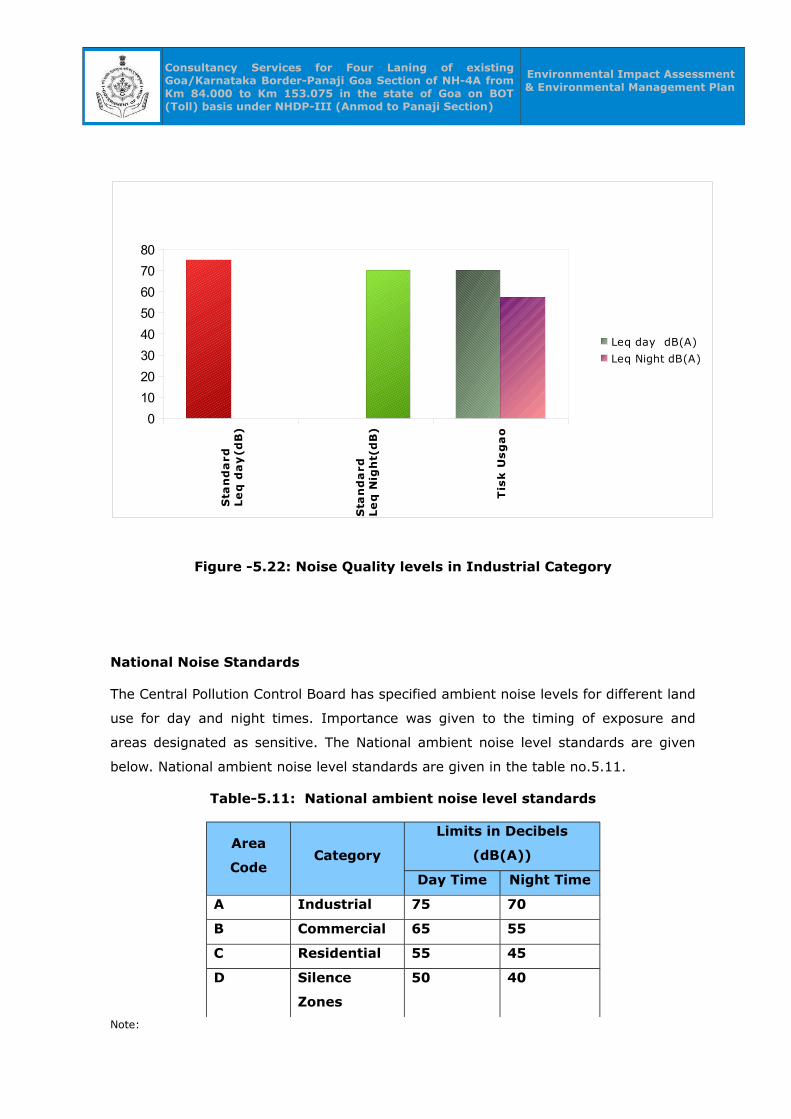
Consultancy Services for Four Laning of existing Goa/Karnataka Border-Panaji Goa Section of NH-4A from Km 84.000 to Km 153.075 in the state of Goa on BOT (Toll) basis under NHDP-III (Anmod to Panaji Section)
Environmental Impact Assessment & Environmental Management Plan
Figure -5.22: Noise Quality levels in Industrial Category
National Noise Standards
The Central Pollution Control Board has specified ambient noise levels for different land
use for day and night times. Importance was given to the timing of exposure and
areas designated as sensitive. The National ambient noise level standards are given
below. National ambient noise level standards are given in the table no.5.11.
Table-5.11: National ambient noise level standards
Area
CodeCategory
Limits in Decibels
(dB(A))
Day Time Night Time
A Industrial 75 70
B Commercial 65 55
C Residential 55 45
D Silence
Zones
50 40
Note:
Sta
nd
ard
Le
q d
ay
(dB
)
Sta
nd
ard
Le
q N
igh
t(d
B)
Tis
k U
sg
ao
0
10
20
30
40
50
60
70
80
Leq day dB(A)
Leq Night dB(A)
Consultancy Services for Four Laning of existing Goa/Karnataka Border-Panaji Goa Section of NH-4A from Km 84.000 to Km 153.075 in the state of Goa on BOT (Toll) basis under NHDP-III (Anmod to Panaji Section)
Environmental Impact Assessment & Environmental Management Plan
• Day Time is recorded in between 6 a.m. and 9 p.m.
• Night time is recorded in between 9 p.m. to 6 a.m.
• Silence zone is defined as areas upto 100 meters around such premises as hospitals, educational
institutions and courts. The silence zones are to be declared by the Competent Authority.
• Use of vehicular horns, loudspeakers and bursting of crackers shall be banned in these zones.
• Mixed categories of areas should be declared as one of the four above mentioned categories by the
Competent Authority and the corresponding standards shall apply.
Source: EPA Notification [G.S.R. 1063 (E) dt. 26.12.1989 published in the Gazette No. 643 dt. 26.12.1989].
5.7 Land Environment
5.7.1 Geology
Geologically the state constitutes the northwesterly extension of the granitoid-
greenstone terrain of Karnataka, comprising rocks of Precambrian age viz., gneisses,
migmatites, granitoids, granites, schists, meta-volcanics (both acid and basic), meta-
greywackes, banded ferruginous quartzites associated with manganiferous phyllites /
argillites, limestones, dolomites and thin bands of quartzite intruded by granite and
maficultramafic complex. Deccan Trap is exposed on the NE border of Goa. Peninsular
Gneisses are well exposed in Anmod Ghat section along the Panaji-Ponda- Londa
highway. Qupem in central Goa and Chauri in the south, when Ranebennur Subgroup
of Shimoga belt further extend north and northwesterly into Goa in response to the
variation in their litho-spectrum and in accordance to the stratigraphic guidelines, they
are assigned with the local name called 'Goa Group' which is further divided into four
formations. The rocks of Peninsular Gneissic Complex and Goa Group are intruded by
maficultramafic complexes.
5.7.2 Soil
For land environment three (3) samples were selected from different villages in the
study area to understand the Physico-chemical properties of the soil. The activities
around the sampling sites were also taken into consideration to understand the
sources of pollution if any and all other factors governing the Physico-chemical
properties of the soil. Meticulous attention was paid to collect adequate amount of
composite soil samples at three depths for analysis. The samples were collected in
dependable, waterproof containers marking the samples accurately, distinctly and
brought to the laboratory for analysis. The soil sampling locations and results of the
analysis are presented in Table -5.12 & 5.13 respectively.
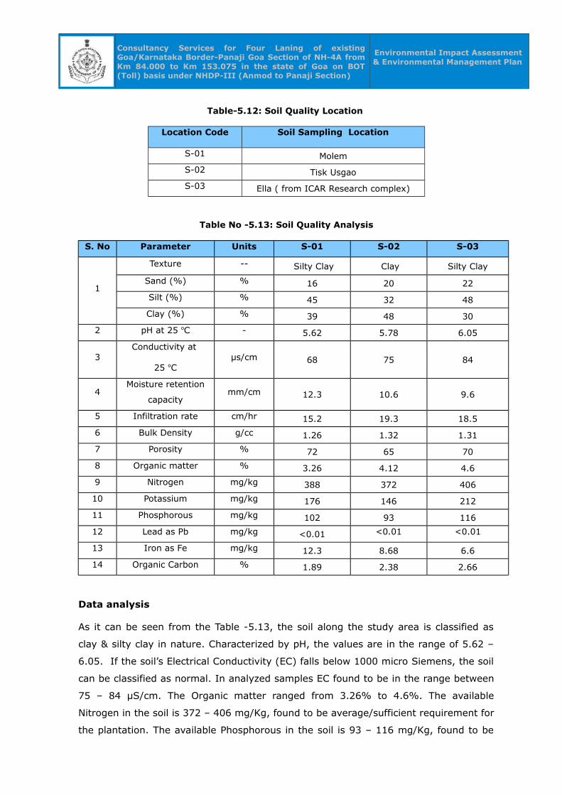
Consultancy Services for Four Laning of existing Goa/Karnataka Border-Panaji Goa Section of NH-4A from Km 84.000 to Km 153.075 in the state of Goa on BOT (Toll) basis under NHDP-III (Anmod to Panaji Section)
Environmental Impact Assessment & Environmental Management Plan
Table-5.12: Soil Quality Location
Location Code Soil Sampling Location
S-01 Molem
S-02 Tisk Usgao
S-03 Ella ( from ICAR Research complex)
Table No -5.13: Soil Quality Analysis
S. No Parameter Units S-01 S-02 S-03
1
Texture -- Silty Clay Clay Silty Clay
Sand (%) % 16 20 22
Silt (%) % 45 32 48
Clay (%) % 39 48 30
2 pH at 25 oC - 5.62 5.78 6.05
3Conductivity at
25 oCµs/cm 68 75 84
4Moisture retention
capacitymm/cm 12.3 10.6 9.6
5 Infiltration rate cm/hr 15.2 19.3 18.5
6 Bulk Density g/cc 1.26 1.32 1.31
7 Porosity % 72 65 70
8 Organic matter % 3.26 4.12 4.6
9 Nitrogen mg/kg 388 372 406
10 Potassium mg/kg 176 146 212
11 Phosphorous mg/kg 102 93 116
12 Lead as Pb mg/kg <0.01 <0.01 <0.01
13 Iron as Fe mg/kg 12.3 8.68 6.6
14 Organic Carbon % 1.89 2.38 2.66
Data analysis
As it can be seen from the Table -5.13, the soil along the study area is classified as
clay & silty clay in nature. Characterized by pH, the values are in the range of 5.62 –
6.05. If the soil’s Electrical Conductivity (EC) falls below 1000 micro Siemens, the soil
can be classified as normal. In analyzed samples EC found to be in the range between
75 – 84 µS/cm. The Organic matter ranged from 3.26% to 4.6%. The available
Nitrogen in the soil is 372 – 406 mg/Kg, found to be average/sufficient requirement for
the plantation. The available Phosphorous in the soil is 93 – 116 mg/Kg, found to be
Consultancy Services for Four Laning of existing Goa/Karnataka Border-Panaji Goa Section of NH-4A from Km 84.000 to Km 153.075 in the state of Goa on BOT (Toll) basis under NHDP-III (Anmod to Panaji Section)
Environmental Impact Assessment & Environmental Management Plan
average requirement for the plantation and agricultural purposes. The available
Potassium in the soil is 146 – 212 mg/Kg, found to be medium requirement for the
plantation and agricultural purposes. Trace metal concentrations found to be low.
5.8 Biological Environment
Goa is having rich tropical biodiversity. The state is covered with Bamboo canes, Chillar
barks, Bhirand, Coconut trees as main forest products. Fruit trees like jack fruits,
mangoes, pineapples and black berries are present in the state. Being close to the
Arabian Sea the Goan climate is warm and humid throughout the year. Goa is home to
rich tropical biodiversity. Goa is also a home for several faunal species. Goa's state
animal is the Gaur, the state bird is the Ruby Throated Yellow Bulbul, which is a
variation of Black-crested Bulbul, and the state tree is the Asan. Other animals like
foxes, wild boars and migratory birds are found in the jungles of Goa. Crabs, lobsters,
shrimps, jellyfish, oysters and catfish form important part of the water-life of the
state. Goa also has a high snake population, which keeps the rodent population in
control.
5.8.1 Land use
The existing project of 4 laning of Anmod to Panaji on NH-4A is passing through hilly,
highly rolling and plain terrain. The project stretch passes through hilly terrain and
majority of adjoining land is Forest. Some of the stretch where industrial places and
junction locations are built up. The important crops grown along the project stretch are
Cashew, Rice and Areca. The land utilization pattern of the study districts are given in
Table – 5.14. The Goa land use map is given in Figure -5.23
Table – 5.14: Land Utilization Pattern of the Goa (Area in Hectare)
Sl.No Land Use Area in Ha Percentage
1 Reporting area for land utilization 361 -
2 Forests 125 34.63
3 Not avaialble for cultivation 37 10.25
4 Permanenet pastures and other grazing lands
1 0.28
5 Land under misc. tree crops & groves 1 0.28
6 Culturable wasteland 53 14.68
7 Fallow lands other than current fallows 0 0.00
8 Current fallows 7 1.94
9 Net are sown 137 37.94

Consultancy Services for Four Laning of existing Goa/Karnataka Border-Panaji Goa Section of NH-4A from Km 84.000 to Km 153.075 in the state of Goa on BOT (Toll) basis under NHDP-III (Anmod to Panaji Section)
Environmental Impact Assessment & Environmental Management Plan
Total Geographical area370 100
Source: Land Use Statistics, Ministry of Agriculture, GoI, 2006.
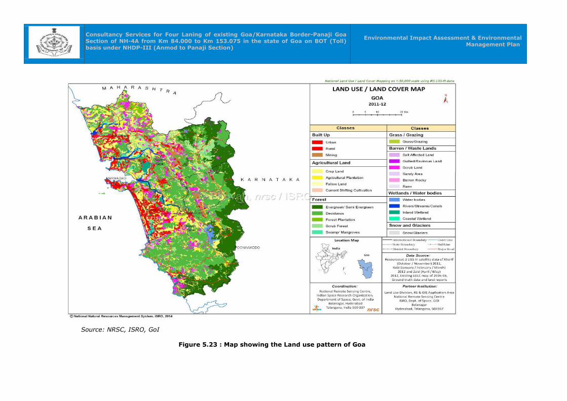
Consultancy Services for Four Laning of existing Goa/Karnataka Border-Panaji Goa Section of NH-4A from Km 84.000 to Km 153.075 in the state of Goa on BOT (Toll) basis under NHDP-III (Anmod to Panaji Section)
Environmental Impact Assessment & Environmental Management Plan
Source: NRSC, ISRO, GoI
Figure 5.23 : Map showing the Land use pattern of Goa
Consultancy Services for Four Laning of existing Goa/Karnataka Border-Panaji Goa Section of NH-4A from Km 84.000 to Km 153.075 in the state of Goa on BOT (Toll) basis under NHDP-III (Anmod to Panaji Section)
Environmental Impact Assessment & Environmental
Management Plan
5.8.1 Forests, Biosphere and Sanctuary
Forests in the Study Area:
A major section of the project road from km 84.000 to km 96.000 passes through part
of Western Ghats, which has been considered as one of the richest reservoirs of the
bio-diversity and termed as 'Biodiversity hotspot'. (Hot spots are areas that are
extremely rich in species, have high endemism, and are under constant threat).
Floristically Western Ghats bio-region is one of the richest harbouring with almost
3500 species of flowering plants (27 percent of the flowering plants in India). The ten
dominant natural orders of plants are Gramineae, Leguminosae, Acanthaceae,
Orchidaceae, Compositae, Euphorbiaceae, Rubiaceae, Asclepiadaceae, Geraniaceae
and Labiatae. The genera found in the region with more than 15 species each are
Crotaleria, Impatiems, Diospyros, Ipomoea, Eugenia, Strobilanthus, Ficus,
Desmodium, Habenaria, Grewia and Osbechia. There are 58 endemic genera mostly
confined to Western Ghats of which 47 are monotypic. Gramineae (Poaceae) has the
highest number of endemic genera and the genus Nilgirianthus has the maximum
number (20) of endemic species. Tree genera endemic to the Western Ghats are
Blepharisternma, Erinocarpus, Meteromyrtus, Ostonephelium, Poeciloneuron and
Pseudoglochidion. Other endemic genera are Adenoon, Griffithella, Willisia, Meineckia,
Baeolepis, Nanothamnus, Wagarea, Campbellia and Calacanthus. In addition, there are
6 genera and 17 species belonging to Bambusae of which 6 are confined to Western
Ghats. Of 25 species of Dalbergia found in India, 22 species and 1 variety are from the
Western Ghats. There are also 84 species and two variants of endemic orchids
belonging to 30 genera (these genera are endemic). Of the known orchids of Indian
peninsula, 37 percent are endemic to the Western Ghats region and of those 15
species are endangered.
Diversity and endemism are also seen in fauna of Western Ghats. There are 48 genera
of mammals, 275 genera of birds (with 28 endemic forms), 60 genera of reptiles with
7 Hoplodactyles, Salea, Pseudoplecturus, Pleucturus, Melanophidium, Platylecturus and
Xylophis have been recorded. The order Salientia is the best represented amphibian
group in India. The genus Rana within this order with 35 species reported from India is
mainly found in the peninsula, with 14 species endemic to the Western Ghats. Family
Rhacophoridae with two genera and nine species occurring in the Western Ghats, out
of the 10 species known from India, family Bufonidae has three genera. The genus
Nectophryne has endemic N. tuberculosa in the Western Ghats. In the genus Bufo, out
of fifteen species, seven are endemic to the Western Ghats.
Consultancy Services for Four Laning of existing Goa/Karnataka Border-Panaji Goa Section of NH-4A from Km 84.000 to Km 153.075 in the state of Goa on BOT (Toll) basis under NHDP-III (Anmod to Panaji Section)
Environmental Impact Assessment & Environmental
Management Plan
Bhagwan Mahaveer Sanctuary and National Park:
This protected area located in the Western Ghats of South India, in Sanguem taluk,
Goa along the eastern border with Karnataka with an area of 240 sq.km Initially, it
was notified as a Sanctuary (Molem Wildlife Sanctuary) in 1967. Subsequently an area
of 107 sq.km. of the said Sanctuary was notified as the Molem National Park in 1978.
Later, the name was changed to Bhagwan Mahaveer Wildlife Sanctuary and National
Park. It is located between 15°15"30' to 15°29"30' N and 74°10"15' to 74°20"15' E.
The area is situated near the town of Molem, 57 kilometres east of Panaji, the state
capital of Goa. National Highway 4A divides it into two parts and the Mormugao -
Londa railway line passes through the area.
The sanctuary is classified as West Coast tropical evergreen forests, West Coast semi-
evergreen forests and moist deciduous forest. The sanctuary's setting in the foothills
of the Western Ghats is wonderful and the countryside is one of the most peaceful
across in Goa. The sanctuary is rich in wildlife and paradise for bird watchers.
The predominant wild mammals in the sanctuary are tiger, leopard black panther,
flying squirrel, barking deer, spotted deer common langur, gaur, wild dog, sambar,
porcupine and mouse deer etc.,The Popular birds are greater Indian hornbill,
large green barbet, grey jungle fowl, Indian black woodpecker, grey-headed
myna, Malabar grey hornbill and the Goa state bird Yellow-throated bulbul etc.,
5.8.2 Flora and Fauna in the Study Area
i) Methodology
A list of all macroscopic plants is prepared based on extensive field survey covering
the entire project site or core area. Quantitative data on frequency, density,
dominance as percent cover etc are noted based on quadrats of 10 x 10 m in case of
trees, 2 x 5 m in case of shrubs and 1 x 1 m in case of herbs. Cover is usually
estimated by a modified line intercept method where the area occupied by each
species is estimated as percentage of total length of a line transect either intercepted
or over lain or under laid along with the transect.
Data from field study is recorded in the following Tables:
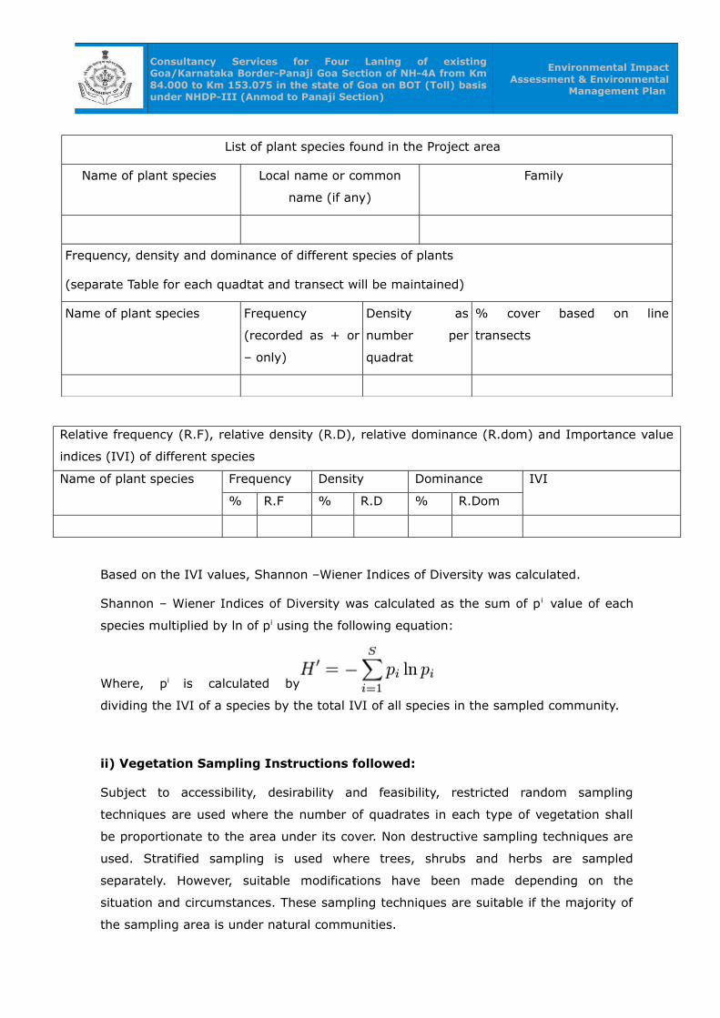
Consultancy Services for Four Laning of existing Goa/Karnataka Border-Panaji Goa Section of NH-4A from Km 84.000 to Km 153.075 in the state of Goa on BOT (Toll) basis under NHDP-III (Anmod to Panaji Section)
Environmental Impact Assessment & Environmental
Management Plan
List of plant species found in the Project area
Name of plant species Local name or common
name (if any)
Family
Frequency, density and dominance of different species of plants
(separate Table for each quadtat and transect will be maintained)
Name of plant species Frequency
(recorded as + or
– only)
Density as
number per
quadrat
% cover based on line
transects
Relative frequency (R.F), relative density (R.D), relative dominance (R.dom) and Importance value
indices (IVI) of different species
Name of plant species Frequency Density Dominance IVI
% R.F % R.D % R.Dom
Based on the IVI values, Shannon –Wiener Indices of Diversity was calculated.
Shannon – Wiener Indices of Diversity was calculated as the sum of pi value of each
species multiplied by ln of pi using the following equation:
Where, pi is calculated by
dividing the IVI of a species by the total IVI of all species in the sampled community.
ii) Vegetation Sampling Instructions followed:
Subject to accessibility, desirability and feasibility, restricted random sampling
techniques are used where the number of quadrates in each type of vegetation shall
be proportionate to the area under its cover. Non destructive sampling techniques are
used. Stratified sampling is used where trees, shrubs and herbs are sampled
separately. However, suitable modifications have been made depending on the
situation and circumstances. These sampling techniques are suitable if the majority of
the sampling area is under natural communities.
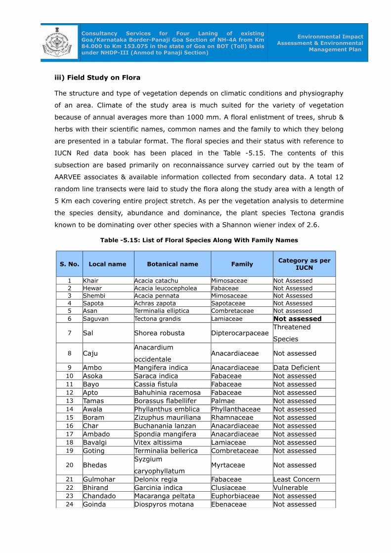
Consultancy Services for Four Laning of existing Goa/Karnataka Border-Panaji Goa Section of NH-4A from Km 84.000 to Km 153.075 in the state of Goa on BOT (Toll) basis under NHDP-III (Anmod to Panaji Section)
Environmental Impact Assessment & Environmental
Management Plan
iii) Field Study on Flora
The structure and type of vegetation depends on climatic conditions and physiography
of an area. Climate of the study area is much suited for the variety of vegetation
because of annual averages more than 1000 mm. A floral enlistment of trees, shrub &
herbs with their scientific names, common names and the family to which they belong
are presented in a tabular format. The floral species and their status with reference to
IUCN Red data book has been placed in the Table -5.15. The contents of this
subsection are based primarily on reconnaissance survey carried out by the team of
AARVEE associates & available information collected from secondary data. A total 12
random line transects were laid to study the flora along the study area with a length of
5 Km each covering entire project stretch. As per the vegetation analysis to determine
the species density, abundance and dominance, the plant species Tectona grandis
known to be dominating over other species with a Shannon wiener index of 2.6.
Table -5.15: List of Floral Species Along With Family Names
S. No. Local name Botanical name FamilyCategory as per
IUCN
1 Khair Acacia catachu Mimosaceae Not Assessed2 Hewar Acacia leucocepholea Fabaceae Not Assessed3 Shembi Acacia pennata Mimosaceae Not Assessed4 Sapota Achras zapota Sapotaceae Not Assessed5 Asan Terminalia elliptica Combretaceae Not assessed6 Saguvan Tectona grandis Lamiaceae Not assessed
7 Sal Shorea robusta DipterocarpaceaeThreatened
Species
8 CajuAnacardium
occidentaleAnacardiaceae Not assessed
9 Ambo Mangifera indica Anacardiaceae Data Deficient 10 Asoka Saraca indica Fabaceae Not assessed 11 Bayo Cassia fistula Fabaceae Not assessed 12 Apto Bahuhinia racemosa Fabaceae Not assessed 13 Tamas Borassus flabellifer Palmae Not assessed14 Awala Phyllanthus emblica Phyllanthaceae Not assessed 15 Boram Zizuphus mauriliana Rhamnaceae Not assessed 16 Char Buchanania lanzan Anacardiaceae Not assessed 17 Ambado Spondia mangifera Anacardiaceae Not assessed 18 Bavalgi Vitex altissima Lamiaceae Not assessed 19 Goting Terminalia bellerica Combretaceae Not assessed
20 BhedasSyzgium
caryophyllatumMyrtaceae Not assessed
21 Gulmohar Delonix regia Fabaceae Least Concern 22 Bhirand Garcinia indica Clusiaceae Vulnerable 23 Chandado Macaranga peltata Euphorbiaceae Not assessed 24 Goinda Diospyros motana Ebenaceae Not assessed

Consultancy Services for Four Laning of existing Goa/Karnataka Border-Panaji Goa Section of NH-4A from Km 84.000 to Km 153.075 in the state of Goa on BOT (Toll) basis under NHDP-III (Anmod to Panaji Section)
Environmental Impact Assessment & Environmental
Management Plan
S. No. Local name Botanical name Family Category as per IUCN
25 Karanji Pongamia pinnata Fabaceae Least Concern
26 KaroStrychonos nux-
vomicaLoganiaceae Not assessed
27 Datura Datura stramonium Solanaceae Not assessed 28 Jamun Syzgium cumini Myrtaceae Not assessed
29 KamdeliRhizophora
mucoronataRhizophoraceae Not assessed
30 Kusum Schleichera Oleosa Sapindaceae Not assessed 31 Kakad Garunga pinnata Burseraceae Not assessed 32 Kala Siras Albizzia odoratissima Fabaceae Not assessed 33 Vad Ficus bengalensis Moraceae Not assessed 34 Hirda Terminalia chebula Combretaceae Not assessed 35 Palas Butea monosperma Fabaceae Not assessed 36 Taman Lagerstoemia speciosa Lythraceae Not assessed 37 Zamba Xylia xylocarpa Fabaceae Not assessed 38 Pipal Ficus religiosa Moraceae Not assessed 39 Sissum Dalbergia latifolia Fabaceae Vulnerable40 Siras Albizzia lebbek Fabaceae Not assessed 41 Sitaphal Annona squamosa Annonaceae Not assessed42 Limb Azadirachta indica Meliaceae Not assessed43 Gul Mohwa Bassia latifolia Sapotaceae Not assessed44 Chillar Caesalpinia sepiaria Caesalpinaceae Not assessed45 Papaya Carica papaya Caricaceae Not assessed
46 CasuarinaCausuarina
equisetifoliaCasuarinaceae Not assessed
47 Coconut Cocos nucifera Palmae Not assessed
48White silk
cotton treeCeiba pentandra Bombaceae Not assessed
49 Downy Datura metel Solanaceae Not assessed50 Eucalyptus Eucalyptus territiconis Myrtaceae Not assessed51 Ashvath Ficus religiosa Moraceae Not assessed52 Kurule Garuga pinnata Burseraceae Not assessed53 Haldu Haldinia cordifolia Rubiaceae Not assessed54 Papra Holoptelea integrifolia Ulmaceae Not assessed55 Kurat Ixora arborea Rubiaceae Not assessed56 Shirali Microcos paniculatus Tiliaceae Not assessed57 Vilayathi Pithecelobium dulce Mimosaceae Not assessed
iv) Survey of Fauna of the study area:
Since the animals with the exception of a few sedentary species and a few residents
move from place to place either for feeding or breeding or for shelter etc, it may not
be possible to prepare separate lists of fauna for core and buffer zones. The mere
absence of a species at the time of sampling does not rule out its presence. In order to
overcome such problems, a list based on both primary survey and secondary data is
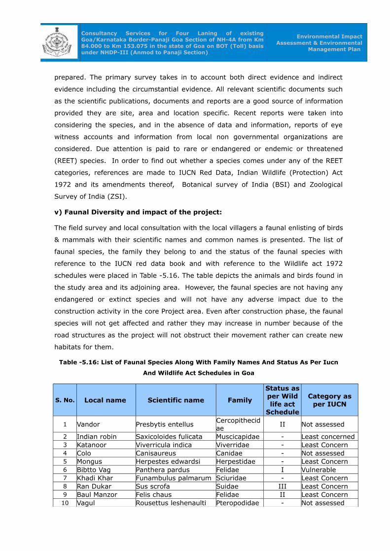
Consultancy Services for Four Laning of existing Goa/Karnataka Border-Panaji Goa Section of NH-4A from Km 84.000 to Km 153.075 in the state of Goa on BOT (Toll) basis under NHDP-III (Anmod to Panaji Section)
Environmental Impact Assessment & Environmental
Management Plan
prepared. The primary survey takes in to account both direct evidence and indirect
evidence including the circumstantial evidence. All relevant scientific documents such
as the scientific publications, documents and reports are a good source of information
provided they are site, area and location specific. Recent reports were taken into
considering the species, and in the absence of data and information, reports of eye
witness accounts and information from local non governmental organizations are
considered. Due attention is paid to rare or endangered or endemic or threatened
(REET) species. In order to find out whether a species comes under any of the REET
categories, references are made to IUCN Red Data, Indian Wildlife (Protection) Act
1972 and its amendments thereof, Botanical survey of India (BSI) and Zoological
Survey of India (ZSI).
v) Faunal Diversity and impact of the project:
The field survey and local consultation with the local villagers a faunal enlisting of birds
& mammals with their scientific names and common names is presented. The list of
faunal species, the family they belong to and the status of the faunal species with
reference to the IUCN red data book and with reference to the Wildlife act 1972
schedules were placed in Table -5.16. The table depicts the animals and birds found in
the study area and its adjoining area. However, the faunal species are not having any
endangered or extinct species and will not have any adverse impact due to the
construction activity in the core Project area. Even after construction phase, the faunal
species will not get affected and rather they may increase in number because of the
road structures as the project will not obstruct their movement rather can create new
habitats for them.
Table -5.16: List of Faunal Species Along With Family Names And Status As Per Iucn
And Wildlife Act Schedules in Goa
S. No. Local name Scientific name Family
Status as per Wild life act
Schedule
Category as per IUCN
1 Vandor Presbytis entellus Cercopithecidae
II Not assessed
2 Indian robin Saxicoloides fulicata Muscicapidae - Least concerned3 Katanoor Viverricula indica Viverridae - Least Concern4 Colo Canisaureus Canidae - Not assessed5 Mongus Herpestes edwardsi Herpestidae - Least Concern6 Bibtto Vag Panthera pardus Felidae I Vulnerable7 Khadi Khar Funambulus palmarum Sciuridae - Least Concern8 Ran Dukar Sus scrofa Suidae III Least Concern9 Baul Manzor Felis chaus Felidae II Least Concern10 Vagul Rousettus leshenaulti Pteropodidae - Not assessed

Consultancy Services for Four Laning of existing Goa/Karnataka Border-Panaji Goa Section of NH-4A from Km 84.000 to Km 153.075 in the state of Goa on BOT (Toll) basis under NHDP-III (Anmod to Panaji Section)
Environmental Impact Assessment & Environmental
Management Plan
S. No. Local name Scientific name Family
Status as per Wild life act
Schedule
Category as per IUCN
11 Bhalu Melursus ursinus Ursidae II Vulnerable12 Shenkaro Ratufa indica Sciuridae II Least Concern13 Bhenkaro Muntiacus muntjak Cervidae III Not assessed14 Sambhar Cervus unicolor Cervidae III Vulnerable15 Koli Undir Bandicot Indica Muridae - Not assessed16 Vagati Felis bengalensis Felidae - Not assessed17 Pak Mazor Petaurista petaurista Sciuridae - Least Concern
Measures to compensate removed plants during construction
There are 20,000 nos. of trees needs to be planted along the project corridor. The type
of plants to be removed are Asan, Rosewood, Bamboo, Khair, Mango, Neem, Cashew,
Casuearina, Betel nuts, Coconut and Eucalyptus. The short-term impact due to felling
of trees will be compensated in long term through the proposed plantation
programme. The local plant varieties will be identified and the same will be planted
along the aqueduct and surrounding areas.
Mitigation Measures:
• Avenue Plantation programme shall be promptly adopted to restore and further
enrich the loss of vegetation.
• Avenue Plantation with an appropriate mix of indigenous and specially suited
species shall be carried out along the corridor. The number of plants proposed
to be planted is 20,000 nos.
• Local plant varieties especially, soil bounding species will be planted near to the
constructed aqueduct and also in the surroundings in order to hold the soil
tightly.
5.8.4 Study of Aquatic flora and Fauna:
The Phytoplankton, Zooplankton, Macrobenthos, Nekton, Macrofauna, Mangroves and
Angiosperms are present in the aquatic flora in the study area. Predominant Man-
groves identified in the study area are Rhizophora mucronata, Rhizophora apiculata,
Avicennia officinalis, Avicennia marina, Avicennia alba, Sonneratia alba, Sonneratia
caseolaris, Ceriops tagal, Aegiceras corniculatum, Derris heterophylla etc. Figure 5.24
is showing the Mangroves near River Mandovi Estuary.

Consultancy Services for Four Laning of existing Goa/Karnataka Border-Panaji Goa Section of NH-4A from Km 84.000 to Km 153.075 in the state of Goa on BOT (Toll) basis under NHDP-III (Anmod to Panaji Section)
Environmental Impact Assessment & Environmental
Management Plan
Figure 5.24: Mangroves near River Mandovi Estuary
Aquatic fauna
Crocodylus palustris, Lepidochelyes olivacea, Calotes rouxii, Hoplobatrachus tigerinus,
Rana malabarica, Melanochelys trijuga are present in the aquatic fauna in the study
area.
5.9 Socio-economic Status (According to 2011 Census)
Population Size 1458545
Population size (Males) 739140
Population size (Females) 719405
Population size (Rural) 551731
Population size (Urban) 906814
Population size (Rural Males) 275436
Population size (Rural Females) 276295
Population size (Urban Males) 463704
Population size (Urban Females) 443110
Population density (Total, Person per sq km) 394
Sex Ratio (Females per 1000 males) 973
Consultancy Services for Four Laning of existing Goa/Karnataka Border-Panaji Goa Section of NH-4A from Km 84.000 to Km 153.075 in the state of Goa on BOT (Toll) basis under NHDP-III (Anmod to Panaji Section)
Environmental Impact Assessment & Environmental
Management Plan
Sex Ratio (Rural) 1003
Sex Ratio (Urban) 956
There are two districts falling under the study area namely North Goa and South Goa.
The district wise demographic details are given below:
North Goa District:
In 2011, North Goa had population of 817,761 which is roughly equal to the nation of
Comoros or the US state of South Dakota. This gives it a ranking of 480 th in India (out
of a total of 640). The district has a population density of 471 inhabitants per square
kilometer ()1,220/sq mi). Its population growth rate over the decade 2001-2011 was
7.8%. North Goa has a sex ratio of 959 females for every 1000 males, and a literacy
rate of 88.85%.
Konkani is the mother tongue of a majority of the people living in North Goa district.
Marathi is spoken by a substantial number of people. English and Hindi are understood
by a majority of the population. Portuguese is also spoken and understood by a small
number of people.
South Goa District:
In 2011, South Goa had population of 639,962 which is roughly equal to the nation of
Montenegro or the US state of Vermont. This gives it a ranking of 515 th in India (out of
a total of 640). The district has a population density of 326 inhabitants per square
kilometer (840/sq mi). Its population growth rate over the decade 2001-2011 was
8.63%. South Goa has a sex ratio of 980 females for every 1000 males, and a literacy
rate of 85.53%.
Konkani is the mother tongue of a majority of the people living in South Goa district.
Marathi is spoken by a substantial number of people. English and Hindi are understood
by a majority of the population. Portuguese is also spoken and understood by a small
number of people.
5.9.1 Social Impact Assessment in the Project
i) Land Requirement:
The proposed road improvement including widening involves expropriation of land
from the current owners/users. It is assessed that land acquisition would be required
only in 35 km. Land acquisition in Wild Life Sanctuary is for 31.01 ha and forests area
is for 33.17 ha. With regard to widening, upgradation and improvement of existing
alignment. The total extent of land to be acquired including non-forest, forests and

Consultancy Services for Four Laning of existing Goa/Karnataka Border-Panaji Goa Section of NH-4A from Km 84.000 to Km 153.075 in the state of Goa on BOT (Toll) basis under NHDP-III (Anmod to Panaji Section)
Environmental Impact Assessment & Environmental
Management Plan
Mahaveer WLS area is estimated to be 136.67ha.
A land acquisition plan is separately prepared for this proposed project. The plan
includes land acquisition maps of the affected villages showing proposed right of way
and land schedule for the affected survey numbers. The land plan schedules include
details like ownership status and the survey numbers with required area. Requirement
of Land in Revenue Villages is given in the table no. 5.17.
Table 5.17: Requirement of Land in Revenue Villages
S. No. Village/ Town Total Required Land (Sq. mt.)
Total Required Land (Ha.)
South Goa District
1 Mollem (Option-2) 200 0.020
2 Sangod 7700 0.770
3 Dharbandora 47800 4.78
4 Piliem 46700 4.67
5 Usgao 56100 5.61
6 Candepar 15600 1.56
7 Kurti 20000 2.00
North Goa District
8 Bandora 98900 9.89
9 Priol 92000 9.20
10 Velinga 3100 0.310
11 Cuncolim 27100 2.71
12 Cundaim 48500 4.85
13 Boma 79400 7.94
14 Adcolna 54500 5.45
15 Corlim 54100 5.41
16 Ella 52600 5.26
Total 704300 70.43
Source: Land Plan Schedule, Aarvee Associates, Hyderabad,2015-16
ii) Magnitude of Impact on Structure:
Census of all the structures lying within proposed RoW is undertaken to assess the
project impact on the population for displacement, resettlement and rehabilitation. As
per our preliminary survey it was estimated that about 377 structures consisting of
private [residential, commercial, mixed structure(res+com)], government, religious,
community and others might be affected by the proposed road. The project affected
person may be titleholder or non titleholder e.g., encroacher, squatter, tenant, kiosk
owner etc. About 108 structures belonging to non titleholders were found within
existing RoW. Of the 269 Titleholders' properties, 63 structures owned by religious and
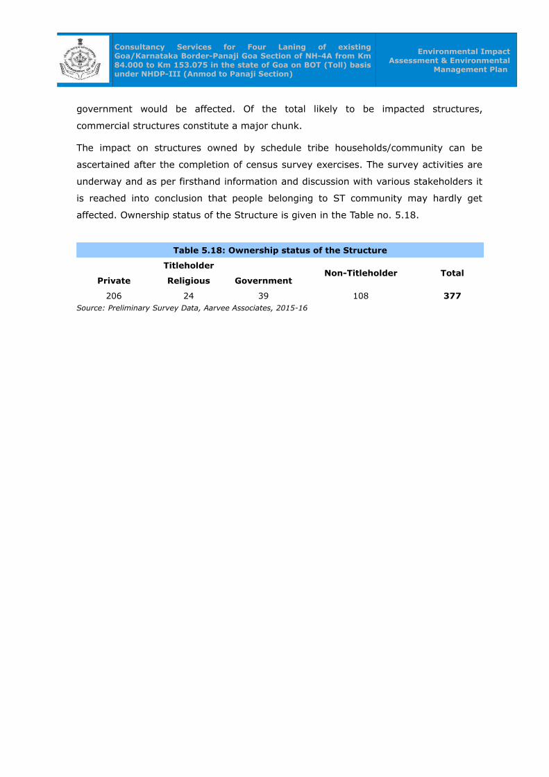
Consultancy Services for Four Laning of existing Goa/Karnataka Border-Panaji Goa Section of NH-4A from Km 84.000 to Km 153.075 in the state of Goa on BOT (Toll) basis under NHDP-III (Anmod to Panaji Section)
Environmental Impact Assessment & Environmental
Management Plan
government would be affected. Of the total likely to be impacted structures,
commercial structures constitute a major chunk.
The impact on structures owned by schedule tribe households/community can be
ascertained after the completion of census survey exercises. The survey activities are
underway and as per firsthand information and discussion with various stakeholders it
is reached into conclusion that people belonging to ST community may hardly get
affected. Ownership status of the Structure is given in the Table no. 5.18.
Table 5.18: Ownership status of the Structure
TitleholderNon-Titleholder Total
Private Religious Government
206 24 39 108 377Source: Preliminary Survey Data, Aarvee Associates, 2015-16
Consultancy Services for Four Laning of existing Goa/Karnataka Border-Panaji Goa Section of NH-4A from Km 84.000 to Km 153.075 in the state of Goa on BOT (Toll) basis under NHDP-III (Anmod to Panaji Section)
Environmental Impact Assessment & Environmental
Management Plan
CHAPTER -06CHAPTER -06
ANTICIPATED ENVIRONMENTAL IMPACTS AND ANTICIPATED ENVIRONMENTAL IMPACTS AND
MITIGATION MEASURESMITIGATION MEASURES
6.0 ANTICIPATED ENVIRONMENTAL IMPACTS AND MITIGATION MEASURES
The Highway development projects exhibit a symbiotic relationship between the
environment and development with both positive and negative and reversible and
irreversible impacts. The present chapter gives the analysis of the environmental
impacts in the proposed project corridor and suggested suitable mitigative measures.
Matrix method will be adopted as methodology for assessment of cumulative impacts
on the project. Based on the scoping of the areas and the work being proposed the
following key issues were assessed for this project.
• Preservation of aesthetic and landscape of the area to the possible extent
• Effective restoration of borrow area and quarries
• Noise and air quality
• Tree removal and tree plantation
• Sanitation and waste disposal
• Road safety
• Protection of flora and fauna
Road development projects can have impacts or cause impacts in four specific
situations as follows:
• Impacts of Location
• Impacts of Project Design
• Impacts during Construction, and
• Impacts when the Road become Operational.
6.1 Impacts of Location
The road stretch has no specific impacts from the location. During this phase, those
impacts, which are likely to take place due to the layout of the project, have been
assessed.
These impacts are:
• Project Affected People (PAPs)

Consultancy Services for Four Laning of existing Goa/Karnataka Border-Panaji Goa Section of NH-4A from Km 84.000 to Km 153.075 in the state of Goa on BOT (Toll) basis under NHDP-III (Anmod to Panaji Section)
Environmental Impact Assessment & Environmental
Management Plan
• Change of Land use
• Loss of trees/forest
• Utility/Drainage Problems
• Impact on Historical and Cultural Monuments
• Impact on Local Transport Facilities
Apart from the clearances, the project road is lack of side drains, inadequate stone
pitching near high embankments, up gradation of structures, paved shoulders and
protection with the crash barriers near high embankments to be upgraded as per the
norms of the Ministry of Road Transport and Highways (MoRTH). Proper care is being
taken in the design of the existing corridor to 4/6-laning configuration of the MoRTH
standards.
6.2 Impacts Due to Project Design
The engineering design of the road is being prepared incorporating all environmental
safeguards. The basic design criteria have been covered in Project Description. The side
drains, stone pitching near high embankments, up gradation of structures and protection
with the crash barriers near high embankments are being taken care in the design of the
project to ensure the 4/6-lane with paved shoulders as per the MoRTH norms.
6.3 Impacts During Construction
Since the construction is dependent on the quality and properties of the available
material, the choice of material, particularly the management of borrow pits, assumes
importance during construction.
6.3.1 Borrow Areas / Stone Quarries / Sand Quarries
The proposed project corridor requires raw materials from 10 borrow areas, 2 metal
quarries and 2 sand quarries. Borrow Areas of Large quantity of earth/ gravel material
is required for widening of formation and embankment, necessitating earth / gravel
from borrow pits.
Mitigation Measures:
To avoid any embankment slippage, the borrow areas will not be dug
continuously, and the size and shape of borrow pits will be decided by the Site
Engineer. Redevelopment of the borrow areas to mitigate the impacts will be
the responsibility of the Contractor. The Contractor shall evolve site-specific
redevelopment plans for each borrow area location, which shall be implemented
after the approval of the Supervision Consultant.
Consultancy Services for Four Laning of existing Goa/Karnataka Border-Panaji Goa Section of NH-4A from Km 84.000 to Km 153.075 in the state of Goa on BOT (Toll) basis under NHDP-III (Anmod to Panaji Section)
Environmental Impact Assessment & Environmental
Management Plan
Precautionary measures as the covering of vehicles will be taken to avoid
spillage during transport of borrow materials. To ensure that the spills, which
might result from the transport of borrow and quarry materials do not impact
the settlements, it will be ensured that the excavation and carrying of earth will
be done during day-time only. The unpaved surfaces used for the haulage of
borrow materials will be maintained properly. Borrowing of earth shall be
carried out at locations recommended as follows:
◦ Non-Cultivable Lands: Borrowing of earth will be carried out upto a depth
of 2.0m from the existing ground level. Borrowing of earth shall not be done
continuously. Ridges of not less than 8m width shall be left at intervals not
exceeding 300m. Small drains shall be cut through the ridges, if necessary,
to facilitate drainage. Borrow pits shall have slopes not steeper than “1
vertical” in “4 horizontal”.
◦ Productive Lands: Borrowing of earth shall be avoided on productive
lands. However, in the event of borrowing from productive lands, under
circumstances as described above, topsoil shall be preserved in stockpiles.
The conservation of topsoil shall be carried out as per the standard
procedures. At productive land locations, the depth of borrow pits shall not
exceed 45cm and it may be dug out to a depth of not more than 30cm after
stripping the 15cm topsoil aside.
◦ Elevated Lands: At locations where private owners desire their fields to be
levelled, the borrowing shall be done to a depth of not more than 2m or up
to the level of surrounding fields. Borrow pits along Roadside: Borrow pits
shall be located 5m away from the toe of the embankment. Depth of the pit
should be such that the bottom of the pit shall not fall within an imaginary
line of slope 1 vertical to 4 horizontal projected from the edge of the final
section of the bank. Borrow pits should not be dug continuously. Ridges of
not less than 8m width should be left at intervals not exceeding 300m.
Small drains should be cut through the ridges to facilitate drainage.
◦ Borrow pits on the riverside: The borrow pit should be located not less
than 15m from the toe of the bank, distance depending on the magnitude
and duration of flood to be withstood.
◦ Community / Private Ponds: Borrowing can be carried out at locations,
where the private owners (or in some cases, the community) desire to
develop lands (mostly low-lying areas) for pisciculture purposes and for use

Consultancy Services for Four Laning of existing Goa/Karnataka Border-Panaji Goa Section of NH-4A from Km 84.000 to Km 153.075 in the state of Goa on BOT (Toll) basis under NHDP-III (Anmod to Panaji Section)
Environmental Impact Assessment & Environmental
Management Plan
as fish ponds.
◦ Borrow Areas near Settlements: Borrow pit location shall be located at
least 0.8 km from villages and settlements. If unavoidable, they should not
be dug for more than 30cm and should be drained.
Quarries and borrow pits will be back filled with rejected construction wastes
and will be given a vegetative cover. If this is not possible, then slopes will be
smoothed and depression will be filled in such a way that it looks more or less
like the original ground surface.
During works execution, the Contractor shall ensure preservation of trees
during piling of materials; spreading of stripping material to facilitate water
percolation and allow natural vegetation growth; re establishment of previous
natural drainage flows; improvement of site appearance; digging of ditches to
collect runoff; and maintenance of roadways where a pit or quarry is declared
useable water source for livestock or people nearby. Once the works are
completed, and at own expense of the Contractor, he shall restore the
environment around the work site to its original splits.
To create a safe environment under the terms of The Mines and Quarries Act
the faces have to be reduced to a naturally stable slope or be adequately
fenced to prevent access to the top and bottom of the faces. Such a fence must
be of a height as prescribed under The Mines Act with a barbed wire top strand
designed to exclude the public from the quarry area. Depending on the location
of the site presence of a permanent lake is considered to be as at is factory
alternative to a fence.
Appropriate plant species for the planting programme have to be selected in
consultation with ecological consultant and local forest department. Depending
on the limitations on the availability of appropriate plant material, harsh
growing conditions (lack of irrigation and hot summer) and ongoing quarry
rehabilitation operations there may be substantial loss of plantation and the
planting programme may have to be continued for over 3–5 years. As plantings
are progressively established they should be monitored before undertaking the
next stage to ensure maximum plant survival rates.
6.3.2 Utilization of Fly Ash
Appreciating the overall concern for environmental and management issues pertaining
to fly ash, which otherwise is a very useful by-product of thermal power plants, the
Technology Information, Forecasting & Assessment Council (TIFAC), Department of
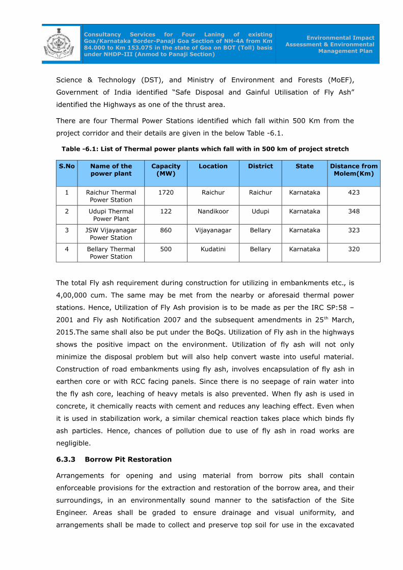
Consultancy Services for Four Laning of existing Goa/Karnataka Border-Panaji Goa Section of NH-4A from Km 84.000 to Km 153.075 in the state of Goa on BOT (Toll) basis under NHDP-III (Anmod to Panaji Section)
Environmental Impact Assessment & Environmental
Management Plan
Science & Technology (DST), and Ministry of Environment and Forests (MoEF),
Government of India identified “Safe Disposal and Gainful Utilisation of Fly Ash”
identified the Highways as one of the thrust area.
There are four Thermal Power Stations identified which fall within 500 Km from the
project corridor and their details are given in the below Table -6.1.
Table -6.1: List of Thermal power plants which fall with in 500 km of project stretch
S.No Name of the power plant
Capacity(MW)
Location District State Distance from Molem(Km)
1 Raichur Thermal Power Station
1720 Raichur Raichur Karnataka 423
2 Udupi Thermal Power Plant
122 Nandikoor Udupi Karnataka 348
3 JSW Vijayanagar Power Station
860 Vijayanagar Bellary Karnataka 323
4 Bellary Thermal Power Station
500 Kudatini Bellary Karnataka 320
The total Fly ash requirement during construction for utilizing in embankments etc., is
4,00,000 cum. The same may be met from the nearby or aforesaid thermal power
stations. Hence, Utilization of Fly Ash provision is to be made as per the IRC SP:58 –
2001 and Fly ash Notification 2007 and the subsequent amendments in 25th March,
2015.The same shall also be put under the BoQs. Utilization of Fly ash in the highways
shows the positive impact on the environment. Utilization of fly ash will not only
minimize the disposal problem but will also help convert waste into useful material.
Construction of road embankments using fly ash, involves encapsulation of fly ash in
earthen core or with RCC facing panels. Since there is no seepage of rain water into
the fly ash core, leaching of heavy metals is also prevented. When fly ash is used in
concrete, it chemically reacts with cement and reduces any leaching effect. Even when
it is used in stabilization work, a similar chemical reaction takes place which binds fly
ash particles. Hence, chances of pollution due to use of fly ash in road works are
negligible.
6.3.3 Borrow Pit Restoration
Arrangements for opening and using material from borrow pits shall contain
enforceable provisions for the extraction and restoration of the borrow area, and their
surroundings, in an environmentally sound manner to the satisfaction of the Site
Engineer. Areas shall be graded to ensure drainage and visual uniformity, and
arrangements shall be made to collect and preserve top soil for use in the excavated
Consultancy Services for Four Laning of existing Goa/Karnataka Border-Panaji Goa Section of NH-4A from Km 84.000 to Km 153.075 in the state of Goa on BOT (Toll) basis under NHDP-III (Anmod to Panaji Section)
Environmental Impact Assessment & Environmental
Management Plan
borrow pit sides and bottom to make it green area alternatively, these borrow areas
would be sited as far as possible on high grounds or hillocks. Topsoil shall be replaced
and the area will be re-vegetated to the satisfaction of the Engineer. The topsoil can
also be used for side slope, median covering for the growth of shrubs and grass.
Additional borrow pits will not be opened without restoration of those areas no longer
in use.
6.3.4 Solid Waste / Surplus Earth
During the construction phase, the quantity of muck generated is approximately
13,00,000 cum and same shall be used for filling up the low-lying areas and some part
will be useful for construction of service roads, etc. The top soil shall be kept
separately and shall be used for plantation/ landscape development purpose in the
project, and also utilized for soil conditioning by the local farmers. An amount of Rs.
9.7 Crore provision is already made in the BoQs for disposal of the same in the
project.
6.3.5 Soil Quality
The problems of soil erosion exist in the stretch due to varying topography, erratic
rainfall and swift velocities of water in the drains during monsoon.
Top Soil Loss: The loss of fertile topsoil / humus may occur because of the extension
of carriageway along the proposed corridor, hence care and precaution need to be
taken to preserve the layer and reuse the soil as it contains the humus.
Soil Erosion: It may occur due to the uneven topography and intensity of rainfall. A
major problem of erosion may occur due to the removal of age-old trees along the
roadside within ROW. The removal will result in the instability of soil binding and soil
structure, as uprooting will make the soil loose. Erosion may occur due to the swift
velocities of drains in monsoon.
Mitigation measures include periodic maintenance of drains to check scouring of soil
and limiting construction activities of culverts and bridges to dry seasons. Measures
should be taken to prevent contamination of soil by bituminous material and other
chemicals utilized during construction. No agricultural land would be used for borrow
areas. The excavated top soil will be properly stored for reuse. In addition to the
engineering design the corridor will be planted with trees to support and the
strengthen the soil binding capacity.
6.3.6 Impact on water resources and water quality
To prevent accumulation of water by the road side, adequate cross drainage (CD)
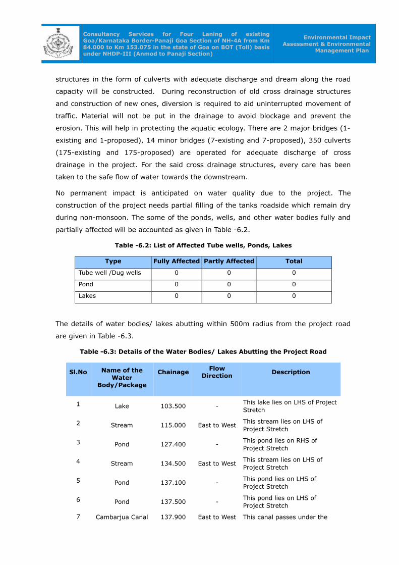
Consultancy Services for Four Laning of existing Goa/Karnataka Border-Panaji Goa Section of NH-4A from Km 84.000 to Km 153.075 in the state of Goa on BOT (Toll) basis under NHDP-III (Anmod to Panaji Section)
Environmental Impact Assessment & Environmental
Management Plan
structures in the form of culverts with adequate discharge and dream along the road
capacity will be constructed. During reconstruction of old cross drainage structures
and construction of new ones, diversion is required to aid uninterrupted movement of
traffic. Material will not be put in the drainage to avoid blockage and prevent the
erosion. This will help in protecting the aquatic ecology. There are 2 major bridges (1-
existing and 1-proposed), 14 minor bridges (7-existing and 7-proposed), 350 culverts
(175-existing and 175-proposed) are operated for adequate discharge of cross
drainage in the project. For the said cross drainage structures, every care has been
taken to the safe flow of water towards the downstream.
No permanent impact is anticipated on water quality due to the project. The
construction of the project needs partial filling of the tanks roadside which remain dry
during non-monsoon. The some of the ponds, wells, and other water bodies fully and
partially affected will be accounted as given in Table -6.2.
Table -6.2: List of Affected Tube wells, Ponds, Lakes
Type Fully Affected Partly Affected Total
Tube well /Dug wells 0 0 0
Pond 0 0 0
Lakes 0 0 0
The details of water bodies/ lakes abutting within 500m radius from the project road
are given in Table -6.3.
Table -6.3: Details of the Water Bodies/ Lakes Abutting the Project Road
Sl.No Name of the Water
Body/Package
Chainage Flow Direction
Description
1 Lake 103.500 -This lake lies on LHS of Project Stretch
2 Stream 115.000 East to WestThis stream lies on LHS of Project Stretch
3 Pond 127.400 -This pond lies on RHS of Project Stretch
4 Stream 134.500 East to WestThis stream lies on LHS of Project Stretch
5 Pond 137.100 -This pond lies on LHS of Project Stretch
6 Pond 137.500 -This pond lies on LHS of Project Stretch
7 Cambarjua Canal 137.900 East to West This canal passes under the
Consultancy Services for Four Laning of existing Goa/Karnataka Border-Panaji Goa Section of NH-4A from Km 84.000 to Km 153.075 in the state of Goa on BOT (Toll) basis under NHDP-III (Anmod to Panaji Section)
Environmental Impact Assessment & Environmental
Management Plan
Sl.No Name of the Water
Body/Package
ChainageFlow
DirectionDescription
bridge of Project Stretch
8 Pond 138.400 -This pond lies on LHS of Project Stretch
9 Syngenta Lake 139.590 -This lake lies on RHS of Project Stretch
10 Carambolim Lake 141.000 - This lake lies on LHS of Project Stretch
Construction activities may temporarily deteriorate surface water quality in terms of
increased turbidity and as well as oil and grease.
The mitigation measures include proper disposal of water and other liquid wastes
arising from construction. Stream courses and drains will be kept free from dumping
of solid wastes and earth material.
6.3.7 Impact on Air Quality
Road construction will involve earth excavation, backfilling and concreting. Impacts on
air during the construction phase could be due to earth excavation, backfilling and
transportation of construction materials, D.G sets which may lead to rise in air pollution.
However, the impact on ambient air quality will not be significant, since the dust and
gases generated is confined to the proposed area and as it will be taken care of by
adopting suitable control measures as described in EMP. However, this impact is
localized.
Impacts on air during the construction phase could be due to transportation of
construction equipment, construction material and road construction activities.
Operation of hot mix plants and Asphalt Plants will result in the emission of fumes and
obnoxious gases to the environment. Loading/ unloading of construction materials and
their transportation, particularly through the unpaved or un-metalled sections of the
road may lead to a rise in the ambient SPM and RPM levels. Material handling, spillage
may occur during the transportation of construction materials.
Mitigation Measures:
• Hot mix plants shall be located away from the inhabited areas, residential
settlements and water bodies.
• Trucks and tippers carrying earth for filling, sand, gravel or stone will be duly

Consultancy Services for Four Laning of existing Goa/Karnataka Border-Panaji Goa Section of NH-4A from Km 84.000 to Km 153.075 in the state of Goa on BOT (Toll) basis under NHDP-III (Anmod to Panaji Section)
Environmental Impact Assessment & Environmental
Management Plan
covered with Tarpaulin sheets to avoid spilling.
• Dust level at the construction sites shall be controlled by sprinkling water on
haulage roads thrice in a day.
• Construction material, machinery and equipment will be maintained in a good
working condition and shall be handled with due precaution and only by trained
professionals.
6.3.8 Impact on Noise
The impact of noise levels from the project on the neighboring communities would be
anticipated with the increase in vehicles and vary with vehicles speed. the increased
noise level is attenuated by vegetative noise barriers. (rows of trees planted). The
major sources for noise pollution during construction will be movement of vehicles
transporting the construction material to the construction yard and the noise
generating activities at the yard itself. The construction equipment with high noise
levels, loading and transportation of material near the borrow areas will affect the
construction personnel and other humans in the area.
Mitigation Measures:
• The required mitigation measures include location of construction equipment at
least 250m away from inhabited areas. In addition construction workers will
have to be provided with protection devices like earplugs.
• Other ancillary measures include maintenance of equipment in good condition,
proper design of engine enclosures. Project activities shall be coincide with
periods when people would be least affected. Construction activities shall be
strictly prohibited between 10 p.m. and 6 a.m. in residential areas.
6.3.9 Impact on Biological Environment
The forests of Goa are typical of the Western Ghats (Southern Maharashtra and
Karnataka). There is diversity in the forests due to the variation in altitude, aspect, soil
characters, slope etc. As per Champion and Seth (1968) Classification of Forest types
of India, the forests of Goa fall in the following types:-
(i) Estuarine vegetation consisting of mangrove species along narrow muddy banks of
rivers [4 B/TS1 and 4B/TS2]
(ii) Strand vegetation along the coastal belts
(iii) Plateau vegetation confined especially to the low altitude
a. Open scrub jungle (5.E7)
b. Moist mixed deciduous forests [3B/C2]

Consultancy Services for Four Laning of existing Goa/Karnataka Border-Panaji Goa Section of NH-4A from Km 84.000 to Km 153.075 in the state of Goa on BOT (Toll) basis under NHDP-III (Anmod to Panaji Section)
Environmental Impact Assessment & Environmental
Management Plan
c. Secondary moist mixed deciduous forests [3B/C2/2SI)
d. Sub-tropical Hill forests [8A/C2]
(iv) Semi-evergreen and evergreen forest.
a. Semi-evergreen forests [2A/C2]
b. Lateritic Semi-evergreen forests [2 E4]
c. Evergreen forests [1A/C4]
i) Flora
The widening & strengthening of the existing 2-lane road to 4-lane road might require
felling of recently planted trees of about 10,000 nos. from the roadside plantation
areas. The predominant tree species going to be felled include Asan, Rosewood,
Bamboo, Khair, Mango, Neem, Cashew, Casuearina, Betel nuts, Coconut and
Eucalyptus. etc. These are all ubiquitous species. The short-term impact due to felling
of trees will be compensated in long term through the proposed avenue plantation
programme. There are 20,000 nos. of trees proposed to be replanted in the project in
the ratio of 1:2 against the trees cut.
It is estimated that there are about 50 Kms (excluding major and minor bridges),
Median plantation is proposed with provisions of 333 nos. of plants per kilometer in
Wild life sanctuary and provisions of 666 nos. of plants per kilometer in the rest of the
stretch. Hence, the estimated median plantation is around 27,445 nos. The median
plant proposed in the project are i.e., Bougainvillea, Nerium Oleander, Thevitia
Nerifolia, Tabernaemontana Coronaria etc.
Mitigation Measures:
An avenue plantation programme shall be promptly adopted to restore and
further enrich the loss of vegetation. Plantation with an appropriate mix of
indigenous and especially suited species shall be carried out along the corridor.
The number of avenue plants proposed to be planted is 20,000 throughout the
project stretch including parking areas, toll gates, bus bays and truck laybyes.
Along the extreme edge of road boundary, fall growing and desert trees such as
Bor, Khair, Banyan, Peepal, Neem, Ain, Amla, Char, Thedu, Mahua, Anjan, Bel,
etc shall be planted at a distance of 3 m from the outer ROW of the project
stretch.
In the median, the Flowering plants & shrubs with a height of about 2m shall be
proposed to be planted. The plantation in the median will serve, as a barrier
against glaring headlights of the vehicular traffic plying in the opposite
direction. Further, this will improve the aesthetics of the road. The suggested

Consultancy Services for Four Laning of existing Goa/Karnataka Border-Panaji Goa Section of NH-4A from Km 84.000 to Km 153.075 in the state of Goa on BOT (Toll) basis under NHDP-III (Anmod to Panaji Section)
Environmental Impact Assessment & Environmental
Management Plan
plantation in the median is Bougainvillea, Thevita peruviana (Be still tree),
Nerium Oleander (Ganneru dwarf) etc.
Mitigation Measures for Bhagwan Mahaveer Wildlife Sanctuary during
Construction Phase:
Awareness programmes shall be conducted in the command area as well as
construction labours in the form of seminars/workshops/exhibitions. An amount
of Rs.20.0 lakhs is made in the EMP for this purpose.
Define the construction boundary near Sanctuary peripheral area, and shall be
provided with hoarding/notice boards/sign boards for the restriction of
movement of construction labours/local public.
Construction camps shall be put 10 Kms away from the Bhagwan Mahaveer
Wildlife Sanctuary boundaries.
Mitigation of man versus animal conflict is going to be the important issue that
will threaten wildlife in Sanctuary area
The construction activity across the reserve forests shall be taken up during day
time only.
Project Authorities shall make periodic visits to meet Forest authorities to
obtain their approval/suggestions during construction and operation of the
project.
Necessary noise mitigation measures as mentioned above shall be strictly
implemented.
Vehicles under PUC checkup only be used during construction activities to
minimize air emissions.
II) Fauna
Terrestrial Fauna:
During the construction, no impact on the wildlife is anticipated.
Aquatic Fauna:
There are 9 nos. of rivers / lakes / ponds identified in the project stretch of 500m
radius, most of them are remain dry during non-monsoon months.
Increasing sediment load to the recipient water bodies i.e. ponds and rivers will restrict
the penetration of solar energy in the water body. This will affect photosynthesis of the
aquatic flora, which in turn will have adverse impacts on the aquatic fauna. Since most
of the water bodies remain dry during the non-monsoon months, this impact will be
negligible. But, the implementation of the following measures will help to avoid soil
erosion and further minimize the impacts of the aquatic fauna.
Consultancy Services for Four Laning of existing Goa/Karnataka Border-Panaji Goa Section of NH-4A from Km 84.000 to Km 153.075 in the state of Goa on BOT (Toll) basis under NHDP-III (Anmod to Panaji Section)
Environmental Impact Assessment & Environmental
Management Plan
Mitigation Measures:
Filling up of ponds wherever required shall be done during the non-monsoon
months.
Construction of bridges and culverts shall be accomplished during the non-
monsoon periods.
Filling up of ponds will be resorted only after exhausting all other options.
The direct discharge of oil and chemical spills to the water bodies shall be
avoided.
6.3.10 Impacts on Human Use Values
i) Land Use
Widening & strengthening of the existing highway to 4/6-laning with National highway
norms may lead to a change in the land use pattern of areas adjacent to the road. The
existing land adjacent to the road at present is mostly of barren, agricultural use and
forest area and grazing use which needs to be acquired for widening of the road.
The project corridor is a mix of hilly, highly rolling and plain terrain and thus, no
disfiguration of land is envisaged due to construction activities except for the opening
up of borrow pits. The borrow pit locations have already been identified and will be
restricted to those areas only.
Mitigation Measures:
1. Construction activities shall be limited to the corridor only.
2. Care shall be taken to ensure that the construction workers camp does not
disturb the surrounding land use.
3. Existing access/ entrances to the highway shall be duly maintained.
4. The realignment alternatives that are best from Engineering, Environmental
and Social aspects are selected for this project.
ii) Flood Characteristics
The project stretch comprises forty two (31) cross drainage existing structures and
eight (11) more are proposed to meet the demand. There are two (2) major bridges
are existing and two (2) more major bridges are proposed. There are eight (8) minor
bridges are existing and one (1) more bridge is proposed. The project stretch are
designed for above HFL hence, the flooding in the area can be avoided. The flood
characteristics of the project area are given project description. In the proposed

Consultancy Services for Four Laning of existing Goa/Karnataka Border-Panaji Goa Section of NH-4A from Km 84.000 to Km 153.075 in the state of Goa on BOT (Toll) basis under NHDP-III (Anmod to Panaji Section)
Environmental Impact Assessment & Environmental
Management Plan
improvement scheme, embankments will be constructed for forming bypasses,
construction of ROBs and vehicular underpasses. These may lead to flooding of the
project area in the event of unprecedented rains.
Mitigation Measures:
All the structures shall have adequate waterway. The design discharge shall be
evaluated for flood of 100 years in case 4 /6 laning is considered in the design of the
project.
• Raising of the embankment height above the submergence depth, with
provision of balancing culverts.
• Widening and strengthening of the existing cross-drainage structures
particularly at the specified locations of submergence.
• Providing drain on both sides of the widened road and extending the drains to a
proper outfall.
• Proper supervision during construction to avoid blocking of micro-drainage
across the road.
• Maintaining existing drainage outlets.
• Replace inadequate or distressed drainage structures.
• Adequate number of cross drainage structures will be provided along the
bypasses.
6.3.11 Impacts on Quality of Life
i. Socio-economics, Land Acquisitions and Re-settlements
Impacts and mitigation measures associated with social environment in the project
influence area (PIA), land acquisition and resettlement of project-affected persons
(PAP) have been dealt in report.
ii. Accident, Health and Safety
Construction activities will cause hindrance to the existing traffic flow. Thus, short-
term impact in terms of accident is anticipated during construction phase of the
widening project. Adequate safety measures to be considered during construction
phase of the project.
Mitigation Measures:
• Reduce speed through construction zones.
Consultancy Services for Four Laning of existing Goa/Karnataka Border-Panaji Goa Section of NH-4A from Km 84.000 to Km 153.075 in the state of Goa on BOT (Toll) basis under NHDP-III (Anmod to Panaji Section)
Environmental Impact Assessment & Environmental
Management Plan
• Construction of bridges/ culverts shall be carried out prior to construction of
new corridor at the first stage.
• Proper cautionary signs shall be displayed at construction sites.
• Diversion roads will be provided wherever needed.
iii. Aesthetics and Landscape
The proposed widening of the existing lane to 4/6-lane road will require very partial
removal of roadside plantation, which will deteriorate the corridors aesthetic values
temporarily. But the proposed plantation all along in long run will improve the
aesthetics and landscaping of the corridor. Dis-figuration of the landscape is also
anticipated due to opening of borrow pits.
Mitigation Measures
• Mixed plantation shall be carried out at roadside and flowering shrubs shall be
planted in the median
• Borrow pits shall be resurfaced with conserved topsoil (borrow pit opening shall
be as per IRC 10-1961).
• Plan for controlled development shall be evolved by land planning agencies.
• There shall be proper vigilance to avoid squatter development all along the
corridor.
6.3.12 Impacts from Construction Workers Camp
Local labourers shall be employed for the construction activities to the maximum
possible number to minimise the production of domestic waste generation. As for this
project is concerned, the number of persons to be employed during the peak and
average construction period would be around 1000 nos. and 500 nos. respectively. The
period of construction is tentatively worked out for 36 months.
Mitigation Measures:
Labourers residing in the camps shall be provided with safe drinking water, adequate
sanitation facilities, kerosene/gas and all other amenities as per the prevailing Labour
laws. Domestic waste generated will be treated as per IS-2470 norms.
Sanitation and Waste Disposal
Sewage and domestic solid waste generated at the construction workers camp will be
properly disposed of to prevent health and hygiene related problems. Adequate
sanitary facilities such as pit latrines/water seal latrines will be established based on
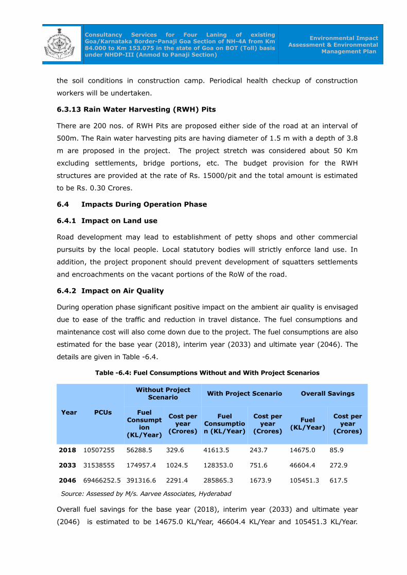
Consultancy Services for Four Laning of existing Goa/Karnataka Border-Panaji Goa Section of NH-4A from Km 84.000 to Km 153.075 in the state of Goa on BOT (Toll) basis under NHDP-III (Anmod to Panaji Section)
Environmental Impact Assessment & Environmental
Management Plan
the soil conditions in construction camp. Periodical health checkup of construction
workers will be undertaken.
6.3.13 Rain Water Harvesting (RWH) Pits
There are 200 nos. of RWH Pits are proposed either side of the road at an interval of
500m. The Rain water harvesting pits are having diameter of 1.5 m with a depth of 3.8
m are proposed in the project. The project stretch was considered about 50 Km
excluding settlements, bridge portions, etc. The budget provision for the RWH
structures are provided at the rate of Rs. 15000/pit and the total amount is estimated
to be Rs. 0.30 Crores.
6.4 Impacts During Operation Phase
6.4.1 Impact on Land use
Road development may lead to establishment of petty shops and other commercial
pursuits by the local people. Local statutory bodies will strictly enforce land use. In
addition, the project proponent should prevent development of squatters settlements
and encroachments on the vacant portions of the RoW of the road.
6.4.2 Impact on Air Quality
During operation phase significant positive impact on the ambient air quality is envisaged
due to ease of the traffic and reduction in travel distance. The fuel consumptions and
maintenance cost will also come down due to the project. The fuel consumptions are also
estimated for the base year (2018), interim year (2033) and ultimate year (2046). The
details are given in Table -6.4.
Table -6.4: Fuel Consumptions Without and With Project Scenarios
Year PCUs
Without Project Scenario
With Project Scenario Overall Savings
Fuel Consumpt
ion (KL/Year)
Cost per year
(Crores)
Fuel Consumption (KL/Year)
Cost per year
(Crores)
Fuel (KL/Year)
Cost per year
(Crores)
2018 10507255 56288.5 329.6 41613.5 243.7 14675.0 85.9
2033 31538555 174957.4 1024.5 128353.0 751.6 46604.4 272.9
2046 69466252.5 391316.6 2291.4 285865.3 1673.9 105451.3 617.5
Source: Assessed by M/s. Aarvee Associates, Hyderabad
Overall fuel savings for the base year (2018), interim year (2033) and ultimate year
(2046) is estimated to be 14675.0 KL/Year, 46604.4 KL/Year and 105451.3 KL/Year.

Consultancy Services for Four Laning of existing Goa/Karnataka Border-Panaji Goa Section of NH-4A from Km 84.000 to Km 153.075 in the state of Goa on BOT (Toll) basis under NHDP-III (Anmod to Panaji Section)
Environmental Impact Assessment & Environmental
Management Plan
Accordingly, the cost saving is estimated to be 85.9 Crores, 272.9 Crores and 617.5
Crores for base, interim and ultimate years respectively. Fuel savings are directly
representing the amount of reduction in pollution loads.
In addition to the above, an attempt has been made for the assessment of the reduction
of the criteria air pollutants such as CO2, CO, NOx, SO2, PM and HC in the proposed
project. The considerable reduction in greenhouse gas (CO2) for the base year (2018),
interim year (2033) and ultimate year (2046) is estimated to be 74665003.0 tonnes/year,
888805660.0 tonnes/year and 4928527511.0 tonnes/year respectively and equivalent
amount of Carbon credits will also be anticipated in the project. The other criteria
pollutants CO, NOx, PM and HC for the base year (2018), interim year (2033) and
ultimate year (2046) are also estimated to be reduced due to this project. The emissions
to be reduced in the proposed metro-rail project are given in Table -6.5.
Table -6.5: Details of the emissions reduced in the project
Year Average PCUs
Emissions Reduced (Approx.) (Tonnes/Year)
CO NOx PM CO2 HC
2018 10507255 1680947 119384 7587 74665003 110182
2033 31538555 20702901 1071487 60485 888805660 1324170
2046 69466252.5 115805082 5428343 293634 4928527511 7365646
Source: Assessed by M/s. Aarvee Associates, Hyderabad
6.4.2.1 Other Direct Benefits:
As per the EIRR Report, the direct benefits of road improvement considered in the
study includes vehicle operating cost (VOC) savings for vehicular traffic using the
project road, travel time savings for passengers and goods (carried) in transit and
accident cost savings. The benefit streams have been computed annually over the 200
year benefit period for all homogeneous sections
i) Vehicle Operating Cost (VOC) Savings:
The unit Vehicle Operating Cost (VOC) by vehicle type and VOC savings section-wise
has been computed by the HDM model. The VOC computation takes into account
capacity augmentation, pavement characteristics, roughness progression vis-à-vis
intervening surface treatment and strengthening policies, traffic characteristics,
geometric conditions and vehicle characteristics. The EIRR report assessed the routine
and periodic maintenance in the project as given in Table -6.6.
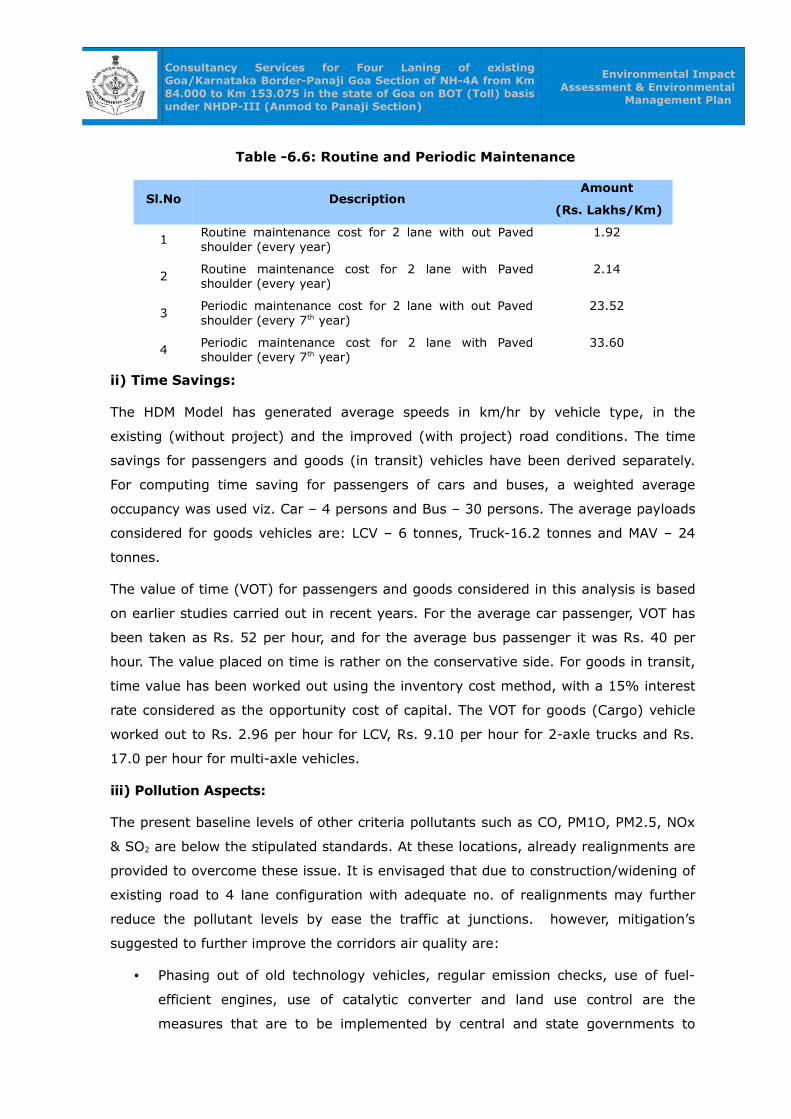
Consultancy Services for Four Laning of existing Goa/Karnataka Border-Panaji Goa Section of NH-4A from Km 84.000 to Km 153.075 in the state of Goa on BOT (Toll) basis under NHDP-III (Anmod to Panaji Section)
Environmental Impact Assessment & Environmental
Management Plan
Table -6.6: Routine and Periodic Maintenance
Sl.No DescriptionAmount
(Rs. Lakhs/Km)
1Routine maintenance cost for 2 lane with out Paved shoulder (every year)
1.92
2 Routine maintenance cost for 2 lane with Paved shoulder (every year)
2.14
3Periodic maintenance cost for 2 lane with out Paved shoulder (every 7th year)
23.52
4 Periodic maintenance cost for 2 lane with Paved shoulder (every 7th year)
33.60
ii) Time Savings:
The HDM Model has generated average speeds in km/hr by vehicle type, in the
existing (without project) and the improved (with project) road conditions. The time
savings for passengers and goods (in transit) vehicles have been derived separately.
For computing time saving for passengers of cars and buses, a weighted average
occupancy was used viz. Car – 4 persons and Bus – 30 persons. The average payloads
considered for goods vehicles are: LCV – 6 tonnes, Truck-16.2 tonnes and MAV – 24
tonnes.
The value of time (VOT) for passengers and goods considered in this analysis is based
on earlier studies carried out in recent years. For the average car passenger, VOT has
been taken as Rs. 52 per hour, and for the average bus passenger it was Rs. 40 per
hour. The value placed on time is rather on the conservative side. For goods in transit,
time value has been worked out using the inventory cost method, with a 15% interest
rate considered as the opportunity cost of capital. The VOT for goods (Cargo) vehicle
worked out to Rs. 2.96 per hour for LCV, Rs. 9.10 per hour for 2-axle trucks and Rs.
17.0 per hour for multi-axle vehicles.
iii) Pollution Aspects:
The present baseline levels of other criteria pollutants such as CO, PM1O, PM2.5, NOx
& SO2 are below the stipulated standards. At these locations, already realignments are
provided to overcome these issue. It is envisaged that due to construction/widening of
existing road to 4 lane configuration with adequate no. of realignments may further
reduce the pollutant levels by ease the traffic at junctions. however, mitigation’s
suggested to further improve the corridors air quality are:
• Phasing out of old technology vehicles, regular emission checks, use of fuel-
efficient engines, use of catalytic converter and land use control are the
measures that are to be implemented by central and state governments to
Consultancy Services for Four Laning of existing Goa/Karnataka Border-Panaji Goa Section of NH-4A from Km 84.000 to Km 153.075 in the state of Goa on BOT (Toll) basis under NHDP-III (Anmod to Panaji Section)
Environmental Impact Assessment & Environmental
Management Plan
reduce pollution levels.
• Enforcing the existing emission norms.
• Avenue Plantation on either side of the road with selected plant species capable
of absorbing pollutants.
• Provision of road, improvements at intersections and separate truck parking
facilities to ensure smooth and uninterrupted traffic flow.
All these facilities shall result in minimizing, stopping and idling of vehicles and thus
improving air quality
6.4.3 Impact on Noise Quality
The major source of noise pollution in the project region is due to vehicular
movements on the highway and noise in the junctions. The noise impact due to the
transportation activity depends on the ultimate traffic volume and the type of the
vehicles in operation. The typical base noise levels generated in the corridor are
presented in the Chapter –5. To predict the cumulative noise impacts due to the traffic
movement, Federal Highways Administration (FHWA) model was used. In this model,
traffic characteristics used in predicting future noise levels could make a substantial
difference in the results. "Worst hourly traffic noise impact" occurs at a time when
truck volumes and vehicle speeds are the greatest have been considered. FHWA
model calculates day (Ld) and night (Ln) noise equivalent for each category of vehicle
and also the total day night (Ldn) due to all kinds of vehicles.
The noise levels are predicted at various locations for different years (i.e., 2015, 2020,
2025, 2030, 2035 and 2040) ‘without project scenario’ and ‘with project scenario’. The
predicted noise levels are given in Table -6.7.
‘Without project scenario’
From Table -6.7, it is clearly indicated that the predicted noise levels based on model
are almost compatible to base noise levels and observed to be slightly higher in some
cases for Leq Day and higher in most of the cases for Leq Night, when compared with
base noise levels (observed at study area).
In commercial category, the predicted noise levels are mostly matching with the CPCB
limits (Leq Day: 65 & Leq Night: 55 dB(A)) and they are start exceeding their base
noise levels in the year 2045. The day & night noise levels are 62.9 & 59.1 dB(A) for
the year 2040.
In residential category, the predicted noise levels are crossing the CPCB limits (Leq
Consultancy Services for Four Laning of existing Goa/Karnataka Border-Panaji Goa Section of NH-4A from Km 84.000 to Km 153.075 in the state of Goa on BOT (Toll) basis under NHDP-III (Anmod to Panaji Section)
Environmental Impact Assessment & Environmental
Management Plan
Day: 55 & Leq Night: 45 dB(A)) from 2015 itself. The day & night noise levels are
ranging from 65.3 to 65.3 dB(A) & 62.6 to 62.9 dB(A) respectively in all the locations
for the year 2040.
‘With project scenario‘
From Table -6.7, it is clearly indicated that the predicted noise levels for the horizon
years 2015, 2020, 2025, 2030,2035 and 2040 are well within the stipulated CPCB
standards for commercial category (Commercial day and night limits of 65 & 55 dB(A))
but crossing the CPCB standards for residential category (Residential day and night
limits of 55 & 45 dB(A)) from 2020 in Mardol and from 2035 in Old Goa. In order to
reduce the noise levels, a thick vegetation of two rows of plantation is proposed in the
project.

Consultancy Services for Four Laning of existing Goa/Karnataka Border-Panaji Goa Section of NH-4A from Km 84.000 to Km 153.075 in the state of Goa on BOT (Toll) basis under NHDP-III (Anmod to Panaji Section)
Environmental Impact Assessment & Environmental Management Plan
Table -6.7: Predicted noise concentrations along the project area
Location/ Chainage
Noise Levels in dB(A)
Base Noise Levels Leq day/ Night
Without project (Predicted) With Project Scenario (Predicted)
2015 2020 2025 2030 2035 2040 2020 2025 2030 2035 2040
Km. 96.600
62.2/50.6
57.4/53.6
58.5/54.7
59.6/55.8
60.7/56.9
61.8/58.0
62.9/59.1
52.9/49.1 54.0/50.2 55.1/51.3 56.2/52.4 57.3/53.5
Km. 133.000
63.9/53.3
59.5/57.3
60.7/58.5
61.8/59.6
63.0/60.7
64.1/61.8
65.3/62.9
55.1/52.8 56.2/53.9 57.3/55.1 58.5/56.2 59.6/57.3
Km. 140.000
59.5/48.0
59.2/56.7
60.4/57.9
61.6/59.1
62.9/60.3
64.1/61.4
65.3/62.6
52.1/49.6 53.3/50.8 54.6/52.0 55.8/53.1 57.0/54.3
Note: The base noise levels are extracted from the field study and the predicted noise levels are assessed from the Vehicle population in different stretches of the project.
106
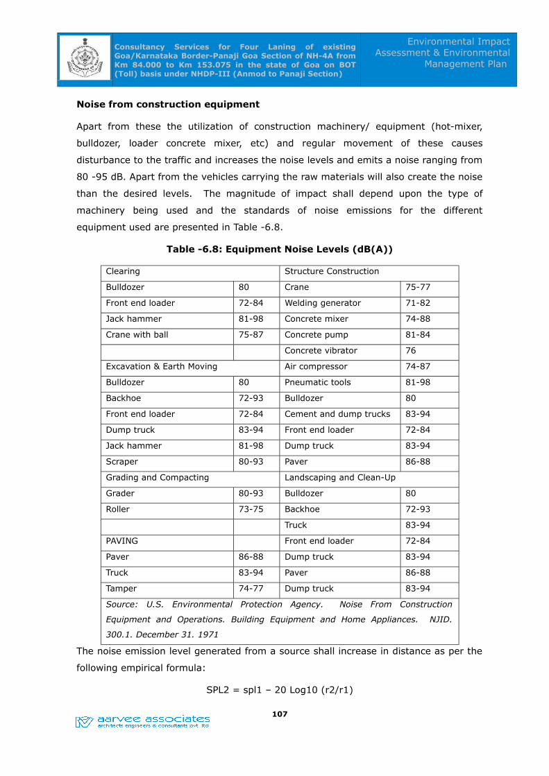
Consultancy Services for Four Laning of existing Goa/Karnataka Border-Panaji Goa Section of NH-4A from Km 84.000 to Km 153.075 in the state of Goa on BOT (Toll) basis under NHDP-III (Anmod to Panaji Section)
Environmental Impact Assessment & Environmental
Management Plan
Noise from construction equipment
Apart from these the utilization of construction machinery/ equipment (hot-mixer,
bulldozer, loader concrete mixer, etc) and regular movement of these causes
disturbance to the traffic and increases the noise levels and emits a noise ranging from
80 -95 dB. Apart from the vehicles carrying the raw materials will also create the noise
than the desired levels. The magnitude of impact shall depend upon the type of
machinery being used and the standards of noise emissions for the different
equipment used are presented in Table -6.8.
Table -6.8: Equipment Noise Levels (dB(A))
Clearing Structure Construction
Bulldozer 80 Crane 75-77
Front end loader 72-84 Welding generator 71-82
Jack hammer 81-98 Concrete mixer 74-88
Crane with ball 75-87 Concrete pump 81-84
Concrete vibrator 76
Excavation & Earth Moving Air compressor 74-87
Bulldozer 80 Pneumatic tools 81-98
Backhoe 72-93 Bulldozer 80
Front end loader 72-84 Cement and dump trucks 83-94
Dump truck 83-94 Front end loader 72-84
Jack hammer 81-98 Dump truck 83-94
Scraper 80-93 Paver 86-88
Grading and Compacting Landscaping and Clean-Up
Grader 80-93 Bulldozer 80
Roller 73-75 Backhoe 72-93
Truck 83-94
PAVING Front end loader 72-84
Paver 86-88 Dump truck 83-94
Truck 83-94 Paver 86-88
Tamper 74-77 Dump truck 83-94
Source: U.S. Environmental Protection Agency. Noise From Construction
Equipment and Operations. Building Equipment and Home Appliances. NJID.
300.1. December 31. 1971
The noise emission level generated from a source shall increase in distance as per the
following empirical formula:
SPL2 = spl1 – 20 Log10 (r2/r1)
107

Consultancy Services for Four Laning of existing Goa/Karnataka Border-Panaji Goa Section of NH-4A from Km 84.000 to Km 153.075 in the state of Goa on BOT (Toll) basis under NHDP-III (Anmod to Panaji Section)
Environmental Impact Assessment & Environmental
Management Plan
Where, SPL1 an SPL2 are the sound pressure levels at distance r1 and r2 respectively
Considering the emissions of different equipment and the stationary nature of the
construction equipment as a point source generating 9 dB(A) at a reference distance of
2m computed distance require to meet the permissible limits during day time for
different land use categories are given in Table -6.9.
Table -6.9: Required distance from Stationary source for meeting standards.
CategoryPermissible limit
(Day time)
Distance
Required(M)
Silence zone 50dB(A) 200
Residential 55dB(A) 113
Commercial 65dB(A) 36
Industrial 75dB(A) 11
The mitigation measures can be taken by attenuating noise levels providing vegetation
noise barrier (by absorbing technique) which can reduce 5 – 6 dB (A). Most of the
villages are 50- 60 m away from the C/L of the road. But prediction has been done at
25 – 30 m from the centre line. Thus doubling of distance between sources to the
receptor shall enable to reduce noise level by 5-6 dB (A). Thus the noise level at
village shall be about 55 dB (A) which is the permissible limit and in the junctions the
noise barriers shall be suggested.
6.5 Accident Hazards and Safety
In North Goa, from 2011 to 2015, a total of 675 accidents ranging from Fatal, Grevious
to Slight and Minor took place in Panaji; similarly, a total of 141 accidents happened in
Old Goa; a total of 278 (highest among all the places in North Goa) accidents
happened in Agacaim; a total of 257 accidents occurred in Valpoi; totals of 201, 39,
262, 82, 22 at Mapusa, Anjuna, Provorim, Pernem, Bicholim respectively.
In South Goa, from 2011 to 2015, accidents ranging from Fatal, Grevious to Slight and
Minor took place in different junctions. A total of 662 accidents, the highest in Goa,
happened in Ponda. Totals of 173, 272, 45, 16, 43, 372 and 47 at Kollem, Margao,
Curtorim, Quepem, Curchorem, Verna and Marmugao respectively.
Major accident prone spots are located in Ponda, Verna, Agacaim, Margao, Provorim
and Valpoi. Near KTC Bus Stand of Panaji and Litan Junction of Verna are the most
accident prone spots.
Accident hazards would be greatly reduced because of construction of 4/6-laning of 108
Consultancy Services for Four Laning of existing Goa/Karnataka Border-Panaji Goa Section of NH-4A from Km 84.000 to Km 153.075 in the state of Goa on BOT (Toll) basis under NHDP-III (Anmod to Panaji Section)
Environmental Impact Assessment & Environmental
Management Plan
proposed realignments will ensure smooth and fast flow of traffic. In the event of
spillage of hazardous chemicals a spillage containment mechanism will be developed
along with the participation of police and the fire department. In addition to this an
emergency response mechanism should be evolved to tackle accidents and spillage of
substances.
6.6 Aesthetics
There are zero nos. of bus bays existed and 20 locations (Both sides) are proposed.
There is 1 no. of Toll plazas proposed. Junctions development with landscape, median
plantation in 4/6-lane road and avenue plantation along the project will improve the
aesthetics of the project. The public amenities and parking place for long distance
travelers have been provided for in the project design.
6.7 Evaluation of Impacts
The environmental impact of a project depends both on the project activities and on
the background environmental setting. The environmental impact assessment process
involves four basic steps:
• Identification
• Evaluation
• Interpretation
• Communication
For the present project, the matrix method is used for assessment of impacts. In the
present case the impact, a scale of –4 to +4 is taken. This method is selected because
it identifies the impact of each project activity on each of the environmental attributes.
Evaluation and interpretation of impacts is mostly subjective and convey a holistic view
of the environmental impact of the project.
Matrix Method
The matrix used for EIA consists of project activities on the x-axis and the
environmental attributes likely to be affected by these activities on the y-axis. Each
cell of the matrix represents a subjective evaluation of the impacts of a particular
activity on a particular attribute in terms of magnitude and importance. A blank cell
indicates no impact of the activity on the component. The magnitude (M) is
represented by a number from 1 to 4,
Where,
109

Consultancy Services for Four Laning of existing Goa/Karnataka Border-Panaji Goa Section of NH-4A from Km 84.000 to Km 153.075 in the state of Goa on BOT (Toll) basis under NHDP-III (Anmod to Panaji Section)
Environmental Impact Assessment & Environmental
Management Plan
1 = minimal 2 = appreciable
3 = significant 4 = severe
Positive sign (or no sign) indicates beneficial impact and negative sign indicates
adverse impact. The importance (I) of the impact is given on a scale of 1 to 4 in each
cell. This number indicates relative importance of the impact of the activity on the
concerned attribute for this project. The magnitude and importance are multiplied to
get a score of each cell. The score of individual cells in each row are added to
determine the total impact of the project activities on each attribute. Similarly, the
score in individual cells in each column are added to determine the total impact of
each activity on all the environmental attributes likely to be affected. The grand total
of all cells indicates the total project impact.
Since both ‘M’ and ‘I’ vary from 1 to 4, the total score in each cell can theoretically
vary between –16 to +16. Therefore the total project impact can vary between (-16 x
total number of cells in the matrix) and (16 x total number of cells in the matrix). To
compare score from matrices containing different number of cells, the total project
scores can be normalized to a scale of 100 as follows
Total project impact scale of 100 = ((Total project impact computed by matrix)/ (16 x
total number of cells in the matrix)) X100
On this scale, the overall impact can be classified as follows:
Total project impact
(Scale of 100)Magnitude of impact
-100 to –75 Severely adverse
-75 to –50 Significantly adverse
-50 to –25 Appreciably adverse
-25 to 0 Minimally adverse
0 to 25 Minimally beneficial
25 to 50 Appreciably beneficial
50 to 75 Significantly beneficial
75 to 100 Extremely beneficial
6.7.1 Evaluation for Alternative Scenarios
EIA without EMP
This scenario was based upon the assumption that the proposed development would
go ahead without any environmental management options being implemented. The 110
Consultancy Services for Four Laning of existing Goa/Karnataka Border-Panaji Goa Section of NH-4A from Km 84.000 to Km 153.075 in the state of Goa on BOT (Toll) basis under NHDP-III (Anmod to Panaji Section)
Environmental Impact Assessment & Environmental
Management Plan
total project impact for the scenario, as can be seen in Table -6.10, was found to be –
80 on a scale of (+/-) 1344. The score on a scale of (+/-) 100 for this scenario was
found to be –5.95, which is on the minimally adverse side. This shows that if the
project goes ahead without an EMP, the adverse impact on the existing environment
would be several times that of the impact without the project. Thus, the EMP described
in Chapter -8 will have to be implemented to minimize the potential negative impact
due to the proposed activity.
EIA with EMP
If the environmental management strategies discussed in Chapter -8 is fully
implemented, the adverse impact of the project would be reduced, and there will be an
overall improvement in physical, chemical, biological and socio-economic environment
of the region. This is reflected in the total project impact score of +55 on scale of
(+/-) 1536, as shown in the Table -6.11 below, for this scenario. The score on a scale
of (+/-) 100 for this scenario was found to be +3.58, which is on the beneficial side.
Therefore, the proposed activity will be beneficial for the environment of the area,
provided the EMP is in place.
It is clear from the above, that the proposed road development project would have
negative effect without implementing certain environmental management strategies. If
EMP, as discussed in the Chapter-8, is strictly adopted and implemented, the adverse
impacts will be reduced and the overall environmental quality of the area would
improve.
111

Consultancy Services for Four Laning of existing Goa/Karnataka Border-Panaji Goa Section of NH-4A from Km 84.000 to Km 153.075 in the state of Goa on BOT (Toll) basis under NHDP-III (Anmod to Panaji Section)
Environmental Impact Assessment & Environmental Management Plan
Table 6.10: Impact Assessment for the Proposed Project (EIA WITHOUT EMP)
Environmental components likely
to be affected
Project activities likely to affect environmental components
Site preparation/ Resettlemen
t and Rehabilitatio
n
Construction /other
activities
Transportation
construction materials
Solid waste generation
and its handling.
Traffic escalatio
n
Waste water
generation
Post construction
and operational phase
Total impact component
Air quality M -2 -2 -1 -1 -1 -2 -16
I 1 2 2 2 2 2
Noise and Vibration M -2 -3 -1 -1 -2 -3 -21
I 1 2 2 1 2 2
Surface water
quality
M -1 -1 -1 -1 -1 -2 -11
I 1 2 2 1 1 2
Ground water
quality
M -1 -1 -1 -1 -5
I 2 1 1 1
Soil quality /
erosion
M -1 -2 -1 -1 -1 -1 -1 -10
I 1 2 1 1 1 1 1
Land use pattern M -2 -2 -1 -1 -2 -14
I 2 2 1 1 2
Flora and Fauna M -2 -2 -1 -1 -1 -12
I 2 2 1 1 2
Aesthetics M -1 -2 -1 -1 -1 -11
112

Consultancy Services for Four Laning of existing Goa/Karnataka Border-Panaji Goa Section of NH-4A from Km 84.000 to Km 153.075 in the state of Goa on BOT (Toll) basis under NHDP-III (Anmod to Panaji Section)
Environmental Impact Assessment & Environmental Management Plan
Environmental components likely
to be affected
Project activities likely to affect environmental components
Site preparation/ Resettlemen
t and Rehabilitatio
n
Construction /other
activities
Transportation
construction materials
Solid waste generation
and its handling.
Traffic escalatio
n
Waste water
generation
Post construction
and operational phase
Total impact component
I 1 2 2 2 2
Safety M -2 -2 -1 -2 -2 -17
I 2 2 1 2 2
Human health M -1 -1 -2 -1 -1 -1 -1 -11
I 1 2 2 1 1 1 1
Socio-economic
status
M 1 2 1 1 1 3 19
I 1 2 2 1 2 3
Economy, trade and
commerce
M 2 2 2 1 2 3 29
I 2 3 2 2 2 3
Total Action Impact -11 -26 -13 -9 -6 -4 -11 -80
I = Importance, M = Magnitude;Impact scale: 1 = Minimal, 2 = Appreciable, 3 = Significant, 4 = Severe. Positive sign (or no sign) indicates beneficial impact, Negative
sign indicates adverse impact, Blank indicates no impact
113
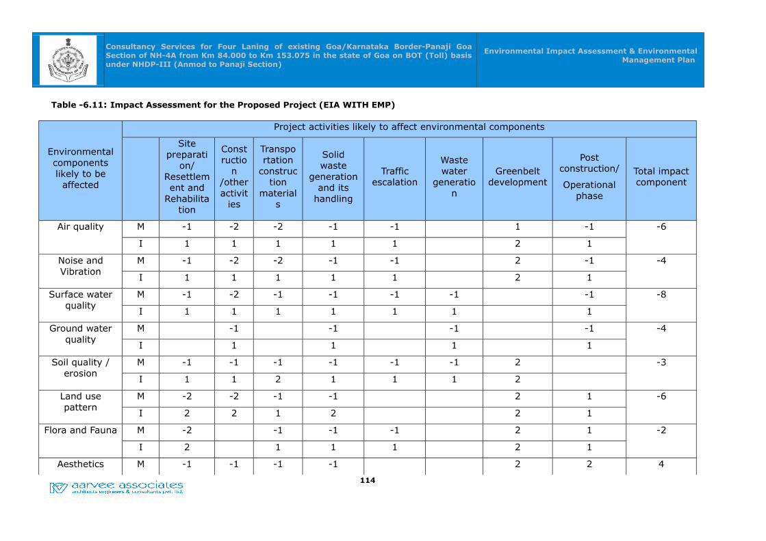
Consultancy Services for Four Laning of existing Goa/Karnataka Border-Panaji Goa Section of NH-4A from Km 84.000 to Km 153.075 in the state of Goa on BOT (Toll) basis under NHDP-III (Anmod to Panaji Section)
Environmental Impact Assessment & Environmental Management Plan
Table -6.11: Impact Assessment for the Proposed Project (EIA WITH EMP)
Environmental components likely to be
affected
Project activities likely to affect environmental components
Site preparati
on/ Resettlement and
Rehabilitation
Constructio
n /other activit
ies
Transportation
construction
materials
Solid waste
generation and its
handling
Traffic escalation
Waste water
generation
Greenbelt development
Post construction/
Operational phase
Total impact component
Air quality M -1 -2 -2 -1 -1 1 -1 -6
I 1 1 1 1 1 2 1
Noise and Vibration
M -1 -2 -2 -1 -1 2 -1 -4
I 1 1 1 1 1 2 1
Surface water quality
M -1 -2 -1 -1 -1 -1 -1 -8
I 1 1 1 1 1 1 1
Ground water quality
M -1 -1 -1 -1 -4
I 1 1 1 1
Soil quality / erosion
M -1 -1 -1 -1 -1 -1 2 -3
I 1 1 2 1 1 1 2
Land use pattern
M -2 -2 -1 -1 2 1 -6
I 2 2 1 2 2 1
Flora and Fauna M -2 -1 -1 -1 2 1 -2
I 2 1 1 1 2 1
Aesthetics M -1 -1 -1 -1 2 2 4
114
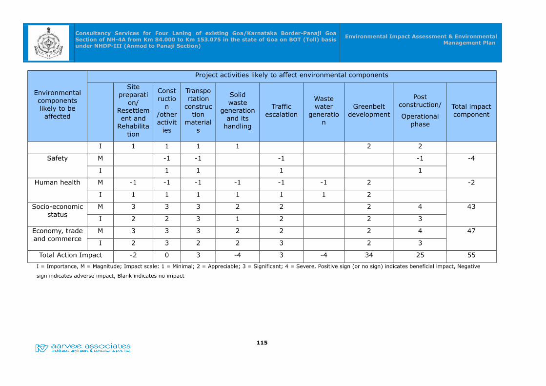
Consultancy Services for Four Laning of existing Goa/Karnataka Border-Panaji Goa Section of NH-4A from Km 84.000 to Km 153.075 in the state of Goa on BOT (Toll) basis under NHDP-III (Anmod to Panaji Section)
Environmental Impact Assessment & Environmental Management Plan
Environmental components likely to be
affected
Project activities likely to affect environmental components
Site preparati
on/ Resettlement and
Rehabilitation
Constructio
n /other activit
ies
Transportation
construction
materials
Solid waste
generation and its
handling
Traffic escalation
Waste water
generation
Greenbelt development
Post construction/
Operational phase
Total impact component
I 1 1 1 1 2 2
Safety M -1 -1 -1 -1 -4
I 1 1 1 1
Human health M -1 -1 -1 -1 -1 -1 2 -2
I 1 1 1 1 1 1 2
Socio-economic status
M 3 3 3 2 2 2 4 43
I 2 2 3 1 2 2 3
Economy, trade and commerce
M 3 3 3 2 2 2 4 47
I 2 3 2 2 3 2 3
Total Action Impact -2 0 3 -4 3 -4 34 25 55
I = Importance, M = Magnitude; Impact scale: 1 = Minimal; 2 = Appreciable; 3 = Significant; 4 = Severe. Positive sign (or no sign) indicates beneficial impact, Negative
sign indicates adverse impact, Blank indicates no impact
115

Consultancy Services for Four Laning of existing Goa/Karnataka Border-Panaji Goa Section of NH-4A from Km 84.000 to Km 153.075 in the state of Goa on BOT (Toll) basis under NHDP-III (Anmod to Panaji Section)
Environmental Impact Assessment & Environmental
Management Plan
CHAPTER -07CHAPTER -07
RISK AND DISASTER MANAGEMENT PLAN RISK AND DISASTER MANAGEMENT PLAN
7.0 RISK AND DISASTER MANAGEMENT PLAN
India has been traditionally vulnerable to natural disasters on account of its unique
geo-climatic conditions. Floods, droughts, cyclones, earthquakes and landslides have
been a recurrent phenomenon. About 60% of the landmass is prone to earthquakes of
various intensities; over 40 million hectares is prone to floods; about 8% of the total
area is prone to cyclones and 68% of the area is susceptible to drought. In the decade
1990-2000, an average of about 4344 people lost their lives and about 30 million
people were affected by disasters every year. The loss in terms of private, community
and public assets has been astronomical.
At the global level, there has been considerable concern over natural disasters. Even
as substantial scientific and material progress is made, the loss of lives and property
due to disasters has not decreased. In fact, the human toll and economic losses have
mounted. It was in this background that the United Nations General Assembly, in
1989, declared the decade 1990-2000 as the International Decade for Natural Disaster
Reduction with the objective to reduce loss of lives and property and restrict socio-
economic damage through concerted international action, especially in developing
countries.
In the case of earthquakes in India, there is a need to adopt a multi-dimensional
endeavor involving diverse scientific, engineering, financial and social processes; the
need to adopt multi-disciplinary and multi-sectoral approach and incorporation of risk
reduction in the developmental plans and strategies.
Risk assessment is the determination of quantitative or qualitative value of risk related
to a concrete situation and a recognized threat (also called hazard). Quantitative risk
assessment requires calculations of two components of risk (R):, the magnitude of the
potential loss (L), and the probability (p) that the loss will occur. Acceptable risk is a
risk that is understood and tolerated usually because the cost or difficulty of
implementing an effective countermeasure for the associated vulnerability exceeds the
expectation of loss
The proposed project is also vulnerable to the various risks and the disasters in the
project stretch as well as in the region. A project study has been made and assessed
116
Consultancy Services for Four Laning of existing Goa/Karnataka Border-Panaji Goa Section of NH-4A from Km 84.000 to Km 153.075 in the state of Goa on BOT (Toll) basis under NHDP-III (Anmod to Panaji Section)
Environmental Impact Assessment & Environmental
Management Plan
the project specific Risks and Disaster Management Plan in the report.
The report contains the findings of the study to identify risks, identification of most likely
risks, health and Environmental hazards/Impacts along the Right of Way (RoW) &
possible natural and manmade disasters happening in the project area and suggesting
suitable remedial measures in all stages of the project i.e. Design phase, Construction
phase, and Operation phase and preparation of Disaster Management Plan.
The objectives of the study are:
Identify the hazards
Decide areas of hazards in the project and how it shows impact.
Evaluation of risks and decide on precautions
Record of findings and its implementation
Assessment of hazards likely likely happening due to result from the proposed
project and suggesting suitable mitigation measures.
Preparation of Disaster Management Plan in order to support in the event of road
accidents (major road mishaps, gas tanker explosions, fire hazards etc.) and
natural calamities (floods, cyclones, earth quakes etc.).
7.1 Natural Disaster Encountered in the Region
As far as Goa is concerned, two types of disasters are being experienced by the State
i.e. 1) Natural Disaster like Earthquake, Floods / Heavy rains, Cyclones, Landslides,
Tsunami and 2) Man-made Disaster like Oil spill in the Sea / Land, Gas leakage,
Explosives, Mine collapse, etc. South Goa District is comparatively safer District in
terms of human and property loss in disasters. The disasters caused in South Goa are
mainly floods, landslides, accidents, fire to markets, property and crops, gas leak and
cyclonic winds and tree fallings. As the problems are identifiable the solutions are
easily traceable. Out of six disasters five can be avoided, loss accrued in one i.e.
cyclone can be mitigated. The brief history of floods/ cyclones/ Drought / Earthquakes
in the region are given in Table -7.1.
117
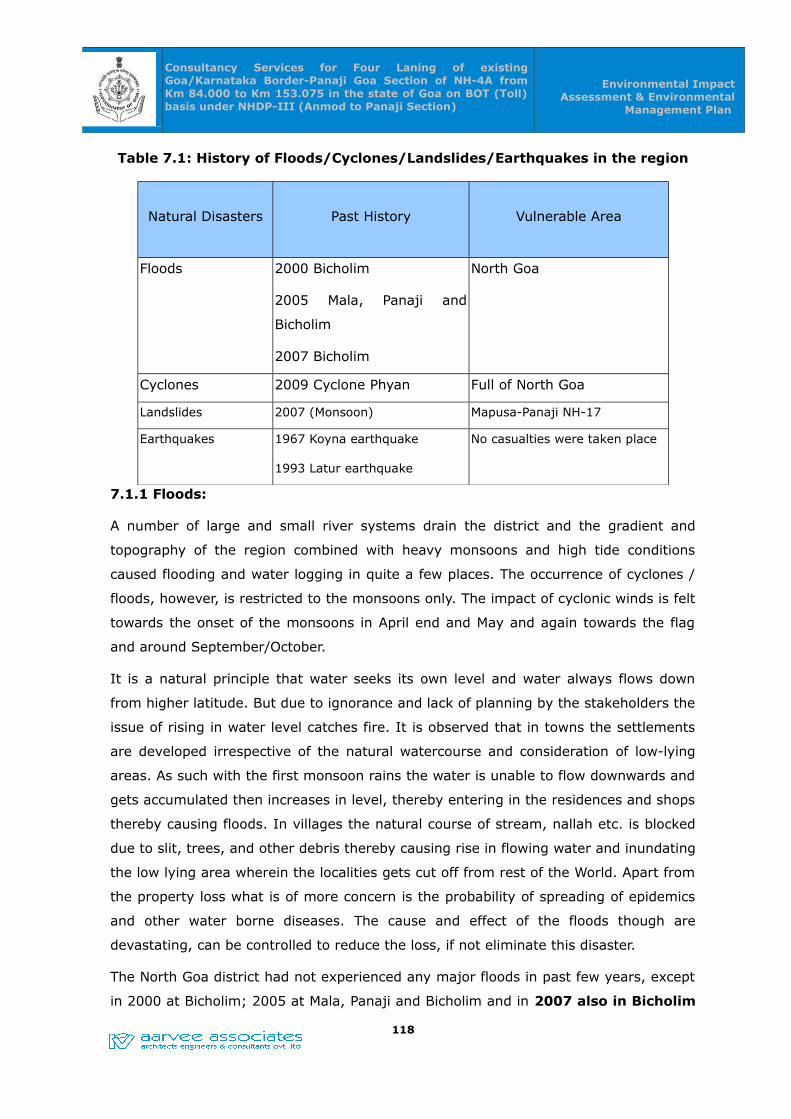
Consultancy Services for Four Laning of existing Goa/Karnataka Border-Panaji Goa Section of NH-4A from Km 84.000 to Km 153.075 in the state of Goa on BOT (Toll) basis under NHDP-III (Anmod to Panaji Section)
Environmental Impact Assessment & Environmental
Management Plan
Table 7.1: History of Floods/Cyclones/Landslides/Earthquakes in the region
Natural Disasters Past History Vulnerable Area
Floods 2000 Bicholim
2005 Mala, Panaji and
Bicholim
2007 Bicholim
North Goa
Cyclones 2009 Cyclone Phyan Full of North Goa
Landslides 2007 (Monsoon) Mapusa-Panaji NH-17
Earthquakes 1967 Koyna earthquake
1993 Latur earthquake
No casualties were taken place
7.1.1 Floods:
A number of large and small river systems drain the district and the gradient and
topography of the region combined with heavy monsoons and high tide conditions
caused flooding and water logging in quite a few places. The occurrence of cyclones /
floods, however, is restricted to the monsoons only. The impact of cyclonic winds is felt
towards the onset of the monsoons in April end and May and again towards the flag
and around September/October.
It is a natural principle that water seeks its own level and water always flows down
from higher latitude. But due to ignorance and lack of planning by the stakeholders the
issue of rising in water level catches fire. It is observed that in towns the settlements
are developed irrespective of the natural watercourse and consideration of low-lying
areas. As such with the first monsoon rains the water is unable to flow downwards and
gets accumulated then increases in level, thereby entering in the residences and shops
thereby causing floods. In villages the natural course of stream, nallah etc. is blocked
due to slit, trees, and other debris thereby causing rise in flowing water and inundating
the low lying area wherein the localities gets cut off from rest of the World. Apart from
the property loss what is of more concern is the probability of spreading of epidemics
and other water borne diseases. The cause and effect of the floods though are
devastating, can be controlled to reduce the loss, if not eliminate this disaster.
The North Goa district had not experienced any major floods in past few years, except
in 2000 at Bicholim; 2005 at Mala, Panaji and Bicholim and in 2007 also in Bicholim
118
Consultancy Services for Four Laning of existing Goa/Karnataka Border-Panaji Goa Section of NH-4A from Km 84.000 to Km 153.075 in the state of Goa on BOT (Toll) basis under NHDP-III (Anmod to Panaji Section)
Environmental Impact Assessment & Environmental
Management Plan
due to verflowing of rivulet, causing no major casualties but causing heavy damages
to the properties. As far as North Goa District is concerned, there are 3 main rivers
viz. Terekhol, Chapora and Mandovi, besides one minor river Baga. The river Mandovi
has 10 tributaries viz. Madei, Surla, Kotrachi, Ragda, Khandepar, Kudnem, Valvanta,
Bicholim, Assonora and Sinker. Bicholim and Sattari Talukas are mainly affected due to
floods due to River Valvonti, whereas the other Talukas of Tiswadi, Bardez, Pernem
and Ponda are flooded either due to low lying areas or due to temporary rise in water
level of nearby rivulets.
7.1.2 Cyclone
Tropical cyclones are considered to be the worst among all the natural hazards when
viewed in terms of their severity, frequency of occurrence and areas of destruction. It
is noted that severe cyclones cause colossal damage not only to non-engineered
buildings such as thatched roofs, tiled houses, etc., but also inflict heavy damage to
semi-engineered buildings such as school, work shop buildings, factory buildings, etc.
and also to well-engineered structures including communication towers and wind mill
towers etc. An important aspect of cyclone risk reduction is to ensure availability of
adequate numbers of shelters, community centers/school buildings, places of worship
etc. This can be utilized for moving the vulnerable people to safety.
Additionally, both the areas along coastline and interior regions can be affected by
gusty winds which can cause damage to property, damage to crops, collapse of trees
and in turn threatening lives of people including fishermen, livestock, ships and
barges, boats, ships, fishing trawlers at ports. If cyclonic winds are accompanied by
heavy rainfall then there is possibility of flooding in low lying areas, in Goa
7.1.3 Earthquakes in the Region
Goa falls in seismic zone IV that indicates that Goa has high probability for occurrence
of earthquakes. Goa forms part of the moderate seismic zone in the country, namely,
Zone IV of seismic zoning map of India. Though Goa has not directly witnessed any
earthquake it was affected by tremors from devastating earthquakes from neighboring
state.
Although Goa has not witnessed earthquakes directly, the tremors of the devastating
earthquakes with magnitude 5.0 or more that hitted “Koyana” and “Latur” in
Maharashtra in the year 1967 and 1993 respectively, affected the routine life of the
people in Goa as many of the residential as well as public structures, infrastructures
were damaged severely, although no casualties were taken place.
119

Consultancy Services for Four Laning of existing Goa/Karnataka Border-Panaji Goa Section of NH-4A from Km 84.000 to Km 153.075 in the state of Goa on BOT (Toll) basis under NHDP-III (Anmod to Panaji Section)
Environmental Impact Assessment & Environmental
Management Plan
Earthquake Disaster Vulnerability of North Goa
Although the vulnerability is low, towns are more at risk than rural areas due to higher
density of population. Another concern is the large numbers of building both private
and public have been constructed without proper earthquake resistance features. Goa
being a tourist location has a number of heritage sites (No. of listed heritage buildings
is 431 as per Town and Country Planning Department Notification) that need to be
made earthquake resistant
7.1.4 Soil Erosion
Coastal erosion, or coastal instability, threatens property and businesses and puts
people living near cliffs and shorelines at risk. The great concentration of national
resources in coastal zones makes it imperative that coastal change is well understood.
Along the coastline of Goa, sea /coastal erosion has been observed on the beaches
Siolim, DonaPaula, Anjuna beach. Additionally, according to a study by the National
Institute of Oceanography, the beach along the Candolim-Sinquerim coast has been
affected by erosion due to the grounded super tanker M.V. River Princess.
7.1.5 Landslides
Landslides are another common disaster experienced. Usually the landslides occur at
the sites that are disturbed by human activities. Though the landslides are reported in
forests lands it has less concerned than the one in settlement area thereby putting the
human life at stake. Geologists have opined that the reckless hill cutting in the most
unscientific manner results in landslides. When proper gradient is not maintained the
inter-locking of the boulders and the hold of the soil loosens resulting into sliding of
the boulders, erosion of soil and uprooting of the trees. And the structures that are
within the purview are destroyed. The worst affected is the life and property, but what
also gets disturbed is the pure drinking water, power supply, telecommunication, and if
the landslide occurs during the monsoon then there is a fear of spread of epidemics.
Incidences of Landslides in Goa (no year)
Sr. No. Taluka Location Severity of Landslide
1 Tiswadi Aradi, St. Cruz. Low
2 Bardez Nerul Low
3 Malim, Betim Low
4 Gaunswada, Mapusa Low
5 Alto Betim, Mapusa-Panaji NH-17, Near Mandovi Bridge
High
6 Pernem Vaidongor Low
120
Consultancy Services for Four Laning of existing Goa/Karnataka Border-Panaji Goa Section of NH-4A from Km 84.000 to Km 153.075 in the state of Goa on BOT (Toll) basis under NHDP-III (Anmod to Panaji Section)
Environmental Impact Assessment & Environmental
Management Plan
The landslides specified at 1 to 4 and 6 above were of low nature as far as the severity
is concerned. In this case, some boulders had slide down towards the residential
structures / school buildings thereby causing severe damages to the structures.
However, the landslide that took place on Mapusa–Panaji NH-17 during the monsoon,
2007 was of high severity as the vehicular traffic on this road was obstructed almost
for a month.
7.2 Risk Assessment & Mitigation Measures
Risk assessment is a process that seeks to estimate the likelihood of occurrence of
adverse effects as a result of poor design, congested roads, in adequate vehicular
underpasses, pedestrian underpasses, road furniture, RoBs, sharp curves, major road
mishaps, gas tanker explosions, fire hazards, floods, cyclones, earth quakes etc. in the
proposed widening and strengthening of Highway project. Fatality rate on Indian
highways is very high mainly due to road accidents associated with the above said
issues. The other adverse impacts due to gas tanker explosions, fire hazards, floods,
cyclones, earth quakes etc. are nominal.
Every care has been taken during the design stage itself for elimination of the risk or
hazard (avoidance of accidents) is given prime importance and Ministry of Road
Transport & Highways (MoRTH) has also introduced many safety provisions in the
design of highways are:
• Identification of risk prone areas,
• Underpasses & other grade separators at congested junctions,
• Service roads in towns & villages for segregating local and through traffic.
• Other design and safety issues of the project
• Traffic control devices / Road safety devices / Road side furniture
7.2.1 Major Risk Prone Areas
The major risk prone areas identified in the project with respect to the poor design,
congested road, junction development, major settlements causing various accidents in
the project stretch between Anmod to Panaji corridor is given in table no.7.2
Table -7.2 : Major settlements along the project stretch
S. No. Name of Township
Location (Km)Length (m)
From To
1 Mollem 96.300 96.900 0.6
121
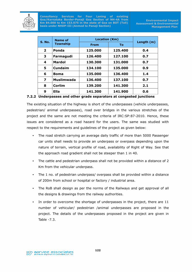
Consultancy Services for Four Laning of existing Goa/Karnataka Border-Panaji Goa Section of NH-4A from Km 84.000 to Km 153.075 in the state of Goa on BOT (Toll) basis under NHDP-III (Anmod to Panaji Section)
Environmental Impact Assessment & Environmental
Management Plan
S. No.Name of Township
Location (Km)Length (m)
From To
2 Ponda 125.000 125.400 0.4
3 Farmagudi 126.400 127.100 0.7
4 Mardol 130.300 131.000 0.7
5 Cundaim 134.100 135.000 0.9
6 Boma 135.000 136.400 1.4
7 Muslimwada 136.400 137.100 0.7
8 Corlim 139.200 141.300 2.1
9 Ella 141.300 141.900 0.6
7.2.2 Underpasses and other grade separators at congested junctions
The existing situation of the highway is short of the underpasses (vehicle underpasses,
pedestrian/ animal underpasses), road over bridges in the various stretches of the
project and the same are not meeting the criteria of IRC:SP:87-2010. Hence, these
issues are considered as a road hazard for the users. The same was studied with
respect to the requirements and guidelines of the project as given below:
• The road stretch carrying an average daily traffic of more than 5000 Passenger
car units shall needs to provide an underpass or overpass depending upon the
nature of terrain, vertical profile of road, availability of Right of Way. See that
the approach road gradient shall not be steeper than 1 in 40.
• The cattle and pedestrian underpass shall not be provided within a distance of 2
Km from the vehicular underpass.
• The 1 no. of pedestrian underpass/ overpass shall be provided within a distance
of 200m from school or hospital or factory / industrial area.
• The RoB shall design as per the norms of the Railways and get approval of all
the designs & drawings from the railway authorities.
• In order to overcome the shortage of underpasses in the project, there are 11
number of vehicular/ pedestrian /animal underpasses are proposed in the
project. The details of the underpasses proposed in the project are given in
Table -7.3.
122
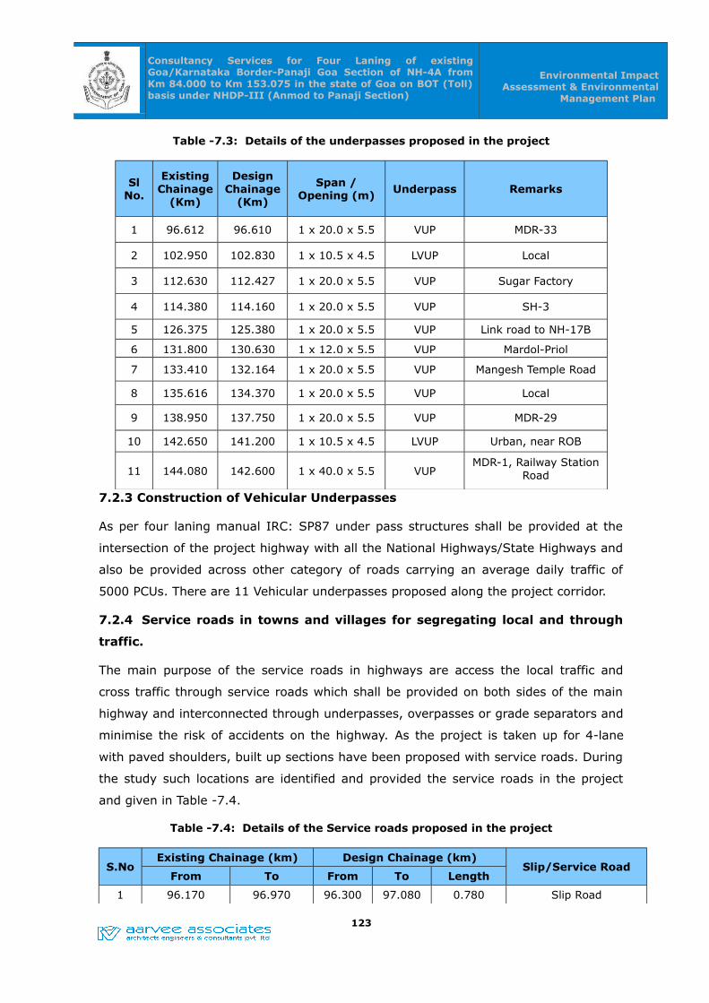
Consultancy Services for Four Laning of existing Goa/Karnataka Border-Panaji Goa Section of NH-4A from Km 84.000 to Km 153.075 in the state of Goa on BOT (Toll) basis under NHDP-III (Anmod to Panaji Section)
Environmental Impact Assessment & Environmental
Management Plan
Table -7.3: Details of the underpasses proposed in the project
Sl No.
Existing Chainage
(Km)
Design Chainage
(Km)
Span / Opening (m) Underpass Remarks
1 96.612 96.610 1 x 20.0 x 5.5 VUP MDR-33
2 102.950 102.830 1 x 10.5 x 4.5 LVUP Local
3 112.630 112.427 1 x 20.0 x 5.5 VUP Sugar Factory
4 114.380 114.160 1 x 20.0 x 5.5 VUP SH-3
5 126.375 125.380 1 x 20.0 x 5.5 VUP Link road to NH-17B
6 131.800 130.630 1 x 12.0 x 5.5 VUP Mardol-Priol
7 133.410 132.164 1 x 20.0 x 5.5 VUP Mangesh Temple Road
8 135.616 134.370 1 x 20.0 x 5.5 VUP Local
9 138.950 137.750 1 x 20.0 x 5.5 VUP MDR-29
10 142.650 141.200 1 x 10.5 x 4.5 LVUP Urban, near ROB
11 144.080 142.600 1 x 40.0 x 5.5 VUPMDR-1, Railway Station
Road
7.2.3 Construction of Vehicular Underpasses
As per four laning manual IRC: SP87 under pass structures shall be provided at the
intersection of the project highway with all the National Highways/State Highways and
also be provided across other category of roads carrying an average daily traffic of
5000 PCUs. There are 11 Vehicular underpasses proposed along the project corridor.
7.2.4 Service roads in towns and villages for segregating local and through
traffic.
The main purpose of the service roads in highways are access the local traffic and
cross traffic through service roads which shall be provided on both sides of the main
highway and interconnected through underpasses, overpasses or grade separators and
minimise the risk of accidents on the highway. As the project is taken up for 4-lane
with paved shoulders, built up sections have been proposed with service roads. During
the study such locations are identified and provided the service roads in the project
and given in Table -7.4.
Table -7.4: Details of the Service roads proposed in the project
S.NoExisting Chainage (km) Design Chainage (km)
Slip/Service RoadFrom To From To Length
1 96.170 96.970 96.300 97.080 0.780 Slip Road
123

Consultancy Services for Four Laning of existing Goa/Karnataka Border-Panaji Goa Section of NH-4A from Km 84.000 to Km 153.075 in the state of Goa on BOT (Toll) basis under NHDP-III (Anmod to Panaji Section)
Environmental Impact Assessment & Environmental
Management Plan
S.NoExisting Chainage (km) Design Chainage (km)
Slip/Service RoadFrom To From To Length
2 102.700 103.300 102.550 103.100 0.550 Slip Road
3 108.600 110.700 108.400 110.600 2.200 Slip & Service Road
4 112.250 113.300 112.050 113.080 1.030 Slip Road
5 114.000 114.950 113.750 114.750 1.000 Slip Road
6 116.000 118.000 115.350 117.350 2.000 Service Road
7 125.000 125.600 125.000 125.600 0.600 Slip Road
8 125.600 126.220 125.600 126.220 0.620 Slip Road
9 126.220 127.700 126.220 127.700 1.480 Service Road
10 129.980 130.690 130.250 130.960 0.710 Slip Road
11 130.690 133.000 130.960 131.710 0.750 Service Road
12 133.000 133.890 131.710 132.600 0.890 Slip Road
13 135.000 136.500 133.865 135.390 1.525 Slip & Service Road
14 136.700 138.300 135.390 137.100 1.710 Service Road
15 138.700 139.400 137.100 137.725 0.625 Slip Road
16 140.300 140.700 139.600 141.070 1.470 Service Road
17 140.700 141.400 141.070 141.900 0.830 Service Road
7.2.5 Construction of Pedestrian Underpasses
It is proposed to prevent direct access from cross roads to the project road, through a
judicious combination of service roads and pedestrian underpasses with 4.0 m vertical
clearance and 10 m horizontal clearance. The extra cost on account of such
underpasses will be more than justified by way of decrease in the number of accidents
that would have otherwise occurred in the event of direct access. There are 0
Pedestrian underpasses proposed along the project corridor.
7.3 Other Design Considerations for Mitigation of Risks
7.3.1 Construction of Bypasses
No bypasses have been proposed for the Project.
7.3.2 Median Openings:
Median openings of not less than 20 m are provided in the project for emergency and
for repair / maintenance with a detachable guard barrier at a spacing of 5 Km.
7.3.3 High Embankment:
Embankment with height 6m or above shall be designed in accordance with IRC:75
taking into account of slope stability, bearing capacity, consolidation, settlement and
safety considerations of the structure and adequate safety delineators proposed in the 124
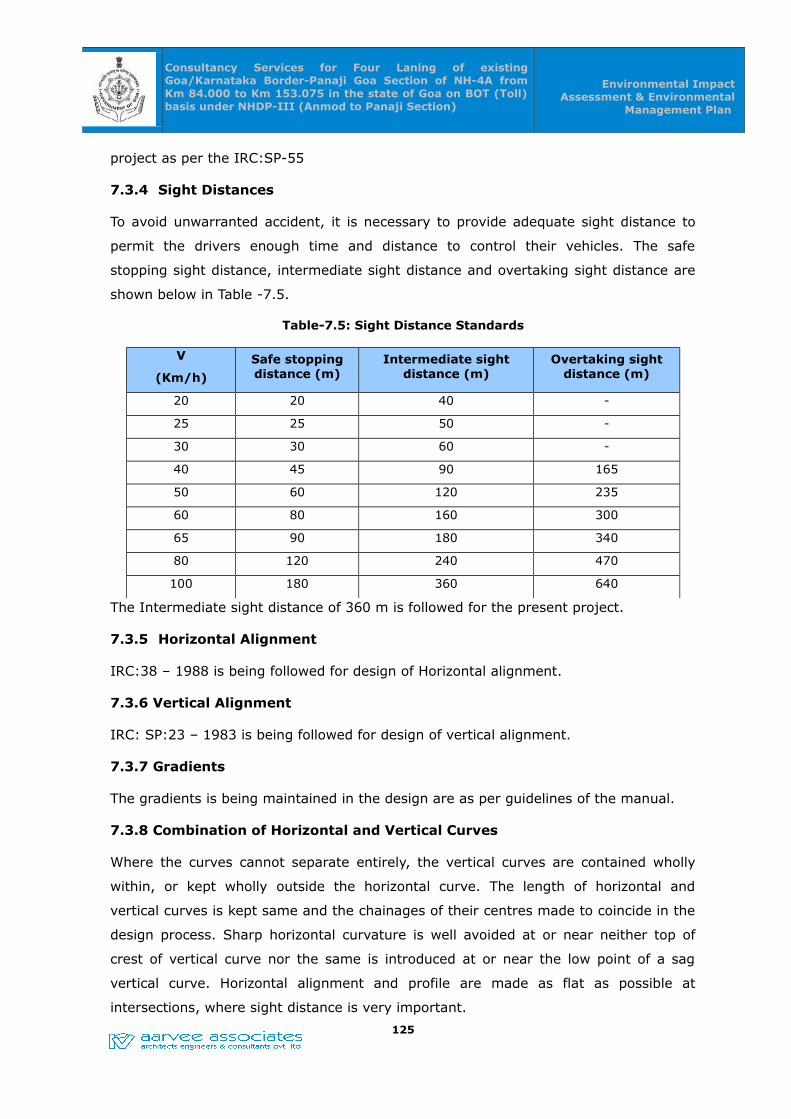
Consultancy Services for Four Laning of existing Goa/Karnataka Border-Panaji Goa Section of NH-4A from Km 84.000 to Km 153.075 in the state of Goa on BOT (Toll) basis under NHDP-III (Anmod to Panaji Section)
Environmental Impact Assessment & Environmental
Management Plan
project as per the IRC:SP-55
7.3.4 Sight Distances
To avoid unwarranted accident, it is necessary to provide adequate sight distance to
permit the drivers enough time and distance to control their vehicles. The safe
stopping sight distance, intermediate sight distance and overtaking sight distance are
shown below in Table -7.5.
Table-7.5: Sight Distance Standards
V
(Km/h)
Safe stopping distance (m)
Intermediate sight distance (m)
Overtaking sight distance (m)
20 20 40 -
25 25 50 -
30 30 60 -
40 45 90 165
50 60 120 235
60 80 160 300
65 90 180 340
80 120 240 470
100 180 360 640
The Intermediate sight distance of 360 m is followed for the present project.
7.3.5 Horizontal Alignment
IRC:38 – 1988 is being followed for design of Horizontal alignment.
7.3.6 Vertical Alignment
IRC: SP:23 – 1983 is being followed for design of vertical alignment.
7.3.7 Gradients
The gradients is being maintained in the design are as per guidelines of the manual.
7.3.8 Combination of Horizontal and Vertical Curves
Where the curves cannot separate entirely, the vertical curves are contained wholly
within, or kept wholly outside the horizontal curve. The length of horizontal and
vertical curves is kept same and the chainages of their centres made to coincide in the
design process. Sharp horizontal curvature is well avoided at or near neither top of
crest of vertical curve nor the same is introduced at or near the low point of a sag
vertical curve. Horizontal alignment and profile are made as flat as possible at
intersections, where sight distance is very important.
125

Consultancy Services for Four Laning of existing Goa/Karnataka Border-Panaji Goa Section of NH-4A from Km 84.000 to Km 153.075 in the state of Goa on BOT (Toll) basis under NHDP-III (Anmod to Panaji Section)
Environmental Impact Assessment & Environmental
Management Plan
7.3.9 Drainage Design, Slope protection & New Culverts
Trapezoidal shaped open drain will be proposed near embankment toes. On hill side of
mountainous sections. “V” shaped drains lined with PCC will be provided. At high
embankments (height exceeding 3m) a system of kerbing at edge of paved shoulders
and chuting at 25m intervals is proposed to safely dispose off surface water to avoid
erosion. For intra-pavement drainage, it is proposed to extend the sub-base layer upto
edge of embankment slopes. In the super elevation sections, a drain in the median will
be constructed and the openings are provided at regular intervals to collect water. This
water will be discharged by providing suitable outfall.
Slope protection in the form of turfing will be proposed on all the embankment slopes.
Pitching will be proposed at the toe where the height of embankment is more than 3m.
Chutes will be proposed to drain off water in case of high embankments.
Planning for New Culverts
• Weak and distressed culverts to be dismantled. Totally new culverts to be
constructed with carriageway and median matching with highway plan and
profile drawing.
• Culverts in service road locations to be extended up to the road side
longitudinal drain.
• The design invert levels of the existing culvert after widening would be
compared with that of the prevailing invert level on the ground. If the design
invert level falls below the existing invert level then the existing culvert would
be proposed to be replaced with another.
7.3.10 Traffic Control Devices / Road Safety Devices / Road Furniture
Traffic control devices / road safety devices / road side furniture shall comprise of road
signs, road markings, object markers, hazard markers, studs, delineators safety
barricades etc proposed in the project.
Road Signs (Danger boards/ Speed limits/ other hazardous indicators)
All signs shall be placed on the left hand side of the road. Where extra emphasis is
warranted, they may be duplicated on the right hand side as well. On non-kerbed, the
extreme edge of the sign shall be 1.5m-2.0m from the edge of the carriageway. On
kerbed portion, it shall not be less than 60cm from the edge of the kerb. Arrangement
for proper surveillance by PWD Goa authority personnel after the expiry of the
maintenance period by the construction agency.126
Consultancy Services for Four Laning of existing Goa/Karnataka Border-Panaji Goa Section of NH-4A from Km 84.000 to Km 153.075 in the state of Goa on BOT (Toll) basis under NHDP-III (Anmod to Panaji Section)
Environmental Impact Assessment & Environmental
Management Plan
Road Marking
Provisions have been made for centre and edge road marking with thermo-plastic
paint as per MOST specification in preference to ordinary paint as a way of better
caution to the driving motorist. This would help reduce road accidents. Border/Edge
lines shall also be marked on both sides of the carriageway along with the Centre line.
Road studs shall also be provided with pavement marking.
Road Delineators
Provision of road delineators has been made in the design that shall comprise roadway
indicators, hazard makers and objects makers. The design shall conform to the
recommendation made in IRC-79. Reflective Chevron signs at bends shall also be
provided for.
Reflective Pavement Markers (Road Studs)
Necessary reflective pavement markers such as road studs, solar studs are proposed
in the project to improve the visibility in night time and wet weather conditions. These
are the prismatic retro-reflective type two way markers confirming to ASTM D 4280.
Conducting of awareness programmes
PWD Goa will conduct the awareness programmes to the nearby community,
transportation associations, NGOs and other interested parties about road safety.
Vigilance by highway patrolling unit
The highway patrolling unit under the control of local police will conduct route checks
and maintain the safety surveillance.
7.4 Disaster Management Plan
Disaster Management Plan (DMP) should be prepared on the basis of risk analysis
considering worst case disaster scenario with respect to specific cases, major road
mishaps, gas tanker explosions, fire hazards, floods, cyclones, earth quakes etc. An
emergency response system should be developed in co-operation with local fire, police
and Medical service. Frequent exercise should be carried out to test the preparedness
of the system by mock drills.
The disaster management plan is given in Fig no.7.2. The role and responsibility of
the concerned officers are well defined and the details are as follows.
127
Consultancy Services for Four Laning of existing Goa/Karnataka Border-Panaji Goa Section of NH-4A from Km 84.000 to Km 153.075 in the state of Goa on BOT (Toll) basis under NHDP-III (Anmod to Panaji Section)
Environmental Impact Assessment & Environmental
Management Plan
7.4.1 Emergency plan in the event of emergency
On receiving the information of emergency due to road mishaps, Executive Engineer,
PWD Goa and Traffic wing will co-ordinate for rescuing the persons, arrangement of
ambulance & first aid, Hospital/Dispensary, information passed on to Police/Fire
brigade/Security, engagement of Rescue team with equipment (crane, mobile van and
other tools).
7.4.2 Emergency plan in the event of emergency (major in nature)
On receiving the information of emergency (due to major in nature like major road
accidents, gas tanker explosions, earth quakes, floods etc) Executive Engineer, PWD
Goa and Traffic wing will co-ordinate for rescuing the persons, arrangement of
ambulance & first aid, Hospital/Dispensary, information passed on to Police/Fire
brigade/Security, engagement of Rescue team with equipment (crane and other
tools).
After receiving the intimation from Executive Engineer/Safety /Traffic wing, Director,
Project Implementation Unit (PIU) will form a Committee to deal with the emergency
with the following:
• Medical facilities
• Set of Control room
• Preparation of action plan
• Welfare activities and
• Repairing and Rehabilitation works.
For the said arrangements, Executive Engineer in co-ordination with project
implementing unit will guide and monitor the work in rendering effective services to
the affected people with the help of Supervisory Consultant & Contractor. The action
taken and final report will be sent to top Management.
Disaster Management Plan (DMP) should be prepared on the basis of risk analysis
considering worst case disaster scenario with respect to specific cases, major road
mishaps, gas tanker explosions, fire hazards, floods, cyclones, earth quakes etc. An
emergency response system should be developed in co-ordination with local fire, police
and Medical service. Frequent exercise should be carried out to test the preparedness
of the system by mock drills.
128
Consultancy Services for Four Laning of existing Goa/Karnataka Border-Panaji Goa Section of NH-4A from Km 84.000 to Km 153.075 in the state of Goa on BOT (Toll) basis under NHDP-III (Anmod to Panaji Section)
Environmental Impact Assessment & Environmental
Management Plan
The disaster management plan is given in Figure -7.2. The role and responsibility of
the concerned officers are well defined and the details are as follows.
7.4.3 Emergency plan in the event of road mishaps
On receiving the information of emergency due to road mishaps, Executive Engineer,
PWD Goa and Traffic wing will co-ordinate for rescuing the persons, arrangement of
ambulance & first aid, Hospital/Dispensary, information passed on to Police/Fire
brigade/Security, engagement of Rescue team with equipment (crane, mobile van and
other tools).
7.4.4 Emergency plan in the event of emergency (major in nature due to
major road accidents, gas tanker explosions etc.)
On receiving the information of emergency (due to major in nature like major road
accidents, gas tanker explosions etc., Executive Engineer, PWD Goa and Traffic wing
will co-ordinate for rescuing the persons, arrangement of ambulance & first aid,
Hospital/Dispensary, information passed on to Police/Fire brigade/Security,
engagement of Rescue team with equipment (crane and other tools).
After receiving the intimation from Executive Engineer (PWD, Goa)/Safety /Traffic
wing, Director, Project Implementation Unit (PIU) will form a Committee to deal with
the emergency with the following:
• Medical facilities
• Set of Control room
• Preparation of action plan
• Welfare activities and
• Repairing and Rehabilitation works.
For the said arrangements, Executive Engineer (PWD, Goa) in co-ordination with
project implementing unit will guide and monitor the work in rendering effective
services to the affected people with the help of Supervisory Consultant & Contractor.
The action taken and final report will be sent to top Management.
7.4.5 Emergency plan in the event of emergency (major in nature due to
Natural disasters.)
On receiving the information of emergency (major in nature due to natural disasters
like earth quakes, floods etc) Executive Engineer, PWD Goa and Traffic wing will co-
ordinate the following;129

Consultancy Services for Four Laning of existing Goa/Karnataka Border-Panaji Goa Section of NH-4A from Km 84.000 to Km 153.075 in the state of Goa on BOT (Toll) basis under NHDP-III (Anmod to Panaji Section)
Environmental Impact Assessment & Environmental
Management Plan
a) for rescuing the persons,
b) arrangement of ambulance & first aid,
c) Hospital/Dispensary,
d) information passed on to Police/Fire brigade/Security,
e) engagement of Rescue team with equipment (crane and other tools) in co-
ordination with District administration.
DMP team will be formed under District Administration control with the following
officials / representatives:
• District Collector or District Magistrate and or his nominated officer
• Executive Engineer, PWD Goa
• Superintendent of Police (S.P) and or his nominee
• District Medical and Health officer
• Representative from Fire department
• Representative from R&B department
• Divisional Engineer, Electricity department
• Executive engineer, Public health engineering department
• Representatives from NGOs etc.
7.4.6 Role and Responsibility of Important Agencies
District Administration: District administration will take active roll and they will co-
ordinate with all the state government agencies for successful implementation of DMP.
All the relief operations and rehabilitations will be supervised by them.
Fire Services: The Fire services department during disaster has to evacuate the
people who are trapped in highway, top on the trees etc. People can be shifted to safer
places (rehabilitation centres). In some cases they also take up supply of drinking
water to relief camps.
Police Department: The law and order situation of the project site will be maintained
by the Police Department and they will also help Fire services whenever required. The
monetary relief released for disbursement to the victims will be escorted by them. The
communications (VHF sets) will be established by them.
130
Consultancy Services for Four Laning of existing Goa/Karnataka Border-Panaji Goa Section of NH-4A from Km 84.000 to Km 153.075 in the state of Goa on BOT (Toll) basis under NHDP-III (Anmod to Panaji Section)
Environmental Impact Assessment & Environmental
Management Plan
Medical & Health department: The medical and health department has to play vital
role during the disaster. During emergency, the department shall ensure that all
ambulances and other vehicles are available at site along with medical teams. Mobile
medical teams shall move to spot to render medical aid to the victims. Preventive
measures to be taken against Gastro-enteritis, Diarrhoea and fever cases. Medical and
health department also distribute the medicines to the victims with proper treatment.
Role of Press & electronic media: The role of Press & Electronic media is
particularly important as it helps to communicate the latest information to the public
as they have close accessibility with the administration department. Flash news, news
items, headlines etc helps the public to move into safer places. The T.V & newspapers
are also educates the people about the possible hazards, steps to mitigate the distress
etc.
Role of NGOs: NGOs plays a vital role for successful implementation of relief works.
Many NGO organizations are also helps to collect the donations and disburse them
directly to the victims.
7.5 Implementation of DMP
In the event of disaster, Executive Engineer, PWD Goa and Traffic wing will co-ordinate
for rescuing the persons, arrangement of ambulance & first aid, Hospital/Dispensary,
information passed on to Police/Fire brigade/Security, engagement of Rescue team
with equipment (crane and other tools) in co-ordination with District administration.
The following rescue operations are to be made on emergency basis:
Implementation of DMP in the event of emergency (major in nature due to major road
accidents, gas tanker explosions, hazardous material spillage
etc.)
1. In case of disaster event, alarm the people and other persons using the Outer
Ring Road and other connected roads.
2. The ambulance, fire tender and ‘hazardous material removal vehicle’ need to be
informed to be ready.
3. Only concerned persons will be present in the affected area and all other
personnel and guests need to be moved to the nearest assembly points.
4. Source of leakage to be traced and isolated from all the other areas.
5. Electrical department need to be informed to shut the power supply (in case of
131
Consultancy Services for Four Laning of existing Goa/Karnataka Border-Panaji Goa Section of NH-4A from Km 84.000 to Km 153.075 in the state of Goa on BOT (Toll) basis under NHDP-III (Anmod to Panaji Section)
Environmental Impact Assessment & Environmental
Management Plan
fuel or other fire hazard substance leakage).
6. In case of a fire the instructions listed against fire hazards needs to be
followed.
7. If the fire is small engage in extinguishing the fire using nearest fire
extinguisher. In case of big fire, fire tender shall be mobilized along with quick
response team and take all the necessary steps to stop the fire.
7.6 Emergency plan in the event of emergency (major in nature due to
Natural disasters.)
• Siren blowing & communication arrangements: In case of disaster event, the
siren will be blown to alarm the drivers, local people and other persons using
the highway. The news about the alarming situation will be telecasted and
published in newspaper along with Radio advertisement. (Agencies responsible:
PWD Goa; District Administration; Electronic Media)
• Evacuation of victims and food arrangements: The arrangements shall be made
to evacuate the victims with the help of Fire brigade and local Police to
rehabilitation places. Necessary arrangement shall be made for accommodation
and provisions. In case of problem to evacuate through road, Air Lifting shall be
done by using helicopters. Air dropping of food packets, medicines and other
needful items shall be done in case of non-approach through roadways.
(Agencies responsible: PWD Goa, District Administration, Fire brigade, police
dept.)
• Monitoring Relief operations: It was the practice that senior officers from State
level were sent by the government to over-see and monitor the arrangements
and effective implementation of the relief operations. The necessary staff,
services and goods shall be deployed for successful implementation of relief
operations. Adequate arrangements are also to be made in advance for supply
of drinking water. (Agencies responsible: State Government, District
Administration, Municipalities, PWD Goa, police dept.) Welfare activities: The
Social welfare/ Tribal Welfare Departments have to reserve in advance stocks of
essential commodities in their hostels functioning in the vulnerable areas.
During the disaster, they are responsible for preparation of food and water
packets and to load them in to the Helicopters for air dropping. (Agencies
responsible: The Social welfare/ Tribal Welfare Departments, PWD Goa, District
Administration)
132
Consultancy Services for Four Laning of existing Goa/Karnataka Border-Panaji Goa Section of NH-4A from Km 84.000 to Km 153.075 in the state of Goa on BOT (Toll) basis under NHDP-III (Anmod to Panaji Section)
Environmental Impact Assessment & Environmental
Management Plan
• Medical and health services: Medical aid to be provided to the victims by the
Mobile medical teams immediately. Post disaster relief measures including
surveillance of Gastro-enteritis, Diarrhoea, Dysentery and other water borne
diseases and spraying of disinfectant to prevent epidemics. Proper sanitation
arrangement should be provided in the flood areas. (Agencies responsible:
DM&HO, District Administration, Municipalities, PWD Goa)
• Post Disaster Management: During post disaster the district administration shall
convene a meeting of all NGOs and role of NGO’s is quite crucial also in terms
of smooth running of relief camps.
• One of the major tasks after disaster will be restoration of normal life and
repair of the damaged structures. After governments approval the Restoration
and Rehabilitation works will be executed by the concerned departments. The
final Disaster Management report will be submitted to the PWD Goa’s top
management and State Government. (Agencies responsible: District
Administration, PWD Goa, Roads & Building department, Municipalities)
133

Consultancy Services for Four Laning of existing Goa/Karnataka Border-Panaji Goa Section of NH-4A from Km 84.000 to Km 153.075 in the state of Goa on BOT (Toll) basis under NHDP-III (Anmod to Panaji Section)
Environmental Impact Assessment & Environmental
Management Plan
134
Executive Engineer (PWD, Goa)/Traffic wing/ Safety officer or
any official available (Wireless/ telephone/ spl-messenger.
Maintenance Contractor or his representative
Rescue of
Persons
Arrangement for Medical
facilities (First-
Hospital/ Dispensary
Police/ Fire brigade / Security
Formation of Committee to deal with an emergency
(major in nature) by Director, Project
Implementation Unit
Immediate Duties-Supervisory Consultant &
Rescue team with Crane,
mobile van & other tools
Set of Control room
Preparation of action
plans
Welfare activitie
s
Monitoring of Disaster Management to deal with
the emergency
Repairing & Rehabilitation
works
Final report to Management
Figure -7.1 : Disaster Management Plan for the proposed 4 laning project for Anmod to Panaji section
Arrangements for Medical
facilities
On knowing about Emergency (Major road mishaps/ Gas tanker
explosions/ Fire hazards/ Floods/Earthquakes/Cyclones,
etc)

Consultancy Services for Four Laning of existing Goa/Karnataka Border-Panaji Goa Section of NH-4A from Km 84.000 to Km 153.075 in the state of Goa on BOT (Toll) basis under NHDP-III (Anmod to Panaji Section)
Environmental Impact Assessment & Environmental
Management Plan
CHAPTER -08CHAPTER -08
ENVIRONMENT MANAGEMENT PLANENVIRONMENT MANAGEMENT PLAN
8.0 ENVIRONMENT MANAGEMENT PLAN
The Environmental Management Plan (EMP) state the procedure in which the project
proponent would carry out the implementation of the mitigation measures and ensure
compliance with environmental regulations that are binding on the project. This plan
also specifies the organizational requirements and institutional strengthening
necessary for sound environmental management of the project. The major
components of the EMP are:
1. EMP Implementing Agency
2. Monitoring of the EMP implementation
3. Training on Environmental management
4. Budget for EMP implementation.
8.1 EMP Implementing Agency
The project proponent will establish an Environmental Management Cell (EMC) to
supervise and implement the mitigation measures as documented in the EMP. This
EMC must also be adequately empowered to discharge the responsibilities as outlined
in the EMP. To ensure smooth implementation of EMP the project proponent will have
to collaborate with various government agencies like Revenue Department, State
Pollution Control Board, State Forest Department, Police Department and other allied
departments.
The details of EMP implementation and implementation responsibilities are given in
Table -8.1. This table comprehensively lists out the tasks to be performed and
completed by the Contracting Company and also lists out the agencies that are
involved and responsible for ensuring the timely completion of the tasks outlined under
EMP. The contractors responsibilities in matters related to protection of environment
shall be the part of the tender document. Table -8.1 gives the provisions that are built
in the bid document to protect and safeguard the environment by the Contractor.
135
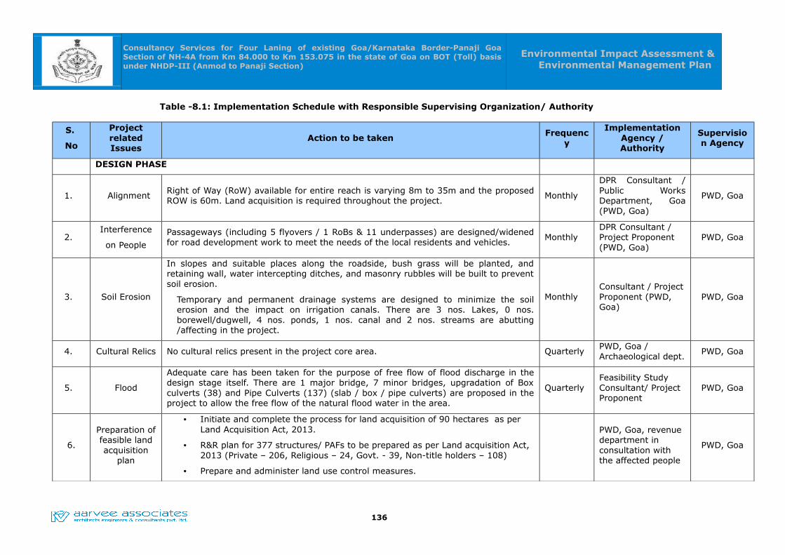
Consultancy Services for Four Laning of existing Goa/Karnataka Border-Panaji Goa Section of NH-4A from Km 84.000 to Km 153.075 in the state of Goa on BOT (Toll) basis under NHDP-III (Anmod to Panaji Section)
Environmental Impact Assessment & Environmental Management Plan
Table -8.1: Implementation Schedule with Responsible Supervising Organization/ Authority
S.
No
Project related Issues
Action to be takenFrequenc
y
Implementation Agency / Authority
Supervision Agency
DESIGN PHASE
1. Alignment Right of Way (RoW) available for entire reach is varying 8m to 35m and the proposed ROW is 60m. Land acquisition is required throughout the project.
Monthly
DPR Consultant / Public Works Department, Goa (PWD, Goa)
PWD, Goa
2. Interference
on People
Passageways (including 5 flyovers / 1 RoBs & 11 underpasses) are designed/widened for road development work to meet the needs of the local residents and vehicles.
MonthlyDPR Consultant / Project Proponent (PWD, Goa)
PWD, Goa
3. Soil Erosion
In slopes and suitable places along the roadside, bush grass will be planted, and retaining wall, water intercepting ditches, and masonry rubbles will be built to prevent soil erosion.
Temporary and permanent drainage systems are designed to minimize the soil erosion and the impact on irrigation canals. There are 3 nos. Lakes, 0 nos. borewell/dugwell, 4 nos. ponds, 1 nos. canal and 2 nos. streams are abutting /affecting in the project.
MonthlyConsultant / Project Proponent (PWD, Goa)
PWD, Goa
4. Cultural Relics No cultural relics present in the project core area. QuarterlyPWD, Goa / Archaeological dept.
PWD, Goa
5. Flood
Adequate care has been taken for the purpose of free flow of flood discharge in the design stage itself. There are 1 major bridge, 7 minor bridges, upgradation of Box culverts (38) and Pipe Culverts (137) (slab / box / pipe culverts) are proposed in the project to allow the free flow of the natural flood water in the area.
QuarterlyFeasibility Study Consultant/ Project Proponent
PWD, Goa
6.
Preparation of feasible land acquisition
plan
• Initiate and complete the process for land acquisition of 90 hectares as per Land Acquisition Act, 2013.
• R&R plan for 377 structures/ PAFs to be prepared as per Land acquisition Act, 2013 (Private – 206, Religious – 24, Govt. - 39, Non-title holders – 108)
• Prepare and administer land use control measures.
PWD, Goa, revenue department in consultation with the affected people
PWD, Goa
136

Consultancy Services for Four Laning of existing Goa/Karnataka Border-Panaji Goa Section of NH-4A from Km 84.000 to Km 153.075 in the state of Goa on BOT (Toll) basis under NHDP-III (Anmod to Panaji Section)
Environmental Impact Assessment & Environmental Management Plan
S.
No
Project related Issues
Action to be takenFrequenc
y
Implementation Agency / Authority
Supervision Agency
CONSTRUCTION PHASE
1Avenue tree cutting and plantation
• Prepare an action plan for about 10,000 nos. of trees to be felled in the project stretch and minimum of 20,000 nos. trees need to be planted as per the Forest Conservation Act, 1980 and subsequent amendments thereof.
• Intimate forest department before cutting trees. Prepare action plan for avenue and median plantation.
• Avenue Plantation: There are two rows of avenue plants proposed along the Project corridor as per IRC-SP-21: 2011. There are 10,000 nos. of trees are affected due to the proposed project. Hence 20,000 nos. of trees are proposed to be planted, out of which 18035 nos. of trees are planted along the sides of road and 1965 nos. of trees are to be planted in parking areas, toll gates, bus bays, truck lay byes. The plants proposed are i.e., Cinamomum camphora, Dalbergia latifolia, Palms, Saraca indica, Sweitenia mahogoni, Tabubea rosea etc.
• Median Plantation: Since the project is widening to four/six laning project median will be utilized. Median plantation is proposed along the four lane stretch of length 50 Kms (excluding major and minor bridges). Median plantation is proposed with provisions of 333 nos. of plants per kilometer in Wild life sanctuary and provisions of 666 nos. of plants per kilometer in the rest of the stretch. Hence, the estimated median plantation is around 27,445 nos. The median plant proposed in the project are i.e., Bougainvillea, Nerium Oleander, Thevitia Nerifolia, Tabernaemontana Coronaria etc.Budget allocation for avenue and median plantation is Rs.2.96crores.
Monthly Concessionaire
PWD, Goa in consultation with the Forest dept.
137

Consultancy Services for Four Laning of existing Goa/Karnataka Border-Panaji Goa Section of NH-4A from Km 84.000 to Km 153.075 in the state of Goa on BOT (Toll) basis under NHDP-III (Anmod to Panaji Section)
Environmental Impact Assessment & Environmental Management Plan
S.
No
Project related Issues
Action to be takenFrequenc
y
Implementation Agency / Authority
Supervision Agency
2
Burrow pits and Quarry sites (stone / sand).
1. There are 10 nos. of borrow areas identified in the project and the same shall get NoC from the private / Government owners well before start of the work.
2. Firm up contract with mining & Geology department for obtaining the identified stone quarries of 2 nos. And 2 sand quarries in the project stretch.
3. Borrow areas shall be carried out upto depth of 2.0m in non-cultivable & elevated lands, 0.45 m in productive lands etc. with a slope of not steeper than 1 vertical to 4 horizontal.
4. Borrow areas shall be away from the 15m of the 10 nos. of water bodies identified in the project.
5. Resurfacing and landscaping of the borrow pits utilised in the project.
Monthly
Contractor or Concessionaire/
Mining Department
/ PWD, Goa
3
Site for storage and construction camp.
The location of the Campsite shall be selected by the Contractor duly confirming the labour laws.
Contractor or Concessionaire/ PWD, Goa
4Sewerage and solid waste disposal.
1. Proper sanitation facilities at the construction workers camp shall be provided as per the IS:2470-1985
2. Domestic refuse shall be collected separately for bio-degradable waste as well as the inert waste and the same shall be sent for the disposal as per the MSW (Management & Handling) Rules, 2000.
3. It is envisaged that approximate 300 - 500 Kg of domestic solid waste (300 - 500 gm/person) per day will be generated from the workers camps which will be disposed of to the nearest solid waste disposal sites as discussed above.
MonthlyContractor or Concessionaire
Labour department / Health department /PWD, Goa
138
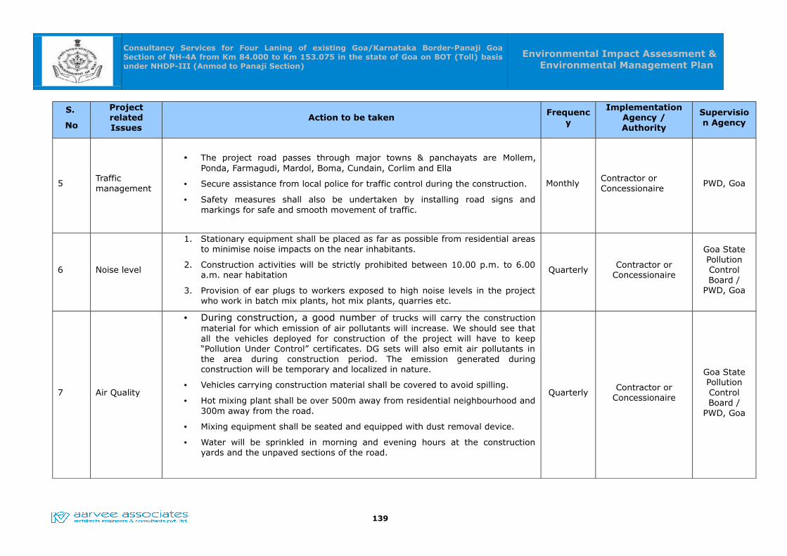
Consultancy Services for Four Laning of existing Goa/Karnataka Border-Panaji Goa Section of NH-4A from Km 84.000 to Km 153.075 in the state of Goa on BOT (Toll) basis under NHDP-III (Anmod to Panaji Section)
Environmental Impact Assessment & Environmental Management Plan
S.
No
Project related Issues
Action to be takenFrequenc
y
Implementation Agency / Authority
Supervision Agency
5Traffic management
• The project road passes through major towns & panchayats are Mollem, Ponda, Farmagudi, Mardol, Boma, Cundain, Corlim and Ella
• Secure assistance from local police for traffic control during the construction.
• Safety measures shall also be undertaken by installing road signs and markings for safe and smooth movement of traffic.
MonthlyContractor or Concessionaire
PWD, Goa
6 Noise level
1. Stationary equipment shall be placed as far as possible from residential areas to minimise noise impacts on the near inhabitants.
2. Construction activities will be strictly prohibited between 10.00 p.m. to 6.00 a.m. near habitation
3. Provision of ear plugs to workers exposed to high noise levels in the project who work in batch mix plants, hot mix plants, quarries etc.
Quarterly Contractor or Concessionaire
Goa State Pollution Control Board /
PWD, Goa
7 Air Quality
• During construction, a good number of trucks will carry the construction material for which emission of air pollutants will increase. We should see that all the vehicles deployed for construction of the project will have to keep “Pollution Under Control” certificates. DG sets will also emit air pollutants in the area during construction period. The emission generated during construction will be temporary and localized in nature.
• Vehicles carrying construction material shall be covered to avoid spilling.
• Hot mixing plant shall be over 500m away from residential neighbourhood and 300m away from the road.
• Mixing equipment shall be seated and equipped with dust removal device.
• Water will be sprinkled in morning and evening hours at the construction yards and the unpaved sections of the road.
QuarterlyContractor or
Concessionaire
Goa State Pollution Control Board /
PWD, Goa
139

Consultancy Services for Four Laning of existing Goa/Karnataka Border-Panaji Goa Section of NH-4A from Km 84.000 to Km 153.075 in the state of Goa on BOT (Toll) basis under NHDP-III (Anmod to Panaji Section)
Environmental Impact Assessment & Environmental Management Plan
S.
No
Project related Issues
Action to be takenFrequenc
y
Implementation Agency / Authority
Supervision Agency
8 Water Quality
1. Prior permission of the concerned engineer and regulatory authorities shall be taken regarding the discharge or disposing of any material arising from the execution of the works.
2. During construction it will be ensured that contractor does not dispose off debris in water bodies.
3. Soil laden run off will not be diverted to water bodies. Provision of waste disposal site for waste from construction and storage yards shall be made.
4. Vehicle maintenance and refueling will be confined to areas under construction yard to trap discarded lubricant and fuel spills.
QuarterlyContractor or
Concessionaire
Goa State Pollution Control Board
/PWD, Goa
9
Water logging and stagnation of water in the Borrow pits
• The majority of the project stretch is plane & horizontal land which will be act as water logging areas during the rainy seasons and may cause the breeding of the vectors in the area.
• Uncontrolled digging of approved Borrow pits in the areas will be avoided to prevent water accumulation which results in breeding of disease causing vectors in the area.
Monthly
Contractor or Concessionaire PWD, Goa
10Occupation Health and Safety
1. Labourers shall be equipped with proper safety gears like helmets, gloves and gum boots.
2. Periodic health checkup of construction workers.
Contractor or Concessionaire
Labour department /PWD, Goa
140

Consultancy Services for Four Laning of existing Goa/Karnataka Border-Panaji Goa Section of NH-4A from Km 84.000 to Km 153.075 in the state of Goa on BOT (Toll) basis under NHDP-III (Anmod to Panaji Section)
Environmental Impact Assessment & Environmental Management Plan
S.
No
Project related Issues
Action to be takenFrequenc
y
Implementation Agency / Authority
Supervision Agency
11
Basic amenities and sanitation facilities for labourers
• Adequate sanitary facilities shall be provided to the workers to avoid health related problems. Sanitation waste from workers camp will not be diverted to water bodies.
• Periodic health checkup of labourers shall be done.
• Contractor to prepare, MORTH’s approved detailed public health utilities plan for the workers camp and other working sites, which make adequate provision for safe disposal of all wastes and prevention of spillages, leakage of polluting materials etc.
• Contractor will be required to pay all costs associated with cleaning up any pollution caused by their activities and to pay full compensation to those affected.
Monthly Contractor or Concessionaire
Labour department /
Health Department /PWD, Goa
12Fuel for labourers
• Adequate supply of fuel (LPG/Kerosene) shall be provided to the labourers to avoid felling of trees for cooking ad other domestic chores.
MonthlyContractor or
Concessionaire
Labour department /
Health Department /PWD, Goa
13Prevention of erosion and scouring
• Stabilizing the embankment with appropriate technique immediately after placing.
• The high embankment slopes near to the major bridges are washed out or weaken and the same shall be strengthened.
• Treating high embankment slopes with rip rap, stone pitching or other technologies to prevent erosion.
• Construction of toe drain all along the road on both sides.
• Avoiding obstruction of existing drainage during filling.
MonthlyContractor or
Concessionaire
Concerned local
department /PWD, Goa
141

Consultancy Services for Four Laning of existing Goa/Karnataka Border-Panaji Goa Section of NH-4A from Km 84.000 to Km 153.075 in the state of Goa on BOT (Toll) basis under NHDP-III (Anmod to Panaji Section)
Environmental Impact Assessment & Environmental Management Plan
S.
No
Project related Issues
Action to be takenFrequenc
y
Implementation Agency / Authority
Supervision Agency
14 Drainage system
1. Adequate care has been taken for the purpose of free flow of flood discharge in the design stage itself. There are 1 major bridge, 7 minor bridges, 175 culverts (slab / box / pipe culverts) are proposed in the project to allow the free flow of the natural drainage water in the area.
2. Construction of toe drain along the road on both the sides.
3. Avoiding obstruction of existing drainage during filling.
MonthlyContractor or
Concessionaire Irrigation /PWD, Goa
15Conservation of Eco-resources
1. To preserve the forests, earth borrowing, piling, and building temporary camps are prohibited in forests lands.
2. Arable lands should not be used as earth borrowing whenever possible. If needed, the topsoil (30cm) should be kept and refilled after construction is over to minimize the impact on ecosystem and agriculture.
3. Construction vehicles should run at temporary accesses to avoid damaging arable lands and cattle-raising lands.
MonthlyContractor or
Concessionaire
Forests or WLS /PWD,
Goa
16 Communications and Transportation
1. Local materials should be used as much as possible so as to avoid long distance transportation that of earth and stone.
2. If there are traffic jammed during construction, measures should be taken to move the jam with the coordination of transportation and public security department.
3. Temporary access should be built at the interchange of the highway and other roads.
4. Passing time on National Highways will be limited, similar measures will also be applied to roads with traffic jams.
5. Materials may be delivery in advance in relatively leisurely season of traffic.
6. A transportation plan of materials will be formulated to avoid delivered of them at peak hours on existing roads.
QuarterlyContractor or
Concessionaire
Transport Department /PWD, Goa
142

Consultancy Services for Four Laning of existing Goa/Karnataka Border-Panaji Goa Section of NH-4A from Km 84.000 to Km 153.075 in the state of Goa on BOT (Toll) basis under NHDP-III (Anmod to Panaji Section)
Environmental Impact Assessment & Environmental Management Plan
S.
No
Project related Issues
Action to be takenFrequenc
y
Implementation Agency / Authority
Supervision Agency
17Rain Water Harvesting
1. The project stretch was considered about an existing length of 50 Km excluding settlements, bridge portions etc.
2. There are 200 nos. of RWH Pits are proposed either side of the road at an interval of 500m. The proposed RWHs are having dia. Of 1.5 m with a depth of 3.8 m.
3. The budget provision for the RWH structures are provided at the rate of Rs. 15000/pit and the total amount is estimated to be Rs. 0.30 Crores.
MonthlyContractor or
Concessionaire
GW Department /PWD, Goa
18
Utilization of Fly Ash
1. In the proposed project, There are fourteen Thermal Power Stations identified and which fall within 500 Km from the project corridor. Hence, Utilisation of Fly Ash in the project is estimated to be 4,00,000 cum provision made as per the IRC SP:58 – 2001 and Fly ash Notification 2007and the subsequent amendments in 25th March, 2015 and the same shall also be put under the BoQs.
MonthlyContractor or
Concessionaire PWD,
Goa/GSPCB
19Surplus earth/ Muck disposal
1. During the construction phase, the quantity of muck generated is approximately 13,00,000 cum and same shall be used for filling up the low-lying areas and some part will be useful for construction of service roads, etc. The top soil shall be kept separately and shall be used for plantation/ landscape development purpose in the project, and also utilized for soil conditioning by the local farmers. An amount of Rs. 9.7 Crore provision is made in the EMP for disposal of the same in the project.
MonthlyContractor or
Concessionaire PWD, Goa
OPERATION PHASE
1 Air Quality
1. Monitor periodically the AAQ at suggested locations.
2. Developing road side vegetation for pollutant sinking.
3. Enforcing different control measures to minimise pollution.
4. Public will be educated about the regulations on air pollution and noise of vehicles.
QuarterlyContractor or
Concessionaire
Goa State Pollution Control
Board /PWD, Goa
143
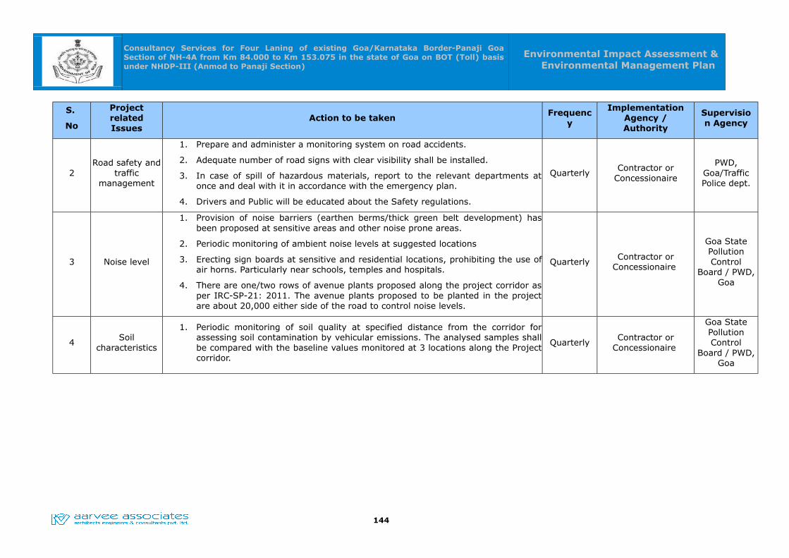
Consultancy Services for Four Laning of existing Goa/Karnataka Border-Panaji Goa Section of NH-4A from Km 84.000 to Km 153.075 in the state of Goa on BOT (Toll) basis under NHDP-III (Anmod to Panaji Section)
Environmental Impact Assessment & Environmental Management Plan
S.
No
Project related Issues
Action to be takenFrequenc
y
Implementation Agency / Authority
Supervision Agency
2Road safety and
traffic management
1. Prepare and administer a monitoring system on road accidents.
2. Adequate number of road signs with clear visibility shall be installed.
3. In case of spill of hazardous materials, report to the relevant departments at once and deal with it in accordance with the emergency plan.
4. Drivers and Public will be educated about the Safety regulations.
QuarterlyContractor or
Concessionaire
PWD, Goa/Traffic Police dept.
3 Noise level
1. Provision of noise barriers (earthen berms/thick green belt development) has been proposed at sensitive areas and other noise prone areas.
2. Periodic monitoring of ambient noise levels at suggested locations
3. Erecting sign boards at sensitive and residential locations, prohibiting the use of air horns. Particularly near schools, temples and hospitals.
4. There are one/two rows of avenue plants proposed along the project corridor as per IRC-SP-21: 2011. The avenue plants proposed to be planted in the project are about 20,000 either side of the road to control noise levels.
QuarterlyContractor or
Concessionaire
Goa State Pollution Control
Board / PWD, Goa
4Soil
characteristics
1. Periodic monitoring of soil quality at specified distance from the corridor for assessing soil contamination by vehicular emissions. The analysed samples shall be compared with the baseline values monitored at 3 locations along the Project corridor.
QuarterlyContractor or
Concessionaire
Goa State Pollution Control
Board / PWD, Goa
144
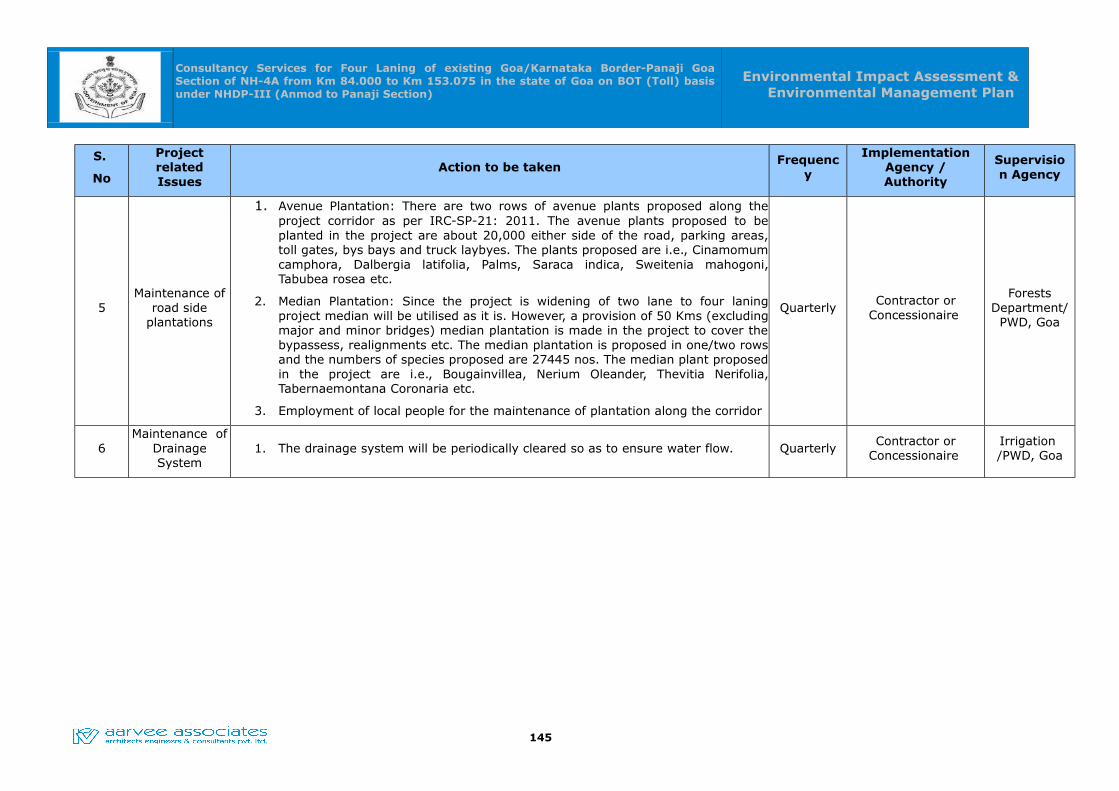
Consultancy Services for Four Laning of existing Goa/Karnataka Border-Panaji Goa Section of NH-4A from Km 84.000 to Km 153.075 in the state of Goa on BOT (Toll) basis under NHDP-III (Anmod to Panaji Section)
Environmental Impact Assessment & Environmental Management Plan
S.
No
Project related Issues
Action to be takenFrequenc
y
Implementation Agency / Authority
Supervision Agency
5Maintenance of
road side plantations
1. Avenue Plantation: There are two rows of avenue plants proposed along the project corridor as per IRC-SP-21: 2011. The avenue plants proposed to be planted in the project are about 20,000 either side of the road, parking areas, toll gates, bys bays and truck laybyes. The plants proposed are i.e., Cinamomum camphora, Dalbergia latifolia, Palms, Saraca indica, Sweitenia mahogoni, Tabubea rosea etc.
2. Median Plantation: Since the project is widening of two lane to four laning project median will be utilised as it is. However, a provision of 50 Kms (excluding major and minor bridges) median plantation is made in the project to cover the bypassess, realignments etc. The median plantation is proposed in one/two rows and the numbers of species proposed are 27445 nos. The median plant proposed in the project are i.e., Bougainvillea, Nerium Oleander, Thevitia Nerifolia, Tabernaemontana Coronaria etc.
3. Employment of local people for the maintenance of plantation along the corridor
QuarterlyContractor or
Concessionaire
Forests Department/
PWD, Goa
6Maintenance of
Drainage System
1. The drainage system will be periodically cleared so as to ensure water flow. QuarterlyContractor or
Concessionaire Irrigation /PWD, Goa
145
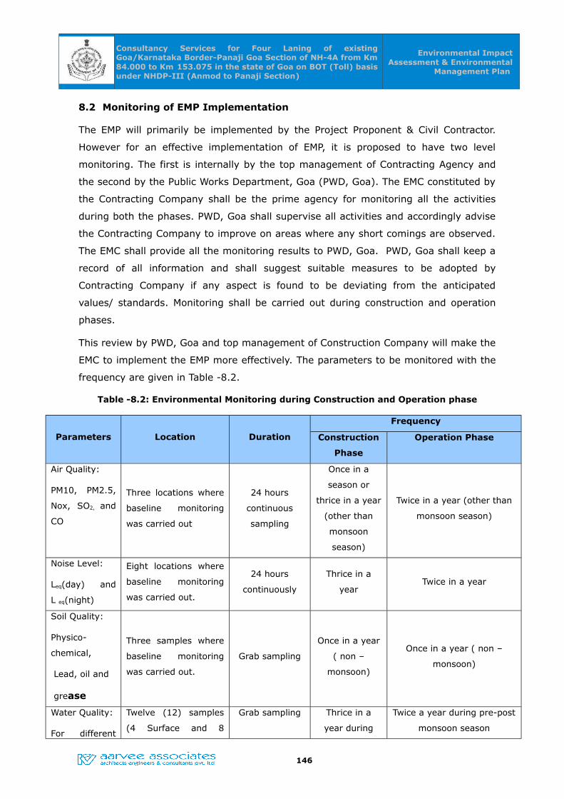
Consultancy Services for Four Laning of existing Goa/Karnataka Border-Panaji Goa Section of NH-4A from Km 84.000 to Km 153.075 in the state of Goa on BOT (Toll) basis under NHDP-III (Anmod to Panaji Section)
Environmental Impact Assessment & Environmental
Management Plan
8.2 Monitoring of EMP Implementation
The EMP will primarily be implemented by the Project Proponent & Civil Contractor.
However for an effective implementation of EMP, it is proposed to have two level
monitoring. The first is internally by the top management of Contracting Agency and
the second by the Public Works Department, Goa (PWD, Goa). The EMC constituted by
the Contracting Company shall be the prime agency for monitoring all the activities
during both the phases. PWD, Goa shall supervise all activities and accordingly advise
the Contracting Company to improve on areas where any short comings are observed.
The EMC shall provide all the monitoring results to PWD, Goa. PWD, Goa shall keep a
record of all information and shall suggest suitable measures to be adopted by
Contracting Company if any aspect is found to be deviating from the anticipated
values/ standards. Monitoring shall be carried out during construction and operation
phases.
This review by PWD, Goa and top management of Construction Company will make the
EMC to implement the EMP more effectively. The parameters to be monitored with the
frequency are given in Table -8.2.
Table -8.2: Environmental Monitoring during Construction and Operation phase
Parameters Location Duration
Frequency
Construction
Phase
Operation Phase
Air Quality:
PM10, PM2.5,
Nox, SO2, and
CO
Three locations where
baseline monitoring
was carried out
24 hours
continuous
sampling
Once in a
season or
thrice in a year
(other than
monsoon
season)
Twice in a year (other than
monsoon season)
Noise Level:
Leq(day) and
L eq(night)
Eight locations where
baseline monitoring
was carried out.
24 hours
continuously
Thrice in a
yearTwice in a year
Soil Quality:
Physico-
chemical,
Lead, oil and
grease
Three samples where
baseline monitoring
was carried out.
Grab sampling
Once in a year
( non –
monsoon)
Once in a year ( non –
monsoon)
Water Quality:
For different
Twelve (12) samples
(4 Surface and 8
Grab sampling Thrice in a
year during
Twice a year during pre-post
monsoon season
146

Consultancy Services for Four Laning of existing Goa/Karnataka Border-Panaji Goa Section of NH-4A from Km 84.000 to Km 153.075 in the state of Goa on BOT (Toll) basis under NHDP-III (Anmod to Panaji Section)
Environmental Impact Assessment & Environmental
Management Plan
Parameters Location Duration
Frequency
Construction
Phase
Operation Phase
physical,
chemical and
biological
parameter
Ground Water)
pre-post
monsoon
season and
winter season
Maintenance
for road side
plantation
All along the project
road. There are18,035
of avenue and 27,445
of median plants
proposed in the
project.
Throughout the
year
Regularly
throughout the
year for three
years
--
Monitoring of
sanitary and
environmental
status of
Burrow areas
All the Borrow pits (10
nos)
Grab Sampling
for Water and
Soil
Once in a
season--
147

Consultancy Services for Four Laning of existing Goa/Karnataka Border-Panaji Goa Section of NH-4A from Km 84.000 to Km 153.075 in the state of Goa on BOT (Toll) basis under NHDP-III (Anmod to Panaji Section)
Environmental Impact Assessment & Environmental
Management Plan
8.3 Corporate Social Responsibility (CSR)
The World Bank Group, stating, “Corporate social responsibility is the commitment of
businesses to contribute to sustainable economic development by working with
employees, their families, the local community and society at large, to improve their
lives in ways that are good for business and for development.”
The core elements of the CSR are:
1. Care for all stakeholders
2. Ethical functioning
3. Respect for workers’ rights and welfare
4. Respect for human rights
5. Protection of Environmental
6. Activities for Social and Inclusive
8.3.1 CSR in Companies Bill 2012
The Companies Bill, 2012 incorporates a provision of CSR under Clause 135 which
states that every company having net worth Rs. 500 crore or more, or a turnover of
Rs. 1000 crore or more or a net profit of rupees five (05) crore or more during any
financial year, shall constitute a CSR Committee of the Board consisting of three or
more Directors, including at least one Independent Director, to recommend activities
for discharging corporate social responsibilities in such a manner that the company
would spend at least 2 per cent of its average net profits of the previous three years
on specified CSR activities.
According to Schedule-VII of Companies Bill, 2012 the following activities can be
included by companies in their CSR Policies:-
Eradicating extreme hunger and poverty;
Promotion of education;
Promoting gender equality and empowering women;
Reducing child mortality and improving maternal health;
Combating human immunodeficiency virus, acquired immune deficiency
syndrome, malaria and other diseases;
Ensuring environmental sustainability;
Employment enhancing vocational skills;
148
Consultancy Services for Four Laning of existing Goa/Karnataka Border-Panaji Goa Section of NH-4A from Km 84.000 to Km 153.075 in the state of Goa on BOT (Toll) basis under NHDP-III (Anmod to Panaji Section)
Environmental Impact Assessment & Environmental
Management Plan
Social business projects;
Contribution to the Prime Minister‟s National Relief Fund or any other fund
set by the Central Government or the State Governments for socio-economic
development and relief and funds for the welfare of the Scheduled Caste, the
Scheduled Tribes, other backward classes, minorities and women; and
Such other matters as may be prescribed.
8.3.2 Guidelines on CSR for Public Enterprises
The Department of Public Enterprises had issued Guidelines on Corporate Social
Responsibility (CSR) for Central Public Sector Enterprises (CPSEs) in April, 2010 which
have been issued formally to the Ministries/Departments for compliance in the CPSEs
under their administrative control. Following are the some of the salient features of
guidelines on CSR & Sustainability:
(i) Corporate Social Responsibility and Sustainability is a company‟s commitment to
its stakeholders to conduct business in an economically, socially and environmentally
sustainable manner that is transparent and ethical.
(ii) In the revised guidelines, CSR and Sustainability agenda is perceived to be equally
applicable to external and internal stakeholders, including the employees of a
company, and a company‟s corporate social responsibility is expected to cover even its
routine business operations and activities. CPSEs are expected to formulate their
policies with a balanced emphasis on all aspects of CSR and Sustainability – equally
with regard to their internal operations, activities and processes, as well as in their
response to externalities.
(iii) In the revised guidelines CSR and Sustainable Development have been clubbed
together in one set of guidelines for CSR and Sustainability because of close linkage
between the two concepts.
(iv) Public Sector enterprises are required to have a CSR and Sustainability policy
approved by their respective Boards of Directors. The CSR and Sustainability activities
undertaken by them under such a policy should also have the approval/ratification of
their Boards. Within the ambit of these guidelines, it is the discretion of the Board of
Directors of CPSEs to decide on the CSR and Sustainability activities to be undertaken.
(v)The financial component/budgetary spend on CSR and Sustainability will be
based on the profitability of the company and shall be determined by the Profit
After Tax (PAT) on the company in the previous year.
149
Consultancy Services for Four Laning of existing Goa/Karnataka Border-Panaji Goa Section of NH-4A from Km 84.000 to Km 153.075 in the state of Goa on BOT (Toll) basis under NHDP-III (Anmod to Panaji Section)
Environmental Impact Assessment & Environmental
Management Plan
S.No.PAT of CPSEs in the Previous
Years
Range of Budgetary allocation for CSR &
Sustainability Activities
(as % of PAT in Previous Year)
1 Less than 100 Crores 3-5%
2 Rs. 100 Crores to Rs. 500 Crores 2-3%
3 Rs. 500 Crores and Above 1-2%
Loss making companies are not mandated to earmark specific funding for CSR and
Sustainability activities. However, they must pursue CSR and Sustainability policies by
integrating them with their business plans, strategies and processes, which do not
involve any financial expenditure. They may also collaborate with the profit making
CPSEs and assist them in ingenious ways without financial support in CSR and
Sustainability activities
8.3.3 CSR Budgetary Allocations for this Project
The Public Works Department plays a major role in the economic, Commercial and
tourist development of the State of Goa. Being a service Department, it is entrusted
with all the developmental activities like Planning, Design, Construction, Operation and
Maintenance of all types of construction works in this State of Goa. PWD, Goa has
undertaken the development of the proposed project road stretch of NH-4A starts from
Anmod and ends at Panaji respectively. The cost of the project is Rs. 2130 Crores.
CSR in Companies Bill, 2012 stating that the budgetary provisions shall be made on
PAT, which is not envisaged throughout the concessions period for this project.
However, as per the Government of India initiative taken on CSR activities, the
lumpsum amount provision of Rs. 2.0 Crores shall be made in the project initially and
the same shall be reviewed and adjusted time to time by the CSR Board of Directors
for this project.
8.4 Environmental Training
The Environmental Management Cell (EMC), in addition to implementing and monitoring
different environmental attributes, shall also be actively involved in imparting training
and raising environmental awareness level of Contractors and the construction staff so as
to enable them to take the environmental aspects into consideration as and when
required. In the long term, the EMC can impart additional and specialized training in the
Environmental Management of the road system.
150
Consultancy Services for Four Laning of existing Goa/Karnataka Border-Panaji Goa Section of NH-4A from Km 84.000 to Km 153.075 in the state of Goa on BOT (Toll) basis under NHDP-III (Anmod to Panaji Section)
Environmental Impact Assessment & Environmental
Management Plan
8.5 Budget for EMP Implementation
The design and construction of the project involves a number of items such as
resettlement & rehabilitation, erosion prevention, rehabilitation of Borrow areas, safety
signage, etc., which are included in the contract cost. Only those items that are not
covered under the budget for construction are shown in the EMP implementation budget.
The total budget for implementation of EMP works out to be Rs. 20.005 Crores as given
in Table -8.3.
The main components are:
• Tree plantation / Transplantation
• Environmental monitoring during construction and operation phase
• Training during construction and operation phase
151

Consultancy Services for Four Laning of existing Goa/Karnataka Border-Panaji Goa Section of NH-4A from Km 84.000 to Km 153.075 in the state of Goa on BOT (Toll) basis under NHDP-III (Anmod to Panaji Section)
Environmental Impact Assessment & Environmental
Management Plan
Table -8.3: Budget for Implementation of Environment Management Plan
S.No. ItemUnit cost/ Lump
sum cost (Rs.)Total cost (Rs.)
I. Logistics cum Administrative costs
1 Vehicle cost 1 location@ Rs
20,000 per month for
12 vehicle months
2,40,000.00
2 Office administration (including man power
costs) and logistics etc for Environment
Management Cell (EMC)
1 locations For 12
months @
Rs.1,00,000/ month
12,00,000.00
II. Construction costs
3 Sanitation- sulabh – sowchalaya 16.5 sq.m area
(Included in project cost)
10,00,000.00
4 Sprinkling of water thrice in a day all along the
stretch & Erosion control Retaining walls, slope
pitching and turfing. (Included in project cost)
(365 days x 3 times x 2 year x 3 vehicles x Rs.
1000/trip)
65,70,000.00
5 Labour camps, health and other services
(Included in project cost)
10,00,000.00
6 Solid waste management (Included in project
cost)
10,00,000.00
7 Muck/Debris Disposal from site
(Approx 13,00,000cum, estimated to be Rs. 9.7
Crores)
Already included in Project BoQs
8 Allocation of Budget towards the Corporate
Social Responsibility (CSR) activities
2,00,00,000.00
III. Tree plantation and compensatory afforestation
9
Compensatory afforestation of 31.01 hectares of Bhagawan Mahaveer Wild life sanctuary & 32.95 hectares of Reserve & Private forest area and Maintenance for 5 years (63.96*20 L/Ha)
12,79,20,000.00
10 Avenue trees including 3 years maintenance -
around 20,000 trees including tree guards (Rs.
1000/tree) (Included in project cost)
2,00,00,000.00
152
Consultancy Services for Four Laning of existing Goa/Karnataka Border-Panaji Goa Section of NH-4A from Km 84.000 to Km 153.075 in the state of Goa on BOT (Toll) basis under NHDP-III (Anmod to Panaji Section)
Environmental Impact Assessment & Environmental
Management Plan
S.No. ItemUnit cost/ Lump
sum cost (Rs.)Total cost (Rs.)
11 Shrub plantation in median and landscaping in
4/6- lane project for 50 Kms(Excluding major
and minor bridges): 27,445 plants @ Rs.350/-
including maintenance for one year. (Included in
project cost)
96,05,750.00
IV. Monitoring costs : Construction Phase
12 Air Quality Monitoring (3 Monitoring stations)
once in a season during the construction period
- (3Stations x 3 Seasons x 3 Years)
Rs.7,000 per station 1,89,000.00
13 Noise level Monitoring ( 8 Monitoring stations)
once in a season during the construction period
- (8 Stations x 3 Seasons x 3 Years)
Rs.1500 per station 1,08,000.00
14 Water Quality Monitoring (12 Monitoring
stations) once in a season during the
construction period - (12 Stations x 3 Seasons x
3 Years)
Rs.7000 per station 7,56,000.00
15 Soil Quality Monitoring ( 3 stations) once in a
year during the construction period - (3 Stations
x 3 Seasons x 3 Years)
Rs.6000 per sample 1,62,000.00
16 Awareness programmes ( Lumpsum) 10,00,000 10,00,000.00
17 Borrow area monitoring (Once in a year)
10 borrow areas
Rs.25,000 per borrow
area per 3 seasons
7,50,000.00
18 200 nos. Rain Water Harvesting Structures
(RWH) Pits of dia. 1.5m with a depth of 3.8 m at
an interval of 500m either side of the road.
Rs. 15000 per RWH
pit
30,00,000.00
19 Protection and mitigative measures for
Bhagawan Mahaveer wildlife during construction
phase
Lumpsum 20,00,000.00
V. Monitoring costs: Operation Phase
20 Air Quality Monitoring (3 Monitoring stations)
twice in a year (other than monsoon season) -(3
Stations x 3Seasons x 1 Year)
Rs.7,000 per station 63,000.00
21 Noise level Monitoring (8 Monitoring stations)
twice in a year (other than monsoon season) -(8
Stations x 3Seasons x 1 Year)
Rs.1500 per station 36,000.00
22 Water Quality Monitoring (12 Monitoring
stations) twice in a year (other than monsoon
Rs.7000 per station 2,52,000.00
153
Consultancy Services for Four Laning of existing Goa/Karnataka Border-Panaji Goa Section of NH-4A from Km 84.000 to Km 153.075 in the state of Goa on BOT (Toll) basis under NHDP-III (Anmod to Panaji Section)
Environmental Impact Assessment & Environmental
Management Plan
S.No. ItemUnit cost/ Lump
sum cost (Rs.)Total cost (Rs.)
season) -(12 Stations x 3Seasons x 1 Year)
23 Soil Quality Monitoring (3 stations) once in a
year (other than monsoon season) -(3 Stations
x 3Seasons x 1 Year)
Rs.6000 per sample 54,000.00
24 Disaster Management Plan L.S 50,00,000.00
Sub Total 20,06,08,750.00
Service Tax @ 15 % 3,00,91313.00
Grand Total 23,07,00,062.00
Say@ Rs. 23.07 Crores
154

Consultancy Services for Four Laning of existing Goa/Karnataka Border-Panaji Goa Section of NH-4A from Km 84.000 to Km 153.075 in the state of Goa on BOT (Toll) basis under NHDP-III (Anmod to Panaji Section)
Environmental Impact Assessment & Environmental
Management Plan
CHAPTER -09CHAPTER -09
CONCLUSIONS AND RECOMMENDATIONSCONCLUSIONS AND RECOMMENDATIONS
9.0 CONCLUSIONS AND RECOMMENDATIONS
The proposed upgradation of existing road into 4 lanes with MoRTH guidelines from
Anmod-Panaji stretch can harmonize with the surrounding environment with the
following direct and indirect benefits.
1. The increased road capacity and improved pavements can reduce the travel
time & traffic jams. Resulting, conservation of fuel and reduction of pollution
load. Based on the vehicle population for year 2033, the saving of the fuel
consumption per year estimated to be 46604.4 KL, which may have a direct
savings of Rs. 272.9 Crores per year.
2. Due to road widening the noise levels can be reduced to 4-5 dB(A) & air
pollutants will also be reduced considerably. Ultimately, this shows positive
impact on human health.
3. There will be improvements of the economic growth in the surrounding places
due to establishment of more industries, institutions, MNCs and other
organizations.
Environmental Improvement Measure Adopted in the project are:
1. During the construction phase of the project, air pollution will be increased due
to various construction activities, movement of construction vehicles etc. and
the same will be mitigated by sprinkling of water thrice in a day. An amount of
Rs. 65,70,000.00 provision is made in the EMP implementation budget to take
care of this issue.
2. Avenue Plantation: There are two rows of avenue plants proposed along the
Project corridor as per IRC-SP-21: 2011. There are 10,000 nos. of trees are
affected due to the proposed project. Hence 20,000 nos. of trees are proposed
to be planted, out of which 18035 nos. of trees are planted along the sides of
road and 1965 nos. of trees are to be planted in parking areas, toll gates, bus
bays, truck lay byes. The plants proposed are i.e., Cinamomum camphora,
Dalbergia latifolia, Palms, Saraca indica, Sweitenia mahogoni, Tabubea rosea
etc.
3. Median Plantation: Since the project is widening of two lane to four laning
155

Consultancy Services for Four Laning of existing Goa/Karnataka Border-Panaji Goa Section of NH-4A from Km 84.000 to Km 153.075 in the state of Goa on BOT (Toll) basis under NHDP-III (Anmod to Panaji Section)
Environmental Impact Assessment & Environmental
Management Plan
project median will be utilised as it is. However, a provision of 50 Kms
(excluding major and minor bridges) median plantation is made in the project
to cover the bypassess, realignments etc. It is estimated that there are about
50 Kms (excluding major and minor bridges), Median plantation is proposed
with provisions of 333 nos. of plants per kilometer in Wild life sanctuary and
provisions of 666 nos. of plants per kilometer in the rest of the stretch. Hence,
the estimated median plantation is around 27,445 nos. The median plant
proposed in the project are i.e., Bougainvillea, Nerium Oleander, Thevitia
Nerifolia, Tabernaemontana Coronaria etc.
4. Budget allocation for avenue and median plantation is Rs. 2.96 crores
Implementation.
5. There are 200 nos. of RWH Pits are proposed either side of the road at an
interval of 500m. The proposed RWHs are having dia. of 1.5 m with a depth of
3.8 m. The budget provision for the RWH structures are already made in the
EMP and amount is estimated to be Rs. 0.30 Crores.
6. In the proposed project, there are fourteen Thermal Power Stations identified
and which fall within 500 Km from the project corridor. The total Fly ash
requirement during construction for utilizing in embankments, etc. is 4,00,000
Cum. Hence, Utilization of Fly Ash in the project shall be made as per the IRC
SP:58 – 2001 and Fly ash Notification 2007 and subsequent amendments in
25th March,2015 and the same is estimated to be 18.7 crores and given under
the BoQs.
7. The total budget for implementation of EMP during construction & operation
phases of the project is for Rs. 20.0015 Crores.
In view of the above benefits, the road widening project can be taken up for the
sustainable development of the society.
156

Consultancy Services for Four Laning of existing Goa/Karnataka Border-Panaji Goa Section of NH-4A from Km 84.000 to Km 153.075 in the state of Goa on BOT (Toll) basis under NHDP-III (Anmod to Panaji Section)
Environmental Impact Assessment & Environmental
Management Plan
CHAPTER -10CHAPTER -10
DISCLOSURE OF CONSULTANT ENGAGEDDISCLOSURE OF CONSULTANT ENGAGED
10.0 DISCLOSURE OF THE CONSULTANT ENGANGED
Aarvee Associates is a premier, ISO 9001:2008 certified multi-disciplinary
engineering consulting company, established in 1989 and based at Hyderabad in India.
We have a pan-India presence, with branch offices in New Delhi, Ahmedabad and
Bhubaneshwar, and project offices in all the major states across the country. We also
have a wholly-owned Australian subsidiary, Aarvee Associates Pvt Ltd, based at
Brisbane, Queensland.
In addition to over 1,000 successful assignments in India, we have carried out projects
in Australia, Bangladesh, Ethiopia, Gabon, Mozambique, Nigeria, South Africa, Sri
Lanka, and Uganda. We have worked on projects funded by various international
agencies including the World Bank, the Asian Development Bank (ADB), the
Department for International Development (DFID), and Japan International
Cooperation Agency (JICA).
M/s. Aarvee Assocates Architects Engineers and Consultants Pvt., Ltd., Hyderabad is a
Civil Engineering Consultancy accredited by QCI-NABET in their Vide letter no.
NABET/EIA/SA091/254 Dated: 12th December 2013 for doing EIA and EMP Studies in
“Highways, Railways, Transport terminals, and Mass Rapid Transport Systems Sector”.
157
Consultancy Services for Four Laning of existing Goa/Karnataka Border-Panaji Goa Section of NH-4A from Km 84.000 to Km 153.075 in the state of Goa on BOT (Toll) basis under NHDP-III (Anmod to Panaji Section)
Environmental Impact Assessment & Environmental
Management Plan
ANNEXURE-1:Details of Borrow Areas/ Metal and Sand Quarries
S. No
Existing Chainage
(Km)
Borrow Area
Side Distance (km)
Area
(Acres)
App. Depth/ Height (m)
App. Qty(m3)
Borrow Areas
1 96.500 BA-1 LHS 2.9 15 1.5 91057.5
2 96.500 BA-2 LHS 1.1 10 1 40470
3 101.600 BA-3 LHS 1.6 10 2 80940
4 103.200 BA-4 LHS 0.2 15 2 121410
5 107.800 BA-5 LHS 0.2 10 2 80940
6 112.000 BA-6 LHS 0.6 10 2 80940
7 116.700 BA-7 LHS 0.2 12 1.5 72846
8 146.800 BA-8 LHS 0.6 30 5 6070650
9 138.900 BA-9 RHS 1 20 5 404700
10 120.500 BA-10 RHS 0.2 15 2 121410
Metal Quarries
1 146.800 MQ-1 LHS 0.6 30 5 607050
2 118.900 MQ-2 LHS 20 50 5 1011750
Sand Quarries
S. NoExisting Chainage
(Km)Side Distance (km) Zone
1 99.700 LHS 0.8 III
2 140.200 RHS 2 III
158
Consultancy Services for Four Laning of existing Goa/Karnataka Border-Panaji Goa Section of NH-4A from Km 84.000 to Km 153.075 in the state of Goa on BOT (Toll) basis under NHDP-III (Anmod to Panaji Section)
Environmental Impact Assessment & Environmental
Management Plan
Masshaul diagram for Goa/Karnataka Border-Panaji Goa Section of NH-4A
(Km 84.000 to Km 153.075)
159
Consultancy Services for Four Laning of existing Goa/Karnataka Border-Panaji Goa
Section of NH-4A from Km 84.000 to Km 153.075 in the state of Goa on BOT (Toll) basis
under NHDP-III (Anmod to Panaji Section)
Environmental Impact Assessment &
Environmental Management Plan
CHAPTER – 11
PROVISIONS FOR WILDLIFE CROSSING
About Animal Passages :
Wildlife/Animal passages are those structures that facilitates the movement of wildlife
across the man made barriers. Wildlife crossing structures are an important tool in multiple
ecosystems to allow safe passage for wildlife across roadways. Hence, it is very essential to
construct/provide access to cross the road for an animal to enable the movement, to
maintain the continuity of the ecosystem. As the vehicles move at the design speed several
animals may meet with accidents and succumb serious injuries. The purpose of
constructing animal passes is to ensure free movement of animals by avoiding accidents
due to vehicular movement.
Animal passes have to be provided based on the type of terrain and the type of wildlife in
the region. These passages have to be constructed and maintained in such a way that the
animals feel that the passage is a natural corridor.
Wildlife/Animal passes can be majorly divided into underpasses and overpasses depending
on the type of terrain.Overpasses are those which allows passage of animals above the
road, Similarly Underpasses allows the passage of animals below the road.
Construction/Provision of fencing/railing is also an important measure to avoid accidents to
animals.Further, fencing directs the animals to effectively use the passages and also acts
as a barricade to stop the animals entering the highway.
Animal Underpasses/Overpasses along proposed project stretch
The proposed road widening in the Bhagwan Mahaveer wildlife sanctuary by constructing
viaduct parallel to the existing road hardly abstructs the animal movement. However,
wherever the existing road is being used a 2 Lane/4 Lane road, locations were identified
with the help of the forest officials where the animals frequently crosses the road.
Important locations were identified to construct four animal passes in the proposed stretch.
Based on the terrain conditions 3 Underpasses and 1 Overpass are proposed for wildlife
movement. Details of the Underpasses and Overpasses locations are given below :
Table 11.1 Proposed Animal passages in Wildlife Sanctuary & National Park
Locations
Design
Chainage
(Km)
Latitude Longitude Proposal
Provisional
Specifications
1 84.400L 15°25'4.94"N 74°16'3.24"E Underpass 12 m X 5 m
2 92.150R 15°23'45.38"N 74°14'16.09"E Underpass 20 m X 5 m
160

Consultancy Services for Four Laning of existing Goa/Karnataka Border-Panaji Goa
Section of NH-4A from Km 84.000 to Km 153.075 in the state of Goa on BOT (Toll) basis
under NHDP-III (Anmod to Panaji Section)
Environmental Impact Assessment &
Environmental Management Plan
Locations
Design
Chainage
(Km)
Latitude Longitude Proposal
Provisional
Specifications
3 93.170R 15°23'14.34"N 74°14'10.94"E Underpass 12 m X 5 m
4 93.850R 15°23'2.90"N 74°13'58.21"E Overpass 12 m X 5 m
Sectional View of the Proposed Passages :
Fig. 11.1 Animal Underpass
Fig. 11.2 Animal Overpass
161
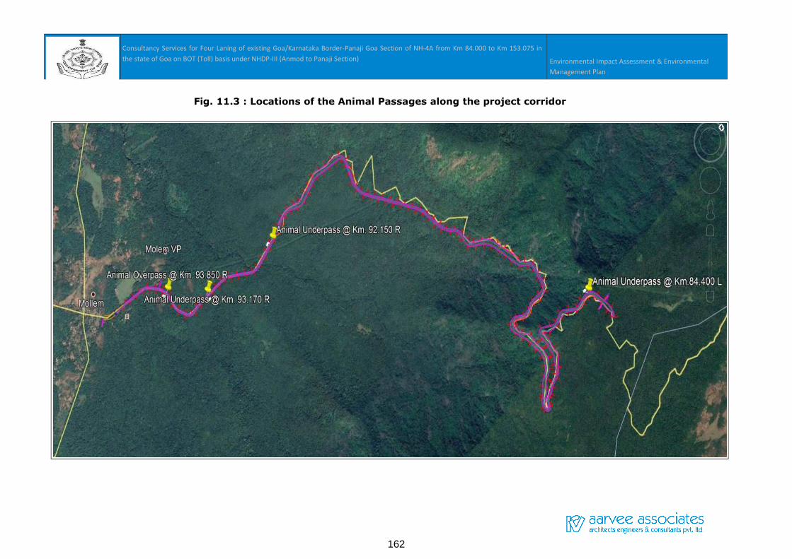
Consultancy Services for Four Laning of existing Goa/Karnataka Border-Panaji Goa Section of NH-4A from Km 84.000 to Km 153.075 in
the state of Goa on BOT (Toll) basis under NHDP-III (Anmod to Panaji Section) Environmental Impact Assessment & Environmental
Management Plan
Fig. 11.3 : Locations of the Animal Passages along the project corridor
162
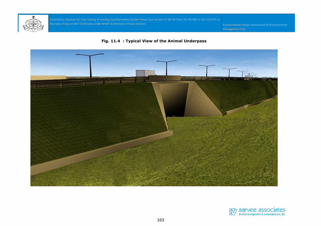
Consultancy Services for Four Laning of existing Goa/Karnataka Border-Panaji Goa Section of NH-4A from Km 84.000 to Km 153.075 in
the state of Goa on BOT (Toll) basis under NHDP-III (Anmod to Panaji Section) Environmental Impact Assessment & Environmental
Management Plan
Fig. 11.4 : Typical View of the Animal Underpass
163
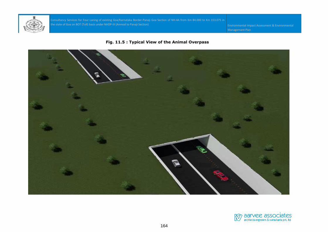
Consultancy Services for Four Laning of existing Goa/Karnataka Border-Panaji Goa Section of NH-4A from Km 84.000 to Km 153.075 in
the state of Goa on BOT (Toll) basis under NHDP-III (Anmod to Panaji Section) Environmental Impact Assessment & Environmental
Management Plan
Fig. 11.5 : Typical View of the Animal Overpass
164