catalog of earth satellite orbits_2017
TRANSCRIPT


Topic: Earth Satellite Orbits
P a g e 1 | 12
TABLE OF CONTENTS
1. ABOUT ORBITS 2
2. TYPES OF ORBITS 3
2.1. HEIGHT OF THE ORBITS 3
2.2. ORBITAL SPEED 4
2.3. ECCENTRICITY AND INCLINATION 4
3. HIGH EARTH ORBIT 5
3.1. LAGRANGE POINTS – SWEET SPOTS 5
4. MEDIUM EARTH ORBIT 7
4.1. THE MOLNIYA ORBIT 7
5. LOW EARTH ORBIT 8
5.1. POLAR ORBIT 9
5.2. SUN-SYNCHRONOUS ORBITS 9
6. ACHIEVING AND MAINTAINING ORBIT 9
6.1. LAUNCH 9
6.2. MAINTAINING ORBIT 10
COURTESY TO 12
REFERENCE 12

Topic: Earth Satellite Orbits
P a g e 2 | 12
CATALOG OF EARTH SATELLITE ORBITS
1. ABOUT ORBITS
Among the many things that NASA engineers consider when designing a satellite is its orbit, including
which one is best for the data it will collect and how much maneuvering it will take to keep it there.
Throughout the design process, engineers make calculations using the same laws of physics that were
developed to explain the orbits of planets. This series of articles details the development of the science
of orbital mechanics, catalogs the most common orbits of Earth-observing satellites, and shadows the
engineers in mission control as they work to keep a satellite in orbit.
Few ideas have had a greater impact on humanity than our quest to understand why things orbit across
the heavens. Planetary Motion: The History of an Idea That Launched a Scientific Revolution describes
how the study of the motion of the planets led to the development of the basic theories of motion and
gravity that are used to calculate a satellite’s orbit.
Satellites are designed to orbit Earth in one of three basic orbits defined by their distance from the
planet. Within these three orbits are many variations, each intended to provide the best view of Earth
for the type of information the satellite is collecting. Catalog of Earth Satellite Orbits describes the most
common orbits for Earth-observing satellites.
Finally, in Flying Steady: Mission Control Tunes Up Aqua’s Orbit, the Earth Observatory peeks in on
the Earth Observing System Mission Control Center as flight engineers adjust the path of NASA’s Aqua
satellite to keep it in the proper orbit for collecting scientific data.
Just as different seats in a theater provide different perspectives on a performance, different Earth orbits
give satellites varying perspectives, each valuable for different reasons. Some seem to hover over a
single spot, providing a constant view of one face of the Earth, while others circle the planet, zipping
over many different places in a day.
Figure 1. Flying hundreds of kilometers above the Earth, the International Space Station and other orbiting satellites provide
a unique perspective on our planet. (NASA Photograph S126-E-014918.)
Topic: Earth Satellite Orbits
P a g e 3 | 12
2. TYPES OF ORBITS
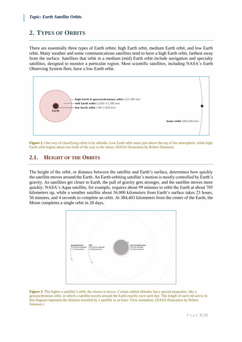
There are essentially three types of Earth orbits: high Earth orbit, medium Earth orbit, and low Earth
orbit. Many weather and some communications satellites tend to have a high Earth orbit, farthest away
from the surface. Satellites that orbit in a medium (mid) Earth orbit include navigation and specialty
satellites, designed to monitor a particular region. Most scientific satellites, including NASA’s Earth
Observing System fleet, have a low Earth orbit.
Figure 2. One way of classifying orbits is by altitude. Low Earth orbit starts just above the top of the atmosphere, while high
Earth orbit begins about one tenth of the way to the moon. (NASA illustration by Robert Simmon)
2.1. HEIGHT OF THE ORBITS
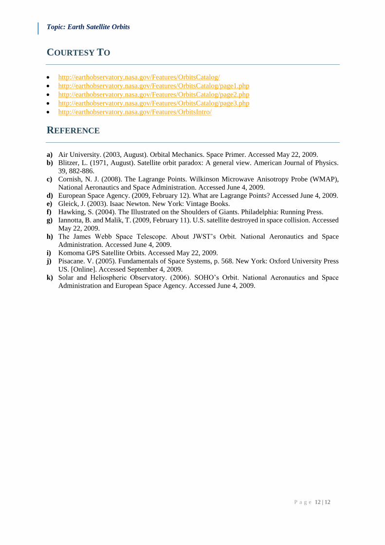
The height of the orbit, or distance between the satellite and Earth’s surface, determines how quickly
the satellite moves around the Earth. An Earth-orbiting satellite’s motion is mostly controlled by Earth’s
gravity. As satellites get closer to Earth, the pull of gravity gets stronger, and the satellite moves more
quickly. NASA’s Aqua satellite, for example, requires about 99 minutes to orbit the Earth at about 705
kilometers up, while a weather satellite about 36,000 kilometers from Earth’s surface takes 23 hours,
56 minutes, and 4 seconds to complete an orbit. At 384,403 kilometers from the center of the Earth, the
Moon completes a single orbit in 28 days.
Figure 3. The higher a satellite’s orbit, the slower it moves. Certain orbital altitudes have special properties, like a
geosynchronous orbit, in which a satellite travels around the Earth exactly once each day. The length of each red arrow in
this diagram represent the distance traveled by a satellite in an hour. View animation. (NASA illustration by Robert
Simmon.)

Topic: Earth Satellite Orbits
P a g e 4 | 12
2.2. ORBITAL SPEED
Changing a satellite’s height will also change its orbital speed. This introduces a strange paradox. If a
satellite operator wants to increase the satellite’s orbital speed, he can’t simply fire the thrusters to
accelerate the satellite. Doing so would boost the orbit (increase the altitude), which would slow the
orbital speed. Instead, he must fire the thrusters in a direction opposite to the satellite’s forward motion,
an action that on the ground would slow a moving vehicle. This change will push the satellite into a
lower orbit, which will increase its forward velocity.
2.3. ECCENTRICITY AND INCLINATION
In addition to height, eccentricity and inclination also shape a satellite’s orbit. Eccentricity refers to the
shape of the orbit. A satellite with a low eccentricity orbit moves in a near circle around the Earth. An
eccentric orbit is elliptical, with the satellite’s distance from Earth changing depending on where it is
in its orbit.
Figure 4. The eccentricity (e) of an orbit indicates the deviation of the orbit from a perfect circle. A circular orbit has an
eccentricity of 0, while a highly eccentric orbit is closer to (but always less than) 1. A satellite in an eccentric orbit moves
around one of the ellipse’s focal points, not the center. (NASA illustration by Robert Simmon.)
Inclination is the angle of the orbit in relation to Earth’s equator. A satellite that orbits directly above
the equator has zero inclination. If a satellite orbits from the north pole (geographic, not magnetic) to
the south pole, its inclination is 90 degrees.
Figure 5. Orbital inclination is the angle between the plane of an orbit and the equator. An orbital inclination of 0° is directly
above the equator, 90° crosses right above the pole, and 180° orbits above the equator in the opposite direction of Earth’s
spin. (NASA illustration by Robert Simmon.)

Topic: Earth Satellite Orbits
P a g e 5 | 12
Together, the satellite’s height, eccentricity, and inclination determine the satellite’s path and what view
it will have of Earth.
3. HIGH EARTH ORBIT
When a satellite reaches exactly 42,164 kilometers from the center of the Earth (about 36,000 kilometers
from Earth’s surface), it enters a sort of “sweet spot” in which its orbit matches Earth’s rotation. Because
the satellite orbits at the same speed that the Earth is turning, the satellite seems to stay in place over a
single longitude, though it may drift north to south. This special, high Earth orbit is called
geosynchronous.
A satellite in a circular geosynchronous orbit directly over the equator (eccentricity and inclination at
zero) will have a geostationary orbit that does not move at all relative to the ground. It is always directly
over the same place on the Earth’s surface.
A geostationary orbit is extremely valuable for weather monitoring because satellites in this orbit
provide a constant view of the same surface area. When you log into your favorite weather web site and
look at the satellite view of your hometown, the image you are seeing comes from a satellite in
geostationary orbit. Every few minutes, geostationary satellites like the Geostationary Operational
Environmental Satellite (GOES) satellites send information about clouds, water vapor, and wind, and
this near-constant stream of information serves as the basis for most weather monitoring and
forecasting.
Figure 6. Satellites in geostationary orbit rotate with the Earth directly above the equator, continuously staying above the
same spot. This position allows satellites to observe weather and other phenomena that vary on short timescales. (NASA
images by Marit Je ntoft-Nilsen and Robert Simmon.)
Because geostationary satellites are always over a single location, they can also be useful for
communication (phones, television, radio). Built and launched by NASA and operated by the National
Oceanic and Atmospheric Administration (NOAA), the GOES satellites provide a search and rescue
beacon used to help locate ships and airplanes in distress.
3.1. LAGRANGE POINTS – SWEET SPOTS
Finally, many high Earth orbiting satellites monitor solar activity. The GOES satellites carry a large
contingent of “space weather” instruments that take images of the Sun and track magnetic and radiation
levels in space around them.
Other orbital “sweet spots,” just beyond high Earth orbit, are the Lagrange points. At the Lagrange
points, the pull of gravity from the Earth cancels out the pull of gravity from the Sun. Anything placed
at these points will feel equally pulled toward the Earth and the Sun and will revolve with the Earth
around the Sun.

Topic: Earth Satellite Orbits
P a g e 6 | 12
Figure 7. Lagrange points are special locations where a satellite will stay stationary relative to the Earth as the satellite and
the Earth revolve around the Sun. L1 and L2 are positioned above the day and night sides of the Earth, respectively. L3 is on
the ot other side of the Sun, opposite the Earth. L4 and L5 are 60° ahead and behind the Earth in the same orbit. (NASA
illustration by Robert Simmon.)
Of the five Lagrange points in the Sun-Earth system, only the last two, called L4 and L5, are stable. A
satellite at the other three points is like a ball balanced at the peak of a steep hill: any slight perturbation
will push the satellite out of the Lagrange point like the ball rolling down the hill. Satellites at these
three points need constant adjustments to stay balanced and in place. Satellites at the last two Lagrange
points are more like a ball in a bowl: even if perturbed, they return to the Lagrange point.
Figure 8. The Lagrange points nearest the Earth are about 5 times the distance from the Earth to the Moon. L1 is between
the Sun and Earth, and always views the Earth’s daylight side. L2 is opposite the sun, always on the night side. (NASA
illustration by Robert Simmon.)
The first Lagrange point is located between the Earth and the Sun, giving satellites at this point a
constant view of the Sun. The Solar and Heliospheric Observatory (SOHO), a NASA and European
Space Agency satellite tasked to monitor the Sun, orbits the first Lagrange point, about 1.5 million
kilometers away from Earth.
The second Lagrange point is about the same distance from the Earth, but is located behind the Earth.
Earth is always between the second Lagrange point and the Sun. Since the Sun and Earth are in a single
line, satellites at this location only need one heat shield to block heat and light from the Sun and Earth.
It is a good location for space telescopes, including the future James Webb Space Telescope (Hubble’s
successor, scheduled to launch in 2014) and the current Wilkinson Microwave Anisotropy Probe
(WMAP), used for studying the nature of the universe by mapping background microwave radiation.
The third Lagrange point is opposite the Earth on the other side of the Sun so that the Sun is always
between it and Earth. A satellite in this position would not be able to communicate with Earth. The
extremely stable fourth and fifth Lagrange points are in Earth’s orbital path around the Sun, 60 degrees
ahead of and behind Earth. The twin Solar Terrestrial Relations Observatory (STEREO) spacecraft will
orbit at the fourth and fifth Lagrange points to provide a three-dimensional view of the Sun.

Topic: Earth Satellite Orbits
P a g e 7 | 12
Figure 9. The twin Solar Terrestrial Relations Observatory (STEREO) spacecraft took these images of sunspot 1024 on July
5, 2009, while on their way to L4 and L5. The perspectives of the Sun from 60 degrees behind (left) and ahead (right) of
Earth’s orbit reveal portions of the Sun’s surface that would otherwise be hidden from view. (NASA images courtesy
STEREO Science Center.)
4. MEDIUM EARTH ORBIT
Closer to the Earth, satellites in a medium Earth orbit move more quickly. Two medium Earth orbits
are notable: the semi-synchronous orbit and the Molniya orbit.
The semi-synchronous orbit is a near-circular orbit (low eccentricity) 26,560 kilometers from the center
of the Earth (about 20,200 kilometers above the surface). A satellite at this height takes 12 hours to
complete an orbit. As the satellite moves, the Earth rotates underneath it. In 24-hours, the satellite
crosses over the same two spots on the equator every day. This orbit is consistent and highly predictable.
It is the orbit used by the Global Positioning System (GPS) satellites.
The second common medium Earth orbit is the Molniya orbit. Invented by the Russians, the Molniya
orbit works well for observing high latitudes. A geostationary orbit is valuable for the constant view it
provides, but satellites in a geostationary orbit are parked over the equator, so they don’t work well for
far northern or southern locations, which are always on the edge of view for a geostationary satellite.
The Molniya orbit offers a useful alternative.
4.1. THE MOLNIYA ORBIT
The Molniya orbit is highly eccentric: the satellite moves in an extreme ellipse with the Earth close to
one edge. Because it is accelerated by our planet’s gravity, the satellite moves very quickly when it is
close to the Earth. As it moves away, its speed slows, so it spends more time at the top of its orbit
farthest from the Earth. A satellite in a Molniya orbit takes 12 hours to complete its orbit, but it spends
about two-thirds of that time over one hemisphere. Like a semi-synchronous orbit, a satellite in the
Molniya orbit passes over the same path every 24 hours. This type of orbit is useful for communications
in the far north or south.

Topic: Earth Satellite Orbits
P a g e 8 | 12
Figure 10. The Molniya orbit combines high inclination (63.4°) with high eccentricity (0.722) to maximize viewing time
over high latitudes. Each orbit lasts 12 hours, so the slow, high-altitude portion of the orbit repeats over the same location
every day and night. Russian communications satellites and the Sirius radio satellites currently use this type of orbit.
(Adapted from Fundamentals of Space Systems by Vincent L. Pisacane, 2005.)
5. LOW EARTH ORBIT
Most scientific satellites and many weather satellites are in a nearly circular, low Earth orbit. The
satellite’s inclination depends on what the satellite was launched to monitor. The Tropical Rainfall
Measuring Mission (TRMM) satellite was launched to monitor rainfall in the tropics. Therefore, it has
a relatively low inclination (35 degrees), staying near the equator.
Figure 11. TRMM’s low orbital inclination—just 35° from the equator—allows its instruments to concentrate on the tropics.
This image shows one half of the observations TRMM makes in a single day. (NASA image courtesy TRMM Project.)
Many of the satellites in NASA’s Earth Observing System have a nearly polar orbit. In this highly-
inclined orbit, the satellite moves around the Earth from pole to pole, taking about 99 minutes to
complete an orbit. During one half of the orbit, the satellite views the daytime side of the Earth. At the
pole, satellite crosses over to the nighttime side of Earth.
As the satellites orbit, the Earth turns underneath. By the time the satellite crosses back into daylight, it
is over the region adjacent to the area seen in its last orbit. In a 24-hour period, polar orbiting satellites
will view most of the Earth twice: once in daylight and once in darkness.

Topic: Earth Satellite Orbits
P a g e 9 | 12
5.1. POLAR ORBIT
Just as the geosynchronous satellites have a sweet spot over the equator that lets them stay over one
spot on Earth, the polar-orbiting satellites have a sweet spot that allows them to stay in one time. This
orbit is a Sun-synchronous orbit, which means that whenever and wherever the satellite crosses the
equator, the local solar time on the ground is always the same. For the Terra satellite for example, it’s
always about 10:30 in the morning when the satellite crosses the equator in Brazil. When the satellite
comes around the Earth in its next overpass about 99 minutes later, it crosses over the equator in Ecuador
or Colombia at about 10:30 local time.
5.2. SUN-SYNCHRONOUS ORBITS
The Sun-synchronous orbit is necessary for science because it keeps the angle of sunlight on the surface
of the Earth as consistent as possible, though the angle will change from season to season. This
consistency means that scientists can compare images from the same season over several years without
worrying too much about extreme changes in shadows and lighting, which can create illusions of
change. Without a Sun-synchronous orbit, it would be very difficult to track change over time. It would
be impossible to collect the kind of consistent information required to study climate change.
The path that a satellite has to travel to stay in a Sun-synchronous orbit is very narrow. If a satellite is
at a height of 100 kilometers, it must have an orbital inclination of 96 degrees to maintain a Sun-
synchronous orbit. Any deviation in height or inclination will take the satellite out of a Sun-synchronous
orbit. Since the drag of the atmosphere and the tug of gravity from the Sun and Moon alter a satellite’s
orbit, it takes regular adjustments to maintain a satellite in a Sun-synchronous orbit.
Figure 12. A Sun-synchronous orbit crosses over the equator at approximately the same local time each day (and night). This
orbit allows consistent scientific observations with the angle between the Sun and the Earth’s surface remaining relatively
constant. These illustrations show 3 consecutive orbits of a sun-synchronous satellite with an equatorial crossing time of 1:30
pm. The satellite’s most recent orbit is indicated by the dark red line, while older orbits are lighter red. View animation. (NASA
illustration by Robert Simmon.)
6. ACHIEVING AND MAINTAINING ORBIT
6.1. LAUNCH
The amount of energy required to launch a satellite into orbit depends on the location of the launch site
and how high and how inclined the orbit is. Satellites in high Earth orbit require the most energy to
reach their destination. Satellites in a highly inclined orbit, such as a polar orbit, take more energy than
a satellite that circles the Earth over the equator. A satellite with a low inclination can use the Earth’s
rotation to help boost it into orbit. The International Space Station orbits at an inclination of 51.6397
degrees to make it easier for the Space Shuttle and Russian rockets to reach it. A polar-orbiting satellite,

Topic: Earth Satellite Orbits
P a g e 10 | 12
on the other hand, gets no help from Earth’s momentum, and so requires more energy to reach the same
altitude.
Figure 13. Satellites in low-inclination orbits can get an energy boost from the Earth’s rotation by being launched near the
equator. The European Space Agency launches satellites into geostationary orbits from their facilities in French Guiana (left).
On the othher hand, high-inclination satellites don’t receive much benefit from equatorial launch sites. The Baikonur
Cosmodrome (right), located at 49° north, is frequently used to launch satellites into polar and Molniya orbits, as well as to
send astronauts and supplies to the International Space Station. [Photographs ©2008 ESA/CNES/ARIANESPACE/Activité
Photo Optique Video CSG (left) and courtesy NASA (right).]
6.2. MAINTAINING ORBIT
Once a satellite is in orbit, it usually takes some work to keep it there. Since Earth isn’t a perfect sphere,
its gravity is stronger in some places compared to others. This unevenness, along with the pull from the
Sun, Moon, and Jupiter (the solar system’s most massive planet), will change the inclination of a
satellite’s orbit. Throughout their lifetime, GOES satellites have to be moved three or four times to keep
them in place. NASA’s low Earth orbit satellites adjust their inclination every year or two to maintain
a Sun-synchronous orbit.
A. Satellites in a low Earth orbit are also pulled out of their orbit by drag from the atmosphere. Though
satellites in low Earth orbit travel through the uppermost (thinnest) layers of the atmosphere, air
resistance is still strong enough to tug at them, pulling them closer to the Earth. Earth’s gravity then
causes the satellites to speed up. Over time, the satellite will eventually burn up as it spirals lower
and faster into the atmosphere or it will fall to Earth.
B. Atmospheric drag is stronger when the Sun is active. Just as the air in a balloon expands and rises
when heated, the atmosphere rises and expands when the Sun adds extra energy to it. The thinnest
layer of atmosphere rises, and the thicker atmosphere beneath it lifts to take its place. Now, the
satellite is moving through this thicker layer of the atmosphere instead of the thin layer it was in
when the Sun was less active. Since the satellite moves through denser air at solar maximum, it
faces more resistance. When the Sun is quiet, satellites in low Earth orbit have to boost their orbits
about four times per year to make up for atmospheric drag. When solar activity is at its greatest, a
satellite may have to be maneuvered every 2-3 weeks.
C. The third reason to move a satellite is to avoid space junk, orbital debris, that may be in its path.
On February 11, a communication satellite owned by Iridium, a U.S. company, collided with a non-
functioning Russian satellite. Both satellites broke apart, creating a field of debris that contained at
least 2,500 pieces. Each piece of debris was added to the database of more than 18,000 manmade
objects currently in Earth orbit and tracked by the U.S. Space Surveillance Network.
NASA satellite mission controllers carefully track anything that may enter the path of their satellites.
As of May 2009, Earth Observing satellites had been moved three separate times to avoid orbital debris.

Topic: Earth Satellite Orbits
P a g e 11 | 12
Figure 14. Thousands of manmade objects—95 % of them “space junk”— occupy low Earth orbit. Each black dot in this
image shows either a functioning satellite, an inactive satellite, or a piece of debris. Although the space near Earth looks
crowded, each dot is much larger than the satellite or debris it represents, and collisions are extremely rare. (NASA
illustration courtesy Orbital Debris Program Office.)
The debris field generated by the Iridium collision is of particular concern to the Earth Observing
System because the center of the debris field will eventually drift through the EOS satellites’ orbits.
The Iridium and Russian satellites were 790 kilometers above the Earth, while EOS satellites orbit at
705 kilometers. Many pieces of debris from this collision were propelled to lower altitudes and are
already causing issues at 705 kilometers.
Mission control engineers track orbital debris and other orbiting satellites that could come into the Earth
Observing System’s orbit, and they carefully plan avoidance maneuvers as needed. The same team also
plans and executes maneuvers to adjust the satellite’s inclination and height. The team evaluates these
planned maneuvers to ensure that they do not bring the EOS satellites into close proximity to catalogued
orbital debris or other satellites. To peek in on a day in the mission control center during one such
maneuver, see the related article Flying Steady: Mission Control Tunes Up Aqua’s Orbit.
Figure 15. Orbiting objects are concentrated in low Earth orbit (nearly obscuring the Earth’s surface in this illustration) and
geostationary orbit (revealed by the ring of satellites along the outer edges). (NASA illustration courtesy Orbital Debris
Program Office.)
Topic: Earth Satellite Orbits
P a g e 12 | 12
COURTESY TO
http://earthobservatory.nasa.gov/Features/OrbitsCatalog/
http://earthobservatory.nasa.gov/Features/OrbitsCatalog/page1.php
http://earthobservatory.nasa.gov/Features/OrbitsCatalog/page2.php
http://earthobservatory.nasa.gov/Features/OrbitsCatalog/page3.php
http://earthobservatory.nasa.gov/Features/OrbitsIntro/
REFERENCE
a) Air University. (2003, August). Orbital Mechanics. Space Primer. Accessed May 22, 2009.
b) Blitzer, L. (1971, August). Satellite orbit paradox: A general view. American Journal of Physics.
39, 882-886.
c) Cornish, N. J. (2008). The Lagrange Points. Wilkinson Microwave Anisotropy Probe (WMAP),
National Aeronautics and Space Administration. Accessed June 4, 2009.
d) European Space Agency. (2009, February 12). What are Lagrange Points? Accessed June 4, 2009.
e) Gleick, J. (2003). Isaac Newton. New York: Vintage Books.
f) Hawking, S. (2004). The Illustrated on the Shoulders of Giants. Philadelphia: Running Press.
g) Iannotta, B. and Malik, T. (2009, February 11). U.S. satellite destroyed in space collision. Accessed
May 22, 2009.
h) The James Webb Space Telescope. About JWST’s Orbit. National Aeronautics and Space
Administration. Accessed June 4, 2009.
i) Komoma GPS Satellite Orbits. Accessed May 22, 2009.
j) Pisacane. V. (2005). Fundamentals of Space Systems, p. 568. New York: Oxford University Press
US. [Online]. Accessed September 4, 2009.
k) Solar and Heliospheric Observatory. (2006). SOHO’s Orbit. National Aeronautics and Space
Administration and European Space Agency. Accessed June 4, 2009.