cary section 6 - projects staff
TRANSCRIPT
Cary Pedestrian Plan Section 6: Future Projects
6-1
Section 6. Future Projects
6.1. Introduction This section identifies potential future projects and focus areas, as well as provides a prioritization of these projects. Projects are developed based upon input from Town staff, the stakeholder committee, and most importantly, the results in Section 2: Existing Needs from public input through focus groups and surveys. Projects are also based upon existing proposed projects and upcoming projects.
6.2. Existing Proposed Projects Pedestrian facilities can include sidewalks, greenways, and intersection improvements, as well as streetscaping projects and traffic calming efforts. Pedestrian facilities can be constructed as part of a roadway project or similar type work, or independently. Town staff keeps a listing of these various projects and their proposed timeframe. The following paragraphs outline existing upcoming pedestrian-related projects, their estimated costs, and proposed timeframe for design and construction.
6.2.1. Roadway Projects Projects currently in progress in Cary are as follows. Sidewalk will be included for each of these projects: Street Improvements ♦ Carpenter Fire Station Road Widening ♦ Cary Park Transportation Improvements ♦ Cary Parkway Extension: North Harrison to
Trinity ♦ Chapel Hill Road Widening – Trinity Road
to NE Maynard ♦ Crossroads Area Traffic Improvements ♦ Davis Drive Widening ♦ Davis Drive Widening – Northern Section ♦ Evans Road Widening ♦ Green Level to Durham Road Widening ♦ High House Road Widening ♦ Jenks Carpenter Road Improvements ♦ Kildaire Farm Road Widening
♦ Louis Stephens Drive Extensions ♦ Morrisville Parkway Extension ♦ NC 54/Chapel Hill Road Widening ♦ NC 55 Widening ♦ Old Apex Rd and Southwest Cary
Parkway Intersection Improvements ♦ O’Kelly Chapel Road Widening ♦ Southwest Maynard Road Widening ♦ Trinity Road Widening and Extension ♦ Tryon Road Widening ♦ US 1/64 Widening ♦ Walnut Street Corridor and Land Use Plan ♦ Walnut Street Widening
This section identifies and prioritizes potential future projects. It also provides a brief description of existing planned projects.

Cary Pedestrian Plan Section 6: Future Projects
6-2
New Traffic Signals ♦ Regency Parkway at Ederlee Drive – Complete March 2006 ♦ NC 55 at McCrimmon Parkway – Complete May 2006 ♦ Walnut Street at Macedonia Road/Tryon Village – Complete July 2006 ♦ Tryon Road at Colonial Baptist Church/Tryon Village – Complete July 2006 ♦ Walnut Street at Centrum/Crossroads Ford – Complete November 2006 ♦ SW Cary Parkway at Towne Center Village Drive/Huntsmoor Lane – Complete December 2006 Upgraded Traffic Signals ♦ Academy Street at Chatham Street – April 2006 ♦ Cary Parkway at Old Apex Road – May 2006 ♦ Harrison Avenue at Harrison Square – August 2006 ♦ SW Maynard Road at Old Apex Road – August 2006 The following table (Table 6-1) is funded transportation projects as listed in Cary’s Capital Listing for FY 2006 – 2007, as of September 2006. A full and complete listing of projects can be found online at: http://townofcary.org/depts/budget/fy2007/budgetfy07summary.htm.
Figure 6-1. Current roadway constructionprojects in Cary will include new sidewalk.

Cary Pedestrian Plan Section 6: Future Projects
6-3
Table 6-1. Funded transportation projects as listed in Cary's FY 2007 – 2016 Capital Improvements Plan.
Project Project Total ($)
Estimated Completion
Date (FY) Alston Avenue Widening 11.5 Mil 2010 Aviation Parkway Widening (Morrisville ETJ to National Guard
Drive) 4.9 Mil 2010
Carpenter Fire Station Rd Widening (NC 55 to Green Level to Durham Rd) – Developer Agreement 6.5 Mil 2009
Cary Glen Road Improvements 7.9 Mil 2008 Cary Parkway Ext (N. Harrison to Trinity Rd) 10.3 Mil 2017 Chapel Hill Road Widening (NE Maynard to NW Maynard) 23.5 Mil 2009 Evans Road Widening 4.1 Mil 2007 Green Level to Durham Road (Carpenter Fire Station to O’Kelly) –
Developer Agreement 9.3 Mil 2009
Green Level West Road Widening 12.5 Mil 2013 Greenwood Circle Extension 1.15 Mil 2011 Holly Springs Rd Widening Phase III (Penny to Ten Ten Rd) 6.7 Mil 2011 Holly Springs Road Widening Phase II (Cary Parkway to Penny Rd) 9.7 Mil 2010 Intersection Realignment: Jenks – Carpenter/High House 3.0 Mil 2008 Kildaire Farm Road Widening – Penny to Ten Ten Road 4.3 Mil 2007 Maynard Rd Widening Phase II (Kildaire Farm Rd to W Chatham
St) 9.3 Mil 2007
Morrsiville Pkwy Extension Phase III (Carpenter Upchurch Rd to Green Level to Durham Rd) 14.0 Mil 2009
Morrisville-Carpenter Rd Widening – NC 55 to Davis Drive 15.8 Mil 2010 O’Kelly Chapel Road Widening (NC 55 to Green Level to
Durham) – Developer Agreement 3.3 Mil 2009
Penny Rd Widening (Holly Springs Rd to SR 1010) 15.5 Mil 2012 Reedy Creek Road Widening (NE Maynard Road to N Harrison
Ave) 5.6 Mil 2009
S. Harrison Avenue Extension 2.0 Mil 2009 TCAP – Downtown Roundabouts (Chatham and E Durham Rd) 1.7 Mil 2009 TCAP – Downtown Roundabouts (Chatham and Old Apex) 1.7 Mil 2009 Ten-Ten Road Widening Phase I 7.4 Mil 2012 Ten-Ten Road Widneing Phase II 8.0 Mil 2016 Thoroughfare Street Lights 0.25 Mil 2007 Tryon Road Widneing Phase II (Piney Plains Rd to New Waverly
Place) 7.6 Mil 2007
Waldo Rood Dual Left Turn Lanes 0.25 Mil 2008 Walker Street Extension 10.0 Mil 2009 Walnut Street Corridor Improvements Phase I 7.0 Mil 2008
Cary Pedestrian Plan Section 6: Future Projects
6-4
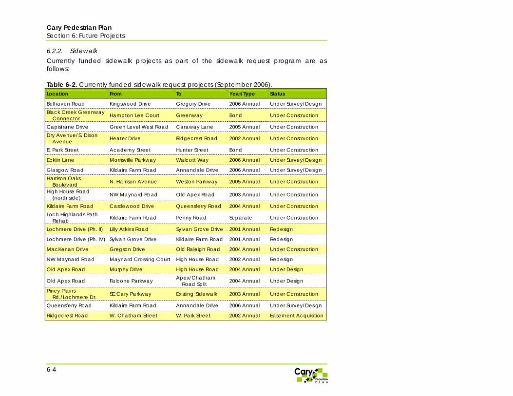
6.2.2. Sidewalk Currently funded sidewalk projects as part of the sidewalk request program are as follows: Table 6-2. Currently funded sidewalk request projects (September 2006). Location From To Year/Type Status
Belhaven Road Kingswood Drive Gregory Drive 2006 Annual Under Survey/Design Black Creek Greenway
Connector Hampton Lee Court Greenway Bond Under Construction
Capistrane Drive Green Level West Road Caraway Lane 2005 Annual Under Construction Dry Avenue/S. Dixon
Avenue Heater Drive Ridgecrest Road 2002 Annual Under Construction
E. Park Street Academy Street Hunter Street Bond Under Construction
Ecklin Lane Morrisville Parkway Walcott Way 2006 Annual Under Survey/Design
Glasgow Road Kildaire Farm Road Annandale Drive 2006 Annual Under Survey/Design Harrison Oaks
Boulevard N. Harrison Avenue Weston Parkway 2005 Annual Under Construction
High House Road (north side) NW Maynard Road Old Apex Road 2003 Annual Under Construction
Kildaire Farm Road Castlewood Drive Queensferry Road 2004 Annual Under Construction Loch Highlands Path
Rehab Kildaire Farm Road Penny Road Separate Under Construction
Lochmere Drive (Ph. II) Lilly Atkins Road Sylvan Grove Drive 2001 Annual Redesign
Lochmere Drive (Ph. IV) Sylvan Grove Drive Kildaire Farm Road 2001 Annual Redesign
MacKenan Drive Gregson Drive Old Raleigh Road 2004 Annual Under Construction
NW Maynard Road Maynard Crossing Court High House Road 2002 Annual Redesign
Old Apex Road Murphy Drive High House Road 2004 Annual Under Design
Old Apex Road Falcone Parkway Apex/Chatham Road Split 2004 Annual Under Design
Piney Plains Rd./Lochmere Dr. SE Cary Parkway Existing Sidewalk 2003 Annual Under Construction
Queensferry Road Kildaire Farm Road Annandale Drive 2006 Annual Under Survey/Design
Ridgecrest Road W. Chatham Street W. Park Street 2002 Annual Easement Acquisition

Cary Pedestrian Plan Section 6: Future Projects
6-5
Table 6-2 (Continued). Location From To Year/Type Status S. West Street Williams Street W. Park Street 2003 Annual Under Construction
SE Cary Parkway Kildaire Farm Road Ridgeview Drive 2005 Annual Under Construction
SW Cary Parkway Cedarpost Drive Pedestrain Tunnel 2003 Annual Under Construction
SW Cary Parkway Center Point Drive Old Apex Road 2001 Annual Under Construction
SW Cary Parkway Kilarney Drive Kildaire Farm Road 2004 Annual Under Construction
SW Cary Parkway Kilarney Drive Existing Asphalt Trail 2004 Annual Under Construction
SW Cary Parkway Inverleigh Drive Waldo Rood Boulevard
2005 Annual Under Construction
SW Cary Parkway W. Chatham Street Baron's Glen 2006 Annual Under Survey/Design
Thurston Drive Wellingborough Drive
Kids Together Playground
2005 Annual Under Construction
W. Park Street W. Chatham Street S. Harrison Avenue 2002 Annual Easement Acquisition
Walnut Street Ralph Drive Kildaire Farm Road 2006 Annual Under Survey/Design
Weston Parkway Black Creek Greenway
Renaissance Park Place
2004 Annual Under Construction
Weston Parkway/Harrison Avenue
Wheelchair Improvements
2005 Annual Under Construction

Cary Pedestrian Plan Section 6: Future Projects
6-6
6.2.3. Greenways The Cary Parks, Recreation, and Cultural Resources Master Plan is responsible for assigning priority to greenway and trail projects in the Town of Cary. Table 6-3 lists the priority projects presented in the 2003 Parks, Recreation, and Cultural Resources Master Plan (and at the time of this printing). The most recent Parks, Recreation, and Cultural Resources Master Plan should be referenced for the most up-to-date listing of greenway priorities. The Parks, Recreation, and Cultural Resources Department can also be contacted for a list of current funded greenway construction and design projects. Table 6-4 shows the most recent greenway construction and design projects underway in Cary as of January 2007. Table 6-3. Greenway priority projects in Cary's Parks, Recreation, & Cultural Resources Master Plan (2003).
Trail Name Length (miles) Location/Description
Black Creek 3.5 Continue to extend to Bond Park. Provide any and all linkages to adjoining neighborhoods.
Higgins 1.86 Extends from Maynard to Danforth. Proposed section would extend to downtown Cary.
High House Multi-Use Trail .96 Extends from proposed linkage with Higgins Trial at Chatham Street, along High Street to Black Creek Extension at intersection of High House and Maynard Streets.
Annie Jones Sidewalk Connector/Oxford Hunt Trail Extension
1.4 Series of potential trails connecting Scottish Hills Area to Bond Park.
Kildaire Farm Trail 2.8 Extends from McDonalds Park (Seabrook) to Annie Jones Park. Includes off-road greenway trails and sidewalk connectors.
Lake Pine Drive Connector Sidewalk .7 Existing sidewalk which extends from Cary Parkway north to
Maynard. Will require signage and pavement treatment. White Oak Creek 5.5 Extends from Bond Park to the American Tobacco Trail. Batchelor Branch Trail 1.6 Extends from Tom Brooks south to White Oak Creek. Raftery Trail 1.5 Extends from Raftery Property east to link with Tom Brooks Park.
Centrum Connector Trail 1.65 Extends north from proposed Neighborhood Park at Tryon Road to link with Kids Together Park.
Speight Branch Trail 1.5 Extends from current trail project at Cary Parkway south to where Speight Branch links with Swift Creek.
Swift Creek Connector Trail .38 Short connecting trail linking the Amphitheatere at Regency and Symphony Lake with Swift Creek Greenway.
Dutchman’s Branch Trail 2.28 Extends eastward from Kildaire Farm Road to link with proposed park on Bartley Parcel.

Cary Pedestrian Plan Section 6: Future Projects
6-7
Table 6-4. January 2007 budgeted or in construction greenway projects.
Trail Name Location Status Est. Completion Date Length (Miles)
Airport Blvd Multi-use Trail Airport Blvd Thru Twins Lake Developer Construction 2008 0.21 Bachelor Branch Trail, Ph I Green Level West Rd south to White Oak Creek Cary Construction Jun-07 0.30 Bachelor Branch Greenway, Ph II Green Hope School Grnwy. to Tom Brooks Park Cary Planned 2008 0.65 Black Creek Greenway Chapel Hill Road to Bond Park Cary Planned 2007 2.15 Carpenter Greenway From Morrisville Parkway north to Bloom Lane Developer Planned TBD 0.36 Carramore Multi-Use Davis Drive to Louis Stevens Developer Construction 2007 0.57 Carramore Greenway Extends around pond to Upchurch Meadows Developer Planned TBD 0.57 Churchill Estates Greenway Links Camp Branch to Crowder Park Developer Construction 2007 0.60 Copperleaf Multi-Use Trail North side of collector Developer Planned TBD 0.56 Downing Village Greenway Connects w/ Twin Lakes Park Developer Construction 2007 0.21 Green Level to Durham Multi-Use Trl Cary Park Town Center Developer Planned 2008 0.25 Glenkirk Greenway Weatherstone-Glenkirk Connector Cary Construction 2007 0.39 Hatcher Grove Greenway Louis Stevens Rd and Morrisville Parkway Developer Planned TBD 0.20 Hawes Greenway, Ph I Tom Brooks - USA Baseball Cary Construction Jun-07 0.30 Hawes Greenway, Ph II Greystone (Gable) segment Developer Designed 2008 0.48 Highcroft Village Greenway From Green Hope School Rd to Glenmore Developer Construction TBD 0.40 Indian Creek Greenway Town Hall Drive (Morrisville) Developer Construction 2008 0.31 Kildaire Farm Road Multi-Use Trail Lochmere Drive to Penney Road Cary Designed TBD 1.29 Louis Stevens Multi-Use Carramore collector north to Tennis Center Developer Construction TBD 0.33 Middle Creek Park Greenway Greenway thru Middle Creek Park Cary Designed 2008 0.53 Morris Branch Greenway Surrounds Amberly Lake Developer Designed 2009 1.24 Morrisville Parkway Multi-Use Trail North side of Morrisville Parkway (east of NC 55) Developer Planned TBD 0.16 Morrisville Pkwy Multi-Use Trail From Greystone west to Weldon Ridge Developer Planned TBD 0.91 Nancy Branch Trail West side Green Level to Durham Road Developer Planned TBD 0.32 NC 55 Multi-Use Trail West side of NC 55 @ Village at the Park Developer Designed TBD 0.50 Raftery Greenway Trail north of Copperleaf Development Developer Planned TBD 0.33 Sowter Drive Multi-Use Trail Parallels Sowter Dr in Legacy Dev. (Carpenter) Developer Planned TBD 0.33 Swift Creek Trail, Ph II Lilly Atkins to Kildaire Farm Rd (Lochmere Drive) Cary Planned TBD 1.60 Symphony Lake Greenway, Ph II From Lake Symphony to Regency Parkway Developer Designed 2008 0.50 Tryon Village Greenway Links Walnut St to Tryon Road Park Developer Construction 2007 0.56 US 1/64 Ped Overpass & Greenway Extension of Hinshaw Greenway to Kids Together Cary Construction Jun-07 0.60 Walnut Creek Greenway Ivy Lane to Buck Jones Cary Planned TBD 1.23 Walnut Creek Greenway Extension to Convention Drive Developer Construction Jun-07 0.20 Weldon Ridge Multi-Use Trail West side of Weldon Ridge Blvd Developer Planned TBD 0.27 Westlake Multi-Use Trail Parallels east side of Westlake Rd Developer Design 2008 0.35 White Oak Creek Grnwy., Ph III, IV Bond Park to Green Level Church Road Cary Construction 2007 2.52 White Oak Creek Greenway, Ph V Apex Jurisd - Green Level Church to ATT Apex/Cary Design TBD 2.00 Yates Store Rd Multi-Use Trail Amberly Lake south to New Hope Church Road Developer Design TBD 2.62
Cary Pedestrian Plan Section 6: Future Projects
6-8
Figure 6-2 shows the locations of the Town’s various projects that have been identified in the preceding paragraphs as current projects, planned projects in the Town’s Fiscal Year 2007 - 2016 Capital Improvements Plan, funded sidewalks in the sidewalk construction program, and priority greenways in the Parks, Recreation, and Cultural Resources Plan. The remainder of this section focuses on the proposed priority projects developed from the analysis and public input process for this Pedestrian Plan. These priority projects build upon the Town’s existing proposed, planned, and in construction projects to create a relatively more inter-connected pedestrian network.

Cary Pedestrian Plan Section 6: Future Projects
6-9
Figure 6-2. Map of Cary's existing planned, funded, or in construction projects as identified in the FY 2007 - 2016 Capital Improvements Plan, Sidewalk Construction Program, and Parks, Recreation, and Cultural Resources Plan.
Cary Pedestrian Plan Section 6: Future Projects
6-10
This page left intentionally blank.

Cary Pedestrian Plan Section 6: Future Projects
6-11
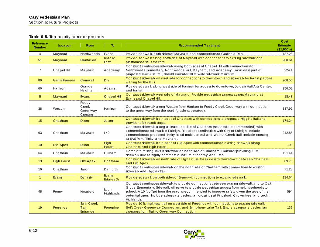
6.3. Project Recommendations The following are proposed top priority projects that the Town should focus efforts on in order to improve pedestrian safety, connectivity, and accessibility in the Town. These projects were selected from a list of projects that were generated based on public input through surveys, focus groups, and stakeholder comments. A complete discussion of the project identification and development process is addressed more thoroughly in Appendix 3, and the results of the study corridor analysis are included in Appendix 4. Appendix 5 contains a complete list of all of the projects which were considered during the planning process. The complete list of projects was prioritized using the Town’s existing sidewalk request program prioritization methodology. This methodology is discussed on the Town’s website at: www.townofcary.org/depts/tcdept/policies/135.htm. Using this methodology, top priority is given to projects within close proximity to schools, parks, shopping, greenways, and transit facilities. Priority is also given to those projects which serve as connections to existing sidewalk. Table 6-5 and accompanying Figure 6-3 shows the top prioritized corridor projects in order from highest to lowest ranking and their source in the public input process. Table 6-6 and Figure 6-4 shows the top intersection projects in order from highest to lowest ranking. These intersections were identified based on their ability to improve pedestrian safety and connectivity within the Town. It is recommended that the Town address these corridors and intersections first. Once these are completed, the remaining projects contained in Appendix 5 should be reprioritized and a new set of top priorities should be selected. The Plan’s public involvement also generated some requests for changes to the transit system and transit facilities which will improve pedestrian conditions and safety. These include: ♦ Relocate the stop at Crossroads 20 out of the middle of the parking lot and near to a
location with sidewalk ♦ Place Maynard Loop 2 stop closer to Maynard Loop 1 stop at Reedy Creek and
Maynard. ♦ In general, provide more bus stop amenities such as benches, shelters, and sidewalk
access.
Cary Pedestrian Plan Section 6: Future Projects
6-12
Table 6-5. Top priority corridor projects.
Reference Number Location From To Recommended Treatment
Cost Estimate ($1,000’s)
4 Maynard Northwoods Evans Provide sidewalk, both sides of Maynard and connections to Godbold Park. 137.28
51 Maynard Plantation Kildaire Farm
Provide sidewalk along north side of Maynard with connections to existing sidewalk and platforms for bus shelters. 200.64
7 Chapel Hill Maynard Academy Construct continuous sidewalk along both sides of Chapel Hill with connections to Northwoods Elementary, Northwoods Trail, Maynard, and Academy. Location is part of proposed multi-use trail, should consider 10 ft. wide sidewalk minimum.
224.4
89 Griffis/Harrison Cornwall Dry Construct sidewalk on west side for connections to downtown and sidewalk for transit patrons waiting for the bus. 208.56
66 Harrison Grande Heights Adams Provide sidewalk along west side of Harrison for access to downtown, Jordan Hall Arts Center,
and transit. 256.08
5 Maynard Evans Chapel Hill Construct sidewalk west side of Maynard. Provide pedestrian access across Maynard at Evans and Chapel Hill. 18.48
38 Weston
Reedy Creek Greenway Crossing
Harrison Construct sidewalk along Weston from Harrison to Reedy Creek Greenway with connection to the greenway from the road (grade-seperated). 337.92
15 Chatham Dixon Jason Construct sidewalk both sides of Chatham with connections to proposed Higgins Trail and provisions for transit stops. 174.24
63 Chatham Maynard I-40
Construct sidewalk along at least one side of Chatham (south side recommended) with connections to sidewalk in Raleigh. Requires coordination with City of Raleigh. Include connections to proposed Trinity Road multi-use trail and Walnut Creek Trail. Include crossing at SAS Park, Trinity, and Maynard.
242.88
10 Old Apex Dixon High House
Construct sidewalk both sides of Old Apex with connections to existing sidewalk along Chatham and High House. 198
64 Chatham Maynard Durham Complete missing links in sidewalk on north side of Chatham. Consider providing 10 ft. sidewalk due to highly commercial nature of nearby land uses. 121.44
13 High House Old Apex Chatham Construct sidewalk on north side of High House for access to downtown between Chatham and Old Apex. 89.76
16 Chatham Jason Danforth Construct continuous sidewalk on the north side of Chatham with connections to existing sidewalk and Higgins Trail. 71.28
1 Evans Dynasty Evans Estates Dr Provide sidewalk on both sides of Evans with connections to existing sidewalk. 134.64
48 Penny Kingsford Loch Highlands
Construct continuous sidewalk to provide connections between existing sidewalk and to Oak Grove Elementary. Sidewalk will serve to provide pedestrian access from neighborhoods to school. A 10 ft offset from the road is recommended to improve safety given the age of the potential users. Include adequate pedestrian crossings at Kingsford, Crickentree, and Loch Highlands.
594
19 Regency Swift Creek Trail Entrance
Peregrine Provide 10 ft. multi-use trail on west side of Regency with connections to existing sidewalk, Swift Creek Greenway Connection, and Symphony Lake Trail. Ensure adequate pedestrian crossings from Trail to Greenway Connection.
132
Cary Pedestrian Plan Section 6: Future Projects
6-13
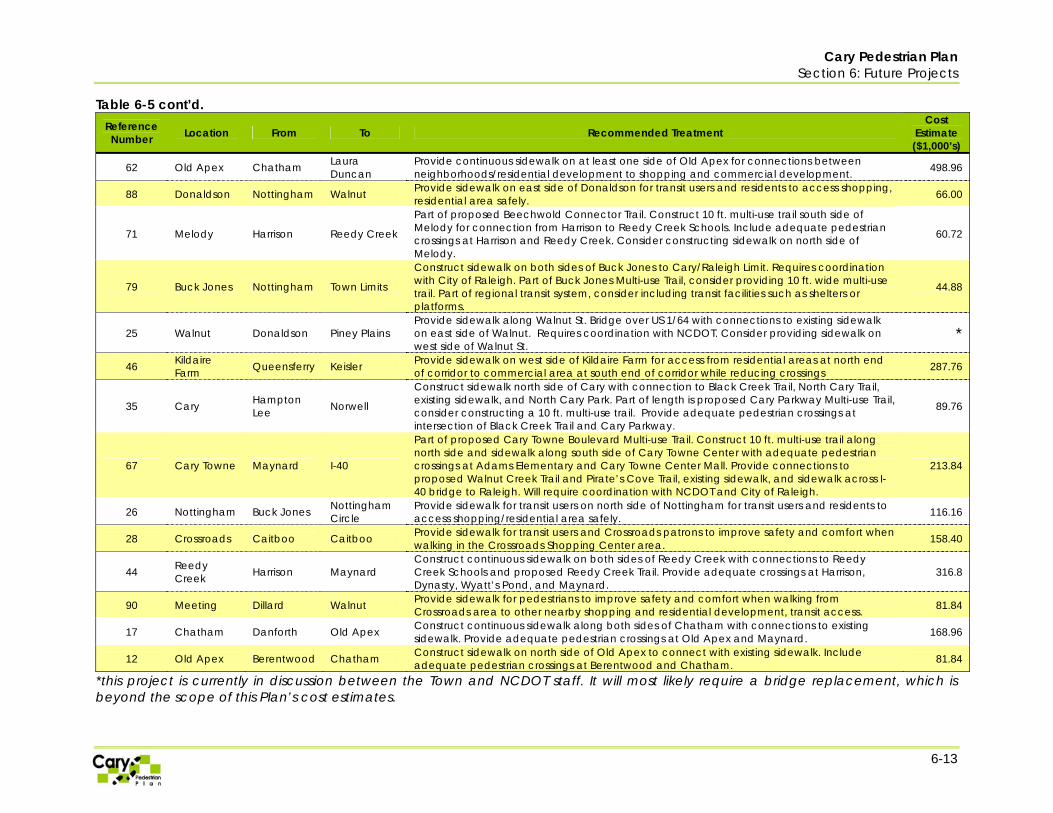
Table 6-5 cont’d. Reference Number Location From To Recommended Treatment
Cost Estimate ($1,000’s)
62 Old Apex Chatham Laura Duncan
Provide continuous sidewalk on at least one side of Old Apex for connections between neighborhoods/residential development to shopping and commercial development. 498.96
88 Donaldson Nottingham Walnut Provide sidewalk on east side of Donaldson for transit users and residents to access shopping, residential area safely. 66.00
71 Melody Harrison Reedy Creek
Part of proposed Beechwold Connector Trail. Construct 10 ft. multi-use trail south side of Melody for connection from Harrison to Reedy Creek Schools. Include adequate pedestrian crossings at Harrison and Reedy Creek. Consider constructing sidewalk on north side of Melody.
60.72
79 Buck Jones Nottingham Town Limits
Construct sidewalk on both sides of Buck Jones to Cary/Raleigh Limit. Requires coordination with City of Raleigh. Part of Buck Jones Multi-use Trail, consider providing 10 ft. wide multi-use trail. Part of regional transit system, consider including transit facilities such as shelters or platforms.
44.88
25 Walnut Donaldson Piney Plains Provide sidewalk along Walnut St. Bridge over US 1/64 with connections to existing sidewalk on east side of Walnut. Requires coordination with NCDOT. Consider providing sidewalk on west side of Walnut St.
*
46 Kildaire Farm Queensferry Keisler Provide sidewalk on west side of Kildaire Farm for access from residential areas at north end
of corridor to commercial area at south end of corridor while reducing crossings 287.76
35 Cary Hampton Lee Norwell
Construct sidewalk north side of Cary with connection to Black Creek Trail, North Cary Trail, existing sidewalk, and North Cary Park. Part of length is proposed Cary Parkway Multi-use Trail, consider constructing a 10 ft. multi-use trail. Provide adequate pedestrian crossings at intersection of Black Creek Trail and Cary Parkway.
89.76
67 Cary Towne Maynard I-40
Part of proposed Cary Towne Boulevard Multi-use Trail. Construct 10 ft. multi-use trail along north side and sidewalk along south side of Cary Towne Center with adequate pedestrian crossings at Adams Elementary and Cary Towne Center Mall. Provide connections to proposed Walnut Creek Trail and Pirate’s Cove Trail, existing sidewalk, and sidewalk across I-40 bridge to Raleigh. Will require coordination with NCDOT and City of Raleigh.
213.84
26 Nottingham Buck Jones Nottingham Circle
Provide sidewalk for transit users on north side of Nottingham for transit users and residents to access shopping/residential area safely. 116.16
28 Crossroads Caitboo Caitboo Provide sidewalk for transit users and Crossroads patrons to improve safety and comfort when walking in the Crossroads Shopping Center area. 158.40
44 Reedy Creek Harrison Maynard
Construct continuous sidewalk on both sides of Reedy Creek with connections to Reedy Creek Schools and proposed Reedy Creek Trail. Provide adequate crossings at Harrison, Dynasty, Wyatt’s Pond, and Maynard.
316.8
90 Meeting Dillard Walnut Provide sidewalk for pedestrians to improve safety and comfort when walking from Crossroads area to other nearby shopping and residential development, transit access. 81.84
17 Chatham Danforth Old Apex Construct continuous sidewalk along both sides of Chatham with connections to existing sidewalk. Provide adequate pedestrian crossings at Old Apex and Maynard. 168.96
12 Old Apex Berentwood Chatham Construct sidewalk on north side of Old Apex to connect with existing sidewalk. Include adequate pedestrian crossings at Berentwood and Chatham. 81.84
*this project is currently in discussion between the Town and NCDOT staff. It will most likely require a bridge replacement, which is beyond the scope of this Plan’s cost estimates.

Cary Pedestrian Plan Section 6: Future Projects
6-14
Reference Number Location From To Recommended Treatment
Cost Estimate ($1,000’s)
65 Ralph Walnut Maynard Construct sidewalk on at least one side of Ralph with connection to existing sidewalk at Maynard and Walnut. Include adequate pedestrian crossings at Cornwall, Maynard, and Walnut.
232.32
29 Caitboo Crossroads Crossroads Provide sidewalk for transit users and Crossroads patrons to improve safety and comfort when walking in the Crossroads Shopping Center area.
61 Cary Tryon Lochmere Construct sidewalk at least one side of Cary with connections to existing sidewalk at Lochmere and Tryon. 129.36
47 Penny Killingsworth Kingsford Provide missing sidewalk link along northwest segment of Penny. 52.8

Cary Pedestrian Plan Section 6: Future Projects
6-15
Figure 6-3. Map of the locations of the top priority corridor projects in reference to on-going and planned projects in the Town. The numbers associated with each project correspond with the reference numbers in Table 6-5.

Cary Pedestrian Plan Section 6: Future Projects
6-16
Table 6-6. Top priority crossings improvement projects.
Reference Number Location Recommended Treatment
96 Evans and Lake Provide signal with pedestrian heads or pedestrian-activated signal for safer access from residential development to school and nearby commercial development.
98 Tate/Maple and Maynard Provide crossing for access to shopping center from residential area 4 Maynard and Black Creek Trail Greenway/pedestrian crossing to Godbold Park
36, 37, 38 Crossing of Maynard at Wicklow, Pond, and Kilmayne
Provide signalized pedestrian-activated crossing at one or more of these locations to improve connectivity and provide a safer passage between neighborhoods, commercial development along Kildaire Farm, and Briarcliff Elementary School. There is already a signal for motorists at the intersection of Pond and Maynard – the Town should consider providing pedestrian heads at this location at the minimum.
52, 53, 54 Green Hope Schools Entrances and Hwy 55/Carpenter Upchurch Rd.
Consider pedestrian improvements such as pedestrian-activated signals at one or more of these crossings to create safer access to schools. Improvements could also include re-evaluating school drop-off and pick-up procedures to limit student/vehicle interaction.
94 Reedy Creek and Wyatt’s Pond Greenway/pedestrian crossing to Reedy Creek schools for nearby neighborhoods and greenway
89 Penny and Ederlee Greenway/pedestrian crossing to Penny Elementary School from nearby neighborhoods and proposed Dutchman's Branch Trail greenway
73 Maynard and Hampton Valley Provide signal with pedestrian heads or pedestrian-activated signal for safer crossing of Maynard from neighborhood to neighborhood and also from neighborhood to commercial development.
64 Cary Parkway and White Oak Creek Trail Greenway/pedestrian crossing for White Oak Creek Trail over Cary Parkway to proposed trail
34 Maynard and High House Provide pedestrian heads at all four legs of intersection for safer crossings, as requested by Seniors Focus Group.
32 Penny and Crickentree Install pedestrian crossing to Oak Grove Elementary School from nearby neighborhood for safer access.
51 Louis Stephens and Upchurch Meadow Consider signal with pedestrian heads or pedestrian-activated signal to improve access within residential development and to nearby schools.
22 Maynard and Reedy Creek Provide pedestrian heads and crosswalks at all four legs of this signalized intersection.
24, 84 Kildaire Farm Rd. and Tryon Rd. and other nearby intersections
Pedestrian crossing accommodations for access from Wake Med Hospital to Waverly Place shopping dining establishments
81 Chatham and S. Reedy Creek Consider providing signal with pedestrian heads or pedestrian-activated signal for better connectivity and easier access across Chatham for pedestrians from commercial and office development.
21 Dynasty and Reedy Creek Provide pedestrian-activated signal or standard signal with pedestrian heads for safe crossing of Reedy Creek from neighborhood to neighborhood and to access Reedy Creek Schools area.
80, 82 Chatham and SAS Soccer Park Entrance Provide safer pedestrian crossing over Chatham from SAS Soccer Park to Trinity and nearby development. Consider signals and pedestrian heads or pedestrian-activated signal.
56 Cary Parkway and Chatham Greenway/pedestrian crossing over Cary Parkway for connection between Swift Creek Trail and Bishop's Gate Trail
42, 43, 44, 45
Intersections of Kildaire Farm and Wren, Commonwealth, Kilmayne, and High Meadow
Consider installing pedestrian-activated signal at one or more of these locations or at a mid-block location to provide quicker, safer pedestrian crossing from residential areas on one side of Kildaire Farm to shopping areas on other side.