broken hill development control plan 2016 · broken hill development control plan 2016 page 5 of 70...
TRANSCRIPT

BROKEN HILL
DEVELOPMENT
CONTROL PLAN
2016

Broken Hill Development Control Plan 2016 Page 2 of 70
QUALITY CONTROL
KEY DIRECTION Our Community
OBJECTIVE 1.4 Our built environment supports our quality of life
FUNCTION Built Environment
STRATEGY 1.4.1 Maintain the character of our historic City through good
design
FILE REFERENCE No 11/126 TRIM No D16/42827
RESPONSIBLE OFFICER Manager Planning, Development and Compliance
REVIEW DATE July 2021
DOUMENT HISTORY ACTION DATE
Council resolved to
prepare draft DCP Resolution 26 August 2015
Notice of intent to exhibit
issued Notice issued 29 June 2016
Draft DCP exhibited Exhibited 6 July 2016 – 2 August 2016
DATE ACTION MINUTE No
2016 Public Exhibition
26 October 2016 Adopted by Council 45292
12 November 2016 Advertised in the Barrier
Daily Truth
This Plan was compiled by Broken Hill City Council and Zenith Town Planning Consultants.
Images were sourced from Council’s image library.
Copies of this plan/document can be viewed on-line at www.brokenhill.nsw.gov.au
© Copyright Broken Hill City Council 2016

Broken Hill Development Control Plan 2016 Page 3 of 70
TABLE OF CONTENTS
1. INTRODUCTION ........................................................................................................................................................................................ 5
1.1 Preface ....................................................................................................................................................................................................... 5
1.1.1 Application ....................................................................................................................................................................................... 5
1.1.2 Purpose ................................................................................................................................................................................................ 5
1.1.3 Savings provisions ......................................................................................................................................................................... 6
1.1.4 How to use this Plan .................................................................................................................................................................... 6
1.1.5 Format .................................................................................................................................................................................................. 6
1.1.6 Definitions ......................................................................................................................................................................................... 7
1.2 The Planning Context ......................................................................................................................................................................... 7
1.2.1 The hierarchy of plans and policies................................................................................................................................. 7
1.2.2 The assessment process ........................................................................................................................................................... 7
1.2.3 Ecologically sustainable development ........................................................................................................................ 8
1.3 Making A Development Application ...................................................................................................................................... 8
1.3.1 Documentation ............................................................................................................................................................................. 9
1.3.2 BASIX ................................................................................................................................................................................................... 10
1.3.3 Requests to vary acceptable solutions ..................................................................................................................... 10
1.4 Advertising And Notification ....................................................................................................................................................... 11
1.4.1 Notification policy..................................................................................................................................................................... 11
1.4.2 Notification procedures ........................................................................................................................................................ 11
1.4.3 Making a submission ............................................................................................................................................................... 12
2. SUBDIVISION ............................................................................................................................................................................................ 13
2.1 Subdivision For Rural Living ........................................................................................................................................................... 13
3. BUILDING ................................................................................................................................................................................................... 15
3.1 General Provisions – All Zones .................................................................................................................................................... 15
3.2 Development In Residential Zones ......................................................................................................................................... 15
3.2.1 All dwellings ................................................................................................................................................................................... 15
3.2.2 Single detached dwellings ................................................................................................................................................. 16
3.2.3 Dual Occupancy ...................................................................................................................................................................... 17
3.2.4 Multi dwelling housing and residential flat buildings ........................................................................................ 18
3.2.5 Non-residential development .......................................................................................................................................... 19
3.3 Development in business zones................................................................................................................................................ 20
3.4 Development in industrial zones .............................................................................................................................................. 20
Broken Hill Development Control Plan 2016 Page 4 of 70
3.5 Rural development ........................................................................................................................................................................... 22
3.5.1 Dwellings.......................................................................................................................................................................................... 22
3.5.2 Keeping of horses ...................................................................................................................................................................... 23
4. CAR PARKING ....................................................................................................................................................................................... 27
4.1 Car parking requirements ................................................................................................................................................... 27
4.2 Industrial Development .................................................................................................................................................................. 32
4.3 Commercial Development ......................................................................................................................................................... 33
5. OUTDOOR ADVERTISING ................................................................................................................................................................ 33
5.1 General provisions – all zones .................................................................................................................................................... 33
5.2 Directional signage in rural zones ........................................................................................................................................... 36
5.3 Signage in industrial zones ........................................................................................................................................................... 36
5.4 Signage in heritage conservation areas and on heritage buildings ............................................................. 37
6. LAND CONTAMINATION ................................................................................................................................................................. 39
6.1 Contamination other than lead .............................................................................................................................................. 39
6.2 Lead contamination ........................................................................................................................................................................ 42
7. TREE PRESERVATION .......................................................................................................................................................................... 46
7.1 Trees on public land ......................................................................................................................................................................... 46
7.2 Trees on private land ....................................................................................................................................................................... 48
8. HERITAGE CONSERVATION ........................................................................................................................................................... 49
8.1 All development ................................................................................................................................................................................. 50
8.1.1 Alterations and Additions .................................................................................................................................................... 51
8.1.2 Archaeological Sites ............................................................................................................................................................... 52
8.1.3 Places of Aboriginal Heritage Significance ............................................................................................................ 52
8.1.4 Fencing ............................................................................................................................................................................................. 52
8.2 Residential development ............................................................................................................................................................. 53
8.3 Commercial development.......................................................................................................................................................... 61
8.3.1 New Development in the Central Business District ............................................................................................ 66
8.4 Development in the Mining Zone ........................................................................................................................................... 67
Broken Hill Development Control Plan 2016 Page 5 of 70
1. INTRODUCTION
1.1 Preface
This plan is called the Broken Hill Development Control Plan (DCP) 2016 and is referred to as the
Plan in this document.
1.1.1 Application
This plan applies to all land subject to Broken Hill Local Environmental Plan (LEP) 2013 and zoned:
• RU2 Rural Landscape
• R1 General Residential
• B1 Neighbourhood Centre
• B2 Local Centre
• B4 Mixed Use
• IN1 General Industrial
• IN2 Light Industrial
• SP1 Special Activities
• SP2 Infrastructure
• SP3 Tourist
• RE1 Public Recreation
• RE2 Private Recreation
• E2 Environmental Conservation
• E4 Environmental Living
1.1.2 Purpose
The purpose of this plan is to guide development within Broken Hill local government area (LGA)
consistent with the aims and objectives of Broken Hill LEP 2013. It contains objectives and
development controls that expand upon the requirements of Broken Hill LEP 2013 and that are to
be considered in addition to the LEP when preparing a proposal to develop land in Broken Hill
LGA.
Broken Hill DCP 2016 has been prepared by Broken Hill City Council in accordance with the
Environmental Planning and Assessment Act 1979 and was adopted by Council on Wednesday
26 October 2016.
Upon taking effect this plan repeals the following DCPs:
• DCP No. 1 Residential Development
• DCP No.2 Commercial Development
• DCP No. 3 Heritage Development
• DCP No. 4 Industrial Development
• DCP No. 5 Notification
• DCP No. 6 Outdoor Advertising
• DCP No. 7 Keeping of Horses
• DCP No. 8 Rural Small Holdings
• DCP No. 10 Contaminated Lands (other than lead contamination)
• DCP No. 11 Management of Lead Contamination
• DCP No 12 Stormwater Collection, Usage and Disposal
Broken Hill Development Control Plan 2016 Page 6 of 70
1.1.3 Savings provisions
This Plan does not apply to any development application or application for a modification to a
development application submitted under section 96 of the Environmental Planning and
Assessment Act (EP&A Act) 1979 that was lodged prior to the date of commencement of this
Plan. Any application lodged before the commencement of this plan will be assessed in
accordance with the development control plan(s) or policy(s) which applied to the site at the
time the application was lodged.
1.1.4 How to use this Plan
The Plan consists of this written document and includes all sketches, diagrams, illustrations and
maps. It comprises an introduction with separate chapters covering subdivision, building, car
parking and access, and outdoor advertising. The code is structured so that each design
consideration is addressed by objectives and controls.
The objectives are goals for what should eventuate on the ground as the final product of the
land development process. It is an essential consideration when designing a subdivision or
building to ensure that new development is appropriate to a site and neighbourhood.
Design guidance is given for some types of development. This is intended to assist site planning,
building design and other considerations when planning new development.
Controls are the specific requirements of Council that are to be fulfilled in development plans.
They may be varied on merit where it can be clearly demonstrated that the statement of intent
for the design element is still being achieved, where site constraints are such that compliance
with controls is not possible or where extenuating circumstances exist. See 1.3.3 Requests to vary
acceptable solutions for procedures to follow when seeking to vary the controls of this Plan.
Council may accept other solutions where the objectives are satisfied.
1.1.5 Format
The plan comprises the following chapters:
Chapter 1 – Introduction. This chapter provides information about the application of the Plan,
how to use the plan, and matters of governance relating to assessment procedures and the
notification of development applications.
Chapter 2 – Subdivision. This chapter contains guidance for the subdivision of land for rural
living.
Chapter 3 – Building. This chapter contains zone-based guidance for new buildings in rural,
residential, business and industrial areas, and alterations and additions to existing buildings.
Chapter 4 – Parking and access. This chapter contains guidance for access arrangements and
the provision of car parking. This chapter applies to all development in Broken Hill LGA.
Chapter 5 – Outdoor advertising. This chapter contains guidance for the design and placement
of signage.
Chapter 6 – Land contamination.
Chapter 7 – Tree preservation.
Chapter 8 – Heritage conservation.
Broken Hill Development Control Plan 2016 Page 7 of 70
1.1.6 Definitions
This plan adopts all definitions contained in the Dictionary to Broken Hill LEP 2013. In addition,
definitions relating to specific aspects of development are included where necessary
throughout this plan.
1.2 The Planning Context
1.2.1 The hierarchy of plans and policies
Planning in NSW is governed by the Environmental Planning and Assessment Act 1979. Provisions
of the Act establish a hierarchy of environmental planning instruments and policies. These are
State Environmental Planning Policies (SEPP), Local Environmental Plans (LEP) and Development
Control Plans (DCP). SEPPs and LEPs are known as environmental planning instruments.
A SEPP is a legal document that generally deals with a specific type of development, such as
infrastructure, or exempt and complying development, or applies to a specified area of land,
such as the coastal zone.
An LEP is a legal document that sets the planning framework at a local level by specifying land
use zones, the uses that are permitted or prohibited in those zones, certain development
standards and provisions relating to heritage conservation, environmental protection and the
like. Broken Hill LEP 2013 is the plan that is in force in Broken Hill LGA.
A DCP is Council policy that provides further guidance to the provisions of the LEP. It contains
objectives and controls for subdivision, building design, engineering matters and the like. It is not
a statutory plan but is a legal consideration in the assessment of a development application.
The Department of Planning & Environment has also issued regional strategies for some areas of
NSW to give high level guidance to planning and development. At the time of adoption of the
Plan a regional strategy had not been prepared for Broken Hill LGA.
1.2.2 The assessment process
A development application is required to be lodged for development that is permitted with
consent under Broken Hill LEP 2013. This is known as local development. Other types of
development are exempt (where an approval is not required), complying (where the proposal
complies with set standards and approval by Council or a private certifier is provided within 10
days), designated development (which must be accompanied by an environmental impact
statement) and integrated development (where the approval of another statutory authority is
required in addition to approval by Council or a Joint Regional Planning Panel). Any consent
issued under integrated development also includes the general terms of approval from those
other agencies.
Council is required to assess a development application in accordance with Part 4 of the
Environmental Planning and Assessment Act 1979. Section 79C of the Act requires Council to
consider the provisions of any environmental planning instruments that apply to the land,
including State Environmental Planning Policies (SEPP) and the Broken Hill LEP 2013, as well as any
potential economic, social and ecological impacts, the suitability of the site for the proposed
development, submissions made by interested persons and the public interest.
The provisions of all SEPPs and Broken Hill LEP 2013 prevail over this plan. In the event that a SEPP
(e.g. SEPP (Infrastructure) 2008 or SEPP (Exempt and Complying Development Codes) 2008) or
the LEP applies to a certain land use and enables that use as either exempt or complying
development subject to specified development standards, then that environmental planning
instrument enables that land use to proceed without the need for the consent of Council.
Broken Hill Development Control Plan 2016 Page 8 of 70
The controls contained in this Plan only apply where a development application is lodged with
Broken Hill City Council for a particular land use and where those controls do not conflict with
the provisions of an environmental planning instrument. Council reserves the right to refuse a
development application or to require modification of the development being proposed, even
where it complies with acceptable solutions, if Council considers that the proposed
development will conflict with or lead to an inconsistency with the desired outcomes as
expressed in the relevant statement of intent.
Broken Hill City Council encourages a flexible approach to land development so that new
development is innovative and adaptive without causing any adverse effect on the amenity of
residents or the local environment.
Council recommends that independent legal or town planning advice should always be sought
prior to making a property purchase or an investment decision. The information in this plan
should not be solely relied upon in reaching a decision to purchase a property or to embark on
a development project.
1.2.3 Ecologically sustainable development
Ecologically Sustainable Development is defined as:-
“using, conserving and enhancing the community’s resources so that ecological processes, on
which life depends, are maintained, and the total quality of life, now and in the future, can be
increased.”
Broken Hill City Council, as part of its charter, has responsibilities to ensure that all of its functions
and decision-making processes take account of the principles of ESD. This means that Council
must consider the following principles prior to carrying out any of the functions for which it has
responsibility:
• Precautionary Principle - “This principle requires that lack of scientific certainty is not used
as a reason for postponing measures to prevent environmental degradation.”
• Inter-generational Equity - “Requires that the present generation should ensure that the
health, diversity and productivity of the environment is maintained or enhanced for the
benefit of future generations.”
• Conservation of Biological Diversity and Ecological Integrity - “is the fundamental
consideration of ESD to promote human well-being through the maintenance of
ecological services and the protection of intrinsic environmental values.”
• Improved Valuation, Pricing and Incentive Mechanisms - “Requires that environmental
factors be included in the valuation of assets and services such that the principles of - user
pays, payment for full lifecycle of goods – including disposal of wastes, and the cost
effective achievement of environmental goals.”
1.3 Making A Development Application
It is important that a meeting be held with Council staff in the first instance and before preparing
development plans to identify the level of information that is to be submitted with a
development application. Missing or incomplete documentation may cause delays in the
assessment of a development application.

Broken Hill Development Control Plan 2016 Page 9 of 70
Depending on the type and scale of the development being proposed and the nature of the
property, specific assessments may be required to be submitted with the development
application that address potential impacts of the proposed development. These may be
required to address:
• Traffic management and car parking,
• Noise and other emissions,
• Flora and fauna,
• Bushfire protection,
• Indigenous or non-indigenous heritage,
• Geotechnical features,
• Overshadowing,
• Visual and scenic values,
• Soil Contamination, and
• Waste Management.
1.3.1 Documentation
Information to be submitted with a development application is specified in Schedule 1 of the
Environmental Planning and Assessment Regulation 2000. As a minimum a development
application is to be accompanied by a site plan and building plans drawn to a scale of 1:100 or
1:200, and a statement of environmental effects.
The site plan is to show:
(a) the location, boundary dimensions, site area and north point of the land,
(b) existing vegetation and trees on the land,
(c) the location and uses of existing buildings on the land,
(d) existing levels of the land in relation to buildings and roads, and
(e) the location and uses of buildings on sites adjoining the land.
Building plans are to show:
(a) the location of any proposed buildings or works (including extensions or additions to
existing buildings or works) in relation to the land’s boundaries and adjoining
development,
(b) floor plans of any proposed buildings showing layout, partitioning, room sizes and
intended uses of each part of the building,
(c) elevations and sections showing proposed external finishes and heights of any
proposed buildings. For temporary structures elevations and sections showing
heights and building materials,
(d) proposed finished levels of the land in relation to existing and proposed buildings
and roads,
Broken Hill Development Control Plan 2016 Page 10 of 70
(e) proposed parking arrangements, entry and exit points for vehicles, and provision for
movement of vehicles within the site (including dimensions where appropriate),
(f) proposed landscaping and treatment of the land (indicating plant types and their
height and maturity),
(g) the proposed location, dimensions and contents of advertising and signage,
(h) proposed methods of draining the land, and
(i) a BASIX certificate if required (see 1.3.2 BASIX).
The statement of environmental effects is to address:
(a) the environmental impacts of the development,
(b) how the environmental impacts of the development have been identified,
(c) the steps to be taken to protect the environment or to lessen the expected harm to
the environment,
(d) any matters required to be indicated by any guidelines issued by the Director-
General of the Department of Planning and Infrastructure.
In the case of subdivision, a proposed plan of subdivision and preliminary engineering drawings
of the work to be carried out are to be submitted with the development application.
If an application for a construction certificate is made at the same time as a development
application then detailed construction plans and building specifications are also required to be
submitted with a report indicating compliance with the Building Code of Australia and relevant
Australian Standards. Alternatively, compliance may be shown on plans and specifications.
1.3.2 BASIX
BASIX is an on-line program that assesses dwelling design against energy and water reduction
targets. If these targets are satisfied a BASIX Certificate is issued. The BASIX Certificate is required
to be submitted with a development application for all developments which contain new
residential dwellings or alterations and additions to a dwelling.
BASIX uses information such as site location, house size, type of building materials and fittings for
hot water, cooling and heating. ‘Commitments’ that are made to achieving energy and water
reduction targets are shown on the BASIX certificate and must be marked on building plans that
accompany the DA. These commitments are to be adhered to during the building process. Any
changes made to the dwelling design means another BASIX assessment must be completed
and a new BASIX Certificate submitted to Council.
The BASIX Certificate should also be attached to an application for a construction certificate
and ensure all BASIX commitments are shown on the plans. It should also be attached to an
application for an occupation certificate. Council will only issue an occupation certificate
when satisfied that the project has been built as described on the BASIX Certificate.
To obtain a BASIX assessment go to www.basix.nsw.gov.au and enter details of your building
plans.
1.3.3 Requests to vary acceptable solutions
Development proposals that comply with controls are generally processed without delay,
minimising costs to the applicant. However, Council may consider varying acceptable solutions
where the proposed development still satisfies the relevant statement of intent and
performance criteria, or site conditions make compliance difficult.
Broken Hill Development Control Plan 2016 Page 11 of 70
A request to vary an acceptable solution must be in writing and specify the control to be varied
and details in support of the variation that demonstrate how the relevant statement of intent
and performance criteria will still be achieved.
In some circumstances, such as where the acceptable solution makes reference to a
requirement of legislation, State policy or an environmental planning instrument (SEPP or LEP), it is
not possible for Council to vary the acceptable solution.
1.4 Advertising And Notification
1.4.1 Notification policy
For certain development proposals Broken Hill City Council notifies the owners of land that is
adjoining and adjacent to the site where an application for development has been received.
Council gives notice of development applications where the proposed development has the
potential to adversely affect surrounding properties, the amenity of the neighbourhood, or the
natural environment. Council determines the circumstances where notification takes place
having regard to the relevant land use zone, the proposed development and consistency with
the zone objectives. Examples of such development are:
• keeping of animals other than companion animals,
• professional consulting rooms in a residential area,
• development of an industrial or commercial nature within an area which, in the opinion
of Council, has the potential for detrimental impacts upon the surrounding
neighbourhood,
• a building that is two or more storeys in height above natural ground level in a
residential zone,
• non-residential use within a residential zone that is likely to interfere with the amenity
of the neighbourhood,
• residential dwellings and class 10 structures within 500 mm of a side or rear boundary,
• integrated development that requires the approval and/or licencing from other
agencies, and
• a public monument or memorial located in a public space.
1.4.2 Notification procedures
Certain development types are classified as ‘advertised development’ or ‘designated
development’ in the Environmental Planning and Assessment Regulation 2000. The procedures
for the notification of a development application for these types of development are specified
in the Regulation.
Applications for all other types of developments will be available for viewing at Council’s offices
for a minimum period of between 14 and 28 days as advised by letter or notice published in
newspaper or a notice placed on-site (depending on the relevant form of notification
undertaken by Council).
Submissions will be received during the exhibition period, and up until the submission closing date
as advised by letter or notice published in newspaper or a notice placed on-site (depending on
the relevant form of notification undertaken by Council). Council maintains discretion to extend
the notification period if considered necessary. Council will also place an advertisement in local
newspapers if the development is of a scale that may warrant broader community input due to
the potential effects of that development.
The extent and form of notification is carried out in accordance with the table below.
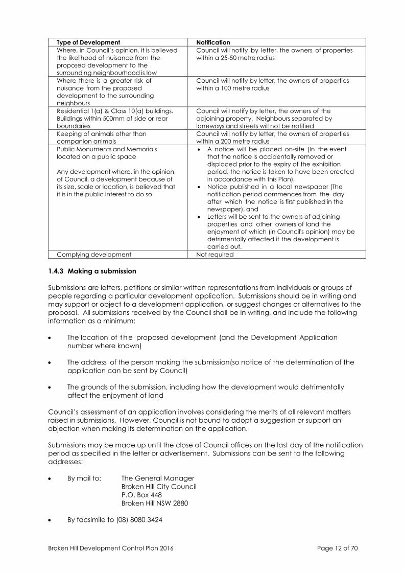
Broken Hill Development Control Plan 2016 Page 12 of 70
Type of Development Notification
Where, in Council’s opinion, it is believed
the likelihood of nuisance from the
proposed development to the
surrounding neighbourhood is low
Council will notify by letter, the owners of properties
within a 25-50 metre radius
Where there is a greater risk of
nuisance from the proposed
development to the surrounding
neighbours
Council will notify by letter, the owners of properties
within a 100 metre radius
Residential 1(a) & Class 10(a) buildings.
Buildings within 500mm of side or rear
boundaries
Council will notify by letter, the owners of the
adjoining property. Neighbours separated by
laneways and streets will not be notified
Keeping of animals other than
companion animals
Council will notify by letter, the owners of properties
within a 200 metre radius
Public Monuments and Memorials
located on a public space
Any development where, in the opinion
of Council, a development because of
its size, scale or location, is believed that
it is in the public interest to do so
• A notice will be placed on-site (In the event
that the notice is accidentally removed or
displaced prior to the expiry of the exhibition
period, the notice is taken to have been erected
in accordance with this Plan),
• Notice published in a local newspaper (The
notification period commences from the day
after which the notice is first published in the
newspaper), and
• Letters will be sent to the owners of adjoining
properties and other owners of land the
enjoyment of which (in Council's opinion) may be
detrimentally affected if the development is
carried out.
Complying development Not required
1.4.3 Making a submission
Submissions are letters, petitions or similar written representations from individuals or groups of
people regarding a particular development application. Submissions should be in writing and
may support or object to a development application, or suggest changes or alternatives to the
proposal. All submissions received by the Council shall be in writing, and include the following
information as a minimum:
• The location of t he proposed development (and the Development Application
number where known)
• The address of the person making the submission(so notice of the determination of the
application can be sent by Council)
• The grounds of the submission, including how the development would detrimentally
affect the enjoyment of land
Council’s assessment of an application involves considering the merits of all relevant matters
raised in submissions. However, Council is not bound to adopt a suggestion or support an
objection when making its determination on the application.
Submissions may be made up until the close of Council offices on the last day of the notification
period as specified in the letter or advertisement. Submissions can be sent to the following
addresses:
• By mail to: The General Manager
Broken Hill City Council
P.O. Box 448
Broken Hill NSW 2880
• By facsimile to (08) 8080 3424

Broken Hill Development Control Plan 2016 Page 13 of 70
• By email to [email protected]
2. SUBDIVISION
2.1 Subdivision For Rural Living
Objectives
• to enable development for the purposes of rural living to be carried out on the land,
• to maintain a high degree of environmental quality and minimum conflict between rural
living land use and the rural activities and amenity within the area,
• to prevent land degradation and ensure that development is carried out in a manner
which protects, enhances and does not adversely affect the environmental qualities of the
land or adjoining land,
• to ensure that rural living development is well designed and located,
• to ensure that development is adequately serviced and not placing a strain on public
services or those of other service providers,
• to ensure rural living development meets the relevant objectives of Broken Hill LEP 2013,
• to provide land suitable for the cohabitation of rural living land use with the use of land for
stables and the keeping of horses generally,
• to provide a wide range of rural living choices,
• to ensure that allotments created in a rural living subdivision provide potential building sites
with minimal risk of damage by bush fires or flooding, and
• to ensure that developments comply with the provisions of the Threatened Species
Conservation Act, 1995.
Controls
• An application for rural living subdivision should include a site analysis that considers:
- drainage - areas which are flat and/or low lying may sometimes have poor drainage
which, in times of high rainfall, could affect access to properties and/or onsite
disposal of sewage,
- slope - excessive slopes should be avoided as they are potentially unstable and
increase the cost of housing,
- landscape/habitat significance – rural living development should not be located in
areas of habitat or landscape significance. The applicant must take into account
the impact of the proposal and in particular the provisions of the Threatened Species
Conservation Act 1995,
- provision of services - the adequacy of existing services and the feasibility of
extending services to the proposed development if necessary, and
- compatibility with adjoining land uses - buffer zones may be required due to the
practice of spraying of agricultural chemicals as part of rural land uses.
• The subdivision layout should provide for:
Broken Hill Development Control Plan 2016 Page 14 of 70
- proper spacing of access points to an existing road to allow for appropriate visibility
setbacks. Spacing between access points would generally be in the order of 90
metres. Subdivision design should encourage joint use of access points to eliminate
an excessive number of intersections
- design geometry of access ways both vertical and horizontal alignment that will
ensure the safety of pedestrian cyclists and vehicular traffic
- the provisions of Broken Hill LEP 2013 including the minimum lot size of allotments.
• A soil assessment is to be carried out and submitted to Council that demonstrates that the
land is capable of safe on-site effluent treatment and disposal
• A landscape plan is required to be prepared and submitted to Council that shows:
- the outline of proposed buildings,
- existing trees (species, height and spread) with an indication of those trees likely to be
adversely affected by the development, and
- proposed tree planting, including buffer areas where Council considers necessary,
using quality species of mature height and spread.
When preparing the landscape plan consideration should be given to topography, the
purpose of the trees (windbreaks, shade, aesthetics, etc), the choice of an appropriate type
of tree (shade, wood type, evergreen or deciduous) and the choice of species which is
suited to the locality (having regard to soils, rainfall and the purpose of planting).
• no earth or gravel may be removed or excavated from the subject land without the
approval of Council, except where such removal and excavation is necessary for the
erection of a pre approved building structure or for the safety of the occupants or
prospective occupants of the land;
• no temporary dwelling, other than those approved pursuant to the Environmental Planning &
Assessment Act, 1979 as amended and the Building Code of Australia 1996 shall be erected
on the subject land.
Broken Hill Development Control Plan 2016 Page 15 of 70
3. BUILDING
3.1 General Provisions – All Zones
This section applies to all new development that involves building or structures, including
alterations and additions, in residential, business, industrial and rural zones in Broken Hill that are
subject to Broken Hill LEP 2013.
Controls
• A surveyors report is to be submitted with a development application for any
permanent structure that requires the consent of Council that is located within 500mm
of an adjoining property boundary (other than to a Council lane or footpath reserve), or
in any case where in the opinion of Council that the boundary of the site is uncertain.
• Stormwater management
- New development and associated works must not adversely affect the level of
floodwaters on adjoining properties.
- A building floor level must be determined for the site to minimise the risk and hazard
of inundation.
- Where the proposed development site is not located in close proximity to a major
overland flow path or creek, floor levels must be a minimum of 300mm above the
adjacent top of kerb level.
- Where the proposed development site is adjacent to a major overland flow path or
creek as defined by this report, floor levels must be a minimum of 300 mm above the
100 year ARI flood level.
- New development must include Water Sensitive Urban Design (WSUD) features
allowing for the retention and re-use of stormwater, and in particular the collection,
storage and reuse of runoff from rooves, and treatment of runoff from paved and
carpark areas using swales or other appropriate devices.
- Where new development will result in an increase in impervious site coverage, on-
site stormwater detention structures/techniques must be provided to limit the post-
development peak discharge rate of stormwater from the site (including roof and
ground surface runoff) to the predevelopment peak flow rate during both the 5 year
and 100 year ARI events.
- New development should ensure that all roof areas are directly connected to the
street water table, and where practicable should not contribute ground surface
runoff to adjoining properties.
- New development should, where possible, minimise impervious ground surfaces and
direct runoff to landscaped areas, soakage trenches, or possible aquifer recharge.
3.2 Development In Residential Zones
Application
This section applies to residential and non-residential development that is permitted with or
without consent in zone R1 General Residential.
3.2.1 All dwellings
Broken Hill Development Control Plan 2016 Page 16 of 70
Controls
• A concrete driveway is to be provided as access to all new dwellings, dual
occupancies, multi dwelling housing and residential flat buildings.
• All stormwater drainage is to be disposed of in such a manner so as not to cause
nuisance.
3.2.2 Single detached dwellings
Objectives
• To permit flexibility in the siting of buildings;
• To minimise adverse impact on adjacent and adjoining properties.
Design guidance
• Setbacks - the location of the dwelling on the allotment should include a setback
from the road reserve which considers the streetscape and adjacent structures.
• Consent is required for alterations, additions or renovations to dwelling houses listed in
Schedule 5 Environmental Heritage of Broken Hill LEP 2013. Any building work undertaken
on residential properties in Broken Hill must be carefully undertaken so that the identified
character is retained:
- Alterations and additions to existing houses should respect the character of the
building in question and not detract from the character of the residential area as
a whole.
- Any new buildings should be carefully designed to fit in with the character of the
area but not pretend to be historic buildings themselves.
Refer to Chapter 8 Heritage Conservation for design guidance and controls that apply to
heritage listed properties and land within heritage conservation areas.
• Site Drainage - the primary source of run-off in residential areas is the individual building lot
where numerous opportunities exist to ‘hold and use the rain where it falls’. Two basic ways
to limit run-off are the provision of rainwater tanks and the construction of paving to drain
to grassed areas.
• Buildings should be designed to achieve a reasonable degree of internal privacy in the
main habitable rooms.
• Materials - external materials of development should be sympathetic in colour, texture
and range to achieve a harmonious composition. The number of materials used within
a group of dwellings or an individual building should be kept to a minimum. In the
event of extending an existing building, the new materials should be selected to match
in texture and colour the materials used in the existing development.
• Windows - New buildings should be designed to accommodate windows which are in
proportion with each other and with adjacent buildings. Toilet and bathroom windows
should not be placed facing the street of the main entry to the building.
• Roof form should be sympathetic to the natural ground slope and/or to neighbouring
buildings. Individual buildings forming a group or cluster should be designed to provide
a sense of visual diversity between the individual dwelling units whilst not detracting
from the unity of the whole. These forms should be coordinated to ensure overall visual
harmony.
Broken Hill Development Control Plan 2016 Page 17 of 70
3.2.3 Dual Occupancy
Objectives
• to provide guidelines for applicants seeking approval to construct a building for use as
a dual occupancy on an allotment
• to ensure that dual occupancies are sited and constructed in such a manner that they
are compatible with surrounding development
• to ensure that dual occupancies do not adversely affect the amenity of adjacent
buildings and the general area where they are located
Design guidance
• Maintain the quality of the streetscape.
- Maintain streetscape character so that buildings visible from the street have
similarities with those that exist.
- Building setbacks from the street alignment should not vary dramatically from those
in the rest of the street.
- Preserve established trees and gardens where possible.
- Match existing roof forms and materials and keep to the scale of surrounding
buildings.
- Limit the number of garages on the street boundary, and keep driveway
crossings to a minimum.
• Maximise views, respect privacy.
- Use screens, planting and walls, to maintain visual privacy of dwellings and
neighbours and to reduce noise.
- To maintain privacy avoid placing new windows opposite the windows of existing
buildings. The effective location of windows and balconies to avoid overlooking is
preferred to the use of screening devices, high sills or obscured glass.
- Balconies and first floor windows of living rooms should not overlook neighbouring
living areas, courtyard areas and swimming pools
• Create clear address and access.
- Minimise area of site devoted to driveways. Make sure parking is workable.
- Provide identifiable elements such as gates, letterboxes and house numbers for
each dwelling so that they are clearly visible to visitors.
• Protect the heritage.
- Seek the advice of Council’s Heritage Adviser or Council’s planning and
building professionals.
- Use related building forms, matching materials and window and door
proportions to complement existing heritage buildings.
- New work should not dominate the streetscape.
• Use your site’s attributes to advantage.
Broken Hill Development Control Plan 2016 Page 18 of 70
- Try to combine neighbouring gardens to maintain the landscape character of the
area.
- Open up living areas directly onto courtyards and gardens, and set them out to
benefit from good sunlight.
- Keep the floor area of the new building to a minimum through efficient planning.
Retain as much of the existing backyard and gardens as possible.
• Minimise site coverage and setbacks from the boundaries.
- Pergolas, verandahs, fences and open carports may be permitted within the
setback zone.
- Preserve as much of an existing mature garden area as possible.
- Where possible co-ordinate development with neighbours to ensure parking and
driveways are shared.
• Preserve landscape qualities.
- Amalgamate neighbouring open spaces to create large, consolidated
landscaped areas even where still divided by a fence.
- Where it is unavoidable to remove big trees, replace them with new trees.
- Use hedges, vines, pergolas or other landscape elements to give privacy
between dwellings.
3.2.4 Multi dwelling housing and residential flat buildings
Design guidance
• New buildings should be designed to create a well-proportioned building form.
Buildings, particularly when viewed from the street, should be compatible with the
character of neighbouring buildings.
• The number of external building materials used within a group of dwellings or an
individual building should be kept to a minimum.
Broken Hill Development Control Plan 2016 Page 19 of 70
• Council regards the provision of quality landscape work to be of very high importance.
The objective in specifying requirements is to ensure that an environment is created in
which nature is not unduly dominated by man-made forms. The landscape setting of
residential buildings is a critical factor in softening the relatively hard aspect of most
medium density residential developments. The following landscaping principles apply:
- the landscape design/plan should be simple and functional.
- trees should be the major element throughout the development.
- planting is to be in scale with the proposed buildings in the development.
- aim for low maintenance landscape areas.
- retain existing trees where possible.
- consider the impact of the development on neighbours – examples views, shade,
noise.
- lessen the visual impact of driveways and car parking areas by use of different
paving, screen planting, curving driveways.
• careful thought to the design of the combination of the planting in private courtyards can
add to the quality of medium density developments. Courtyards should be suitable for
outdoor living and contain a flat area of sufficient size to take tables and chairs.
• Vehicles need to be physically restricted from landscape areas and this can be achieved
by use of raised kerbs along driveways which will protect lawns and shrubs from damage.
Long straight driveways should be avoided. Curving driveways provide relief.
• adequate provision should be made for control, collection and disposal of excess
stormwater by way of easements, on-site storage or directed to the street.
• Use screens, planting and walls, to maintain visual privacy of dwellings and neighbours and
to reduce noise. To maintain privacy avoid placing new windows opposite the windows of
existing buildings. The effective location of windows and balconies to avoid overlooking is
preferred to the use of screening devices, high sills or obscured glass. Balconies and first
floor windows of living rooms should not overlook neighbouring living areas, courtyard
areas and swimming pools. (see sketches under privacy in dual occupancies section of this
DCP)
3.2.5 Non-residential development
Objectives
The objectives concerning non-residential development in residential areas are to ensure
that the activity does not:
• interfere with the amenity of the locality by reason of the hours of operation, emission of
noise, vibration, smell, fumes, smoke, vapour, steam, ash, dust, waste products, oil or
otherwise;
• involve exposure to view from any public place of any unsightly matter;
• give rise to traffic levels out of keeping with those of the surrounding area.
Broken Hill Development Control Plan 2016 Page 20 of 70
3.3 Development in business zones
Application
This section applies to commercial development in zones B1 Neighbourhood Centre, B2 Local
Centre and B4 Mixed Use.
Objectives
• to encourage comprehensive development and expansion of business activities which
will contribute to economic growth and employment opportunities within the City
• to ensure the conservation and enhancement of the historic, architectural and
aesthetic character of the City, particularly the City Centre Commercial Precinct
• to identify a number of commercial precincts in t he City and encourage commercial
development in these areas
• to ensure commercial development meets the relevant objectives of the Broken Hill LEP
2013.
Controls
• The texture and colour of materials proposed to be used are to be shown on plans
submitted with the development application with a statement of their expected
performance under likely environmental conditions.
• Buildings fronting Oxide Street, Patton Street, Brookfield Avenue/Thomas Street, Gypsum
Street, McCulloch Street, and between Duff Street and Knox Lane shall not exceed one (1)
storey in height.
3.4 Development in industrial zones
Application
This section applies to development in zones IN1 General Industrial and IN2 Light Industrial.
Objectives
• to promote and encourage industrial development in appropriate locations within the
City of Broken Hill;
• to encourage industrial development without creating environmental problems or
adversely affecting existing services and infrastructure;
• to ensure industrial development:
- is generally related to the scale, bulk and height of existing development and
landscape in its locality,
- is attractive and functional,
- retains existing worthwhile vegetation wherever possible, and
- has adequate on-site parking.
• to ensure industrial development meets the relevant objectives of the Broken Hill LEP 2013.
• in the Kanandah Road/Pinnacles Place Precinct to encourage appropriate heavy
industrial development within the precinct.
• in the Rakow Street and Eyre Street Precincts, to encourage appropriate light industrial
Broken Hill Development Control Plan 2016 Page 21 of 70
development within the precincts and to ensure industrial developments do not have an
adverse environmental impact on nearby residential land use.
Controls
• Generally a site coverage not exceeding 50% can be used as a guide, however, where it
can be demonstrated to Council’s satisfaction that the requirements for setbacks,
parking, access, loading/unloading, and landscaping can be met, a variation to this may
be permitted.
• Landscaping should be designed to complement and enhance the development, and
where applicable, screen such features as open storage areas, carparks, loading docks,
garbage storage areas etc.
• security fencing is considered desirable for most industrial sites. Security fencing should
be preferably shall be located on or behind the building line and behind the front
landscaped area.
• The siting and design of an industrial development shall be of suitable scale, colour,
height and position to that of its surrounding environment.
• Access, parking and setbacks should be considered in relation to the building size and
function.
• Building materials should be non-reflective. Large unrelieved expanses of wall are not
favoured.
• Council encourages the provision of employee facilities such as canteens, child minding
centres etc., particularly in larger developments employing more than twenty (20)
persons. Amenities and toilet facilities are to be provided to Council’s satisfaction in
accordance with the requirements of the Workcover Authority of NSW under the
Factories, Shops and Industries Act, 1962.
• Goods may only be displayed outdoors if they are manufactured, processed or sold on
site. Display areas shall form an integral part of the landscaped area.
• The design of buildings as well as being functional is to be visually acceptable and
compatible with development on adjoining land when viewed from the public road.
• All open areas for the storage of plant, goods materials, and/or wastes shall be screened
from public view by means of a suitable screen wall of face brick, masonry or like
construction.
• Suitable provisions shall be made for the storage and disposal of all trade wastes, refuse
etc. in such a manner as to insure that it does not interfere with the amenity of the area
and that it is not exposed to public view. For this purpose Council administers a Waste
Volume, Storage and Removal Requisites Code which is available at Council’s
Administrative Centre.
• Consideration should also be given to the use of suitable screening either in conjunction
with or in certain cases, in place of landscaping.
Broken Hill Development Control Plan 2016 Page 22 of 70
• All buildings shall be designed to effectively prevent the emission of noise and evidence
will be required that any machinery to be housed or installed on the premises shall not
emit noise in excess of a noise level of 5dB (A) above background noise when measured
adjacent to surrounding residential areas. All industrial activity is to be conducted to
avoid unnecessary or unreasonable noise, particularly at night.
• All machinery shall be so bedded to ensure that no vibration is transmitted outside the
limits of the subject land.
• The use of the premises shall be conducted and where necessary control equipment shall
be installed so as to ensure that there are no adverse discharges of gas, dust or other
material to the atmosphere and that any emissions are within the limits set by regulation
under the Clean Air Act. On-site incineration shall not be permitted.
• in the Kanandah Road/Pinnacles Place Precinct the setback from the street frontage to
the building line should generally be no less than 6 metres, however setbacks shall also
be determined on the following criteria:
(i) building height, bulk and layout
(ii) the nature and needs of the industrial activity
(iii) the general streetscape.
3.5 Rural development
Application
This section applies to development within zone RU2 Rural Landscape.
3.5.1 Dwellings
Design guidance
• Energy conservation: to achieve the maximum benefit from the sun’s energy the
house should be sited with its longest sides facing north/south. The use of pergolas on
the northern side shade summer sun but permit winter sun to penetrate inside the
house. Appropriate tree planting can also protect the house from the elements.
• Vegetation: plants can be used to protect the house from undesirable winds,
screen the house and surrounds from the road and neighboring properties, to
stabilize fragile soils and to assist in the absorption of effluent. Deciduous plants
can be used to shade windows and areas in summer whilst permitting winter
sunlight.
• Materials: the relationship of the house to the colours and textures of the landscape
in which it is sited, should be a major influence on the selection of materials and
colours. Materials should also be chosen which contribute to the energy efficiency of
the house. The use of fiber cement sheets or planks should generally be avoided as
the material has low insulation and heat storage properties. However where used,
fiber cement cladding should be painted in browns, gray-greens or other natural
earth colours suited to the region and used with stained timber frames to blend with
the landscape.
Broken Hill Development Control Plan 2016 Page 23 of 70
• Finishes: roof and wall finishes of all rural buildings should comprise low reflective
surface materials and colours in natural earth shades (fawns, mid-browns, silver-gray,
gray blues and greens) to blend with the rural setting. Galvanized iron or steel deck,
preferably colour-bonded or painted in colours mentioned above, is a good match
for simple timber or brick structures.
• Roofs: roof pitch (slope) should relate to the surrounding landform in flat areas; the
most suitable roofs are low-pitched. For more undulating land hip roofs and split
gable roofs are more appropriate. Verandahs and pergolas should relate to the
main rooflines. Galvanized iron or steel sheeting makes suitable roofing material in
rural areas (being relatively inexpensive and flexible to use).
• Access: the point of entry to the property should be clearly visible for a
considerable distance, either side of the entrance along the road, to maximize
road safety.
• Siting: of houses may require the provision of buffer zones to ensure that suitable
separation distances are maintained from existing rural lands where spraying of
chemicals occurs as part of the normal activities associated with rural production.
Controls
• New dwellings shall:
- be constructed wholly of new materials or pre-used bricks,
- be of an area of not less than 90 square metres assessed from plans and
specifications not including verandahs, carports or ancillary buildings,
- contain an approved waste water treatment system and no exterior toilets or water
closet out buildings shall be erected
3.5.2 Keeping of horses
Objectives
• To provide clear and specific guidelines for people wishing to construct horse stables
within the City of Broken Hill.
• To allow for the high level of demand existing within Broken Hill for developments of this
nature.
• To provide a mechanism whereby people may apply to Council for variations in the
methods and materials used in construction of stables and associated structures.
• To allow for the construction of stables in areas where the potential for conflict exists, i.e. in
residential areas.
• To encourage the location of stables, especially those of a large and or intense nature,
into areas specifically designed to cater for such activities. Council may need to provide
areas specifically for that purpose within its planning instruments.
• To provide a suitable environment for the keeping of horses in such a manner whereby the
suffering of horses will be prevented from occurring. Note: all matters pertaining to
animal welfare are the responsibility of the RSPCA.
Broken Hill Development Control Plan 2016 Page 24 of 70
• To encourage development to be sympathetic to the topography of the land,
character, and scale of the surrounding development, and minimise impact on the
environment
• To encourage a high standard of design, both functionally and aesthetically, which will
have due regard to the needs of occupants, neighbors and local amenity
• To allow for the keeping of horses within a residential precinct without limiting
consideration of normal residential uses
• To ensure stables development meets the relevant objectives of the Broken Hill LEP 2013.
Controls
• Number of Horses - The number of horses to be kept depends on a number of factors
including the area of land available, distances to shops, schools and residences etc. and
the potential for nuisance. The following areas are suggested as minimums for specific
uses:
- Holding Yards – (standing area only) = 40m2 (not including area of stables).
- Working Yards = 100m2 (not including the area for stables and a holding yard). It is
not recommended that working areas be incorporated into stable complexes
within residential areas due to potential problems with dust and noise. Stables in
these areas should be passive with the exercising of the horses being carried out off
site, however a minimum passive exercise area of 40m2 should be provided in
addition to holding yards;
- Stables – (not including tack sheds or feed sheds) = 16m2 per horse
• Note: It is the owner’s responsibility to ensure that the animals are supplied with suitable
accommodation. Failure to supply the basic requirements could result in actions by the
RSPCA under the Cruelty to Animals Act.
• Owner Occupied Sites - Stables for non-commercial uses will only be considered when in
conjunction with an existing residence or an application for a new residence lodged at
the same time as the application for stables. This is to ensure that the applicant is in a
position to act with speed and efficiency in the event that a nuisance does occur.
Applications for commercial horse keeping establishments will need to satisfy Council of
their ability to respond to nuisances as part of an ongoing management and
maintenance plan.
• Minimum site area - The minimum allowable lot size with regard to a residence and stables
within a residential area is 2100 m2
.
• Distances from other buildings - Under the provisions of this Development Control Plan and
schedule 5 of the Local Government Act, 1993, there are minimum distances from certain
buildings and public places which must be complied with. Such distances apply to any
part of the stables or yards. Distances stated by this Development Control Plan are in
excess of the minimum distances provided under the Local Government Act and are 25
metres to a Dwelling, School, Shop, Office, Workshop, Church or other place of
public worship, public hall or premises used for the preparation and or sale of food
Broken Hill Development Control Plan 2016 Page 25 of 70
In addition, a local requirement is that no structure, yard or the like is to be within three
metres of a side or rear boundary. This provision is to ensure that horses are not able to
damage existing fences or shrubbery. This distance is included within the 25 metre
distance referred to above.
Note: Council may need to take account of the likely impact upon known or likely future
development, e.g. If an area is planned for a school or residential uses etc.
• Construction & Materials
- The floor shall be constructed of concrete, 100mm thick and suitably reinforced. All
junctions between floors and walls are to be coved. Floors shall be graded at a
minimum fall of 2 degrees to a discharge point, presumably the door. A concrete
apron one-(1) metre in width is to be placed in front of the door. Use of
materials such as straw and rice hulls is permitted provided they are changed on
a regular basis. As a minimum, such material should be changed once a week,
however in warm weather or where a nuisance exists, the frequency of changing
may need to be increased to remove any nuisance. The applicant should
monitor this situation closely and take appropriate action.
Council may also approve other suitable flooring such as hard masonry or pavers,
provided such floors are properly constructed with sufficient falls to drain all wastes
to a given point external to the stable. Council may in some circumstances require
such drainage to be connected to the Country Energy sewer.
- Are to be of a solid construction, being masonry or concrete or a similar material to
a height of 1200 mm. Alternative construction shall be allowed for construction
above 1200 mm in height subject to compliance with normal building standards.
Use of timber kick boards is allowed as a lining to solid construction but not as an
alternative.
- A ceiling clearance of 2.75 metres should be maintained throughout. Construction
shall be as for walls above 1200 mm. All roof waters are to be disposed of in a
suitable manner so as not to create nuisance.
- All openings shall be of sufficient size to allow horses to enter and exit the structure in
safety, however as a guide, openings for doors shall be 1200 mm in width and 2400
mm in height.
- Suitable ventilation should be provided in the form of openings between the roof
and walls. Should the amount of openings be less than 3 m2
, or alternative
methods be proposed, then the approval of the Environmental Services
Department should be sought prior to construction. Use of screens for cold
weather is permitted subject to suitable design and the permission of Council.
- Are open sided structures to give shelter from the elements. They should not be
enclosed without Council permission. They should comply with relevant building
standards for the construction of structures and should be provided with paving for
the floor area.
- Shall be constructed in order to ensure the control of vermin. Containers with tight
fitting lids shall be used for the storage of all feed material. Water supplies shall be
designed to ensure that no nuisance occurs and that no provision is made
whereby the breeding of mosquitoes is allowed to occur.
• Fences - Additional fences shall be erected a minimum of 3 metres inside of boundary
fences in order to stop horses from damaging boundary fences and damaging trees and
shrubs in neighboring properties.
Broken Hill Development Control Plan 2016 Page 26 of 70
• Manure disposal - All manure, feed waste and damp bedding is to be collected daily and
stored in suitable airtight storage bins.
• Drainage - All yards, enclosures and stables are to be suitably drained to ensure that no
ponding occurs. All waste waters, including water from hose down procedures shall be
maintained on site. No waste is to be disposed of to the storm water system. In
exceptional circumstances, Council may require wastes to be disposed of to Country
Energy’s sewer system. Approval of the Water Board may be required.
• Nuisance Control - Even the most conscientious horse owner will have problems from
time to time. The nuisance that arises will ultimately impact upon the neighborhood, but
the degree of that impact can be minimised. As a guide, the following checklist can be
used to determine possible reasons for the nuisance and is therefore a good starting point
for resolving the problem.
- Are there too many horses for the block?
- Are the stables too close to the neighbors?
- Are the stables being cleaned out daily?
- Is there adequate fly and vermin control?
- Are the stables built to the current standards? If not, can they be brought up to
standard?
• Fly Control
- Keep all containers for manure and feed covered
- Collect all manure and other wastes daily
- Remove wastes at least once a week
- Seal all cracks and potential breeding areas
- Use knock down sprays, surface residual sprays, fly baits etc.
- Keep premises clean at all times
Note: be careful with pesticides as they can poison animals and people.
Should approval be granted subject to conditions, Council will conduct ongoing surveillance
and monitoring of the operation and the reactions of adjoining properties. This shall be
conducted on a three monthly schedule for the first twelve months of operation. Failure to
comply with conditions of approval may result in Council rescinding the approval.
Please be aware that keeping of horses is an emotive issue within residential areas and
improper control of stables will lead to complaints. Council will be able to serve notices to
require certain works to be carried out or in some cases, may even rescind approvals for
keeping horses. It is in your interest to ensure that your stables are maintained in a clean
and tidy condition and kept free from vermin and other nuisances.
Broken Hill Development Control Plan 2016 Page 27 of 70
4. CAR PARKING
4.1 Car parking requirements
This chapter establishes and outlines the car parking requirements for various land uses and
other requirements relating to the operation and embellishment of parking areas. Development
proposals that significantly impact existing road systems or are traffic or service vehicle intensive
(e.g. supermarkets or shopping developments, or major buildings on main roads) will require a
traffic impact statement to be prepared by a qualified person and submitted to Council with
the development application.
Objectives
• To ensure that the provision of parking is appropriate for the proposed use or development
of the land,
• To protect amenity, enhance streetscapes and provide shade,
• To maintain traffic flow efficiency, improve safety and protect the environment,
• To ensure convenient and safe provision of off street car parking for disadvantaged
persons,
• To allocate adequate bicycle and motorcycle standing areas,
• To ensure convenient and safe space is provided for loading and unloading of goods, and
• To provide convenient and safe access to car parking areas, minimising disruption to
traffic and maximising pedestrian safety.
Design guidance
All development proposals will, according to their size, have to consider some or all of the
following matters:
• The amount of traffic generated by the use
• The impact of traffic generation on surrounding road network
• Driveway location and service vehicle access
• Traffic circulation patterns and parking layout
• The safety of pedestrians and pedestrian circulation patterns
Controls
Design and safety
• Car parking areas shall be constructed to an all-weather hard stand surface and be
graded and drained to Council’s stormwater system.
• Motorists shall easily be able to locate the car parking area. Parking spaces shall be clearly
marked and signposted where appropriate. Vehicles shall be able to enter and leave the
site in a forward direction.
• All car parking and manoeuvring areas are to be located on the development site and
clear of the footpath and verge.

Broken Hill Development Control Plan 2016 Page 28 of 70
• Access arrangements and parking area design, including parking space dimensions and
car park layouts including for commercial and industrial development, shall be in
accordance with the RTA Guide to Traffic Generating Developments Version 2.2 released
in October 2002.
Parking Spaces
• The number of parking spaces required for different land uses shall be provided on-site in
accordance with Table 5.1 below.
• Parking spaces shall be designed in accordance with Australian Standard 2890.1 Parking
Facilities. Part 1: Off-street Car Parking and AS 2890.2 Off-street Parking. Part 2: Commercial
Vehicle Facilities. Alternative layouts are shown in AS 2890.1.
• Car parking for disabled persons shall be provided for developments where disabled
access to the building is required. Parking spaces for disabled persons shall have a
minimum dimension as per AS 2890.6-2009 Off-street Parking for People with Disabilities and
located as close as practicable to the main entrance of the building.
Landscaping
• Development applications for parking areas shall be accompanied by a landscape plan
demonstrating the means to provide shade and soften the visual impact of any parking
structure or parking area.
Exemptions from meeting requirements in Schedule
• Inability to provide parking as per the schedule will not exclude a development and in
such cases the Development Application will be considered on its merits.
• Council may exempt a development involving restoration and/or adaptive re-use of a
building which is either listed as a heritage item in Schedule 5 Environmental heritage of
Broken Hill LEP 2013 or is within a Heritage Conservation Area, from part or all of the subject
developments on-site parking requirement. In this instance, the applicant must provide
details of expected parking demand and justification as to why an exemption should be
given.
Table 5.1 Car parking requirements
Land use Parking requirements
Accommodation
Dwelling houses 1 - 2 spaces
Secondary dwellings No additional parking required
Dual occupancy Minimum 2 spaces
Multi-unit housing/Residential flat buildings 1 space per I bedroom unit or less than 75m2 GFA
1.5 spaces per 2 bedroom unit or 75m2 to 110m2 GFA
2 spaces per 3 or more bedrooms or greater than
110m2
Seniors housing Resident funded developments
Self-contained dwellings:
• 2 spaces per 3 units
• + 1 space per 5 units (visitor parking)
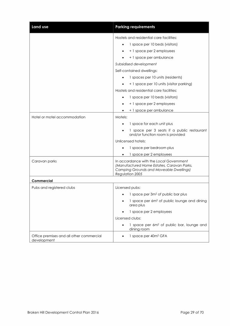
Broken Hill Development Control Plan 2016 Page 29 of 70
Land use Parking requirements
Hostels and residential care facilities:
• 1 space per 10 beds (visitors)
• + 1 space per 2 employees
• + 1 space per ambulance
Subsidised development
Self-contained dwellings:
• 1 spaces per 10 units (residents)
• + 1 space per 10 units (visitor parking)
Hostels and residential care facilities:
• 1 space per 10 beds (visitors)
• + 1 space per 2 employees
• + 1 space per ambulance
Hotel or motel accommodation Motels:
• 1 space for each unit plus
• 1 space per 3 seats if a public restaurant
and/or function room is provided
Unlicensed hotels:
• 1 space per bedroom plus
• 1 space per 2 employees
Caravan parks In accordance with the Local Government
(Manufactured Home Estates, Caravan Parks,
Camping Grounds and Moveable Dwellings)
Regulation 2005
Commercial
Pubs and registered clubs Licensed pubs:
• 1 space per 3m2 of public bar plus
• 1 space per 6m2 of public lounge and dining
area plus
• 1 space per 2 employees
Licensed clubs:
• 1 space per 6m2 of public bar, lounge and
dining room
Office premises and all other commercial
development
• 1 space per 40m2 GFA
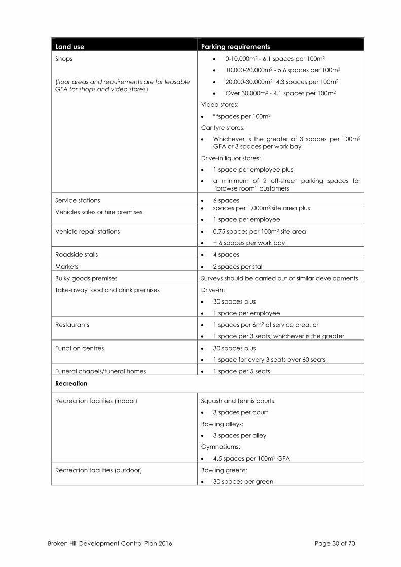
Broken Hill Development Control Plan 2016 Page 30 of 70
Land use Parking requirements
Shops
(floor areas and requirements are for leasable
GFA for shops and video stores)
• 0-10,000m2 - 6.1 spaces per 100m2
• 10,000-20,000m2 - 5.6 spaces per 100m2
• 20,000-30,000m2 - 4.3 spaces per 100m2
• Over 30,000m2 - 4.1 spaces per 100m2
Video stores:
• **spaces per 100m2
Car tyre stores:
• Whichever is the greater of 3 spaces per 100m2
GFA or 3 spaces per work bay
Drive-in liquor stores:
• 1 space per employee plus
• a minimum of 2 off-street parking spaces for
“browse room” customers
Service stations • 6 spaces
Vehicles sales or hire premises • spaces per 1,000m2 site area plus
• 1 space per employee
Vehicle repair stations • 0.75 spaces per 100m2 site area
• + 6 spaces per work bay
Roadside stalls • 4 spaces
Markets • 2 spaces per stall
Bulky goods premises Surveys should be carried out of similar developments
Take-away food and drink premises Drive-in:
• 30 spaces plus
• 1 space per employee
Restaurants • 1 spaces per 6m2 of service area, or
• 1 space per 3 seats, whichever is the greater
Function centres • 30 spaces plus
• 1 space for every 3 seats over 60 seats
Funeral chapels/funeral homes • 1 space per 5 seats
Recreation
Recreation facilities (indoor) Squash and tennis courts:
• 3 spaces per court
Bowling alleys:
• 3 spaces per alley
Gymnasiums:
• 4.5 spaces per 100m2 GFA
Recreation facilities (outdoor) Bowling greens:
• 30 spaces per green
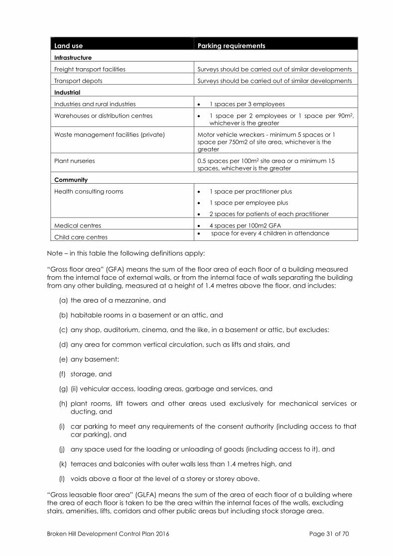
Broken Hill Development Control Plan 2016 Page 31 of 70
Land use Parking requirements
Infrastructure
Freight transport facilities Surveys should be carried out of similar developments
Transport depots Surveys should be carried out of similar developments
Industrial
Industries and rural industries • 1 spaces per 3 employees
Warehouses or distribution centres • 1 space per 2 employees or 1 space per 90m2,
whichever is the greater
Waste management facilities (private) Motor vehicle wreckers - minimum 5 spaces or 1
space per 750m2 of site area, whichever is the
greater
Plant nurseries 0.5 spaces per 100m2 site area or a minimum 15
spaces, whichever is the greater
Community
Health consulting rooms • 1 space per practitioner plus
• 1 space per employee plus
• 2 spaces for patients of each practitioner
Medical centres • 4 spaces per 100m2 GFA
Child care centres • space for every 4 children in attendance
Note – in this table the following definitions apply:
“Gross floor area” (GFA) means the sum of the floor area of each floor of a building measured
from the internal face of external walls, or from the internal face of walls separating the building
from any other building, measured at a height of 1.4 metres above the floor, and includes:
(a) the area of a mezzanine, and
(b) habitable rooms in a basement or an attic, and
(c) any shop, auditorium, cinema, and the like, in a basement or attic, but excludes:
(d) any area for common vertical circulation, such as lifts and stairs, and
(e) any basement:
(f) storage, and
(g) (ii) vehicular access, loading areas, garbage and services, and
(h) plant rooms, lift towers and other areas used exclusively for mechanical services or
ducting, and
(i) car parking to meet any requirements of the consent authority (including access to that
car parking), and
(j) any space used for the loading or unloading of goods (including access to it), and
(k) terraces and balconies with outer walls less than 1.4 metres high, and
(l) voids above a floor at the level of a storey or storey above.
“Gross leasable floor area” (GLFA) means the sum of the area of each floor of a building where
the area of each floor is taken to be the area within the internal faces of the walls, excluding
stairs, amenities, lifts, corridors and other public areas but including stock storage area.
Broken Hill Development Control Plan 2016 Page 32 of 70
4.2 Industrial Development
Controls
• Location of car parking
- Parking should preferably be located at the side or rear of the site behind the front
building line.
- If it is intended to locate the parking area in front of the building then the area is
to be behind the building line and screened from view (dense planting, feature
wall etc. may be used). Small parking areas need not be totally screened from
viewed but be behind the landscape set back.
- Loading facilities are considered to be an important part of any
development, whether new or existing. Where ever possible, such facilities should
be provided wholly within the site.
• Vehicular Access
By Main Roads
- all development which have direct vehicular access to a main road are subject
to consultation with NSW Roads and Maritime Services, either direct or through the
local Council’s Traffic Committee.
- Generally, no vehicular access will be permitted to a main road if reasonable
access is available from an alternative street.
By Local Streets
- not more than two (2) crossings will be permitted to any premises;
- where two (2) vehicular crossings are provided the crossing on the approach side
will be constructed, signposted and used solely as an entrance and the other
crossing will be constructed, signposted and used solely as an exit.
• Access Driveways
- Access driveways, parking loading/unloading and manoeuvring areas are to be
constructed of sealed gravel pavement or equivalent standard which causes
stormwater to be drained off the surface so as to be suitable for use in all weather
conditions. Unsealed cracker dust or limestone will not be acceptable as an
equivalent alternative.
- A vehicular access driveway should be no less than six (6) metres wide at the
property boundary. Driveway widths may be varied at Council’s discretion to ensure
that vehicles may exit the development without crossing the centre line of the
public road.
- Driveways shall be located no less than six (6) metres from an intersection of
a public road.
- Driveways shall be positioned at right angles to the kerb to ensure safe entry
and exit from the site.
- All footpath and gutter crossings are to be located and constructed in
accordance with Council’s requirements at full cost to the developer.
• Vehicular Movement

Broken Hill Development Control Plan 2016 Page 33 of 70
- Sufficient turning area shall be provided on the site for all vehicles to manoeuvre on
and off the site in a forward direction at all times. The RTA Guidelines should be
consulted with regard to dimensions, site distances, turning circles and other
associated information for the design of vehicular movements on site.
4.3 Commercial Development
Controls
• Loading and delivery bays for properties in the Westside Plaza commercial precinct should
be located on site and be designed to ensure that vehicles using these areas can enter
and leave the site in a forward direction
• If buildings have access to a rear lane within any commercial precinct, where practical
loading and unloading shall be provided from that lane, unless Council is satisfied that the
laneway is inadequate for that purpose
5. OUTDOOR ADVERTISING
5.1 General provisions – all zones
Application
This section applies to advertising and signage as defined in State Environmental Planning Policy
No 64 – Advertising and Signage in all zones in Broken Hill that are subject to Broken Hill LEP 2013.
SEPP No 64 regulates signage across NSW and SEPP (Exempt and Complying Development
Codes) 2008 provides for advertising and signage that may be carried out as exempt
development. The provisions of this section provide design guidance and control the content of
signage. Development applications for advertising and signage are assessed by Council in
accordance with Schedule 1 Assessment Criteria of SEPP No 64.
Objectives
• To provide for good quality and well-maintained signage which is adequate and effective in
promoting the City’s tourist attractions and it’s trade, commerce and services without being
detrimental to the amenity and character of the area
• To provide for signage which is complementary in scale and form with the built environment
and the streetscape as a whole
• To establish common criteria for the assessment of applications for outdoor advertising
• To achieve a gradual replacement of existing unwanted signs with new, good quality, well
maintained signs through incentives balanced, by strong enforcement
• To provide for directional signs to meet the needs of visitors and residents in locating facilities,
places and services
Design guidance
Size and Number - Signs should be in scale with their surroundings. The size of the sign should be
appropriate to the relative size of both the building and the adjoining road or pedestrian way
together with the speed of passing traffic. Signage should be attractively designed in style and
colours which complement the amenity of the area. Where possible, signs should be
integrated into the overall design of a building.
Content - Signs should be simple, clear and concise. In some instances, graphic symbols may be
more effective than words.
Broken Hill Development Control Plan 2016 Page 34 of 70
Orderliness - The different components of an outdoor advertising campaign should be planned
and integrated, to avoid the appearance of a clutter of “add-ons” or afterthoughts. Poorly
maintained or constructed signs don’t create a favourable image and may even work to the
detriment of the advertiser. Where there is more than one shop or business within a building,
signs should be coordinated in height, shape, size and colour
Fit - The design of signage should be appropriate to its surrounding and complementary to the
building
Shape - Sign shapes can be varied to create a distinctive image, however, care is needed to
ensure larger signs “fit” rather than dominate their surroundings.
Lettering and Layout - Lettering styles should be appropriate to the sign’s purpose and its
surroundings. It is always preferable to use qualified designers or signwriters to ensure a
professional finish.
Resemblance to Road Signs - Signs should not resemble road signs in colour, shape, layout or
wording to avoid confusing motorists.
Maintenance of Signs - Advertisements and advertising structures shall be maintained in good
structural condition, kept clean, neatly painted and be of a professional standard of design and
finish.
Removal of Signs - When a change of use takes place, the signs of the outgoing occupant are
to be removed by the advertiser.
New Signs For Old - Council actively offers incentives to encourage a rationalisation of
approved signs on individual premises. In this regard, Council will consider concessions in
relation to new signage to achieve a “clean-up” of an existing cluttered site or where removal
or reconstruction of a redundant or poorly maintained sign is proposed as an integral
component of a beautification or restoration scheme. Council will consider all reasonable
proposals on the merits of the individual case. However, it is necessary for the applicant to
provide proof that the existing sign(s) was erected with approval from Council.
Illegal Signs - Council will be systematically seeking removal of an illegal, redundant and poorly
maintained signs as an essential part of the total effort to achieve an orderly and interesting
display of signage in the City. Council may order the advertiser to alter, obliterate, demolish or
remove an advertisement and any associated advertising structure where:
• The advertisement is unsightly, objectionable or injurious to the amenity of any natural
landscape, public reserve or public place at or near where the advertisement is displayed;
• An unauthorised advertisement is displayed;
• An unauthorised advertising structure is erected; or
Alternatively, where the condition of an advertising structure threatens the safety of the public,
Council may order the advertiser to do whatever is considered necessary to remove the threat.
Should the advertiser not comply with the order, Council will undertake the work and charge the
advertiser for the cost of the work. In such cases Council will also seek to have fines imposed on
the advertiser.
Controls
• The following types of signs are not acceptable in the City of Broken Hill:
- Signs which project from the building façade and obscure the view of neighbouring
buildings or interrupt the perspective view of the streetscape;
Broken Hill Development Control Plan 2016 Page 35 of 70
- Signs fixed to trees, or light, telephone or power poles;
- Signs which could reduce road safety by adversely interfering with the operation of
traffic lights or authorised road signs;
- Any sign which would, in the opinion of the Council, be unsightly, objectionable or
injurious to the amenity of the locality, any natural landscape, public reserve or
public place;
- Signs on or attached to parked vehicles directing attention to a nearby business or
goods for sale;
- Portable signs on public footways and road reserves;
- Numerous small signs and advertisements carrying duplicate information;
- Overhead banners and bunting, except for:
- Temporary signs related to local festivals, fairs or celebrations (See details on “special
event signs”); or
- The opening of a new business, for a duration not exceeding 2 weeks;
- Signs on bus sheds, seats and waste bins unless for community related purposes
approved by Council;
- Any sign located over the footpath which is lower than 2.6m above the footpath.
- Flashing signs.
- Advertising signage in heritage conservation areas. Only business identification or
building identification signage is acceptable in heritage conservation areas.
• Special Event Signs - Special events signs, temporary event signs and special promotional
advertisements which require development consent shall:
- only be displayed for a period of not more than 2 months prior to the event and shall
be removed within 48 hours after the event;
- comprise a maximum of 2 on-site temporary signs per event;
- shall be securely fastened to an approved signage structure, fence or post supports;
- shall not exceed 5.0m² in area;
- shall not overhang a public road or footway;
- the position of the sign shall not obstruct a driver’s line of sight;
- the consent shall be obtained from the property owner prior to the erection of any
signage;
- shall not be fixed or secured to public property, such as electricity poles, street signs
or seating
• Murals and public art - Murals and Public Art on private structures/buildings will be assessed
on a case by case basis. Codes SEPP exemptions may apply. Murals and Public Art on
Council owned or managed properties must comply with the Broken Hill Public Art Policy.

Broken Hill Development Control Plan 2016 Page 36 of 70
5.2 Directional signage in rural zones
Application
This section applies to directionall signage for a Place of Tourist Interest in zone RU2 Rural
Landscape.
A Place of Tourist Interest:
• Is a place which would reasonably be expected to be predominantly utilised by tourists and
is a place of scientific, historical or scenic interest
• May generally include galleries, museums, architectural/engineering structures, and wildlife
or nature parks
• Does not include a place or building where the primary purpose is retail premises, tourist and
visitor accommodation, caravan parks and the like
Design guidance
• The principle purpose of the advertisement is to direct the public to that building or place
• The size of the advertisement is not larger than would be reasonably required to direct
passing public
• The advertisement will not be detrimental to the amenity and character of the surrounding
area
Controls
• Applications should be accompanied by a statement or supporting documentation
justifying that the place is of scientific, historical, or scenic interest
• In general, signs in rural areas should have a maximum area of 10 square metre
• directional signage is to be limited to three (3) signs per tourist place
• A particular site should have no more than two (2) signs of this type erected upon it
• The sign can contain the name of the tourist place, attraction and directional information
only
• The maximum size for a sign of this type is 5m2 (area of advertising panel).
5.3 Signage in industrial zones
This section applies to building identification signs in zones IN1 General Industrial and IN2 Light
Industrial.
Design guidance
• Only one business identification sign is permitted on industrial premises and no bunting or
other advertising media may be displayed.
• The typical size of building identification signs for industrial premises are:
- Above awning sign 1.4 metres
- Business sign 5 metres
Broken Hill Development Control Plan 2016 Page 37 of 70
Illuminated signs:
- Indirectly lit 3 metres
- Internally lit 8 metres
- Neon 4 metres
- Pole or pylon sign 4 metres
- Sky, roof, fin sign 8 metres
- Wall sign 15 metres
Consent may be granted for signs of greater size than that specified above depending on
the location, site attributes, surrounding amenity and the like.
• If the site is occupied by a number of tenants, one index board may be constructed near
the site entrance, detailing the unit number, tenant, and product of each occupant of
the site.
5.4 Signage in heritage conservation areas and on heritage buildings
Application
This section applies to signage in heritage conservation areas and on heritage buildings that are
listed in Schedule 5 Environmental heritage of Broken Hill LEP 2013.
Design guidance
• Signs on buildings within heritage conservation areas should be simple and clear.
There are logical places for signs on buildings. A clutter of signs on buildings does
not contribute to the streetscape and makes advertising ineffective.
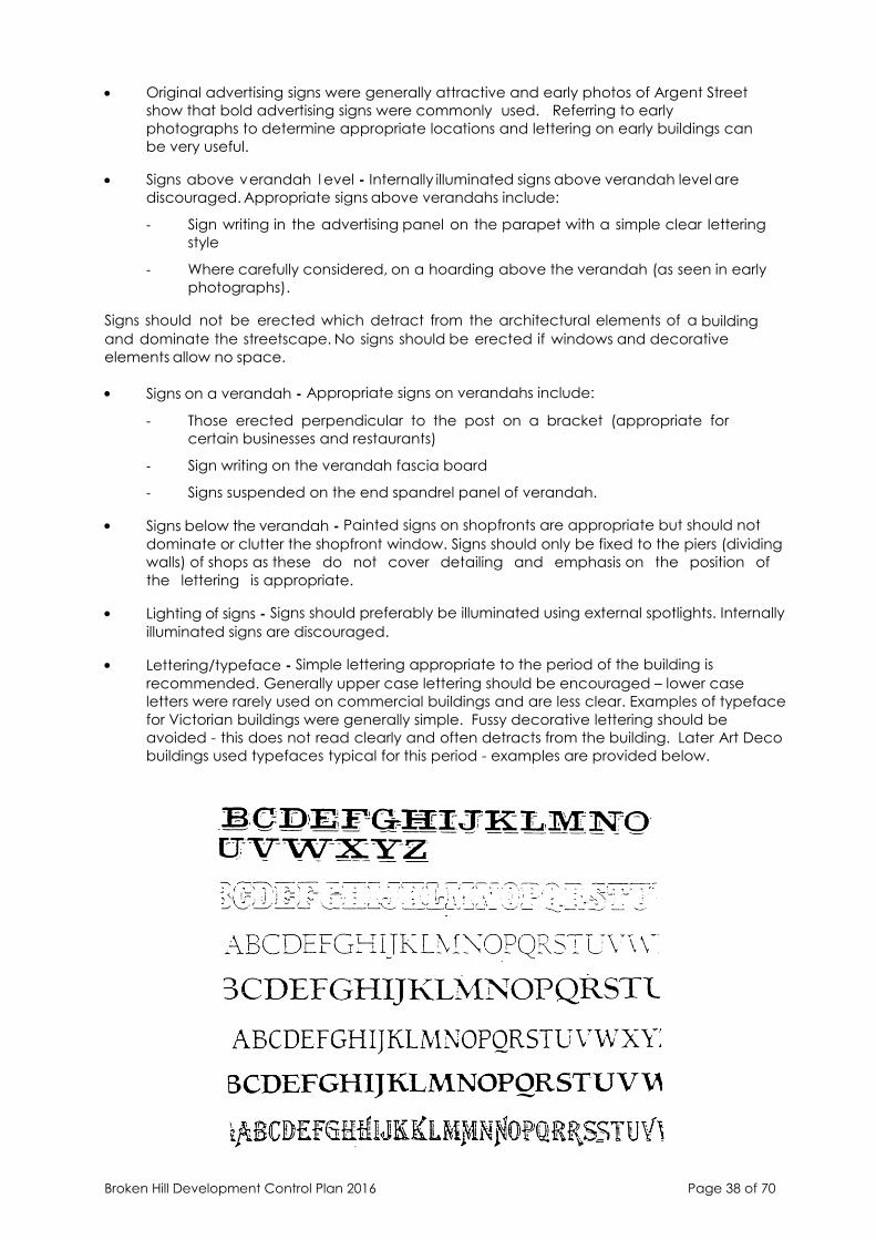
Broken Hill Development Control Plan 2016 Page 38 of 70
• Original advertising signs were generally attractive and early photos of Argent Street
show that bold advertising signs were commonly used. Referring to early
photographs to determine appropriate locations and lettering on early buildings can
be very useful.
• Signs above verandah l evel - Internally illuminated signs above verandah level are
discouraged. Appropriate signs above verandahs include:
- Sign writing in the advertising panel on the parapet with a simple clear lettering
style
- Where carefully considered, on a hoarding above the verandah (as seen in early
photographs).
Signs should not be erected which detract from the architectural elements of a building
and dominate the streetscape. No signs should be erected if windows and decorative
elements allow no space.
• Signs on a verandah - Appropriate signs on verandahs include:
- Those erected perpendicular to the post on a bracket (appropriate for
certain businesses and restaurants)
- Sign writing on the verandah fascia board
- Signs suspended on the end spandrel panel of verandah.
• Signs below the verandah - Painted signs on shopfronts are appropriate but should not
dominate or clutter the shopfront window. Signs should only be fixed to the piers (dividing
walls) of shops as these do not cover detailing and emphasis on the position of
the lettering is appropriate.
• Lighting of signs - Signs should preferably be illuminated using external spotlights. Internally
illuminated signs are discouraged.
• Lettering/typeface - Simple lettering appropriate to the period of the building is
recommended. Generally upper case lettering should be encouraged – lower case
letters were rarely used on commercial buildings and are less clear. Examples of typeface
for Victorian buildings were generally simple. Fussy decorative lettering should be
avoided - this does not read clearly and often detracts from the building. Later Art Deco
buildings used typefaces typical for this period - examples are provided below.

Broken Hill Development Control Plan 2016 Page 39 of 70
6. LAND CONTAMINATION
Development applications that involve contaminated land are assessed in accordance with
SEPP No 55 and the Managing Contaminated Land Planning Guidelines. All definitions of SEPP
No 55 and the Guidelines are adopted for the purposes of this chapter of the Plan.
6.1 Contamination other than lead
Application
This section establishes and outlines development guidelines relating to development on land
which is known to be or is potentially contaminated (other than with lead) within the definitions
of State Environmental Planning Policy 55 – Remediation of Land and associated Managing
Contaminated Land Planning Guidelines and the Contaminated Land Management Act 1997.
Objectives
• establish appropriate guidelines for the remediation of contamination from materials,
other than lead, as outlined by the Managing Contaminated Land Planning Guidelines
• identify sites known to be or likely to be contaminated as defined by State Environmental
Planning Policy 55 and the Guidelines, by means of researching and identifying past uses
of specific sites wherever possible
• Determine appropriate procedures for assessing applications for development that allow
the continuing development of the City of Broken Hill whilst maintaining appropriate
controls on land use within the boundaries of the City. Such procedures shall take into
account the proposed use and the risks associated with that use given the presence of
contaminants on the site
Design guidance
Use of property
Wherever possible, a risk based analysis approach will be used to determine applications for the
development of sites identified as potentially contaminated. This means that if a land use is
similar to a previous land use, or would not impose a greater risk to human health and the
environment, then that use may be permitted without the need for remediation works to be
carried out. It should be noted however, that this would not prevent the owner of the land from
being liable for remediation works at a future time should the contamination:-
• Become worse and or subject to migration from the site;
• Become subject to a further change of use which is incompatible with the levels of
contamination;
• The EPA issue an order to investigate and or remediate the site.
In the event that one of the above circumstances occurs, it is the responsibility of the owner of
the site to carry out any testing and or remedial works required to alleviate the problem.
Rezoning of the site to allow for residential purposes may require remediation of the site to a
level suitable for such use. The degree of remediation will be dependent upon the type,
location and extent of contamination for that particular site.
Risk
Broken Hill Development Control Plan 2016 Page 40 of 70
Managing contamination involves considering risk to human health and the environment. The
Site Investigation Process may only need to be carried out in situations that are considered to
present a risk to health or the environment.
Particular care should be taken in the following situations:
• The development, regardless of site history, will involve a sensitive use
• A vacant site is to be rezoned or redeveloped for residential purposes
• Redevelopment for industrial or commercial purposes
• Industrial site to be rezoned or redeveloped for commercial or residential use
• Commercial site is to be rezoned or redeveloped for residential use
In determining the risk posed by contamination, the following issues should be considered:
• Whether the contamination of the site has already caused harm
• Whether the substances are toxic or present in large quantities or concentrations
• Whether there are routes whereby the substances may proceed from the source of the
contamination to human beings or other aspects of the environment
• Whether the uses or approved uses to which the site and adjoining sites are currently
being put are likely to increase the risk of harm
• Any guidelines made or approved by the EPA on contamination and remediation.
Controls
• Remediation methods, apart from existing residential allotments, will in most cases, be
subject to an evaluation and recommendations from an accredited person under the
Contaminated Land Management Act
• Remediation from contaminants, other than lead, will require an approach as outlined in
the “Guidelines for Consultants Reporting on Contaminated Sites”, produced by the
Environmental Protection Authority NSW
• The four steps outlined therein are
1. Preliminary Site Investigation
2. Detailed Site Investigation
3. Remediation (Remedial action plan)
4. Validation and Ongoing Site Monitoring
Depending upon the type and degree of contamination, the proposed course of action
may require one or more of the above steps and in some more severe cases, may require
all of the above steps. Remediation techniques and the degree of remediation required
will also depend upon the proposed use of the land and the risks associated therein.
Broken Hill Development Control Plan 2016 Page 41 of 70
Stage 1 – Preliminary Site Investigation
The main objectives of a preliminary site investigation are to identify any past or present
potentially contaminating activities, provide a preliminary assessment of any site contamination
and, if required, provide a basis for a more detailed investigation.
Where contaminating activities are likely to have occurred, or where the site inspection does not
conclude that no contamination has occurred, confirmation through sampling and analysis is
required to support any conclusion reached from the history appraisal and inspection. The onus
is on the applicant to provide information in sufficient detail for assessment by Council.
Where a preliminary site investigation indicates that the land is potentially contaminated or
where Council is not satisfied that the site is suitable for the proposed use (due to contamination,
or potential contamination) Council may request that the applicant conduct a Stage 2 –
Detailed Site Investigation.
Stage 2 – Detailed site investigation
A detailed investigation is only necessary when a preliminary investigation indicates that the
land is contaminated or that it is, or was, formally used for an activity listed in Schedule 1 and a
land use change is proposed that has the potential to increase the risk of exposure to
contamination.
The objectives of a detailed investigation are to define the nature, extent and degree of
contamination; to assess potential risk posed by contaminants to health and the environment.
The investigation should also determine whether remediation is necessary to reduce the levels of
contamination in order for the proposed use to proceed.
What happens after a detailed site investigation?
After a detailed site investigation is completed, Council must be satisfied that it has enough
information to determine the Development Application. The investigation should demonstrate
and conclude that:
(a) the site is free from contamination and no remediation work is required for the proposed
development to proceed; or
(b) the site has minor contamination, however, the extent and nature of that contamination is
insignificant having regard to the proposed use, and the proposal can be determined without
the need for remediation of the site; or
(c) the site is unsuitable for the proposed use (with regard to contamination) and will require
remediation to reduce the level of contamination so that the site is suitable for the proposed
use; or
(d) the site is unsuitable for the proposed use, even if remediation processes are undertaken, and
the proposal should not proceed.
Broken Hill Development Control Plan 2016 Page 42 of 70
Stage 3 – Remediation
SEPP55 - Remediation of Land identifies when remediation works require consent from the
relevant consent authority.
These works are identified as Category 1 in the SEPP. Other remediation works (known as
Category 2 in the SEPP) do not require the consent of Council, but compliance with the
provisions of the SEPP, including notification to Council, is mandatory.
If it is identified that remediation works require development consent (i.e. Category 1
remediation works), the applicant is required to submit a Development Application.
Development Applications for, or which include, site remediation works (Category 1) must be
accompanied by a site Remedial Action Plan (RAP) in accordance with the provisions of State
Environmental Planning Policy No. 55 - Remediation of Land.
The objectives of a site remedial action plan (RAP) are:-
- to set remediation goals that ensure the remediated site will be suitable for the proposed
use and will pose no unacceptable risk to human health or to the environment; and
- to determine the most appropriate remedial strategy.
Stage 4 – Validation and Ongoing Site monitoring
Validation should determine whether the pre-determined clean-up objectives have been
attained and whether any further remediation work or restrictions on land use are required.
Ideally, validation should be conducted by the same consultant that conducted the rest of the
site investigation and remediation process.
Validation must confirm statistically that the remediated site complies with the predetermined
clean-up criteria for the site. The relevant NSW EPA guidelines should be followed when
validating the site. SEPP55 outlines the proponent's responsibilities for reporting notice of
completion to the consent authority for Category 1 remediation works.
6.2 Lead contamination
Application
This section establishes and outlines development guidelines relating to development on land
which is known to be or is potentially contaminated with lead within the definitions of State
Environmental Planning Policy 55 – Remediation of Land and associated Managing
Contaminated Land Planning Guidelines and the Contaminated Land Management Act 1997.
Development applications that involve contaminated land are assessed in accordance with
SEPP No 55 and the Managing Contaminated Land Planning Guidelines. All definitions of SEPP
No 55 and the Guidelines are adopted for the purposes of this section of the Plan.
Objectives
• to minimise lead exposure to the public, particularly young children and to minimise
the impact of lead within the environment through lead safe work practices, controls
and proper disposal procedures
• ensure that all development/activities, including exempt, complying, local and
integrated development, complies with acceptable environmental planning practices
and standards
• assist in achieving a consistent approach to the management of lead contamination

Broken Hill Development Control Plan 2016 Page 43 of 70
• minimise the overall environmental impacts of lead contamination
• minimise the effects of lead on the health of residents
• provide advice to people and organisations on how to manage lead in their premises
and the environment, matters that need to be considered and the actions to be
carried out
• provide advice to applicants when assessing the effects of a variety of applications
made under the Environmental Planning and Assessment Act 1979
• provide advice to intending applicants on how to reduce and handle waste during the
demolition and construction phase
• provide for on-going control of lead in premises
• provide guidance for council in undertaking its infrastructure management and
maintenance functions
Design guidance
As a result of mining activities over the last 100 years and erosion from the ore body, much of
Broken Hill is potentially contaminated with lead. Lead has been distributed from the ore body
through a combination of wind, and water erosion contaminating the soils, ceiling spaces, wall
cavities and internal areas of homes within Broken Hill, with the greatest deposition within 0.4 km
north of the Line of Lode and 0.8 km south of the Line of Lode. Additionally, wide-spread use of
lead-based paint has potentially caused localised contamination of soil and building interiors
due to the paint flaking or peeling off, being removed with unsafe techniques (heat gun, dry
sanding or water blasting) or from painted wood having been burnt.
Lead levels of “old” soil are known to be generally well above the Health Investigation Lead
level of 300 PPM, particularly in areas within 0.4 km north of the Line of Lode and 0.8 km south
of the Line of Lode. A small number of properties have been remediated through the Broken
Hill Environmental Lead Program and these are likely to have substantially lower soil lead
levels than would otherwise be expected. It is necessary for Council to undertake the
precautionary principle, ie. to assume that all land is contaminated unless proven otherwise.
Some of the following questions will provide additional insights into the degree of lead
contamination present:-
• Is the soil and land around the building or structure likely to be contaminated with lead
due to previous lead paint or protective coating use or industrial activities?
• Has fill which may have been sourced from lead contaminated land been used on the
site?
• Has the land been used for orchards, market gardens or other agricultural
purpose in which lead arsenate could have been used?
• What was the previous use of the land/property? Could any of the activities
contaminated the land with lead ie. previous petrol station, previous rifle range?
• Has the land been built on prior to 1970 and was there an unsafe demolition or
renovation?
• Has there been fill or slag that may be contaminated used on the property?
It is acknowledged that there may be insufficient information to answer some of these
questions. Where lack of knowledge exists, it is suggested that the precautionary principle be
Broken Hill Development Control Plan 2016 Page 44 of 70
applied. Ie. it should be assumed that contamination may be present and consideration
given to remediation works.
Renovation/demolition
As a result of over 100 years of wind erosion, lead dust has accumulated to varying degrees in
most Broken Hill homes. During renovation and demolition works dust that has been
accumulating in the ceiling space, wall cavities and floor space may be exposed and
mobilized. This will result in a high health risk to occupants, workers and neighbours. Lead
levels in ceiling dust are known to be very high. Paints used prior to 1970 contained high
levels of lead. The lead levels in paint of most pre-1970s dwellings in Broken Hill is known to be
well over the acceptable limit.
The following questions may help identify possible contamination issues as to the degree of
contamination present on site:-
• Is there evidence that demolition or renovations have been carried out on the site
which may have resulted in lead contamination?
• Did part of the building or structure contain lead paint or protective coatings or use lead
products?
• Has the building or structure been used in the manufacture or use of lead? (e.g.
printing, pigment production or mixing, lead sinker production).
Lead management plan
In most cases, compliance with the controls of this Plan will be sufficient. Where Council has
ascertained that an unacceptable risk applies it may require the preparation of a Lead
Management Plan. The lead management plan must be prepared on behalf of the
developer by an accredited contaminated site auditor or an appropriately qualified person
experienced in lead assessment, and must provide the following details:-
• history of any relevant structures, buildings or land
• details regarding any testing which has been carried out to ascertain the extent of
lead contamination
• type of lead contamination (internal / external lead paint, lead dust in ceiling or wall
cavities, contaminated soil, slag or fill)
• how the lead is to be controlled or removed
• how the lead is to be disposed of
• a statement outlining the ways in which the lead related environmental and health
effects of the proposal will be minimised
• Workplace Health & Safety procedures to be used.
Remediation
There are many different ways to remediate an allotment of land. The purpose of remediation
is to remove the cause of contamination, reduce, disperse or destroy the contamination, or
eliminate or reduce the hazard arising from contamination. It is not always necessary or even
possible to remove all contamination from a given parcel of land. As such, alternatives must
be found to minimise risk.
Council, has prepared a number of policies and guidelines for the safe development of land
as well as safe work practices when dealing with lead. This approach also revolves around
dust suppression within the residence, which is a somewhat different approach to the land
use approach of the planning system. This approach is considered to be the most suitable
Broken Hill Development Control Plan 2016 Page 45 of 70
method of dealing with health issues arising from lead contamination in Broken Hill.
Remediation methods
Existing residential sites contaminated by lead may be dealt with by remediation techniques
determined by Broken Hill City Council. Information regarding acceptable remediation
techniques for lead contamination in existing residential allotments are available from
Council. Remediation techniques and the degree of remediation required will also depend
upon the proposed use of the land and the risks associated therein.
In the event that an investigation order or remediation order has been issued by the
Environment Protection Authority and/or by Council subject to direction by the Environment
Protection Authority, then appeal rights will be available against that order under the
provisions of clause 6 of the Contaminated Land Management Act 1997.
Controls
• All works shall be undertaken in a lead safe manner. Council recommends that the
tradesman is an accredited Lead Safe Tradesman
• During works, the site shall be continually damped down with water to suppress dust.
Water should not escape into the street as this will result in contaminated dust being
washed into the street and mobilised by traffic
Demolition, alterations/ additions to existing buildings and minor structures
• Where necessary, cavities shall be vacuumed using an approved HEPA style Vacuum
Cleaner and dust collected and disposed of in an approved method
• Works will be undertaken so as to minimise the escape of dust into the atmosphere. To
achieve this, all internal linings shall be removed whilst the external fabric of the building
is essentially intact. Dust should be vacuumed in an approved manner
• Works shall not be undertaken during periods of high winds, i.e. winds strong enough to
raise dust
• The site is to be thoroughly cleaned prior to finishing by wet wiping all ledges, sills, benches,
surfaces and wet mopping of floors using appropriate high-phosphate detergents (e.g.
sugar soap) to restore site to a “lead safe” environment that is safe to live in (high
phosphate detergents are more effective in binding lead)
• On completion, unless the site can be shown not to have been contaminated by the
works the site shall be stabilised with a 50 mm cover of clean material. In the event that
further development is to take place unless Council is satisfied that works will commence
within a reasonable period of time
Commercial, industrial and residential construction works
• Work areas should be sealed off from living areas and work areas regularly cleaned to
minimise the risk if dust
• Wet mopping should be used wherever possible to remove dust
• Care should be taken to ensure that work clothes etc. do not transport dust into
clean areas at the end of the day
• Care should also be taken not to contaminate external areas such as ground outside of
the proposed work area
Filling of land and subdivisions
Broken Hill Development Control Plan 2016 Page 46 of 70
• Works will be undertaken so as to minimise the escape of dust into the atmosphere.
To achieve this, only necessary removal of vegetation shall be allowed
• Fill brought into the site shall be sourced from a lead free source. Excavated
material from other locations within Broken Hill will not be accepted
• Works shall not be undertaken during periods of high winds, i.e. winds strong enough to
raise dust
Procedures for disposal of material
• Cover all trailer, truck and utility loads, including fill removed during earthworks to prevent
their escape during transport
• Dispose of all fill and excavated material at a Council waste management facility
• Do not disturb materials unnecessarily
• Use a plastic membrane as a base when stacking materials in the trailer, truck or utility for
transport and disposal
7. TREE PRESERVATION
7.1 Trees on public land
Application
This section applies to trees and shrubs planted on land that is owned and/or managed by
Council including community land, operational land, nature strips, road corridors and public
reserves.
Objectives
• To promote the safety and beautification of streets, parks and reserves
• To maintain and protect trees and shrubs on public land
Design Guidance
• A combination of native and exotic trees will be maintained within the streetscapes and
within developments, however, Council will encourage consistent vegetation themes that
reduce the diversity of species selected so as to maintain street integrity and unity
• Residents are encouraged to promote the health of trees in the vicinity of their residences
by watering watering of newly planted and small trees when required, however, tree
trimming and pruning may not be carried out without the prior written approval of Council
• Council may approve the removal of trees where a ratepayer is able to demonstrate a
valid reason for the removal of the tree. In such circumstances, the cost for removal will be
met by the ratepayer. Leaf debris or shading of solar panels are not considered valid
reasons for the removal of street trees. The removal of trees and shrubs on Council
controlled property shall be undertaken, where possible, by Council staff or a contracted
arborist
• Should tree roots from a tree planted on public or Council owned land encroach into a
private residence, the ratepayer will be required to submit a report of the alleged
damage so that a Council Officer can assess the situation and determine an appropriate
course of action. Such action may include tree root extraction or, where there is no other
option, removal of the tree. Residents and ratepayers are responsible for preventing the

Broken Hill Development Control Plan 2016 Page 47 of 70
encroachment of trees and other vegetation planted within their properties onto
footpaths and nature strips
• Tree vandalism includes the unlawful destruction, damage or injury to trees and
vegetation on public land. Examples include poisoning, mowing of young trees, pruning,
ringbarking or removal. Council will investigate any instance of tree vandalism and will
pursue reimbursement for any costs involved in investigation, removal and reinstatement
of any tree that has been shown to have been vandalised.
Controls
• Trees are to be selected for planting based on their suitability for the particular location,
expected performance, life expectancy and the risks that the tree might pose to people
and infrastructure including underground and aboveground services
• Council will provide suitable trees to plant on nature strips and authorise residents to plant
trees provided that:
a) a written application is made for such plantings containing an agreement from the
applicant that the trees, once planted, will be watered and otherwise maintained
by the applicant,
b) the trees provided shall be in accordance with Councils Tree Management Plan,
and
c) the total number of trees on any section of nature strip (including existing trees) does
not exceed two (2) for each property frontage, except where Council may
determine that additional trees are warranted, where the property frontage is
significantly longer than normal, or other unusual circumstances exist.
Residents or land owners may provide and plant additional trees on nature strips at their
own cost provided that the trees are listed on Council’s “Preferred Species’ list given
below and provided that such plantings are located so as to minimise future problems in
regard to Council’s and other Utilities facilities (such as kerb and gutter, water mains,
electrical mains, telecommunication etc.) or with the consideration of the safety of
pedestrians and traffic.
• Council may direct the removal or relocation of any tree or shrub that may:
a) cause damage to water mains, sewer mains, drainage lines, footpaths, kerb and
gutter or other Council facilities or utilities, or
b) cause fouling of power lines, or
c) cause a safety hazard to pedestrians or vehicular traffic.
Council reserves the right to remove such trees at the expense of the person who
authorised the planting of those trees.
• Any development proposal that involves a conflict with or a need to remove a tree is
subject to Council approval. Street trees impacted by the proposed development should
be marked on plans that are submitted for development consent. Every attempt will be
made to avoid conflict between the development and the existing tree(s). Where this is
not possible Council will consider allowing the removal of the tree(s) to enable the
development to occur at full cost to the proponent
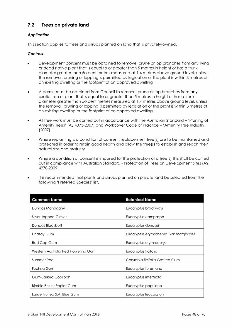
Broken Hill Development Control Plan 2016 Page 48 of 70
7.2 Trees on private land
Application
This section applies to trees and shrubs planted on land that is privately-owned.
Controls
• Development consent must be obtained to remove, prune or lop branches from any living
or dead native plant that is equal to or greater than 5 metres in height or has a trunk
diameter greater than 5o centimetres measured at 1.4 metres above ground level, unless
the removal, pruning or lopping is permitted by legislation or the plant is within 3 metres of
an existing dwelling or the footprint of an approved dwelling
• A permit must be obtained from Council to remove, prune or lop branches from any
exotic tree or plant that is equal to or greater than 5 metres in height or has a trunk
diameter greater than 5o centimetres measured at 1.4 metres above ground level, unless
the removal, pruning or lopping is permitted by legislation or the plant is within 3 metres of
an existing dwelling or the footprint of an approved dwelling
• All tree work must be carried out in accordance with the Australian Standard – ‘Pruning of
Amenity Trees’ (AS 4373-2007) and Workcover Code of Practice – ‘Amenity Tree Industry’
(2007)
• Where replanting is a condition of consent, replacement tree(s) are to be maintained and
protected in order to retain good health and allow the tree(s) to establish and reach their
natural size and maturity
• Where a condition of consent is imposed for the protection of a tree(s) this shall be carried
out in compliance with Australian Standard - Protection of Trees on Development Sites (AS
4970-2009)
• It is recommended that plants and shrubs planted on private land be selected from the
following ‘Preferred Species’ list.
Common Name Botanical Name
Dundas Mahogany Eucalyptus brockwayi
Silver-topped Gimlet Eucalyptus campaspe
Dundas Blackbutt Eucalyptus dundasii
Lindsay Gum Eucalyptus erythronema (var marginate)
Red Cap Gum Eucalyptus erythrocorys
Western Australia Red Flowering Gum Eucalyptus ficifolia
Summer Red Corymbia ficifolia Grafted Gum
Fuchsia Gum Eucalyptus forestiana
Gum-Barked Coolibah Eucalyptus intertexta
Bimble Box or Poplar Gum Eucalyptus populnea
Large Fruited S.A. Blue Gum Eucalyptus leucoxylon
Broken Hill Development Control Plan 2016 Page 49 of 70
Jacaranda Jacaranda mimosifolia
Crepe Myrtle Lagerstroemia Indica x L
Claret Ash Fraxinus oxycarpa “Raywoodii”
Mop Top Robinia pseudoacacia
Weeping Bottlebrush Callistemon viminalis
Laurestinus Viburnum tinus
Golden Rain Tree Koelreuteria paniculata
Melaleuca Melaleuca quinquenervia
8. HERITAGE CONSERVATION
The City of Broken Hill was included in the National Heritage List on 20 January 2015. The City of
Broken Hill is of outstanding heritage value to the nation for its significant role in the development
of Australia as a modern and prosperous country. This listing recognises the City of Broken Hill’s
mining operations, its contribution to technical developments in the field of mining, its pioneering
role in the development of occupational health and safety standards, and its early practice of
regenerating the environment in and around mining operations.
The Environment Protection and Biodiversity Conservation Act 1999 (the EPBC Act) provides for
the protection of the environment, especially matters of national environmental significance
(NES) which includes places listed as National Heritage. Under the EPBC Act, a person must not
take an action that has, will have, or is likely to have a significant impact on any of the matters
of NES without approval from the Australian Government Environment Minister or the Minister’s
delegate. An action is a project, a development, an undertaking, an activity or a series of
activities, or an alteration of any of these things.
If a proposed action is likely to have a significant impact on a matter of national environmental
significance then the development application is to be referred to the Commonwealth Minister.
The responsibility for referring an action to the Commonwealth Environment Minister lies with the
person proposing to take the action. Council is only responsible for referring actions that the
Council proposes to take itself. It is not responsible for referring the actions of other developers.
Statement of Significance
The City of Broken Hill has outstanding significance to the nation for its role in creating enormous
wealth, for its long, enduring and continuing mining operations, and the community’s deep
and shared connection with Broken Hill as the isolated city in the desert, its outback landscape,
the planned design and landscaping of the town, the regeneration areas and particularly the
physical reminders of its mining origins such as the Line of Lode, the barren mullock heaps,
tailings, skimps and slagheap escarpment and relict structures. It exhibits historic qualities in its
ongoing mining operations since 1883, the current and relict mining infrastructure and its
landscape setting. It is significant for its industrial past and the adoption of vanguard industrial
relations and management policies, together with its role as a pioneer in setting occupational
health and safety standards.
It demonstrates the principal characteristics of a mining town in a remote location with
extensive transport infrastructure and administrative connections to three state capitals and as
a rare example of a place subject to Australia’s complex Federal system where differing
administrative, social and economic influences are expressed in both tangible and intangible
forms. It has social significance for its residents as a place of community pride, endurance, and
as a remote mining community resilient to major social and economic change. Broken Hill has

Broken Hill Development Control Plan 2016 Page 50 of 70
strong social significance for all Australians as a place where great wealth was created, as well
as strong group associations with the Barrier Industrial Council. It exhibits outstanding aesthetic
characteristics as a city in an arid desert setting, as the subject of interest for Australian artists,
poets, film makers, TV producers and photographers.
It has significance as a place where outstanding technical achievement has occurred in
refining ore for its minerals including the froth flotation process and the computer controlled on-
stream analysis of slurries. Broken Hill is also important as a place of research potential to reveal
further information on mineral deposits with its range of complex minerals, It is associated with
persons of great importance to Australia’s history, including Albert Morris (arid land
regeneration), Charles Rasp (discoverer), Herbert Hoover (mining engineer), WL Baillieu, WS
Robinson and MAE Mawby (industrialists), GD Delprat (metallurgist), Percy Brookfield and
Eugene O’Neill (unionists). Broken Hill’s association with the Barrier Industrial Council as a group
is also important.
The Broken Hill zinc-lead-silver ore deposit is one of the world’s largest ore bodies and contains
an extraordinary array of minerals. It is geologically complex and has national scientific
significance. The Broken Hill operation is significant for its immense size and unrecorded mineral
species continue to be found. It contributes to an understanding of the formation of the
Australian continent and more than 2,300 million years of the earth’s history.
8.1 All development
This section applies to properties that are listed as items of environmental heritage or located
within a heritage conservation area listed in Schedule 5 of Broken Hill LEP 2013. It does not apply
to the Broken Hill Mining Zone.
Objectives
• To conserve items of environmental heritage and maintain appropriate settings and views.
• To retain evidence of historic themes of development evident in Broken Hill through the
proper care and maintenance of individual items of environmental heritage and Heritage
Conservation Areas.
• To provide guidelines for alterations and additions which complement and do not detract
from the heritage significance of individually listed heritage items and Heritage
Conservation Areas.
• To protect those items and areas of value to the local community.
• To encourage new development which complements existing heritage items and
Conservation Areas in a current day context.
Design guidance
• Items of environmental heritage should be conserved and new development should not
diminish the significance of the item.
• An experienced heritage architect or conservation specialist should be engaged for works
to a significant heritage item.
• Significant internal and external features of heritage items must be maintained in their
original form.
• Subdivision of a site containing a heritage item must leave an adequate curtilage to the
heritage item.
Broken Hill Development Control Plan 2016 Page 51 of 70
• Before any changes to a heritage item are considered, the item should be fully
understood. The applicant should examine its history, stages of development and its form
and fabric. A statement of heritage significance encapsulating the findings, and a HIS
must accompany any development application submitted to Council for a heritage item.
• New development need not seek to replicate period details of original buildings, but
rather, demonstrate respect for the form and scale of the immediate area.
8.1.1 Alterations and Additions
Controls
• Alterations and additions must not adversely impact the significant features of the heritage
item.
• Changes must maintain the significant form, proportion, scale, details and materials of the
item.
• Extensions must not compete with the integrity, scale or character of the item. Extensions
can best meet this requirement if separation from the original building is maximised and
they are designed in a simple, unobtrusive style and size.
• Alterations and additions must be located so as to reduce their visibility and prominence
from any point in the street or adjoining streets, and the height must not be seen above
the main ridgeline of the building.
• New side additions may be permitted where:
o They are sympathetic to the character and design of the existing building, having
regard to the form, bulk, materials and details of the existing building without
attempting to reproduce exactly those elements and decorative details in particular;
o They are not in front of or obscuring the street elevation of the existing building;
o They are set back a greater distance from the street than the existing building;
o They are lower or equal to the height of the majority of the existing building; and
o They are compatible with the existing building in terms of wall height proportions and
roof form.
• Ancillary buildings on the same site as an individual heritage item must be located in a
place that does not obscure the significant elements.
• Alterations to alleviate aircraft, rail or road noise must not detract from the streetscape
values of individual buildings by removing or covering significant building fabric or details.
• Solar water heater storage tanks, solar panels, ventilators, airconditioning units, satellite
dishes and antennae and the like must not be located on the principal roof elevations of
heritage items including on the roof or awning. NB The installation of these items behind
the ridgeline and out of view may be permissible as minor works.
• Building Materials and Details
- Any proposed changes to the external finishes (unless otherwise advised by Council)
require development consent, including paint removal, re-skinning, painting
unpainted brickwork or render of timber or of an unrendered surface.
Broken Hill Development Control Plan 2016 Page 52 of 70
- Development should seek to reconstruct missing architectural detailing, such as
bargeboards, finial trim, window awnings and front verandahs or balconies.
- Re-painting of timber detailing and facades should be guided by the palette of
original period colours. Avoid the use of single colour solutions and attempt a
complementary colour combination. Contemporary colours are not discouraged,
but must be combined in a complementary way.
- Where mortar repointing and render repairs are proposed, gain a proper
understanding of the different types of mortar and render and how it was used. Lime
render was predominantly used in Broken Hill and cement render repairs are
damaging to heritage buildings. Appropriate material must be consistent with the
building form and style.
- Do not paint or render face brick; the original wall treatment must be retained.
- When new windows are to be inserted into the existing building, the proportion of
these windows should respect the form and scale of the architectural style period.
8.1.2 Archaeological Sites
Controls
• Where in the course of building works any archaeological resources are found or
considered may be found, the proponent must inform the NSW Heritage Branch and
obtain necessary approval.
• Where significant archaeological resources are found, alterations and additions in the
vicinity must be designed to care for significant fabric and other features of the place.
• The depth and extent of excavations to the ground surface surrounding heritage items or a
known archaeological site must be minimised.
8.1.3 Places of Aboriginal Heritage Significance
Controls
• Known and potential Aboriginal places and objects must be preserved and protected
when development occurs.
• No excavation of ground surfaces can occur in areas surrounding a known or potential
Aboriginal site.
• Building or landscaping works, paths and driveways must be located away from Aboriginal
sites to allow for in-situ preservation of artefacts.
8.1.4 Fencing
Design guidance
In Broken Hill, galvanised iron (either standard corrugated or ripple iron) was often used because
of economical cost and various different styles of fences were built out of the material. In the
1920’s woven crimped wire was introduced. Stone fences were reserved for only the most
substantial houses.
Early photographs of houses in Broken Hill can be referred to as a guide for restoration and
upgrading of residential buildings. When erecting a new fence to an old house, select a fence
appropriate to the period of the house. Early photos of the house may show the original fence or
a house of a similar period could be located with an appropriate fence which could serve as a
Broken Hill Development Control Plan 2016 Page 53 of 70
model. If early photos are not available, front fence details can be copied from a similar existing
house which can serve as a guide.
Controls
• Front fences are to be
- open in character unless a corrugated iron, ripple iron or stone fence, of maximum
height 1400mm
- constructed in crimp mesh, timber pickets, or metal pickets - with or without a masonry
base
- appropriate to the style and period of the house
- not overly fussy in detail
• The following fencing styles are generally inappropriate
- Solid metal cladding of non-custom orb or ripple iron profile
- Height above 1500 and of solid nature– particularly masonry fencing
• When erecting a new fence for a new house in a street with predominantly old houses the
front fence should not exceed 1200 - 1400 if of as solid nature. Open mesh fencing
associated with landscaping can be effective as shown on the following new residential
development.
8.2 Residential development
Design guidance
• Broken Hill has a rich, varied and unique residential architectural heritage. The City grew
rapidly after the commencement of mining in the 1880’s and its origin as a mining town
with early rapid growth has resulted in a distinctive character. The need for lightweight,
easily transportable building materials resulted in the almost universal use of corrugated
iron for roofing and walls. Corrugated iron was also widely used for fencing. The City
developed a specific appearance with corrugated iron dominating as a building
material.
• Broken Hill’s residential character largely derives from the generally regular and
consistent setback of houses from the street. Any building work undertaken in residential
precincts of Broken Hill must be carefully undertaken so that this identified character is
retained.
• Alterations and additions to existing houses should respect the character of the
building in question and not detract from the character of the precinct as a whole.
• Any new buildings should be carefully designed to fit in with the character of the
precinct but not pretend to be historic buildings themselves.
• The early development of Broken Hill was characterised by makeshift buildings of simple
materials: timber and iron cottages were brought to the silver fields on jinkers drawn by
bullocks, horses, camels or donkeys. By 1888 more substantial houses were erected with
newfound mining wealth but the transportation has remained a critical factor in the
choice of materials for residential buildings. Descriptions of the design elements of
residential development styles are outlined below.
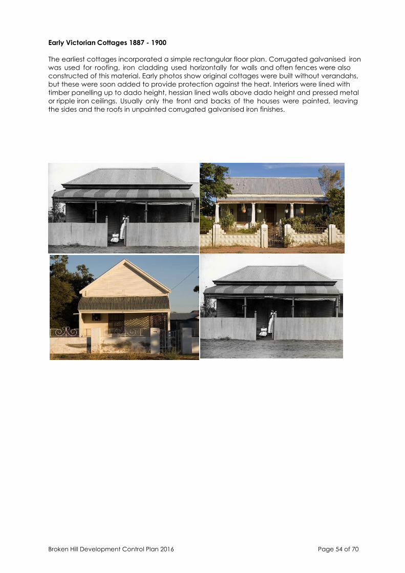
Broken Hill Development Control Plan 2016 Page 54 of 70
Early Victorian Cottages 1887 - 1900
The earliest cottages incorporated a simple rectangular floor plan. Corrugated galvanised iron
was used for roofing, iron cladding used horizontally for walls and often fences were also
constructed of this material. Early photos show original cottages were built without verandahs,
but these were soon added to provide protection against the heat. Interiors were lined with
timber panelling up to dado height, hessian lined walls above dado height and pressed metal
or ripple iron ceilings. Usually only the front and backs of the houses were painted, leaving
the sides and the roofs in unpainted corrugated galvanised iron finishes.

Broken Hill Development Control Plan 2016 Page 55 of 70
Stone Victorian Houses - Pre 1900
More substantial houses of this period were built in local stone (generally random coursed)
and built in a similar vernacular to the South Australian house style. Stone walls were
elaborated with red brick quoins. Villa-sized houses were also constructed in corrugated iron
with verandahs across the frontage which sometimes returned down one or both sides.
There are some examples of row cottages from this period constructed in stone which
provided worker housing. More substantial fencing was used to these larger residences, and
the use of stone with rendered posts is common.
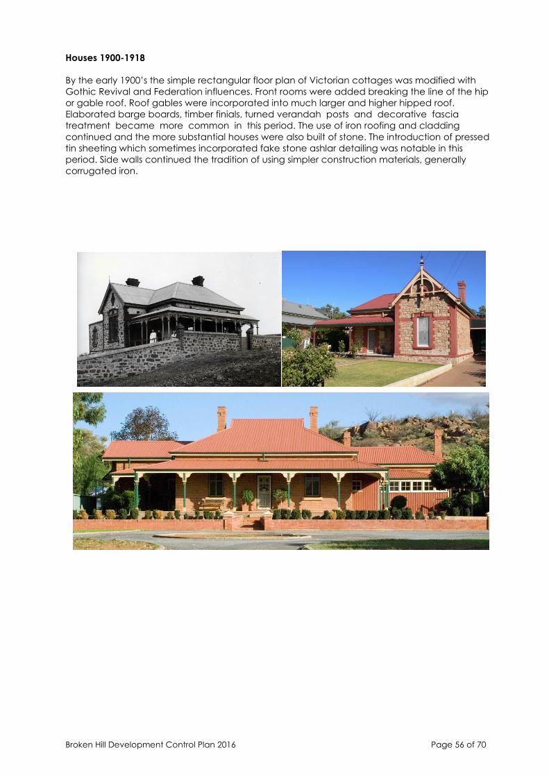
Broken Hill Development Control Plan 2016 Page 56 of 70
Houses 1900-1918
By the early 1900’s the simple rectangular floor plan of Victorian cottages was modified with
Gothic Revival and Federation influences. Front rooms were added breaking the line of the hip
or gable roof. Roof gables were incorporated into much larger and higher hipped roof.
Elaborated barge boards, timber finials, turned verandah posts and decorative fascia
treatment became more common in this period. The use of iron roofing and cladding
continued and the more substantial houses were also built of stone. The introduction of pressed
tin sheeting which sometimes incorporated fake stone ashlar detailing was notable in this
period. Side walls continued the tradition of using simpler construction materials, generally
corrugated iron.

Broken Hill Development Control Plan 2016 Page 57 of 70
Inter-War Housing
Houses built in Broken Hill between the Wars tended to adopt the styles of housing elsewhere in
Australia, such as the Californian Bungalow and Tudor styles. The vast majority were built of
corrugated iron with decorative facades of pressed metal. Stone housing was less
common during this period.
The Bungalow style is characterised by a more solid building form. The Bungalow features a
low pitched roof with extended eaves and large masonry piers as verandahs columns. In
Broken Hill the skills of concrete fabricators are evidenced by the wide use of precast concrete
front verandah posts on houses of this period.
The configuration of windows and doors altered with the wide use of triple front windows or in
some cases casement windows. Leadlight panels were often incorporated into glazing and
front doors were often three panelled or fully glazed.
Fencing matched the heavy bulk of the appearance of the Bungalow and was often
constructed in masonry. The use of woven crimped wire and cyclone mesh fencing was also
common.
Controls
Alterations and Extensions
• If your house is similar in style to those described above, the house contributes to the
heritage character of Broken Hill. The Broken Hill Council is committed to the retention of
the existing residential character and demolition of these contributory houses is not
encouraged.
• When planning alterations to your house, the design and appearance of the original
house must be considered. The front facade should be restored and extensions and
modifications reserved for the rear or side. The scale should be appropriate and new
works should not dominate the old.
• Roof form and pitch should resemble or match the existing building and repeat eaves
details. Similar windows and doors should be used, maintaining existing materials,
proportions and rhythm. The existing verandah could be extended as an additional link.
Original decorative features could be used in the addition (eg. finials to the roof, internal
finishing details such as skirtings and architraves).
• Construction materials should reflect or match those of the original building. In most
residences this is corrugated iron and well detailed, this material is a very attractive and
functional building material. Use of the material is now becoming fashionable with
many architectural awards being given to new houses erected in this material.
The following sketches indicate the preferred way of adding to existing houses in a manner
which reinforces the original character of the house.

Broken Hill Development Control Plan 2016 Page 58 of 70
Different extension concepts for typical Broken Hill houses. Extension profile shown shaded.
Siting of Structures
• Any permanent structure that requires the consent of Council, that is located within
500mm of a boundary, or in any other case where the assessing officer is of the opinion
that the boundary of the site is uncertain, shall be subject to a Surveyors Report.
Building Materials
• Galvanised iron: the most common building material, this occurs in many forms; standard
corrugated custom orb profile, ripple form (close corrugations); pressed fake ashlar (usually
reserved for the front facade only).
• Stonework and square-edged profile brick are less common. Stonework is reserved for the
more substantial residences with brick quoins. Square-edged profile brick is generally
rendered and occasionally as face brickwork (now often painted).
Maintenance
• Galvanised iron requires regular painting to prevent decay by rust. The temptation to
reclad with fake brickwork or imitation weatherboard cladding should be avoided as
corner and joint detailing is generally poor and deteriorates rapidly. Rebuilding with
masonry is rarely successful as the residence always looks reclad. Repair work should be
undertaken with material which matches the original.
• Re pointing of masonry walls is often required. The mortar type should be carefully selected
to match the colour and mixture of the original.
• Sandblasting to expose brick or stonework is not recommended as this removes mortar
and damages brickwork. Paint removal should be attempted only with care using
appropriate chemicals and steam.
• Rising damp/salt damp is often the result of an ineffective damp course. An effective
solution can be to improve underfloor ventilation; however it is often necessary to insert a
Broken Hill Development Control Plan 2016 Page 59 of 70
new damp course (and where necessary under-set the wall with new masonry). This is a
specialist maintenance job and requires experienced tradesmen. The installation of a
concrete floor slab causes damp to travel up the walls and should be avoided at all costs.
A timber floor allows the structure to breathe and if well ventilated will last in good
condition. Guttering and downpipes should be regularly checked - if roof waters are not
discharged well away from the foundations, rising damp and wall cracking will result.
• Timber framing, rotting or pest infested timber should be regularly treated and where
necessary replaced. Timber detailing or weatherboards should be retained where possible.
Imitation weatherboards do not blend well with timber as the corner and joint details are
lost.
Windows and Doors
• Most common to Victorian cottages and houses are simple double-hung sash windows
and four panelled timber entrance doors. Later interwar housing introduced casement
windows. Timber-framed windows are an integral part of the character of older houses
and with repair and maintenance can perform equally as their modern day counterpart.
• Many people consider that renovating a house involves replacing “old” timber framed
windows. This is not the case. Many fine cottages have been spoiled by the replacement
of original windows with aluminium framed windows which generally also require a
different sized opening to be provided in the wall.
Verandahs and Shade Devices
• The verandah has been used universally to cool houses in the hot desert climate in
Australia and these are used on almost all Broken Hill houses. Verandahs break up the
facade of the building and provide an outdoor living area protected from the elements.
Many verandahs have been enclosed for the use as sleep outs, kitchens and playrooms. It
is now generally recognised that an open verandah is necessary as a buffer zone against
the heat and when reinstated or restored the original charm of the house is rediscovered
and the house made more comfortable. Where possible, handrails, balustrades and
verandah posts should be reinstated in the original way and timber and cast iron
decoration repaired or re-erected to the original evidence. Verandah timber and cast iron
work was always painted, iron verandah roofs were often painted in stripes which can
greatly add to the appearance of the house. Window hoods were often effectively used
on windows not protected by verandahs.
Garages, Carports and Outbuildings
• Garages and carports should generally not be erected in front of a dwelling obliterating
the view of the house. It is recommended that these be set at the side or towards the back
of the house.
• Galvanised iron is an appropriate wall and roof material for garages and sheds, and a
traditional pitched roof should be used. However, where a carport is proposed next to the
house and well planted with creepers to minimise its impact. A flat roof should be avoided
and lean-to skillion roof used where possible.
New Houses
• When erecting a new house in a street with predominantly old houses the following design
aspects should be considered:
- Roof form and material - a traditional pitched roof form(minimum 25 degrees) using
custom orb profile galvanised steel should be used;
- A verandah on the front elevation (preferably timber);
- Windows of vertical proportions (preferably timber);
Broken Hill Development Control Plan 2016 Page 60 of 70
- Wall materials - galvanised iron, brick (with flush uncoloured joints) of a neutral
colour, rendered concrete or brick;
- Simple detailing - mock historic elements (example iron lace) should not be used as
these look out of place on a new building.
Use of Early Photographs
• Early photographs of houses in Broken Hill can be referred to as a guide for restoration and
upgrading of residential buildings. Photographs are held at the Charles Rasp Library. The
reinstatement of architectural elements, such as verandahs is best undertaken with
historical accuracy where possible. If early photos are not available, front facade details
can be copied from a similar existing intact house which can serve as a guide.
Roofs and Chimneys
• The roof is one of the most important features which determines the overall appearance of
houses. Corrugated galvanised iron was used in Broken Hill almost universally due to ease
and economy of transportation and the ability of the material to span large widths (thus
requiring less timber support). Ogee profile gutter and round downpipes were also used.
• Regular maintenance (spotting of rust spots, painting etc.) will prolong the life of an iron
roof. If re-roofing is required, custom orb profile corrugated steel roofing should be used -
the finish could be galvanised, zincalume or an appropriate Colorbond (beige, ferric red,
slate grey, dark green).
• Roof features such as turned finials at gable ends, decorations at corners of gutters, should
be restored as these contribute to the character of the roof.
• Chimneys are an important part of the roof and should not be removed. Regular
maintenance of brickwork will prevent deterioration.
Paint Schemes
• Paint schemes for early residential buildings were often bold and imaginative with strong
colours (used to pick out details of joinery, verandah posts) contrasting against lighter
painted wall colours.
• Paint companies have heritage colour charts which contain paint colours appropriate for
use on heritage buildings. The following is a simplified summary of external paint finishes
appropriate for early residential buildings in Broken Hill.

Broken Hill Development Control Plan 2016 Page 61 of 70
Walls All brickwork and stonework should remain unpainted.
Paintwork to timber, galvanised iron wall cladding and painted brickwork to be in
shades of creams, buffs, off whites, ochre shades.
Joinery Work One or a combination of a range of colours (gloss finish) including Indian Red,
Brunswick Green, Deep Brown, Light Brown, Light Stone.
Roofs Unpainted corrugated galvanised iron or painted in Slate Grey, Light Stone, Ferric
Red or Green.
Cast Iron Work Deep iron colours such as Indian Red, Brunswick Green, Rich Brown or Light Stone.
A different colour was sometimes used to pick out details on the iron work.
Fences When erecting a new fence to an old house, select a fence appropriate to the
period of the house. Early photos of the house may show the original fence or a
house of a similar period could be located with an appropriate fence which could
serve as a model.
In Broken Hill, galvanised iron (either standard corrugated or ripple iron) was often
used because of economical cost and various different styles of fences were built
out of the material. In the 1920’s woven crimped wire was introduced. Stone
fences were reserved for only the most substantial houses.
8.3 Commercial development
Design guidance
Broken Hill has a rich, varied and unique commercial architectural heritage. Many architect
designed buildings were erected reflecting the wealth of the early mining activities. These
architectural styles originate from South Australian, Victorian and New South Wales influences, as
typified in the civic block in Argent Street.
• Broken Hill’s commercial character largely derives from the regular placement of the
buildings. Shops, banks and hotels are almost all constructed to street alignment. Any
building work undertaken in commercial precincts of Broken Hill must be carefully
considered so that the identified historic character is retained.
• Alterations and additions to existing heritage buildings should respect the character of
the building in question and not detract from the character of the precinct as a whole.

Broken Hill Development Control Plan 2016 Page 62 of 70
The Argent Street Urban Design Study report should be referred to for buildings within the
CBD precinct.
• Any new buildings should be carefully designed to fit in with the character of the
precinct but not pretend to be historic buildings themselves. Commercial buildings
should generally incorporate a verandah across the street front footpath.
Built Form and Materials
Roofs, Parapets and Chimneys
• Corrugated iron is the universal roofing material in Broken Hill and most shops have street
front parapets that serve to hide the roof behind. These parapets were generally erected
in masonry and were often carefully designed with urns, balustrades and render detailing.
In many cases, this decoration has been removed and the surfaces simplified. Roof
configuration is usually steep in pitch and simple in form (either hips or gables or
combination of both). Roofs in any additions should be carefully related to the existing roof
in material, shape and pitch. Where the roof is visible this should be in a pitched form.
Walls
• Many of the early commercial buildings in Broken Hill were erected in local stone, often
using render detailing. Late Victorian and Edwardian buildings predominate and by the
turn of the century, brick was more commonly used (often with decorative cement render
detailing). Less important buildings were erected using galvanised iron for walls and roof.
Maintenance and Repair of Walls
• Rising damp in Broken Hill is common. Many early buildings did not incorporate damp
proof courses or the existing ones may no longer be effective, often due to a raised
ground height. The most effective solution is to lower the ground level, improve underfloor
ventilation and where necessary, replace or insert a new damp course. Whilst, it is the most
satisfactory long term solution and the advice of an experienced tradesman or architect is
essential in this special maintenance job.
• Masonry walls often require repairs, even though the bricks and stones are still in place.
When re mortaring or repairing brick work, the mortar type should be carefully selected to
match the colour and mixture of the original. High cement content mortar should not be
used as it is a different colour and too strong compared to the original. Strong cement
mortar will break away from the masonry, often fracturing the brick or stone. Mortars with a
high lime content are more flexible for re mortaring or re pointing.
• Deteriorated stone work needs careful assessment. Matching stone is the most suitable
replacement for repair work. Original rendering on external walls should not be chipped or
sandblasted away - the render was often a protective finish for second grade stone or
brickwork and when removed can result in bad weathering of walls.
Shopfronts
• Most original shopfronts in Broken Hill have been removed, but there are many early
shopfronts which still survive. Original shopfronts should generally be retained and restored.
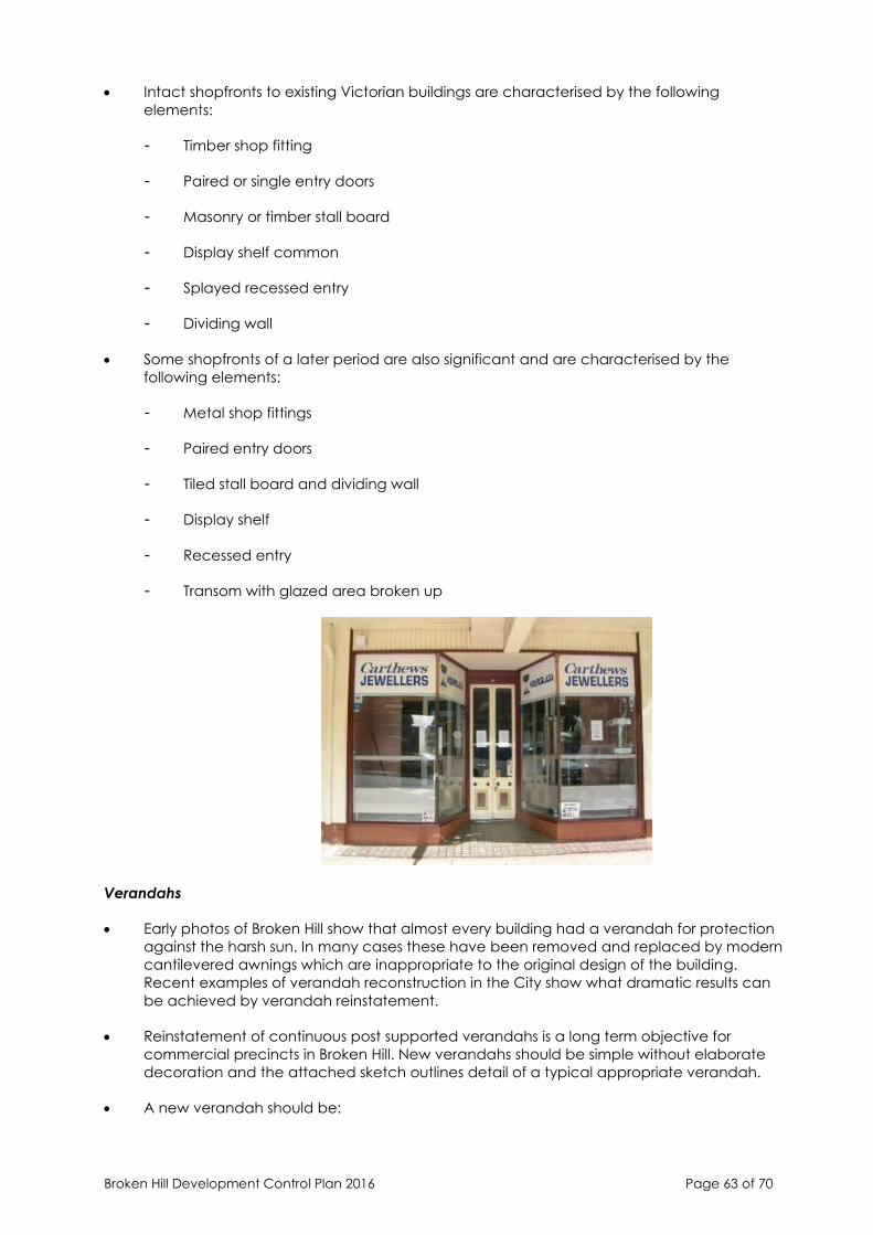
Broken Hill Development Control Plan 2016 Page 63 of 70
• Intact shopfronts to existing Victorian buildings are characterised by the following
elements:
- Timber shop fitting
- Paired or single entry doors
- Masonry or timber stall board
- Display shelf common
- Splayed recessed entry
- Dividing wall
• Some shopfronts of a later period are also significant and are characterised by the
following elements:
- Metal shop fittings
- Paired entry doors
- Tiled stall board and dividing wall
- Display shelf
- Recessed entry
- Transom with glazed area broken up
Verandahs
• Early photos of Broken Hill show that almost every building had a verandah for protection
against the harsh sun. In many cases these have been removed and replaced by modern
cantilevered awnings which are inappropriate to the original design of the building.
Recent examples of verandah reconstruction in the City show what dramatic results can
be achieved by verandah reinstatement.
• Reinstatement of continuous post supported verandahs is a long term objective for
commercial precincts in Broken Hill. New verandahs should be simple without elaborate
decoration and the attached sketch outlines detail of a typical appropriate verandah.
• A new verandah should be:
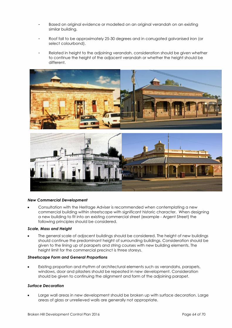
Broken Hill Development Control Plan 2016 Page 64 of 70
- Based on original evidence or modelled on an original verandah on an existing
similar building.
- Roof fall to be approximately 25-30 degrees and in corrugated galvanised iron (or
select colourbond).
- Related in height to the adjoining verandah, consideration should be given whether
to continue the height of the adjacent verandah or whether the height should be
different.
New Commercial Development
• Consultation with the Heritage Adviser is recommended when contemplating a new
commercial building within streetscape with significant historic character. When designing
a new building to fit into an existing commercial street (example - Argent Street) the
following principles should be considered.
Scale, Mass and Height
• The general scale of adjacent buildings should be considered. The height of new buildings
should continue the predominant height of surrounding buildings. Consideration should be
given to the lining up of parapets and string courses with new building elements. The
height limit for the commercial precinct is three storeys.
Streetscape Form and General Proportions
• Existing proportion and rhythm of architectural elements such as verandahs, parapets,
windows, door and pilasters should be repeated in new development. Consideration
should be given to continuing the alignment and form of the adjoining parapet.
Surface Decoration
• Large wall areas in new development should be broken up with surface decoration. Large
areas of glass or unrelieved walls are generally not appropriate.
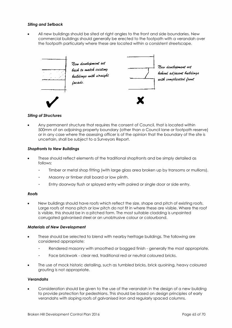
Broken Hill Development Control Plan 2016 Page 65 of 70
Siting and Setback
• All new buildings should be sited at right angles to the front and side boundaries. New
commercial buildings should generally be erected to the footpath with a verandah over
the footpath particularly where these are located within a consistent streetscape.
Siting of Structures
• Any permanent structure that requires the consent of Council, that is located within
500mm of an adjoining property boundary (other than a Council lane or footpath reserve)
or in any case where the assessing officer is of the opinion that the boundary of the site is
uncertain, shall be subject to a Surveyors Report.
Shopfronts to New Buildings
• These should reflect elements of the traditional shopfronts and be simply detailed as
follows:
- Timber or metal shop fitting (with large glass area broken up by transoms or mullions).
- Masonry or timber stall board or low plinth.
- Entry doorway flush or splayed entry with paired or single door or side entry.
Roofs
• New buildings should have roofs which reflect the size, shape and pitch of existing roofs.
Large roofs of mono pitch or low pitch do not fit in where these are visible. Where the roof
is visible, this should be in a pitched form. The most suitable cladding is unpainted
corrugated galvanised steel or an unobtrusive colour or colourbond.
Materials of New Development
• These should be selected to blend with nearby heritage buildings. The following are
considered appropriate:
- Rendered masonry with smoothed or bagged finish - generally the most appropriate.
- Face brickwork - clear red, traditional red or neutral coloured bricks.
• The use of mock historic detailing, such as tumbled bricks, brick quoining, heavy coloured
grouting is not appropriate.
Verandahs
• Consideration should be given to the use of the verandah in the design of a new building
to provide protection for pedestrians. This should be based on design principles of early
verandahs with sloping roofs of galvanised iron and regularly spaced columns.
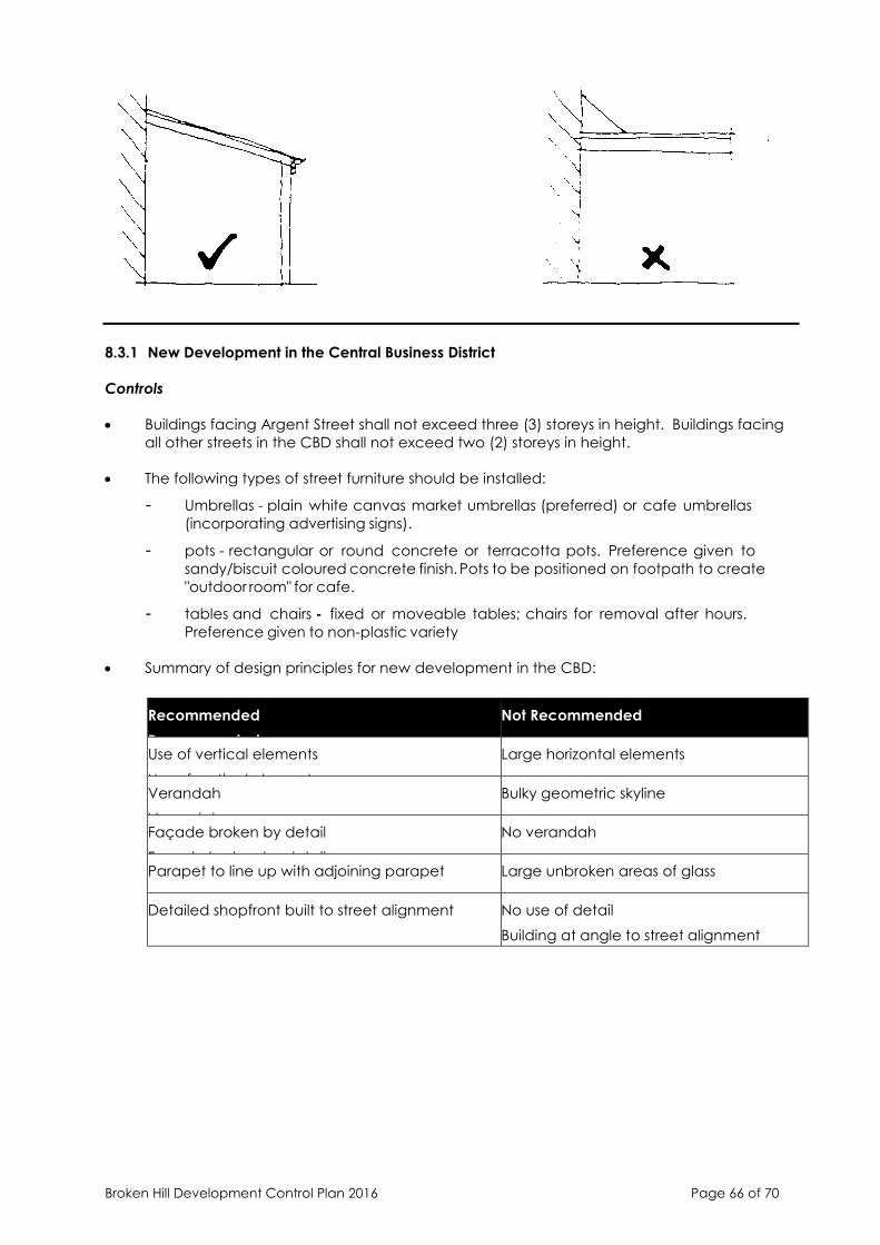
Broken Hill Development Control Plan 2016 Page 66 of 70
8.3.1 New Development in the Central Business District
Controls
• Buildings facing Argent Street shall not exceed three (3) storeys in height. Buildings facing
all other streets in the CBD shall not exceed two (2) storeys in height.
• The following types of street furniture should be installed:
- Umbrellas - plain white canvas market umbrellas (preferred) or cafe umbrellas
(incorporating advertising signs).
- pots - rectangular or round concrete or terracotta pots. Preference given to
sandy/biscuit coloured concrete finish. Pots to be positioned on footpath to create
"outdoor room" for cafe.
- tables and chairs - fixed or moveable tables; chairs for removal after hours.
Preference given to non-plastic variety
• Summary of design principles for new development in the CBD:
Recommended
Recommended
Not Recommended
Use of vertical elements
Use of vertical elements
Large horizontal elements
Verandah
Verandah
Bulky geometric skyline
Façade broken by detail
Façade broken by detail
No verandah
Parapet to line up with adjoining parapet Large unbroken areas of glass
Detailed shopfront built to street alignment No use of detail
Building at angle to street alignment
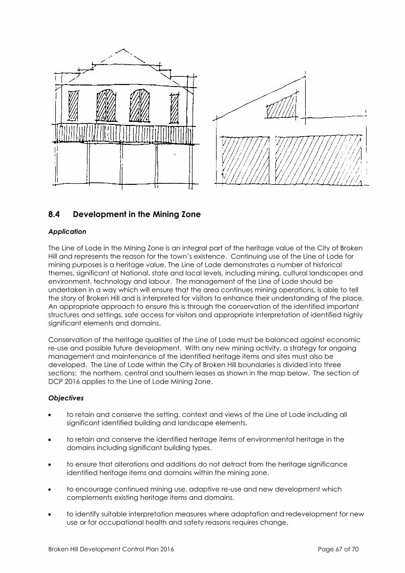
Broken Hill Development Control Plan 2016 Page 67 of 70
8.4 Development in the Mining Zone
Application
The Line of Lode in the Mining Zone is an integral part of the heritage value of the City of Broken
Hill and represents the reason for the town’s existence. Continuing use of the Line of Lode for
mining purposes is a heritage value. The Line of Lode demonstrates a number of historical
themes, significant at National, state and local levels, including mining, cultural landscapes and
environment, technology and labour. The management of the Line of Lode should be
undertaken in a way which will ensure that the area continues mining operations, is able to tell
the story of Broken Hill and is interpreted for visitors to enhance their understanding of the place.
An appropriate approach to ensure this is through the conservation of the identified important
structures and settings, safe access for visitors and appropriate interpretation of identified highly
significant elements and domains.
Conservation of the heritage qualities of the Line of Lode must be balanced against economic
re-use and possible future development. With any new mining activity, a strategy for ongoing
management and maintenance of the identified heritage items and sites must also be
developed. The Line of Lode within the City of Broken Hill boundaries is divided into three
sections: the northern, central and southern leases as shown in the map below. The section of
DCP 2016 applies to the Line of Lode Mining Zone.
Objectives
• to retain and conserve the setting, context and views of the Line of Lode including all
significant identified building and landscape elements.
• to retain and conserve the identified heritage items of environmental heritage in the
domains including significant building types.
• to ensure that alterations and additions do not detract from the heritage significance
identified heritage items and domains within the mining zone.
• to encourage continued mining use, adaptive re-use and new development which
complements existing heritage items and domains.
• to identify suitable interpretation measures where adaptation and redevelopment for new
use or for occupational health and safety reasons requires change.

Broken Hill Development Control Plan 2016 Page 68 of 70
• to conserve and manage all facets of the heritage value of the mining zone.
Design guidance
• When undertaking any development the above objectives should be incorporated as part
of the proposed development.
Identified heritage items, sites, elements and domains should be conserved and maintained
• An experienced heritage architect or conservation specialist should be engaged for works
to a significant heritage item.
• Significant original external (and internal where relevant) elements of heritage items should
be maintained. Replacement of deteriorated elements when required should be
undertaken in matching profiles and materials.
• Alterations, adaptation, additions or redevelopment should not adversely impact the
heritage values of the heritage item, unless all other alternatives have been exhausted.
• Changes should maintain the significant form, proportion, scale, details, colours and
materials of the item.
• Changes to structures still in mining use (operational) should be undertaken carefully in
light of the possible adaptation required in the future.
• Where items are already identified as ruins, stabilisation and passive decay is acceptable.
• A Statement of Heritage Impact should be prepared and submitted with the development
application which assess the impact of the proposed development.
Controls
New development
• New mining equipment and infrastructure proposed for sites within the Line of Lode will
add a modern layer of processing technology and it is important that new and old
buildings coexist appropriately where heritage items are retained.
• New development should not diminish the heritage significance of the item, site or
domain.
In considering new development the following should be taken into account:
• The height and scale of the new building and how it relates to existing buildings.
• Material and colours – these should be the same, or similar to existing predominant
materials and colours.
• Siting of new development – new development should not visually dominate or intrude into
the curtilage of an existing heritage item.
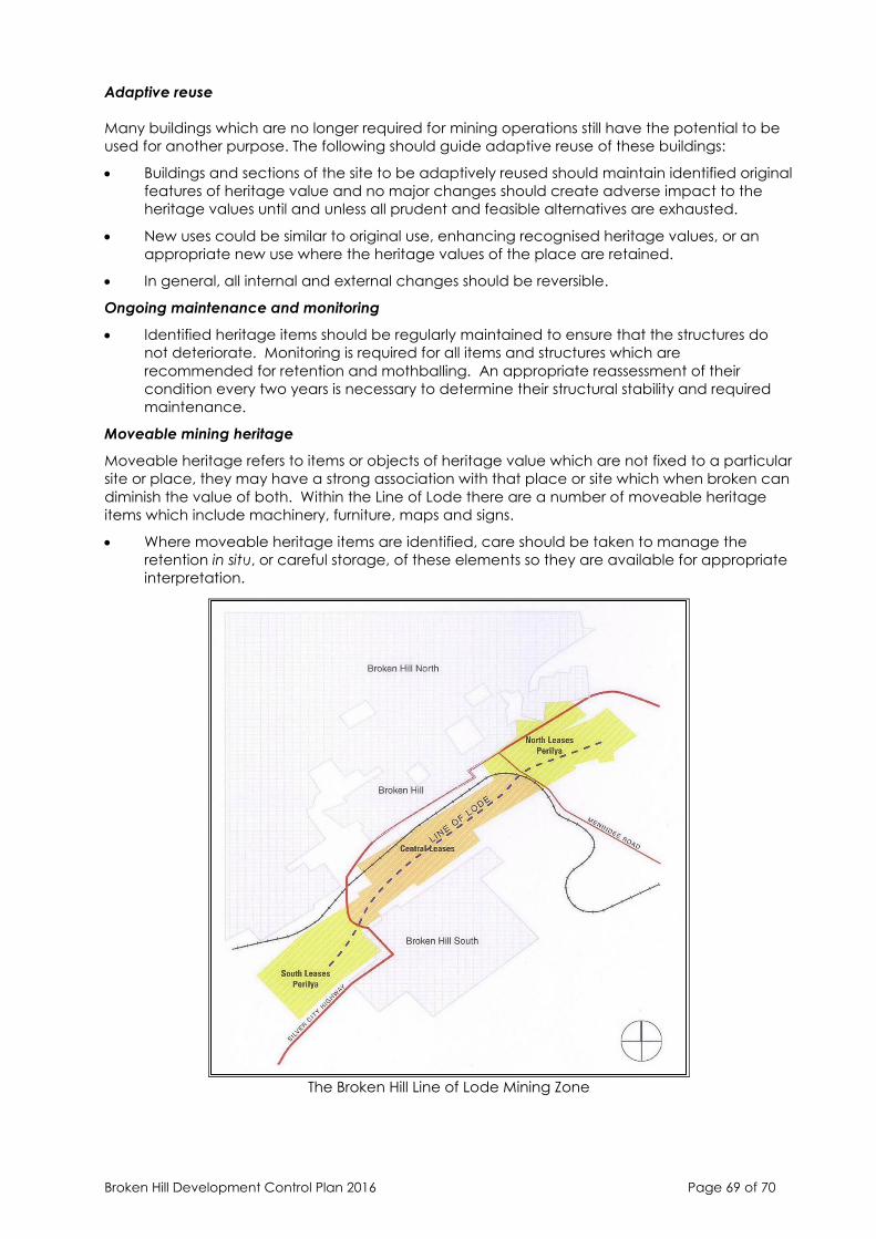
Broken Hill Development Control Plan 2016 Page 69 of 70
Adaptive reuse
Many buildings which are no longer required for mining operations still have the potential to be
used for another purpose. The following should guide adaptive reuse of these buildings:
• Buildings and sections of the site to be adaptively reused should maintain identified original
features of heritage value and no major changes should create adverse impact to the
heritage values until and unless all prudent and feasible alternatives are exhausted.
• New uses could be similar to original use, enhancing recognised heritage values, or an
appropriate new use where the heritage values of the place are retained.
• In general, all internal and external changes should be reversible.
Ongoing maintenance and monitoring
• Identified heritage items should be regularly maintained to ensure that the structures do
not deteriorate. Monitoring is required for all items and structures which are
recommended for retention and mothballing. An appropriate reassessment of their
condition every two years is necessary to determine their structural stability and required
maintenance.
Moveable mining heritage
Moveable heritage refers to items or objects of heritage value which are not fixed to a particular
site or place, they may have a strong association with that place or site which when broken can
diminish the value of both. Within the Line of Lode there are a number of moveable heritage
items which include machinery, furniture, maps and signs.
• Where moveable heritage items are identified, care should be taken to manage the
retention in situ, or careful storage, of these elements so they are available for appropriate
interpretation.
The Broken Hill Line of Lode Mining Zone