bonaparte gold property kamloops, british … · technical report bonaparte gold property kamloops,...
TRANSCRIPT

TECHNICAL REPORT
BONAPARTE GOLD PROPERTY KAMLOOPS, BRITISH COLUMBIA
KAMLOOPS MINING DISTRICT
NTS MAP NO. 092P/01W
51 DEGREES 00 MINUTES NORTH LATITUDE 120 DEGREES 27 MINUTES WEST LONGITUDE
for
Owner: Brad Jefferson. 947 Frederick Road,
North Vancouver, BC Canada V7K 1H7
Operator: Encore Renaissance Resources Corporation.
5623 145A Street, Surrey, BC
Canada V3X 8E3
BY
Shaun M. Dykes , M.Sc.(Eng), P. Geo . 514 East Columbia St. New Westminster B.C.
V3L 3X7
April 30, 2009 FINAL

Page 2
Bonaparte Gold Property Technical Report - Geologic Systems Ltd. April, 2009 2
TABLE OF CONTENTS SUMMARY................................................................................................................................................ 4 INTRODUCTION AND TERMS OF REFERENCE ................................................................................ 5 DISCLAIMER ............................................................................................................................................ 5
Property Description and Location ......................................................................................................... 6 Ownership Agreements........................................................................................................................... 6 Accessibility, Climate, Local Resources Infrastructure and Physiography .......................................... 11 History................................................................................................................................................... 11
GEOLOGY SETTING.............................................................................................................................. 15
Regional Geology ................................................................................................................................. 15 Local Geology....................................................................................................................................... 15 Mineralization ....................................................................................................................................... 17 Deposit Types ....................................................................................................................................... 20 EXPLORATION................................................................................................................................... 23
GREY JAY VEIN:............................................................................................................................ 23 CROW VEIN:................................................................................................................................... 23 OWL VEIN:...................................................................................................................................... 25 NUTCRACKER VEIN:.................................................................................................................... 26 RAVEN VEIN: ................................................................................................................................. 26 EAGLE-CHICKADEE VEIN: ......................................................................................................... 27 FLICKER AND WOODPECKER VEINS:...................................................................................... 27
SAMPLING, ANALYSIS AND DATA VERIFICATION.................................................................. 28
Survey Grid and Work Location Plotting Problems ............................................................................. 29 ADJACENT PROPERTIES. .................................................................................................................... 29 MINERAL PROCESSING AND METALLURGICAL TESTING......................................................... 29 MINERAL RESOURCE AND MINERAL RESERVE ESTIMATES.................................................... 30 INTERPRETATION AND CONCLUSIONS.......................................................................................... 30 RECOMMENDATIONS.......................................................................................................................... 31
Phase 1 - Regional Exploration and Bulk Sampling............................................................................ 31 Phase 2 – Exploration and further development ................................................................................... 32
PROGRAM COST ESTIMATE............................................................................................................... 33 CERTIFICATE OF QUALIFICATIONS................................................................................................. 35 BIBLIOGRAPHY..................................................................................................................................... 36 APPENDIX 1............................................................................................................................................ 38

Page 3
Bonaparte Gold Property Technical Report - Geologic Systems Ltd. April, 2009 3
List of Figures
List of Figures............................................................................................................................................ 3
Figure 1 : British Columbia Location Map............................................................................................... 8
Figure 2 : Property Location Map............................................................................................................. 9
Figure 3 : Claims Location Map ............................................................................................................. 10
Figure 4 : Property Photographs ............................................................................................................. 14
Figure 5 : Lithostratigraphic Section Discovery Area ........................................................................... 16
Figure 6 : Bonaparte Gold Property Discovery Area Site Plan .............................................................. 18
Figure 7 : Geology Photographs ............................................................................................................. 19
Figure 8 : Drill Hole Collars and Hole Traces........................................................................................ 22
Figure 9 : 1: 2000 Scale Ramp Plans ...................................................................................................... 33
Page 4
Bonaparte Gold Property Technical Report - Geologic Systems Ltd. April, 2009 4
SUMMARY The 2216 hectare (5,507-acre) Bonaparte Gold Property is located at 510 02' North, 1200 27' West in close
proximity to Kamloops, B.C. (less than 1 hours drive) Access to the property is by well maintained paved and gravel
roads. Work on the property commenced in 1985 with the discovery of high-grade gold in quartz float. The previous
work has outlined the presence of a series of well-developed, en-echelon, shear/fracture zones that contain
auriferous quartz veins within a Triassic/Jurassic quartz diorite that intrudes late Paleozoic volcanics and
metasediments. These zones average 2 to 3 meters thick and contain quartz veins that range from 10cm to 3
meters in thickness. They appear to be located 12 to 15 meters apart within a larger regional structure. Work to
date has outlined at least ten veins (nine of which have been named) in an area 300m wide and 350m in length,
some of the veins have been outlined to a depth of 40 meters with the deepest intersection located 108 meters
below surface. The zone containing the fracture/shears is wide open in all directions. Additional information from
drilling and direct observations by the author indicates a minimum 200 meter extension in width to the regional
structure is evident with more veins to be found within the extension.
Diamond drilling to date has been concentrated mainly on the western-most three of these zones, namely the Crow,
Grey Jay, and Nutcracker. Some exceptionally high grade gold intersections were encountered in trenching and
diamond drilling. In consequence, two small open pits were excavated in 1994, yielding a 3,700 tonne bulk sample
grading approximately 26.5 grams gold per tonne. The sample was shipped to the Trial Smelter,. Mining was
discontinued, not due to lack of ore, but due mainly to the on-set of winter conditions. Several high-grade
intersections were encountered in diamond drilling beneath the present bottom of the pit include 113.70 gms Au over
a horizontal width of 0.87 m, 84.21 gms/1.44 m, 142.97 gms/1.2m, 321.22 gms/0.56 m, and 115.41 gms/1.07 m, plus
a multitude of other significant intersections. Out of 112 holes drilled to date seven(7) holes had intersection higher
than 34 gms Au/tonne, twenty-four(24) range between 8.56 and 34 gms Au/tonne, and nineteen(19) range between
3.4 and 8.56 gms Au/tonne over the width of the vein. The remaining holes had low grade intersections. Extensive
work is required in order to establish the connectivity between these intersections, so that a proper (NI 43-101)
mineral resource can be calculated.
It is likely that the portion explored to date is only a small part of a much larger more extensive mineralizing
system that requires detailed exploration to define. In addition to the shear/fracture hosted mineralization,
potential exists for large bulk tonnage, porphyry copper-gold mineralization and for paleo-placer style
mineralization within the unconformity between the host rocks and the overlying plateau basalt.
In order to further explore the property a two phase exploration program has been recommended with a overall
budget of approximately $2,640,000.

Page 5
Bonaparte Gold Property Technical Report - Geologic Systems Ltd. April, 2009 5
INTRODUCTION AND TERMS OF REFERENCE
The author was commissioned by Encore Renaissance Resources Corporation to examine all available
data, visit the property and make recommendations as to the potential size and extent of the
mineralization and what work will be required to further develop the property. Previous maps and
reports include several Assessment Work Reports submitted to the Ministry of Mines between 1986 and
1995 and internal company reports describing specific exploration programs. The author carried out an
on site evaluation of the property October 27 to 29, 2003.
In March, 2009 the author was asked to update the report with information from a 2004 silt sampling
survey and a 2003 diamond drill program.
It should be noted that any resource/reserve estimates referred to in this report are historical and as such
in accordance with NI 43-101,section 2.4 they should be used only as an indicator of the potential of the
property.
DISCLAIMER The author has prepared this report based upon information believed to be accurate at the time of
completion, but which is not guaranteed. The author has relied on information provided by Encore
Renaissance Resources Corporation from their technical files including published literature and private
historic files. In writing this technical report, the author has relied on the truth and accuracy presented
from the sources listed in the Reference section of this report.
The author has not made an in-depth investigation to verify the status of the claims that comprise the
Bonaparte property. Claims and Title to the Bonaparte Property claims has been reviewed by
management of Encore Renaissance Resources Corporation who takes responsibility for their accuracy.
The author reserves the right, but will not be obliged, to revise this report if additional information
becomes known to the author subsequent to the date of this report. The author assumes no responsibility
for the actions of Encore Renaissance Resources Corporation.

Page 6
Bonaparte Gold Property Technical Report - Geologic Systems Ltd. April, 2009 6
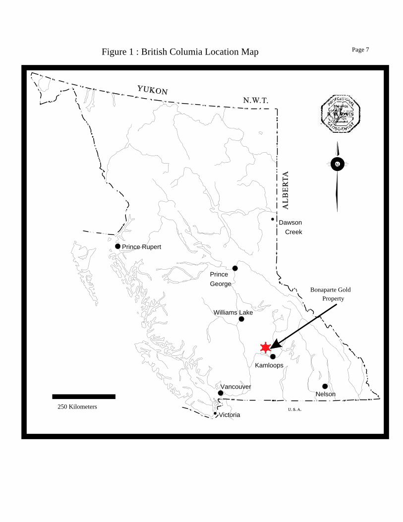
Property Description and Location
The Bonaparte gold property is located approximately 35 km north of Kamloops, B.C. (Kamloops
Mining Division) on Map sheets 92I/16W & 92P/1W, at about 510 02' North, and 1280 28' West
(Figures. 1 and 2). Access is by way of a 24km paved road north from Kamloops and then by and
additional 24.7 km of well-maintained gravel logging roads namely the Jamieson-Wentworth Creek and
Bob Lake Roads. The property is accessible by two-wheel drive automobile in dry weather, four wheel
drive is recommended during the wet and/or winter conditions.
Ownership Agreements
Originally staked as six 2-post claims called the “Bon” claims by Egil Livgard, P. Eng. in July and
August, 2002 the property was sold to Uganda Gold Mines Ltd. (UGM). UGM then granted Clan
Resources Ltd. (CRL) an option to earn a 100% interest for consideration of a 2% Net Smelter Returns
royalty, $60,000, in incremental to December 31, 2005, and the issuing of 200,000 shares, in increments
to Dec. 31, 2004. Timothy Young in December, 2002 on behalf of CRL staked the Aparte 1 and 2
claims, which consist of 38 units (2100 acres), that completely overlapped the original “Bon” claims.
In July of 2003, Egil Livgard transferred full ownership of the “Bon” claims, and Timothy Young
transferred ownership of the “Aparte” claims to CRL. The “Bon” claims may or may not appear on the
latest government claims maps as they have been incorporated into the “Aparte” claim group, and have
had the expiry date change to coincide with the expiry date of the Aparte 1 claim (December 14,2004)
Under the terms of the earlier agreement between UGM and CRL, the agreement was modified such that
the Aparte 1 and Aparte 2 mineral claims (which include the Bon Mineral Claims) were to be held in
trust for UGM pending the exercise of the option. If, on the other hand, for any reason the option is not
exercised and is terminated, CRL agreed to transfer these claims over to UGM free and clear of any
liabilities and encumbrances.
In July 18, 2003, CRL entered into an agreement with North American Gem Inc.(NAG) whereby NAG
was granted an option to earn up to a 70% interest in "Aparte" claim group (including the Bon). Under
the agreement, NAG may earn a 60% interest in the property by paying CRL $100,000 in cash, issuing
400,000 shares of NAG and incurring $1,000,000 in expenditures on the property over the life of the
Page 7
Bonaparte Gold Property Technical Report - Geologic Systems Ltd. April, 2009 7
agreement. Additional provisions of the agreement will allow NAG to increase its interest to 70% upon
payment of certain lump sums to CRL during the term of the agreement.
In late 2003, early 2004 NAG returned the property to Uganda Gold Mines Ltd, who had changed their
name to Canaf Group Inc (CANAF). As a result of the change in staking regulations and the switch
from ground staking to map staking , all claims were re-acquired and assigned new numbers. CANAF
in turn transferred the ownership in all claims to Brad Jefferson. A.J. Beaton Mining is currently the
agent, manager and operator of the property. In total, the claims cover an area of approximately 2216
hectares or 5,507 acres (Figure 3).
CLAIM NAME
UNITS
TENURE No.
EXPIRY DATE
28 504482 Aug.. 15, 2011 BONER 11 504717 Aug.. 15, 2011 24 522159 Aug.. 15, 2011 20 522160 Aug.. 15, 2011 3 522161 Aug.. 15, 2011 18 522329 Aug.. 15, 2011 UGPART 4 537111 Aug.. 15, 2011
Dawson Creek
Kamloops
Williams Lake
NelsonVancouver
Victoria
Prince Rupert
Prince George
Figure 1 : British Columia Location Map
Bonaparte GoldProperty
N
250 Kilometers
Page 7

0 5 10 15 20Scale in KilometresGeologic Systems 2003
Kamloops
BONAPARTEGOLD
PROPERTY
McLure
Black Pines
Vinsula
Heffley Creek
Rayleigh
Westsyde
Oak Hills
North Kamloops
Tranquille
Figure 2 - Property Location Map
N
Page 8

522160
504717
504482522329
522159
0 500 1000 1500 2000
Scale in Meters
N
Geologic Systems 2009
Figure 3 : Claims Location Map
DiscoveryArea
684,0
00
680,0
00
5,653,000
5,656,000
Page 9
537111
522161

Page 11
Bonaparte Gold Property Technical Report - Geologic Systems Ltd. April, 2009 11
Accessibility, Climate, Local Resources Infrastructure and Physiography The Bonaparte Gold Property lies on the Thompson Plateau at elevations between 1,600 to 1850 meters
(5,300 and 6,100 feet) above sea level. The property is mainly forested with fir but contains some open
meadows and swampy areas. Due to the elevation, the climate is relatively cool. Annual precipitation
exceeds 40 inches (100 cm) and falls mainly as snow, causing heavy spring run-off.
History
The Bonaparte property was first explored in 1973 for molybdenum mineralization by Amoco Canada
Petroleum Company Ltd. The work consisted of geological mapping, soil sampling, magnetometer and
IP surveys and drilled 300 meters (2 holes) on the property .No mention was made of gold
mineralization at that time.
In 1984, regional stream silt sampling by MineQuest Exploration Associates Ltd. (on behalf of
GoldQuest I Limited Partnership) resulted in the discovery of gold mineralization in quartz float over a
diorite intrusion on the present Discovery area of the property. These intrusions had previously been
explored for copper-molybdenum porphyry-type mineralization. In 1985, a total of 11 claims were
staked by MineQuest (for GoldQuest 1 LP), totaling 53 units. Inter-Pacific Resource Corp. acquired the
right to earn a 75% interest in the property in September of that year and work by MineQuest resulted in
the discovery of additional gold-bearing float with grades varying from 3.4 to 547 gms Au/tonne (0.1 to
almost 16 oz Au/ton). A diamond drill hole drilled in early 1986 intersected 0.79m (2.8 ft) of quartz vein
assaying 35.6 gms Au/tonne (1.04 oz Au/ton), confirming that the boulders were derived from local
bedrock. Later, in 1986, Inter-Pacific optioned a 50% interest in the property to the Hughes-Lang Group
of companies.
Exploration between 1985 and 1989 conducted by MineQuest, consisted of geological mapping,
geochemical and geophysical surveys, 1,683 m trenching (5,520 ft ), test pits (38), and 4,428 m diamond
drilling in 64 holes (14,527 ft). The trenching and diamond drilling encountered high grade gold values
over widths of 0.6 to 2.0 meters (2.0 to 6.6 feet) and in diamond drill holes typically to a depth to
vertical depths up to 108 meters (354 feet).

Page 12
Bonaparte Gold Property Technical Report - Geologic Systems Ltd. April, 2009 12
In early 1994, the property was purchased outright from the GoldQuest/Inter-Pacific / Hughes-Lang
groups by Beaton Engineering. An agreement was then signed with Claimstaker Resources Ltd. to
grubstake development of the high-grade veins by open pit methods on the basis of a net-profits interest.
A resource estimate of 6,400 metric tonnes grading 25.4 gms Au/tonne (0.74 oz Au/ton) for the Crow
zone was reported in 1994 (Vancouver Stockwatch, May 2,1994). It should be noted that the resource
estimate calculation method, assumptions etc are unknown, however the estimate appears to be very
reliable having been confirmed by a bulk sample taken and thus can be used to indicate the potential
grade of veins exposed on the property. A bulk sample taken in 1994 from within the defined resource,
consisted of 3,700 metric tonnes (4.000 short tons) of mineralization was removed from the Grey Jay -
Crow vein and direct-shipped to the COMINCO smelter at Trail, B.C., yielding approximately 98 kg
(3,160 oz) of gold. The shipped ore graded 26.5 gms Au/tonne versus 25.4 gms Au/tonne for the
estimated resource. It is important to note that the sample was taken in a near vertical trench, with the
entire width of the zone being removed and shipped. Thus the bulk sample represents an accurate
estimate of grade of the vein including any dilution within this area. Bulk sample mining was
discontinued due to pit walls becoming too steep to warrant safe mining, particularly since winter-like
freeze-thaw conditions had set in. The maximum vertical depth reached in the deepest section of the pit
was estimated at just 12 m (40 feet ) below surface. A significant amount of unshipped broken ore
remains on the dump. Figure 4 shows a view of the open pit area.
During the 1994 and 1995 period, additional work on the property by Claimstaker Resources consisted
of 1,185 m (3,887 ft ) diamond drilling in 25 holes. The claims then reverted to Beaton Engineering in
1997. In 1998, 1,171.3 m (3,848 feet) diamond drilling in 23 holes were completed on behalf of Orko
Gold Corporation who had purchased the property outright from Beaton Engineering. The information
on these is contained in an unpublished report of that year by Egil Livgard, P. Eng. (see Bibliography).
Ash (2003) has compiled a listing of all drill hole and trench information, some information is missing
and should be added as soon as possible to these tables, (see Appendix 1, tables 1 and 2).
In late October, 2003 a program of diamond drilling was carried out by North American Gem Inc. A
total of 652.1 meters (2139 feet) in 15 holes was drilled on the property.

Page 13
Bonaparte Gold Property Technical Report - Geologic Systems Ltd. April, 2009 13
Finally in July 2004 a stream silt sampling program was carried out consisting of 59 samples. He results
show clusters of anomalous values in Wentworth Creek below the confluence with Mine Creek that
drains the main discovery area and in some small creeks draining an area to the south. This is of interest
as it shows potential for additional quartz veins beneath the basal cover ( figure 3, Livgard, 2004)
Diamond Drill Hole Summary
Year Number total Total Drilled holes meters feet 1986 26 1250.2 4101.7 1987 24 1884.7 6183.4 1989 14 1293.3 4243.1
1994-5 25 1185.0 3887.8 1998 23 1171.3 3842.8 2003 15 652.1 2139.4
127 7,436.6 24,398.3
The majority of work to date has been restricted to a relatively small area, termed the “Discovery Area”.
It measures 300 m (1,000 ft) wide (east west) by 350 m (1000 feet) long (north-south). Trenching and
diamond drilling have identified several quartz veins at regular intervals across the 300m width. The
veins discovered in trenching were named after birds, including the Grey Jay, Nutcracker, Crow, Owl,
Raven, Eagle, Chickadee, Flicker and Woodpecker. High grade, sporadic values were encountered in
many of these veins both in trenching and diamond drilling. Figure 4 shows typical photographs of the
trenching and quartz veins.
It is important to note that the trenching and diamond drilling tended to concentrate in the immediate
vicinity of vein exposure and no systematic continuous trenching or drilling was conducted. In fact two
more vein exposures were uncovered by the operator during the recent visit of the author to the property,
as the result of trenching between known veins.

Photo #1a View looking South of Crow/grey jay open pit
Photo #1b View looking South along Eagle Vein Photo #1c View looking south along Flicker Vein
Figure 4 : Property Photographs
Page 13

Page 15
Bonaparte Gold Property Technical Report - Geologic Systems Ltd. April, 2009 15
GEOLOGY SETTING
Regional Geology The regional geology has been summarized by Gourlay (1985) as follows: “The North Thompson [sic] Bonaparte claims cover the boundary between two map sheets at 510 00' N. Cockfield (1948) mapped the Nicola sheet and considered the rocks in the claim area to be carboniferous to Permian Cache Creek Group (argillite, quartzite, hornstone, limestone, sheared conglomerate, breccia, greenstone, serpentinite, and minor carbonate). To the north, the Bonaparte Lake map sheet was mapped by Campbell and Tipper (1965), who designated the rocks as Pennsylvanian to Permian volcanic arenite, greenstone, argillite and phyllite with minor quartz-mica schist, limestone plus basaltic and andesite flows. The sequence was intruded by granitic rocks similar to the early to mid-Mesozoic Thuya and Takomkane batholiths, with composition of hornblende-biotite quartz diorite and granodiorite, with minor hornblende diorite, monzonite, gabbro, and hornblendite. Miocene Plateau basalts are found at higher elevations and are predominantly olivine basalt and andesite with minor ash and breccia. More recently, Monger and McMillan (1983) have mapped the Ashcroft Map area and have classed the basement in the claims area as Paleozoic and Mesozoic, with volcanic rocks similarly to the Triassic Nicola Group and sedimentary rocks similar to the “Harper Ranch Group” of Devonian to Permian age. Volcanic rocks are augite porphyry, bladed feldspar porphyry, chlorite schist, and metabasalt, whereas the sedimentary strata comprise argillite, cherty argillite, siltstone, volcanic and chert grain sandstone, chert pebble conglomerate, volcaniclastics of basic to acid composition and rare carbonate pods.”
Local Geology The geology of the immediate area of interest represents an erosional window through a sequence
Miocene Plateau basalts in which the Devonian to Triassic metasediments and volcanics are exposed.
These have been intruded by Triassic/Jurassic quartz diorite that is believed to be part of the larger
Thuya batholith. Several large lineaments/faults crosscut the area subdividing it into separate structural
domains. Figure 5 shows a lithographic section of the Discovery area.
The immediate area of interest consists of several on-echelon fracture/shear zones that cut the quartz
diorite intrusion and possibly the older country rock. The fracture/shear zones appear to be part of a
larger regional structural zone that is exposed for a 300m width and 350 m strike length. The individual
fracture/shear zones tend to be quite tight and relatively narrow, generally 2 to 3 meters wide strike
northerly, dip 40 to 60 degrees to the east and have sharp contacts with the surrounding quartz diorite.
The exact dimensions of the zones has not yet been defined as they remain open in all directions.


Page 17
Bonaparte Gold Property Technical Report - Geologic Systems Ltd. April, 2009 17
The zones are variable and contain varying amounts of silicified quartz diorite and auriferous quartz
veins. The auriferous quartz veins can occupy the entire width of the fracture/shear zone, can form a
narrow 10 to 20cm wide center or can be patchy, stockwork like areas of veins and veinlets. There is
little indication of major displacement along these fracture/shear zones. The fracture/shear zone hosting
the Crow/Grey Jay system (Figure. 6) has been traced on surface for well over 350 meters and remains
open both along strike to the north and to the south where it passes beneath the basalt cap. Although
there is a tendency for the quartz vein widths to vary a great deal along strike, with veins narrowing
from over two meter to hairline widths in a matter of a few meters, the actual fracture/shear zones can be
traced using the silicification, in addition to the quartz veins themselves.
Mineralization Locally the quartz veins contain up to several percent sulphides consisting of pyrite with lesser
chalcopyrite, pyrrhotite and molybdenite. Native gold is also observed in association with fine grey
tellurides, a relationship with chalcopyrite has also been noted. Sulphides, especially chalcopyrite, tend
to be coarse grained. There appears to be a weak correlation between the gold content and width of the
veins, and a stronger correlation between gold and sulphide content. In the western part of the
fracture/shear system, veins appear to be very tight with very little alteration, stockwork or veins in the
country rock; to the east the amount of veins, veinlets, stockwork and alteration in the wall rock
increase until at the Flicker vein there are heavy concentrations of sulphides in the wall rock. This could
be an indication of an increase in fracturing and thus potential mineralization to the east.
The thicker quartz veins within the fracture/shear zones appear to be weakly zoned with dark gray-to
white granular quartz near the contacts or as patches and a white massive to fine grained locally
fractured quartz. Heavy concentrations of sulphides appear to be related to the dark grey granular
quartz. While the massive quartz has sulphides as small irregular shaped spots that appear related to
fractures within the quartz. Also vugs within the quartz are often rimmed with sulphide. Figure 7 shows
some typical rock samples from the area.
The section of the Discovery Area explored to date measures only 300 m east-west (cross-sectional
distance), by 350 m north-south (along strike). Over ten semi-parallel veins have been exposed on
surface to date over this cross-sectional distance, the majority of which have been found to be gold
bearing to some degree. The nine veins accorded names include the Grey Jay, Nutcracker, Crow,

Access RoadTo Kamloops
Grey ja
yCr
owO
wl
Rav
en
Eagl
eC
hick
adee
Flic
ker
Woo
dpec
ker
Triassic Volcanics andLate Paleozoic Sediments
Jurassic/Triassic Quartz Diorite
Hornfels
Tertiary Tuff
Miocene basalt
N
Figure 6 : Bonaparte Gold Property Discovery Area Site Plan
(Modified from Ash, W. (2003))Geologic Systems 2003
Quartz Vein
Access Road and cleared area
Geologic Contact0 50 100 150 200
Scale in meters
ProposedUnderground
Drift
8000 N
8300 N
3700
E
4000
E
Page 19
Quartz VeinBoulders
Quartz Veinin Creek
Nut
crac
ker

Photo #2a Typical High Grade Quartz Vein. Note: Sulphide association with darker colored quartz areas.
Photo #2b Relatively unaltered Quartz Diorite Photo #2c Silicified Quartz Diorite
Figure 7 : Geology Photographs
Photo #2d Quartz Diorite with irregular quartz patches and veinlets
Quartz
Geologic Systems 2003
Page 20

Page 20
Bonaparte Gold Property Technical Report - Geologic Systems Ltd. April, 2009 20
Owl, Raven, Eagle, Chickadee, Flicker and Woodpecker (Figure. 6). These veins were originally
discovered by trenching through clusters of mineralized, frost-heaved boulders to bedrock, with further
cross-trenching of the encountered fracture/shear zone along strike.
The past drilling was almost entirely restricted to the Crow, Nutcracker and Grey Jay vein systems
(Figure 8). Large sections within the Discovery area remain almost entirely unexplored although other
“blind” veins have been intersected in diamond drilling. While on the property the author visited:
1. An area where many large well-mineralized quartz boulders strewn throughout the glacial till, some 60 meters to the north-west of the Crow open pit beyond any of the existing work. This area contained large up to 1m wide irregular shaped, angular pieces of mineralized quartz veins almost identical to the existing veins. Since the boulders were found in the up ice direction they are not the result of glaciation but more probably the result of frost heaves and represent an additional zone 60m west of the current work area.
2. An exposed quartz vein in the creek bottom approximately 110 meters east past the Flicker vein. The vein exposed was approximately 1m wide and strikes parallel to the main fractures, and contains minor disseminated sulphides.
3. Two new quartz veins between, eagle and crow veins, exposed by excavator trenching. Confirming the regular nature of the fracture/shear zones with the overall structure.
4. A couple of quartz boulders located in the glacial till immediately to the south-east of the Crow vein currently being drilled.
The above indicate that the structural zone containing the individual auriferous quartz bearing
fracture/shear zones is at least 200m wider than the area currently being explored.
In addition, another prospective area, located along trend, some 1,000 meters to the south-east of the
Discovery Area, was scheduled for more detailed work in the late 1980's although this was not carried
out. The area was outlined by a geophysical and geochemical survey plus some small frost heave
boulders of quartz material were also noted. All this indicates that the area is wide open in all directions
and the actual width and strike extension of the overall structural system that contains the auriferous
quartz bearing fracture/shear zones is unknown. In conclusion the Discovery Area is likely to constitute
a relatively small portion of a much wider area of highly prospective ground.
Deposit Types The existing mineralization consists of series of well-developed, en-echelon, shear/fracture zones that
contain auriferous quartz veins within a Triassic/Jurassic quartz diorite . These individual zones are
contained in an overall regional structural zone within the quartz diorite. It would appear that these

Page 21
Bonaparte Gold Property Technical Report - Geologic Systems Ltd. April, 2009 21
structures are related to the final stages of cooling of the quartz diorite intrusive body, as the veins
appear to be multi-staged and vary from silicified zones with narrow quartz veins that grade into the
quartz diorite to sharp contact quartz veins. Further work is required to confirm the concept.
In addition to the shear/fracture zones within the quartz diorite, potential exist for other related styles of
mineralization such as large bulk tonnage copper-gold porphyry style mineralization at or near the
contact between the quartz diorite and the country rocks and/or a paleo-placer style of mineralization
located in areas where the shear/fracture structure intersect the unconformity between the Paleozoic
intrusions and sediments, and the covering Miocene plateau basalt.
In the case of large bulk tonnage, copper-gold porphyry style mineralization the author observed the
following during the recent property visit.
1. The amount of fracturing and quartz veinlets in the country rock between the individual fracture/shears zones is increasing toward the east.
2. At Flicker vein up to 5% chalcopyrite was observed in quartz diorite wallrock and micro-veinlets up to 1m away from the vein.
3. Weak Argillitic alteration was associated with the chalcopyrite in the wall rock
During regional work especially to the eastern side of the main area, attention should be paid to the
features of this style of deposit, especially in areas where the quartz diorite is in contact with the
overlying Triassic -Jurassic country rocks.
The second type of deposits (paleo placer) could form where the shear/fracture zones intersect the
unconformity with the overlying basaltic cap rocks. They form as a result of mechanical weathering of
the auriferous veins resulting in the concentration of gold grains, exactly like a placer deposit. Special
attention needs to be paid to textures and structures within the unconformity that could indicate any
potential transport directions. Although no evidence exists for the presence of this type of deposit, the
tracing of the vein structures to within 30m of the basalt cap would indicated that the intersection
between the unconformity and the individual shear/fracture zones should be examined in more detail for
this type of deposit

4900 E
1916,17
1
235
6,710
12
11
12
11,12
15 13,14
13,14
18
189,10
10
21
9 24
2322,23
12
243
17
68
12
15
2166,7
3,4
6
14,15
12,13
16.17
18,19
7
20,21
11
10
4
5
16,18
1
5
1
15
3,4
3
210,11
4,5
7,17
3
19
20
8,9
27
13,14
1
11,14
21,22
6,7
2,9
8
2526
4800 E
4700 E
56
00
N
55
00
N
54
00
N
53
00
N
Flicker
Woodpecker
Eagle-Chickadee
Raven
Nutcracker
Grey
Jay
Crow
- Central
Cro
w-S
outh
N
Figure 8 : Drill Hole Collars and Hole Traces
0 50 100Scale in Meters
1986 Drill Hole
1987 Drill Hole
1989 Drill Hole
1994 Drill Hole
1998 Drill Hole
Open Pit Area
Quartz Vein
Page 23
Crow
-N
orth
OWL
1,2
3
4,56,7
8
9,10
11
12
131414
15
2003 Drill Hole

Page 23
Bonaparte Gold Property Technical Report - Geologic Systems Ltd. April, 2009 23
EXPLORATION In order to properly describe the exploration on the property each vein is dealt with as a separate section.
GREY JAY VEIN: Three longitudinal trenches in 1987 (Trenches 22, 37, 45 & 46)(Appendix 1, Table 2), exposed the vein
continuously over a strike length of 55 meters. The vein strikes at 23 degrees azimuth degrees and dips
45 degrees to the east. Based on a combination of channel and panel sampling (69 samples in total), the
average true width and grade sampled, of the 55 meter strike length was 29 gms Au/tonne over 0.95
meters (0.846 oz Au/t over 3.1 ft). The Grey Jay vein may intersect the Crow and Owl veins at its south
end, at depth. This vein is quite wide at surface but appears to narrow with depth. The upper 40 vertical
feet of this vein were removed in open pitting in 1994. Since 1987 additional trenching and the open pit
has extended the vein. A total of 12 diamond drill holes have been identified as intersecting the zone.
All the work to date has outlined the extent of the vein as 126 meter in strike, 46 meters in depth and an
average width of 1.1 meters. It is still open along strike to the south.
Of particular interest is DDH89-6, which graded 321 gms Au/t over a true width of 0.56 m, located an
estimated nine meters down-dip of the bottom of the main open pit (appendix 1, Table 1). This is a
prime target for additional work most likely by driving a ventilation raise during the proposed
underground development program.
CROW VEIN: Trench 45, excavated in 1987, located in the center segment, discovered the vein, and exposed it
longitudinally by a combination of channel and panel samples (Appendix 2, Table 3). It showed an
average true width and grade of 1.15 m @ 14.4 g Au/t (17 samples) over a trench length of 30 meters
(open along strike to the north).
Between 1986 and 1989, the Crow vein was intersected by 36 drill holes, and by seven holes in 1998. It
was likely intersected by additional holes in 1994 and/or 1995 but due to lack of complete data, the
author cannot tell how many of the 25 holes drilled, intersected the vein although the Claimstaker
Resources Ltd. map (Appendix 1) suggests that at least four intersections were made, grading 7.0 gms
Au/t or higher. The overall extent of the Crow vein outlined prior to the start of the October 2003
program was 250m in strike, depth to 50 meters and 1 to 1.3 meter in thickness. At the time of the

Page 24
Bonaparte Gold Property Technical Report - Geologic Systems Ltd. April, 2009 24
authors visit drill holes on the southern extension had intersected the vein a further 65 meters south.
Both trench and drill data suggest the Crow vein consists of three discrete segments, labeled the North,
Central and South segments (figure 8).
Crow Vein South: The South segment strikes at 27 degree azimuth and dips at 55 degrees to the east. It is separated from
the Central section by a major fault, which displaces the South section some 10 meters to the west. The
width of the vein is generally good, with no apparent change with depth. For the most part, the grade is
lean. Up until 1997, only 4 holes out of 15 returned encouraging intersections (DDH89-4 [email protected]
gms Au/tonne, DDH89-11 [email protected] gms Au/tonne, DDH94-3 [email protected] gms Au/tonne,
DDH94-4 0.56m @12.16 gms Au/tonne) (appendix 1, Table 1).. However, in 1998, DDH98-1
intersected a true width of 4.0 meters grading 11.30 gms Au/ tonne at a depth of 40 vertical meters
below the collar. The initial holes in the recent 2003 drill program have been drilled in the area of this
intersection. The author was able to observe the drill core of these holes during the recent visit. Hole
03-01 intersected a 1.0m wide quartz vein, while hole 03-02 intersected quartz veins of 0.75m, 1.6m and
0.4m widths, while significant sulphide content was observed in the vein intersections no assays have
been received to date. The segment is now at least 110 meters in strike length varying from 0.8 to 1.6m
in thickness with intersections as deep as 40 meters below surface.
Crow Vein Central: The central section of the Crow vein has been well explored by both trenching and drilling. The strike
of the vein in this section averages an azimuth of 12 degrees and dips 55 degrees to the east. The
portion of the vein near the north end of the segment represents the region where the Nutcracker and
Crow veins have merged along strike. Out of 26 holes identified as intersecting the central Crow
section, eight holes have no assay indicate for the vein location, five had grades below 1 gm Au/tonne,
one had a grade of 2.05 gms Au/tonne, eight had a grade between 8.25 gms Au /tonne and 31.88 gms
Au /tonne and three had values over 84 gms Au/ton. Widths vary from 0.20 to 1.8 meters wide with the
best intersection 1.07 meters grading 115.27 gms Au/tonne(appendix 1, Table 1). Several of these holes
were outside the mined area.
It is often the case that the best grades and widths in similar type gold deposits occur at the junction of
mineralized veins. The Grey Jay vein dips at 45 degrees to the east and the Crow vein, located some 20

Page 25
Bonaparte Gold Property Technical Report - Geologic Systems Ltd. April, 2009 25
meters to the hanging-wall on surface, dips at 55 degrees to the east. This suggests that the veins may
merge at a vertical depth in the range of 60 to 70 meters. Making an extremely interesting target.
Overall the Crow Central segment was exposed for a strike length of approximately 70 meters and tested
to a depth of 55m
Crow Vein North:
This section is located at the north end of the main open pit, beyond the Grey Jay vein(figure 8) and has
not been thoroughly investigated, It appears to strike at 34 degrees and dips at 55 degrees to the east. It
was exposed by one 28 meter-long longitudinal trench and shows an average true width of 1.15 meters.
In the 1980's programs, the scant drilling encountered no high grade intersections at depth. In late 1994,
a two-hole fence was drilled. While the dips of the holes are not available to the author, it is assumed
that DDH94-11 was drilled at -45 degrees while DDH94-12 was drilled at -60 to -70 degrees (Appendix
2, Table 1). No widths or values have been recorded for DDH94-11 but DDH94-12 intersected 70.6 g
Au/t over a core interval of 0.35 m (appendix 1, Table 1). Three drill-holes drilled in 1998 cut low-
grade values over narrow widths. The Crow Central section of the structure contains high-grade gold
mineralization. The Crow South section yielded a good intersection after a relatively long stretch of low
grade mineralization. The northern projection of this structure therefore warrants at least several
additional cross-trenches to determine if the same holds true for the northerly projection.
OWL VEIN: In the “North” section of the area pitted, the Owl Vein (originally termed the “Crow A” vein), lies
between the Grey Jay and Crow North veins. It strikes at 32 degrees and dips at 50 degrees east. It was
first recognized during the interpretation of the 1988 drill program (Longe and Lee, 1989) . No attempt
was made in 1989 to trench this vein on surface since the last recorded program conducted by
MineQuest was in the winter of 1988-89, . Lee interpreted that at least 30 holes have intersected this
vein, indicating a minimum strike length in the range of 100 m and a depth extent of at least 36 meters.
It is considered part of the Crow vein system. However, it continues as a separate entity both along
strike and down-dip beyond all drill intersections. The width appears to increase with depth to a
maximum of 2.3 meters (hornfels with quartz veinlets in DDH89-8). While grades are generally low,
several significant grade intersections were noted, including 14.04 gms Au/tonne over a true width
estimated at 2.30 m (DDH98-9, appendix 1, Table 1).. The near-surface portion of this was mined from

Page 26
Bonaparte Gold Property Technical Report - Geologic Systems Ltd. April, 2009 26
the open pit. It should be noted that in the mined area, the Grey Jay, Owl, Crow (North) and Nutcracker
veins all occur within a cross-sectional width of just 20 meters. Near the south-central section of the
main open pit, Lee has interpreted the Owl vein as being in the footwall of the Grey Jay vein. Thus, she
interprets that the Owl vein crosses through the Grey Jay vein somewhere between the north and south-
central sections of the open pit. Three additional narrow veins have been intersected within a further 20
meters in the footwall of the Grey Jay vein in DDH 87-9 and DDH87-13.
NUTCRACKER VEIN: The Nutcracker vein has been considered part of the Crow vein system although it was mined as a pit
separate from the main pit. Nine cross-trenches and two longitudinal trenches exposed the vein over a
strike length of over ten meters. On surface, the vein was narrow (average 0.35 m), striking 23 degrees
and dipping at 48 degrees east. In the trenches the grade averaged 50.4 gms Au/t, with grades ranging
2.3 gms Au/tonne to 144.6 gms Au/tonne based on 25 samples over the width of the zone. The trenches
were completely mined in the bulk sample, no separate account was made of the grade of the material
from the Nutcracker portion of the bulk sample. Originally believed to terminate at its merge point with
the Crow vein, a re-evaluation conducted in 1989 suggested that it continues south beyond the merge
point. No trenching has been done to trace its southern projection. The widest and highest grades
appear to be adjacent to the merge point. Both the southern and northern projections warrant additional
trenching. This is particularly so since the vein exhibited such a high average grade. The Nutcracker
was intersected by at least 26 drill holes. The drill indicated strike length of this vein is 110 meters with
an average depth of 35 meters with one intersection at a depth of 108 meters below surface (DDH87-19,
appendix 1, Table 1)
RAVEN VEIN:
Three cross-trenches were excavated on this vein in 1986, with recovered values of up to 112.8 gms
Au/t. However the average grade and width, based on longitudinal trenching is 7.0 gms Au/tonne over a
true width of 0.69 m (based on 15 samples). Only six holes have been drilled on this structure. Only
low or nil values have been intersected, basically due to the complex faulting in several directions. The
Raven vein strikes at 20 degrees. and dips at 48 degrees east. It has a trench indicated length of 100 m
and a depth of 15 meters. Further cross and longitudinal trenching is warranted along strike in both
directions. It should also be considered a prime target for underground exploration.

Page 27
Bonaparte Gold Property Technical Report - Geologic Systems Ltd. April, 2009 27
EAGLE-CHICKADEE VEIN: The Chickadee vein was originally tested by 5 cross-trenches and a single drill-hole. The trench-
indicated length is 20 m. Grades of ranging from trace to 13.8 gms Au/tonne in 4 samples, were
encountered in surface sampling although the average trenched width is a scant 30 to 36 cm. In the
current 2003 program the vein has been renamed Eagle and trenching has exposed 75m of strike length
averaging 1.42m wide. The vein been sampled and assays are pending. Examination of a recently
blasted portion of this trench indicated the presence of 1.7m wide vein with up to 10% sulphides
consisting of pyrite-pyrrhotite-chalcopyrite with minor amounts of steel-grey minerals believed to be
tellurides. Locally the vein shows the same variations of light grey granular quartz with fine massive
white quartz observed in the Crow vein system. As with the Crow vein, the sulphides in the Eagle vein
concentrate in the light grey granular quartz areas.
FLICKER AND WOODPECKER VEINS: One trench excavated on this vein in 1986 exposed the vein over a length of 6 meters. Grades of
ranging from 1.0 to 16.1 gms Au/tonne (5 samples) were encountered in channel sampling. Two holes
were drilled on this vein. In DDH86-26, two intersections were encountered. The hanging-wall
intersection assayed 9.26 gms Au/tonne over 1.67 m while the footwall intersection assayed 8.47 gms
Au/tonne over 0.95 m. While originally thought to be intersections on the Flicker vein, these may be
part of the Woodpecker vein, due to displacement of the vein by low angle faults. The Flicker vein has a
trench-indicated length of 33 m, and average width of 0.95 m and a grade averaging 6.07 gms Au/tonne.
The deepest drill-hole intersection was 45 m deep. While relatively low grade, the width and the fact
that the vein is mineralized are good reasons for targeting this vein as an underground exploration target,
particularly since the mineralization is expected to extend down to the proposed adit level. In addition
the author observed significant quantities of chalcopyrite in the wallrocks of the vein, and that the
structure containing the vein appears to be wider and more open than previous veins.

Page 28
Bonaparte Gold Property Technical Report - Geologic Systems Ltd. April, 2009 28
SAMPLING, ANALYSIS AND DATA VERIFICATION
Examination of the various reports and programs conducted by the different companies indicates that
great care was taken in the actual sampling and assaying of samples from the property. This is evident
from the descriptions contained in the reports of the sampling and analytical methods employed(see
assessment reports). Signed assay sheets from the analytical laboratory also indicate blanks and
duplicate check samples were also run. The surface trenches were sampled using both channel
sampling, and later panel sampling. Drill core samples were split using a diamond saw with one half of
the core being sent to a commercial lab in Kamloops. Multi-ounce samples were re-assayed with check
samples being run. The samples were assayed by fire assay collection with final bead assaying using
atomic absorption methods. It is not known whether or not “metallics” assays were conducted.
A visual inspection of the core (or what is left of it after being vandalized between 1990 and 2003,
suggests that core recovery was generally excellent. Special attention was paid to the split mineralized
sections of core. The inspection showed that the mineralized zones are competent, with the gold bearing
sulphide mineralization within the solid portions of the quartz and very little on exposed fracture
surfaces. Thus, there is no valid reason to expect core recovery or fracturing would have materially
impact on the accuracy or reproducibility of the assay results.
As the work was conducted prior to the implementation of National Instrument 43-101, no extra-
precautionary care is believed to have been taken regarding security and integrity of the samples.
However, it appears for the reasons stated above that all sampling, assaying and work was conducted in
a professional manner with assays being done and reproduced by several non-related parties. Finally,
the grade estimate, from a large portion of the drilling and trenching, was confirmed by the removal of a
large bulk sample from one of the vein areas. This was shipped to a smelter with results comparing
favorably with the initial grade estimates, thus confirming the validity of the sampling and assaying
practices used.

Page 29
Bonaparte Gold Property Technical Report - Geologic Systems Ltd. April, 2009 29
Survey Grid and Work Location Plotting Problems The work conducted on the property between 1985 and 1989 used a grid system with “Grid North” at
azimuth 315 degrees. Assessment Work Reports (AR) filed during the 1985 - 1989 period show only
the work conducted for the specific year for which the report was filed. While some of the longitudinal
sections of the main veins incorporated drill-hole intersections for the entire period, there are no plans
showing all the drill-hole collars from that period. A different survey grid was used during the 1994-95
period (“Grid North” estimated at azimuth 7 deg). While tie-ins were apparently made with drill-holes
of former years, the information is not available to the author and needs to be established.
A third survey grid (“Grid North” approx. true north?) was used by Orko for plotting the holes drilled
during 1998, plus some previous hole collars. However, no assessment work report was filed with the
government and the survey data is unavailable to the author. The result is that the author has used an
overlay method in producing a composite map (see Fig. 8) of the drill-holes, main veins and mine
workings. The method consists of using common points between the different grids to transfer one grid
system to another. It is believed that there is sufficient common points and shapes between grids to give
a reasonably accurate location for most diamond drill hole collars and trenches.
As more information becomes available the data will be added and the overall database improved.
ADJACENT PROPERTIES.
There are numerous claims that surround the Bonaparte property, all are in the early stage of work with
only a few scattered showings on mainly copper found to date.
MINERAL PROCESSING AND METALLURGICAL TESTING. The author is not aware of nay detailer metallurgical testing on the property. However a bulk sample
taken in 1994 consisting of 3,700 metric tonnes (4.000 short tons) of mineralization was removed from
the Grey Jay - Crow vein and direct-shipped to the COMINCO smelter at Trail, B.C., yielding
approximately 98 kg (3,160 oz) of gold. The shipped ore graded 26.5 gms Au/tonne versus 25.4 gms
Au/tonne indicated by the exploration data. This bulk sample demonstrates that the gold is recoverable
from the veins on the property.
.

Page 30
Bonaparte Gold Property Technical Report - Geologic Systems Ltd. April, 2009 30
MINERAL RESOURCE AND MINERAL RESERVE ESTIMATES A resource estimate of 6,400 metric tonnes grading 25.4 gms Au/tonne (0.74 oz Au/ton) for the Crow
zone was reported in 1994 (Vancouver Stockwatch, May 2,1994). It should be noted that the resource
estimate calculation method, assumptions etc are unknown, however the estimate appears to be very
reliable having been confirmed by a bulk sample taken and thus can be used to indicate the potential
grade of veins exposed on the property. 3700 tonnes form this resource was mined as a bulk sample in
1994. The author is not aware of any other resource or reserve estimates for the property.
INTERPRETATION AND CONCLUSIONS Only a small portion of the Bonaparte Gold Property has been explored to date. The previous work has
outlined the presence of a series of well-developed, en-echelon, shear/fracture zones that contain
auriferous quartz veins within a Triassic/Jurassic quartz diorite that intrudes late Paleozoic volcanics and
metasediments. These zones average 2 to 3 meters thick and contain quartz veins that range from 10 cm
to 3 meters in thickness. The limits to the veins and zones have not yet been defined leaving them open
all directions. They appear to be located 12 to 15 meters apart within a wider regional structure. Where
not occupied by quartz veins the shear/fracture zones show intense silicification. Sulphides consist of
pyrite, pyrrhotite and chalcopyrite with traces of telluride's and molybdenite. Work to date has outlined
at least 10 veins in an area 300m wide and 350m in length, some of the veins have been outlined to a
depth of 40 meters, with the deepest vein intersection at 108 meters below surface. The zone containing
the fracture/shears is wide open in all directions. Additional information from drilling and direct
observations by the author indicates a minimum 200 meter extension in width is possible. A large (3700
tonne) bulk sample from just one of the veins returned a recovered average grade of approximately 26.5
gms Au/ tonne confirming the significant potential of these veins.
It is likely that the portion explored to date is only a small part of a much larger more extensive
mineralizing system that requires detailed exploration to define. Diamond drilling indicates that a
considerable tonnage of high-grade gold mineralization remains in-situ below the small open pits and
along strike on several of the veins. Extensive work is required in order to establish the connectivity
between these intersections, so that a proper (NI 43-101) mineral resource can be calculated. In addition
to the shear/fracture zones within the quartz diorite, potential exist for other related styles of
mineralization such as large bulk tonnage copper-gold porphyry style mineralization at or near the

Page 31
Bonaparte Gold Property Technical Report - Geologic Systems Ltd. April, 2009 31
contact between the quartz diorite and the country rocks and/or a paleo-placer style of mineralization
located in areas where the shear/fracture structure intersect the unconformity between the Paleozoic
intrusions and sediments and the covering Miocene plateau basalt. As before, extensive work will be
required to determine the presence of these styles of mineralization within the property.
The property is within an hour’s drive of a major population center and is readily accessible by
automobile during the summer months. The company holding the logging rights to the property is
presently up-grading the access road, and establishing new roads within the boundaries of the claims
group. The surrounding area is relatively flat and has several excellent potential sites for a milling and
tailings complex. The water supply is excellent.
RECOMMENDATIONS A two phase approach to the property is recommended.
Phase 1 - Regional Exploration and Bulk Sampling. All existing geophysical, geochemical and geological surveys should be compiled into a single
exploration map to be used in extending the existing mineralization. Prospecting and geological
mapping is strongly recommended in those areas not covered in the compilation, especially in the north-
south direction. The cross trenches should be continued to the north and south of the existing zone
stepping out at approximately 250m intervals and building a continuous trench perpendicular the
regional structural trend. Trenches can be discontinued where barren cover basalt is encountered or
other non-favorable geology. If the basalt cover is encountered over top of the continuation of the main
shear/fracture zone, consideration should be given to drilling diamond drill holes to target areas where
the main system intersects the unconformity separating the rock strata. Holes could also continue into
the main system to identify any veins or silicification zones. The information provided would go along
way to defining any metal zonation patterns present and the size and extent of the mineralizing system
Where encouraging geology is identified; the trenches should be blasted, washed with high-pressure
sprays, all veins and/or shear zones encountered mapped and sampled, and the trenches should be filled
back in, when work has been completed.

Page 32
Bonaparte Gold Property Technical Report - Geologic Systems Ltd. April, 2009 32
During the first phase, it is also recommended that consideration be given to creating a proper base map
to plot all the relevant information, including air photography and a contour map. The author checked
the aerial photo library in Victoria and found the best color photos to be listed as 30BCC00045, photo
numbers 19 to 21. It is recommended that these photographs be acquired and examined for potential
use. It is the authors experience that these photographs tend to be out of date and not very useful. A
better solution is to fly ones own photography laying out proper ground control and producing base
maps where required. The local logging company might be interested in sharing the cost of a new air
photo survey as it could benefit from up to date photography.
In addition to the exploration work it is recommended that a 10,000 ton bulk sample be taken from the
Crow Vein. Access to the vein can be done through the existing open pit area involving the construction
of a 312 meters of decline/ramp followed by 224 meters of stope and raise development. The bulk
sample would provide an source of funding for future work and also establish a good idea of the grade
of the vein in the area. Figure 9 shows the location of the decline/ramp and raise development.
Phase 2 – Exploration and further development The existing discovery area should be thoroughly explored using diamond drilling, trenching and
underground drifting. First, all existing data should be compiled into a database with all drill hole
intersections with quartz veins or silicified zones identified, all trenches located and included. A 3D
model can then be constructed of the various veins and fractures to be used in controlling the exploration
program.
Utilizing the underground access created for the bulk sample, a program of underground drilling to
delineated additional ore zones is recommended for phase 3. An additional 150 meters of drifting and
50 meters of raise will allow access for drilling to the southern extension of the Crow Vein and 9 other
parallel veins to the east. 1,000 meters of NQ underground drilling is recommended.

Page 33
Bonaparte Gold Property Technical Report - Geologic Systems Ltd. April, 2009 33
Figure 9 : 1: 2000 Scale Ramp Plans

Page 34
Bonaparte Gold Property Technical Report - Geologic Systems Ltd. April, 2009 34
PROGRAM COST ESTIMATE PHASE 1: Acquisition of aerial photos, and contouring, base map $15,000 Compilation of all data geochemical. geophysical, geological $2,500 Mob & De-mobilize equipment, camp (10 man) $60,000 Site preparation, road access etc. $10,000 Excavator Operation: 15 days @ 10 hr @ $200/hr $30,000 Labor: 40 man days blasting, washing etc. @ $250/man day $10,000 Geologist: mapping, sampling, supervision: 30 days @ $500/man day $15,000 Transportation for laborers, geologist: 50 days at $70/day $3,500 Bulk Sample (10,000 tons) Dewatering of existing pit $50,000 Cleaning, pit walls, scaling bolting and other preparation work $75,000 Setup and mobilization of mining equipment $50,000 collaring decline: blasting, bolting timber sets $50,000 Development and production for 10,000 tons (312 meters drift, 224 meters raise and stope)
$1,300,000
Mine Permit and bonding $60,000 Camp costs $75,000 Assaying and engineering $45,000 Report: 5 days @ $500/day $2,500 contingencies $40,500 TOTAL PHASE 1 $1,894,000
PHASE 2: Underground drilling and exploration Underground Drilling (1,000 meters) $160,000 Additional underground development (150 meters drift, 50 meters raise) $350,000 Geologist: mapping, sampling, supervision: 30 days @ $500/man day $15,000 Assaying $5,000 Camp and Support $25,000 Report $1,500 Contigency $13,500 TOTAL PHASE 2 $570,000
TOTAL TWO PHASE PROGRAM:........................................................................ $2,464,000

Page 35
Bonaparte Gold Property Technical Report - Geologic Systems Ltd. April, 2009 35
CERTIFICATE OF QUALIFICATIONS I, Shaun M Dykes, resident of New Westminster, Province of British Columbia, hereby certify as follows:
1) I am a consulting geologist with an office located at 514 East Columbia St., New Westminster, British Columbia.
2) I graduated with a degree of Bachelor of Science(engineering) in geology from Queen's
University in 1976 and with a Master of Science(engineering) in geology from Queen's University in 1979 and have practiced my profession for 7 years on a seasonal and 24 years on a continuous basis and I am a "Qualified Person" under the terms and policies of National Instrument 43-101.
3) I am registered as Professional Geoscientist ( N0. 123245) by the Association of Professional
Engineers and Geoscientists of British Columbia. 4) This report, TECHNICAL REPORT, BONAPARTE GOLD PROPERTY KAMLOOPS, BRITISH
COLUMBIA is based on examination of the available data, a site visit to the property October 27-29,2003 and my experience working in exploration. Prior to the visit I had no prior knowledge or involvement in the property or the vicinity.
5) I am not aware of any material fact or material change with respect to the subject matter of the
technical report, which is not reflected in the technical report, the omission to disclosure, which makes the technical report misleading.
6) I have no direct, indirect or contingent interest in shares or business of Encore Renaissance
Resources Corporation I am independent of the issuer applying all tests setout in section 1.5 of National Instrument 43-101.
7) The author has read National Instrument 43-101, " Standards Of Disclosure For Mineral Projects " and
Form 43-101F1, and this report has been prepared in compliance with 43-101 and Form 43-101F. 8) Encore Renaissance Resources Corporation may use this report, or excerpts from it, for any legitimate
corporate purposes, so long as the excerpts used do not detract from the meaning or purpose of this report as set out in the whole.
Dated at New Westminster, Province of British Columbia, this 30th day of April, 2009 Shaun M. Dykes Shaun M Dykes, M.Sc(Eng), P. Geo Geologist

Page 36
Bonaparte Gold Property Technical Report - Geologic Systems Ltd. April, 2009 36
BIBLIOGRAPHY Ash, Wayne. Evaluation Report of the Bonaparte Gold Property, report for Clan Resources Ltd. June 6, 2003. CAMPBELL, R.B. and H.W. TIPPER. 1965 Geology of the Bonaparte Lake map-area, British Columbia. GSC Memoir 363 COCKFIELD, W.E. 1946. Geology and mineral deposits of Nicola map-area. GSC Memoir 249 EXPLORATION IN B.C.: Summary of exploration activity in B.C., published by the B.C. Ministry of Energy, Mines and Petroleum Resources, Victoria GEM: Geology, Exploration and Mining in British Columbia; published by the British Columbia Ministry of Energy, Mines and Petroleum Resources, Victoria GOSSE, R. R. 1987. Diamond drilling, trenching and geophysics on the Discovery Zone, Bonaparte Property. MineQuest Report # 146, report submitted to Ministry of Mines as Assessment Report # 15,757. Minister of Mines Assessment Report # 15757. GOSSE, R. R. 1987. Drilling, Geochemical, Geophysical, Physical Work on the Bonaparte Property. MineQuest Report, report submitted to Ministry of Mines as Assessment Report # 16,045 GOSSE, R. R. 1988. MineQuest Report, report submitted to Ministry of Mines as Assessment Report # 17,206. GOURLAY, A.W. 1985. North Thompson Claims, geology and geochemistry. MineQuest Report #92, report submitted for Assessment work credit. GOURLAY, Andrew W. 1988. Bonaparte Discovery Belt, 1988 Summer Field Program Geophysics. MineQuest Report, report submitted to Ministry of Mines as Assessment Report # 15,762. GOURLAY, Andrew W. 1988. Summer Field Program, Geochemistry, Geophysics, and Geology, Bonaparte Discovery Belt. MineQuest Report, report submitted to Ministry of Mines as Assessment Report # 17,904. LEE, L. J. 1989. Trenching and Drilling on the Bonaparte Central Property. MineQuest Report #219, report submitted to Ministry of Mines as Assessment Report # 18,682. LIVGARD, Egil 2004. Geochemical Silt Sampling Survey on and around Bonaparte Gold Property. report submitted to Ministry of Mines as Assessment Report # 27,756. LIVGARD, Egil 1998. Details of 1998 Diamond Drilling on Bonaparte Gold Property. Unpublished Report.
Page 37
Bonaparte Gold Property Technical Report - Geologic Systems Ltd. April, 2009 37
MONGER, J.W.H. AND W.J. McMILLAN. 1983. Bedrock geology of Ashcroft (92I) map-area. GSC Open File 980 PEATFIELD, G. R. PhD, P. Eng.: 1986 Geology, rock and soil geochemistry, geophysics and diamond drilling on the Bonaparte Property. MineQuest Report # 130, report submitted to Ministry of Mines as Assessment Report # 15166. SCHWARTZ & SONS LTD. : Pit Survey, Sept/94

Page 38
Bonaparte Gold Property Technical Report - Geologic Systems Ltd. April, 2009 38
APPENDIX 1

TABLE 1DIAMOND DRILL DATA
COLLAR LOCATION Tot 'INTERSECTIONS Page 1 of 4 Av Intersection grid ElevHole No. North East Elev Az Dip Depth From to wdth Au (opt) VEIN DESCRIPTION depth hor dist vert dist east intersectDDH86-1 5405 4796 1694 70 45 194.8DDH86-5 5540 4866 1687 90 45 147.5DDH86-6 5536 4863 1687 150 45 122.2DDH86-7 5536 4863 1687 165 45 84.1DDH86-8 5433 4846 1692 289 45 91.7 17.04 17.58 0.54 0.083 Raven 17.31 12.2 12.2 4842 1679.8DDH86-9 5433 4846 1692 289 85 23.6 20.78 21.35 0.57 0.038 Raven 21.07 1.8 21.0 4846 1671.0DDH86-10 5541 4827 1689 289 45 23.2DDH86-11 5443 4823 1689 270 45 15.2 9.40 9.77 0.37 0.020 Raven 9.59 6.8 6.8 4818 1682.2DDH86-12 5538 4774 1688 272 45 30.5 21.51 21.88 0.37 0.616 Grey Jay 21.70 15.3 15.3 4764 1672.7DDH86-12 5538 4774 1688 272 45 13.08 13.67 0.59 3.319 Crow 13.38 9.5 9.5 4771 1678.5DDH86-13 5538 4774 1688 272 77 33.1 15.56 16.63 1.07 3.366 Crow 16.10 3.6 15.7 4771 1672.3DDH86-13 5538 4774 1688 272 77 26.57 26.73 0.16 0.100 Grey Jay 26.65 6.0 26.0 4770 1662.0DDH86-14 5543 4783 1688 266 45 25.4 20.65 20.95 0.30 0.023 Grey Jay 20.80 14.7 14.7 4772 1673.3DDH86-14 5543 4783 1688 266 45 11.31 1.31 0.271 Crow 5.66 4.0 4.0 4778 1684.0DDH86-15 5544 4783 1688 272 77 26.8 18.70 20.50 1.80 0.004 Crow 19.60 4.4 19.1 4778 1668.9DDH86-16 5531 4767 1689 272 45 17.8 15.21 16.65 1.44 2.456 Crow 15.93 11.3 11.3 4760 1677.7DDH86-17 5531 4767 1698 272 77 26.6 19.35 20.22 0.87 0.036 Crow 19.79 4.5 19.3 4766 1678.7DDH86-18 5517 4753 1691 246 45 31.1 16.40 17.14 0.74 0.265 Crow 16.77 11.9 11.9 4747 1679.1DDH86-19 5517 4753 1691 276 77 23.5 19.41 20.30 0.89 0.931 Crow 19.86 4.5 19.3 4751 1671.7DDH86-20 5450 4799 1686 277 75 34.4 20.65 21.43 0.78 1.942 new vein between Raven & Cr 21.04 5.4 20.3 4796 1665.7DDH86-21 5450 4799 1686 277 72 27.4 22.48 23.03 0.55 0.020 new vein between Raven & Cr 22.76 7.0 21.6 4796 1664.4DDH86-22 5554 4759 1688 92 45 17.4DDH86-23 5507 4804 1688 273 45 61.6 41.35 41.64 0.29 0.371 Crow 41.50 29.3 29.3 4784 1658.7DDH86-24 4585 4825 1688 272 62 97.8DDH86-25 5281 4885 1683 278 45 29.6 16.48 18.15 1.67 0.270 Flicker 17.32 12.2 12.2 4877 1670.8DDH86-25 5281 4885 1683 278 45 23.82 24.77 0.95 0.247 Flicker fw vein 24.30 17.2 17.2 4873 1665.8DDH86-26 5279 4883 1683 243 55 50.9 48.26 48.48 0.22 0.205 Flicker fw vein 48.37 27.7 39.6 4855 1643.4DDH87-1 5491 4724 1696 270 45 108.5 23.07 24.27 0.56 0.025 New Vein (fw of Crow south) 23.67 16.7 16.7 4713 1679.3DDH87-2 5476 4685 1705 280 45 61.9 Crow south 9.00 6.4 6.4 4672 1698.6DDH87-3 5440 4668 1715 262 45 36.6 ? 0.00 0.0 0.0 1715.0DDH87-4 5483 4873 1690 276 45 76.0 51.10 51.30 0.20 0.010 Crow south 51.20 36.2 36.2 4761 1653.8DDH87-5 5457 4753 1692 276 45 65.8 56.69 58.16 0.45 0.003 Crow south 57.43 40.6 40.6 4728 1651.4

COLLAR LOCATION 'INTERSECTIONS Page 2 of 4 Av Intersection grid ElevHole No. North East Elev Az Dip Depth From to wdth Au (opt) VEIN DESCRIPTION depth hor dist vert dist east intersectDDH87-6 5330 4897 1688 100 45 91.4 29.26 29.38 0.11 0.360 Flicker 29.32 20.7 20.7 4918 1667.3DDH87-7 5273 4831 1692 100 50 36.9 34.22 34.30 0.07 0.200 Flicker 34.26 22.0 26.2 4919 1665.8DDH87-8 5292 4951 1667 275 45 51.8 47.22 48.37 0.42 0.000 Flicker 47.80 33.8 33.8 4928 1633.2DDH87-9 5551 4839 1687 320 45 64.0 30.86 31.09 0.23 0.154 Grey Jay 30.98 21.9 21.9 4841 1665.1DDH87-10 5551 4839 1687 320 77 19.5 14.77 15.36 0.50 0.015 Nutcracker 15.07 3.4 14.7 4839 1672.3DDH87-11 5543 4859 1687 320 45 44.2 29.60 29.77 0.17 <0.002 Nutcracker 29.69 21.0 21.0 4860 1666.0DDH87-12 5564 4874 1685 275 45 73.2 45.15 42.35 0.20 <0.002 Owl (fw of Grey Jay) 43.75 30.9 30.9 4854 1654.1DDH87-13 5576 4841 1684 320 45 41.2 9.07 9.46 0.39 0.372 Grey Jay 9.27 6.6 6.6 4838 1677.4DDH87-13 5576 4841 1684 320 45 17.07 17.56 0.46 0.592 Grey Jay 17.32 12.2 12.2 4835 1671.8DDH87-14 5576 4841 1684 5 45 35.1 25.62 26.12 0.50 0.005 Grey Jay 25.87 18.3 18.3 4855 1665.7DDH87-15 5432 4724 1699 276 45 76.0 67.30 67.84 0.53 0.013 Crow south 67.57 47.8 47.8 4659 1651.2DDH87-16 5400 4753 1696 276 50 160.0 78.03 78.37 0.27 0.000 Vein between Raven and Crow 78.20 50.3 59.9 4721 1636.1DDH87-17 5540 4817 1686 303 45 74.4 13.54 13.63 0.09 1.699 Nutcracker 13.59 9.6 9.6 4815 1676.4DDH87-17 5540 4817 1686 303 45 18.87 19.02 0.15 0.054 Nutcracker fw 18.95 13.4 13.4 4814 1672.6DDH87-17 5540 4817 1686 303 45 47.17 47.37 0.20 0.055 Grey Jay 47.27 33.4 33.4 4810 1652.6DDH87-18 5508 4838 1688 320 45 67.1 57.67 57.86 0.19 0.037 Grey Jay 57.77 40.8 40.8 4841 1647.2DDH87-18 5508 4838 1688 320 45 49.31 49.40 0.09 0.047 Nutcracker fw 49.36 34.9 34.9 4841 1653.1DDH87-18 5508 4838 1688 320 45 41.95 42.06 0.11 0.068 Nutcracker 42.01 29.7 29.7 4840 1658.3DDH87-19 5375 4856 1695 305 45 236.5 149.90 150.37 0.47 0.012 Nutcracker hw 150.14 106.2 106.2 4838 1588.8DDH87-19 5375 4856 1695 305 45 153.31 153.88 0.57 0.142 Nutcracker 153.60 108.6 108.6 4837 1586.4DDH87-19 5375 4856 1695 305 45 22.49 22.61 0.12 0.177 new vein 1 22.55 15.9 15.9 4853 1679.1DDH87-19 5375 4856 1695 305 45 51.57 51.67 0.10 0.254 new vein 2 51.62 36.5 36.5 4849 1658.5DDH87-19 5375 4856 1695 305 45 168.41 168.91 0.23 0.031 Grey Jay 168.66 119.3 119.3 4837 1575.7DDH87-20 5360 4861 1695 276 45 236.5 17.60 17.97 0.36 <0.002 Chickadee 17.79 12.6 12.6 4852 1682.4DDH87-20 5360 4861 1695 276 45 67.26 67.66 0.39 <0.002 unnamed vein 67.46 47.7 47.7 4832 1647.3DDH87-21 5569 4823 1684 307 45 93.0 14.38 14.97 0.59 0.006 Grey Jay 14.68 10.4 10.4 4823 1673.6DDH87-22 5565 4808 1685 299 45 23.2 17.93 18.12 0.19 0.253 Grey Jay 18.03 12.7 12.7 4804 1672.3DDH87-23 5565 4809 1685 326 45 24.4 18.04 19.28 1.16 0.009 Grey Jay 18.66 13.2 13.2 4811 1671.8DDH87-24 5512 4810 1688 272 73 87.5 55.40 55.68 0.28 <0.002 Crow 55.54 16.2 53.1 4794 1634.9DDH89-1 5516 4782 1689 282 45 49.7 25.10 25.51 0.41 0.060 Crow 25.31 17.9 17.9 4772 1671.1DDH89-1 5516 4782 1689 282 45 41.25 42.83 1.58 <0.002 Grey Jay fw vein 42.04 29.7 29.7 4766 1659.3DDH89-1 5516 4782 1689 282 45 38.59 38.77 0.18 <0.002 Grey Jay 38.68 27.4 27.4 4769 1661.6DDH89-1 5516 4782 1689 282 45 31.85 32.31 0.46 <0.002 Crow/Grey Jay 32.08 22.7 22.7 4772 1666.3DDH89-2 5476 4770 1691 282 45 75.0 56.67 57.11 0.44 0.010 Crow south 56.89 40.2 40.2 4749 1650.8DDH89-3 5465 4727 1695 282 45 80.2 30.45 31.39 0.94 0.133 Crow south 30.92 21.9 21.9 4716 1673.1DDH89-4 5474 4703 1701 282 45 86.3 32.00 32.65 0.65 0.580 new vein fw of Crow S 32.33 22.9 22.9 4690 1678.1DDH89-5 5474 4703 1701 282 60 45.1 39.02 39.60 0.58 <0.002 Crow south 39.31 19.7 34.0 4692 1667.0DDH89-6 5542 4796 1687 293 45 31.4 9.92 10.06 0.14 0.458 Crow Central 9.99 7.1 7.1 4791 1679.9DDH89-6 5542 4796 1687 293 45 18.39 19.37 0.98 <0.002 Crow? 18.88 13.4 13.4 4787 1673.6DDH89-6 5542 4796 1687 293 45 24.79 25.35 0.56 9.369 Grey Jay fw vein 25.07 17.7 17.7 4786 1669.3
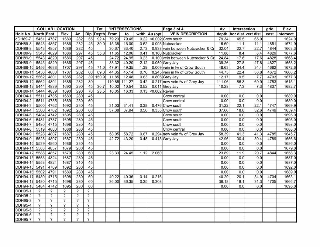
COLLAR LOCATION Tot 'INTERSECTIONS Page 3 of 4 Av Intersection grid ElevHole No. North East Elev Az Dip Depth From to wdth Au (opt) VEIN DESCRIPTION depth hor dist vert dist east intersectdDH89-7 5451 4787 1689 282 55 92.4 79.23 79.45 0.22 <0.002 Crow south 79.34 45.5 65.0 1624.0DDH89-8 5543 4857 1686 282 45 39.0 15.38 16.00 0.62 0.093 Nutcracker 15.69 11.1 11.1 4851 1674.9DDH89-8 5543 4857 1686 282 45 30.67 33.40 2.73 0.938 vein between Nutcracker & Cro 32.04 22.7 22.7 4844 1663.3DDH89-9 5543 4829 1686 297 45 55.8 11.65 12.06 0.41 0.160 Nutcracker 11.86 8.4 8.4 4829 1677.6DDH89-9 5543 4829 1686 297 45 24.72 24.95 0.23 0.100 vein between Nutcracker & Cro 24.84 17.6 17.6 4828 1668.4DDH89-9 5543 4829 1686 297 45 38.32 40.20 2.12 0.050 Grey Jay 39.26 27.8 27.8 4827 1658.2DDH89-10 5456 4688 1707 297 45 71.0 47.91 49.35 1.39 0.009 vein in fw of Crow South 48.63 34.4 34.4 4682 1672.6DDH89-11 5456 4688 1707 282 60 89.3 44.35 45.14 0.76 0.245 vein in fw of Crow South 44.75 22.4 38.8 4672 1668.2DDH89-12 5562 4801 1685 282 39 150.9 11.85 12.48 0.63 0.805 Grey Jay 12.17 9.5 7.7 4793 1677.3DDH89-12 5562 4801 1685 282 39 110.85 111.27 0.42 0.217 new vein fw of Grey Jay 111.06 86.3 69.9 4753 1615.1DDH89-13 5444 4839 1690 290 45 30.7 10.02 10.54 0.52 0.011 Grey Jay 10.28 7.3 7.3 4837 1682.7DDH89-14 5444 4839 1690 290 70 23.5 16.05 16.33 0.13 <0.002 RavenDDH94-1 5511 4785 1689 280 45 Crow central 0.00 0.0 0.0 1689.0DDH94-2 5511 4785 1689 280 60 Crow central 0.00 0.0 0.0 1689.0DDH94-3 5500 4762 1692 280 45 31.03 31.41 0.38 0.476 Crow south 31.22 22.1 22.1 4747 1669.9DDH94-4 5500 4762 1692 280 60 37.38 37.94 0.56 0.355 Crow south 37.66 18.8 32.6 4749 1659.4DDH94-5 5484 4742 1695 280 45 Crow south 0.00 0.0 0.0 1695.0DDH94-6 5481 4737 1695 280 45 Crow south 0.00 0.0 0.0 1695.0DDH94-7 5480 4715 1698 280 45 Crow south 0.00 0.0 0.0 1698.0DDH94-8 5519 4800 1688 280 45 Crow central 0.00 0.0 0.0 1688.0DDH94-9 5528 4807 1687 280 45 58.05 58.72 0.67 0.294 new vein fw of Grey Jay 58.39 41.3 41.3 4785 1645.7DDH94-9 5528 4807 1687 280 45 42.72 43.20 0.48 0.418 Grey Jay 42.96 30.4 30.4 4789 1656.6DDH94-10 5539 4860 1686 280 45 0.00 0.0 0.0 1686.0DDH94-11 5588 4857 1679 280 45 0.00 0.0 0.0 1679.0DDH94-12 5588 4857 1679 280 60 23.33 24.45 1.12 2.060 23.89 11.9 20.7 4844 1658.3DDH94-13 5553 4824 1687 280 45 0.00 0.0 0.0 1687.0DDH94-14 5553 4824 1687 310 45 0.00 0.0 0.0 1687.0DDH94-15 5491 4769 1692 280 45 0.00 0.0 0.0 1692.0DDH94-16 5502 4791 1689 280 45 0.00 0.0 0.0 1689.0DDH94-17 5480 4715 1698 280 60 40.22 40.36 0.14 0.216 40.29 20.1 34.9 4704 1663.1DDH94-17 5480 4715 1698 280 60 36.00 36.35 0.35 0.308 36.18 18.1 31.3 4705 1666.7DDH94-18 5484 4742 1695 280 60 0.00 0.0 0.0 1695.0DDH95-1 ? ? ? ? ?DDH95-2 ? ? ? ? ?DDH95-3 ? ? ? ? ?DDH95-4 ? ? ? ? ?DDH95-5 ? ? ? ? ?DDH95-6 ? ? ? ? ?DDH95-7 ? ? ? ? ?

COLLAR LOCATION Tot 'INTERSECTIONS Page 4 of 4 Av Intersection grid ElevHole No. North East Elev Az Dip Depth From to wdth Au (opt) VEIN DESCRIPTION depth hor dist vert dist east intersectDDH98-1 5439 4715 1705 270 60 84.5 44.60 48.60 4.00 0.330 New vein between Raven & Cr 46.60 23.3 40.4 4698 1664.6DDH98-2 5326 4915 1687 65 45 29.9 16.40 17.20 0.80 0.670 Flicker 16.80 11.9 11.9 4927 1675.1DDH98-3 5471 4718 1702 270 45 33.5 9.50 10.40 0.90 0.216 New Vein (HW of Crow South) 9.95 7.0 7.0 4713 1695.0DDH98-4 5471 4718 1702 0 90 45.7 Crow south 0.00 0.0 0.0 4718 1702.0DDH98-5 5464 4733 1701 0 90 70.1 54.90 55.80 0.90 Crow south 55.35 0.0 55.4 4733 1645.7DDH98-6 5499 4767 1692 270 53 97.5 92.80 95.60 2.80 New Vein in fw of Crow 94.20 56.7 75.2 4727 1616.8DDH98-6 5499 4767 1692 270 53 27.00 27.70 0.70 0.083 Crow south split 27.35 16.5 21.8 4756 1670.2DDH98-6 5499 4767 1692 270 53 33.20 34.10 0.90 0.241 Crow Central 33.65 20.3 26.9 4754 1665.1DDH98-7 5499 4767 1692 270 80 60.4 39.00 40.00 1.00 Vein in fw of Crow Central 39.50 6.9 38.9 4741 1653.1DDH98-8 5529 4809 1687 270 50 74.7 25.30 27.70 2.40 0.410 Owl vein 26.50 17.0 20.3 4803 1666.7DDH98-8 5529 4809 1687 270 50 74.7 35.30 36.30 1.00 0.611 Crow Central split 35.80 23.0 27.4 4803 1659.6DDH98-9 5327 4915 1687 115 45 28.7 19.30 22.90 3.60 0.025 Flicker 21.10 14.9 14.9 4930 1672.1DDH98-10 5546 4829 1688 270 55 65.2 Grey Jay 0.00 0.0 0.0 1688.0DDH98-11 5386 4903 1691 270 45 15.9 Chickadee 0.00 0.0 0.0 1691.0DDH98-12 5556 4855 1688 270 55 77.7 53.10 53.80 0.70 0.044 Shear 53.45 30.7 43.8 4836 1644.2DDH98-12 5556 4855 1688 270 55 23.80 24.60 0.80 0.076 Nutcracker? 24.20 13.9 19.8 4845 1668.2DDH98-12 5556 4855 1688 270 55 39.70 41.10 1.40 0.181 Grey Jay 40.40 23.2 33.1 4839 1654.9DDH98-14 5386 4903 1691 270 60 22.9 6.80 7.60 0.80 0.127 Chickadee 7.20 3.6 6.2 4899 1684.8DDH98-15 5592 4848 1679 270 70 66.2 14.90 16.50 1.60 ? Grey Jay 15.70 5.4 14.8 4843 1664.2DDH98-15 5592 4848 1679 270 70 31.70 33.20 1.50 0.013 New vein in fw of Grey Jay 32.45 11.1 30.5 4840 1648.5DDH98-16 5565 4889 1685 270 55 44.5 42.70 43.90 1.20 0.007 Grey Jay (no nutcracker) 43.30 24.8 35.5 4871 1649.5DDH98-17 5565 4889 1685 360 75 45.1 Nutcracker cut by dyke 0.00 0.0 0.0 1685.0DDH98-18 5538 4910 1688 270 45 59.5 Cu,Mo at contact 0.00 0.0 0.0 1688.0DDH98-19 5585 4889 1682 270 45 95.1 40.50 41.30 0.80 0.092 Shearing (fw) 40.90 28.9 28.9 4868 1653.1DDH98-19 5585 4889 1682 270 45 22.90 23.20 0.30 0.065 Nutcracker 23.05 16.3 16.3 4876 1665.7DDH98-19 5585 4889 1682 270 45 30.50 31.60 1.10 0.132 Grey Jay 31.05 22.0 22.0 4873 1660.0DDH98-21 5495 4963 1688 270 45 15.2 Contact zone 0.00 0.0 0.0 1688.0DDH98-22 5495 4963 1688 270 60 18.6 Contact zone 0.00 0.0 0.0 1688.0DDH98-23 5522 4873 1690 270 45 45.7 33.00 33.70 0.70 <0.002 Chickadee N ext. 33.35 23.6 23.6 4856 1666.4DDH03-1 5447 4750 ? 280 -45 32.3 Crow 22.8 22.8DDH03-2 5447 4750 ? 280 -65 48.2 48 49.6 1.6 0.079 Crow 48.80 20.4 43.7DDH03-3 5447 4750 ? 260 -65 57.3 20 21.2 1.2 0.119 Crow 20.60 24.2 51.9DDH03-4 5467 4747 ? 270 -45 26.8 20 21.2 1.2 0.982 Crow 20.60 19.0 19.0DDH03-5 5467 4747 ? 270 -65 94.2 32 34.6 2.6 0.505 Crow 33.30 39.8 85.4DDH03-6 5489 4744 ? 270 -65 46.5 42 42.7 0.7 0.088 Crow 42.35 19.7 42.1DDH03-7 5489 4747 ? 270 -45 29.9 26 27.52 1.52 0.037 Crow 26.76 21.1 21.1DDH03-8 5488 4747 ? 250 -45 48.2 32 32.9 0.9 0.045 Crow 32.45 34.1 34.1DDH03-9 5469 4921 ? 280 -65 57.0 Eagle 24.1 51.7DDH03-10 5469 4921 ? 280 -45 32.6 Eagle 23.1 23.1
No samples analyzedNo samples analyzed

COLLAR LOCATION Tot 'INTERSECTIONS Page 4 of 4 Av Intersection grid ElevHole No. North East Elev Az Dip Depth From to wdth Au (opt) VEIN DESCRIPTION depth hor dist vert dist east intersectDDH03-11 5467 4921 ? 250 -45 45.7 Eagle 32.3 32.3DDH03-12 5472 4921 ? 300 -45 41.8 Eagle 29.6 29.6DDH03-13 5476 4824 ? 80 -45 44.8 Raven 31.7 31.7DDH03-14 5473 4824 ? 103 -45 35.7 Raven 25.2 25.2DDH03-15 5410 4848 ? 280 -45 9.1 Raven 6.4 6.4
No samples analyzedNo samples analyzedNo samples analyzed
No samples analyzedNo samples analyzed

TABLE 2MINERALIZED TRENCH SAMPLES
SAMPLE Page 1 of 4TRENCH SAMPLE WIDTH ASSAY
No. TYPE (m) oz Au/ton VEIN
TR86-4 channel 0.55 0.017 Ravenchannel 0.55 0.102 Ravenchannel 0.65 0.262 Ravenchannel 0.50 0.030 Ravenchannel 0.50 0.011 Raven footwall dioritechannel 0.76 0.144 Raven hangingwall dioritechannel 0.50 0.251 Ravenchannel 0.64 3.291 Ravenchannel 3.25 0.026 Ravenchannel 3.10 0.018 Ravenchannel 6.35 0.024 Raven
TR86-5.1 channel 1.00 0.099 ChickadeeTR85-5.2 channel 0.35 0.404 ChickadeeTR86-5.3 channel 0.25 0.790 ChickadeeTR86-6 channel 0.70 0.361 Flicker
channel 0.75 0.471 Flickerchannel 1.10 0.058 east Flicker wallrockchannel 0.65 0.120 Flickerchannel 0.70 0.085 west Flicker wallrock
TR86-8 channel 0.66 0.018 RavenTR86-10 channel 1.00 0.088 CrowTR86-13 channel 0.60 0.023 Crow
channel 0.60 0.074 Crowchannel 1.50 0.171 quartz veinchannel 0.40 0.050 Crow footwall diorite
TR86-14 channel 0.50 0.022 Crowchannel 0.50 0.113 Crow footwall diorite
TR86-15 channel 0.50 0.047 CrowTR86-16 channel 0.70 0.736 Crow
channel 0.70 0.626 Crow footwall dioritechannel 1.00 0.056 Crow hangingwall dioritechannel 0.70 3.545 Crowchannel 1.00 0.040 Crow footwall dioritechannel 0.70 0.601 Crow
TR86-17 channel 0.40 0.026 CrowTR86-18 channel 1.17 0.092 Crow
channel 1.12 0.064 Crowchannel 0.30 0.080 Crow (sheared vein)
TR86-20 channel 1.40 0.087 Crowpanel 1.4 x .75 0.75 0.140 Crow
TR86-21 channel 0.60 0.316 Crowchannel 1.00 4.034 Crowchannel 0.90 0.048 Crowpanel: 1.0 x 1.10 0.014 Crowchannel 1.00 0.701 Crowpanel 1.0 x 1.25 5.674 Crowpanel 1.0 x 1.25 13.091 Crow
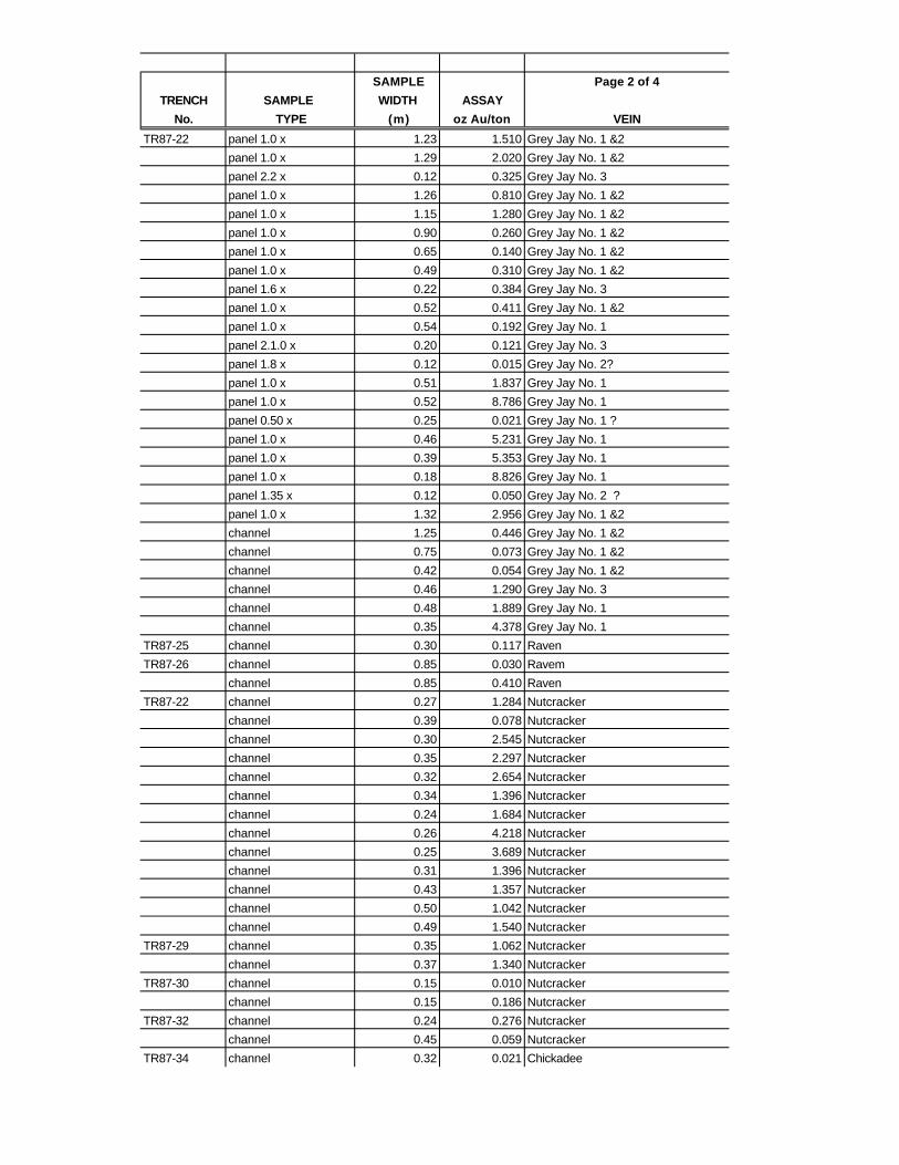
SAMPLE Page 2 of 4TRENCH SAMPLE WIDTH ASSAY
No. TYPE (m) oz Au/ton VEIN
TR87-22 panel 1.0 x 1.23 1.510 Grey Jay No. 1 &2panel 1.0 x 1.29 2.020 Grey Jay No. 1 &2panel 2.2 x 0.12 0.325 Grey Jay No. 3panel 1.0 x 1.26 0.810 Grey Jay No. 1 &2panel 1.0 x 1.15 1.280 Grey Jay No. 1 &2panel 1.0 x 0.90 0.260 Grey Jay No. 1 &2panel 1.0 x 0.65 0.140 Grey Jay No. 1 &2panel 1.0 x 0.49 0.310 Grey Jay No. 1 &2panel 1.6 x 0.22 0.384 Grey Jay No. 3panel 1.0 x 0.52 0.411 Grey Jay No. 1 &2panel 1.0 x 0.54 0.192 Grey Jay No. 1panel 2.1.0 x 0.20 0.121 Grey Jay No. 3panel 1.8 x 0.12 0.015 Grey Jay No. 2?panel 1.0 x 0.51 1.837 Grey Jay No. 1panel 1.0 x 0.52 8.786 Grey Jay No. 1panel 0.50 x 0.25 0.021 Grey Jay No. 1 ?panel 1.0 x 0.46 5.231 Grey Jay No. 1panel 1.0 x 0.39 5.353 Grey Jay No. 1panel 1.0 x 0.18 8.826 Grey Jay No. 1panel 1.35 x 0.12 0.050 Grey Jay No. 2 ?panel 1.0 x 1.32 2.956 Grey Jay No. 1 &2channel 1.25 0.446 Grey Jay No. 1 &2channel 0.75 0.073 Grey Jay No. 1 &2channel 0.42 0.054 Grey Jay No. 1 &2channel 0.46 1.290 Grey Jay No. 3channel 0.48 1.889 Grey Jay No. 1channel 0.35 4.378 Grey Jay No. 1
TR87-25 channel 0.30 0.117 RavenTR87-26 channel 0.85 0.030 Ravem
channel 0.85 0.410 RavenTR87-22 channel 0.27 1.284 Nutcracker
channel 0.39 0.078 Nutcrackerchannel 0.30 2.545 Nutcrackerchannel 0.35 2.297 Nutcrackerchannel 0.32 2.654 Nutcrackerchannel 0.34 1.396 Nutcrackerchannel 0.24 1.684 Nutcrackerchannel 0.26 4.218 Nutcrackerchannel 0.25 3.689 Nutcrackerchannel 0.31 1.396 Nutcrackerchannel 0.43 1.357 Nutcrackerchannel 0.50 1.042 Nutcrackerchannel 0.49 1.540 Nutcracker
TR87-29 channel 0.35 1.062 Nutcrackerchannel 0.37 1.340 Nutcracker
TR87-30 channel 0.15 0.010 Nutcrackerchannel 0.15 0.186 Nutcracker
TR87-32 channel 0.24 0.276 Nutcrackerchannel 0.45 0.059 Nutcracker
TR87-34 channel 0.32 0.021 Chickadee

SAMPLE Page 3 of 4TRENCH SAMPLE WIDTH ASSAY
No. TYPE (m) oz Au/ton VEIN
TR87-36 channel 0.25 0.284 Crowchannel 0.25 1.087 Nutcrackerchannel 0.32 0.384 Nutcrackerchannel 0.32 0.140 quartz vein
TR87-37 panel 1.0 x 0.31 3.437 Grey Jay No. 1panel 1.0 x 0.35 2.384 Grey Jay No. 1panel 1.0 x 0.39 0.006 dioritepanel 1.0 x 1.51 0.440 Grey Jay No. 1 & 2panel 0.54 x 0.40 0.038 dioritepanel 0.40 x 0.40 0.002 dioritepanel 1.0 x 1.39 0.370 Grey Jay No. 1 & 2panel 1.0 x 1.14 0.280 Grey Jay No. 1 & 2panel 1.0 x 0.15 0.148 dioritepanel 1.0 x 1.08 0.470 Grey Jay No. 1 & 2panel 1.0 x 1.27 0.580 Grey Jay No. 1 & 2panel 1.0 x 1.43 0.480 Grey Jay No. 1 & 2panel 1.0 x 1.78 0.080 Grey Jay No. 1 & 2panel 1.75 x 0.74 0.006 ddioritepanel 1.65 x 0.39 0.090 Grey Jay No. 2 channel 3.17 0.172 qtz & dioritechannel 2.02 0.041 qtz & diorite
TR87-38 channel 0.12 0.958 Nutcrackerchannel 0.10 1.082 Nutcrackerchannel 0.08 0.091 Nutcracker
TR87-41 channel 0.20 0.179 NutcrackerTR87-45 panel 1.0 x 2.75 0.030 Crow
panel 1.0 x 2.94 0.250 Crow & Grey Jaypanel 1.0 x 1.18 0.120 Crowpanel 1.0 x 0.94 0.159 Crowpanel 1.0 x 1.39 0.010 qtz stockworkpanel 1.0 x 0.49 1.353 Crowpanel 1.0 x 0.84 1.055 Crowpanel 1.0 x 1.18 0.383 Crow, diorite, nutcrackerpanel 1.0 x 2.39 0.050 Crow, diorite, nutcrackerchannel 2.12 0.050 Crowchannel 1.77 0.020 Grey Jay & Crowchannel 2.62 0.020 Crowchannel 1.53 0.450 Crowchannel 1.98 0.020 Crowchannel 0.54 0.672 Crowchannel 0.65 0.382 Crowchannel 1.52 0.070 Crow, diorite, nutcracker

SAMPLE Page 4 of 4TRENCH SAMPLE WIDTH ASSAY
No. TYPE (m) oz Au/ton VEIN
TR87-46 panel 1.0 x 0.56 0.008 Grey Jay No. 1panel 1.0 x 0.56 0.105 Grey Jay No. 1panel 1.6 x 0.57 0.019 Grey Jay No. 1panel 1.0 x 0.74 0.242 Grey Jay No. 1panel 1.0 x 0.76 0.086 Grey Jay No. 1panel 1.0 x 0.64 0.046 Grey Jay No. 1panel 1.0 x 0.76 0.068 Grey Jay No. 1panel 1.0 x 0.83 0.064 Grey Jay No. 1panel 1.0 x 0.83 0.404 Grey Jay No. 1panel 1.6 x 0.76 0.080 Grey Jay No. 1panel 1.0 x 0.59 0.062 Grey Jay No. 1panel 1.0 x 0.51 1.602 Grey Jay No. 1panel 1.4 x 0.48 2.390 Grey Jay No. 1panel 1.5 x 0.14 0.157 Grey Jay No. 2panel 1.6 x 0.18 0.125 Grey Jay No. 2panel 1.0 x 0.17 0.360 Grey Jay No. 1panel 1.0 x 0.26 0.653 Grey Jay No. 1panel 1.0 x 0.48 0.350 Grey Jay No. 1
TR87-46 panel 1.0 x 1.07 0.060 Grey Jay No. 1 & 2panel 1.0 x 1.30 0.020 Grey Jay No. 1 & 2panel 1.0 x 1.43 0.130 Grey Jay No. 1 & 2panel 1.0 x 0.08 0.033 qtz & dioritepanel 1.0 x 1.22 0.430 Grey Jay No. 1 & 2panel 1.0 x 0.60 0.011 Grey Jay No. 3panel 1.0 x 0.83 0.851 Grey Jay No. 1 panel 1.0 x 0.48 0.071 Grey Jay No. 2panel 1.0 x 2.11 0.530 Grey Jay No. 1, 2 & 3panel 1.0 x 2.09 1.440 Grey Jay No. 1, 2 & 3panel 1.0 x 2.03 0.480 Grey Jay No. 1, 2 & 3channel 0.73 0.002 dioritechannel 0.20 0.002 Grey Jay No. 2