background image weather & circulation the ocean and its currents have a major influence on...
TRANSCRIPT

Background Imagehttp://www.futura-sciences.com/img/willy.jpg
Weather & CirculationWeather & CirculationThe ocean and its currents have a major
influence on weather and climate on Earth.

Background Imagehttp://www.futura-sciences.com/img/willy.jpg
AtmosphereAtmosphere• Air composed mostly of nitrogen and oxygen
– Never dry – always contains water vapor– Air’s density determined by
• Temperature • Water content
• Weather - The state of the atmosphere at a given time and place, with respect to variables such as temperature, moisture, wind velocity, and barometric pressure.
• Climate - The meteorological conditions, including temperature, precipitation, and wind, that characteristically prevail in a particular region.

Background Imagehttp://www.futura-sciences.com/img/willy.jpg
Greenhouse EffectGreenhouse Effect• Greenhouse effect - The atmosphere of
our Earth traps heat– the energy from the sun also heats up
the oceans. • 50% of radiation from the sun is
absorbed by the Earth’s surface and then reflected back into the earth’s atmosphere.
– Gases (carbon dioxide and water vapor) can stop this energy from escaping into space by keeping it here on Earth.
Image

Background Imagehttp://www.futura-sciences.com/img/willy.jpg
Global WarmingGlobal Warming
• Scientists have noticed that the Earth is experiencing a warming trend.
• In the past 100 years, the Earth’s mean global temperature has increased more than 1 degree Farenheit and ocean levels have risen
• Global warming is the result, the gradual increase in Earth’s temperature.
• Scientists measure polar ice caps to determine if their rate of melting continues to increase.

Background Imagehttp://www.futura-sciences.com/img/willy.jpg
Measuring the MeltMeasuring the Melt• The graph below shows total ice coverage since 1973. • As glacial ice melts, sea levels rise and ocean currents can change.

Background Imagehttp://www.futura-sciences.com/img/willy.jpg
• Average temperatures in the Arctic region are rising twice as fast as they are elsewhere in the world. Arctic ice is getting thinner, melting and rupturing.
– the largest single block of ice in the Arctic, the Ward Hunt Ice Shelf, had been around for 3,000 years before it started cracking in 2000. Within two years it had split all the way through and is now breaking into pieces.
• The polar ice cap as a whole is shrinking.
– Images from NASA satellites show that the area of permanent ice cover is contracting at a rate of 9 percent each decade.
– If this trend continues, summers in the Arctic could become ice-free by the end of the century.
• The melting of once-permanent ice is already affecting native people, wildlife and plants.
– When the Ward Hunt Ice Shelf splintered, the rare freshwater lake it enclosed, along with its unique ecosystem, drained into the ocean.
– Polar bears, whales, walrus and seals are changing their feeding and migration patterns, making it harder for native people to hunt them.

Background Imagehttp://www.futura-sciences.com/img/willy.jpg
Carbon Dioxide levelsCarbon Dioxide levels• The amount of carbon dioxide in the atmosphere has been steadily
increasing. • As we continue to cut down trees for paper production, we are
decreasing the plants that convert CO2 to oxygen, causing an increase in CO2 levels.
• The burning of fossil fuels (oil, coal, etc) also adds carbon dioxide to the environment.

Background Imagehttp://www.futura-sciences.com/img/willy.jpg
Natural Air PollutionNatural Air Pollution
• Even “clean” air is not perfectly clean.
• It contains many pollutants from natural sources like dust, volcanic gases and ash, smoke from forest fires, pollen, etc.
• Most of the air pollution mentioned in the news is a result of human activities.
Image

Background Imagehttp://www.futura-sciences.com/img/willy.jpg
Natural Cycle?Natural Cycle?
• natural phenomenon - climate has gone through periods of warmth and periods of extreme cold (often known as an Ice Age).
• Some scientists claim that the warming trend is part of a natural cycle that will eventually reverse itself through CO2 uptake by photosynthetic marine and terrestrial plant life.
• Others claim that the warming of Earth’s atmosphere is a real problem that can be reduced by decreasing the use of fossil fuels and finding alternative energy sources.

Background Imagehttp://www.futura-sciences.com/img/willy.jpg
CurrentsCurrents• Ocean currents - moving water connecting major
landmasses on Earth– global ocean currents – largest currents that move
across the ocean (like rivers that travel great distances)– affected by
• global temperature• freshwater glacial ice melt• density differences due to salt concentrations and
temperature differences.

Background Imagehttp://www.futura-sciences.com/img/willy.jpg
Water’s DensityWater’s Density• Density is important to the currents which shape the
planet’s climate.– Fresh water is less dense than salty water. – Warm water has a lower density than cold water

Background Imagehttp://www.futura-sciences.com/img/willy.jpg
• Salty water will sink while fresh water will rise because of differences in density.
Effect of SalinityEffect of Salinity
Image

Background Imagehttp://www.futura-sciences.com/img/willy.jpg
In the MediterraneanIn the Mediterranean• The Mediterranean Sea, for example, has a higher salinity
than the Atlantic Ocean, creating a current south of Spain that moves salty water deep into the Atlantic Ocean.
Image

Background Imagehttp://www.futura-sciences.com/img/willy.jpg
Global Ocean CurrentsGlobal Ocean Currents

Background Imagehttp://www.futura-sciences.com/img/willy.jpg
Radiant Radiant EnergyEnergy
• The sun, the source of all energy on Earth, gives off radiant energy and influences the climate that we experience.
• Angle of Isolation - the angle at which the rays of the sun strike the surface of the earth.– Determines the amount of radiant (or solar) energy that reaches any
part of the planet• Areas farthest away from the sun’s rays (the poles) receive slanted
rays with a larger angle, and are therefore less intense– Caused by:
• The Earth’s curved surface • the tilt of its axis

Background Imagehttp://www.futura-sciences.com/img/willy.jpg
Ocean TemperatureOcean Temperature• The uneven heating of the Earth due to the rays of the
sun causes ocean temperatures to vary with latitude. • The ocean is warmest at the equator.
Image

Background Imagehttp://www.futura-sciences.com/img/willy.jpg
Coriolis EffectCoriolis Effect
• The coriolis effect - the spinning Earth causes the winds and surface waters to move in a specific directions.
• northern hemisphere - the currents deflect clockwise to the east.
• southern hemisphere - currents move in the opposite direction, counter clockwise to the west.
Image

Background Imagehttp://www.futura-sciences.com/img/willy.jpg
GyresGyres• Gyres - giant circles created when the water moves and hits
the continent which deflect the currents
Image

Background Imagehttp://www.futura-sciences.com/img/willy.jpg
Gulf StreamGulf Stream
• The gulf stream current flows from the southwestern Atlantic to the northeastern– it is the major factor in favorable (warm) weather on
the eastern coast of the United States.
• Benjamin Franklin was the first to chart the temperature and speed of the gulf stream back in the 1700s.

Background Imagehttp://www.futura-sciences.com/img/willy.jpg
Subsurface CurrentsSubsurface Currents• Subsurface currents - move because of differences in temperature
and salinity.

Background Imagehttp://www.futura-sciences.com/img/willy.jpg
Downwelling & UpwellingDownwelling & Upwelling• Downwelling - After warm water has risen to the surface, it will
eventually cool off and therefore sink again near the poles • Upwelling - When currents rise to the surface, they bring nutrient-rich
sediments from the bottom.
• Nutrients found on the floor of the ocean (such as phosphates & nitrates) are important for all organisms in aquatic food webs.

Background Imagehttp://www.futura-sciences.com/img/willy.jpg
Coastal Coastal CurrentsCurrents
• Waves – when currents eventually meet coastal areas– After a wave breaks on a beach, the forward momentum transports
water up the slope of a beach. – The returning current or backwash is called the undertow.
• Currents that move parallel to the beach are called longshore currents.
• Spaces between islands off the coast of a continent, like Galveston and South Padre, cause a rush of water called a rip current that moves quickly out into the ocean.

Background Imagehttp://www.futura-sciences.com/img/willy.jpg
Tidal CurrentsTidal Currents
• The movement of the moon around the Earth and it’s gravity causes tides– the daily rise and fall of the ocean seen along the shore.
• When a tide enters and leaves and area, the tidal change produces swift-moving tidal currents that run parallel to the shore. – important to aquatic food chains because they carry nutrients and
small organisms back and forth between the bays and the offshore waters.
Image

Background Imagehttp://www.futura-sciences.com/img/willy.jpg
Ocean WindOcean Wind• Convection currents occur in many different media
(liquid, air, magma). • Day Time
– Often, the wind around the ocean creates a sea breeze
• due to differences in temperature of the air over the ocean versus over land.
– Water heats up slowly, while land heats up quickly.
– A convection current is created because the cooler air over the ocean sinks and travels inland while the warm air over the land rises up.
• Night Time– The opposite occurs– land cools very quickly, but water has a very
high specific heat and takes longer to cool. – The air over the water is warmer and wind
travels out to the ocean in the reversed convection current.
Background Imagehttp://www.futura-sciences.com/img/willy.jpg
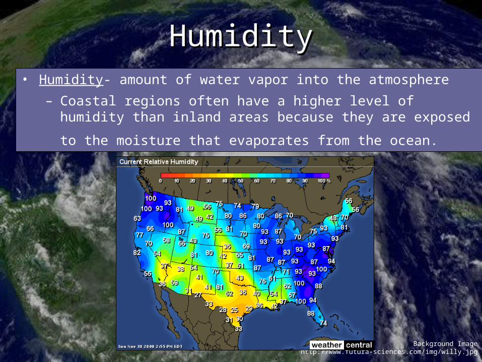
HumidityHumidity• Humidity- amount of water vapor into the atmosphere
– Coastal regions often have a higher level of humidity than inland areas because they are exposed to the moisture that evaporates from
the ocean.

Background Imagehttp://www.futura-sciences.com/img/willy.jpg
Fog & DewFog & Dew• Fog - Air saturated with moisture creating
clouds near the ground – forms when warm, moist air makes
contact with a cold surface. – The mirror in your bathroom often “fogs”
when warm moist air from the shower hits the cold surface of the mirror.
• Dew - When water condenses (changes from a vapor to a liquid) on a solid surface

Background Imagehttp://www.futura-sciences.com/img/willy.jpg
HurricanesHurricanes• A hurricane -a coastal storm with a wind velocity exceeding 120 km/hr
• Form in warm tropical seas where there is hot, moist air
– As hot, moist air rises, it cools in the upper atmosphere and condenses into ring shaped clouds.
– During condensation, a great deal of heat energy is released, which causes more hot air to rise even quicker.
– This whirlwind of rising air moves in a spiral direction around calm air knows as the “eye” of a hurricane.

Background Imagehttp://www.futura-sciences.com/img/willy.jpg
El NinoEl Nino• El Nino - Oceanic warming • Begins in the western Pacific Ocean• Warm currents are normally carried northwest due to trade winds. • El Nino reverses the currents because of a decline in southeast trade
winds • causes a change in the climate of South America (bringing floods
and stormy weather).
~

Background Imagehttp://www.futura-sciences.com/img/willy.jpg
La NinaLa Nina• La Nina - Unusually cold currents causing cooler surface
temperatures
• winters are cooler than normal in the northwest United states and warmer than normal in the southeast.
• The cycles for El Nino/La Nina often last 1 to 2 years and occur every 4 to 6 years.
• Click on the graphic to view an animation depicting the differences between El Nino and La Nina.
~