assuring pnt for all
TRANSCRIPT
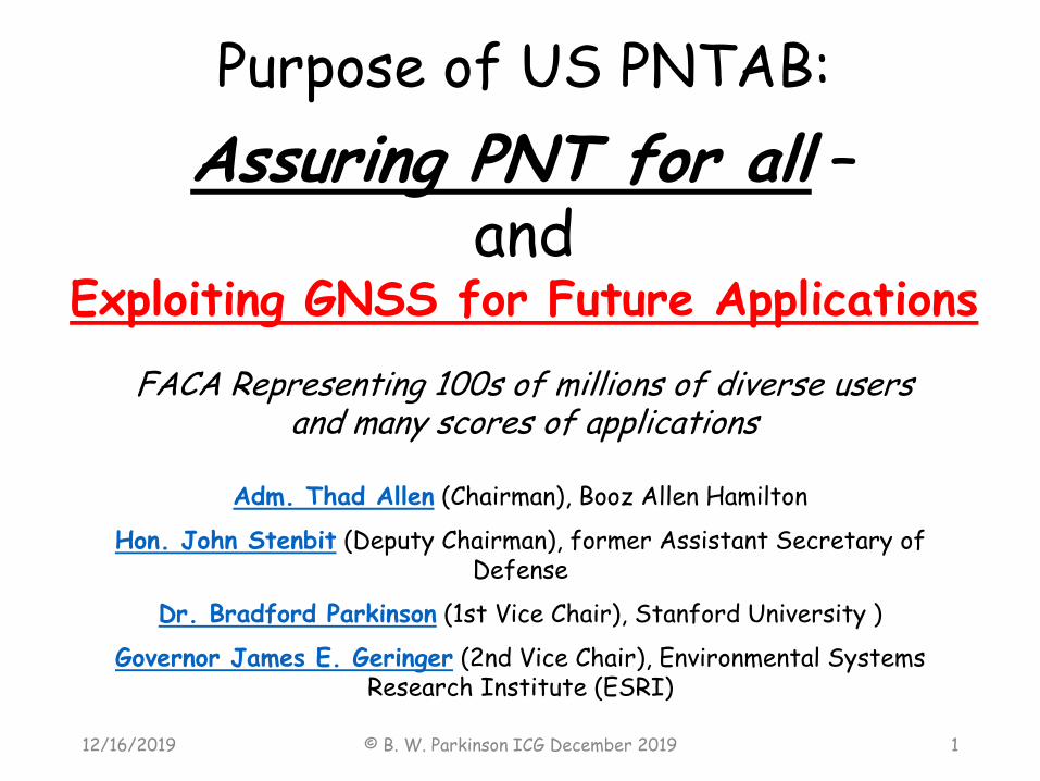
Purpose of US PNTAB:
Assuring PNT for all –and
Exploiting GNSS for Future Applications
FACA Representing 100s of millions of diverse usersand many scores of applications
Adm. Thad Allen (Chairman), Booz Allen Hamilton
Hon. John Stenbit (Deputy Chairman), former Assistant Secretary of Defense
Dr. Bradford Parkinson (1st Vice Chair), Stanford University )
Governor James E. Geringer (2nd Vice Chair), Environmental Systems Research Institute (ESRI)
© B. W. Parkinson ICG December 2019 112/16/2019

What is important for PNT users now?
12/16/2019 © B. W. Parkinson ICG December 2019 2
Two of the “Important Things” that I Listed earlier

An Initial List of Important Things 3
12/16/2019 © B. W. Parkinson ICG December 2019 3
“Future Applications and Capabilities"
F1. Defining and publicizing power of 2nd (and 3rd) GNSS
satellite signal lobe for SSV
F2 Progress and prospects of Intelligent Transportation Program (includes positive Train Control)
F3 Accelerate Progress on fielding Autonomous Vehicles – (e.g.
large interstate trucks and consumer vehicles on expressways)
F4. How can GNSS help in integrating UAS and Urban Air
Mobility (UAM) into the airspace system?
F5. Insuring protection for Powergrid Timing
F6. Ensuring Timing for the Financial community
F7. Ensuring scientific capabilities are preserved and enhanced,
such as water vapor measurements and weather predictions

12/16/2019 © B. W. Parkinson ICG December 2019 4
F4. How can GNSS help in integrating UAS and Urban Air Mobility (UAM) into the airspace system?

Rapidly growing UAS applications -Significant Productivity Enhancements
© B. W. Parkinson ICG December 2019 512/16/2019
• Power line inspection
• Agricultural Inspection
• Media coverage
• Security
Both UAS Control and
Air Traffic Monitoring
depend on GNSS

Autonomous Air Taxi - Volocopternow being tested in cities
12/16/2019 © B. W. Parkinson ICG December 2019 6

PrimeAir Coming to a house near you?
12/16/2019 © B. W. Parkinson ICG December 2019 7

A Problem: What non-UAS Applications spend time flying close to the ground?
(Where collisions with UASs are most probable)
12/16/2019 © B. W. Parkinson ICG December 2019 8
• Commercial Airplanes during takeoff and landing
• Wildfire Tankers/Helicopters
• Law Enforcement Helicopters
• General Aviation – particularly a small or remote airfields
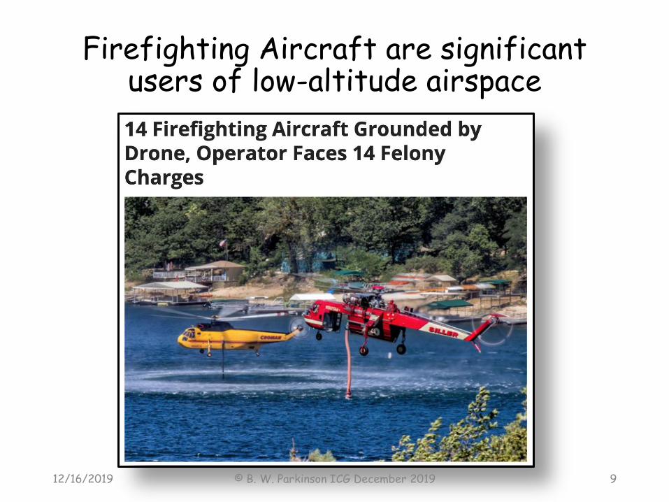
Firefighting Aircraft are significant users of low-altitude airspace
12/16/2019 © B. W. Parkinson ICG December 2019 9

Part of Solution? – GNSS based Geofencing – commercial products already available
12/16/2019 © B. W. Parkinson ICG December 2019 10
Need 3D and rapid exclusion assignment – enforcement?
- Robust GNSS is key enabler
~ 3 inches

UAS/UAM regulation by FAA in US is evolving-amid safety and security concerns
• No simple answers but PNT/GNSS is at the heart of the problem and solution
• BVLOS not authorized, but certainly feasible and desirable for civil applications
• “Geofencing” has well established products and systems for ground fleet management• GNSS as Position measurement/location• Adaptation to UAS/UAM?• Static and dynamic fences?• Feasibility of fail safe UAS control?
12/16/2019 © B. W. Parkinson ICG December 2019 11
By 2022 the Federal Aviation Administration (FAA) expects that there will be 2.9 million drones flying in the United States. (CNBC 2019)

12/16/2019 © B. W. Parkinson ICG December 2019 12
F3. Accelerate Progress on fielding Autonomous Vehicles –(especially large interstate trucks and consumer vehicles on expressways)

A Humanitarian Opportunity
12/16/2019 © B. W. Parkinson ICG December 2019 13
US Traffic Fatalities in Recent 10 Years:
387,000- 213 People Died on US Roads for
Every US Soldier who died in Afghanistan in the same period

12/16/2019 © B. W. Parkinson ICG December 2019 14
Implementing “Brilliant Autos” (Auto-guided
Automobiles) and “Brilliant Semis” (Auto-guided
long-haul trucks/lorries)
• Use all GNSS Position Signals
• Vector Kinematic Receivers (10 cm or better)
• MEMS/IMU
• 360o Radars
• Cooperative Tracking of other vehicles (V2V)

“Brilliant Vehicles” – GNSS will be an essential part - Needs Phased Introduction (underway!)
• Phase I: Alerts and Warnings (especially for low-vis)
• Lane Drifting• Adjacent Vehicle Hazards• Traction• Curves• Vehicles• Road Hazards
• Phase II: Auto Steering/Throttle/Braking with manual over-ride
• Phase III (for Cargo Trucks): No Driver
12/16/2019 © B. W. Parkinson ICG December 2019 15
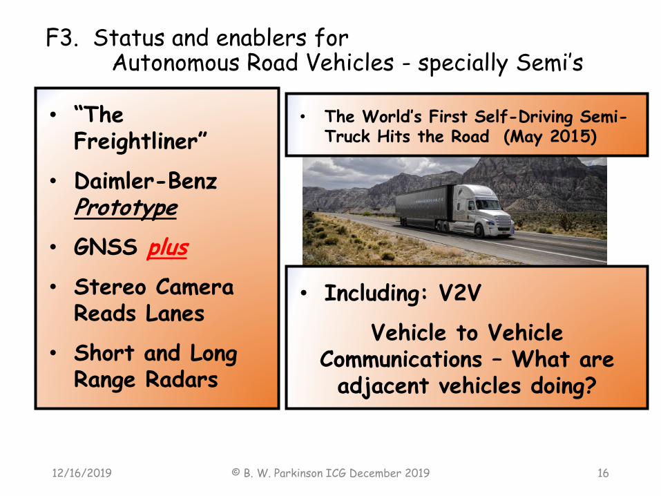
F3. Status and enablers for Autonomous Road Vehicles - specially Semi’s
12/16/2019 © B. W. Parkinson ICG December 2019 16
• “The Freightliner”
• Daimler-Benz Prototype
• GNSS plus
• Stereo Camera Reads Lanes
• Short and Long Range Radars
• Including: V2V
Vehicle to Vehicle Communications – What are adjacent vehicles doing?
• The World’s First Self-Driving Semi-Truck Hits the Road (May 2015)

© B. W. Parkinson ICG December 201912/16/2019 17
Demonstration: Car Autopilot Convoy
European Demonstration: Truck Platooning - not yet fully automatic
No Hands
On average 10 percent
less fuel per journey.
…
90 percent of driving
accidents are caused
by human error…
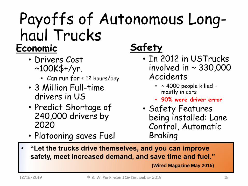
Payoffs of Autonomous Long-haul TrucksEconomic
• Drivers Cost ~100K$+/yr.• Can run for < 12 hours/day
• 3 Million Full-time drivers in US
• Predict Shortage of 240,000 drivers by 2020
• Platooning saves Fuel
Safety• In 2012 in USTrucks
involved in ~ 330,000 Accidents
• ~ 4000 people killed –mostly in cars
• 90% were driver error
• Safety Features being installed: Lane Control, Automatic Braking
12/16/2019 © B. W. Parkinson ICG December 2019 18
• “Let the trucks drive themselves, and you can improve
safety, meet increased demand, and save time and fuel.”
(Wired Magazine May 2015)

Many Issues to be resolved with self-driving vehicles
• Safety
• Integrity
•Accuracy
•Affordability
• Certification
• Public/Political Acceptance
12/16/2019 © B. W. Parkinson ICG December 2019 19
GNSS can help with these issues

Conclusion: GNSS can contribute for both F3 & F4
• Continue Improvements in Availabilty (ARAIM)➢Frequency diversity (e.g. using dual frequency measurements
on L1/L5 for GPS),
➢Geometry diversity (e.g. using as many GNSS constellations as possible in order to reach the required levels of satellite availability),
➢Use of an Integrity Support Message (ISM) send safety assertions for each of the core GNSS to the sovereign responsible for a given airspace,
• Accelerate Interchangeability(for Integrity, Availability and Accuracy)
• 4 Satellite Ranges from 4 Different Constellations yields the same Positioning Accuracy as 4 Satellite Ranges from one constellation or:
4 from 4 ≅ 4 from 1 - “Any four will do”
12/16/2019 © B. W. Parkinson ICG December 2019 20