archived evidence document - cornwall council · record information for each survey sub heading...
TRANSCRIPT

1
Appendix D
Penzance Housing Evidence Report: Landscape
Character Assessment Results
ARCHIVED EVIDENCE
DOCUMENT

2
Introduction This Appendix sets out the results for the Landscape Character Assessment stage (Step 6) of the Urban Extension
Assessment. The methodology for this step of the process is set out in Appendix C of this report. The local
Launceston Character Area Description is considered, followed by the more detailed assessment results, which
are presented in tabular and diagrammatic formats.
Launceston Character Area Description The historic town of Launceston sits in the strategically important location overlooking the Devon border and is
centrally placed between the north and south coasts. The ‘old’ town is situated on a small plateau which had for
long been an important cross roads for transport links for the counties of Devon and Cornwall. There are main
road links to Callington, Saltash and Plymouth to the south. Bodmin to the west, Okehampton and Exeter to the
east and Holsworthy and Bude to the north. These roads are all busy and congestion, particularly from the road
leading to Bude and Holsworthy is normal for the residents of this otherwise attractive town which still retains an
agricultural setting to the castle from a number of viewpoints.
Prominent though the castle and surrounding ‘old’ townscape is, much of the town is only visible close by along
access roads or public rights of way as it is well screened by the high ground surrounding it and by established
tree cover. In general, the landscape is a mixture of rolling pasture to the north and south with a steeper sided
green valley running through the town from east to west, where, in this more sheltered location, there are many
fine mature trees and a diverse range of habitats and wildlife.
The mix of a well-established, mature pastoral landscape, interspersed with significant areas of mixed woodland
and the focal point of the historic castle and the surrounding diverse architecture of the old town has produced a
unique quality to Launceston which is quite different to most other towns in the south west. It is still an attractive
town set within a diverse but rural landscape with good road links to the surrounding towns in both Devon &
Cornwall.
Landscape Character Assessment Results The outputs of this assessment are presented in two formats – for each cell:
the landscape characteristics are presented visually on maps (Figures 1-15); and,
the results of the landscape character assessments are presented in tables (Tables 1-17).
Please note that, in carrying out this assessment it was considered appropriate to split cells into a number of sub-
cells where the landscape character had distinctly different features within one cell. Consequently, in the case of
Launceston, Cells 2, 7 and 11 were split into smaller study sub-cells for this step of the process.
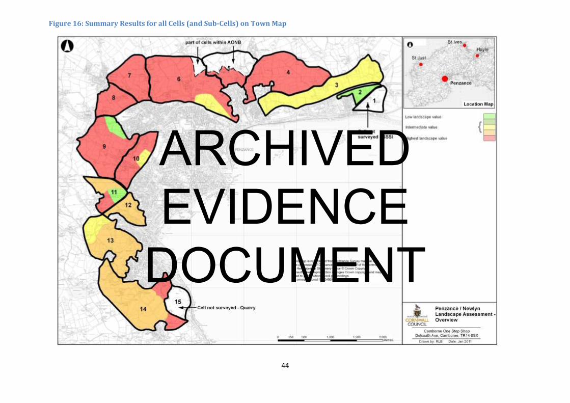
Figure 16 illustrates the summary results for all Cells (and sub-cells) on a map of the town.
ARCHIVED EVIDENCE
DOCUMENT
3
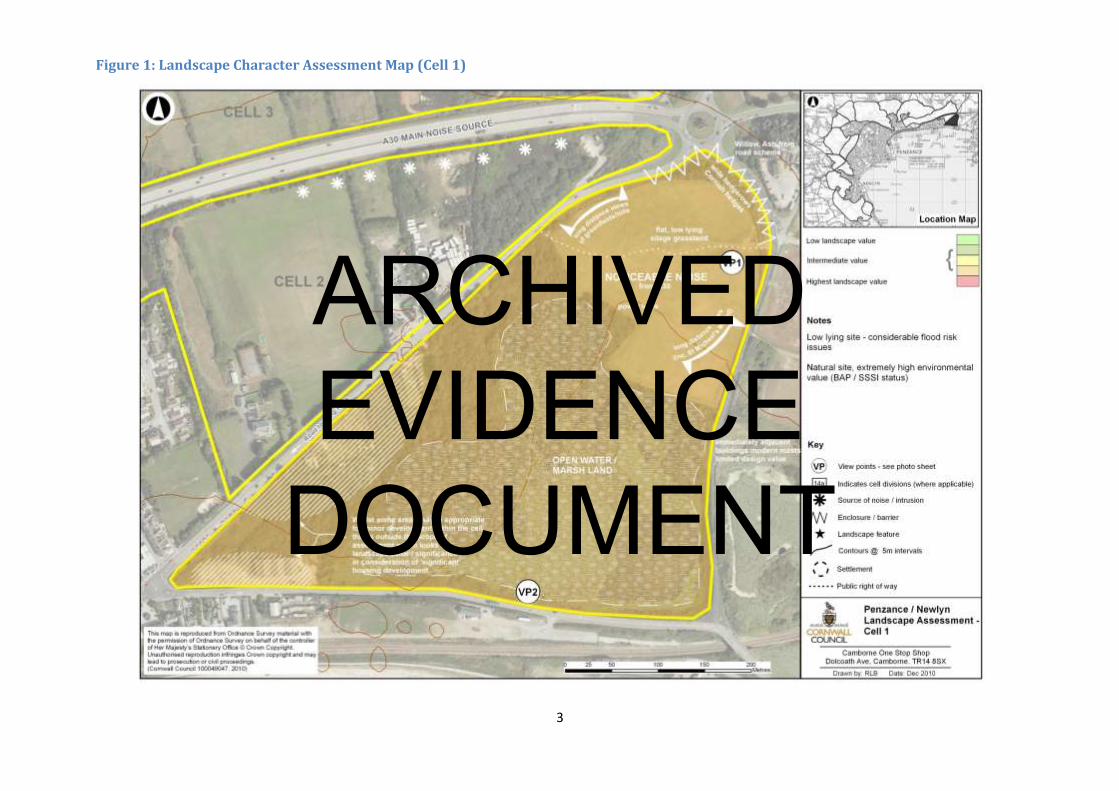
Figure 1: Landscape Character Assessment Map (Cell 1)
ARCHIVED EVIDENCE
DOCUMENT

CELL REFERENCE NUMBER; Penzance & Newlyn Cell 1
SHEET NUMBER;
ASSESSOR; Jon Mitchell/Cathy Lowe DATE; 27 October 2010
Landscape Survey Information Landscape Value Landscape
Sensitivity
Overall Landscape
AssessmentLandscape
Description Record descriptive information for each survey sub heading listed
Landscape Character Area No. 04
Landscape Description Unit No’s. 134
Place a value of H/M/L-
see guidance
Place a value of H/M/L-
see guidance
Final Cell Judgement
As per previous matrix Record information for each survey sub heading listed -
Natural Landscape Features
H
(Due to SSSI, BAP, Woodland
Cover) Marsh
M
Overall Landscape
Assessment Topography/ landform Flat, low lying land
Vegetation cover/ trees Grassland, pasture, scrub and marshland
Field pattern/ boundary
type
Natural boundaries in marsh, Highway planting to North East; Willow to North West
side
Land use Marsh, Allotments, Agricultural grassland
Natural
Distinctive landscape/
historic features
Open water to southern side of cell/natural character
Water bodies/ courses Open water / ponds
Settlement/ Built Features
Settlement type Limited, scattered to North along B road
Distinctive manmade
features
Power lines to North East
Distinctive historic or
cultural features
Chapel near West corner
Long distance views / St Michaels Mount
Vernacular (use of local
materials)
Limited, apart from Chapel
CELL 1 Transport Pattern
A Road/ B Road/ other B roads along boundaries
Railways None
Farm/ Private tracks
Cycleways None
PROW
Informal paths
Table 1: Landscape Character Assessment Results (Cell1)
4
ARCHIVED EVIDENCE
DOCUMENT

Visual Prominence (tick appropriate)
Open/ long distance
(high)
Intermittent (medium) Some long distance to East
Limited (low)
Landscape Condition
Integrity and unity of
landscape 3 mixed uses – wetland / pasture / allotments
Aesthetic & Sensory
Tranquillity (H/ M/ L) M
How is the landscape
experienced?
Natural to South East
Key sources / visual or
noise (both within and
outside the cell)
Main source- A30
Cell to Cell relationship
What is the key
information relating to
adjacent cell?
Divided by road
Photograph numbers
Other Information
Cell is too small to subdivide, whilst opportunity for some minor developments in North East.
Cells size makes it inappropriate for ‘significant’ development after Natural Areas have been omitted, likely flooding issues with developments
5
ARCHIVED EVIDENCE
DOCUMENT

6
Figure 2: Landscape Character Assessment Map (Cell 2)
ARCHIVED EVIDENCE
DOCUMENT

CELL REFERENCE NUMBER; Penzance & Newlyn Cell 2
SHEET NUMBER;
ASSESSOR; Jon Mitchell/Cathy Lowe DATE; 27 October 2010
Landscape Survey Information Landscape Value Landscape
Sensitivity
Overall Landscape
AssessmentLandscape
Description Record descriptive information for each survey sub heading listed
Landscape Character Area No. CA04
Landscape Description Unit No’s. 134
Place a value of H/M/L-
see guidance
Place a value of H/M/L-
see guidance
Final Cell Judgement
As per previous matrix Record information for each survey sub heading listed –
Small variable, cell, former sports field, low lying ground with gas governor/station
on NE side, unmanaged land to NE end with wet ground species
Natural Landscape Features
L
(Not tranquil, eroded
landscape/intrusions, therefore
not intact)
Score
L
(Well screened from A30 and
B road, therefore mitigation
potential)
Overall Landscape
Assessment Topography/ landform Flat, low lying
Vegetation cover/ trees Marshland, Bracken to East. Central of cell – former cricket field, now grassland
Field pattern/ boundary
type
Hedgerow, spps/high tree planting/screen to North (forms part of maturing highway
planting scheme – Alder/Ash) Original linear pattern matching cell 3 although
divided by A30
Land use Unused/derelict area with tipping to East / Central former cricket strip, west edge
adjacent housing, small public open space
Distinctive landscape/
historic features
Prominent views to St Michaels Mount to East of site and backdrop of high ground/
hills to the North (Cells 3 and 4)
Water bodies/ courses None visible- but is low lying ground with wetland species indicating springs/ wet
ground
Settlement type Urban Edge to West, caravan sales isolated residential
Distinctive manmade
features
-
Distinctive historic or
cultural features
None within cell, St Michaels Mount to South
Vernacular (use of local
materials)
None apparent within cell
CELL 2 Transport Pattern
A Road/ B Road/ other A30 on North / Significant A road on Southern Side.
Railways -
Farm/ Private tracks Some access to private property
Cycleways -
PROW Western edge of cell
Informal paths -
Table 2: Landscape Character Assessment Results (Cell 2)
7
ARCHIVED EVIDENCE
DOCUMENT

Visual Prominence (tick appropriate)
Open/ long distance
(high)
Intermittent (medium) Due to higher ground to North and St. Michaels Mount to South, planting to
north screens much of cell from A30
Limited (low)
Landscape Condition
Integrity and unity of
landscape
Intrusions – power, noise from roads (and heliport), broken up cell– various low
quality developments – caravan sales, garage
Aesthetic & Sensory
Tranquillity (H/ M/ L) L – Noise is the main intrusion from adjacent roads
How is the landscape
experienced?
Noisy, visually sheltered/enclosed – greatest to East
Key sources / visual or
noise (both within and
outside the cell)
A30/A roads
Cell to Cell relationship
What is the key
information relating to
adjacent cell?
Divided by road to both N and S, no smooth transitions
Photograph numbers
Other Information
Low integrity / impact on landscape is great due to proximity to A30 road, unmanaged, tipping.
Any development feels more appropriate for none residential to East
West could accommodate some housing adjacent existing housing area.
8
ARCHIVED EVIDENCE
DOCUMENT

9
Figure 3: Landscape Character Assessment Map (Cell 3)
ARCHIVED EVIDENCE
DOCUMENT

CELL REFERENCE NUMBER; Penzance & Newlyn Cell 3
SHEET NUMBER;
ASSESSOR; Jon Mitchell/Cathy Lowe DATE; 01 November 2010
Landscape Survey Information Landscape Value Landscape
Sensitivity
Overall Landscape
AssessmentLandscape
Description Record descriptive information for each survey sub heading listed
Landscape Character Area No. 04
Landscape Description Unit No’s. 133
Place a value of H/M/L-
see guidance
Place a value of H/M/L-
see guidance
Final Cell Judgement
As per previous matrix Record information for each survey sub heading listed –
Natural Landscape Features
Score
M
Grade 1 agricultural land,
partially tranquil, although
proximity to A30 and heliport
does impact on tranquillity.
The cell is reasonably intact.
Score
M
The proximity to the big shed
development to the south
(KFC, etc) visible from the
cell
Overall Landscape
Assessment Topography/ landform Gently sloping land from South rising to North, shallow even gradient
Vegetation cover/ trees Extensively worked grassland/agricultural land with hedgerow nature spp – lower
down, pine / willow – occasional arable
Field pattern/ boundary
type
Hedgerow, Elm, medium/small scale field pattern.
East side of site linear/ (medieval?) field pattern, productive land- grade 1
Field size medium, decreasing in size to the eastern side of cell
Land use Mainly grassland/ some agriculture
Distinctive landscape/
historic features
No distinct wind shaping of trees despite openness to Sea
Water bodies/ courses Small water way approx 2/3 along cell, running N-S
Settlement type Limited, Rural dwellings along northern road, a mix of modern and grand older
properties
Distinctive manmade
features
None within cell
Distinctive historic or
cultural features
None within cell, abuts Gulval Church Town and has impressive views of St Michaels
Mount in some locations
Vernacular (use of local
materials)
Wide range
CELL 3 Transport Pattern
A Road/ B Road/ other Surrounded by A30/South
Railways -
Farm/ Private tracks
Cycleways -
PROW
Informal paths -
Table 3: Landscape Character Assessment Results (Cell 3)
10
ARCHIVED EVIDENCE
DOCUMENT

Visual Prominence (tick appropriate)
Open/ long distance
(high) Open, high visibility
Intermittent (medium)
Limited (low)
Landscape Condition
Integrity and unity of
landscape
Within cell, integrated and unified landscape, however ‘big box’ development outside
cell boundary to south (KFC etc) impacts upon cells experience
Aesthetic & Sensory
Tranquillity (H/ M/ L) M – due to background road noise. Interrupted by Heliport, A30 – background.
General road noise, but not excessive.
How is the landscape
experienced?
Visually exposed, moderate exposure, well tendered landscape.
Key sources / visual or
noise (both within and
outside the cell)
Heliport, A30, railway.
Cell to Cell relationship
What is the key
information relating to
adjacent cell?
From South side – most frequented viewed – cells 3 & 4 are whole/continuous piece
of landscape.
Photograph numbers
Other Information
Forms the bottom of the hill which cells 3 and 4 make up. These 2 cells combined make up one complete piece of landscape which is highly visible from A30 and train as approach to Penzance
11
ARCHIVED EVIDENCE
DOCUMENT
12
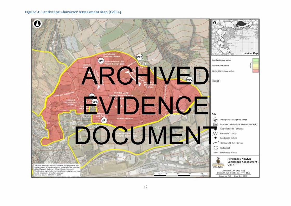
Figure 4: Landscape Character Assessment Map (Cell 4)
ARCHIVED EVIDENCE
DOCUMENT

CELL REFERENCE NUMBER; Penzance & Newlyn Cell 4
SHEET NUMBER;
ASSESSOR; Jon Mitchell/Cathy Lowe DATE; 03 November 2010
Landscape Survey Information Landscape Value Landscape
Sensitivity
Overall Landscape
AssessmentLandscape
Description Record descriptive information for each survey sub heading listed
Landscape Character Area No. CA04
Landscape Description Unit No’s. 139 & 133
Place a value of H/M/L-
see guidance
Place a value of H/M/L-
see guidance
Final Cell Judgement
As per previous matrix Record information for each survey sub heading listed –
Natural Landscape Features
H
Complete landscape, tranquil,
no degradation
H
Overall Landscape
Assessment Topography/ landform Lower slopes, shallow, increasing with height.
Vegetation cover/ trees Sporadic hedgerow trees, mainly arable in cell with some grassland.
Field pattern/ boundary
type
Hedgerow pattern, bunds, traditional pattern of hedgerow, no significant loss of
boundary, similar size fields, bigger to East (where more level)
Land use Arable/pasture limited
Distinctive landscape/
historic features
Tree tunnel on road to North East and South
Water bodies/ courses None
Settlement type Rural - Distinctive edge to Gulval, then no settlements apart from Tolver.
Distinctive manmade
features
None dominant
Distinctive historic or
cultural features
Gulval church town – historic settlement, Church at Gulval, St Michaels Mount from
most view points.
Vernacular (use of local
materials)
Some in traditional farm building, Granite.
Some highway features in East side compromise original character
CELL 4 Transport Pattern
A Road/ B Road/ other B roads around entire cell (apart from North section)
Railways -
Farm/ Private tracks Several
Cycleways -
PROW - Informal paths -
Table 4: Landscape Character Assessment Results (Cell 4)
13
ARCHIVED EVIDENCE
DOCUMENT

Visual Prominence (tick appropriate)
Open/ long distance
(high)
Intermittent (medium)
Limited (low)
Landscape Condition
Integrity and unity of
landscape
Intact – Complete landscape - + landscape to Cell 3
Aesthetic & Sensory
Tranquillity (H/ M/ L) H – across top of cell, only South side of sell – visual intrusions ‘Big Sheds’ ,
mitigation could screen.
How is the landscape
experienced?
Gradient form sheltered -> exposed (fairly)
Key sources / visual or
noise (both within and
outside the cell)
Big Shed developments (KFC/ McDonalds/ B&Q, etc)
A30 slightly but due to distance less impact than Cell 3
Cell to Cell relationship
What is the key
information relating to
adjacent cell?
Key link with cell 3 (only small road divides)
Photograph numbers
Other Information
Forms the mid/ top of the hill which cells 3 and 4 make up. These 2 cells combined make up one complete piece of landscape which is highly visible from A30 and train as approach to Penzance
14
ARCHIVED EVIDENCE
DOCUMENT

14
Figure 5: Landscape Character Assessment Map (Cell 5)
ARCHIVED EVIDENCE
DOCUMENT
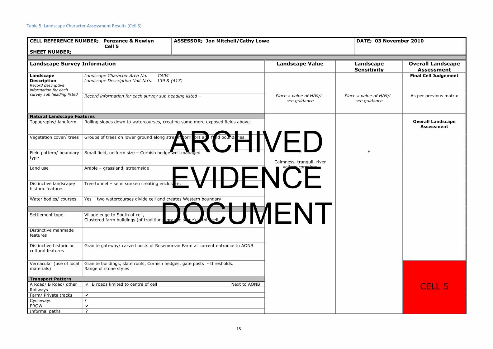
CELL REFERENCE NUMBER; Penzance & Newlyn Cell 5
SHEET NUMBER;
ASSESSOR; Jon Mitchell/Cathy Lowe DATE; 03 November 2010
Landscape Survey Information Landscape Value Landscape
Sensitivity
Overall Landscape
AssessmentLandscape
Description Record descriptive information for each survey sub heading listed
Landscape Character Area No. CA04
Landscape Description Unit No’s. 139 & (417)
Place a value of H/M/L-
see guidance
Place a value of H/M/L-
see guidance
Final Cell Judgement
As per previous matrix Record information for each survey sub heading listed –
Natural Landscape Features
H
Calmness, tranquil, river
valleys complete
H
Overall Landscape
Assessment Topography/ landform Rolling slopes down to watercourses, creating some more exposed fields above.
Vegetation cover/ trees Groups of trees on lower ground along stream corridors and field boundaries.
Field pattern/ boundary
type
Small field, uniform size – Cornish hedge well managed
Land use Arable – grassland, streamside
Distinctive landscape/
historic features
Tree tunnel – semi sunken creating enclosure.
Water bodies/ courses Yes – two watercourses divide cell and creates Western boundary.
Settlement type Village edge to South of cell,
Clustered farm buildings (of traditional granite stone) within cell
Distinctive manmade
features
Distinctive historic or
cultural features
Granite gateway/ carved posts of Rosemorran Farm at current entrance to AONB
Vernacular (use of local
materials)
Granite buildings, slate roofs, Cornish hedges, gate posts - thresholds.
Range of stone styles
CELL 5 Transport Pattern
A Road/ B Road/ other B roads limited to centre of cell Next to AONB
Railways -
Farm/ Private tracks
Cycleways ?
PROW
Informal paths ?
Table 5: Landscape Character Assessment Results (Cell 5)
15
ARCHIVED EVIDENCE
DOCUMENT

Visual Prominence (tick appropriate)
Open/ long distance
(high)
Intermittent (medium)
Limited (low)
Landscape Condition
Integrity and unity of
landscape
Cell complete although influence of adjacent Gulval village is prominent in South
Aesthetic & Sensory
Tranquillity (H/ M/ L) H
How is the landscape
experienced?
Generally sheltered feel, quiet, tranquil, despite proximity to Gulval
Key sources / visual or
noise (both within and
outside the cell)
Gulval village a potential source
Cell to Cell relationship
What is the key
information relating to
adjacent cell?
AONB to North
* Photograph numbers
Other Information
Small cell. Landscape character feels identical to the AONB in the north of Cell 5 and could be worthy of AONB extension south
16
ARCHIVED EVIDENCE
DOCUMENT

17
Figure 6: Landscape Character Assessment Map (Cell 6)
ARCHIVED EVIDENCE
DOCUMENT

CELL REFERENCE NUMBER; Penzance and Newlyn 6, A&B
SHEET NUMBER;
ASSESSOR; Jon Mitchell/Cathy Lowe DATE; 03 November 2010
Landscape Survey Information Landscape Value Landscape
Sensitivity
Overall Landscape
AssessmentLandscape
Description Record descriptive information for each survey sub heading listed
Landscape Character Area No. CA04
Landscape Description Unit No’s. 417 (Text Missing)
282 (6A)
Place a value of H/M/L- see
guidance
Place a value of H/M/L-
see guidance
Final Cell Judgement
As per previous matrix Record information for each survey sub heading listed -
Natural Landscape Features
6(A) = H
6(B) = M
6(A) = M
6(B) = M
Overall Landscape
Assessment Topography/ landform Crown to North, Steep sided to North East, Sloping South
Undulating landscape with steep sided wooded river valley, road embankment to
South
Vegetation cover/ trees Grassland, some arable, hedgerow / roadside / river valley trees, sycamore, some
Beech, Nature hedgerow mix.
Mature parkland associated with Manor
Field pattern/ boundary
type
Small scale, boundaries still evident, wind sculpted to exposed / higher ground,
sheltered South East.
Land use Arable, pasture, some woodland, parkland for Manor House
Distinctive landscape/
historic features
Some tree tunnels along roads
Water bodies/ courses None within cell
Settlement/ Built Features
Settlement type Urban edge to South and South East, clustered farm buildings.
Distinctive manmade
features
None within cell, southern side of cell influenced by P2, wind turbine, school/college
was prominent.
Distinctive historic or
cultural features
Boskeriwyn(?), church tower in Penzance prominent on horizon. Sea not visible
from much of cell.
Vernacular (use of local
materials)
Simple gate posts, Cornish hedge boundary
CELL 6A CELL 6B Transport Pattern
A Road/ B Road/ other Limited to B roads
Railways -
Farm/ Private tracks
Cycleways -
Table 6: Landscape Character Assessment Results (Cell 6 A & B)
18
ARCHIVED EVIDENCE
DOCUMENT

PROW Several public footpaths within cell
Informal paths -
Visual Prominence (tick appropriate)
Open/ long distance
(high) } Prominence varies
South – influenced by proximity to A30/Residential P2
Intermittent (medium) } Centre/North – highly prominent from AONB, West + P2
Limited (low)
Landscape Condition
Integrity and unity of
landscape
Northern part complete, Southern part – intrusions from A30/P2
Aesthetic & Sensory
Tranquillity (H/ M/ L) Low to south, gradient through to high – mid / centre of cell
How is the landscape
experienced?
Exposure, sheltered enclosed, simple
Range – mostly heavily influenced by topography – Valley – sheltered
- Hilltops - exposed
Key sources / visual or
noise (both within and
outside the cell)
A30, Penzance
Cell to Cell relationship
What is the key
information relating to
adjacent cell?
Photograph numbers
Other Information
Split Cell – Southern edge has different character – influenced by A30 noise, proximity to housing, not tranquil, visually dominant.
Whereas Mid/North is intact landscape/ rural setting, with extremely limited impact from adjacent town.
19
ARCHIVED EVIDENCE
DOCUMENT

20
Figure 7: Landscape Character Assessment Map (Cell 7)
ARCHIVED EVIDENCE
DOCUMENT

CELL REFERENCE NUMBER; Penzance & Newlyn Cell 7
SHEET NUMBER;
ASSESSOR; Jon Mitchell/Cathy Lowe DATE; 10 November 2010
Landscape Survey Information Landscape Value Landscape
Sensitivity
Overall Landscape
AssessmentLandscape
Description Record descriptive information for each survey sub heading listed
Landscape Character Area No.
Landscape Description Unit No’s.
Place a value of H/M/L-
see guidance
Place a value of H/M/L-
see guidance
Final Cell Judgement
As per previous matrix Record information for each survey sub heading listed -
Natural Landscape Features
H H
Overall Landscape
Assessment Topography/ landform Varies from gently sloping high ground to very steeply sloping river valley sides.
Vegetation cover/ trees Stunted hedgerow trees on high ground, through pasture down to mature trees in
mixed woodland in valley bottom.
Field pattern/ boundary
type
Cornish hedges and hedgerow trees appropriate low key management
Land use Pasture (horses predominantly) woodland valleys, allotments in South East corner
(…….…….. land)
Distinctive landscape/
historic features
Low key features such as stone bridge in valley bottom and steps by public footpath
– made from substantial granites
Water bodies/ courses 2 main watercourses - rivers
Settlement/ Built Features
Settlement type To north east isolated farm buildings, associated with roads, Madron to North West –
substantial stone village impacts on cell
Distinctive manmade
features
Within cell – limited to substation on eastern edge (low lying site, so low impact
generally) Power lines and … Distance views Penzance town wind turbine
dominates
Distinctive historic or
cultural features
Engine houses / church tower / Cornish hedges / tree tunnels, listed buildings, SAMs
other important features
Vernacular (use of local
materials)
Local stone (granite) dominant in walls, hedges, gate posts, steps, etc, etc.
Watercourse details
CELL 7 Transport Pattern
A Road/ B Road/ other B roads and public footpath
Railways -
Farm/ Private tracks
Cycleways -
PROW
Informal paths -
Table 7: Landscape Character Assessment Results (Cell 7)
21
ARCHIVED EVIDENCE
DOCUMENT

Visual Prominence (tick appropriate)
Open/ long distance
(high) Northern and mid parts of cell – very high prominence
Intermittent (medium) Transition areas from high to valley bottom
Limited (low) Valley Bottoms
Landscape Condition
Integrity and unity of
landscape Complete – very limited – modern dwellings on edge of Madron.
Small scale posts with overhead wires
Aesthetic & Sensory
Tranquillity (H/ M/ L) HIGH!
How is the landscape
experienced?
Exposed on high ground infinite/enclosed in valleys – range between.
Key sources / visual or
noise (both within and
outside the cell)
Good noises only 0 water strong element.
Cell to Cell relationship
What is the key
information relating to
adjacent cell?
Western edge of cell highly visible and boundary road on eastern edge feels as
though it travels through a ‘whole’ landscape – western edge cell falls away steeply
so not so … continuity
Photograph numbers
Other Information
22
ARCHIVED EVIDENCE
DOCUMENT
23
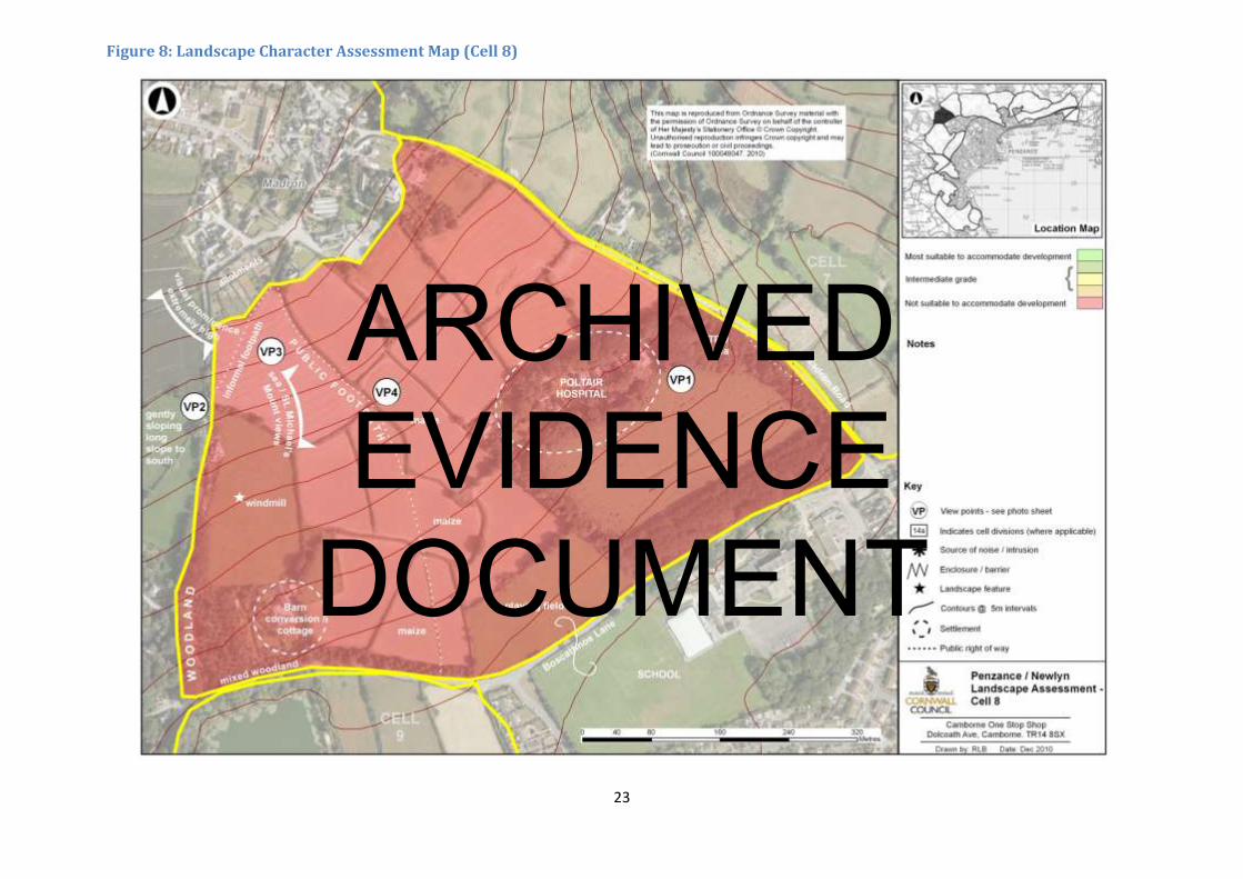
Figure 8: Landscape Character Assessment Map (Cell 8)
ARCHIVED EVIDENCE
DOCUMENT

CELL REFERENCE NUMBER; Penzance & Newlyn Cell 8
SHEET NUMBER;
ASSESSOR; Jon Mitchell/Cathy Lowe DATE; 10 November 2010
Landscape Survey Information Landscape Value Landscape
Sensitivity
Overall Landscape
AssessmentLandscape
Description Record descriptive information for each
survey sub heading listed
Landscape Character Area No.
Landscape Description Unit No’s.
Place a value of H/M/L- see
guidance
Place a value of H/M/L-
see guidance
Final Cell Judgement
As per previous matrix Record information for each survey sub heading listed -
Natural Landscape Features
H
Score
H
Overall Landscape
Assessment Topography/ landform Evenly falling gentle south facing slope
Vegetation cover/ trees Woodland associated with Poltair Hospital.
Arable/pasture and sports field to the South
Field pattern/ boundary
type
Medium sized field pattern, hedgerow, native species, thorn and some gorse
Land use Arable, pasture, woodland, sports
Distinctive landscape/
historic features
Tree tunnel on West side, substantial granite cattle grids
Water bodies/ courses None
Settlement/ Built Features
Settlement type Village edge to North, Heamoor to South, with dispersed residential along road and
hospital.
Distinctive manmade
features
Limited on site
Distinctive historic or
cultural features
Madron Church spire, St Michael’s Mount.
Hospital screened from Madron by tree cover.
Vernacular (use of local
materials)
Penwith style Cornish hedge, granite stiles, granite steps
CELL 8 Transport Pattern
A Road/ B Road/ other B roads – East, South and West
Railways -
Farm/ Private tracks
Cycleways -
PROW PROW across cell North to South and from West
Informal paths
Table 8: Landscape Character Assessment Results (Cell 8)
24
ARCHIVED EVIDENCE
DOCUMENT

Visual Prominence (tick appropriate)
Open/ long distance
(high) HIGH – Very
Intermittent (medium)
Limited (low)
Landscape Condition
Integrity and unity of
landscape Complete
Aesthetic & Sensory
Tranquillity (H/ M/ L) Generally High – potential noise from school to South
How is the landscape
experienced?
Open landscape – high quality mature woodlands, contribute to sense of maturity
within landscape with long distance views
Key sources / visual or
noise (both within and
outside the cell)
Mounts Bay School, near to Heamoor village but not obtrusive because of change in
levels
Cell to Cell relationship
What is the key
information relating to
adjacent cell?
Photograph numbers
25
ARCHIVED EVIDENCE
DOCUMENT

26
Figure 9: Landscape Character Assessment Map (Cell 9)
ARCHIVED EVIDENCE
DOCUMENT

CELL REFERENCE NUMBER; Penzance & Newlyn Cell 9
SHEET NUMBER;
ASSESSOR; Jon Mitchell/Cathy Lowe DATE; 18 November 2010
Landscape Survey Information Landscape Value Landscape
Sensitivity
Overall Landscape
AssessmentLandscape
Description Record descriptive information for each survey sub heading listed
Landscape Character Area No.
Landscape Description Unit No’s.
Place a value of H/M/L- see
guidance
Place a value of H/M/L- see
guidance
9(A) – H
9(B) – L
Final Cell Judgement
As per previous matrix Record information for each survey sub heading listed -
Natural Landscape Features
9(A) – H
9(B) – L
Overall Landscape
Assessment Topography/ landform Cell divided by valley running North West -> South East, North side of cell generally
open/level, valley becoming increasingly marked toward South East. Higher land
around Lesingey Round, which is positioned at the crown and prominent from
surrounding area.
Vegetation cover/ trees Agricultural landscape compromising of grassland (managed/unmanaged)
Deciduous woodland around reservoir and along river corridor, Hedgerows in South
of cell thorn mix with situated hedgerow trees.
Field pattern/ boundary
type
Medium size field pattern, uniform across cell. Cornish hedge field boundaries with
some trees along roadside.
Land use Agricultural, woodland, natural along river, reservoir
Unmanaged/neglected poly tunnels and farm West/North West side of cell.
Distinctive landscape/
historic features
Lesingey Round most distinctive feature, granite gate posts and consists with stiles
style along footway.
Water bodies/ courses Reservoir and river running North West -> South East with subsidiary streams
Settlement/ Built Features
Settlement type Variable, cell is adjacent urban edge, however within cell 3 farms comprising of
clustered farm buildings.
Distinctive manmade
features
Power lines in the North of cell extremely prominent.
Distinctive historic or
cultural features
Lesingey Round is a key historic feature both visually and as a Scheduled Ancient
monument
Vernacular (use of local
materials)
Granite linear stiles, stone buildings
CELL 9A
CELL 9B
Transport Pattern
A Road/ B Road/ other B roads around West, North West and North
Railways -
Farm/ Private tracks
Cycleways -
PROW
Informal paths
Table 9: Landscape Character Assessment Results (Cell 9)
27
ARCHIVED EVIDENCE
DOCUMENT

Visual Prominence (tick appropriate)
Open/ long distance
(high) South side of cell far reaching views to Newlyn and prominent in South cell of
round (for rural views)
South West side of cell far reaching views to Madron.
Intermittent (medium) Northern side of cell
Limited (low)
Landscape Condition
Integrity and unity of
landscape
The North West side of site as urban fringe has significant intrusions – visually focus
roof lines and significant overhead power lines. The farm is neglected, damaged
walls and unmanaged fields.
Southern Cell is intact farming landscape, pasture, fields and hedges with some hay
baling.
Aesthetic & Sensory
Tranquillity (H/ M/ L) Variable, tranquil to South/South West, low tranquillity to North/North East
How is the landscape
experienced?
Sheltered and enclosed along river valley, open far reaching around Lesingey Round.
Key sources / visual or
noise (both within and
outside the cell)
Housing along Eastern boundary (and school).
Minor road noise.
Significant negative impact of power lines.
Cell to Cell relationship
What is the key
information relating to
adjacent cell?
Photograph numbers
Other Information
28
ARCHIVED EVIDENCE
DOCUMENT

29
Figure 10: Landscape Character Assessment Map (Cell 10)
ARCHIVED EVIDENCE
DOCUMENT

CELL REFERENCE NUMBER; Penzance & Newlyn Cell 10
SHEET NUMBER;
ASSESSOR; Jon Mitchell/Cathy Lowe DATE; 18 November 2010
Landscape Survey Information Landscape Value Landscape
Sensitivity
Overall Landscape
AssessmentLandscape
Description Record descriptive information for each survey sub heading listed
Landscape Character Area No.
Landscape Description Unit No’s.
Place a value of H/M/L-
see guidance
Place a value of H/M/L-
see guidance
Final Cell Judgement
As per previous matrix Record information for each survey sub heading listed -
Natural Landscape Features
10(A) – H
10(B) – M
10(A) – H
10(B) – L
Overall Landscape
Assessment Topography/ landform Varies, flat to northern end of cell in-front of Nancealvern house.
Sloping South East in centre of cell, wooded river valley incises South end of cell.
Vegetation cover/ trees Mixed, mature deciduous parkland trees and native woodland mixed with introduced
species, as part of historic estates, Millennium woodland along A road, maturing
highway planting and some bunding.
Field pattern/ boundary
type
No overall dominant style, but stone boundaries.
Land use Mixed- vineyard, parkland, grassland, pasture, millennium woodland.
Distinctive landscape/
historic features
Good tree lined driveways to properties, granite block steps/stile/bridge traditional
style on footpaths.
Water bodies/ courses -
Settlement/ Built Features
Settlement type Large individual historic properties, more modern development within the river
valley, light industrial along roadside.
Distinctive manmade
features
Wind turbine visible, but not in cell.
Some power lines, but not overly dominant.
Distinctive historic or
cultural features
3 historic houses – YHA (former Castle Horrick), Nancealver and Rosehill.
Vernacular (use of local
materials)
CELL
10A
CELL
10B
Transport Pattern
A Road/ B Road/ other A30 to South East boundary, AOH South boundary
Railways -
Farm/ Private tracks
Cycleways -
PROW Several
Informal paths
Table 10: Landscape Character Assessment Results (Cell 10)
30
ARCHIVED EVIDENCE
DOCUMENT

Visual Prominence (tick appropriate)
Open/ long distance
(high)
Intermittent (medium) Only long views to St Michaels Mount from South end of cell.
Limited (low)
Landscape Condition
Integrity and unity of
landscape
Mixed cell, mature, fairly small scale, lots of mature trees
Middle distance views -> Complete
Aesthetic & Sensory
Tranquillity (H/ M/ L) M -> H
Road noise, lack of exposure, some powerlines
How is the landscape
experienced?
Sheltered enclosed, gentle, mature, established.
Key sources / visual or
noise (both within and
outside the cell)
Road (A30) to South East
Cell to Cell relationship
What is the key
information relating to
adjacent cell?
Photograph numbers
Other Information
Around Polgoon vineyards (whilst they are clearly an appropriate and viable business) the industrial estates offer less from a landscape perspective due to proximity to A30, housing adjacent cell.
Northern cell – is intact parkland associated with Manor House
Southern Cell – feels mature, part of original YHA estate
31
ARCHIVED EVIDENCE
DOCUMENT

32
Figure 11: Landscape Character Assessment Map (Cell 11)
ARCHIVED EVIDENCE
DOCUMENT

CELL REFERENCE NUMBER; Penzance & Newlyn Cell 11
SHEET NUMBER;
ASSESSOR; Melissa Ralph & Belinda Edwards DATE; 09 November 2010
Landscape Survey Information Landscape Value Landscape
Sensitivity
Overall Landscape
AssessmentLandscape
Description Record descriptive information for each survey sub heading listed
Landscape Character Area No.
Landscape Description Unit No’s. 417
Place a value of H/M/L-
see guidance
Place a value of H/M/L-
see guidance
Final Cell Judgement
As per previous matrix Record information for each survey sub heading listed –
Natural Landscape Features
11(A) - M
11(B) - H
11(C) – M
11(A) - H
11(B) - H
11(C) – L
Overall Landscape
Assessment Topography/ landform Uniform gentle to medium slopes running south towards flood plain.
Vegetation cover/ trees Mainly pastoral and arable with some copses/woodland and well wooded hedges on
lower slopes.
Field pattern/ boundary
type
Cornish hedges – broadleaved trees and shrubs on lower field boundaries, upper
fields quite devoid of trees and kept flailed
Land use 11A Grade 2 arable farmland. 11B is parkland to Trereife House (grade 1
agricultural land). 11C Grade 2 agricultural land, used as pasture.
Distinctive landscape/
historic features
Trereife House forms landmark in the landscape – grade 1 listed house and ancient
cross in grounds
Water bodies/ courses Pond and small stream
Settlement type Hamlet of Trereife on West boundary. No other buildings.
Distinctive manmade
features
Power line shown on plan
Distinctive historic or
cultural features
Trereife House – Grade I listed
Vernacular (use of local
materials)
Granite hedge styles, estate gate posts (granite) wrought iron field gates and kissing
gates.
CELL
11A
CELL
11B
CELL
11C A Road/ B Road/ other A30 and A3071 roads – border North and South of site, meet at roundabout
Railways -
Farm/ Private tracks
Cycleways -
PROW
Informal paths -
Table 11: Landscape Character Assessment Results (Cell 11)
33
ARCHIVED EVIDENCE
DOCUMENT

Visual Prominence (tick appropriate)
Open/ long distance
(high) Higher Fields (11A)
Intermittent (medium)
Low and Medium height fields (11B and 11C)
Limited (low)
Landscape Condition
Integrity and unity of
landscape
Trerife Estate – good quality historic landscape.
Higher fields – good quality agricultural land – well maintained
Aesthetic & Sensory
Tranquillity (H/ M/ L) M
How is the landscape
experienced?
Exposed on the higher ground, intimate around Trerife House
Key sources / visual or
noise (both within and
outside the cell)
Road noise from A30 and A3071 running along East boundary of cell.
Cell to Cell relationship
What is the key
information relating to
adjacent cell?
Busy roads form effective cut off, but landform of 11 & 12 is coherent and connected
when viewed from a distance.
Photograph numbers
Other Information
34
ARCHIVED EVIDENCE
DOCUMENT

35
Figure 12: Landscape Character Assessment Map (Cell 12)
ARCHIVED EVIDENCE
DOCUMENT

CELL REFERENCE NUMBER; Penzance & Newlyn Cell 12
SHEET NUMBER;
ASSESSOR; Melissa Ralph & Belinda Edwards DATE; 15 November 2010
Landscape Survey Information Landscape Value Landscape
Sensitivity
Overall Landscape
AssessmentLandscape
Description Record descriptive information for each survey sub heading listed
Landscape Character Area No. CA04
Landscape Description Unit No’s. 417 (and 285 urban)
Place a value of H/M/L-
see guidance
Place a value of H/M/L-
see guidance
Final Cell Judgement
As per previous matrix Record information for each survey sub heading listed –
Natural Landscape Features
M M
Overall Landscape
Assessment Topography/ landform Gentle/medium slopes of valley side, generally to South West towards watercourse.
Ranging from flood plain level to 65m
Vegetation cover/ trees Mainly pastoral and arable with belts of woodland and scrub on steep banks. Mix of
native broadleaves in general. Well wooded Cornish hedges around lower fields.
Overall effect is of significant woodland cover to cell.
Field pattern/ boundary
type
Cornish hedges, mix of managed and unmanaged. Mature broadleaved trees in
hedges on lower fields.
Land use Mainly arable and pasture, Grade 1 and 2 agricultural land. Amenity use of
woodland areas.
Pitches on low lying level area – former tip?
Distinctive landscape/
historic features
Tolcarne Round – iron age round/bronze age barrow and former mining area, now
wooded, high informal amenity value.
Water bodies/ courses River with streams and associated floodplain
Settlement type Open area between dense residential edges of Penzance to North East and Newyln to
South West.
Distinctive manmade
features
Telephone mast just beyond cell boundary to West on Misery Hill, highly visible.
Power lines on posts across some fields.
Distinctive historic or
cultural features
Cornish hedges and double hedged footpath with stone style.
Vernacular (use of local
materials)
Granite gate posts and traditional wrought iron field gates.
CELL 12 A Road/ B Road/ other A30 Penzance – Lands End. North West boundary of cell. B3315 to Newlyn
along South boundary of cell.
Railways -
Farm/ Private tracks -
Cycleways -
PROW
Informal paths
Table 12: Landscape Character Assessment Results (Cell 12)
36
ARCHIVED EVIDENCE
DOCUMENT

Visual Prominence (tick appropriate)
Open/ long distance
(high)
Intermittent (medium)
Limited (low)
Landscape Condition
Integrity and unity of
landscape
Minor intrusions
Aesthetic & Sensory
Tranquillity (H/ M/ L) M
How is the landscape
experienced?
Sheltered and enclosed, diverse mix of landscape experiences e.g. Riverside,
woodland banks, scrubland, grassland, wetland
Key sources / visual or
noise (both within and
outside the cell)
A30 and B road are source of significant noise to adjacent fields
Cell to Cell relationship
What is the key
information relating to
adjacent cell?
Cell 11 – A30 and roadside planting cuts off short views of adjacent cell. Longer
distance views of Cell 11 from the higher areas of cell 12 – Trereife Estate and
surrounding farmland.
Photograph numbers
Other Information
KEY POINTS
Extremely diverse landscape types – high biodiversity (river, wetland, scrub, woodland, open grassland ie whole range of habitats)
Valuable amenity – should be part of G1
Separates residential edges of Newlyn and Penzance (OARS – Open area related to settlements)
Whilst this came out overall as a score of 6 (Orange), it combines some highly visible areas, the less visible areas are very close to flood plain, some high amenity areas and an area of high biodiversity
overall. On balance, in my view, it is probably not suitable for development.
37
ARCHIVED EVIDENCE
DOCUMENT

38
Figure 13: Landscape Character Assessment Map (Cell 13)
ARCHIVED EVIDENCE
DOCUMENT
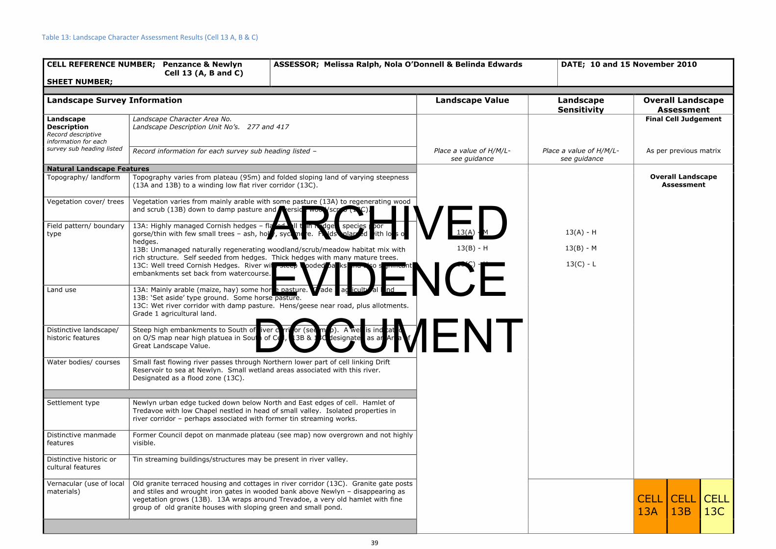
CELL REFERENCE NUMBER; Penzance & Newlyn Cell 13 (A, B and C)
SHEET NUMBER;
ASSESSOR; Melissa Ralph, Nola O’Donnell & Belinda Edwards DATE; 10 and 15 November 2010
Landscape Survey Information Landscape Value Landscape
Sensitivity
Overall Landscape
AssessmentLandscape
Description Record descriptive information for each survey sub heading listed
Landscape Character Area No.
Landscape Description Unit No’s. 277 and 417
Place a value of H/M/L-
see guidance
Place a value of H/M/L-
see guidance
Final Cell Judgement
As per previous matrix Record information for each survey sub heading listed –
Natural Landscape Features
13(A) - M
13(B) - H
13(C) - H
13(A) - H
13(B) - M
13(C) - L
Overall Landscape
Assessment Topography/ landform Topography varies from plateau (95m) and folded sloping land of varying steepness
(13A and 13B) to a winding low flat river corridor (13C).
Vegetation cover/ trees Vegetation varies from mainly arable with some pasture (13A) to regenerating wood
and scrub (13B) down to damp pasture and riverside wood/scrub (13C).
Field pattern/ boundary
type
13A: Highly managed Cornish hedges – flailed tall thin hedges, species poor
gorse/thin with few small trees – ash, holly, sycamore. Fields enlarged with loss of
hedges.
13B: Unmanaged naturally regenerating woodland/scrub/meadow habitat mix with
rich structure. Self seeded from hedges. Thick hedges with many mature trees.
13C: Well treed Cornish Hedges. River with steep wooded banks and also significant
embankments set back from watercourse.
Land use 13A: Mainly arable (maize, hay) some horse pasture. Grade 3 agricultural land
13B: ‘Set aside’ type ground. Some horse pasture.
13C: Wet river corridor with damp pasture. Hens/geese near road, plus allotments.
Grade 1 agricultural land.
Distinctive landscape/
historic features
Steep high embankments to South of river corridor (see map). A well is indicated
on O/S map near high platuea in South of Cell, 13B & 13C designated as an Area of
Great Landscape Value.
Water bodies/ courses Small fast flowing river passes through Northern lower part of cell linking Drift
Reservoir to sea at Newlyn. Small wetland areas associated with this river.
Designated as a flood zone (13C).
Settlement type Newlyn urban edge tucked down below North and East edges of cell. Hamlet of
Tredavoe with low Chapel nestled in head of small valley. Isolated properties in
river corridor – perhaps associated with former tin streaming works.
Distinctive manmade
features
Former Council depot on manmade plateau (see map) now overgrown and not highly
visible.
Distinctive historic or
cultural features
Tin streaming buildings/structures may be present in river valley.
Vernacular (use of local
materials)
Old granite terraced housing and cottages in river corridor (13C). Granite gate posts
and stiles and wrought iron gates in wooded bank above Newlyn – disappearing as
vegetation grows (13B). 13A wraps around Trevadoe, a very old hamlet with fine
group of old granite houses with sloping green and small pond. CELL
13A
CELL
13B
CELL
13C
Table 13: Landscape Character Assessment Results (Cell 13 A, B & C)
39
ARCHIVED EVIDENCE
DOCUMENT

A Road/ B Road/ other A30 to lowest North edge of cell. B3315 borders part of North edge – 13C
Railways -
Farm/ Private tracks
Cycleways Bridleways to South edge of cell
PROW Many paths radiating from Tredavoe – 13A
Informal paths
Visual Prominence (tick appropriate)
Open/ long distance
(high) 13A
Intermittent (medium)
13B
Limited (low)
13C
Landscape Condition
Integrity and unity of
landscape
Minor intrusions
Aesthetic & Sensory
Tranquillity (H/ M/ L) Cell 13A = H
Cell 13B = M
Cell 13C = M
How is the landscape
experienced?
Cell 13A = High, exposed, folded valleys, intensively farmed.
Cell 13B = Rich varied, naturally regenerating woodland/scrub.
Cell 13C = Low, enclosed sheltered, river corridor.
Key sources / visual or
noise (both within and
outside the cell)
A30 and B3315 are sources of traffic noise in lowest part of the cell (13C).
Cell to Cell relationship
What is the key
information relating to
adjacent cell?
The river corridor in 13C runs into the lower side of Cell 12, across the B3315.
Photograph numbers
Other Information
40
ARCHIVED EVIDENCE
DOCUMENT

41
Figure 14: Landscape Character Assessment Map (Cell 14)
ARCHIVED EVIDENCE
DOCUMENT

CELL REFERENCE NUMBER; Penzance & Newlyn Cell 14 (A and B)
SHEET NUMBER;
ASSESSOR; Melissa Ralph & Belinda Edwards DATE; 03 November 2010
Landscape Survey Information Landscape Value Landscape
Sensitivity
Overall Landscape
AssessmentLandscape
Description Record descriptive information for each survey sub heading listed
Landscape Character Area No.
Landscape Description Unit No’s. 14A = 277
14B = 132
Place a value of H/M/L-
see guidance
Place a value of H/M/L-
see guidance
Final Cell Judgement
As per previous matrix Record information for each survey sub heading listed –
Natural Landscape Features
14(A) - M
14(B) - H
14(A) - M
14(B) - H
Overall Landscape
Assessment Topography/ landform 14A: Gently undulating farmland above Newlyn. Manmade ‘hill’ to eastern part of
the cell, projects above the natural contours.
14B: Steeply sloping (East facing) land overlooking Bay (95-60m)
Vegetation cover/ trees 14A: Medium sized agricultural fields, mainly arable, some cattle pasture.
14B: Mixed – Medium size arable fields, small pastural fields, regenerating
woodland bank, including a BAP woodland area, with TPO and SSSI area associated
with the Quarry.
Field pattern/ boundary
type
14A: Medium sized fields with managed uniform Cornish hedges – species poor,
flailed, windblown.
14B: Mix of hedges, lower ones richer, wider with mature trees.
Land use 14A: Mainly arable, some cattle pasture, horse pasture. Grade 3 agricultural land.
14B: Mixed arable, small paddocks, regenerating woodland. Grade 3 agricultural
land.
Distinctive landscape/
historic features
14B: Gwavas Lane is a species rich sunken lane with some mature trees
Water bodies/ courses Small pond and two wells – see map.
Settlement type 14A: Scattered individual properties and erban edge of Newlyn to North.
14B: Urban edge of Newlyn to North, village urban edge (Paul) to South
Distinctive manmade
features
14A: ‘Hill’ is a striking landmark to East of this subcell. Reservoir, low power lines
also in 14A. Penlee Quarry lies to East of cell 14A.
Distinctive historic or
cultural features
Chyenhal Settlement mound, scheduled ancient monument borders edge of cell.
Paul Church Tower seen from 14A and 14B (South of cell). Standing stone.
Vernacular (use of local
materials)
Cornish stone hedges, impressive stone stiles (Gwavas Lane and outskirts of Paul).
Very old farm cottages at Chywoone Grove.
CELL 14A CELL 14B A Road/ B Road/ other B3315 (Newlyn to Land’s End) passes through centre of cell.
Railways -
Farm/ Private tracks
Cycleways -
Table 14: Landscape Character Assessment Results (Cell 14 A & B)
42
ARCHIVED EVIDENCE
DOCUMENT

PROW
Informal paths 'Hill' is used as an amenity area with panoramic views. Visual Prominence (tick appropriate)
Open/ long distance
(high) 14B – Due to slope and aspect, highly visible from Newlyn, Penzance,
Marazion to North East and Paul to South
Intermittent (medium)
14A
Limited (low)
Landscape Condition
Integrity and unity of
landscape
Some intrusions – ‘hill’ being most significant. Also reservoir and low power lines.
Aesthetic & Sensory
Tranquillity (H/ M/ L) Cell 14A = M
Cell 14B = H (other than adjacent quarry which is now a SSSI)
How is the landscape
experienced?
Cell 14A = Rolling landform, sheltered, some urban fringe. Low visibility. Hill
exposed, windy, panoramic views.
Cell 14B = Stunning sea views, exposed, windswept. Highly visible
Key sources / visual or
noise (both within and
outside the cell)
Road noise from B3315
Cell to Cell relationship
What is the key
information relating to
adjacent cell?
Photograph numbers
Other Information
14B – There may be limited scope to expand Paul with pockets of houses, so long as remains distinct from nearby Newlyn and Mousehole.
43
ARCHIVED EVIDENCE
DOCUMENT
44
Figure 16: Summary Results for all Cells (and Sub-Cells) on Town Map
ARCHIVED EVIDENCE
DOCUMENT