applications of satellite and marine geodesy to …
TRANSCRIPT

NASA CONTRACTOR REI'ORT NASA CR-141395
(NASA-Cg-1413 9 5 ) APPLICATIONS OFSATELLITE
N75-2068
AND MARINE GEODESY TO OPERATIONS, IN THE
OCEAN ENVIRONNENT ;(Battelle Columbus Labs.,,Ohio.) 120 -p HC $5.25 CSCL 14B Unclas
20 p H$5. 25 G3/35 14732
APPLICATIONS OF SATELLITE
AND MARINE GEODESY TO OPERATIONS
IN THE OCEAN ENVIRONMENT
by: D.M. Fubara and A.G. Mourad
Prepared under contract No. NAS6-2006 by:
Battelle
Columbus Laboratories -
505 King Avenue
Columbus, Ohio 43201
for:
NATIONAL AERONAUTICS AND SPACE ADMINISTRATION
WALLOPS FLIGHT CENTER
WALLOPS ISLAND, VIRGINIA 23337 March 1975

1. Report No. 2. Government Accession No. 3. Recipient's Catalog No.
NASA CR-1413954. Title and Subtitle 5. Report Date
APPLICATIONS OF SATELLITE AND MARINE GEODESY TO OPERATIONS IN March 1973
THE OCEAN ENVIRONMENT 6. Performing Organization Code
7. Author(s) 8. Performing Organization Report No.
D. M. J. Fubara and A. G. Mourad10. Work Unit No.
9. Performing Organization Name and Address
Battelle 11. Contract or Grant No.Columbus Laboratories505 King Avenue NAS6-2006Columbus, Ohio 43201 13. Type of Report and Period Covered
12. Sponsoring Agency Name and Address Contractor ReportNational Aeronautics & Space AdministrationWallops Flight Center 14. Sponsoring Agency CodeWallops Flight CenterWallops Island, Virginia 23337
15. Supplementary Notes
In accordance with para. 5.d. of NASA Policy Directive, NPD-2220.4, "Use of the InternationalSystem of Units (SI) in NASA Publications," a waiver has been granted for this report.
16. Abstract
The overall objective of this study was to assess the requirements for marine and satellitegeodesy technology with the emphasis on the development of the case for marine geodesy. Thisobjective was achieved by (1) analysis of various NASA programs and missions for identificationof the satellite geodesy technology applicable to marine geodesy, (2) analysis of variousnational and international marine programs to identify the possible roles of satellite/marinegeodesy techniques for meeting the objectives of these programs and other objectives of nationalinterest more effectively, and (3) development of the case for marine geodesy based on theextraction of requirements documented by authoritative technical industrial people, professionalgeodesists, government agency personnel, and applicable technology reports.
17. Key Words (Suggested by Author(s)) 18. Distribution Statement
EREP Unclassified - UnlimitedSkylabGEOS-C Satellite STAR Category 35Marine Geodesy
19. Security Classif. (of this report) 20. Security Classif. (of this page) 21. No. of Pages 22. Price*
Unclassified Unclassified 119
For sale by the National Technical Information Service, Springfield, Virginia 22151

FOREWORD
This report covers activities preformed by Battelle's
Columbus Laboratories (BCL) on behalf of the National Aeronautics and
Space Administration, Wallops Station, under Contract No. NAS6-2006,"Services for Oceanography, Geodesy, and Related Areas Task Support".
The NASA task monitor was Mr. H. R. Stanley. The Battelle task
director was Mr. A. G. Mourad.
pB NtT FIIAF"D

ABSTRACT
The overall objective of this study was to assess the requirements for marine
and satellite geodesy technology with the emphasis on the development of the case for
marine geodesy. This objective was achieved by (1) analysis of various NASA programs
and missions for identification of the satellite geodesy technology applicable to marine
geodesy, (2) analysis of various national and international marine programs to identify the
possible roles of satellite/marine geodesy techniques for meeting the objectives of these
programs and other objectives of national interest more effectively, and (3) development
of the case for marine geodesy based on the extraction of requirements documented by
authoritative technical industrial people, professional geodesists, government agency
personnel, and applicable technology reports.
Of the several NASA programs and missions reviewed only EREP/Skylab and GEOS-C
are currently approved missions specifically related to marine geodesy and ocean physics
applications. The planned Earth and Ocean Physics Application Program (EOPAP) is another
important program as a follow up to Skylab and GEOS-C missions, and will require extensive
support from marine geodesy. Under the AAFE Program RAD/SCAT System is being developed
along with an altimeter which utilizes optimum pulse compression techniques. The RAD/SCAT
relates to ocean physics and the altimeter relates both to ocean physics and geodesy.
From the analysis of marine programs and activities, it was found that the
emphasis in these programs is on (1) environment (monitoring, prediction and preservation
of its quality) and collection of the necessary baseline data, (2) development of ocean
resources (for food, energy, minerals, etc.), and (3) development of required technology.
Marine mapping and charting activities, which are highly dependent on marine and satellite
geodesy technology, are prerequisites for success in most ocean operations. All programs
discussed in this report require accurate geographic location. This can best be provided
by satellite/marine geodesy techniques. Some programs require accurate knowledge of the
geoid, "undisturbed mean sea level", which in the ocean can best be obtained through
satellite altimetry in combination with marine geodetic and oceanographic ground truths
determined by conventional methods. Other programs have requirements for sea state and
wave height information that could be provided also by satellite altimetry and/or a
bistatic satellite radar technique under development for NASA. On the other hand, some
of NASA's satellite programs such as GEOS-C and Skylab require ground truth data that
most of the marine programs can help to provide.
Industry's estimated $2.5 billion expenditures in 1973, for development of
ocean resources exceeds by far all other expenditures for ocean related activities. In
contrast, the 1973 funding for a Federal Ocean Program was about $0.7 billion. The off-
shore industry trend is toward operations in deeper water. Marine and satellite geodesy
techniques are required in the solution of some of the problems involved in exploration
and exploitation of ocean resources. A major stumbling block in deep ocean resource
development involves resolution of seabed ownership and mineral exploitation rights.
Associated with this problem are boundary determination and reidentification which can
only be resolved effectively through the use of marine and satellite geodesy technology.
Implications of marine legislation and laws of the sea related to ocean bed exploration
are described in detail.
The "case" is, therefore, made for marine geodesy from synthesis of the
requirements and the dependency on satellite technology in the following major topics
(1) environment, (2) ocean resources and transportation, (3) national security and (4)
space science and technology and ocean physics applications research.
ORIGINAL PAGE ISOF POOR QUALITY

TABLE OF CONTENTS
Page
FOREWORD . ... . . . . . . . . . . . . . . . . . . . ........ iii
ABSTRACT. . . . . . ... . . .. .. . . . . . . . . . . . . . .. . .
1.0 CONCLUSIONS AND RECOMMENDATIONS. . . ...... . . . .. . . . . 1
1.1 Conclusions ................ . . .. . . . . . . . .. . 1
1.2 Recommendations .......... . .. . ..... . 2
2.0 TASK REVIEW. ... . . . . . . . . . . .. . . . . . . . . ... . 4
2.1 Task Objectives . . . . . . . . . . . . . . . . . . . . 4
2.2 Research Approach . . . . . . . . . ....... . . . 4
2.3 National Programs Reviewed . . . . . . . . . . . . . . 4
2.3.1 NASA Satellite Programs and Missions . . . . . . 5
2.3.2 National Marine Programs . ........... 6
3.0 THE CASE FOR A NATIONAL MARINE GEODESY PROGRAM. . . . . . . . 11
3.1 Requirements for Marine Geodesy in EnvironmentalMonitoring and Quality Control. . . . . . . . . . . . 11
3.1.1 The Impact of Marine/Satellite Geodesy onOceanography and Meteorology . . . . . . . . . 12
3.1.2 The Need for Marine/Satellite Geodesy in WasteDisposal, Pollution and Seabed HazardPrevention . . . . . . . . . . . . . . . . . . 15
3.1.3 The Significance of Marine/Satellite Geodesyto the Environmental Needs for MarineGeophysics and Geology . ........... 20
3.2 Requirements for Marine Geodesy In Resources andEnergy From the Oceans, and Transportation. . . . . . 22
3.3 National Security Requirement for Marine Geodesy. . . . 34
3.4 Requirements for Marine Geodesy in Space Technology
Applications and Scientific Research. . . . . . . . . 43
APPENDIX A
SATELLITE GEODESY TECHNOLOGY . ................. . A-1
A.1 Existing and Planned NASA Programs Relevant to MarineGeodesy and Ocean Physics Applications. . . . . . . . . A-I
A.1.1 Operational Missions . . . . . . . . . . . . . . A-3
A.1.2 Approved Missions . . . . . . . . . . . . . . .. A-4
A.1.2.1 EREP/SKYLAB, ATS-F, and GEOS-C. . ... . A-4

vi
TABLE OF CONTENTS
(Continued)
Page
APPENDIX B
NATIONAL AND INTERNATIONAL MARINE PROGRAMS AND THE ROLES OFSATELLITE/MARINE GEODESY. . .. . . . . . . . . . . . . . . . . B-I
B.1 National Data Buoy Program (NDBP) . . . . . . . . . . . B-3
B.1.1 Justifications for the Program . . . . . . . . . B-3
B.1.2 Priorities of Industrial User Categories . . . . B-4
B.1.3 Some Specific Potential Benefits . . . . . . . . B-4
B.1.4 NDBP As An Aid to Navigation and Surveying . B-6
B.1.5 The Role of Marine Geodesy and SatelliteTechnology . . . . . . . . . . . . . . . . . . . B-6
B.2 International Decade of Ocean Exploration . . . . . . . B-7
B.2.1 Environmental Quality Program. . . . . . . . . . B-8
B.2.2 Environmental Forecasting Program. . . . . . . . B-8
B.2.2.1 Mid-Ocean Dynamic Experiment (MODE) . . B-9
B.2.2.2 North Pacific Experiment (NORPAX) . B-9
B.2.3 Seabed Assessment Program . .......... . B-10
B.2.4 Living Resources Program . ........... B-11
B.2.5 Relevancy of Satellite and Marine Geodesyto IDOE. .. .. .............. . . B-11
B.3 Ocean Sediment Coring Program . ............ B-12
B.4 Global Atmospheric Research Program (GARP) and OtherRelated Programs . ................. . . . B-13
B.4.1 IGOSS . .................. ... B-14
B.4.2 Long-Term and Expanded Program of OceanResearch (LEPOR) . .... ........... B-14
B.4.3 GARP Atlantic Tropical Experiment (GATE) . . . B-14
B.4.4 Relevancy of Satellite and Marine Geodesy toGARP and Related Programs. . . . . . . . . . . . B-15
B.5 Arctic Ice Dynamics Joint Experiment (AIDJEX) . . . . . B-16
B.5.1 Implementation Plans .. . . . . . . . . . . .. B-17
B.5.2 Relevancy of Satellite and Marine Geodesyto AIDJEX. . . . . . .. . . . . . . . . . . . . B-17
B.6 Ocean Resources--Industry's Efforts and Relevancy ofMarine/Satellite Geodesy. . . . . . . . . . . . . . . . B-19
B.6.1 Seabed Surface Mineral Deposits. . . . . . . . . B-20
B.6.1.1 Manganese Nodules . . . . . . . . . . . B-21
B.6.1.2 Phosphorites. . ........... . . . B-22

vii
TABLE OF CONTENTS
(Continued)
Page
B.6.1.3 Other Minerals. . . . . . . . . . . . B-22
B.6.1.4 Environmental Considerations. . ... . B-22
B.6.1.5 Legal Considerations. . . . . . . . . B-23
B.6.1.6 Industry's Investment and Effort. . . B-25
B.6.2 Seabed Subsurface Deposits - Oil and Gas . B-28
B.6.2.1 Energy Shortage . . . . . . . . . . . B-28
B.6.2.2 Trends and Problems in Offshore
Oil and Gas . . . . . . . . . . . . . B-31
B.6.3 Requirements in Ocean Resources Development
for Marine/Satellite Geodesy . . . . . . . . . B-35
B.7 Marine Legislations and Law of the Sea. . . . . . . . B-36
B.7.1 Geneva Convention - 1958 . . . . . . . . . . . B-39
B.7.2 United Nations Seabed Resolution - 1967. . . . B-39
B.7.3 Malta Proposal - 1967. . ........... . B-40
B.7.4 United Nations 1969 Resolution ... . . . . . . B-40
B.7.5 President Nixon Proposal on Ocean
Policy - 1970. . . . . . . . . . .. . . . . ... . B-41
B.7.6 Marine Legislation and Policy -
1971/1972. . ............... . . B-42
B.7.7 Law of the Sea Conference - 1973 . . . . . . . B-42
APPENDIX C
PRESENT-DAY ACCURACY OF EARTH'S GRAVITATIONAL FIELD . ... . C-1
C.1 Summary . . . . . . . . . . . . . . . . . . . . . . . C-l
C.2 Supporting Investigations . . . . . . . . . . . . . . C-2
C.2.1 Extent of World Gravity Coverage . . . . . . . C-2
C.2.2 Accuracy of Gravity Data . . . . . . . . . . . C-4
C.2.3 Gravitational Model Analysis . . . . . . . . . C-4
C.2.3.1 Comparison of Terrestrial Mean GravityAnomalies With Those Computed From
Gravitational Models . . . . . . . . C-5
C.2.3.2 Comparison of a Conventional Geoid
With Geoid Derived From
Gravitational Models. . . . . . . . . C-5
C.2.3.3 Comparison of Gravitational
Components at Points on the Earth's
Physical Surface. . . . . . . . . . . C-9

viii
TABLE OF CONTENTS
(Continued)
Page
C.2.3.4 The Accuracy of Individual
Geopotential Coefficients . ..... C-10
C.3.0 Conclusions. ... .. . . . . . . . . . . . . . . C-11
APPENDIX D
REFERENCES. . . . . . . .... . ..................... ... . . . . D-1
LIST OF TABLES
Table 3-1. Estimated Positional Accuracy Requirements. ..... . 38
Table A-i. Existing and Planned NASA Programs Relevant toMarine Geodesy and Ocean Physics. . . . . . . .... A-2
Table B-I. Breadth of Territorial Seas and Other JurisdictionsClaimed by Selected Countries . ...... . . . . B-37
Table C-i. Mean Gravity Anomaly Comparisons (300x300 ±30NM Areas) . . . . . . . . . . . . . . . . .. . . . C-6
Table C-2. Geoid Height Comparisons by Geographic Area . . . . C-7
Table C-3. Comparison of Gravity Magnitudes from SurfaceMeasurements with Those Computed from the Gaposchkin(SAO, 1969) Gravitational Model .... ..... . C-9
LIST OF FIGURES
Figure 3.1. Interaction of Marine Geodesy with Physical Oceano-graphic Research and National Goals . ...... . 16
Figure B.1. GATE Geographic Location. ... . ........ . . B-15
Figure B.2. Growth in World Oil Consumption . ... ..... . . B-29
Figure C.l. Various Geoid Height Values - India Low . . . . . . C-8

1.0 CONCLUSIONS AND RECOMMENDATIONS
As a preamble to the recommendations that follow, the major
findings of this study are first summarized. Section 3, the Case for
National Marine Geodesy Program, gives extensive details on the bases
of our conclusions supported by over ninety authoritative documents by
personnel representing many Government agencies, private industry research
organizations and universities. Various marine research programs, energy
and resources exploitation activities and legal considerations for marine
operations are reviewed with respect to their requirements for satellite/
marine geodesy.
The two main outputs of geodesy are (1) geodetic coordinates or
positions of points on the continents, the seas and in space; and (2) the
geoid (the undisturbed mean sea level equivalent of an equipotential surface'
in the earth's gravity field) or the earth's gravity field at mean sea
level. Determination of these parameters in the oceans specifically is the
role of marine geodesy.
1.1 Conclusions
On the basis of this study, the following conclusions can be
made:
(1) There are numerous requirements for marine geodesy,
(2) Most of these requirements have not been fulfilled,
(3) There is no publicized, concerted, organized, formal and
systematic national effort or policy for a program to "...initiate planning,
research, and development for marine geodesy" as advocated by R. Adm. Jones,
(former Director of National Ocean Survey of NOAA) since 1966 [92].
(4) There is a need for such a program in marine geodesy. The
research necessary to formulate and standardize marine geodesy methodologies,
as has been done for "continental" geodesy, has not been initiated. Without
this, marine geodesy cannot play its roles effectively. Such roles were
summarized by R. Adm. Jones as: "In the immediate future, state, territorial,
and international boundaries as well as exploratory property lease limits...must
be located. Other oceanographic activities need geodetic positioning at great
distances at sea to permit calibration of navigation systems. Structures
and operations that are a hazard to navigation must be accurately located
and charted."

2
(5) Other activities in the oceans for which the requirements
for marine geodesy were identified include: (a) satellite altimetry
applications for computing sea surface slopes in order to model ocean
dynamics and deduce current and circulation patterns that affect such
areas as weather and its predicition and pollution control; (b) position.
determination and navigation involved in exploitation of energy and other
resources at sea; (2) oceanographic, geophysical and other marine research
programs under NOAA, NSF, DoD, etc.; (d) refinement of the gravity field
and geodetic groundtruth for satellite altimetry missions and other
objectives of the NASA-proposed Earth and Ocean Physics Applications
Program (EOPAP).
(6) EREP/Skylab and GEOS-C are, currently, the only approved
NASA missions dedicated to earth and ocean physics research required for
environmental monitoring, prediction and quality control. The proposed
EOPAP is a necessary and logical program for these environmental needs.
(7) The practical applications and the necessity to include
the uses of marine geodesy in several marine programs are either not
recognized or are being ignored to the detriment of the optimum effectiveness
of such marine activities.
(8) Although there is a need for it, the mechanism through which
user requirements can be obtained or whereby users can be informed about
developed satellite/marine geodesy techniques applicable to their
operations does not exist.
(9) Currently, satellite technology is indispensable to
effective applications of marine geodesy, especially in the deep oceans.
So far, NASA has played the only significant role for supporting research
in marine geodesy.
(10) There is lack of intersystems evaluation and calibration of
the various systems in use for marine positioning, navigation, etc.
1.2 Recommendations
It is recommended that:
(1) as in the case of the National Geodetic Satellite Program
(NGSP), and in view of the high dependency on satellite technology and the
successes of previous NASA-supported marine geodesy experiments, NASA
should provide leadership in and "...initiate planning, research, and
developement for marine geodesy" a long unfulfilled urgent need. The
marine geodesy program should include the following objectives:
3
(a) To provide a mechanism whereby potential industrial and
other users can specify requirements for satellite/marine
geodesy technology applicable to the solution of problems
in the ocean environment, energy and resource development,
transportation, national security and space research.
(b) To identify roles of satellite technology in the physical-
establishment and reidentification of legal commercial .and
international boundaries at sea; develop the satellite ,.',-.
technology/marine geodesy methodology for these purposes;
demonstrate the efficacy and practicability and/or identify
necessary modifications of the developed methodology.
(c) To establish experiments for evaluation andcalibration, in
field operational conditions, of positioning systems (including
satellite systems, and the startracker aboard the Apollo
Ship Vanguard) in use or useable for marine geodesy. Such
systems evaluation should include determination of (i) system
precision and accuracy (ii) error sources, mode of
propagation and performance criteria, and (iii) determine
their suitability for determination of the geoid and geodetic
positions at sea in support of oceanography, groundtruth for
future satellite altimetry missions, and other needs for
marine geodesy required by EIPAP and national needs in the
ocean environment.
(d) To establish the fundamental research necessary to develop.
marine geodesy methodologies for various requirements and
operating conditions. This should include specification
of methods for finding accurate three-dimensional geodetic
coordinates at sea in a defined geodetic datum; establishing
control surveys; definition of uniform systems for computations
and adjustments with correct statistical involvement for both
geodetic controls and geoid determination; and the adaptation
of astrogravimetry to marine geodesy.
(2) the logical follow up to this satellite/marine geodesy
requirements assessment study is initiation of a project for formal
definition of marine geodesy program responsive to the above recommendations.

2.0 TASK REVIEW
2.1 Task Objectives
The overall task objectives were to (1) assess the national
requirements for improved marine geodesy; (2) evaluate how, which and to
what extent NASA-developed satellite technology and related precision
measurement techniques can meet these requirements with respect to national
marine programs and activities for national goals such as (a) environmental
monitoring, prediction, and quality control; (b) marine exploitation for
resources and energy; (c) national security; (d) transportation over the
oceans by air and sea; (e) space, earth and ocean physics.
2.2 Research Approach
As a result of the findings from a preceding investigation into
the Interactions of Marine Geodesy, Satellite Technology and Ocean Physics
[72], the conduct of the research involved:
(1) Reviews and analyses of existing, approved and planned
major NASA programs and missions that already relate or could relate to
both marine geodesy and oceanographic research which is fundamental to
achieving the above enumerated national goals.
(2) Reviews and analyses of existing and planned marine national
programs and activities as a means of assessing the applicability and
degree of relevancy of satellite/marine geodesy to the goals of the programs
and those national goals listed earlier.
(3) Comparative analysis and evaluation of the results of steps
(1) and (2), and extraction of documented requirements for improved marine
geodesy from several reviewed publications. These were combined to synthesize
"the case for marine geodesy" and its dependency on satellite technology.
2.3 National Programs Reviewed
This is a summary of the national programs reviewed and analyzed.
Specific details on these programs are contained in Appendix A--Satellite
Geodesy Technology, and in Appendix B--National and International Marine
Programs and the Roles of Satellite/Marine Geodesy. Appendix C--Present-Day

5
Accuracy of the Earth's-Gravitational Field--is a review of the results of
national and international programs' efforts to accurately define the earth's
gravity field. The geoid (the equipotential surface of the earth's gravity
field at "undisturbed" mean sea level) or the knowledge of the earth's
gravity field at sea level is of fundamental importance to geodesy, oceano-
graphy, geophysics and geology, the disciplines on which hang all other
environmental considerations outlined under the project objectives.
2.3.1 NASA Satellite Programs and Missions
Existing or approved, and planned NASA satellite programs/missions
were reviewed and analyzed for relevancy to and requirements for marine
geodesy. The 1972 version of the NASA proposed Earth and Ocean Physics
Applications Program (EOPAP) could not be obtained for this study. NASA
programs/missions reviewed and discussed in Appendix A included: 'PAGEOS-1,
ATS - Series I through M, GEOS-1, -2 and -C, EREP/SKYLAB, GRAVMAG, GEOPAUSE,
SEASATS (SATS ALTIMETRY), TDRSS, EOS, SEOS, TIROS-O, GRAVSATS, LAGEOS, ERTS.
The discussions, evaluations and results in Appendix A show
(1) the names of NASA satellite programs/missions
(2) the status of the programs/missions, such as currently
operational, or approved but not yet operational or proposed and under
evaluation for approval
(3) current and proposed operational schedules
(4) program/mission objectives and applicability to (a) establish-
ment of geodetic controls, (b) mapping and charting, (c) geoid and/or earth
gravity field determination, (d) polar motion investigation, (e) geodetic
ground truth for satellite altimetry missions, (f) navigation, (g) plate
tectonics, (h) sea state monitoring, (i) ocean tide measurement, (j) ocean
currents and circulations, water mass transport all of which relate to air-sea
interactions that influence weather prediction. Applicability was classified
under directly applicable, indirectly applicable not applicable and potentially
applicable if further applications research and/or certain suggested slight
hardware modifications or additions or increase in mission scope were implemented.
EREP/SKYLAB (1973) and GEOS-C (1974) appear to be the first and
currently the only approved missions specifically designed to help in solving
earth and ocean physics problems for the benefit of man's environmental needs.

6
Beyond GEOS-C, there now (1973) appears to be no other approved missions
dedicated to solving earth and ocean physics applications problems. However,
several missions of this type are under the umbrella of the proposed Earth
and Ocean Physics Applications Program (EOPAP). Furthermore, both SKYLAB
and GEOS-C missions can only demonstrate hardware and software feasibility
or the lack of it because they carry the first generation of unproven
spacecraft equipment. It is imperative, therefore, that EOPAP be approved
and implemented or the resulting research vacuum could cause irreparable
damage to our limited ability for environmental monitoring, prediction, and
quality control through geodetic, oceanographic, geophysical and geological
research. Section 3 shows the assessed requirements for marine geodesy as
the indispensable links in resolving many operational needs in the oceans.
2.3.2 National Marine Programs
Several national and international marine programs or activities
were studied to identify the possible role of satellite/marine geodesy
techniques for meeting the objectives of these programs and additional
objectives of national interest more effectively. These programs include
International Decade of Ocean Explorations (IDOE), Azores Fixed Acoustic
Range (AFAR), Inter-Seamount Acoustic Range (ISAR), Deep Sea Drilling Project
(DSDP), Cooperative Investigation of the Caribbean and Adjacent Regions
(CICAR), DoD and NOAA Marine Mapping and Charting, International Field Year
for the Great Lakes (IFYGL), Integrated Global Ocean Stations System (IGOSS),
Marine Resources Monitoring Assessment and Prediction Program (MARMAP), National
Data Buoy Project (NDBP), Geochemical Ocean Sections Study (GEOSECS), Mid-Ocean
Dynamic Experiment (MODE), French American Mid-Ocean Undersea Study (FAMOUS),
Trans-Atlantic Geotraverse (TAG), Sea Grant, Manned Open Sea Experimentation
Station (MOSES), Undersea Long-Range Missile System (ULMS), Long-Term and
Expanded Program of Ocean Research (LEPOR), Global Atmospheric Research
Program (GARP), GARP Atlantic Tropical Experiment (GATE), Coastal Zones
Program, and Arctic Ice Dynamics Joint Experiment (AIDJEX). Marine activities
revLewed included those of various industries (offshore oil, gas and minerals,
etc.) and marine legislation implications and the Law of the Sea.
Although all these programs and activities listed above were reviewed
during this study, only the NDBP, MODE, NORPAX, GARP, GATE, DSDP, AIDJEX,
Ocean Resources and Marine Legislation are discussed further here and in detail
in Appendix B. The criteria used for this selection were:

7
(1) Relevancy of marine and satellite geodesy
(2) Availability of descriptive and technical information
(3) Duration to at least 1975 (to allow sufficient lead time for
NASA planning and interaction with lead agencies)
(4) Operation in deep water areas rather than in coastal and
Great Lakes areas where most geodetic requirements may be satisfied by
existing and/or non-satellite systems.
Obviously, marine mapping and charting programs and activities are
prerequisites for many ocean operations, and they are highly dependent on
marine geodesy and satellite technology. However, mapping and charting
activities are not discussed separately, but they are considered in detail.
in Section 3, The Case for a National Marine Geodesy Program.
All marine programs and activities discussed in this report require
accurate geographic location. This can best be provided by satellite/marine
geodesy techniques. Some of the programs require accurate knowledge of the
geoid "mean sea level" which, in the oceans, can best be obtained through
satellite altimetry in combination with geodetic and oceanographic ground
truths determined by conventional methods. Others have requirements for sea:
state and wave height information that could be provided also by satellite
altimetry and/or the bistatic satellite radar technique under development
for NASA [79]. On the other hand, some of NASA's satellite programs such
as GEOS-C and Skylab require ground truth data that most of the marine.
programs can help to provide.
The importance of the NDBP is underlined by the Industrial Data
Users Meeting (IDUM) on the program, attended by representatives from
offshore oil and gas industry, marine hard-mineral mining, marine surface
transportation, the airlines, fishing industry, commercial meteorology and
ship routing firms, coastal engineering and construction organizations,
agriculture, the recreation industry, and government agencies. These various
national interests extensively use environmental data in planning, designing,
scheduling and conducting their operations [3]. Some of the buoys will be
moored. Such moored data buoys, being fixed stations in the open ocean, have
the potential of serving as valuable
(a) navigational aids to marine and air traffic and
(b) surveying control points for offshore gas, oil and hard-mineral
prospecting, bathymetric mapping, physical boundary establishment and
reidentification at sea, marine geophysical research, oceanographic research,
etc. and

(c) aid to determination of ground truth in support of Skylab,
GEOS-C and Apollo-Soyuz and similar future space missions for earth observation.
Such moored buoys should.carry (1) visual markings and light for day and
night visibility, (2) radar targets suitable for use with standard commercial
X- and S-band radars, (3) under water sonar beacons for submarine traffic,
and (4) radio-beacons for air traffic.
To become useful aids to navigation and surveying, the geodetic
coordinates (on an uniform geodetic datum) of each buoy should be known
accurately to between 10 meters and 1 km. depending on the type of marine
operation involved. Currently, in the open oceans, only satellite
and marine geodesy techniques can determine the coordinates of each buoy to
the required accuracy referenced to a consistent geodetic datum. The
feasibility of 10 meter accuracy in the determination of geodetic positions
at sea has been proven [71]. What is needed now is to blend this operational
philosophy into NDBP planning and thoroughly investigate how to implement
this additional use of the buoys. To monitor the time-varying positions of
a moored buoy, ocean-bottom transponders can be used for geodetic-acoustic
tracking of the buoy.,
For programs such as MODE, NORPAX, GARP and GATE [5,7,14,16,31],
there is a need to know relative positions of the hydrophones and the
research ships. Accurate geodetic (geographic) locations of these various
components and stations comprising the experiment's array should be known
so that the results of each experiment can be correlated with results of other
oceanographic, meteorologic, geodetic and geophysical experiments in the
Atlantic and worldwide. Geodetic-acoustic techniques are necessary for the
precise surveying of the hydrophones' relative positions. Satellite geodetic
positioning in combination with simultaneous acoustic ranging to the hydrophones
from ship(s) is the most effective means of accurate geographic location in
the oceans to meet the objective of global correlation of results. Some of
the ships and buoys for GATE are required to be stationary and will have to
be anchored. The type of anchors used in the past, in the BOMEX program for
example, and which failed are expected to be improved upon-and used in GATE.
As a result of experience from BOMEX, current plans to use anchors prohibits
the use of ships more than 1,000 tons. The application of satellite geodesy
and marine geodetic-acoustic techniques to locate the ships and monitor their
positional time history relative to fixed ocean bottom transponders can relax
the current stringent plans related particularly to ship size and anchors.

9
It will also furnish a backup system if the anchor systems fail as in BOMEX.
In fact, the anchor systems could be completely eliminated particularly since
the cost of ocean bottom acoustic transponders is competitive with deep
ocean anchoring systems. One of the transponders could be a nuclear-powered
permanent type (about 20-year life expectancy) so that the exact site of
the experiment could be returned to for future confirmation experiments."
GATE will be in operation during the early part of the GEOS-C
mission. With a little coordination of efforts with the responsible
agencies and institutions, programs such as GATE, and MODE, should furnish
useful surface truth data for GEOS-C altimetry data processing and evaluation.
On the other hand, satellite technology such as the ITOS satellite series is
expected to make key contributions to these programs.
The Deep Sea Drilling Project (DSDP) [4] explores the earth's
crust covered by the sea in order to investigate the origin and history of
the earth. This must be known to enhance the understanding and further the
preservation of our environment.
The DSDP, using the drill ship GLOMAR CHALLENGER, demonstrates the
effective use of marine and satellite geodesy techniques. The ship employs
dynamic ship positioning techniques for deep drilling. Ocean-bottom
transponders are used for relative positioning of the ship and the drill
pipe. In addition, a satellite navigation receiver is employed to provide
the geocentric location of the drill sites. Results so far obtained have
been useful for investigating the hypothesis of continental drift and sea-floo
spreading by inference. Marine and satellite geodesy and VLBI techniques
can and should be used to experiment in direct measurement of the rate of
sea-floor spreading to verify DSDP inferences and current plate tectonics
theories. These have bearing on current efforts to predict and eventually
prevent earthquakes, tsunamis and similar environmental hazards.
AIDJEX [12,21,61] supported by Canada, Japan, and United States
agencies--ONR, ARPA, NASA, NAVOCEANO, NOAA, Army, USCG, USGS, and NSF
Office of Polar Programs--is designed to provide the basic understanding of
the complete ocean-ice-atmosphere system that affect weather, climate and
their predictions. In addition to many oceanographic and meteorological
measurements, there will be sea-ice observations involving the determinations
of position, azimuth control, sea-ice velocity and acceleration and strain.
Determination of these parameters depends on geodetic techniques exclusively,
as is further elaborated on in Appendix B where it is shown that the
application of satellite-marine geodesy is clearly relevant to the success

10
of AIDJEX. The pertinent techniques are similar to those proven by a NASA
supported marine geodesy experiment (71].
Ocean resources and associated industrial activities are discussed
in detail in Appendix B. The main purposes were to show (1) the types and
quantities and the importance of ocean resources to national needs for food,
energy, mineral, security, etc.; (2) the amount of industrial efforts and
significant investments involved; (3) the problems associated with
exploration and exploitation of these resources; and (4) the requirements
for satellite/marine geodesy in the solution of some of these problems to
secure maximum operational effectiveness economically and safety-wise.
Section 3.2 gives a general assessment of the indispensable requirements for
satellite/marine geodesy extracted from documentations of various industrial
users.
Legislation for regulating jurisdictions and operational boundary
rights are also reviewed in Appendix B. As on land, the actual physical
delineation and reidentification of boundaries at sea have to employ
geodesy. Throughout the history of man, all efficient and systematic
explorations, exploitations developments and use of the continents, and
even the moon and other planets are preceded by geodetic operations, mapping,
charting, etc. In effect, all the reviewed marine programs and activities
reinforce the need to adapt geodesy for similar utilization in the oceans.

3.0 THE CASE FOR A NATIONAL MARINE GEODESY PROGRAM
Several national needs have requirements for marine geodesy,
such as:
* Environment-monitoring, prediction, and quality control
* Resources exploitation
* Transportation
* National security
" Space sciences and technology
" Applications to the earth
" Other scientific research.
Analysis of these requirements are made in this report.
Basically, all geodetic activities aim at two fundamental objec-
tives: (1) determination of the three-dimensional coordinates of points
on the continents, the oceans or in space in a predefined coordinate sys-
tem, and (2) determination of the geoid (the equipotential surface in the
earth's gravity field coincident with the undisturbed mean sea level) or
the earth's gravity field at sea level by gravity measurements.
These two fundamental determinations in the oceans (i.e., the
tasks of Marine Geodesy) are indispensable for satisfaction of operational
responsibilities of the State Department, NASA, DoD, NOAA, marine and
air transportation, off-shore gas, oil and hard mineral industries, and
oceanographic research.
3.1 Requirements for Marine Geodesy in EnvironmentalMonitoring and Quality Control
The two main outputs of marine geodesy are indispensable to
effective research in oceanography, meteorology, marine geophysics, marine
geology, marine biology, waste disposal and pollution control, prevention
of accidents at sea, etc. The .research and operations of these disciplines
constitute the major elements in environmental monitoring and quality con-
trol in the oceans which make up about 70 percent of the earth's surface.
These two marine geodesy/satellite technology outputs of concern are (1) the
absolute geoid (correctly oriented, scaled and earth centered) or the earth
gravity field defined at mean sea level, and (2) geographic location or
positioning (geodetic coordinates of a point in a known geodetic datum).

12
3.1.1 The Impact of Marine/Satellite Geodesy onOceanography and Meteorology
The general circulation of the world's oceans has a strong bearing
on the weather and its prediction. Accurate knowledge and modeling of this
general circulation is a very important goal in oceanography. The require-
ments for this goal and its unavoidable dependency on accurate knowledge
of the marine geoid which requires marine/satellite geodesy for its deter-
mination are emphasized by the following excerpts from the NASA Williamson
Study report [1] on the topic of the general circulation:
"Of fundamental importance to physical oceanography is the
measurement of the difference between the topography of the
sea surface and the geoid. Given the geopotential of the
sea surface and knowing from ship observations the internal
distribution of water density, we would then be able to
compute the dynamic topography of all isobaric surfaces and
the values of the global geostrophic transport of mass and
heat by ocean currents at all depths. The great advantagein this approach is that oceanographic calculations of geo-strophic mass and heat transports by ocean currents could be
made on the basis of facts, avoiding the traditional and in-
valid assumption (level of no motion) [26, 82, 85] that some-
where deep in the ocean the water is motionless...
"These measurements would be not only of basic scientific
interest, but also of practical value. For example, theatmosphere overlies the world ocean and is nourished byoceanic water vapor and heat. Detailed observation of the
structure of the oceanic general circulation on a day-by-day basis would surely advance knowledge of the energy ex-
changes between the ocean and the lower atmosphere [75] andimprove capabilities to predict weather by numerical for-casting techniques. For dynamical interpretation of cal-culations of mass transports, measurements of sea-surfacerelief would be most valuable if made with reference to thegeoid...There is at present no method that permits the po-tential or gravity at the sea surface to be determined tohigh spatial resolution from conventional satellitemeasurements."
[Note: However current plans for satellite altimetry supported
by marine geodetic ground truth, etc., can resolve this problem.]
"Spherical harmonic analysis of the geopotential topographyof the sea surface would have to be carried to at least the360th degree to resolve the topographic changes associatedwith such important features of the ocean circulation as theGulf Stream. The optimistic estimates of spherical harmonicresolution from present methods of orbital perturbation anal-ysis suggest that 20th-degree coefficients may be evaluated,but this is too coarse for oceanographic purposes."

13
Hence more sensitive techniques, such as continuous satellite-to-satellite
tracking or marine astrogravimetry and other marine geodesy techniques [40]
are needed to obtain the required resolution.
"...However, further investigation should be made of surface
techniques to determine variations in geoid height: i.e., the
deflection of the vertical (the slope of the geoid, and hence
the horizontal derivative of potential aV/as, referred to the
fixed stars). The accuracy desired is +0''5 for an averaging
distance of 15 km...
"A difference of the slope inferred from the altimetry from
that derived from the deflections of the vertical would in-
dicate a slope of the sea surface with respect to the geoid,
i.e., the presence of a current. The observed slope would
be very close to the slope of an isobaric surface (1 atm) and,
with 0.1-m resolution in the altimetric data, yield a measure-
ment of the dynamic slope accurate to 0.1 dynamic meter. Such
resolution in the dynamic topography of an isobaric surface
would permit the internal field of pressure and currents at
all other depths in the ocean to be computed with an error of
only 20 percent or so wherever measurements have been made of
the vertical specific-volume gradient in the underlying water
column."
These same requirements for the marine geoid or a definition of
the earth's gravity field at sea level by marine geodesy in support of
physical oceanography and consequently numerical weather prediction are am-
plified by Kaula [54, 55]:
"The ocean physics panel considered the use of altimeters
to determine variations in the sea level surface; precise
positioning and tracking of ships and buoys; and ocean trans-
port and diffusion.
"The great difficulty in solving the general circulation
problem in oceanography is the lack of an adequate pressure
boundary condition. The mean sea level differs from the
geoid because of variations in temperature and salinity,
which are adequately known, and barometric pressure and wind
stress, which are not. Consequently integrations to deter-
mine the circulation have had to make the unsatisfactory
assumption that at some level there was no motion. Repeated
measurements of the sea surface would enable elimination of
this assumption, provided they were to an accuracy of +10 cm.
Furthermore, to distinguish the geoid from the sea level,
there must be some measure of the variations in gravity. This
circumstance will require some smoothing of the boundary con-
dition, but in any case the altimetry would contribute greatly
to the solution of the ocean circulation problem, and thus to
the problems of diffusion, heat transport, air-sea interaction,
etc...For ship-borne gravimetry it is desirable to measure
vessel location to +100 m and velocity to +5 cm/sec. A

14
satellite navigation system together with a network of
geodetic control points on the sea floor would contri-
bute greatly to the attainment of these accuracies."
Kaula advanced the following rationale to support the above
statements:
"The...above would be of some benefit in the support theyrender to navigation, orbit-determination, geodetic survey,etc. However, their main practical value arises from their
scientific value. It seems inescapable that our fundamental
understanding of the natural environment must be radicallyimproved if exploitation of the environment is to continue
at the same pace, without deterioration of its quality, on
into the next century...Better insight into such things asair-sea interaction...is also needed to improve protectionagainst the environment. Space and astronomic techniques"(as employed in marine geodesy) "can make a contribution to
this improved understanding of the terrestrial environment,in particular the:* driving forces and response mechanisms of the long term
dynamics of the solid earth;* causes and consequences of the ocean circulation;...* contribution of ocean currents and heat transport to the
global heat balance;...* energy dissipation in the oceans..."
In support of the systems and techniques to implement this required
research into the application of marine geodesy and satellite technology to
oceanography and meteorology for environmental prediction and protection,
Kaula further stated:
"The above described systems would logically be supplementedby:* navigation systems accurate to +5 cm/sec. (i.e., 0.1 knot)
for ships;...* position measurement of +2 km accuracy over 5 day intervals
for buoys;* surface geodetic surveys...* Theoretical research, including large scale computer use."
To implement all these, the employment of marine geodesy is ines-
capable. For instance, it is not enough to design and build a marine navi-
gation system and assign it the above specified accuracy. The instrument
must be tested in various real operational conditions to establish its accu-
racy. This would establish present accuracies achievable and guide future
systems' developments. Marine geodetic controls already mentioned above by
Kaula and discussed in [41, 42, 67, 68, 69, 70, 71] are indispensable re-
quirements for testing and calibrating navigation systems in actual

15
operational conditions. This would eliminate the undesirable situation
described by Jury [53] as:
"Definition of system accuracy and performance are as varied
as the product of the number of systems used and the number
of using agencies."
Jury went on to suggest among other things that:
"Controlled tests should be conducted against an adequatestandard to determine the accuracy and performance of navi-
gation systems prior to commitment for operational missions...A national committee is needed to establish test procedures
and accuracy definitions...and select...test facilities suit-
able...for general oceanographic and...programs."
There are more documentations such as [46, 72, 84, 88, 89], linking
physical oceanographic research and its contributions to weather prediction
and other environmental goals with the determination of the marine geoid, and
marine geodetic controls which depend on the application of marine geodesy
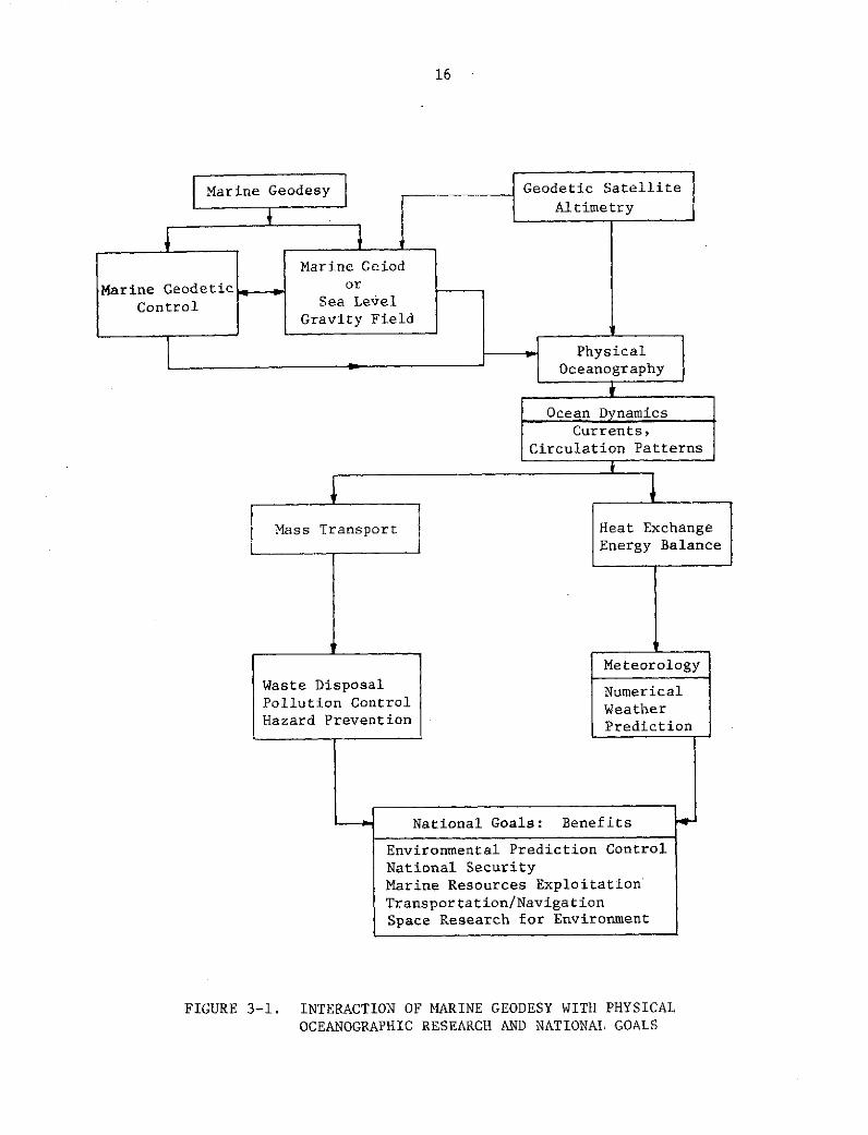
and satellite technology. A flowchart of this interaction and the benefits
to certain national goals is depicted in Figure 3-1.
Certain environmental requirements for the geoid have been estab-
lished. For the determination of the geoid at sea both by classical methods
and satellite altimetry marine geodetic controls are required [43, 67, 72].
Marine geodetic controls are needed for the geometric computation of quasi-
stationary departures of the sea surface topography from the geoid, using
satellite altimetry data. In Section 2, various ongoing and planned national
marine programs such as AIDJEX, NDBP, NORPAX, GARP, GATE, MODE, GEOSECS,
etc., have been discussed. The common objectives of all these NOAA, and/or
NSF managed programs is to improve the description, prediction, monitoring,
research, and management of the atmospheric and marine environments of the
living/non-living resources of the sea through the acquisition of data at
sea, [6, 24]. The need for geodetic controls for optimum effectiveness of
these environmental programs have been established along with the program
descriptions. In the deep oceans, satellite geodesy is the key to the es-
tablishment of the required marine geodetic controls.
3.1.2 The Need for Marine/Satellite Geodesy in Waste Disposal,
Pollution and Seabed Hazard Prevention
In the use of the ocean for waste disposal, various questions re-
main unanswered. Such questions include:
16
Marine Geodesy Geodetic SatelliteAltimetry
Marine Geiod
Marine Geodetic _ or
Control Sea LevelGravity Field
HPhysicaliOceanography
Ocean Dynamics
Currents,Circulation Patterns
Mass Transport Heat ExchangeEnergy Balance
Meteorology
Waste Disposal NumericalPollution Control WeatherHazard Prevention Prediction
- ~ National Goals: Benefits
Environmental Prediction Control
National Security
Marine Resources Exploitation
Transportation/NavigationSpace Research for Environment
FIGURE 3-1. INTERACTION OF MARINE GEODESY WITH PHYSICALOCEANOGRAPHIC RESEARCH AND NATIONAL GOALS

17
(1) Where was the waste dumped?
(2) What are the ocean bottom topography and depth of water?
(3) How do the bottom topography and geologic structures influence
disposed waste and the effects of the waste?
(4) Will the location of the waste vary with time and if so,
where and when will the waste affect the environment?
(5) Does the waste degrade?--At what rate and with what effect
on the environment?--If waste does not disintegrate will
it be a potential hazard to deep submersibles, mineral ex-
ploitation, cable and pipeline laying and other marine
activities?
The answer to "where" can be provided only by accurate positioning
information in a known geodetic datum and derived from navigation and/or
location determination equipment. Elsewhere, in various parts of this report
it has been shown that: (a) existing navigation and positioning systems
have not been evaluated and calibrated in real operational conditions for
reliable assessment of systems accuracy. All accuracy statements are theo-
retical estimates that vary with the users and geographic locations; (b)
intersystems comparisons in theory and actual operations are nonexistent.
In fact, different systems give different values for the latitude and
longitude of the same location and very often such differences are signi-
ficant to the validity, safety or effectiveness of the marine operations [80]
For example, such systems differences could lead to inadvertently dumping
two dangerous wastes (e.g., weapons) in the same location or conducting
another marine operation over a previously dumped hazardous waste. Because,
through the use of different uncompared navigation or positioning systems,
two operations were in fact over the same location when the positioning
systems indicated the contrary, several ships have been wrecked by running
into previous ship wrecks in the English channel and elsewhere; (c) appli-
cation of marine geodesy and satellite technology is currently the only
valid means for the navigation and positioning systems evaluation, calibra-
tion and intersystems comparisons discussed above [53, 64].
Emphasizing the above need to know "where" is the following excerpt
from a paper [28] by the staff of the U. S. Naval Oceanographic office,
National Academy of Sciences, Woods Hole Oceanographic Institution on:
"Hazards of the Deep...Threat to all ocean bottom activity.
Although the following discussion is restricted to the threat
to research submersibles...it should be obvious that the
threat applies equally to all activity on or near the ocean

18
floor. Therefore, those involved in such efforts as Sealab,offshore oil well drilling, salvage, etc., would be welladvised to take this threat into consideration in the plan-ning and execution of their programs and operations...ade-quate data do not exist to support precise statements re-garding the geographic distribution...on or in the oceanfloor."
Accurate and detailed bathymetric maps and geologic surveys are,
in principle, the answer to the need to know ocean bottom topography and
geologic structures at "waste disposal" sites. Usually, this information
is obtained from previous surveys.. But as pointed out in [59]:
"...we are confrnted with the problem of how accurate theposition of the survey ship was at the time it obtainedthe original survey data."
Of course, one answer is to conduct, in situ, all the necessary surveys,
having first emplaced two or three geoditically located ocean bottom
markers, using marine/satellite geodesy techniques.
Mobility of disposed waste in the oceans depends on the presence
and magnitude of currents, density of the waste material and its ability
to disintegrate physically and chemically. Our present knowledge of
ocean circulation and ocean current patterns or mass transport of the
ocean is inadequate to realistically predict the mobility and diffusion
of disposed waste. Drastic improvement of such knowledge is required if
the oceans are to be used for waste disposal without damage to the environ-
ment or hazard to man's operations in the oceans. In respect of improving
our knowledge of ocean dynamics, the roles of marine geodesy and satellite
technology have been discussed in Section 2.1. Several national marine
programs such as NDBP, MODE, GARP, GATE, NORPAX, Skylab, and GEOS-C, are
designed to aid in improved knowledge of ocean dynamics. These programs
and relevant roles of marine geodesy have been discussed elsewhere in this
report.
The need for improved knowledge of ocean dynamics, particularly
ocean transport and diffusion, which are important factors in waste dis-
posal, pollution control and seabed hazard prevention is amplified by the
NASA report on the Williamstown Stldy [i]
"The elucidation of the general circulation is a fundamentalproblem in physical oceanography. Interest in the resultsranges from simple scientific curiosity to very practicaland topical concerns such as the spread of nutrients or ofpollutants that have been released in the deep sea deliberately

19
or by accident. After a century of study, oceanographersare still unable to answer such questions as: How long willany leakage of supposedly sealed reactor waste take to reachthe surface from a deep dumping ground? or where will anyleakage first make its appearance at the surface? When dealingwith the surface circulation, which has been by far the most
fully explored, oceanographers are hard put to predict themotion of a Santa Barbara oil slick, to name another practicalexample. Some of the most important questions asked of ocean-ographers concern the distribution and transport of substancesin the ocean. The answers to these questions have as theirstarting point statements about mixing and flow in the sea.Such questions must be answered if disasters are to be avoidedin the exploitation of the oceans. Oceanographers may answerthese questions only if they can understand the motion of thewater of the sea."
All the discussions on environmental monitoring and quality con-
trol center on oceanography. That oceanography alone cannot meet these
environmental objectives without marine geodesy is emphasized in [1] as
follows:
"A long-standing problem in deep-sea oceanography is thatof adequate horizontal positioning. Many quite properscientific questions are simply not asked because off-shorenavigaton, even by TRANSIT satellite, is not accurate enough.Continuous vehicle location of +100 m or better and a deter-mination of 5-min average vehicle velocity to +5 cm/sec orbetter can be achieved by radio navigation within 100 milesof land, but off-shore navigation is only one-tenth as accu-rate at best. Removal of this limitation would produce aquantum jump in open ocean research and survey opportunities.
"There are basically two types of measurement requirements:1. Positioning of fixed points on the ocean floor
where several repeated measurements can be made; and2. Positioning while the vehicle is underway so that
only a single measurement can be made at one place.
"It is desirable that the accuracy achieved with type-1 mea-surements be an order of magnitude higher than with type-2to permit precise station-keeping and to provide referencepoints for survey operations. Marine geodetic referencepoints are needed to serve as sites in the open sea and fornavigation and mapping control for the calibration of posi-tioning and surveying systems. It has been shown that suchreference points can be marked by an acoustic transponderarray on the sea floor [66] and [42, 69, 71]."
In spite of all this documented evidence and the above excerpt,
oceanographic research programs and other marine activities continue to be
planned and executed without any formal inclusion of the roles of marine
geodesy. Such programs include NDBP, MODE, GARP, GATE, NORPAX and other
20
IDOE activities. Underlying all this is the absence of a national program
in marine geodesy to provide increased national consciousness of and pro-
mote research to identify and formalize methodologies and operational speci-
fications in "marine geodesy" as has been done for "continental geodesy".
3.1.3 The Significance of Marine/Satellite Geodesy to the EnvironmentalNeeds for Marine Geophysics and Geology
Effective monitoring, prediction, preservation and exploitation
of the environment requires more than the current piecemeal activities in
marine geophysics and geology, and the inclusion of marine geodesy in these
activities. Efficient synthesis of marine geophysical and geological data
to deduce globally meaningful models of the environment demands reliable
knowledge of locations of the acquired data. The need to know "...how
accurate the position of the survey data" [59] exists. There is also the
need to use geodetically located markers to (a) demarcate the boundary of
the survey area and (b) continuously track the survey ship to obtain con-
sistently accurate ship locations throughout the survey duration. Such
marine geodetic controls further permit a return to the same site to repeat
data acquisition either for confirmation or for investigations such as sea
floor spreading that require repeated measurements on site.
With respect to this role of marine geodesy, the statement from
[1] that
"A long-standing problem in deep-sea oceanography is that ofadequate horizontal positioning...fixed points on the oceanfloor where repeated measurements can be made...to permitprecise station-keeping and to provide reference points forsurvey operations"
applies equally if not more stringently to marine geophysical and geologic
operations.
Instruments required in these geophysical and geological data
acquisition need not only calibrations but also the correlation and elimi-
nation of systematic errors in acquired data through the use of "base sta-
tions". The needs for and methods of utilization of such base stations
were elucidated Uy Kivvioja [56] in "Significance of Open-Ocean Gravity Base
Stations and Calibration Lines" which ended with the conclusion that:
"All the fields of study that have been mentioned and possiblysome others, will benefit from the gravity surveys on oceans.The framework for a successful execution of a gravity survey

21
is provided by a network of gravity base stations. Good
gravity anomalies can only be obtained by using good gravity
base stations."
The use of satellite altimetry to compliment or even partially eliminate
conventional marine gravity anomalies measurements is under investigation.
In either case, the use of marine base stations or marine geodetic control
points remains indispensable.
Further elaboration of these issues in [1] states that:
"Gravity measurements on a worldwide basis are needed to
further understanding of the earth's figure and mass distri-
bution. The largest errors in gravity measurements at sea,
whether the measurements were obtained from shipboard or in
airborne systems, are caused by navigational uncertainties.
It is necessary that the E-W component of velocity of the
surveying vehicle be known to 1.0 knot (5 cm/sec) to reduce
observed gravity to rest with an accuracy of 1 mgal...Marine
geodetic reference points are needed to serve as sites in
the open sea for navigation and mapping control and for the
calibration of positioning and surveying systems. It is
desirable that these reference points be located in an
ocean-wide geodetic coordinate system and that standards
of gravity be known at each station to +0.1 mgal, magnetic
dip to +1', magnetic intensity to +1 gamma, and water depth
to +0.5 m (referred to mean sea level). It has been shown
that such reference points can be marked by an acoustic
transponder array on the sea floor [66]...It is intended
that these marine reference points be moved about to meet
existing research and survey requirements. Apollo tracking
ships appear to be suitable vehicles for locating these sta-
tions to the required accuracy. But the full capability of
these ships can be achieved only when a satellite is equipped
with either a C-band or S-band radar transponder and a doppler
system..."
(as in the GEOS-C mission planned to begin in mid 1974. Experiments with
GEOS-II in the Bahamas and Puerto Rican trench [42, 69, 81] have demonstrated
feasibility of such a capability and confirms the continuation of the above
excerpt.)
"The propsed open-ocean reference points would be valuable in
this connection for navigational control. Electromagnetic or
acoustic positioning relative to these stations could fill in
the gaps between satellite fixes and would thus provide a much
needed improvement in the measurement of ship velocity for the
reduction of gravity observations to rest."
All these requirements point to the need for more concerted effort
and systematic research in marine geodesy. This can only be realized by the
establishment of a well organized national marine geodesy program.

22
3.2 Requirements for Marine Geodesy in Resources
and Energy From the Oceans, and Transportation
Determinations of geodetic controls and the geoid at sea (the two
main tasks of marine geodesy) are requirements for efficient transportation
and effective but non-destructive exploitation of the oceans for living and
non-living resources and energy. Basically, the geodetic controls are
needed for (1) mapping and charting; (2) lease, territorial or operational
site boundary delineation and reidentification; (3) navigation--time-
varying position determination, navigation systems calibration, standard-
ization and intersystems comparison which help in prevention of hazards
due to navigation or positioning errors; (4) reconnaissance surveys and
operational relocation. The geoid is needed as shown in Section 3.1 for
oceanographic research related to weather forecasts, pollution which af-
fects marine living resources, and other environmental monitoring and
quality control required for marine activities related to resources, en-
ergy and transportation.
In support of the above promulgation and as a basis for further
elucidation, excerpts from some industrial user documentations will be
quoted. Basic user requirements for satellite/marine geodesy by the hard
mineral industry is not much different from those of the oil/gas indus-
try. Therefore, the oil/gas industry will be used mostly as the example.
The following are comments by Sheriff [80] of Chevron Oil
Company on "The Requirements and Problems of Navigation for Geophysical
Exploration", presented at the 1973 Symposium on Offshore Positioning
for Petroleum Exploration and Production:
"Marine geophysical work is expected to continue at
roughly the level of $125 million per year. Most of
this work is seismic, some gravity; both require ac-
curate positioning on a continuous basis...Geophysical
surveying from ships constitutes an almost universal
step in the petroleum exploration of offshore areas...
The seismic specifications (25 feet CEP) are given in
terms of repeatability rather than accuracy because
usually the important aspect involves having different
points bear the right relation with respect to each
other and being able to relocate the same spot, ratherthan knowing locations in terms of geodetic or statuatory
coordinates. The latter sometimes are also importantand impose additional requirements. For example, a lo-
cation may be repeatable in each of two different systems
without the two systems agreeing on the coordinates of thepoint and neither may give geodetic or legal coordinates."

23
Because repeatability alone can lead to disastrous mistakes such as op-
erating outside one's lease boundary, he then recommended:
"...Tie off the navigation system into local geodetic con-trol. At least two points need to be tied in to providethis relationship and these should preferably be at oppo-site sides of the survey area. These might be done bystatic satellite observations involving 10 or so fixeswhile tied up at known location."
On the same topic, Clewell [29] stated:
"One of the primary items of interest was repeatability;
the ability to go back to the same point again and findthe same object or position on the bottom, which oftenmay not have any close correlation with the true geo-detic position indicated by the system. However, it is
necessary to relate this repeatability data, in whateverform it may be and with whatever accuracy, to somegeodetic point when the information is collated ashore."
These recommendations require satellite/marine geodesy for which
there is no organized program of research to establish pertinent method-
ologies in spite of several experiments [63,70,71] that have demonstrated
feasibility.
The need for (1) reliability in marine positioning and (2) ade-
quate intersystems evaluation and calibration for standardization of
navigation systems in real operational conditions, and the roles of
satellite/marine geodesy are discussed in Section 3.3. How this need
affects the marine oil/gas industry is emphasized by the following from
Sheriff [80]:
"At the Second Symposium on Marine Geodesy in New Orleans,Jones and Sheriff [52] pointed out that despite the moneyinvolved in marine petroleum work, it did not follow thatthe very best positioning technology would be used. 'Hardeconomic judgments balancing positioning costs against theprobable and possible costs consequent to less precisepositioning' have to be made. This, of course, remainstrue. But have our judgments been good?
"Consider the following, all of whic happened recently:
(1) Intersecting seismic lines show differences in waterdepth of several hundred feet. The survey was run with anintegrated satellite-gyrocompass-doppler-sonar systemusing real-time filtering. Water depth was highly vari-able so that the doppler-sonar frequently switched betweenbottom-track and water-reverberation modes.
(2) Common geological features in seismic data are dis-placed by a mile. The survey was run with Loran-C in thehyperbolic mode. Ironically, a back-up navigation system

24
on the ship indicated a discrepancy at the time but wasnot believed.
(3) Aircraft flying lane count to a survey ship usinga CW phase-comparison radio system show discrepancieson a quarter of the flight.
(4) A Shoran transponder is located on the wrong island.
(5) A navigation system fails and the back-up systemon board is discovered to be non-operational...
(6) A shotpoint map prepared in post-mission analysisindicates that ship speeds at times reached 70 knots.Three features are evident:
(1) The situations which restrict navigation systemsare not considered adequately when surveys are beingplanned and, hence, inappropriate systems are chosen.
(2) Operations are carried on wider conditions whichexceed the limitations for accurate location determinations.
(3) The accuracy figures quoted for navigation systemsdo not represent operational conditions.
I do not cite the above failures as typical; in thesesurveys we know that errors occurred. A "typical" sur-vey is more than apt to be one for which the accuracyactually realized is never determined. While incon-sistencies in the geophysical or other data may pointto a location bust, lack of obvious inconsistency cannotcertify that locations are correct. Without an inde-pendent means of verifying location, one cannot deter-mine that a measurement is accurate."
To remedy these problems, Sheriff's recommendations included:
"...(1) Tie the navigation system into local geodeticcontrol...
(2) Specification as to what constitutes acceptable per-formance, such as the range of acceptable angles atclosest approach for a satellite, the minimum number ofdoppler counts for a fix, the maximum correction betweena dead-reckoned position and a satellite fix, how toaccommodate corrections under various conditions, etc.
(3) Definition as to which system provides the primarynavigation under given circumstances.
(4) Operational specifications such as the minimum num-ber of independent location determinations along anygiven line or within any given period of time, for ex-ample, requirements for satellite fixes near the begin-ning and end of a line, the conditions which requirecircling and rerunning portions of a line, etc."
25
The satellite/marine geodesy research for effective implemen-
tation of such recommendations is awaiting a systematic and organized
national program in marine geodesy.
On the general mapping and charting needs for "Subsea Mineral
Resources and Problems Related to Their Development", McKelvey [62]
stated:
"Basic documents, especially regional topographic andgeologic maps, lay the groundwork for identifying areasfavorable for the occurrence of various minerals andfor an appraisal of their potential resources.
"Three kinds of maps are needed:
(1) Accurate topographic or bathymetric base maps thatshow bottom depth and shape of features by contours andare used as base maps for geologic and other studies.
(2) Surficial or bottom-sediment maps that show thekinds, distribution and thickness of the sediments thatlie at the surface of the sea bottom.
(3) Geological maps of the bedrock beneath the sea bot-tom that show the distribution, thickness, and structuralrelations of rock units underlying the sea floor and thatmake possible three-dimensional analysis of potentialoil- and mineral-bearing structures."
McKelvey cites the development of an acoustic pinger as a fun-
damental need for mineral evaluation and mining.
"...new device is a radioisotope-powered acoustic pingerthat has a 5-year life, usable in water as deep as 6,000feet, and will precisely mark undersea locations, afundamental need in both mineral evaluation and mining."
The feasibility of using ocean bottom acoustic transponders and
satellites or other surface positioning systems for tracking a ship to
permit accurate mapping and charting tied to a known geodetic coordinate
system has been demonstrated in several marine geodetic experiments.
What is needed now is a formal establishment of methodologies, performance
criteria and operational specifications through marine geodetic research.
Formal inception of marine geodesy can be credited to the First
Marine Geodesy Symposium of 1966. In his paper "Marine Geodetic Problems
of Industry and Commerce," [27] Burg, then Vice President of Geophysical
Services, Inc. of Texas Instruments, Inc., stated: "Industry and commerce
have many uses for marine geodesy...a rather broad subject..." He de-
scribed the general uses of marine geodesy to cover

26
"...national defense, development of marine resources,
navigation, safety and economy of sea-going activities,
support for scientific investigation of marine phenomena."
He further stated:
"Development of marine resources, through the exploration,development, and exploitation phases, is dependent uponposition-fixing.
"Navigation, above and beneath, as well as upon the sea,
was the first use of geodesy. However, with expansion
of commerce and development of marine resources by in-
dustry, navigation becomes more of a science and less of
an art.
"The installation of resource development platforms and
accompanying increase in sea traffic places a new re-
quirement upon geodesy. The safety and economy of these
ocean environment activities becomes an important con-
cern, related to navigation and position-fixing.
"The scientific investigation of marine phenomena be-
comes more meaningful if the locations of the measure-
ments are accurately known.
"If we analyze each of these general applications of
marine geodesy, we recognize a common basic requirement.This is position-fixing. This can be static or dynamic
or both static and dynamic. Every oceanic activity hasa static position-fixing requirement--of knowing pre-
cisely where on the face of the earth the activity is
located. Most activities have a dynamic position-fixing
requirement--of knowing precisely the location of onepoint of activity relative to adjacent points. This
is an especially critical requirement in the case of
exploration for resources and collection of scientificdata...we can be sure that the Science of Marine
Geodesy will be a key contributor in this oceanic
resource development. We know the geodetic require-
ments, the motivations are there, and we must provide
the capabilities."
To provide the required capabilities demands a national commit-
ment.to a program of organized research in marine geodesy and the associ-
ated satellite and electronic technologies.
On the issue of navigation and positioning requirements, Captain
Putzke [76] summarized the following:
"The Coast Guard's analysis of uscr needs for the maritime
navigation community, is to a large extent based upon the
results of a requirements survey. This survey, conducted
by an independent contractor, assessed the user needs inthree different environments, namely the high seas, the
coastal/confluence zone and the harbor and estuary or
terminal environment...

27
"The overall objective of the study was to identify anddescribe the total spectrum of the marine operationsrequiring a position fixing service to perform its as-signed mission. The study was directed toward an"on site" position fixing capability which is distinctlydifferent from the point-to-point navigational capabil-ity. In other words, who are the users and what are the
requirements for "on site" marine positioning?
"The survey was conducted through d combination ques-tionnaire and interview technique, with a response levelof 62%, most of which was productive. With the exceptionof governmental vessel operators having classified mili-tary requirement, the field of existing users was wellcovered in the United States.
"The categories of special purpose users are:
* Government* Institutional* Industrial.
"The categories were subdivided into operational areas(missions) consisting of:
* Oceanography* Geophysics* Hydrology" Marine Biology" Oil exploration" Cable and pipeline surveying and construction" Dredging* Salvage (search and recovery).
"Current requirements most important consideration...isin the level of accuracy of position. The majority ofthose surveyed indicated that this requirement is in the0 to 50 foot range. Analysis and interpretation of inter-views and response to the questionnaire reveal the follow-ing conclusions.
Dredging - 5 to 6 feet
Pipe laying - 1 to 10 feet
Cable laying - 1 to 10 feet near shore1000 feet thereafter
Salvage - 30 feet
Oil exploration - 50 feet
Hydrography - 10 to 100 feet near shore500 to 1000 feet beyond 100 mile
Geophysics - 50 to 100 feet
Oceanography - 500 feet
Marine Biology - 500 to 1000 feet."
A Government/OSTAC Workshop on marine mapping, charting and geo-
desy organized by National Security Industrial Association [29] reported
similar findings for requirements.
28
"The consensus of workshop members were as follows: Theaccuracy requirements for dredging--five to six feet; forpipe and cable laying--less than ten feet; for salvageoperations--thirty feet; for operations in the field ofhydrography--ten to one hundred feet in areas near shore--in areas over one hundred miles from shore--six hundredfoot accuracy is needed; for geophysics--a range of fiftyto six hundred feet (but this is primarily a relativeaccuracy requirement); for oceanography--an absolute ref-erence accuracy is required of five hundred feet--however,a thirty-five to three hundred foot relative accuracy isrequired; for marine biology--fifty to one thousand feetdepending on the specifications of the operation; foroil and gas exploration--in the area from the coast totwenty miles from shore--fifty foot accuracy--and in thearea from twenty miles to three hundred miles offshore--fifty to one hundred foot accuracy is needed...
"On the accuracy requirement for submersibles, in thenear short and offshore environment, one-tenth of a naut-ical mile was considered as the present requirement bythe workshop participants. There is a need for chartingand mapping based on a common geodetic reference. Thereis a current need for a simple conversion system.
"It was pointed out that accuracy, in terms of presentlyavailable systems, is not constant throughout the cover-age area of that system; there is a dilution of the ac-curacy with distance from the station reference. It wasdetermined that there was a need to know what degree ofconfidence may be placed in the system accuracy at vari-ous points within the coverage area.
"Instrument reliability, standards and calibration arecontinuing problems in most measurement areas and needadditional support and emphasis.
"One of the primary problems identified was that thevarious charting and mapping operations that go on todayare not based on a common geodetic reference. Theneed for such a common geodetic reference was expressedby most members of the group.
"...There is a need for some mechanism through whichthe needs of user groups can be presented to the govern-ment, and that these needs must be presented in specificterms. In the past, needs have often been defined interms of 'the best we can get'. This type of require-ment is of little use as a long-range planning factor."
A well organized national seminar for user requirements is sug-
gested for this needed mechanism.
These statements for requirements which only satellite/marine
geodesy can be used to conclusively satisfy as explained in Section 3.3,
are further amplified by Cohen [30]:

29
"Most individuals who conduct work of any kind...would attestto the importance of position determination...there are andwill be requirements for position determination of greateraccuracy.
"There is ready agreement that a requirement exists foraccurate terrain maps. By requirement is meant the needfor the map--or bathymetric chart--as a tool to aid inthe performance of certain work in the oceans. By theterm accurate is meant a reasonable current portrayal ofbottom terrain at some suitable working scale. There isno difficulty in establishing recognition that properbathymetric charts are requisites to effective accom-plishment of many end goals in the oceans, and it isprobably correct to state that certain things could notbe done in the absence of such charts.
"The group of tasks that follow next all necessitatestandards allowing for very accurate position, +20-50meters. These tasks have a certain commonality: thereis direct relation between validity of measurement andposition. It is fair to predict that submersibleswill be potent tools for implantation of gear, rescueand salvage, mining, deep drilling studies, retrievalof treasure and man-in-the-sea programs. The chartproduct for the latter category will invariably be oflarge scale, perhaps 1:5,000 or even larger, have aclose contour interval (2-5 meters) and will necessi-tate extremely detailed bottom surveys.
"Cable-laying ships frequently conduct on-site surveysand chart compilation prior to the lay. The accu-racies are manifold due to the nature of the operation,with depth parameters of importance in the sound chan-nel and because the array of cable must be in prede-termined azimuth. The shortest distance to shore,terrain considerations notwithstanding, is of importancebecause of the expense of cable. Precise position inreal time is paramount in this kind of operation.
"Pollution studies and waste disposal are, of course,directly interrelated. Here, again, the author fallsback upon leaving it to those more expert than he asto accuracies required. In certain cases, such as dis-posal of radiation-type waste in deeper ocean areas,exact position would appear to be critical.
"In conclusion, even if the data above are valid and re-ceive general agreement, the biggest job still liesahead. This is to translate the accuracy standards de-sired to specific programs of surveys and chart pro-duction. And this may be the most difficult task ofall."
On the issue of physical determination and reidentification of
boundaries at sea, R. Admiral Nygren made the following comments [73]:
30
"We are talking about marine law and marine boundaries,and there is a great sensitivity on the part of various
jurisdictions to express any kind of policy or to make
any kind of controversial statements in this area atthis time. As we look at the problem of boundary deter-mination, we find a shake out into at least four generalgroupings. There are some technical problems; AdmiralJones will discuss some of these in his paper. There
are some legal problems. There are some problems which,for want of a better name, might be called policy ques-
tions, and Dr. Alexander will touch on some of these.
Some of the most important problems of boundary determi-
nations are political. Nobody wants to touch these with
a ten-foot pole, apparently, because boundaries reallyare limits which define various jurisdictions. No matter
how you slice it, they are areas over which somebodyexercises effective control of some kind or another. Andthis control .in the off-shore area, particularly, includesthe ownership or the right to manage resources or wealth.And, resources have been and are the source of strife allover the world.
"Conflicts have arisen between states, between the statesand federal government, between federal government andinternational agencies, and between countries. I wouldcall to your attention the example of the IntergovernmentalOceanographic Commission, which now includes 66 countries.Many--perhaps most of them--have no capability in ocean-ography whatsoever, but have a great interest in the'limitless riches of the ocean', and they are in that orga-nization either to get their share, or to be sure thatnobody else gets their share. So, I think it is safe tosay that this problem of the limit of national jurisdiction
is going to continue in various international forums fora long time to come. There is really no reason why weshould expect that the historic controversies over landboundaries will not be carried over into the oceans.They already are being carried over into the oceans. So,in my opinion, the future really doesn't hold much hopefor peaceful solutions to many of these things. The
pattern has never been peaceful. If we succeed in this,it will be truly remarkable.
"Now these boundaries between various jurisdictions mustbe accepted, must be recognized, must be definable, andthey must be recoverable. And whether these boundariesare extended from shore or from shoreline features tovarious distances off shore, whether they are defined byunderwater features themselves, such as isobaths or seamounts, or whether they are defined by mathematical lines,such as meridians and parallels, they must be properlypositioned, and this is where the job for the geodesistcomes in. I do not believe he is always going to enjoyhis role in this part of the field."
31
Rear Admiral Jones' discussion [511 included:
"Accelerated development and growth of the use of the seaare indicative of expanded exploitation for the benefitof commerce, industry, recreation, and settlement. Someday aquaculture may well rival and surpass agriculture inimportance as the population growth forces increased de-pendence upon the marine environment for survival.
"Increased national effort must be made if our technologyis to be used effectively in making intelligent use of ouroceanic resources. One of the basic problems now beingencountered is the determination of the extent of offshorewaters over which a maritime nationhas sovereignty. Own-ership of rights to the ocean floor, state-federal juris-diction, the extent of fishing rights, and other factorsare pressing problems.
'The Geneva Conventions, adopted in 1958 and ratified bythe United States in 1964, clarify some of the legalquestions involved, but many remain unresolved. Thefederal-state contention over lands and minerals in thecomplex coastal areas is far from settled. The era ofsubmarine law is here, and with it is a dire need fordetermining precise jurisdictional boundaries."
He further stated that for:
"Boundary demarcation, or the laying out of a boundaryon the ground and with an appropriately detailed pic-torial representation...the field work involved en-compasses ground control; projection of the boundaryline; mapping the boundary strip; and placement of sur-vey monuments. Problems usually encountered in de-marcating a dry land boundary are consideraly morecomplicated in the demarcation of a submerged landboundary...Mean sea level takes on a new significancewhen we deal in the offshore area. Mean sea level'(the geoid)' is defined by geodesists as the equi-potential surface which the oceans would assume if theonly forces acting upon them were the earth's gravita-tional forces and the centrifugal forces set up by theearth's rotation. There are other forces, however,with which we must deal, such as the tidal forces of thesun and the moon, and the meteorological forces such aswind, atmospheric pressure, and others which vary fromtime to time and place to place.
"These forces produce an ever changing surface of thesea which is difficult to relate to the ideal equi-potential surface of the geodesists' mean sea level.It is true that the differences between the outer sur-face of the sea and the equipotential surface are of arather small order; perhaps only a few meters at most.Still some oceanographers are interested in what theycall the slope of the sea and its position above or

32
below the equipotential surface at any given time at
a given place."
On the continents, these problems are resolved by appropriate
geodetic methodologies developed through concerted and well organized
national research and international cooperation. At sea, these prob-
lems must and can be solved by marine geodesy. However, formal devel-
opment of the appropriate methodologies is awaiting the creation of an
organized and systematic national research program in marine geodesy.
Air and sea transportation depend on navigation and hazard
prevention in navigation is of utmost importance. Flawless knowledge
of position of transportation vessels relative to one another, relative
to hazards (such as sunken vessels or exploration constructions or
natural features), and relative to the ports of start and destination
or other transportation facilities enroute, all hinge on well evaluated
and calibrated positioning and navigation systems. The navigation re-
quirements for marine geodesy are discussed later. As mentioned earlier,
the incorporation of marine geodesy into the National Data Buoy Program
(NDBP) would greatly help in providing aid to air and sea transportation
over the oceans and the continental shelf by giving the vessels highly
reliable positioning information.
This assessment of requirements for marine geodesy can be
summarized by Rear Admiral Jones' comments [92] that:
"The increasing recognition of the vast resource
potential of the Continental Shelf and ocean regionshas hastened the emergence of a relatively new disci-pline in geophysical sciences: the marine geodesy.Just as classical geodesy is needed on land to increaseknowledge of the size and shape of the earth, to es-tablish precise horizontal and vertical control formapping and cadastral surveying, and to provide essen-tial related gravimetric and astronomic data, somarine geodesy is opportune throughout the remaining
three-fourths of the earth's surface--the oceanic areas.It is apropos that the geodetic community should takethe responsibility and leadership to investigate theproblems, determine the requirements, and outline a
program of marine geodesy.
"The plans and programs of the Coast and Geodetic Survey
envision the immediate requirements for marine geodesy
to be horizontal control and gravity determinations;needed for exploration and development of oceanic re-sources of the Continental Shelf regions. Obviously,

33
the basic geodetic networks over the entire Continental
Shelf cannot be established in just a few years and with
limited resources. However, activities must be initiated
now to respond to the need for marine geodesy and to
assure that these activities will serve the same func-
tions that the present geodetic systems serve on the
continental and island land masses. These functionsinclude:
(1) Maintain a specified standard of accuracy overlarge areas and long distances
(2) Assure coordination between activities accomplished
at different periods of time and at adjacent locations
(3) Provide means to reestablish boundaries.
"Geodetic surveys have been extended short distances intothe marine environment to satisfy the immediate needs of
the petroleum industry by using classical land techniquesto locate offshore platforms and exploratory lease limits.Oceanographic activities have included gravity determina-
tions at sea, both by surface vessels and by submersibles.
Ocean-bottom gravity meters are also being employed. To
date, actual marine geodetic activity has only been a
'drop in the ocean'.
"In the immediate future, state, territorial, and inter-
national boundaries, as well as exploratory property lease
limits on the Continental Shelf, must be located. Otheroceanographic activities need geodetic positioning at
great distances at sea to permit calibration of navigationsystems. Structures and operations that are a hazard tonavigation must be accurately located and charted. There
is, therefore, an urgent need to initiate planning re-search, and development for marine geodesy."
This statement of need is more true today than it has ever been.
The necessary program to accomplish Rear Admiral Jones' suggestion for
"...initiate planning, research, and development for marine geodesy" is
yet to be instituted.

34
3.3 National Security Requirement for Marine Geodesy
The various activities which require marine geodesy directly or
indirectly, and which are important for national security include (1) sur-
veying and mapping, (2) navigation, which involves knowing one's geographic
coordinates at any given time, (3) calibration of missile systems and navi-
gation equipment, (4) guidance of missile systems, (5) accurate gravity
field model for computation of satellite orbits and missile trajectories,
(6) waste and weapon disposal at sea, (7) search and rescue, (8) meteorolog-
ical forecasts, and (9) boundary determination.
As a preamble to specific discussions of the above needs, the fol-
lowing are excerpts from "Requirements and Views of DoD in Marine Geodesy"
by Capt. M. Macomber [59].
"The agencies (in DoD) find that their activities requirea diverse input of geodetic information, some of which isreadily available, but some of which must be measured forthe particular project being undertaken... We will requirea knowledge of gravity to guarantee the proper orientationof the major geodetic systems correctly in a world datum...The knowledge of gravity that is required for the datumorientation cannot be limited to land areas, but must ex-tend to the ocean areas of the world surrounding eachmajor geodetic datum.
"So far we have considered geodetic requirements in landareas which require a knowledge of gravity in the marineenvironment. Let us now consider a problem more intimatelyconnected with the oceans. In keeping with the nation'sgreater international awareness, the need has developed tomaintain knowledge of the location of major fleet units ona continuing basis in the same coordinate system used forthe land areas.... We are satisfied with high qualitynavigational control, but this in turn requires informationof geodetic accuracy either on or contiguous to the oceanareas. Unfortunately, I am unable to address the positionalaccuracies required, but there are many considerations thatmay be discussed at this time.
"The most popular positioning systems in use today fornavigational purposes are the long-range electronic sys-tems....If we consider the installation of stations in amajor datum that can be converted to a world geodetic sys-tem, and if we assume that trivia such as errors in thepropagation velocity are nonexistent, then we can expectrelatively high accuracy in the determination of positionsat sea; however, we must keep in mind that these systemshave hyperbolic lines of position, and that the expansionof the lanes as we depart from the baselines has an adverse
35
effect on the resolution of the system. We must also
keep in mind the angle of intersection of the two lines
of position and use the system only in those areas where
the position can be determined with reasonable validity.As the area in which the vessel is operating changes, itis necessary to change the location of the shore naviga-tion stations used, or to accept some degradation in the
positioning information. As we go farther out into the
ocean, the problem becomes more acute. When we reach an
operating area where it is necessary to select three
islands for transmitting sites, we are severely limitedin the configuration of the net. To further complicatethe problem, those islands which are strategically placed
for a given navigation net may not be diplomaticallyaccessible for the construction and operation of naviga-tional aids, so it becomes necessary either to use poorlyplaced transmitter sites or to move operating areas tolocations where coverage by the long-range systems issufficiently accurate.
"Because of these limitations on the long-range electronicsystems, especially when coupled with other problems suchas uncertainties in the velocity of propagation, jammingpossibilities, poor reception characteristics under manyatmospheric conditions and a myriad of other features,other systems have been developed or are currently underdevelopment which are considered to be more universallyacceptable.
"The second system to be considered will be bottom contournavigation. The U.S. Navy has been quite successful inrecovering positions at sea by matching fathograms takenover bathymetric features with the results obtained by asurvey vessel whose position was accurately known.Although the recovery of position is considered good, weare confronted with the problem of how accurate the posi-tion of the survey ship was at the time it obtained theoriginal survey data. This then breaks down, in most in-stances, to the problem considered before with the use ofthe long-range electronic systems, but with the addeddegradation caused by the additional sounding operationsinvolved....
"Navigation by geophysical phenomena has often been men-tioned as a prospective device, with either lines ofmagnetic intensity or lines of the force of gravity beingused. Both of these systems....suffer from the sameproblems as the bottom contour navigation, plus the addi-tional difficulty that resolution is not so good, underthe present state of the art, as in the case of bottomcontour navigation.
"Navigation by satellite has become possible operationally...The requirement for the gravitational field...that couldbe deduced from our present knowledge of gravity..." can notyet be adequately satisfied as shown by Decker [32].

36
"An extremely accurate description of the gravitational
field at the altitude of the satellites is required. It
is indeed fortunate that this field could be derived to
sufficient accuracy at that altitude from satellite
tracking data and did not need to be determined from ter-
restrial measurements. It is regrettable that we are
unable to describe the same gravitational field at zero
elevation to the same accuracy. Although this system
provides measurement precision of geodetic quality, and
has satisfied many of our geodetic positioning require-
ments, it must be borne in mind that the navigational
data derived are not continuous, so some means must be
available to bridge between fixes. The dynamics of the
satellite system causes fixes in low latitudes to be
about 2 hours apart.
"This quite naturally leads us to the inertial system,
which is the last system to be considered. The mechan-
ical basis of the systems are such that the navigators
attempt to track the local vertical rather than the
geodetic position. If there were no factors such as
gyro drift to degrade the position keeping qualities of
these instruments, they would do an outstanding job of
indicating the astronomic position of the navigating
unit; however, since there are errors which creep into
the system, it is necessary to reset the navigator
periodically. The combination of navigational satellite
and inertial navigator should approach an ideal system.
Unfortunately, when the inertial navigator is reset to
the true position, the component of the gravity vector
perpendicular to the ellipsoidal normal causes an
apparent horizontal acceleration. This results in an
oscillation of the navigated position about the astro-
nomic position with the Schuler period, with the plane of
the apparent motion rotating about the astronomic position
with the period of a Foucalt pendulum. In areas where the
deflection of the vertical is negligible, this is no prob-
lem; however, where the deflection reaches an appreciable
magnitude, it is necessary to reset the inertial navigator
to the astronomic position, and to correct positions indi-
cated by the navigator for the deflection of the vertical
in order to obtain an accurate geographic position. This
requires a dense gravimetric survey of the entire operating
area and areas immediately contiguous thereto, with the
density of observations diminishing away from the area of
interest.
"Although a complete gravimetric survey is indicated as
being essential, the density of observations required can
be determined only after a preliminary investigation indi-
cates the degree of gravimetric smoothness.
"In this discussion of navigation systems, I have completely
ignored error sources other than geodetic, considering those
to be without the purview of this symposium; however, let us
keep in mind the fact that error sources do exist, and that
37
the errors are significant. Other disciplines are con-centrating on their identification and elimination orcompensation.
"If we summarize the requirements mentioned above tosupport navigational systems, even though I have beenunable to give exact figures for accuracies required atsea, it can be seen that the Department of Defense hasa requirement for the same type of geodetic informationin the 70 percent of the earth constituting the marineareas as it has in the 30 percent constituting the land.There is an immediate requirement for detailed gravimet-ric surveys in the northern hemisphere, with the elimi-nation of holiday areas in the southern hemisphere, andfor the precise positioning of transmitter sites fornavigational aids throughout the ocean areas."
The First Marine Geodesy Symposium held at Battelle, Columbus,
Ohio in 1966 constituted the first clear evidence of international recogni-
tion of Marine Geodesy as a new and important discipline. Since then, prog-
ress in marine geodetic research has been slow. Consequently, the above
statement of concepts and requirements are as valid now as they were then.
Following is a brief discussion of the roles and relevancy of marine/
satellite geodesy to the previously listed activities in support of national
security.
Surveying and Mapping require that the geodetic location of the
surveying vessel be known in a coordinate system tied into a known geodetic
datum [35]. This is the requirement implied by Capt. Macomber's [59]
statement "...we are confronted with the problem of how accurate the posi-tion of the survey ship was at the time it obtained the original survey
data." Furthermore, in order to correlate and eventually match up cor-
rectly the current piecemeal surveying and mapping of various parts of the
ocean, conducted at various times, accurate geodetic location of the survey
vessels in a known geodetic datum is a requirement.
National Security has an interest in oceanographic, gravimetric,magnetic, seismic, geologic and biological research in the oceans. Such
research is being carried out at various sites in the oceans. The geodetic
location of the sites should be reliably known to permit accurate correla-
tion of results from different experimental sites and/or return to the same
site to repeat and/or conduct additional experiments.
Table 3-1, taken from (72], shows various marine operations and theapproximate positional accuracy requirements. To meet the requirements statedin Table 3-1 one must find answers to the following questions: (a) what navi-gational or geodetic positioning systems are available for these requirements?
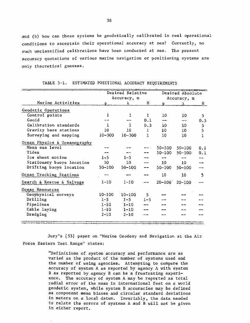
38
and (b) how can these systems be geodetically calibrated in real operational
conditions to ascertain their operational accuracy at sea? Currently, no
such unclassified calibrations have been conducted at sea. The present
accuracy quotations of various marine navigation or positioning systems are
only theoretical guesses.
TABLE 3-1. ESTIMATED POSITIONAL ACCURACY REQUIREMENTS
Desired Relative Desired AbsoluteAccuracy, m Accuracy, m
Marine Activities X H p X H
Geodetic OperationsControl points 1 1 1 10 10 5Geoid -- -- 0.1 -- -- 0.5Calibration standards 1 1 0.3 10 10 5Gravity base stations 10 10 1 10 10 5Surveying and mapping 10-300 10-300 1 10 10 1
Ocean Physics & OceanographyMean sea level -- -- -- 50-100 50-100 0.1Tides -- -- -- 50-100 50-100 0.1Ice sheet motion 1-5 1-5 -- -- -
Stationary buoys location 10 10 -- 10 10 --Drifting buoys location 50-100 50-100 -- 50-100 50-100 --
Ocean Tracking Stations -- -- -- 10 10 5
Search & Rescue & Salvage 1-10 1-10 -- 20-100 20-100 --
Ocean ResourcesGeophysical surveys 10-100 10-100 5 -- -- --
Drilling 1-5 1-5 1-5 -- -- --
Pipelines 1-10 1-10 -- -- -- --
Cable laying 1-10 1-10 -- -- -
Dredging 2-10 2-10 -- -- -- --
Jury's [531 paper on "Marine Geodesy and Navigation at the Air
Force Eastern Test Range" states:
"Definitions of system accuracy and performance are asvaried as the product of the number of systems used andthe number of using agencies. Attempting to compare theaccuracy of system A as reported by agency A with systemB as reported by agency B can be a frustrating experi-ence. The accuracy of system A may be reported as totalradial error of the mean in international feet on a worldgeodetic system, while system B accuracies may be definedas component mean biases and circular standard deviationsin meters on a local datum. Invariably, the data neededto relate the errors of systems A and B will not be givenin either report.

39
"Care should be taken in the evaluation of certainsatellite dependent systems to assure that the stan-dard position of the ship and the geodetic/navigationsystem output are on the same datum. Another consid-eration of primary importance is whether the erroridentified is the standard error of a random observa-tion or the standard error of the mean for all obser-vations. Although these errors may differ by a factorof 5 or 0, there is often no distinction as to which
error is being identified. Use of a standard that isless accurate than the system being evaluated should,of course, be avoided. Often the system to be evalu-ated is compared against itself. This approach doesgive an indication of system precision, but allows sys-tem biases to go undetected."
Five major navigation systems are available. These are satellite,
"electronic" such as Lorac, astronomic, inertial and underwater acoustic
systems. Captain Macomber's statements quoted earlier describe the opera-
tional and accuracy limiting factors for the satellite, "electronic" and
inertial systems. In the absence of geodetic calibration in real opera-
tional conditions, and the non-existence of intersystem comparisions with
real data, it is not known to what extent these systems can or are satisfy-
ing the positioning requirements for surveying and mapping at sea. The use
of underwater acoustic transponders for establishing geodetic control at sea
to within 10 meters in latitude and longitude has been demonstrated [57,71].
Such geodetic control can be established at low cost as a means for evalu-
ating positioning and navigational aids.
The views and requirements for "Marine Geodesy and Navigation at
the Air Force Eastern Test Range" have been stated by Jury [53] as follows:
"Accurate geodetic positioning of instrumented ships isrequired at the Air Force Eastern Test Range (AFETR) forshipboard measurements of missile trajectories and tolocate broad ocean area hydrophones used for missileimpact scoring. Several different techniques and instru-ments are used for ship positioning, depending on thearea of operation and the accuracy required. Systemsused at the AFETR include Hiran/Photography, Gyrostabi-lized Optics, BRN-3/SRN-9 Satellite Doppler, Lorac, Loran,Omega, SINS/Star Tracker, Radar, and Acoustic Hydrophones/Transponders....
"Marine geodesy and navigation activities at the Air ForceEastern Test Range (AFETR) result from trajectory measure-ment and impact scoring requirements related to missiletesting.
"Instrumented ships used for missile trajectory measurementmust be positioned continuously during the missile tracking

40
event. Accurate missile impact location is achieved bymeasuring the travel time of acoustic energy from the
point of impact to each of several ocean-bottom hydro-phones which have been positioned in prior surveys....
"Geodesy is often defined as that science which treats
mathematically the size, shape, and gravity variations
of the earth and the determination of exact positions
of points on the earth. Marine geodesy, then, is an
extension of geodesy to the ocean environment. It will
be assumed here that the points used for marine geodesywill be fixed, long lasting, ocean-bottom markers, either
natural or artifical, that can be readily identified -
certainly a rather comprehensive assumption. A liberal
interpretation would be necessary to include acoustictransponders which would be tethered a short distance
above the ocean bottom to suppress unwanted acoustic
reflections. Nevertheless, certain fixed points are
essential to establish geodetic control in the oceansto allow the redundant measurements required forstatistical adjustment....
"The following comments are considered appropriate to
future activities in marine geodesy and navigationalareas.
1. Controlled tests should be conducted againstan adequate standard to determine the accuracy andperformance of geodetic/navigation systems prior tocommitment for operational missions.
2. An unambiguous report should be publisheddefining the accuracy and performance of the system.
3. More emphasis should be placed on three-dimensional evaluation and error analysis of geodetic/navigation systems used for marine geodesy purposes.
4. A national committee is needed to establishtest procedures and accuracy definitions. Fortunately,the Marine Geodesy Committee of the Marine TechnologySociety has already initiated action on this item.
5. A national committee is needed to evaluateand select missile ranges or other test facilitiessuitable not only for geodesy/navigation system testingbut for general oceanographic and aeronautical testingprograms. Use of existing facilities, rather than thedevelopment of new facilities, can lead to substantialcost savings and should be given serious consideration.
6. The current National Geodetic Satellite Pro-gram (NGSP) is concerned with the establishment ofprimary control on the 30 percent of the earth con-sisting of land mass. It would seem most desirableand certainly economical to establish selected primarymarine control points in conjunction with the presentNGSP. A few such points would be most useful until afull scale marine geodesy program is implemented to mapthe remaining 70 percent of the world."

41
The Space and Missile Test Center (SAMTEC) performed an experi-
ment in 1972 [57], which confirms that (1) there is a requirement for
accurate marine geodetic controls and (2) that these requirements can be
met through research. The objectives of their experiment were to:
"(a) evaluate the accuracy of ship positions obtainedfrom ASPS relative to the geodetic positions of theVAFB launch sites and mainland sensors;
"(b) evaluate the metric accuracy of a shipbornetracking radar and consequently its contribution tothe best estimate of trajectory of typical WesternTest Range missile operations."
This experiment clearly showed that marine geodetic controls are indispens-
able to evaluation of missile guidance and navigational systems. Preven-
tion of hazard related to weapon disposal, search and rescue operations and
boundary determination at sea require reliable geodetic positioning
information.
The U.S. Coast Guard views on national security requirements for
marine geodesy expressed by Capt. S. G. Putzke [76] and captioned "Marine
Positioning - The Now and The Need" included:
"This paper thus becomes a preliminary report to themarine navigational community of the results to dateof the Coast Guard's Navigational Planning Staff. Tothe extent that marine positioning is relevant tomarine navigation, it will speak of certain issuesgermane to our findings....
"As you know, there is what might be called 'an un-defined' relationship between position fixing andnavigation. Or it may be said that a relationshipexists, since knowing ones general position is aninherent part of the art of navigation....
"More specifically, it might be asked whether or notmarine positioning in the sense of marine geodesy isa U.S. Coast Guard responsibility. A review ofTITLE 14 USC. 2 states, in part, that the Coast Guard"...shall develop, establish, maintain and operate,with due regard to the requirements of National defense,aids to maritime navigation. TITLE 14 USC 81 expands.this function as follows: In order to aid navigationand to prevent disaster, collisions, and wrecks of ves-sels and aircraft, the Coast Guard may establish, main-tain and operate:
(1) Aids to maritime navigation required to servethe needs of the Armed Forces...
(2) Aids to air navigation required to serve theneeds of the Armed Forces of the United States peculiarto warfare and primarily of military concern as determined
42
by the Secretary of Defense and as requested by anyof those officials; and
(3) Electronic aids to navigation systems
(a) required to serve the needs of theArmed Forces of the United States peculiar to
warfare and primarily of military concern as
determined by the Secretary of Defense or any
department within the Department of Defense;or...
"These aids to navigation other than electronic aids
to navigation systems shall be established and oper-ated only within the United States, the waters above
the Continental Shelf, the territories and posses-
sions of the United States, the Trust Territories of
the Pacific Islands, and beyond the territorial juris-
diction of the United States at places where naval or
military bases of the United States are or may be
located. To complete the definition it is necessaryto refer to TITLE 33 CFR to define an aid to navigationas: 'any device external to a vessel or aircraft in-
tended to assist a navigator to determine his position
or safe course, or to warn him of dangers or obstruc-
tions to navigation."'
"...The Marine Sciences Council and other influential
members of the Marine Sciences Community continue to
press for a worldwide navigation accuracy of 0.1 NMand a coastal (100 mile) accuracy of a few tens ofmeters....
"There is a strong opinion, in many quarters, that itis in the best interest of the United States to encour-
age marine sciences and engineering development, and the
provision of precise position fixing service is often
cited as a productive area of support."
The other major marine geodetic operation which is necessary to
National Security is determination of the geoid and/or the gravity field.
Satellite altimetry is being investigated to replace conventional methods
that are costly and time consuming. The geoid and/or the gravity field is
required for (1) computations of satellite orbits and ICBM trajectories,
(2) deflection of the vertical for orienting weapon systems and inertial
navigation equipment, and (3) oceanographic and meteorological research in
modeling the dynamics of the oceans in connection with ocean/atmospheric
energy exchange that affect weather and its prediction, currents which
affect navigation, sound propagation which is of interest to underwater
acoustics.
In other words, all current indications agree that Capt. Macomber
was right in stating that "...it can be seen that the Department of Defense

43
has a requirement for the same type of geodetic information in the 70% of
the earth constituting the marine areas as it has in the 30% constituting
the land" [59]. What is now needed is a National Marine Geodesy Program
to address the needs of the. nation for national security, and for the
environment, resources and energy and transportation discussed in this
report.
3.4 Requirements for Marine Geodesy in Space Tech-nology Applications and Scientific Research
There is general agreement that the inputs from marine geodesy
of (1) geodetic coordinates and (2) the geoid or the gravity field defined
at "undisturbed" mean sea level, are requirements in various space and
other scientific research. In the process of discussions in Section 3.1
through 3.3, these requirements have been extensively dealt with, some-
times explicitly but implicitly at other times. The report [72] on the
interactions of satellite technology, marine geodesy and its ocean physics
applications has elaborate discussions on these requirements. The report
[1] on the NASA supported Williamstown study--"The Terrestrial Environment,
Solid-Earth and Ocean: Application of Space and Astronomic Techniques" has
also documented these requirements.
As a summary, we state that there are requirements for marine
geodesy in space and earth science research related to:
(1) Accurate orbit determination and computation of the "abso-
lute" three-dimensional geodetic coordinates of tracking stations and other
scientific control stations.
(2) Definition of the geoid and/or the earth's gravity field,
both for the global problem and especially at "ground truth" areas.
(Appendix C describes the extent of inaccuracy and inconsistencies in the
present day knowledge of the earth's gravity field.) Upon these two geo-
detic outputs hang the success of many geodetic, oceanographic, geophysi-
cal, geological and even biological and meteorological research discussed
earlier in this chapter. Satellite altimetry missions' objectives and the
proposed EOPAP with their tremendous impacts on the ability for science,technology and man to accommodate our environmental problems related to the
oceans all depend on marine geodesy. However, first, marine geodesy has to
stand on its own feet before it can provide the effective supporting roles

44
for other sciences. This spells, as Rear Admiral Jones put it, "...an
urgent need to initiate planning, research, and development for marine
geodesy" [92].

A-i
APPENDIX A
SATELLITE GEODESY TECHNOLOGY
A.1 Existing and Planned NASA Programs Relevant toMarine Geodesy and Ocean Physics Applications
In the attempt "... to determine how and to what extent NASA-
developed satellite technology could be utilized advantageously in more
national programs related to marine geodesy, precise ship positioning, and
ocean physics research", existing and planned NASA programs/missions
relevant to marine geodesy and ocean physics were analyzed.
Table A-i indicates the main NASA satellite missions, existing
of planned, that are or could be relevant to marine geodesy and ocean
physics (MG/O) for solving man's environmental problems according to the
results of Phase 1 of this study. By design, some of the satellites are
directly applicable, or are either indirectly or potentially applicable sub-
ject to further applications research and/or hardware modification(s). Up
until the launch of GEOS-C scheduled for 1974, PAGEOS 1 and GEOS-1&2 appear
to be the only NASA missions specifically directed towards solving geodetic
and geophysical problems on earth. Although many metorological satellites
exist and could have indirect bearing on ocean physics research, EREP/
SKYLAB (1973) and GEOS-C (1974) appear to be the first and only approved
missions addressed to solving earth and ocean physics problems for the bene-
fit of man's environment.
Beyond GEOS-C (scheduled for launch in 1974) there are now (1972)
no other approved missions designed to solve these problems. All currently
proposed missions relevant to geodesy and ocean physics are under the um-
brella of the proposed "Earth and Ocean Physics Applications Program" (EOPAP).
Besides, both SKYLAB and GEOS-C missions can only demonstrate hardware and
software feasibility or lack of it because they carry the first generation
of unproven spacecraft equipment. It seems imperative, therefore, that
EOPAP be approved and implemented or else we shall create a vacuum that could
cause irreparable damage to our limited ability for environmental monitoring,
prediction, and quality control. The following gives brief details of opera-
tional, approved, and proposed programs/missions.

A-2
TABLE A-1. EXISTING AND PLANNED NASA PROGRAMS RELEVANT TO MARINE GEODESY AND OCEAN PHYSICS
Applicability to Marine Geodesy Applicability to Ocean PhysicsGeodetic Geoid and Geodetic Circulation, Mass
Program/ Status/ Control/ Gravity Field, Ground Plate Sea Ocean Transport, Air-Sea
Mission Name Schedule Mapping Polar Motion Truth Navigation Tectonics State Tides Interaction
PAGEO Sl Launched DA Limited DA NA NA NA NA NA NA1966
ATS Launched1 1966 Could have been used for MG/O but satellites lack necessary hardware3 1967
GEOS Launched1 1965 DA DA DA PA PA NA NA NA
1968
AT'S 5 Launched PA NA NA PA NA NA NA NA1969
REI:P/SKYLAB ApprovedPartially NA PA NA NA NA DA PA DADesigned forMG/O 1973
ATS-F, G ApprovedPartiallyDesigned for DA DA IA PA DA IA IA IAMG/O1974 - 1975
GEOS-C Approved
Specifically DA DA IA DA DA DA PA DADesigned forMCG/ 1974
SATS ProposedALTIMETRY under Earth UA DA IA PA DA DA DA DA
and OceanGEODYNAM1CS 'hy sics(Cannon Balland Bullet) Applications DA DA PA IA DA NA IA NA
Program(EOPAP)1975 - 1977
Earth Har- Proposedmonics under
GR AG 1976 DA I)A IA IA DA NA IA IA
(Drag free)
GEOPAUSE ProposedA & B under EOPAP DA DA IA PA DA IA IA IA
1977
Earth Physics ProposedObservatory under EOPAP DA DA DA IA DA DA DA DA
1981
TDRSS UnderEvaluation PA IA IA PA PA IA IA IA1977 k'ith additional equipment it could
have DA
EOS UnderEvaluation DA PA NA NA NA DA DA DA1977 (Mapping)
SEOS UnderEvaluation NA PA PA NA NA DA DA DA1979
ATS- H, 1, J, UnderM Evaluation
1978/79 DA and IA, depending on the success of ATS-F, G, and plans for spacecraft instrumentation
1981
TIROS - O UnderEvaluation NA PA IA DA NA DA DA DA1981
Key: DA - Directly ApplicableIA - Indirectly ApplicablePA - Potentially ApplicableNA - Not Applicable
MG/O - Marine Geodesy/Ocean Physics
ORIGINAL PAGE ISOF POOR QUALITY

A-3
A.1.1 Operational Missions
There are in operation at least six NASA satellite missions di--
rectly or potentially applicable to solving certain problems in geodesy and
ocean physics. These are GEOS-1,2, PAGEOS 1, ATS-1,3,5. The GEOS and
PAGEOS series were specifically designed for geodesy but equipped mainly for
station position determination, earth gravity field, and polar motion investi-
gations. The current design and instrumentation of GEOS-C are not only for
advancement in technology but also to make up for the limited utility of
PAGEOS-1 and GEOS-1,2 in obtaining urgent needed solutions to geodesy/earth
and ocean physics application problems. ATS-1,3, still in orbit, lack the
necessary hardware to adapt them to geodetic and ocean physics uses. These
satellites in orbit with equipment which cannot be modified for geodesy and
ocean physics will not be discussed further.
The ATS-5 L-band system is potentially usable for navigation and
position determination provided that certain conditions discussed below are
fulfilled. Due to equipment malfunction a C-band up-link is required to
operate the L-band transponder. An efficient portable receiver needs to be
developed. A limited demonstration experiment has shown that ATS-5, simul-
taneously observed from two stations, one whose geodetic coordinates are
already known, can be used to define a "line of position" along or close to
which the coordinates of the unknown station lie. In order to determine the
unknown position uniquely in two dimensions, one other satellite must be
observed simultaneously from the unknown position and a known position.
Three-dimensional coordinates require at least three satellites not verti-
cally coplanar. The geometric configurations or relative positions of the
satellites, the known and unknown positions are critical to avoiding position
indeterminancy. Communication linkage with the known and unknown positions
must be established in real time, time synchronization, computing facilities
at the unknown position are required for stationary position determination.
For navigation or nonstationary position determinations, in ad-
dition to the above requirements, the two or more satellites involved must
be observed almost simultaneously. In all cases a command ground station
for the up-link transmission to the satellites is required. The analytical
basis for computing the position lines is too crude to satsify geodetic accu-
racy. There is a need to know fairly accurately the approximate coordinates

A-4
of the new position to be determined. The assumptions for calibration of
range data and refraction correction need drastic refinement, especially to
make them applicable for widely separated ground stations. Refined tech-
niques have to be developed to permit multiple user capability. The use of
three (non-vertically coplanar) or more satellites does eliminate some of
the problems discussed.
ERTS-1 is an operational mission with sensors relevant to ocean
physics research.
A.1.2 Approved Missions
Already approved NASA missions relevant to geodesy and ocean
physics include EREP/SKYLAB (1973), ATS-F (1974), GEOS-C (1974), and ATS-G
(1975). ERTS-B (1973) is an approved mission whose sensors should contri-
bute to oceanographic research. The following is a brief discussion on
mission-relevancy for the application of geodesy and ocean physics to the
solution of environmental problems.
A.1.2.1 EREP/SKYLAB, ATS-F, and GEOS-C
One of the specific objectives of this mission is "To study the
earth--synoptic survey of selected areas on the earth in visible, infrared,
and microwave spectral wavelengths". It is a technology development
mission to test, among other things, the use of Infrared Spectrometer (S191),
Multispectral Scanner (S192), Microwave Radiometer/Scatterometer and Alti-
meter (S193), and L-Band Radiometer (S194) for geodetic and ocean physics
research in topics indicated in Table A-I. The success or failure of the
mission, and experience gained in both hardware and data processing and
analyses, are prerequisites to future NASA missions for application of
satellite technology to geodesy, earth, and ocean physics solution of
problems on earth.
The unmanned ERTS-B, which is a follow-up of ERTS-1, is a com-
panion mission to SKYLAB and is expected to make valuable contributions to
cartography and oceanography.

A-5
ATS-F and G: The project objectives-of ATS-F and G are to
(1) Develop the application of space technology to meet unique
educational and informational needs of individual professions and public
services.
(2) Develop the technology required to establish an independent
worldwide tracking and data acquisition satellite system to support near-
earth satellite missions.
(3) Develop the technology for maximizing the communications use
of the synchronous orbit.
(4) Determine the utility of satellite systems to meet the air-
craft and ship navigation and traffic control needs.
(5) Assess the use of and develop the technology for laser
satellite communications systems.
This project will provide a technology base for prototype systems
such as Tracking and Data Relay Satellite System (TDRSS) and other systems
demonstrations requiring large antennas and accurate pointing which are
necessary for designing information network operational systems. These
missions, by current design, do not directly solve geodetic and ocean
physics problems. ATS-F will be used to demonstrate feasibility and use-
fulness of satellite-to-satellite tracking with GEOS-C and Nimbus F. The
success of this experiment will greatly enhance the ability of GEOS-C to ful-
fill its mission objectives for geodesy and ocean physics to solve environ-
mental problems.
Besides these indirect applications, its C-band and L-band instru-
mentation could be used for position fixing and navigation. These satellites
could be used as sources for VLBI development. The VLBI has great potential
for solving the problems listed in Table A-I. Since the ATS will have retro-
reflectors they will be extremely useful for geodetic control, earth gravity,
polar motion, continental drift, sea floor spreading, and other crustal
movement investigations.
GEOS-C: This is the fourth and last in a series of geodetic
satellites developed to provide the transition between the on-going National
Geodetic Satellite Program (NGSP) and the emerging Earth and Ocean Physics
Applications Program (EOPAP). The program objectives are to

A-6
(1) provide a precise and accurate geometric description of the
earth's surface,
(2) provide a precise and accurate mathematical description of
the earth's gravitational field,
(3) determine the time variations of the geometry of ocean sur-
face, the solid earth, the gravity field, and other geophycical parameters.
In keeping with these overall objectives, GEOS-C is designed to
(1) demonstrate and calibrate a satellite radar altimeter to
absolute accuracy of 5 meters and relative accuracy of 1-2 meters,
(2) establish precision capability of satellite-to-satellite
tracking (ATS-F/GEOS-C),
(3) better define the structure of the earth's gravity field.
Other expected benefits include ability to measure sea state, ocean tides,
shape of ocean currents, the ocean geoid and its separation from sea surface
topography, geodetic control, polar motion, and crustal movements in areas
such as the San Andreas fault. GEOS-C is a mission that is extremely respon-
sive to the use of geodesy and oceanograpyy for solving the various environ-
mental problems that are related to earth and ocean physics.
A.1.3 Planned Programs/Missions
Currently (1972), the only future program of relevance to geodesy
and oceanography is the proposed Earth and Ocean Physics Applications Program
(EOPAP). This program, in some form, must be implemented. If not, a dis-
astrous vacuum will be created in technology development, geodetic, oceano-
graphic, geologic, geophysical, and meteorological research needed to pre-
serve the environment as a habitat for man.
Environmental and scientific areas that would benefit from the
implementation of EOPAP include (1) earthquake damage alleviation (study of
its mechanism, prediction, and eventually its prevention), (2) tsunami,
storm surge, sea state, (3) ocean circulation, mass transport and their
influence on pollution control, and protection of ocean environment, (4) air-
sea interaction, weather, and climatic forecasts and eventual control,
(5) fishing and ocean food resources, (6) mineral and oil exploration,
(7) ocean and solid earth tides, (8) geodetic control and mapping, station
positions, the geoid, 'and the earth's gravity field, (9) polar motion,

A-7
(10) Techonophysics-continental drift, sea floor spreading, crustal/fault
movements, (11) geomagnetism, (12) astrodynamics, (13) the atmosphere and
the ionosphere, (14) air and marine navigation and traffic control, (15) de-
fense agencies' needs, and (16) technology development.
The various satellite missions that have been proposed under EOPAP
include SATS-Altimetry, GEODYNAMICS (cannon ball and bullet), Earth
Harmonics--GRAV MAG (drag-free), and GEOPAUSE A and B. Other planned mis-
sions of great relevance to the objectives of EOPAP include GRAVSATS,
LAGEOS, TDRSS, SEOS, EOS, ATS-H, I, J, M, TIROS-0. Plans about these mis-
sions have not been finalized. Specific discussions of each mission are,
therefore, omitted. However, each of them is a necessary means for effectively
pursuing the objectives to derive all the benefits previously outlined.

B-i
APPENDIX B
NATIONAL AND INTERNATIONAL MARINE PROGRAMS ANDTHE ROLES OF SATELLITE/MARINE GEODESY
A number of national and international marine programs were
studied to identify the possible ways that satellite/marine geodesy
techniques can assist in meeting their objectives and the objectives of
national interest more effectively. These programs include:
" International Decade of Ocean Explorations (IDOE),
* Azores Fixed Acoustic Range (AFAR),
* Inter-Seamount Acoustic Range (ISAR),
* Ocean Sediment Coring/Deep Sea Drilling Project (DSDP),
* Cooperative Investigation of the Caribbean and AdjacentRegions (CICAR),
* DoD and NOAA Marine Mapping and Charting,
" International Field Year for the Great Lakes (IFYGL),
* Integrated Global Ocean Stations System (IGOSS),
e Marine Resources Monitoring Assessment and PredictionProgram (MARMAP),
* National Data Buoy Project (NDBP),
* Geochemical Ocean Sections Study (GEOSECS),
* Mid-Ocean Dynamic Experiment (MODE),
* French American Mid-Ocean Undersea Study (FAMOUS),
* Trans-Atlantic Geotraverse (TAG),
* Sea Grant
* Manned Opean Sea Experimentation Station (MOSES),
* Undersea Long-Range Missile System (ULMS),
* Long-Term and Expanded Program of Ocean Research (LEPOR),
* Global-Atmospheric Research Program (GARP),
* GARP Atlantic Tropical Experiment (GATE),
" Coastal Zones, and
* Arctic Ice Dynamics Joint Experiment (AIDJEX).
In addition, the implications of the marine-resources activities
of a number of industries (offshore oil, gas, minerals, etc.) were stud-
ied as were the implications of marine legislation and laws of the sea.

B-2
Although all these programs and activities were considered
during this study, only the following were selected for further dis-
cussion here: NDBP, IDOE (MODE, NORPAX, GEOSEC, Seabed Assess-
ment, etc.), DSDP, GARP, IGOSS, LEPOR, GATE, AIDJEX, Ocean Resources,
and Marine Legislation/Law of the Sea. The following criteria were used
for this selection:
(1) Relevancy of marine and satellite geodesy
(2) Availability of descriptive and technical information
(3) Duration to at least 1975 (to allow sufficient lead time
for NASA planning and interaction with lead agencies)
(4) Operation in deep water areas rather than in coastal and
Great Lakes areas (where most of geodetic requirements may be satisfied
by existing and/or non-satellite systems).
Obviously, marine mapping and charting programs and activities
are prerequisites for many ocean operations, and are highly dependent on
marine geodesy and satellite technology. However, mapping and charting.
activities are not discussed separately, but they are considered in de-
tails in Section 3, "The Case for Marine Geodesy".
All marine programs and activities discussed in this report
require accurate geographic location. This can best be provided by
satellite/marine geodesy techniques. Some of the programs require ac-
curate knowledge of the geoid "mean sea level" which, in the oceans, can
best be obtained through satellite altimetry in combination with geo-
detic and oceanographic ground truths determined by conventional methods.
Other programs have requirements for sea state and wave height informa-
tion that could also be provided by satellite altimetry and/or the
bistatic satellite radar technique under development for NASA [79]. On
the other hand, some of NASA's satellite programs such as GEOS-C and
Skylab require ground truth data that the marine programs can help to
provide.

B-3
B.1 National Data Buoy Program (NDBP)
The overall objective of NDBP is to establish a system for
measuring oceanic and meteorologic environmental parameters required to
serve the national interest. The program is designed to improve research
and the description, prediction, monitoring, and management of the
atmospheric and marine environment and of the living resources of the
sea through the acquisition of data via direct and/or satellite
communications link [2,3,24]. The program was established in 1968
under the responsibility of the Coast Guard. Currently the program is
under NOAA's responsibility.
B.1.1 Justifications for the Program
The best justification for the program is provided by the
participation in the Industrial Data Users Meeting (IDUM) which was
attended by representatives from various groups such as, off-shore oil
and gas industry, marine hard-mineral mining, marine surface transportation,
commercial airlines, fishing industry, commercial meteorology and ship-
routing firms, coastal engineering and construction organizations,
agriculture, recreation, and government agencies.
Various national interests make extensive use of environmental
data in planning, designing, scheduling, and conductingtheir operations.
Such data include wind speed and direction, air and sea-surface temperatures,
barometric pressure, sea state (especially in the form of wave spectra),
humidity, and visibility [3].
The IDUM expressed the following potential benefits. "in the
offshore oil and gas sector, potential savings were anticipated from
improved operations and better design (i.d., less over-design) of equipment.
and facilities; and through the mechanism of better forecasts, there would
be reduction in losses from actions taken in response to false alarms.
Benefits in offshore construction would stem from more efficient operations
due to better daily environmental reports (weather, oceanic) and better
long-range forecasts; savings would also accrue from avoidance of
over-design of structures and equipment. Data from buoys could provide
savings to the marine transportation industry by affording reduction of

B-4
transit time and cargo and hull damage, thus reducing repair time and
insurance rates. Better rainfall forecasting would benefit coastal
agriculture; the citrus industry is financially vulnerable to frost,
and in the Florida region millions of dollars per season might be
saved, if better information--such as might be developed from buoy-collected
data--were made available. Many sectors of industry would derive
benefits from archived rather than real-time data; well-defined recording
of extreme wind and wave conditions is important in this regard."
B.1.2 Priorities of Industrial User Categories
The major categories of industrial users were identified at
the IDUM as:
(1) Off-shore oil, gas and hard-mineral mining
(2) Marine transportation
(3) Commercial fisheries
(4) Commercial meteorological and oceanic consultants
(5) Marine Recreation
(6) Agriculture
The hard core or top priority parameters are: wind velocity,
wave conditions (wave spectra) or sea state, current velocity, air and
sea temperature, barometric pressure. The middle priority parameters
included sea ice conditions, sea water transparency, salinity, dissolved
oxygen, incoming radiation, dew point, and precipitation. The lower
priority parameters are visibility, biological fouling, ambient noise,
cloud base, carbon dioxide and nutrients.
B.1.3 Some Specific Potential Benefits
Specific potential benefits to industrial users are itemized
below:
(1) Better wind and wave forecasts to improve operations capability,
prevent losses due to false alarm and avoid losses due to more severe
conditions than those forecasted.
(2) Much more reliable statistics of extreme waves and winds,
which would improve efficiency in the design of equipment. The important

B-5
needed statistical information is about height, period, direction and
velocity of swells, waves, tides, and currents.
(3) More accurate daily longer range (1 to 2 weeks) weather
reports and forecasts, including reports on the condition of the sea.
This will result in more reliable scheduling of operationsand minimization
of emergency situations due to weather.
(4) Reduction of the time for ocean-going vessels to achieve
crossings, thus setting and maintaing schedules effectively.
(5) Optimization of the earning capability of steady-cost
operations for a fleet's vessels via more crossing due to faster turnarounds.
(6) Reduction of the damage to hull and cargo due to adverse
weather enroute. The savings would include reduced repair time in a shipyard.
(7) Reduction of marine insurance premiums to safety conscious
owners/operators.
(8) Better long-range (1 to 3 weeks) weather forecasts to
provide data for agricultural and recreational decision-makers whose
industrial activities are affected by cold temperatures and/or precipitation.
Typical operational questions to be answered are:
(a) .when should field irrigation start?
(b) when and for how long can pleasure boats put out
to sea safely?
(c) when and for how long will a tourist attraction
have a large or small crowd?
(d) what final actions are needed and when must they
be taken to provide freeze protection for growing crops?
For instance, it is estimated that such reliable forecasts could result
in savings of about a million dollars per night for the Florida citrus
industry.
Items 1 and 2 were stressed by representatives of the oil, gas
and hard-mineral industry, items 2 and 3 by off-shore construction, items
4 through 7 by marine transportation, and item 8 by Recreation/Agriculture.

B-6
B.l.4 NDBP As An Aid to Navigation and Surveying
The NDBP involves two main categories of buoys--the "limited-
Capability Buoys" (LCB) and the "High-Capability Buoys" (HCS) often
referred to as "monster" buoys because of their immense size. The HCB
would weigh about 100 tons and carry more than 100 sensors for measuring
and reporting oceanic and atmospheric conditions. The LCBs which are
smaller and less costly, measure and report fewer environmental parame-
ters, and have a shorter deployment life expectancy than the HCB. There
will be two versions of the LCBs, one for moored and another for drifting
applications. The HCBs are only expected to be moored. Both the LCBs
and HCBs are to be designed to withstand hurricane conditions; 150-knot
winds, 60-foot waves and 10-knot currents.
The drifting buoys can be continuously tracked using geodetic
satellite techniques, to determine their geographic coordinates. Thus,
they can be made to serve as navigation aids.
Moored data buoys, being fixed stations in the open ocean,
have the valuable potential of serving as (a) navigational aids to marine
and air traffic and (b) surveying control points for marine gas, oil and
hard-mineral prospecting, bathymetric mapping, physical boundary estab-
lishment and reidentification at sea, marine geophysical research, and
oceanographic research, and (c) an aid to determination of ground truth
in support of Slylab, GEOS-C and Apollo-Soyuz and similar future earth
observation space missions. Such moored buoys should carry (1) clearly
visible markings and a light for day and night visibility, (2) a radar
target suitable for use with standard commercial X- and S-band radars,
(3) an under water sonar beacon for submarine traffic, and (4) a radio-
beacon for air traffic position location.
B.1.5 The Role of Marine Geodesy and Satellite Technology
The suggested spacing between buoy locations is about 120 to
600 miles in deep ocean and 60 miles in coastal zones and the Gulf of
Mexico. To become useful aids to navigation and surveying, the geodetic
coordinates (on an uniform geodetic datum) of each buoy should be known
accurately to between 10 meters and 1 km. depending on the type of marine

B-7
operation involved. The feasibility of 10 meter accuracy in the deter-
mination of geodetic positions at sea has been proven. Currently, in the
open oceans, only satellite and marine geodesy techniques can determine
the coordinates of each buoy to the required accuracy referenced to a con-
sistent geodetic datum. What is needed now is to blend this operational
philosophy into NDBP planning and thoroughly investigate how to implement
this additional use of the buoys. Ocean transponders can be used for
geodetic-acoustic tracking of the buoys and to monitor the time-varying
positions of a moored buoy. Benefits from implementation of such a plan
have been identified above and are in keeping with the overall philosophy
of the NDBP.
Currently, there is no fully operational device for accurate
and remote monitoring of sea state. Ocean wave spectra, wave heights
and directions have been particularly emphasized by all IDUM participants.
A Battelle/NASA Wallops team is developing a Bistatic Radar system for
remote sea state monitoring. This system can be adopted for use aboard
spacecrafts, aircrafts, buoys and ships. The system requires ocean-
surface-based transmitters which can be on either drifting or moored buoys.
B.2 International Decade of Ocean Exploration
The International Decade of Ocean Exploration (IDOE) was es-
tablished in 1969 and funded in 1971 under the leadership of National
Science Foundation (NSF). The program is expected to continue through the
1970's. Its goals include
(1) Preservation of the ocean environment by accelerating
scientific observations of the natural state of the ocean
(2) Improving environmental forecasting to help reduce hazards
and permit more efficient use of rnarine resources
(3) Expansion of seabed assessment activities
(4) Development of an ocean monitoring system to facilitate
prediction of oceanographic and atmospheric conditions [7].
IDOE supports research programs of both Federal and non-Federal
organizations. Coordination with governmental agencies is achieved
through the Interagency Decade Planning Group, and coordination of non-
governmental programs is provided by panels of the National Academies of

B-8
Sciences and Engineering. International scientific coordination has
been provided by the Scientific Committee on Ocean Research (SCOR) of
the International Council of Scientific Unions and Intergovernmental
Oceanographic Commission (IOC) Advisory Body [12]. So far, four major
program areas have been established toward achieving the above goals.
These are: (1) Environmental Quality, (2) Environmental Forecasting,
(3) Seabed Assessment, and (4) Living Resources.
B.2.1 Environmental Quality Program
The Environmental Quality Program includes several projects
which involve baseline data-acquisition studies in the East and West
coasts of the United States, the Gulf of Mexico and Caribbean. The
largest of these baseline projects is the Global Baseline Data Project
known as the Geochemical Ocean Section Study (GEOSECS). GEOSECS is a
multi-year project involving geochemists from several Universities,
Woods Hole and Scripps, and participation from Canada, France, Germany,
India, Italy, and Japan. The basic task of the program is the detailed
measurement of the oceanic constituents and mapping the distribution of
the important oceanic tracers and properties along continuous longi-
tudinal sections of the three major oceans. The U. S. project calls for
the occupation of 120 oceanographic stations along the main survey
tracks between the Arctic and the Antarctic areas. The parameters to
be measured include temperature and salinity at all depths, carbon-14,
tritium, nutrients and dissolved organic carbon, oxygen and carbon di-
oxide samples. The program is expected to establish baselines of ocean
conditions against which to measure future changes and predict the im-
pact of these changes on biological processes.
B.2.2 Environmental Forecasting Program
There are several projects conducted under the Environmental
Forecasting Program which focus on the role of the oceans in shaping
global weather and climate. Examples of such projects include Climate
Longrange Investigation, Mapping, and Prediction (CLIMAP), the Coastal

B-9
Upwelling Experiment (CUE), the Mid-Ocean Dynamics Experiment (MODE), and
the North Pacific Experiment (NORPAX) which is conducted jointly with the
Office of Naval Research. Only the latter two projects MODE and NORPAX
to which satellite and marine geodesy are relevant will be discussed
further.
B.2.2.1 Mid-Ocean Dynamic Experiment (MODE). The long-range
goal of MODE is to investigate the role of medium-scale geostrophic
eddies in the general circulation of the oceans by combining oceanographic
observations with numerical theory. The immediate purpose of Phase I of
MODE is to provide a kinematic description of these eddies. The first
experiment is designed to ascertain what phenomena exist, so that later
and more comprehensive experiments can be designed to test specific hy-
potheses and determine how the mid-ocean phenomena interact with the
general circulation. It is also planned to study large eddies in the sea
motion, and to determine the dominant motions and density fluctuations
that occur below the surface of the ocean over distances of 10 to 200 km
and from day to day [7,12,50].
NSF is cooperating with ONR, about eight United States univers-
ities, WHOI and England for the execution of the program. The first ex-
periment is scheduled for March to June, 1973. Future experiments will
depend on the results of MODE-I. The National Institute of Oceanography,
England, has supported large portions of related field experiments since
November, 1971. The experiment's site is 500 km southwest of Bermuda and
bounded by latitudes 230N and 280N and longitude 680W. The area is about
200 km square and 5 km deep. Instrumentation to be used includes bottom
pressure gages, fixed-moored arrays, vertical profilers, and current
meters. In addition, an array of ocean-bottom hydrophones will be used
to track surface floats carrying sensors for the experiment. About three
U. S. and one British ships will be used [12].
B.2.2.2 North Pacific Experiment (NORPAX). The Office of Naval
Research (ONR), has over the past several years, supported research pro-
grams in the North Pacific for identification of the oceanic processes
related to anomalous "weather" conditions. Recently, the resources of

B-10
IDOE and ONR were combined to produce a larger and more comprehensive ef-
fort than either could support alone [31]. The major objective of NORPAX
is to describe and develop a basis for explaining the mechanisms respons-
ible for the large-scale oceanic and atmospheric fluctuations that occur
in the mid-latitudes of the North Pacific Ocean affecting the North
American weather.
NORPAX, though still in the planning stage, is expected to con-
tinue throughout the Decade [50]. A time/phase diagram for NORPAX has
been published in Reference [31] showing a four-phase program covering
the period from FY 72 to FY 82. The NORPAX Program Office at NSF/IODE is
working on plan modification which are expected to be released sometime
in the spring of 1973. The published information [31] shows several test
sites in the North Pacific Ocean covering large areas ranging in size
from 50 x 20 to 200 x 300 rectangles. Several buoy systems (moored and
drifting) are being planned for data gathering and radio telemetry of
such data. Telemetry ranges up to 1000 nmi are expected. The project
administration and overall management will be located at Scripps. ONR
and NSF hope that other Government agencies such as NOAA/NDBP and other
nations could be represented in NORPAX.
B.2.3 Seabed Assessment Program
The Seabed Assessment Program has three projects aimed at ex-
ploring the petroleum and mineral resources on the Continental margins,
the deep sea floor, and the ocean ridges and trenches [50]. Broad justi-
fication for these projects is based on the significant resources of
petroleum, sulfur, and hard minerals already found in some areas of the
continental margins and deep ocean floor [7]. Continental margin studies
include those of the East Atlantic (off West Africa) and Southwest Atlantic
(off South America). The East Atlantic study being conducted by WHOI in-
volves making reconnaissance geophysical surveys and maps (seismic, mag-
netic, gravity, bathymetry, etc.) for the continental margins. The
research vessel ATLANTIC II, equipped with satellite navigation equipment
is used for the surveys. There are other participants involved from the
U. S., Europe, and Africa.

B-ll
Similar studies are also conducted on the mid-ocean ridges and
trenches which presumably hold the key to answering questions about min-
eral deposits. A major investigation underway is the NASCA Lithospheric
Plate Study (NLPS) off the west coast of Peru. The purpose of the NLPS
is to examine in detail the processes of crustal formation and destruction
that take place at the diverging and converging edges of a well-defined
lithospheric plate. The diverging edge of the plate has been identified
as potentially important for mineralization. The convergence zones of the
plates are also of social importance because they often cause crustal up-
lift, volcanos, and earthquakes. The NLPS is focused on the plate active
boundaries, which include the rift valley of the East Pacific Rise and the
Peru-Chile Trench. The project involves participants from the U. S. and
South America.
B.2.4 Living Resources Program
The Living Resources Program is the latest addition to IDOE. It
seeks to combine biological and physical oceanography for better under-
standing of the marine ecosystem and the coastal upwelling processes.
B.2.5 Relevancy of Satellite and MarineGeodesy to IDOE
Several important contributions can be made from applying satel-
lite and marine geodesy to the various IDOE programs. For example, in the
MODE Project there is a need to know relative positions of the hydrophones
and the research ships. Accurate geodetic (geographic) locations of these
various components should be known so that the experiment's results can be
correlated with results of other oceanographic, meteorologic, geodetic
and geophysical experiments in the Atlantic and, hence, worldwide.
Geodetic-acoustic techniques are necessary for the precise surveying of
the hydrophones relative positions. Satellite geodetic positioning in
combination with simultaneous acoustic ranging to the hydrophones from
ships is the most effective means of accurate geographic location in the
oceans to meet the objective of global correlation of results. Future
experiments of MODE could furnish useful surface truth data for the
GEOS-C satellite altimetry program.

B-12
One of the most difficult problems, the NORPAX project will be
attempting to determine the departure of the sea surface topography from-
the geoid (sea slope) in the North Pacific Ocean between the U. S. and
the Japanese coasts. This departure is less than 1 meter. The future
goals of satellite altimetry programs are to determine the geoid to the
sub-meter accuracy. Hence, the departure will also be determined to that
accuracy. NORPAX could also benefit from satellite geodesy techniques
in determination of the geographic coordinates of the buoys and the ship
in the same geodetic datum and GEOS-C altimetry program could use sea
state data for ground truth.
Similarly, position information will be valuable for the seabed
resources assessment program. This requirement is discussed in more de-
tail under the ocean resources topic in this section.
B.3 Ocean Sediment Coring Program
The objectives of the Ocean Sediment Coring Program of NSF is
to explore the earth's crust covered by the sea to learn about the origin
and history of the earth. The major activity of this program is the Deep
Sea Drilling Project (DSDP). DSDP was established in 1966 under a con-
tract from NSF to Scripps. However, it was not until 1968 that the Project
began operations when the drilling ship GLOMAR CHALLENGER of Global Marine
Inc. was completed with capability to drill in the very deep oceans. Cores
have been taken from the seabed at water depth up to 20,000 feet, with
some samples taken from holes drilled 4000 feet into the ocean floor.
Plans are to continue drilling operations through August 1975. The scien-
tific guidance on DSDP is provided to Scripps through a consortium of five
U. S. academic groups, Joint Oceanographic Institutions for Deep Earth
Sampling (JOIDES) [4,12].
The DSDP has achieved many significant scientific results. Per-
haps the most important of these results is the verification of the hy-
pothesis of continental drift and sea-floor spreading. Core analysis have
helped to confirm sea-floor spreading, which explains the horizontal move-
ment of continents away from midocean spreading centers. Other accomplish-
ments of DSDP included proving that many minerals form in deep-sea sedi-
ments, after deposition, by chemical action. Recent drilling in the middle

B-13
of the Red Sea found rich deposits of gold, silver, and other metals.
The extent of the deposits (estimated at $2.4 billion value) is about ten
miles long, two miles wide, and 33 feet deep [13]. Other discoveries
proved that much of the deep Gulf of Mexico is underlain by salt, some of
which has been forced up into salt domes trapping oil deposits.
The DSDP, using the drill ship GLOMAR CHALLENGER, demonstrated
the use of marine and satellite geodesy techniques effectively. The
ship employs dynamic ship positioning techniques for deep drilling.
Ocean-bottom transponders are used for relative positioning of the ship
and the drill pipe. In addition, a satellite navigation receiver is
employed to provide the geocentric location of the drill sites. The
position accuracy obtained from navigation satellites is satisfactory for
"coarse" positioning while the ocean-bottom transponders provide "fine"
positioning for locating drill holes. Marine and satellite geodesy and
VLRI techniques can, however, conceivably design an experiment for direct
measurement of the rate of ocean floor spreading for verifying the re-
sults of DSDP.
B.4 Global Atmospheric Research Program (GARP)and Other Related Programs
The Global Atmospheric Research Program (GARP), is designed to
help improve the range and accuracy of weather forecasting of the nations,
to assess the consequences of man's pollution of the atmosphere, and to
determine the feasibility of large-scale weather modification. The ap-
proach is to measure the various parameters descriptive of the state of
the atmosphere and the oceans and their interactions. GARP involves
development of theoretical models and their validation by experiments and
observational techniques. Every effort is expected to be made to ac-
commodate peripheral observational programs (oceanographic experiments)
on a non-interference-basis [5].
NOAA is the lead agency. The list of participants include
other United States agencies, universities, and other nations. The first
GARP global experiment is scheduled for 1976/1977. Other collaborating
and interacting programs include Integrated Global Ocean Stations System
(IGOSS), Long-Term and Expanded Program of Ocean Research (LEPOR), and
World Weather Watch. The NOAA ITOS satellite series is expected to make
key contributions to these programs.

B-14
B.4.1 IGOSS
IGOSS is a major marine monitoring and prediction program ini-
tiated by IOC with the collaboration of the World Meteorological Organi-
zation (WMO). The purpose of IGOSS is to bring together a number of
national systems to form, ultimately, a dynamic worldwide system for ob-
serving and measuring the marine environment. The NOAA National Data
Buoy Program and its related satellite relay systems are expected to be
a major contributor to IGOSS (6,12].
B.4.2 Long-Term and Expanded Program ofOcean Research (LEPOR)
The scope of LEPOR includes studies to obtain adequate under-
standing of physical processes such as ocean-atmosphere interactions,
ocean circulation and variability, upwelling, tsunami and parameters for
oceanic mathematical modeling. Included will be research on living re-
sources, geology, geophysics and mineral resources and oceanic mathemat-
ical modeling. NOAA is coordinating its effort in LEPOR with the NSF,
IDOE Program [6].
B.4.3. GARP Atlantic Tropical Experiment (GATE)
The first of a series of major international field experiments
associated with GARP is the GARP Atlantic Tropical Experiment (GATE).
GATE is planned for a three-month duration in the summer of 1974. The ex-
periment calls for the placement of coordinated arrays of buoys and ships
for measuring atmospheric and physical oceanographic parameters at two
separate locations: (1) the A-array along the equator between longitudes
100 and 30°W and (2) the B-array along longitude 240W and between lati-
tudes 50N and 150N as shown in Figure B.1. The objectives of GATE are to
study the structure and evolution of weather systems in the tropical east-
ern Atlantic and to assess the extent to which these tropical disturbances
affect the behavior of the atmosphere. Some 20 research ships, 10 re-
search aircraft, satellites and automated data buoys involving many nations
will participate in GATE. The experiment area covers tens of thousands of
square miles of ocean surface and the vertical column from the seabed to

B-15
the atmosphere. The oceanographic portions of GATE are still being for-
mulated [14,16].
40. 30 200
20"-
AFRICAB-ARRAY
100-t
EQUATORIAL ARRAY
SOUTH
A ME R IC A 10 0
300 200 100
FIGURE B.1. GATE GEOGRAPHIC LOCATION
Positions in B-array indicate stationary vessels;
positions near equator indicate a variety of buoys
[16].
B.4.4 Relevancy of Satellite and Marine Geodesy
to GARP and Related Programs
Knowledge of the true geographic locations of the various sta-
tions comprising the experiment's arrays will be required. For this,
satellite geodesy techniques for position determination are indispensable.
Some of the ships and buoys are required to be stationary as in the B-array
of GATE and will have to be anchored. The type of anchors used in the
past, in the BOMEX program for example, and which failed are expected to be

B-16
improved upon and used in GATE. The plan to use anchors necessitates the
use of ships less than 1,000 tons. The application of satellite geodesy
and marine geodetic-acoustic techniques to locate the ships and monitor
their positional time history relative to fixed ocean bottom transponders
can relax the current stringent plans related particularly to ship size
and anchors. It will also furnish a backup system if the anchor systems
fail as in BOMEX. In fact, the anchor systems could be completely elim-
inated particularly since the cost of ocean bottom acoustic transponders
is competitive with deep ocean anchoring systems. One of the transponders
could be a nuclear-powered permanent type (about 20-year life expectancy)
so that the exact site of the experiment could be returned to for future
confirmation experiments.
GATE will be in operation during the early part of the GEOS-C
mission. With a little coordination of efforts, GATE should furnish use-
ful surface truth data for GEOS-C altimetry data processing and evaluation.
B.5 Arctic Ice Dynamics Joint Experiment (AIDJEX)
AIDJEX is a national and international program of research in
the Arctic. There is now a recognized need to exploit the Arctic's vast
storehouse of natural resources and perhaps open it up for commerce and
transportation without environmental destruction or degradation. For
instance, shipping distance between East Asia and Western Europe will be
cut in half if done via the Arctic. Before this need can be met, the
structure and dynamics of the Arctic environment must be studied and
understood. Consequently, following the success of IGY programs, AIDJEX
was formed in late 1969 to accomplish the research needed in the Arctic.
The Office of Naval Research (ONR) and the Defense Research
Board of Canada, through the Arctic Institute of North America (AINA),
provided the initial funding. NSF followed with the award of a substan-
tial contract, in July 1970, to the University of Washington for assis-
tance in coordinating, planning and execution of AIDTJEX. Currently, the
program is supported by Canada, Japan, and United States agencies--ONR,
ARPA, NASA, NAVOCEANO, NOAA, Army, USCG, USGS, and NSF Office of Polar
Programs [21,61].

B-17
The objective of AIDJEX is to reach, through coordinated, field
experiments and theoretical analyses, a fundamental understanding of the
dynamic and thermodynamic interaction between arctic sea ice and its
environment.
Sea ice cover is an earth surface variable most sensitive to
climate conditions. Unlike the massive continental ice caps of Antarctica
and Greenland, whose variations occur on a time scale of.millennia, sea
ice is a thin veneer of frozen sea water whose size varies rapidly with
environmental changes on a time scale of weeks to years. An.ice cover'
changes the transfer of momentum from air to water and suppresses drift
currents and wind mixing. Sea ice effectively reduces heat exchange be-
tween the atmosphere and the ocean by reflecting solar radiation during
summer and suppressing heat loss from the ocean to the atmosphere during
winter. The role of sea ice in modifying the global circulations of the
atmosphere and the oceans is not understood quantitatively. The basic
objective of AIDJEX is the basic understanding of the complete ocean-
ice-atmosphere system.
B.5.1 Implementation Plans
The plans for AIDJEX are designed to answer four basic ques-
tions: (1) how does large-scale ice deformation relate to the external
stress fields, (2) how can these external stresses be derived from a few
fundamental and easily measurable parameters, (3) what are the mechanisms
of ice deformation, and (4) how do ice deformation and morphology affect
the heat balance?
Three pilot studies have been conducted in the Arctic, one in
each of spring 1970, 1971, and 1972. A fourth pilot study is planned for
spring 1973. The main experiment is scheduled to begin in March, 1975,
and last for about one year.
B.5.2 Relevancy of Satellite and MarineGeodesy to AIDJEX
In addition to many oceanographic and meteorological measure-
ments, there will be sea-ice observations involving the determinations of
B-18
position, azimuth control, sea-ice velocity, and acceleration and strain.
Determination of these parameters depends on geodetic techniques exclusively.
The strain measurements involve the use of theodolites and geo-
detic electronic distance measuring (EDM) systems to monitor time varying
angular and linear displacements, respectively. The best angular measure-
ment precision so far reported in AIDJEX reports is +5" rms by the
Japanese team. This should be improved to +1" through the use of experi-
enced geodetic observers but is subject to the stability of the ice floe.
The current use of laser or EDM equipment for surface-to-surface linear
measurements is adequate for local strain studies based on hourly obser-
vations. For extended ice-floes and inter-ice-floe monitoring, the geo-
detic satellite translocation technique should be used. This will be sim-
ilar to the San Andreas Fault Experiment (SAFE) for monitoring crustal
movements. In this case, ideally at least one of the stations should be
permanently located on a continental ice cap not subject to perceptible
motion.
Sea-ice velocity and acceleration are currently being measured
by a geodetic-acoustic technique. Reported precision is +10-20 meters
rms in the time varying positions of ice floes. Current AIDJEX practice
determines velocity as a derivative of position with respect to time.
Their acoustic tracking technique for position determination leads to posi-
tion ambiguity due to freedom of rotation of the ice floe and the conse-
quent unknown orientation. This can be remedied by more accurate geodetic-
acoustic techniques developed by Battelle and applied in the NASA Bahamas
experiment which can give +1 meter rms per unit time in monitoring sea-ice
positions for velocity determination.
The positions of the research stations on the ice floe must be
determined at regular intervals and with great precision. The time series
of positions will define the ice drift, its deformation and a geographic
reference for the meteorological and oceanographic measurements. The Navy
Transit Satellite System is currently used for geographic or geodetic
position determination. The ice floe time varying relative positions must
be accurately monitored in order to make the satellite position determi-
nation accurate enough for the experiments objectives. These, again, are
purely geodetic problems which are complicated but readily soluble.

B-19
Azimuth control is required to furnish the orientation of the
ice floe so that measured parameters can be related to geographic (or
geodetic) coordinates. Also changes in floe orientation are needed to
measure local floe rotations to be compared with the large scale vorticity
and shear. Azimuth control is required to eliminate position ambiguities
discussed above. For this in the Arctic, magnetic compasses are virtually
useless, gyrocompasses are reasonable only below latitude 800 N (or S).
The obvious answer is azimuth determination by geodetic astronomy but this
is precluded by weather conditions most of the time. The only choice, as
of now, is the use of geodetic-acoustic techniques of the type developed
by Battelle for NASA (71].
The application of satellite-marine geodesy is clearly relevant
to the success of AIDJEX.
B.6 Ocean Resources--Industry's Efforts andRelevancy of Marine/Satellite Geodesy
The following is a preliminary detailed description of ocean re-
sources, the problems associated with exploration and exploitation of such
resources and their implications. One of the purposes of this discussion
is to show the importance of resources to national needs and the amount of
industrial effort and investment involved and the role of satellite/marine
geodesy to make these operations most effective. This role is only briefly
discussed here. More details are given in Section 3.2.
It appears inevitable that exploration and exploitation of ocean
resources will increase extensively during the next decades because of en-
ergy shortages and depletion of land natural resources. Ocean resources
can be classified broadly into living and non-living resources. The living
resources include marine organisms that provide food and food derivatives
as well as drugs and other products. For exploitation of living resources,
the requirement for marine/satellite geodesy is primarily for position de-
termination. Although the basic positioning accuracy requirements for ex-
ploitation of the living resources are not demanding and perhaps can be
satisfied by general navigation systems such as Omega (±+1 mile), they can
use more accurate positioning capability if available. Accordingly, the
living resources will not be considered any further in this report.

B-20
The non-living resources, on the other hand, are treated in some
detail. These resources, because of their economic potential, have at-
tracted world attention and concern. For the purpose of this report, the
non-living resources are restricted to (1) the mineral deposits found on
the surface of the seabed (such as manganese nodules and phosphorites), and
(2) the subsurface seabed deposits (such as oil, gas, and sulfur). Beach
sand, gravel and other heavy minerals such as gold, tin and platinum found
in or near coastal areas will be excluded, and chemical treatment or re-
covery of water (such as desalination) will also be omitted.
B.6.1. Seabed Surface Mineral Deposits
Offshore mining has been a reality for many years. During 1970
and 1971 alone, more than 85 new or on-going exploration programs were
reported worldwide [8]. Examples of major marine mining activities that
are in operation include sulfur along the U. S. Gulf Coast, diamonds along
South West Africa, tin placers off Thailand and Indonesia [91] and England,
[22], argonite in the Bahamas, barite off Alaska, iron sands off Japan [91],
"heavy mineral" off Australia, monazite, ilmenite and others off Brazil and
India and magnetite off New Zealand [22]. These mining activities are
mostly near coastal areas and on the continental shelf in less than 200 feet
of water. Because of closeness to land, the mining requirements for
marine/satellite geodesy are not critical.
Most of the marine mining industry effort of interest to marine
satellite geodesy is that in deep water. So far this effort involves either
exploration to find ore deposits that can be economically produced or en-
gineering studies to develop the necessary technology for mineral exploita-
tion [91]. Exploration for deep resources however tends to be more selec-
tive with a great deal of preliminary work. The increased demand for
minerals suggests that deep mining activity will increase. However, this
will depend on several factors such as
(1) Discovery of rich ore bodies (readily available) at little
cost
(2) Technology to explore and define deepsea ore rich areas
(3) Technology for mining such ore bodies
(4) Legal problem - right of ownership

B-21
(5) Environmental considerations -.ecology, pollutants, con-
servation, etc.
(6) Finances - consortium (to minimize risk)
(7) Economic from exploration and exploitation to trans-
portation to user and making profit.
The seabed deposits with potential economic value which make
them most likely to be recovered first include phosphorites and manganese
nodules and perhaps some of the "heavy minerals" discovered in the Red
Sea. Surface deposits of phosphorite and manganese nodules blanket large
areas of the ocean floor. The continental shelves of the world contain
an estimated 300 billion tons of phosphorite. Equally extensive on the
ocean floor are nodules containing manganese and iron oxide, cobalt,
nickel, and copper.
B.6.1.1 Manganese Nodules.. One of the most interesting dis-
coveries made some 100 years ago by the "Challenger" Expedition (1873-76)
was that of the manganese nodules on the floor of the Pacific, Atlantic,
and Indian Oceans. From an economic standpoint, they are the most im-
portant sediment of the deep-ocean floor [60]. Manganese nodules are
known to exist particularly beyond the continental shelf, in the abyssal
plains and oceanic deeps. Various experts estimate the amount of manga-
nese nodules on the floor of the Pacific to be several 100 billion tons.
Analysis of over 6000 piston cores [47] and ocean bottom photographs [34]
taken from most parts of the world oceans revealed that the highest con-
centration of manganese nodules are in the North Pacific Ocean from the
deep waters of Central America to the seaward wall of the Mariana Trench
(between 60N and 200N). The distribution of nodules is associated with
red clay.deposition which dominates much of the North Pacific Basin. The
nodules are found in water depths between 10,000 and 20,000 feet [47].
Many other isolated deposits are found in the Indian and the Atlantic
Oceans. Major deposits are found in the Indian and the Atlantic Oceans.
Major deposits of nodules occur where rates of sedimentation are lowest.
A more recent discovery of massive heavy metal deposits covering
an area 1400 miles long and 300 miles wide was made by U. S. and Soviet
scientists during the expedition of the Soviet research vessel DMITRY
MENDELEEV in the South Pacific [15]. The metal deposits include iron,
B-22
manganese, copper, zinc and barium, which are combined in brown mud in
12,000 feet of water. However, unlike the North Pacific deposits and de-
spite such extensive deposits, no one metal is present in sufficiently
rich quantity in the mud to make it feasible for mining.
B.6.1.2 Phosphorites. Phosphorite which is used in fertilizers
has been found in extensive areas on the continental margins and the ocean
floor. Phosphate nodules blanket large areas of the ocean floors. Occur-
rences of phosphorites are known to exist from near shore to more than
200 miles offshore, in depths ranging from 60 feet to more than 11,000 feet.
However, mining of ocean phosphorites will depend mainly on economics and
supply and demand. As long as sufficient land deposits exist to take care
of the demands, ocean floor deposits must be of better quality to make
their mining more economical. In addition, the problem of balance of pay-
ments is of importance. To cut down on imports and decrease the dollar
outflow, ocean mining of minerals that would otherwise have to be imported
becomes a necessity. John L. Mero [60] estimated about 36,000 square miles
of phosphorite nodules available for mining in offshore California.
B.6.1.3 Other Minerals. Other deep ocean mineral deposits of
economic value are those associated with hot brine of the Red Sea referred
to as geothermal deposits. The heated waters (from geothermal heat) dis-
solve the salts from sedimentary rocks and create a metal saturated brine.
This brine contains lead, zinc, silver, copper and gold. These heavy
metals have been estimated to have a value of $2.5 billion [33].
Investigation of the Red Sea muds have been undertaken by a
German combine and Woods Hole with the U. S. Geological Survey, on behalf
of one of the bordering nations. Technical data are now available which
suggests that this resource merits economic evaluation and development of
the required dredging and metal-winning technology. Forecasts regarding
the economic viability of the deposits are premature [36].
B.6.1.4 Environmental Considerations. Several studies are under-
way by industry and Government attempting to define the environmental prob-
lems that will result from recovering minerals from the ocean floor and
methods of their solution [44,77,78].

B-23
Roby [27] of the Marine Mineral Technology Center of.NOAA indi-
cates that the probable effect of mining mineral deposits on the marine en-
vironment has a common relationship to the problems of turbidity, possible
changes in littoral drift, and changes in the habitat of the marine biota
in the mine area. He maintains that during evaluation of sea floor de-
posits, much environmental data such as turbidity, pollutants and nutrients
should be determined during drilling.
The assessment and preservation of the existing marine ecology is
recognized by the industrial firms contemplating ocean mining operations as
a normal and required objective in the development of an acceptable ocean
mining endeavor. Preliminary studies have shown that the benefits to the
world community resulting from the availability of deep ocean resources can
be achieved without environmental degradation [44]. For example, nodule
resources of high potential value except.as a connection between more pro-
ductive regions of the ocean. As a food producing region, the area can be
ranked as an "oceanic desert" [44]. According to [44] an analysis of sev-
eral mining systems under current development revealed no major problems
related to the protection of the ocean environment.
"Deep ocean mining is a new industry being developed at atime when environmental impact is recognized as an impor-tant element of the system. In a way this is fortuitoussince it will be readily possible to economically design ininto the operation all required protection that may beneeded.... By starting fresh with a new industry, utilizingproper environmental planning, design, testing, and evalu-ation and monitoring, the mineral resources of the deepocean can be effectively tapped to furnish the future needsof mankind" [44].
B.6.1.5 Legal Considerations. The problem of seabed ownership
and mineral exploitation is perhaps the most difficult one to resolve and
stands in the way of industry's sea mining commitment. The U. N. Conti-
nental Shelf Convention gives the basic legal frameworknecessary for
securing, holding, and operating mineral deposits on the continental shelves.
Jurisdictional disputes between adjacent states and between Federal and
Local administration still must be resolved [91]. For deep sea mining, the
problem, however, still extends beyond questions relating to territorial
waters. Several countries have proposed plans concerning deep sea mineral
exploitation. Perhaps the-situation is best summarized by Flipse [37].

B-24
"Perhaps the most disappointing aspects of an otherwise
exciting year (1972) are the continued lack of progress
of the U.N. Seabeds Committee and the administration's
continued reluctance to implement President Nixon's 1970
Oceans Policy Statement. The Deep Seabed Hard Minerals
Act gained support during the year with significant con-
gressional testimony by the industry segment. Postpone-
ment of a position until January, 1973, was the adminis-
tration's tactic.
"The plea to defer interim legislation until the U.N.
negotiations are complete is wearing thin. The sterile
August Geneva debate and the polarization, rather than
consolidation, of positions was disappointing. The
December deliberations in the General Assembly clearly
indicate that the earliest possible date for substantive
sessions of the Law of the Sea Conference will be late
1974 and that results before 1976 cannot reasonably be
anticipated. Early action in the next Congress is ex-
pected to assure that U.S. interim investments are
protected. Outcome of the Law of the Sea Conference
is critical."
The U. S. Congress is considering two Bills (H.R. 13904 and
S2801) for protection of U. S. investment. These Bills would permit U. S.
private enterprise in the absence of international agreement. The Bills
[39] provide essentially the following interim measures for seabed surface
mineral exploitation:
* "A licensed 'surface block' is 40,000 square kilometers
or 15,430 square miles, and extending 10 meters, or 32.8
feet, below the bottom.
* License will remain in force for 15 years provided re-
covery continues.
* Minimum development investment per block will be $100,000
for the first year and build to at least $700,000 by the
15th year.
* Within 10 years after start of commercial recovery the
licensee will relinquish 75% of theblock.
* Licensing is on a first-come, first-served basis. License
fee is $55,000 for each block.
* In general, licenses will be limited to 40% control of a
1,250 kilometer circle.
Other provisions are for an international registry clearing-
house, an escrow fund reimbursement to companies for losses
due to future international rules, and insurance at a stipu-
lated premium to cover any losses caused by interference by
any other person of recovery of hard minerals."
It is apparent from all the above that until the question of ex-
ploitation rights have been settled, companies will be reluctant to risk
the large capital required without some assurance of protection.

B-25
B.6.1.6 Industry's Investment and Effort. According to Flipse
[37], industrial investment in deep sea mineral recovery by major com-
panies such as Tenneco, Hughes, Kennecott and-others now exceeds $100
million. Resolution of the political uncertainty is needed in 1973 if
the American effort is to continue at its present, or an expanded level.
Deepsea.Ventures Inc., a subsidiary of Tenneco, has been collecting data
on location, depth and composition of manganese nodules since 1962 [8].
The company [36] operated in 1971 a mini-pilot plant and recovered manga-
nese nodules from 2700 feet of water. It also developed a hydrochloric
acid leach method to test the nodules and recover marketable copper,
nickel, cobalt and manganese. According to Flipse [36], "This accomplish-
ment places Deepsea in a position to undertake commercial ocean mining
upon the completion of legal, financial business arrangements." Commer-
cial extraction of manganese nodules from 18,000 feet of water is ex-
pected to begin in the mid-Pacific in 1974 [8].
The testimony of Freeman, Chairman of the Board of Tenneco,
before the Subcommittee on Oceanography of the House Committee on
Merchant Marine and Fisheries [39], is reported as follows
..."the U.S. is dependent upon imports for 19% of its
copper, 84% of its nickel, 92% of its cobalt and 98% of
its manganese. The mining industry, he said, has soughtpolitical stability to protect its investments. Never-
theless, these foreign sources still represent an out-
flow of capital.
"An alternative, he said, is the deepsea nodule. Deepsea
has invested $20 million over a period of 10 years to de-
velop the resource, technology and commercial strategy for
recovery of these strategically needed metals...
Freeman made these points:
* Detailed definition of these ore bodies will entail ex-tensive costly and highly visible operations on loca-tion. As soon as operations begin, the location willbecome public information.
* Deepsea has located economically viable deposits thatare candidates based on a,40 year operation at one
million short tons of dry nodules per year.
* Different ore bodies are enough unalike as to require
widely varying engineering to effect recovery.
* National and international monitoring of environmentalimpacts will make disclosure of sites mandatory...If
his company is granted one claim, the company intendsto spend 24 months and $16 million additional, to further

B-26
define the ore body and refine engineering to site re-
quirements. After the 24-month period, he added, an-other $150 million would be spent, with metals beingdelivered to market within 36 months of the start of
capital construction.
This would result in the production, he stated, of the
following approximate quantities of pure metals to the
world markets:
" Manganese, 500 million pounds.
* Nickel, 25 million pounds.
* Copper, 20 million pounds.
* Cobalt, 4.5 million pounds.
* Others, including molybdenum, vanadium, and zinc,
5.5 million pounds."
Other companies such as Hughes and the Japanese activities are
summarized by Flipse [37],
"The ocean mining industry made major progress during 1972with the launching of two vessels for the Hughes/Global
Marine interests and the completion of a continuous line
bucket system test sponsored by the Japanese Resources
Agency.
"In January, 1972, the Hughes Tool Company launched a 324-
foot barge to be used as an ocean mining support vessel. The
top secret project was contracted through the LockheedMissiles and Space Company and built by National Steel and
Shipbuilding of San Diego, California. Very little is
known about the barge or its intended use except that it is
capable of being submerged to allow it to handle massive
equipment.
"The mining ship for the Hughes operations was launched at
Sun Shipbuilding and Dry Dock Company, Chester, Pennsylvania,
in November, 1972. Named the Hughes Glomar Explorer, the
vessel is 618 feet long, 115-1/2 feet wide and displaces
51,000 tons. Secrecy is again the byword with Paul Reeve,
manager of the Hughes Ocean Mining Division, revealing onlythat the vessel is a prototype and will be employed in
solving problems of manganese nodule acquisition.
"The Japanese Continuous Line Bucket system developmentprogram included a full scale application test this summerconducted by Sumitomo of Japan supported by a group ofAmerican and overseas companies. Results of the "Japanese
Rope Trick", as it is affectionately called, have not been
made public. Unofficial reports vary from abject failureto moderate success. We look forward to the facts.
"In other activities, offshore deposits of argonite arebeing mined by the Dillingham in the Bahamas and Inlet Oil'smining of barite in Alaskan waters continues. Diamondoperations off the coast of South Africa have ceased."

B-27
As for the future of ocean mining, the following statements by
Padan [74], Acting Director of NOAA Marine Technology Center, summarized
the situation:
"I would term the 70's the decade of exploration, research,and development and perhaps the 80's will witness the ac-celeration of large scale seafloor mining. There is noquestion that we are progressing steadily towards such agoal, and during this past year a good foundation has beenlaid by government and industry in many countries of theworld. American leadership is not in doubt but, like theminerals in the sea, it will not be kept without effort.Within this framework it behooves us to assure that asmining develops off our shores, as it has off many foreignnations, the quality of the marine environment is notplaced in jeopardy. This is the real challenge to themarine mining engineer of the 70's."
Similar predictions have also been made by others such as shown
below from Oceanology International [8],
"There is no question that ocean mining is a viable, ifembryonic, industry with a future as positive and as longterm as that of terrestrial mining.
"Marine minerals are a substantial natural resource, andthe development of a technology to exploit them is gov-erned only by need for the resource.
"Although at all times our world supply of mineral com-modities is maintained on a competitive basis, costs nolonger can be measured only in terms of immediate economicgain. Environmental and human factors will play a largepart in the development of oceanic minerals. The conceptof multiple use of our environment will require us to givethought not only to maintaining the integrity of theoceans and seas, but in many cases to utilizing them toavoid catastrophic disturbance of alternative resourceareas on land.
"A great deal of fundamental research on the natural bal-ance of the many and various marine environments, such asestuaries, beaches, enclosed seas, and deep oceans, mustbe carried out in many cases before informed decisions canbe made on the choice of alternatives for mining.
"The pending entry of industrial giants such as InternationalNickel Co., Kennecott Copper Corp., Hughes Tool Co., andTenneco, through Deepsea Ventures Inc., together with themassive programs of national research being mounted by theSoviet Union, hopefully may give impetus to this country'sso far meager efforts in the development of technical andenvironmental standards on which decisions can be based."
B-28
B.6.2 Seabed Subsurface Deposits - Oil and Gas
The offshore oil and gas industry is, by far, leading all other
mineral and commercial industries marine activities. Ikard [49], President
of the American Petroleum Institute, estimates that offshore oil and gas
expenditures will exceed $2.5 billion in 1973 for exploration, drilling,
completion and production. U. S. offshore wells account for 18% of the
crude oil and 17% of the natural gas produced in this country. Potentially
important oil fields are being discovered continually, and most of the
world nations are investing considerable capital in offshore minerals. For
example, December's 1972 sales of offshore lands in the Gulf of Mexico
produced bids from petroleum firms of a record $6.2 billion, of which
about $1.7 billion was accepted. The price of $3,187/acre was about three
times as high as in the sale two years earlier [19]. Ikard [49] cites a
new study by the National Petroleum Council which indicates that offshore
lease sales totalling 21 million acres would be required by 1985. This
compares with seven million acres made available from 1954 to date. Most
predictions also indicate that world demand will increase from its present
52 million barrels per day (bpd) to 100 million bpd in the early 1980's [87].
B.6.2.1 Energy Shortage. The energy crisis is certain to bring
increasing demands for more offshore sales as petroleum resources are
considered the best immediate answer to energy supply needs. According to
Ikard 149],
"The growing gap between available domestic supplies andincreasing consumer demands for petroleum energy requiresthat government take a more realistic and positive viewtoward marine exploration and the vast potential reservesof oil and gas thought to exist in U.S. seabed areas.The petroleum industry has urged, consonant with environ-mental goals, that the frequency of lease sales andamount of federal offshore acreage leased to be increased."
"The following information on energy shortage is summarized from
a Seminar on "What's ahead for offshore oil, 1973-1985, and from interviews,
conducted by ocean industry with (1) Owen Thomas, Philips Petroleum Co.,
(2) Bob Palmer, Rowan Companies, Inc., (3) George E. Kitchel, Transworld
Drilling Co., and (4) Kerr McGee Corp. [8].

B-29
"The sharp upward trend of GNP curves which represent eco-
nomic growth of nations throughout the world is paralleled
by soaring energy consumption curves. Generally, the na-
tions having the most plentiful supplies of low cost energy
lead in GNP or "economic advancement." But now the days of
cheap energy are drawing to a close. The primary reason is
that in the near future, most nations must depend on oil and
gas to supply the major part of their energy mix; and the
demand for these products is sharply increasing as the sup-
ply is decreasing, see Figure B.2.
"Because most land areas (with the exceptions of USSR,
China, Amazon Basin and Arctic islands) have been thoroughlyexplored, the industry must turn to the sea for most favor-
able prospects. Hence, as the demand soars upward; the
offshore oil industry must step up the tempo of its offshore
operations. Prospects in deeper water and further from
shore will become more economic, and the drilling rate will
spiral upward."
100
I1l
80 /
60
40 4
0
1940 1950 1960 1970 1980 1990 2000
FIGURE B.2. GROWTH IN WORLD OIL CONSUMPTION [181
It appears that there is no doubt that the United States will ex-
perience a shortage of energy [18]. The seriousness of oil shortage will
depend largely on what we do in the immediate future to minimize its effects.
oil and gas amounts to about 75% of the total energy used in the U. S. At

B-30
present U. S. consumption is about 16 million barrels of oil per day of
which about 4 million bpd are imported. By 1985, imports are projected
to reach 15 to 20 million bpd, and this could produce a serious deficit
in our balance of payments [18].
What Can Be Done About Energy Shortage. In order to overcome
the energy shortage, Thomas [18] recommends the following steps:
(1) Remove the controls of wellhead prices of natural gas
(2) Increase the price of crude to provide the industry with
the capital required to search for and develop additional reserves
(3) The Federal Government must open for exploration our re-
maining unexplored areas, lying mainly offshore
(4) Accelerate the development of equipment and methods to
drill and complete wells in deep water. "Exploratory drilling has been
carried out in water depths exceeding 1700 ft., and there are a growing
number of sea floor completion systems. This is only the beginning.
Ultimately, we must be able to reach and produce all prospective areas
under the sea" [18].
(5) Devote more research effort toward the development of im-
proved exploration and drilling tools, such as new seismic and other
geophysical techniques
(6) Use our energy more efficiently and reduce waste
(7) Prepare for large-scale imports that are inevitable.
Extent of Future Energy Development. The extent the major off-
shore oil producing areas will be developed by 1985 will depend on the
following:
(1) Time lag required of 10-12 years between "discovery peak"
and the "production peak" in a given oil province. For example, if the
Atlantic coast and Gulf of Alaska were opened up to exploration in 1973,
it would probably be in the mid-1980s or later before the production
peak is reached.
(2) Pace of exploration drilling in the sea - It is imperative
that the pace of exploratory drilling be increased if we are to avoid a
drastic deterioration in our standard of living.

B-31
(3) Finances - oil industry cannot provide the capital for a
great increase in the rate of exploration and production without substan-
tial increases in the prices of oil and gas.
It is estimated that the industry will need $1,000,000,000,000
to meet all of its -requirements by 1985. At current prices the industry
will fall short by $400,000,000,000 [18].
.Effect of Technical Innovations. Research and development work
has produced new deep water production systems. The most dramatic innova-
tion will be the development of (1) subsea facilities to produce oil in
deep waters and (2) techniques for laying pipelines and providing other
facilities in deep water. Deep water technology development is expected
to accelerate because of the discovery of known basins in the Gulf of
Mexico and other areas.
B.6.2.2 Trends and Problems in Offshore Oil and Gas. The off-
shore oil and gas industry is enjoying a boom at the present and is ex-
pected to continue into the future. This boom is helped by the discovery
of giant oil fields in the North Sea. According to 0. D. Thomas, Vice
President of Exploration and Petroleum with Philips Petroleum [87]:
"No event in recent years has captured the imagination of
the oil industry as has the discovery of a series of giant
oil fields in the North Sea beginning with Ekofisk field...
in offshore Norway...North Sea discoveries have defined
a major petroleum basin 100 miles wide and 380 miles long...
The fulfilling of a dream, finding reserves capable of
supporting large-scale production in Western Europe,which few people ever expected to become a reality, has
amazed Europeans and excited even the most cynical members
of the industry...The North Sea is likely to be top pri-
ority for the industry for years to come...While no one
can say at this time with any degree of certainty what
level of production can be attained from the North Sea,
a level of. 10 to 20% of Western Europe's Consumption by
1980 would be highly gratifying considering that projected
demand by that time is on the order of 30 million barrels
of oil per day...It is likely that the development of the
fields found to date will entail the expenditure of sev-
eral billions of dollars before 1980 and many observers
believe what has been found so far is only a small part
of the potential of the area."
Another example contributing to the boom is the discovery of oil
and gas in the deep waters. Oil was found on the Knolls on the Gulf of
B-32
Mexico's continental rise by a scientific group on board the R/V ALAMINOS,
research vessel of Texas A and M University [25], by the Deep Sea Drilling
Project [45], and by the U. S. Geological Survey in conjunction with the
Navy Oceanographic office [90]. The latter made 11,000 miles of deep Gulf
sub-bottom seismic profiles and found many salt domes of potential oil
deposits.
The strength of this offshore boom is expected to continue ac-
cording to a group of experts [63] because of the need for energy through-
out the world and because of the pressure of politically unstable areas of
the world with oil supply; offshore oil will be pushed even at higher cost
and greater risk.
The major problems or obstacles for the offshore industry are
due to environmental, political/legal and economic considerations. For ex-
ample, in recent years ecology control and pollution prevention have made
a sudden appearance and added to the cost of oil exploration and exploi-
tation. According to Ikard [49],
"Concern about the environmental impact of marine drilling
has been primarily responsible for delayed lease sales and
proposals to ban all further petroleum exploration of U.S.
seabed areas. For example, one lease sale in the Gulf of
Mexico, originally scheduled for November 1971, was held
up some eight months: a second lease sale, initially sched-
uled for May 1972, took place only last month...Environ-
mental fears are based on the mistaken belief that offshore
drilling has had a widespread adverse impact on the marine
ecology. Actually, more than 16,000 wells have been drilled
in the U.S. waters over the past quarter-century, but only
three blowouts--two in the Gulf and one in the Santa
Barbara Channel--resulted in significant oil spillage. And
there is no evidence that these three spills caused any
permanent environmental damage."
From the economic point of view it appears that the balance of
payments the U. S. will incur by importing oil is going to be one of the
biggest problems this country must face. Another problem obviously is due
to increased costs.
From the political/legal point of view there are several problems
that must be solved. These are due to,
(1) Uncertainty as to ownership of areas beyond the 600 ft. depth
(2) Uncertainty in lease policy and
(3) Regulation of prices.

B-33
In the North Sea the legal/political problems were resolved
somewhat when the neighboring countries settled their own dispute as
Taylor [86] notes:
"The genesis of this area as an oil province came in1964, when all of the countries surrounding the NorthSea agreed to the Geneva Convention on the ContinentalShelf. The Convention gave the coastal nations soverignrights over natural resources below the seabed out to awater depth of 200 meters - or deeper if mineral exploi-tation is possible. The countries also agreed on theboundaries (with several notable exceptions), and theNorth Sea oil boom commenced."
The oil and gas industry appears optimistic about moving out to
deeper waters in the future. Dr. R. J. Howe of ESSO Production [48] sum-
marized the situation for the 1980's.
"It appears, however, that the water depths in which thepetroleum industry will be operating in the year (1987)will be governed by economics rather than technical fac-tors. By that time the industry should have the capabil-ity to explore for and produce hydrocarbon reserves inalmost any ocean area of the world; however, there aremany alternate sources of energy which will probably enterthe market before petroleum deposits are produced inultradeep water...
"...In 1980, oil production from offshore fields will total20 million barrels of oil per day, representing approxi-mately one third of total Free World production, comparedwith 5 million barrels and 17 percent today. Total invest-ment in offshore petroleum resources will then stand at$55 billion, compared with $18 billion today (1968)".
Offshore drilling is a multi-billion dollar effort. The industry
is concerned about the number of rigs to be built to meet the demands and
whether subsea completion systems will replace fixed rigs. Most operators
agree that the break-even-point for a rig in the North Sea is about
$24000/day operating 90% of the time. Although tests have been made on
reentry systems, dependable subsea completion technology will not occur
soon. Subsea completion will require mobile rigs and therefore this should
accelerate' mobile rig development. Other problems facing offshore drilling
are
* Increased rig construction costs,
" Increased insurance costs,
* Maintenance, and
* Personnel training.
B-34
One of the most pressing technical problems is the need for accu-
rate information on wave heights and wave forces that can be expected in a
given area [63]. Such information is significant in the design of rigs.
Overdesigning increases the cost considerably and underdesigning is danger-
ous. For example, rigs used in the North Sea are designed for about 100 ft.
waves. Accordingly, the design for overturning moment is about 10 times
that in the Gulf of Mexico [86]. Yet recent updated information on wave
heights for the North Sea caused the insurance companies to demand higher
premiums or moving the rigs to other areas.
The offshore industry is preparing now to explore for oil in deep
water. The dominant factors influencing deep water production include
technology, production costs and seabed ownership [11]. The technological
problems include dynamic ship positioning, which has already been demon-
strated, and reentry problems. Dynamic positioning tests have been com-
pleted for 20,000 ft. of water by Institute Francais du Petrole (IFP) and
Centre National d'Exploration des Oceans (CNEXCO) and IHC of Holland [11].
The drill ship SEDCO 445, designed to Shell Oil Co.'s specifications,
drilled a 5,893 ft. hole in water depths beyond 1300 ft. off northwest
Borneo using dynamic positioning (without use of anchor) for the first time
in drilling for oil [20,10]. The source indicates that the ship can drill
in water depth of more than 2000 ft.
Reentry which was impractical only a few years ago, now seems
to be a reality. The Glomar Challenger is developing efficient economic
methods to reenter holes at 20,000 ft [11].
"Although no one yet claims that the re-entry problem
has been totally solved, reentry systems are well beyond
the test stage and like ultradeep drilling rigs, wait
only to be put in common use."
Two important trends involve moves toward deeper water and the move
into hostile environmental areas such as the North Sea and eastern coast of
Canada. These "will produce changes such as larger rigs, higher horsepower,
better wave construction, deeper mooring capability and dynamic positioning
systems" [63].
Industry's most pressing problem during 1973-1985 will be to con-
vince the public, Government officials and political leaders of the critical
nature of oil and gas shortage and the need for removing barriers to find-
ing reserves.

B-35
B.6.3 Requirements in Ocean ResourcesDevelopment for Marine/Satellite Geodesy
In view of the above discussions on ocean resources, it is appar-
ent that marine/satellite geodesy capabilities can make significant con-
tributions in practically all phases of the oil and gas and mineral industry
from exploration to production, to pipe-laying and transportation to users.
The most important requirements are
(1) Accurate and continuous position information which are re-
quired for geophysical surveys and explorations
(2) Accurate bathymetric mapping
(3) Lease boundary determination and re-identification
(4) Dynamic ship positions for mobile rigs and for use of sub-
mersibles in sea-floor oil well completions
(5) Accurate wave height information.
As oil and gas production move out to deeper water, these require-
ments will have more importance. As have been shown in the foregoing dis-
cussions the trend is toward deeper water and world-wide exploration and
production. This will make accurate geodetic position information more
essential for efficient operations and reduction of the cost of offshore
operations.
Geophysical exploration expenditures are on the order of $200-
million per year with about 75% going to marine geophysical contractors.
"Commitment for at least $3 to $4-Million for several sea-going marine
survey vessels, superbly equipped with multi-sensor systems, ready to
explore offshore areas around the world for potential petroleum and/or
mineral deposits, and one or more sophisticated digital computer process-
ing centers" are required to be competitive in offshore exploration [58].
According to Luehrmann [58] "continued increase in the use of
satellite-doppler-sonar systems, both integrated and semi-integrated,
was evident as the need became urgent to remove field operations from de-
pendence on shore-based stations and to provide around-the-clock operation
for higher cost effectiveness. (Overall survey costs to the client may be
as much as 30 to 50% lower in remote areas where satellite-doppler-sonar
navigation is used in lieu of the two- or three-base station systems."
Actually, if the trend towards deeper water continues, doppler sonar would

B-36
be ineffective and other systems must be developed and integrated with
satellite navigation to provide continuous position information. It is
apparent that the "systems which can provide maximum flexibility, mini-
mum capital investment, and minimum cost per survey mile will dominate
this phase of the exploration industry. These developments eventually
will make obsolete the expensive shore-dependent systems for offshore
seismic exploration except for special applications such as mining stud-
ies or where large, fixed networks already exist" [58].
Additional information on the requirements and the relevancy
of marine/satellite geodesy were already discussed in Section 3.2.
B.7 Marine Legislations and Law of the Sea
The legal delineation and reidentification of territorial
boundaries at sea are regulated by national marine legislations and in-
ternational laws of the sea. However, the actual physical delineation
and reidentification have to employ marine geodesy and satellite tech-
nology. The interdependency of the legal and physical boundary problems
are inseparable. Therefore, in examining this practical application of
marine/satellite geodetic technology, pertinent marine legislations and
laws of the sea are briefly reviewed. Territorial limits have often
been a major issue of national and international controversy. The nations
of the world have taken different attitudes and actions in regard to terri-
torial boundary claims. Table B-1 shows the breadth of territorial seas
and other jurisdictions claimed by selected countries [33].
The question of territorial limits continues to be dealt with
legally and without detailed consideration of the technical implications.
For example, investigations of the marine geodetic technology required to
define and establish boundaries have been limited to adaptation of classi-
cal geodetic methods for the three or 12 miles limits only. As resource
explorations (already feasible in the deep ocean) expand to deeper waters
new technology must be developed.
It is important that the U. S. assume a leadership position andbe prepared technically for dealing with the international community con-ferences on the law of the sea scheduled for 1973 and 1974 (discussed
later). A U. S. marine.geodetic program can contribute to the resolutions

B-37
TABLE B-i. BREADTH OF TERRITORIAL SEAS AND OTHERJURISDICTIONS CLAIMED BY SELECTEDCOUNTRIES [33]
Territorial Fishing limitCountry sea (miles) (miles) Other
Albania................ ..... 12 12Algeria .......... . ........ 12 12Argentina ................ 200 200 Sovereignty is claimed over a 200-mile maritime zone
but the law specifically provides that freedom ofnavigation of ships and aircraft in the zone is un-affected. Continental Shelf- including sovereigntyover superjacent waters.
Australia................... 3 12Belgium .................. 3 112Brazil.............. .--------------- 200 12Bulgaria ......... ........ 12 12Burma........ ......... 12 12Cambodia ..... . 12 12 Continental shelf claimed to 50 m-including sov-
ereignty over superjacent waters.Cameroun... . ...................... 18 18Canada......--- ............ .. 12 12Ceylon-------------...... ---------.......... 6 6 Claims right to establish conservation zones within
100 nautical miles of the territorial sea.Chile ............ :: 50 200China.. ..................... 3 3Colombia.. ................... 12 12Congo (Brazzaville).... 3 3Congo (Kinshasa) .... . . 3 3Costa Rica .... .......... 3 .... "Specialized competence" over living resources to
200 miles.Cuba........................ 3 3Cyprus .................... 12 12Dahomey .......... 12 12 100-mile mineral exploitation limit.Denmark -- 3 ..................... 12
Greenland ...........- - -............... 12Faroe Islands.. 12
Dominican Republic ... ... 6 12 Contiguous zone 6 miles beyond territorial sea forprotection of health, fiscal, customs matters, andthe conservation of fisheries and other naturalresources of the sea.
Ecuador -----............------ ........ 200 200El Salvador............- - .......- -200 200Ethiopia.........-----............... 12 12Federal Republic of Germany.... 3 12Finland .................... 4 4France..... ....... ....... 3 12Gabon....... ......... . 25 25Gambia.. ......... . .. 12 18Ghana-.... 12 12 Undefined protective areas may be proclaimed sea-
ward of territorial sea, and up to 100 miles seawardof territorial sea may be proclaimed fishing con-servation zone.
Greece.................. 6 6Guatemala.................. 12 12Guinea....--- .................. 130 130Guyana..................... 3 3Haiti----..... ................. 6 6Honduras .....-......-... .... 12 12Iceland .................... . 4 12India ..-----.................... 12 12 Plus right to establish 100 miles conservation zuna.Indonesia.............. ......-- 12 12 Archipelago concept baselines.Iran........................... IZ 12Ireland................. . 12 12Israel................... ...... 6 6Italy......---.................---------------------... 6 12Ivory Coast.----------............--------... 6 12Jamaica.--................---- ---------- 12 12Japan... -------------------------- 3 3Jordan..------------------------ 3 3Kenya..---....................... 12 12
See footnotes at end of table.
ORIGINAL PAGE ISOF POOR QUALITY

B-38
TABLE B-1. (Continued)
Territorial Fishing limitCountry sea (miles) (miles) Other
Korea --------............------------ -. 3 20 to 200 Continental Shelf including sovereignty over super-jacent waters.
Kuwait............. ... ...... 12 12Lebanon................................. ... 6Liberia ........................ 12 12Libya... ................. . .... 12 12Malagasy Republic .............. 12 12Malaysia .................... 12 12Maldive Islands ................. 6 .......Malta............ ............. 3 3Mauritania..................... 12 12Mauritius...................... 3 3Mexico................... ... 12 12Morocco............ ............. 3 12 Exception 6 mile fishing zone for Strait of Gibraltar.Netherlands.... . .......-... 3 112New Zealand .......... . . 3 12Nicaragua. . . ..... 3 200 Continental ShAlf including sovereignty over super-
iacent waters.Nigeria.... 12 12Norway.. 4 12Pakistan. 12 12 Plus right to establish 100-mile conservation zones.Panama . 200 200 Continental Shelf including sovereignty over super-
jasent waters.Peru .. .... 200 200Philippines... .. Archipelago concept baselines. Waters between these
baselines and the limits described in the Treaty ofParis. Dec. 10, 1898, the United States-Spain Treatyof Nov. 7, 1900, and United States-United KingdomTreaty of Jan. 2, 1930, are claimed as territorialsea.
Poland ...... ... . 3 3Portugal..............) 12Romania.. ....... ....... 12 12Saudia Arabia... .... 12 12Senegal....... .. 12 18 Fishing zone beyond 12 miles does not apply to those
nations which are party to the 1958 Geneva Conven-tion on the Territorial Sea and the ContiguousZone.
Sierra Leone .......... 12 12Singapore .. ....... 3 3Somali Republic ... 12 12South Africa....... ..... 6 12Southern Yemen .......... .. 12 12Spain ...... .... 6 112Sudan .. 12 12Sweden.. .. 4 1 12Syria. 12 12 Contiguous zone -an additional 6-mile area to control
security, customs, hygiene, and financial matters.Tanzania... . ... 12 12Thailand........ 12 12Togo ........- 12 12Trinidad and Tobago . 3 3Tunisia_ 6 12 Fisheries zone follows the 50-meter isobath at speci-
fied areas of the coast (maximum 65 miles).Turkey .............. 6 12Ukrainian S.S.R ........ 12 12U.S.S.R.. .. ... 12 12United Arab Republic.. 12 12United Kingdom.... .... 3 12
Overseas areas... 3 3United States of America. 3 12Uruguay .............. . 12 200 Sovereignty is claimed over a 200-mile maritime zone
but law specifically provides that the freedom ofnavigation of ships and aircraft beyond 12 miles isunaffected by the claim.
Venezuela....................... 12 12Vietnam.. .................... 3 3 20Yemen......................... 12 12Yugoslavia................ ... 10 10
I Parties to the European Fisheries Convention which provides for the right to establish 3-mile exclusive fishing zoneseaward of 3-mile territorial sea plus additional 6-mile fishing zone restricted to the convention nations.
2 Kilometers (I km 0.62 mi).
Source: Information available to the National Council on Marine Resources and Engineering Development as of Jan. 1,1970, as updated to Sept. 1. 1970, by the Department of State.
ORIGINAL PAGE ISOF PQOR QUmALff
B-39
of international boundary disputes, particularly in the open ocean.
Having experimentally evaluated availablecapability, including satellite
technology, the U. S. could assume a leadership role during the develop-
ment of international treaties and agreements.
Marine law and legislations during the past years are summarized;
and major events (and implications) since the 1958 Geneva Convention are
discussed below.
B.7.1 Geneva Convention - 1958
The 1958 Geneva Convention on the Continental Shelf which was
ratified by the United States in June 1964 gave new incentive to scien-
tific exploration and economic development of coastal and offshore areas.
This United Nations agreement recognizes the rights and responsibilities
of coastal nations with respect to their continental shelves "...to a
depth of 200 meters..." But this definition cannot be interpreted nar-,.
rowly for it goes on to say, "...or beyond that limit, to where the depth
of the superadjacent waters admits of the exploitation of the natural
resources...." The seaward limit of the "Continental shelf" thus becomes
dependent upon a nation's capability for exploration and development.
The Geneva Convention essentially (1) failed to delineate the
territorial sea boundaries, (2) ignored the physical characteristics of
the Continental shelf; the arbitrary (200 meter) isobath is scientifically
unfounded and inequitable in resource allocations, and (3) introduced
ambiguity inherent in the extended definition [33].
B.7.2 United Nations Seabed Resolution - 1967
The controversy over the 1958 Geneva Convention of extending
exploitation limits to the nation's capability arose in the middle sixties
when various scientific literature described the potential wealth of the
oceans. The underdeveloped nations became concerned about the techno-
logically advanced industrial nations stripping the ocean resources.
They mounted a campaign to insure the resources of the oceans would be
exploited under international agreement over which they would have pre-
dominant control. They passed the UN 1967 Resolution by an overwhelming

B-40
majority for establishing an ad hoc Committee on the Seabeds and calling
for a convention to design an international authority under which ex-
traction of subsea minerals would be conducted.
B.7.3 Malta Proposal - 1967
Malta submitted in August 1967 to the UN Secretary General,
proposing "Declaration and treaty concerning the reservation exclusively
for peaceful purposes of the sea-bed and of the ocean floor, underlying.
the seas beyond the limits of present national jurisdiction, and the use
of their resources in the interest of mankind" [33]. On December 18,
1967, a resolution was passed by which the General Assembly created an
Ad Hoc Committee to study the Peaceful Uses of the Seabed and the Ocean
floor beyond the limits of national jurisdiction. It suggested that the
oceans be declared a "common heritage of mankind". The underdeveloped
nations still felt that the seabed mining would be dominated by indus-
trialized nations who possess the technology and capital. The developing
countries felt that deep sea production may drive prices of land resources
down and hurt their own resources.
B.7. 4 United Nations 1969 Resolution
The following resolution was passed by the United Nations in
1969:
(1) Study of possible types of international machinery for
governing the seabed
(2) Hold a convention
(3) Draft international agreement and in the meantime
(4) Hold a moratorium on all subsea exploration until inter-
national agreement could be established.
The U. S. voted against this resolution on the basis that
moratorium would hurt technology.

B-41
B.7.5 President Nixon Proposal on Ocean Policy - 1970
President Nixon Ocean Policy Proposal aimed at calming the fears
of developed countries. The proposal called for the Coastal States of the
world to renounce their national claims to seabed mineral resources beyond
the 200-meter isobath, establishing the area beyond as falling under inter-
national jurisdiction [23]. It also recommended:
(1) A 12-mile limit (rather than 3 at present),
(2) Establishment of an international agency charged with over-
sight of the exploration and production of undersea resources,
(3) Declaration of areas of continental margins beyond 200-m
depth as an international trusteeship zone,
(4) Establish interim policy,
(5) Amendment of domestic tax laws to prevent discrimination
against U. S. nationals operating in the trusteeship zone of other na-
tions, and
(6) Maintenance of international policy of freedom of the seas
and conservation of ocean resources.
The reaction to President Nixon's proposal varied. The oil in-
dustry opposed it stating that "the U.S. in common with other coastal
nations, now has exclusive jurisdiction over the natural resources of the
submerged continental mass seaward to where the submerged portion of that
mass meets the abysal ocean floor and that it should declare its rights
accordingly." The industrialized nations felt that the draft would give
control of the international seabeds to the developing nations who hold a
majority at the United Nations. The developing nations, particularly
with economies depending on petroleum and mineral exports are in favor of
sovereignty to the edge of the continental margin which would force oil
companies to deal directly with them.
The biggest obstacle is the confrontation between the developing
and industrialized nations. The developing nations can pass any resolution
they want because of majority but the industrialized nations because of
United Nation rules can ignore any measure they don't like.

B-42
B.7.6 Marine Legislation and Policy - 1971/1972
The U. S. Senate introduced in November 1971, a Bill, S 2801
Metcalf Bill and the House also introduced in February 1972, an identical
Bill on Seabed Mining (HR 13076). These Bills would license U. S. mining
companies on the seabed. The Bills will introduce a semblance of a legal
regime to something that is going to happen. It may take the United Nations
15 years before it acts., In the meantime S 2801 is an interim measure and
every nation can do the same thing. The Bill will provide law in order to
avoid confrontation.
Potential investors in deep ocean oil and mineral exploitation
want to know under what conditions exploration and production of ocean
resources must be carried out before money is spent on deepwater operations.
B.7.7 Law of the Sea Conference - 1973
After many months of deliberating, the United Nations Political
Committee finally has set a date of November, 1973, for the long heralded
Law-of-the Sea Conference to be held in New York [17]. It appears that
there are some 25 items on the agenda, and that the session is expected
only to refine the agenda and perhaps make decisions on the less contro-
versial items. Following this conference, another final session is being
scheduled for Santiago, Chile, in 1974.

C-1
APPENDIX C
PRESENT-DAY ACCURAY OF EARTH'S GRAVITATIONAL FIELD
C. 1 Summary
This Appendix includes a review of an investigation conducted
at Defense Mapping Agency Aerospace Center (DMAAC), [32] related to the
accuracy of determination of the geoid which features prominently throughout
this report. Various earth gravitational models available in the U. S., Western
Europe, and Australia, were investigated for different application environ-
ments to determine the accuracy with which the earth's gravitational field
is known today. These models were based on satellite data alone, or surface
gravity data alone, or a combination of both. The results of the study
showed that the earth's gravitational field and hence the geoid is not known
to great accuracy. This knowledge of the present-day accuracy of the earth's
gravitational field, including current and projected data requirements, is
necessary for efficient planning and execution of programs for improving
the gravitational field representation.
The study examined the four commonly used methods of gravitational
field representation: (1) mean gravity anomalies for various block sizes,
(2) geopotential coefficients set for spherical harmonic representation,
(3) point mass sets, and (4) mean densities for simple surface layers.
Factors that affect accuracies in each method of representation were inves-
tigated. The factors include the type of data, the quantity and global dis-
tribution of data, the quality or accuracy of data, and the data processing
methods in use.
Currently, the global coverage of surface gravity data is still
grossly inadequate. .Complete global coverage is a key factor in the use of
surface gravity for representation of the earth's gravitational field. The
efforts to collect surface gravity data tremendously increased during the
last two decades but the percentage of global coverage has scarcely increased.
With current efforts and level of.funding, complete global coverage remains
a distant dream. Errors in collected data, especially at sea, are still
substantially above desirable levels. No rigorous accuracy determination of
mean gravity anomalies exists. Prediction, extrapolation and computation
errors for areas without observed data are still high. Accuracy estimates

C-2
of mean anomalies for gravitational field representation range from + 1 - 10
mgals on land to + 10 - over 100 mgals in the oceans. There are as many
varied techniques and numbers of computational parameters as there are in-
vestigators in existing geopotential models.
Using various comparison criteria, there were few intermodel
agreements but the variability and magnitudes of the disagreements led to
the conclusion that the present day accuracy of earth's gravitational field
representation is poor. The resultant geoids from the various representa-
tions differ significantly. RMS geoid height differences range from + 19 to
+ 31 m for North America, + 48 to + 58 m for Europe/Asia, + 13 to + 26 m
for Australia and + 34 to + 40 m on a worldwide basis when several models
from OSU, SAO, GSFC, APL, UCLA, NOS/NOAA, and other organizations in Europe
were compared. .The report also indicated that due to current and near future
data accuracy and lack of global coverage, the geoid deducible from applying
Stokes' formula to gravity data is not accurate enough for use as a standard.
C.2 Supporting Investigations
The investigations from which these conclusions were derived are
summarized in brief. First, we look at the material available for gravi-
tational field representation.
C.2.1 Extent of World Gravity Coverage
Published information of importance concerning the extent to which
at least one gravity observation exists in any no x no square, worldwide,
are as follows:
(1) Zhongolovich (1952) - 100 x 100 in which 204 out of 410 had
actual data - 50 percent. He developed a geopotential model to degree and
order eight from the 26,000 gravity observations available.
(2) Kaula (1959) - 100 x 100 data as in (1) plus 1000 10 x 10
data. He also used the vailable surface gravity data to evelop a set of
geopotential coefficients to degree and order eight.
(3) Heiskanen (1959) - a graphic displaying 50 x 50 mean free-
air gravity anomalies for 1349 of the 2592 50 x 50 global units. Data in
some of the 1349 squares were predicted and not observed.

C-3
(4) Uotila (1961) - published "Existing Gravity Material" for all
10 x 10 squares having one or more gravity observations. This showed that
only 30 percent of the earth had this type of data.
In 1962 Uotila published 1049 of the 2592 global 50 x 50 mean
free-air gravity anomalies in two-separate reports. Each report contained
three geopotential coefficient sets of fourth degree and order.
At the IUGG XIII General Assembly in 1963, Uotila presented
a worldwide 50 x 50 field of gravity anomalies determined from a spherical
harmonic expansion to degree and order 36, using mean elevation data. He
published a related representation in 1965 using satellite derived coeffi-
cients, to the seventh degree and order, instead of the former mean eleva-
tion data.
A 1964 presentation by Uotila showed that 35 percent of the
earth had 10 x 10 squares containing at least one observed gravity data.
(5) In 1966, Kaula published a worldwide 100 x 100 mean gravity
anaomaly field, using 16331 60 x 60 + 30 nautical mile areas covering about
25 percent of the earth's surface.
(6) Rapp (1968) developed from a combination of satellite and
gravimetric data a worldwide 100 x 100 mean free-air gravity anomaly field.
The gravimetric data were 1426 (out of 2592 for the whole world) mean free-
air anomalies. The satellite data were from SAO 1966 Standard Earth geo-
potential coefficient set. This combination solution also produced an ad-
justed set of geopoteitial coefficients to degree and order 14.
(7) In 1971, DMAAC published 19,164 10 x 10 mean free-air gravity
anomalies covering about 30 percent of the earth's surface. Some of these
anomalies were predictions from gravity/geophysical correlation techniques.
Ten years earlier, Uotila's publication also showed 30 percent. This em-
phasizes the slow growth of global gravity data acquisition coverage.
(8) In 1972 a NASA report prepared by CSC indicated 20,538 10 x 10
mean free-air gravity anomaly data were available from all over the world.
(9) As of July, 1972, the largest number of 10 x 10 mean free-
air gravity anomalies available from DMAAC (the world's largest and most
authoritative gravity data agency) is 23,946 or about 31 percent of the
earth.
This is a brief survey of available gravity data and the slow rate
of increase in global coverage with time. It was made because global coverage

C-4
is a critical factor in assessing the capability of mean gravity anomaly
sets to accurately represent the earth's gravitational field. The con-
clusion is that the rate of increase in global coverage and the existing
coverage cannot in the foreseeable future satisfy the need to accurately
represent the earth's gravitational field, using gravity data alone.
C.2.2 Accuracy of Gravity Data
Besides the extent of worldwide coverage, the report showed that
large errors in observed as well as predicted gravity anomalies, which
strongly influence the accuracy of gravitational field representation, exist.
The accuracy of the DMAAC July, 1972, 10 x 10 mean free-air gravity infor-
mation which contains all the best available, is as shown by the following
rms values
Northern hemisphere + 27 mgals
Southern hemisphere + 20 mgals
Worldwide + 24 mgals.
C.2.3 Gravitational Model Analysis
Earth gravitational field representation in the form of geopotential
coefficient sets has been extremely popular in the last two decades. Since
1965, over 24 different models have been published. The models range in
size from one of 44 coefficients by Kaula in 1966 to 326 coefficients in a
1972 GSFC model. DMAAC is preparing a 437 coefficient set. Data used in
developing the models vary and include satellite Doppler and optical satel-
lite tracking, surface gravity, geoidal undulation, etc., or various com-
binations of these data. Some of the developments also simultaneously solved
for geodetic and earth physics parameters other than the geopotential coeffi-
cients. The weighting schemes and/or mathematical techniques used are as
varied as the number of models. Data from different satellites of different
altitudes and inclination affected the various solutions differently. The
practice of preassigning values to certain coefficients, the number and
locations of tracking stations providing data also influenced solutions
using the various models. Some models had more data or more accurate data
or improved mathematical techniques as experience increased.

C-5
To establish how well the different models represent the ture
earth's gravitational field, each was used to derive other forms of gravi-
tational field representation for independent comparisons.
C.2.3.1 Comparison of Terrestrial Mean Gravity Anomalies With
Those Computed From Gravitational Models. Terrestrial gravity data repre-
sent the best standard against which to estimate the accuracy of earth
gravitational models. Table C-1 shows the results from probably the best
14 models, expressed in terms of rms differences which ranged from + 7 mgals
to + 20 mgals. Errors in the gravity data used as a standard were neglected.
If not, these rms values would be nearly twice as large.
C.2.3.2 Comparison of a Conventional Geoid With Geoid Derived
From Gravitational Models. The relative accuracy of earth gravitational
models were inferred by calculating a geoid from each model and determining
how well each geoid agreed with a standard geoid. A geoid based on surface
gravity data, using Stokes' formula, as the standard was avoided because a
gravimetric geoid demands a global coverage of accurate surface gravity data
which has been shown to be nonexistent. An absolute geoid on a single datum
was derived from the best existing astrogeodetic geoids through the appli-
cation of necessary transformations, rotations, datum shifts, Molodensky
corrections, and changes in reference ellipsoids. About 275 geoid spot
heights located about 4 degrees apart in North America, Europe/Asia, and
Australia were used in the comparison.
Table C-2 shows the results of the geoid comparisons. The rms
differences relative to the standard geoid ranged from + 13 m in Australia
to + 58 m in Europe/Asia. Other comparisons for geoidal heights at tracking
stations showed even greater gross variability. Pronounced geoidal highs
and lows, e.g., the Indian low, demonstrated great variability both in
location as well as in undulation magnitudes, see Figure C-l.
The report states: "The fact that geoid heights from various
gravitational models disagree to a considerable extent at individual points
is of concern since accurate geoid height data is required for certain appli-
cations. ...it is safe to conclude that the present geopotential models do
not represent the earth's true gravitational field to great accuracy." Grav-
itational components computed from different gravitational-models at points

TABLE C-i. MEAN GRAVITY ANOMALY COMPARISONS (300x300 +30 NM AREAS)
Observed minus those computed from gravitational models.
RMS Differences, mgals
Number of Observed 60x60 +30 AgValues Available in 300x300 +30 NM Area
Gravitational Models 25 >20 >10 >1 Source of Data Used in Computation
Rapp (OSU, 1972) + 7.4 +10.1 +12.3 +13.4 Surface gravity
GSFC-C (GSFC, 1972) 8.4 9.9 11.7 12.7 Optical/Electronic/Surface gravity
Kohnlein (SAO, 1967) 9.7 11.1 12.3 12.6 Baker-Nunn Surface gravity
Gaposchkin (SAO, 1969) 10.1 11.5 13.1 13.6 Baker-Nunn/Surface gravity/Laser
GSFC (GSFC, 1972) 10.2 11.5 13.1 13.4 Optical/Electronic
Rapp-B (OSU, 1968) 10.9 11.3 12.8 13.1 Baker-Nunn/Surface gravity/Topography
Gaposchkin-Ml (SAO, 1966) 11.0 12.6 13.8 13.7 Baker-Nunn
Witte-C (NOS, 1971) 12.1 13.5 15.2 14.8 Doppler/Surface gravity
Koch (Bonn, 1970) 12.5 13.0 15.4 15.7 Baker-Nunn/Surface gravity
Bjerhammar-C (ETL, 1967) 12.7 13.2 13.9 13.7 Doppler/Baker-Nunn/Surface gravity
Kaula-CA (UCLA, 1966) 13.7 14.1 14.3 13.7 Doppler/Baker-Nunn/Surface gravity
Kaula-C (UCLA, 1966) 13.8 14.4 14.6 13.9 Doppler/Baker-Nunn
APL 5.0 (APL, 1972) 17.7 18.3 20.3 19.7 Doppler
Witte (NOS, 1971) 19.0 20.0 20.4 18.9 Doppler
Number of Squares 81 248 672 1249
in Comparison

C-7
TABLE C-2. GEOID HEIGHT COMPARISONS BY GEOGRAPHIC AREA
RMS Differences Between Nag (GRS 67) and
N Calculated From Various Gravitational Models
World- North Europe/
Gravitational Models wide* America Asia Australi
Koch (Bonn, 1970) +34.6m +24.7m +48.7m +19.4m
Rapp (OSU, 1972) 35.1 19.3 52.3 25.8
Witte (NOS, 1971) 37.1 20.9 55.2 26.2
Witte-C (NOS, 1971) 37.4 20.8 56.7 20.0
Gaposchkin-Ml (SOA, 1966) 38.0 25.4 55.2 16.6GSFC-C (GSFC, 1972) 38.2 23.1 57.1 17.2
GSFC (GSFC, 1972) 38.6 23.1 58.0 16.4
Gaposchkin (SAO, 1969) 38.7 24.9 57.2 15.9
Kaula-C (UCLA, 1966) 38.9 26.5 56.6 14.0
Kohnlein (SAO, 1967) 39.1 26.5 56.6 18.1Kaula-CA (UCLA, 1966) 39.8 29.1 56.1 18.2
Bjerhammar-C (ETL, 1967) 40.0 30.0 56.3 13.3APL 5.0 (APL, 1972) 40.3 31.1 54.7 24.4
Rapp-B (OSU, 1968) 40.5 30.9 55.9 19.3
*Worldwide only in the sense that the rms geoid height differences in North
America, Europe/Asia, and Australia were taken collectively.

150 N
India
A * -95m
100
Ceylon
B * -97m
5c' A = Witte (NOS, 1971)
B = Witte-C (NOS, 1971)C = Rapp (OSU, 1972)
C * -97m D = GSFC-C (GSFC, 1972)D -108 E = GSFC (GSFC, 1972)E -110 F = Gaposchkin (SAO, 1969)
Oc' F - 16 G = Koch (Bonn, 1970)
-50
G * -105m
-100 L 1 1650 700 750 800 850 E
FIGURE C-I. VARIOUS GEOID HEIGHT VALUES - INDIA LOW

C-9
in space were compared with one another. The report .showed that "The dif-
ferences were quite large and substantial enough in themselves to conclude
that the earth's true gravitational field is not yet accurately modeled."
C.2.3.3 Comparison of Gravitational Components at Points on the
Earth's Physical Surface. The extent of quantitative agreement between the
magnitude of gravity determined from the earth's gravitational models and
actual values observed at corresponding points on the earth's physical sur-
face was investigated.; Using the 14 gravitational models of Table C-l, the
magnitude of gravitational force was calculated at each of 231 of the 1871
gravity base stations which form the International Gravity Standardization
Network, 1971. The test sites were selected such that no 50 x 50 square
had more than one site. An additional 106 gravity stations were randomly
selected in various 200 x 200 blocks. Similar calculations of gravitational
force magnitude and comparison with observed values were made at each of
those sites.
All the gravitational models produced gross differences between
the computed and observed values. The results of this type of comparison
with the Gaposchkin (SAO, 1969) Gravitational Model,.for example, are shown
in Table C-3. Such large numerical differences reinforce the conclusions
from the other tests "...that the present gravitational models due to accu-
racy and/or form limitations cannot systemmatically reproduce the gravity
field at discrete points on the earth's surface..." to within +50 mgals
of the true values.
TABLE C-3. COMPARISON OF GRAVITY MAGNITUDES FROM SURFACE MEASUREMENTSWITH THOSE COMPUTED FROM THE GAPOSCHKIN (SAO, 1969)GRAVITATIONAL MODEL
Gravity Magnitude Statistics, mgals
Maximum Maximum Average ofComparison Positive Negative Absolute RMSStandard Difference Difference Differences Difference
IGSN 71 GravityBase Stations 286 -152 35 53
(231)
Gravity Stations 291 - 71 40 66(106)

C-10
The report justifies these comparisons and conclusions by stating:
"It may be claimed that the above comparison is unrealisticsince satellite orbital analyses cannot be expected to definethe detailed structure of the gravity field at or near theearth's physical surface because of the attenuation of thegravitational field at the sensing altitude of the satellite.In the same vein, it might be argued that from prior knowledgeit is known that gravitational models containing a finitenumber of coefficients, such as those analyzed here, are in-capable of accurately reproducing gravity magnitudes at pointson the earth's surface. However, the comparison is valid fromthe standpoint that it is being made to establish how well(numerically) present gravitational models represent the earth'strue field."
C.2.3.4 The Accuracy of Individual Geopotential Coefficients.
There was no detailed analysis of the exactness of individual coefficients.
Some of the reasons for omission of that analysis included the length of
time required, the large numbers of models and coefficients to be considered,
and the failure of the authors of gravitational models to determine or pub-
lish coefficient accuracy values. Most geopotential coefficient sets are
derived from least squares solutions in which variable numbers of other
parameters have been solved for 'simultaneously'. The number of gravita-
tional and nongravitational parameters solved for does influence the magni-
tudes of individual coefficients and their variances and covariances which
the authors do not publish.
However, the magnitude and accuracy of individual coefficients
are important to the accuracy of gravitational field representation. The
1969 Kozai value for the 9th degree zonal harmonic coefficient is 4.5 times
larger than his 1967 value. This discrepancy alone is enough to cause about
1 meter difference in geoid heights computed from spherical harmonic expan-
sions in which Kozai's 1967 and 1969 values for C90 are the only changes.
From model to model, coefficient magnitudes fluctuate even for recent rep-
resentations and for coefficients such as C2 2 and S22 which are supposedly
well determined. Various investigations, including analyses of gravity
anomaly degree variances, performed on coefficient sets of the models in
Table C-1 produced large disagreements, especially between the Gaposchkin
(SAO, 1969), Rapp (OSU, 1972), Koch (Bonn, 1970), and Witte (NOS, 1971)
gravitational models.

C-11
C.3.0 Conclusions
(1) The investigations were hampered by lack of any accurate
independent standard for evaluating the different gravitational field
representations.
(2) The report concluded that "...it is quite apparent from the
numerical results presented (in 26 tables and 26 figures) that an accurate
model of the earth's gravitational field does not exist today."
(3) The report posed several questions yet to be answered. How
should the model be defined--is it from the standpoint of geophysics or
geodesy/celestial mechanics? What form should the gravitational field take--
spherical harmonics, mean gravity anomalies, point masses, or mean densities
of a simple'surface layer, etc.? Efforts to reach international agreement
on surface element sizes for forming mean gravity anomalies encountered
unexpected difficulties.
(4) To use surface gravity data for accurate representation of the
earth's gravitational field requires a worldwide 5 x 5 arc-minute mean
gravity anomalies, accurate to less than +3 mgals (1 a). Geophysical and
oceanographic needs require better than +1 mgal (1 a) accuracy. Currently,
only about 31 percent of the earth has 60 x 60 arc-minute data with an
average 1 a of +25 mgals. Accuracies estimates in the oceans range from
+10 to over +100 mgals (1 a). The oceans cover about 70 percent of the
earth. At current and past rates of support for gravity data acquisition,
5 x 5 arc-minute global coverage with precise gravity observation is a
very, very distant dream.
(5) If satellite altimetry and adequate incorporation of geodetic
roles were implemented, the mapping, defense, oceanographic, geophysical,
geodetic, and celestial mechanics needs for better representation of the
earth's gravitational field could be met speedily and economically.

APPENDIX-D
REFERENCES
[1] Anonymous, "The Terrestrial Environment: Solid-Earth and Ocean
Physics", Report prepared by MIT, NASA CR-1579, National Aeronautics
and Space Administration, Washington, D. C., April, 1970.
[2] Anonymous, "Proceedings of Briefing to Industry--National Data
Buoy Development Project, U.S. Coast Guard", Supplement Included,
National Security Industrial Association, Washington, D. C., April,
1970.
[3] Anonymous, "Proceedings of the U.S. Coast Guard National Data Buoy
Development Project Industrial Data Users Meeting", National Data
Buoy Development Project, Washington, D. C., May, 1970.
[4] Anonymous, "Deep Sea Drilling Project - Ocean Sediment Coring
Program", National Science Foundation, NSF 70-25, pp. 15, Washington,D. C., August, 1970.
[5] Anonymous, "Plan For U.S. Participation in The GARP Atlantic
Tropical Experiment", National Academy of Sciences, pp. 25, Washington,
C. C., 1971.
[6] Anonymous, "Proceedings of the 1971 OSTAC Annual Meeting and NOA/NSIA
Symposium", National Security Industrial Association, Washington, D.C.,June, 1971.
[7] Anonymous, "International Decade of Ocean Exploration", National
Science Foundation, NSF 71-34, pp. 64, Washington, D. C., October,
1971.
[8] Anonymous, "Ocean Mining Comes of Age - Part i", Oceanology Inter-
national Offshore Technology, pp. 34-41, November, 1971.
[9] Anonymous, "Ocean Mining Comes of Age - Part 2, Oceanology Inter-
national Offshore Technology, pp. 33-38, December, 1971.
[10] Anonymous, "SEDCO 445 Positioning System Now Operational", Ocean
Industry, Vol. 7, No. 3, pp. 16-17, March, 1972.
(11] Anonymous, "Drillers Gear Up for Deeper Waters", Offshore, Vol. 32,No. 3, pp. 93-96, March, 1972.
[12] Anonymous, "The Federal Ocean Program", USGPO, pp. 121, Washington,D. C., April, 1972.
[13] Anonymous, "Oceanography Newsletter", Vol. VII, No. 13, May 15, 1972.
[141 Anonymous, "A Preliminary Oceanographic Program for GATE", National
Academy of Sciences, National Research Council, pp. 61, July, 1972.
[151 Anonymous, "Heavy Metal Deposits Discovered in South Pacific", Ocean
Industry, Vol. 7, No. 10, pp. 54-55, October, 1972.

D-2
REFERENCES(Con't)
[16] Anonymous, "An Oceanographic Program for GATE", National Academyof Sciences, pp. 90, November, 1972.
[17] Anonymous, "Law-of-the Sea Conference Date Ste", Undersea Technology,Vol. 13, No. 12, p. 11, December, 1972.
[18] Anonymous, "Seminar - What's Ahead for Offshore Oil", Ocean Industry,Vol, 8, No. 1, pp. 19-30, January, 1973.
[19] Anonymous, "Gulf of Mexico Lease Sale", Ocean Industry, Vol. 8,No. 1, p. 30, January, 1973.
[20] Anonymous, "Dynamically Positioned Drillship Drills to 5,893 ft.in 1,300 feet Water", Ocean Industry, Vol. 8, No. 1, p. 36, January,1973.
[21] Anonymous, "1972 AIDJEX Pilot Study", AIDJEX Bulletin No. 14,University of Washington, Seattle, Washington, July, 1972.
[22] Anderson, R. J., "Recent Developments in Offshore Mining", PaperNo. OTC-1585, presented at Offshore Technology Conference, Houston,
Texas, May 1-3, 1972.
[23] Beradelli, P. J., "International Politics Overshadows Drilling inDeep Waters", Offshore, pp 43-52, June 20, 1972.
[24] Booda, L. L., "NOAA Ocean Data Buoys", Under Sea Technology, Vol. 13,No. 6, pp 36-39, June, 1972.
[25] Bouina, A. H and Rezak, R., "Oil Found on Knolls on Gulf's ContinentalRise", Ocean Industry, Vol. 4, No. 5, pp 73-77, May, 1969.
[26] Bryan, K. and Cox, M. D., A non-linear model of an ocean driven bywind and differential heating: Part I. Description of 3-dimensional
velocity and density fields. Part II. An analysis of the heat vor-
ticity and energy balance, J. Atmos. Science, 25, pp 945-978, 1969.
[27] Burg, K. E., "Marine Geodetic Problems of Industry and Commerce",Proceedings of First Marine Geodesy Symposium, Columbus, Ohio,
September 28-30, 1966, pp 55-60, USGPO, 1967.
[28] Busby, R. F., Hunt, L. M. and Rainnie, W. O., "Hazards of the Deep",
Part 2, Ocean Industry, Vol. 3, No. 8, pp 32-39, August, 1968.
[29] Clewell, D. H., "A Government/OSTAC Workshop on Marine Mapping,Charting and Geodesy", held at National Bureau of Standards, 27-28October, 1969, National Security Association,August, 1970.

D-3
REFERENCES(Con't)
[30] Cohen, P. M., "Definition of Geographic Accuracies for VariousMarine Tasks," Proceedings of a Second Symposium on Marine Geodesy,3-5 November, 1969, pp. 13-17, Marine Technology Society, Washington,D. C., 1970.
[31] Collins, C. A., Wilson, W. S. Carlmark, J., Merrell, W. J. andArnett, T. P., "The North Pacific Experiment Probes WeatherPhenomenon", Marine Technology Society Journal, Vol. 7, No. 1,pp. 10-13, January-February, 1973.
[32] Decker, B. L., "Present Day Accuracy of the Earth's GravitationalField", presented at the International Symposium on Earth GravityModels and Related Problems, Defense Mapping Agency AerospaceCenter, St. Louis Air Force Station, Missouri, August, 1972.
[33] Doumani, G. A., "Exploiting the Resources of the Seabed", preparedfor the Subcommittee on National Security Policy and ScientificDevelopments of the Committee on Foreign Affairs, U.S. House ofRepresentative, pp. 1552, USGPO, Washington, D. C., 1971.
[34] Ewing, M., Horn, D., Sullivan, L., Aitken, T. and Thorndike, E.,"Photographing Manganese Nodules on the Ocean Floor", OceanologyInternational, pp. 27-32, December, 1971.
[35] Fischer, I., Shirley, F. R. and Todd, S., "Specific PracticalApplications of Satellite Geodesy", Surveying and Mapping, Vol. 30,
No. 4, pp. 541-551, December, 1970.
[36] Flipse, J. E., "Ocean Mining --The Sleeping Giant", Under SeaTechnology, Vol. 13, No. 1, p 37, January, 1972.
[37] Flipse, J. E., "Ship Launchings Highlight Active Year in OceanMining", Under Sea Technology, Vol. 14, No. 1, pp. 21-22, January,1973.
[38] Frazier, N. A. and Buttner, F. H., "Activities and Developments inthe U.S. Continental Shelf Regions--Motivations for Marine Geodesy",Proceedings of First Marine Geodesy Symposium, September 28-30, 1966,pp. 249-254, USGPO, Washington, D. C., 1967.
[39] Freeman, N. W., "Capital Report - Freeman Lays it on the Line", UnderSea Technology, Vol. 13, No. 6, pp. 22-23, June, 1972.
[40] Fubara, D. M. & Mourad, A. G., "Requirements for a Marine GeoidCompatible with Geoid Deducible from Satellite Altimetry", Proceedingsof NOAA/NASA/NAVY Conference on Sea Surface Topography from Space,Key Biscayne, Florida, October 6-8, 1971, NOAA Technical Report ERL228-AOML 7, J. R. Apel, Editor, USGPO, Washington, D. C., February, 1972.

D-4
REFERENCES(Con't)
[41] Fubara, D. M. and Mourad, A. G., "Non-Classical Determination of
Spatial Coordinates of Ocean Bottom Acoustic Transponders', paper
presented at the Fifty-Second Annual Meeting of the American
Geophysical Union in Washington, D. C., April, 1971, to be published
in Bulletin Geodesique, 1973.
[42] Fubara, D. M. and Mourad, A. G., "Marine Geodetic Control for
Geoidal Profile Mapping Across the Puerto Rican Trench", Report
Prepared by Battelle's Columbus Laboratories, to NASA WallopsStation, under Contract Number NAS6-2006, April, 1972.
[43] Fubara, D. M. J. and Mourad, A. G., "Geodetic Determination of the
Geoid from Satellite Altimetry", Paper presented at the 8th Annual
Conference and Exposition, Marine Technology Society, September 11-13,
1972.
[44] Garland, C. and Hagerty, R., "Environmental Planning Considerations
for Deep Ocean Mining", Preprints, 8th Annual Conference and
Exposition, Marine Technology Society, pp. 381-393, Washington, D. C.,
September 11-13, 1972.
[45] Gealy, E. L. and Davies, T. A., "The Deep Sea Drilling Project",Geotimes, Vol. 14, No. 2, pp. 10-12, February, 1969.
[46] Greenwood, J. A., Nathan, A., Nuemann, G., Pierson, W. J., Jackson,F. C., and Pease, R. E., "Radar Altimetry from a Spacecraft and
its Potential Applications to Geodesy", Remote Sensing Environment 1,
pp. 55-70, 1969.
[47] Horn, D. R., Ewing, M., Horn, B. M., and Delach, M. N., "World-Wide
Distribution of Manganese Nodules", Ocean Industry, Vol. 7, No. i,
pp. 26-29, January, 1972.
[48] Howe, R. J., "Petroleum Operations in the Sea--1980 and Beyond",Ocean Industry, Vol. 3, No. 8, pp. 25-31, August, 1968.
[49] Ikard, F. N., "Oil Industry Urges More Offshore Leases", Under Sea
Technology, Vol. 14, No. 1, p 21, January, 1973.
[50] Jennings, F. D., "IDOE Starts Major Ocean Research Projects", Under
Sea Technology, Vol. 14, No. 1, pp. 23-24, January, 1973.
[51] Jones, D. A., "Seaward Boundary Determination", Proceedings of a
Second Symposium on Marine Cdesy, 3-5 November, 1969, pp. 265-274,
Marine Technology Society, 1970.

D-5
REFERENCES(Con't)
[52] Jones, G. E. and Sheriff, R. E., "Marine Positioning for thePetroleum Industry", Proceedings of A Second Symposium on MarineGeodesy, 3-5 November 1969, pp. 215-223, Marine Technology Society,Washington, D. C., 1970.
[53] Jury, H. L., "Marine Geodesy and Navigation at the Air ForceEastern Test Range", Proceedings of A Second Sumposium on MarineGeodesy, 3-5 November, 1969, pp. 89-99, Marine Technology Society,Washington, D. C., 1970.
[54] Kaula, W. M., "Application of Space and Astronomic Techniques toSolid Earth and Ocean Physics", Advances in Dynamic Gravimetry,Edited by W. T. Kattner, p. 130, Instrument Society of American,Pittsburgh, Penn., 1970.
[55] Kaula, William, M., "Solid Earth and Ocean Dynamics - Why Don'tthe Engineers Respond to the Needs in this Attractive Field?",Reviews of Space Science, Astronautics and Aeronautics, pp. 19-23,July, 1971.
[56] Kivioja, L., "Significance of Open-Ocean Gravity Base Stationsand Calibration Lines", Proceedings of First Marine GeodesySymposium, Columbus, Ohio, September 28-30, 1966, pp. 75-76,USGPO, Washington, D. C., 1967.
[57] Knowles, T. C. and Roy, R. E. Jr., "Geodetic Survey of Deep OceanAcoustic Transponder Arrays and Evaluation of Recovered ShipLocations", Systems Performance Analysis Directorate, Western TestRange Division, Federal Electric Coporation, pp. 17, December, 1972.
[58] Luehrmann, W. H., "The High Cost of Offshore Exploration", OceanologyInternational, pp. 24-29, October, 1971.
[59] Macomber, M., "Requirements and Views of DoD in Marine Geodesy",Proceedings of First Marine Geodesy Sumposium, Columbus, Ohio,September 28-30, 1966, pp. 51-54, USGPO, Washington, D. C., 1967.
[60] Maro, J. L., "The Mineral Resources of the Sea", Elsevier PublishingCompany, pp. 312, Amsterdam-London-New York, 1965.
[61] Maykut, G. A., Thorndike, A. S. and Untersteiner, N., "AIDJEX ScientificPlan", AIDJEX Bulletin, No. 15, University of Washington, Seattle,Washington, August, 1972.
[62] McKelvey, V. E., Tracey, J. I., Stoertz, G. E. and Vedder, J. G.,Subsea Mineral Resources and Problems Related to Their Development,"Geological Survey Circular 619, pp. 26, Washington, D. C., 1969.

D-6
REFERENCES(Con't)
63] Moore, N. H., Ray, H., Hunt, W. H., Wilson, R. 0. and Posgate, J.C.,Industry Leaders Discuss Trends and Problems of Offshore Oil", OceanIndustry, Vol. 7, No. 1, pp. 19-40, January, 1972.
64] Mourad, A. G., and Frazier, N. A., "Improving Navigational SystemsThrough Establishment of a Marine Geodetic Range", Journal of theInstitute of Navigation, Vol. 14, No. 2, pp. 187-194, Summer, 1967.
65] Mourad, A. G., "Marine Geodesy and Its Role in Expanding MarineResources", The Encyclopedia of Ocean Resources, F. Firth, Editor,Reinhold Publishing Corp., pp. 383-389, 1969.
66] Mourad, A. G., et al., New geodetic marker. EOS, Trans. Amer.Geophys. Union, Vol. 50, No. 4, p. 104, see also p. 119, 1969.
67] Mourad, A. G., Frazier, N. A., Holdahl, J. H., Someroski, F. W.,and Hopper, A. T., "Satellite Applications to Marine Geodesy",Final Report to NASA/OSSA under Contract No. NASr-100(11), preparedin 1968 by Battelle Memorial Institute Columbus Laboratories,NASA CR-1253, pp. 146, January, 1969.
68] Mourad, A. G., Holdahl, J. H., and Frazier, N. A., "PreliminaryResults of the Establishment of a Marine Geodetic Point in thePacific Ocean", Marine Technology Society, Marine Geodesy, pp. 39-54,and Bulletin Geodesique, pp. 107-124, No. 96, June, 1970.
69] Mourad, A. G., Hopper, A. T., Fubara, D. M., and Ruck, G. T.,"Acoustic Data Reduction and Calibration for the GEOS-II C-BandRadar Marine Geodesy Experiment in the Bahamas", Proceedings ofGEOS-II Program Review Meeting, Vol. III, pp. 167-188, 22-24, June,1970, Edited by CSC, NASA, November, 1970.
70] Mourad, A. G., "New Techniques for Geodetic Measurements at Sea",Trans. Amer. Geophys. Union-EeS, Vol. 51, No. 12, pp. 864-873, Dec., 1970.
71] Mourad, A. G., Fubara, D. M., Hopper, A. T. and Ruck, G. T., "GeodeticLocation of Acoustic Ocean - Bottom Transponders from SurfacePositions", EOS, Transaction American Geophysical Union, Vol. 53,No. 6, pp. 644-649, June, 1972.
72] Mourad, A. G. and Fubara, D. M., "Interaction of Marine Geodesy,Satellite Technology and Ocean Physics", Report prepared byBattelle's Columbus Laboratories for NASA Wallops Station underContract NAS6-2006, pp. 97, June, 1972.
73] Nygren, H. D., RAdm., "Opening Remarks: Mrine Law and MarineBoundaries", Proceedings of A Second Symposium on Marine Geodesy,3-5 November, 1969, p. 255, Marine Technology Society, Washington,D. C., 1970.

D-7
REFERENCES(Con't)
[74] Padan, J. W., "Ocean Mining Begins to Compete with Land Sources",Under Sea Technology, Vol. 12, No. 1, p. 31, January, 1971.
[75] Phillips, 0. M., "The Dynamics of the Upper Ocean", CambridgeUniversity Press, London, pp. 261, 1966.
[76] Putzke, S. C., "Marine Positioning-The Now and the Need", Proceedingsof A Second Symposium on Marine Geodesy, 3-5 November, 1969, pp.5-11,Marine Technology Society, Washington, D. C., 1970.
[77] Roby, R. N., "An Environmental Analysis of A Simulated Sea-FloorMining Operation", Preprints, 8th Annual Conference and Exposition,Marine Technology Society, pp. 375-380, Washington, D. C., September11-13, 1972.
[78] Roels, O. A., Amos, A. F., Garside, C. and Malone, T. C., "TheEnvironmental Impact of Deep Sea Mining", Preprints, 8th AnnualConference and Exposition, Marine Technology Society, pp. 369-373,Washington, D. C., September 11-13, 1972.
[79] Ruck, G. T., Barrick, D. E. and Kaliszewski, T., "Bistatic RadarSea State Monitoring", Report prepared by Battelle, ColumbusLaboratories for NASA Wallops Station under Contract NAS6-2006,June, 1972.
[80] Sheriff, R. E., "The Requirements and Problems of Navigation ForGeophysical Exploration", Paper to be Presented at Symposiumon Offshore Positioning for Petroleum Exploration and Production,Offshore Technology Conference, Houston, Texas, May, 1973.
[81] Stanley, H. R., "Puerto Rico Trench Experiment", NASA WallopsStation, pp. 9, 1971.
[82] Stommel, H. M., "The Gulf Stream." Univ. California Press,Berkeley, pp. 248, see pp. 19, 158-172, 177, 1965.
[83] Stommel, H. M. et al., "Summer Study Program in Geophysical FluidDynamics", Woods Hole Oceanographic Institute, Ref. No. 68-72,1968.
[84] Sturges, Wilton,-"Ocean Circulation with Regard to Satellite Altimetry",Proceedings of NOAA/NASA/Navy Conference on Sea-Surface Topography fromSpace, Key Biscayne, Florida, October 6-8, 1971, NOAA Technical ReportERL 228-AOML 7, J. Apel, editor, USGPO, February, 1972.
[85] Sverdrup, H. U., "On the Explanation of the Oxygen Minima andMaxima of the Oceans", J. Conseil Intern. Explor. Mer., 13, pp.163-172, 1938.
D-8
REFERENCES
(Con't)
[86] Taylor, D. M., "North Sea Report - Overview", Ocean Industry,Vol. 8, No. 2, pp. 61-63, February, 1973.
[87] Thomas, O. D., "North Sea Oil Boom", Ocean Industry, Vol. 7,No. 3, pp. 12-15, March, 1972.
[88] Von Arx, William S., "Relationship of Marine Physical Geodesy toPhysical Oceanographic Measurements", Proceedings of First MarineGeodesy Symposium, Columbus, Ohio, September 28-30, 1966, pp. 37-42, USGPO, Washington, D. C., 1967.
[89] Von Arx, William S., "Marine Geodesy", Volume 4, Part 1, of The Sea,Wiley-Interscience, pp. 597-635, 1970.
[90] Walter, E. A., "Gulf of Mexico...Giant Deep-Water Oil Provinceof Future?", Ocean Industry, Vol. 4, No. 5, pp. 68-72, May, 1969.
[91] Walthier, T. N., "Mining Panel Report", Proceedings of OSTAC AnnualMeeting and NOA/NSIA Symposium, PP. IV-34-46, State Department,Washington, D. C. 2-3, June, 1971.
[92] Jones, D. A., "Plans .and Programs of the U.S. Coast and GeodeticSurvey", Proceedings of First Marine Geodesy Symposium, Columbus,Ohio, September 28-30, 1966, pp. 65-68, USGPO, Washington, D. C.,1967.