appendix l: cultural-heritage study · 2019-03-16 · heritage resources (cultural resources)...
TRANSCRIPT

PPM Plant Expansion Project 710.16002.00026
L
APPENDIX L: CULTURAL-HERITAGE STUDY

1
Prepared for:
SLR Consulting (Africa) (Pty) Ltd
Johannesburg 2060
Tel 0114670945
Fax 0114670978
AN UPDATED PHASE I HERITAGE IMPACT ASSESSMENT
(HIA) STUDY FOR PILANESBERG PLATINUM MINE’S (PPM)
PROPOSED PLANT EXPANSION PROJECT NEAR THE
PILANESBERG IN THE NORTH-WEST PROVINCE
Prepared by:
Dr Julius CC Pistorius
Archaeologist and Heritage Consultant
8 5th Avenue, Cashan x 1
Rustenburg 0299
February 2019

2
ACRONYMS AND ABBREVIATIONS
AIA Archaeological Impact Assessment
ASAPA Association of South African Professional Archaeologists
CRM Cultural Resource Management
EAP Environmental Assessment Practitioner
ECO Environmental Control Officer
EIA Environmental Impact Assessment
EMP Environmental Management Plan
EIA Early Iron Age
ESA Early Stone Age
GPS Global Positioning System
HIA Heritage Impact Assessment
IEM Integrated Environmental Management
I & Aps Interested and Affected Parties
LIA Late Iron Age
LSA Late Stone Age
MIA Middle Iron Age
MPRDA Mineral and Petroleum Resources Development Act, 28 of 2002
MSA Middle Stone Age
NEMA National Environmental Management Act, 107 of 1998
NEMBA National Environmental Management: Biodiversity Act, 10 of 2004
NEMAQA National Environmental Management: Air Quality Act, 39 of 2004
NEMWA National Environmental Management: Waste Act, 59 of 2008
NHRA National Heritage Resources Act, 25 of 1999
NWA National Water Act, 36 of 1998
OSHA Occupational Health and Safety Act, 85 of 1993
PHRA Provincial Heritage Resource Agency
RSA Republic of South Africa
SAHRA South African Heritage Resources Agency
SAHRIS South African Heritage Resources Information System
ToR Terms of Reference

3
TERMINOLOGY
Terms that may be used in this report are briefly outlined below:
Conservation: Maintaining all or part of a renewable or non-renewable
resource in its present condition to provide for its continued use. Conservation
includes sustainable use, protection, maintenance, rehabilitation, restoration
and enhancement of the natural and cultural environment.
Cultural resource management: A process that consists of a range of
interventions and provides a framework for informed and value-based
decision-making. It integrates professional, technical and administrative
functions and interventions that impact on cultural resources. Activities include
planning, policy development, monitoring and assessment, auditing,
implementation, maintenance, communication, and many others. All these
activities are (or will be) based on sound research.
Cultural resources: A broad, generic term covering any physical, natural and
spiritual properties and features adapted, used and created by humans in the
past and present. Cultural resources are the result of continuing human
cultural activity and embody a range of community values and meanings.
These resources are non-renewable and finite. Cultural resources include
traditional systems of cultural practice, belief or social interaction. They can
be, but are not necessarily identified with defined locations.
Heritage resources: The various natural and cultural assets that collectively
form the heritage. These assets are also known as cultural and natural
resources. Heritage resources (cultural resources) include all human-made
phenomena and intangible products that are the result of the human mind.
Natural, technological or industrial features may also be part of heritage
resources, as places that have made an outstanding contribution to the cultures,
traditions and lifestyles of the people or groups of people of South Africa.
In-Situ Conservation: Conservation and maintenance of ecosystems, natural
habitats and cultural resources in their natural and original surroundings.

4
Iron Age: Refers to the last two millennia and ‘Early Iron Age’ to the first
thousand years AD. ‘Late Iron Age' refers to the period between the 16th century
and the 19th century and can therefore include the Historical Period.
Maintenance: Keeping something in good health or repair.
Pre-historical: Refers to the time before any historical documents were written or
any written language developed in a particular area or region of the world. The
historical period and historical remains refer, for the Project Area, to the first
appearance or use of ‘modern’ Western writing brought to the Eastern Highveld
by the first Colonists who settled here from the 1840’s onwards.
Preservation: Conservation activities that consolidate and maintain the
existing form, material and integrity of a cultural resource.
Recent past: Refers to the 20th century. Remains from this period are not
necessarily older than sixty years and therefore may not qualify as
archaeological or historical remains. Some of these remains, however, may be
close to sixty years of age and may, in the near future, qualify as heritage
resources.
Protected area: A geographically defined area designated and managed to
achieve specific conservation objectives. Protected areas are dedicated
primarily to the protection and enjoyment of natural or cultural heritage, to the
maintenance of biodiversity, and to the maintenance of life-support systems.
Various types of protected areas occur in South Africa.
Reconstruction: Re-erecting a structure on its original site using original
components.
Replication: The act or process of reproducing by new construction the exact
form and detail of a vanished building, structure, object, or a part thereof, as it
appeared at a specific period.

5
Restoration: Returning the existing fabric of a place to a known earlier state
by removing additions or by reassembling existing components.
Stone Age: Refers to the prehistoric past, although Late Stone Age people lived
in South Africa well into the Historical Period. The Stone Age is divided into an
Earlier Stone Age (3 million years to 150 000 thousand years ago) the Middle
Stone Age (150 000 years to 40 000 years ago) and the Late Stone Age (40 000
years to 200 years ago).
Sustainability: The ability of an activity to continue indefinitely, at current and
projected levels, without depleting social, financial, physical and other
resources required to produce the expected benefits.
Translocation: Dismantling a structure and re-erecting it on a new site using
original components.
Project Area: refers to the area (footprint) where the developer wants to focus its
development activities.
Phase I studies refer to surveys using various sources of data in order to
establish the presence of all possible types and ranges of heritage resources in
any given Project Area (excluding paleontological remains as these studies are
done by registered and accredited palaeontologists).
Phase II studies include in-depth cultural heritage studies such as
archaeological mapping, excavating and sometimes laboratory work. Phase II
work may include the documenting of rock art, engraving or historical sites
and dwellings; the sampling of archaeological sites or shipwrecks; extended
excavations of archaeological sites; the exhumation of human remains and
the relocation of graveyards, etc. Phase II work involves permitting processes,
requires the input of different specialists and the co-operation and approval of
the SAHRA.

6
EXECUTIVE SUMMARY
A Phase I Heritage Impact Assessment (HIA) study as required in terms of Section 38 of the
National Heritage Resources Act (No 25 of 1999) was done for Pilanesberg Platinum Mine’s
(PPM) proposed Plant Expansion Project near the Pilanesberg in the North-West Province. The
aims with the Phase I HIA study were the following:
To establish whether any of the types and ranges of heritage resources as outlined in
Section 3 of the National Heritage Resources Act (No 25 of 1999) (see Box 1)
(except paleontological remains) do occur in the Project Area.
To establish if any of these heritage resources may be affected by the proposed
Plant Expansion Project and, if so, to determine the significance of the impacts on
these heritage resources.
To recommend appropriate mitigation measures for those types and ranges of
heritage resources which may be affected by the Plant Expansion Project.
The Phase I HIA for the proposed Plant Expansion Project Area revealed the following types
and ranges of heritage resources as outlined in Section 3 of the National Heritage Resources
Act (Act No 25 of 1999) in the PPM Project Area, namely:
A stone walled complex along the eastern foot of Mukukunupu
This stone walled complex was geo-referenced, tabulated and mapped (Figure 6 - 9; Table 1).
The significance of the stone walled sites
The significance of the stone walled sites must be determined in order to establish the
significance of the impact on any of these remains. This will determine whether any mitigation
measures may be required for the stone walled complex which may be negatively affected by
the PPM Plant Expansion Project.
The stone walled sites comprise remains which are older than sixty years and which qualify as
archaeological remains and which therefore are protected by the National Heritage Resources
Act (No 25 of 1999).
The stone walled sites are rated as of medium to high significance. This rating is based on the
use of two rating (grading) schemes, namely:

7
A scheme of criteria which outlines places and objects as part of the national estate as
they have cultural-historical significance or other special value (outlined in Section 3 of
the NHRA [Act No 25 of 1999] (see Box 1) (Table 3).
A field rating scheme according to which heritage resources are graded in three tiers
(levels) of significance based on the regional occurrence of heritage resources (Table 4)
(Section 7 of the NHRA [Act No 25 of 1999).
Criteria to be part of the national estate
The NHRA (No 25 of 1999) distinguishes nine criteria for places and objects to be ‘part of
the national estate’ if they have cultural significance or other special value, namely (also see
Box 1):
Its importance in/to the community, or pattern of South Africa’s history;
Its possession of uncommon, rare or endangered aspects of South Africa’s
natural or cultural heritage;
Its potential to yield information that will contribute to an understanding of
South Africa’s natural or cultural heritage;
Its importance in demonstrating the principal characteristics of a particular class of
South Africa’s natural or cultural places or objects;
Its importance in exhibiting particular aesthetic characteristics valued by a community
or cultural group;
Its importance in demonstrating a high degree of creative or technical
achievement at a particular period;
Its strong or special association with a particular community or cultural group
for social, cultural or spiritual reasons;
Its strong or special association with the life or work of a person, group or
organisation of importance in the history of South Africa; and
Sites of significance relating to the history of slavery in South Africa.
The highlighted criteria reflect aspects of the historical, social, technical or scientific
significance (research, use and application, e.g. in tourism industry) of the stone walled
sites. According to these criteria the significance of the stone walled sites is graded as of
medium to high significance (Table 3).
Field rating scheme for stone walled sites
Grading of heritage resources remains the responsibility of heritage resources authorities.
However, in terms of minimum standards SAHRA requires that heritage reports include field

8
ratings in order to comply with Section 38 of the NHRA (No 25 of 1999). The NHRA (No 25
of 1999, Section 7) provides for a three-tier grading system for heritage resources. The field
rating process is designed to provide a qualitative and quantitative rating of heritage
resources. The rating system distinguishes three categories of heritage resources:
Grade I Heritage resources hold qualities so exceptional that they are of special
national significance.
Grade II Heritage resources hold qualities which make them significant within the
context of a province or a region.
Grade III heritage resources are worthy of conservation, i.e. are generally
protected in terms of Sections 33 to 37 of the NHRA (No 25 of 1999).
According to the highlighted field rating scheme the stone walled sites can be rated as of
medium to high significance and can be destroyed after the remains have been recorded and a
permit obtained from SAHRA for allowing for the destruction of the remains (Table 4).
Possible impact on the stone walled sites
According to the current layout plan for the PPM Plant Expansion Project the following can be
noted:
None of the stone walled sites identified in the project area will be directly affected by
the PPM Plant Expansion Project.
The stone walled complex occurs at a safe distance from where the proposed Training
Centre could be established (Figure 7).
The significance of the impact on the stone walled sites
None of the stone walled sites will be affected by the proposed PPM Plant Expansion Project.
The significance of the impact on these remains therefore is very low (Table 5)
Managing the stone wallled sites
The stone walled sites along the lower foot slope of Mukukunupu must be avoided by all
developmental activities. Notice boards with the following inscriptions can be erected along the
fence and dirt road that border the settlements: ‘Caution Archaeological sites. Avoid as any
damage caused may lead to prosecution’.
9
Summary
None of the stone walled sites identified in the Project Area need to be affected by the PPM
Plant Expansion Project. Consequently, there is no reason from a heritage point of view why
the proposed PPM Plant Expansion Project cannot proceed.
General: disclaimer
It is possible that this Phase I HIA study may have missed heritage resources in the Project
Area as heritage sites may be covered with grass or vegetation while others may lie below
the surface of the earth and may only be exposed once development commences.
If any heritage resources of significance is exposed during the construction, operation or
closure of the proposed PPM Plant Expansion Project the South African Heritage Resources
Authority (SAHRA) should be notified immediately, all development activities must be
stopped and an archaeologist accredited with the Association for Southern African
Professional Archaeologist (ASAPA) should be notify in order to determine appropriate
mitigation measures for the discovered finds. This may include obtaining the necessary
authorisation (permits) from SAHRA to conduct the mitigation measures.

10
CONTENTS
ACRONYMS AND ABBREVIATIONS 2
TERMINOLOGY 3
EXECUTIVE SUMMARY 6
1 INTRODUCTION 13
1.1 Background 13
1.2 Aims of this report 13
1.3 Assumptions and limitations 13
2 DETAILS OF THE SPECIALIST 15
3 DECLARATION OF INDEPENDENCE 16
4 LEGAL FRAMEWORK 17
4.1 Legislation relevant to heritage resources 17
4.1.1 NEMA 19
4.1.2 MPRDA 19
4.1.3 NHRA 19
4.1.3.1 Heritage Impact Assessment studies 19
4.1.3.2 Section 34 (Buildings and structures) 20
4.1.3.3 Section 35 (Archaeological and palaeontological
resources and meteorites) 21
4.1.3.4 Section 36 (Burial grounds and graves) 23
4.1.3.5 Section 37 (Public monuments and memorials) 23
4.1.3.6 Section 38 (HRM) 23
4.4.4 NEMA Appendix 6 requirements 24
5 THE PILANESBERG PLATINUM MINES PROJECT AREA 26
5.1 Location 26
5.2 The Pilanesberg as a natural heritage resource 26

11
5.3 The nature of the PPM Plant Expansion project 28
6 CONTEXTUALISING THE PILANESBERG PLATINUM MINE 31
PROJECT AREA 31
6.1 Stone Age sites 31
6.2 Late Iron Age remains 32
6.2.1 Origins of the Kgatla group 32
6.2.2 Brief history of the Kgatla Kgafêla 33
6.2.3 Brief history of the Tlhako 35
6.3 Arrival of the first colonists 36
6.4 Early chrome mining 37
7 APPROACH AND METHODOLOGY 39
7.1 Field survey 39
7.2 Databases, literature survey and maps 40
7.3 Consultation process undertaken and comments 40
received from stakeholders
7.4 Significance rating 41
8 THE PHASE I HERITAGE IMPACT ASSESSMENT STUDY 43
8.1 The field survey 43
8.2 Types and ranges of heritage resources 45
8.2.1 A cluster of Late Iron Age sites 47
8.3 Table Locality and significance of Stone Walled Sites 49
9 THE HERITAGE ASSESSMENT FOR THE PPM PLANT EXPANSION
PROJECT 50
9.1 The significance of the heritage resources 50
9.1.1 The significance of the stone walled sites 50
9.1.1.1 Criteria to be part of the national estate 50
9.1.1.2 Field rating scheme for stone walled sites 52
9.2 Possible impact on the stone walled sites 53
9.3 The significance of the impact on the stone walled sites 53
9.4 Managing the stone wallled sites 54

12
9.5 Summary 54
10 CONCLUSION AND RECOMMENDATIONS 55
11 SELECT BIBLIOGRAPHY 59
12 BIBLIOGRAPHY RELATING TO EARLIER HERITAGE STUDIES 61

13
1 INTRODUCTION
1.1 Background
The North-West Province of South Africa has a rich heritage comprised of remains
dating from the pre-historic and from the historical (or colonial) periods of South
Africa. Pre-historic and historical remains in the North-West Province present a
record of the heritage of most groups living in South Africa today. Various types and
ranges of heritage resources that qualify as part of South Africa’s ‘national estate’
(outlined in Section 3 of the National Heritage Resources Act, Act No 25 of 1999)
occur in this region (see Box 1).
1.2 Aims with this report
This study comprises a Phase I HIA survey and assessment for PPM’s proposed Plant
Expansion Project. The aims with the Phase I HIA were the following:
To establish whether any of the types and ranges of heritage resources as
outlined in Section 3 of the National Heritage Resources Act (No 25 of 1999)
(see Box 1) occur with the footprint of the proposed Plant Expansion Project
(hereafter referred to as the Project Area) and, if so,
To determine the significance of these heritage resources, and,
To make recommendations regarding the mitigation and/or the conservation of
any significant heritage resources that may be affected by the proposed Plant
Expansion Project.
1.3 Assumptions and limitations
The findings, observations, conclusions and recommendations reached in this report
are based on the author’s best scientific and professional knowledge, available
information and his ability to keep up with the physical and other comprehensive
challenges that the project commanded. The author has a good understanding of the
types and ranges of heritage resources that occur in the Project Area as he was

14
involved in several heritage impact assessment studies in the larger area during the
last fifteen years.
The report’s findings are based on accepted archaeological survey and assessment
techniques and methodologies.
The author preserves the right to modify aspects of the report including the
recommendations if and when new information becomes available particularly if this
information may have an influence on the reports final results and recommendations.
The heritage survey may have missed heritage resources as heritage sites may
occur in tall grass or thick clumps of vegetation whilst others may be located below
the surface of the earth and may only be exposed once development commences.
It is also possible that heritage resources may simply have been missed as a result
of human failure.
15
2 DETAILS OF THE SPECIALIST
Profession: Archaeologist, Museologist (Museum Scientists), Lecturer, Heritage Guide Trainer and
Heritage Consultant
Qualifications:
BA (Archaeology, Anthropology and Psychology) (UP, 1976)
BA (Hons) Archaeology (distinction) (UP, 1979)
MA Archaeology (distinction) (UP, 1985)
D Phil Archaeology (UP, 1989)
Post Graduate Diploma in Museology (Museum Sciences) (UP, 1981)
Work experience:
Museum curator and archaeologist for the Rustenburg and Phalaborwa Town Councils (1980-1984)
Head of the Department of Archaeology, National Cultural History Museum in Pretoria (1988-1989)
Lecturer and Senior lecturer Department of Anthropology and Archaeology, University of Pretoria
(1990-2003)
Independent Archaeologist and Heritage Consultant (2003-)
Accreditation: Member of the Association for Southern African Professional Archaeologists.
(ASAPA)
Summary: Julius Pistorius is a qualified archaeologist and heritage specialist with extensive
experience as a university lecturer, museum scientist, researcher and heritage consultant. His
research focussed on the Late Iron Age Tswana and Lowveld-Sotho (particularly the Bamalatji of
Phalaborwa). He has published a book on early Tswana settlement in the North-West Province and
has completed an unpublished manuscript on the rise of Bamalatji metal workings spheres in
Phalaborwa during the last 1 200 years. He has excavated more than twenty LIA settlements in
North-West and twelve IA settlements in the Lowveld and has mapped hundreds of stone walled sites
in the North-West. He has written a guide for Eskom’s field personnel on heritage management. He
has published twenty scientific papers in academic journals and several popular articles on
archaeology and heritage matters. He collaborated with environmental companies in compiling State
of the Environmental Reports for Ekhurhuleni, Hartebeespoort and heritage management plans for
the Magaliesberg and Waterberg. Since acting as an independent consultant he has done
approximately 800 large to small heritage impact assessment reports. He has a longstanding working
relationship with Eskom, Rio Tinto (PMC), Rio Tinto (EXP), Impala Platinum, Angloplats (Rustenburg),
Lonmin, Sasol, PMC, Foskor, Kudu and Kelgran Granite, Bafokeng Royal Resources, Pilanesberg
Platinum Mine (PPM) etc. as well as with several environmental companies.

16
3 DECLARATION OF INDEPENDENCE
I, Dr Julius CC Pistorius declare the following:
I act as an independent specialist in this application;
I will perform the work relating to the application in an objective manner, even, if this
result in views and findings that are not favourable for the applicant;
I declare that there are no circumstances that may compromise my objectivity in
performing such work;
I have expertise in conducting the specialists report relevant to this application,
including knowledge of the Act, Regulations and any guidelines that have relevance
to the applications;
I will comply with the Act, Regulations and other applicable legislation;
I will consider, to the extent possible, the matters listed in Regulation 13;
I understand to disclose to the applicant and the compentent authority all material
information in my possession
All the particulars furnished by me in this form are true and correctthat reasonably
has or may have the potential of influencing - any decision to be taken with respect
to the application by the competent authority; and - the objectivity of any report,
plan or document to be prepared by myself for submission to the competent
authority; and
I realise that a false declaration is offence in terms of regulation 48 and is punishable
in terms of section 24F of the Act.
18 February 2019

17
4 LEGAL FRAMEWORK
South Africa’s heritage resources (’national estate’) are protected by international,
national, provincial and local legislation which provides regulations, policies and
guidelines for the protection, management, promotion and utilization of heritage
resources. South Africa’s ‘national estate’ includes a wide range of various types of
heritage resources as outlined in Section 3 of the National Heritage Resources Act
(NHRA, Act No 25 of 1999) (see Box 1).
At a national level heritage resources are dealt with by the National Heritage Council
Act (Act No 11 of 1999) and the National Heritage Resources Act (NHRA, Act No 25
of 1999). According to the NHRA (Act No 25 of 1999) heritage resources are
categorized using a three-tier system, namely Grade I (national), Grade II (provincial)
and Grade III (local) heritage resources.
At the provincial level, heritage legislation is implemented by Provincial Heritage
Resources Agencies (PHRA’s) which apply the National Heritage Resources Act
(Act 25 of 1999) together with provincial government guidelines and strategic
frameworks. Metropolitan or Municipal (local) policy regarding the protection of
cultural heritage resources is also linked to national and provincial acts and is
implemented by the South African Heritage Resources Agency (SAHRA) and the
Provincial Heritage Resources Agencies (PHRA’s).
4.1 Legislation relevant to heritage resources
Legislation relevant to South Africa’s national estate includes the following:
National Environmental Management Act (NEMA) Act 107 of 1998
Minerals and Petroleum Resources Development Act (MPRDA) Act 28 of
2002
National Heritage Resources Act (NHRA) Act 25 of 1999
Development Facilitation Act (DFA) Act 67 of 1995

18
Box 1: Types and ranges of heritage resources (the national estate) as outlined
in Section 3 of the National Heritage Resources Act, 1999 (No 25 of 1999).
The National Heritage Resources Act (Act No 25 of 1999, Art 3) outlines the following types and ranges of
heritage resources that qualify as part of the National Estate, namely:
(a) places, buildings structures and equipment of cultural significance;
(b) places to which oral traditions are attached or which are associated with living heritage;
(c ) historical settlements and townscapes;
(d) landscapes and natural features of cultural significance;
(e) geological sites of scientific or cultural importance;
(f) archaeological and palaeontological sites;
(g) graves and burial grounds including-
(i) ancestral graves;
(ii) royal graves and graves of traditional leaders;
(iii) graves of victims of conflict;(iv) graves of individuals designated by the Minister by notice in the
Gazette;
(v) historical graves and cemeteries; and
(vi) other human remains which are not covered by in terms of the Human Tissues Act, 1983 (Act No
65 of 1983);
(h) sites of significance relating to the history of slavery in South Africa;
(i) movable objects, including -
(i) objects recovered from the soil or waters of South Africa, including archaeological and palaeontological objects and material, meteorites and rare geological specimens;
(ii) objects to which oral traditions are attached or which are associated with living heritage;
(iii) ethnographic art and objects;
(iv) military objects;
(v) objects of decorative or fine art;
(vi) objects of scientific or technological interest; and
(vii) books, records, documents, photographs, positives and negatives, graphic, film or video material
or sound recordings, excluding those that are public records as defined in section 1(xiv) of the
National Archives of South Africa Act, 1996 (Act No 43 of 1996).
The National Heritage Resources Act (Act No 25 of 1999, Art 3) also distinguishes nine criteria for places
and objects to qualify as ‘part of the national estate if they have cultural significance or other special value
…‘. These criteria are the following:
(a) its importance in the community, or pattern of South Africa’s history;
(a) its possession of uncommon, rare or endangered aspects of South Africa’s natural or cultural
heritage;
(b) its potential to yield information that will contribute to an understanding of South Africa’s natural or
cultural heritage;
(c) its importance in demonstrating the principal characteristics of a particular class of South Africa’s
natural or cultural places or objects;
(e) its importance in exhibiting particular aesthetic characteristics valued by a community or cultural
group;
(f) its importance in demonstrating a high degree of creative or technical achievement at a particular
period;
(g) its strong or special association with a particular community or cultural group for social, cultural or
spiritual reasons; (h)
(h) its strong or special association with the life or work of a person, group or organisation of
importance in the history of South Africa;
(i) sites of significance relating to the history of slavery in South Africa

19
4.1.1 NEMA
The NEMA stipulates under Section 2(4)(a) that sustainable development requires
the consideration of all relevant factors including (iii) the disturbance of landscapes
and sites that constitute the nation’s cultural heritage must be avoided, or where it
cannot be altogether avoided, is minimised and remedied. Heritage assessments are
implemented in terms of the NEMA Section 24 in order to give effect to the general
objectives. Procedures considering heritage resource management in terms of the
NEMA are summarised under Section 24(4) as amended in 2008. In addition to the
NEMA, the National Environmental Management: Protected Areas Act, 2003 (Act
No. 57 of 2003) (NEMPA) may also be applicable. This act applies to protected
areas and world heritage sites, declared as such in terms of the World Heritage
Convention Act, 1999 (Act No. 49 of 1999) (WHCA).
4.1.2 MPRDA
The MPRDA stipulates under Section 5(4) no person may prospect for or remove,
mine, conduct technical co-operation operations, reconnaissance operations, explore
for and produce any mineral or petroleum or commence with any work incidental
thereto on any area without (a) an approved environmental management programme
or approved environmental management plan, as the case may be.
4.1.3 NHRA
According to Section 3 of the NHRA (Act No 25 of 1999) the ‘national estate’
comprises a wide range and various types of heritage resources (see Box 1).
4.1.3.1 Heritage Impact Assessment studies
According to Section 38 of the National Heritage Resources Act (Act No 25 of 1999)
a Heritage Impact Assessment (HIA) process must be followed under the following
circumstances:
The construction of a linear development (road, wall, power line, canal etc.)
exceeding 300m in length
20
The construction of a bridge or similar structure exceeding 50m in length
Any development or activity that will change the character of a site and which
exceeds 5 000m2 or which involve three or more existing erven or
subdivisions thereof
Re-zoning of a site exceeding 10 000 m2
Any other category provided for in the regulations of SAHRA, a provincial or
local heritage authority or any other legislation such as NEMA, MPRDA, etc.
4.1.3.2 Section 34 (Buildings and structures)
Section 34 of the NHRA provides for general protection of structures older than 60
years. According to Section 34(1) no person may alter (demolish) any structure or
part thereof which is older than 60 years without a permit issued by the relevant
provincial heritage resources authority.
A structure means any building, works, device or any other facility made by people
and which is fixed to land and which includes fixtures, fittings and equipment
associated with such structures.
Alter means any action which affects the structure, appearance or physical
properties of a place or object, whether by way of structural or any other works such
as painting, plastering, decorating, etc..
Most importantly, Section 34(1) clearly states that no structure or part thereof may be
altered or demolished without a permit issued by the relevant Provincial Heritage
Resources Authority (PHRA). These permits will not be granted without a HIA being
completed. A destruction permit will thus be required before any removal and/or
demolition may take place, unless exempted by the PHRA according to Section
34(2) of the NHRA.

21
4.1.3.3 Section 35 (Archaeological and palaeontological resources and
meteorites)
Section 35 of the NHRA provides for the general protection of archaeological and
palaeontological resources, and meteorites. In the event that archaeological
resources are discovered during the course of development, Section 38(3)
specifically requires that the discovery must immediately be reported to the PHRA, or
local authority or museum who must notify the PHRA. Furthermore, no person may
without permits issued by the responsible heritage resources authority may:
destroy, damage, excavate, alter, deface or otherwise disturb any
archaeological or paleontological site or any meteorite
destroy, damage, excavate, remove from its original position, collect or own
any archaeological or paleontological material or object or any meteorite
trade in, sell for private gain, export or attempt to export from the Republic any
category of archaeological or paleontological material or object, or any
meteorite; or bring onto or use at an archaeological or paleontological site any
excavation equipment or any equipment that assists in the detection or
recovery of metals or archaeological and paleontological material or objects,
or use such equipment for the recovery of meteorites
alter or demolish any structure or part of a structure which is older than 60
years.
Heritage resources may only be disturbed or moved by an archaeologist after being
issued with a permit received from the South African Heritage Resources Agency
(SAHRA). In order to demolish heritage resources the developer has to acquire a
destruction permit by from SAHRA.
4.1.3.4 Section 36 (Burial grounds and graves)
Section 36 of the NHRA allows for the general protection of burial grounds and
graves. Should burial grounds or graves be found during the course of development,
Section 36(6) stipulates that such activities must immediately cease and the
discovery reported to the responsible heritage resources authority and the South

22
African Police Service (SAPS). Section 36 also stipulates that no person without a
permit issued by the relevant heritage resources authority may:
(a) destroy, damage, alter, exhume or remove from its original position or otherwise
disturb the grave of a victim of conflict, or any burial ground or part thereof which
contains such graves
(b) destroy, damage, alter, exhume or remove from its original position or otherwise
disturb any grave or burial ground older than 60 years which is situated outside a formal
cemetery administered by a local authority; or
9(c ) bring onto or use at a burial ground or grave referred to in paragraph (a) or (b) any
excavation, or any equipment which assists in the detection or recovery of metals.
Section 36 of the NHRA divides graves and burial grounds into the following
categories:
a. ancestral graves
b. royal graves and graves of traditional leaders
c. graves of victims of conflict
d. graves designated by the Minister
e. historical graves and cemeteries
f. human remains
Human remains less than 60 years old are subject to provisions of the National
Health Act, 2003 (Act No 61 of 2003), Ordinance 12 of 1980 (Exhumation
Ordinance) and Ordinance No 7 of 1925 (Graves and dead bodies Ordinance,
repealed by Mpumalanga). Municipal bylaws with regard to graves and graveyards
may differ. Professionals involved with the exhumation and relocation of graves and
graveyards must establish whether such bylaws exist and must adhere to these
laws.
Unidentified graves are handled as if they are older than 60 years until proven
otherwise.
Permission for the exhumation and relocation of graves older than sixty years must
also be gained from descendants of the deceased (where known), the National
Department of Health, Provincial Department of Health, Premier of the Province and

23
local police. Furthermore, permission must also be gained from the various
landowners (i.e. where the graves are located and where they are to be relocated)
before exhumation can take place.
Human remains can only be handled by a registered undertaker or an institution
declared under the Human Tissues Act (Act 65 of 1983 as amended).
4.1.3.5 Section 37 (Public monuments and memorials)
Section 37 makes provision for the protection of all public monuments and
memorials in the same manner as places which are entered in a heritage register
referred to in Section 30 of the NHRA.
4.1.3.6 Section 38 (HRM)
Section 38 (8): The provisions of this section do not apply to a development as
described in Section 38 (1) if an evaluation of the impact of such development on
heritage resources is required in terms of the Environment Conservation Act, 1989
(Act No. 73 of 1989), or the integrated environmental management guidelines issued
by the Department of Environment Affairs and Tourism, or the Minerals Act, 1991
(Act No. 50 of 1991), or any other legislation. Section 38(8) ensures cooperative
governance between all responsible authorities through ensuring that the evaluation
fulfils the requirements of the relevant heritage resources authority in terms of
Subsection (3), and any comments and recommendations of the relevant heritage
resources authority with regard to such development have been taken into account
prior to the granting of the consent.
The Listed Activities in terms of the Government Notice Regulations (GNRs)
stipulated under NEMA for which Environmental Authorisation (EA) will be applied
for will trigger a HIA as contemplated in Section 38(1) above as follows:

24
4.4.4 NEMA Appendix 6 requirements
NEMA Regulations (2014) (as amended) - Appendix 6 Relevant section in report
Details of the specialist who prepared the report Dr Julius CC Pistorius
The expertise of that person to compile a specialist report
including a curriculum vitae
Part 2. Details of the specialist
A declaration that the person is independent in a form as
may be specified by the competent authority
Part 3. Declaration of independence
An indication of the scope of, and the purpose for which,
the report was prepared
Part 1. Introduction
An indication of the quality and age of base data used for
the specialist report
Part 7. Approach and Methodology
Part 7.1 Databases, literature survey and
maps
A description of existing impacts on the site, cumulative
impacts of the proposed development and levels of
acceptable change
Part 8.1. Field survey
The duration date and season of the site investigation and
the relevance of the season to the outcome of the
assessment
Part 7. Approach and Methodology
A description of the methodology adopted in preparing the
report or carrying out the specialised process inclusive of
equipment and modelling used
Part 7. Approach and Methodology
Part 8.1. Field survey
Details of an assessment of the specific identified
sensitivity of the site related to the proposed activity or
activities and its associated structures and infrastructure
inclusive of a site plan identifying site alternatives
Part 8. Heritage survey
An identification of any areas to be avoided, including
buffers
Part 8. Heritage assessment
A map superimposing the activity including the associated
structures and infrastructure on the environmental
sensitivities of the site including areas to be avoided,
including buffers;
Figure 6
A description of any assumptions made and any
uncertainties or gaps in knowledge;
Part 1.3. Assumptions and limitations
A description of the findings and potential implications of
such findings on the impact of the proposed activity or
activities
Part 9.5 Summary
Part 10. Conclusion and
recommendations
Any mitigation measures for inclusion in the EMPr Part 9.4. Managing the heritage resources
Any conditions for inclusion in the environmental
authorisation
None
Any monitoring requirements for inclusion in the EMPr or
environmental authorisation
None
A reasoned opinion as to whether the proposed activity or
portions thereof should be authorised and regarding the
acceptability of the proposed activity or activities
Part 9.5. Summary
Part 10. Conclusion and
recommendations
If the opinion is that the proposed activity or portions
thereof should be authorised, any avoidance, management
and mitigation measures that should be included in the
EMPr, and where applicable, the closure plan
Part 9.5. Summary
Part 10. Conclusion and
recommendations

25
NEMA Regulations (2014) (as amended) - Appendix 6 Relevant section in report
A description of any consultation process that was
undertaken during the course of preparing the specialist
report
Part 7.3. Consultation process undertaken
and comments from interested & affected
parties
A summary and copies of any comments received during
any consultation process and where applicable all
responses thereto
Part 7.3. Consultation process undertaken
and comments from interested & affected
parties
Any other information requested by the competent
authority.
None

26
5 THE PILANESBERG PLATINUM MINE PLANT EXPANSION PROJECT
5.1 Location
The PPM Project Area stretches across parts of the farms Rooderand 46JQ,
Witkleifontein 136JP, Tuschenkomst 135JP and Ruighoek 169JP near the north-
western and northern perimeters of the Pilanesberg in the North-West Province. The
PPM Project Area has been affected by mining activities such as the establishment of
open cast pits for the mining of platinum; the dumping of waste rock; the establishing of
a mineral processing plant and other mine related infrastructure as well as the
developing, upgrading and relocation of roads, etc..
The PPM Plant Expansion Project occurs within the footprint of the mine’s existing
infrastructure and operational area (2526BB Mabeskraal and 2527AA Saulspoort; 1:
50 000 topographical maps) (Figure 1).
5.2 The Pilanesberg as a natural heritage resource
The Pilanesberg near the PPM is a unique natural landmark and it forms part of
South Africa’s natural heritage. This complex of mountains consists of an eroded
circular alkaline volcanic structure, 1 250 million years old, in the low-lying Bushveld
Complex. This extinct volcano is 27km in diameter and it is surrounded by six rings
of mountains.
The result is a circular mountainous region which stands in stark contrast to the
surrounding open plains, creating a unique enclave for human occupation and
utilisation from the earliest times.
During the Late Iron Age, access to the Pilanesberg was controlled by well-
positioned and extensive settlements near the periphery of this circular mountain
range, close to some of the entrances leading to the pathway-like valleys which
criss-cross the central part of the Pilanesberg.

27
Figure 1- The PPM Plant Expansion Project falls within the existing infrastructure and operational area of
Pilanesberg Platinum Mine north of the Pilanesberg (red circle outlines stone walled sites) (above).

28
The Pilanesberg National Park was developed in and around this extinct volcano and
covers a surface of 500km². The park was opened in 1979 and it now contains
examples of most southern African mammals and some 300 bird species. The central
feature of the park is a man-made lake known as Mankwe on the river by the same
name.
Sun City, on the edge of the Pilanesberg, was the first of several casinos and holiday
resorts to be established on the South African veldt soon after the Bophuthatswana
homeland was granted independence in 1977. The complex incorporates the
Superbowl, a huge concert area, four luxury hotels, including the Palace of the Lost
City, as well as many sporting and gambling facilities and an artificial beach, the Valley
of the Waves.
5.3 The nature of the PPM Plant Expansion Project
Current operations at the PPM include open pit mining on the farm Tuschenkomst
135JP. Ore from the open pit operations is transported to the existing mineral
processing facility located on the farms Witkleifontein 136JP and Tuschenkomst
136JP for processing. Waste rock is stockpiled on waste rock dumps. Tailings from
the mineral processing facility are disposed of on the PPM tailings storage facility on
the farm Witkleifontein 136JP. Services and infrastructure exist to support the mining
and mineral processing activities (Figure 2).

29
Figure 2- The footprint of the proposed PPM Plant Expansion Project located mainly within the footprint of the existing
disturbed infrastructure (above).

30
With reference to Figure 2, PPM proposes to expand the existing mineral processing
facilities located on the farms Witkleifontein 136 JP and Tuschenkomst 135 JP. The
expanded mineral processing facility will include the following:
a hydrometallurgical plant for the extraction of PGMs and base metals;
a UG2 milling and flotation circuit to process ore from the Sedibelo Platinum Mine
(SPM) operation.
In addition, the following is planned:
upgrading of the existing sewage treatment plant; and
relocation of the waste storage and handling facility from inside the plant to an
area outside the plant.
Furthermore, a number of community based initiatives have been established at the
mine. These have been included in this report at the request of the DMR. They
include:
an aggregate crusher and brick making project;
nursery;
vegetable garden and composting area;
car wash.
It is expected that the proposed project will extend the life of PPM’s processing
facility beyond the life of mine.

31
6 CONTEXTUALISING THE PILANESBERG PLATINUM MINE PROJECT AREA
A brief overview of pre-historical and historical information is provided below in order
to contextualise the region and to help to determine the significance of any heritage
resources that may occur in the PPM Project Area.
6.1 Stone Age sites
Stone Age (SA) sites are marked by stone artefacts that are found scattered on the
surface of the earth or that are part of deposits in caves and rock shelters. The Stone
Age is divided into the Early Stone Age (ESA, the period from 2.5 million years ago
to 250 000 years ago), the Middle Stone Age (MSA, the period from 250 000 years
ago to 22 000 years ago) and the Late Stone Age (LSA, the period from 22 000
years ago to about 2 000 years ago).
A few isolated, haphazardly scattered stone tools were observed throughout the
PPM Project Area. These tools date from the MSA and include two Mousterian
cores, a blade and an end-scraper. These stone tools were not geo-referenced as
they were possibly carried into the area.
The LSA is associated with rock paintings and engravings done by the San, Khoi Khoi
and, in more recent times, by Negroid (Iron Age) farmers. More than one spokesperson
told the author that there are caves higher up the mountain of Matone. Such
phenomena, if they do exist, may contain stone tools dating from the SA, Late Iron
Age remains and even rock paintings. A few rock paintings have been recorded in the
Pilanesberg.
6.2 Late Iron Age remains
The Pilanesberg area is dominated by stone walled sites that date from the Late Iron
Age (LIA), some of which were occupied into the historical period. These sites are
associated with Tswana groups such as the Kgatla Kgafêla, the Tlhako, the Tlôkwa

32
and Nguni-affiliated clans who were either living in the area from an earlier time,
before the Sotho-Tswana arrived, or who were descended from Mzilikazi’s Ndebele
who temporarily occupied several settlement complexes in the area before they
moved to the Zeerust-Marico area in AD1832. Large numbers of the descendants of
these original Nguni-speaking people today live in Groenfontein, Rhenosterhoek and
Kraalhoek, to the north of the PPM Project Area.
The following contextual evidence serves as background to the PPM Project Area:
the origins of the Kgatla group; the history of the Kgatla Kgafêla and the Tlhako; the
arrival of the first colonists and early chrome mining in the area.
6.2.1 Origins of the Kgatla group
The ancestral Kgatla were composed of the Kgatla, the Tlôkwa, the Makgolokwe and
probably the Bahlakwana and the Basia sections. (The latter three clans no longer
exist). The Kgatla also maintained that there was an early relationship with the
Hurutshe (under common chiefs such as Malekele-Masilo-Legabo) which may date
back to AD1450 when the Hurutshe and Kwena separated. These earliest Kgatla
groups initially lived in the central part of the former Transvaal province, somewhat to
the south of what is today Thabazimbi, near the Rooiberg Tin Mines.
Phohoti, the son of Mokgatle, is usually regarded as the first Kgatla chief. His son
and successor was Botlholo (Mashiasebara), whose sons Mogale, Pule and Modise
split up. Pule initially ruled on behalf of Mogale’s son Mosetlha, who died before he
could succeed, and this encouraged Pule (whose son Masego died before his father)
to leave the tribe and to form a separate tribe under his grandson Kgafele. Bothlolo’s
third son, Modise, and his son Tabane were the forefathers of the sections of the
Mmakau, the Motša and the Seabe.
Today there are numerous subsections of the Kgatla. In 1953 a leading
anthropologist distinguished at least eleven tribes within this group.

33
The totem of the Kgatla is the blue monkey (kgabo), although they also had another
totem, the ‘kgabo ya mollo’, or the ‘tip of the flame’, which they used when the Kgatla
were on the warpath.
Mogale, the ancestor of the Mosetlha, lived at a place called Dirolong/Direleng in the
Bela Bela area (some say in the Rustenburg area). Mogale (Mosetlha) or Mashego
(Kgafela) moved to Momuseng (the old Makapans Location). Towards the end of the
17th century, the Kgafela section broke away under Mahego (the son of the regent,
Pule). However, Kgafela and his son Tebele remained east of the Crocodile River
and Kgafela’s grandson Masellane moved to Molokwane (‘Vlieggepoort’) near the
confluence of the Crocodile and Pienaars Rivers. (This split was the result of a
dispute whether Mosetlha, a woman, should rule the tribe). This was also the time
when Tabane (the Mmakau section) broke away and settled at Mogwete
(Varkfontein, in the Premier Mining area).
While the Kgatla Mosetlha remained one section, Tabane’s branch later broke up
into several tribes. Modise or Moptsha had a young wife who left the tribe while she
was pregnant, as she was accused of witchcraft, saying that her child was crying in
her womb. It was called ‘lelela teng’ (‘crying inside’). This child later became the
great Pedi chief Thulare, who was also called ‘Thulare a Mmakau’. Further divisions
of the Kgatla were caused by internal strife during the time of Mzilikazi (Breutz 1954,
1986; Schapera 1942, 1952, 1955).
6.2.2 Brief history of the Kgatla Kgafêla
After the Kgafêla broke away from the Mosetlha at Momusweng (Makapans
Location, Hammanskraal), probably during the first half of the 17th century, they
settled in various places on their way to the north-west and the Crocodile River.
Known places of settlement were Ntuane (to the north-west of Makapans Location
near the Pienaars River), Momoseu (near Ntwane), and Tshekane (Leeuwpoort,
south of the Rooiberg Tin Mine). Tshekane proved to be unhealthy, so they dwelt at
Matone (Tuschenkomst) for a while and then settled at Molokwane (‘Vlieggepoort’, at
the confluence of the Crocodile and Pienaars Rivers) near Ramakokas Location.

34
At the start of the 18th century, they lived at Mabule, Kruidfontein (near Saulspoort).
During the first half of the 18th century, Kgwefane lived at Saulspoort in the
Dithubaruba section of Moruleng. Molefe lived at Maramapong at Saulspoort.
Towards the end of the 18th century, Phetso lived at Sefikile (Spitskop, 8km to the
west of Northam). Letsebe ruled at Mabule (Kruidfonten) at the confluence of the
Modderkuil and Middelkuil. When Senwelo was invested as chief, he moved from
Mabule to Tlokwane (Rhenosterkop). Motlotle ruled at Magakwe or Dithubarubu
(Kruidfontein).
Pilane built his village at Monamaneng (Kafferskraal). Later he moved to Bogopana
(Witfonteinrand), to the north-east of Witfontein, and from there to
Mmamodimokwana (Schilpadsnest) near the Crocodile River.
After the Matabele invasion in AD1827 Pilane went to live at Motsitle (Mabeskraal).
After AD1837 he settled at the Elands River at Mmasebudule (Rhenosterfontein).
During the Matabele invasion, the Kgatla were too weak to defend them against
enemies. Consequently, they paid a tribute to the Ndebele. Nevertheless, their
villages were destroyed and the young men were incorporated into the Ndebele
army. After the Ndebele had left the Pilanesberg area (AD1832) Ndebele raiders
returned to the area and took three of Pilane’s sons with them in AD1842. Molefi
Pilane’s uncle negotiated their release. Molefi, who maintained good relations with
the Ndebele took charge of the tribe when Pilane fled to the Langa Ndebele.
The far northern part of Kgatla territory, incorporating the farms Holfontein,
Cyferfontein and Rhenosterkraal was a separate tribal section for some years under
the authority of a sub-chief, Dikema Pilane. He played an important role in the times
of Paul Kruger. It was also in this far northerly area that the descendants of one of
Mzilikazi’s sons lived.
Kgamanyana lived at Moruleng the present tribal headquarters at Saulspoort. In
1869 Kgamanyana and many tribesmen left the country to settle at Mochudi on the
banks of the Nkgotwane River in Botswana, after camping one year at Tshwene-

35
Tshwene (near Vleesfontein). The other part of the tribe remained at Saulspoort and
acquired most of the farms to the north of the Pilanesberg.
Many of these Tswana clans were uprooted during the difaqane when Mzilikazi’s
Matabele (Ndebele) entered the North-West Province, crossing the Magaliesberg at
Mpame (Kommandonek) in the middle of August 1832 (Breutz 1954, 1986; Schapera
1942, 1952, 1955).
From this brief historical overview, it is clear that the mountain Matone was occupied
by the Kgatla while the PPM Project Area to the north of the Pilanesberg covers
much of the sphere of influence of one section of the Kgatla. This group probably
intermarried with Mzilikazi’s Ndebele, especially given that some of his sons
remained in the area after the Ndebele moved westwards. Descendants of this
mixed Ndebele/Tswana population still live in the area today (Breutz 1954, 1986;
Schapera 1952, Schapera 1955). A similar situation occurred to the north of
Rustenburg, south of Phokêng, where the Ndebele intermarried with their Tswana
neighbours, the Fokeng ) (Pistorius 1997a, 1997b).
6.2.3 Brief history of the Tlhako
The Tlhako is one of the numerous Nguni-related clans who lived in the central part
of the former Transvaal province from early on. They branched off from the
Ndzundza-Ndebele who lived near what is today the Premier Mine (Cullinan,
Mangolwana) and Wonderboom (Pretoria). Thereafter they dwelt in the Boshoek
(Pharami) area for some time, before settling along the Thulani River near Pella
towards the end of the 17th century.
Chief Seutlwane settled on the northern slope of Pilwe Mountain. His son, Mabe,
who lived about the middle of the 18th century, moved six kilometres further to the
north to Mothoutlung on the eastern part of Palmietfontein. Mabe’s youngest son,
Motsisi, went to live at Legatalle, to the north-east of Ruighoek 426, where he
became involved with a long struggle with the Kgatla Kgafêla. His son, Molotsi, also
lived and died at Legatalle, probably around AD1820 to AD1830.

36
Mabe became chief in 1820 and settled at Motsitle, today known as Mabieskraal.
When Mzilikazi invaded the region, the Tlhako did not leave the area, but were
subjugated by the Ndebele. Many of the Tlhako later accompanied the Ndebele and
crossed the Marico River to settle with the Ndebele at Silkaatskop. However, when
the Ndebele were defeated by the Voortrekkers in the far North-Western Transvaal,
many returned to their old home at Motsitle in 1837.
Maabe and the Voortrekkers’ relationship deteriorated. After he was flogged by the
Boers in AD1860, the tribe moved to Molepolole and settled at Magagarape, where
Maabe died in 1869. His sons Moetle, Mokgatele, Leotwane and Setadi returned to
Mabeskraal.
Moetle Mabe became chief in 1870. He raided the cattle of the local white farmers
and also supplied labour to surrounding white farmers. He died on 15 May 1908.
The Tlhako’s sphere of influence overlaps the west and in the south with parts of the
PPM Project Area. Stone walled sites on Ruighoek 169JP, Rooderand 46JQ and
Witkleifontein 136JP and possibly Tuschenkomst as well therefore can therefore
possibly be associated with this group (Breutz 1954, 1986).
6.3 Arrival of the first colonists
During the first half of the 19th century, the first colonial traders who operated
between the far north-west and the central part of the Bankeveld used the gap
between the northern tip of the Magaliesberg and the south-western edges of the
Pilanesberg, near the PPM Project Area as a corridor. Wagons passed through this
corridor on their way to Rustenburg and further to the east. Traders such as Schoon
and McLuckie (1829), missionaries such as Robert Moffat (1829), the scientific
expedition of Andrew Smith (1835) (Lye 1975), and adventurers such as Cornwallis
Harris (1836) moved between the Magaliesberg and the Pilanesberg where they
observed numerous Late Iron Age communities living in this part of the north-west
(Horn 1996).

37
Rustenburg, to the far south of the PPM Project Area, was the first colonial town to
be established by Europeans (Voortrekkers) during the first half of the 19th century
(Pretorius 1967). Closer to Pilanesberg, Boshoek was established along the railway
line from Pretoria, and the town initially served as a terminus (Erasmus 1995).
6.4 Early chrome mining
It has long been known that there were chrome ores in the Bushveld Igneous Complex.
They were indicated on Carl Mauch’s geological map of the area close to the Hex River
near Rustenburg, which he visited in 1865. Chromite is also mentioned in official
reports that were compiled by a certain Molengraaf. The first exploration for chrome
occurred in 1917 and general production of the metal began in 1924 when 4 570 tons
were mined.
Chromite is present in the Bushveld Igneous Complex as layers in the piroxinite, norite
and anorthosite units and to a certain extent also in the harzburgiet unit. The deposits
in the Complex can be divided into a Western Zone and an Eastern Zone.
The deposits in the Western Zone stretch for approximately 200km from Brits to
Rustenburg, further northwards to the west of the Pilanesberg, and from there, with
some interruptions of seven to thirteen kilometres, to near the Crocodile River. The
Eastern Complex starts near Draailkraal at the upper reaches of the Dwars River in the
Lydenburg district. Further northwards the deposit crosses the Steelpoort River near
the Steelpoort station and gradually turns north-westwards as far as Scheiding – a total
distance of 120 kilometres.
The Western Zone can be divided into four sections, namely a sector to the north of
Rustenburg, two sectors to the west and to the north of the Pilanesberg, and a sector in
the Brits-Rustenburg area.
The sector to the west of the Pilanesberg seems to have been exploited the most. Here
two distinct layers were distinguished, namely the Groenfontein layer and the Main
Layer higher up in the sequence. These layers vary in thickness on farms such as
Palmietfontein 208JP, Groenfontein 138JP and Ruighoek 169JP.

38
By the start of 1974 seventeen chrome mines were already operating: eight in the
Western Zone, six in the Eastern Zone, two in Marico and one near Mokopane (Viljoen
& Reimold 1999; Wagner 1973).
39
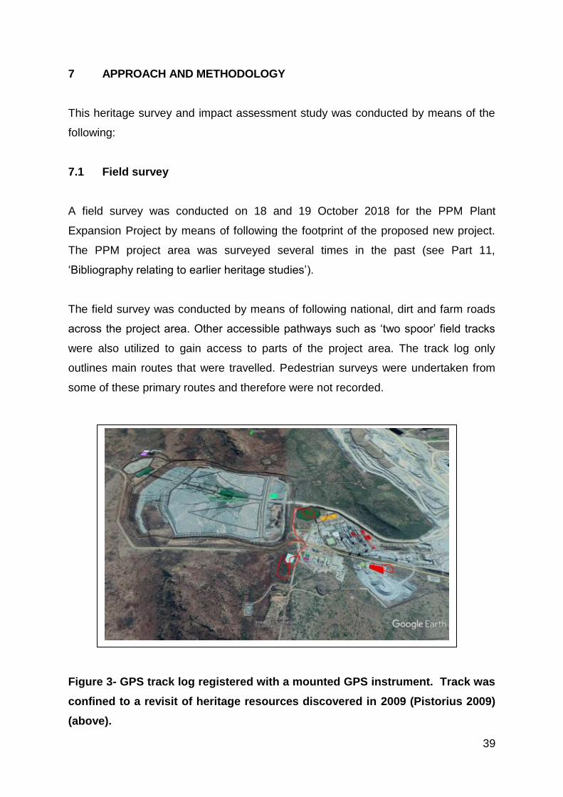
7 APPROACH AND METHODOLOGY
This heritage survey and impact assessment study was conducted by means of the
following:
7.1 Field survey
A field survey was conducted on 18 and 19 October 2018 for the PPM Plant
Expansion Project by means of following the footprint of the proposed new project.
The PPM project area was surveyed several times in the past (see Part 11,
‘Bibliography relating to earlier heritage studies’).
The field survey was conducted by means of following national, dirt and farm roads
across the project area. Other accessible pathways such as ‘two spoor’ field tracks
were also utilized to gain access to parts of the project area. The track log only
outlines main routes that were travelled. Pedestrian surveys were undertaken from
some of these primary routes and therefore were not recorded.
Figure 3- GPS track log registered with a mounted GPS instrument. Track was
confined to a revisit of heritage resources discovered in 2009 (Pistorius 2009)
(above).

40
Ecological indicators such as alternations in vegetation patterns; open or bald spots
in the veld; protrusions of boulders, low hills or patches with grass, prominent
dolerite kopjes or dykes and dense penetrable vegetation were searched as these
could harbour foundations of possible historical structures or graveyards.
Aerial imagery served as a supplementary source (prior and after fieldwork) to
establish the possible presence of heritage resources such as farm homesteads or
extended stone walled villages.
All coordinates for heritage resources recorded by the author were done with a
Garmin Etrex hand set Global Positioning System (instrument) with an accuracy of <
15m.
The nature and character of the project area is further illuminated with descriptions
and photographs (see Part 8.1 ‘The field survey’).
7.2 Databases, literature survey and maps
Databases kept and maintained at institutions such as the PHRA, the Archaeological
Data Recording Centre at the National Flagship Institute (Museum Africa) in Pretoria
and SAHRA’s national archive (SAHRIS) were consulted by the author to determine
whether any heritage resources of significance had been identified during earlier
heritage surveys in or near the project area. Most of the heritage studies done for PPM
since the inception of the mine were done by the author (see Part 11, Bibliography
relating to earlier heritage studies’) Never the less heritage resources may have been
missed as a result of various factors (Part 1.3, ‘Assumptions and limitations).
7.3 Consultation process undertaken and comments received from
stakeholders
No specific consultation process was undertaken for the purposes of the heritage
study as the stakeholder consultation for the project is being done by SLR
Consulting (Africa) (Pty) Ltd.

41
7.4 Significance ratings
The significance of possible impacts on the heritage resources was determined
using a ranking scale based on the following:
Occurrence
- Probability of occurrence (how likely is it that the impact may/will occur?), and
- Duration of occurrence (how long may/will it last?)
Severity
- Magnitude (severity) of impact (will the impact be of high, moderate or low
severity?), and
- Scale/extent of impact (will the impact affect the national, regional or local
environment, or only that of the site?).
Each of these factors has been assessed for each potential impact using the
following ranking scales:
Probability:
5 – Definite/don’t know
4 – Highly probable
3 – Medium probability
2 – Low probability
1 – Improbable
0 – None
Duration:
5 – Permanent
4 – Long-term (ceases with the
operational life)
3 - Medium-term (5-15 years)
2 - Short-term (0-5 years)
1 – Immediate
Scale:
5 – International
4 – National
3 – Regional
2 – Local
1 – Site only
0 – None
Magnitude:
10 - Very high/don’t know
8 – High
6 – Moderate
4 – Low
2 – Minor
The heritage significance of each potential impact was assessed using the following
formula:

42
Significance Points (SP) = (Magnitude + Duration + Scale) x Probability
The maximum value is 100 Significance Points (SP). Potential environmental
impacts are rated as very high, high, moderate, low or very low significance on the
following basis:
More than 80 significance points indicates VERY HIGH heritage significance.
Between 60 and 80 significance points indicates HIGH heritage significance.
Between 40 and 60 significance points indicates MODERATE heritage
significance.
Between 20 and 40 significance points indicates LOW heritage significance.
Less than 20 significance points indicates VERY LOW heritage significance.

43
8 THE PHASE I HERITAGE IMPACT ASSESSMENT STUDY (HIA)
8.1 The field survey
The field survey was done by means of following national and local roads was well
as two track roads across the project area in order to gain access to the footprint of
developmental components of the PPM Plant Expansion Project.
However, the largest part of the project area comprises a ‘brown fields’ area as it
falls within the footprint and operational area of the existing PPM.
Figure 4- The footprint where the proposed new training centre could be
established is in undisturbed bush in the foreground but closer to the tailings
dam in the background. No heritage resources of significance were observed on
this flat piece of land (above).

44
Figure 5- The existing aggregate crusher and part of its footprint. This area was
surveyed during earlier heritage studies and no heritage resources were found
on this level piece of turf veld (above).
Figure 6- The existing vegetable garden and nursery’s footprint were surveyed in
the past. Stone walled sites occur on the slope of Matome in the background but
not where the existing community facilities were established (above).

45
8.2 Types and ranges of heritage resources
The Phase I HIA for the proposed Plant Expansion Project Area revealed the following
types and ranges of heritage resources as outlined in Section 3 of the National
Heritage Resources Act (Act No 25 of 1999) in the PPM Project Area, namely:
A stone walled complex along the eastern foot of Mukukunupu
This stone walled complex was geo-referenced, tabulated and mapped (Figure 6 - 9;
Table 1).
The stone walled complex is now briefly described and illuminated with photographs.

46
Figure 7- A stone walled complex dating from the Late Iron Age (AD1600 to AD1820) along the eastern foot of
Mukukunupu in the proposed Project Area (above).
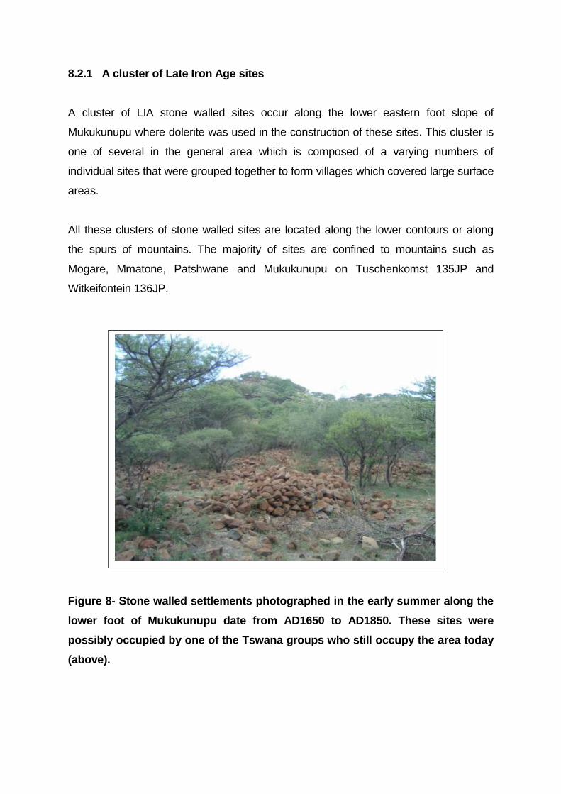
8.2.1 A cluster of Late Iron Age sites
A cluster of LIA stone walled sites occur along the lower eastern foot slope of
Mukukunupu where dolerite was used in the construction of these sites. This cluster is
one of several in the general area which is composed of a varying numbers of
individual sites that were grouped together to form villages which covered large surface
areas.
All these clusters of stone walled sites are located along the lower contours or along
the spurs of mountains. The majority of sites are confined to mountains such as
Mogare, Mmatone, Patshwane and Mukukunupu on Tuschenkomst 135JP and
Witkeifontein 136JP.
Figure 8- Stone walled settlements photographed in the early summer along the
lower foot of Mukukunupu date from AD1650 to AD1850. These sites were
possibly occupied by one of the Tswana groups who still occupy the area today
(above).

48
Figure 9- The spatial composition of the stone walled sites comprises an outer
ring of dwellings around a large central inner space (above).
Figure10- A residential unit in one of the stone walled dwellings along the foot of
Mukukunupu. It seems as if dwellings which were constructed with grass and
thatch were constructed in these homesteads (above).
49
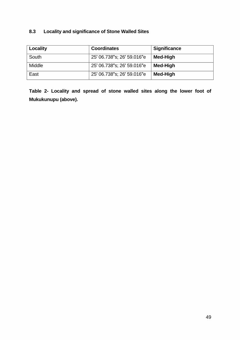
8.3 Locality and significance of Stone Walled Sites
Locality Coordinates Significance
South 25ʹ 06.738ʺs; 26ʹ 59.016ʺe Med-High
Middle 25ʹ 06.738ʺs; 26ʹ 59.016ʺe Med-High
East 25ʹ 06.738ʺs; 26ʹ 59.016ʺe Med-High
Table 2- Locality and spread of stone walled sites along the lower foot of
Mukukunupu (above).

50
9 THE HERITAGE ASSESSMENT FOR THE PPM PLANT EXPANSION
PROJECT
9.1 The significance of the heritage resources
The significance of the stone walled sites must be determined in order to establish the
significance of the impact on any of these remains. This will determine whether any
mitigation measures may be required for the stone walled complex which may be
negatively affected by the PPM Plant Expansion Project.
9.1.1 The significance of the stone walled sites
The stone walled sites comprise remains which are older than sixty years and which
qualify as archaeological remains and which therefore are protected by the National
Heritage Resources Act (No 25 of 1999).
The stone walled sites are rated as of medium to high significance. This rating is based
on the use of two rating (grading) schemes, namely:
A scheme of criteria which outlines places and objects as part of the national
estate as they have cultural-historical significance or other special value
(outlined in Section 3 of the NHRA [Act No 25 of 1999] (see Box 1) (Table 3).
A field rating scheme according to which heritage resources are graded in three
tiers (levels) of significance based on the regional occurrence of heritage
resources (Table 4) (Section 7 of the NHRA [Act No 25 of 1999).
9.1.1.1 Criteria to be part of the national estate
The NHRA (No 25 of 1999) distinguishes nine criteria for places and objects to be
‘part of the national estate’ if they have cultural significance or other special value,
namely (also see Box 1):
Its importance in/to the community, or pattern of South Africa’s history;
Its possession of uncommon, rare or endangered aspects of South
Africa’s natural or cultural heritage;

51
Its potential to yield information that will contribute to an understanding
of South Africa’s natural or cultural heritage;
Its importance in demonstrating the principal characteristics of a particular
class of South Africa’s natural or cultural places or objects;
Its importance in exhibiting particular aesthetic characteristics valued by a
community or cultural group;
Its importance in demonstrating a high degree of creative or technical
achievement at a particular period;
Its strong or special association with a particular community or cultural
group for social, cultural or spiritual reasons;
Its strong or special association with the life or work of a person, group
or organisation of importance in the history of South Africa; and
Sites of significance relating to the history of slavery in South Africa.
Criteria Low Medium High
Historical significance x x
Social significance x x
Technical significance x x
Scientific significance
(research, use, application,
e.g. in tourism industry)
x x
Table 3- Rating the stone walled settlements’ significance according to criteria
outlined in the NHRA (25 of 1990) (above).
The highlighted criteria reflect aspects of the historical, social, technical or scientific
significance (research, use and application, e.g. in tourism industry) of the stone
walled sites. According to these criteria the significance of the stone walled sites is
graded as of medium to high significance (Table 3).

52
9.1.1.2 Field rating scheme for stone walled sites
Grading of heritage resources remains the responsibility of heritage resources
authorities. However, in terms of minimum standards SAHRA requires that heritage
reports include field ratings in order to comply with Section 38 of the NHRA (No 25 of
1999). The NHRA (No 25 of 1999, Section 7) provides for a three-tier grading system
for heritage resources. The field rating process is designed to provide a qualitative
and quantitative rating of heritage resources. The rating system distinguishes three
categories of heritage resources:
Grade I Heritage resources hold qualities so exceptional that they are of
special national significance.
Grade II Heritage resources hold qualities which make them significant within
the context of a province or a region.
Grade III heritage resources are worthy of conservation, i.e. are generally
protected in terms of Sections 33 to 37 of the NHRA (No 25 of 1999).
Field rating Grade Significance Recommended mitigation
National
significance
Grade 1 High significance Nominate national site.
Conservation
Provincial
significance
Grade 2 High significance Nominate provincial site.
Conservation
Local significance Grade 3A High significance Conservation. Mitigation not
advised.
Local significance Grade 3B High significance Mitigation (part of site should
be retained)
Generally
Protected (GP.A)
- Medium to High
significance
Mitigation before
destruction
Generally
Protected (GP.B)
- Medium
significance
Recording before destruction
Generally
Protected (GP.C)
- Low significance Destruction
Table 4- Field rating (grading) for stone walled sites in the project area (above).

53
According to the highlighted field rating scheme the stone walled sites can be rated as
of medium to high significance and can be destroyed after the remains have been
recorded and a permit obtained from SAHRA for allowing for the destruction of the
remains (Table 4).
9.2 Possible impact on the stone walled sites
According to the current layout plan for the PPM Plant Expansion Project the following
can be noted:
None of the stone walled sites identified in the project area will be directly
affected by the PPM Plant Expansion Project.
The stone walled complex occurs at a safe distance from where the proposed
Training Centre could be established (Figure 7).
9.3 The significance of the impact on the stone walled sites
None of the stone walled sites will be affected by the proposed PPM Plant Expansion
Project. The significance of the impact on these remains therefore is very low (Table 5)
Table 5- The significance of the impact on the stone walled sites is very low
(below).
Probability
of impact
Magnitude
of impact
Duration
of
impact
Scale Significance
points
Significance
rating
Significance
after
management
Stone
walled
sites
1 2 1 1 4 Very low Very low

54
9.4 Managing the stone wallled sites
The stone walled sites along the lower foot slope of Mukukunupu must be avoided by
all developmental activities. Notice boards with the following inscriptions can be erected
along the fence and dirt road that border the settlements: ‘Caution Archaeological sites.
Avoid as any damage caused may lead to prosecution’.
9.5 Summary
None of the stone walled sites identified in the Project Area need to be affected by the
PPM Plant Expansion Project. Consequently, there is no reason from a heritage point
of view why the proposed PPM Plant Expansion Project cannot proceed.

55
10 CONCLUSION AND RECOMMENDATIONS
The Phase I HIA for the proposed Plant Expansion Project Area revealed the following
types and ranges of heritage resources as outlined in Section 3 of the National
Heritage Resources Act (Act No 25 of 1999) in the PPM Project Area, namely:
A stone walled complex along the eastern foot of Mukukunupu
This stone walled complex was geo-referenced, tabulated and mapped (Figure 6 - 9;
Table 1).
The significance of the stone walled sites must be determined in order to establish the
significance of the impact on any of these remains. This will determine whether any
mitigation measures may be required for the stone walled complex which may be
negatively affected by the PPM Plant Expansion Project.
The significance of the stone walled sites
The stone walled sites comprise remains which are older than sixty years and which
qualify as archaeological remains and which therefore are protected by the National
Heritage Resources Act (No 25 of 1999).
The stone walled sites are rated as of medium to high significance. This rating is based
on the use of two rating (grading) schemes, namely:
A scheme of criteria which outlines places and objects as part of the national
estate as they have cultural-historical significance or other special value
(outlined in Section 3 of the NHRA [Act No 25 of 1999] (see Box 1) (Table 3).
A field rating scheme according to which heritage resources are graded in three
tiers (levels) of significance based on the regional occurrence of heritage
resources (Table 4) (Section 7 of the NHRA [Act No 25 of 1999).
Criteria to be part of the national estate
The NHRA (No 25 of 1999) distinguishes nine criteria for places and objects to be
‘part of the national estate’ if they have cultural significance or other special value,
namely (also see Box 1):
Its importance in/to the community, or pattern of South Africa’s history;

56
Its possession of uncommon, rare or endangered aspects of South
Africa’s natural or cultural heritage;
Its potential to yield information that will contribute to an understanding
of South Africa’s natural or cultural heritage;
Its importance in demonstrating the principal characteristics of a particular
class of South Africa’s natural or cultural places or objects;
Its importance in exhibiting particular aesthetic characteristics valued by a
community or cultural group;
Its importance in demonstrating a high degree of creative or technical
achievement at a particular period;
Its strong or special association with a particular community or cultural
group for social, cultural or spiritual reasons;
Its strong or special association with the life or work of a person, group
or organisation of importance in the history of South Africa; and
Sites of significance relating to the history of slavery in South Africa.
The highlighted criteria reflect aspects of the historical, social, technical or scientific
significance (research, use and application, e.g. in tourism industry) of the stone
walled sites. According to these criteria the significance of the stone walled sites is
graded as of medium to high significance (Table 3).
Field rating scheme for stone walled sites
Grading of heritage resources remains the responsibility of heritage resources
authorities. However, in terms of minimum standards SAHRA requires that heritage
reports include field ratings in order to comply with Section 38 of the NHRA (No 25 of
1999). The NHRA (No 25 of 1999, Section 7) provides for a three-tier grading system
for heritage resources. The field rating process is designed to provide a qualitative
and quantitative rating of heritage resources. The rating system distinguishes three
categories of heritage resources:
Grade I Heritage resources hold qualities so exceptional that they are of
special national significance.
Grade II Heritage resources hold qualities which make them significant within
the context of a province or a region.

57
Grade III heritage resources are worthy of conservation, i.e. are generally
protected in terms of Sections 33 to 37 of the NHRA (No 25 of 1999).
According to the highlighted field rating scheme the stone walled sites can be rated as
of medium to high significance and can be destroyed after the remains have been
recorded and a permit obtained from SAHRA for allowing for the destruction of the
remains (Table 4).
Possible impact on the stone walled sites
According to the current layout plan for the PPM Plant Expansion Project the following
can be noted:
None of the stone walled sites identified in the project area will be directly
affected by the PPM Plant Expansion Project.
The stone walled complex occurs at a safe distance from where the proposed
Training Centre could be established (Figure 7).
The significance of the impact on the stone walled sites
None of the stone walled sites will be affected by the proposed PPM Plant Expansion
Project. The significance of the impact on these remains therefore is very low (Table 5)
Managing the stone wallled sites
The stone walled sites along the lower foot slope of Mukukunupu must be avoided by
all developmental activities. Notice boards with the following inscriptions can be erected
along the fence and dirt road that border the settlements: ‘Caution Archaeological sites.
Avoid as any damage caused may lead to prosecution’.
Summary
None of the stone walled sites identified in the Project Area need to be affected by the
PPM Plant Expansion Project. Consequently, there is no reason from a heritage point
of view why the proposed PPM Plant Expansion Project cannot proceed.

58
Dr Julius CC Pistorius
Archaeologist & Heritage Consultant
Member ASAPA

59
11 SELECT BIBLIOGRAPHY
Breutz, P.L. 1953. The tribes of the Rustenburg and Pilanesberg districts. Pretoria:
Government Printer.
Breutz, P.L. 1986. A history of the Batswana and origin of Bophuthatswana. Margate,
Natal: Thumbprint.
Bergh, J.S. 1992. Die vestiging van die Voortrekkers noord van die Vaalrivier tot
1840. Historia, 37(2); 38-42.
Coetzee C.B. 1976. Delfstowwe van die Republiek van Suid-Afrika. Geologiese
Opname. Departement van Mynbou. Pretoria: Die Staatsdrukker.
Erasmus, B.P.J. 1995. Oppad in Suid Afrika. ‘n Gids tot Suid Afrika, Streek vir Streek.
Jonathan Ball Uitgewers Bpk.
Harris, C. 1963. The wild sports of Southern Africa. London:John Murray.
Horn, A. C. 1996. Okkupasie van die Bankeveld voor 1840 n.C.: ‘n sintese. Suid
Afrikaanse Tydskrif vir Etnologie, 19(1):17-27.
Lye, W.F. (ed.) 1975. Andrew Smith’s journal of his expedition into the interior of South
Africa, 1834-1836. Cape Town: Balkema.
Mason, R.J. 1968. Iron Age settlement in the Transvaal and Natal revealed by aerial
photography and excavation. African Studies, 27(4)
Pretorius, Z.L. 1967. Die Geskiedenis van Rustenburg, 1851-1918. MA
verhandeling. Potchefstroom: PU vir CHO.
Rasmussen, R.K. 1978. Migrant Kingdom: Mzilikazi's Ndebele in South Africa. David
Philip: Cape Town.

60
Schapera, I. 1952. The ethnic composition of Tswana tribes. Monographs on Social
Anthropology, No 11. London School of Economics and Political Science.
Schapera, I. 1942. A short history of the Bakgatla Bagakgafela of Bechuanaland
Protectorate. Communications from the School of African Studies. University of Cape
Town.
TNAD 1905. Short History of the Native Tribes of the Transvaal. Government Printer:
Pretoria.
Môkgatle, N. 1971. Autobiography of an unknown South African. London: University
of California Press.
Schapera, I. 1955. A handbook of Tswana law and customs. Oxford University
Press: London.
Schapera, I. 1976. The Tswana. Great Britian: Clarke, Doble & Brendon.
Viljoen, M.J. & Reimold, W.U. 1999. An introduction to South Africa’s geological and
mining heritage. The Geological Society of South Africa. Mintek. Randburg.
Wagner, P.A. 1973. The platinum deposits and mines of South Africa. Struik: Cape
Town.

61
12 BIBLIOGRAPHY RELATING TO EARLIER HERITAGE STUDIES
Pistorius, J.C.C. 2000. An Archaeological scoping report on possible cultural resources
on a part of the farm Boschoek 103JQ in the Rustenburg District of the North West:
Proposed development of a new town by Amplats. Unpublished report prepared for
Landscape Dynamics and Amplats.
Pistorius, J.C.C. 2000. An Archaeological scoping report supplemented with a Phase
I Archaeological survey for SA Chrome’s proposed new Ferrochrome Smelter on the
farm Boschhoek 103JQ in the Rustenburg District of the Central Bankeveld in the
North West Province. Unpublished report prepared for Metago Environmental
Engineers.
Pistorius, J.C.C. 2000. New Late Iron Age spatial identities in the Bankeveld. South
African Journal of Enthnology. 23 (4),150-163.
Pistorius, J.C.C. 2003. A Heritage Impact Assessment (HIA) for SA Ferrochrome’s
new proposed expansion operations in Boschoek north of Rustenburg in in the North
West Province. Unpublished report prepared for Metago Environmental Engineers.
Pistorius, J.C.C. 2006a. A Phase I Heritage Impact Assessment (HIA) study for
Boynton Platinum’s new proposed mining areas near the Pilanesberg in the North-
West Province of South Africa. Unpublished report prepared for Metago Environmental
Engineers.
Pistorius, J.C.C. 2006b. An extended Phase I Heritage Impact Assessment (HIA) study
for Pilanesberg Platinum Mines (PPM) new proposed mining areas near the
Pilanesberg in the North-West Province of South Africa. Unpublished report prepared
for Metago Environmental Engineers.
Pistorius, J.C.C. 2006c. A Phase I Heritage Impact Assessment (HIA) study for
Boynton Platinum’s new proposed mining areas near the Pilanesberg in the North-
West Province of South Africa. Unpublished report prepared for Metago Environmental
Engineers (combination of first two studies).

62
Pistorius, J.C.C. 2007. A Phase I Heritage Impact Assessment (HIA) study for the
proposed new Sedibelo Platinum Mine near the Pilanesberg in the North-West
Province of South Africa. Unpublished report prepared for Barrick Platinum.
Pistorius, J.C.C. 2007. A Phase I Heritage Impact Assessment (HIA) study for
Batlhako Mining Limited on the farm Ruighoek 169JP near the Pilanesberg in the
North-West Province. Unpublished report prepared for Golder Associates (Africa)
Ltd..
Pistorius, J.C.C. 2008. A Phase I Heritage Impact Assessment (HIA) study for a
proposed new sport complex and associated facilities in Saulspoort near the
Pilanesberg in the North-West Province of South Africa. Unpublished report
prepared for Metago Environmental Engineers.
Pistorius, J.C.C. 2009. A Phase I Heritage Impact Assessment (HIA) study for
Pilanesberg Platinum Mine’s (PPM) proposed rock waste dump extension near the
Pilanesberg in the North-West Province of South Africa. Unpublished report prepared
for Pilanesberg Platinum Mine.
Pistorius, J.C.C. 2010. Brief report on heritage matters at Pilanesberg Platinum Mine.
Unpublished report prepared for Pilanesberg Platinum Mine.
Pistorius, J.C.C. 2010. A Phase I Heritage Impact Assessment (HIA) study for the
farm Magazynskraal 3JQ near the Pilanesberg in the North-West Province of South
Africa. Unpublished report prepared for Metago Environmental Engineers.
Pistorius, J.C.C. 2010. Mitigating and managing heritage resources within the
Horison Chrome Mine on Portions of the farm Ruighoek 169JP near the Pilanesberg
in the North-West Province. Unpublished report prepared for Natural Scientific
Services (NSS).
Pistorius, J.C.C. 2011. A Phase I Heritage Impact Assessment (HIA) study for
Pilanesberg Platinum Mine’s (PPM) proposed amendment of the closure objectives of
the Tuschenkomst Open Pit and community water supply scheme near the Pilanesberg

63
in the North-West Province. Unpublished report prepared for Pilanesberg Platinum
Mine.
Pistorius, J.C.C. 2011. A Phase I Heritage Impact Assessment (HIA) study for a
combined platinum mining operation near Pilanesberg in the North-West Province:
the extension of the Tuschenkomst open cast pit for Pilanesberg Platinum Mine.
Unpublished report prepared for LSR Consulting (Africa) (Pty) Ltd..
Pistorius, J.C.C. 2011. A Phase I Heritage Impact Assessment (HIA) study for
Lonmin Platinum’s proposed exploration activities on the farm Vlakfontein 207JP and
Diamand 206JP near the Pilanesberg in the North-West Province. Unpublished
report prepared for Lonmin Platinum.
Pistorius, J.C.C. 2011. Follow-up report on Lonmin’s exploration activities on
Vlakfontein 207JP and Diamand 206JP near the Pilanesberg in the North-West
Province: completion of exploration activities during 2011. Unpublished report
prepared for Lonmin Platinum.
Pistorius, J.C.C. 2011. A Phase I Heritage Impact Assessment (HIA) study for
Pilanesberg Platinum Mine’s (PPM) proposed amendment of the closure objectives of
the Tuschenkomst Open Pit and community water supply scheme near the Pilanesberg
in the North-West Province. Unpublished report prepared for Pilanesberg Platinum
Mine.
Pistorius, J.C.C. 2011. A Phase I Heritage Impact Assessment (HIA) study for a
combined platinum mining operation near Pilanesberg in the North-West Province:
the extension of the Tuschenkomst open cast pit for Pilanesberg Platinum Mine.
Unpublished report prepared for LSR Consulting (Africa) (Pty) Ltd..
Pistorius, J.C.C. 2012. A Phase I Heritage Impact Assessment (HIA) study for
chrome mining activities on various portions of the farms Groenfontein 138JP,
Vlakfontein 163JP and Vogelstruisnek 174JP west of the Pilanesberg in the North-
West Province of South Africa. Unpublished report prepared for Golder Associates
(Africa) Ltd..

64
Pistorius, J.C.C. 2013. An updated Phase I Heritage Impact Assessment (HIA) study
for Pilanesberg Platinum Mine (PPM) near the Pilanesberg in the North-West
Province.. Unpublished report prepared for LSR Consulting (Africa) (Pty) Ltd..