appendix g local erosion law
TRANSCRIPT

G-1
APPENDIX G
LOCAL EROSION LAW
WHEREAS, a public hearing was held by the Town Board of the Town of East Hampton on August 17, 2006 regarding the amendment of Chapter 255 ("Zoning") of the East Hampton Town Code in order to better protect the Town's coastline, by implementing the coastal erosion recommendations of the Local Waterfront Revitalization Program ("LWRP") and creating the Coastal Erosion Overlay District to regulate projects which are designed to control or prevent flooding and erosion of the coastline and adjacent upland areas or which may impact coastal resources, all as more fully set forth in the text of the Local Law; and WHEREAS, such public hearing was held open and public comment was accepted until September 18, 2006;
WHEREAS, the Town Board considered the comments of all persons regarding this Local Law, both as submitted in writing and as presented orally at the public hearing; and WHEREAS, the adoption of this local law is a Type I action pursuant to the State Environmental Quality State Environmental Quality Review Act (SEQRA); and WHEREAS, the Town Board has prepared and considered an Environmental Assessment Form which evaluates the potential environmental impacts of the proposed amendment; and WHEREAS, the Board has determined that the adoption of this Local Law will not have a significant negative impact upon the environment; NOW, THEREFORE, BE IT RESOLVED, that a negative declaration is hereby made pursuant to the State Environmental Quality Review Act (SEQRA); be it further RESOLVED, that the said Local Law is hereby enacted to read as follows:
LOCAL LAW NO. __14____ OF 2007
INTRODUCTORY NO. ___25___ OF 2006
A Local Law providing for the amendment of Chapter 255 ("Zoning") of the East Hampton Town Code in order to better protect the Town's coastline, by implementing the coastal erosion recommendations of the Local Waterfront Revitalization Program ("LWRP") and creating the Coastal Erosion Overlay District to regulate projects which are designed to control or prevent flooding and erosion of the coastline and adjacent upland areas or which may impact coastal resources, said Local Law to read as follows: BE IT ENACTED by the Town Board of the Town of East Hampton as follows: SECTION I. - FINDINGS AND OBJECTIVES: This Local Law is intended to provide better protection of the Town's shorelines, dunelands, bluffs, beaches, and other coastal resources by enacting the recommendations for coastal flooding and erosion control which are found in Policies #11-17 of the Town's Local
Waterfront Revitalization Program ("LWRP"). The Town of East Hampton has a tradition dating back to its colonial origins of maintaining coastal resources for all its citizens. Many of the beaches in East Hampton are owned by the Town Trustees and have been historically open to public use. It is the Town Board’s intention in adopting this Local Law to preserve and reaffirm the established powers, rights and privileges of the Town Trustees with respect to the management and regulation of the beaches, bottomlands and other lands that they own. Nothing in this Local Law shall be construed as diminishing in any way these powers, rights, and privileges of the Town Trustees.
East Hampton's north and south shores have greatly differing geography and geology with different weather exposures. The Town's south shore Atlantic Ocean beaches are generally more dynamic because of the higher wave energies and greater quantities of sediment being transported. The Town's northerly bay beaches, while more protected, are narrower and more fragile and take longer to recover from storms. They are mostly fed by sediment from bluffs and headlands. Where attempts have been made to stabilize bluffs with hard structures, these sand sources have been restricted, and the resulting deficit in the local sediment budget has led to further narrowing or elimination of beaches. On undeveloped shores, natural coastal processes, including storm flooding and erosion, establish a dynamic equilibrium of shoreline accretion and recession. Natural protective features such as beaches, dunes, bluffs, sand spits, and wetlands enable the shoreline to absorb and recover from the force of storms. Changes in climate (global warming and the "greenhouse effect") may exert an influence on future storm activity and also cause sea-level to rise, with profound effects on the Town's coast. Such changes would render these natural protective features all the more important. In any case, while future sea level rise and increased storm activity may be uncertain, it is well established that present sea level is rising and statistically certain that storms will be an ever-present threat to the Town's coastal zone. In the past, siting of development often failed to take into account potential damage from flooding, erosion and coastal storms. Following major storms, homeowners recognizing their precarious predicament built so-called erosion protection structures to protect their property. However, groins, bulkheads and other hard structures have had detrimental effects on adjoining beaches or neighboring property and have often aggravated the erosion problems they were designed to prevent. Their legacy is a disappearance of sandy beaches in many locations, a significant loss for a Town whose way of life and resort economy depend on public access to unspoiled beaches. The Town's primary objectives in enacting this Local Law are to maintain the public interest in its coastal resources and to protect the health and safety of its residents by preserving, protecting and enhancing the natural protective features of its coast, with due regard for the needs of individual property owners. In practice, this approach to flooding and erosion leads to an emphasis on non-structural or "soft" solutions which will not disrupt coastal processes or damage natural protective features.
This Local Law establishes a coastal erosion overlay district consisting of four zones covering the Town's coastline (“CEOD”). It also establishes regulations for each of four coastal erosion overlay zones. These regulations govern projects which are designed to control or prevent flooding and erosion of the coastline and adjacent upland areas, or which may impact coastal resources. The Local Law amends the Zoning Code to specifically authorize private property owners to take emergency action, in certain situations, to protect privately-owned structures from damage caused by coastal flooding or erosion. These emergency activities, which are exempt from the normal Natural Resources Special Permit review process, are authorized only in very limited circumstances where immediate action is necessary to prevent substantial damage to a privately-owned structure, and are restricted to only four types of actions: (1) moving the structure landward, (2) making repairs or providing structural support to a damaged structure, (3) depositing sand on the beach in front of the structure, or (4) installing -- on a temporary basis only -- a geotextile tube or sandbag erosion control structure. With respect to the emergency authorization for geotextile tube or sandbag systems, the Town Board finds that such temporary authorization appropriately balances the difficult and conflicting interests of shorefront property owners and the general public. The Town Board finds that the public's rights to use of the foreshore are paramount, but that emergency measures to protect private buildings and structures are in the overall best interests of the public as well as shorefront land owners. In making this legislative determination, the Town Board specifically finds that the long-term effects of erosion control structures -- including geotextile tube or sandbag systems -- are highly detrimental to East Hampton's environment and economy, and that the use of geotextile tubes or sandbag systems, on a short-term basis only, is warranted only in emergency situations because they offer a somewhat smaller prospect of harm than other types of erosion control structures and are more easily removed. With respect to downtown Montauk, specifically the hotel and business district, the Board recognizes that it is within an exceptional geological location given its proximity to the Atlantic Ocean and its low elevation and consequent vulnerability to flooding. The Board also recognizes that the Town’s economic stability is linked to the survival and prosperity of its business districts. Accordingly, the Board concludes that the downtown Montauk area comprises a unique concentration of economic assets vital to the Town’s tourist economy that warrants further study and a long-term solution for coastal erosion. The Town Board held a public hearing on this proposed Local Law on August 16, 2006 and accepted written comments until September 18, 2006. Over a period of eight months following the public hearing and receipt of written and oral comments, the Town Board carefully reviewed and discussed all of the oral and written comments submitted regarding the proposed legislation. The Town Planning Department in conjunction with the Town Attorney’s Office prepared a series of memoranda analyzing the public comments and recommending some proposed modifications to the Local Law as a result thereof. The Town Board held work sessions on November 14, 2006, December 19, 2006, January 23, 2007, February 13, 2007, and April 10, 2007 to discuss the memoranda and come to a consensus as to how the law would be
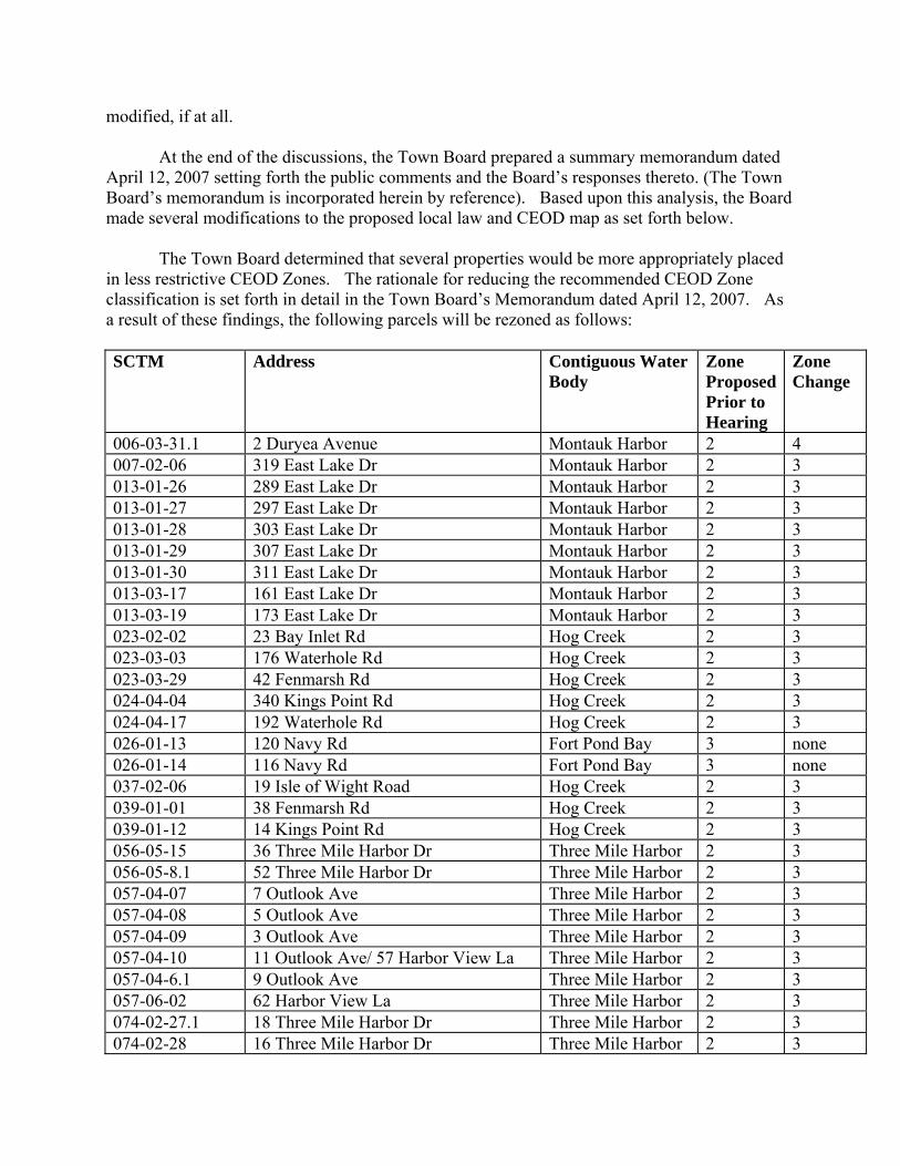
modified, if at all. At the end of the discussions, the Town Board prepared a summary memorandum dated April 12, 2007 setting forth the public comments and the Board’s responses thereto. (The Town Board’s memorandum is incorporated herein by reference). Based upon this analysis, the Board made several modifications to the proposed local law and CEOD map as set forth below. The Town Board determined that several properties would be more appropriately placed in less restrictive CEOD Zones. The rationale for reducing the recommended CEOD Zone classification is set forth in detail in the Town Board’s Memorandum dated April 12, 2007. As a result of these findings, the following parcels will be rezoned as follows: SCTM Address Contiguous Water
Body Zone Proposed Prior to Hearing
Zone Change
006-03-31.1 2 Duryea Avenue Montauk Harbor 2 4 007-02-06 319 East Lake Dr Montauk Harbor 2 3 013-01-26 289 East Lake Dr Montauk Harbor 2 3 013-01-27 297 East Lake Dr Montauk Harbor 2 3 013-01-28 303 East Lake Dr Montauk Harbor 2 3 013-01-29 307 East Lake Dr Montauk Harbor 2 3 013-01-30 311 East Lake Dr Montauk Harbor 2 3 013-03-17 161 East Lake Dr Montauk Harbor 2 3 013-03-19 173 East Lake Dr Montauk Harbor 2 3 023-02-02 23 Bay Inlet Rd Hog Creek 2 3 023-03-03 176 Waterhole Rd Hog Creek 2 3 023-03-29 42 Fenmarsh Rd Hog Creek 2 3 024-04-04 340 Kings Point Rd Hog Creek 2 3 024-04-17 192 Waterhole Rd Hog Creek 2 3 026-01-13 120 Navy Rd Fort Pond Bay 3 none 026-01-14 116 Navy Rd Fort Pond Bay 3 none 037-02-06 19 Isle of Wight Road Hog Creek 2 3 039-01-01 38 Fenmarsh Rd Hog Creek 2 3 039-01-12 14 Kings Point Rd Hog Creek 2 3 056-05-15 36 Three Mile Harbor Dr Three Mile Harbor 2 3 056-05-8.1 52 Three Mile Harbor Dr Three Mile Harbor 2 3 057-04-07 7 Outlook Ave Three Mile Harbor 2 3 057-04-08 5 Outlook Ave Three Mile Harbor 2 3 057-04-09 3 Outlook Ave Three Mile Harbor 2 3 057-04-10 11 Outlook Ave/ 57 Harbor View La Three Mile Harbor 2 3 057-04-6.1 9 Outlook Ave Three Mile Harbor 2 3 057-06-02 62 Harbor View La Three Mile Harbor 2 3 074-02-27.1 18 Three Mile Harbor Dr Three Mile Harbor 2 3 074-02-28 16 Three Mile Harbor Dr Three Mile Harbor 2 3
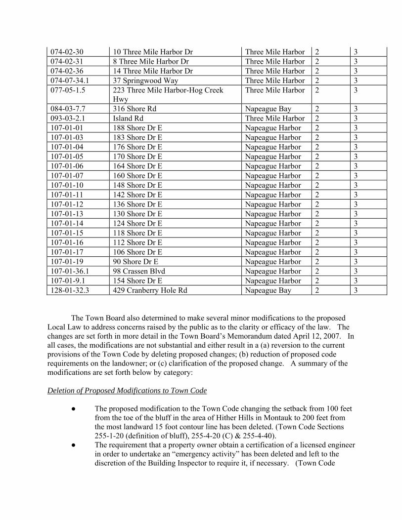
074-02-30 10 Three Mile Harbor Dr Three Mile Harbor 2 3 074-02-31 8 Three Mile Harbor Dr Three Mile Harbor 2 3 074-02-36 14 Three Mile Harbor Dr Three Mile Harbor 2 3 074-07-34.1 37 Springwood Way Three Mile Harbor 2 3 077-05-1.5 223 Three Mile Harbor-Hog Creek
Hwy Three Mile Harbor 2 3
084-03-7.7 316 Shore Rd Napeague Bay 2 3 093-03-2.1 Island Rd Three Mile Harbor 2 3 107-01-01 188 Shore Dr E Napeague Harbor 2 3 107-01-03 183 Shore Dr E Napeague Harbor 2 3 107-01-04 176 Shore Dr E Napeague Harbor 2 3 107-01-05 170 Shore Dr E Napeague Harbor 2 3 107-01-06 164 Shore Dr E Napeague Harbor 2 3 107-01-07 160 Shore Dr E Napeague Harbor 2 3 107-01-10 148 Shore Dr E Napeague Harbor 2 3 107-01-11 142 Shore Dr E Napeague Harbor 2 3 107-01-12 136 Shore Dr E Napeague Harbor 2 3 107-01-13 130 Shore Dr E Napeague Harbor 2 3 107-01-14 124 Shore Dr E Napeague Harbor 2 3 107-01-15 118 Shore Dr E Napeague Harbor 2 3 107-01-16 112 Shore Dr E Napeague Harbor 2 3 107-01-17 106 Shore Dr E Napeague Harbor 2 3 107-01-19 90 Shore Dr E Napeague Harbor 2 3 107-01-36.1 98 Crassen Blvd Napeague Harbor 2 3 107-01-9.1 154 Shore Dr E Napeague Harbor 2 3 128-01-32.3 429 Cranberry Hole Rd Napeague Bay 2 3
The Town Board also determined to make several minor modifications to the proposed Local Law to address concerns raised by the public as to the clarity or efficacy of the law. The changes are set forth in more detail in the Town Board’s Memorandum dated April 12, 2007. In all cases, the modifications are not substantial and either result in a (a) reversion to the current provisions of the Town Code by deleting proposed changes; (b) reduction of proposed code requirements on the landowner; or (c) clarification of the proposed change. A summary of the modifications are set forth below by category: Deletion of Proposed Modifications to Town Code
● The proposed modification to the Town Code changing the setback from 100 feet from the toe of the bluff in the area of Hither Hills in Montauk to 200 feet from the most landward 15 foot contour line has been deleted. (Town Code Sections 255-1-20 (definition of bluff), 255-4-20 (C) & 255-4-40).
● The requirement that a property owner obtain a certification of a licensed engineer in order to undertake an “emergency activity” has been deleted and left to the discretion of the Building Inspector to require it, if necessary. (Town Code
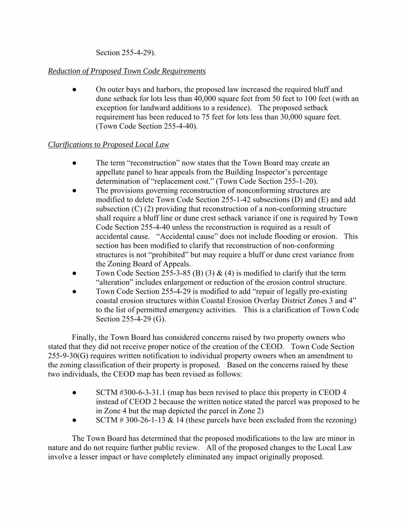
Section 255-4-29). Reduction of Proposed Town Code Requirements
● On outer bays and harbors, the proposed law increased the required bluff and dune setback for lots less than 40,000 square feet from 50 feet to 100 feet (with an exception for landward additions to a residence). The proposed setback requirement has been reduced to 75 feet for lots less than 30,000 square feet. (Town Code Section 255-4-40).
Clarifications to Proposed Local Law
● The term “reconstruction” now states that the Town Board may create an appellate panel to hear appeals from the Building Inspector’s percentage determination of “replacement cost.” (Town Code Section 255-1-20).
● The provisions governing reconstruction of nonconforming structures are modified to delete Town Code Section 255-1-42 subsections (D) and (E) and add subsection (C) (2) providing that reconstruction of a non-conforming structure shall require a bluff line or dune crest setback variance if one is required by Town Code Section 255-4-40 unless the reconstruction is required as a result of accidental cause. “Accidental cause” does not include flooding or erosion. This section has been modified to clarify that reconstruction of non-conforming structures is not “prohibited” but may require a bluff or dune crest variance from the Zoning Board of Appeals.
● Town Code Section 255-3-85 (B) (3) & (4) is modified to clarify that the term “alteration” includes enlargement or reduction of the erosion control structure.
● Town Code Section 255-4-29 is modified to add “repair of legally pre-existing coastal erosion structures within Coastal Erosion Overlay District Zones 3 and 4” to the list of permitted emergency activities. This is a clarification of Town Code Section 255-4-29 (G).
Finally, the Town Board has considered concerns raised by two property owners who stated that they did not receive proper notice of the creation of the CEOD. Town Code Section 255-9-30(G) requires written notification to individual property owners when an amendment to the zoning classification of their property is proposed. Based on the concerns raised by these two individuals, the CEOD map has been revised as follows:
● SCTM #300-6-3-31.1 (map has been revised to place this property in CEOD 4 instead of CEOD 2 because the written notice stated the parcel was proposed to be in Zone 4 but the map depicted the parcel in Zone 2)
● SCTM # 300-26-1-13 & 14 (these parcels have been excluded from the rezoning) The Town Board has determined that the proposed modifications to the law are minor in nature and do not require further public review. All of the proposed changes to the Local Law involve a lesser impact or have completely eliminated any impact originally proposed.

SECTION II. - TOWN CODE AMENDED: Chapter 255 ("Zoning") of the East Hampton Town Code is hereby amended in part to read as follows: [CHANGES ARE IN BOLD OR INDICATED BY STRIKE OUT]

ARTICLE I General Provisions
§ 255-1-20. Definitions. As used in this chapter, the following terms shall have the meanings indicated: BEACH VEGETATION - Beach grass (Ammophila breviligulata), as well as the following plants or lichens: beach heather (Hudsonia tomentosa), beach plum (Prunus maritima), beach pea (Lathyrus maritimus), bearberry (Arctostaphylos uva-ursi), bayberry (Myrica pensylvanica), dusty miller (Artemissia stellariana), seaside goldenrod (Solidago sempervirens), pine barren sandwort (Arenaria caroliniana), and reindeer lichen (Cladonia species). BEACH GRASS - See “beach vegetation." BLUFF - A formation of land which is landward of the natural beach and which rises sharply from its base to a bluff line which is at least two feet higher than the base. A bank or cliff with a precipitous or steeply sloped face lying landward of a beach or body of water, and having a bluff line at least two (2) feet higher than its base or toe. A "bluff" may extend across all or part of a parcel. For the purposes of this chapter, a "bluff" shall not be considered to encompass barrier sand dunes. BLUFF LINE - The natural land contour running along the top of a bluff beyond which to landward the natural land contours resume a gradual slope. COASTAL EROSION CONTROL STRUCTURE - See "erosion control structure." COASTAL EROSION HAZARD AREA MAP (or "CEHA" MAP) - The map issued by the Commissioner of the New York State Department of Environmental Conservation ("DEC") pursuant to Article 34 of the Environmental Conservation Law ("ECL"), as the same may be amended from time to time. Said map delineates the boundaries of erosion hazard areas subject to regulation under Article 34 of the ECL. COASTAL RESTORATION PROJECT - The deposit of sand or soil on a beach, dune, or the face of a bluff, in order to restore or replace similar material lost to erosion, and the stabilization of such material by planting beach vegetation. This definition shall include the installation of snow fencing or permeable mesh fencing, the placement of biodegradable fabric mesh or biodegradable gels, and the installation of drains and pipes for the control of water runoff, if these devices are designed and used to allow vegetation to grow upon and stabilize the deposited materials. DUNE (or SAND DUNE) - A naturally occurring accumulation of sand in wind-formed ridges or mounds landward of the beach, often characterized by the natural growth of beach grass
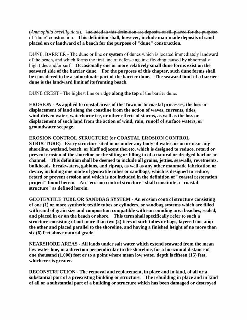
(Ammophila breviligulata). Included in this definition are deposits of fill placed for the purpose of "dune" construction. This definition shall, however, include man-made deposits of sand placed on or landward of a beach for the purpose of "dune" construction. DUNE, BARRIER - The dune or line or system of dunes which is located immediately landward of the beach, and which forms the first line of defense against flooding caused by abnormally high tides and/or surf. Occasionally one or more relatively small dune forms exist on the seaward side of the barrier dune. For the purposes of this chapter, such dune forms shall be considered to be a subordinate part of the barrier dune. The seaward limit of a barrier dune is the landward limit of its fronting beach. DUNE CREST - The highest line or ridge along the top of the barrier dune. EROSION - As applied to coastal areas of the Town or to coastal processes, the loss or displacement of land along the coastline from the action of waves, currents, tides, wind-driven water, waterborne ice, or other effects of storms, as well as the loss or displacement of such land from the action of wind, rain, runoff of surface waters, or groundwater seepage. EROSION CONTROL STRUCTURE (or COASTAL EROSION CONTROL STRUCTURE) - Every structure sited in or under any body of water, or on or near any shoreline, wetland, beach, or bluff adjacent thereto, which is designed to reduce, retard or prevent erosion of the shoreline or the silting or filling in of a natural or dredged harbor or channel. This definition shall be deemed to include all groins, jetties, seawalls, revetments, bulkheads, breakwaters, gabions, and riprap, as well as any other manmade fabrication or device, including one made of geotextile tubes or sandbags, which is designed to reduce, retard or prevent erosion and which is not included in the definition of "coastal restoration project" found herein. An "erosion control structure" shall constitute a "coastal structure" as defined herein. GEOTEXTILE TUBE OR SANDBAG SYSTEM - An erosion control structure consisting of one (1) or more synthetic textile tubes or cylinders, or sandbag systems which are filled with sand of grain size and composition compatible with surrounding area beaches, sealed, and placed in or on the beach or shore. This term shall specifically refer to such a structure consisting of not more than two (2) tiers of such tubes or bags, layered one atop the other and placed parallel to the shoreline, and having a finished height of no more than six (6) feet above natural grade. NEARSHORE AREAS - All lands under salt water which extend seaward from the mean low water line, in a direction perpendicular to the shoreline, for a horizontal distance of one thousand (1,000) feet or to a point where mean low water depth is fifteen (15) feet, whichever is greater. RECONSTRUCTION - The removal and replacement, in place and in kind, of all or a substantial part of a preexisting building or structure. The rebuilding in place and in kind of all or a substantial part of a building or structure which has been damaged or destroyed
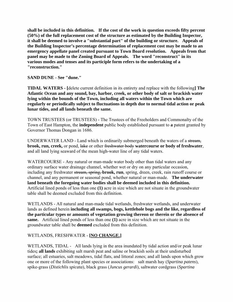
shall be included in this definition. If the cost of the work in question exceeds fifty percent (50%) of the full replacement cost of the structure as estimated by the Building Inspector, it shall be deemed to involve a "substantial part" of the building or structure. Appeals of the Building Inspector’s percentage determination of replacement cost may be made to an emergency appellate panel created pursuant to Town Board resolution. Appeals from that panel may be made to the Zoning Board of Appeals. The word "reconstruct" in its various modes and tenses and its participle form refers to the undertaking of a "reconstruction." SAND DUNE - See "dune." TIDAL WATERS - [delete current definition in its entirety and replace with the following] The Atlantic Ocean and any sound, bay, harbor, creek, or other body of salt or brackish water lying within the bounds of the Town, including all waters within the Town which are regularly or periodically subject to fluctuations in depth due to normal tidal action or peak lunar tides, and all lands beneath the same. TOWN TRUSTEES (or TRUSTEES) - The Trustees of the Freeholders and Commonalty of the Town of East Hampton, the independent public body established pursuant to a patent granted by Governor Thomas Dongan in 1686. UNDERWATER LAND - Land which is ordinarily submerged beneath the waters of a stream, brook, run, creek, or pond, lake or other freshwater body watercourse or body of freshwater, and all land lying seaward of the mean high-water line of any tidal waters. WATERCOURSE - Any natural or man-made water body other than tidal waters and any ordinary surface water drainage channel, whether wet or dry on any particular occasion, including any freshwater stream, spring, brook, run, spring, dreen, creek, rain runoff course or channel, and any permanent or seasonal pond, whether natural or man-made. The underwater land beneath the foregoing water bodies shall be deemed included in this definition. Artificial lined ponds of less than one (1) acre in size which are not situate in the groundwater table shall be deemed excluded from this definition. WETLANDS - All natural and man-made tidal wetlands, freshwater wetlands, and underwater lands as defined herein including all swamps, bogs, kettlehole bogs and the like, regardless of the particular types or amounts of vegetation growing thereon or therein or the absence of same. Artificial lined ponds of less than one (1) acre in size which are not situate in the groundwater table shall be deemed excluded from this definition. WETLANDS, FRESHWATER - [NO CHANGE.] WETLANDS, TIDAL - All lands lying in the area inundated by tidal action and/or peak lunar tides; all lands exhibiting salt marsh peat and saline or brackish soils at their undisturbed surface; all estuaries, salt meadows, tidal flats, and littoral zones; and all lands upon which grow one or more of the following plant species or associations: salt marsh hay (Spartina patens), spike-grass (Distichlis spicata), black grass (Juncus gerardi), saltwater cordgrass (Spartina
alterniflora), saltwort, glasswort (Salicornia species), sea lavender (Limonium carolinanus), salt marsh bulrush or chairmaker's rush (Scirpus species), sand spurry (Spergularia marina), groundsel bush (Baccharis halimifolia), high tide bush or marsh elder (Iva frutescens), cattail (Typha species), spikerush (Eleocharis species), bent grass (Agrostis species), rockweed (Fucus species), reed (Phragmites species), marsh pink (Sabatia species), sea blite (Suaeda species), umbrella sedges (Fimbristylis species), marsh mallow (Hibiscus species), and Triglochin species, narrow-leaf cattail and triglochin. Lands lying within or beneath tidal waters shall also be deemed to be "tidal wetlands," regardless of the type or amount of vegetation growing thereon or the absence of the same. § 255-1-40. Nonconforming uses.
[NO CHANGE TO THIS SECTION. CORRECTED TITLE IS SHOWN FOR THE BENEFIT OF CODE PUBLICATION.]
§ 255-1-42. Nonconforming buildings and structures. The following provisions shall apply to and govern all nonconforming buildings and structures, as the same are defined herein, wherever located.
A. Expansion of nonconforming structures authorized, generally. Except as provided in § 255-4-32, a building or structure lawfully existing on a nonconforming lot or a nonconforming building or structure located on any lot, which building or structure is used by a conforming use, may be enlarged, reconstructed, altered, restored or repaired, in whole or in part, provided that the degree of nonconformity is not thereby increased and provided that all other applicable regulations are complied with. A nonconforming building or structure lawfully existing on any lot, or a building or structure which lawfully exists on a nonconforming lot, may be enlarged, reconstructed, altered, restored, or repaired, in whole or part, provided that the "degree of nonconformity" is not thereby increased. For the purposes of this subsection, an increase in the "degree of nonconformity" shall include an increase in the amount of a nonconforming building's or structure's gross floor area which is located within a required yard, natural resources, or other setback area, or an increase in any portion of a building or structure located above the maximum height permitted or within the required pyramid law setback.
B. Rule governing nonconforming uses. The provisions of this section do not
apply to a building or structure which is used for a nonconforming use. The enlargement, reconstruction, alteration, restoration, or repair of a building or structure used by a nonconforming use shall be governed by the provisions of § 255-1-40 hereof.
C. Limitations on reconstruction. Reconstruction of a legally pre-existing
nonconforming building or structure shall be limited as follows:
(1) Reconstruction of a nonconforming building or structure shall require the issuance of a natural resources special permit if such is mandated by § 255-4-20 and § 255-4-21 hereof.
(2) Reconstruction of a nonconforming building or structure shall require
a bluff line or dune crest setback variance if such is mandated by § 255-4-40 hereof unless such reconstruction is required as a result of accidental cause including fire. “Accidental cause” shall not include flooding or erosion.
ARTICLE III
Overlay Districts § 255-3-44. Duties of Building Inspector. The Building Inspector shall administer the standards and requirements of the Flood Hazard Overlay District which are set forth herein and shall ensure that a natural resources special permit is obtained for any activity in the velocity floodplain which is regulated by § 255-4-20 § 255-4-20B hereof. In the exercise of these duties, the Building Inspector shall have the following powers and responsibilities: A. [NO CHANGE.] B. [NO CHANGE.] C. [NO CHANGE.] D. [NO CHANGE.] E. [NO CHANGE.] § 255-3-80. Coastal Erosion Overlay District. § 255-3-81. Purpose. The purpose of the Coastal Erosion Overlay District is the protection of the Town's natural shoreline and coastal resources. These features require protection because of their important flooding and erosion prevention functions, their scenic qualities, their value for public recreation and water access, and their value as wildlife habitat. The overlay district is divided into four coastal erosion zones, each of which covers sections of the Town's coast which have similar features, characteristics, and storm exposures. The district establishes rules and standards for erosion control structures and projects, which may differ from one zone to the next. § 255-3-82. Boundaries. The Coastal Erosion Overlay District shall encompass all lands, including underwater lands, which are located within any of the following areas: (i) landward of the mean high water line of any tidal waters within the Town, to a line which is two hundred (200) feet landward of said mean high water line, (ii) seaward of said mean high water line,
to a line which is one thousand (1,000) feet seaward of the mean low water line of any tidal waters within the Town, or (iii) seaward of the mean high water line, to the contour line at which mean low water depth is fifteen (15) feet. The overlay district shall consist of four coastal erosion zones as shown on the Use District map. The coastal erosion zones constituting the Coastal Erosion Overlay District shall be identified as follows:
A. Coastal Erosion Overlay Zone 1. Ocean coastal zone, including bluffs, dunes, beaches, and nearshore areas. This zone is predominantly free of erosion control structures.
B. Coastal Erosion Overlay Zone 2. Bay coastal zone, including bluffs, dunes,
beaches, and nearshore areas, which is predominantly free of erosion control structures.
C. Coastal Erosion Overlay Zone 3. Bay coastal zone, including bluffs, dunes,
beaches, and nearshore areas, which contains erosion control structures which are isolated and discontinuous, or which have no substantial flooding or erosion protection function.
D. Coastal Erosion Overlay Zone 4. Bay coastal zone, including any remaining
bluffs, dunes, beaches, and nearshore areas, which contains numerous erosion control structures. Within this zone the loss of natural resources and features such as bluffs, dunes, and beaches means that in many cases erosion control structures provide the only remaining protection against flooding and erosion.
§ 255-3-85. Regulations. In addition to any other provisions of this Chapter which may apply to them, lots, lands, buildings, structures, uses, and activities within the Coastal Erosion Overlay District shall be subject to the following restrictions and regulations:
A. Coastal Erosion Overlay Zones, generally.
(1) All buildings and other structures, except coastal structures, shall be located and constructed so as to minimize the damage to property and risk to human life which may be caused by flooding and erosion.
(2) All construction and related activities, including the clearing and
grading of land, shall be undertaken in a manner which minimizes the damage caused to wetlands, beaches, bluffs, dunes, and vegetation growing thereon by flooding and erosion.
B. Regulation of erosion control structures.
(1) In Coastal Erosion Overlay Zone 1:
(a) The construction, placement, or installation of new erosion control structures is prohibited.
(b) The repair, reconstruction, or alteration of all lawfully existing
erosion control structures shall require the issuance of a natural resources special permit.
(c) Notwithstanding the provisions of the foregoing subparagraph
(b), the repair, reconstruction, or alteration of existing erosion control structures which are constructed perpendicular to the shoreline, such as groins and jetties, is prohibited. The construction, placement, or installation of any such new erosion control structure built perpendicular to the shoreline is also prohibited.
(d) Notwithstanding the provisions of the foregoing paragraph (c),
the alteration or removal of groins, jetties, or other existing erosion control structure constructed perpendicular to the shoreline, is permitted upon issuance of a building permit when such alteration would result in a reduction of the size or length of the structure and a public or environmental benefit. The Building Inspector may consult with other Town agencies and the Town Trustees to ensure that the alteration would result in a public or environmental benefit.
(2) In Coastal Erosion Overlay Zone 2:
(a) The construction, placement, or installation of new erosion control
structures is prohibited.
(b) Subject to the exception set forth in subsection (c) below, the repair, reconstruction, or alteration of existing erosion control structures is prohibited. This prohibition shall not apply to erosion control structures installed to ensure the safe navigability of boat channels; the construction, repair, reconstruction, or alteration of any such structure shall require the issuance of a natural resources special permit.
(c) Nothwithstanding the provisions of the foregoing paragraph (b),
the alteration or removal of groins, jetties, or other existing erosion control structure constructed perpendicular to the shoreline, is permitted upon issuance of a building permit when such alteration would result in a reduction of the size or length of the structure and a public or environmental benefit. The

Building Inspector may consult with other Town agencies and the Town Trustees to ensure that the alteration would result in a public or environmental benefit.
(3) In Coastal Erosion Overlay Zone 3:
(a) The construction, placement, or installation of new erosion control structures is prohibited.
(b) Subject to the exception set forth in subsection (c) below, the
repair, reconstruction, or alteration of existing erosion control structures which are constructed perpendicular to the shoreline, such as groins and jetties, is prohibited. This prohibition shall not apply to erosion control structures installed to ensure the safe navigability of boat channels; the construction, repair, reconstruction, or alteration of any such structure shall require the issuance of a natural resources special permit.
(c) Notwithstanding the provisions of the foregoing paragraph (b),
the alteration or removal of groins, jetties, or other existing erosion control structure constructed perpendicular to the shoreline, is permitted upon issuance of a building permit when such alteration would result in a reduction of the size or length of the structure and a public or environmental benefit. The Building Inspector may consult with other Town agencies and the Town Trustees to ensure that the alteration would result in a public or environmental benefit.
(d) The repair, reconstruction, or alteration (including
enlargement or reduction in size) of all other lawfully preexisting erosion control structures shall require the issuance of a natural resources special permit.
(4) In Coastal Erosion Overlay Zone 4:
(a) Subject to the exception set forth in subparagraph (d) below,
the construction, placement, or installation of new erosion control structures shall require the issuance of a natural resources special permit.
(b) Subject to the exception set forth in subparagraph (d) below,
the alteration (including enlargement or reduction in size) of existing erosion control structures shall require the issuance of a natural resources special permit.
(c) Subject to the exception set forth in subparagraph (d) below,
the repair or reconstruction of existing erosion control structures shall require the issuance of a natural resources special permit. If such structures are lawfully preexisting, repair or reconstruction may be authorized by means of an expedited administrative natural resources special permit, pursuant to § 255-4-28 hereof.
(d) Notwithstanding the provisions of the foregoing
subparagraphs (a) through (c) and subject to the exception set forth in subparagraph (e) below, the repair, reconstruction, or alteration of existing erosion control structures which are constructed perpendicular to the shoreline, such as groins and jetties, is prohibited. The construction, placement, or installation of any such new erosion control structure built perpendicular to the shoreline is also prohibited. These prohibitions shall not apply to erosion control structures installed to ensure the safe navigability of boat channels, but work on any such structure shall require the issuance of a natural resources special permit.
(e) Notwithstanding the provisions of the foregoing subparagraph
(d), the alteration or removal of groins, jetties, or other existing erosion control structure constructed perpendicular to the shoreline, is permitted upon issuance of a building permit when such alteration would result in a reduction of the size or length of the structure and a public or environmental benefit. The Building Inspector may consult with other Town agencies and the Town Trustees to ensure that the alteration would result in a public or environmental benefit.
ARTICLE IV
Protection of Natural Features Resources
§ 255-4-10. Purpose of Article. [deleted in entirety and replaced with the following] The regulations in this Article are adopted to protect and perpetuate some of the Town's most important natural resources. Rapid growth and development have encroached upon or despoiled many of the Town's wetlands, watercourses, tidal waters, natural drainage areas, watersheds and water recharge areas, as well as its beaches, dunes, bluffs, and other coastal features. These natural resources which are threatened by the Town's growth constitute important physical, social, scenic, aesthetic, recreational, and economic attributes of the Town. The provisions of this Article are therefore designed to preserve and maintain these natural resources by minimizing their disturbance. Such protection will benefit the Town and its people in many ways, among which are the

following:
A. The protection of wetlands, watercourses, tidal waters, and marine habitat from damage caused by pollution, turbidity, siltation, or direct destruction, thereby protecting stocks of fish, shellfish, and other marine organisms, as well as the wildlife and vegetation which depend upon these resources for their survival.
B. The protection of the Town's underground water supply and the quality of
its tidal and fresh waters, through the preservation of natural filtration areas, natural vegetative buffers, and recharge sites.
C. The lessening of danger to life and property caused by coastal flooding and
storms.
D. The preservation of beaches and other coastal habitat needed to sustain rare or threatened coastal birds, as well as fragile coastal vegetative communities.
E. The preservation of the Town's beaches, dunes, bluffs, wetlands, marshes,
and other coastal resources, which together are integral to the character of East Hampton and to its social and economic well-being.
§ 255-4-12. Natural resources. The following are hereby designated as natural resources which are in need of special protection as provided in this Article:
A. Tidal and freshwater wetlands. All tidal and freshwater wetlands as defined in this Chapter, including all wetlands shown or identified as such on the Freshwater Wetlands Map for Suffolk County, promulgated by the Department of Environmental Conservation pursuant to the Freshwater Wetlands Act (Article 24 of the New York Environmental Conservation Law).
B. Tidal waters and watercourses, and nearshore areas, as defined in this
Chapter.
C. Beaches, dunes, bluffs, and the vegetation which grows thereon, all as defined in this Chapter.
[The following subsection is to be deleted in its entirety and replaced with the following] § 255-4-15. Legislative findings regarding the functions and benefits of natural resources. The Town Board finds that the natural resources regulated under this Article have important benefits for the Town and its people. Among these benefits, many of which have been expressly recognized by the New York State Legislature in the Environmental
Conservation Law, are those set forth below.
A. Tidal wetlands, generally. Tidal wetlands constitute one of the most vital and productive components of the natural world. The many and multiple values of such wetlands include the following:
(1) Marine food production. Tidal wetlands are a nursery and sanctuary
for many species of crustaceans, shellfish, and finfish. These wetlands produce nutrients and sustain macro- and microscopic marine organisms and vegetation which are essential to the terrestrial and marine food chains. Two-thirds (2/3) of the commercially harvested fish and shellfish and two-thirds (2/3) of sport fish depend on the marsh-estuarine system of the tidal wetlands at some point in their life cycle.
(2) Wildlife habitat. Tidal wetlands are the breeding, nesting, and
feeding grounds for many forms of waterfowl, shorebirds, and other wildlife, and are needed by many species as cover from predators.
(3) Flood and storm control. Tidal wetlands provide valuable protection
from coastal storms and floods. Their hydrologic water absorption and storage capacity minimizes erosion and flood damage; their hydraulic and hydrographic functions serve as a natural buffer protecting upland and developed areas from storm tides and waves.
(4) Recreation. Tidal wetlands directly or indirectly provide thousands
of opportunities per year for the pursuit of hunting, fishing, boating, hiking, bird watching, photography, and recreational activities, to the enjoyment of many East Hampton residents and visitors and to the benefit of the Town's economy.
(5) Pollution control. Tidal wetlands serve as an invaluable and
irreplaceable biological and chemical oxidation basin in which organic run-off and organic pollution are oxidized, metabolized, and converted into useful nutrients. The vast quantities of oxygen necessary for these processes derive from the photosynthetic mechanism of tidal wetlands.
(6) Sedimentation control. Tidal wetlands are an essential settling and
filtering basin for the absorption of silt and organic matter which would otherwise obstruct channels and harbors to the detriment of navigation.
(7) Education and research. Tidal wetlands afford a wide range of
opportunities for scientific research, outdoor biophysical laboratory work, and living educational classroom programs, having great

training and education value for Town residents and visitors of all ages.
(8) Open space and aesthetic appreciation. Tidal wetlands comprise a
large part of the remaining natural and unspoiled areas along the Town's coastline. The public benefit of these natural open areas in a growing, changing Town is significant. Tidal wetlands offer unique open space and aesthetic qualities while sustaining their other natural values.
B. Benefits of specific types of tidal wetlands. Tidal wetlands consist of several
ecological zones, including high marsh or salt meadow; coastal fresh marsh; intertidal marsh; the littoral area; coastal shoals, bars, and flats; and nearshore areas. In addition, the upland areas adjoining tidal wetlands serve to protect the wetlands and contribute in important ways to their productivity. The functions and benefits of certain types of tidal wetlands include the following:
(1) High marsh or salt meadow tidal wetlands. High marsh or salt
meadow constitutes an extensive zone of salt marshes which receive only occasional tidal flooding coincident with extreme lunar tides and occasional storms. Since their photosynthetic productivity is lower than intertidal marshes and coastal fresh marshes and since flushing of the biological products of the high marsh or salt meadow to the estuary is less efficient than in intertidal and coastal fresh marshes, salt meadows or high marshes, while vital to marine food production, are slightly less important in this regard than intertidal or coastal fresh marshes. Because of their size and location, however, salt meadows or high marshes are as important for the absorption of silt and organic material and for flood, hurricane, and storm control as intertidal marshes and coastal fresh marshes. Furthermore, because they are generally located as to first receive run-off and other materials from the upland, they have an important role in cleansing ecosystems, although their value in this respect is generally slightly less than in intertidal and coastal fresh marshes because of the lessened tidal influence in high marshes or salt meadows. Because these wetlands are usually located adjacent to intertidal marshes and because their values are similar, salt meadows or high marshes must be stringently protected. Even small portions of these areas are very important resources, although slightly less so than intertidal marshes and coastal fresh marshes.
(2) Intertidal marsh and coastal fresh marsh tidal wetlands. Intertidal
and coastal fresh marsh wetlands are the most biologically productive of all tidal wetlands areas. Furthermore, since they receive twice-daily tidal flushing, the products of vegetative photosynthetic

activity and decomposition in these zones are readily transported to adjacent waters for use in the estuarine food chain. Their intertidal location makes them among the most effective wetland zones for flood, hurricane, and storm protection. Both their intertidal location and their highly productive nature makes these wetlands among the most effective wetland zones for cleansing ecosystems and for absorbing silt and organic material. Because of these high values and their sensitive location at the land and water interface, intertidal and coastal fresh marshes must be stringently protected. Even small portions of these zones are critically important natural resources.
(3) Nearshore areas and the littoral zone. Nearshore and littoral areas
are the habitat of hard and soft clams, oysters, mussels, and scallops, as well as many other types of marine organisms. The shellfish help to support the still significant portion of the Town's population which makes its living from the sea, and also support a recreational shellfishery. Baitfish and other marine species living in these areas are crucial links in the maritime food chain. Along the bay and ocean coastlines of the Town, nearshore bottomland areas play an important role in controlling the erosion of the Town's coastline. Shallow nearshore areas cause waves to collapse or break, thus dissipating wave energy before it is expended on beaches, bluffs, or dunes. They also function as reservoirs of sand and gravel which can be returned to the beaches. Sandbars, which are located in nearshore areas, control the orientation of incoming waves and limit their power, thereby also helping to protect shorelines during storms. The roots of aquatic vegetation in nearshore areas bind fine-grained silts, clays, and organic matter to form a cohesive bottom that resists erosion. This vegetation also assists in trapping sediments.
C. Benefits of Freshwater wetlands. Freshwater wetlands are highly
productive natural areas which are necessary to the survival of many species of fish, birds, amphibians, reptiles, and mammals. The numerous and varied values of such wetlands include the following:
(1) Freshwater fisheries. In areas with open water, freshwater wetlands
are the spawning and nursery grounds for a number of fish species within the Town, several of which are harvested by recreational fishermen. These include yellow perch, smallmouth and largemouth bass, and pickerel. Freshwater wetlands provide the nutrients needed to sustain the aquatic food chain, while purifying stormwater runoff into open waters and helping to regulate the amounts of dissolved oxygen and nitrogen in these waters.
(2) Wildlife and plant habitat. Freshwater wetlands have unparalleled
value as wildlife habitat. Most local species of wildlife depend upon

their existence to at least some degree. In addition, many species of birds found in the Town at certain times of year are migratory and require freshwater wetlands for nesting or wintering purposes. Freshwater wetlands are also the habitat of numerous species of plants, shrubs, and trees, many of which are specifically adapted to the saturated soil conditions of these wetlands. The eastern end of Long Island, including East Hampton, has an unusually high percentage of the State's rare and threatened plant species; many of these species survive only in freshwater wetlands.
(3) Flood and stormwater control. Freshwater wetlands slow the runoff
of stormwaters and temporarily store these waters, thus helping to protect adjacent upland areas from flooding.
(4) Recreation. Freshwater wetlands offer important opportunities for
hunting, fishing, boating, hiking, bird watching, photography, and other recreational activities, to the enjoyment of many East Hampton residents and visitors and to the benefit of the Town's economy. In addition, freshwater wetlands contribute to these recreational pursuits well beyond their immediate boundaries, because of their ability to sustain populations of birds and wildlife.
(5) Water supply and water quality. Freshwater wetlands are
themselves a source of surface water and, under appropriate hydrological conditions, serve to recharge the Town's groundwater supplies and to maintain surface water flow. Freshwater wetlands also serve as chemical and biological oxidation basins that help to cleanse the water that flows through them. The wetlands absorb silt and organic matter, thereby preventing sedimentation of ponds and other open waters and preserving water quality.
(6) Education and research. Because of their high biological
productivity and the variety of plant and animal species that they support, freshwater wetlands benefit the Town's residents and visitors by providing outdoor laboratories and living classrooms for studying and appreciating natural history, ecology, and biology.
(7) Open space and aesthetic appreciation. Freshwater wetlands afford
visual variety in many different settings. Freshwater wetlands contribute to the Town's sense of open space and provide a sense of connection with the natural world. These are important elements of the Town's character which underpin its success and survival as both a year-round and resort community.
D. Benefits of Beaches. East Hampton's coastal area is characterized by
beaches, dunes, and bluffs. These landforms, and the vegetation growing on

them, are among the most important natural resources of the Town. The scenic beauty of the Town's beaches, as well as the dunes and bluffs which lie behind them, is a signature of the Town. The value of these features in protecting the Town's coastlands cannot be overstated. Beaches themselves have several important functions, among which are the following:
(1) Flooding and erosion control. Beaches protect shorelands from
flooding and erosion by dissipating wave energy that would otherwise be expended against the toe or face of bluffs and dunes, or which would send stormwaters spilling onto upland property. Beaches which are high and wide protect shorelands from erosion and flooding more effectively than beaches that are low or narrow. Beaches also act as a reservoir of sand and other unconsolidated material for littoral transport along the shore and for the formation of protective offshore sandbars and shoals.
(2) Wildlife habitat. Beaches have habitat value, particularly for such
shorebirds as the endangered piping plover and least tern. A variety of migratory and resident shorebirds, including piping plover and least tern, are directly dependent on beach habitat for their continued survival.
(3) Recreation. Beaches are perhaps the single most important economic
asset of the Town. They attract tourists and second home owners to the Town for a myriad of reasons. If East Hampton's beaches were to become significantly damaged or depleted, and their attraction for visitors thereby reduced, the economic impacts on the Town could well be incalculable.
E. Benefits of Bluffs. Bluffs are a natural and scenic asset of the Town. Their
many important functions include the following:
(1) Flooding and erosion control. Bluffs protect shorelands and coastal development by absorbing the wave energy associated with open water. Bluffs are also an important source of depositional material for beaches and for offshore sandbars and shoals. Through their own gradual erosion, bluffs provide material to maintain these other coastal features and thus to limit erosion on other sections of the coastline.
(2) Wildlife habitat. Bluffs provide habitat for certain types of birds.
This is particularly true on the ocean side of Montauk, where high, steep bluffs of clay and glacial till afford nesting areas for bank swallows.
(3) Scenic Vistas. Bluffs provide a natural barrier to development behind

them and help preserve the natural scenic vista from the shoreline and surface waters.
F. Benefits of Dunes. Dunes are a significant part of East Hampton's coastal
aesthetic. They also play an important role in protecting upland areas from storm damage and flooding and, for this reason, were among the first natural features in the Town to be protected by municipal regulation. Among the important functions of dunes are the following:
(1) Flooding and erosion control. Like beaches and bluffs, dunes are of
the greatest protective value during conditions of storm-induced high water. Because dunes often protect some of the Town's most biologically productive areas as well as developed coastal areas, their value as protective features is especially great. The two primary protective functions of dunes are prevention of wave overtopping and the storage of sand for coastal processes. High, vegetated dunes are more stable and thus provide a greater degree of protection than low, unvegetated ones. The keys to maintaining a stable dune system are the establishment and maintenance of beach vegetation and the assurance of a dependable supply of sand to nourish the dunes.
(2) (Reserved.)
G. Benefits of Beach Vegetation. Beach and dune vegetation, such as beach
grass but including other types of vegetation indigenous to the coastal zone, traps sand and organic matter and holds it in place, thereby helping dunes and bluffs to retain their cohesiveness against the erosive forces of wind and waves. By trapping sand and other material, beach vegetation allows dunes to increase in size and slows the rate of bluff erosion. Beach vegetation is therefore vital in protecting coastal areas from the effects of storms.
§ 255-4-20. Activities requiring Natural Resources Special Permits.
[deleted in entirety and replaced with the following] No person shall undertake any of the activities listed herein without first having obtained a natural resources special permit therefor, pursuant to Article V of this Chapter:
A. Wetlands.
(1) On or within any freshwater or tidal wetland, or within one hundred fifty (150) feet of any boundary of the same:
(a) Clearing or grading land. (b) Digging, dredging, or excavating land, or depositing fill or
other material upon land.
(c) Building, constructing, erecting, reconstructing, enlarging,
altering, or placing any structure or other improvement whatsoever in or upon land.
(2) On or within any freshwater or tidal wetland, or within two hundred
(200) feet of any boundary of the same:
(a) Constructing or installing on or in land any cesspool, septic tank, or other structure, system, or device for the disposal of sewage or other liquid wastes.
(b) Constructing or installing on or in land any structure, system,
or device for the receipt or storage of fuel or any other liquid except water.
(3) Filling or altering any wetland.
B. Beaches.
(1) On or within any beach, or within one hundred fifty (150) feet of the
inland boundary of any beach:
(a) Clearing or grading land.
(b) Digging, dredging, or excavating land, or depositing fill or other material upon land.
(c) Building, constructing, erecting, reconstructing, enlarging,
altering, or placing any structure or other improvement whatsoever in or upon land.
(2) On or within any beach, or within two hundred (200) feet of the
inland boundary of any beach:
(a) Constructing or installing on or in land any cesspool, septic tank, or other structure, system, or device for the disposal of sewage or other liquid wastes.
(b) Constructing or installing on or in land any structure, system,
or device for the receipt or storage of fuel or any other liquid except water.
C. Bluffs.
(1) Within one hundred fifty (150) feet of the bluff line on all lands which

lie along the Atlantic Ocean east of Map No. 174, Montauk, and within one hundred (100) feet of the bluff line on all other lands:
(a) Clearing or grading land, including the bluff itself.
(b) Digging, dredging, or excavating land, including the bluff
itself, or depositing fill or other material upon land.
(c) Building, constructing, erecting, reconstructing, enlarging, altering, or placing any structure or other improvement whatsoever in or upon land.
(2) On or within any bluff, clearing, grading, filling, cutting, removing, or
otherwise altering the bluff, or undertaking any other activity enumerated in Subsection C (1) above.
D. Dunes.
(1) Within one hundred fifty (150) feet of the dune crest on all lands
which lie along the Atlantic Ocean east of Map No. 174, Montauk, and within one hundred (100) feet of the dune crest on all other lands:
(a) Clearing or grading land.
(b) Digging, dredging, or excavating land, or depositing fill or
other material upon land.
(c) Building, constructing, erecting, reconstructing, enlarging, altering, or placing any structure or other improvement whatsoever in or upon land.
(2) On or within any dune, wherever located, clearing, grading, filling,
cutting, removing, or otherwise altering the dune, or undertaking any other activity enumerated in Subsection D (1) above.
E. Waters and nearshore areas.
(1) On or within any nearshore area, tidal water, or watercourse:
(a) Digging, dredging, or excavating land, or depositing fill or other material upon land.
(b) Building, constructing, erecting, reconstructing, enlarging,
altering, or placing any structure or other improvement whatsoever in or upon land. This provision shall not apply to
fish traps.
(2) Filling or altering any watercourse or tidal water.
(3) Constructing, creating, or enlarging, or filling or diminishing in size, any artificial pond or other man-made water body which exceeds ten thousand (10,000) square feet in surface area or which, regardless of size, is situate in the groundwater table.
F. Velocity floodplain. On any lands lying in the VE flood hazard zone within
the Flood Hazard overlay district:
(1) Clearing or grading land.
(2) Digging, dredging, or excavating land, or depositing fill or other material upon land.
(3) Building, constructing, erecting, reconstructing, enlarging, altering, or
placing any structure or other improvement whatsoever in or upon land.
G. Beach vegetation. Clearing, removing, uprooting, burying, or otherwise
damaging any beach vegetation, or replacing the same with lawn, sod, or turf. This section shall not be deemed to require a permit for the planting of beach vegetation in a manner which does not disturb existing beach vegetation.
§ 255-4-21. Reduced Natural Resources jurisdiction.
[deleted in entirety and replaced with the following] The distance of one hundred fifty (150) feet contained in subsection A (1) of § 255-4-20 hereof shall be deemed to be reduced to one hundred (100) feet for:
A. Minor addition to residence. Building, constructing, erecting, or placing one (1) addition, extension, enclosure, or porch or deck addition, not exceeding one hundred fifty (150) square feet in gross floor area, onto an existing residence, together with any clearing, grading, digging, or filling necessarily associated with the same.
B. Minor accessory structure. Building, constructing, erecting, or placing an
accessory building or structure, not exceeding one hundred fifty (150) square feet in gross floor area and having no plumbing, on a lot containing a residence, together with any clearing, grading, digging, or filling necessarily associated with the same.
C. Reconstruction. The reconstruction or repair of any lawfully preexisting

building or structure. D. Other restrictions or approvals. This section shall not be deemed to authorize
any reconstruction or other work prohibited by § 255-1-40 or § 255-1-42 hereof, nor to exempt an applicant from the necessity of obtaining permits or approvals from other agencies, such as the New York State Department of Environmental Conservation or the Town Trustees.
§ 255-4-26. Building permits limited.
A. [NO CHANGE.] B. [NO CHANGE.]
C. Referral to Planning Department Director or Natural Resources Department
Director. [deleted in entirety and replaced with the following]
(1) No building permit may issue on any lot which abuts or contains any wetland, watercourse, or tidal water, or which contains any beach, dune, bluff, or other natural resource designated in § 255-4-12 hereof, until the application for such building permit shall have been referred by the Building Inspector to the Planning Department and/or Natural Resources Department, which shall verify the presence and location of all such designated natural resources on or near the lot.
(2) Upon verifying the presence and location of any natural resource
designated in § 255-4-12, the Planning Department and/or Natural Resources Department shall so inform the Building Inspector, in writing. The Building Inspector shall then determine, based upon the presence and location of any natural resource reported by the Planning Department and/or Natural Resources Department, whether a natural resources special permit is required for the activity, improvement, work, or use in question. If a natural resources special permit is required for such activity, improvement, work, or use, no building permit shall be issued until such natural resources special permit has been obtained or the project has been amended so as to avoid the need for the natural resources special permit.
(3) The owner of a lot or his agent may request an inspection of said lot
for the purpose of ascertaining whether natural resources regulated under this Article exist on or near the lot. Any such lot inspection request shall be submitted to the Building Inspector, who shall refer said request to the Planning Department and/or Natural Resources Department. The Planning Department and/or Natural Resources Department shall perform the lot inspection immediately upon receipt

of a referral by the Building Inspector, and shall deliver to the Building Inspector a written statement, within twenty (20) days of the receipt of such lot inspection referral, as to the presence and approximate location of any natural resources on or near the subject lot. The Planning Department's and/or Natural Resources Department's statement on a lot inspection, however, shall not constitute the verification of natural resources which is required by the subparagraphs (2) and (3) above.
D. [NO CHANGE.]
[The following subsection is to be deleted in its entirety and replaced with the following] § 255-4-28. Coastal restoration projects and repair or reconstruction of coastal structures.
A. Expedited permit review. An expedited administrative natural resources special permit may be obtained, pursuant to the provisions of § 255-8-84 hereof, for any of the following:
(1) The undertaking of a coastal restoration project as defined herein.
(2) The repair or reconstruction, in-place and in-kind, of a lawfully
preexisting coastal structure other than an erosion control structure.
(3) The repair or reconstruction, in-place and in-kind, of a lawfully preexisting erosion control structure in Coastal Erosion Overlay Zone 4 of the Coastal Erosion Overlay District.
B. Meaning of in-place and in-kind. For the purposes of this section, work
which involves the relocation, enlargement, or extension of a coastal structure, or the replacement of any part of the structure with materially different components or materials, shall not be considered to be in-place and in-kind.
C. Meaning of lawfully preexisting. For the purposes of this section, a
structure shall be deemed "lawfully preexisting" only if (i) it received all governmental approvals necessary at the time of its construction or any subsequent alteration, (ii) it is substantially complete and in existence, and (iii) it has not deteriorated to the point at which it is no longer functional for its intended purpose.
D. Other restrictions or approvals. This section shall not be deemed to
authorize any reconstruction or other work prohibited by § 255-1-40 or § 255-1-42 hereof, nor to exempt an applicant from the necessity of obtaining permits or approvals from other agencies, such as the New York State Department of Environmental Conservation or the Town Trustees.
E. Minor Maintenance. Minor maintenance, in place and in kind, to any documented existing dock is permitted, provided that each of the following conditions are satisfied:
(1) The maintenance work proposed does not exceed the aggregate of
25% of the total existing dock area, number of pilings or linear footage of bulkhead;
(2) The materials to be used, method of installation and disposal or material removed are approved in writing by the Natural Resources Department;
(3) A building permit is first obtained incorporating such reasonable conditions as may be necessary; and
(4) No minor maintenance building permits totaling an aggregate of more than 25% has been issued within the prior three years.
F. Upon receipt of an application for a building permit under subsection E
above, the Building Inspector shall refer the matter to the Town Engineer, the Natural Resources Director, and the Planning Department Director to assist him in determining whether the work proposed is of a type described therein or instead represents activity, such as expansion of a structure, new work, repair of damage more than one year old, etc., for which a natural resources special permit must be obtained. Nothing herein shall be deemed to exempt an applicant from the necessity of obtaining approvals or permits other than those required by this Chapter, such as a permit from the Town Trustees or the New York State Department of Environmental Conservation.
§ 255-4-29. Emergency activities. The provisions of this section shall apply to emergency activities within the Coastal Erosion Overlay District which are immediately necessary to protect the public health, safety, or welfare, or to protect publicly- or privately-owned buildings and structures from major structural damage. For the purposes of this section, emergency activities are actions: (i) designed to protect buildings or structures from major structural damage, if those buildings or structures are in imminent peril of incurring such damage because of flooding or erosion, or (ii) designed to prevent a structural failure of all or part of a building or structure which has already incurred major structural damage because of flooding or erosion. Emergency activities shall be limited to the following actions: moving a building or other structure to a location which is landward of its existing location; making alterations to the building or structure, solely to repair damage already caused by flooding or erosion or to prevent a structural failure of all or part of the building or structure; depositing sand fill seaward of the building or structure; installing a geotextile tube or sandbag system, with provision for its eventual removal as required by this section; or repair of lawfully pre-existing coastal erosion structures in Coastal Erosion Overly Zones 3 or 4. Whenever emergency activities are undertaken, damage to natural resources, features, or systems shall be avoided or minimized. Emergency activities shall
be governed by the following rules and procedures: A. Notification of Building Inspector. Prior to the commencement of any
emergency activity described in this section, the Building Inspector shall be notified in writing and shall determine whether to authorize the proposed emergency activity under the provisions of this section. Such written notification shall clearly and conspicuously state that it is a request to undertake an emergency activity pursuant to this section and shall include the following information:
(1) Description of the proposed action and the manner in which it is to be
undertaken. (2) Location map and plan of the proposed action. (3) Any additional information which the Building Inspector may
reasonably require to properly evaluate the proposed action, including the report of a licensed professional engineer.
B. Findings by Building Inspector. In authorizing an emergency activity the
Building Inspector shall:
(1) Find that the proposed action constitutes a permissible emergency activity as described in this section.
(2) Determine that the proposed emergency activity can and will be
carried out in a manner which will cause the least adverse impact on the public health, safety, or welfare and the least harm to natural resources, features, and systems.
(3) Where applicable, coordinate with and consider the comments of the
Town Trustees or their authorized representatives. (4) Determine that (i) the building or structure in question is in imminent
peril of incurring major structural damage as a result of flooding or erosion, and the proposed emergency activity is necessary to prevent such damage, or (ii) the building or structure has already incurred major structural damage because of flooding or erosion, and the proposed emergency activity is necessary to repair such damage or to prevent a structural failure of all or part of the building or structure. In making this determination, the Building Inspector may consult the Town Engineer or the Town Fire Marshal and may require the applicant to provide an evaluation and/or certification from a licensed professional engineer.
C. Determination of Building Inspector. The Building Inspector shall, in writing, authorize or refuse to authorize a proposed emergency activity

within five (5) business days of his receipt of the notification (including all required information) described in Subsection A hereof. If the Building Inspector authorizes the proposed activity, his authorization shall specify the following:
(1) Description of the emergency activity for which the authorization is issued.
(2) Address and location of the property where the emergency activity is to be conducted.
(3) Name and address of the person or persons authorized to conduct the emergency activity.
(4) Period of validity of the authorization.
(5) Terms and conditions of the authorization.
D. Conditions to determination. The Building Inspector may authorize any emergency activity which is specified in this section and which is warranted by the circumstances. He may impose conditions commensurate with the emergency and reasonably related to the emergency activity which he authorizes. Such conditions may include, but shall not be limited to, the following:
(1) Removal of damaged buildings or structures or portions thereof, if
those damaged buildings, structures, or parts thereof are or have become hazardous to human health or safety, or if said buildings, structures, or parts thereof present a threat of damage to other buildings or structures or to natural resources.
(2) Removal of any building or structure which has been constructed,
erected, or placed, or any material which has been placed or deposited, without benefit of a building permit, natural resources special permit, or other required permit or approval.
(3) Restoration of any natural resource which has been or may be
damaged by the emergency activity. (4) The posting of an undertaking and security which the Building
Inspector may reasonably determine to be necessary to ensure the completion of restoration work, the removal of structures, or the completion of other work required by his authorization.
E. Duration of emergency authorization. An authorization for the undertaking
of emergency activity pursuant to this section shall be valid for a period of time not to exceed six (6) months. Such authorization may be renewed for

one (1) additional period not to exceed three (3) months, provided that: (i) the person seeking to undertake the emergency activity requests such renewal in writing, (ii) the activity thus far undertaken pursuant to the Building Inspector’s authorization is in full compliance with the terms and conditions of that authorization, and (iii) the Building Inspector finds that an emergency situation as described in this section still exists. All emergency activity authorized under this section shall be completed prior to the expiration of said emergency authorization or the activity shall be deemed work subject to and requiring a natural resources special permit pursuant to the other provisions of this article.
F. Removal of geotextile tube or sandbag systems. Where the Building
Inspector authorizes installation of a geotextile tube or sandbag system as an emergency activity pursuant to this section, his determination authorizing the work shall specify that the applicant will remove the geotextile tube or sandbag system in its entirety, and will complete any restoration work required by the Building Inspector's authorization, prior to the expiration of that authorization. In the event that the geotextile tube or sandbag system is not fully removed from the property in question by the expiration date of the authorization, or the required restoration work has not been completed by that date, the Town shall have the right to enter upon the property to remove the system and/or to perform the uncompleted restoration work, and shall have the right to use any security posted in connection therewith in order to undertake these tasks.
G. Exceptions to emergency power. Notwithstanding anything herein to the
contrary, the provisions of this section shall not allow the Building Inspector to authorize the following activities:
(1) Repair, reconstruction, or alteration of existing coastal erosion
structures located within Coastal Erosion Overlay Zones 1 or 2. (2) (Reserved)
§ 255-4-30. Wetland setbacks. [deleted in entirety and replaced with the following]
The following minimum setbacks or other restrictions shall apply to all lots, lands, uses, activities, and structures within the Town. These setbacks or other restrictions shall apply whether or not the particular lot, land, use, activity, or structure requires a natural resources special permit or other permit or approval, but are subject to certain exceptions set forth in § 255-4-43 hereof and to the provisions of §§ 255-3-70 et seq. hereof relating to the Harbor Protection Overlay District.
A. Construction prohibited within wetlands. No building or other structure shall be erected, constructed, placed, enlarged or reconstructed on or within a wetland.
B. Sewage disposal devices. No sewage disposal device or structure shall be
constructed, placed, or installed within one hundred fifty (150) feet of the upland boundary of a wetland. (See also § 255-3-75B.)
C. All other structures. Except as set forth in § 255-4-43 hereof, no building or
other structure shall be erected, constructed, placed, enlarged or installed within one hundred (100) feet of the upland boundary of a wetland.
D. Clearing. The clearing of vegetation or the establishment of turf, lawn, or
landscaping shall not be undertaken within fifty (50) feet of the upland boundary of a wetland.
§ 255-4-40. Coastal setbacks, including bluff and dune setbacks.
[deleted in entirety and replaced with the following]
The following minimum setbacks or other restrictions shall apply to all lots, lands, uses, activities, and structures within the Town. These setbacks or other restrictions shall apply whether or not the particular lot, land, use, activity, or structure requires a natural resources special permit or other permit or approval, but are subject to certain exceptions set forth in § 255-4-43 hereof.
A. Seaward face of bluff or dune. No building or other structure shall be erected, constructed, placed, enlarged or reconstructed on a bluff or seaward of the bluff line or dune crest.
B. Atlantic Ocean; generally. Along the Atlantic Ocean, no building or other
structure shall be erected, constructed, placed, enlarged or reconstructed within one hundred (100) feet of the bluff line or dune crest or, where no bluff line or dune crest exists, within one hundred (100) feet of the landward boundary of the beach; provided, however, that the oceanfront areas described in subsections C, D & E below shall be governed by the provisions of those subsections.
C. Atlantic Ocean; eastern Montauk. Along the Atlantic Ocean, on all lands
lying east of the eastern boundary of Map No. 174, Montauk, no building or other structure shall be erected, constructed, placed, enlarged or reconstructed within one hundred fifty (150) feet of the bluff line or dune crest or, where no bluff line or dune crest exists, within one hundred fifty (150) feet of the landward boundary of the beach.
D. Outer bays and harbors. Along the shorelines of Northwest Harbor,
Gardiner's Bay, Napeague Bay, Fort Pond Bay, and Block Island Sound, no building or other structure shall be erected, constructed, placed, enlarged or reconstructed within the following distances of the bluff line or dune crest or,

where no bluff line or dune crest exists, within the following distances of the landward boundary of the beach:
(1) On lots having a lot area of less than thirty thousand (30,000) square feet:
seventy-five (75) feet.
(2) On lots having a lot area of less than eighty thousand (80,000) but greater than or equal to thirty thousand (30,000) square feet: one hundred (100) feet.
(3) On lots having a lot area of eighty thousand (80,000) square feet or more:
one hundred fifty (150) feet.
(4) Nothwithstanding the foregoing, on lots having a lot area of less than eighty thousand (80,000) square feet, an addition to a legally pre-existing structure that is situated landward of the existing structure, the required setback shall be fifty (50) feet.
E. Inner harbors. Along the shorelines of Northwest Creek, Three Mile
Harbor, Hog Creek, Accabonac Creek, Napeague Harbor, Great Pond (Lake Montauk) and the tributaries thereto, no building or other structure shall be erected, constructed, placed, enlarged or reconstructed within the following distances of the bluff line or dune crest or, where no bluff line or dune crest exists, within the following distances of the landward boundary of the beach:
(1) On lots having a lot area of less than forty thousand (40,000)
square feet: fifty (50) feet.
(2) On lots having a lot area of forty thousand (40,000) square feet or more: one hundred (100) feet.
F. Clearing. The clearing of vegetation or the establishment of turf, lawn or
landscaping shall not be undertaken within fifty (50) feet of the bluff line or dune crest, or where no bluff line or dune crest exists, the landward boundary of the beach.
§ 255-4-43. Exceptions to setbacks.
[deleted in entirety and replaced with the following] The following structures, uses, and activities shall not be required to conform to the minimum setbacks from natural features or other prohibitions which are specified in this Article, to the extent set forth below:
A. Coastal structures. The wetland, bluff line, and dune crest setbacks contained in §§ 255-4-30 and 255-4-40 hereof shall not apply to any coastal structure for which a natural resources special permit is issued pursuant to
Article V hereof.
B. Pervious residential driveways. The wetland setbacks contained in § 255-4-30 hereof shall not apply to a pervious driveway or walkway serving residential property. Any such driveway or walkway shall, however, be set back as great a distance as practicable from the upland boundary of all wetlands.
C. Subdivision access. The wetland setbacks contained in § 255-4-30 hereof
shall not apply to a street or common driveway serving lots in a subdivision approved by the Planning Board, provided that the Planning Board makes an express finding in its resolution approving the subdivision that, pursuant to this subsection, there is no feasible way to provide the lots served by the street or common driveway with suitable access if the wetland setbacks contained in § 255-4-30 hereof are required to be met, and provided further that a natural resources special permit is obtained for the street or common driveway pursuant to Article V hereof. Wherever such setback relief is granted by the Planning Board, it shall be the minimum relief necessary to provide safe and reasonable access to the lots in question.
D. Marinas and other uses in the Waterfront district. The wetland setbacks
contained in § 255-4-30 hereof shall not apply to any structure on a lot in the Waterfront (WF) use district or to any structure which is part of a lawfully existing marina or recreational marina in any district, provided that the structure is either water-dependent in that it is used for the servicing of boats, the unloading of fish, or the like, or for some other reason cannot feasibly be located landward of the otherwise applicable setback line.
E. Reconstruction of nonconforming structures. The reconstruction of
nonconforming buildings and structures shall be exempt from the setback requirements of this article only as set forth below:
(1) The reconstruction, as defined herein, of a nonconforming building or
structure shall be exempt from compliance with the wetland setback requirements of § 255-4-30 hereof.
(2) The reconstruction, as defined herein, of a nonconforming building or
structure shall only be exempt from compliance with the bluff line or dune crest setback requirements of § 255-4-40 hereof if such reconstruction is undertaken because of accidental damage or destruction, pursuant to and as described in § 255-1-42D hereof.
§ 255-4-80. Interpretation. If the Building Inspector, in administering or enforcing any provision of this chapter, is in doubt as to the existence, location, boundary, or extent of any natural feature, area, resource or

system, including but not limited to those designated in § 255-4-15 255-4-12 hereof, he shall consult with the Natural Resources Director and/or Planning Director, who shall provide the Building Inspector with a written determination regarding the same. Where the Natural Resources Director or Planning Director informs the Building Inspector in writing as to the existence, location, boundary, or extent of any such natural feature, area, resource, or system, either in response to the Building Inspector's inquiry or without such an inquiry, this determination shall be binding upon the Building Inspector and the affected property owner for all purposes under this chapter, unless and until a different determination shall have been rendered by the Zoning Board of Appeals pursuant to the authority given it in Article VIII hereof. § 255-4-85. Limitation of subdivision Subdivision of land.
[deleted in entirety and replaced with the following] Notwithstanding any other provision of this Code to the contrary, except the provisions of § 255-4-43 hereof regarding access to subdivision lots, no property shall be subdivided so as to create any lot on which a principal building, structure, or use cannot be sited in compliance with all of the setback requirements contained in this Article. This section shall not be construed to prevent the Planning Board from requiring setbacks of whatever greater size it deems reasonable and necessary in a particular subdivision application.
ARTICLE V § 255-5-50. Specific standards and safeguards.
[NO CHANGE TO THIS SECTION EXCEPT TO FOLLOWING SUBSECTION.]
NATURAL RESOURCES SPECIAL PERMIT: [deleted in entirety and replaced with the following]
The specific standards and safeguards for a natural resources special permit are fully set forth at § 255-5-51 hereof. All references in this chapter to such standards and safeguards for natural resources special permits shall be deemed to refer to the provisions of § 255-5-51, and those provisions shall be deemed part of § 255-5-50 for all purposes hereunder.
§ 255-5-51. Specific standards and safeguards for Natural Resources Special Permits. Because of their number and complexity, the specific standards and safeguards applicable to natural resources special permits under § 255-5-50 hereof are set forth in this section. These standards and safeguards shall apply to every natural resources special permit as though set forth in their entirety in § 255-5-50.
A. Natural resources special permits, generally. This special permit shall be issued by the Board of Appeals, which agency shall have exclusive and complete jurisdiction over the administration of such permit in accordance

with the provisions of this section. In reviewing any application for a natural resources special permit, the Board of Appeals may refer the matter to the Planning Department and the Town Trustees (where applicable) for a recommendation. In the event of any such referral, the Planning Department and the Town Trustees (where applicable) shall make a recommendation in writing to the Board of Appeals within thirty (30) days of the date of the referral. However, in the event that additional information is required by the Planning Department to complete its review, it shall notify the applicant within ten (10) days of the date of the referral what additional information is needed and, in such event, the Planning Department shall submit its recommendation to the Board of Appeals within twenty (20) days after receipt of the requested information from the applicant.
B. Delegation of natural resources special permits. Pursuant to the provisions
of § 255-8-84 hereof, which authorize the Planning Department to process and issue certain natural resources special permits, the Board of Appeals may delegate such review and approval of individual applications to the Planning Department in any manner which the Board deems best suited to this purpose. With regard to any permit, class of permits, or permit application for which such a delegation has been duly made, references in this Chapter to the Board of Appeals shall be construed, where appropriate, to mean the Planning Department.
C. Compatibility with purposes of Chapter. The building, structure, use, or
activity for which a natural resources special permit is sought must be found to be compatible with the purposes set forth in § 255-1-11 and § 255-4-10 of this Chapter.
D. Preservation of natural resources. All structures and uses, other than
coastal structures, shall be located on upland and shall be located so that no natural resource, feature, or system designated in § 255-4-12 hereof will be diminished in size, polluted, degraded, or lost, or placed in peril thereof, in order to establish such structure or use. If there is inadequate upland for the structure or use proposed, minimal exceptions to the requirements of this section may be authorized in the permit, but only after:
(1) Alternative reasonable uses of the property are determined not to
exist; and (2) Alternative designs entailing smaller buildings or structures, reduced
yard or other setbacks, or diminished or reconfigured areas of use are determined not to be effective in preventing loss of or potential damage to designated natural features, or the only such designs are found to be infeasible or unlawful.
E. Coastal structures, generally. A coastal structure may be placed at any
location on a lot if the structure and the uses associated therewith are found not to be detrimental to any natural resource, feature, or system designated in § 255-4-12 hereof. No permit shall issue for any structure which would unduly interfere with tidal flow or marine life or habitat, or which would destroy other than the minimal practicable areas of beach vegetation, wetland vegetation, or eel grass (Zostera marina). For the purposes of this section, a structure will be deemed in violation of the preceding sentence and ineligible for a natural resources special permit if the structure, together with all similar structures likely to be sited in the vicinity should it be approved, would cause such undue interference or destruction.
F. Erosion control structures. No natural resources special permit shall be
issued for the construction, placement, installation, repair, reconstruction, replacement, or alteration of a erosion control structure unless the application for such permit, in addition to complying with the general requirements for issuance of special permits and the requirements of the preceding subsection regarding coastal structures, and subject to the provisions of § 255-3-85 hereof, satisfies the following requirements:
(1) If the application involves a new erosion control structure, the applicant
shall demonstrate that erosion control on the project site cannot adequately be accomplished by means of a coastal restoration project, as defined herein, with periodic renourishment or renewal of sand or other materials.
(2) If the application involves a new coastal erosion control structure in
Coastal Erosion Overlay Zones 1, 2 or 3, the applicant shall demonstrate that: (i) the erosion control structure is immediately necessary to prevent the loss or destruction of a principal building or structure on the applicant's lot, or to prevent severe damage to such building or structure, (ii) the threatened loss, destruction, or severe damage to a principal building or structure cannot reasonably be prevented by some alternative means, such as relocating the building or structure or undertaking a coastal restoration project, as defined herein, and (iii) the erosion control structure is of the minimum size, design, and physical extent needed to prevent the threatened loss, destruction, or severe damage.
(3) The construction, installation, or other work proposed for the erosion
control structure, as well as future repair, maintenance, or restoration of the same, shall not:
(a) Interfere with the littoral transport of sand or other sediment,
so as to cause substantial damage to or a measurable increase in erosion of the project site or downdrift beaches, dunes, bluffs, or shoreline.

(b) Cause the loss of identified habitat for important wildlife or native vegetation, including marine life and marine habitat.
(c) Exacerbate flood damage by generating floodborne flotsam.
(4) The erosion control structure shall be designed and constructed
according to generally accepted engineering principles, such that the structure will have a reasonable probability of controlling erosion on the project site for a period of at least thirty (30) years.
(5) All materials used in the erosion control structure shall be non-toxic,
durable, and capable of withstanding the icing, weathering, inundation, wave impact, and other meteorological and hydrographic conditions to which they will be exposed for a period of at least thirty (30) years. Individual components of the structure may have a working life of less than thirty (30) years if a maintenance program required in connection with the issuance of a permit will ensure that these components are regularly maintained and replaced as necessary to attain the required thirty (30) years of erosion control.
(6) The application shall include a long-term program for the repair,
maintenance, or restoration of the structure. That program must include standards for the normal maintenance or replacement of degradable materials and the replacement of sand and vegetative cover. The Zoning Board of Appeals shall require the filing of an appropriate legal instrument against the subject property at the Office of the Suffolk County Clerk in form acceptable to the Town Attorney, that shall require the applicant and all future owners of the property to follow the long-term program for the repair, maintenance, or restoration of the structure. The Zoning Board of Appeals may require that the applicant for an erosion control structure assure the required maintenance by posting an appropriate undertaking and security with the Town.
G. Water-dependent facilities. The provisions of Subsection F above shall not
apply to bulkheads and similar structures which are part of a water-dependent facility in the Waterfront (WF) use district, or which are part of a lawfully existing marina or recreational marina in any district.
H. Docks. No dock, pier, wharf, or similar structure (hereafter, "dock") may
be authorized by natural resources special permit on residential property or underwater lands adjacent thereto, unless the dock complies with the following standards or limitations, which are in addition to the other standards enumerated in this article for issuance of a natural resources special permit, including those specified with regard to coastal structures in Subsection E above:

(1) If the property in question is already improved with a lawfully
preexisting fixed dock, a natural resources special permit may authorize the reconstruction of that dock or its replacement with a new fixed dock.
(2) If the property in question is not already improved with a lawfully
preexisting fixed dock, the only type of dock which may be authorized by natural resources special permit is a floating dock, which shall be construed to mean that the dock meets the following requirements:
(a) The horizontal weight-bearing construction on which persons
and objects stand (which is itself commonly called the "dock") shall be no greater than five (5) feet in width and shall be designed so that it floats on the surface of the water (i.e., so that it is a "floating dock");
(b) Every part of the dock except the pilings shall be designed and
shall be used so that it is removed during the winter months and reinstalled in the spring (i.e., so that the dock, excepting only the pilings, is "fully removable");
(c) The dock shall be designed and sited so that, with the exception
of the pilings, no part of the dock (including any catwalk and any ramp between a catwalk and the remainder of the dock) will contact the bottomland during a normal low tide;
(d) The dock shall be the minimum length necessary to reach a
point where the water depth at the seaward terminus of the dock (inclusive of any catwalk) is three (3) feet at mean low water, provided, however, that such point shall not in any case be more than eighty (80) feet seaward of mean high water, as measured on a perpendicular line from the mean high water mark;
(e) Notwithstanding the provisions of subparagraphs (a) and (b)
above, when necessary to maintain a floating dock in a floating condition through a normal tide range, access between the dock and shore may be provided by means of an elevated fixed walkway (commonly called a "catwalk") not more than five (5) feet in width, provided, however, that no such catwalk shall extend more than forty (40) feet seaward of mean high water, as measured on a perpendicular line from the mean high water mark; and
(f) A catwalk shall provide, in appropriate circumstances, for
passage by the public along the beach or foreshore, e.g., by means of a removable or raised section (allowing vehicular passage) or steps or a ramp (allowing pedestrian passage).
(3) Before approving a dock under the provisions of paragraph (2) above,
the Board of Appeals shall have first considered all reasonable alternatives which will allow the applicant to safely access and utilize a boat (e.g., rig line and pulley, free swinging mooring).
(4) In considering whether to issue a natural resources special permit for
a dock, the Board of Appeals shall consider whether the dock will have any of the following harmful effects:
(a) Whether the dock will impair navigation;
(b) Whether the dock will unduly interfere with the public use of
waterways for swimming, boating, fishing, shellfishing, waterskiing, and the like;
(c) Whether the dock will unduly interfere with transit by the
public along the public beaches or foreshore;
(d) Whether the dock will significantly impair the use or value of waterfront property adjacent to or near the dock;
(e) Whether the dock will cause degradation of surface water
quality;
(f) Whether the dock will result in the destruction of beds of eel grass (Zostera marina) or shellfish;
(g) Whether the dock will unduly restrict tidal flow or water
circulation; and
(h) Whether the dock will despoil views from public parklands or roadways.
I. CCA and other treated wood. No natural resources special permit which is
required for projects or activities in tidal waters shall allow the use of wood which has been treated with copper chromated arsenate (CCA), ammoniacal copper quat (ACQ), or creosote unless it can be shown that no reasonable alternative material will serve the purpose for which the CCA-, ACQ-, or creasote-treated wood is intended to be used. In determining whether no reasonable alternative to the proposed wood exists, the Board of Appeals shall take into account the cost of alternative materials, their suitability for the intended use (e.g., structural stability), and any environmental benefit to

using alternative materials.
J. Harbor Protection Overlay District. For structures, lands, or uses located within the Harbor Protection Overlay District, the disturbance of natural vegetation and topography during construction activities shall be minimized to the greatest degree practicable. To this end, project-limiting fencing, siltation mesh, straw bales, or similar devices for controlling land disturbances and retarding erosion and siltation shall be required during construction and during any clearing or grading of land preparatory to or associated with construction activities.
K. Deposit of materials within Coastal Erosion Overlay District. Apart from
structures approved pursuant to this Chapter, no fill or other material may be placed or deposited on beaches, dunes, or nearshore areas within the Coastal Erosion Overlay District except clean sand or gravel, having particles of a size equivalent to or slightly larger than that of the materials naturally occurring at the site in question. Where appropriate such deposited material shall be stabilized by the planting of vegetation.
ARTICLE VI Site Plan Review
§ 255-6-35. Exceptions. The following uses and activities shall not require site plan review and approval, to the extent indicated:
A. [delete in entirety and replaced with the following] Coastal restoration projects and repair or reconstruction of coastal structures. Coastal restoration projects and the repair or reconstruction of lawfully preexisting coastal structures, where such work is undertaken pursuant to § 255-4-28 hereof.
B. [deleted in entirety and replaced with the following] Fuel tanks, fuel dispensers,
and hazardous materials storage facilities. Site plan review shall not be required for the demolition, removal, or replacement of existing fuel tanks, fuel lines, fuel dispensers, or other hazardous or toxic materials storage facilities where such demolition, removal, or replacement is required by Article 12 of the Suffolk County Sanitary Code, provided that:
(1) Approval of such work has been obtained from the Suffolk County
Department of Health Services; and
(2) An application for a building permit has been reviewed by the Natural Resources Department and/or Planning Department and the Office of Fire Prevention and a building permit has been issued incorporating the recommendations of those agencies pursuant to the provisions of §
255-11-88 hereof. C. [NO CHANGE.]
ARTICLE VIII Zoning Board of Appeals
§ 255-8-45. [RESERVED] § 255-8-50. Standards.
[NO CHANGE EXCEPT - REPEAL Subsection E; transfer substance to § 255-8-62A.]
§ 255-8-60. Limitations on certain variances.
[NO CHANGE EXCEPT - REPEAL Subsection C and REPEAL Subsection E.]
§ 255-8-62. Variances in Flood Hazard Overlay District and Coastal Erosion Overlay District.
A. Variances from requirements of Flood Hazard Overlay District. A variance from the Town's Flood Hazard Overlay District requirements shall be deemed an area variance. Nevertheless, pursuant to Article 36 of the Environmental Conservation Law and notwithstanding anything to the contrary in § 255-8-50D hereof or in § 267-b of the Town Law or any other provision of the Town Law relating to the standards for grant of area variances, the review of variances from the requirements of said Overlay District shall be governed by the following provisions:
(1) The Board of Appeals shall not grant any variance from the
requirements of the Flood Hazard Overlay District (found at § 255-3-40 et seq. hereof), unless the Board shall find and fully set forth in its determination that the applicant has shown exceptional hardship, which shall mean that:
(a) The applicant cannot reasonably comply with the requirement
from which a variance is sought; and
(b) Grant of the variance will not result in an undue threat to human health or safety, will not result in an undue risk of damage to public or private property, will not increase flood heights, and will not cause extraordinary public expense.
(2) The applicant shall have the burden of establishing the existence of exceptional hardship and shall show that, in view of the flood hazard, the variance sought is the minimum variance necessary to afford him relief. In deciding whether to grant a variance under this subsection, the Board shall consider the following factors:
(a) The degree of difficulty which the applicant would have in
complying with the requirement;
(b) The expected heights, velocity, duration, rate of rise, and sediment transport of floodwaters at the applicant's property, and the effects of wave action, if applicable;
(c) The extent of the danger to life and property due to flooding or
flood-caused erosion of the applicant's land;
(d) The susceptibility of any proposed structure or use, or its contents, to flood damage and the effects of such damage on the applicant;
(e) The importance of the benefits provided to the community by
the applicant's proposed structure or use;
(f) The applicant's need for a waterfront location, where applicable;
(g) The availability of alternative locations for the proposed
structure or use which are not as subject to flooding or erosion damage;
(h) The compatibility of the proposed structure or use with
existing and anticipated development in its vicinity;
(i) The relationship of the proposed structure or use to the Town's Comprehensive Plan and floodplain management program for the area;
(j) The safety of vehicular access to the applicant's property in
times of flood;
(k) The cost of governmental services associated with flooding of the applicant's property, such as search and rescue operations, post-storm clean-up, and restoration of public facilities and utilities; and
(l) The dangers associated with search and rescue operations

involving the applicant's property during periods of flooding.
(3) Notwithstanding the foregoing, a variance may be granted for the repair or rehabilitation of an historic structure, as defined herein, if the requirements of subparagraph (1) (b) above are met and the proposed repair or rehabilitation will not preclude the structure's continued designation as an historic structure.
B. Limitation on Variances from requirements of Coastal Erosion Overlay
District. Any variance from the prohibition of erosion control structures in certain areas of the Town, as set forth in § 255-3-85B hereof, shall be deemed an area variance and subject to the standards set forth in § 255-8-50 hereof. Nevertheless, pursuant to Article 34 of the Environmental Conservation Law and notwithstanding anything to the contrary in § 255-8-50 hereof or in § 267-b of the Town Law or any other provision of the Town Law relating to the standards for grant of area variances, the Zoning Board of Appeals shall not grant a variance to allow the construction, placement, installation, maintenance, repair, replacement, or alteration of an erosion control structure which extends perpendicular to the shoreline (such as a groin or jetty), unless such structure is necessary to ensure the safe navigability of a boat channel.
§ 255-8-84. Administrative natural resources special permits.
A. [NO CHANGE.] B. [NO CHANGE.] C. [NO CHANGE.]
D. Receipt of applications. [deleted in entirety and replace with the following] All applications for administrative natural resources special permits shall be submitted to and received for the Town by the Building Inspector, in the same manner as he receives and processes all other applications for natural resources special permits. The Building Inspector shall accept only applications which he finds to be facially complete and for which the appropriate fee has been received. One (1) copy of each application accepted shall be forwarded immediately to the Planning Department, the Town Engineer, the Director of Natural Resources, and the Town Trustees (where applicable). Within five (5) days after receipt of the application, the Town Engineer and the Director of Natural Resources shall advise the Planning Department as to whether they require additional information from the applicant.
E. Initial staff review. Review of applications. [deleted in entirety and replaced with
the following] The Planning Department shall review every application forwarded to the Department by the Building Inspector for completeness.
Within ten (10) days after receipt of the application by the Town Building Inspector, the Planning Department shall issue either a notice of complete application as specified below or a request to the applicant for additional information. The Department shall thereafter collect and compile any information necessary to an informed and thorough review of the application, shall conduct a site inspection, and shall formulate its analysis and recommendations regarding proper disposition of the application, including appropriate mitigation measures in the event a permit should issue. The Department shall solicit comments and recommendations from the Department of Natural Resources, the Town Engineer, and the Town Trustees (where applicable) which shall have a maximum of fourteen days to respond. After receipt of all information necessary to meet the above requirements, and at the end of any comment period prescribed in Subsection F, the Planning Department shall either issue an administrative natural resources special permit or shall refer the matter to the Zoning Board of Appeals for public hearing and decision because one (1) or more of the conditions listed in Subsection J below are found to exist. If for any such reason it is determined that a particular application cannot be further processed administratively by the Planning Department, the Board of Appeals shall be so informed by the Department, and the Board shall schedule and hold a public hearing on the application at the earliest practicable time and shall thereafter proceed to decide the application in the usual manner.
F. Complete application. Publication and notice; comment period. [deleted in
entirety and replaced with the following] Except as to applications made pursuant to § 255-4-28 hereof for coastal restoration projects or the repair or reconstruction of certain coastal structures, which are governed by the provisions of Subsection H, once an application is deemed complete the Planning Department shall send a notice of complete application to the Board of Appeals, the official newspaper, and the applicant. If one or more official Town forms have been designed for these purposes, such forms shall be employed. Notice sent by the Department to the official newspaper shall be in form ready to be published, shall state that the application is one which may result in the issuance of a permit by the Department without a public hearing being held thereon, and shall inform the public that comments on the application or requests that a public hearing be held must be received by the Town within twenty (20) days after the date of publication in the official newspaper (the "notice date"). Notice sent by the Department to the applicant must inform the applicant of his responsibilities to post the property and to mail copies of the notice of application or other similar approved form to all neighboring property owners as detailed in § 255-9-23 hereof. Notices sent by the Department to the applicant for forwarding to neighbors shall inform such persons that comments on the application or requests that a public hearing be held thereon must be received by the Town within twenty (20) days of the "notice date."
G. Further staff review. Final administrative processing. [deleted current
language and replaced with the following] If none of the conditions listed in subsection J below are found to exist, a draft natural resources special permit may be prepared by the Department. This permit shall be mailed by the Planning Department with a cover letter informing the applicant that, unless he submits to the Planning Department within ten (10) days a written request for modification of the draft permit or an objection to one (1) or more conditions of the draft permit, the final permit will issue as originally drafted. Any objection or modification request so submitted shall be considered by the Planning Department, which may elect to modify the final permit accordingly. If such a modification is made, the final permit issued by the Planning Department shall reflect the modification; otherwise it shall be identical to the originally issued draft.
H. Final administrative processing. [deleted in entirety and replaced with the
following] Expedited review for coastal restoration projects and the repair or reconstruction of certain coastal structures. In the case of an application for a coastal restoration project or for the repair or reconstruction of certain coastal structures, as enumerated in and pursuant to § 255-4-28 hereof, the publication, notice, and public comment requirements of Subsection F shall not apply. In such applications, after receipt of all information required by the Planning Department pursuant to Subsection E, the Department shall either issue an administrative natural resources special permit or within five (5) days or refer the matter to the Zoning Board of Appeals, in accordance with the procedures for all other administrative natural resources special permits. At the request of an applicant for an expedited permit under this subsection, the Planning Department may waive the preparation and mailing of a draft permit as would be required by Subsection G. Where the Planning Department finds that the work proposed is neither a coastal restoration project nor the repair or reconstruction of a coastal structure as authorized in § 255-4-28, the application may not be processed under this subsection and shall be subject to the procedural requirements governing all other applications for administrative natural resources special permits.
I. Appeals; hearing de novo. [deleted in entirety and replaced with the following]
An applicant may appeal the Planning Department's decision not to issue an administrative natural resources special permit or the imposition in any permit issued by the Department of one (1) or more particular conditions. Any such appeal shall be deemed procedurally and for all other purposes an entirely new application to the Board of Appeals for a non-administrative natural resources special permit, and the Board of Appeals shall hear and decide the matter on that basis. The Board may make use of documents and materials already submitted by the applicant or produced by the Planning Department. No new fee shall be charged an applicant for the further processing of the application.
J. [NO CHANGE.]
ARTICLE XII Use District (Zoning) Maps
AMENDED TO SHOW COASTAL EROSION OVERLAY DISTRICT (ZONE 1 through ZONE 4 inclusive) - SEE ATTACHED MAPS.
SECTION III. - SEVERABILITY: Should any part or provision of this Local Law be decided by the courts to be unconstitutional or invalid, such decision shall not affect the validity of this Local Law as a whole nor any part thereof other than the part so decided to be unconstitutional or invalid. SECTION IV. - TOWN LAW SUPERSEDED: To the extent that the limitation imposed upon the grant of variances from the provisions of § 255-3-85B may be inconsistent with the general area variance standards set forth in § 267-b of the New York Town Law, or any other provision of the Town Law relating to the standards for grant of variances, those provisions of the Town Law are hereby superseded pursuant to the Town's powers under the New York Municipal Home Rule Law, the Statute of Local Governments, and the State Constitution, as well as the powers accorded the Town in Article 34 of the New York Environmental Conservation Law. SECTION V. - EFFECTIVE DATE: This Local Law shall take effect immediately upon filing with the Secretary of State as provided by law.
DATED: [insert] BY ORDER OF THE TOWN BOARD
TOWN OF EAST HAMPTON, NEW YORK
FRED L. OVERTON, TOWN CLERK