analysis of the geomorphological map along western coast ... · analysis of the geomorphological...
TRANSCRIPT

1
Analysis of the Geomorphological map along Western Coast of The Suez Gulf
between Wadi Um Lug and Wadi Malha
Dr. Aly Moustafa Kamel*
INTRODUCTION
The area studied can be considered as one of the rough
landscape in the Gulf of Suez region. The area lies between
latitudes 29° ‘15 - 29° ‘35 North and longitudes 32° ’20 - 32°
’35 East Fig. (1) It covers an area of about 305 Km2.
It is located on the western side of the Gulf of Suez. This
area is borderd eastwards by waters of Suez Gulf and
westwards by watershed of drainage basins and the scarp of
Northern Galala. It also extends from Wadi UM Lug due to
Wadi Malha.
The study aims to analyze and determine the most
important geomorphological characteristics and controlling
factors.
Methods :
The data in this study depended on the following
sources :
* Geography Department, Faculty of Arts; Benha, Zagazig University
* Paper presented to the fourth Annual conference on Crisis and Disaster Magement -
Ain Shams university , 1999

2
- Data obtained from the topographic and geologic maps.
- Data obtained from analysis of geomorphological map
and Air photo of the area study.
- Climatic Data of the Suez station and the Kattamia
station.
- Data obtained from field measurement and analysis of
morphometric drainage basins.

3
0 2 4 km
Wadi Malha
29° 30`
32° 30`
Fig. (1) : Location map of the studied area
Suez G
ulf

4
Geomorphological Analysis
At the present time, geomorphological mapping is the
main research method of geomorphology. Their importance
for the further development of geomorphology as a science
and its wider practical application is generally recognized.
The aim of analysis of geomorphological mapping Fig.
(2) along Western Coast of Suez Gulf between Wadi Um Lug
and Wadi Malha is to investigate the morphology, genesis and
age of relief. In this study, the following points will be
considered :
- The effects of structure.
- Dynamic processes.
- The spatial distribution of the different forms.
- The practical significance of the relief to man
geomorphological hazards.
Generally the area can be subdivided geomorphologically
into :
- The Western Scarp.
- Hillslopes.
- Drainage Basins.
- The Coastal strip.
Alluvial Fans.
Benches.
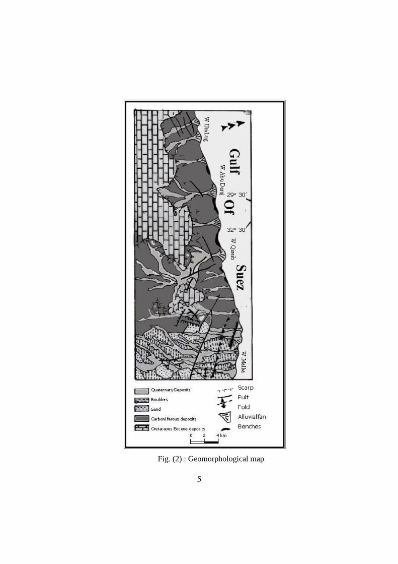
5 Fig. (2) : Geomorphological map
6
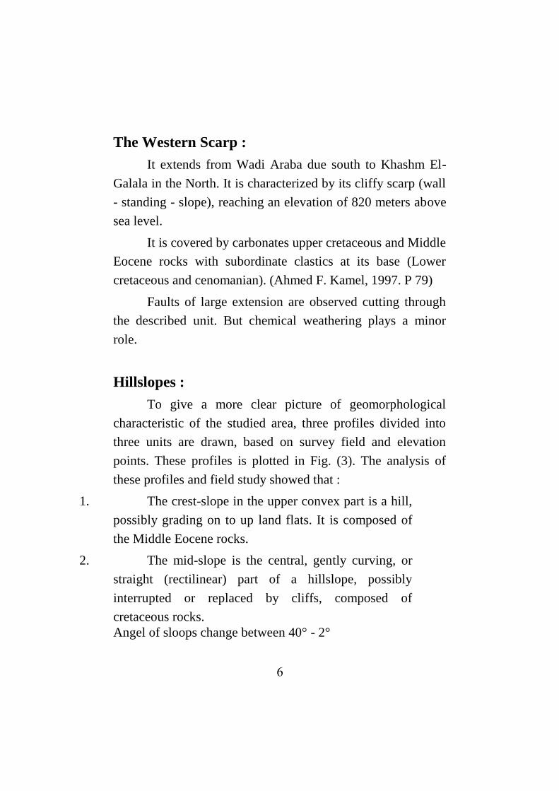
The Western Scarp :
It extends from Wadi Araba due south to Khashm El-
Galala in the North. It is characterized by its cliffy scarp (wall
- standing - slope), reaching an elevation of 820 meters above
sea level.
It is covered by carbonates upper cretaceous and Middle
Eocene rocks with subordinate clastics at its base (Lower
cretaceous and cenomanian). (Ahmed F. Kamel, 1997. P 79)
Faults of large extension are observed cutting through
the described unit. But chemical weathering plays a minor
role.
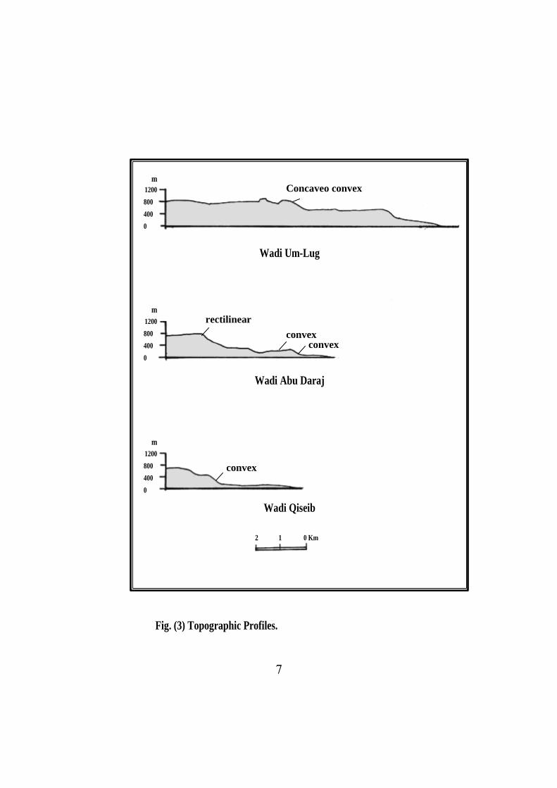
Hillslopes :
To give a more clear picture of geomorphological
characteristic of the studied area, three profiles divided into
three units are drawn, based on survey field and elevation
points. These profiles is plotted in Fig. (3). The analysis of
these profiles and field study showed that :
1. The crest-slope in the upper convex part is a hill,
possibly grading on to up land flats. It is composed of
the Middle Eocene rocks.
2. The mid-slope is the central, gently curving, or
straight (rectilinear) part of a hillslope, possibly
interrupted or replaced by cliffs, composed of
cretaceous rocks.
Angel of sloops change between 40° - 2°
7
1200
800
400
0
1200
800
400
0
1200
800
400
0
Wadi Um-Lug
Wadi Abu Daraj
Wadi Qiseib
Fig. (3) Topographic Profiles.
2 1 0 Km
m
m
m
Concaveo convex
rectilinear convex
convex
convex
8
3. The Foot-slope is the lower, concave part of a hillslope. It
is composed of upper-Paleozoic rocks. Angle sloops are
>2°
The change of slope inclination may be abrupt and
angular, or it may be smooth. Cliffs and slopes have a
Longitudinal geometric form. It attains a width ranging
between 3-4.5 kms. In some parts of the area, this unit faces
directly the Gulf water.
Drainage Basins :
The Aerial photos show that thirty drainage were
involved in the area study. Their geographic location, shape
and size of drainage area are located Fig. (1).
The quantitative drainage analysis shows that large
extended drainage are exemplified in the area studied by Wadi
Um Lug, Wadi Abu Daraj and Qiseib and other unnamed
wadis.
The small extended ones e.g. Wadi Um Reiga, Wadi
Um Galwat, Wadi Malha and others. Some of large drainage
reaches 25 Kms, While the small extended ones average 1.3
Kms. Tribataries are mainly lithologically controlled, While
some of main wadi covers are controlled by mega-faults,
having east-west direction. Mean bifurcation ratios differ
considerably from one basin to another, ranging from 2 to 4.2.
It related to lithology, Fracturing and jointing.
1- Angles of Juction :
9
From Aerial photos, measured the angle of confluence
and argimth of orientation as defined by lines joining the mode
and head of stream segments. In fact this is the way junction
angles are measured in the field. Gut of this measuring, it
appeared that average of junction angles between the first and
second order varies 60° - 65°degree, meantime the average of
angles of junction between the main stream and the other order
streams varies 40-45° and varies 85°-90° in the area of
rectangular pattern.
It indicates that junction angles are related to gradient
and the relif of the basin Wadi Qiseib, Wadi Um Lug and
Wadi Um Julauat and to discharge of tributaries involved in
Pleistocene period.
2- Drainage Pattern :
The aerial photos show that low drainage orders (1st and
2nd
) cutting the Eocene-cretaceous sediments of western scarp.
They are dendritic, subdendritic, rectangular and
subrectangular types. Fig. (1).
The low orders controlled by the lithologic as well as
structural characteristics. While high order and the main
drainage courses attain a parallel to sub-parallel pattern,
indicating a structural control coinciding with the more or less
east-west fault lines.
The drainage pattern in Wadi Um Hamata and Wadi
Qiseil is nearly sub-dendritic to rectangular pattern. Wadi Um

11
Sweillim characterized by sub-dendritic to sub-parallel pattern,
and also Wadi Um Lug.
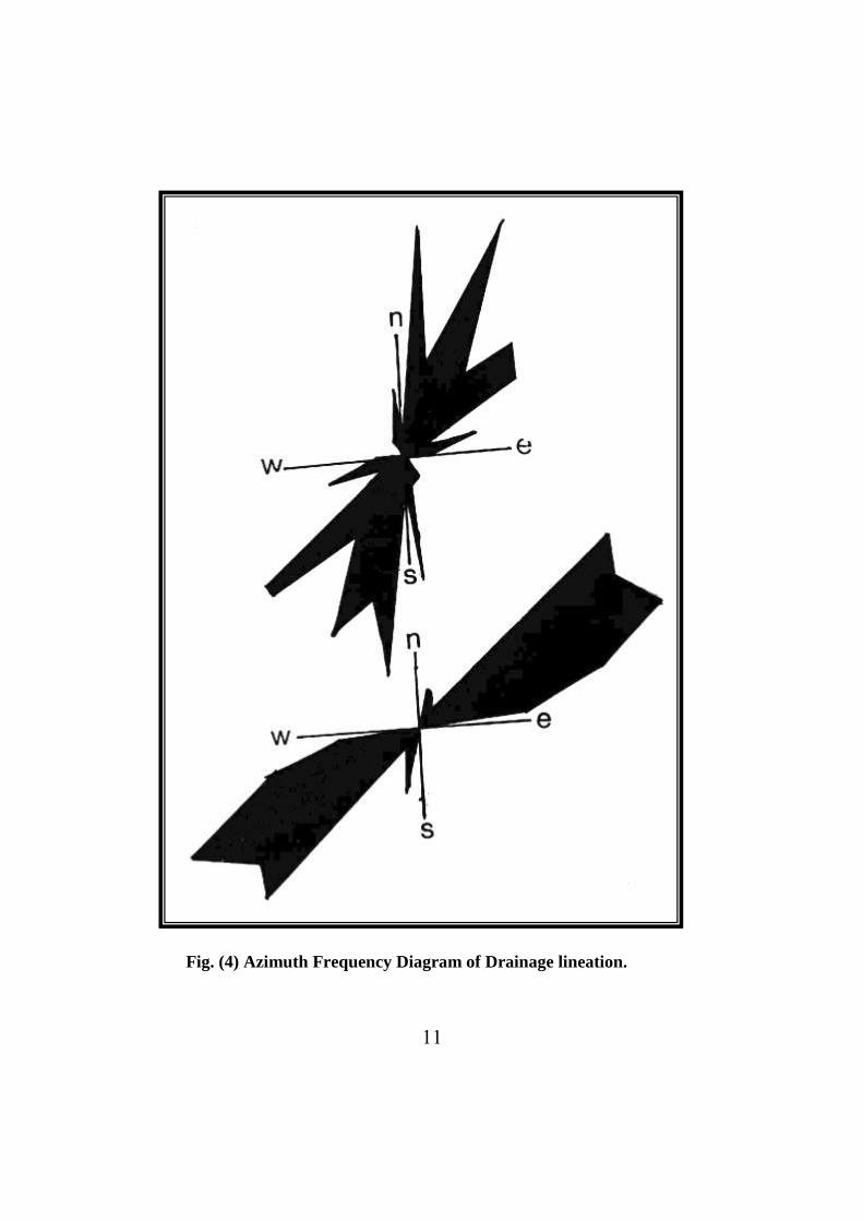
3- Drainage Lineations :
The drainage lineations are plotted on azimuth-
frequency diagrams Fig. (4). These show a prominent two sets
NE-SW, which is the major one and E-West. The NE-SW set
is strucurally controlled by minor faults cutting through
different rock units. (El Shazly, E.M., and others, 1980, 1991).
The E-W faults dissect paleogenic rocks to the Gulf water.
In Abu Sandug Area, diagram for the east channel order
show that it is composed mainly of sets :
- First one trending NE-SW with different angles due to
the different trends of features in the area.
- Second one trends N-S and the east one trends E-W.
The structural control can be strongly accepted in this
area, the E-W and N-S are observed as separate sets the first
time in this locality.
In Abu Daraj area diagram Fig. (4) for the east order in
the area show the coincidence between the trends of drainage
lineation and structural feature. Both of them trending mainly
NE-SW as well as N-S. This shows that they are most
probably structurally controlled.
11
Fig. (4) Azimuth Frequency Diagram of Drainage lineation.
12
Wadi Um Lug :
Wadi Um Lug occurs in the North part of area study, to
the North of Wadi Abu Daraj Basin of Wadi Um Lug covers
an area of about 37.12 Km2. It’s main channel extends for
about 75 km. It is nearly of an elliptical shape. It is dendritic
drainage pattern. The drainage density is 1.68 K/Km2.
Wadi Abu Daraj :
It occurs between Wadi Um Lug in the North and Wadi
Qiseib Abu Daraj covers an area of about 62.72 Km2. It is
nearly to Fan in shape. The drainage density is 2.63 K/Km2. It
is dendritic to rectangular drainage pattern.
Wadi Qiseib :
It occurs to south of Wadi Abu Daraj. This basin covers
an area of about 51.2 Km2. Its main channel extends for about
25 Km. It is leaf-like to fan in shape. The drainage density is
7.67 K/Km2. It is dendritic to rectangular drainage pattern.
13
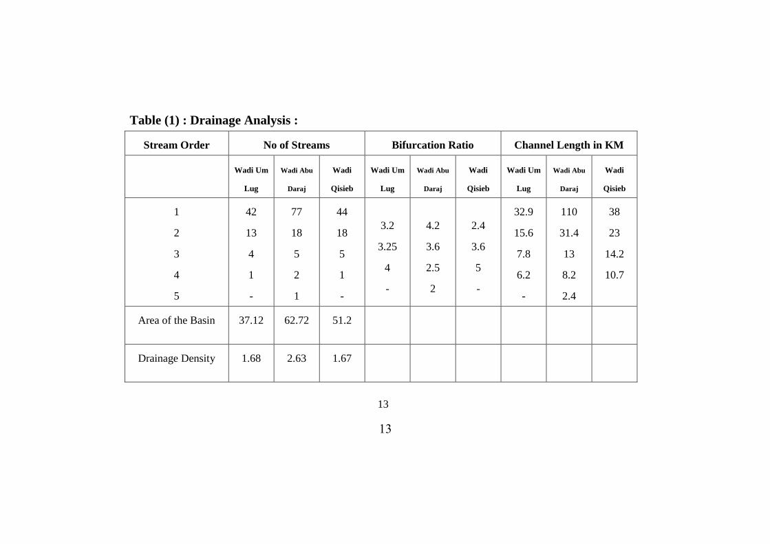
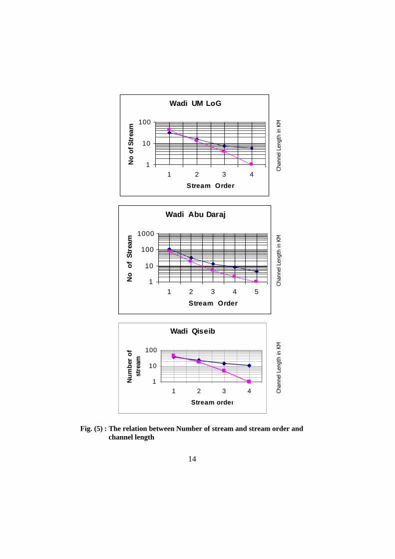
Table (1) : Drainage Analysis :
Stream Order No of Streams Bifurcation Ratio Channel Length in KM
Wadi Um
Lug
Wadi Abu
Daraj
Wadi
Qisieb
Wadi Um
Lug
Wadi Abu
Daraj
Wadi
Qisieb
Wadi Um
Lug
Wadi Abu
Daraj
Wadi
Qisieb
1
2
3
4
5
42
13
4
1
-
77
18
5
2
1
44
18
5
1
-
3.2
3.25
4
-
4.2
3.6
2.5
2
2.4
3.6
5
-
32.9
15.6
7.8
6.2
-
110
31.4
13
8.2
2.4
38
23
14.2
10.7
Area of the Basin 37.12 62.72 51.2
Drainage Density 1.68 2.63 1.67
13
14
Wadi UM LoG
1
10
100
1 2 3 4
Stream Order
No
of
Str
ea
m
Wadi Abu Daraj
1
10
100
1000
1 2 3 4 5
Stream Order
No
o
f S
tream
Wadi Qiseib
1
10
100
1 2 3 4
Stream order
Nu
mb
er
of
str
eam
Channel Length
in K
M
Channel Length
in K
M
Channel Length
in K
M
14
Fig. (5) : The relation between Number of stream and stream order and
channel length
15
The Coastal Strip :
The Coastal strip is bounded eastwards by the waters of
the Gulf and westwards by the moderate relief. It attains a very
small width in some part of the area. Its maximum width is
observed where it fans out towards the Gulf. It reaches a
maximum width of 3.5 kms.
It is characterized by boulders, gravels and sands of the
Gulf of Suez belonging to the Quaternary.
The recorded thickness of such sediment are 140-235 m.
From the East and South, it is bounded by the Gulf of Suez
and major E-W Fault scarps of the North Galala Plateau.
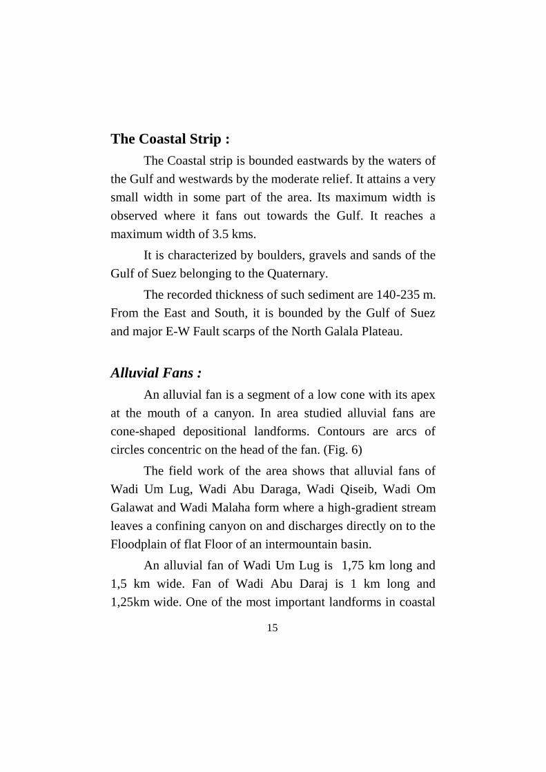
Alluvial Fans :
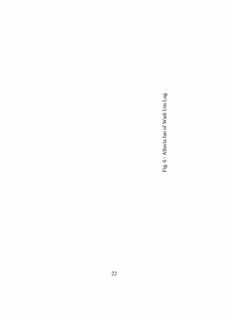
An alluvial fan is a segment of a low cone with its apex
at the mouth of a canyon. In area studied alluvial fans are
cone-shaped depositional landforms. Contours are arcs of
circles concentric on the head of the fan. (Fig. 6)
The field work of the area shows that alluvial fans of
Wadi Um Lug, Wadi Abu Daraga, Wadi Qiseib, Wadi Om
Galawat and Wadi Malaha form where a high-gradient stream
leaves a confining canyon on and discharges directly on to the
Floodplain of flat Floor of an intermountain basin.
An alluvial fan of Wadi Um Lug is 1,75 km long and
1,5 km wide. Fan of Wadi Abu Daraj is 1 km long and
1,25km wide. One of the most important landforms in coastal
15
16
strip is the alluvial fan of Wadi Qiesb it is 2,25 km long and
2,25 km wide.
Benches
A Bench is a coastal feature formed because of the
unequal solubility of various sediments. Benches can be
developed on layers of durable sandstone that alternate with
beds of readily eroded shale. The downslope flow of spray has
sufficient force to remove rock fragments from the most bench
surfaces. The most of Benches are due to intensive south Wadi
Qiseib and Wadi Abu Daraj bench extend.
The Geomorphic Process
The geomorphic process prevailing is degradation
mainly due to the major and minor drainage lines dissecting
the area. Resulting from location and the above description, a
major fault line activated in Plio-Pliestocene to Recent
interval. Occasionaly, landsliding plays, an important part.
Large rock masses belonging to area between Bir Abu Sandug
and Ra’s Abu Daraj, slide down and sometimes block the
Suez-Ras Gharib road, especially in winter times in which
precipitation of a few days of heavy rainfall is reported.
There are water-layer weathering more relevant to shore
platform erosion, solution of calcareous rock and rock
weathering.
17
Geomorphological Hazards
Studying the geomorphological map Fig. (2), air photo
of the area study and field study showed that the main
geomorphological hazards are related to precipitation,
sediment movement, alluvial fan flooding and sedimentary
rocks and earthquake hazards.
(1) Precipitation :
Clinically the area is dominated by the interaction of
marine and continental influences, giving rise to steep climatic
gradients inland.
The study area receives small amount so rainfall mainly
in autumn, winter and spring.
In the Kattamia station, the rainy period starts in
December and ends in April with a maximum recorded
average value of 3.9 mm in December. The months May
through November are dry. The average annual precipitation is
16.5 mm.
In the Suez station, the rainy period starts in November
and ends in May with a maximum recorded value of 5 mm.
The average annual precipitation is 21.3 mm.
The rainfall was caused by cold northerly air that
penetrated southwards along an upper air through associated
with a Mediterranean depression moving eastwards across the
Sinai Peninsula. The increase in rainfall occurs when the
northerly and northwesterly winds strike the major E-W scarp
of the North Galala. Maistureladen sir is forced to rise to
18
higher levels, expansion, cooling and precipitation follows. El-
Shaly (1987) estimated the average annual precipitation on the
Northern Glala plateau to be 203- mm. The amount of water
that precipitated over the catachement area of mentioned
drainage basins are 19 mm.
During the time of the study (1994-1997), the area has
been subjected to one short heavy rainstorm each year. The
duration of each storm ranges between 1-2 hours.
The field work of the area shows more changes for the
accumulation of surface runoff draining the highlands to reach
the plains.
The catchement areas of the major drainage basins, such
as Wadi Um Lug, and Wadi Abu-Darag and made up of
limestone belonging to the Middle Eocone. The drainage
basins are characterized by steep slopes, deep gorges that cut
into the highlands, and lack of soil and vegetation. This
configuration helps in controlling the run off and discharge of
the floods onto the plain.
(2) Sediment Movement :
Sediment movement on hillslopes is mainly caused by
rain drop and overland flow process. The flows generally
occur on hillside slopes of greater than 30°. The movement
usually originates in a single or multiple head, follows a long
narrowing track and spreads out on the lower slopes of the
valley. The sediment received from tributary channels with
pulsed changes to width and depth in downstream.
19
The deposits are normally composed of 45-70% sand or
coarse clasts. According to change of slope angle down valley
from the > 30° hillslopes to 15-20° in the supply channels and
6-8° in the run out areas, the material supplied by the stream,
hillside debris flows, and other mass movements accumulate in
the main valley track.
(3) Alluvial-Fan Flooding :
Detailed studies of area floods are scarce because they
rarely affect man, settlements and research stations are few.
Flooding has scared man and despite prodigious efforts to
reduce flood damage and loss of life in some areas, the
problem remains serious. Flooding on alluvial fans can occur
in two principal locations along the margins of the main
supply channels, and in the depositional zones beyond the ends
of the supply channels.
Floods began in mountain tributaries and were fed into
the main valley along alluvial Fan channels. The flows
accumulated huge quantities of sediment and deposited much
of it within the basin.
(4) Sedimentary Rocks and Earthquake Hazards :
The sedimentary rocks in Suez Gulf region are
susceptible to earthquake hazards. The intensity of earthquakes
is generally larger over soft rocks.
Mass movement hazards can be considered as an
integral part of urbanization, land use and regional planning.
Damage caused by disaster events depends largely on the rock
mechanics.
21
The high elevated steep slopes and close fracturing
originate debris falls. The massive calcareous rocks are often
affected by closely spaced joint sets and subjected to rock falls
and block slides. The alternation of sandy and clayey layers is
particularly unstable and the high pore pressure on the sandy
layers. Quaternary sediment rocks are affected by various
types of dangerous mass movements. (Ahmed F. Kamel, 1997
p. 83).

21
References :
1. Abdel-Gawad, A., (1969) Geological Structures of the Red Sea
Area inferred from Statelite Pictures, edited by Degens, Eand Ross,
S. New York.
2. Ahmed F. Kamel., (1997) Sedimentary rocks and natural
hazards incidences in Egypt, Sedimentology of Egypt, vol. 5, p 77-
88.
3. Baker, B.H. (1969) the Structural Pattern of Afro-Arabian Rift
System in relation to plate tectonics, R.S of London, vol 267.
4. El Shazly, E.M., Abd El Hady, M.A., El Ghawaby, M.A.,
Salman, A. B., El Kassas, I.A., Khaucasik, S.M., El Amin, H., El
Rakaiby, M.M., 1980, The geological map of Egypt, the structural
lineaments of Egypt and the drainage map of Egypt, 1-Imagery
interpretation and field investigations: Remote Sensing Center,
Acad. Sci. Res. And Technology, Cairo, Gen. Organ. Housing,
Building and Planning Res. Report, 1991.
5. Ferrar, H.J. (1919) Note on a Mangrove Swamp at the Mouth of
Gulf of Suez, Cairo. Sc, J. vol v111, no, 88.
6. Fisher, W.B (1978) the Middle East, 7th
ed, London.
7. Hilmy, M.E., (1951) Beach SeaSand of Medit. Coast of Egypt,
Jour. Sea, vol 21.
8. Hume, W.F., (1937) Geology of Egypt, Suv. Dept, Cairo.
9. Hume, W.F., nd Little, O. (1928) Raised beaches and terraces
of Egypt, Cairo.
10. Sadek, H., (1926) The Geography and Geology of district
between Gebel Ataqa and El Galala El Baharia, Cairo, Sur Dept.
11. Said, R, (1962) the Geology of Egypt, New Amesterdam,
Elsever.
22
Fig
. 6
: A
lluvia
fan
of
Wad
i U
m L
ug
23
Arabic References خليج السىيس دراست إقليميةت رسةةةلت ( 1968)سعد قسطندي ملطً -1
.دكتىراه غري منشىرة كليت اآلداب جةمعت القةىرةبعض خصةئص التصريف املةةئً ررفععةةث مصةر ( 1981)طو حممد جةد -2
. القةىرة11الشرقيت جملت معهد البحىث والدراسةث العربيت العدد .اىة األقمةر الصنةعيت القةىرةمصر كمة فر( 1978)فةروق البةز -3( اجلىانب الطبيعيت)جغرافيت الصحةري املصريت ( 1991)حممد صربي حمسىب -4
.اجلسء الثةىن الصحراء الشرقيت دار النهضت العربيت القةىرة (حبىث ىف اجليىمىرفىلىجيةة )سىاحل مصر ( 1994)حممد صربي حمسىب -5
.دار الثقةفت للنشر والتىزيع القةىرة .مىرفىلىجيت األراضً املصريت القةىرة( 1966)مد صعً الدين حم -6بعض الظةىراث اجليىمىرفىلىجيت علً السةهل ( 1991)نبيل يىسف عبده -7
رسةلت دكتىراه غري منشةىرة ( جنىىب خليج السىيس)السةحلً للبحر األمحر .آداب عني مشس
فرمجت دميتةري كةىري وآخةرين -جيىلىجيت مصر ( 1921)ىيىم ف -8 .لقةىرةا
24
Analysis of the
Geomorphological map along
Western Coast of The Suez Gulf
between Wadi Um Lug
and Wadi Malha
Dr. Aly Moustafa Kamel
Geography Department,
Faculty of Arts; Benha, Zagazig University
1999