paleo-geomorphological map of …damanhour.edu.eg/pdf/artsfac/paleo-geomorphological...
TRANSCRIPT
PALEO-GEOMORPHOLOGICAL MAP OF ALEXANDRIA SITE, EGYPT BY USING
SUBMERGED ARCHAEOLOGICAL AND OTHER EVIDENCES
Magdy Torab
Professor of Geomorphology, Damanhour University, Egypt.
President of The Egyptian Society of Environmental Change.
Abstract
Several submarine archaeological survey has used to recognize characteristics of Alexandria city
remains in the eastern harbor and Abu Qir bay area, by using some technics such as side scane sonar
survey (Schwartz, 1980), eco-sound survey, geoarchaeological settlements dating (Goddio, 1998),
remote viewing, remote sensing and sea bottom soil boring during last 50 years.This paper aims to
define paleo-geomorphological map and stability of coast line area of Alexandria ancient city and
relationship between land and sea as a result of tectonic movements, climatic changes and human
activites during last 2000 years ago, depending upon submerged archaeological evidences during Greco-
Roman and Ptolemaic periods (http://www.cealex.org). These criteria include: local subsidence or
uplifting, relative sea-level rise (RSLR), land topography, width of lagoon barriers, beach-face slope, high-
elevated features such as coastal dunes and ridges, eroding and accreting coastlines and ancient
protection works.
Kewords: Paleo-Geomorphology, Alexandria, submerged archeology, Egypt, Mediterranean Sea
1. Introduction Alexander the Great has constructed Alexandria on the shores of the Mediterranean Sea in 332
B.C. The city was famous in all the world for its huge Royal Library, it is generally have been founded
during the reign of Ptolemy II at the beginning of the 3rd century BC, as well as Pharos island lighthouse
(one of the Seven Wonders of the Ancient World), it was constructed early in the Ptolemaic period.
Most of the royal and civic quarters of Alexandria city sank beneath harbor due to earthquake
subsidence, a part of the ancient city of Alexandria lies 6 to 8 meters under seawater as a result of
climatic sea level rises in modern times (LA Riche, 1979).
1.1. Objective This paper aims to reconstruction of paleo-geomorphological map of Alexandria city area before
building it by Alexander the great on 331 BC by using submerged archaeological and other evidences.
1.2. Previous work The submerged archaeological sites of ancient Alexandria city have been studied by: Empereur,
1998; Mckenzie, 2003; Ashton, 2004; and Marriner et al., 2008 & Goiran, 2001.
The Alexandria region has been the focus of numerous investigations including: Geography (Goddio et
al., 1998); Oceanography of Mediterranean Sea near Alexandria coastline (Inman and Jenkins, 1984);
Geology and paleogeography (Warne and Stanley, 1993; Goiran, 2001); Stratigraphical analysis (Goiran
et al., 2000); Underwater Archaeological Survey by the Hellenic Institute for the Preservation of Nautical
Tradition and the Hellenic Institute for Ancient and Mediaeval Alexandrian Studies, 2000;
Sedimentological analysis (Goiran., 2001; Stanley et al., 1996 & 2006). 1.3. Methods
Several submarine archaeological surveys have used to recognize characteristics of Alexandria city
remains in the eastern harbor to reconstruction paleo geomorphological map of the study area by using
some techniques such as: Interpretation of remote sensing images and historical topographic maps;
field surveying; results of side scan sonar survey (Schwartz, 1980; eco-sound survey (Empereur, 1998);
Geoarchaeological settlements dating (Goddio, 1998(; Sedimentary boring (Goiran, 2001; Stanley et al.,
1996 & 2006).
2. Results and discussion: 2.1. Alexandria before Alexander:
The analytic of Alexandria harbor cores sediments have revealed that Alexander the Great did not
found the Egyptian city of Alexandria – he just rebranded it. New geochemical data, published by (Véron
et al. 2006 and Stanley & Bernasconi, 2006) depending upon geochemical data and C14 dating of
seashell fragments found in some cores show that peaks of lead contamination in Alexandria during the
Egyptian Old Kingdom between 2686 and 2181 B.C., and again during the Iron Age, from 1000 to 800
B.C. at the end of the prosperous Ramses dynasties, it means that ancient Alexandria was settled 4,500
years ago, more than two millennia before Alexander's arrival. Rhakotis was the original name of the city
of Alexandria.
2.2. Geographical elements of Alexandria's location: Alexander Great has chosen this location to construction his city because of the following factors:
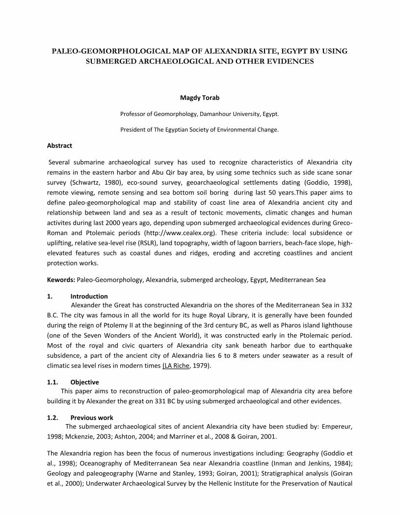
2.2.1. He chooses this bay to keep Alexandia harbors from winter storms and marine erosion (Fig.1).
2.2.2. Alexandria location lies between Mediterranean Sea and Mariut lake (Fig.1).
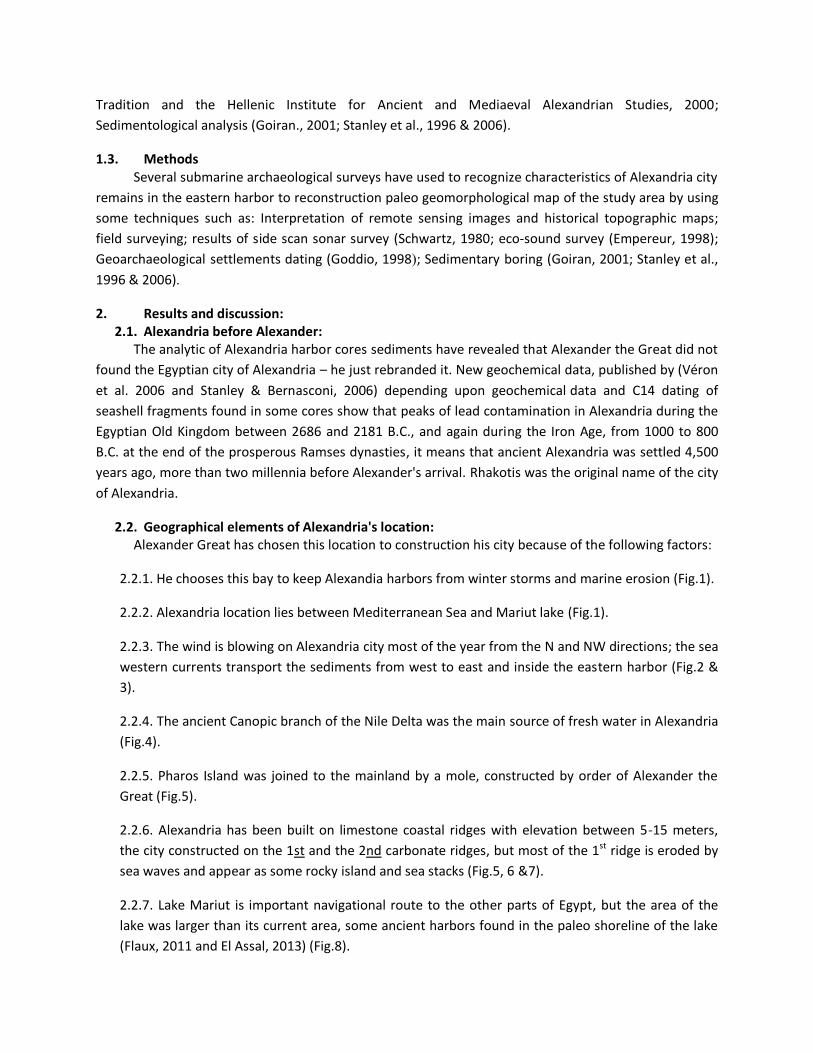
2.2.3. The wind is blowing on Alexandria city most of the year from the N and NW directions; the sea
western currents transport the sediments from west to east and inside the eastern harbor (Fig.2 &
3).
2.2.4. The ancient Canopic branch of the Nile Delta was the main source of fresh water in Alexandria
(Fig.4).
2.2.5. Pharos Island was joined to the mainland by a mole, constructed by order of Alexander the
Great (Fig.5).
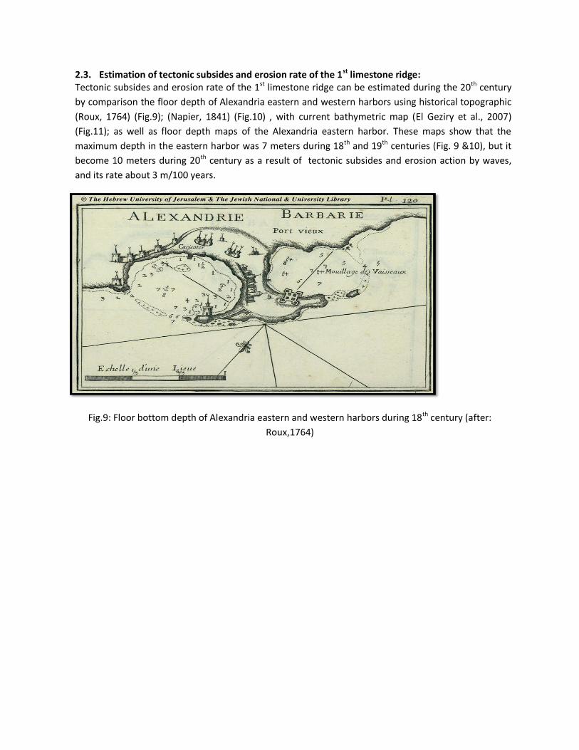
2.2.6. Alexandria has been built on limestone coastal ridges with elevation between 5-15 meters,
the city constructed on the 1st and the 2nd carbonate ridges, but most of the 1st ridge is eroded by
sea waves and appear as some rocky island and sea stacks (Fig.5, 6 &7).
2.2.7. Lake Mariut is important navigational route to the other parts of Egypt, but the area of the
lake was larger than its current area, some ancient harbors found in the paleo shoreline of the lake
(Flaux, 2011 and El Assal, 2013) (Fig.8).
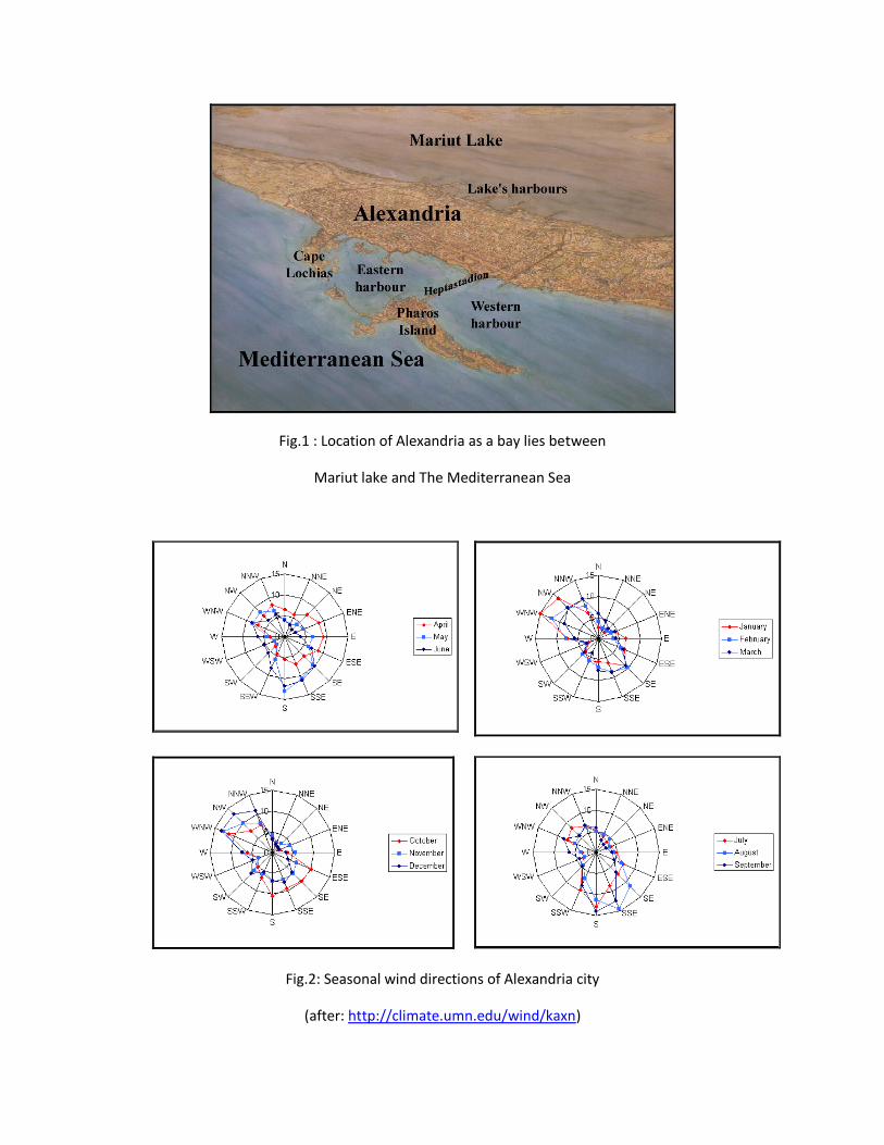
Fig.1 : Location of Alexandria as a bay lies between
Mariut lake and The Mediterranean Sea
Fig.2: Seasonal wind directions of Alexandria city
(after: http://climate.umn.edu/wind/kaxn)
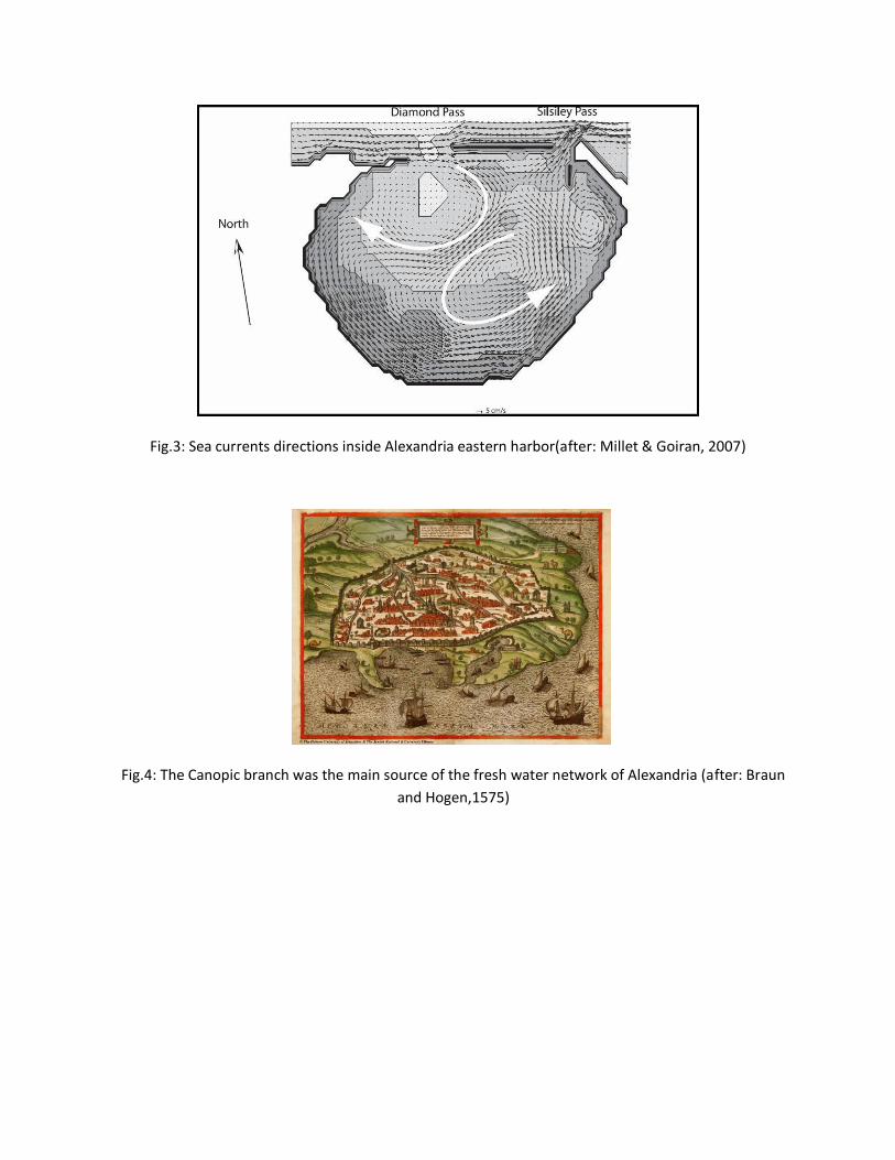
Fig.3: Sea currents directions inside Alexandria eastern harbor(after: Millet & Goiran, 2007)
Fig.4: The Canopic branch was the main source of the fresh water network of Alexandria (after: Braun
and Hogen,1575)
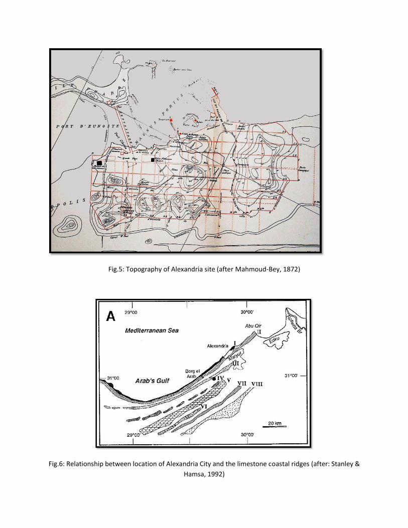
Fig.5: Topography of Alexandria site (after Mahmoud-Bey, 1872)
Fig.6: Relationship between location of Alexandria City and the limestone coastal ridges (after: Stanley &
Hamsa, 1992)
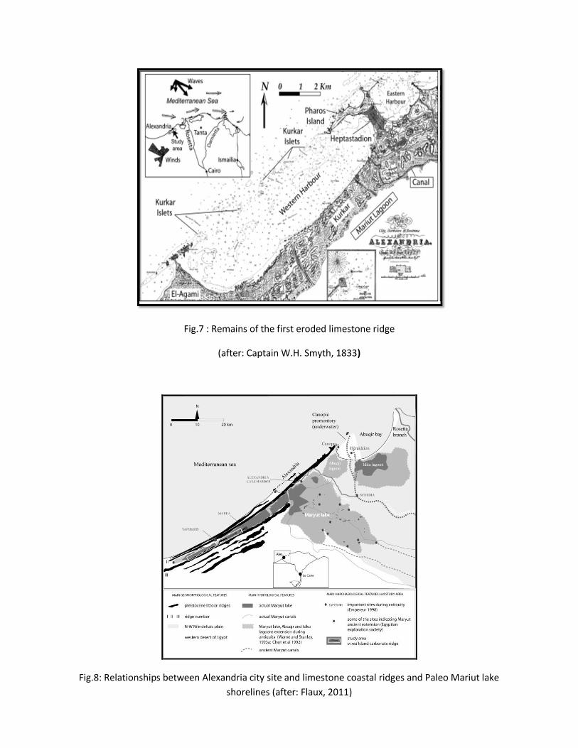
Fig.7 : Remains of the first eroded limestone ridge
(after: Captain W.H. Smyth, 1833)
Fig.8: Relationships between Alexandria city site and limestone coastal ridges and Paleo Mariut lake
shorelines (after: Flaux, 2011)
2.3. Estimation of tectonic subsides and erosion rate of the 1st limestone ridge: Tectonic subsides and erosion rate of the 1st limestone ridge can be estimated during the 20th century
by comparison the floor depth of Alexandria eastern and western harbors using historical topographic
(Roux, 1764) (Fig.9); (Napier, 1841) (Fig.10) , with current bathymetric map (El Geziry et al., 2007)
(Fig.11); as well as floor depth maps of the Alexandria eastern harbor. These maps show that the
maximum depth in the eastern harbor was 7 meters during 18th and 19th centuries (Fig. 9 &10), but it
become 10 meters during 20th century as a result of tectonic subsides and erosion action by waves,
and its rate about 3 m/100 years.
Fig.9: Floor bottom depth of Alexandria eastern and western harbors during 18th century (after:
Roux,1764)
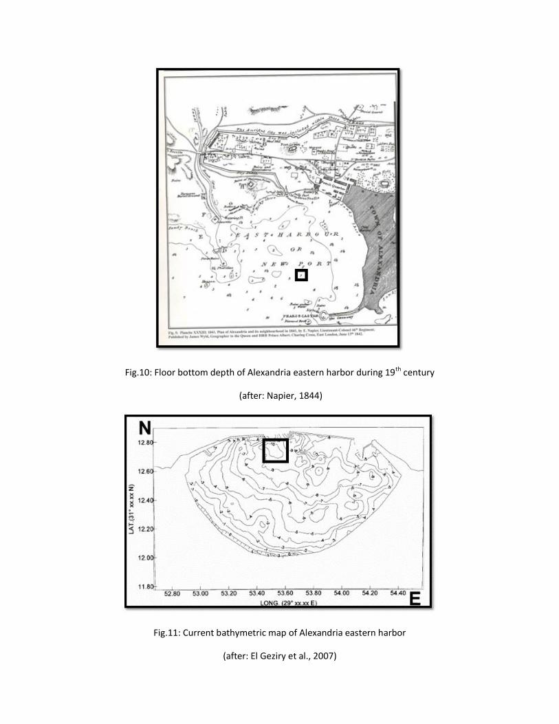
Fig.10: Floor bottom depth of Alexandria eastern harbor during 19th century
(after: Napier, 1844)
Fig.11: Current bathymetric map of Alexandria eastern harbor
(after: El Geziry et al., 2007)
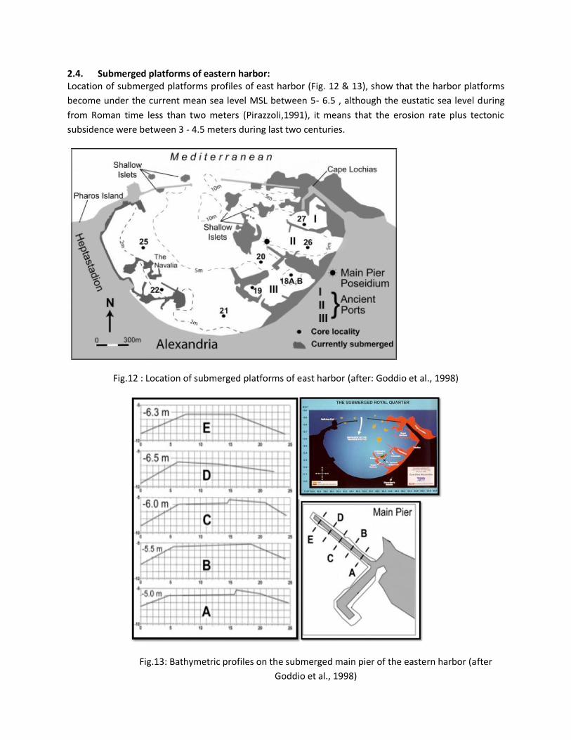
2.4. Submerged platforms of eastern harbor: Location of submerged platforms profiles of east harbor (Fig. 12 & 13), show that the harbor platforms
become under the current mean sea level MSL between 5- 6.5 , although the eustatic sea level during
from Roman time less than two meters (Pirazzoli,1991), it means that the erosion rate plus tectonic
subsidence were between 3 - 4.5 meters during last two centuries.
Fig.12 : Location of submerged platforms of east harbor (after: Goddio et al., 1998)
Fig.13: Bathymetric profiles on the submerged main pier of the eastern harbor (after
Goddio et al., 1998)
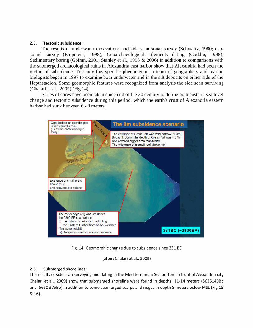
2.5. Tectonic subsidence:
The results of underwater excavations and side scan sonar survey (Schwartz, 1980; eco-
sound survey (Empereur, 1998); Geoarchaeological settlements dating (Goddio, 1998(;
Sedimentary boring (Goiran, 2001; Stanley et al., 1996 & 2006) in addition to comparisons with
the submerged archaeological ruins in Alexandria east harbor show that Alexandria had been the
victim of subsidence. To study this specific phenomenon, a team of geographers and marine
biologists began in 1997 to examine both underwater and in the silt deposits on either side of the
Heptastadion. Some geomorphic features were recognized from analysis the side scan surviving
(Chalari et al., 2009) (Fig.14).
Series of cores have been taken since end of the 20 century to define both eustatic sea level
change and tectonic subsidence during this period, which the earth's crust of Alexandria eastern
harbor had sunk between 6 - 8 meters.
Fig. 14: Geomorphic change due to subsidence since 331 BC
(after: Chalari et al., 2009)
2.6. Submerged shorelines: The results of side scan surveying and dating in the Mediterranean Sea bottom in front of Alexandria city
Chalari et al., 2009) show that submerged shoreline were found in depths 11-14 meters (5625±40Bp
and 5650 ±75Bp) in addition to some submerged scarps and ridges in depth 8 meters below MSL (Fig.15
& 16).
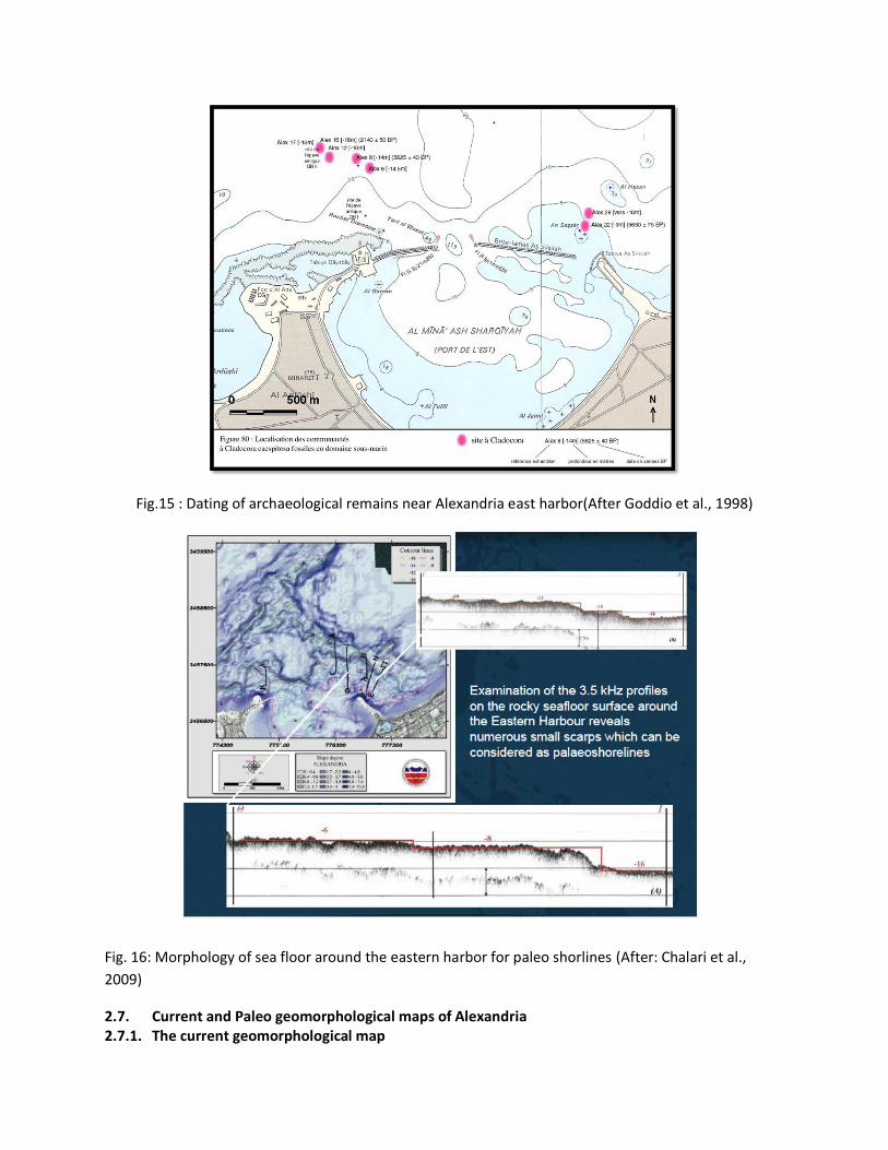
Fig.15 : Dating of archaeological remains near Alexandria east harbor(After Goddio et al., 1998)
Fig. 16: Morphology of sea floor around the eastern harbor for paleo shorlines (After: Chalari et al.,
2009)
2.7. Current and Paleo geomorphological maps of Alexandria 2.7.1. The current geomorphological map
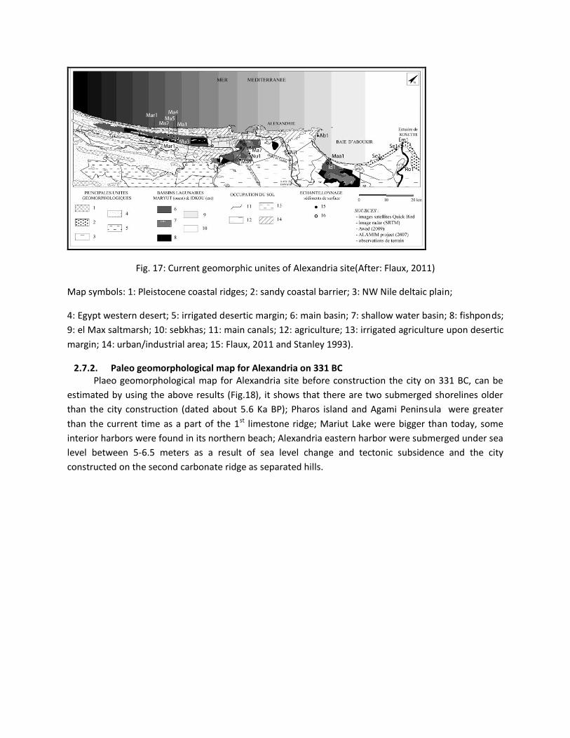
Fig. 17: Current geomorphic unites of Alexandria site(After: Flaux, 2011)
Map symbols: 1: Pleistocene coastal ridges; 2: sandy coastal barrier; 3: NW Nile deltaic plain;
4: Egypt western desert; 5: irrigated desertic margin; 6: main basin; 7: shallow water basin; 8: fishponds;
9: el Max saltmarsh; 10: sebkhas; 11: main canals; 12: agriculture; 13: irrigated agriculture upon desertic
margin; 14: urban/industrial area; 15: Flaux, 2011 and Stanley 1993).
2.7.2. Paleo geomorphological map for Alexandria on 331 BC Plaeo geomorphological map for Alexandria site before construction the city on 331 BC, can be
estimated by using the above results (Fig.18), it shows that there are two submerged shorelines older
than the city construction (dated about 5.6 Ka BP); Pharos island and Agami Peninsula were greater
than the current time as a part of the 1st limestone ridge; Mariut Lake were bigger than today, some
interior harbors were found in its northern beach; Alexandria eastern harbor were submerged under sea
level between 5-6.5 meters as a result of sea level change and tectonic subsidence and the city
constructed on the second carbonate ridge as separated hills.
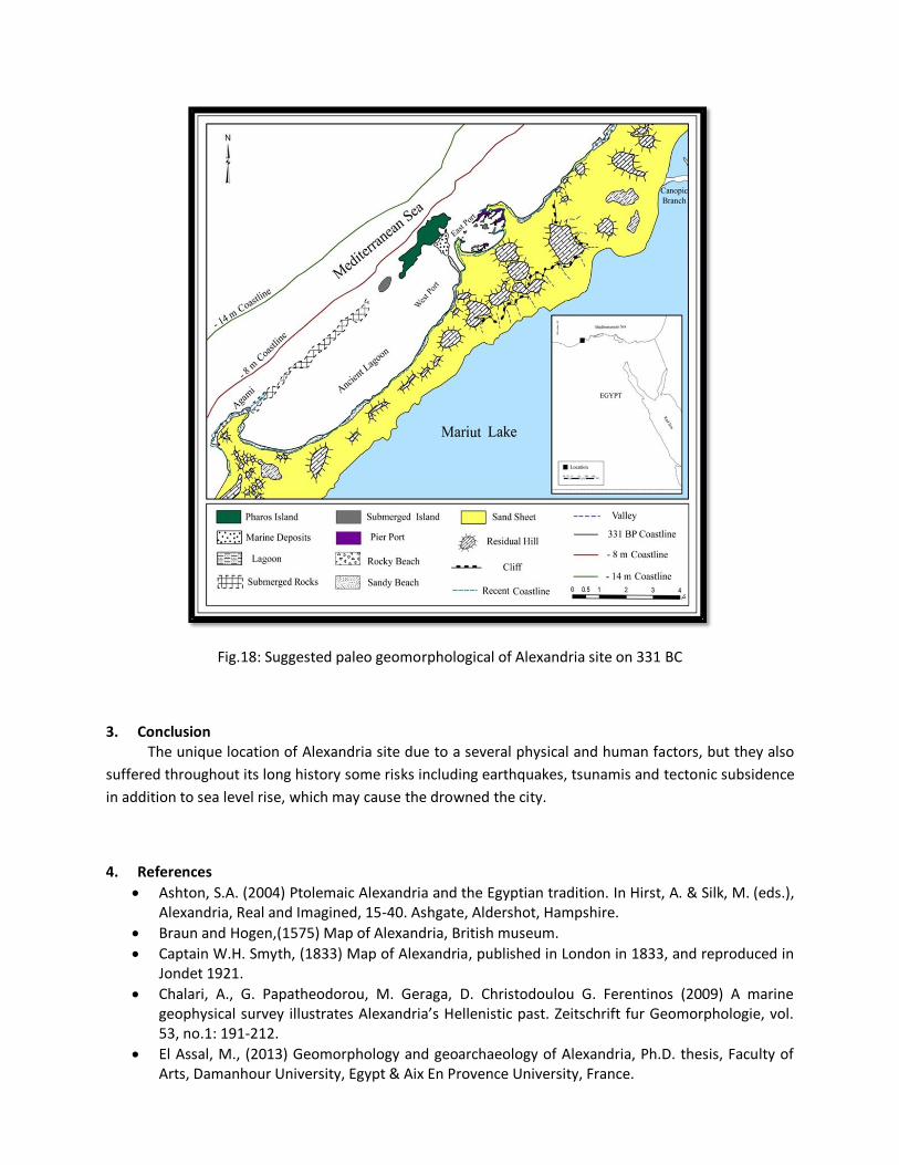
Fig.18: Suggested paleo geomorphological of Alexandria site on 331 BC
3. Conclusion The unique location of Alexandria site due to a several physical and human factors, but they also
suffered throughout its long history some risks including earthquakes, tsunamis and tectonic subsidence
in addition to sea level rise, which may cause the drowned the city.
4. References
Ashton, S.A. (2004) Ptolemaic Alexandria and the Egyptian tradition. In Hirst, A. & Silk, M. (eds.), Alexandria, Real and Imagined, 15-40. Ashgate, Aldershot, Hampshire.
Braun and Hogen,(1575) Map of Alexandria, British museum.
Captain W.H. Smyth, (1833) Map of Alexandria, published in London in 1833, and reproduced in Jondet 1921.
Chalari, A., G. Papatheodorou, M. Geraga, D. Christodoulou G. Ferentinos (2009) A marine geophysical survey illustrates Alexandria’s Hellenistic past. Zeitschrift fur Geomorphologie, vol. 53, no.1: 191-212.
El Assal, M., (2013) Geomorphology and geoarchaeology of Alexandria, Ph.D. thesis, Faculty of Arts, Damanhour University, Egypt & Aix En Provence University, France.
El Geziry, T., Gad Ella R.,G., and Maiyza, I.A., (2007) Bathymetric chart of Alexandria eastern harbor, Egyptian journal of Aquatic research, V. 33 N. 1: 15-21
El Fishawi, N.M., Fanos, A.M., (1989) Prediction of sea level rise by 2100, Nile delta coast’. INQUA, Commission on Quaternary Shorelines, Newsletter, 11:43–47.
Emprereur, J. Y. ,(1998) Alexandrie redécouverte, Paris.
Inman, D. L.& S. A. Jenkins, (1984) "The Nile littoral cell and man's impact on the coastal zone of the south-eastern Mediterranean," SIO Reference Series No. 84-31.
Flaux, C. (2012). Paléo-environnements littoraux Holocène du lac Maryut, nord-ouest du delta du Nil, Egypte , These du Docteur , Universite provence (Aix - Marseille) .
Flaux,C. , El-Assal,M. , Marriner, N. , Morhange,C. , Rouchy,J.M., Marsche,I.S., Torab,M. (2012) Environmental changes in the Maryut lagoon (northwestern Nile delta) during the last ~2000 years .
Frihy, O.E., (1992) Sea-level rise and shoreline retreat of the Nile delta promontories, Egypt. Natural Hazards, 5: 65–81.
Frihy, O.Ε.,(2003) ‘The Nile delta-Alexandria coast: vulnerability to Sea-level rise, consequences and adaptation’.Mitigation and Adaptation Strategies for Global Change, 8: 115–138
Frihy, O. E. , Dewidar, K. M. El Raey, M. ,( 1996), Evaluation of coastal problems at Alexandria, Egypt,Ocean and Coastal Management, 30, n° 2-3: 281-295.
Goddio,F. (1998) "Alexandria, les quartiers royaux submerges", Perilus, London, 274p.
Goriran, J.-P. Morhange, C. (1999) Nouvelles données sédimentologiques et biologiques sur le tombolo et dans le port antique d’Alexandrie, Egypte ». Bulletin de Correspondance Hellénique, 123: 560-566.
Goiran, J.-P. Morhange, C. Bourcier, M. Carbonel, P. Morigi, C.(2000), Evolution des rivages d’Alexandrie à l’Holocène récent, marge occidentale du delta du Nil, Egypte, Méditerranée, 1-2, Tome 94: 83-90.
Goiran, J.-P. (2001)Recherche géomorphologique dans la région littorale d’Alexandrie, Egypte : mobilité des paysages à l’Holocène récent et évolution des milieux portuaires antiques, Thèse de l’Université d’AixMarseille I-CEREGE.
Jondet, M.G., (1912) ‘Les Ports antiques de Pharos’. Bulletin de la Socié té Arché ologique d’Alexandrie, 14: 252- 266, Alexandria.
Jondet, M.G., (1916) ‘Les Ports Submergé s de l'ancienne Île de Pharos. Cairo’. Mé moires de l'Institut d'Egypte, IX: 101.
Jondet, M.G.,( 1921) Atlas Historique de la Ville et des Ports d’Alexandrie, Imprimerie de l’Institut Français d’Arché ologie Orientale, Cairo, 54 map plates.
LA Riche,W., (1979) " Alexandria: The Sunken City", George Weidenfeld & Nicholson, Ltd., London, 135p.
Mahmoud-Bey, M. (1872) Mémoire sur l’Antique Alexandrie, ses Faubourgs et Environs Découverts par les Fouilles, Sondages, Nivellements et Autres Recherches. Imprimerie de Bianco Luno, Copenhagen, 132 p.
Marriner, N., Goiran, J.-P., Morhange, C., (2008). Alexander the Great's tombolos at Tyre and Alexandria, eastern Mediterranean. Geomorphology, 100, 3-4: 377-400.
McKenzie, J., (2003) "Glimpses of Alexandria from Archaeological Evidence", Journal of Roman Archaeology 16: 35-61.
Millet, B. & Gorian, J.P. (2007) Impacts of Alexandria’s Heptastadion on coastal hydro-sedimentary dynamics during the Hellenistic period:a numerical modelling approach, The International Journal of Nautical Archaeology, 36.1: 167–176.
Napier, (1844) Plan of Alexandria, British museum, London
Schwartz,A.S. (1980) " A preliminary survey of the eastern harbor, Alexandria, Egypt including a comparison of side scan sonar and remote viewing", Radio strobe laboratory, Massachusetts Institute of Technology, ambridge, Massachusetts, 46p.
Stanley, J-D., Warne, A.G., (1993) ‘Nile Delta: Recent Geological Evolution and Human Impact’. Science, New Series, 260 (5108): 628-634.
Stanley, J.D., McRea,J.E., Jr., and Waldron,J.C.., (1996). Nile Delta Drill Core and Sample Database for 1985-1994: Mediterranean Basin (MEDIBA) Program, Smithsonian Contributions to The Marine Sciences # 37.
Stanley, J.-D., Jorstad, T.F. & Goddio,F. (2006). Human impact on sediment mass movement and submergence of ancient sites in the two harbors of Alexandria, Egypt. Norwegian Journal of Geology, Vol. 86: 337-350.
Stanley, D. J. and Hamsa, H., (1992) Terrigenous-Carbonate Sediment Interface (Late Quaternary) along the Northwestern Margin of the Nile Delta, Journal of Coastal Research 8.2,: 153–71.
Pirazzoli,P.A. (1991) World Atlas of Holocene Sea-Level Changes, Elsevier, New York, 300 p.
Pollard J.and Reid, H.,(2005) The rise and fall of Alexandria,London,329p.
Roux,(1764) Map of Alexandria, The Hebrew University & The Jewish National & University library, P.L. 120
Torab,M. (2008). Paleo-Geomorphological map of Alexandria coastline area, Egypt by using submerged archaeological evidences. Presented in: The 13th Belgium-France-Italy-Romania Geomorphological Meeting “Landscape Evolution & Geoarchaeology”, Porto Heli, Greece, June 18-21.
Torab, M. (1996). A Geomorphological map of the ancient branches of the Nile Delta, The Bulletin of The Society of Cartographers, Volume 30, part 2, London.
Ve´ron, A, Goiran,,J.P., Morhange,C., Marriner, N., and Empereur J.Y.(2006) Pollutant lead reveals the pre-Hellenistic occupation and ancient growth of Alexandria, Egypt, Geophysical research letters, V.33:1-4.
Warne A.G. & Stanley D.J.(1993). Late Quaternary Evolution of the North west Nile Delta and Adjacent coast in Alexandria Region , Egypt . Journal of Coastal Research.
http://www.touregyptforums.com.
http://www.cealex.org/
http://climate.umn.edu/wind/kaxn