aip gen 0.3-1 singapore 6 feb14 · 2017-07-27 · paya lebar
TRANSCRIPT
1. SIGNIFICANT INFORMATION AND CHANGES
1.1 Singapore Changi Airport (WSSS)
a) Update to the docking procedures and safety measures for the Safegate Aircraft Docking Guidance System (SAFEDOCK).
WSSS AD 2-5.2 toWSSS AD 2-5.3
b) Revision of pushback procedure for aircraft stands 103 and 104. WSSS AD 2-7.5
c) Redesignation of Taxiway L4 as Taxilane L4 WSSS AD 2-31 / chart
d) Withdrawal of charts due to SIDs no longer in use:
LELIB DEPARTUTE (LLB 1C) WSSS AD 2-59
PIMOK DEPARTURE (PMK 1C) WSSS AD 2-61
BOBAG DEPARTURES (BOG 1V RWY 20R and BOG 1X RWY 20C) WSSS AD 2-80-1/2-80-2
ADPAX DEPARTURES (ADPAX IU RWY 02L and ADPAX 1W RWY 02C) WSSS AD 2-80-3/2-80-4
ADPAX DEPARTURES (ADPAX 1V RWY 20R and ADPAX 1X RWY 20C) WSSS AD 2-80-5/2-80-6
1.2 Seletar Airport (WSSL)
a) Update to the description for RWY 03/21 approach light. WSSL AD 2-5 andWSSL AD 2-9
b) Update to Seletar Aerodrome Obstacle Chart - ICAO Type A WSSL AD 2-17
c) Update to Seletar Aerodrome Obstacle Chart - ICAO Type B WSSL AD 2-19
2. REMOVE THE FOLLOWING CHARTS WHICH ARE NO LONGER IN USE:WSSS AD 2-59 LELIB DEPARTURE dated 10 JAN 13WSSS AD 2-61 PIMOK DEPARTURE dated 10 JAN 13WSSS AD 2-80-1/2-80-2 BOBAG DEPARTURES RWY 20 dated 20 SEP 12WSSS AD 2-80-3/2-80-4 ADPAX DEPARTURES RWY 02 dated 10 JAN 13WSSS AD 2-80-5/2-80-6 ADPAX DEPARTURES RWY 20 dated 10 JAN 13
3. INSERT THE ATTACHED REPLACEMENT PAGES WHICH ARE MARKED WITH ASTERISKS IN THE CHECKLIST OF PAGES - GEN 0.4-1 TO GEN 0.4-4.
4. NEW OR REVISED INFORMATION IS INDICATED EITHER BY A HORIZONTAL ARROW OR A VERTICAL LINE.
5. RECORD ENTRY OF AMENDMENT ON PAGE GEN 0.2-1.
6. THIS AMENDMENT INCORPORATES INFORMATION CONTAINED IN THE FOLLOWING WHICH ARE HEREBY SUPERSEDED:NOTAM: A2507/13 dated 23 OCT 13A2778/13 dated 2 DEC 13A2932/13 dated 23 DEC 13A0049/14 dated 10 JAN 14
AIC: 5/13 dated 18 JUN 13
AIPREPUBLIC OF SINGAPORE
AERONAUTICAL INFORMATION SERVICESCIVIL AVIATION AUTHORITY OF SINGAPORE
SINGAPORE CHANGI AIRPORT
P.O. BOX 1, SINGAPORE 918141
AMENDMENT NR 1/146 FEBRUARY 2014
TEL : (65) 6595 6051
FAX : (65) 6441 0221
AFS : WSSSYNYX


AIP GEN 0.3-1SINGAPORE 6 FEB14
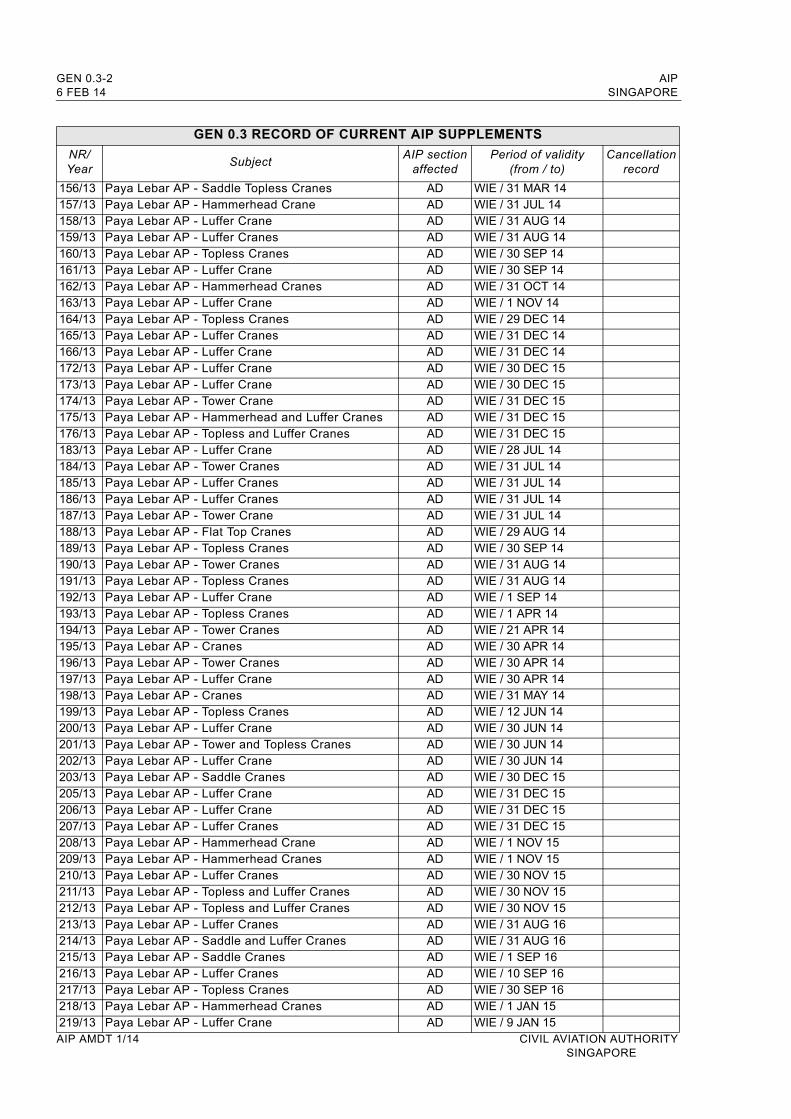
GEN 0.3 RECORD OF CURRENT AIP SUPPLEMENTS
NR/Year
SubjectAIP section
affectedPeriod of validity
(from / to)Cancellation
record
190/11 Paya Lebar AP - Cranes AD WIE / 31 DEC 14191/11 Paya Lebar AP - Tower Crane AD WIE / 31 DEC 14192/11 Paya Lebar AP - Topless Cranes AD WIE / 31 DEC 14193/11 Paya Lebar AP - Hammerhead Cranes AD WIE / 31 DEC 14194/11 Paya Lebar AP - Luffer Cranes AD WIE / 31 DEC 1485/12 Paya Lebar AP - Hammerhead Cranes AD WIE / 30 DEC 1486/12 Paya Lebar AP - Topless Cranes AD WIE / 31 DEC 1487/12 Paya Lebar AP - Luffer Crane AD WIE / 31 DEC 1488/12 Paya Lebar AP - Hammerhead Cranes AD WIE / 31 DEC 1489/12 Paya Lebar AP - Cranes AD WIE / 31 DEC 14172/12 Paya Lebar AP - Hammerhead Cranes AD WIE / 31 DEC 14173/12 Paya Lebar AP - Luffer Crane AD WIE / 31 DEC 14174/12 Paya Lebar AP - Topless Cranes AD WIE / 31 DEC 14175/12 Paya Lebar AP - Saddle Tower Cranes AD WIE / 31 DEC 14176/12 Paya Lebar AP - Hammerhead Cranes AD WIE / 31 DEC 14177/12 Paya Lebar AP - Hammerhead Cranes AD WIE / 31 DEC 14178/12 Paya Lebar AP - Luffer Crane AD WIE / 31 DEC 14179/12 Paya Lebar AP - Luffer Cranes AD WIE / 31 DEC 14180/12 Paya Lebar AP - Luffer Cranes AD WIE / 31 DEC 14181/12 Paya Lebar AP - Luffer Cranes AD WIE / 31 DEC 14194/12 Paya Lebar AP - Cranes AD WIE / 31 DEC 15195/12 Paya Lebar AP - Luffer Crane AD WIE / 31 DEC 15196/12 Paya Lebar AP - Topless Cranes AD WIE / 31 DEC 15197/12 Paya Lebar AP - Topless Cranes AD WIE / 31 DEC 15198/12 Paya Lebar AP - Luffer Cranes AD WIE / 31 DEC 151/13 Paya Lebar AP - Luffer Crane AD WIE / 31 DEC 152/13 Paya Lebar AP - Topless Cranes AD WIE / 31 DEC 153/13 Paya Lebar AP - Topless Cranes AD WIE / 31 DEC 154/13 Paya Lebar AP - Cranes AD WIE / 31 DEC 155/13 Paya Lebar AP - Topless Cranes AD WIE / 31 DEC 1549/13 Paya Lebar AP - Topless Cranes AD WIE / 4 JAN 1450/13 Paya Lebar AP - Flat Top Crane AD WIE / 16 JAN 1451/13 Paya Lebar AP - Luffer Crane AD WIE / 31 JAN 1452/13 Paya Lebar AP - Tower Cranes AD WIE / 31 JAN 1453/13 Paya Lebar AP - Cranes and Rigs AD WIE / 31 JAN 1490/13 Paya Lebar AP - Hammerhead Cranes AD WIE / 1 JAN 1691/13 Paya Lebar AP - Hammerhead Cranes AD WIE / 1 JAN 1692/13 Paya Lebar AP - Tower Cranes AD WIE / 25 JAN 1693/13 Paya Lebar AP - Topless Cranes AD WIE / 31 JAN 1694/13 Paya Lebar AP - Luffer Crane AD WIE / 31 JAN 16103/13 Paya Lebar AP - Topless Cranes AD WIE / 14 MAR 14104/13 Paya Lebar AP - Tower Cranes AD WIE / 14 MAR 14105/13 Paya Lebar AP - Cranes AD WIE / 31 MAR 14106/13 Paya Lebar AP - Crawler Crane AD WIE / 31 MAR 14107/13 Paya Lebar AP - Mobile Crane AD WIE / 31 MAR 14108/13 Paya Lebar AP - Luffer Crane AD WIE / 20 MAY 14109/13 Paya Lebar AP - Hammerhead Crane AD WIE / 31 MAY 14110/13 Paya Lebar AP - Luffer Cranes AD WIE / 31 MAY 14111/13 Paya Lebar AP - Luffer Cranes AD WIE / 31 MAY 14112/13 Paya Lebar AP - Cranes AD WIE / 31 MAY 14152/13 Paya Lebar AP - Tower Cranes AD WIE / 28 FEB 14153/13 Paya Lebar AP - Topless Cranes AD WIE / 28 FEB 14154/13 Paya Lebar AP - Tower Cranes AD WIE / 9 MAR 14155/13 Paya Lebar AP - Crawler Crane AD WIE / 18 MAR 14
CIVIL AVIATION AUTHORITY AIP AMDT 1/14SINGAPORE
GEN 0.3-2 AIP6 FEB 14 SINGAPORE
GEN 0.3 RECORD OF CURRENT AIP SUPPLEMENTS
NR/Year
SubjectAIP section
affectedPeriod of validity
(from / to)Cancellation
record
156/13 Paya Lebar AP - Saddle Topless Cranes AD WIE / 31 MAR 14157/13 Paya Lebar AP - Hammerhead Crane AD WIE / 31 JUL 14158/13 Paya Lebar AP - Luffer Crane AD WIE / 31 AUG 14159/13 Paya Lebar AP - Luffer Cranes AD WIE / 31 AUG 14160/13 Paya Lebar AP - Topless Cranes AD WIE / 30 SEP 14161/13 Paya Lebar AP - Luffer Crane AD WIE / 30 SEP 14162/13 Paya Lebar AP - Hammerhead Cranes AD WIE / 31 OCT 14163/13 Paya Lebar AP - Luffer Crane AD WIE / 1 NOV 14164/13 Paya Lebar AP - Topless Cranes AD WIE / 29 DEC 14165/13 Paya Lebar AP - Luffer Cranes AD WIE / 31 DEC 14166/13 Paya Lebar AP - Luffer Crane AD WIE / 31 DEC 14172/13 Paya Lebar AP - Luffer Crane AD WIE / 30 DEC 15173/13 Paya Lebar AP - Luffer Crane AD WIE / 30 DEC 15174/13 Paya Lebar AP - Tower Crane AD WIE / 31 DEC 15175/13 Paya Lebar AP - Hammerhead and Luffer Cranes AD WIE / 31 DEC 15176/13 Paya Lebar AP - Topless and Luffer Cranes AD WIE / 31 DEC 15183/13 Paya Lebar AP - Luffer Crane AD WIE / 28 JUL 14184/13 Paya Lebar AP - Tower Cranes AD WIE / 31 JUL 14185/13 Paya Lebar AP - Luffer Cranes AD WIE / 31 JUL 14186/13 Paya Lebar AP - Luffer Cranes AD WIE / 31 JUL 14187/13 Paya Lebar AP - Tower Crane AD WIE / 31 JUL 14188/13 Paya Lebar AP - Flat Top Cranes AD WIE / 29 AUG 14189/13 Paya Lebar AP - Topless Cranes AD WIE / 30 SEP 14190/13 Paya Lebar AP - Tower Cranes AD WIE / 31 AUG 14191/13 Paya Lebar AP - Topless Cranes AD WIE / 31 AUG 14192/13 Paya Lebar AP - Luffer Crane AD WIE / 1 SEP 14193/13 Paya Lebar AP - Topless Cranes AD WIE / 1 APR 14194/13 Paya Lebar AP - Tower Cranes AD WIE / 21 APR 14195/13 Paya Lebar AP - Cranes AD WIE / 30 APR 14196/13 Paya Lebar AP - Tower Cranes AD WIE / 30 APR 14197/13 Paya Lebar AP - Luffer Crane AD WIE / 30 APR 14198/13 Paya Lebar AP - Cranes AD WIE / 31 MAY 14199/13 Paya Lebar AP - Topless Cranes AD WIE / 12 JUN 14200/13 Paya Lebar AP - Luffer Crane AD WIE / 30 JUN 14201/13 Paya Lebar AP - Tower and Topless Cranes AD WIE / 30 JUN 14202/13 Paya Lebar AP - Luffer Crane AD WIE / 30 JUN 14203/13 Paya Lebar AP - Saddle Cranes AD WIE / 30 DEC 15205/13 Paya Lebar AP - Luffer Crane AD WIE / 31 DEC 15206/13 Paya Lebar AP - Luffer Crane AD WIE / 31 DEC 15207/13 Paya Lebar AP - Luffer Cranes AD WIE / 31 DEC 15208/13 Paya Lebar AP - Hammerhead Crane AD WIE / 1 NOV 15209/13 Paya Lebar AP - Hammerhead Cranes AD WIE / 1 NOV 15210/13 Paya Lebar AP - Luffer Cranes AD WIE / 30 NOV 15211/13 Paya Lebar AP - Topless and Luffer Cranes AD WIE / 30 NOV 15212/13 Paya Lebar AP - Topless and Luffer Cranes AD WIE / 30 NOV 15213/13 Paya Lebar AP - Luffer Cranes AD WIE / 31 AUG 16214/13 Paya Lebar AP - Saddle and Luffer Cranes AD WIE / 31 AUG 16215/13 Paya Lebar AP - Saddle Cranes AD WIE / 1 SEP 16216/13 Paya Lebar AP - Luffer Cranes AD WIE / 10 SEP 16217/13 Paya Lebar AP - Topless Cranes AD WIE / 30 SEP 16218/13 Paya Lebar AP - Hammerhead Cranes AD WIE / 1 JAN 15219/13 Paya Lebar AP - Luffer Crane AD WIE / 9 JAN 15AIP AMDT 1/14 CIVIL AVIATION AUTHORITY
SINGAPORE
AIP GEN 0.3-3SINGAPORE 6 FEB 14
GEN 0.3 RECORD OF CURRENT AIP SUPPLEMENTS
NR/Year
SubjectAIP section
affectedPeriod of validity
(from / to)Cancellation
record
220/13 Paya Lebar AP - Hammerhead and Luffer Cranes AD WIE / 31 JAN 15221/13 Paya Lebar AP - Luffer Crane AD WIE / 31 JAN 15222/13 Paya Lebar AP - Luffer Crane AD WIE / 31 JAN 15223/13 Paya Lebar AP - Flat Top Cranes AD WIE / 28 FEB 15224/13 Paya Lebar AP - Luffer Crane AD WIE / 28 FEB 15225/13 Paya Lebar AP - Hammerhead and Luffer Cranes AD WIE / 28 FEB 15226/13 Paya Lebar AP - Mobile Crane AD WIE / 14 MAR 15227/13 Paya Lebar AP - Topless Cranes AD WIE / 30 APR 15228/13 Paya Lebar AP - Luffer Cranes AD WIE / 15 MAR 15229/13 Paya Lebar AP - Luffer Cranes AD WIE / 15 MAR 15230/13 Paya Lebar AP - Luffer and Topless Cranes AD WIE / 31 MAR 15231/13 Paya Lebar AP - Topless Cranes AD WIE / 31 MAR 15232/13 Paya Lebar AP - Topless Cranes AD WIE / 31 MAR 15238/13 Paya Lebar AP - Cranes AD WIE / 9 JUL 15239/13 Paya Lebar AP - Saddle and Luffer Cranes AD WIE / 31 JUL 15240/13 Paya Lebar AP - Saddle Cranes AD WIE / 1 AUG 15241/13 Paya Lebar AP - Topless Cranes AD WIE / 30 SEP 15242/13 Paya Lebar AP - Luffer Crane AD WIE / 1 NOV 15243/13 Paya Lebar AP - Hammerhead and Luffer Cranes AD WIE / 31 MAR 16244/13 Paya Lebar AP - Luffer Cranes AD WIE / 31 MAR 16245/13 Paya Lebar AP - Hammerhead Cranes AD WIE / 1 APR 16246/13 Paya Lebar AP - Luffer Crane AD WIE / 30 MAY 16247/13 Paya Lebar AP - Luffer Crane AD WIE / 22 JUN 16248/13 Paya Lebar AP - Luffer Cranes AD WIE / 30 JUN 16249/13 Paya Lebar AP - Luffer Cranes AD WIE / 30 JUN 16250/13 Paya Lebar AP - Topless Cranes AD WIE / 31 DEC 16251/13 Paya Lebar AP - Topless Cranes AD WIE / 31 DEC 16252/13 Paya Lebar AP - Luffer Cranes AD WIE / 31 DEC 17254/13 Singapore FIR - Implementation of Automatic
Dependent Surveillance Broadcast (ADS-B) Out Exclusive Airspace within parts of the Singapore FIR
ENR WEF 12 DEC 13 / PERM
255/13 Paya Lebar AP - Hammerhead and Topless Cranes AD WIE / 31 DEC 16256/13 Paya Lebar AP - Topless Cranes / A Frames AD WIE / 31 DEC 16257/13 Paya Lebar AP - Topless Cranes AD WIE / 31 DEC 16258/13 Paya Lebar AP - Luffer and Hammerhead Canes AD WIE / 31 DEC 16259/13 Paya Lebar AP - Topless and Hammerhead Cranes AD WIE / 31 DEC 16260/13 Paya Lebar AP - Luffer Cranes AD WIE / 1 DEC 15261/13 Paya Lebar AP - Hammerhead Cranes AD WIE / 20 DEC 15262/13 Paya Lebar AP - Luffer Crane AD WIE / 31 DEC 15263/13 Paya Lebar AP - Luffer Cranes AD WIE / 31 DEC 15264/13 Paya Lebar AP - Luffer Crane AD WIE / 31 DEC 15265/13 Paya Lebar AP - Luffer Crane AD WIE / 30 SEP 15266/13 Paya Lebar AP - Topless Cranes AD WIE / 31 OCT 15267/13 Paya Lebar AP - Luffer Cranes AD WIE / 30 NOV 15268/13 Paya Lebar AP - Luffer Crane AD WIE / 30 SEP 16269/13 Paya Lebar AP - Luffer Cranes AD WIE / 31 DEC 17270/13 Paya Lebar AP - Luffer Cranes AD WIE / 31 DEC 14271/13 Paya Lebar AP - Tower Crane AD WIE / 15 JAN 15272/13 Paya Lebar AP - Topless Cranes AD WIE / 28 FEB 15273/13 Paya Lebar AP - Crawler Crane AD WIE / 15 MAR 15274/13 Paya Lebar AP - Mobile Crane AD WIE / 6 JUN15
CIVIL AVIATION AUTHORITY AIP AMDT 1/14SINGAPORE
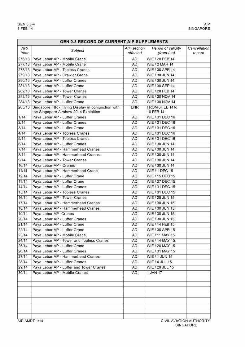
GEN 0.3-4 AIP6 FEB 14 SINGAPORE
GEN 0.3 RECORD OF CURRENT AIP SUPPLEMENTS
NR/Year
SubjectAIP section
affectedPeriod of validity
(from / to)Cancellation
record
276/13 Paya Lebar AP - Mobile Crane AD WIE / 28 FEB 14
277/13 Paya Lebar AP - Mobile Crane AD WIE / 2 MAR 14
278/13 Paya Lebar AP - Topless Cranes AD WIE / 30 APR 14
279/13 Paya Lebar AP - Crawler Crane AD WIE / 30 JUN 14
280/13 Paya Lebar AP - Luffer Cranes AD WIE / 30 JUN 14
281/13 Paya Lebar AP - Luffer Crane AD WIE / 30 SEP 14
282/13 Paya Lebar AP - Tower Cranes AD WIE / 28 FEB 14
283/13 Paya Lebar AP - Tower Cranes AD WIE / 30 NOV 14
284/13 Paya Lebar AP - Luffer Crane AD WIE / 30 NOV 14
285/13 Singapore FIR - Flying Display in conjunction with the Singapore Airshow 2014 Exhibition
ENR FROM 6 FEB 14 to 16 FEB 14
1/14 Paya Lebar AP - Luffer Cranes AD WIE / 31 DEC 16
2/14 Paya Lebar AP - Luffer Cranes AD WIE / 31 DEC 16
3/14 Paya Lebar AP - Luffer Crane AD WIE / 31 DEC 16
4/14 Paya Lebar AP - Topless Cranes AD WIE / 31 DEC 16
5/14 Paya Lebar AP - Topless Cranes AD WIE / 31 DEC 16
6/14 Paya Lebar AP - Luffer Cranes AD WIE / 30 JUN 14
7/14 Paya Lebar AP - Hammerhead Cranes AD WIE / 30 JUN 14
8/14 Paya Lebar AP - Hammerhead Cranes AD WIE / 30 JUN 14
9/14 Paya Lebar AP - Tower Cranes AD WIE / 30 JUN 14
10/14 Paya Lebar AP - Cranes AD WIE / 30 JUN 14
11/14 Paya Lebar AP - Hammerhead Crane AD WIE / 1 DEC 15
12/14 Paya Lebar AP - Luffer Crane AD WIE / 15 DEC 15
13/14 Paya Lebar AP - Luffer Crane AD WIE / 27 DEC 15
14/14 Paya Lebar AP - Luffer Cranes AD WIE / 31 DEC 15
15/14 Paya Lebar AP - Topless Cranes AD WIE / 31 DEC 15
16/14 Paya Lebar AP - Tower Cranes AD WIE / 25 JUN 15
17/14 Paya Lebar AP - Hammerhead Cranes AD WIE / 30 JUN 15
18/14 Paya Lebar AP - Hammerhead Cranes AD WIE / 30 JUN 15
19/14 Paya Lebar AP- Cranes AD WIE / 30 JUN 15
20/14 Paya Lebar AP - Luffer Cranes AD WIE / 30 JUN 15
21/14 Paya Lebar AP - Luffer Crane AD WIE / 14 FEB 15
22/14 Paya Lebar AP - Luffer Crane AD WIE / 30 APR 15
23/14 Paya Lebar AP - Mobile Crane AD WIE / 11 MAY 15
24/14 Paya Lebar AP - Tower and Topless Cranes AD WIE / 14 MAY 15
25/14 Paya Lebar AP - Luffer Crane AD WIE / 20 MAY 15
26/14 Paya Lebar AP - Luffer Cranes AD WIE / 31 MAY 15
27/14 Paya Lebar AP - Hammerhead Cranes AD WIE / 1 JUN 15
28/14 Paya Lebar AP - Luffer Cranes AD WIE / 4 JUL 15
29/14 Paya Lebar AP - Luffer and Tower Cranes AD WIE / 29 JUL 15
30/14 Paya Lebar AP - Mobile Cranes AD 1 JAN 17
AIP AMDT 1/14 CIVIL AVIATION AUTHORITYSINGAPORE
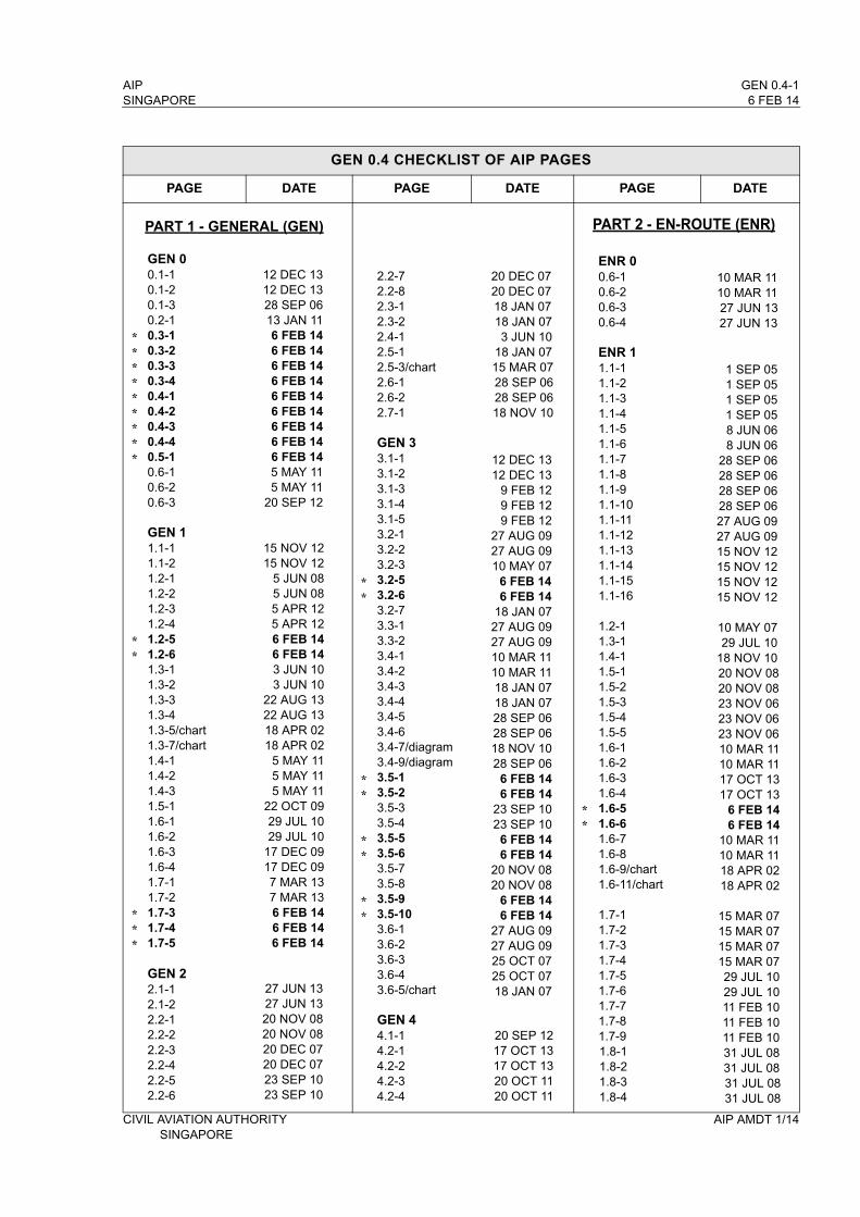
AIP GEN 0.4-1SINGAPORE 6 FEB 14
GEN 0.4 CHECKLIST OF AIP PAGES
PAGE DATE PAGE DATE PAGE DATE
GEN 00.1-10.1-20.1-30.2-10.3-10.3-20.3-30.3-40.4-10.4-20.4-30.4-40.5-10.6-10.6-20.6-3
GEN 11.1-11.1-21.2-11.2-21.2-31.2-41.2-51.2-61.3-11.3-21.3-31.3-41.3-5/chart1.3-7/chart1.4-11.4-21.4-31.5-11.6-11.6-21.6-31.6-41.7-11.7-21.7-31.7-41.7-5
GEN 22.1-12.1-22.2-12.2-22.2-32.2-42.2-52.2-6
12 DEC 1312 DEC 1328 SEP 0613 JAN 116 FEB 146 FEB 146 FEB 146 FEB 146 FEB 146 FEB 146 FEB 146 FEB 146 FEB 145 MAY 115 MAY 11
20 SEP 12
15 NOV 1215 NOV 12
5 JUN 085 JUN 085 APR 125 APR 126 FEB 146 FEB 143 JUN 103 JUN 10
22 AUG 1322 AUG 1318 APR 0218 APR 02
5 MAY 115 MAY 115 MAY 11
22 OCT 0929 JUL 1029 JUL 10
17 DEC 0917 DEC 097 MAR 137 MAR 136 FEB 146 FEB 146 FEB 14
27 JUN 1327 JUN 1320 NOV 0820 NOV 0820 DEC 0720 DEC 0723 SEP 1023 SEP 10
2.2-72.2-82.3-12.3-22.4-12.5-12.5-3/chart2.6-12.6-22.7-1
GEN 33.1-13.1-23.1-33.1-43.1-53.2-13.2-23.2-33.2-53.2-63.2-73.3-13.3-23.4-13.4-23.4-33.4-43.4-53.4-63.4-7/diagram3.4-9/diagram3.5-13.5-23.5-33.5-43.5-53.5-63.5-73.5-83.5-93.5-103.6-13.6-23.6-33.6-43.6-5/chart
GEN 44.1-14.2-14.2-24.2-34.2-4
20 DEC 0720 DEC 0718 JAN 0718 JAN 073 JUN 10
18 JAN 0715 MAR 0728 SEP 0628 SEP 0618 NOV 10
12 DEC 1312 DEC 13
9 FEB 129 FEB 129 FEB 12
27 AUG 0927 AUG 0910 MAY 07
6 FEB 146 FEB 14
18 JAN 0727 AUG 0927 AUG 0910 MAR 1110 MAR 1118 JAN 0718 JAN 0728 SEP 0628 SEP 0618 NOV 1028 SEP 06
6 FEB 146 FEB 14
23 SEP 1023 SEP 10
6 FEB 146 FEB 14
20 NOV 0820 NOV 08
6 FEB 146 FEB 14
27 AUG 0927 AUG 0925 OCT 0725 OCT 0718 JAN 07
20 SEP 1217 OCT 1317 OCT 1320 OCT 1120 OCT 11
ENR 00.6-10.6-20.6-30.6-4
ENR 11.1-11.1-21.1-31.1-41.1-51.1-61.1-71.1-81.1-91.1-101.1-111.1-121.1-131.1-141.1-151.1-16
1.2-11.3-11.4-11.5-11.5-21.5-31.5-41.5-51.6-11.6-21.6-31.6-41.6-51.6-61.6-71.6-81.6-9/chart1.6-11/chart
1.7-11.7-21.7-31.7-41.7-51.7-61.7-71.7-81.7-91.8-11.8-21.8-31.8-4
10 MAR 1110 MAR 1127 JUN 1327 JUN 13
1 SEP 051 SEP 051 SEP 051 SEP 058 JUN 068 JUN 06
28 SEP 0628 SEP 0628 SEP 0628 SEP 0627 AUG 0927 AUG 0915 NOV 1215 NOV 1215 NOV 1215 NOV 12
10 MAY 0729 JUL 10
18 NOV 1020 NOV 0820 NOV 0823 NOV 0623 NOV 0623 NOV 0610 MAR 1110 MAR 1117 OCT 1317 OCT 13
6 FEB 146 FEB 14
10 MAR 1110 MAR 1118 APR 0218 APR 02
15 MAR 0715 MAR 0715 MAR 0715 MAR 0729 JUL 1029 JUL 1011 FEB 1011 FEB 1011 FEB 1031 JUL 0831 JUL 0831 JUL 0831 JUL 08
CIVIL AVIATION AUTHORITY AIP AMDT 1/14SINGAPORE
PART 1 - GENERAL (GEN) PART 2 - EN-ROUTE (ENR)
*********
**
***
**
**
**
**
**

GEN 0.4-2 AIP6 FEB 14 SINGAPORE
GEN 0.4 CHECKLIST OF AIP PAGES
PAGE DATE PAGE DATE PAGE DATE
1.8-51.8-61.8-71.8-81.8-91.8-101.8-111.8-121.8-131.8-141.8-151.8-161.8-171.8-181.8-191.8-201.8-211.8-221.8-231.9-11.9-21.9-31.9-41.9-51.10-11.10-21.10-31.10-41.11-11.12-11.12-21.12-31.12-41.13-11.14-11.14-21.14-31.14-41.14-51.14-61.15-11.15-31.15-4ENR 22.1-12.1-22.1-32.1-42.1-7/chart2.1-9/chart2.1-11A/diagram2.1-11B/diagram2.1-13/diagram2.1-15/chart2.2-1
ENR 33.1-13.1-23.1-33.1-4
31 JUL 0831 JUL 0831 JUL 0831 JUL 081 SEP 051 SEP 053 JUN 103 JUN 10
29 JUL 1029 JUL 1027 JUN 1327 JUN 1318 NOV 1018 NOV 1026 JUL 1226 JUL 12
22 AUG 1322 AUG 1315 NOV 1215 JAN 0915 JAN 09
5 JUL 075 JUL 075 JUL 07
15 NOV 1215 NOV 1215 NOV 1215 NOV 1210 MAR 11
8 APR 108 APR 10
18 JAN 0718 JAN 0718 JAN 0710 MAR 1110 MAR 11
3 JUN 103 JUN 103 JUN 103 JUN 10
10 JAN 132 MAY 132 MAY 13
18 NOV 1018 NOV 1018 NOV 1018 NOV 10
7 JUL 0520 SEP 128 APR 108 APR 108 OCT 982 MAY 13
18 JAN 07
10 JAN 1310 JAN 1320 SEP 1220 SEP 12
3.1-53.1-63.1-73.1-83.1-17/chart3.3-13.3-23.3-33.3-43.3-53.3-63.3-73.3-83.3-93.3-103.3-113.3-123.3-133.3-143.4-13.4-23.4-33.4-43.4-5/chart3.4-7/chart3.5-13.5-23.5-3/chart3.6-13.6-23.6-3/chart3.6-5/chart3.6-7/chart3.6-9/chart
ENR 44.1-14.1-24.2-14.3-14.4-14.4-24.4-34.4-44.5-1
ENR 55.1-15.1-35.1-45.1-55.1-65.1-7/chart5.1-9/chart5.2-15.2-25.3-15.4-15.5-15.6-15.6-3
22 AUG 1322 AUG 1320 SEP 1220 SEP 122 MAY 139 FEB 129 FEB 126 FEB 146 FEB 14
20 SEP 1220 SEP 1218 NOV 1018 NOV 10
6 FEB 146 FEB 149 FEB 129 FEB 12
20 SEP 1220 SEP 12
6 FEB 146 FEB 14
18 NOV 1018 NOV 1030 JUN 1118 JAN 0727 JUN 1327 JUN 1313 JAN 1120 OCT 1120 OCT 1120 SEP 1220 SEP 1220 SEP 1220 SEP 12
20 SEP 1220 SEP 1210 MAR 1110 MAR 1120 SEP 1220 SEP 1220 SEP 1220 SEP 1210 MAR 11
8 APR 1010 MAR 1110 MAR 1110 MAR 1110 MAR 1120 SEP 1210 MAR 1118 NOV 1018 NOV 1011 FEB 1010 MAR 1115 DEC 1110 JAN 1310 JAN 13
ENR 66-1/chartWAC 2860
AD 00.6-10.6-20.6-30.6-4
AD 11.1-11.1-21.1-31.1-41.2-11.3-11.3-3/chart1.4-11.5-1
AD 2WSSS AD 2-1WSSS AD 2-2WSSS AD 2-3WSSS AD 2-4
WSSS AD 2-5.1WSSS AD 2-5.2WSSS AD 2-5.3
WSSS AD 2-6.1WSSS AD 2-6.2WSSS AD 2-6.3WSSS AD 2-6.4WSSS AD 2-6.5WSSS AD 2-6.6WSSS AD 2-6.7WSSS AD 2-6.8WSSS AD 2-7.1WSSS AD 2-7.2WSSS AD 2-7.3WSSS AD 2-7.4WSSS AD 2-7.5WSSS AD 2-7.6WSSS AD 2-7.7WSSS AD 2-7.8WSSS AD 2-7.9WSSS AD 2-7.10WSSS AD 2-7.11WSSS AD 2-7.12WSSS AD 2-7.13WSSS AD 2-7.14WSSS AD 2-7.15WSSS AD 2-7.16WSSS AD 2-8.1WSSS AD 2-8.2
2 MAY 1315 JUL 99
17 OCT 1317 OCT 1317 OCT 1317 OCT 13
27 AUG 0927 AUG 09
2 MAY 132 MAY 13
18 JAN 0710 MAY 0715 MAR 0718 JAN 0717 DEC 09
6 FEB 146 FEB 14
17 OCT 1317 OCT 13
6 FEB 146 FEB 146 FEB 14
15 NOV 1215 NOV 12
7 MAR 137 MAR 13
17 OCT 1317 OCT 1312 DEC 1312 DEC 13
7 MAY 097 MAY 097 MAY 097 MAY 096 FEB 146 FEB 142 MAY 132 MAY 132 MAY 132 MAY 132 MAY 132 MAY 13
12 DEC 1312 DEC 13
2 MAY 132 MAY 138 APR 108 APR 10
AIP AMDT 1/14 CIVIL AVIATION AUTHORITYSINGAPORE
**
**
**
**
***
**
PART 3 - AERODROME (AD)

AIP GEN 0.4-3SINGAPORE 6 FEB 14
GEN 0.4 CHECKLIST OF AIP PAGES
PAGE DATE PAGE DATE PAGE DATE
WSSS AD 2-9WSSS AD 2-10WSSS AD 2-11WSSS AD 2-12WSSS AD 2-13WSSS AD 2-14WSSS AD 2-15WSSS AD 2-16WSSS AD 2-17WSSS AD 2-18WSSS AD 2-19 WSSS AD 2-20WSSS AD 2-21WSSS AD 2-22WSSS AD 2-23WSSS AD 2-24WSSS AD 2-25WSSS AD 2-26WSSS AD 2-27WSSS AD 2-28WSSS AD 2-29
WSSS AD 2-31/chartWSSS AD 2-33/chartWSSS AD 2-37/chartWSSS AD 2-39/chartWSSS AD 2-41/chartWSSS AD 2-43/chartWSSS AD 2-45/chartWSSS AD 2-47WSSS AD 2-48WSSS AD 2-49WSSS AD 2-50WSSS AD 2-50-1WSSS AD 2-50-2WSSS AD 2-50-3WSSS AD 2-50-4
WSSS AD 2-51/chartWSSS AD 2-52 WSSS AD 2-53/chartWSSS AD 2-54 WSSS AD 2-55/chartWSSS AD 2-56 WSSS AD 2-57/chartWSSS AD 2-58
WSSS AD 2-63/chartWSSS AD 2-64 WSSS AD 2-65/chartWSSS AD 2-66 WSSS AD 2-67/chartWSSS AD 2-68 WSSS AD 2-69/chartWSSS AD 2-70 WSSS AD 2-71/chartWSSS AD 2-72
13 JAN 1113 JAN 116 FEB 146 FEB 14
23 NOV 0623 NOV 0618 JAN 0718 JAN 0712 DEC 1312 DEC 1315 DEC 1115 DEC 1117 OCT 1317 OCT 1320 SEP 1220 SEP 1220 SEP 1220 SEP 12
6 FEB 146 FEB 141 SEP 05
6 FEB 1415 JAN 0915 JUL 9915 JUL 9915 JUL 99
25 APR 9625 APR 965 APR 125 APR 12
20 SEP 1220 SEP 1226 JUL 1226 JUL 125 APR 125 APR 12
2 MAY 132 MAY 132 MAY 132 MAY 13
10 JAN 1310 JAN 1310 JAN 1310 JAN 13
10 JAN 1310 JAN 1310 JAN 1310 JAN 1310 JAN 1310 JAN 1310 JAN 1310 JAN 1310 JAN 1310 JAN 13
WSSS AD 2-71-1/chartWSSS AD 2-72-1 WSSS AD 2-73/chartWSSS AD 2-74 WSSS AD 2-73-1/chartWSSS AD 2-74-1 WSSS AD 2-75/chartWSSS AD 2-76 WSSS AD 2-77/chartWSSS AD 2-78
WSSS AD 2-81/chartWSSS AD 2-82WSSS AD 2-81-1/chartWSSS AD 2-82-1WSSS AD 2-83/chartWSSS AD 2-84 WSSS AD 2-83-1/chartWSSS AD 2-84-1WSSS AD 2-85/chartWSSS AD 2-86 WSSS AD 2-85-1/chartWSSS AD 2-86-1WSSS AD 2-86-2WSSS AD 2-87/chartWSSS AD 2-88 WSSS AD 2-87-1/chartWSSS AD 2-88-1WSSS AD 2-88-2WSSS AD 2-89/chartWSSS AD 2-90
WSSS AD 2-91/chartWSSS AD 2-92 WSSS AD 2-91-1/chartWSSS AD 2-92-1WSSS AD 2-92-2WSSS AD 2-93/chartWSSS AD 2-94WSSS AD 2-93-1/chartWSSS AD 2-94-1WSSS AD 2-94-2
WSSS AD 2-97/chartWSSS AD 2-98WSSS AD 2-97-1/chartWSSS AD 2-98-1WSSS AD 2-99/chartWSSS AD 2-100 WSSS AD 2-99-1/chartWSSS AD 2-100-1
10 JAN 1310 JAN 1310 JAN 1310 JAN 1310 JAN 1310 JAN 1310 JAN 1310 JAN 1310 JAN 1310 JAN 13
26 JUL 1226 JUL 125 APR 125 APR 1226 JUL 1226 JUL 125 APR 125 APR 1226 JUL 1226 JUL 125 APR 125 APR 125 APR 1226 JUL 1226 JUL 125 APR 125 APR 125 APR 1226 JUL 1226 JUL 12
26 JUL 1226 JUL 125 APR 125 APR 125 APR 1226 JUL 1226 JUL 125 APR 125 APR 125 APR 12
26 JUL 1226 JUL 125 APR 125 APR 1226 JUL 1226 JUL 125 APR 125 APR 12
WSSS AD 2-101/chartWSSS AD 2-103/chartWSSS AD 2-105/chartWSSS AD 2-107/chartWSSS AD 2-109/chartWSSS AD 2-111/chartWSSS AD 2-113/chartWSSS AD 2-115/chartWSSS AD 2-117/chartWSSS AD 2-119/chartWSSS AD 2-121/chart
WSSL AD 2-1WSSL AD 2-2WSSL AD 2-3-1WSSL AD 2-3-2WSSL AD 2-4-1WSSL AD 2-4-2WSSL AD 2-5WSSL AD 2-6WSSL AD 2-7WSSL AD 2-8WSSL AD 2-9WSSL AD 2-10WSSL AD 2-11WSSL AD 2-12WSSL AD 2-12-1WSSL AD 2-12-2WSSL AD 2-13/chartWSSL AD 2-15/chartWSSL AD 2-17/chartWSSL AD 2-19/chartWSSL AD 2-21/chartWSSL AD 2-23/chartWSSL AD 2-25/chartWSSL AD 2-27/chartWSSL AD 2-29/chartWSSL AD 2-31/chartWSSL AD 2-33/chartWSSL AD 2-35/chartWSSL AD 2-37/chart
WSAP AD 2-1WSAP AD 2-2WSAP AD 2-3WSAP AD 2-4WSAP AD 2-5WSAP AD 2-6WSAP AD 2-7WSAP AD 2-8WSAP AD 2-9WSAP AD 2-10WSAP AD 2-11/chartWSAP AD 2-13/chartWSAP AD 2-15/chartWSAP AD 2-17/chartWSAP AD 2-19/chartWSAP AD 2-21/chartWSAP AD 2-23/chart
10 MAR 1110 MAR 1110 MAR 1110 MAR 1110 MAR 1110 MAR 1110 MAR 1118 NOV 1010 MAR 117 MAR 13
10 MAR 11
12 DEC 1312 DEC 13
6 FEB 146 FEB 14
17 OCT 1317 OCT 13
6 FEB 146 FEB 149 FEB 129 FEB 126 FEB 146 FEB 14
20 OCT 1120 OCT 1112 DEC 1312 DEC 13
6 FEB 146 FEB 146 FEB 146 FEB 14
12 DEC 1312 DEC 1312 DEC 1312 DEC 1312 DEC 1312 DEC 1330 JUN 1130 JUN 1130 JUN 11
6 FEB 146 FEB 14
18 NOV 1018 NOV 10
6 FEB 146 FEB 14
20 OCT 1120 OCT 1118 NOV 1018 NOV 1018 NOV 1018 NOV 1025 APR 9610 MAR 1110 MAR 1110 MAR 1110 MAR 11
CIVIL AVIATION AUTHORITY AIP AMDT 1/14SINGAPORE
**
**
*
**
**
**
****
**
**
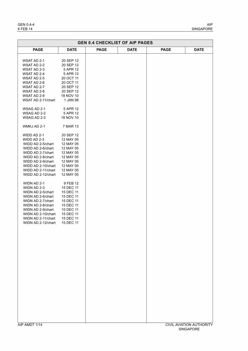
GEN 0.4-4 AIP6 FEB 14 SINGAPORE
GEN 0.4 CHECKLIST OF AIP PAGES
PAGE DATE PAGE DATE PAGE DATE
WSAT AD 2-1WSAT AD 2-2WSAT AD 2-3WSAT AD 2-4WSAT AD 2-5WSAT AD 2-6WSAT AD 2-7WSAT AD 2-8WSAT AD 2-9WSAT AD 2-11/chart
WSAG AD 2-1WSAG AD 2-2WSAG AD 2-3
WMKJ AD 2-1
WIDD AD 2-1WIDD AD 2-3WIDD AD 2-5/chartWIDD AD 2-6/chartWIDD AD 2-7/chartWIDD AD 2-8/chartWIDD AD 2-9/chartWIDD AD 2-10/chartWIDD AD 2-11/chartWIDD AD 2-12/chart
WIDN AD 2-1WIDN AD 2-3WIDN AD 2-5/chartWIDN AD 2-6/chartWIDN AD 2-7/chartWIDN AD 2-8/chartWIDN AD 2-9/chartWIDN AD 2-10/chartWIDN AD 2-11/chartWIDN AD 2-12/chart
20 SEP 1220 SEP 125 APR 125 APR 12
20 OCT 1120 OCT 1120 SEP 1220 SEP 1218 NOV 10
1 JAN 98
5 APR 125 APR 12
18 NOV 10
7 MAR 13
20 SEP 1212 MAY 0512 MAY 0512 MAY 0512 MAY 0512 MAY 0512 MAY 0512 MAY 0512 MAY 0512 MAY 05
9 FEB 1215 DEC 1115 DEC 1115 DEC 1115 DEC 1115 DEC 1115 DEC 1115 DEC 1115 DEC 1115 DEC 11
AIP AMDT 1/14 CIVIL AVIATION AUTHORITYSINGAPORE
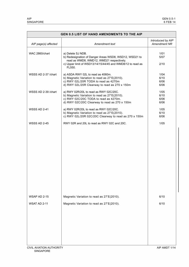
AIP GEN 0.5-1SINGAPORE 6 FEB 14
GEN 0.5 LIST OF HAND AMENDMENTS TO THE AIP
AIP page(s) affected Amendment textIntroduced by AIPAmendment NR
WAC 2860/chart
WSSS AD 2-37 /chart
WSSS AD 2-39 /chart
WSSS AD 2-41
WSSS AD 2-45
WSAP AD 2-15
WSAT AD 2-11
a) Delete SJ NDB.b) Redesignation of Danger Areas WSD8, WSD12, WSD21 to
read as WMD8, WMD12, WMD21 respectively.c) Upper limit of WSD13/14/15/44/45 and WMD8/12 to read as
FL550.
a) ASDA RWY 02L to read as 4060m.b) Magnetic Variation to read as 27’E(2010).c) RWY 02L/20R TODA to read as 4270md) RWY 02L/20R Clearway to read as 270 x 150m
a) RWY 02R/20L to read as RWY 02C/20C.b) Magnetic Variation to read as 27’E(2010).c) RWY 02C/20C TODA to read as 4270m.d) RWY 02C/20C Clearway to read as 270 x 150m
a) RWY 02R/20L to read as RWY 02C/20C.b) Magnetic Variation to read as 27’E(2010).c) RWY 02L/20R 02C/20C Clearway to read as 270 x 150m
RWY 02R and 20L to read as RWY 02C and 20C.
Magnetic Variation to read as 27’E(2010).
Magnetic Variation to read as 27’E(2010).
1/015/07
2/10
1/046/106/066/06
1/056/106/066/06
1/056/106/06
1/05
6/10
6/10
CIVIL AVIATION AUTHORITY AIP AMDT 1/14SINGAPORE

AIP SINGAPORE
INTENTIONALLY
LEFT
BLANK
CIVIL AVIATION AUTHORITY SINGAPORE
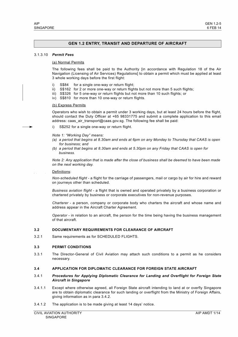
AIP GEN 1.2-5SINGAPORE 6 FEB 14
GEN 1.2 ENTRY, TRANSIT AND DEPARTURE OF AIRCRAFT
3.1.3.10 Permit Fees
(a) Normal Permits
The following fees shall be paid to the Authority [in accordance with Regulation 18 of the Air Navigation (Licensing of Air Services) Regulations] to obtain a permit which must be applied at least 3 whole working days before the first flight:
i) S$84 for a single one-way or return flight;ii) S$162 for 2 or more one-way or return flights but not more than 5 such flights;iii) S$326 for 5 one-way or return flights but not more than 10 such flights; oriv) S$810 for more than 10 one-way or return flights.
(b) Express Permits
Operators who wish to obtain a permit under 3 working days, but at least 24 hours before the flight, should contact the Duty Officer at +65 98331775 and submit a complete application to this email address: [email protected]. The following fee shall be paid:
i) S$252 for a single one-way or return flight.
Note 1: “Working Day” means:(a) a period that begins at 8.30am and ends at 6pm on any Monday to Thursday that CAAS is open
for business; and(b) a period that begins at 8.30am and ends at 5.30pm on any Friday that CAAS is open for
business.
Note 2: Any application that is made after the close of business shall be deemed to have been made on the next working day.
Definitions:
Non-scheduled flight - a flight for the carriage of passengers, mail or cargo by air for hire and reward on journeys other than scheduled.
Business aviation flight - a flight that is owned and operated privately by a business corporation or chartered privately by business or corporate executives for non-revenue purposes.
Charterer - a person, company or corporate body who charters the aircraft and whose name and address appear in the Aircraft Charter Agreement.
Operator - in relation to an aircraft, the person for the time being having the business management of that aircraft.
3.2 DOCUMENTARY REQUIREMENTS FOR CLEARANCE OF AIRCRAFT
3.2.1 Same requirements as for SCHEDULED FLIGHTS.
3.3 PERMIT CONDITIONS
3.3.1 The Director-General of Civil Aviation may attach such conditions to a permit as he considers necessary.
3.4 APPLICATION FOR DIPLOMATIC CLEARANCE FOR FOREIGN STATE AIRCRAFT
3.4.1 Procedures for Applying Diplomatic Clearance for Landing and Overflight for Foreign State Aircraft in Singapore
3.4.1.1 Except where otherwise agreed, all Foreign State aircraft intending to land at or overfly Singapore are to obtain diplomatic clearance for such landing or overflight from the Ministry of Foreign Affairs, giving information as in para 3.4.2.
3.4.1.2 The application is to be made giving at least 14 days’ notice.
CIVIL AVIATION AUTHORITY AIP AMDT 1/14SINGAPORE

GEN 1.2-6 AIP6 FEB 14 SINGAPORE
GEN 1.2 ENTRY, TRANSIT AND DEPARTURE OF AIRCRAFT
3.4.2 Information to be provided when applying for Diplomatic Clearance
3.4.2.1 All applications for diplomatic clearance should contain the following information:a) Name of Mission/Organisation;b) Liaison Officer;c) Telephone Number;d) Number and Type of Aircraft;e) Callsign;f) Aircraft Registration;g) Full flight itinerary;h) Route after entering and before leaving Singapore FIR;i) Date of Arrival;j) Time of Arrival;k) Date of Departure;l) Time of Departure;m) Arrival from;n) Departing to;o) Airfield requested;p) Name of Pilot;q) Number of Crew;r) Number of Passengers;s) If VIP flight, Name of VIP and number of other officials;t) Purpose;u) Photograph and sensory equipment if any;v) Nature of freight or cargoes carried if any;w) Dangerous cargoes, if any (e.g. arms, ammunition, explosives, toxic chemicals);x) Types of services required (e.g. type of fuel, APU/GPU, ground handling etc.);y) Additional/Special request
Note: Aircraft used in military, customs or police services are deemed to be State aircraft.
4. APPLICATION FOR TEST FLIGHTS
4.1 All applications for test flights are subject to prior approval.
4.2 All applications are to be made at least 2 working days but not more than 2 weeks in advance. If notice is not complied with, the application may not be considered.
4.3 Applicants should provide details as listed in items a) to e) below and ensure that the documents as listed in items f) to h) of the aircraft undergoing test flights remain valid during the period of operation:a) Aircraft Registration;b) Aircraft Callsign;c) Aircraft Type;d) Date / Time / Duration of flight;e) Point of Departure and Arrival;f) Certificate of Registration;g) Certificate of Airworthiness;h) A Permit to Fly, issued by CAAS, in the absence of a valid Certificate of Airworthiness.
4.4 All applications should be submitted to:Duty Manager, Singapore Air Traffic Control CentreCivil Aviation Authority of Singapore60 Biggin Hill Road, Singapore 509950Email: [email protected]: 65457526
4.5 Details on flight planning for test flights are listed on page ENR 1.10-1.
5. AIRCRAFT BANNED FROM OPERATIONS AT SINGAPORE AERODROMES
5.1 The Antonov-12 aircraft is banned from all operations to/from Singapore aerodromes due to concerns over its continuing airworthiness.
AIP AMDT 1/14 CIVIL AVIATION AUTHORITY SINGAPORE

AIP GEN 1.7-3SINGAPORE 6 FEB 14
ANNEX 7 Aircraft Nationality and Registration Marks, 6th edition (Amendment 6)
- Nil differences.
ANNEX 8 Airworthiness of Aircraft, 11th edition (Amendment 103)
- Nil differences.
ANNEX 9 Facilitation, 13th edition (Amendment 22)
Chapter 2
2.4 General Declaration is required.2.5 Name of flight crew members are required and to be provided on General Declaration on
entry and departure of aircraft.2.6 Two copies of Embarking Passenger manifests are required.2.12 Crew lists are required.2.15 Crew lists are required.2.18 Documents for entry and departure of aircraft should be in English.
Chapter 3
3.7 Visa is only required for persons who are holders of Certificate of Identity and Travel Documents issued by countries which have not entered visa agreement with the Singapore Government.
3.8 Visa fees are payable at standard rates.
3.8.4 Permanent residents who are not Singapore Citizens are required to be in possession of Re-Entry Permits when they return from overseas trips.
3.9 Embarkation/Disembarkation forms and certain supplementary information are required.
3.10 Embarkation/Disembarkation forms and certain supplementary information are required.
3.23 Crew members when travelling as passengers are required to be in possession of passports.
Chapter 4
4.8 Except for certain scheduled items for which a Diversion Certificate or other authority is required, in/out cargo is as free as possible of governmental documentary requirements.
Chapter 5
5.2 Facilities for provisional declarations are available to expedite clearance.5.4.1 Passports and visas, when necessary, are required where passengers have to leave the
International Airport and stay in Singapore.
Chapter 6
6.57 Any requests to station representatives of the public authorities of another State will be considered on its merits.
Chapter 8
8.1 As laws differ between Government Departments, the use of a single comprehensive bond is not acceptable.
8.14 There is a medical centre at the airport which provides consultation, pharmaceutical, dental, x-ray and minor operations facilities. Requests for medical care and assistance could be made prior to arrival of aircraft.
CIVIL AVIATION AUTHORITY AIP AMDT 1/14SINGAPORE
GEN 1.7-4 AIP6 FEB 14 SINGAPORE
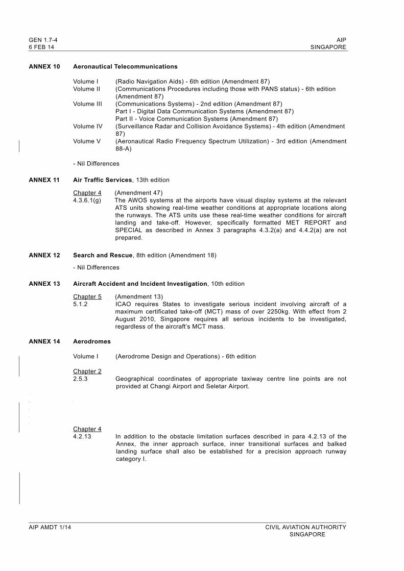
ANNEX 10 Aeronautical Telecommunications
Volume I (Radio Navigation Aids) - 6th edition (Amendment 87)Volume II (Communications Procedures including those with PANS status) - 6th edition
(Amendment 87)Volume III (Communications Systems) - 2nd edition (Amendment 87)
Part I - Digital Data Communication Systems (Amendment 87)Part II - Voice Communication Systems (Amendment 87)
Volume IV (Surveillance Radar and Collision Avoidance Systems) - 4th edition (Amendment 87)
Volume V (Aeronautical Radio Frequency Spectrum Utilization) - 3rd edition (Amendment 88-A)
- Nil Differences
ANNEX 11 Air Traffic Services, 13th edition
Chapter 4 (Amendment 47)4.3.6.1(g) The AWOS systems at the airports have visual display systems at the relevant
ATS units showing real-time weather conditions at appropriate locations along the runways. The ATS units use these real-time weather conditions for aircraft landing and take-off. However, specifically formatted MET REPORT and SPECIAL as described in Annex 3 paragraphs 4.3.2(a) and 4.4.2(a) are not prepared.
ANNEX 12 Search and Rescue, 8th edition (Amendment 18)
- Nil Differences
ANNEX 13 Aircraft Accident and Incident Investigation, 10th edition
Chapter 5 (Amendment 13)5.1.2 ICAO requires States to investigate serious incident involving aircraft of a
maximum certificated take-off (MCT) mass of over 2250kg. With effect from 2 August 2010, Singapore requires all serious incidents to be investigated, regardless of the aircraft’s MCT mass.
ANNEX 14 Aerodromes
Volume I (Aerodrome Design and Operations) - 6th edition
Chapter 22.5.3 Geographical coordinates of appropriate taxiway centre line points are not
provided at Changi Airport and Seletar Airport.
Chapter 44.2.13 In addition to the obstacle limitation surfaces described in para 4.2.13 of the
Annex, the inner approach surface, inner transitional surfaces and balked landing surface shall also be established for a precision approach runway category I.
AIP AMDT 1/14 CIVIL AVIATION AUTHORITYSINGAPORE

AIP GEN 1.7-5SINGAPORE 6 FEB 14
Chapter 77.4.1 In addition to para 7.4.1 of the Annex, unserviceability markers shall also be
displayed at the entrances to a permanently or temporarily closed runway or taxiway, or part thereof.
Chapter 99.2.3 The remission factor described in para 9.2.3 of the Annex has been removed from
our national regulations.
Volume II (Heliports) - 3rd edition (Amendment 4)- Not applicable
ANNEX 15 Aeronautical Information Services, 14th edition
Chapter 10 (Amendment 36)
Singapore has not promulgated regulations or requirements on electronic terrain and obstacle data (ETOD). ETOD is currently not provided in Singapore.
ANNEX 16 Environmental ProtectionVolume I (Aircraft Noise) - 6th edition (Amendment 10)Volume II (Aircraft Engine Emissions) - 3rd edition (Amendment 7)
- Nil Differences
ANNEX 17 Security - Safeguarding International Civil Aviation Against Acts of Unlawful Interference, 9th edition (Amendment 12)
- Nil Differences
ANNEX 18 The Safe Transport of Dangerous Goods by Air, 4th edition (Amendment 10)
- Nil Differences
ANNEX 19 Safety Management, 1st edition
- Nil Differences
CIVIL AVIATION AUTHORITY AIP AMDT 1/14SINGAPORE

AIP SINGAPORE
INTENTIONALLY
LEFT
BLANK
CIVIL AVIATION AUTHORITY SINGAPORE

AIP GEN 3.2-5SINGAPORE 6 FEB 14
GEN 3.2.5 LIST OF AERONAUTICAL CHARTS AVAILABLE
Title of Chart Series Scale Name and/or number Price ($) Date
World Aeronautical Chart ICAO (WAC)
1:1 000 000 WAC 2860 In AIP 15 JUL 99
Enroute Chart ICAO (ENRC)
ENR 6-1 In AIP 2 MAY 13
Instrument Approach Chart ICAO (IAC) 1:400 000
1:400 0001:400 0001:400 0001:400 0001:400 0001:400 0001:400 0001:400 0001:400 000
1:400 0001:400 0001:400 0001:400 000
Singapore ChangiRWY 02L - ICW ILS/DME RWY 02C - ICE ILS/DME RWY 02C - VTK DVOR/DME RWY 02R - ICX ILS/DME RWY 20R - ICH ILS/DME RWY 20C - ICC ILS/DME RWY 20C - VTK DVOR/DME RWY 20L - ICZ ILS/DME RWY 02L - RNAV(GNSS) RWY 20R - RNAV(GNSS)
Paya LebarRWY 20 - PU DVOR/DME RWY 02 - PU DVOR/DME RWY 20 - IPS ILS/DME RWY 02 - IPN ILS/DME
WSSS AD 2-101WSSS AD 2-103WSSS AD 2-105WSSS AD 2-107WSSS AD 2-109WSSS AD 2-111WSSS AD 2-113WSSS AD 2-115WSSS AD 2-117WSSS AD 2-119
WSAP AD 2-17WSAP AD 2-19WSAP AD 2-21WSAP AD 2-23
In AIPIn AIPIn AIPIn AIPIn AIPIn AIPIn AIPIn AIPIn AIPIn AIP
In AIPIn AIPIn AIPIn AIP
10 MAR 1110 MAR 1110 MAR 1110 MAR 1110 MAR 1110 MAR 1110 MAR 1110 MAR 1110 MAR 117 MAR 13
10 MAR 1110 MAR 1110 MAR 1110 MAR 11
Visual Approach ChartICAO (VAC)
1:400 000
1:100 0001:100 0001:100 0001:100 000
Singapore Changi
SeletarRWY 03RWY 21RWY 03RWY 21
WSSS AD 2-121
WSSL AD 2-21WSSL AD 2-23WSSL AD 2-25WSSL AD 2-27
In AIP
In AIPIn AIPIn AIPIn AIP
10 MAR 11
9 FEB 129 FEB 12 9 FEB 129 FEB 12
Visual Departure Chart1:100 0001:100 000
SeletarRWY 03RWY 21
WSSL AD 2-29WSSL AD 2-31
In AIPIn AIP
9 FEB 129 FEB 12
Aerodrome Chart ICAO (AC)
Singapore ChangiSeletarPaya Lebar
WSSS AD 2-31WSSL AD 2-13WSAP AD 2-11
In AIPIn AIPIn AIP
6 FEB 146 FEB 14
18 NOV 10
Aerodrome Obstacle Chart ICAO TYPE A (AOC) 1:10 000
1:10 000
1:10 000
1:20 000
Singapore ChangiRWY 20R/02LRWY 20C/02C
SeletarRWY 03/21
Paya LebarRWY 20/02
WSSS AD 2-37WSSS AD 2-39
WSSL AD 2 -17
WSAP AD 2-15
In AIPIn AIP
In AIP
In AIP
15 JUL 9915 JUL 99
6 FEB 14
25 APR 96
Aerodrome Obstacle Chart ICAO TYPE B (AOC) 1:25 000
1:12 500
Singapore ChangiRWY 02L/20R and 02C/20C
SeletarRWY 03/21
WSSS AD 2-41
WSSL AD 2-19
In AIP
In AIP
15 JUL 99
6 FEB 14
Precision Approach Terrain Chart - ICAO (PATC) 1:2 500
1:2 500
Singapore Changi RWY 02LRWY 02C
WSSS AD 2-43WSSS AD 2-45
In AIPIn AIP
25 APR 9625 APR 96
CIVIL AVIATION AUTHORITY AIP AMDT 1/14SINGAPORE

GEN 3.2-6 AIP6 FEB 14 SINGAPORE
GEN 3.2.6 INDEX TO THE WORLD AERONAUTICAL CHART (WAC) - ICAO 1:1 000 000
AIP AMDT 1/14 CIVIL AVIATION AUTHORITY SINGAPORE
AIP GEN 3.5-1SINGAPORE 6 FEB 14
GEN 3.5 METEOROLOGICAL SERVICES
1. RESPONSIBLE SERVICE
1.1 The meteorological services for civil aviation are provided by the Meteorological Service Singapore of the National Environment Agency.
The Director-GeneralMeteorological Service Singapore Singapore Changi AirportP. O. Box 8Singapore 918141
TEL: (65) 65457190 (HQ)(65) 65425059 / (65) 65422837 (MET Office)
FAX: (65) 65457192 (HQ)(65) 65425026 (MET Office)
AFS: WSSSYMYX
Website: http://www.weather.gov.sg
1.2 The service is provided in accordance with the provisions contained in the following ICAO documents:
Annex 3 - Meteorological Service for International Air NavigationDoc 7030 - Regional Supplementary Procedures Part 3 - Meteorology
1.3 Differences to these provisions are detailed in subsection GEN 1.7.
2. AREA OF RESPONSIBILITY
2.1 Area meteorological watch is provided for the Singapore FIR.
CIVIL AVIATION AUTHORITY AIP AMDT 1/14SINGAPORE
GEN 3.5-2 AIP6 FEB 14 SINGAPORE
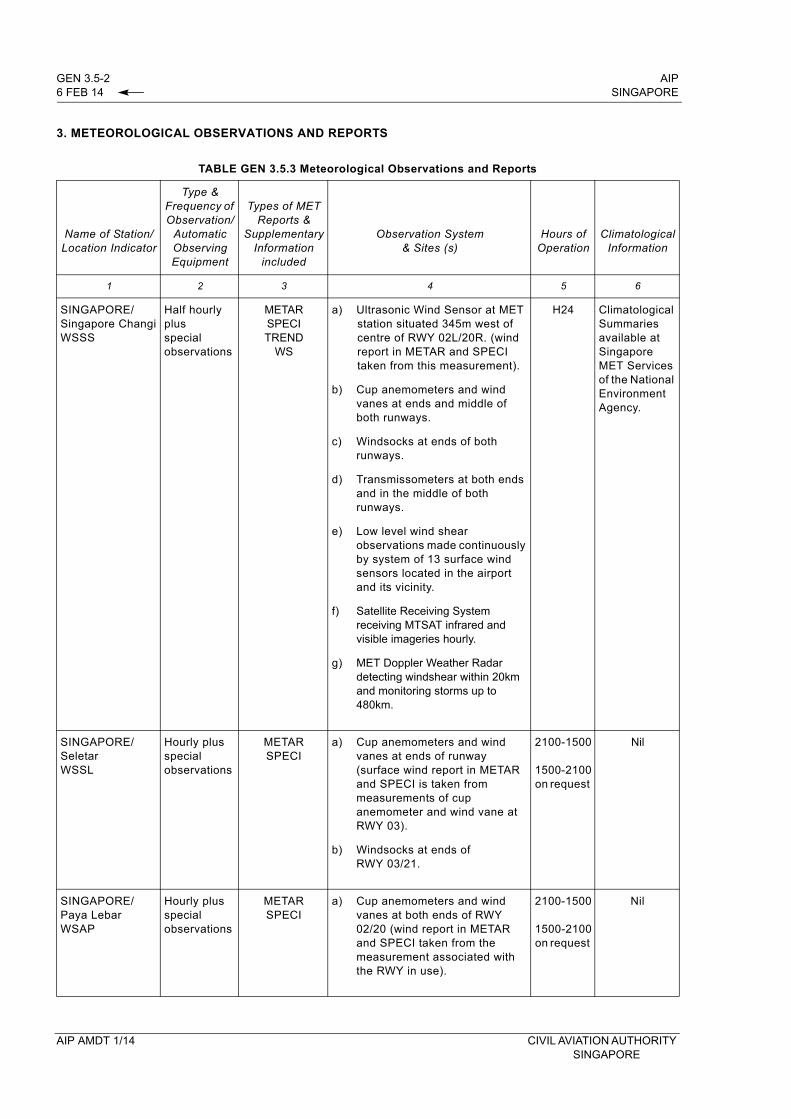
3. METEOROLOGICAL OBSERVATIONS AND REPORTS
TABLE GEN 3.5.3 Meteorological Observations and Reports
Name of Station/Location Indicator
Type & Frequency of Observation/
Automatic Observing Equipment
Types of METReports &
SupplementaryInformation
included
Observation System& Sites (s)
Hours ofOperation
ClimatologicalInformation
1 2 3 4 5 6
SINGAPORE/Singapore ChangiWSSS
Half hourly plusspecial observations
METARSPECI TREND
WS
a)
b)
c)
d)
e)
f)
g)
Ultrasonic Wind Sensor at MET station situated 345m west of centre of RWY 02L/20R. (wind report in METAR and SPECI taken from this measurement).
Cup anemometers and wind vanes at ends and middle of both runways.
Windsocks at ends of both runways.
Transmissometers at both ends and in the middle of both runways.
Low level wind shear observations made continuously by system of 13 surface wind sensors located in the airport and its vicinity.
Satellite Receiving System receiving MTSAT infrared and visible imageries hourly.
MET Doppler Weather Radar detecting windshear within 20km and monitoring storms up to 480km.
H24 Climatological Summaries available at Singapore MET Services of the National Environment Agency.
SINGAPORE/SeletarWSSL
Hourly plus special observations
METARSPECI
a)
b)
Cup anemometers and wind vanes at ends of runway (surface wind report in METAR and SPECI is taken from measurements of cup anemometer and wind vane at RWY 03).
Windsocks at ends of RWY 03/21.
2100-1500
1500-2100on request
Nil
SINGAPORE/Paya LebarWSAP
Hourly plus special observations
METARSPECI
a) Cup anemometers and wind vanes at both ends of RWY 02/20 (wind report in METAR and SPECI taken from the measurement associated with the RWY in use).
2100-1500
1500-2100 on request
Nil
AIP AMDT 1/14 CIVIL AVIATION AUTHORITY SINGAPORE
AIP GEN 3.5-5SINGAPORE 6 FEB 14
4.8.1.3.4 The phraseology used by ATC to warn pilots of the presence of wind shear of intensity greater than 30 knots is:
“...........(callsign) WIND SHEAR WARNING SEVERE LOW LEVEL WIND SHEAR OBSERVED IN THE VICINITY OF CHANGI AIRPORT AT ........(time)”
4.8.1.3.5 The presence of wind shear will also be broadcast in the ATIS for the next half an hour.
4.8.2 SELETAR AERODROME
4.8.2.1 Surface wind is measured by cup anemometers and wind vanes at ends of runway. Surface wind report in METAR and SPECI is taken from measurements of cup anemometer and wind vane at RWY 03.
4.8.2.2 Wind Shear Observations (Seletar Aerodrome)
4.8.2.1 ATC will pass to all aircraft taking off or landing for the next 1/2 hour from the time of report
whenever microburst or windshear of intensity 10 knots or greater is observed/reported.
4.8.2.2.2 The phraseology used by ATC to warn pilots of the presence of wind shear of intensity between 10 and 30 knots is:
“...........(callsign) WIND SHEAR WARNING STRONG LOW LEVEL WIND SHEAR OBSERVED IN THE VICINITY OF SELETAR AIRPORT AT ........(time)”
4.8.2.2.3 The phraseology used by ATC to warn pilots of the presence of wind shear of intensity greater than 30 knots is:
“...........(callsign) WIND SHEAR WARNING SEVERE LOW LEVEL WIND SHEAR OBSERVED IN THE VICINITY OF SELETAR AIRPORT AT ........(time)”
5. NOTIFICATION REQUIRED FROM OPERATORS
5.1 It is the responsibility of the operator or the pilot-in-command to notify the meteorological office of any flight for which meteorological documentation is required (ref. ICAO Annex 3, paragraph 2.3). As much prior notice as possible should be given, and at least one and a half hours’ notice at Singapore Changi Airport and three hours at Seletar Aerodrome would be required for non-scheduled flights.
6. AIRCRAFT REPORTS REQUIRED FROM OPERATORS
6.1 AIREP
6.1.1 Routine aircraft meteorological observations shall be made and the reports transmitted at ATS/MET reporting points listed on page GEN 3.5-6 and as indicated in subsection ENR 3.1 - ATS ROUTES.
6.1.2 Special aircraft observations and aircraft observations during climb-out and approach shall be made and the reports transmitted as necessary.
6.1.3 Special aircraft observations of pre-eruption volcanic activity, volcanic eruption or volcanic ash cloud shall be recorded on the special Air-Report of Volcanic Activity form which can be downloaded from URL https://fpl-1.caasaim.gov.sg/. A copy of the completed Volcanic Activity Report shall be delivered by the operator or a flight crew member, without delay, either personally or by telephone facsimile (TEL: 65425026) to the Meteorological Office, Singapore Changi Airport.
CIVIL AVIATION AUTHORITY AIP AMDT 1/14SINGAPORE
GEN 3.5-6 AIP6 FEB 14 SINGAPORE
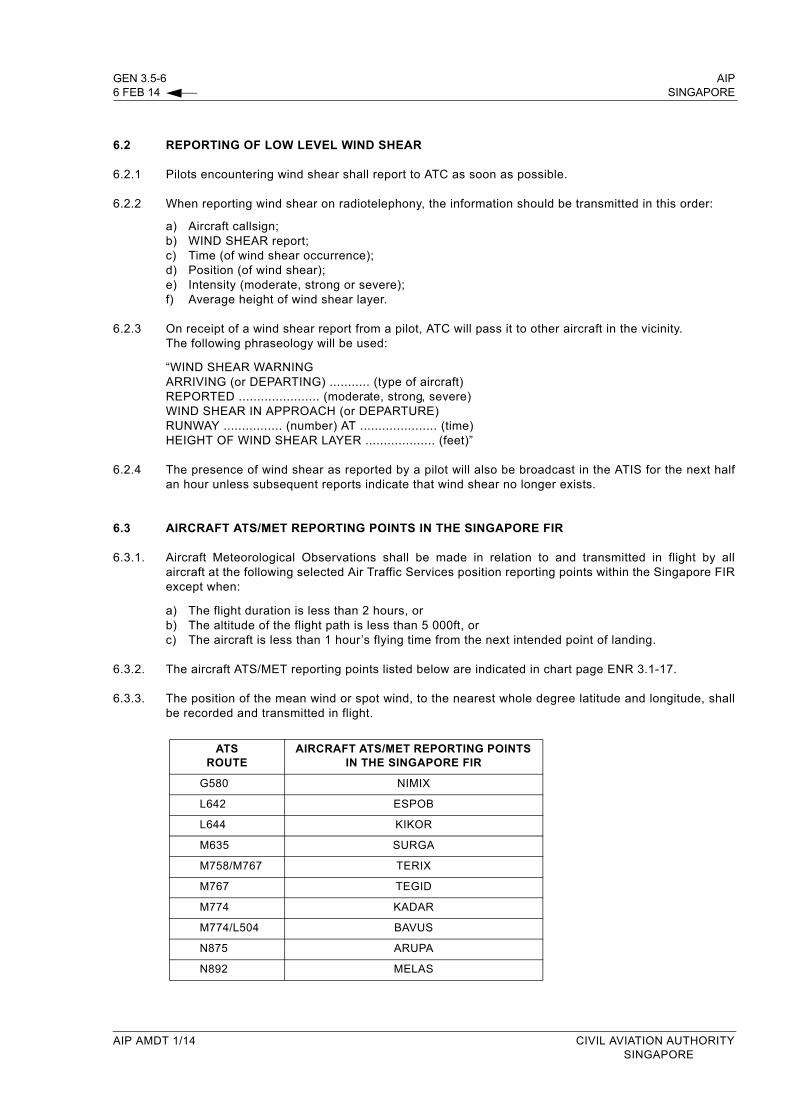
6.2 REPORTING OF LOW LEVEL WIND SHEAR
6.2.1 Pilots encountering wind shear shall report to ATC as soon as possible.
6.2.2 When reporting wind shear on radiotelephony, the information should be transmitted in this order:
a) Aircraft callsign;b) WIND SHEAR report;c) Time (of wind shear occurrence);d) Position (of wind shear);e) Intensity (moderate, strong or severe);f) Average height of wind shear layer.
6.2.3 On receipt of a wind shear report from a pilot, ATC will pass it to other aircraft in the vicinity. The following phraseology will be used:
“WIND SHEAR WARNINGARRIVING (or DEPARTING) ........... (type of aircraft)REPORTED ...................... (moderate, strong, severe)WIND SHEAR IN APPROACH (or DEPARTURE)RUNWAY ................ (number) AT ..................... (time)HEIGHT OF WIND SHEAR LAYER ................... (feet)”
6.2.4 The presence of wind shear as reported by a pilot will also be broadcast in the ATIS for the next half an hour unless subsequent reports indicate that wind shear no longer exists.
6.3 AIRCRAFT ATS/MET REPORTING POINTS IN THE SINGAPORE FIR
6.3.1. Aircraft Meteorological Observations shall be made in relation to and transmitted in flight by all aircraft at the following selected Air Traffic Services position reporting points within the Singapore FIR except when:
a) The flight duration is less than 2 hours, or b) The altitude of the flight path is less than 5 000ft, orc) The aircraft is less than 1 hour’s flying time from the next intended point of landing.
6.3.2. The aircraft ATS/MET reporting points listed below are indicated in chart page ENR 3.1-17.
6.3.3. The position of the mean wind or spot wind, to the nearest whole degree latitude and longitude, shall be recorded and transmitted in flight.
ATS ROUTE
AIRCRAFT ATS/MET REPORTING POINTS IN THE SINGAPORE FIR
G580 NIMIX
L642 ESPOB
L644 KIKOR
M635 SURGA
M758/M767 TERIX
M767 TEGID
M774 KADAR
M774/L504 BAVUS
N875 ARUPA
N892 MELAS
AIP AMDT 1/14 CIVIL AVIATION AUTHORITYSINGAPORE
AIP GEN 3.5-9SINGAPORE 6 FEB 14
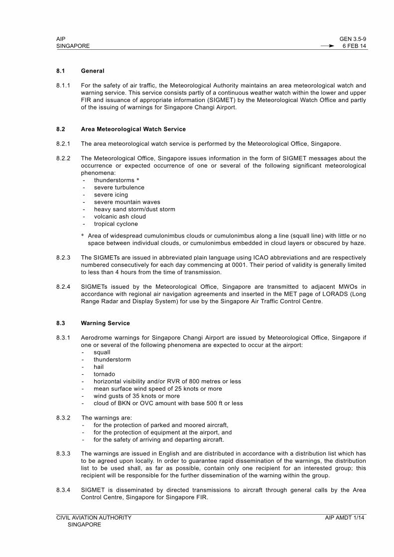
8.1 General
8.1.1 For the safety of air traffic, the Meteorological Authority maintains an area meteorological watch and warning service. This service consists partly of a continuous weather watch within the lower and upper FIR and issuance of appropriate information (SIGMET) by the Meteorological Watch Office and partly of the issuing of warnings for Singapore Changi Airport.
8.2 Area Meteorological Watch Service
8.2.1 The area meteorological watch service is performed by the Meteorological Office, Singapore.
8.2.2 The Meteorological Office, Singapore issues information in the form of SIGMET messages about the occurrence or expected occurrence of one or several of the following significant meteorological phenomena:- thunderstorms *- severe turbulence- severe icing - severe mountain waves- heavy sand storm/dust storm- volcanic ash cloud- tropical cyclone
* Area of widespread cumulonimbus clouds or cumulonimbus along a line (squall line) with little or no space between individual clouds, or cumulonimbus embedded in cloud layers or obscured by haze.
8.2.3 The SIGMETs are issued in abbreviated plain language using ICAO abbreviations and are respectively numbered consecutively for each day commencing at 0001. Their period of validity is generally limited to less than 4 hours from the time of transmission.
8.2.4 SIGMETs issued by the Meteorological Office, Singapore are transmitted to adjacent MWOs in accordance with regional air navigation agreements and inserted in the MET page of LORADS (Long Range Radar and Display System) for use by the Singapore Air Traffic Control Centre.
8.3 Warning Service
8.3.1 Aerodrome warnings for Singapore Changi Airport are issued by Meteorological Office, Singapore if one or several of the following phenomena are expected to occur at the airport:- squall- thunderstorm- hail- tornado- horizontal visibility and/or RVR of 800 metres or less- mean surface wind speed of 25 knots or more - wind gusts of 35 knots or more- cloud of BKN or OVC amount with base 500 ft or less
8.3.2 The warnings are:- for the protection of parked and moored aircraft,- for the protection of equipment at the airport, and- for the safety of arriving and departing aircraft.
8.3.3 The warnings are issued in English and are distributed in accordance with a distribution list which has to be agreed upon locally. In order to guarantee rapid dissemination of the warnings, the distribution list to be used shall, as far as possible, contain only one recipient for an interested group; this recipient will be responsible for the further dissemination of the warning within the group.
8.3.4 SIGMET is disseminated by directed transmissions to aircraft through general calls by the Area Control Centre, Singapore for Singapore FIR.
CIVIL AVIATION AUTHORITY AIP AMDT 1/14SINGAPORE

GEN 3.5-10 AIP6 FEB 14 SINGAPORE
9. OTHER AUTOMATED METEOROLOGICAL SERVICES
9.1 Besides VOLMET and ATIS broadcasts, airline operators can obtain access to various operational meteorological information through our Aviation Intranet dedicated computer to computer links and automated faxing service.
9.2 Aviation Intranet is free to airlines or flight operators with flights departing from Singapore Changi and Seletar Airports. It is accessible at URL http://www.weather.gov.sg/. A registered user account is required for the access. For registration, please email to [email protected]
TABLE 3.5.9 AVIATION INTRANET
Service Name Information Available Area, Route andAerodrome Coverage
Telephone and Telefax numbers
Remarks
1 2 3 4
Aviation Intranet METAR, SPECI, TAF, SIGMET, Typhoon and Tropical Cyclone Warnings, Tropical Cyclone / Volcanic Ash Advisories
Latest hourly IR MTSAT-1R and FY2E Satellite pictures
Latest images from other satellites
Mid-Level Significant Weather charts
WAFS (World Area Forecast System) SIGWX charts
Prognostic Wind-Temperature charts
Weather Radar images
All METAR, SPECI, TAF, SIGMET, Typhoon and Tropical Cyclone Warnings, Tropical Cyclone / Volcanic Ash Advisories received
Southeast Asia and full globe
Europe, America and Asia Pacific
Medium-High level (FL100-FL450) covering 30E -180E; 45N - 45S
Medium-High level covering Asia, Middle East, Africa, America and Europe
Standard levels covering Europe, America and the Asia-Pacific Regions
Latest Singapore Changi Airport 70km range rain intensity radar plots.
Note: Details of meteorological briefing at aerodromes are given in the individual aerodrome sections, i.e. AD2
AIP AMDT 1/14 CIVIL AVIATION AUTHORITYSINGAPORE
AIP ENR 1.6-5SINGAPORE 6 FEB 14
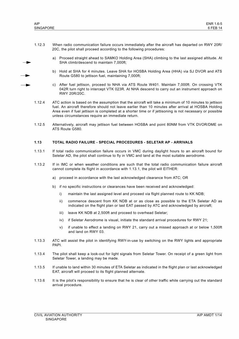
1.12.3 When radio communication failure occurs immediately after the aircraft has departed on RWY 20R/20C, the pilot shall proceed according to the following procedures:
a) Proceed straight ahead to SAMKO Holding Area (SHA) climbing to the last assigned altitude. At SHA climb/descend to maintain 7,000ft;
b) Hold at SHA for 4 minutes. Leave SHA for HOSBA Holding Area (HHA) via SJ DVOR and ATS Route G580 to jettison fuel, maintaining 7,000ft;
c) After fuel jettison, proceed to NHA via ATS Route W401. Maintain 7,000ft. On crossing VTK 042R turn right to intercept VTK 023R. At NHA descend to carry out an instrument approach on RWY 20R/20C.
1.12.4 ATC action is based on the assumption that the aircraft will take a minimum of 10 minutes to jettison fuel. An aircraft therefore should not leave earlier than 10 minutes after arrival at HOSBA Holding Area even if fuel jettison is completed at a shorter time or if jettisoning is not necessary or possible unless circumstances require an immediate return.
1.12.5 Alternatively, aircraft may jettison fuel between HOSBA and point 80NM from VTK DVOR/DME on ATS Route G580.
1.13 TOTAL RADIO FAILURE - SPECIAL PROCEDURES - SELETAR AP - ARRIVALS
1.13.1 If total radio communication failure occurs in VMC during daylight hours to an aircraft bound for Seletar AD, the pilot shall continue to fly in VMC and land at the most suitable aerodrome.
1.13.2 If in IMC or when weather conditions are such that the total radio communication failure aircraft cannot complete its flight in accordance with 1.13.1, the pilot will EITHER:
a) proceed in accordance with the last acknowledged clearance from ATC; OR
b) if no specific instructions or clearances have been received and acknowledged:
i) maintain the last assigned level and proceed via flight planned route to KK NDB;
ii) commence descent from KK NDB at or as close as possible to the ETA Seletar AD as indicated on the flight plan or last EAT passed by ATC and acknowledged by aircraft;
iii) leave KK NDB at 2,500ft and proceed to overhead Seletar;
iv) if Seletar Aerodrome is visual, initiate the standard arrival procedures for RWY 21;
v) if unable to effect a landing on RWY 21, carry out a missed approach at or below 1,500ft and land on RWY 03.
1.13.3 ATC will assist the pilot in identifying RWY-in-use by switching on the RWY lights and appropriate PAPI.
1.13.4 The pilot shall keep a look-out for light signals from Seletar Tower. On receipt of a green light from Seletar Tower, a landing may be made.
1.13.5 If unable to land within 30 minutes of ETA Seletar as indicated in the flight plan or last acknowledged EAT, aircraft will proceed to its flight planned alternate.
1.13.6 It is the pilot’s responsibility to ensure that he is clear of other traffic while carrying out the standard arrival procedure.
CIVIL AVIATION AUTHORITY AIP AMDT 1/14SINGAPORE

ENR 1.6-6 AIP6 FEB 14 SINGAPORE
1.14 TOTAL RADIO FAILURE - SPECIAL PROCEDURES - SELETAR AP - DEPARTURES
1.14.1 If total radio communication failure occurs to a departing aircraft within the Seletar Control Zone, the pilot shall maintain 2,500ft and if Seletar Ad is visual, initiate the standard arrival procedures for RWY 21. If unable to effect a landing on RWY 21, carry out a missed approach at or below 1,500ft and land on RWY 03. When in the circuit, the pilot shall keep a look-out for light signals from Seletar Tower.
1.14.2 If departing aircraft experiences total radio communication failure outside the Seletar Control Zone, the pilot shall follow procedures as set out in paragraph 1.13.
1.14.3 At night, aircraft experiencing total radio communication failure will proceed to its flight planned alternate.
1.15 RADIO FAILURE - SPECIAL PROCEDURES - SELETAR AP - HELICOPTERS
1.15.1 Helicopters experiencing RTF failure should approach low level (not above 300ft) and fly past the Control Tower on the eastern side of the runway rocking laterally.
1.15.2 Unless the pilot unmistakenly sees a green light from the Tower, he is not to assume that he is cleared to land but is to carry out the same procedure again.
1.15.3 In each circumstance, it is the pilot’s responsibility to ensure that he is cleared of other circuit traffic and does not encroach on the approach of the runway.
1.16 RADIO FAILURE - SPECIAL PROCEDURES - SELETAR AP - FIXED WING AIRCRAFT
1.16.1 Aircraft experiencing radio failure are to descend on the western side of the runway to 600ft and rock the aircraft when passing abeam the Control Tower.
1.16.2 Unless the pilot unmistakenly sees a green light from the Tower, he is not to assume that he is cleared to land but is to carry out the same procedure again.
1.16.3 When carrying out radio failure procedure, the pilot-in-command shall not infringe the helicopter circuit whenever it is active and shall keep a sharp look-out for helicopters and other aircraft operating in the aerodrome circuit.
1.17 ACTION TAKEN BY ATC DURING RADIO FAILURE
1.17.1 In addition to the action specified in paragraph 1.8.2, if unable to establish normal communication with an aircraft, ATC will:
a) Maintain separation between the aircraft and other aircraft known to be operating in its vicinity;b) Transmit essential information to the aircraft, including the flight levels reserved for its use,
route to be flown, and any significant weather information, such as terminal weather, areas in which VMC may be expected, etc.;
c) Advise other acft in the vicinity of the presumed psn of the acft experiencing radio failure;d) Use ground radar to check whether or not the aircraft is receiving and complying with ATC
instructions, and to ensure separation from other aircraft;e) Inform the operator concerned or his representative;f) Inform the alternate aerodrome of the circumstances of the failure and request attempts to
establish communication with the aircraft;g) Inform all concerned and end all radio failure actions if communication with aircraft is
established and when aircraft lands.
AIP AMDT 1/14 CIVIL AVIATION AUTHORITYSINGAPORE
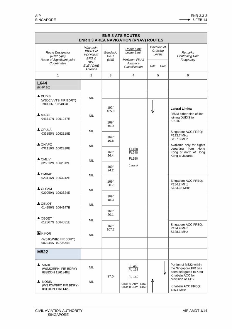
AIP ENR 3.3-3 SINGAPORE 6 FEB 14
CIVIL AVIATION AUTHORITY AIP AMDT 1/14 SINGAPORE
ENR 3 ATS ROUTES ENR 3.3 AREA NAVIGATION (RNAV) ROUTES
Route Designator (RNP type)
Name of Significant point Coordinates
Way-point IDENT of
VOR/DME BRG & DIST
ELEV DME Antenna
Geodesic DIST (NM)
Upper Limit Lower Limit
Minimum Flt Alt
Airspace Classification
Direction of Cruising Levels
Remarks Controlling Unit
Frequency
Odd
Even
1 2 3 4 5 6
L644 (RNP 10)
DUDIS
NIL
NIL
NIL
NIL
NIL
NIL
NIL
NIL
NIL
NIL
(WSJC/VVTS FIR BDRY) 070000N 1064834E
192° 165.8
FL460 FL240
FL250
Class A
Lateral Limits:
25NM either side of line joining DUDIS to KIKOR. Singapore ACC FREQ: P123.7 MHz S127.3 MHz
Available only for flights departing from Hong Kong or north of Hong Kong to Jakarta.
MABLI
041717N 1061247E 169° 45.9
OPULA
033155N 1062118E 169° 10.8
ONAPO
032116N 1062318E 169° 26.4
OMLIV
025512N 1062812E 169° 24.2
OMBAP
023116N 1063242E 169° 30.7
Singapore ACC FREQ: P134.2 MHz S133.35 MHz
OLSAM
020059N 1063824E 169° 18.3
OBLOT
014256N 1064147E 169° 20.1
OBGET
012307N 1064531E 169° 107.2
Singapore ACC FREQ: P134.4 MHz S128.1 MHz
KIKOR
(WSJC/WIIZ FIR BDRY) 002244S 1070524E
M522
VINIK
(WSJC/RPHI FIR BDRY) 083830N 1161348E
NODIN
(WSJC/WBFC FIR BDRY) 081100N 1161142E
NIL
NIL
27.5
FL 460 FL 135
FL 140
Class A–ABV FL150 Class B-BLW FL150
Portion of M522 within the Singapore FIR has been delegated to Kota Kinabalu ACC for provision of ATS Kinabalu ACC FREQ: 126.1 MHz
ENR 3.3-4 AIP 6 FEB 14 SINGAPORE
AIP AMDT 1/14 CIVIL AVIATION AUTHORITY SINGAPORE
ENR 3 ATS ROUTES ENR 3.3 AREA NAVIGATION (RNAV) ROUTES
Route Designator
(RNP Type) Name of Significant Points
Coordinates
Way-point IDENT of
VOR/DME BRG & DIST ELEV DME
Antenna
Geodesic
DIST (NM)
Upper Limit Lower Limit
Minimum Flt Alt Airspace
Classification
Direction of Cruising Levels
Remarks Controlling Unit
Frequency Odd Even
1 2 3 4 5 6
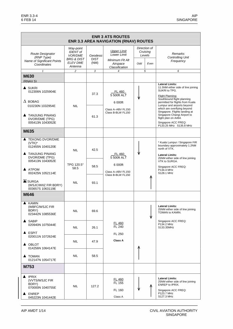
M630 (RNAV 5)
SUKRI
012306N 1025904E
∆ BOBAG
010230N 1032954E
TANJUNG PINANG DVOR/DME (TPG) 005413N 1043052E
NIL
37.3
__FL 460_ 5 500ft ALT
6 000ft
Class A–ABV FL150 Class B-BLW FL150
Lateral Limits: 11.5NM either side of line joining SUKRI to TPG.
Flight Planning: Southbound flight planning permitted for flights from Kuala Lumpur and airports beyond
which are overflying beyond Singapore. Flights landing at Singapore Changi Airport to flight plan on A464.
Singapore ACC FREQ: P133.25 MHz S135.8 MHz
61.3
M635
TEKONG DVOR/DME (VTK)* 012455N 1040120E
TANJUNG PINANG DVOR/DME (TPG) 005413N 1043052E
ATPOM
002425N 1052114E
SURGA (WSJC/WIIZ FIR BDRY) 003657S 1063119E
NIL
TPG 120.5° 58.5
NIL
42.5
__FL 460_ 5 500ft ALT
6 000ft
Class A–ABV FL150 Class B-BLW FL150
* Kuala Lumpur / Singapore FIR boundary approximately 1.2NM north of VTK. Lateral Limits: 25NM either side of line joining VTK to SURGA.
Singapore ACC FREQ: P134.4 MHz S128.1 MHz
58.5
93.1
M646
KAMIN (WBFC/WSJC FIR BDRY) 023442N 1085536E
SABIP 020940N 1075044E
ESPIT
020011N 1072624E
OBLOT
014256N 1064147E
TOMAN
012147N 1054717E
NIL 69.6
FL 460 FL 240
FL 250
Class A
Lateral Limits: 25NM either side of line joining TOMAN to KAMIN.
Singapore ACC FREQ: P134.2 MHz S133.35MHz NIL 26.1
NIL 47.9
NIL 58.5
M753
IPRIX (VVTS/WSJC FIR BDRY) 070000N 1040755E
ENREP 045223N 1041442E
NIL
127.2
FL 460 FL 155
FL 160
Class A
Lateral Limits: 25NM either side of line joining ENREP to IPRIX.
Singapore ACC FREQ: P123.7 MHz S127.3 MHz

AIP ENR 3.3-9 SINGAPORE 6 FEB 14
CIVIL AVIATION AUTHORITY AIP AMDT 1/14 SINGAPORE
ENR 3. ATS ROUTES ENR 3.3 AREA NAVIGATION (RNAV) ROUTES
Route Designator
(RNP Type) Name of Significant Points
Coordinates
Way-point IDENT of VOR/DME BRG/ DIST ELEV DME
Antenna
Great Circle DIST (NM)
Upper Limits Lower Limits
Minimum Flt Alt Airspace
Classification
Direction of Cruising Levels
Remarks Controlling Unit
Frequency Odd Even
1 2 3 4 5 6
M772 (RNP 10)
LAXOR
(WSJC /RPHI FIR BDRY) 094937N 1144829E
BIDAG 073101N 1135544E
ASISU (WBFC /WSJC FIR BDRY) 055906N 1132046E
NIL
NIL
BRU 305° 113.3NM
Lateral Limits: 25NM either side of line joining ASISU to LAXOR. Available only for flights departing from Jakarta to Hong Kong or to destinations beyond Hong Kong.
020° 147.5
FL 460 FL 240
FL 250
Class A
020° 97.9
M774 (RNAV)
TANJUNG PINANG
DVOR/DME (TPG) 005413N 1043052E
OBDOS
002503N 1065551E
KADAR
(WSJC/WIIZ FIR BDRY)
000647S 1074342E
NIL
TPG 101.3°
148.1NM
NIL
Lateral Limits: 25NM either side of line joining TPG to KADAR.
Route from OBDOS to KADAR is RNAV10.
Singapore ACC FREQ: P134.4MHz S128.1MHz
148.1
FL 460 5 500ft ALT
6 000ft ALT
Class A-ABV FL150 Class B-BLW FL150
57.5
M904
TIDAR (WSJC/VTBB FIR BDRY)
065230.15N 1024959.82E
ODONO
063613.82N 1030129.41E
UPRON 060903.41N 1032039.98E
ENREP
045223N 1041442E
Lateral Limits: 25NM
Singapore ACC FREQ: P123.7MHz S127.3MHz
NIL
20
FL 460 FL 65
FL 70
Class A (FL290 and ABV)
NIL 33
FL 460 FL 145
FL 150
Class A (FL290 and ABV)
NIL 93
FL 460 FL 245
FL 250
Class A (FL290 and ABV)
ENR 3.3-10 AIP 6 FEB 14 SINGAPORE
AIP AMDT 1/14 CIVIL AVIATION AUTHORITY SINGAPORE
ENR 3 ATS ROUTES ENR 3.3 AREA NAVIGATION (RNAV) ROUTES
Route Designator
(RNP Type) Name of Significant Points
Coordinates
Way-point IDENT of
VOR/DME BRG & DIST ELEV DME
Antenna
Great Circle DIST (NM)
Upper Limits Lower Limits
Minimum Flt Alt Airspace
Classification
Direction of Cruising Levels
Remarks Controlling Unit
Frequency Odd Even
1 2 3 4 5 6
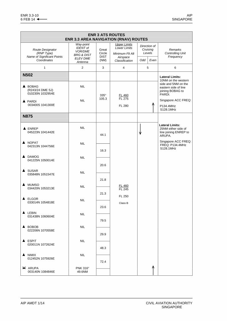
N502 Lateral Limits: 10NM on the western side and 5NM on the eastern side of line joining BOBAG to PARDI.
Singapore ACC FREQ:
P134.4MHz S128.1MHz
BOBAG
(R243/24 DME SJ) 010230N 1032954E
PARDI 003400S 1041300E
NIL
NIL
335° 105.3
FL 460 FL 275
FL 280
N875 Lateral Limits: 25NM either side of line joining ENREP to ARUPA.
Singapore ACC FREQ: FREQ: P134.4MHz S128.1MHz
ENREP
045223N 1041442E
NOPAT
042313N 1044756E
DAMOG
041225N 1050014E
SUSAR
035848N 1051547E
MUMSO
034420N 1053213E
ELGOR
033014N 1054818E
LEBIN
031438N 1060604E
BOBOB
022206N 1070558E
ESPIT
020011N 1072624E
NIMIX
012452N 1075926E
ARUPA 003140N 1084846E
NIL
NIL
NIL
NIL
NIL
NIL
NIL
NIL
NIL
NIL
PNK 316° 49.6NM
44.1
FL 460 FL 245
FL 250
Class B
16.3
20.6
21.8
21.3
23.6
79.5
29.9
48.3
72.4

AIP WSSS AD 2-1SINGAPORE 6 FEB 14
AD 2 AERODROMES
WSSS AD 2.1 AERODROME LOCATION INDICATOR AND NAME
WSSS - SINGAPORE/Singapore Changi International
WSSS AD 2.2 AERODROME GEOGRAPHICAL AND ADMINISTRATIVE DATA
1 ARP coordinates and site at AD 012133.16N 1035921.57E (Control Tower)
2 Direction and distance from (city) 061°, 17.2km from City Centre (The Fullerton, Singapore)
3 Elevation/Reference temperature 6.66m (21.85ft) / 32.4°C
4 Geoid Undulation (AD elevation position) 10.29m
5 MAG VAR /Annual change 27’E (2010) / negligible
6 AD Administration, address, telephone, telefax, AFS
RWY 02L/20R and RWY 02C/20CChangi Airport Group (Singapore) Pte LtdSingapore Changi AirportP.O.Box 168, Singapore 918146Tel: (65)65956868 or (65)65423223AFS: WSSSYAYX
RWY 02R/20LRepublic of Singapore Air ForceHeadquarters, Changi Air Base508A, Cranwell RoadSIngapore 509863Tel: (65) 65864033 (Base Operations)
7 Types of traffic permitted IFR
8 Remarks
a)
b)
c)
d)
e)
f)
g)
Scheduled Closure Periods for RWY 02L/20R and RWY 02C/20C: see AIP page WSSS AD 2-12.
Not available to all non-scheduled civil aircraft types of 40-seater or below except in special circumstances. Aircraft larger than the above category shall not plan their arrival between 0900-1559UTC.
Aircraft shall leave nose-in position (90 deg) with the aid of aircraft tow tractors. Reverse thrust or variable pitch propellers shall not be used. Aircraft operators shall make suitable arrangements.
PPR for aircraft not equipped with RTF.
A subsonic jet aircraft, unless otherwise exempted, is not permitted to operate in Singapore unless it possesses a noise certificate stating that it meets the noise standards of ICAO Annex 16, Volume 1, Chapter 3, or equivalent. The noise certificate may also take the form of a suitable statement contained in another document approved by the State of Registry of the aircraft.
Direct transit area: Overnight transit in Singapore City, TEL: (65)65956868 or (65)65423223
RWY 02R/20L is solely for use by Republic of Singapore Air Force (RSAF) aircraft.
WSSS AD 2.3 OPERATIONAL HOURS
1 Aerodrome Administration:
RWY 02L/20R and RWY 02C/20C H24
RWY 02R/20L 2300-1100 SUN/MON to THU/FRI. Prior permission required from RSAF Headquarters via Changi Operations outside these hours and on public holidays.
2 Customs and Immigration H24 5 ATS Reporting Office H24
3 Health and Sanitation H24 6 MET Briefing Office H24
4 AIS Briefing Office H24 7 Air Traffic Services H24
CIVIL AVIATION AUTHORITY AIP AMDT 1/14SINGAPORE
WSSS AD 2-2 AIP6 FEB 14 SINGAPORE
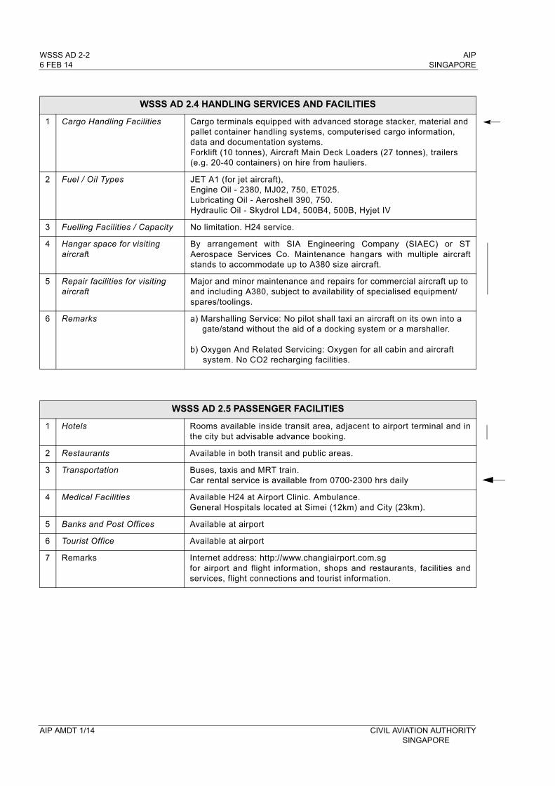
WSSS AD 2.4 HANDLING SERVICES AND FACILITIES
1 Cargo Handling Facilities Cargo terminals equipped with advanced storage stacker, material and pallet container handling systems, computerised cargo information, data and documentation systems. Forklift (10 tonnes), Aircraft Main Deck Loaders (27 tonnes), trailers (e.g. 20-40 containers) on hire from hauliers.
2 Fuel / Oil Types JET A1 (for jet aircraft), Engine Oil - 2380, MJ02, 750, ET025. Lubricating Oil - Aeroshell 390, 750. Hydraulic Oil - Skydrol LD4, 500B4, 500B, Hyjet IV
3 Fuelling Facilities / Capacity No limitation. H24 service.
4 Hangar space for visiting aircraft
By arrangement with SIA Engineering Company (SIAEC) or ST Aerospace Services Co. Maintenance hangars with multiple aircraft stands to accommodate up to A380 size aircraft.
5 Repair facilities for visiting aircraft
Major and minor maintenance and repairs for commercial aircraft up to and including A380, subject to availability of specialised equipment/spares/toolings.
6 Remarks a) Marshalling Service: No pilot shall taxi an aircraft on its own into a gate/stand without the aid of a docking system or a marshaller.
b) Oxygen And Related Servicing: Oxygen for all cabin and aircraft system. No CO2 recharging facilities.
WSSS AD 2.5 PASSENGER FACILITIES
1 Hotels Rooms available inside transit area, adjacent to airport terminal and in the city but advisable advance booking.
2 Restaurants Available in both transit and public areas.
3 Transportation Buses, taxis and MRT train.Car rental service is available from 0700-2300 hrs daily
4 Medical Facilities Available H24 at Airport Clinic. Ambulance. General Hospitals located at Simei (12km) and City (23km).
5 Banks and Post Offices Available at airport
6 Tourist Office Available at airport
7 Remarks Internet address: http://www.changiairport.com.sgfor airport and flight information, shops and restaurants, facilities and services, flight connections and tourist information.
AIP AMDT 1/14 CIVIL AVIATION AUTHORITYSINGAPORE
AIP WSSS AD 2-5.1 SINGAPORE 6 FEB 14
CIVIL AVIATION AUTHORITY AIP AMDT 1/14 SINGAPORE
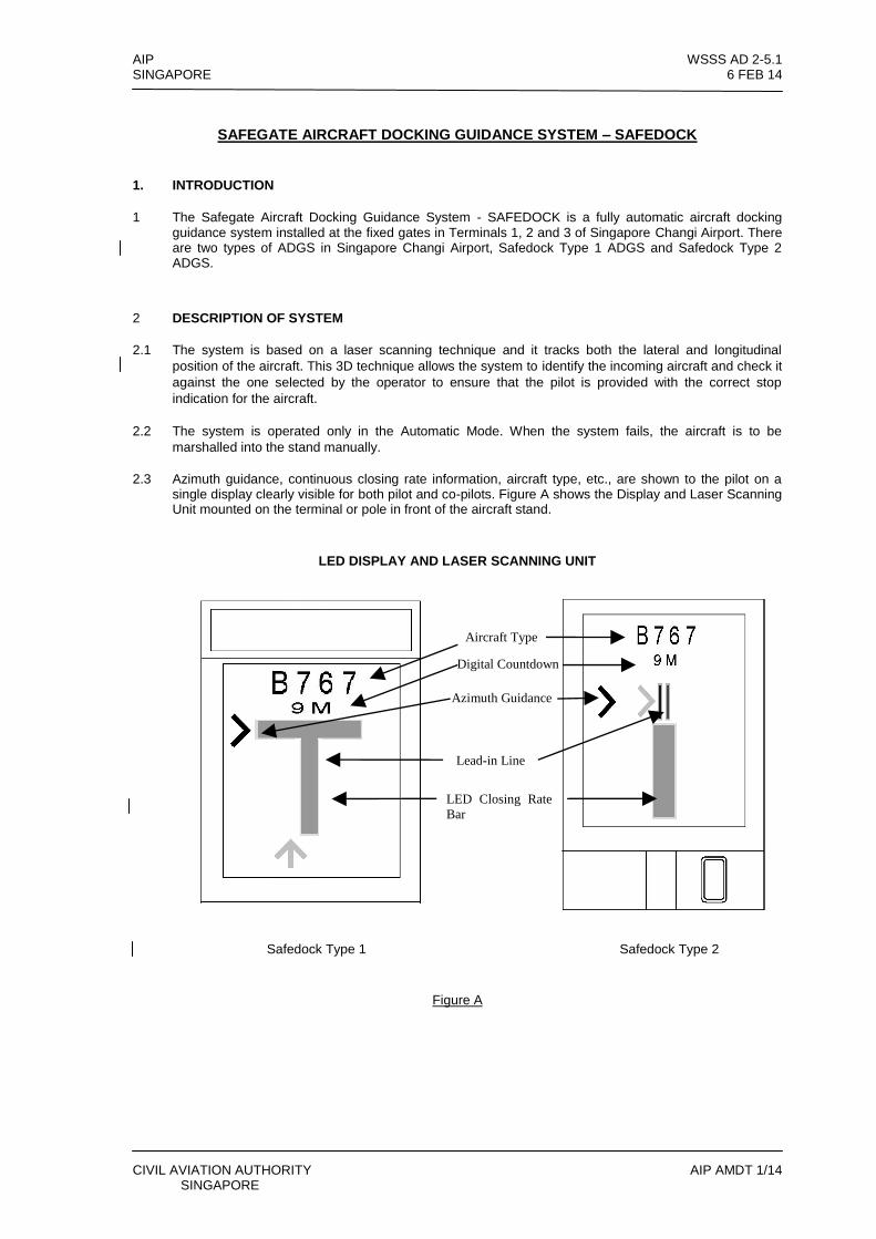
SAFEGATE AIRCRAFT DOCKING GUIDANCE SYSTEM – SAFEDOCK
1. INTRODUCTION
1 The Safegate Aircraft Docking Guidance System - SAFEDOCK is a fully automatic aircraft docking guidance system installed at the fixed gates in Terminals 1, 2 and 3 of Singapore Changi Airport. There are two types of ADGS in Singapore Changi Airport, Safedock Type 1 ADGS and Safedock Type 2 ADGS.
2 DESCRIPTION OF SYSTEM
2.1 The system is based on a laser scanning technique and it tracks both the lateral and longitudinal
position of the aircraft. This 3D technique allows the system to identify the incoming aircraft and check it
against the one selected by the operator to ensure that the pilot is provided with the correct stop
indication for the aircraft.
2.2 The system is operated only in the Automatic Mode. When the system fails, the aircraft is to be
marshalled into the stand manually.
2.3 Azimuth guidance, continuous closing rate information, aircraft type, etc., are shown to the pilot on a single display clearly visible for both pilot and co-pilots. Figure A shows the Display and Laser Scanning Unit mounted on the terminal or pole in front of the aircraft stand.
LED DISPLAY AND LASER SCANNING UNIT
Safedock Type 1 Safedock Type 2
Figure A
Aircraft Type
Digital Countdown
Azimuth Guidance
Lead-in Line
LED Closing Rate
Bar
WSSS AD 2-5.2 AIP 6 FEB 14 SINGAPORE
AIP AMDT 1/14 CIVIL AVIATION AUTHORITY SINGAPORE
3. DOCKING PROCEDURES
3.1 Check that the correct aircraft type is displayed. The scrolling
arrows indicate that the system is activated (see figure 1).
3.2 Follow the lead-in line.
3.3 When the aircraft has been caught by the scanning unit, the
scanning unit checks that the aircraft is the correct type and
the display provides azimuth guidance information. When the
solid yellow closing rate bar appears, the aircraft is being
tracked by the system. (see figure 2).
3.4 Look for the flashing red arrow and solid yellow arrow which
provide azimuth guidance information. The flashing red arrow
shows which direction to steer, while the solid yellow arrow
gives an indication of how far the aircraft is off the centreline
(see figures 2 and 3).
3.5 When the aircraft is 15m from the stop position, closing rate
information is given. “Distance to go” is indicated by turning off one row of LEDs (Laser Electronic Displays) for every half metre that the aircraft advances towards the stop position. From 15m to the stop position, a digital display will indicate the distance from the stop position for every 1m. At 3m from the stop position, the display will indicate the distance from the stop position for every 0.2m (see figures 3 and 4).
3.6 When the correct stop position is reached, all of the LEDs for
the closing rate bar will be off, the word “STOP” will appear in the display. For Safedock Type 1 ADGS, the word “STOP” will be displayed in red with red border. For Safedock Type 2 ADGS, the word “STOP” will be displayed in yellow and two red, rectangular fields will light in the azimuth guidance area of the display (see figure 5).
3.7 If the aircraft stops in the correct position, “OK” will be
displayed after a few seconds (see figure 6).
been caught by the scan
Figure 1 System tracking for aircraft.
Figure 2 Aircraft tracked by the system.
( depicts flashing red arrow.)
( or depicts solid yellow arrow.)
Figure 3 LED closing rate bar starts diminishing when the aircraft is 15m from stopbar at one row for every 0.5m that the aircraft moves forward.
Figure 4 LED closing rate bar getting shorter as aircraft moves nearer to stopbar.
Figure 5 Pilot to stop aircraft when “STOP” is displayed.
Figure 6 Informs the pilot that everything is in order and he can shutdown engine.
Safedock
Type 1 Safedock
Type 2
AIP WSSS AD 2-5.3 SINGAPORE 6 FEB 14
CIVIL AVIATION AUTHORITY AIP AMDT 1/14 SINGAPORE
3.8 If the aircraft has gone past the correct stop position, the
display will show “TOO FAR” (see figure 7).
3.9 If some object is blocking the view towards the approaching aircraft or the detected aircraft is lost before 12m to the correct stop position, the system will show “WAIT” (see figure 8).
3.10 The aircraft must be identified at least 12m before the correct stop position. Otherwise, the display will show “WAIT”, “STOP” and “ID FAIL” (see figures 8, 9 and 10).
4. SAFETY MEASURES
4.1 Pilot should not turn an aircraft into the aircraft stand if the
docking system is not activated or on seeing a wrong aircraft
type displayed on the system.
4.2 Pilot should not proceed beyond the passenger loading bridges
unless the scrolling arrows (see figure 1) have been
superseded by the solid yellow closing rate bar (see figure 2).
4.3 When using the docking system, pilots are to taxi into the
aircraft stand at minimum speed. The system will display
“SLOW” to inform the pilot if the aircraft’s taxiing speed
exceeded 1.2 m/s (see figure 11).
4.4 In bad weather conditions, the docking system may go into downgrade mode. The display will show the aircraft type and “SLOW” and the scrolling arrows are disabled (see figure 12). When the system has detected the aircraft, the solid yellow closing rate bar appears. Docking process is allowed to continue but pilots should exercise caution.
4.5 To avoid overshooting, pilots are advised to approach the stop
position slowly and observe the closing rate information
displayed. Pilots should stop the aircraft immediately when
seeing the “STOP” or “WAIT” display, when given the stop
sign by the aircraft marshaller or is unsure of the information
displayed during the docking process.
4.6 Pilot should stop the aircraft immediately if the display goes
black during the docking process. The aircraft is to be
marshalled into the stand manually.
been caugh
Figure 7 Indicates that the aircraft has gone beyond the stopbar.
Pilot to check with ground engineer on the next move.
Figure 8 Pilot to hold aircraft and wait for other instructions from the display.
Figure 9 “STOP" may appear suddenly in the process of docking. Pilot to stop immediately and wait for further instructions.
Figure 10 Indicates the system fails to identify the aircraft.
Figure 11 Informs the pilot that the aircraft travelling speed is too fast. Pilot to slow down the speed. Similar for both Safedock Type 1 and Type 2
Figure 12 The system goes into ‘downgrade’ mode due to bad weather conditions, pilot will be prompted to slow down. Docking process will continue when the aircraft is detected but pilot should exercise caution.
Safedock
Type 1
Safedock
Type 2

AIP SINGAPORE
INTENTIONALLY
LEFT
BLANK
CIVIL AVIATION AUTHORITY SINGAPORE
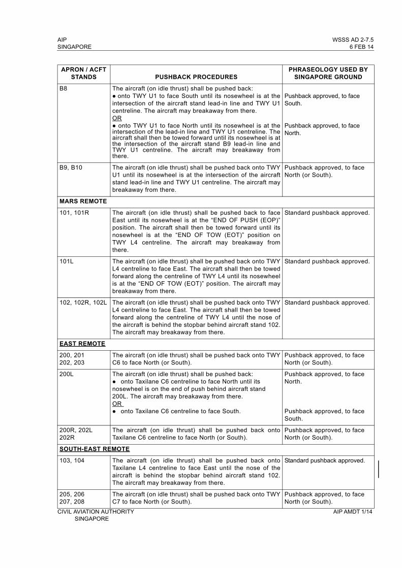
AIP WSSS AD 2-7.5SINGAPORE 6 FEB 14
APRON / ACFT STANDS PUSHBACK PROCEDURES
PHRASEOLOGY USED BY SINGAPORE GROUND
B8 The aircraft (on idle thrust) shall be pushed back: onto TWY U1 to face South until its nosewheel is at the intersection of the aircraft stand lead-in line and TWY U1 centreline. The aircraft may breakaway from there. OR onto TWY U1 to face North until its nosewheel is at the intersection of the lead-in line and TWY U1 centreline. The aircraft shall then be towed forward until its nosewheel is at the intersection of the aircraft stand B9 lead-in line and TWY U1 centreline. The aircraft may breakaway from there.
Pushback approved, to face South.
Pushback approved, to face North.
B9, B10 The aircraft (on idle thrust) shall be pushed back onto TWY U1 until its nosewheel is at the intersection of the aircraft stand lead-in line and TWY U1 centreline. The aircraft may breakaway from there.
Pushback approved, to face North (or South).
MARS REMOTE
101, 101R The aircraft (on idle thrust) shall be pushed back to face East until its nosewheel is at the “END OF PUSH (EOP)” position. The aircraft shall then be towed forward until its nosewheel is at the “END OF TOW (EOT)” position on TWY L4 centreline. The aircraft may breakaway from there.
Standard pushback approved.
101L The aircraft (on idle thrust) shall be pushed back onto TWY L4 centreline to face East. The aircraft shall then be towed forward along the centreline of TWY L4 until its nosewheel is at the “END OF TOW (EOT)” position. The aircraft may breakaway from there.
Standard pushback approved.
102, 102R, 102L The aircraft (on idle thrust) shall be pushed back onto TWY L4 centreline to face East. The aircraft shall then be towed forward along the centreline of TWY L4 until the nose of the aircraft is behind the stopbar behind aircraft stand 102. The aircraft may breakaway from there.
Standard pushback approved.
EAST REMOTE
200, 201202, 203
The aircraft (on idle thrust) shall be pushed back onto TWY C6 to face North (or South).
Pushback approved, to face North (or South).
200L The aircraft (on idle thrust) shall be pushed back:onto Taxilane C6 centreline to face North until its nosewheel is on the end of push behind aircraft stand 200L. The aircraft may breakaway from there.OR onto Taxilane C6 centreline to face South.
Pushback approved, to face North.
Pushback approved, to face South.
200R, 202L 202R
The aircraft (on idle thrust) shall be pushed back onto Taxilane C6 centreline to face North (or South).
Pushback approved, to face North (or South).
SOUTH-EAST REMOTE
103, 104 The aircraft (on idle thrust) shall be pushed back onto Taxilane L4 centreline to face East until the nose of the aircraft is behind the stopbar behind aircraft stand 102. The aircraft may breakaway from there.
Standard pushback approved.
205, 206 207, 208
The aircraft (on idle thrust) shall be pushed back onto TWY C7 to face North (or South).
Pushback approved, to face North (or South).
CIVIL AVIATION AUTHORITY AIP AMDT 1/14 SINGAPORE
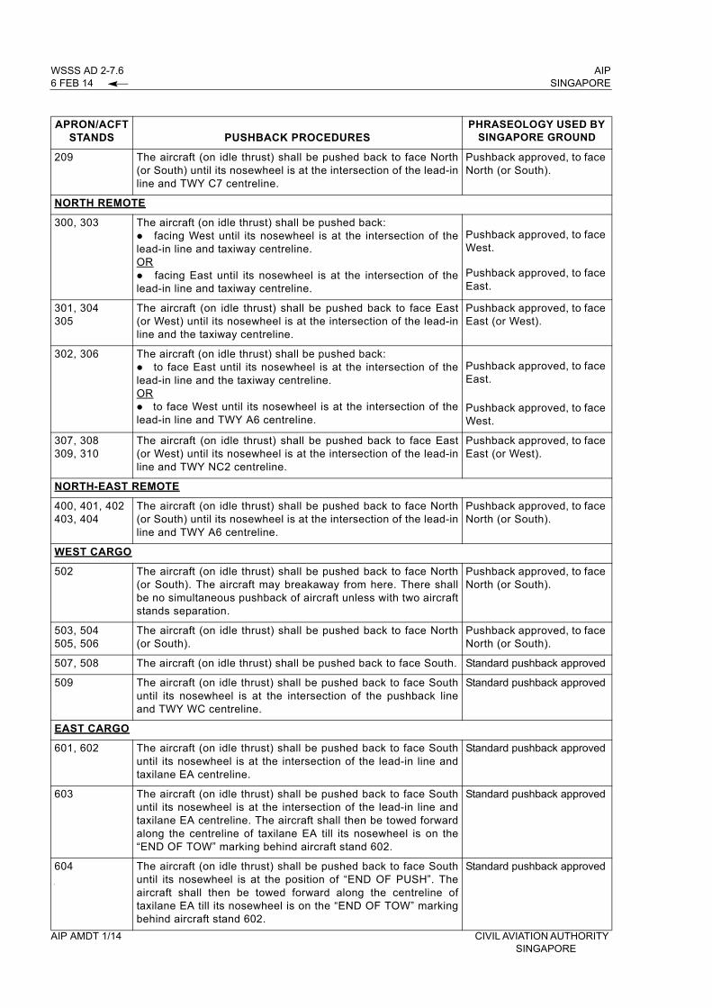
WSSS AD 2-7.6 AIP 6 FEB 14 SINGAPORE
APRON/ACFT STANDS PUSHBACK PROCEDURES
PHRASEOLOGY USED BY SINGAPORE GROUND
209 The aircraft (on idle thrust) shall be pushed back to face North (or South) until its nosewheel is at the intersection of the lead-in line and TWY C7 centreline.
Pushback approved, to face North (or South).
NORTH REMOTE
300, 303 The aircraft (on idle thrust) shall be pushed back: facing West until its nosewheel is at the intersection of the lead-in line and taxiway centreline.OR facing East until its nosewheel is at the intersection of the lead-in line and taxiway centreline.
Pushback approved, to face West.
Pushback approved, to face East.
301, 304 305
The aircraft (on idle thrust) shall be pushed back to face East (or West) until its nosewheel is at the intersection of the lead-in line and the taxiway centreline.
Pushback approved, to face East (or West).
302, 306 The aircraft (on idle thrust) shall be pushed back: to face East until its nosewheel is at the intersection of the lead-in line and the taxiway centreline.OR to face West until its nosewheel is at the intersection of the lead-in line and TWY A6 centreline.
Pushback approved, to face East.
Pushback approved, to face West.
307, 308309, 310
The aircraft (on idle thrust) shall be pushed back to face East (or West) until its nosewheel is at the intersection of the lead-in line and TWY NC2 centreline.
Pushback approved, to face East (or West).
NORTH-EAST REMOTE
400, 401, 402 403, 404
The aircraft (on idle thrust) shall be pushed back to face North (or South) until its nosewheel is at the intersection of the lead-in line and TWY A6 centreline.
Pushback approved, to face North (or South).
WEST CARGO
502 The aircraft (on idle thrust) shall be pushed back to face North (or South). The aircraft may breakaway from here. There shall be no simultaneous pushback of aircraft unless with two aircraft stands separation.
Pushback approved, to face North (or South).
503, 504 505, 506
The aircraft (on idle thrust) shall be pushed back to face North (or South).
Pushback approved, to face North (or South).
507, 508 The aircraft (on idle thrust) shall be pushed back to face South. Standard pushback approved
509 The aircraft (on idle thrust) shall be pushed back to face South until its nosewheel is at the intersection of the pushback line and TWY WC centreline.
Standard pushback approved
EAST CARGO
601, 602 The aircraft (on idle thrust) shall be pushed back to face South until its nosewheel is at the intersection of the lead-in line and taxilane EA centreline.
Standard pushback approved
603 The aircraft (on idle thrust) shall be pushed back to face South until its nosewheel is at the intersection of the lead-in line and taxilane EA centreline. The aircraft shall then be towed forward along the centreline of taxilane EA till its nosewheel is on the “END OF TOW” marking behind aircraft stand 602.
Standard pushback approved
604 The aircraft (on idle thrust) shall be pushed back to face South until its nosewheel is at the position of “END OF PUSH”. The aircraft shall then be towed forward along the centreline of taxilane EA till its nosewheel is on the “END OF TOW” marking behind aircraft stand 602.
Standard pushback approved
AIP AMDT 1/14 CIVIL AVIATION AUTHORITY SINGAPORE

AIP WSSS AD 2-11SINGAPORE 6 FEB 14
WSSS AD 2.11 METEOROLOGICAL INFORMATION PROVIDED
1 Associated MET Office Singapore Changi (WSSS)
2 Hours of service H24
3 Office responsible for TAF preparation Periods of validity
Singapore Changi (WSSS)12, 30
4 Type of landing forecast, Interval of issuance TREND
5 Briefing/consultation provided P
6 Flight documentation, Language used Charts or Tabular forms, English
7 Charts and other information available for briefing or consultation
S, U, P
8 Supplementary equipment available for providing information
HRPT: High Resolution Picture TransmissionAPT: Automatic Picture TransmissionMDWR: MET Doppler Weather RadarMAINT: Second WED of every month BTN 0200-0900ALTN period: THU following the second WED.
9 ATS units provided with information Singapore ACC, Singapore RCC
10 Additional information TEL: 65422837 (MET Office)
WSSS AD 2.12 RUNWAY PHYSICAL CHARACTERISTICS
DesignationsRWY NR TRUE BRG
Dimensions of RWY (m)
Strength (PCN) and surface of RWY and SWY
THR coordinates (THR Geoid Undulation)
THR elevation and highest elevation of TDZ of precision approach RWY
1 2 3 4 5 6
02L 023.02° 4 000 x 6072/F/B/W/UBituminous
concrete
012056.26N1035838.83E
(10.29m)
6.66m
6.23m
20R(Displaced
THR)203.02° 3 260 x 60
72/F/B/W/UBituminous
concrete
012233.95N1035920.06E
(10.29m)
4.01m
4.31m
02C 023.03° 4 000 x 6072/F/B/W/UBituminous
concrete
011943.51N1035905.86E
(10.28m)
4.32m
4.52m
20C 203.03° 4 000 x 6072/F/B/W/UBituminous
concrete
012143.37N1035956.46E
(10.28m)
4.58m
4.56m
02R 023° 2 750 x 6072/F/B/W/U
Asphalt011958.05N
1040015.26E-
20L 203° 2 750 x 6072/F/B/W/U
Asphalt012120.45N1040050.05E
-
Note: RWY 02R/20L is used solely by the Republic of Singapore Air Force (RSAF) aircraft.
CIVIL AVIATION AUTHORITY AIP AMDT 1/14SINGAPORE

WSSS AD 2-12 AIP 6 FEB 14 SINGAPORE
WSSS AD 2.12 RUNWAY PHYSICAL CHARACTERISTICS (continued)
Slope of RWY-SWY
Transverse /Longitudinal
SWY Dimensions (m)
CWYDimensions (m)
STRIPDimensions (m)
OFZ Remarks
7 8 9 10 11 12
RWY 02L0.76 / 0.24%
60 X 60 270 X 150 4 240 X 300
Yes
Scheduled closure of runways(see below)
RWY 20R1.45 / 0.25%
60 X 60 270 X 150 4 240 X 300
RWY 02C1.50 / 0.03%
60 X 60 270 X 150 4 240 X 300
RWY 20C1.38 / 0.07%
60 X 60 270 X 150 4 240 X 300
RWY 02R 150 X 60 - 3 050 X 300 -Hookwire cable installed 450m (1476ft) from the southern THR and 457m (1500ft) from the northern THR.
RWY 20L
150 X 60 - 3 050 X 300 -
Remarks (continued from above)
Scheduled Closure of RWY 02L/20R
1a)
1b)
1c)
BTN 1700-2300 on first FRI, third MON and third WED of every month (preventive maintenance work). In the event of an emergency, RWY will be re-opened within 30 minutes.
BTN 0225-0240 0630-0635 1000-1005 2300-2305 daily (inspection).In the event of an emergency, RWY will be re-opened within 5 minutes.
BTN 1745-1915 daily (maintenance). In the event of an emergency, RWY will be re-opened in 30 minutes.
Scheduled Closure of RWY 02C/20C
2a)
2b)
2c)
BTN 1700-2300 on second FRI, fourth MON and fourth WED of every month (preventive maintenance work). In the event of an emergency, RWY will be re-opened within 30 minutes.
BTN 0300-0315 0650-0655 1020-1025 1720-1730 2320-2325 daily (inspection). In the event of emergency, RWY will be re-opened within 5 minutes.
BTN 1930-2100 daily (maintenance). In the event of emergency, RWY will be re-opened in 30 minutes.
AIP AMDT 1/14 CIVIL AVIATION AUTHORITYSINGAPORE
AIP WSSS AD 2-27SINGAPORE 6 FEB 14
13. TAKE-OFF AND LANDING
13.1 Departing aircraft will normally be directed by ATC to use the full length of the runway for take-off. On obtaining an ATC clearance the aircraft shall enter the runway via designated taxiways:
RWY 02C - TWY E10 or E11RWY 02L - TWY W8, W9 or W10RWY 20C - TWY E1, E2RWY 20R - TWY W1, W2
13.2 The pilot-in-command shall not take-off or land without a clearance from Aerodrome Control.
13.3 The pilot-in-command shall not run-up on the runway in use unless authorised by Aerodrome Control. Engine run-ups in the holding pan or taxiway holding point clear of the runway in use may be carried out subject to approval by Aerodrome Control.
13.4 After landing, the pilot-in-command shall vacate the runway by the shortest suitable route and to contact Ground Control who will issue specific taxi route instructions to its assigned aircraft stand.
13.5 Aircraft with radio communication failure shall vacate the runway and stop on the taxiway and watch for light signals from Aerodrome Control.
14. ARRIVING AIRCRAFT
14.1 The pilot-in-command of an arriving aircraft shall contact the appropriate Approach Control Unit 10 minutes before entering the CTR or ATZ.
15. LIGHT AIRCRAFT OPERATIONS
15.1 Light aircraft operations into and out of Singapore Changi Airport may be approved subject to the following conditions:
a) Prior permission has been granted;b) Aircraft is suitably equipped;c) Pilot is appropriately rated;d) Subject to ATC.
15.2 Flight notification shall be given by filing a flight plan.
15.3 All such operations will be regulated in accordance with IFR procedures.
WSSS AD 2.23 ADDITIONAL INFORMATION
1. BIRD CONCENTRATION IN THE VICINITY OF THE AIRPORT
1.1 A number of varieties of birds are found in Singapore throughout the year. The larger birds commonly found in Singapore Changi Airport include the following:
- cattle egrets (weighing approximately 300g each)- grey herons (weighing approximately 500g each)- brahminy kites (weighing approximately 600g each)
1.2 There could be an increase in bird activities during the migratory months of September to April. During this period, migratory birds may use the airport as their feeding ground.
CIVIL AVIATION AUTHORITY AIP AMDT 1/14SINGAPORE
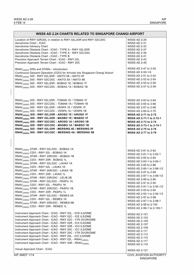
WSSS AD 2-28 AIP6 FEB 14 SINGAPORE
WSSS AD 2.24 CHARTS RELATED TO SINGAPORE CHANGI AIRPORT
Location of RWY 02R/20L in relation to RWY 02L/20R and RWY 02C/20CAerodrome Chart - ICAOAerodrome Advisory ChartAerodrome Obstacle Chart - ICAO - TYPE A - RWY 02L/20RAerodrome Obstacle Chart - ICAO - TYPE A - RWY 02C/20CAerodrome Obstacle Chart - ICAO - TYPE BPrecision Approach Terrain Chart - ICAO - RWY 02LPrecision Approach Terrain Chart - ICAO - RWY 20C
RNAV(GNSS) SIDs and STARs - IntroductionContinuous Descent Operation (CDO) for Arrivals into Singapore Changi AirportRNAV(GNSS) SID - RWY 02L/20R - ANITO 5E / ANITO 4FRNAV(GNSS) SID - RWY 02C/20C - ANITO 5A / ANITO 4BRNAV(GNSS) SID - RWY 02L/20R - BOBAG 1E / BOBAG 1FRNAV(GNSS) SID - RWY 02C/20C - BOBAG 1A / BOBAG 1B
RNAV(GNSS) SID - RWY 02L/20R - TOMAN 1E / TOMAN 1FRNAV(GNSS) SID - RWY 02C/20C - TOMAN 1A / TOMAN 1BRNAV(GNSS) SID - RWY 02L/20R - VENPA 1E / VENPA 1FRNAV(GNSS) SID - RWY 02C/20C - VENPA 1A / VENPA 1BRNAV(GNSS) SID - RWY 02L/20R - AROSO 1E / AROSO 1FRNAV(GNSS) SID - RWY 02L/20R - MASBO 1E / MABSO 1FRNAV(GNSS) SID - RWY 02C/20C - AROSO 1A / AROSO 1BRNAV(GNSS) SID - RWY 02C/20C - MASBO 1A / MABSO 1BRNAV(GNSS) SID - RWY 02L/20R - MERSING 4E / MERSING 5FRNAV(GNSS) SID - RWY 02C/20C - MERSING 4A / MERSING 5B
RNAV(GNSS) STAR - RWY 02L/02C - BOBAG 1A RNAV(GNSS) CDO - RWY 02L - BOBAG 1KRNAV(GNSS) STAR - RWY 20R/20C - BOBAG 1B RNAV(GNSS) CDO - RWY 20R - BOBAG 1LRNAV(GNSS) STAR - RWY 02L/02C - LAVAX 1A RNAV(GNSS) CDO - RWY 02L - LAVAX 1KRNAV(GNSS) STAR - RWY 20R/20C - LAVAX 1BRNAV(GNSS) CDO - RWY 20R - LAVAX 1LRNAV(GNSS) STAR - RWY 20R/20C - LELIB 2BRNAV(GNSS) STAR - RWY 02L/02C - PASPU 1A RNAV(GNSS) CDO - RWY 02L - PASPU 1KRNAV(GNSS) STAR - RWY 20R/20C - PASPU 1BRNAV(GNSS) CDO - RWY 20R - PASPU 1L RNAV(GNSS) STAR - RWY 02L/02C - REMES 5ARNAV(GNSS) CDO - RWY 02L - REMES 1K RNAV(GNSS) STAR - RWY 20R/20C - REMES 6BRNAV(GNSS) CDO - RWY 20R - REMES 1L
Instrument Approach Chart - ICAO - RWY 02L - ICW ILS/DMEInstrument Approach Chart - ICAO - RWY 02C - ICE ILS/DMEInstrument Approach Chart - ICAO - RWY 02C - VTK DVOR/DMEInstrument Approach Chart - ICAO - RWY 02R - ICX ILS/DMEInstrument Approach Chart - ICAO - RWY 20R - ICH ILS/DMEInstrument Approach Chart - ICAO - RWY 20C - ICC ILS/DMEInstrument Approach Chart - ICAO - RWY 20C - VTK DVOR/DMEInstrument Approach Chart - ICAO - RWY 20L - ICZ ILS/DMEInstrument Approach Chart - ICAO - RWY 02L - RNAV(GNSS)
Instrument Approach Chart - ICAO - RWY 20R - RNAV(GNSS)
Visual Approach Chart - ICAO
WSSS AD 2-29WSSS AD 2-31WSSS AD 2-33WSSS AD 2-37WSSS AD 2-39WSSS AD 2-41WSSS AD 2-43WSSS AD 2-45
WSSS AD 2-47 to 2-50WSSS AD 2-50-1/4WSSS AD 2-51 to 2-52WSSS AD 2-53 to 2-54WSSS AD 2-55 to 2-56WSSS AD 2-57 to 2-58
WSSS AD 2-63 to 2-64WSSS AD 2-65 to 2-66WSSS AD 2-67 to 2-68WSSS AD 2-69 to 2-70WSSS AD 2-71 to 2-72WSSS AD 2-71-1 to 2-72-1WSSS AD 2-73 to 2-74WSSS AD 2-73-1 to 2-74-1WSSS AD 2-75 to 2-76WSSS AD 2-77 to 2-78
WSSS AD 2-81 to 2-82WSSS AD 2-81-1 to 2-82-1WSSS AD 2-83 to 2-84WSSS AD 2-83-1 to 2-84-1WSSS AD 2-85 to 2-86WSSS AD 2-85-1 to 2-86-1/2WSSS AD 2-87 to 2-88WSSS AD 2-87-1 to 2-88-1/2WSSS AD 2-89 to 2-90WSSS AD 2-91 to 2-92WSSS AD 2-91-1 to 2-92-1/2WSSS AD 2-93 to 2-94WSSS AD 2-93-1 to 2-94-1/2WSSS AD 2-97 to 2-98WSSS AD 2-97-1 to 2-98-1WSSS AD 2-99 to 2-100WSSS AD 2-99-1 to 2-100-1
WSSS AD 2-101WSSS AD 2-103WSSS AD 2-105WSSS AD 2-107WSSS AD 2-109WSSS AD 2-111WSSS AD 2-113WSSS AD 2-115WSSS AD 2-117WSSS AD 2-119
WSSS AD 2-121
AIP AMDT 1/14 CIVIL AVIATION AUTHORITY SINGAPORE

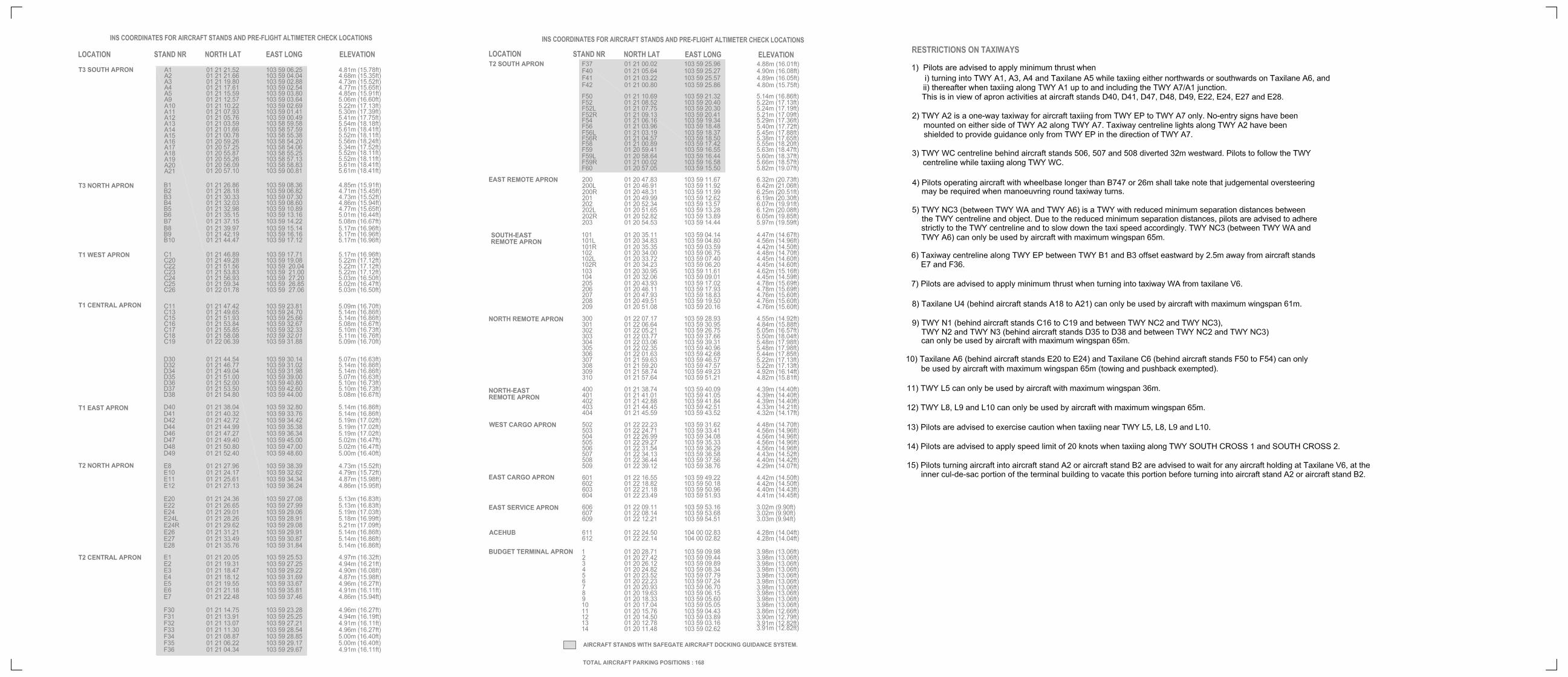

AIP WSSL AD 2-3-1SINGAPORE 6 FEB 14
WSSL AD 2.8 APRONS, TAXIWAYS AND CHECK LOCATIONS/POSITIONS DATA
1 Apron surface and strength Surface: Bituminous concrete (aircraft stand C7)Strength: PCN47/F/C/X/USurface: Concrete (all other aircraft stands)Strength: PCN45/R/C/W/U
2 Taxiway width, surface and strength
Width: 23m (75.5ft), 18m (59.1ft)TWY EC48m (26.2ft) TWY WS1 and WS2
Surface: Bituminous concreteStrength: PCN47/F/C/X/U
3 Remarks
WSSL AD 2.9 SURFACE MOVEMENT GUIDANCE AND CONTROL SYSTEM AND MARKINGS
1 Use of aircraft stand ID signs, TWY guidelines and visual docking/parking guidance system of aircraft stands
Taxiing guidance signs at all intersections with TWY and RWY at all holding positions. Guidelines at apron. Nose-in guidance at aircraft stands.
2 RWY and TWY markings and LGT
RWY LGT: refer to page WSSL AD 2-5 for details. RWY Turn Pad LGT / Markings: Only AVBL at THR RWY 03. Yellow turnpad centreline.
TWY LGT: TWY Edge LGT: Blue LGT, inset, elevated and omni-directional.TWY markings: Yellow TWY centreline.
MARKING AIDS: Threshold, touchdown zone, centre line stripes and RWY designation. RWY width outline from bituminous concrete surface by white lines.
AIMING POINT MARKINGS: RWY 03: coincident with PAPI origin located 311.6m from THR respectively.RWY 21: coincident with PAPI origin located 232.8m from THR respectively.
3 Stop Bars: Red LGT across taxiways W1, W2, W3, E2, E3 and E4, flushed with TWY surface.
CIVIL AVIATION AUTHORITY AIP AMDT 1/14SINGAPORE

WSSL AD 2-3-2 AIP6 FEB 14 SINGAPORE
WSSL AD 2.9 SURFACE MOVEMENT GUIDANCE AND CONTROL SYSTEM AND MARKINGS
4 Remarks
a)
b)
c)
d)
e)
f)
g)
h)
i)
j)
k)
Aircraft operators/ground handlers shall be responsible for the safe and smooth operations of aircraft at the aircraft stands.
To enhance airside safety, all aircraft larger than Code A (i.e. up to but not including 15m wingspan) shall be marshalled into the aircraft stands.
Arriving aircraft will be assigned an aircraft stand. A ground handler shall marshall the aircraft into the aircraft stand.
A ground handler shall be at the aircraft stand when the aircraft is ready to depart. When the pilot signals that he is ready to taxi, the ground handler shall ensure that the area around the aircraft is clear before marshalling the aircraft out of the aircraft stand.
Only Code A aircraft, Code B aircraft, aircraft type Global Express, Global 5000, Global Express XRS, Fokker 50, Fokker 100, Gulfstream 500, Gulfstream 550, ATR 72-500, DASH 7and Falcon 7X are allowed to self-power out from aircraft stands C1, C2, C3, C4, C5 and C6.
Aircraft at stand C1 shall self-power out towards the north only.
Aircraft at stand C6 shall self-power towards the south only.
Aircraft at stands C2, C3, C4 and C5 are allowed to self-power out towards the south or the north.
Aircraft can self-power in from the north as well as the south via TWY WA.
All personnel, tow tugs and equipment shall be cleared from the aircraft stand and red chevron markings on the adjacent aircraft stands before self-power out can commence.
Aircraft with wingspan larger than 28.35m are not allowed to park at aircraft stand C7. Refuelling will not be allowed at aircraft stand C7.
AIP AMDT 1/14 CIVIL AVIATION AUTHORITYSINGAPORE

AIP WSSL AD 2-5SINGAPORE 6 FEB 14
WSSL AD 2.12 RUNWAY PHYSICAL CHARACTERISTICS
DesignationsRWY NR
TRUE BRG
Dimensions of RWY (m)
Strength (PCN) and Surface of RWY and SWY
THR coordinates (THR GEOID Undulation)
THR Elevation
RWY End Elevation
Highest Elevation of Touchdown
Zone
1 2 3 4 5 6 7 8
03 033.33° 1836 x 4647/F/C/X/UBituminous
concrete
012430.845N1035143.792E
(24m)14m 5m 13m
21 213.33° 1836 x 4647/F/C/X/UBituminous
concrete
012520.789N1035216.425E
(15m)5m 14m 10m
CWY Dimensions STRIP Dimensions (m) OFZ Remarks (continued below)
9 10 11 12
60m X 150m 1956m X 150m Not applicable RESA RWY 03 - 90m X 92m RESA RWY 21 - 240m X 92m
12 Remarks:
Scheduled closure periods for RWY 03/21a) BTN 1600-2300 first FRI of EV month or second FRI if the first FRI is a public holiday. RWY CLSD to all TFC except medivac and
EMERG flights. Advance notice of 30 minutes is required for EMERG opening of RWY.b) BTN 0500-0515, 1030-1045, 1600-1615 and 2300-2315 daily for RWY inspection. Aircraft to expect delay.c) BTN 1600-1800 EV TUE and FRI of EV month. RWY CLSD to all TFC except medivac and EMERG flights. Advance notice of 30
minutes is required for EMERG opening of RWY.
Runway turn pada) A lighted turn pad with centreline marking is provided at the threshold of RWY 03 which is able to serve aircraft up to B757-200.
WSSL AD 2.13 DECLARED DISTANCES
RWY Designator TORA (m) TODA (m) ASDA (m) LDA (m) Remarks
1 2 3 4 5 6
0321
1 8361 836
1 8961 896
1 8361 836
1 8361 836
WSSL AD 2.14 APPROACH AND RUNWAY LIGHTING
RWYDesig-nator
APCH LGTTypeLEN
INTST
THRLGT
ColourWBAR
VASIS(MEHT)
PAPI
TDZLGTLEN
RWY CLLGT,LENspacing,Colour, INTST
RWY Edge LGTLEN, spacingColour, INTST
RWYEndLGT
ColourWBAR
SWYLGTLEN
Colour
1 2 3 4 5 6 7 8 9
03 Simple APCH LGT consisting of 4 rows of barettes of 3 LGT each and 1 crossbar of 13 LGT. White, ele-vated, uni-direc-tional APCH LGT and white, omni-directional CGL on top of elevated APCH LGT.
Greenwith THR IDENT LGT
PAPI 3°(both sides of RWY)2 white 2 red LGT (17.720m)3 white 1 red LGT (20.323m)4 white LGT (22.927m).ACFT with eye-to-wheel HGT greater than 6.3m are ADZ to fly with 2 white 2 red LGT visible so as to achieve sufficient wheel CLR.
Nil Nil White with yellow on last 600m of either end. Elevated, omni- directional and brilliancy controlled.
Red Nil
21 APCH LGT con-sisting of 1 row of inset APCH LGT of 4 LGT and 4 rows of barettes of 4 LGT each. White, inset uni-directional APCH LGT and white, omni-direc-tional CGL on top of White, elevated uni-directional APCH LGT.
Green with THR IDENT LGT
PAPI 3.5°(both sides of RWY)2 white 2 red LGT (17.720m)3 white 1 red LGT (19.286m)4 white LGT (20.871m).ACFT with eye-to-wheel HGT greater than 6.3m are ADZ to fly with 2 white 2 red LGT visible so as to achieve sufficient wheel CLR.
Nil Nil White with yellow on last 600m of either end. Elevated, omni-directional and brilliancy controlled.
Red Nil
RWY 21 THR and RWY END LGT symmetrically disposed in 2 groups with a gap between the groups. RWY 21 THR and RWY END LGT reinstated to inset fitting.
CIVIL AVIATION AUTHORITY AIP AMDT 1/14SINGAPORE

WSSL AD 2-6 AIP6 FEB 14 SINGAPORE
WSSL AD 2.15 OTHER LIGHTING, SECONDARY POWER SUPPLY
1 ABN/IBN location, characteristics and hours of operation
ABN: 012448.001N 1035207.961E (on top of Control Tower) ALTN FLG W G EV 2.5 SECHN and IMC
IBN: 012459.52N 1035155.84E (on top of West Substation)Flashing G ‘SL’ repeatedlyHN and IMC
2 LDI location and LGTAnemometer location and LGT
Cup anemometers and wind vanes and windsocks at ends of RWY.
3 TWY edge and centre line marking TWY Edge LGT: Blue, elevated and omni-directionalTWY Centreline Marking: Yellow
4 Secondary power supply/switch-over time
Automatic standby generator power supply available for airfield lighting.
5 Remarks Vehicles painted yellow or displaying checkered red/white or orange/white flag at highest point of vehicle. WDI lighted.
WSSL AD 2.16 HELICOPTER LANDING AREA
See charts WSSL AD 2-13 and WSSL AD 2-15
WSSL AD 2.17 ATS AIRSPACE
1 Designation and Lateral Limits
SELETAR CTR012703N 1035009E 012825N 1035009E 012900N 1035425E 012534N 1035454E thence along international boundary to 012556N 1035326E 012227N 1035158E 012232N 1035016E 012327N 1034922E 012607N 1035053E and thence an arc of 2NM radius (centred at position 012527N 1034856E) joining 012607N 1035053E and 012703N 1035009E
SELETAR CONTROL ZONE ‘A’Portion of Seletar CTR within Singapore FIR is known as Seletar CTR ‘A’.
SELETAR CONTROL ZONE ‘B’The part in the Kuala Lumpur FIR is known as Seletar CTR ‘B’ and is bounded by 012825N 1035009E, 012900N 1035425E, 012534N 1035454E thence along the Peninsular Malaysia/Singapore international boundary to 012808N 1035010E to 012825N 1035009E from GND/sea level to 3,000ft.It will be activated only with prior approval of Johor Bahru ATC.(see chart WSSL AD 2-33).
2 Vertical Limits SFC to 3,000ft ALT
3 Airspace Classification C
4 ATS Unit Call signLanguage(s)
Seletar TowerEnglish
5 Transition Altitude 11,000ft (3,350m)
6 Remarks Nil
AIP AMDT 1/14 CIVIL AVIATION AUTHORITYSINGAPORE

AIP WSSL AD 2-9SINGAPORE 6 FEB 14
3. WRONG APPROACHES AND LANDINGS OF AIRCRAFT BOUND FOR SELETAR AERODROME AND SEMBAWANG MILITARY AERODROME
3.1 INTRODUCTION
3.1.1 The attention of all pilots is drawn to the existence of RSAF Sembawang Aerodrome, 3NM to the west of Seletar Aerodrome. The runway at Sembawang is orientated in almost the same direction as the runway at Seletar Aerodrome i.e. 03/21 for Seletar Aerodrome and 05/23 for Sembawang. Due to the close proximity of these two runways, pilots are cautioned against mistaking Sembawang Aerodrome for Seletar Aerodrome and thus making an inadvertent visual landing or approach to land at Sembawang.
3.1.2 Erroneous approaches or landings usually occurred in marginal weather conditions. In almost every instance, the prevailing weather at the time of the incident contributed towards a hasty and erroneous identification of the correct aerodrome.
3.1.3 There is intensive local flying at both aerodromes during the day and night. As pilot training is the major activity at both aerodromes, the risk of collision is very great if a wrong approach or landing is made at either of the two aerodromes.
3.2 POINTS TO BEAR IN MIND WHEN APPROACHING SELETAR AD OR SEMBAWANG AD
3.2.1 The following points are highlighted to serve as a guide to assist pilots in identifying Seletar AD or Sembawang AD and should be remembered and followed:a) The runways at Seletar and Sembawang are almost identically aligned. Extra vigilance, therefore,
is required when approaching either aerodrome, or when commencing an approach to land.b) Make full use of available navigational and landing aids, and positively identify each aid used.c) Adhere strictly to the joining instructions issued by ATC.
3.3 AERODROME CHARACTERISTICS OF SELETAR AND SEMBAWANG AERODROMES
Aeronautical Service Seletar AD Sembawang AD
Significant Differences and Remarks
RWYDesignation
03/21 05/23 Exercise caution due to almost similar RWY alignment
Location Adjacent to the Straits of Johor on the eastern bank of Seletar River. Seletar AD is situated APRX 3NM NW of Paya Lebar AP.
APRX 3NM west of Seletar AD and 3NM inland from the Straits of Johor
Seletar RWY commences almost from the edge of the shore. Also note that Sembawang AD is inland and not next to the sea.
RWY LGT White/Amber RWY edge LGT Nil Sembawang AD has no RWY LGT
Approach LGT Simple approach LGT available for RWY 03 approach, consisting of 4 rows of barettes and 1 crossbar (5th row). RWY 03 - white, elevated, uni-directional approach LGT and white, omni-directional CGL on top of elevated approach LGT.Approach LGT available for RWY 21 approach, consisting of 1 row of inset approach LGT (1st row) and 4 rows of barettes.RWY 21 - white, inset and elevated, uni-directional approach LGT and white, omni-directional CGL on top of elevated approach LGT.
Nil No visual approach slope indicator at Sembawang AD
IBN Flashing Green ‘SL’ Flashing R ‘AG’ EV 20 SEC HN and IMC
Nil
ABN ALTN Flashing W G EV 2.5 SEC Nil Sembawang AD has no ABN
Parking Apron
Relatively large aircraft parking apron to the west of RWY, connected to the RWY by three taxiways
Small aircraft parking apron
Differences in size and location of the parking apron
CIVIL AVIATION AUTHORITY AIP AMDT 1/14SINGAPORE
WSSL AD 2-10 AIP6 FEB 14 SINGAPORE
WSSL AD 2.21 NOISE ABATEMENT PROCEDURES
1.1 To alleviate the problem of noise, all aircraft on AWY G579 between Sinjon (SJ) and Jaybee (JB) shall operate at/above 5,000ft.
1.2 Aircraft are restricted from overflying built-up residential areas around Seletar AP (refer to charts WSSL AD 2-21, WSSL AD 2-23, WSSL AD 2-25 and WSSL AD 2-27) at an altitude of below 1,500ft. Aircraft types which are unable to safely manoeuvre clear of the built-up residential areas are not allowed to operate at Seletar AP.
1.3 Freighter flights are not permitted between 1400-2300.
1.4 No engine run up shall be permitted between 1400-2300.
WSSL AD 2.22 FLIGHT PROCEDURES
1. PROCEDURES FOR ARRIVALS INTO SELETAR AERODROME
1.1 Introduction
1.1.1 Aircraft on VFR flight plan, routing via East of JB Town to Seletar shall follow the joining procedures as described in paragraph 1.2 and illustrated in charts WSSL AD2-21, WSSL AD2-23 and WSSL AD2-33.
1.1.2 Aircraft returning from Light Aircraft Training Areas shall follow the joining procedures as described in paragraph 1.3 and illustrated in charts WSSL AD2-21 and WSSL AD2-23.
1.1.3 Aircraft on IFR flight plan, routing via JB or KK to Seletar shall be vectored under radar for a visual approach. Paya Lebar Approach shall provide the radar service. When Paya Lebar Approach is closed, Singapore Approach shall provide the service. Unless authorised by ATC, pilots shall follow the joining procedures as described in paragraph 1.4 and 1.5. The joining procedures are illustrated in charts WSSL AD2-25, WSSL AD2-27, WSSL AD2-35 and WSSL AD2-37.
1.1.4 When within 5km of the aerodrome reference point, aircraft are to fly; at a manoeuvring speed of not more than 170kt unless otherwise authorised by ATC. All aircraft are required to keep well clear of Sembawang ATZ and Paya Lebar CTR.
1.1.5 Circuit traffic already downwind shall have priority. Arriving aircraft shall position and sequence itself accordingly, unless directed otherwise by ATC.
1.1.6 Pilots shall not fly east of the runway. This is due to tall buildings up to 90m (296ft) AMSL to the east of Seletar CTR (the location is depicted in charts WSSL AD2-21 to WSSL AD2-27).
1.2 Joining Procedures for VFR flights from East of JB Town
1.2.1 Aircraft on VFR flight plan joining Seletar CTR from East of JB Town are to descend to altitude cleared by ATC. From East of JB Town descend in VMC to altitude cleared by ATC and proceed to POINT ‘X’ (located 012830N 1034954E or radial 297/7DME from PU DVOR/DME) keeping clear of WMP228 and then direct to overhead the airfield.
1.2.2 When overhead the airfield, the joining aircraft shall make a turn overflying the runway and after passing abeam the Control Tower, commence descent as cleared to cross the upwind end of the runway at 1,500ft. Passing over the end of the runway, descend to circuit altitude as cleared by ATC. Pilots shall ensure to keep clear of Sembawang ATZ and Paya Lebar CTR and not to fly east of the runway. This is to keep clear of tall buildings up to 90m AMSL to the east of Seletar CTR. The area where the tall buildings are located is indicated in the Seletar Visual Approach Charts WSSL AD 2-21 to WSSL AD 2-27. Procedures are illustrated in the following charts:i) WSSL AD 2-21: VAC - RWY 03ii) WSSL AD 2-23: VAC - RWY 21
1.2.3 Traffic permitting and in good visibility, joining aircraft may be cleared to join directly for right base when landing on RWY 21 or turn downwind for RWY 03 from Position ‘A’.
AIP AMDT 1/14 CIVIL AVIATION AUTHORITY SINGAPORE


INS COORDINATES FOR AIRCRAFT STANDS
STAND NR NORTH LATITUDE
EAST LONGITUDE
ELEVATION
A1 01 25 13.101 103 51 56.167 6.131m (20.114ft)
A2 01 25 12.779 103 51 56.652 6.319m (20.731ft)
A3 01 25 12.350 103 51 57.301 6.538m (21.450ft)
A4 01 25 12.029 103 51 57.787 6.702m (21.988ft)
A50 01 24 51.431 103 52 05.764 7.757m (25.449ft)
A51 01 24 51.109 103 52 06.251 7.890m (25.886ft)
A52 01 24 50.680 103 52 06.899 8.049m (26.407ft)
A53 01 24 50.358 103 52 07.386 8.168m (26.798ft)
A54 01 24 50.036 103 52 07.872 8.297m (27.221ft)
A55 01 24 48.591 103 52 06.929 8.691m (28.514ft)
A56 01 24 48.913 103 52 06.442 8.527m (27.976ft)
A57 01 24 49.235 103 52 05.955 8.361m (27.431ft)
A58 01 24 49.664 103 52 05.307 8.130m (26.673ft)
A59 01 24 49.986 103 52 04.820 7.972m (26.155ft)
B1 01 25 11.402 103 51 55.230 6.271m (20.574ft)
B2 01 25 10.812 103 51 56.122 6.595m (21.637ft)
B3 01 25 10.220 103 51 57.014 6.922m (22.710ft)
B4 01 25 09.179 103 52 00.361 7.654m (25.111ft)
B5 01 25 08.257 103 51 59.759 7.889m (25.882ft)
B6 01 25 07.346 103 51 59.164 8.125m (26.656ft)
B7 01 25 04.505 103 51 57.521 8.368m (27.454ft)
B8 01 25 03.634 103 51 56.952 8.352m (27.401ft)
B9 01 25 02.764 103 51 56.383 8.328m (27.322ft)
B10 01 25 01.716 103 51 56.082 8.299m (27.227ft)
B11 01 25 01.006 103 51 55.237 8.303m (27.240ft)
B12 01 25 00.108 103 51 54.649 8.417m (27.614ft)
B13 01 24 59.374 103 51 54.169 8.515m (27.936ft)
B14 01 24 58.477 103 51 53.582 8.520m (27.952ft)
B50 01 24 43.888 103 52 00.873 8.800m (28.871ft)
B51 01 24 43.154 103 52 00.394 8.896m (29.186ft)
B52 01 24 42.063 103 51 59.682 9.041m (29.662ft)
B53 01 24 41.329 103 51 59.202 9.136m (29.973ft)
B54 01 24 40.154 103 51 58.435 9.296m (30.498ft)
B55 01 24 39.420 103 51 57.955 9.391m (30.810ft)
B56 01 24 38.348 103 51 57.253 9.538m (31.292ft)
B57 01 24 37.614 103 51 56.774 9.632m (31.601ft)
B58 01 24 36.463 103 51 56.021 9.786m (32.106ft)
B59 01 24 35.728 103 51 55.542 9.887m (32.437ft)
B60 01 24 32.415 103 51 53.375 11.004m (36.102ft)
B61 01 24 31.265 103 51 52.624 10.129m (33.231ft)
B62 01 24 30.531 103 51 52.144 10.216m (33.517ft)
B63 01 24 23.859 103 51 47.938 10.580m (34.711ft)
C1 01 25 18.803 103 52 06.626 5.043m (16.545ft)
C2 01 25 17.498 103 52 05.773 5.380m (17.650ft)
C3 01 25 16.192 103 52 04.920 5.716m (18.753ft)
C4 01 25 14.886 103 52 04.069 6.186m (20.295ft)
C5 01 25 13.580 103 52 03.214 6.793m (22.286ft)
C6 01 25 12.274 103 52 02.361 7.297m (23.940ft)
C7 01 25 05.903 103 51 54.572 7.174m (23.537ft)
C50 01 24 29.477 103 51 51.396 10.361m (33.992ft)
C51 01 24 27.626 103 51 50.188 10.575m (34.694ft)
C52 01 24 25.779 103 51 48.980 10.724m (35.183ft)
D1 01 25 14.663 103 51 58.151 6.359m (20.862ft)
D2 01 25 24.032 103 52 04.804 3.413m (11.197ft)


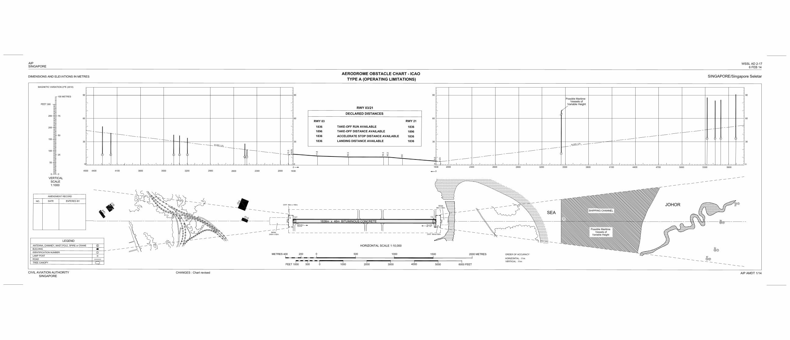

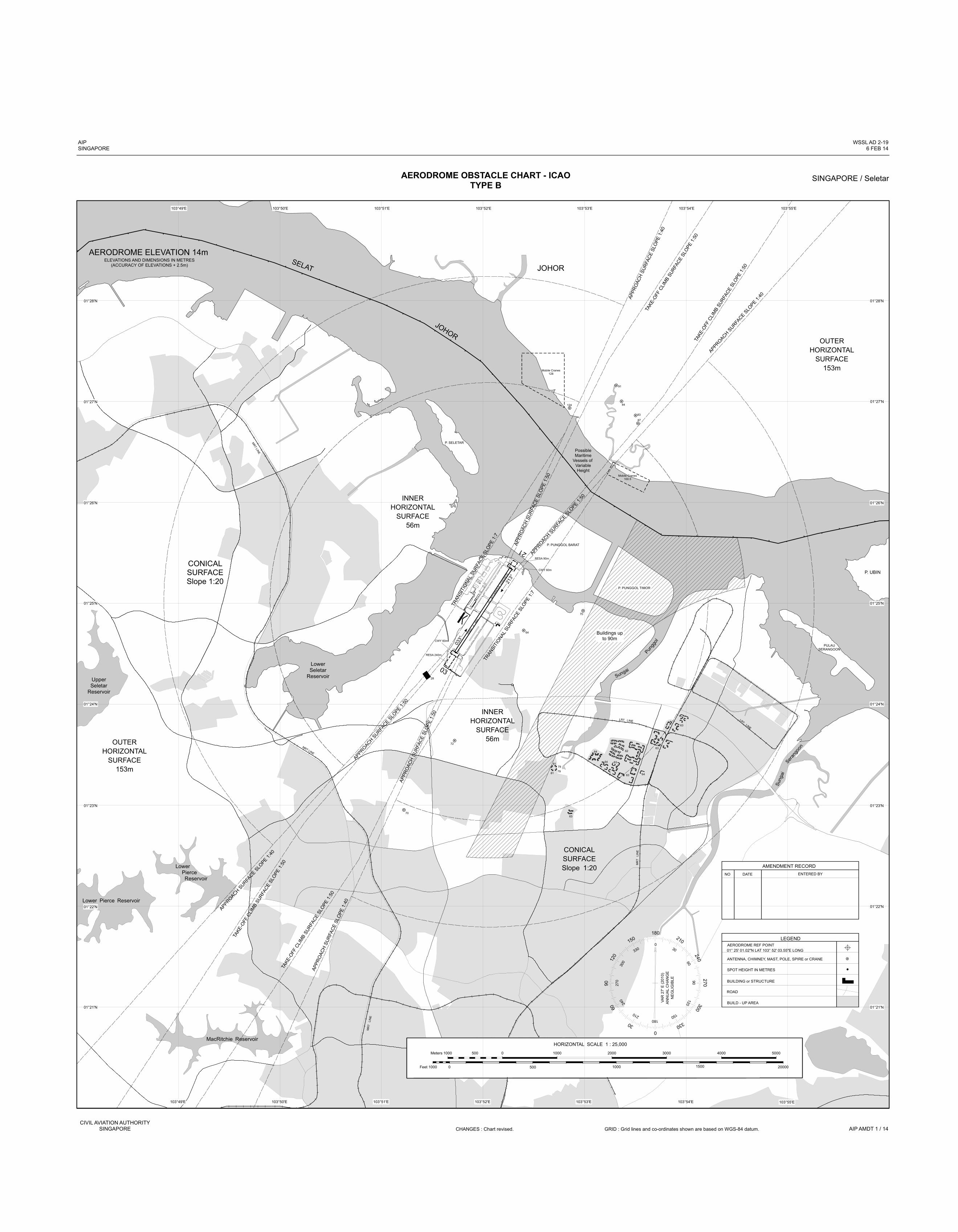
APPR
OACH
SURF
ACE S
LOPE
1:40
TAKE
-OFF CL
IMB SUR
FACE
SLOPE
1:50
TAKE
-OFF CL
IMB SUR
FACE
SLOPE
1:50
APPROACH SURFACE SLOPE 1:4
0
91
84
87
124
Mobile Cranes128
CONICALSURFACESlope 1:20
28
5
14
1836m
x 4
6m
BITUM
INOUS
CONC
RETE
033°
213°
03
CWY 60m
21
CWY 60m
P. PUNGGOL BARAT
P. PUNGGOL TIMOR
Buildings upto 90m
Sungai
Punggol
INNERHORIZONTAL
SURFACE56m
INNERHORIZONTAL
SURFACE56m
CONICALSURFACESlope 1:20
OUTERHORIZONTAL
SURFACE153m
OUTERHORIZONTAL
SURFACE153m
SELAT
JOHOR
JOHOR
APPROACH SURFACE SLOPE 1:5
0
APPR
OACH
SURF
ACE S
LOPE
1:50
APPROACH SURFACE SLOPE 1:5
0AP
PROA
CH SU
RFAC
E SLO
PE 1:
50
AIPSINGAPORE
WSSL AD 2-196 FEB 14
SINGAPORE / SeletarAERODROME OBSTACLE CHART - ICAOTYPE B
CIVIL AVIATION AUTHORITYSINGAPORE AIP AMDT 1 / 14CHANGES : Chart revised. GRID : Grid lines and co-ordinates shown are based on WGS-84 datum.
LowerSeletar
ReservoirUpperSeletar
Reservoir
MRT LINE
Lower Pierce
Reservoir
P. SELETARMRT LINE
P. UBIN
PULAUSERANGOON
Sung
aiSera
ngoon
LRT LINE LRT LINE
MRT
LINE
MRT
LINE
MacRitchie Reservoir
Lower Pierce Reservoir
103°54'E103°53'E103°52'E103°51'E103°50'E103°49'E
01°28'N
01°27'N
01°26'N
01°25'N
01°24'N
01°23'N
01°22'N
01°21'N
103°55'E103°54'E103°53'E103°52'E103°51'E103°50'E103°49'E
01°28'N
01°27'N
01°26'N
01°25'N
01°24'N
01°23'N
01°22'N
01°21'N
72
64
70
7979
81
81
70
AERODROME REF POINT01° 25' 01.02"N LAT 103° 52' 03.55"E LONGANTENNA, CHIMNEY, MAST, POLE, SPIRE or CRANE
SPOT HEIGHT IN METRES
BUILDING or STRUCTURE
ROAD
BUILD - UP AREA
LEGEND180
0
90
270
120
300
150
330
210
240
30
60
0
300
330 30
609027
0240
210180
150
120VAR
27' E
(201
0)AN
NUAL
CHA
NGE
NEGL
IGIB
LE
AMENDMENT RECORDNO DATE ENTERED BY
103°55'E
1000 0 1000 2000 3000 4000 5000500Meters
1000 200000Feet 500 1000 1500
TAKE
-OFF CL
IMB SUR
FACE
SLOPE
1:50
APPROACH SURFACE SLOPE 1:4
0TA
KE-OFF
CLIMB S
URFA
CE SL
OPE 1:5
0
TRAN
SITIONAL
SURFA
CE SLO
PE 1:7
TRAN
SITION
AL SU
RFAC
E SLO
PE 1:7
RESA 90m
RESA 240m
APPR
OACH
SURF
ACE S
LOPE
1:40
Mobile Cranes100.5
63
64
63
63
63
63
64
64
62
HORIZONTAL SCALE 1 : 25,000
83
AERODROME ELEVATION 14mELEVATIONS AND DIMENSIONS IN METRES
(ACCURACY OF ELEVATIONS + 2.5m)
PossibleMaritime
Vessels of VariableHeight


AIP WSAP AD 2-1SINGAPORE 6 FEB 14
WSAP AD 2.1 AERODROME LOCATION INDICATOR AND NAME
WSAP - Paya Lebar Airport
WSAP AD 2.2 AERODROME GEOGRAPHICAL AND ADMINISTRATIVE DATA
1 ARP coordinates and site at AD 012120.6N 1035410.0E (Paya Lebar IBN)
2 Direction and distance from (city) -
3 Elevation/Reference temperature 20m (65ft) / 31.5°C
4 MAG VAR 27’E (2010)
5 AD Administration, address, telephone,telefax, telex, AFS
Paya Lebar AirportSingapore 539906Tel: 63813222 (Base Operations Centre)AFS: WSAPYWYX
6 Types of traffic permitted IFR
7 Remarks Operator: Republic of Singapore Air Force.Alternate/Emergency Diversionary Aerodrome for Singapore Changi Airport (see page WSAP AD 2-9)
WSAP AD 2.3 OPERATIONAL HOURS
1 Aerodrome Administration BTN 2300-1100 SUN/MON to THU/FRI, 2300-0500 FRI/SAT; Public holidays and outside operating hours prior permission required from RSAF Headquarters via Paya Lebar Operations.
2 Customs and Immigration by prior arrangement only
3 Health and Sanitation by prior arrangement only
4 AIS Briefing Office -
5 ATS Reporting Office -
6 MET Briefing Office H24
7 Air Traffic Services H24
8 Remarks AD may be closed periodically for Foreign Object Damage (FOD) walk. Actual emergency or diversion will be accepted at 30 min notification. Such closure will be published via NOTAM.
WSAP AD 2.4 HANDLING SERVICES AND FACILITIES
1 Cargo Handling Facilities -
2 Fuel / Oil Types JET A1, Oil
3 Fuelling Facilities / Capacity BTN 2300-1100 SUN/MON to THU/FRI; 2300-0500 FRI/SAT; Public holidays and outside operating hours prior permission required from RSAF Headquarters via Paya Lebar Operations.
4 Hangar space for visiting aircraft -
5 Repair facilities for visiting aircraft -
6 Remarks Nil
CIVIL AVIATION AUTHORITY AIP AMDT 1/14SINGAPORE
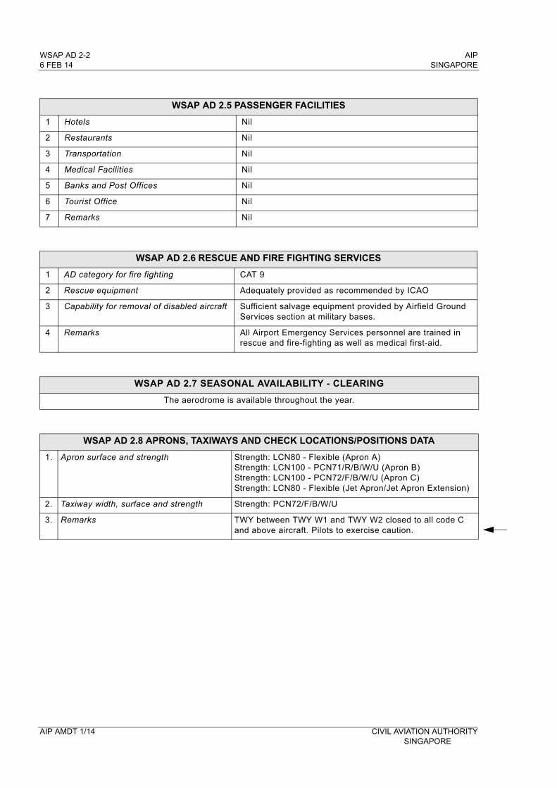
WSAP AD 2-2 AIP6 FEB 14 SINGAPORE
WSAP AD 2.5 PASSENGER FACILITIES
1 Hotels Nil
2 Restaurants Nil
3 Transportation Nil
4 Medical Facilities Nil
5 Banks and Post Offices Nil
6 Tourist Office Nil
7 Remarks Nil
WSAP AD 2.6 RESCUE AND FIRE FIGHTING SERVICES
1 AD category for fire fighting CAT 9
2 Rescue equipment Adequately provided as recommended by ICAO
3 Capability for removal of disabled aircraft Sufficient salvage equipment provided by Airfield Ground Services section at military bases.
4 Remarks All Airport Emergency Services personnel are trained in rescue and fire-fighting as well as medical first-aid.
WSAP AD 2.7 SEASONAL AVAILABILITY - CLEARING
The aerodrome is available throughout the year.
WSAP AD 2.8 APRONS, TAXIWAYS AND CHECK LOCATIONS/POSITIONS DATA
1. Apron surface and strength Strength: LCN80 - Flexible (Apron A)Strength: LCN100 - PCN71/R/B/W/U (Apron B)Strength: LCN100 - PCN72/F/B/W/U (Apron C)Strength: LCN80 - Flexible (Jet Apron/Jet Apron Extension)
2. Taxiway width, surface and strength Strength: PCN72/F/B/W/U
3. Remarks TWY between TWY W1 and TWY W2 closed to all code C and above aircraft. Pilots to exercise caution.
AIP AMDT 1/14 CIVIL AVIATION AUTHORITYSINGAPORE

AIP WSAP AD 2-5SINGAPORE 6 FEB 14
WSAP AD 2.10 AERODROME OBSTACLESIN APPROACH / TKOF AREAS
RWY/Area affected OBST type, ELEV, Markings/LGT Location/Coordinates1 2 3
a) RWY 02 APCHRWY 20 TKOF
Industrial buildings, HGT 83ft AMSL. OBST LGTD
Located on either side of approach funnel 2300ft from RWY 02 THR.
b) RWY 02 APCHRWY 20 TKOF
Structure (water tower), HGT 229ft AMSL, marked and LGTD
012022N 1035436E (east of RWY)
c) RWY 02/20 APCHRWY 02/20 TKOF
LLS LLZ co-located with LLZ antennae, HGT 17ft AGL.
LLZ RWY 02 LOC1324ft from RWY 20 THR. LLZ RWY 20 LOC1525ft from RWY 02 THR.
IN CIRCLING AREA AND AT AERODROME
OBST type, ELEV, Markings/LGT Location/Coordinates1 2
a) ILS GP huts co-located with GP antenna mast (HGT 53ft AGL).
GP RWY 02 located 296ft west of western edge of RWY and 858ft from RWY 02 THR. GP RWY 20 located 296ft west of western edge of RWY and 984ft from RWY 20 THR.
b) PAR hut, HGT 39ft AGL, marked and LGTD.
211ft E of eastern edge of RWY, 7089ft north of RWY 02 THR.
c) 2 x Frangible PAR Moving Target Indicator (MTI) reflectors.
RWY 02 MTI reflectors, HGT 16ft AGL, located 213ft east of eastern edge of RWY, 4389ft from RWY 02 THR. RWY 20 MTI reflectors, HGT 16ft AGL, located 209ft east of eastern edge of RWY, 2911ft from RWY 20 THR.
d) Arrestor hookwire installed 1200ft from RWY 02 THR, 1100ft from RWY 20 THR
Within the RWY strip. Retriever Unit located 52ft from both sides of the RWY edges, 4ft in HGT.
e) Arrestor barrier installed 210ft south of RWY 02 THR, 118ft north of RWY 20 THR
Within the RWY strip.
f) Surface wind direction sleeves (HGT 25ft AGL).
344ft west of western edge of RWY for both sides, 458ft from RWY 02 THR and 307ft from RWY 20 THR.
g) AWOS stanchions (HGT 23ft AGL).
296ft west of western edge of RWY on both sides, 658ft from RWY 02 THR and 654ft from RWY 20 THR.
h) One wheel structure (HGT 178m AMSL).
erected at 011726N 1035150E, BRG 216 DEG, DIST 5NM from WSAP ARP - within WSAP CTR). Structure marked/LGTD.
i) One Building (HGT 245m AMSL).
erected at 011642N 1035105E, BRG 216 DEG, DIST 6.2NMfrom WSAP ARP - within WSAP CTR). Building marked/LGTD.
j) Mobile aircraft arrestor gear (HGT 2m AGL)
12m from edge of western taxiway between TWY W1 and W2 at 415m south of TWY W1. Lighted at night.
k Lightning protection system, HGT 218ft AMSL
erected at 012203.36N 1035509.39E.
WSAP AD 2.11 METEOROLOGICAL INFORMATION PROVIDED
1 Associated MET Office Paya Lebar (WSAP)
2 Hours of service H24
3 Office responsible for TAF preparation and Periods of validity Paya Lebar (WSAP), 9, 24
4 Type of landing forecast and Interval of issuance Nil
5 Briefing/consultation provided P
6 Flight documentation and Language(s) used Charts or Tabular forms, English
7 Charts and other information available for briefing or consultation S, U, P
8 Supplementary equipment available for providing information APT, WXR
9 ATS units provided with information -
10 Additional information TEL: 63813156 (Met Office)
CIVIL AVIATION AUTHORITY AIP AMDT 1/14SINGAPORE
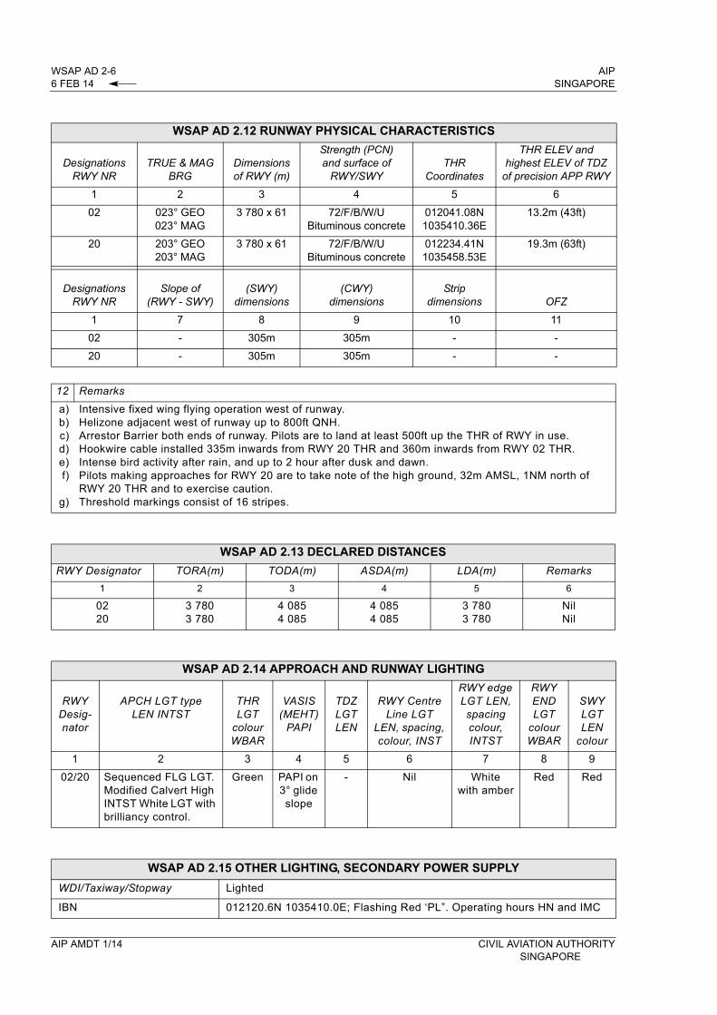
WSAP AD 2-6 AIP6 FEB 14 SINGAPORE
WSAP AD 2.12 RUNWAY PHYSICAL CHARACTERISTICS
DesignationsRWY NR
TRUE & MAG BRG
Dimensions of RWY (m)
Strength (PCN) and surface of
RWY/SWYTHR
Coordinates
THR ELEV and highest ELEV of TDZ
of precision APP RWY
1 2 3 4 5 6
02 023° GEO023° MAG
3 780 x 61 72/F/B/W/UBituminous concrete
012041.08N1035410.36E
13.2m (43ft)
20 203° GEO203° MAG
3 780 x 61 72/F/B/W/UBituminous concrete
012234.41N1035458.53E
19.3m (63ft)
DesignationsRWY NR
Slope of (RWY - SWY)
(SWY) dimensions
(CWY) dimensions
Strip dimensions OFZ
1 7 8 9 10 11
02 - 305m 305m - -
20 - 305m 305m - -
12 Remarks
a)b)c)d)e)f)
g)
Intensive fixed wing flying operation west of runway.Helizone adjacent west of runway up to 800ft QNH.Arrestor Barrier both ends of runway. Pilots are to land at least 500ft up the THR of RWY in use.Hookwire cable installed 335m inwards from RWY 20 THR and 360m inwards from RWY 02 THR.Intense bird activity after rain, and up to 2 hour after dusk and dawn.Pilots making approaches for RWY 20 are to take note of the high ground, 32m AMSL, 1NM north of RWY 20 THR and to exercise caution.Threshold markings consist of 16 stripes.
WSAP AD 2.13 DECLARED DISTANCES
RWY Designator TORA(m) TODA(m) ASDA(m) LDA(m) Remarks
1 2 3 4 5 6
0220
3 7803 780
4 0854 085
4 0854 085
3 7803 780
NilNil
WSAP AD 2.14 APPROACH AND RUNWAY LIGHTING
RWYDesig-nator
APCH LGT type LEN INTST
THR LGT
colour WBAR
VASIS (MEHT)
PAPI
TDZ LGT LEN
RWY Centre Line LGT
LEN, spacing, colour, INST
RWY edge LGT LEN, spacing colour, INTST
RWY END LGT
colour WBAR
SWY LGT LEN
colour
1 2 3 4 5 6 7 8 9
02/20 Sequenced FLG LGT. Modified Calvert High INTST White LGT with brilliancy control.
Green PAPI on 3° glide slope
- Nil White with amber
Red Red
WSAP AD 2.15 OTHER LIGHTING, SECONDARY POWER SUPPLY
WDI/Taxiway/Stopway Lighted
IBN 012120.6N 1035410.0E; Flashing Red ‘PL”. Operating hours HN and IMC
AIP AMDT 1/14 CIVIL AVIATION AUTHORITYSINGAPORE