africa a continent of physical diversity. the equator divides the continent in half. cairo, egypt is...
TRANSCRIPT

Africa
A continent of physical diversity

The equator divides the continent in half. Cairo, Egypt is as far away from the equator as New Orleans.

Four-fifths of Africa is situated between the tropics of Capricorn and Cancer.
Mediterranean Sea
Red Sea
Atlantic Ocean
Indian Ocean

The Nile River - the world’s longest river flows out of Ethiopia’s highlands to the Mediterranean Sea.

The two main tributaries of the Nile River are the White Nile and the Blue Nile. Lake Victoria is the source of the White Nile. The two tributaries converge in Khartoum, the capital of Sudan where they form the Nile River. The Nile River has a total length of 4,160 miles (6,695 kilometers) from source to sea.

Ethiopia, where the Blue Nile begins, is an entirely landlocked nation. It has a rich and colorful history dating back more than 3,000 years. With legends of King Solomon and the Queen of Sheba, the Ark of the Covenant and the Axumite Kingdom, its history is a woven tapestry of mystery and intrigue.
http://www.niletrip.com/route.html

Just north of the border between Egypt and Sudan lies the Aswan High Dam, a huge rock filled dam which captures the world's longest river, the Nile, in one of the world's third largest reservoirs, Lake Nasser.

The Sahara is a desert plain in the northern part of Africa, covering over 9 million square kilometers (about the size of the continental US), from the Atlantic Ocean to the Red Sea.

It is responsible for approximately 70% of all barren lands of the world. About one fifth of its surface is formed by extensive sand dune fields.

Oasis’ break up the endless horizon in the desert.

The Sahel, just south of the Sahara is grassland slowing being taken over by the desert – known as desertification.
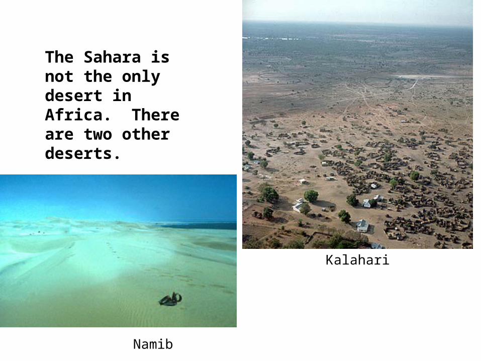
The Sahara is not the only desert in Africa. There are two other deserts.
Kalahari
Namib

These basins disrupt the flow of rivers producing rapids and marshlands.

Water is a scarce resource in Africa
Congo River
Niger RiverSurface water

Horn of Africa, in Somalia. This photo, from NASA, shows the arid-to-semiarid landscape in the east of Somalia. The shape of this part of Africa seems like a horn of rhinoceros penetrating the Indian Ocean.

The west African coast, also known as the Ivory or Gold coast is a major trade area for the continent
Freetown, Sierra Leone
Goree Island – point of departure for many slaves

Equatorial Africa is dominated by a large rain forest and the Congo Basin


Africa is marked by large basins located in the central part of the continent.

Freetown, Sierra Leone
Goree Island – point of departure
for many slaves
The west African coast, also known as
the Ivory or Gold coast is a major trade
area for the continent.

The East and West Rift Valleys run along a tectonic plate boundary in East and Central Africa

Lake Victoria is Africa’s largest lake and the second largest lake in the world (behind Lake Superior). It border three countries: Uganda, Tanzania and Kenya.

Lake Malawi and Lake Tanganyika are rift lakes. They formed when tectonic action produced a rift in the ground. Ocean water flowed into the rift and formed a salty lake. Over time rain and runoff diluted the lake down to the low salt content it has today. http://web.mit.edu/lxs/www/cichlids/water.html

Lake Tanganyika is the second largest lake in Africa about 410 miles long and at its' widest 45 miles and is also known for its great depth of over 4700 feet. The lake has a couple of interesting points, (1) it is the longest lake in the world and (2) it is the second deepest lake in the world.www.etravelphotos.com/tanzania/misc.html

Lake Malawi is the third largest lake in Africa about 365 miles long but only 53 miles at its widest and probably has the greatest fish diversity anywhere on the planet.

Located in the Zambezi river, in the border between Zambia and Zimbabwe, the Victoria Falls is 108 meters height. It is the biggest waterfall of Africa, about two times deeper and two times wider than Niagara Falls.

The British explorer David Livingstone was the first European to see the Falls, in 1855, and named them after Queen Victoria.

Mt. Kilimanjaro is the highest point in Africa and 19,550 feet above sea level.
It is the highest walkablemountain in the world.

Mt. Kenya and the neighboring Serengeti are popular for Safari tours

Safaris take advantage of Africa’s rich animal life

The island nation of Madagascar has many unique plants and animals
3,000 year old Baobab trees

Malawi hut
Uganda tea farmZanzibar clove farm
Africa’s Indian Ocean coast is full of variety

The Great Escarpment
Africa’s southern coast is marked by an escarpment.

The country of South Africa is home to the Cape of Good Hope, Africa’s southern tip.

In summary, Africa’s physical geography presents great possibilities and major challenges for economic development

Sources
• www.jao.com/africa
• www.africapictures.com – Dunbar beach
• www.junglerunner.com/Africa99/journal_10.htm
• www.bugbog.com