a report on the investigation of the fgdc cadastral data
TRANSCRIPT
Report on Ohio Survey Investigation --------------------------------------------------------------------------------------------------------------------------------------------
i
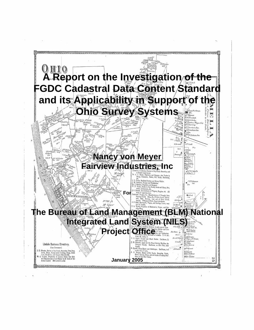
A Report on the Investigation of the FGDC Cadastral Data Content Standard and its Applicability in Support of the
Ohio Survey Systems
Nancy von Meyer Fairview Industries, Inc
For
The Bureau of Land Management (BLM) National Integrated Land System (NILS)
Project Office
January 2005
Report on Ohio Survey Investigation --------------------------------------------------------------------------------------------------------------------------------------------
i
Preface Ohio was the testing and proving grounds of the Public Land Survey System (PLSS). As a result Ohio contains many varied land descriptions and survey systems. Further complicating the Ohio land description scene are large federal tracts reserved for military use and lands held by other states prior to Ohio statehood. This document is not a history of the land system development for Ohio. The history of Ohio surveys can be found in other materials including the following:
Downs, Randolf C., 1927, Evolution of Ohio County Boundaries”, Ohio Archeological and Historical Publications Number XXXVI, Columbus, Ohio. Reprinted in 1970. Gates, Paul W., 1968. “History of Public Land Law Development”, Public Land Law Review Commission, Washington DC. Knepper, George, 2002, “The Official Ohio Lands Book” Auditor of State, Columbus Ohio. http://www.auditor.state.oh.us/StudentResources/OhioLands/ohio_lands.pdf Last Accessed November 2, 2004 Petro, Jim, 1997, “Ohio Lands A Short History”, Auditor of State, Columbus Ohio. Sherman, C.E., 1925, “Original Ohio Land Subdivisions” Volume III of the Final Report to the Ohio Cooperative Topographic Survey. Reprinted in 1991. White, Albert C., “A History of the Public Land Survey System”, US Government Printing Office, Stock Number 024-011-00150-6, Washington D.C.
The resources listed above were used as background materials to clarify the intent, layout and use of the Ohio Survey Systems. This document is a validation of the definitions, relationships and modeling contained in the Federal Geographic Data Committee (FGDC) Subcommittee for Cadastral Data Cadastral Data Content Standard version 1.3. The goal of this investigation is to determine the adequacy of the Cadastral Content Standard in handling survey systems in Ohio and to provide guidance for future expansion of the Bureau of Land Management (BLM) National Integrated Lands System (NILS) into the eastern states. This investigation was funded by the NILS Project Office and as such is a public record document. Special thanks to Jeff Grant of Clermont County Ohio, Scott Yoder of Lucas County Ohio, James McDermott of the Ohio Department of Natural Resources and Stuart Davis of the Ohio Department of Administration for data, information and answers. The physical implementation of the standard for testing is in ESRI’s ArcGIS version 9 service pack 2. The database is a personal geodatabase in Access™.
Report on Ohio Survey Investigation --------------------------------------------------------------------------------------------------------------------------------------------
ii
Table of Contents
Page 1. Introduction 1 2. Findings Summary 2 3. Public Land Survey System Areas 3 3.1 PLSS Township 10 3.2 PLSS First Division 14 3.3 PLSS Second Divisions 21 3.4 PLSS Third Divisions 23 4. Survey Systems 24 5. County and State Data Set Details 29 5.1 Area 1 - Twelve-Miles Square Reservation 29 5.2 Virginia Military District 30 5.3 County and State Data Sets 33
Report on Ohio Survey Investigation --------------------------------------------------------------------------------------------------------------------------------------------
1
1. Introduction The Bureau of Land Management’s (BLM) National Integrated Land System (NILS) Project is developing a common data model (based on Federal Geographic Data Committee (FGDC) standards) and a toolset for managing land records in a Geographic Information System (GIS) environment. The data model and toolset will fulfill BLM and U.S. Forest Service core business requirements critical to meeting the common mission objectives of both agencies. Deployed as a national system, NILS facilitates the collection, management and sharing of survey and title record information (OMB Circular A-16 lead responsibilities) across all levels of government and the private sector while protecting and enhancing current investments in cadastral data. One test of a national common data model is its ability to handle the varied systems in Ohio, where the Public Land Survey was first developed through a series of “experiments”. Ohio is also where the more traditional metes (measures) and bounds (boundary feature) system in the original thirteen colonies mix with and transition to the rectangular public land survey. The Federal Geographic Data Committee (FGDC) Cadastral Data Content Standard is the basis for the NILS common model and as a standard is intended to support the automation and integration of publicly available land records information. It is intended to be useable by all levels of government and the private sector. This report presents the results of an investigation into the PLSS Areas and Survey Systems in Ohio and their representation in a physical model of the Cadastral Data Content Standard. The goal of the investigation was to test the domains of values, the attributes and relationships in the Cadastral Data Content Standard against the reality of the Ohio systems. Several data sources were used to test the data model. The primary data set was purchased from the Ohio Department of Natural Resources (ODNR) and represents the statewide PLSS framework for the agency. This state wide data set was supplemented with data sets downloaded from county web sites and from data provided by the counties to support the investigation. Jeff Grant of Clermont County Ohio and Scott Yoder of Lucas County Ohio were both very supportive and helpful in providing data and additional information A summary of the findings is described in Section 2. The Public Land Survey Systems in Ohio are described in Section 3. Section 4 describes the Survey System Areas and Section 5 explores some of the specific implementation findings that compares state data to county records and source documents.
Report on Ohio Survey Investigation --------------------------------------------------------------------------------------------------------------------------------------------
2
2. Findings Summary The primary findings of the investigation are that the FGDC Cadastral Data Content Standard supports the Ohio surveys, representing the Public Land Survey System and the other Survey Systems in separate feature classes provides one solution for implementation in ESRI’s ArcGIS geodatabase and that the additional detail found in county parcel mapping projects should continue to be integrated into a standard state-wide core parcel data representation. The FGDC Data Content Standard
• In the entity describing the Public Land Survey System Origin the notable changes to the Standard are the removal of the survey named areas from the PLSS Origin list, the clean up of the survey named areas and the clean up of the secondary survey named areas to better reflect the survey areas in Ohio.
• In the entity describing the PLSS Township adding to the township and range direction suggested domain of values improved the applicability of the standard for Ohio
• In the PLSS First and Second divisions there are a few suggestions for the expansion of the domains of values for the division types.
• This investigation did not expose changes for the entities in the Standard describing Survey Systems and their divisions.
• The changes identified in this investigation should be forwarded to the FGDC Cadastral Subcommittee for inclusion in the next round of updates to the standard.
Geodatabase Modeling
• Separating the PLSS Areas and Survey System Areas into different feature classes supported developing topology rules specific to these areas.
• The separate feature classes accommodated the type domains in the Cadastral Standard.
• Performance considerations may change the approach to the geodatabase implementation, but for geographies the size of counties and states, the level of normalization in the investigation did not have serious performance issues.
Locally Generated Data Combined for a State-wide Parcel System
• In areas where values and geometry in state-wide data set were verified it was apparent that the locally generated and maintained definitions of the PLSS and Survey Systems areas more closely represent the original surveys.
• The geodatabase developed for this investigation could serve as a state-wide parcel framework standard for the purpose of building an integrated state-wide parcel framework.
• The state-wide data set from ODNR provided an excellent starting point and the County data can be used to update and improve the state-wide data set.
Report on Ohio Survey Investigation --------------------------------------------------------------------------------------------------------------------------------------------
3
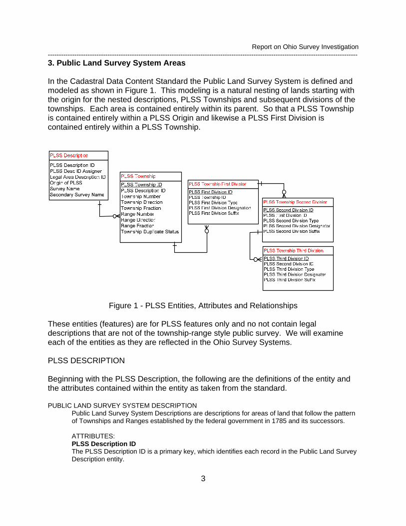
3. Public Land Survey System Areas In the Cadastral Data Content Standard the Public Land Survey System is defined and modeled as shown in Figure 1. This modeling is a natural nesting of lands starting with the origin for the nested descriptions, PLSS Townships and subsequent divisions of the townships. Each area is contained entirely within its parent. So that a PLSS Township is contained entirely within a PLSS Origin and likewise a PLSS First Division is contained entirely within a PLSS Township.
Figure 1 - PLSS Entities, Attributes and Relationships These entities (features) are for PLSS features only and no not contain legal descriptions that are not of the township-range style public survey. We will examine each of the entities as they are reflected in the Ohio Survey Systems. PLSS DESCRIPTION Beginning with the PLSS Description, the following are the definitions of the entity and the attributes contained within the entity as taken from the standard. PUBLIC LAND SURVEY SYSTEM DESCRIPTION
Public Land Survey System Descriptions are descriptions for areas of land that follow the pattern of Townships and Ranges established by the federal government in 1785 and its successors.
ATTRIBUTES: PLSS Description ID The PLSS Description ID is a primary key, which identifies each record in the Public Land Survey Description entity.
Report on Ohio Survey Investigation --------------------------------------------------------------------------------------------------------------------------------------------
4
PLSS Description ID Assigner This is a designation for the agency, organization or jurisdiction that assigns and maintains the primary key. (This was added as requirement of the Geospatial One Stop Standards) Legal Area Description ID The Legal Area Description ID is a foreign key that points to a record in the Legal Area Description, where information on the Legal Area Description can be found.
Origin of Public Land Survey System The Origin of Public Land Survey System is a reference for the numbering of townships and ranges within a public land survey area.
Survey Name Public Land survey areas in Ohio are identified by a name. The named areas have an origin of Public Land Survey System value and then are further identified by Survey Name.
Secondary Survey Name Secondary Survey Name further identifies named areas within the Ohio surveys.
Other than the identifiers which are used to relate one entity to another and to uniquely identify occurrences in an entity, the attributes that were examined were the Origin of the Public Land Survey System, the Survey Name and the Secondary Survey Name. Figure 2 illustrates the PLSS Description areas of Ohio.
Report on Ohio Survey Investigation --------------------------------------------------------------------------------------------------------------------------------------------
5
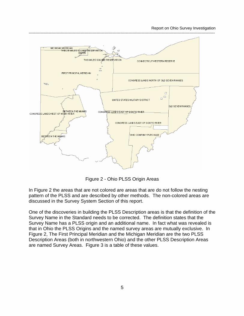
Figure 2 - Ohio PLSS Origin Areas
In Figure 2 the areas that are not colored are areas that are do not follow the nesting pattern of the PLSS and are described by other methods. The non-colored areas are discussed in the Survey System Section of this report. One of the discoveries in building the PLSS Description areas is that the definition of the Survey Name in the Standard needs to be corrected. The definition states that the Survey Name has a PLSS origin and an additional name. In fact what was revealed is that in Ohio the PLSS Origins and the named survey areas are mutually exclusive. In Figure 2, The First Principal Meridian and the Michigan Meridian are the two PLSS Description Areas (both in northwestern Ohio) and the other PLSS Description Areas are named Survey Areas. Figure 3 is a table of these values.
Report on Ohio Survey Investigation --------------------------------------------------------------------------------------------------------------------------------------------
6
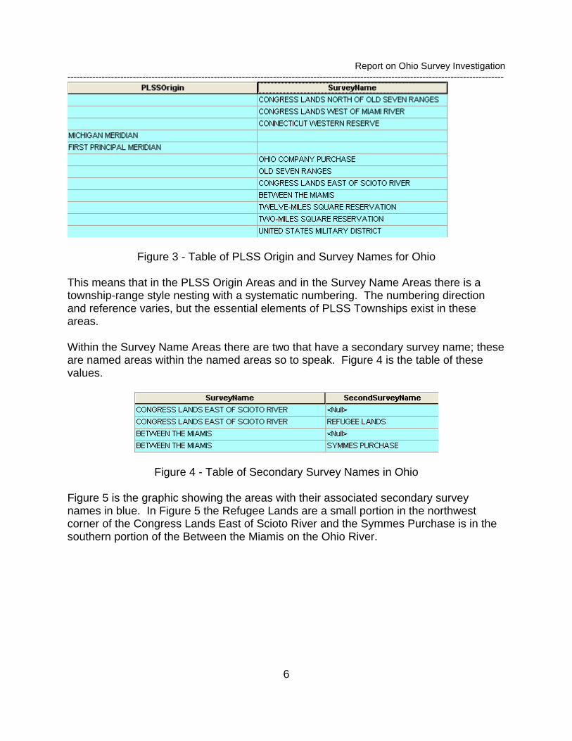
Figure 3 - Table of PLSS Origin and Survey Names for Ohio
This means that in the PLSS Origin Areas and in the Survey Name Areas there is a township-range style nesting with a systematic numbering. The numbering direction and reference varies, but the essential elements of PLSS Townships exist in these areas. Within the Survey Name Areas there are two that have a secondary survey name; these are named areas within the named areas so to speak. Figure 4 is the table of these values.
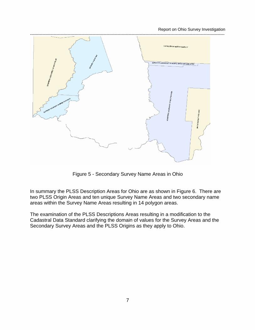
Figure 4 - Table of Secondary Survey Names in Ohio Figure 5 is the graphic showing the areas with their associated secondary survey names in blue. In Figure 5 the Refugee Lands are a small portion in the northwest corner of the Congress Lands East of Scioto River and the Symmes Purchase is in the southern portion of the Between the Miamis on the Ohio River.
Report on Ohio Survey Investigation --------------------------------------------------------------------------------------------------------------------------------------------
7
Figure 5 - Secondary Survey Name Areas in Ohio In summary the PLSS Description Areas for Ohio are as shown in Figure 6. There are two PLSS Origin Areas and ten unique Survey Name Areas and two secondary name areas within the Survey Name Areas resulting in 14 polygon areas. The examination of the PLSS Descriptions Areas resulting in a modification to the Cadastral Data Standard clarifying the domain of values for the Survey Areas and the Secondary Survey Areas and the PLSS Origins as they apply to Ohio.
Report on Ohio Survey Investigation --------------------------------------------------------------------------------------------------------------------------------------------
8
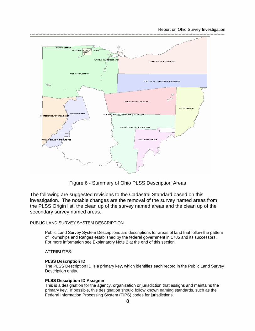
Figure 6 - Summary of Ohio PLSS Description Areas
The following are suggested revisions to the Cadastral Standard based on this investigation. The notable changes are the removal of the survey named areas from the PLSS Origin list, the clean up of the survey named areas and the clean up of the secondary survey named areas. PUBLIC LAND SURVEY SYSTEM DESCRIPTION
Public Land Survey System Descriptions are descriptions for areas of land that follow the pattern of Townships and Ranges established by the federal government in 1785 and its successors. For more information see Explanatory Note 2 at the end of this section.
ATTRIBUTES:
PLSS Description ID The PLSS Description ID is a primary key, which identifies each record in the Public Land Survey Description entity. PLSS Description ID Assigner This is a designation for the agency, organization or jurisdiction that assigns and maintains the primary key. If possible, this designation should follow known naming standards, such as the Federal Information Processing System (FIPS) codes for jurisdictions.
Report on Ohio Survey Investigation --------------------------------------------------------------------------------------------------------------------------------------------
9
Legal Area Description ID The Legal Area Description ID is a foreign key that points to a record in the Legal Area Description, where information on the Legal Area Description can be found.
Origin of Public Land Survey System The Origin of Public Land Survey System is a reference for the numbering of townships and ranges within a public land survey area.
Suggested Domain Values: Black Hills Meridian, Boise Meridian, Chickasaw Meridian, Choctaw Meridian, Cimarron Meridian, Copper River Meridian, Extended Fourth Principal Meridian, Fairbanks Meridian, Fifth Principal Meridian, First Principal Meridian, Fourth Principal Meridian, Gila and Salt River Meridian, Humboldt Meridian, Huntsville Meridian, Indian Meridian, Kateel River Meridian, Louisiana Meridian, New Mexico Principal Meridian, Michigan Meridian, Mount Diablo Meridian, Muskingum River, Navajo Meridian, St. Helena Meridian, St. Stephens Meridian, Salt Lake Meridian, San Bernardino Meridian, Second Principal Meridian, Seward Meridian, Sixth Principal Meridian, Tallahassee Meridian, Third Principal Meridian, Uintah Meridian, Umiat Meridian, Ute Meridian, Washington Meridian, Willamette Meridian, Wind River Meridian
Survey Name Public Land survey areas in Ohio are identified by a name. The named areas do not an origin of Public Land Survey System value.
Suggested Domain Values: BETWEEN THE MIAMIS, CONGRESS LANDS EAST OF SCIOTO RIVER, CONGRESS LANDS NORTH OF OLD SEVEN RANGES, CONGRESS LANDS WEST OF MIAMI RIVER, CONNECTICUT WESTERN RESERVE, OHIO COMPANY PURCHASE, OLD SEVEN RANGES, TWELVE-MILES SQUARE RESERVATION, TWO-MILES SQUARE RESERVATION, UNITED STATES MILITARY DISTRICT
Secondary Survey Name Secondary Survey Name further identifies named areas within the Ohio surveys.
Suggested Domain Values: REFUGEE LANDS, SYMMES PURCHASE
Report on Ohio Survey Investigation --------------------------------------------------------------------------------------------------------------------------------------------
10
3.1 PLSS Township The PLSS Township is the initial breakdown of a PLSS Description. These are areas that nominally 6 miles by 6 miles in size and are identified by reference to a baseline, a meridian or both. All of the PLSS Areas within a description area have a PLSS Township designation, but the PLSS Townships do not tessellate the lands in a PLSS Description area. That is, there may be gaps in the PLSS and these gaps would not have a PLSS Township designation. The definitions of the attributes in the standard for the PLSS Township are as follows. PUBLIC LAND SURVEY SYSTEM TOWNSHIP
In the Public Land Survey System a Township refers to a unit of land, that are nominally six miles on a side, usually containing 36 sections.
BUSINESS RULE:
1. Public Land Survey System Townships will have a Public Land Survey System Origin and a State.
ATTRIBUTES: PLSS Township ID The PLSS Township ID is a primary key, which identifies each record in the Public Land Survey System Township entity.
PLSS Description ID The PLSS Description ID is a foreign key, which points to a record in the Public Land Survey System Description entity, where information on the Public Land Survey System Description can be found.
Township Number The Township Number indicates the number of rows of townships, north or south from a Public Land Survey System Origin.
Township Direction The direction of a row of Townships from a Public Land Survey System Origin.
Suggested Domain Values: North, South
Township Fraction Township Fractions are created when there are gaps between surveyed Township boundaries or due to excess size in Townships that arose from executing original surveys.
Suggested Domain Values: 1/4 Township, 1/2 Township, 3/4 Township
Range Number The Range Number indicates the number of columns of townships, east or west from a Public Land Survey System Origin.
Range Direction The direction of a column of townships from a Public Land Survey System Origin.
Suggested Domain Values: East, West
Range Fraction
Report on Ohio Survey Investigation --------------------------------------------------------------------------------------------------------------------------------------------
11
Range Fractions are created when there are gaps between surveyed Township boundaries or due to excess size in Townships that arose from executing original surveys.
Suggested Domain Values: 1/4 Range, ½ Range, 3/4 Range
Township Duplicate Status If there are multiple townships in a Public Land Survey System Origin, State and Survey Name, the Township Duplicate Status is used to establish uniqueness. When more than one Public Land Survey System Township has the same Township and Range numbers and directions and fractions, and are in the same State, this attribute is used to distinguish among duplicate values.
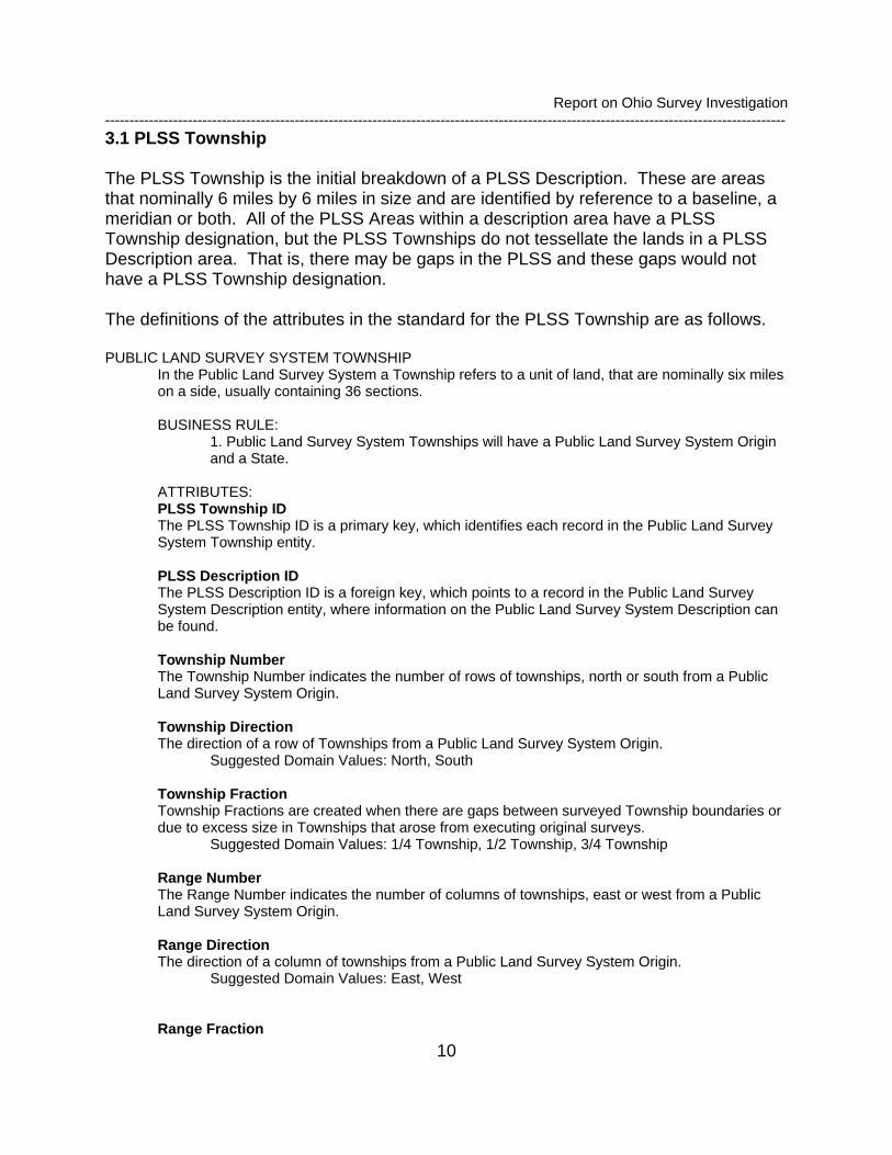
The PLSS Township testing paid particular attention to the Township and Range directions, the baseline or PLSS Origin and the duplicates because these seemed to be of particular concern in the Standard and in discussions with land records with people from Ohio. Figure 7 shows the PLSS Townships in the PLSS Description areas in Ohio. Figure 8 shows the geodatabase feature class attributes and attribute details for the PLSS Township.
Figure 7 - PLSS Township in Ohio
Report on Ohio Survey Investigation --------------------------------------------------------------------------------------------------------------------------------------------
12
Simple feature classPLSSTownship Contains Z values
Contains M valuesGeometry Polygon
NoNo
Data typeField namePrec-ision Scale LengthDomainDefault value
Allow nulls
OBJECTID Object IDShape Geometry Yes
TownshipNumber Long integer Yes 0TownshipDirection String Yes TownshipTownDirection 2TownshipFraction Long integer Yes 0
Range Long integer Yes 0RangeDirection String Yes TownshipRangeDirection 1RangeFraction Long integer Yes 0
StateCode Long integer Yes StateCode 0Shape_Length Double Yes 0 0Shape_Area Double Yes 0 0
PLSSID Short integer Yes 0PLSSTTownshipID Short integer Yes 0TownshipDuplicate String Yes TownshipDuplicate 1
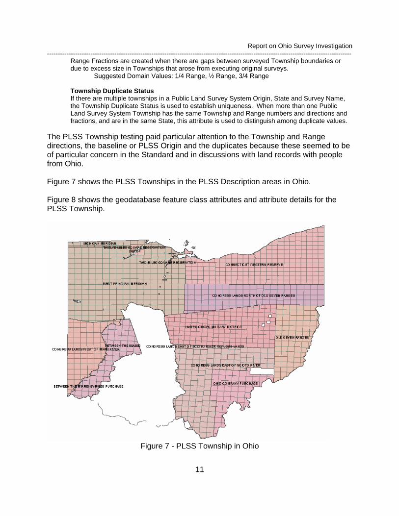
Figure 8 - PLSS Township Feature Class Detail
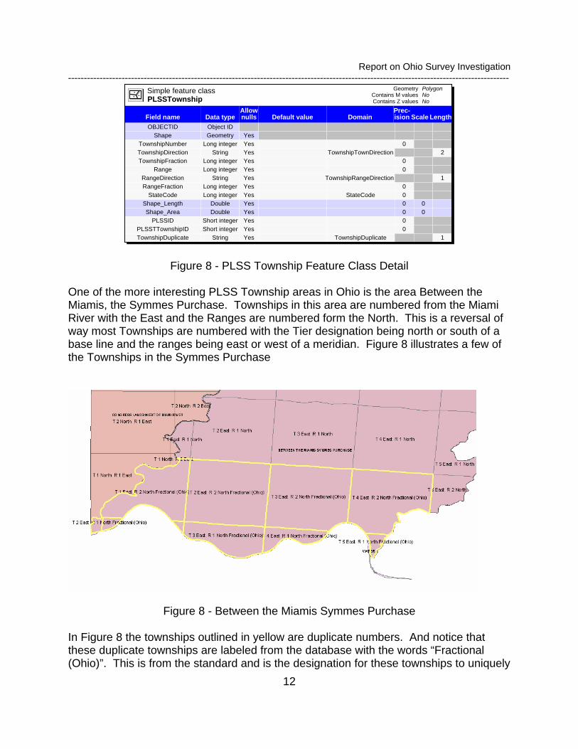
One of the more interesting PLSS Township areas in Ohio is the area Between the Miamis, the Symmes Purchase. Townships in this area are numbered from the Miami River with the East and the Ranges are numbered form the North. This is a reversal of way most Townships are numbered with the Tier designation being north or south of a base line and the ranges being east or west of a meridian. Figure 8 illustrates a few of the Townships in the Symmes Purchase
Figure 8 - Between the Miamis Symmes Purchase
In Figure 8 the townships outlined in yellow are duplicate numbers. And notice that these duplicate townships are labeled from the database with the words “Fractional (Ohio)”. This is from the standard and is the designation for these townships to uniquely
Report on Ohio Survey Investigation --------------------------------------------------------------------------------------------------------------------------------------------
13
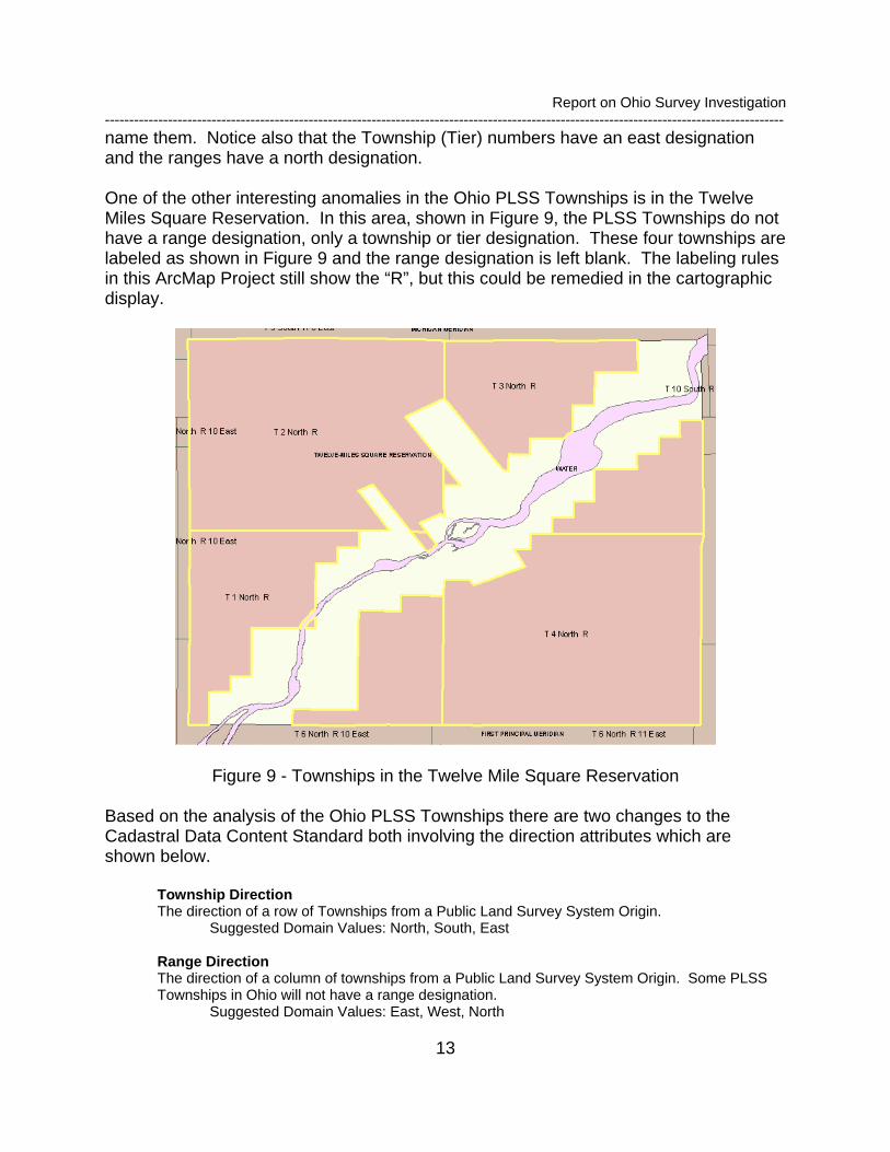
name them. Notice also that the Township (Tier) numbers have an east designation and the ranges have a north designation. One of the other interesting anomalies in the Ohio PLSS Townships is in the Twelve Miles Square Reservation. In this area, shown in Figure 9, the PLSS Townships do not have a range designation, only a township or tier designation. These four townships are labeled as shown in Figure 9 and the range designation is left blank. The labeling rules in this ArcMap Project still show the “R”, but this could be remedied in the cartographic display.
Figure 9 - Townships in the Twelve Mile Square Reservation
Based on the analysis of the Ohio PLSS Townships there are two changes to the Cadastral Data Content Standard both involving the direction attributes which are shown below.
Township Direction The direction of a row of Townships from a Public Land Survey System Origin.
Suggested Domain Values: North, South, East
Range Direction The direction of a column of townships from a Public Land Survey System Origin. Some PLSS Townships in Ohio will not have a range designation.
Suggested Domain Values: East, West, North

Report on Ohio Survey Investigation --------------------------------------------------------------------------------------------------------------------------------------------
14
3.2 PLSS First Division The PLSS First Division is the first division of a PLSS Township. There are many types of first divisions, but the most common is the Section. Typically there are 36 sections in a PLSS Township and typically they are numbered. The definitions for the attributes of the PLSS First Division in the Cadastral Content Standard are
PUBLIC LAND SURVEY SYSTEM TOWNSHIP FIRST DIVISION Public Land Survey System Townships first divisions are normally Public Land Survey System Tracts or Public Land Survey System Sections. This entity is the primary or first subdivisions of a Public Land Survey System Township.
ATTRIBUTES: PLSS First Division ID The PLSS First Division ID is a primary key that identifies each record in the Public Land Survey System Township First Division entity.
PLSS Township ID The PLSS Township ID is a foreign key that points to a record in the Public Land Survey System Township entity, where information on the Public Land Survey System Township can be found.
PLSS First Division Type The First Division Type of a Public Land Survey System Township is the primary or first subdivision category. If the first division type is fractional section, then the metadata for this data set will need to document how fractional sections are labeled.
Suggested Domain Values: Unsectionalized Area, Section, Lot, Tract, Protraction Block note 1, Parcel, Fractional Section, Water Note 1: A Protraction Block is a designation for sections of uncertain acreage which lie between the coordinate based interior and the prior surveyed boundaries of record that generally form the exterior perimeters of the protracted areas. (BLM IM 93-353, 9/30/93).
PLSS First Division Designator The First Division Designator is the letter, number, or letter number combination that identifies the First Division.
PLSS First Division Suffix
The First Division Suffix is the indicator for duplicate First Divisions
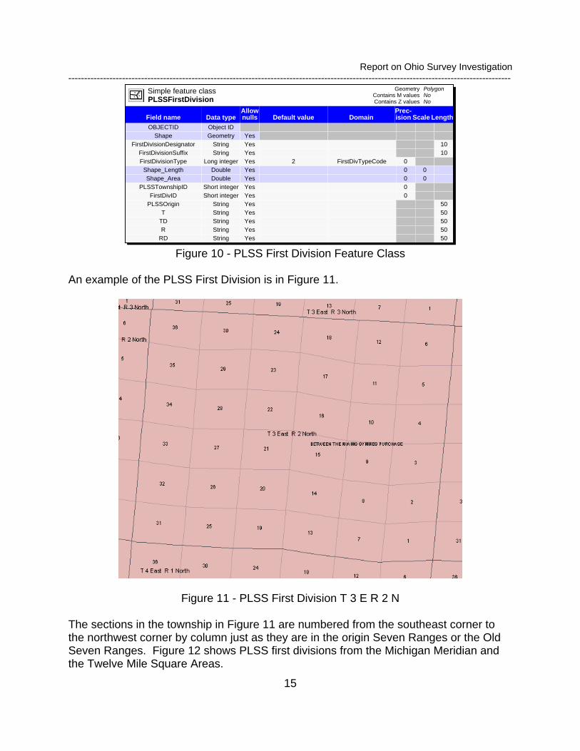
The feature class for the PLSS First Division in the geodatabase is as shown in Figure 10. The attributes PLSS Origin, T, TD, R and RD are included to assist with the migration of source data and to make the join to the PLSS Township feature class.
Report on Ohio Survey Investigation --------------------------------------------------------------------------------------------------------------------------------------------
15
Simple feature classPLSSFirstDivision Contains Z values
Contains M valuesGeometry Polygon
NoNo
Data typeField namePrec-ision Scale LengthDomainDefault value
Allow nulls
OBJECTID Object IDShape Geometry Yes
FirstDivisionDesignator String Yes 10FirstDivisionSuffix String Yes 10FirstDivisionType Long integer Yes 2 FirstDivTypeCode 0
Shape_Length Double Yes 0 0Shape_Area Double Yes 0 0
PLSSTownshipID Short integer Yes 0FirstDivID Short integer Yes 0
PLSSOrigin String Yes 50T String Yes 50
TD String Yes 50R String Yes 50
RD String Yes 50 Figure 10 - PLSS First Division Feature Class
An example of the PLSS First Division is in Figure 11.
Figure 11 - PLSS First Division T 3 E R 2 N
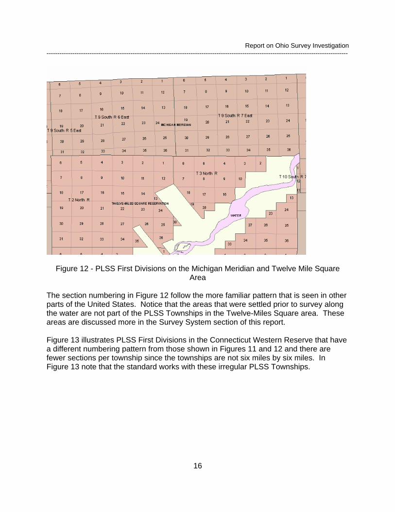
The sections in the township in Figure 11 are numbered from the southeast corner to the northwest corner by column just as they are in the origin Seven Ranges or the Old Seven Ranges. Figure 12 shows PLSS first divisions from the Michigan Meridian and the Twelve Mile Square Areas.
Report on Ohio Survey Investigation --------------------------------------------------------------------------------------------------------------------------------------------
16
Figure 12 - PLSS First Divisions on the Michigan Meridian and Twelve Mile Square Area
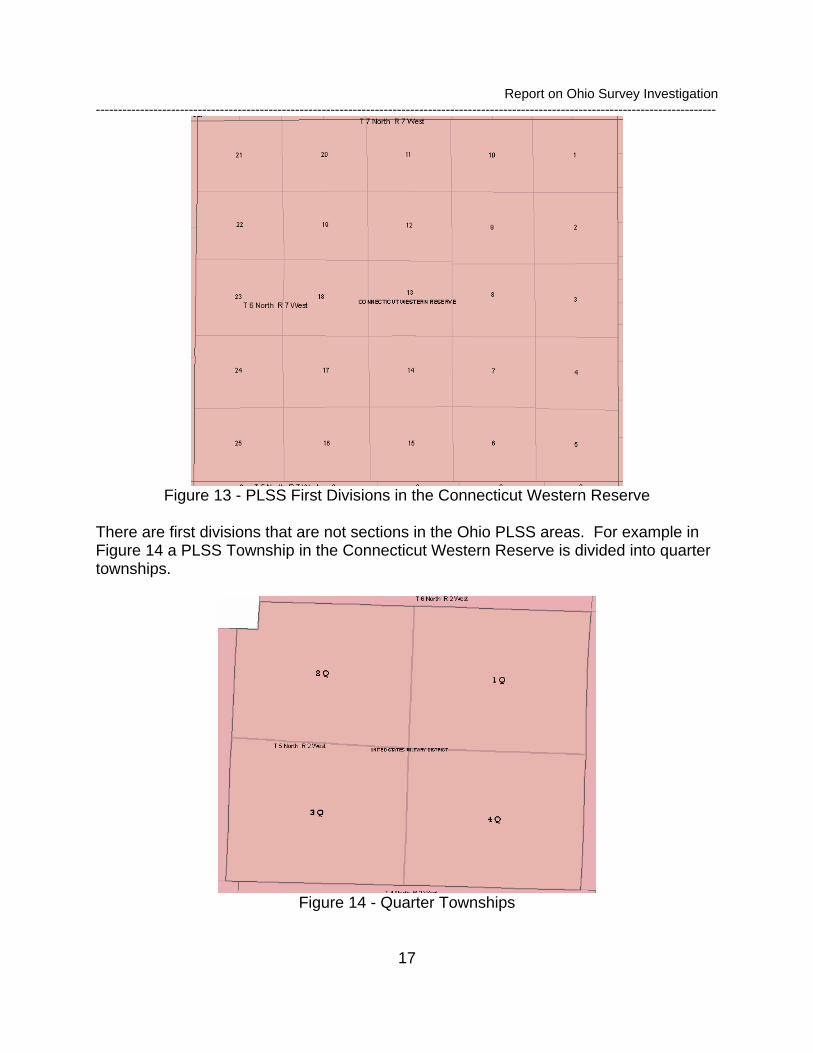
The section numbering in Figure 12 follow the more familiar pattern that is seen in other parts of the United States. Notice that the areas that were settled prior to survey along the water are not part of the PLSS Townships in the Twelve-Miles Square area. These areas are discussed more in the Survey System section of this report. Figure 13 illustrates PLSS First Divisions in the Connecticut Western Reserve that have a different numbering pattern from those shown in Figures 11 and 12 and there are fewer sections per township since the townships are not six miles by six miles. In Figure 13 note that the standard works with these irregular PLSS Townships.
Report on Ohio Survey Investigation --------------------------------------------------------------------------------------------------------------------------------------------
17
Figure 13 - PLSS First Divisions in the Connecticut Western Reserve
There are first divisions that are not sections in the Ohio PLSS areas. For example in Figure 14 a PLSS Township in the Connecticut Western Reserve is divided into quarter townships.
Figure 14 - Quarter Townships

Report on Ohio Survey Investigation --------------------------------------------------------------------------------------------------------------------------------------------
18
Some PLSS Townships are divided different types of First Division. In Figure 15 a PLSS Township in the Connecticut Western Reserve is divided into Tracts and Lots. Some of the Tracts are numbered and one of them is named and in this case the lots are all named. The significance here is that the PLSS First Divisions are non-overlapping and they uniquely account for all the area in the PLSS Township.
Figure 15 - Township Divided into Tracts and Lots
In Figure 16 the PLSS Township has been divided entirely into Lots. This occurs in many other parts of the country as well. Each lot is uniquely numbered and the lot sizes may vary.
Report on Ohio Survey Investigation --------------------------------------------------------------------------------------------------------------------------------------------
19
Figure 16 - PLSS Township divided into Lots
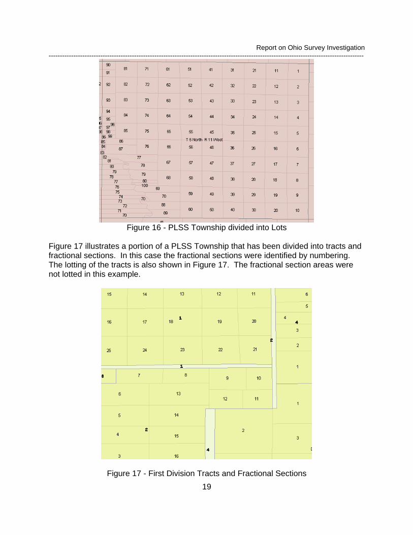
Figure 17 illustrates a portion of a PLSS Township that has been divided into tracts and fractional sections. In this case the fractional sections were identified by numbering. The lotting of the tracts is also shown in Figure 17. The fractional section areas were not lotted in this example.
Figure 17 - First Division Tracts and Fractional Sections
Report on Ohio Survey Investigation --------------------------------------------------------------------------------------------------------------------------------------------
20
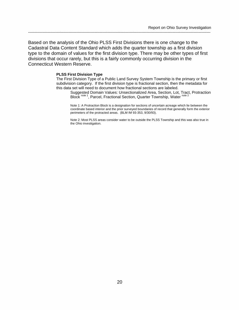
Based on the analysis of the Ohio PLSS First Divisions there is one change to the Cadastral Data Content Standard which adds the quarter township as a first division type to the domain of values for the first division type. There may be other types of first divisions that occur rarely, but this is a fairly commonly occurring division in the Connecticut Western Reserve.
PLSS First Division Type The First Division Type of a Public Land Survey System Township is the primary or first subdivision category. If the first division type is fractional section, then the metadata for this data set will need to document how fractional sections are labeled.
Suggested Domain Values: Unsectionalized Area, Section, Lot, Tract, Protraction Block note 1, Parcel, Fractional Section, Quarter Township, Water note 2 Note 1: A Protraction Block is a designation for sections of uncertain acreage which lie between the coordinate based interior and the prior surveyed boundaries of record that generally form the exterior perimeters of the protracted areas. (BLM IM 93-353, 9/30/93). Note 2: Most PLSS areas consider water to be outside the PLSS Township and this was also true in the Ohio investigation.
Report on Ohio Survey Investigation --------------------------------------------------------------------------------------------------------------------------------------------
21
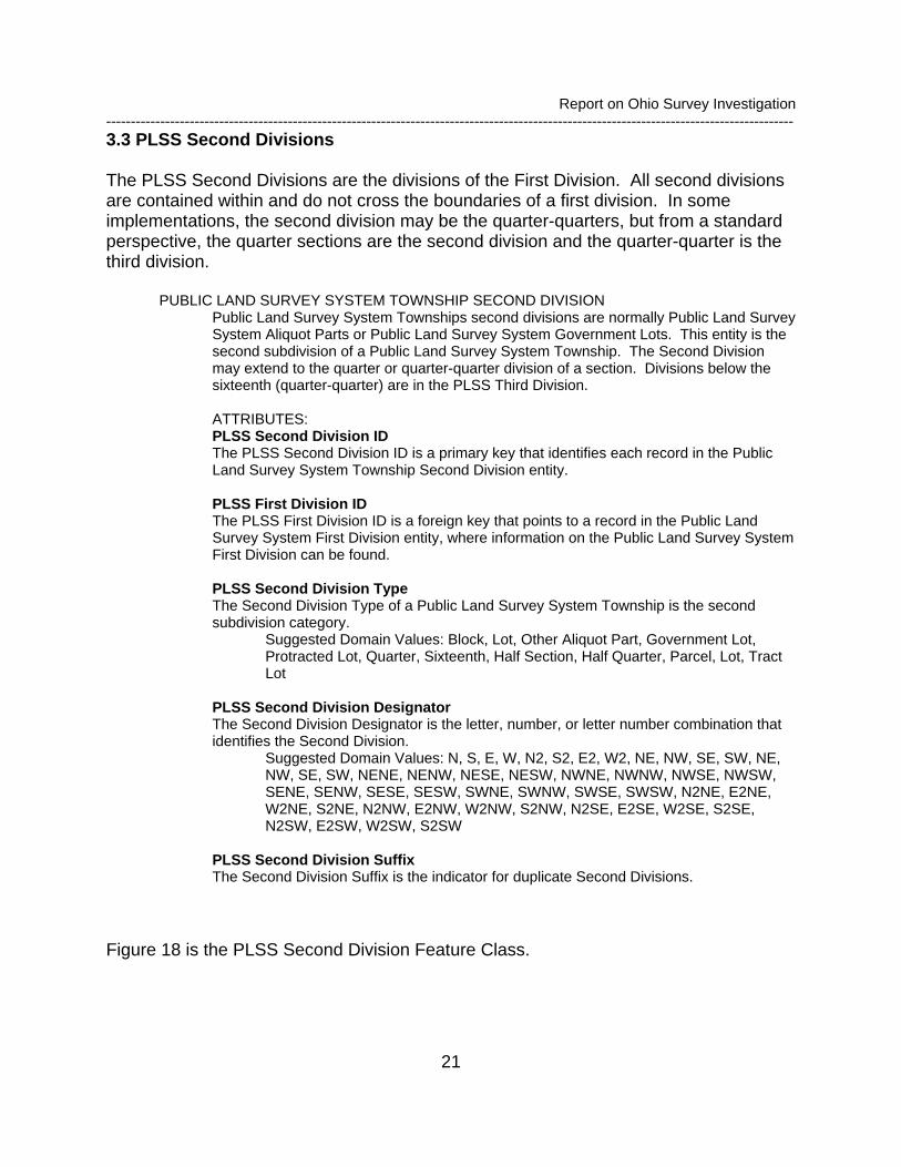
3.3 PLSS Second Divisions The PLSS Second Divisions are the divisions of the First Division. All second divisions are contained within and do not cross the boundaries of a first division. In some implementations, the second division may be the quarter-quarters, but from a standard perspective, the quarter sections are the second division and the quarter-quarter is the third division.
PUBLIC LAND SURVEY SYSTEM TOWNSHIP SECOND DIVISION Public Land Survey System Townships second divisions are normally Public Land Survey System Aliquot Parts or Public Land Survey System Government Lots. This entity is the second subdivision of a Public Land Survey System Township. The Second Division may extend to the quarter or quarter-quarter division of a section. Divisions below the sixteenth (quarter-quarter) are in the PLSS Third Division.
ATTRIBUTES: PLSS Second Division ID The PLSS Second Division ID is a primary key that identifies each record in the Public Land Survey System Township Second Division entity.
PLSS First Division ID The PLSS First Division ID is a foreign key that points to a record in the Public Land Survey System First Division entity, where information on the Public Land Survey System First Division can be found. PLSS Second Division Type The Second Division Type of a Public Land Survey System Township is the second subdivision category.
Suggested Domain Values: Block, Lot, Other Aliquot Part, Government Lot, Protracted Lot, Quarter, Sixteenth, Half Section, Half Quarter, Parcel, Lot, Tract Lot
PLSS Second Division Designator The Second Division Designator is the letter, number, or letter number combination that identifies the Second Division.
Suggested Domain Values: N, S, E, W, N2, S2, E2, W2, NE, NW, SE, SW, NE, NW, SE, SW, NENE, NENW, NESE, NESW, NWNE, NWNW, NWSE, NWSW, SENE, SENW, SESE, SESW, SWNE, SWNW, SWSE, SWSW, N2NE, E2NE, W2NE, S2NE, N2NW, E2NW, W2NW, S2NW, N2SE, E2SE, W2SE, S2SE, N2SW, E2SW, W2SW, S2SW
PLSS Second Division Suffix The Second Division Suffix is the indicator for duplicate Second Divisions.
Figure 18 is the PLSS Second Division Feature Class.

Report on Ohio Survey Investigation ---------------------------------------------------------------------------------------------------------------------------------
22
Figure 18 - PLSS Second Division Feature Class
Figure 19 is an example of the PLSS Second Divisions where the first divisions are quarter townships. Three of the quarters have been divided into lots and the quarter in the southeast corner of the PLSS Township is divided into sections
Figure 19 - PLSS Second Divisions in Quarter Townships
This example indicates that the section may be a second division type as well as first division type
Report on Ohio Survey Investigation ---------------------------------------------------------------------------------------------------------------------------------
23
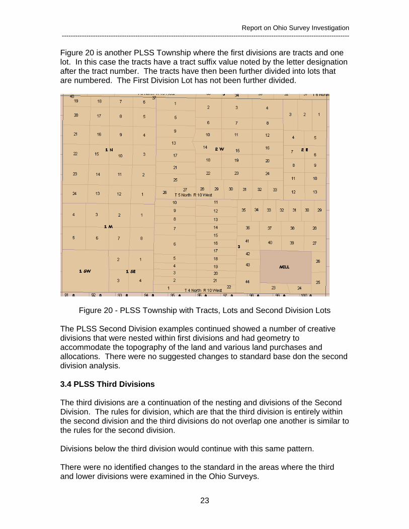
Figure 20 is another PLSS Township where the first divisions are tracts and one lot. In this case the tracts have a tract suffix value noted by the letter designation after the tract number. The tracts have then been further divided into lots that are numbered. The First Division Lot has not been further divided.
Figure 20 - PLSS Township with Tracts, Lots and Second Division Lots
The PLSS Second Division examples continued showed a number of creative divisions that were nested within first divisions and had geometry to accommodate the topography of the land and various land purchases and allocations. There were no suggested changes to standard base don the second division analysis. 3.4 PLSS Third Divisions The third divisions are a continuation of the nesting and divisions of the Second Division. The rules for division, which are that the third division is entirely within the second division and the third divisions do not overlap one another is similar to the rules for the second division. Divisions below the third division would continue with this same pattern. There were no identified changes to the standard in the areas where the third and lower divisions were examined in the Ohio Surveys.

Report on Ohio Survey Investigation ---------------------------------------------------------------------------------------------------------------------------------
24
4. Survey Systems The Survey System areas are the areas of land description that do not follow the naming and rules of the PLSS areas. In Ohio the Survey Systems are named survey areas, such as Military Districts, or Private Tracts that existed at the time of the original survey. Adding the Survey Systems to the PLSS Origin Areas for Ohio presents a complete representation of the area of the state as shown in Figure 21. The survey System areas are labeled in red and the PLSS origin areas are labeled in black.
Figure 21 - Ohio PLSS Origin Areas and Survey System Areas
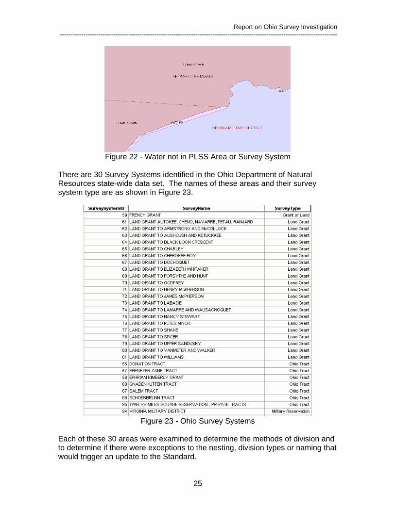
The areas of Water are the exception to the complete representation. As shown in Figure 22, the boundary between the PLSS Area, between the Miamis, and the Virginia Military District is water and is not covered by either the PLSS Area or the Survey System
Report on Ohio Survey Investigation ---------------------------------------------------------------------------------------------------------------------------------
25
Figure 22 - Water not in PLSS Area or Survey System
There are 30 Survey Systems identified in the Ohio Department of Natural Resources state-wide data set. The names of these areas and their survey system type are as shown in Figure 23.
Figure 23 - Ohio Survey Systems
Each of these 30 areas were examined to determine the methods of division and to determine if there were exceptions to the nesting, division types or naming that would trigger an update to the Standard.
Report on Ohio Survey Investigation ---------------------------------------------------------------------------------------------------------------------------------
26
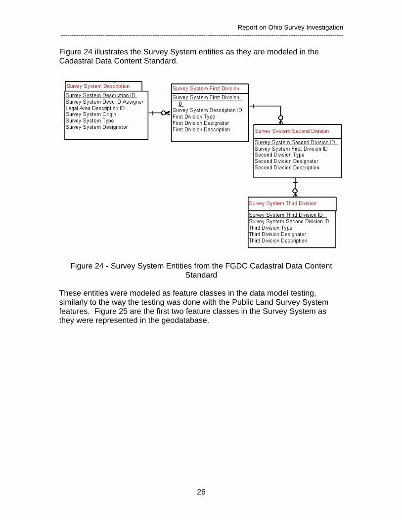
Figure 24 illustrates the Survey System entities as they are modeled in the Cadastral Data Content Standard.
Figure 24 - Survey System Entities from the FGDC Cadastral Data Content Standard
These entities were modeled as feature classes in the data model testing, similarly to the way the testing was done with the Public Land Survey System features. Figure 25 are the first two feature classes in the Survey System as they were represented in the geodatabase.

Report on Ohio Survey Investigation ---------------------------------------------------------------------------------------------------------------------------------
27
Simple feature classSurveySystem Contains Z values
Contains M valuesGeometry Polygon
NoNo
Data typeField namePrec-ision Scale LengthDomainDefault value
Allow nulls
OBJECTID Object IDShape Geometry Yes
Shape_Length Double Yes 0 0Shape_Area Double Yes 0 0
SurveySystemID Short integer Yes 0SurveyName String Yes 60SurveyType Long integer Yes SimConType 0
Simple feature classSurveySystemFirstDiv Contains Z values
Contains M valuesGeometry Polygon
NoNo
Data typeField namePrec-ision Scale LengthDomainDefault value
Allow nulls
OBJECTID Object IDSHAPE Geometry Yes
SurveyFirstDivID Short integer Yes 0SurveySystemID Short integer Yes 0
SurveyFirstDivType Long integer Yes FirstDivTypeCode 0SurveyFirstName String Yes 50SHAPE_Length Double Yes 0 0SHAPE_Area Double Yes 0 0
SurveyFirstDesc String Yes 50
Figure 25 - Survey System Feature Classes
Figure 26 is one example of a Survey System Area is the French Grant on the Ohio River. This grant is divided into lots as shown in Figure 26.
Figure 26 - French Grant Divisions
Report on Ohio Survey Investigation ---------------------------------------------------------------------------------------------------------------------------------
28
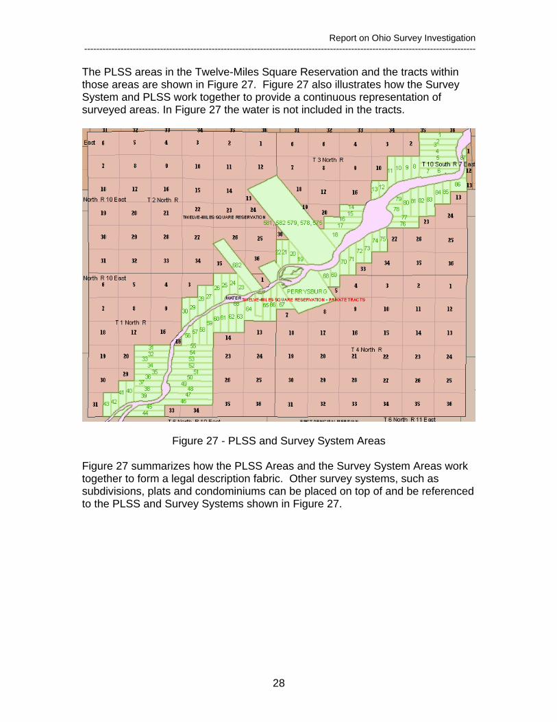
The PLSS areas in the Twelve-Miles Square Reservation and the tracts within those areas are shown in Figure 27. Figure 27 also illustrates how the Survey System and PLSS work together to provide a continuous representation of surveyed areas. In Figure 27 the water is not included in the tracts.
Figure 27 - PLSS and Survey System Areas
Figure 27 summarizes how the PLSS Areas and the Survey System Areas work together to form a legal description fabric. Other survey systems, such as subdivisions, plats and condominiums can be placed on top of and be referenced to the PLSS and Survey Systems shown in Figure 27.
Report on Ohio Survey Investigation ---------------------------------------------------------------------------------------------------------------------------------
29
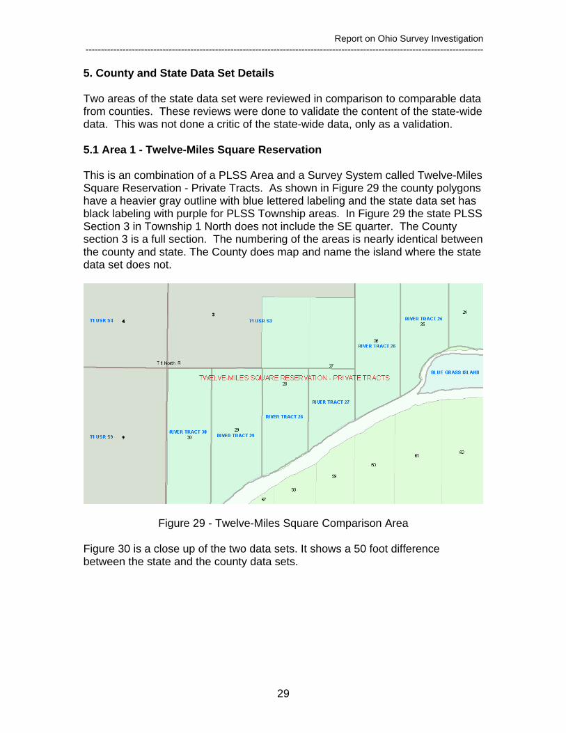
5. County and State Data Set Details Two areas of the state data set were reviewed in comparison to comparable data from counties. These reviews were done to validate the content of the state-wide data. This was not done a critic of the state-wide data, only as a validation. 5.1 Area 1 - Twelve-Miles Square Reservation This is an combination of a PLSS Area and a Survey System called Twelve-Miles Square Reservation - Private Tracts. As shown in Figure 29 the county polygons have a heavier gray outline with blue lettered labeling and the state data set has black labeling with purple for PLSS Township areas. In Figure 29 the state PLSS Section 3 in Township 1 North does not include the SE quarter. The County section 3 is a full section. The numbering of the areas is nearly identical between the county and state. The County does map and name the island where the state data set does not.
Figure 29 - Twelve-Miles Square Comparison Area
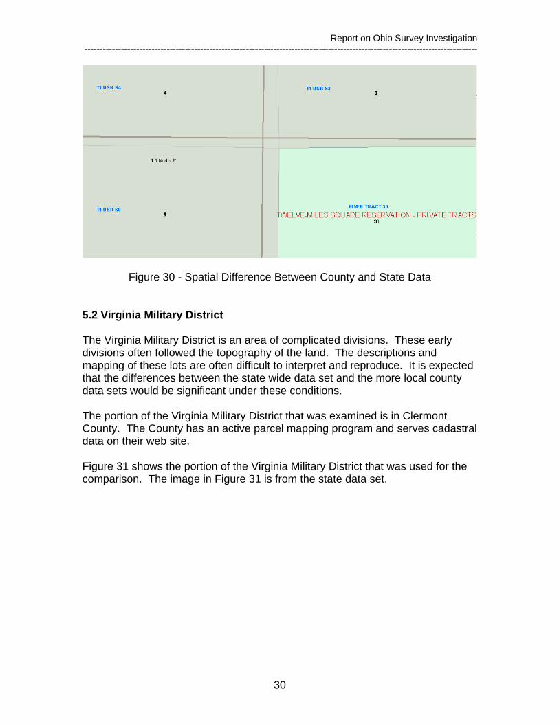
Figure 30 is a close up of the two data sets. It shows a 50 foot difference between the state and the county data sets.
Report on Ohio Survey Investigation ---------------------------------------------------------------------------------------------------------------------------------
30
Figure 30 - Spatial Difference Between County and State Data
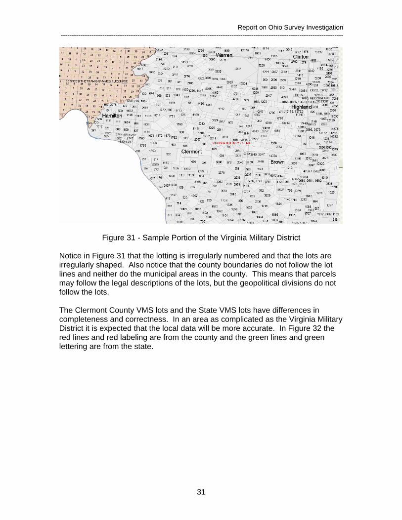
5.2 Virginia Military District The Virginia Military District is an area of complicated divisions. These early divisions often followed the topography of the land. The descriptions and mapping of these lots are often difficult to interpret and reproduce. It is expected that the differences between the state wide data set and the more local county data sets would be significant under these conditions. The portion of the Virginia Military District that was examined is in Clermont County. The County has an active parcel mapping program and serves cadastral data on their web site. Figure 31 shows the portion of the Virginia Military District that was used for the comparison. The image in Figure 31 is from the state data set.
Report on Ohio Survey Investigation ---------------------------------------------------------------------------------------------------------------------------------
31
Figure 31 - Sample Portion of the Virginia Military District
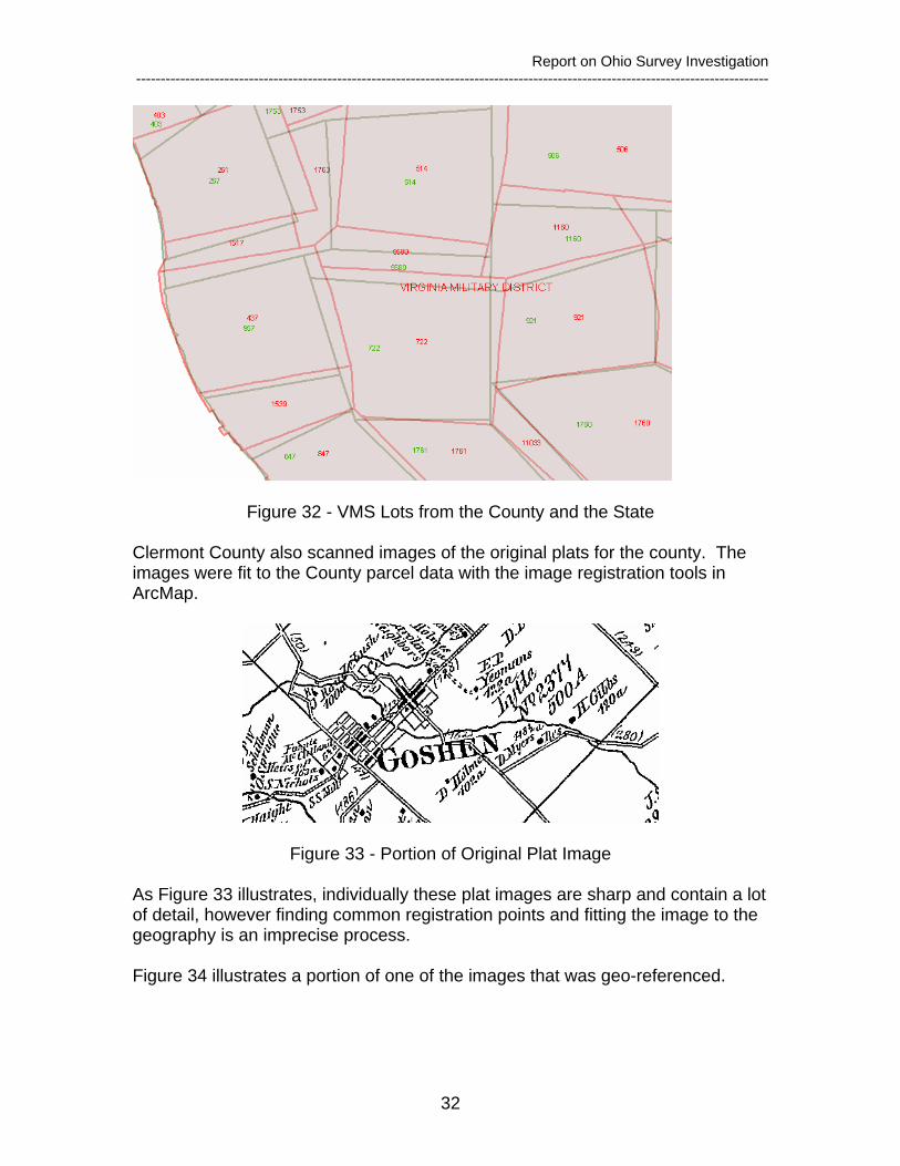
Notice in Figure 31 that the lotting is irregularly numbered and that the lots are irregularly shaped. Also notice that the county boundaries do not follow the lot lines and neither do the municipal areas in the county. This means that parcels may follow the legal descriptions of the lots, but the geopolitical divisions do not follow the lots. The Clermont County VMS lots and the State VMS lots have differences in completeness and correctness. In an area as complicated as the Virginia Military District it is expected that the local data will be more accurate. In Figure 32 the red lines and red labeling are from the county and the green lines and green lettering are from the state.
Report on Ohio Survey Investigation ---------------------------------------------------------------------------------------------------------------------------------
32
Figure 32 - VMS Lots from the County and the State
Clermont County also scanned images of the original plats for the county. The images were fit to the County parcel data with the image registration tools in ArcMap.
Figure 33 - Portion of Original Plat Image
As Figure 33 illustrates, individually these plat images are sharp and contain a lot of detail, however finding common registration points and fitting the image to the geography is an imprecise process. Figure 34 illustrates a portion of one of the images that was geo-referenced.

Report on Ohio Survey Investigation ---------------------------------------------------------------------------------------------------------------------------------
33
Figure 34 - Geo-Referenced Plat image Red outline are polygons for the Virginia Military Reservation Lots from the County of Clermont. Green outline are polygons from the State of Ohio Department of Natural Resources (ODNR) data set for Virginia Military Reservation Lots. Yellow line is a highlighted polygon from the State ODNR data set for lot 910.
In this area the County and the State data sets have reasonably similar identification of the original lot numbers. The complexity of the original plat areas and the resulting vector mapping of the lots can be seen in Figure 34. 5.3 County and State Data Sets The state-wide data set provided by the ODNR is an excellent resource for evaluating the PLSS and Survey System areas in the state. It provides a continuous inventory of areas across the state and is an excellent starting point. If the State ODNR data were restructured to follow the Cadastral Data Content Standard and placed in a geodatabase, it seems that the more detailed and more spatially accurate information from the counties could be used to improve the quality of the overall statewide data set. The Parcel Framework portion of the Cadastral Core is designed to support just these sort of activities and having a county driven parcel framework would enhance the ability of federal projects such as NILS to use the same framework hence provide vertically integrated land records information from all sources.