a dpsir analysis of aeolian sand dune mobilization along ...€¦ · 4) health hazard because sand...
TRANSCRIPT
Dissanayake Mudiyanselage Ruwan Sampath
Joana Gaspar de Freitas
A DPSIR analysis of aeolian sand dune mobilization
along the coast of Manawatu-Wanganui in New Zealand
Center for History, School of Arts and Humanities,
University of Lisbon, Portugal

Study Area: A Digital Elevation Model of the North Island and
the Manawatu-Wanganui Dune Field
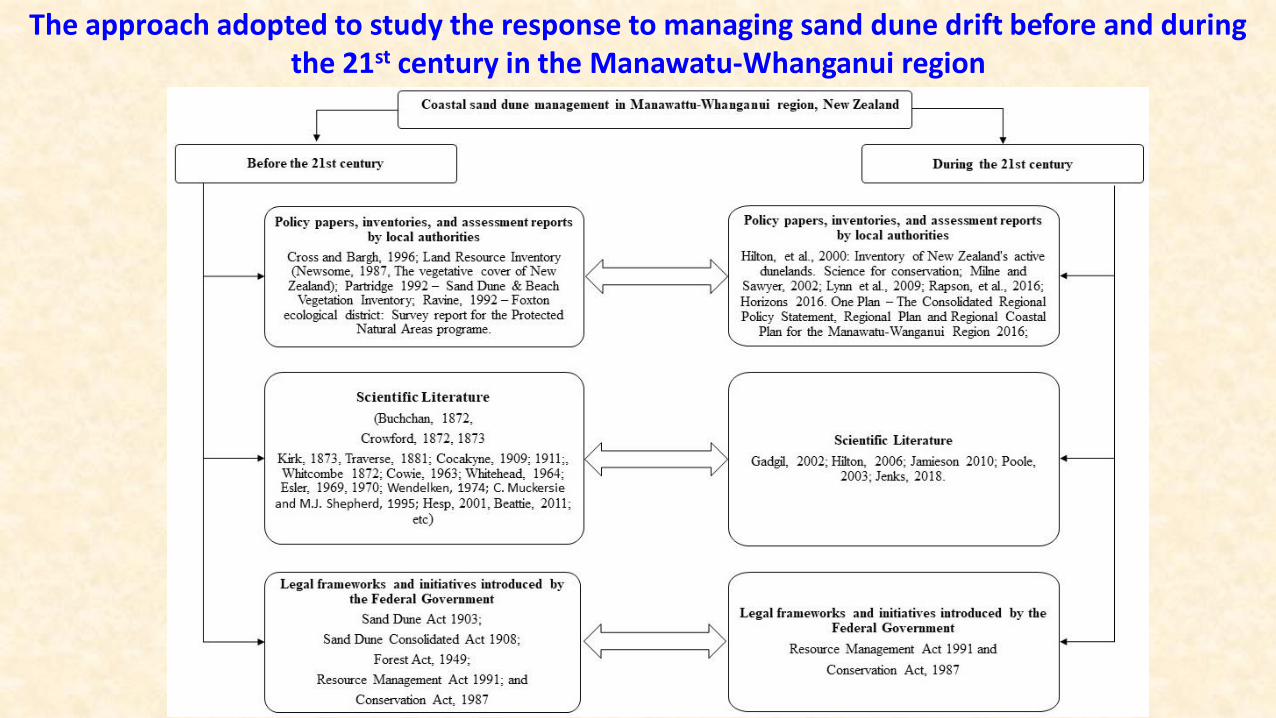
The approach adopted to study the response to managing sand dune drift before and during the 21st century in the Manawatu-Whanganui region
Drivers (D)
Pressures (P)
State (S)
Impact (I)
Response (R)
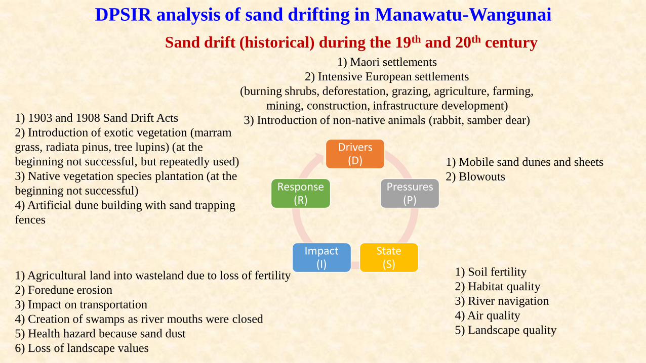
1) Maori settlements
2) Intensive European settlements
(burning shrubs, deforestation, grazing, agriculture, farming,
mining, construction, infrastructure development)
3) Introduction of non-native animals (rabbit, samber dear)
1) Agricultural land into wasteland due to loss of fertility
2) Foredune erosion
3) Impact on transportation
4) Creation of swamps as river mouths were closed
5) Health hazard because sand dust
6) Loss of landscape values
1) Mobile sand dunes and sheets
2) Blowouts
1) Soil fertility
2) Habitat quality
3) River navigation
4) Air quality
5) Landscape quality
1) 1903 and 1908 Sand Drift Acts
2) Introduction of exotic vegetation (marram
grass, radiata pinus, tree lupins) (at the
beginning not successful, but repeatedly used)
3) Native vegetation species plantation (at the
beginning not successful)
4) Artificial dune building with sand trapping
fences
Sand drift (historical) during the 19th and 20th century
DPSIR analysis of sand drifting in Manawatu-Wangunai

DPSIR analysis of sand drifting in Manawatu-Wangunai
Drivers (D)
Pressures (P)
State (S)
Impact (I)
Response (R)
1) Urbanization
2) Intensive settlements
(deforestation, grazing, agriculture, farming, mining,
construction, infrastructure development)
3) Introduction of exotic vegetation as a response to dune
mobilization in the 19th and 20th centuries
4) Climate change
1) Land into wasteland due to loss of fertility
Transportation issues
2) Loss of biodiversity
3) Creation of swamps as river mouths were closed
4) Health hazard because sand dust
5) Loss of forest cover
6) Loss of landscape values
7) Change of trangressive dunes to parabolic dunes
8) Coastal inundation and foredune erosion
1) Mobile sand dunes
2) Blowouts
3) Spread of invasive species
(marram grass)
4) Sea-level rise
1) Soil fertility
2) Bio diversity (flora and fauna)
3) Habitat quality
4) River navigation
5) Air quality
6) Landscape quality
7) Land with beaches and dunes
1) Resource Management Act 1991 (RMA)
2) Integrated management “One Plan” The Consolidated
Regional Policy Statement, Regional Plan and Regional
Coastal Plan for the Manawatu-Wanganui Region prepared
by the Horizons Regional Council
3) Removal of exotic vegetation (e.g. marram grass)
4) Introduction of native vegetation species
5) Artificial dune building with sand trapping fences
6) Enhance awareness
7) Public participation
8) No special attention to SLR in One Plan
Sand drift during the 21st century

Direct and indirect paths of knowledge transfer to New Zealand to manage sand
dune drift in the 19th and 20th centuries.
(Base map: DUNES project database)
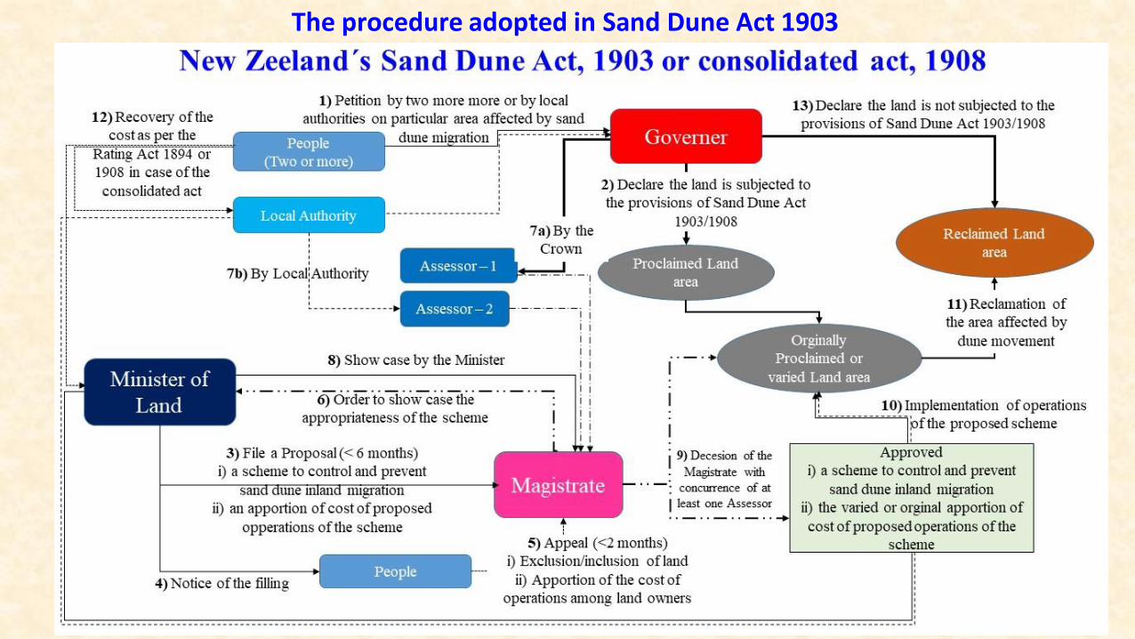
The procedure adopted in Sand Dune Act 1903
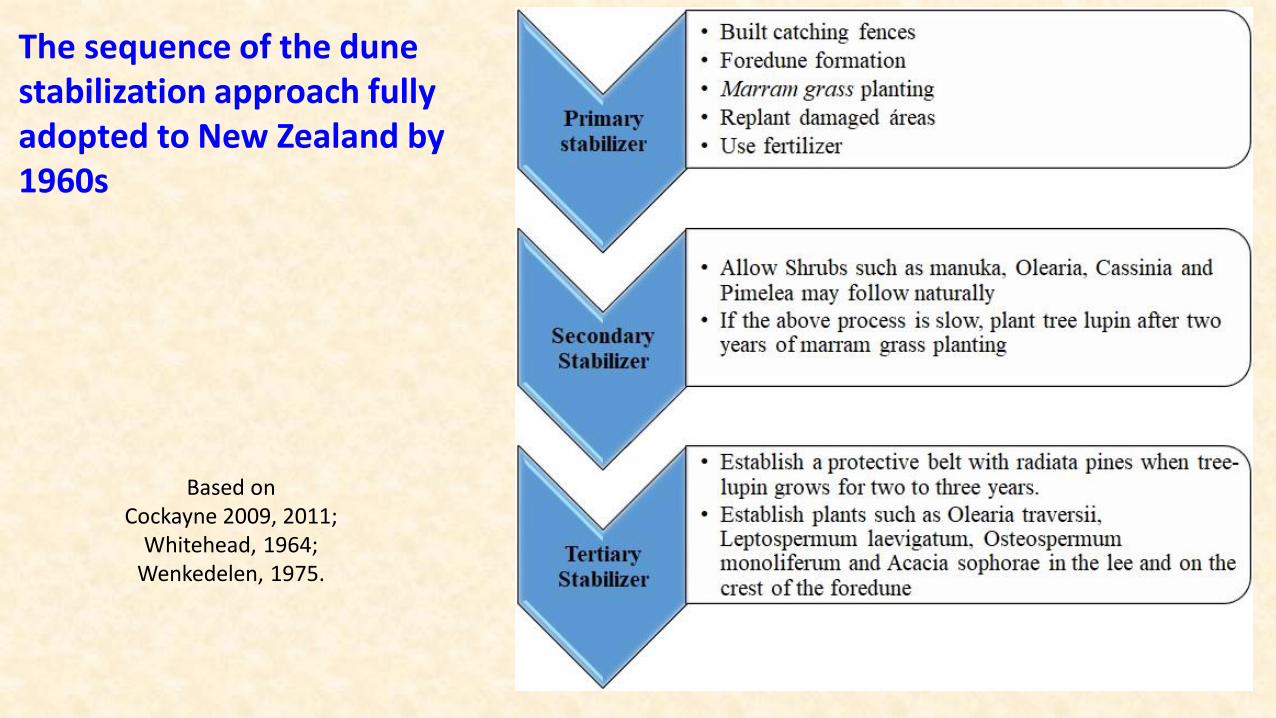
The sequence of the dune stabilization approach fully adopted to New Zealand by 1960s
Based on Cockayne 2009, 2011;
Whitehead, 1964;Wenkedelen, 1975.
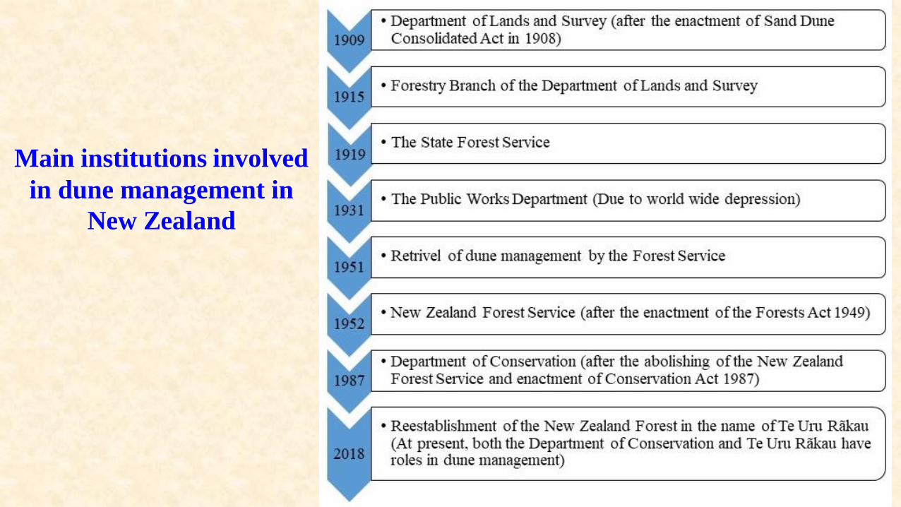
Main institutions involved
in dune management in
New Zealand
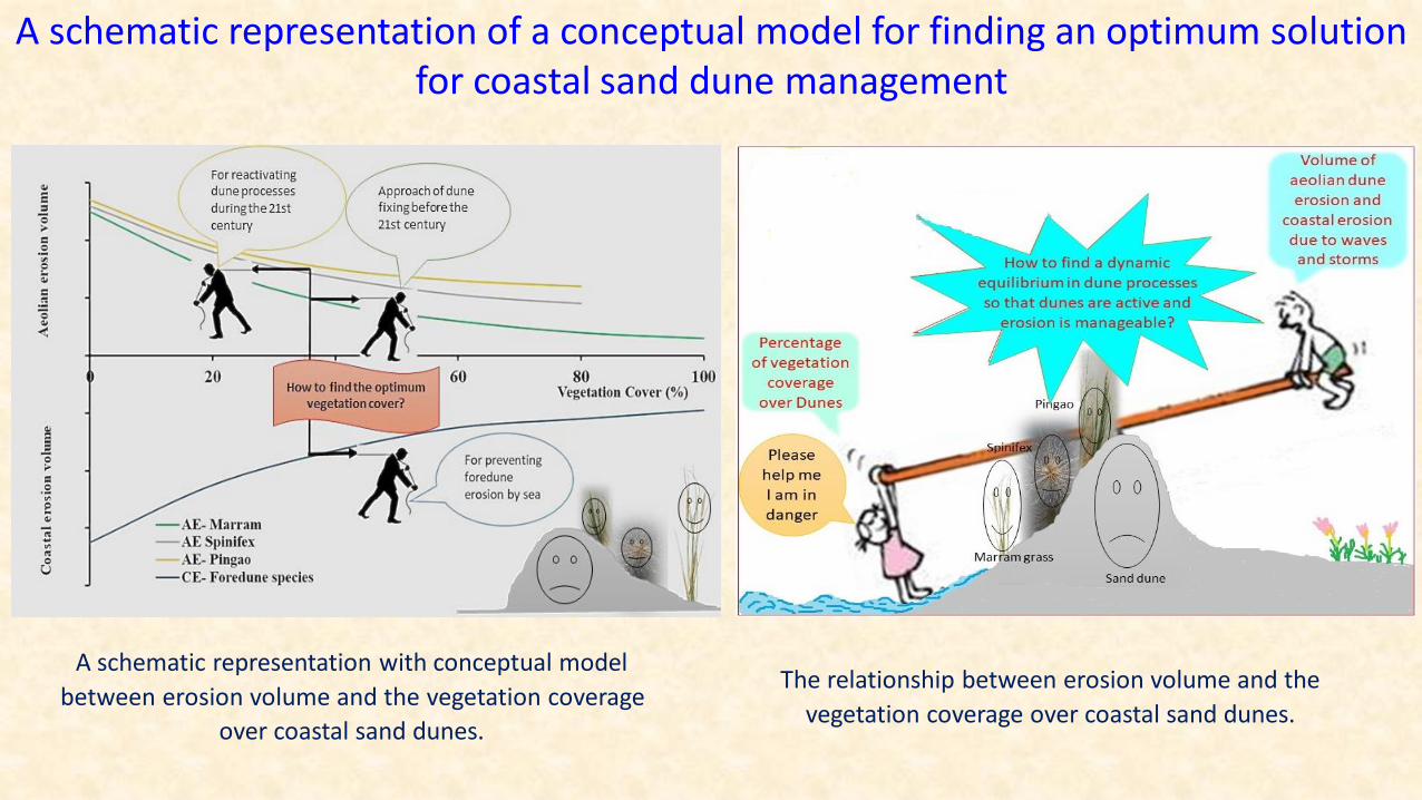
The relationship between erosion volume and the
vegetation coverage over coastal sand dunes.
A schematic representation with conceptual model
between erosion volume and the vegetation coverage
over coastal sand dunes.
A schematic representation of a conceptual model for finding an optimum solution for coastal sand dune management

Lessons Learnt and reccommendations
• Adaptation of foreign methodologies are recommended only if they can enhance the natural process of the local environments.
• Proper scientific research must be carried out to understand the natural environment and their processes and their sensitivity to change of the system.
• Environmental anxiety may sometimes cause negative impact and can be detrimental in finding sustainable solutions to environmental hazards. Therefore, any mitigation and adaptation approached must be planned and implemented rationally and objectively.
• Public participation should be encouraged in the restoration projects of sand dunes, as it connects the population with the environment and enhance the awareness of natural hazards and boosts precautionary approaches.
• It is required to identify new threats. For instance, accelerated sea-level rise as predicted in numerous studies, including the IPCC, can aggravate the issue as the erosion of foredunes can be increased.
• Though the eroded sand may be deposited below the sea-level, they will ultimately contribute to the formation of sand dunes further inland.

Thank You