7% 1 exploration itd. geology geophysics mining …
TRANSCRIPT
> 7 % 1 ../'
GEOLOGY GEOPHYSICS exploration Itd. MINING ENGINEERING
Suite 614-850 WEST HASTINGS STREET, VANCOUVER, B.C. TELEPHONE (604) 681-0191 V6C 1E l
GEOLOGICAL, GEOPHYSICAL and GEOCHEMICAL REPORT
on the
GONZO CLAIM
Cariboo Mining Division - British Columbia
Lat. 57' 42' N. Long. 12fo 50' W.
N.T.S. 93 AI12 d
for
Gunsteel Resources Incorporated
J. Gravel (M.Sc.1 D. G. Allen, P. Eng. (B.C.) D. R. MacQuarrie, (B.Sc.)
July 20, 1986 Vancouver, B.C.
TABLE OF CONTENTS
SUMMARY
CONCLUSION
RECOMMENDATIONS
ESTIMATED COSTS OF RECOMMENDATIONS INTRODUCTION
LOCATION, ACCESS, PHYSIOGRAPHY
CLAIM DATA
GEOLOGY
Regional Geology
Property Geology
MINERAL OCCURRENCES OF THE CARIBOO-QUESNEL GOLD BELT
QR Deposit
Cariboo Bell
Frasergold Prospect
PREVIOUS FIELDWORK
1986 FIELDWORK
ANALYTICAL RESULTS
Basemetal Pattern
Mafic Rock
GEOPHYSICAL RESULTS
Magnetometer Survey
VLF Survey
COMPILATION OF RESULTS
1
2
3
4
5
5
5
6
6
6
7
8
9
9
9
10
10
10
11
11
11
11
1 2
TABLE OF CONTENTS (Cont'd.)
FIGURES
Figure 1 Location Map 1:10,000,000
Figure 2 Access Map 1 : 250,000
Figure 3 Claim Map 1 : 50,000
Figure 4a Property Location Map Quesnel River Area 1:125,000
Figure 4b Quesnel Gold Belt 1 : 700,000
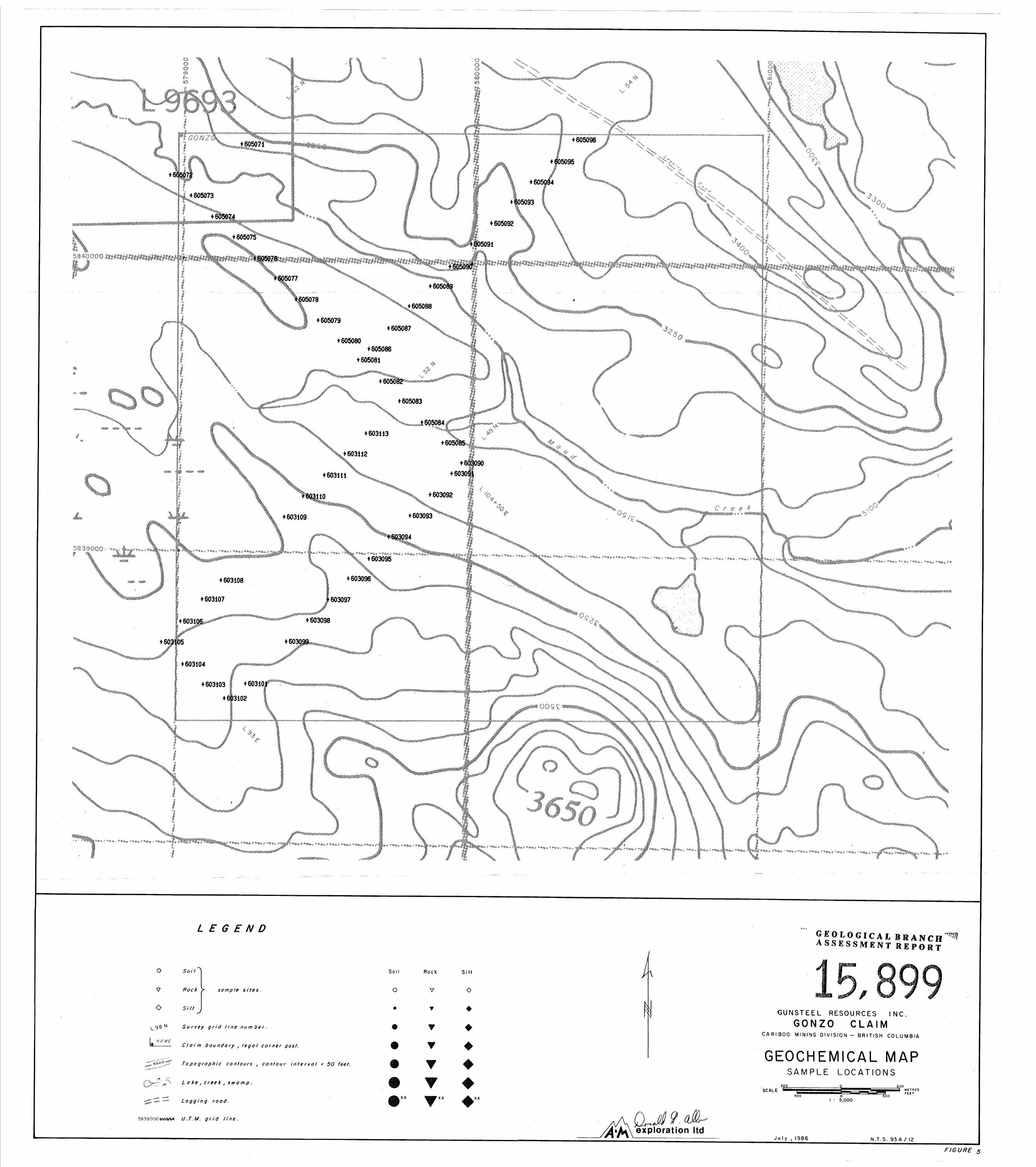
Figure 5 Sample Location Map 1 : 5,000
Figure 5a-e Geochemical Maps 1 : 5,000
Figure 5f-p Geochemical Maps 1:15,000
Figure 6a Magnetic Survey 1 : 5,000
Figure 6b VLF-Electromagnetic Map 1 : 5,000
Figure 7 Compilation Map 1 : 15,000
Figure 8a Magnetic Contour & Electro- magnetic Conductor Map 1 : 15,000
Figure 8b Total Field VLF Contour Map 1:15,000
Figure 8c Electromagnetic Profiles Map (low freq., coaxial coils) 1:15,000
Figure 8d Electromagnetic Profiles Map (high freq., coplanar coils) 1:15,000
APPENDICES
Appendix I 1984 Airborne Geophysical Surveys
Appendix I1 Sampling Procedures, Analytical Procedures, Statistics and Data Listing
After p. 5
After p. 5
After P. 6
After p. 6
After p. 7
In pocket
In pocket
After p. 10
In pocket
In pocket
After p. 10
Appendix I
Appendix I
Appendix I
Appendix I
Appendix 111 Affidavit of Expenses
1
SUMMARY
w
Gunsteel Resources Incorporated holds title to the GONZO claim, a
16 unit block located in the Cariboo Mining Division of central British
Columbia. The property lies 55 kilometres southeast of Quesnel and is
directly accessible by a branch of the Nyland Lake logging road. Past work consists of an airborne magnetic and electromagnetic survey in
1984. The 1986 follow-up program comprised preliminary ground geo-
physical and soil geochemistry surveys.
The GONZO claim is strategically located along the Quesnel Basin
fault, three kilometres north of the QR and QR West deposits and 44
kilometres southeast of the Maud occurrence. Other important dis-
coveries in the area include the Cariboo Bell deposit and Mt. Calvery's
Spanish Mountain occurrence, 19 and 27 kilometres to the southeast,
respectively. Significant geochemical and geophysical anomalies have
been found to the north (Titan Resources Ltd., Curator Resources Ltd.,
Buena Exploration) of the property.
The aforementioned properties lie within the Quesnel Trough, a
northwest trending belt of dominantly Lower Mesozoic volcanic and
volcanically derived sedimentary rocks. The QR and Cariboo Bell
deposits are associated with complex alkalic intrusions that are coeval
to the enclosing volcanics. Both discoveries are based on geochemically and geophysically derived drill targets.
Approximately 5.5 kilometres of grid lines were established as
follow-up to the 1984 airborne geophysical surveys. VLF-EM and proton
precession magnetometer readings were taken every 25 metres, and B
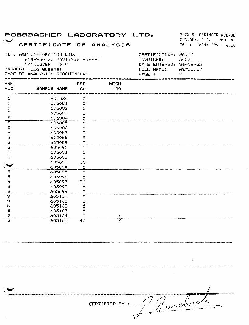
horizon soil samples were collected every 100 metres on this grid. 49
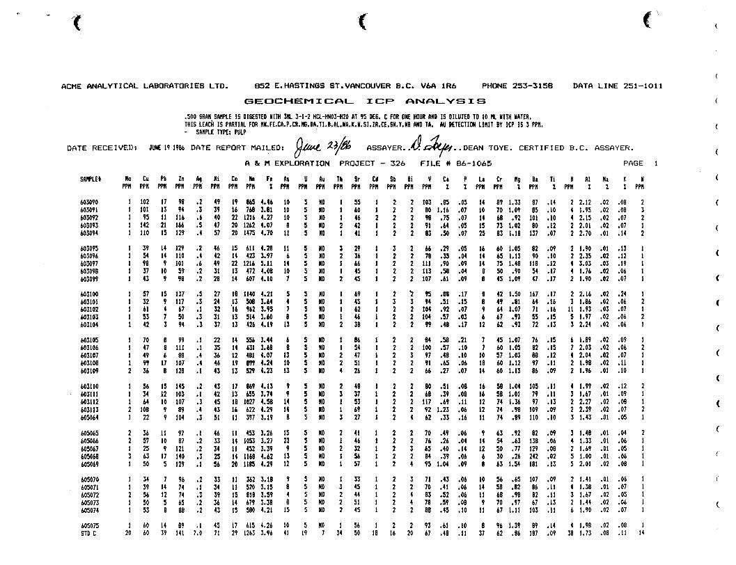
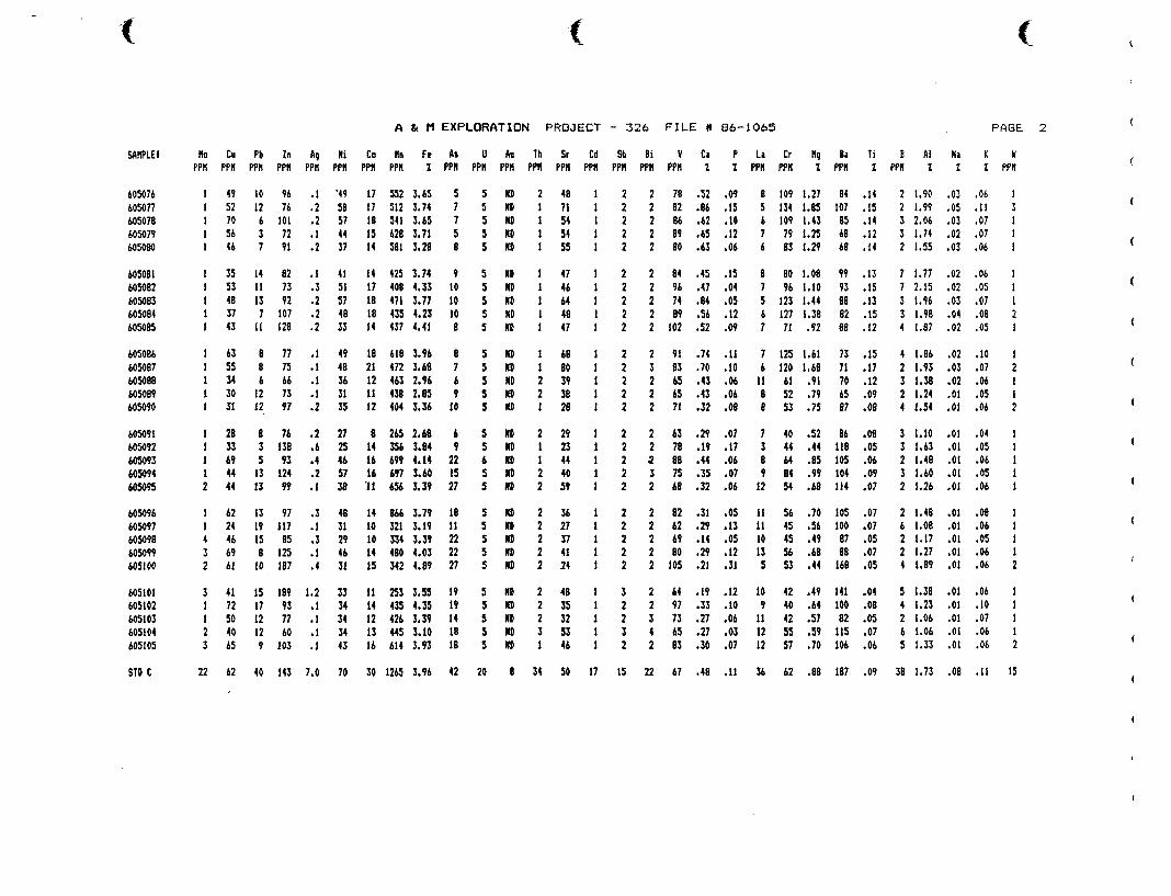
soil samples were analysed for gold at Rossbacher Laboratory Ltd. and 30
element ICP spectrometry at Acme Analytical Laboratories Ltd.
Gold is uniformly low: no samples contain above the,detection
limit (5 ppb) concentration. Two principal anomaly distribution
patterns, termed the basemetal pattern and mafic rock pattern, were
observed. The patterns probably reflect a change in bedrock types. The
2
mafic rock patter.1 is thought to overlie mafic volcanics whereas the
basemetal pattern could be defining sulphide bearing sediments or more
felsic volcanics and volcaniclastics. A sharp increase in the magnetic
field in the area of the mafic rock pattern also suggests mafic
volcanics as the underlying rock type. Moderate magnetic readings
coincident to the basemetal pattern suggests the underlying rock type
may be an andesite.
CONCLUSION
Recent positive results by various companies in the Quesnel River
area indicate it will continue to be one of intense exploration
activity. The GONZO claim is strategically located in terms of:
proximity to known deposits; position along favourable structures; and
geology.
Good accessibility and moderate to thin glacial drift promote cost
effective exploration.
Moderately anomalous copper, lead, zinc, silver, manganese, iron,
arsenic, potassium and aluminum indicate underlying sedimentary or
felsic volcanic rock with minor sulphides, while the magnetometer
results suggest an andesite.
The reconnaissance grid lines are too sparse to properly evaluate the gold potential of the GONZO. Presence of the Maud Lake Fault
bisecting the property and the nearby Maud Lake occurrence argue
favourably for mineralization. Further geochemical and geophysical work
is warranted to give a proper evaluation and prove up targets for
trenching andfor diamond drilling.
3
RECOMMENDATIONS
A two-phase program is proposed to properly evaluate the mineral
potential of the GONZO claim. Phase I consists of extending the present
grid to cover the entire claim block. Geochemical samples should be
collected at a 100x200 metre spacing with VLF-EM and magnetometer
readings gathered every 25 metres. IP traverses are suggested over the
whole of the grid.
Based on results of Phase I, trenching is recommended for zones having coincident anomalous geochemical and IP responses. Follow-up
drilling is warranted if initial results are encouraging. Estimated
costs for Phase I and I1 are $23,000 and $77,000, respectively, for a
grand total of $100,000.
W
4
V .ESTIMATED COSTS OF RECOMMENDATIONS
PHASE I Geochemical soil sampling, geological mapping, VLF-EM, Magnetometer and Induced Polarization surveys.
Salaries Geologist 15 days @ $200/day 4 Assistants 60 days 63 $100/day
Geochemical Analyses 250 samples @ $12 Room and Board 75 man-days @ $35 Vehicle Rental Material, Camp Supplies Instrument Rental Report and Maps
Subtotal Contingencies
TOTAL PHASE I
Phase I1 Follow-up trenching and diamond drilling.
Salaries Geologist Ass is t ant
Room and Board Vehicle Rental Backhoe for trenching Bulldozer for drill
site preparation Dr ill ing Geochemical Analyses Material and Supplies Report and Maps
1 mo. @ $6,000 1 mo. @ $3,000 60 man-days @ $35
75 hrs. 63 $75/hr.
100 hrs. @ $80/hr.
250 samples @ $12 1,000 ft. @ $35/ft.
Subtotal Contingencies
$ 3,000.00 6,000.00 3,000.00 2,625.00 1,000.00 1,000.00 1,000.00 2,500.00
$20,125.00 $ 2,875.00
$23,000.00
$ 6,000.00 3,000.00 2,100.00 1,000.00 5,625.00
8,000 .OO 35,000.00
3,000.00 3,000.00 2,500.00
$69,225.00 7.775.00
TOTAL PHASE I1 $77,000.00
GRAND TOTAL $ioo,ooo .oo
W
5
INTRODUCTION
V
Gunsteel Resources Incorporated holds the GONZO claim, a 16 unit
block which was staked based on its favourable geology, structure and
position relative to several substantial gold discoveries in the Cariboo-Quesnel Gold belt. The property lies immediately north of Dome
Mines' QR (950,000 tons grading 0.21 oz/ton Au) and QR West deposits.
This report summarizes results of a program of preliminary
geochemical, VLF-electromagnetic and magnetic surveys carried out on the
GONZO claim from June 11 to 12, 1986. Also summarized is the geology of
the QR, QR West, Maud and other exploration targets in the
Cariboo-Quesnel gold belt.
LOCATION, ACCESS, PHYSIOGRAPHY
The GONZO claim is situated 55 kilometres southeast of Quesnel,
British Columbia (Figure 1). The property lies along Maud Creek, a
tributary of Quesnel River (Figure 2). The area is part of the Quesnel
Highlands of the Interior Plateau. Low rolling hills elongated in the
direction of glaciation (310') separated by boggy depressions are the
principal geophysiographic features. The hills are typically covered by
a thin veneer of glacial till which varies from less than one metre to several tens of metre's thick. Maximum relief of about 50 metres is
observed along Maud Creek.
Forest cover consists of mature growths of lodgepole pine, balsam,
fir, spruce and poplar with undergrowth of alder and willow. A branch
of the Nyland Lake logging road traverses the northeast corner of the
claim block making the property accessible by 4-wheel drive vehicle
(Figure 2).
CLAIM DATA
The claim is owned 100% by Gunsteel Resources Incorporated. The
claim Record Number is 4881 and expiry date is June 6, 1987. Two
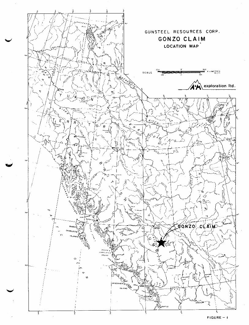
GUNSTEEL RESOURCES CORP.
G O N Z O C L A I M LOCATION MAP
F I G U R E - I
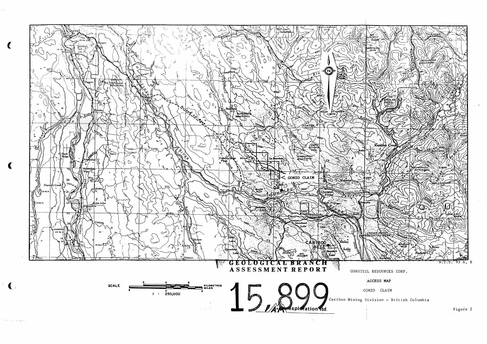
;ACCESS MAP aiLowiaLs I
SCALE - Y l L f S GONZO CLAIM 0 S S
I : 250,000
Cariboo Mining Division - British Columbia
I I
B
Figure 2
6
internal claims are not held by Gunsteel. Claim boundaries are shown on
Figure 3 .
GEOLOGY
Regional Geology
The area of interest is underlain by a thick sequence of mainly
Upper Triassic and Lower Jurassic volcaniclastic and sedimentary rocks
that lie in a fault bounded structure termed the Quesnel Trough
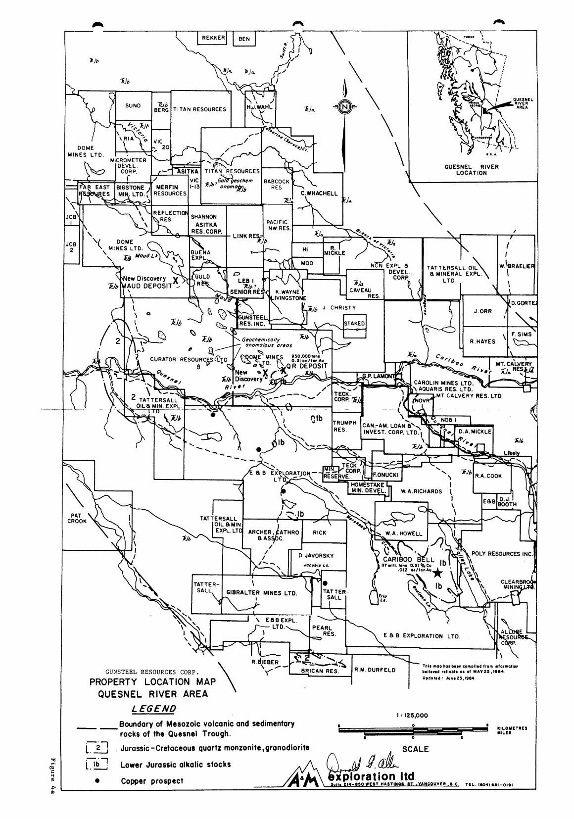
(Campbell and Tipper, 1970). It is a northwesterly trending feature about 35 kilometres wide (Figure 4a) which is flanked on the east by Proterozoic and Paleozoic strata of the Omineca geanticline and on the
west by Upper Paleozoic rocks of the Pinchi geanticline. Intrusive rocks in the trough fall into two age groups. Those grouped as 200
m.y.2 include two types: (la) plutons and batholiths such as the
Takomkane batholith, which vary in composition from granodiorite to
quartz diorite and (lb) small alkalic stocks that are apparently coeval
with enclosing volcanic rocks and vary in composition from syenite
through diorite to pyroxenite; ( 2 ) plutons of the 100 m.y.2 age group
are primarily biotite quartz monzonite and granodiorite and are commonly
porphyritic - one such intrusion outcrops in the Quesnel River valley seven kilometres southwest of the claim area and another unmapped
intrusion lies about five kilometres northwest of Maud Lake.
Property Geolopy
Because relief in the GONZO claim area is subdued, outcrops are
nonexistant. Most of the rock types observed only in float were phases
of andesite and basalt with varied textures. Of these, porphyritic
augite andesite phases predominate. Areas of low magnetic relief
suggest that the northern half of the claim area is actuallylunderlain
by sedimentary rocks.
The main rock types in the immediate area as described by Campbell
(1978) are as follows:
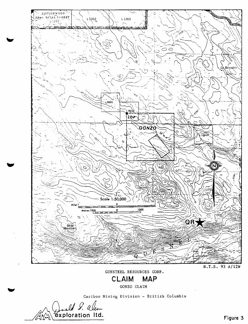
GUNSTEEL RESOURCES CORP.
CLAIM MAP GONZO CLAIM
Cariboo Mining Division - British Columbia //ywJ?d Abh exploration Itd.
N . T . S . 93 A/12W
Figure 3
. r
EJtl
x l b
Wb BERG T ITAN RESOURCES
\ QUESNEL RIVER LO CAT ION
I
LY RESOURCES INC.
E a B EXPLORATION LTD.
R.M. DURFELD Updotod : June 25,1984
I 2 128,000
GUNSTEEL RESOURCES CORP.
PROPERTY LOCATION M A P QUESNEL RIVER AREA
L EGEND 8
KILOMETRES M I L CI
-- Boundary of Mesozoic volcanic and sedimentary 0
\ \
TATTERSALL OIL a MINERAL EXPL.
/ I
f I
I \
W. \ BRAELLR
2 1 J.ORR
F SIYS . . -. .-. - R.HAYES '1.
i. i -2 Jurassic -Cretaceous quartz monzonite ,granodiorite A SCALE
1. Ti7 - Lower Jurassic olkalic stocks
0 Copper prospect
P ' G E O L O G I C A L B R A N C H ', A S S E S S M E N T R E P O R T
7
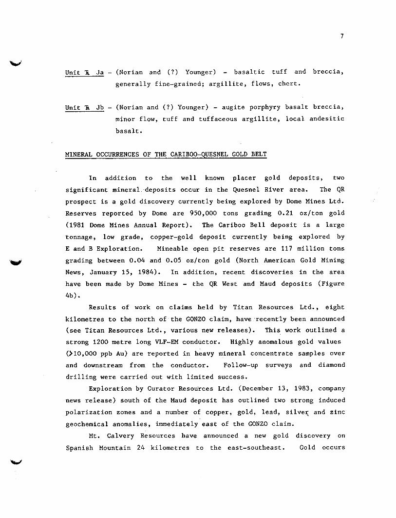
V Unit 'IL Ja - (Norian and ( ? ) Younger) - basaltic tuff and breccia,
generally fine-grained; argillite, flows, chert.
Unit 'A Jb - (Norian and ( ? ) Younger) - augite porphyry basalt breccia, minor flow, tuff and tuffaceous argillite, local andesitic
basalt.
MINERAL OCCURRENCES OF THE CARIBOO-QUESNEL GOLD BELT
In addition to the well known placer gold deposits, two
significant mineral deposits occur in the Quesnel River area. The QR
prospect is a gold discovery currently being explored by Dome Mines Ltd.
Reserves reported by Dome are 950,000 tons grading 0.21 oz/ton gold
(1981 Dome Mines Annual Report). The Cariboo Bell deposit is a large
tonnage, low grade, copper-gold deposit currently being explored by
E and B Exploration. Mineable open pit reserves are 117 million tons
grading between 0.04 and 0.05 oz/ton gold (North American Gold Mining
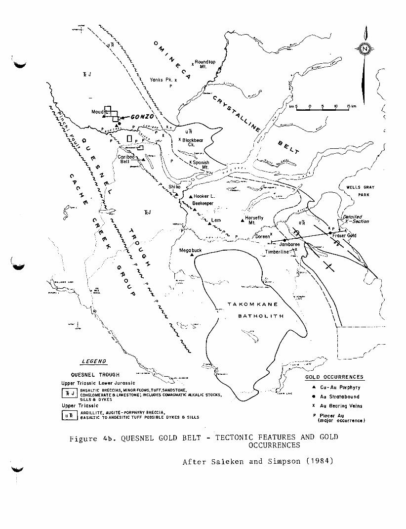
News, January 15, 1984). In addition, recent discoveries in the area
have been made by Dome Mines - the QR West and Maud deposits (Figure
4 b ) .
Results of work on claims held by Titan Resources Ltd., eight
kilometres to the north of the GONZO claim, have recently been announced (see Titan Resources Ltd., various new releases). This work outlined a
strong 1200 metre long VLF-EM conductor. Highly anomalous gold values
(>lO,OOO ppb Au) are reported in heavy mineral concentrate samples over
and downstream from the conductor. Follow-up surveys and diamond
drilling were carried out with limited success.
Exploration by Curator Resources Ltd. (December 13, 1983, company
news release) south of the Maud deposit has outlined two strong induced
polarization zones and a number of copper, gold, lead, silveq and zinc
geochemical anomalies, immediately east of the GONZO claim.
Mt. Calvery Resources have announced a new gold discovery on
Spanish Mountain 24 kilometres to the east-southeast. Gold occurs
ARGILL IT€, AUGITE - PORPHYRY BRECCIA, BASALTIC TO ANDESITIC TUFF POSSIBLE OYKES 8 SILLS P Placer Au
(major occurrence 1
F i g u r e 4b. QUESNEL GOLD BELT - TECTONIC FEATURES AND GOLD OCCURRENCES
After S a l e k e n and Simpson ( 1 9 8 4 )
8
associated with pyrite in phyllites and graphitic phyllites with values
to 0.1 oz/ton Au over widths up to 15 metres (see Mt. Calvery Resources,
various news releases).
Copper - + gold mineralization is widespread in the Quesnel Trough. A number of copper prospects are shown on Figures 4a and 4b. The
scarcity of mineral occurrences to the north of Quesnel River may be because of widespread glacial drift and lack of outcrop and hence, up
until recently, the area has not been intensely explored.
QR Deposit
Geological data of the QR deposit has not been published; however,
a brief description of the property prior to the discovery of the gold
deposit was made by Richardson (1978). According to Richardson:
"Dark grey alkali basalts and layers of unstratified basaltic
autobreccia form outcrops on the west part of the property. Poorly
bedded volcanic wackes, sedimentary grits, and stock comprising
augite diorite, biotite monzodiorite and minor coarse grained
syenite outcrop on steep slopes of the Quesnel River valley. The
stock is exposed along the valley side for some 1100 metres. The
east and north part of the stock is highly fractured and altered
to K-feldspar veinlets and irregular patches of epidote. Pyrite
is abundant and forms disseminated grains and thin films on fractures. Magnetite forms disseminated aggregates and small stockwork zones associated with K-feldspar and epidote."
Gold mineralization, according to Saleken and Simpson (1984) after
Fox (1983), is associated with a pyrite-epidote alteration zone flanking
the zoned stock.
9
w
Cariboo Bell
The Cariboo Bell deposits have been described by Hodgson et a1
(1976) and by Simpson and Saleken (1983). The deposits occur in an
alkalic syenite complex which intrudes the upper part of thick sequence
of Upper Triassic trachybasalts and volcaniclastic strata. Volcanic
conglomerate and sandstone form a thick unit at the base of the
sequence. Volcanic flows in the sequence are of two types:
(1) porphyritic augite trachybasalts with pillow basalt and aquagene
tuff; and ( 2 ) andesite trachybasalt. Crystal and lapilli tuff and
polymictic volcanic breccias occur locally. This volcanic assemblage is
intruded by a coeval subvolcanic laccolith consisting of six phases.
These phases include syenodiorite, monzonite, porphyry, intrusion
breccia, pyroxenite-gabbro, and pseudoleucite syenite lenses.
Magnetite, chalcopyrite and pyrite occur as dissemination, fracture
fillings and cavity fillings in the intrusion breccias near the top of
the laccolith. Potash feldspar-biotite-diopside alteration surrounded
by garnet-epidote alteration zones occur within the breccia zones.
Frasergold Prospect
The Frasergold deposit, as described by Belik (1983), appears to
be a stratabound gold deposit. Gold mineralization occurs within an
iron-carbonate-rich member of a phyllite sequence of Upper Triassic age. Gold occurs both within the phyllite and in quartz-carbonate "sweats".
PREVIOUS FIELDWORK
Previous fieldwork consists of 18.1 line kilometres of
helicopter-borne multi-frequency electromagnetic and magnetometer
surveys, conducted by R. Sheldrake of Apex Airborne Surveys Ltd. in
1984. Summary of R. Sheldrake's report is given in Appendix 1.-
10
1986 FIELDWORK
Soil geochemistry, VLF-EM and magnetometer surveys were employed
to follow up anomalous geophysical features highlighted by the airborne
survey. A total of 49 samples were collected at a spacing of 100 metres on lines 49N, 52N, 54N and 62N giving 5.5 kilometres of grid.
Geophysical measurements were taken every 25 metres. Work was completed
by a four-man crew consisting of J. Gravel, D. Brownlee, D. Sorenson and
B. Stewart in seven man-days. Sampling procedures, analytical methods, statistical interpreta-
tion and a listing of results is given in Appendix 11. Sample sites and
numbers are plotted on Figure 5 and sample results plotted on Figures 5a to 5p. A compilation of results is presented on Figure 7.
ANALYTICAL RESULTS
All gold analyses were below the detection limit of 5 ppb in
concentration.
Two principal anomaly patterns are evident on examination of the
other element plots. These are termed the basemetal pattern and the
mafic rock element pattern after the association of elements that define
each pattern.
Basemetal Pattern
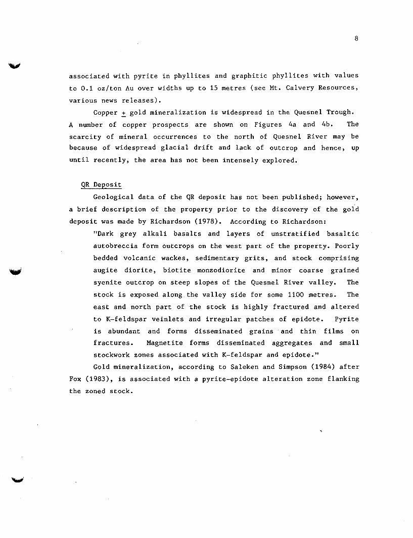
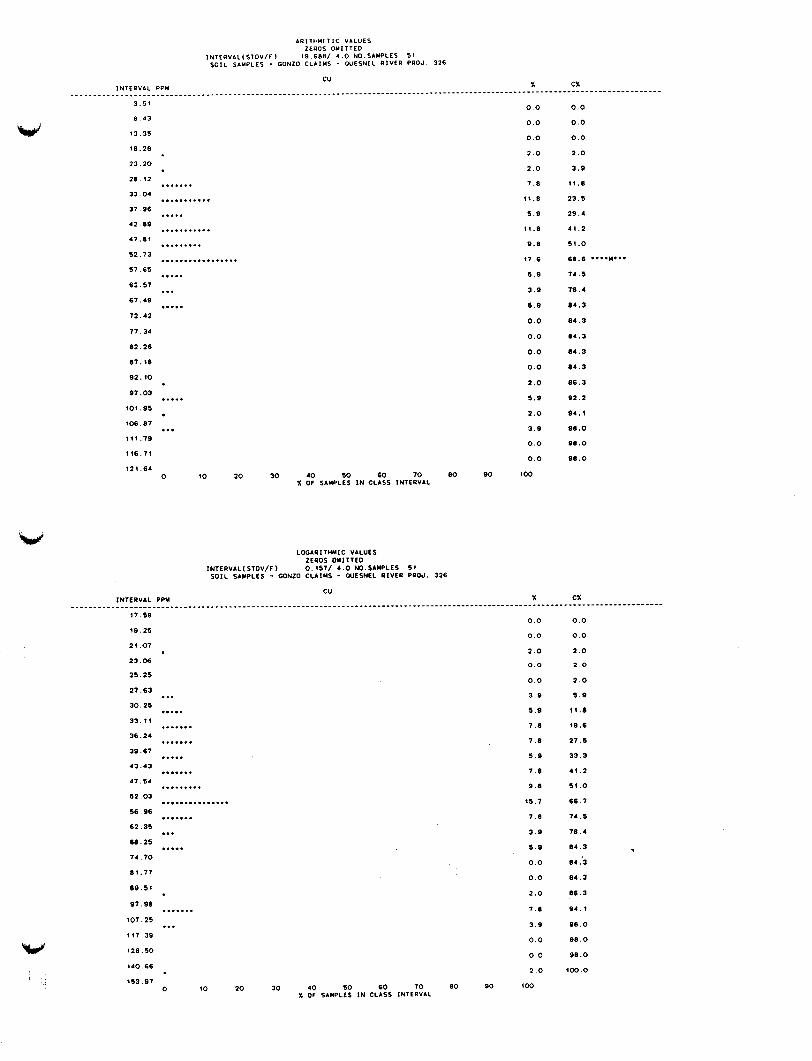
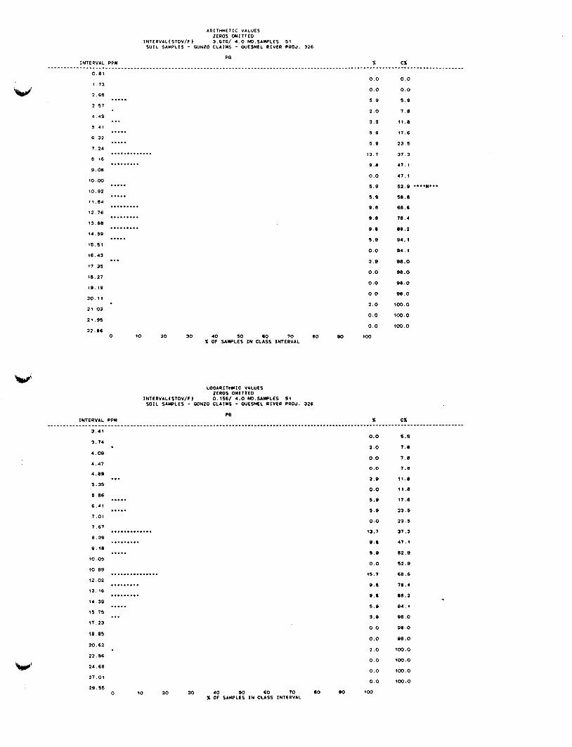
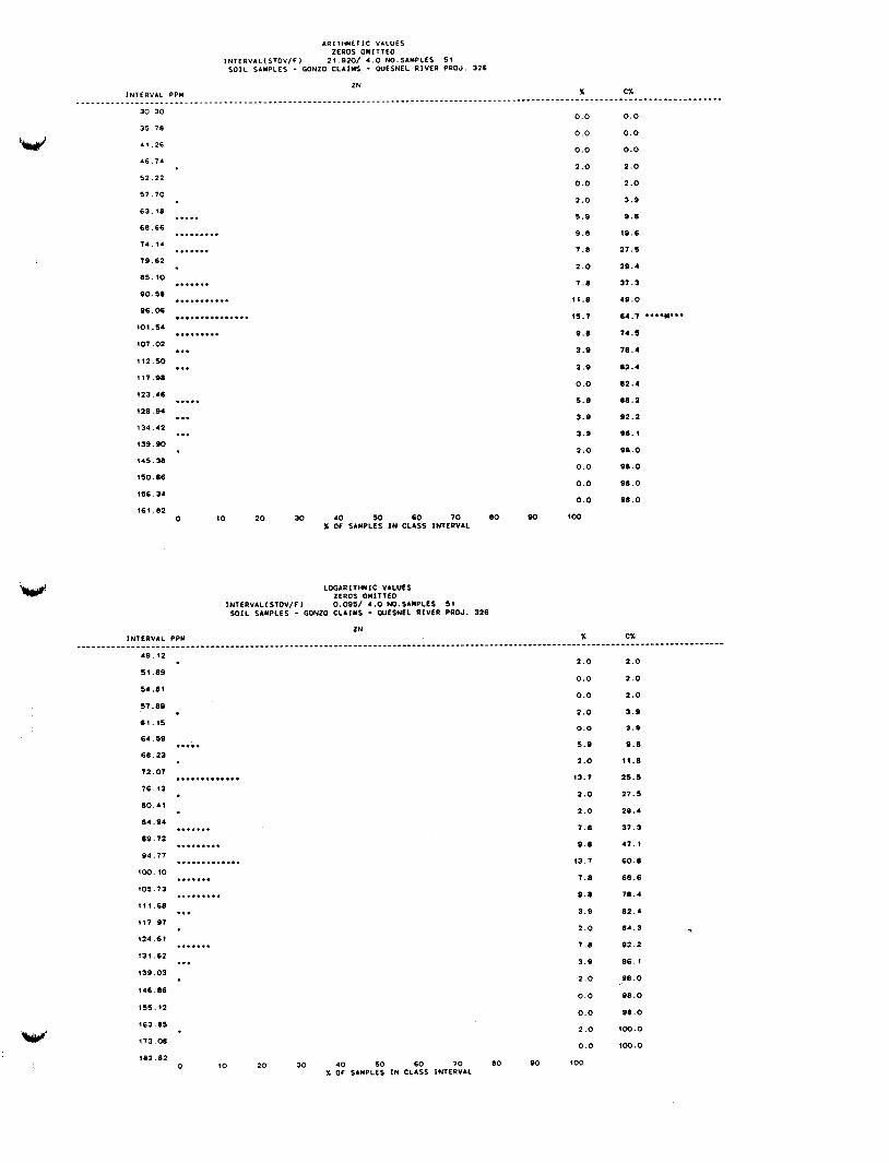
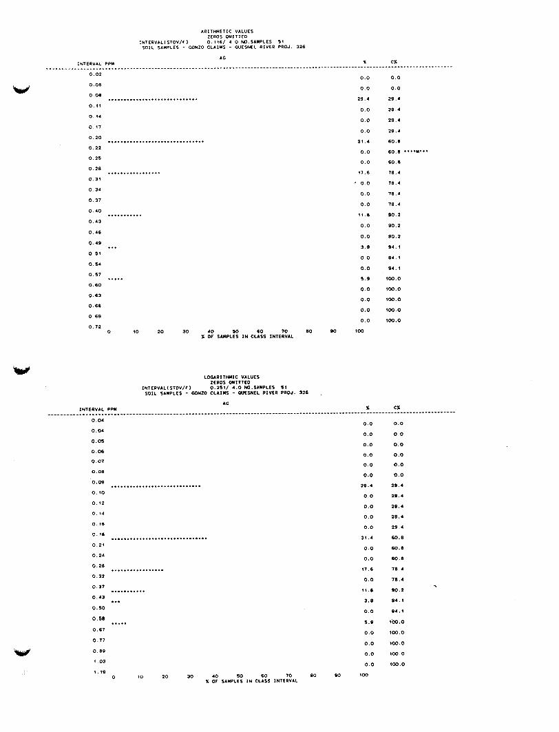
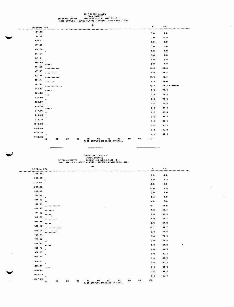
The basemetal pattern is defined by copper (Figure 5a) up to peak
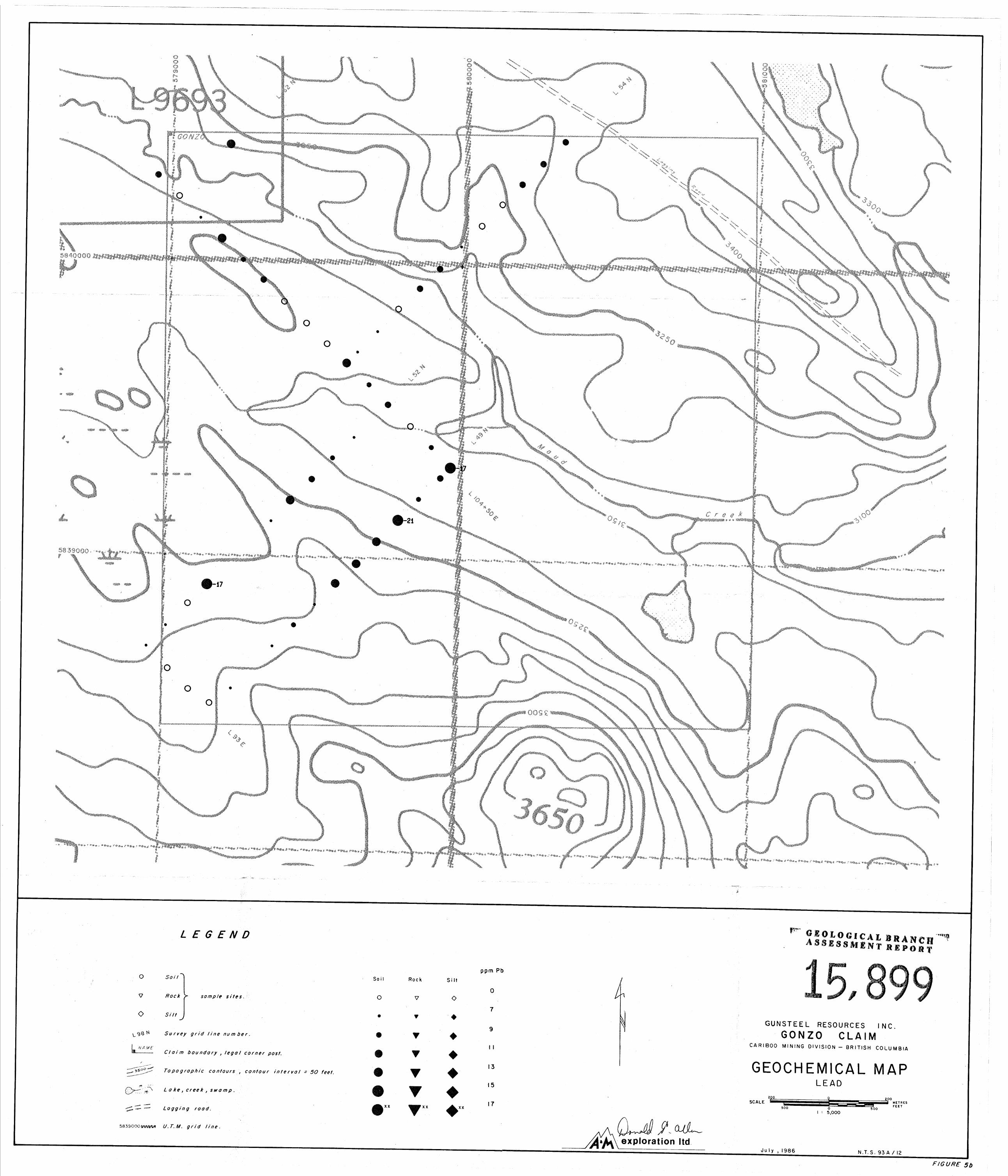
concentration of 142 ppm, lead (Figure 5b) up to 21 ppm, zinc (Figure
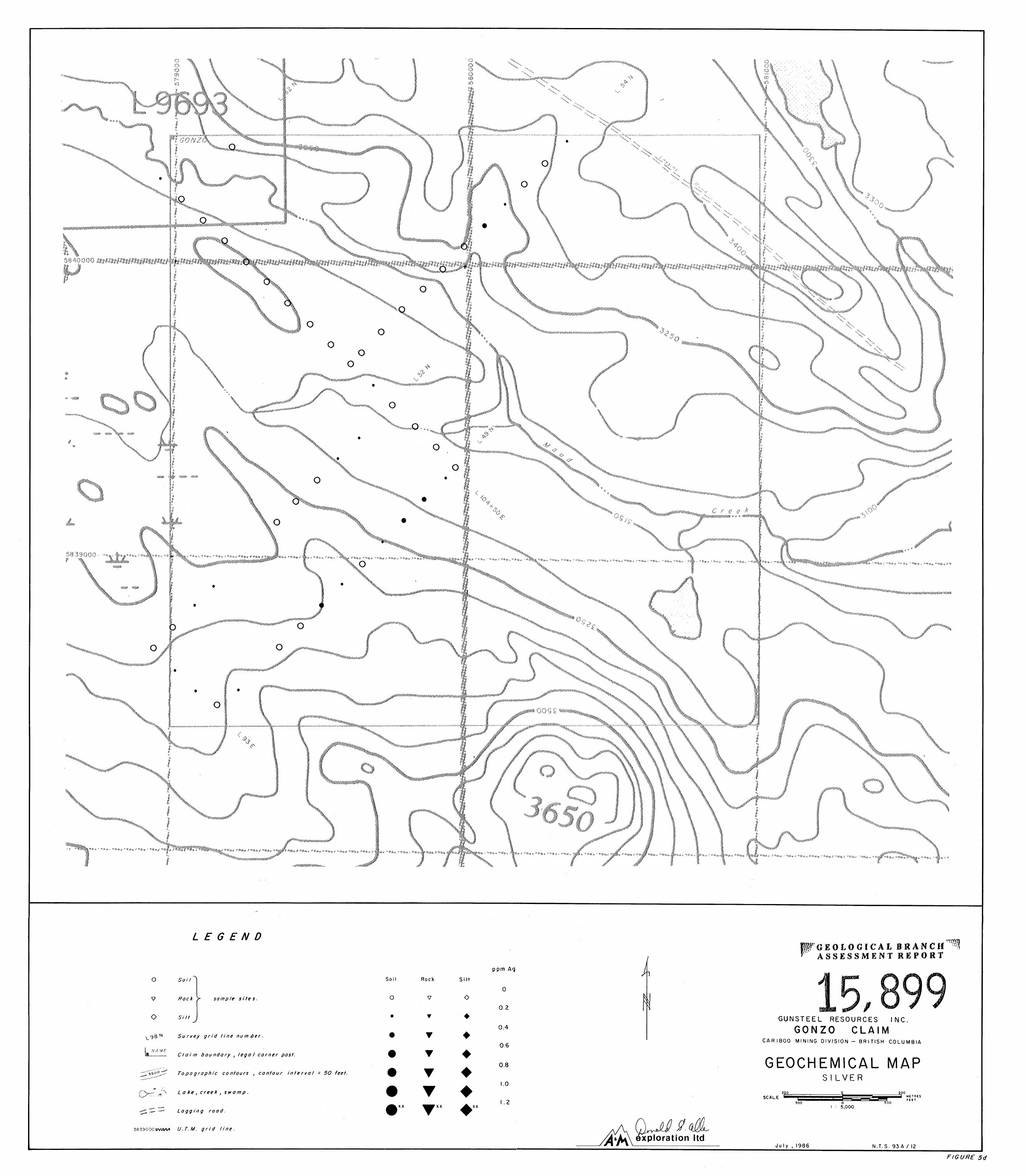
5c) up to 166 ppm, silver (Figure 5d) up to 0.8 ppm, manganese (Figure
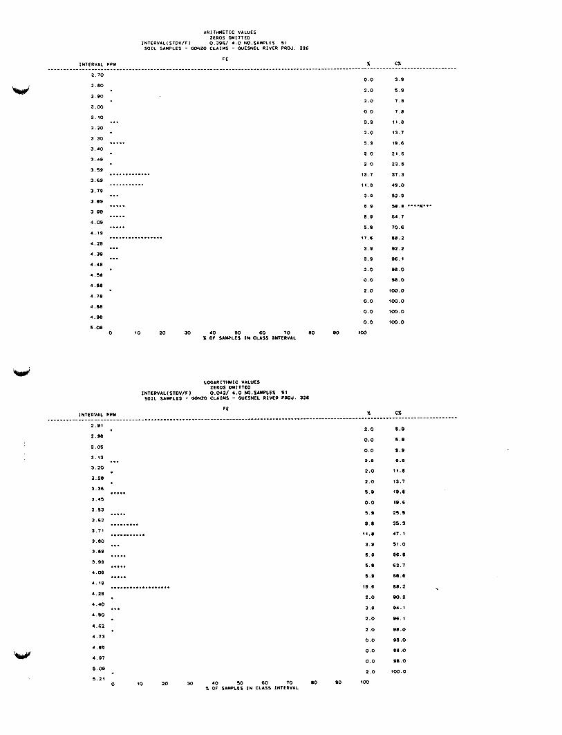
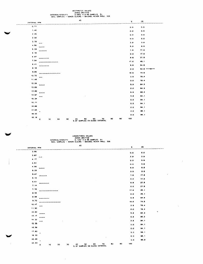
5f) up to 1475 ppm, iron (Figure 5g) up to 5.1 %, arsenic (Figure 5h) up
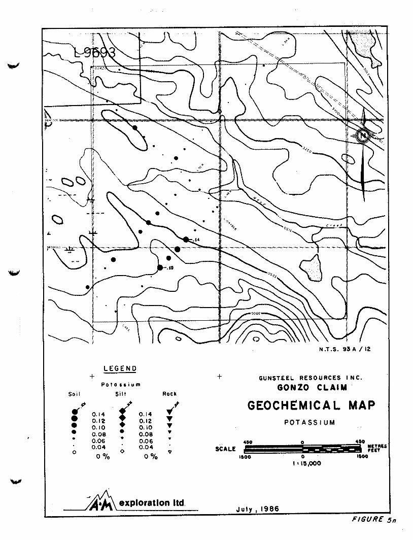
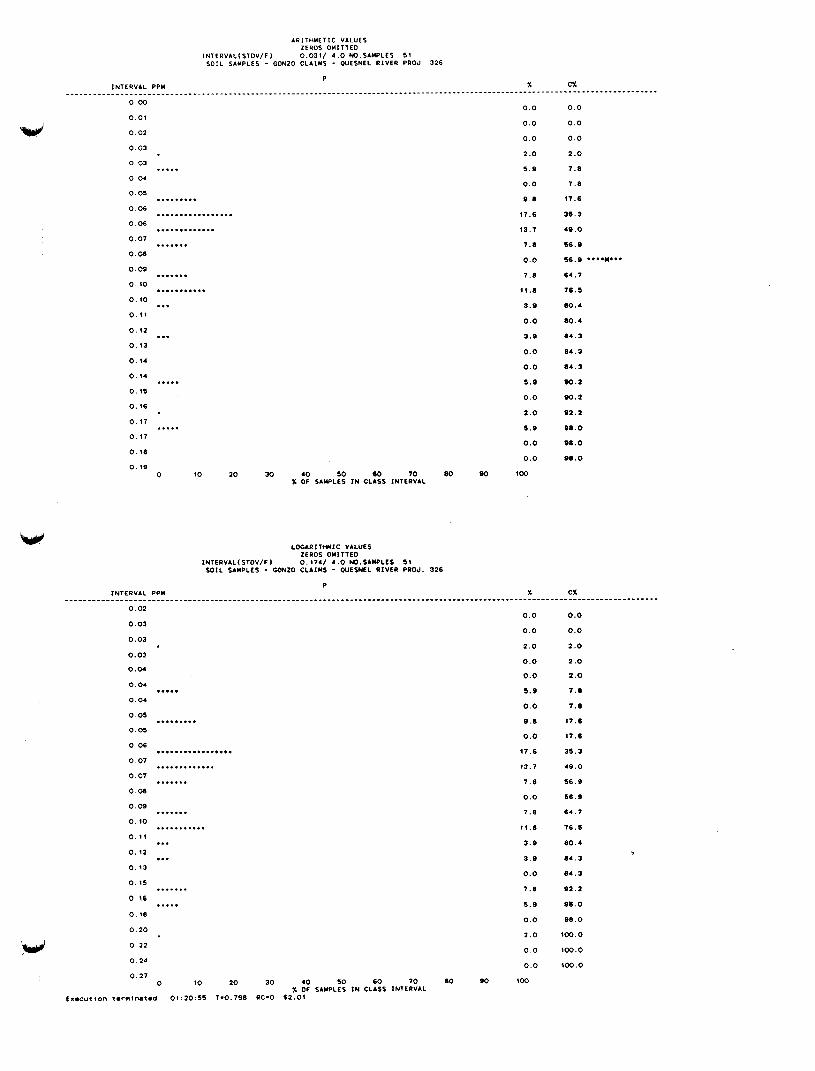
to 15 ppm, aluminum (Figure 5m) up to 3.03% and potassium (Figure 5p) up to 0.19%. The anomalies are predominantly found on lines 49N and 52N
from 104+50E to 98E. Anomaly levels are modest, likely reflecting minor
sulphide in a sedimentary or felsic volcanic rock unit.
LEGEND + M o n g onete
Soi I siit - Rock
r'" a 0 0 e
0
9 50 800 6 5 0 5 5 0 5 0 0 400
0 PPm
r* +
0
950
650 550 500 ' 400 '
0 PPm
800 'I
V
N .T.S. 93 A / 12
+ GUNSTEEL RESOURCES I NC.
GONZO CLAIM
GEOCHEMICAL MAP MANGANESE
J u l y , 1986 exploration Itd.

N.T.S. 93 A / 12
L E G E N D + G U N S T E E L R E S O U R C E S I N C . t
GONZO CLAIM I RON S o i I Si It Rock
( 4 . 9 0 4.50
4.90 4.50 4.15 t 4.15
P
v T 3.80 . 3.80 . . 3.60 . 3.60 . 0 3.35 0 3.35 v
GEOCHEMICAL MAP I R O N
4SO n
0 0 O/O 0 O/O
exploration Itd. J u l y , 1986
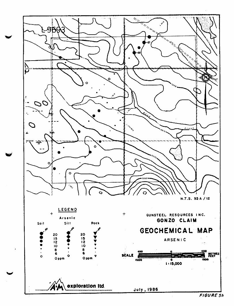
L E G E N D
A r s e n i c Soi I S i l t Rock
+
r" 0 0 0 0
20 I 5 I 2 10 8
f + 9
20 IS 12 IO 0
t
N .T.S. 93 A / 12
GUNSTEEL RESOURCES I N C.
GONZO CLAIM
GEOCHEMICAL MAP A R S E N I C
4so 8 ) O o
0 480
I600 S C A l t
0 I ' 15,000
J u l y , 1986
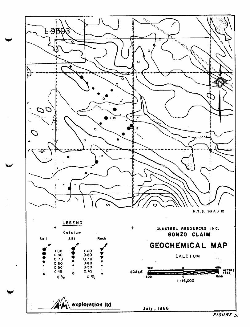
L E G E N D
C a l c i u m +
Soil Sill
t v
Rock
N.T.S. 93 A / 12
GUNSTEEL RESOURCES I NC.
GONZO CLAIM
r' 1.00 0.80 0.80
0.70 0.70 0.60 . 0.60
r'" 1.00
0.50 0.50 . - - .
0.45 0.45 0
0 O/O 0 O/O
GEOCHEMICAL MAP C A L C i UM
YLTRk 4S0 0
SCALE - r r n 1800 0 1800
I ' 15,000
J u l y , 1986 exploration Itd.
4 P - --./-
J u l y , 1986 exploration ltd.
N.T.S. 93 A / 12
I
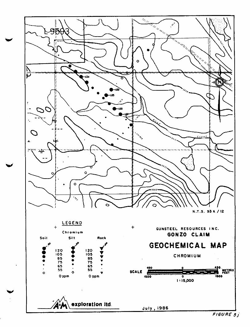
L E G E N D
C hr o m i u m Soil Silt Roc h
+ + G U N S T L E L R E S O U R C E S I N C .
GONZO CLAIM
GEOCHEMICAL MAP C H R O M I U M
.'# 120 105 + 0
e 85 75 85 7 5
65 65 ' 0 0
0
4SO 0 @ NgTItk SCALE 1- FELT
55 0 55 *
0 PPm 0 w m 1500 ' 0 WOO I I IS,OoO
N.T.S. 93 A / 12
J u l y , 1986 exploration Itd.
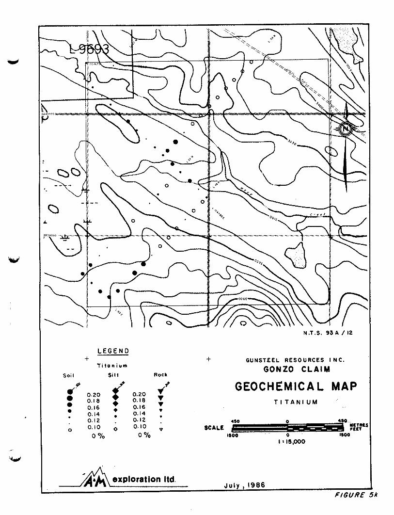
LEGEND
Ti t o n i u m + t GUNSTEEL RESOURCES I NC.
GONZO CLAIM Soi I S i l t Rock
I
f9 G E O C H E M I C A L M A P T I T A N I U M
r' 0.20 0
0.18 'I 0.16 + 0.16 T 0.14 . 0.14 ,
6. 0.20 0.18 +
0 0.10 0 0.10 SCALE k-- t L I f
450 wrtrt: 0.12 . 0.12 . 480 0
0 % 0 O/O IS00 0 1800 - . - I I 15,000
L E G E N D
Y o t ~ n r r i u m +
Soi I S i l t Rock
.'' 1.70 1.35 1.20 : 1.00 . 0.90
0 O/O
0.80 0
r' 0
1.70 I. 35 1.20 1.00 0.90 0.80
0 O/O
exploration Itd.
N .T.S. 93 A / 12
+ GUNSTeEL RESOURCES I NC.
GONZO CLAIM
GEOCHEMICAL MAP M A G N E S I U M
480 SCALE &!g4
1800 0 WOO
J u i v . 1986

N.T.S. 93 A / 12
L E G E N D + + GUNSTLEL RESOURCES I NC.
A l u m i n i u m
S o i l S i l t Rock GONZO CLAIM
f 2.50 2 .30
d' 2.50 2 .30
1.95 1.95 2.10 + 2.10 (I
0 1.80 ' I .80 1.55 . 1.55 '
0 0 Yo 0
0 O/O 0
GEOCHEMICAL MAP A L U M I N I U M
J u l y 1986 exploration Itd.
FIGURE 5 m
L E G E N D t
P o t a r r i u m So i I Silt Roc It
+ GUNSTLEL RESOURCES I NC.
GONZO CLAIM
GEOCHEMICAL MAP 4? P O T A S S I U M
< 0.14
0.08 . 0.08 0.06 0.06 450 0 450
0.12 'I 0.14 0.12 0.10 + 0.10
0 0.04 0 0.04 V ' SCALE fl tLLt WLTRU
0 O/O 0 O/. 1500 0 #boo
I t 15,000
J u l y , 1986 exploration Itd.
F/GUR€ 5 n

L E G E N D
Barium
Soi I Silt R o c k
+
2 0 0 I 6 5 145 I 2 5 115
r" +
200 I 6 5 145 125 115
+
N.T.S. 93 A / 12
GUNSTJZEL RESOURCES I N C .
GONZO CLAIM
GEOCHEMICAL MAP B A R I U M
YETRt. SCALE CELT
moo 0 1500
I t IS,OoO
J u l y , 1986 /A:A\exploration ltd.
L E G E N D
P h o r p h o r u s +
Soi I Silt c) 4
Rock &t
4' 0.1 6 0.16 'I . 0.12 0.12 . 0.09 0.09 0.07 0.07 ' _ _ 0.06 ' 0.06 '
0 P 0 O/O 0 O/O
0
+
N.T.S. 93 A / 12
GUNST€EL RESOURCES I NC.
GONZO CLAIM
GEOCHEMICAL MAP P H O S P H O R U S
J u l y , 1986 exploration Itd.
FIGURL-
L E G E N O ,e-.
',' 1 G e o c h r m i c o l o n o m o l y . - - /
lflllllll V L F - E M o n o m o l y .
- I P o n o m o l y . -
N . T . S . 9 3 A /I2
G U N S T L E L R E S O U R C E S I N C .
GONZO CLAIM
COMPILATION MAP
*" Y L t R t 450 0
SCACE - FEET I500 0 I500
I ' 15,000
J u l y , 1986 explota t ion Itd.
11
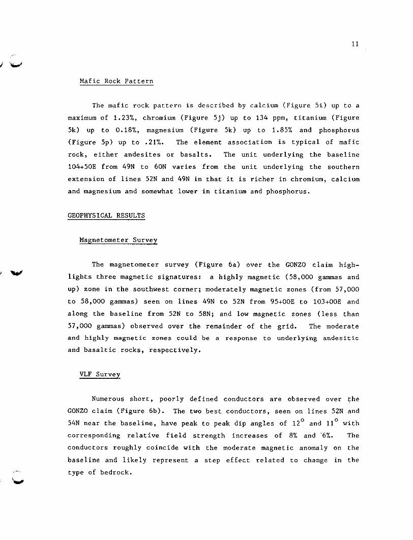
Mafic Rock Pattern
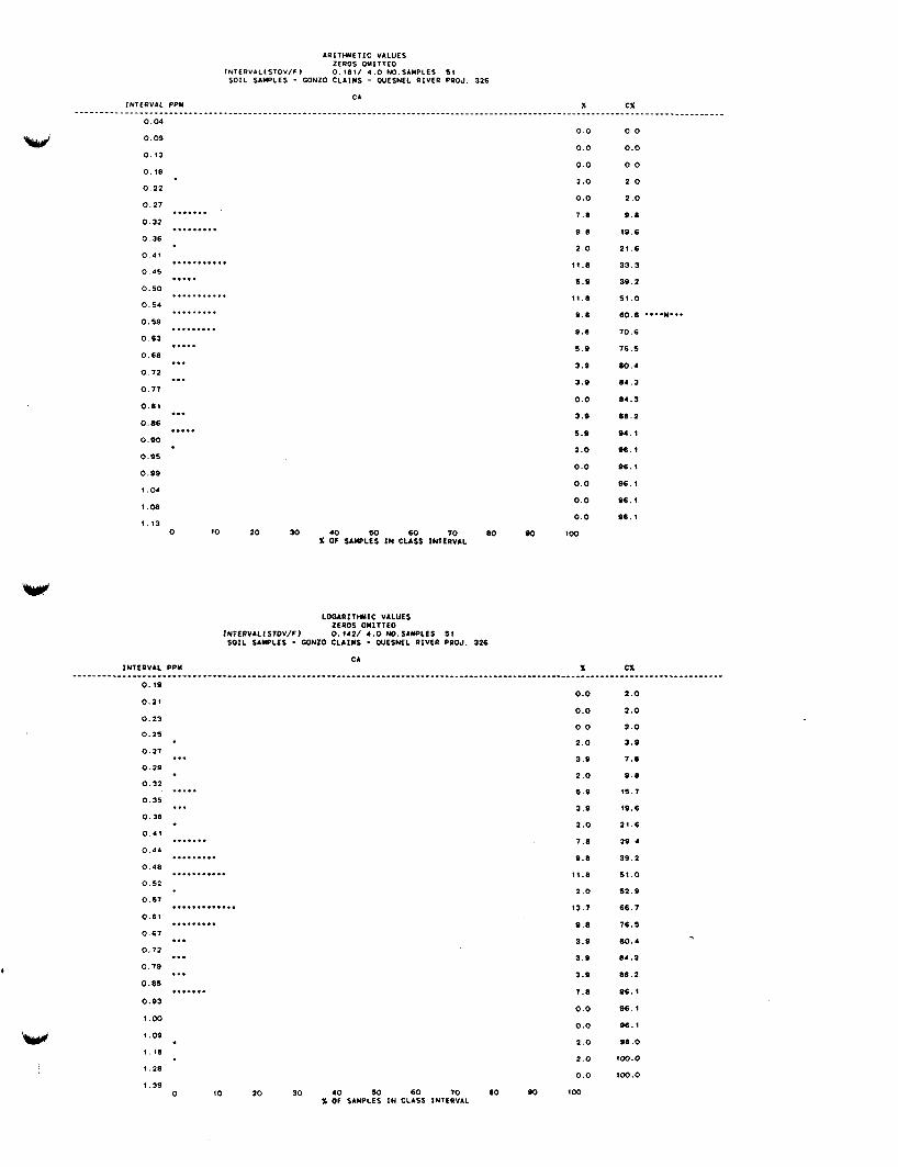
The mafic rock pattern is described by calcium (Figure 5i) up to a
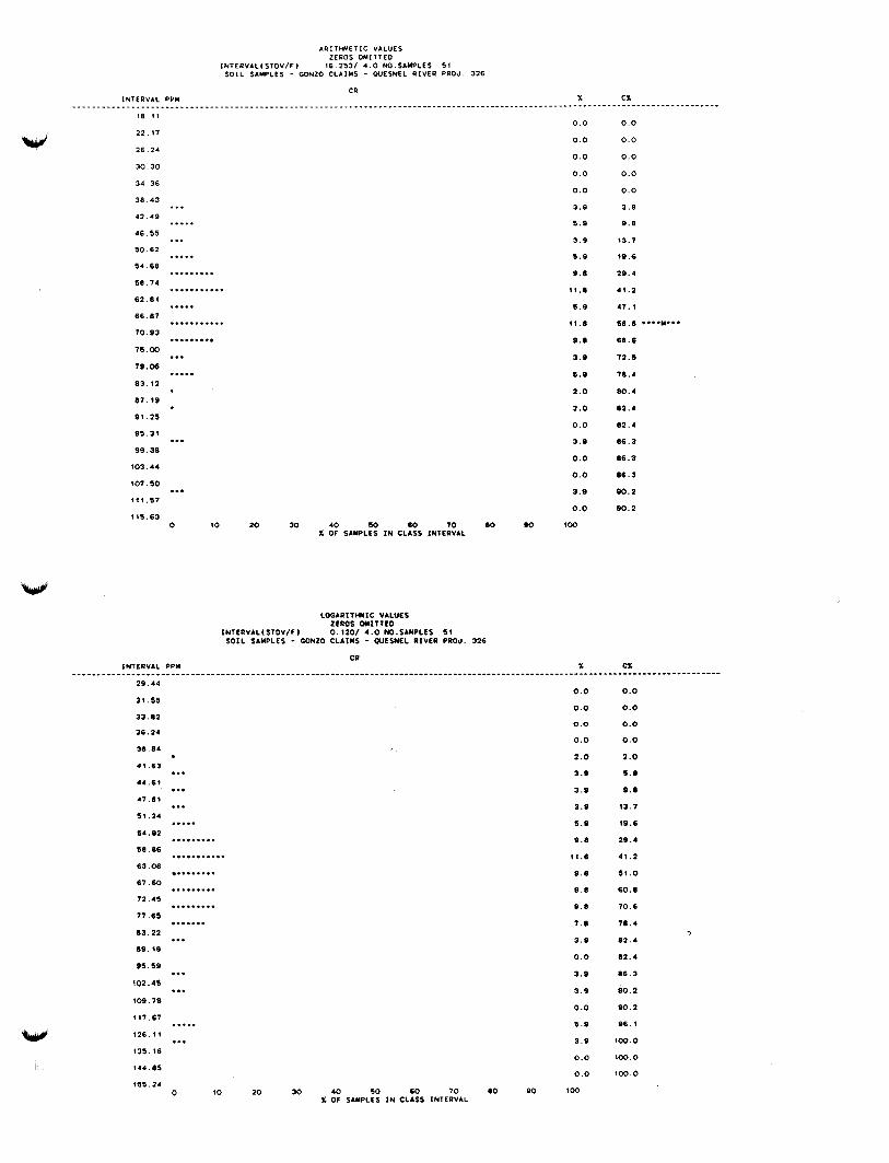
maximum of 1.23%, chromium (Figure 5j) up to 134 ppm, titanium (Figure
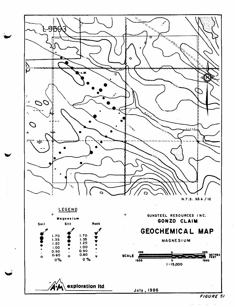
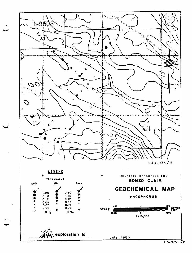
5k) up to 0.18%, magnesium (Figure 5k) up to 1.85% and phosphorus
(Figure 5p) up to .21%. The element association is typical of mafic
rock, either andesites or basalts. The unit underlying the baseline
104+50E from 49N to 60N varies from the unit underlying the southern
extension of lines 52N and 49N in that it is richer in chromium, calcium
and magnesium and somewhat lower in titanium and phosphorus.
GEOPHYSICAL RESULTS
Magnetometer Survey
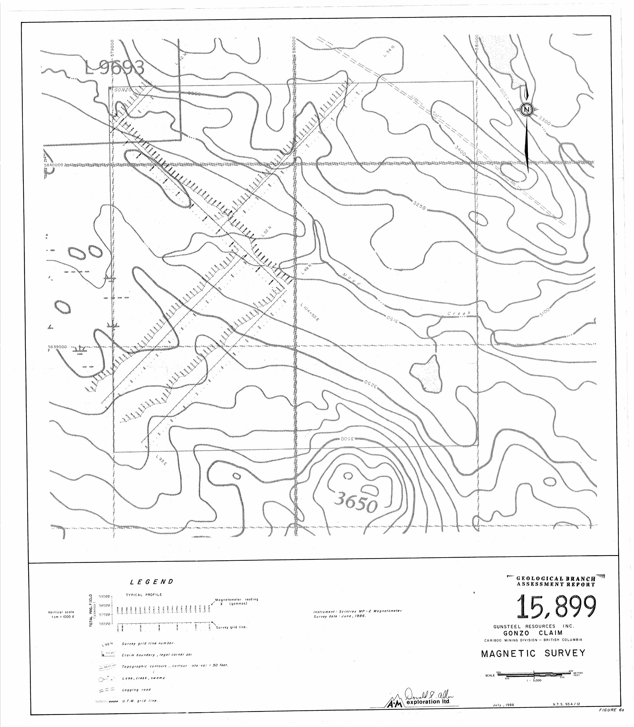
The magnetometer survey (Figure 6a) over the GONZO claim high-
lights three magnetic signatures: a highly magnetic (58,000 gammas and
up) zone in the southwest corner; moderately magnetic zones (from 57,000
to 58,000 gammas) seen on lines 49N to 52N from 95+00E to 103+00E and
along the baseline from 52N to 58N; and low magnetic zones (less than
57,000 gammas) observed over the remainder of the grid. The moderate and highly magnetic zones could be a response to underlying andesitic
and basaltic rocks, respectively.
VLF Survey
Numerous short, poorly defined conductors are observed over the
GONZO claim (Figure 6b). The two best conductors, seen on lines 52N and
54N near the baseline, have peak to peak dip angles of 12O and 11' with
corresponding relative field strength increases of 8% and '6%. The
conductors roughly coincide with the moderate magnetic anomaly on the
baseline and likely represent a step effect related to change in the
type of bedrock.
12
COMPILATION OF RESULTS
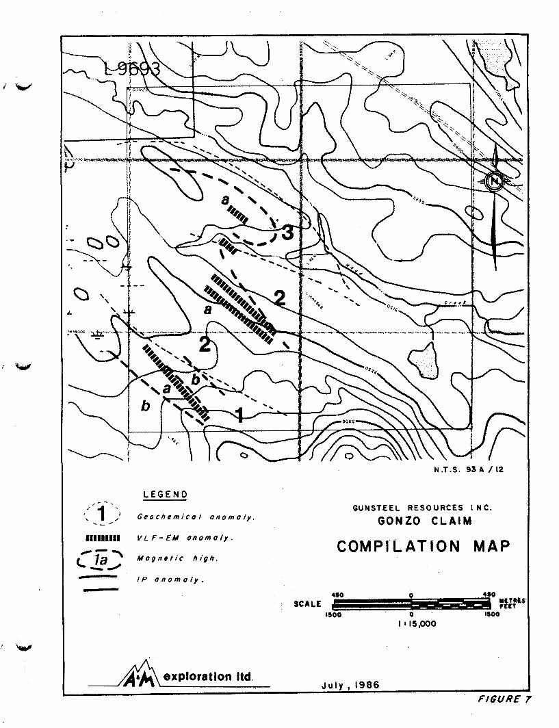
Three geochemical patterns have been defined and outlined in
Figure 7 along with geophysical responses.
Patterns 1 and 3 are described as mafic rock patterns having enrichments in such mafic lithophile elements as chromium, titanium and
magnesium. Pattern 1 coincides to a strong magnetic field (b) indicat-
ing that the underlying rock is a basalt. Pattern 3 is coincidental
with moderate magnetic responses suggesting andesitic bedrock.
The basemetal pattern ( 2 ) has enriched concentrations in copper,
lead, zinc and a number of other elements indicating sulphide mineral-
ization. The magnetometer survey over pattern 2 outlined a moderately
magnetic rock (a) possibly an andesite or a magnetite bearing felsic
volcanic.
REFERENCES
W
Belik, G. D. (1982). Frasergold Property - in Eureka Resources Inc., Prospectus dated June 1, 1983.
Brock, J. S. (1984). Mt. Calvery Resources active in Cariboo-Quesnel. Western Miner, April, 1984, pp. 28-29.
Campbell, R. B. (1978). Quesnel Map Sheet, Geol. Surv. Canada, Open File 574.
Campbell, R. B. and Tipper, H. W. (1970). Geology and Mineral Exploration Potential of the Quesnel Trough, British Columbia. C.I.M. Bulletin, Vol. 63, pp. 785-790.
Deleen, M. E. (1984). Summary Report on the Cariboo-Likely Project. Prospectus Report for Mt. Calvery Resources Ltd. dated December 3 , 1984.
Fox, P. E. (1983). The QR deposit. Verbal presentation to the Vancouver M.E.G., November 30, 1983.
Fox, P. E. (1982). Geological and Geophysical Report on the Maud Property. B.C.Min of Mines and Pet. Res., Assessment Report 9956.
Fox, P. E. (1982). Diamond Drill Program on the Maud 1-7 Mineral Claims, Quesnel River Area. B.C. Minister of Mines Assessment Report 10527.
Fox, P. E., Cameron, R. S. and Hoffman, S. J. (1986). Geology and Soil Geochemistry of the Quesnel River Gold Deposit, B.C. AEG/GAC Cordilleran Section GEOEXP0/86 Symposium Abstracts, pp. 40-41.
Hodgson, C. J., Bailes, R. J. and Verzosa, R. S. (1976). Cariboo Bell in Porphyry Copper Deposits of the Canadian Cordillera. C . 1 . K Spec. Vol. 15, pp. 388-396.
Richardson, P. W. (1978). Assessment Report describing Soil Geo- chemical, Magnetic and Geological Surveys on the QR Claim Group. B.C. Ministry of Mines Assessment Report 6730.
Saleken, L. W. and Simpson, R. G. (1984). Cariboo Quesnel Gold Belt: A Geological Overview. Western Miner, April, 1984, pp. 15-20.
Sheldrake, R. F. (1984). Report on a Helicopter-borne Mulpifrequency Electromagnetic, VLF-Electromagnetic and Magnetometer Survey on Three Blocks within the Quesnel Basin Area, B.C.
REFERENCES
Simpson, R. and Saleken, L. W. (1983). Cariboo Bell Deposit in G.A.C.- - M.A.C. Field trip No. 4, Guidebook, pp. 13-21.
Troup, A. G. (1984). Report on the Victoria Creek Gold Prospect in Statement of Material Facts dated May 23, Titan Resources Ltd.
1984.
CERTIFICATE
I, John Gravel, certify that:
1. I am a Consulting Geologist and Geochemist, of GHS Geochemical Services with offices at Suite 311-1930 West 3rd Avenue, Vancouver, British Columbia.
2. I am a graduate of McGill University with degrees in Geology (B.Sc., 1979) and Mineral Exploration (M.Sc., 1985).
3. I have practised my profession of exploration geologist/ geochemist since 1979 in British Columbia.
4 . I am a member in good standing of the Association of Exploration Geochemists and a member of the Geological Association of Canada.
5. This report is based on information listed under References, and fieldwork carried out by J. Gravel, D. Brownlee, D. Sorenson and B. Stewart during the period June 11th to June 12th, 1986.
6. I am a shareholder in Gunsteel Resources Incorporated, and as such have an interest in the GONZO property.
7. I consent to the use of this report by Gunsteel in connection with the raising of funds to carry out the further exploration program recommended.
July 31, 1986 Vancouver, B.C.
John Gravel, B.Sc, M.Sc.
,-.
W'
CERTIFICATE
w
I, Douglas R. MacQuarrie, certify that:
1. I am a Consulting Geophysicist of A & M Exploration Ltd., with offices at Suite 614, 850 West Hastings Street, Vancouver, B.C.
2. I am a graduate of the University of British Columbia with a degree in Geology and Geophysics (B.Sc., 1975).
3 . I have been practising my profession since 1975 and have been active in the mining industry since 1971.
4. I am an active member of the Canadian Institute of Mining and Metallurgy and a member of the British Columbia Geophysical Society .
5. This report is based mainly on information listed under References and fieldwork carried out by J. Gravel.
6. I am a Director and shareholder of Gunsteel Resources Incorporated and, as such, have an interest in the Gonzo property.
7. I consent to the use of this report in a Statement of Material Facts or in a Prospectus in connection with the raising of funds for the project covered by this report.
July 31, 1986 Vancouver, B.C.
D. R. MacQuarrie B.Sc.
CERTIFICATE
I, Donald G. Allen, certify that:
1. I am a Consulting Geological Engineer, at A & M Exploration Ltd., with offices at Suite 614, 850 West Hastings Street, Vancouver, British Columbia.
2. I am a graduate of the University of British Columbia with degrees in Geological Engineering (B.A.Sc., 1964; M.A.Sc., 1966).
3. I have been practising my profession since 1964 to the present in British Columbia, the Yukon, Alaska and various parts of the Western United States.
4. I am a member in good standing of the Association of Professional Engineers of British Columbia.
5. This report is based mainly on information listed under References and fieldwork carried out by J. Gravel.
6. I am a Director and shareholder of Gunsteel Resources Incorporated, and as such have an interest in the Gonzo property.
7. I consent to the use of this report by Gunsteel in connection with the raising of funds to carry out the further exploration program recommended.
July 30, 1986 Vancouver, B.C.
Donald G. Allen P. Eng. (B.C.)
W
APPENDIX I
1984 AIRBORNE MAGNETIC AND ELECTROMAGNETIC SURVEY
1
1984 AIRBORNE MAGNETIC AND ELECTROMAGNETIC SURVEY - ..
In 1984, an exploration program consisting of 18.1 kilometres of
helicopter-borne multifrequency electromagnetic, VLF-electromagnetic and
magnetic surveys was conducted over the GONZO claim.
The airborne geophysical surveys were conducted by R. Sheldrake of
Apex Airborne Surveys Ltd. The survey was part of a larger survey of
the general Maude Lake area. In addition, test flights were flown over
the QR and Cariboo Bell deposits to determine geophysical responses for comparison with anomalies generated in the survey area. Instrumenta-
tion and results of work are described in detail in a separate report by
Sheldrake (1984). A prominent magnetic feature which warrants examina-
tion for disseminated sulphidelgold mineralization was discovered.
Geophysical results of the general Maude Lake area as discussed by
Sheldrake are as follows:
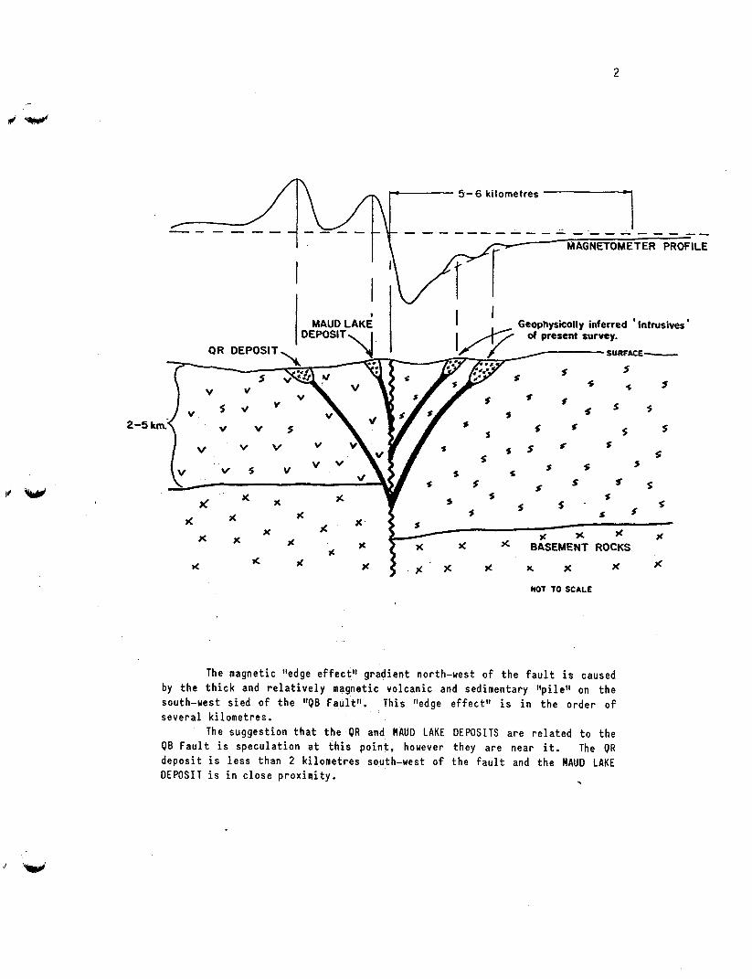
"MAUD LAKE AREA - GEOPHYSICAL RESULTS
The predominant f e a t u r e s o f t h e MAUD LAKE AREA magnet ic mapsheet a r e t h e l i n e a r s t r u c t u r e s and g r a d i e n t s t h a t s t r i k e N.W.4.E. They a r e r e l a t e d t o a 120 k i l o m e t e r l o n g " r e g i o n a l f e a t u r e t h a t can be t raced from t h e GEOLOGICAL SURVEY OF CANADA, Aeromagnetic Se r ies Maps. This l l l i neament l t extends f rom t h e nor th -west o f Maude Lake t o near t h e town o f L i k e l y and then southwards a long Quesne l Lake t o H o r s e f l y Bay c o n t i n u i n g southwards t o H o r s e f l y Lake and then t o t h e a rea o f Hendr ix (Sunset) Lake. A schematic i n t e r p r e t a t i o n o f t h e feature , ( f o r the purposes of this report ca l led the Q U E S N E L BASIN or Q B FAULT) and a suggested r e l a t i o n s h i p t o t h e QR and MAUD LAKE i n t r u s i v e r o c k s i s d i s p l a y e d i n FIGURE 2 below.
2
~
/n ,,,r 5-6 kilometres -1
~ D E ~ s I T , ~ k 1 QR DEPOSIT.
RAUDLAKE 1 1 Geophysically inferred ' lntrusives ' I /y/ of present survey. - - -.-
'J SURFACE- /,,
* s
x z % X x . BASEMENT ROCKS I.
% 1 x x x *
ac d
NOT TO SCALE
The magnet ic "edge e f f e c t " g r a d i e n t north-west o f t h e f a u l t i s caused by t h e t h i c k and r e l a t i v e l y magnet ic v o l c a n i c and sedimentary " p i l e " on t h e south-west s i e d o f t h e llQB Fau l t f 1 . Th i s "edge e f fec t " i s i n t h e o r d e r o f s e v e r a l k i l o m e t r e s .
The sugges t ion t h a t t h e OR and MAUD LAKE DEPOSITS a r e r e l a t e d t o t h e Q B F a u l t i s s p e c u l a t i o n a t t h i s p o i n t , however they a r e near i t . The OR d e p o s i t i s l e s s than 2 k i l o m e t r e s south-west o f t h e f a u l t and t h e MAUD LAKE D E P O S I T i s i n c l o s e p r o x i m i t y . .
3
The Q B F a u l t , f o r t he most p a r t , l i e s south-west o f t h e p resen t survey area, except a t t h e south-western co rne r o f t he NEL 1 C L A I M , t he southern p o r t i o n o f t h e GONZO 1 CLAIM, and t h e western p o r t i o n o f t h e C H A I Z 1 CLAIM. (The O B F a u l t s t r i k e s N-S i n the area o f t he C H A I Z 1 C L A I M . )
A number o f geophys ica l l y i n f e r r e d s t r u c t u r e s a re i n d i c a t e d from the p r e s e n t magnet ic survey t h a t appear t o be r e l a t e d , by v i r t u e o f t h e i r p r o x i m i t y and c o n t i n u i t y , t o t h e QB F a u l t .
I n t h e LIKELY area where t t f ea tu res t t ( i n t r u s i v e r o c k s ) a re i n s i m i l a r aspec t ( g e o p h y s i c a l l y speak ing) t o t h e Q B F a u l t , some o f them a r e known t o have anomalous g o l d values. (Persona l comunica t ion M r . John Brock, Mount Ca lve ry Resources Ltd.)
The d a t a i n d i c a t e 4 c a t e g o r i e s o f m a g n e t i c a l l y i n f e r r e d f e a t u r e s based on t h e i r d i s t a n c e f rom t h e OB F a u l t and the c h a r a c t e r o f t h e magnet ic responses.
Type 1, o f which t h e r e a r e 2 cases, a r e centered on t h e h i g h magnet ic va lues l o c a t e d i n t h e sou the rn p o r t i o n o f t h e GONZO 1 CLAIM and h i g h magnet ic va lues i n t h e western p a r t o f t h e C H A I Z 1 CLAIM. These f e a t u r e s l i e south and/or west o f t h e Q B F a u l t and may i n d i c a t e i n t r u s i v e r o c k s s i m i l a r t o those i n t h e Q R and MAUO LAKE area.
Type 2 r e f e r s t o those I tMagne t i ca l l y i n f e r r e d t l f e a t u r e s n o r t h and eas t of t h e OUESNEL B A S I N FAULT t h a t have r e l a t i v e l y s h o r t s t r i k e l eng ths . They l i e w i t h i n t h e p r e v i o u s l y mentioned g r a d i e n t caused by t h e "edge e f f e c t " o f t h e t h i c k vo l can ic / sed imen ta ry p i l e t o t h e south-west. These f e a t u r e s l i e n e a r e s t t o t h e OB F a u l t and a r e i n t e r p r e t e d as v o l c a n i c o r i n t r u s i v e rocks t h a t may have come up th rough secondary f a u l t s .
Type 3 r e f e r s t o t h e N.W.-S.E. magnet ic f e a t u r e t h a t i s g e n e r a l l y con t inuous between t h e LEE 1 CLAIM i n t h e south-east and t h e V I C 20 CLAIM i n t h e nor th -west . Th i s f e a t u r e i s s u b p a r a l l e l t o t h e QB F a u l t and may have o r i g i n a t e d th rough secondary f a u l t s t r u c t u r e s . These rocks may be t h e sources of t h e anomalous geochemistry va lues t h a t have been r e p o r t e d i n t h e area o f t h e Leb 1 CLAIM.
. .
REMARK: There a r e a number o f t l o f f - s e t s t t i n t h e ItType 3" f e a t u r e t h a t t y p i c a l l y i n d i c a t e f a u l t i n g . F u r t h e r , t h e r e may be anomalous d i s t o r t i o n of t h e r o c k s i n t h e nor th -west c o r n e r o f t h e SHANNON 1 CLAIM and t h e V I C 13 CLAIH which may i n d i c a t e an a rea o f a l t e r a t i o n o r severe f r a c t u r i n g . This a rea ought t o be tes ted .
Type 4 r e f e r s t o l e s s w e l l d e f i n e d magnet ic f e a t u r e s nor th -west o f t h e p r e v i o u s l y ment ioned l i neamen t (Type 3 f e a t u r e ) . These may be a c i d i c i n t r u s i o n s o r v o l c a n i c f l o w s w i t h i n t h e sedimentary sequence. They a r e r e l a t i v e l y i s o l a t e d and do n o t appear t o be r e l a t e d t o t h e OB F a u l t .
ELECTROMAGNETIC RESULTS
One hundred and t w e n t y - f i v e conductors have been p l o t t e d on PLATE 1, THE M A G N E T I C CONTOUR AND E.M. CONDUCTOR MAP. These conductors we.re s e l e c t e d from t h e lou- f requency c o a x i a l c o i l d a t a as responses most s u i t a b l e f o r "ha l f -p lane modeltt i n t e r p r e t a t i o n . Al though a l l o f them i n d i c a t e an i nc rease i n t h e c o n d u c t i v i t y o f t h e u n d e r l y i n g rocks , none o f t h e c a l c u l a t e d
4
w
conductances a r e above 15 mohs. One conductor, however, on L 65 a t f i d u c i a l 1436.15 appears anomalous because o f i t s t lwel l -def inedl t response and i t s p r o x i m i t y t o an i n f e r r e d i n t r u s i o n . Th is conductor may i n d i c a t e a l o c a l i z e d i n c r e a s e i n m e t a l l i c c o n t e n t and ought t o be t e s t e d .
The E l e c t r o m a g n e t i c P r o f i l e d a t a a r e q u i t e a c t i v e and i n d i c a t e t h a t t h e overburden i n t h e a r e a i s moderately conduct ive . Many o f t h e HEM responses a r e due t o c o n d u c t i v e overburden o r sha l low s loughs t h a t a r e f i l l e d w i th c o n d u c t i v e sediments. Under c o n d i t i o n s o f c o n d u c t i v e overburden, t h e e lec t romagnetometer becomes s e n s i t i v e t o t e r r a i n c l e a r a n c e v a r i a t i o n s and some o f t h e responses a r e due t o t h i s e f f e c t .
However, any r e a l i n c r e a s e i n c o n d u c t i v i t y i n t h e C H A I Z 2 AND V I C 1 CLAIMS, does n o t appear t o be r e l a t e d t o c o n d u c t i v e overburden and may i n d i c a t e i n c r e a s e d m e t a l l i c m i n e r a l i z a t i o n , a l t h o u g h t h e presence o f c o n d u c t i v e g r a p h i t i c r o c k s cannot be r u l e d o u t .
The VLF Electromagnetometer d i d n o t respond t o t h e g e o l o g i c a l f e a t u r e s i n f e r r e d by t h e magnet ic o r t h e H E M survey. The t t r e g i o n a l t t l o w f requency n a t u r e o f t h e c o n t o u r p a t t e r n i s due t o t h e e f f e c t o f topography.
However, t h e r e i s one area of d i s t o r t i o n i n t h e VLF d a t a t h a t i s n e a r t o a " t y p e 1" magnet ic f e a t u r e and may be anomalous. The c o n t o u r p a t t e r n i s d i s t o r t e d i n t h e a r e a o f L 134 f i d u c i a l 2628 and L 14 f i d u c i a l 2567 (on t h e CHAIZ 1 c l a i m ) may i n d i c a t e a zone of d i s t u r b e d o r a l t e r e d rock."
Airborne data for the GONZO claim is plotted on airphoto enlarg- ment basemaps (Figures 8a to 8d). Of significance are (1) a prominent
magnetic high which cuts across the southwest corner of the claim. This
is interpreted as a prominent structural break, between primarily
sedimentary rocks at the east and volcanic rocks on the west. It
appears to project along strike to the Maud deposit immediately to the
northwest.
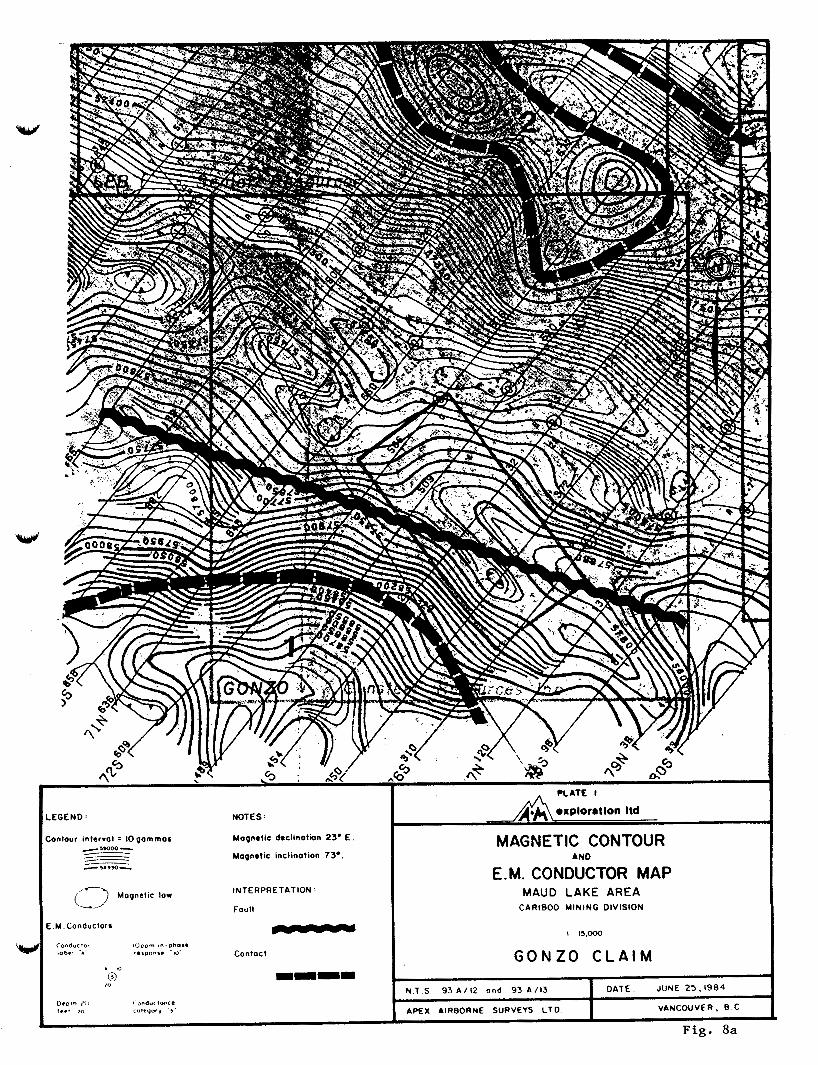
LEGEND: NOTES:
Contour inltrvol = IO gammas -')WOO - - - Magnetic inclination 73..
Magndic d8cllnation 23. E .
- - -5.950-
'0" m m m m ( 0
D t o r o I t . , *"d"<l(nCe tee* >" I W C " " 1 , 3
INTERPRETATION :
Foul1
(2 Moqnclic low
E M Conductors - COn6"<l"c lODpm Jn D h O W lobel -A 'CIP001. W- Conloct
DATE JUNE 2 5 , 1 9 8 4 N T S 9 3 A / 1 2 and 9 3 A / 1 3
APEX AIRBORNE SURVEYS CTD
I
VANCOUVER. 8 c I
MAGNETIC CONTOUR
EM. CONDUCTOR MAP AND
MAUD LAKE AREA CARIB00 MINING DIVISION
G O N Z O C L A I M
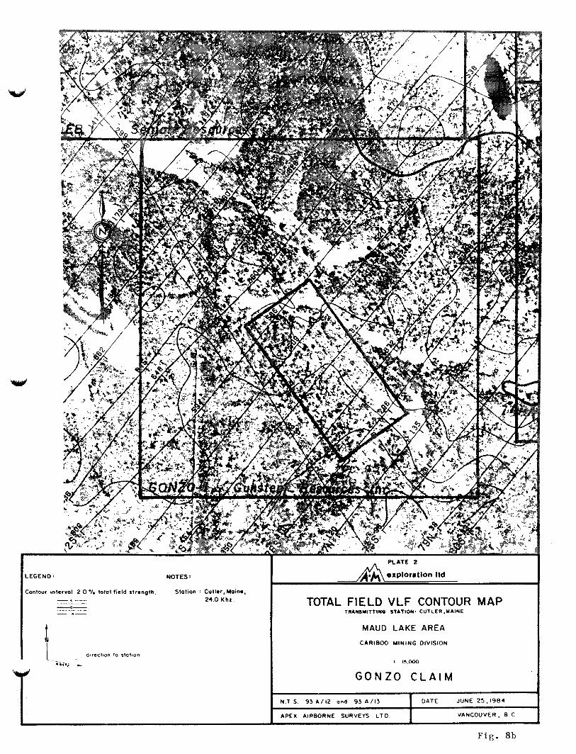
LEGEND : NOTES :
Contour intervol 2 0 % lolo1 field strength. Station . Cutler,Main*, -.- 24.0 K hz -0-
- .-
d~reclton lo slolion I . *<;a,
- PLATE 2
TOTAL FIELD V L F CONTOUR MAP TRAmMITTlNQ STATION' CUTLER.MA1NE
MAUD LAKE AREA
CARIBOO MINING DIVISION
G O N Z O C L A I M
N T S 93 * / I 2 and 93 A I 1 3 DATE JUNE 25,1984
APEX AIRBORNE SURVEYS L T D VANCOUVER, 8 C
F i g . 8b
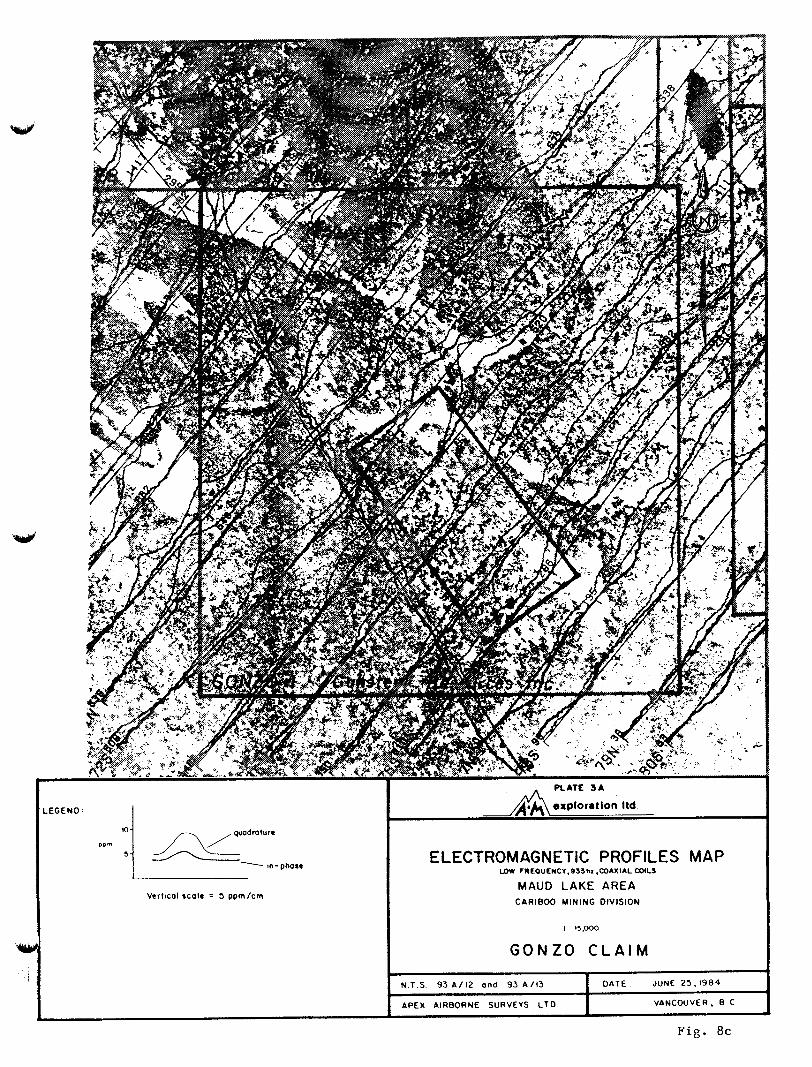
I LEGEND:
in-phose
Vertical scale = 5 ppmIcm
ELECTROMAGNETIC PROFILES MAP I D W FREOUENCY.933hI .COAXIAL COlLS
MAUD LAKE AREA CAR1800 MINING DIVISION
G O N Z O C L A I M
N.1 S 9 3 A / 1 2 a n d 93 A / l 3 DATE JUNE 25,1984
APEX AlR8ORNE SURVEYS L T D VANCOUVER, 8 c
Fig. 8c
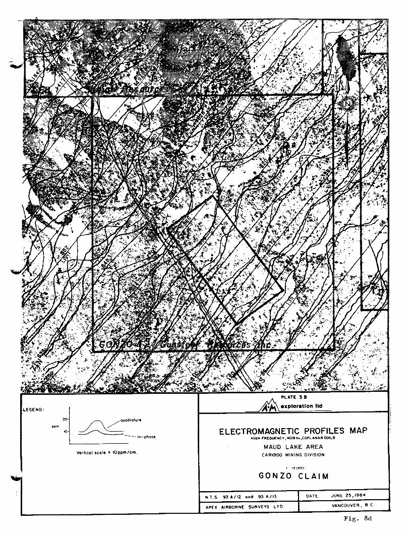
I LEGEND: A A e x p l o r a t l o n ttd
ELECTROMAGNETIC PROFILES MAP HIOH FREOUENCY ,40010 hi,COPLANARCOlLS
MAUD LAKE AREA C A R 1 8 0 0 MINING OlVlSlON
I I 15.000
G O N Z O C L A I M Y I I
N T S 9 3 A / 1 2 and 9 3 A I 1 3 DATE JUNE 2 5 , I 9 8 4
APEX AIRBORNE SURVEYS L T O VANCOUVER, 8 c ,
F i g . 8d
APPENDIX I1
Analytical Results
1
w
w
SAMPLING PROCEDURES
The baseline for the GONZO grid was tied into the LCP and oriented at
135' to provide the best intersection of the structural lithological and
glacial trend. Soil samples were collected at 100 metre x 100 or 200
metre spacing depending on proximity to known geophysical targets.
A shovel was used to sample the B horizon at a depth varying from 20 to 60 centimetres. Approximately & to 1 kilogram of soil is placed in a Kraft paper bag and allowed to dry at ambient temperature prior to
shipment to the laboratory.
ANALYTICAL PROCEDURES
Samples were sent to Rossbacher Laboratory Ltd. in Burnaby, British
Columbia, for sample preparation and gold analysis. Soil samples were
oven dried at 80° then desiccated and sieved to -80 mesh. Rock samples
are crushed and pulverized to -100 mesh. 0 Ten grams of the fine mesh fractions were then ashed at 520 and
leached by hot aqua regia. Gold is extracted from the acid solution by
MIBK and its concentration is then determined by atomic absorption
spectrometry.
Several grams of the -80 mesh fraction were shipped to Acme Analytical Laboratories Ltd. for 30 element I C P analysis. A 0.5 gram
split of the sample pulp is digested in aqua regia and aspirated into the
ICP spectrometer. Results are outputted to a micro computer for hard copy
printout and reproduction on a floppy disk.
STATISTICAL ANALYSIS
Sample concentrations are analysed using simple univariate statistics. Histograms are calculated and printed out using the UBC Amdal computer. Class intervals for the histograms are set to 1 / 4 standard
deviation, this is used f o r both arithmetic and logarithmic histograms.
2
Concentration intervals, represented by varying dot sizes used in the
element plots, are based on a combination of percentiles (i.e., 35th,
50th, 65th, 80th, 90th, 95th percentile) and estimated divisions between
families in multimodal populations.
DATA LISTINGS
A printout of field site observations, UTM coordinates and analytical results is given at the end of Appendix 11.
Field site parameters lie in column 1-80, UTM coordinates are in
columns 19-31 and analytical results are in columns 81 to 256. A coding
guide to field site parameters precedes the data listing.
W
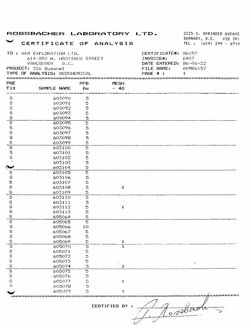
ROSSBACHER LeIBOReTORY LTD,
h m d C E R T I F I C f i T E O F f i N A L Y S I 8
CERTIFICATE#: INVOICE#: DATE ENTERED: FILE NAME: PhGE # :
2225 S. S P R I N G E R A V E N U E E U R N A E Y , E.C. V5P 3N1 TEL : (604) 299 - 6910
S S S
s S S X
S s s
X
POSSBFICHER LrlBORATORY LTD, kd
C E R T I F I C A T E O F 4 N G L Y S I S
2225 S . S P R I N G E R AVENUE PURNCIPY, P.C. V58 3 N 1 T E L : ( 6 0 4 ) 299 - 6910
s S s S
s S
n
- 't
ACME ANALYTICAL LABORATORIES LTD. BJ2 E. HASTINOS ST. VANCOUVER 8. C. V6A 1R6 PHONE 253-3158 DATA LINE 2 5 1 - 1 0 1 1
G E O C H E M I C A L X C P A N A L Y S I S
.500 6RbI S A N K € IS DIGESTED YITH 3)(L 3-1-2 HU-HN03-H20 AT 95 M6. C FOR OWE HOUR MD IS DlLUTED TO 10 H i WITH YRTER. THIS LERCk IS P M T I A L FOR I(N.FE.CA.P.CR.AG.BA.TI.8.AL.NR.K,Y.SI.ZR.(X.SN.V.N8 AND TA. MJ DETECTION LIHIT BY ICP IS 3 PPH. - s A n w TYPE: PULP
DATE RECEIVED: JUNE 19 1986 DATE REPORT MAILED: z@ ASSAYER. .d+. .DEAN TOYE. CERTIFIED P.C. ASSAYEH.
A & H EXPLORATION PROJECT - 326 FILE # 86-1065 PAGE 1
SAWLEI I o Cu Pb Zn b9 N i Co I n Fr As U Au Th Sr Ed Sb Si V Cc P La C r I 9 Bc Ti 8 A1 Ha K Y
603090 1 102 17 98 -2 49 19 865 4.46 10 5 ND 1 55 1 2 2 103 -85 .05 14 89 1.33 87 .14 2 2.12 .02 .OB 2 603091 1 101 13 94 .3 39 16 768 3.81 10 5 ID 1 60 1 2 2 80 1.16 .07 10 70 1.09 85 .lo 4 1.95 .02 .OB 3
PPI P P I m PPI m ppn wn PPI x PPI PPI Ppn PPI PPI PPI PPI PPI PPI x x Ppn Ppn x PPH z PPI z z x PPI
603092 1 95 11 116 *6 40 22 1216 4.27 10 5 ID 1 46 2 2 2 98 .75 .07 14 68 -92 101 -10 4 2.15 e 0 2 -07 2 603093 1 142 21 166 .5 47 20 1262 4.07 8 5 ID 2 42 1 2 2 91 e64 .OS 15 73 1.02 80 .12 2 2.01 a 0 2 -07 1 603094 1 110 15 129 .4 57 20 1475 4.70 11 5 ID 1 41 1 2 2 83 .SO .07 25 83 1.18 137 .07 2 2.70 .01 .I4 2
603095 1 39 14 129 0 2 46 15 611 4.28 11 5 ND 3 29 I 3 2 66 m 2 9 e 0 5 16 60 1.05 82 -09 2 1.90 -01 013 1 603096 1 54 14 110 .4 42 14 423 3.97 6 5 ID 2 36 1 2 2 78 .35 .04 14 65 1.13 90 .10 2 2.35 .02 .12 1 603097 1 98 9 101 .6 49 22 1216 5.11 14 5 ND 1 66 1 2 2 111 .90 .09 14 75 1.48 118 .12 4 3.03 .03 .19 1 603098 1 37 10 59 .2 31 13 472 4.08 10 5 ID 1 45 1 2 2 113 .Sa .04 8 50 .90 54 .17 4 1.76 .02 .Ob 1 603099 1 43 9 98 - 2 28 14 607 4.10 7 5 MD 2 45 1 2 2 107 .61 .09 8 45 1.09 47 .17 2 1.90 .02 .07 1
603100 1 57 15 137 .5 27 18 1140 4.21 5 5 ND 1 69 I 2 > 95 .88 .I7 8 42 1.50 167 -17 2 2.16 .02 .24 1 603101 1 32 9 117 .3 24 1s 508 3.64 4 5 ND 1 45 1 3 3 94 .51 .I5 B 49 .81 64 .16 3 1.86 .02 .Ob 2 603102 1 61 4 67 .I 32 '16 962 3.95 7 5 ID 1 62 1 2 2 104 .92 .07 9 64 1.07 71 .16 11 1.93 .03 .07 1 603103 1 53 7 50 .3 31 13 514 3.60 8 5 ID 1 46 1 2 2 104 .57 .03 b 67 .93 S .IS 5 1.97 .02 .Ob 2 603104 1 42 3 94 .3 37 13 426 4.19 13 5 NU 2 38 1 2 2 99 .48 .I7 12 62 .93 72 .13 3 2.24 .02 .Ob 1
603105 1 70 8 99 .l 22 14 55b 3.44 6 5 )(D 1 E6 1 2 2 64 .3 .21 7 45 1.07 76 .IS b 1.89 .02 .09 1 603106 1 47 8 111 .1 35 14 631 3.68 8 5 ID 1 54 1 2 2 100 .57 .10 7 60 1.05 82 .15 7 2.03 .02 .06 2 603107 1 49 6 88 .4 36 12 481 4.07 13 5 ID 2 47 1 2 3 97 .48 .10 10 57 1.03 68 .12 4 2.04 .02 .07 1 603108 1 99 17 107 .4 46 19 E99 4.24 10 5 ID 2 51 1 2 2 91 -65 .06 18 60 1.12 97 .I1 2 1.98 .02 .I1 1 603109 2 36 8 128 .1 43 13 529 4.23 13 5 ID 4 26 1 2 2 66 -27 007 14 60 1.13 86 a09 2 1.96 a01 410 1
603110 1 56 15 145 .2 43 17 869 4.13 9 5 ND 2 48 I 2 2 BO .51 .ofl 16 I 1.04 105 .I1 4 1.99 .02 .12 2 6031 11 1 34 12 103 .l 42 13 655 3.74 9 5 3 37 1 2 2 68 .39 .OB 16 58 1.01 79 .If 3 1.67 .01 .09 1 603112 1 64 10 107 . 3 45 18 1027 4.58 14 5 ID 1 53 1 2 2 117 .69 .I1 12 74 1.36 97 .13 2 2.27 .02 .OB 1 603113 2 108 9 89 .4 43 16 622 4.29 14 5 ID 1 69 1 2 2 92 1.23 .06 12 74 .OB 109 .W 2 2.39 .02 .07 2 605064 1 22 9 104 .3 51 I1 397 3.19 8 5 ID 3 27 1 2 4 62 .33 .16 11 74 .89 110 .10 3 1.43 .01 .OS 1
605065 2 36 11 97 .1 46 11 453 3.26 15 5 NO 2 41 1 2 2 70 .49 .06 9 63 .92 82 .09 3 1.48 .01 .04 2
605067 1 25 9 121 .2 34 11 452 3.39 9 5 ID 2 32 1 2 3 65 .40 .I4 12 50 .77 129 .08 2 1.69 .01 .05 1 605068 3 63 17 140 .3 25 14 1168 4.62 13 5 ND 1 56 1 2 2 84 .39 .06 6 30 .26 242 .02 5 1.00 .01 .Ob 1 605069 1 50 5 129 .1 56 20 1185 4.29 12 5 ND 1 57 1 2 4 95 1.04 .09 8 63 1.54 181 .13 5 2.01 .02 .OB 1
605070 1 34 7 96 .2 33 11 362 3.18 9 5 ND 1 33 1 2 3 71 .43 .Ob 10 56 .65 107 .09 2 1.41 .01 .06 1 605071 1 39 14 74 .I 34 11 520 3.15 8 5 ND 3 45 1 2 2 70 .41 .06 14 58 .82 86 ,I1 4 1.38 .01 .07 1 605072 2 56 12 74 .3 39 15 818 3.59 4 5 ID 2 44 1 2 4 83 .52 -06 11 68 .98 82 .ll 3 1.67 .02 .OS 1 605073 1 50 5 65 .2 36 14 679 3.38 8 5 ND 2 51 1 2 4 78 3 9 .OB 9 70 .97 67 .13 2 1.44 .02 .06 1 605074 1 53 8 88 .2 43 15 580 4.21 15 5 ND 2 45 1 2 2 88 .45 .10 11 67 1.11 103 .I1 6 1.90 .02 .07 1
605075 1 60 14 89 .1 45 17 615 4.26 10 5 ND 1 56 1 2 2 93 .61 .lo 8 96 1.39 89 .I4 4 1.9B .02 .OB 1 STD C 20 60 39 141 7.0 71 29 1263 3.96 41 19 7 34 50 18 16 20 67 ,48 .I1 37 62 .E6 187 .09 38 1.73 .OB .I1 14
605066 2 57 10 87 .2 33 I4 1053 3.27 23 5 ID 1 46 1 2 2 76 -26 -04 14 54 .63 138 .06 4 1.33 e01 e06 1
I f:
A & M EXPLORATION PROJECT
A9 Ni Co I n Fe AS U Au Th Sr Cd P P I P P I P P I P P I I P P I P P I P P I P P I P P I P P I
- 326 FILE # 86-1065
Sb Bi V Ca P La Cr I 9 P P I P P I P P I I I P P I P P I I
FRGE 2
snIPLE+ I o Cu Pb P P I P P I P P I
In P P I
8a P P I
Ti 8 A1 Wa I P P I I 2
k Y 1 PPN
605076 605077 605078 605079 bo5080
605081 605082 605083 605084 605085
1 49 10 1 52 12 1 70 6 1 56 3 1 46 7
96 76 101 72 91
82 73 92
107 128
. 1 '49 17 552 3.65 5 5 ID 2 48 1
.2 58 17 512 3.74 7 5 ID 1 71 1
.2 57 18 S41 3.65 7 5 ND 1 54 1
.1 44 15 628 3.71 5 5 ID 1 54 1
.2 37 14 581 3.28 8 5 ID 1 55 1
.1 41 14 425 3.74 9 5 ID 1 47 1 .3 51 17 408 4.33 10 5 ID 1 46 1
.2 48 18 435 4.23 10 5 ID 1 48 1 .2 33 14 437 4.41 8 5 I 6 1 47 1
.2 57 18 471 3.77 io 5 ID 1 64 I
2 2 78 .52 .09 8 109 1.27 2 2 82 .86 .IS 5 134 1.85 2 2 86 .62 .10 6 109 1.43 2 2 89 .65 .12 7 79 1.25 2 2 80 .63 .06 6 83 1.29
2 2 84 .45 .I5 8 80 1.08 2 2 96 .47 .04 7 96 1.10 2 2 74 .84 .OS 5 123 1.44 2 2 89 .56 .I2 6 127 1.38 2 2 102 .52 .09 7 71 .92
84 107 85 68 68
.14 2 1.90 .03
.15 2 1.99 .OS
.14 3 2.06 .03
.12 3 1.74 .02
.I4 2 1.55 .03
.13 7 1.77 .02
.IS 1 2.15 .02
.13 3 1.96 .OS
.15 3 1.98 .04
.12 4 1.87 .02
.Ob 1
.11 3
.07 1
.07 1
.Ob 1
.Ob 1
.os 1
.07 1
.08 2
.05 1
1 35 14 1 53 11 1 48 13 1 37 7 1 43 11
99 93 88 82 88
605086 605087 605088 605089 605090
605091 605092 605093 605094 605095
1 63 8 1 55 8 1 34 6 1 30 12 1 31 12
1 28 8 1 33 3 1 69 5 1 44 13 2 44 13
77 75 66 73 97
76 138 93
121 99
.1 49 18 618 3.96 8 5 ID 1 68 1 * l 48 21 472 3.68 7 5 ID 1 80 1 e 1 36 12 (63 2.96 6 5 ID 2 39 1 a 1 31 11 438 2-05 9 5 NU 2 38 1 .2 SS 12 (04 3.36 10 5 ID 1 28 I
.2 27 8 265 2.68 6 5 ID 2 29 1
.6 25 14 356 3.84 9 5 ID 1 23 1 -4 46 16 699 4.14 22 6 ID 1 44 1 .2 57 16 697 3.60 15 5 ID 2 40 1 .I 38 I1 656 3.39 27 5 I1D 2 59 1
.3 48 14 866 3.79 18 5 ID 2 36 1
.1 31 10 321 3.19 11 5 ID 2 27 1
.3 29 10 354 3.39 22 5 ID 2 37 1
.l 46 14 480 4.03 22 5 ID 2 41 1
.4 31 15 32 1.89 27 5 ID 2 24 1
1.2 33 11 253 3.8 19 5 I1D 2 48 1 ,1 34 14 435 4.35 19 5 KD 2 35 1 .I 34 12 426 3.39 14 5 ID 2 32 1 ,1 34 13 445 3.10 18 5 ID 3 53 1 .1 13 16 614 3.93 18 5 ID 1 46 1
7.0 70 30 1265 3.96 42 20 8 34 SO 17
2 2 91 .74 .I1 7 125 1.61 2 3 83 .70 .10 6 120 1.68 2 2 65 .43 .06 11 61 .91 2 2 65 .43 .06 8 52 .79 2 2 71 .32 .OB 8 53 . I S
2 2 63 .29 .07 7 40 .52 2 2 78 .19 .17 3 44 .44 2 2 88 .44 -06 8 64 .85 2 3 75 .35 .07 9 84 .99 2 2 68 .32 .06 12 54 .68
73 71 70 65 87
86 118 105 104 114
.IS 4 1.86 .02
.17 2 1.93 .03
.12 3 1.38 .02
.09 2 1.24 .01
.08 4 1.54 .01
, o l 3 1.10 .01 .OS 3 1.63 .01 .Ob 2 1.48 .01 .09 3 1.60 .01 .07 2 1.26 .01
.lo 1
.07 2
.06 1
.05 1
.Ob 2
.04 1
.os 1
.06 1
.os 1
.06 1
605096 605097 605098 605099 605100
bo5101 605102 605103 605104 605 IO5
1 62 13 1 24 19 4 46 15 3 69 8 2 61 10
97 117 85
1ZS 187
2 2 82 .31 .OS 11 56 .70 2 2 62 .29 .13 11 45 .56 2 2 69 -14 .OS 10 45 .49 2 2 BO .29 .12 13 56 .68 2 2 105 .21 .31 5 53 .44
105 100 87 88 168
.07 2 1.48 .01
.07 6 1.08 .01
.os 2 1.17 -01
.07 2 1.27 .01
.OS 4 1.89 .01
. o f ) 1
.06 1
.os 1
.06 1
.06 2
3 41 Xi 1 72 17 1 50 12 2 40 12 3 65 9
22 62 40
189 93 77 60
103
3 2 64 .I9 .12 10 42 -49 2 2 97 .33 .lo 9 40 .64 2 3 73 .27 .06 11 42 .57 3 4 65 .27 .03 12 55 .59 2 2 83 .30 .07 12 57 .70
15 22 67 .48 . I f 36 62 .88
141 100 82 1 IS 106
187
.04 5 1.38 .01 .OB 4 1.23 .01 .OS 2 1.06 .01 .07 6 1.06 .01 .Ob 5 1.33 .01
.09 38 1.73 .08
.06 1
.10 1
.07 1
.Ob 1
.Ob 2
.11 1s STD C 143
A R I T H M E T I C VALUES ZEROS O Y l T T E O
I N T E R V A L ( S T O V / F l 19.688/ 4 . 0 NO.SAMPLES 51 S O I L SAMPLES - GONZO C L A I M S - W E S N E L R I V E R P R O 4 326
w
!NTERVAL PPM
3.51
8 43
1 3 . 3 5
18.28
23 .10
28 .11
3 3 . 0 4
37.96
42 .89
47 .81
51 .73
57 .65
61.57
67 .49
71 .42
77.34
82 .26
87.18
_ _ _ _ _ _ _ _ _ _ _ _ _ _ _ _ _ _ _ _ _ _ _ _ _ _ _ _ _ _ _ _ _ _ _ _ _ _ _ _ - -
....... ...........
..... ........... . . . . . . . . . ................. .....
... .....
92. 10
97.03
101.95
106.87
111.79
.....
... 116.71
111.64 0 1 0 10
% C% cu
0 . 0 0 .0
0 . 0 0 . 0
0.0 0.0
a .o 2 . 0
2 . 0 3 . 9
7 . 8 11.8
11.8 23.5
5 . 9 19.4
11.8 41 .2
9 . 8 51 .0
17.6 68.6 * * . * Y * * *
5 .9 74 .5
3 .9 78.4
5 . 9 84 .3
0.0 84 .3
0.0 8 4 . 3
0.0 84 .3
0.0 84 .3
2 . 0 86.3
5.9 92.2
2 . 0 94.1
3 . 9 80 .0
0.0 98.0
0.0 98.0
30 4 0 50 60 70 80 90 1 0 0 X OF SAYPLES I N CLASS I N T E R V A L
W L O G A R I T H M I C VALUES
ZEROS O Y I T T E O I N T E R V A L ( S T O V / F ) 0.157/ 4.0 W . S A Y P L E S 51 SOIL SAMPLES - GONZO CLAIMS - OUESNEL RIVER PROJ. 326
W
17.59
19.25
21.07
23.06
25.15
27.63
30.15
33 .11
36.24
39.67
43.43
47.54
51.03
5 6 . 9 6
61 .35
68.15
74 .70
81.77
8 9 . 5 1
97 .98
107.25
117.39
128.50
140.66
... ..... . . . . . . . . . . . . . . ..... . . . . . . . . . . . . . . . . ...............
....... ... .....
. . . . . . .
...
153.97 0 io 20 30 4 0 50 60 7 0
% OF SAMPLES IN CLASS I N T E R V A L
0.0
0.0
2 . 0
0.0
0.0
3 .9
5 . 9
7 . 8
7 .8
5 .9
7 . 8
9 .8
15.7
7 . 8
3 . 9
5 . 0
0.0
0.0
1.0
7 . 8
3 . 9
0 .0
0.0
2 .o
80 90 loo
0.0
0.0
a .o 2 .o
2 . 0
5 . 9
11.8
19.6
27.5
33.3
41.2
5 1 .o
66 .7
74.5
78.4
1 4 . 3
84 :3
84 .3
86.3
9 4 . 1
9 8 . 0
9 8 . 0
98 .O
100.0
A R I T + ! M E T I C VALUES ZEROS OMITTEO
INTERVAL(STOV/F) 3.676/ 4 . 0 NOSAMPLES 51 S O I L SAMPLES - GONZO CLAIMS - W E S N E L RIVER PROJ. 326
P 0 INTERVAL PPM
..... 6 . 3 2
............. 7 . 2 4
8 16
9 . 0 8 . . , . . . . . .
‘O O0 ..... ..... 10.92
. . . . . . . . . 11.84
12.76
13.68
14.59
15.51
16.43
17.35
(8 .27
19.19
20 .11
21 .03
21.95
22.86
. . . . . . . . .
....... .. .....
...
0 i o 20 30 40 50 60 i o 80 eo % OF SAMPLES I N CLASS INTERVAL
x C% . . . . . . . . . . . . . . . . . . . . . . . . . . . . . . . . . . . . . . 0 . 0 0.0
0.0 0.0
5 9 5 . 9
2 . 0 7 . 8
3 . 9 1 1 . 8
5 . 9 ( 1 . 6
5 . 9 23.5
13.7 3 1 . 3
9 .8 4 7 . 1
0.0 41 .1
5 . 9 5 2 . 9 .**.M***
5 , s 50.8
9 . 8 68.6
9 .8 78.4
S . 8 88.2
5 . 9 s 4 . i
0.0 04 .1
3.9 08.0
0.0 98.0
0 . 0 S 8 . 0
0 . 0 98.0
2 . 0 100.0
0.0 100.0
0.0 100.0
1 0 0
3 . 4 1
3.14
4 . 0 s
4 . 4 7
4 .89
5.3s
5.86
6 . 4 1
1 . 0 1
7 .67
8 . 3 9
9 . 1 8
10.05
10 99
12.02
13.16
14.39
15.75
17.23
18.85
20.62
22.56
24.69
21 .01
29.55
...
..... .....
............. . . . . . . . . . .....
............... . . . . . . . . . . . . . . . . . .
..... ...
0 10 20 40 80 60 7 0 % OF SAMPLES I N CLASS INTERVAL
80 eo
0.0
2 .o 0.0
0 .0
3.9
0.0
5.9
5.5
0.0
(3 .1
9 .8
5 . 9
0.0
15.7
9 . 8
9 . 8
5 . 9
3.9
0 . 0
0.0
2 .o
0.0
0.0
0.0
1 0 0
5 .9
1 . 8
7 . 8
7 . 8
11.8
11.8
17.6
23.5
23.5
31 .3
41 .1
52 .8
52 .9
68 .6
18.4
88.2
54.1
0 8 . 0
9 8 . 0
98 .0
100.0
1 0 0 . 0
1 0 0 . 0
100.0
IRITWIETIC VILUES ZEROS OMITTED
INTERVbL(STOV/F) 21.920/ 4.0 NO.SAYPLES 51 SOIL S W P L E S - GONZO CLAIMS - OUESNEL RIVER PROJ. 326
2N INTERVbL PPY . . . . . . . . . . . . . . . . . . . . . . . . . . . . . . . . . . . . . . . . . . . . . . . . . . . . . . . . . . . . . . . . . . . . . . . . . . . . . . . . . . . . . . . . . . .
30.30
35.78
41.26
46.74
52.22
57.70
63. 18
68.66
74.14
79.62
85.10
90.58
96.06
101.54
f.... . . . . . . . . . . . . . . . . ....... ........... ............... . . . . . . . . . ... 107 .02
112.W
117.98
123.46
128.94
134.42
139.30
145.38
150.86
156.34
161.82
...
..... *..
...
0
x - - - - - - - - 0.0
0.0
0.0
2.0
0.0
2.0
5.9
9.8
7.8
2 .o 7.8
11.8
15.7
9.8
3.9
3.9
0.0
5.9
3.9
3.9
2 .O
0.0
0.0
0 . 0
10 20 30 40 W 60 70 80 90 100 X OF SAMPLES IN CLASS lNTERVAL
C*
0.0
0.0
0.0
2 . 0
2.0
3.9
9.8
19.6
27.5
29.4
37.3
49.0
64.7 .*..y...
74,5
78.4
82.4
82.4
e8 .a
92.2
96.1
98.0
98 .o
98.0
98.0
W
w
49.12
51.89
54.81
57. 89
61.15
64. 59
68.23
72.07
76.12
80.41
84.94
89.72
94.77
1 0 0 . 10
105.73
111.68
117 97
124.61
131.62
139.03
146.86
155.12
163.85
173.08
182.82
.....
.I...........
....... . . . . . . . . . ............. . . . . . . . . . . . . . . . . ...
. . . . . . .
...
0 10
2 .O
0.0
0.0
2.0
0.0
5.9
2 .0
13.T
2.0
2 . 0
7.8
9.8
13.7
7.8
9.8
3.9
2 .O
7.8
3.9
2.0
0.0
0.0
2 .o
0.0
20 30 40 W 60 70 80 90 1 0 0 X OF SAMPLES IN CLASS INTERVAL
2 .o
2.0
2 . 0
3.9
3.9
9.8
11.8
25.5
27.5
29.4
37.3
47.1
60.8
68.6
78.4
82.4
84.3
92.2
96. t
98.0
08 .0
98.0
100.0
100.0
ARITHMETIC VALUES ZEROS OMITTED
INTERVAL(STOV/F) 0.116/ 4 . 0 NO.SAMPLES 51 SOIL SAMPLES - GONZO CLAIMS - OUESNEL R I V E R PROJ. 326
V
AC INTERVAL PPM Y CX
0.0 0.0
0.0 0.0
29.4 29.4
0.0 29.4
0.0 29.4
0.0 19.4 ............................... 3 t . 4 60.8
0 . 0 2
0.05
0.08
0.11
0. 14
0.17
0 . 2 0
0.22
0 2s
0.28
0.31
0 . 3 4
0.37
0.40
0.43
0.46
0.49
0.51
0 . S 4
0.Sl
0.60
0.63
0.66
0.69
0.11
..............................
0.0 60.1 * * * . Y * * *
0.0 60.1
................. 17.6 70.4
0 0 78.4
0.0 78.4
0.0 78.4
11.8 90.2
0.0 90.2
0.0 90.2
... 3.9 9 4 . t
0 . 0 94.1
0.0 94.1
..... s.9 100.0
0 . 0 100.0
0.0 100.0
0.0 100.0
0.0 100.0
...........
0 10 20 30 40 SO 60 70 80 90 1 0 0 X OF SAMPLES I N CLASS INTERVAL
LOGARITHYIC VALUES ZEROS OMITTED
INTERVAL(STDV/F) 0.2Sl/ 4.0 W.SAMPLES S1 S O I L SAMPLES - GQNZO CLAIMS - W E S N E L R I V E R PROJ. 326
0.01
0.04
0.05
0.06
0.07
0.08
0.09
0.10
0.12
0 . 1 4
0.16
0 . 1 8
0.11
0.24
0.28
0.32
0.37
0.43
0 .so
0.58
0.67
0.77
0.89
1.03
.............................
...............................
.................
........... e..
.....
1.19 0 10 20 30 40 SO 60 70
Y OF SAMPLES I N CLASS INTERVAL
0 . 0
0.0
0 .0
0.0
0.0
0.0
25.4
0.0
0.0
0.0
0.0
31.4
0.0
0.0
17.6
0.0
11.8
3.9
0.0
5.9
0 .0
0 .0
0 . 0
0.0
80 90 1 0 0
0.0
0.0
0.0
0.0
0.0
0.0
29.4
29.4
29.4
29.4
29.4
60.8
60.1
60.1
78.4
70.4
9 0 . 2
94.1
94.1
100.0
100.0
(00.0
100.0
100.0
ARITWIETIC VALUES ZEROS OMITTEO
INTERVAL(STOV/ f l 186.145/ 4 . 0 NO.SAMPLES 5 1 S O I L SAMPLES - GONZO CLAIMS - OUESNEL RIVER PROJ. 326
W
W
31.59
8 4 . 2 8
130.97
177.65
224.34
271 03
317.71
364 4 0
d 1 1 . 0 8
457.71
504.46
551.14
..... ........... . . . . . . . . . ...........
....... ............. 397 .a3
..... 644.32
691 .20
731 .89
184.57
831.26
877.93
924.63
971.32
1018.01
1064.69
11 11.38
1158.06
...
.....
0 10 20 30 40 W 60 10 80 X OF SAYPLES I N CLASS INTERVAL
0 . 0
0.0
0 . 0
0 . 0
2 . 0
0.0
2 . 0
6 . 9
11 .8
9.8
11.8
7 .8
13.1
5 . 9
3 . 9
2 . 0
2 .o
5.9
2 . 0
2 .o
0.0
2 . 0
0.0
2 .o
90 1 0 0
L O G A R I T W I C VALUES ZEROS OYITTEO
INTERVAL(STOV/F) 0 .135/ 4 . 0 NO.SAMPLES 5 1 S O I L SAMPLES - GONZO C L A I Y S - W E S N E L RIVER PROJ. 326
M INTERVAL PPY ________________________________________----------------------------------------------.
235.33
254.40
273.02
297.30
3 2 1 . 4 0
347.45
313.60 ... 406.04 ............ *
. . . . . . . 438.95
414.52
512.98
554.55
599.50
648. 08
700.61
157.38
818.77
883.12
956. 85
1034.40
1 1 1 8 . 2 3
1208.86
1306.83
1412.73
..... . . . . . . . . . ..... ............. ..... ....
... .....
...
.....
1527.23 0 10 2 0 30 40 50 60 10 80
% OF SAMPLES IN CLASS INTERVAL
%
0.0
0.0
0 . 0
0 .0
2 .o
2 .o 3 .9
9 . 8
2 1 . 5
31.4
43 .1
61 .o 6 4 . 1 ....*... 10.6
14 .5
76.5
18 .4
84 .3
86.3
8 8 . 2
88.2
50.2
90.2
92.2
C Y
0.0
2 .o
0.0
0.0
0.0
2 .O
3.9
13.1
7 . 8
5.9
9 . 8
5 . 9
1 3 . 1
9.8
0.0
3 . 9
5.9
2 . 0
3.9
0.0
2 . 0
5 . 9
0 .0
2 .o
so 1 0 0
0.0
2 .o
2 . 0
2 . 0
2 .o 1 . 9
7 . 8
2 1 . 6
25.4
35.3
4 6 . 1
5 1 . 0
6 4 . 7
14 .5
74 .5
18.4
84 .3
86 .3
90.2
90.2
9 2 . 2
9 8 . 0
98.0
100.0
A R I T W E T I C VALUES ZEROS OMlTTEO
INTERVAL(STOV/F) 0.396/ 4.0 NO.SAMPLES 51 SOIL SAMPLES - GONZO CLAIMS - OUESNEL RIVER PROJ. 326
2.70
2 . 8 0
2 . 8 0
3.00
3.10
3.20
3.30
3.40
3.49
3.59
3 69
3.79
3.89
3 99
4.09
4.19
4.29
4.39
4.48
4.S8
4.68
4.78
4.88
4.98
5 . 0 8
...
.....
.............
...........
...
.....
..... .....
.................
...
...
0 10 20 30 40 SO 60 10 % OF SAMPLES I N CLASS INTERVAL
0 . 0
2 . 0
2 . 0
0.0
3.9
2 . 0
5 . 9
2 . 0
2 . 0
1 3 . 1
11.8
3.9
5.9
5 . 9
5.8
17.6
3.9
3.9
2.0
0 . 0
2 .o 0.0
0 .0
0 .0
80 90 1 0 0
3.9
5.9
7 . 8
7.8
11.8
1 3 . 1
19.6
21.6
23.5
3 1 . 3
49.0
52.9
58.8 .... M...
64.1
7 0 . 6
88.2
92.2
96.1
98.0
98.0
100.0
100.0
100.0
100.0
L O C A R I T H l l C VALUES ZEROS O M I l 7 E O
INTERVAL(STOV/F) 0.042/ 4 .0 NO.SAYPLES S I S O I L SAMPLES - GONZO CLAIMS - W E S N E L R I V E R PROJ. 326
FE CX
2.91
2.98
3.05
3.13
3 . 1 0
3.28
3.36
3.4s
3.s3
3.62
3 . 1 1
3.80
3.89
3.99
4.09
4.18
4.29
4.40
4 .SO
4.62
4.73
4 .8s
4.97
5.09
5.21
...
.....
..... . . . . . . . . . ..... * ..... ... ..... ..... ..... ...................
...
0 10 20
1 .o 0.0
0.0
3.9
2.0
2 .O
5.0
0.0
5.9
9.8
11.8
3.9
5.9
5 . 9
5.9
19.6
2 .O
3.9
2 .O
2 . 0
0.0
0 .0
0 .0
2 .o
x) 4 0 SO 60 70 80 m 1 0 0 X OF SAMPLES I N CLASS INTERVAL
5.9
5.9
5.9
5.8
11.8
13.7
19.6
(9.6
25.5
35.3
47.1
s1 .o 56.9
6 2 . 1
68.6
8 8 . 2
90.2
94.1
96.1
88.0
98.0
98 .o
98.0
100.0
A R I T H M E T I C VALUES ZEROS OMITTED
I N T E R V 4 L t S T O V / F ) 3.080/ 4 . 0 NO.SAMPLES 51 SOIL SAMPLES - GONZO C L A I M S - W E S N E L R I V E R PROJ. 326
I N T E R V A L PPM
0 . 7 1
1.48
2 .15
3.02
3 .79
4 .56
5 . 3 3
6 . 1 0
. . . . . . . . . . . . . . . . . . . . . . . . . . .
... .....
. . . . . . .
. . . . . . . . . 6 . 8 7
7.64
8 .41
9.18
9.95
.................
... ......
................... ... 10.72
11.49
12.26
13.03
13.80
14.51
15.34
16.11
16.08
17.65
18.42
.....
.....
...
13.19 0
0.0
0.0
0.0
0.0
3 .9
5 . 9
7 . 8
0.0
9 . 8
17.6
9 . 8
0.0
19.6
3.9
0.0
5 . 9
0.0
5 . 9
3 .9
0.0
0.0
0.0
2 . 0
0.0
10 20 30 4 0 5 0 6 0 70 80 90 1 0 0 % OF SAMPLES I N C L A S S I N T E R V A L
0.0
0.0
0.0
0.0
3 .9
9 . 8
17 .6
17.6
27.5
45 .1
5 4 . 9
5 4 . 9 .... M...
74 .5
78.4
78.4
84 .3
84.3
00 .2
94.1
9 4 . 4
94 .1
94 .1
96 .1
ss . l
3 .58
3 .87
4 . 1 7
4 . 5 1
4 . 8 6
5 .25
5 .67
6 . 1 2
6 . 6 1
7.14
7 .70
8.32
8.98
9 . 7 0
10.47
11 30
12.20
13.17
14 22
18.35
16.58
17.00
19.32
20.86
22.52
...
.....
. . . . . . .
. . . . . . . . .
.................
. . . . . . . . . ............. f..... ...
..... ..... ...
0 10 20
0.0
3 . 9
0.0
0.0
5 . 9
0.0
7 .8
0.0
9 . 8
0.0
17.6
0.0
9 .8
19.6
3 . 9
0.0
5.9
5 . 9
3 .9
0.0
0.0
2 . 0
0 0
2 . 0
30 4 0 50 60 7 0 00 80 lo0 % OF SAMPLES I N C L A S S I N T E R V A L
0.0
3 . 9
3 . 9
3.5
9.8
9 .8
17.6
17.6
2 7 . 5
27.6
45 .1
45 .1
54 .9
74.5
78.4
70.4
84.3
90.2
94 .1
94 .1
9 4 . 1
96 .1
9 6 . 1
9 8 . 0
ARITHMETIC VALUES ZEROS OMITTEO
INTEPVAL(STOV/FI 0 .181/ 4 . 0 NO.SAMPLES 5 1 S O I L SAMPLES - GONZO CLAIMS - WESNEL RIVER PROJ. 326
CA INTERVAL PPM
0.04
0.09
0 .13
0 .18
0 . 2 2
0 . 2 7
0 . 3 2
0 .36
0 4 1
0 . 4 5
0 . 5 0
0 . 5 4
0 . 5 9
. . . . . . . . . . . . . . . . . . . . . . . . . . . . . . . . . . . . . . . . . . . . . . . . . . . . . . . . . . . . . . . . . . . . . . . . . . . . . . . . . . . . . . . . . . . . . . . . . .
. . . . . . .
.... .....
........... ..... ...........
...... ...
. . . . . . . . .
w
0.63
0.68
0 . 7 2
0 . 7 7
0 . 8 1
0 . 8 6
0 . 9 0
0 . 9 5
0 . 9 9
1 .w
1 . 0 8
1.13
..... ... ...
... .....
0
0 . 0
0 .0
0 .0
2 .o
0.0
7 . 8
9 .8
2 . 0
11.8
5 .9
11 .8
9 .8
9 . 8
5 . 0
3 .9
3 . 9
0.0
3 . 9
5.9
2 .o
0.0
0.0
0.0
0.0
10 20 30 40 ta 60 70 IK, so 100 % OF SAMPLES I N CLASS INTERVAL
0 . 0
0.0
0.0
2 .o
1 .o 9 . 8
19.6
2 1 . 6
33.3
39 .1
5 1 . 0
60 .0 * . . -y . r .
70 .6
76 .5
80.4
8 4 . 3
8 4 . 3
88.2
9 4 . 1
%. 1
06.1
m. 1
9 6 . 1
96 .1
W L O G A R I T W I C VALUES
ZEROS OMITTEO INTERVAL(SlOV/F) 0.142/ 4 . 0 W.SAMPLES 5 $
S O I L SAMPLES - GONZO CLAIMS - WESNEL RIVER PROJ. 326
w
0 . 1 9
0.21
0.23
0 . 2 5
0 . 2 7
0 . 2 9
0 . 3 2
0 . 3 5
0 . 3 8
0 . 4 1
0 . 4 4
0 . 4 8
0 . 5 2
0 .57
0 . 6 1
0 . 6 7
0 . 7 1
0 . 7 9
0.8s
0 . 9 3
1 .oo
...
..... ...
. . . . . . .
.... ..... ...........
............. ...... ... ... ... ... ....... 1.09 . 1 . 1 8
1 . 2 8
1.39 0 10
0.0
0.0
0.0
2 . 0
3 . 9
2 .o
5.9
3.9
2 . 0
7 .8
9.8
11.8
2 .O
13.7
0 . 8
3 . 9
3.9
3.9
T . 8
0 . 0
0.0
2 .o
2 . 0
0.0
40 M 60 70 80 so too 20 30 % OF SAMPLES I N CLASS INTERVAL
2 .o 2 . 0
2 .o 3.9
7.8
9 . 8
15.7
19.6
21.6
29.4
39.2
51.0
51.0
66.7
76.5
80.4
84.3
88.2
96,5
9 6 . 1
96.1
98.0
100.0
100.0
ARITHYETlC VALUES ZEROS OMITTEO
INTERVAL(STOV/FI 0.031/ 4.0 NO.SAYPLES 5 1 SOIL SAYPLES - GONZO CLAIMS - OUESNEL RIVER PROJ. 316
. . . . . . . . . 0 . 0 5
0.06
0.06
0 .07
................. .............
.....*. 0.08
. . . . . . . 0.09
........... 0 . 10
... 0 . 1 0
0 .11
... 0 . 1 2
0.13
0 . 1 4
0 .14
0 .15
0.16
0 .17
0 .17
0 . 18
.....
.....
0 . 1 9 0 to 20 30 4 0 50 60 70 x OF SAYPLES IN CLASS INTERVAL
INTERVAL PPM
13.7
1.8
0.0
1 .8
11.8
3.9
0 . 0
3.8
0.0
0.0
5.9
0 .0
2 .o 5 . 9
0.0
0.0
80 m 100
49 .0
56.9
56.9 .r..y*..
84.1
16.5
80.4
80.4
84.3
04.3
8 4 . 3
30.2
m.2
92.2
98.0
98.0
98.0
0 .02
0.03
0.03
0.03
0.04
0 . 0 4
0 . 0 4
0 . 0 5
0.05
0.06
0 . 0 1
.....
. . . . . . . . .
................. ............. ....... 0.07
0.08
0.09
0 . 10
0 . 1 1
0 . 1 2
0 13
0 . 1 5
0.16
0.18
0 2 0
0 . 2 2
0 . 2 4
8 , 0 . 2 7
. . . . . . .
........... ... ...
.. e.... .....
0 10
Lx.cut1on t .r l iMtod 0 1 : 2 0 : 5 5
0 . 0
0.0
2 . 0
0.0
0.0
5 .9
0.0
9 .8
0 . 0
17.6
13.1
1 . 8
0 . 0
1 .8
11.8
3.9
3 . 8
0 .0
1 .8
5 . 9
0 . 0
2 . 0
0 . 0
0 . 0
2 0 30 40 5 0 60 10 BO 90 (00 % OF SIYPLES IN CLASS INTERVIL
1.0.798 R C . 0 r2.01
0.0
0.0
2 .o
a .O
2 .o 7 . 8
1.8
11.6
17.6
35 .3
49 .0
56.9
5 6 . 9
64.7
76 .5
80 .4
84.3
84 .3
9 2 . 2
98 .o 88 .O
100.0
100.0
100.0
ARITWIETIC VALUES ZEROS OMITTEO
I N T E R V A L ( S T O V / F ) 16.2531 4 . 0 W.SAMPLES 5 1 S O I L SAMPLES - GONZO CLIIYS - W E S N E L RIVER PROJ. 326
CR INTERVAL PPY
18 1 1
w 22.17
26.24
30.30
3 4 . 3 6
38.43
42.49
46.55
50.62
54 .68
58.74
6 2 . 8 1
6 6 . 8 1
70 .93
75 .00
79.06
83 .12
87 . 19
91.25
95 .31
99.38
103.44
107.50
111.57
115.63
...
.....
... .....
..... .... ........... ..... ........... ........ ... .....
...
... 0 10 20 30 40 50 60 10 80
% OF SAMPLES I N CLASS I N l E R V A L
- _ _ -
eo
x CX
0 . 0
0 . 0
0 . 0
0.0
0.0
3.0
5 . 9
3 .9
5 . 9
9 .8
11.8
5 . 9
11.8
9 .8
3 . 9
5 . 9
2 . 0
2 . 0
0.0
3.9
0.0
0 . 0
3.9
0.0
1 0 0
0 . 0
0 . 0
0 . 0
0 .0
0.0
3 . 0
0 .8
13.1
19.6
29.4
41.2
47 .1
18.8 .... M...
68.6
72.5
78.4
80.4
82.4
82.4
86.3
86.3
86.3
50.2
90.2
LOGARITHYIC VALUES ZEROS MlZTTED
INTERVAL(STOV/F) 0 .1201 4 . 0 NO.SAYPLES 51 SOIL SAMPLES - GONZO CLAIMS - W E S N E L R I V E R PROJ. 326
W 1,
29.44
31.55
33.82
36.24
31.84
41.63
44.61
47.11
51.21
54. 92
58.86
63.08
67 .60
12.45
17.65
03 .22
89 .19
95 .59
102.45
1oB.19
117.67
126.11
135.16
144.05
... , ... ... ..... . . . . . . . . . .........*. . . . . . . . . ...... ... . . . . . . . . . . . . . . . . **.
... ...
..... ... 155.24
0 1 0
0.0
0.0
0.0
0.0
2 .o 3 . 9
3 .9
3.9
5 . 9
9 . 8
11.8
9 . 8
9 .8
9 . 8
7 .8
3 . 9
0.0
3 . 9
3 . 9
0.0
6 . 9
3 . 9
0.0
0.0
2 0 30 4 0 50 60 70 80 90 160 X OF SAMPLCS I N CLASS INTERVAL
0.0
0.0
0.0
0.0
2 . 0
5.9
9.8
(3 .7
19.6
29.4
41.2
51.0
60.8
10.6
78.4
82 .4
82.4
86.3
60.2
90.2
96 .1
1 0 0 . 0
1 0 0 . 0
100.0
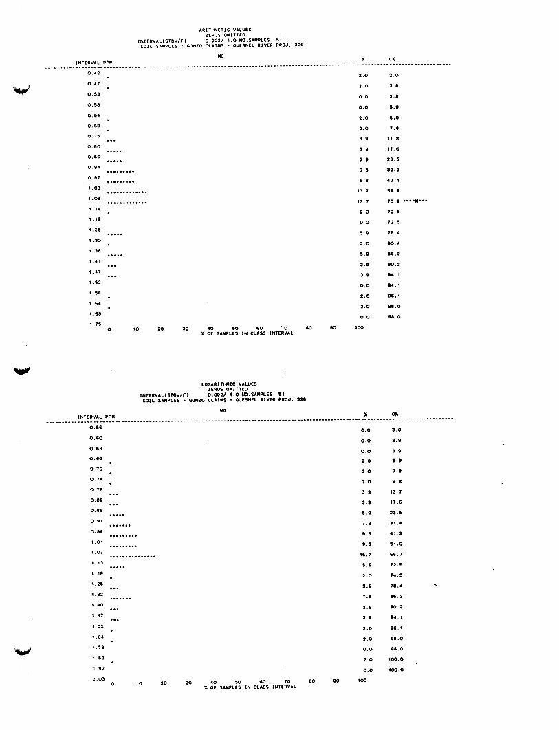
W
w
0 . 4 2
0 . 4 7
0 . 5 3
0 . 5 8
0 .64
0 . 6 9
0 . 7 5
0 . 8 0
0.86
0 . 9 1
0 . 9 7
1.03
1.08
1.14
1.19
1.25
1.30
1.36
1 .41
1.47
1.52
1.58
1.64
1 .69
1.75
...
..... ..... . . . . . . . . . . . . . . . . . . ............. .............
.....
.....
... ...
0
2 . 0
2 . 0
0 .0
0.0
2 . 0
2 - 0
3 . 9
5 .9
5 . 9
9 . 8
9 . 8
1 3 . 1
13.7
2 . 0
0 .0
5 .9
2 . 0
5 . 9
3 . 9
3 . 9
0.0
2 .O
2 . 0
0 .0
LOCARITHYIC VbLUES ZEROS OMITTED
INTERVAL(STOV/F) O . W 2 / 4 . 0 NO.SbMPLES 51 S O I L SAMPLES - GONZO CLAIMS - QUFSNEL RIVER PROJ. 326
2 .o 3.0
3 . 9
3 . 9
5 . 9
7 .8
11.8
17.6
23 .5
33.3
4 3 . 1
56 .9
70 .6 ....M...
7 1 . 6
12 .5
78.4
80.4
86.3
90.2
94.1
9 4 . 1
96 .1
08.0
9 8 . 0
0 . 5 6
0.60
0 .63
0.66
0 . 7 0
0 . 7 4
0 .78
0 . 8 2
0.86
0 . 9 1
0 .96
1.01
1.07
... ... ...*. ....... ... ..... * * . . . . . . . . ...............
0.0
0 .0
0.0
2 . 0
2 . 0
2 . 0
3 . 9
3 . 9
5 . 9
7 .8
9 . 8
9 . 0
15.7
..... 1.13
1.19
1.25
1.32
1.40
1.47
1.55
1.64
1.73
... ....... ... ...
1 . 8 2
1.92
2.03 0
5 . 9
2 .o 3 . 9
7.8
3 . 9
3.9
2 .o
2 . 0
0 . 0
2 . 0
0 .0
10 2 0 30 4 0 SO 60 7 0 80 W $00 X OF SAMPLES I N CLASS INTERVAL
3.9
3 . 9
3 . 9
5 . 9
7 . 8
9 . 8
13.7
17.6
23.5
31.4
4 1 . 2
51 .o 66.7
72.5
74.5
78.4 9
86.3
90.2
94.1
9 6 . 1
0 8 . 0
98 .0
100.0
100.0
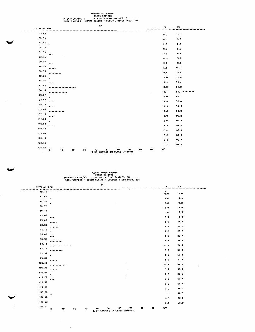
A R I T H M E T I C VALUES ZEROS OMITTEO
I N T E P V A L ( S T O V / F ) 16.809/ 4 . 0 NO.SAMPLES 51 S O I L SAMPLES - GONZO C L A I M S - OUESNEL R I V E R P R O J . 326
W
I N T E R V A L PPM
35.13
39.94
44.14
48.34
52.54
56.15
6 0 . 9 5
65 .15
69 .35
73 .56
77.76
81.96
86.16
90 .37
96.57
98.17
102.97
107. 17
111.38
115.58
119.78
123.98
128.19
132.39
136.S9
...
... ..... . . . . . . . . .
... ................... .............
... ... ........... ...
...
0.0
0 . 0
2 .o
0.0
3 . 9
0.0
3 . 9
5 . 9
9 .8
2 . 0
3 .9
19.6
13.7
2 . 0
3 .9
3 . 9
11.8
3 . 9
2 .o
3.9
0.0
0 .0
0 .0
0 .0
0 10 2 0 30 4 0 50 60 7 0 80 SO $00 X OF SAMPLES IN CLASS I N T E R V A L
0.0
0.0
2 . 0
2 . 0
5 . 9
5 . 9
9 . 8
15.7
25 .5
27.5
31.4
5 1 . 0
64.7 ....M...
6 6 . 7
70.6
74 .5
86.3
9 0 . 2
9 2 . 2
96.
96.
96.
96.
%.
4 9 . 4 4
51.83
54.34
56.97
59 .73
62.62
65.65
68.83
72.16
75.65
79 .31
83 .15
07.17
91 .39
95.82
100.45
105.32
110.41
115.76
121.36
127.23
133.39
139.85
146.62
153.71
... ..... .......
... . . . . . . . . .
...I........... . . . . . . . . .
..... ........... .....
...
0 10
0 0
2 0
2 0
0 0
0 0
3 9
5 9
7 8
2 0
3 9
9 8
15 7
9 8
2 0
5.9
1 1 8
5 9
2 0
35
0 0
0 0
2 0
0 0
0 0
20 30 4 0 50 60 70 80 SO '00 X OF SAMPLES I N C L A S S I N T E R V A L
2 . 0
3 .9
5 . 0
5.9
5 . 9
9 . 8
15.7
23.5
25.5
29.4
39 .2
5 4 . 9
64.7
66.7
72.5
8 4 . 3
€30.2
92.2
96.1
96. 1
9 6 . 1
9 8 . 0
98 .o
98 .o
,
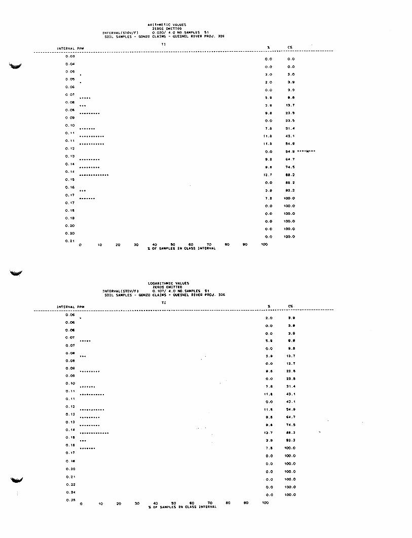
ARITHMETIC VALUES ZEROS OMITTED
INTERVAL(STOV/F) 0.030/ 4 . 0 NO.SAMPLLS 5 1 S O I L SAMPLES - GONZO CLAIMS - OUESNEL RIVER PROJ. 326
..... 0 .07
0.08 ... . . . . . . . . . 0.08
0.09
0. i o
0 .19
0 . 1 1
0 . 12
0 . 1 3
0 . 1 4
0. 94
0 . 1 5
0 . 1 6
0 .17
0. 17
0 .18
0. 19
0 . 2 0
0.20
. . . . . . . ........... ...........
. . . . . . . . .
. . . . . . . . . .............
... . . . . . . .
0 . 2 1 0 10
0.0
0.0
2 .o
2 .o
0.0
5 . 9
3 . 9
9 . 8
0.0
7 .8
11.8
11.8
0.0
9 .8
9 .8
13.7
0.0
3.9
7 .8
0.0
0.0
0.0
0.0
0.0
2o 30 4 0 w 60 70 80 rn 100 X OF SAMPLES I N CLASS INTERVAL
0.0
0.0
2 . 0
3 . 8
3 .9
9.8
13.7
23.5
23.5
31.4
43 .1
54 .9
5 4 . 9 .*..M...
64.7
74.5
88.2
08.2
92.2
100.0
100.0
100.0
100.0
100.0
100.0
0.06
0.06
0.06
0 . 0 7
0 .07 .....
0.08 ... 0 .08
. . . . . . . . , 0.09
0.09
. . . . . . . 0 . 1 0
0 . 1 1
0 . 1 1
0 . 1 2
0 . 1 3
0 .13
0.1.
0 . 1 5
0 .16
0 .17
........I..
........... . . . . . . . . . .... * .... ............. ... . . . . . . . 0 . 18
0 . 2 0
0 . 2 1
0 . 2 2
0.24
0 .25 0 10
2 .o
0.0
0.0
5 .9
0.0
3.9
0.0
9 8
0.0
7 .8
11.8
0.0
11.8
9.8
9 . 8
13 7
3 .9
7 . 8
0.0
0.0
0.0
0 .0
0.0
0 .0
20 30 4 0 so 60 70 80 Bo wo % O F SAMPLES I N CLASS INTERVAL
3.9
3.9
3.9
9.8
9 .0
13.7
93.7
23.5
23,5
31 .4
43 .1
43 .1
54 .9
64 .7
14 .5
88.2
92.2
100.0
100.0
100.0
100.0
900.0
100.0
100.0
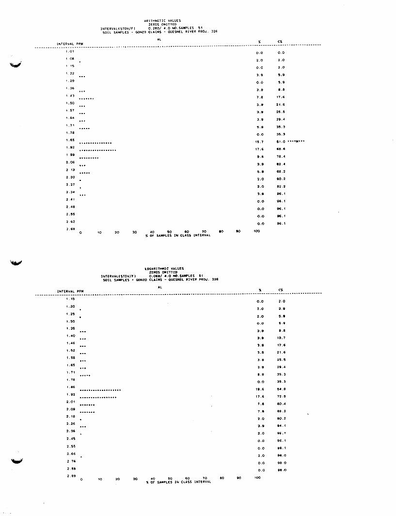
INTERVAL PPU
1 . 0 1
1 08
1 15
- _ - -
ARITHMETIC VALUES ZEROS OMITTED
INTERVAL(STDV/F) 0.280/ 4 . 0 NO.SAMPLES 51 SOIL SIMPLES - GONZO CLAIMS - W E S N E L RIVER PRO& 326
AL
. . . . . . . . . . . . . . . . . . . . . . . . . . . . . . . . . . . . . . . . . . . . . . . . . . . . . . . . . . . . . .
... 1.22
1.29
1.36
1.43
1.50
1 57
1.64
1.71
1.78
1 . 8 S
1 .92
1.99
2 . 0 6
2 . 1 3
2 . 2 0
2 .27
2.34
2 .41
2.48
2.55
2 .62
... . . . . . . .
...
...
...
.....
............... ................. . . . . . . . . . ... .....
...
2 .69 0 10 20 30 40 SO 60 70 80 90 100
X OF SAMPLES IN CLASS INTERVAL
Y _ _ _ _ - - - - - - - - - 0.0
2 .o
0.0
3 . 9
0.0
3 .9
7 .a
3 . 9
3 .9
3 .9
5 . 9
0.0
15.7
17.6
9 . 8
3 .9
5 .9
2 .o 2 . 0
3 . 9
0.0
0.0
0.0
0.0
CX
0 . 0
2 .o
2 . 0
5 . 9
5 . 9
9 . 8
17.6
21 .6
2 5 . 5
29.4
31.3
35.3
s 1 . 0 .... M...
68 .6
78.4
82.4
88 .2
8 0 . 2
92.2
06 .1
96 .1
96 .1
96.1
96 .1
1.15
1 - 2 0
1.25
1.30
1.35
1.40
1.46
1.52
1.58
1.6s
1.71
1.78
1.80
1.93
2 . 0 1
2 . 0 9
2 .18
2 .26
2.36
2.45
2.55
2 .66
2.76
2.88
2 .99
... ... ...
...
... ... .....
................... ................. . . . . . . .
. . . . . . .
.*.
0 10 2 0
0.0
2 .o 2 . 0
0.0
3 .9
3 . 9
3 . 9
3 . 9
3 . 9
3 . 9
5.9
0.0
19.6
17.6
7 .8
7 .8
2 . 0
3 .9
2 . 0
0 . 0
0 . 0
2 . 0
0 . 0
0 . 0
30 40 SO 60 70 80 90 1 0 0 7, OF SAMPLES IN CLASS INTERVAL
2 .0
3.9
5 . 9
5.9
9 . 8
13.7
17.6
21.6
25.5
29.4
3 5 . 3
35.3
54 .9
7 2 . 5
80.4
88 .2
90.2
94 .1
9 6 . 1
96. 1
96.1
9 8 . 0
9 8 . 0
9 8 . 0

ARITHYETIC VALUES ZEROS OMITTEO
INTERVAL(STOV/F) 0.023/ 4 . 0 NO.SAMCLES 51 SOIL SAMPLES - GONZO CLAIMS - WESNEL RIVER PRO& 326
w 0.01
0.01
0 . 0 2
0 . 0 2
0.03
0.03
0 .04
0 . 0 5
0 . 0 5
0.06
0.06
0.07
.............
.........................
....................... 0.07
........... 0.08
0.08
0 .09
0 . 1 0
0 . 1 0
0 . 1 1
0 . 1 1
0 . 1 2
0 . 1 2
0 .13
0 .14
0. 14
...
...
...
...
0 10
0.0
0.0
0.0
0.0
0.0
0.0
2 .o 13.7
0.0
25.5
0.0
23.5
0.0
11.8
3 . 9
0.0
3 . 9
0.0
3 . 9
0.0
3 . 9
0.0
2 .o
2 .o
20 30 4 0 SO 60 7 0 80 90 1 0 0 X OF SAMPLES I N CLASS INTERVAL
0.0
0.0
0.0
0.0
0.0
0.0
2 . 0
15.7
15.7
4 1 . 1
41.2
64.7
6 4 . 7 ....M...
76.5
80.4
80.4
8 4 . 3
84 .3
88.2
8 8 . 1
92.2
9 2 . 2
94 .1
96 .1
L O G A R I T W I C VALUES ZEROS OMITTEO
INTERVALISTOV/F) 0.121/ 4 .0 NO.SAMPLLS 61 S O I L SAMPLES - GONZO CLAIMS - OUESNEL R I V E R PROJ. 326
w
0.03
0.03
0.04
0.04
0.04
0 . 0 4
0.05
0 .05
0 . 0 5
0.06
0.06
0 .07
.............
..........................
...................... 1
0.0
0.0
0.0
2 . 0
0.0
0.0
0.0
13.7
0.0
25.5
0.0
23.5 0 . 0 7
0.08
0.08
0.09
0 . 0 9
0 . 1 0
0 . 1 1
0 . 1 1
0 . 1 2
0 . 1 3
0. 14
0 . 15
0 16
...........
... ...
... ...
0 10
0.0
11.8
0.0
3 .9
3 . 9
0.0
3 . 9
3 .9
2 .O
2 .O
0.0
0.0
20 30 40 50 60 70 80 90 1 0 0 % OF SAMPLES I N CLASS INTERVAL
0.0
0.0
0.0
a .o 2 .o
2 .o
2 .o
15.7
15.7
41.2
41.2
6 4 . 7
6 4 . 7
76.5
76.5
8 0 . 4 9
84 .3
84.3
.sa.z
92.2
94 .1
9 6 . 1
9 6 . 1
86.1
APPENDIX 111
Affidavit of Expenses
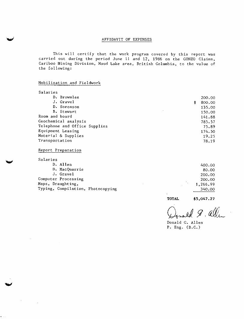
W AFFIDAVIT OF EXPENSES
W
This will certify that the work program covered by this report was carried out during the period June 11 and 12, 1986 on the GONZO Claims, Cariboo Mining Division, Maud Lake area, British Columbia, to the value of the following:
Mobilization and Fieldwork
Salaries D. Brownlee J. Gravel D. Sorenson B. Stewart
Room and board Geochemical analysis Telephone and Office Supplies Equipment Leasing Material & Supplies Transportation
Report Preparation
Salaries D. Allen D. MacQuarrie J. Gravel
Computer Processing Maps, Draughting, Typing, Compilation, Photocopying
200.00 $ 800.00
135.00 150.00 141.88 785.57
75.89 174.50
19.25 78.19
400.00 80.00
200.00 200.00
1,266.99 340.00
TOTAL $5,047 -27
Donald G. Allen P. Eng. (B.C.)