5humans value, change and protect...
TRANSCRIPT
acid rain: rainfall that has become acidic from atmospheric pollution; causes environmental harm to soils, forests and lakes
anthropogenic: caused by human activitycanal: artificial waterway constructed to allow the passage of
boats or irrigation of cropsclimate change: long-term change in weather patterns that range
from decades to millions of yearscultural landscapes: natural landscapes changed by humansdykes: earth walls that hold back waterestuarine: where the sea extends inland to meet a river mouthgross domestic product (GDP): total value of goods and services
produced in a country in a given year
chap
ter Humans value,
change and protect landscapes
The real voyage of discovery consists not in seeking new landscapes, but in having new eyes.
Marcel Proust
5
Geovocab
heritage: our legacy from the past, what we live with today, and what we pass on to future generations (UNESCO definition)
Indigenous People’s Knowledge (IPK): refers to the knowledge, innovations and practices of Indigenous communities
land reclamation: creating new land from the sea or riverslandscape: comprises landforms, including the sea; living elements,
such as vegetation and animals; and human elements, such as land use and buildings
landscape degradation: decline in natural features (e.g. mountains, lakes, the sea and vegetation) and human features (e.g. land use and buildings)
moor: upland area with peat soils producing sparse vegetation

mountaintop removal (MTR) mining: alteration and removal of a summit of a mountain or hill to obtain geological material, such as coal
polder: low-lying land reclaimed from a sea or river, protected by dykesriparian: situated on the banks of a riverstorm surge: rising sea as a result of a tsunami or cyclonesustainable: a pattern of resource use that aims to meet both
present and future needs; consists of environmental, social and economic factors
tundra: flat, treeless Arctic region in which the subsoil is permanently frozen
wetland: land consisting of marshes or swamps
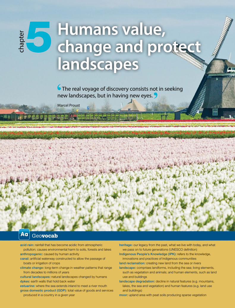
All landscapes contain the imprint of human use and hold aesthetic, cultural and spiritual values for different people. Over time, rivers have been dammed to reduce flooding, mountain tops removed for minerals, and coastal areas enclosed within sea walls. Roads are dug through mountains, while forests are cleared to make way for farms and wetlands for settlements. Land is reclaimed from the sea for agriculture, cities and holiday resorts.
Human activities have resulted in landscape degrada-tion—tourism and mountain biking has caused soil erosion, industry has contributed to acid rain, and mining has polluted water sources. As a result, these landscapes need to be protected for future generations to enjoy.
Aboriginal and Torres Strait Islander Peoples have managed their landscapes for over 40 000 years. These original Australians have a spiritual and cultural attachment to particular landforms, and have had a lasting impact on the landscape through the use of fire. Their knowledge has contributed to the sustainable management of landscapes and their distinctive landform features.
Think, puzzle, explore
• Place What are the effects of human changes on landscapes in different places?
• Space What is the spatial distribution of major dams?• Environment How can Earth support an increasing
global population without landscape degradation?• Interconnection What are the interconnections
between recreation and land degradation?• Sustainability How can landscapes be managed
sustainably?• Scale How can humans protect landscapes from
the local to the global scale?• Change Why do humans change landscapes?
Geoskills in focus
• Observing changes to landscapes through fieldwork, such as visiting areas degraded by recreation, mining, farming or urban activities
• Collecting, recording and analysing primary and secondary sources to investigate causes and effects of landscape degradation by humans, such as interviewing people
• Evaluating alternatives to improve landscape degradation
• Communicating information using web 2.0 tools such as infographics and Prezi, and incorporating maps, graphs, statistics and photographs
• Reflecting on the values of landscapes and ways to protect landscapes, from the local to the global scale
Humans have changed sea into land to grow flowers in the Netherlands

ISBN 978 1 4202 3265 3142
GeoWorld 8: Australian Curriculum
5.1 Humans change landscapes All landscapes contain the imprint of human use. People live in landscapes, and can alter the landscape with little understanding of their impacts on the natural environment. Rivers are dammed to create reservoirs and wetlands drained for settlements. Forests are logged for paper and hillsides terraced to grow crops. Mountain tops are removed for minerals and coastal areas enclosed with sea walls to reduce the impacts of rising sea levels. Roads and railways are dug through rugged mountains, and monasteries are perched on steep cliffs. Land is dotted with quarries and oil rigs.
Additionally, many human activities have increased the rate at which natural processes shape landscapes, for example:
• erosion—from overcropping, overgrazing animals, logging forests for settlements, bush walking, mountain biking and driving off-road vehicles
• air pollution—from acid rain speeding up the weathering of Earth’s surface, as seen on the Taj Mahal’s marble facades.
Satellites monitor landscape degradation, for instance toxic mining waste in South African rivers, or irrigation leading to the decline of the Aral Sea area in Central Asia.
Anthropogenic landscapesHumans constantly change natural landscapes. Cultural landscapes are the combined efforts of nature and humans, such as the polders in the Netherlands and the Three Gorges Dam in China.
Landscape changes can be permanent (e.g. mountain-top mining), semi-permanent (e.g. roads and power transmission lines) or temporary (e.g. commercial forests returned to previous natural vegetation). These changes are often a source of conflict, such as the sculpture of four presidents carved into the granite face of Mt Rushmore. The carvings are controversial among Native Americans because the USA seized the area from the Lakota tribe.
The impacts of human changes can be either positive, such as seawalls constructed to save a community from a dangerous tsunami, or negative, such as anthropogenic landscape degradation with a decline in wetlands and seagrasses.
5.1.2 Roads constructed through mountains alters landforms at St Gotthard Pass, Switzerland
5.1.3 Sculpturing landforms at Mt Rushmore, USA
5.1.1 Extracting oil changes landscapes in California, USA

ISBN 978 1 4202 3265 3
Humans value, change and protect landscapes
143
Ch
ap
ter 5
Changing the Tuscan landscapeAcross centuries, people have left their imprint on the Tuscan landscape. Tuscany, in Italy, is famous for landscape paintings, fields covered with olive groves and vineyards, and medieval castles and fortresses perched on hill tops.
The hills were originally vegetated with chestnut, pine and cypress trees, but over time humans have changed the Tuscan landscape with farms and urban settlements. In order to protect the landscape, six Tuscan localities were designated as World Heritage sites and over 120 protected nature reserves were established. However, the natural environment is under stress from the 3.8 million inhabitants and
growing tourism—the capital city of Tuscany, Florence, attracts 10 million tourists a year.
The wine maker, farmer, tourist, shop keeper, painter, town planner, urban dweller and conservationist each have different views on managing the Tuscan landscape. Of increasing concern is whether the resources in the area are used in a sustainable way.
Geoinfo
Many famous people used the Tuscan landscape as inspiration for their work (e.g. Leonardo de Vinci).
Geoactivities 5.1
Knowledge and understanding
1 What is a landscape? 2 How have humans changed the landscape over time? 3 List human behaviours that degrade landscapes. 4 Landscapes are constantly changing. What does this
statement mean?
Inquiry and skills
5 Refer to 5.1.1 and 5.1.2. a Why did humans change these landscapes?b Do you think these human activities have degraded
the landscapes? Provide reasons for your answer.c Discuss how technology has changed landscapes.
6 Refer to 5.1.3.a Why is Mt Rushmore a source of conflict?b Explain whether you consider these statues
landscape degradation.
7 Refer to 5.1.4.a Where is Tuscany located?b Describe how humans have changed the Tuscan
landscape over time.c Explain whether you consider these changes
cause landscape degradation. 8 Research Tuscany and present a photo story of the
natural and cultural landscapes. 9 Using secondary sources, investigate one natural
landscape, such as the Grand Canyon, Great Barrier Reef, Mt Everest or Iguassu Falls. Explain how humans have changed the landscape to provide for the increasing number of tourists.
10 All landscapes contain the imprint of human use. Explain this statement in a short report.
5.1.4 Cultural landscape of Tuscany
Aesthetic value—views and architecture (e.g. Leaning Tower of Pisa)
History—people, events, stories, songs and medieval castles
Plants and animals introduced by humans (e.g. vineyards, olive groves and vegetables)
Water—piped water to homes and to fields for irrigation
Spiritual—power of places, sacred sites, burial sites (e.g. ancient Apennine and Villanovan cultures)
Places—development of villages and towns (e.g. Florence and Sienna)
People—individuals, communities and tourists change the landscape (e.g. roads, accommodation and wineries)
Topography—mountains cleared of vegetation for farms and settlements, mines (e.g. iron ore, copper and mercury), tourists attracted to natural hot springs

Palm Springs
Hollister
Frazier Park
Fresno
Parkland
Sacramento
San Bernardino
Santa Rosa
San Jose
Lancaster
CAL IFORNIA
Palm Springs
Santa Cruz Hollister
Frazier Park
Eureka
Fresno
Parkland
Mendocino
Monterey
Sacramento
San BernardinoLos Angeles
San Francisco
Brawley
San Luis Obispo
Santa Barbara
Santa Rosa
Crescent City
Tijuana
San Mateo San Jose
San Diego
Lancaster
i c O c e a nP a c i f
NEVADA
CAL IFORNIA
N
0 100 200 km
UTM Projection
San Andreas Fault
ISBN 978 1 4202 3265 3144
GeoWorld 8: Australian Curriculum
5.2 Urban–industrial landscapesSince the beginning of the Neolithic Revolution about eight millennia ago, humans have shaped and changed landscapes. These landscapes vary from Mongolian yurts to New York’s high-rise apartments, and from small Indonesian rice farms to large Argentinean cattle ranches.
Landscapes have changed around the world to accommodate 7 billion people. With over 50% of the global population living in urban areas, the world’s wetlands, forests and farms have been converted into urban landscapes. Enormous landscape changes have occurred in China, with the urban population growing from 26% in 1990 to 52% in 2013. Changes continue as the country aims to create the largest megacity in the world containing 42 million people, and plans to build 20 000 to 50 000 new skyscrapers over the next 20 years.
Manila, the capital of the Philippines, changed from a fortified settlement of a few hundred people on the shores of the Pasig River in the 13th century to a population of 12 million today. As it is one of the most densely populated cities in the world, the city expanded and engulfed rural landscapes and coastal landscapes by clearing wetlands along waterfronts.
San Francisco’s changing landscapeSan Francisco is located on the east coast of the USA. The area was once sand dunes and marshland, but after the 1849 gold rush it developed into a large city that accommodates 8 million people today. In the 1840s, the San Francisco area was desolate with only stunted vegetation on sand dunes. By 1849 sand hills
were levelled and tidal marshes filled. Thousands of tonnes of sand were dumped into the bay to create additional land. Located near the San Andreas Fault, there are concerns San Francisco could be affected by an earthquake and tsunami as well as the impacts of rising sea levels in the low-lying Bay Area.
Blaenavon industrial landscapeThe Industrial Revolution in 1700s saw the growth of manufacturing in the UK followed by the rest of
the world. These indus-trial landscapes degraded the environment with air and water pollution. Today these old industrial sites have become areas of urban decay. Some have been rejuvenated with new functions, referred to as urban renewal, such as the Docklands in London, the Rocks Area in Sydney and Southbank in Melbourne.
5.2.1 San Francisco: sand dunes c. 1900 and today’s urban landscape
5.2.2 Location of the San Andreas Fault

ISBN 978 1 4202 3265 3
Humans value, change and protect landscapes
145
Ch
ap
ter 5
Frequently original landscapes are forgotten, such as that of the Blaenavon Industrial Landscape World Heritage site in Wales. During the Industrial Revolution, Blaenavon was pitted with mines and quarries. Eventually, mining and associated industries declined, resulting in a degraded and desolate landscape. After some time, vegetation colonised mining wastes and wildlife returned. Concerns for the protection of this degraded
Geoinfo
3000 people died in the 1906 San Francisco earthquake (magnitude 7.8) and subsequent fires.
5.2.3 Blaenavon’s 19th century industrial and mining landscape
5.2.4 Map of Blaenavon
landscape led to the Forgotten Landscapes Project, which aims to protect the area’s industrial heritage and conserve its heather moorland.
Future urban landscapesIn the future, city landscapes will change due to human-induced climate change. Rising sea levels means many coastal cities are in danger of being flooded, such as New York (USA), Bangkok (Thailand), Shanghai (China), Venice (Italy) and Mexico City (Mexico). To ensure these areas are protected, humans are changing the landscape by building seawalls (Mumbai) and barriers (London).
Geoactivities 5.2
Knowledge and understanding
1 How have humans shaped landscapes? 2 How does urban growth change landscapes? 3 What is the cause of major landscape change in
China? 4 Explain how the Industrial Revolution changed
landscapes from the 1700s. 5 Describe the impacts of human-induced changes
on future landscapes.
Inquiry and skills
6 Refer to 5.2.1. Explain the effects of urban growth on the landscape.
7 Refer to 5.2.2. a Imagine San Francisco’s landscape after an
earthquake. Suggest strategies to reduce landscape degradation
b Describe the location of the San Andreas Fault. 8 Refer to 5.2.3, 5.2.4 and the text.
a Describe the changes to the Blaenavon landscape over time.
b Explain why the area was declared a World Heritage site.
9 Brainstorm changes to landscapes in your local area over time. Has the change degraded the landscape or improved it? Justify your answer.
10 Homes adapt to landscapes and reflect different cultures. Design a collage of different types of homes and the related culture in your local area.
11 Using ICT, discuss how technological innovations have increased human’s ability to change natural landscapes.

Mumbai
Sion
Bandra
Worli
Mahim
Parel
Mazagaon
Fort
Colaba
MalabarHill
MahimBay
BackBay
Parel
Mazagaon
Bombay
Colaba
Little Colaba
Mahim
Worli
MumbaiHarbour
Seven Islandsof Bombay
Seven Islandsof Bombay
0 2 4 km
UTM Projection
N
0 2 4 km
UTM Projection
N
ISBN 978 1 4202 3265 3146
GeoWorld 8: Australian Curriculum
5.3 Land reclamation creates islands and cities
For over 800 years, the Uros tribe of Lake Titicaca, Peru, weaved floating isles of totora reeds. Recently in South Korea, three floating islands were anchored in the Han River with concrete blocks. Should a flood eventuate, these islands rise and fall with the water levels.
5.3.2 Seven Islands of Bombay merge
from the bottom of the Persian Gulf. Construction damaged the marine habitat by burying coral reefs, oyster beds and sea grass. As ocean currents have been disrupted, beaches are eroding.
SingaporeLocated off the southern tip of the Malay Peninsula, Singapore consists of 63 islands. Limited land and a growing population led to the country reclaiming land from the sea. Since the 1960s, land reclamation has increased the original land area by 20%. Coast-lines have been altered and mangroves reduced from 13% in the 1820s to 0.5% today. Singapore’s population of over 5 million people is expected to reach 6.5–6.9 million by 2030. To accommodate the population, land reclamation is anticipated to increase by another 100 km2 by 2030.
Hong KongMountainous Hong Kong in China has a limited supply of useable land. The country commenced reclaiming land from the sea from 206 bc when beaches were turned into fields for salt production. Major land reclamation projects have been conducted since the mid-19th century.
5.3.1 Seoul Floating Island on the Han River
Land reclamationHave you fantasised about living on your own island paradise? Today this can be a reality as engineers have created habitable islands by land reclamation.
Land reclamation is the process of creating new land from oceans, rivers or lakes, and as a result new landscapes have emerged. In the Netherlands 18% of the country is reclaimed from the North Sea and marshes, and 25% of Hong Kong is built on reclaimed land. Mumbai originally consisted of seven islands, which were united through land reclamation projects. Limited land availability for growing populations is expected to result in increased land reclama-tion around the world, causing degradation of wetlands, sea grasses and coral reefs.
Land reclamation has been extensive in the following places:
Dubai and BahrainIn West Asia, artificial islands have been created, for instance, Dubai’s Palm Islands and Bahrain’s Amwaj Islands. The con-struction of the three Palm Islands adds 520 km of beaches to Dubai. The islands are composed of rock and sand dredged

55° 00’ E
25° 18’ N
25° 06’ N
24° 54’ N
25° 18’ N
25° 06’ N
24° 54’ N
55° 12’ E 55° 24’ E
55° 00’ E 55° 12’ E 55° 24’ E
Dubai
Jumeirah
Bur Dubai
MinaJebel Ali
DubaiMarina
Sharjah
Ajman
DubaiWaterfront
The PalmsJebel Ali
The PalmsJumeirah
The Universe
The PalmsDeira
The WorldP e r s i a n
G u l f
0 10 20 km
UTM Projection
N
Reclamation under construction
Urban area
ISBN 978 1 4202 3265 3
Humans value, change and protect landscapes
147
Ch
ap
ter 5
Today Hong Kong Disneyland Resort is located on reclaimed land, while Hong Kong International Airport involved levelling two isles and adding an additional 6000 km2 via land reclamation. As the city expanded, new towns, (e.g. Sha Tin) were built on reclaimed land. Reclamation has impacted on seaweed beds, marine environments and the endangered Chinese white dolphin. In 1996 Hong Kong passed a law to safeguard the threatened Victoria Harbour against encroaching land development.
5.3.3 Satellite image and map showing Dubai’s land reclamation from the sea
Geoactivities 5.3
Knowledge and understanding
1 Why do people change landforms? List the answers as a mind map.
2 What are floating isles and what are their advantages? 3 What is land reclamation? 4 List the advantages and disadvantages of land
reclamation in two columns. 5 Describe how Singapore and Hong Kong changed
landforms to accommodate their growing populations.
Inquiry and skills
6 Refer to 5.3.1. What are the advantages of South Korea’s floating islands?
7 Refer to 5.3.2.a Describe how Mumbai connected islands into one
landmassb What were the effects of the landform changes?
8 Refer to 5.3.3 and the text.a What are the advantages of using a map and a
satellite image to identify areas where land has been reclaimed in Dubai?
b Describe the impacts of artificial islands on the environment.
9 Refer to the chapter opening photo on pages 140–141 and secondary sources.a Explain how the Netherlands changed from being
a landscape under the sea to one above the land.b Draw and label a line drawing of the Netherlands
photo. Indicate changes by humans.c What are the advantages of windmills in the
Netherlands? How do they differ from modern wind farms?
10 Polders also exist in countries other than the Netherlands. Select a polder in another country. Discuss why it was built and its effects on the landscape.
11 Research the artificial Zoran Island off Phuket in Thailand. Include answers to questions such as: Where will it be located? How will humans change the landscape? What will be the function of the new island? What are the environmental issues? Present as a short report.
12 Research Eden Island in the Seychelles or Kansai Airport island in Japan.
13 Design a collage of land reclamation of countries in the Asia region.
The NetherlandsThe Dutch pushed back the water of the Zuiderzee by building dykes and creating polders (see photo on pages 140–141). Once dykes were built, canals and pumps drained the land to keep it dry for agriculture and settlements. Further protective dykes were built, reclaiming IJsselmeer. The new land led to the creation of Flevoland. There are future threats from rising sea levels, as 27% of the Netherlands is below sea level.
ISBN 978 1 4202 3265 3148
GeoWorld 8: Australian Curriculum
5.4 Mining explosions and mountain top removal
Mining areas are frequently in the news as they account for 12 000 deaths annually, caused by fires, explosions, ground subsidence, and mudslides from steep waste dumps (tailings). Explosions killed 1572 miners in 1942 at a Honkeiko coal mine in China, and 96 miners in 1902 at a Port Kembla coal mine in New South Wales.
Mining changes landformsMining causes scars on Earth that can be seen from space. The Mirny diamond mine in Siberia is the largest open-cut diamond mine in the world. Its mining hole is 1.2 km wide and 525 m deep. Wind currents inside the huge hole form a downdraft that can result in helicopters being sucked in and crashing.
Mining changes landforms as mountain tops are removed and underground explosions conducted. Mountaintop removal (MTR) mining involves the removal of a summit on a mountain or hill to obtain geological material, such as coal. Mountain tops have been removed for coal in the Appalachian Mountains in the eastern USA and the Dnepropetrovsk-Donets
and Kuznets area in Russia. Sometimes the land is dumped back on the ridge and compacted to reflect the original contour of the mountain. In other cases, wastes are dumped into nearby streams, altering their flow and causing a decrease in aquatic biodiversity.
Landscape degradationDuring the process of mining, landscapes become degraded, for example:
• logging forests—contributes to a decline in biodiversity
• water pollution—causes toxins to enter rivers and groundwater
• air pollution—emits dust and carbon monoxide.
There are health impacts as well, for instance lung diseases (e.g. asbestosis).
Madre de Dios occupies Peru’s lowland and hosts the Manu National Park, which was designated a UNESCO World Heritage site. Mining activities in Madre de Dios contributed to deforestation faster than any other activity. Roughly 7000 ha of pristine
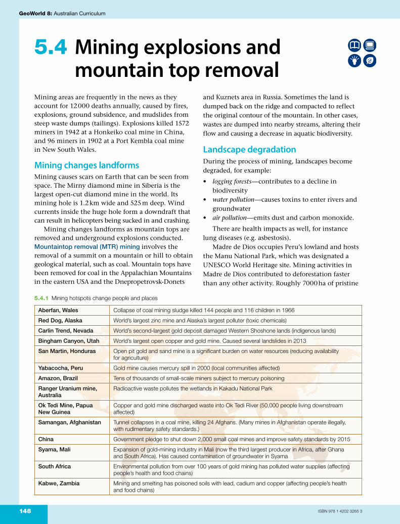
5.4.1 Mining hotspots change people and places
Aberfan, Wales Collapse of coal mining sludge killed 144 people and 116 children in 1966
Red Dog, Alaska World’s largest zinc mine and Alaska’s largest polluter (toxic chemicals)
Carlin Trend, Nevada World’s second-largest gold deposit damaged Western Shoshone lands (indigenous lands)
Bingham Canyon, Utah World’s largest open copper and gold mine. Caused several landslides in 2013
San Martin, Honduras Open pit gold and sand mine is a significant burden on water resources (reducing availability for agriculture)
Yabacocha, Peru Gold mine causes mercury spill in 2000 (local communities affected)
Amazon, Brazil Tens of thousands of small-scale miners subject to mercury poisoning
Ranger Uranium mine, Australia
Radioactive waste pollutes the wetlands in Kakadu National Park
Ok Tedi Mine, Papua New Guinea
Copper and gold mine discharged waste into Ok Tedi River (50,000 people living downstream affected)
Samangan, Afghanistan Tunnel collapses in a coal mine, killing 24 Afghans. (Many mines in Afghanistan operate illegally, with rudimentary safety standards.)
China Government pledge to shut down 2,000 small coal mines and improve safety standards by 2015
Syama, Mali Expansion of gold-mining industry in Mali (now the third largest producer in Africa, after Ghana and South Africa). Has caused contamination of groundwater in Syama
South Africa Environmental pollution from over 100 years of gold mining has polluted water supplies (affecting people’s health and food chains)
Kabwe, Zambia Mining and smelting has poisoned soils with lead, cadium and copper (affecting people’s health and food chains)

4 The land can be rehabilitated by returning topsoil and vegetation
Adverse effects• Decline in biodiversity – vegetation and animal species• Destroys rivers when buried by valley fills• Blasting damages foundations of homes and infrastructure• Flooding downstream from loss of vegetation and valleys
Process of mountain-top removal
1 Vegetation is cleared 2 Giant earthmovers remove bedrock
3 Material is dumped into valleys – called valley fills which changes the course of rivers
1
1
2
2
3
3
4
4
ISBN 978 1 4202 3265 3
Humans value, change and protect landscapes
149
Ch
ap
ter 5forest and wetlands were cleared at two mining sites
between 2003 and 2009. Over a period of 20 years the Ok Tedi open-cut
copper and gold mines in Papua New Guinea (PNG)discharged over 70 million tonnes of mining waste into the Ok Tedi River, annually. The pollutants harmed the livelihood of 50 000 people living down-stream. Fish species declined and contaminated mud destroyed plantations of taro and bananas—the staple foods of the local people.
Conflicts: perspectivesConflicts concerned with mining take place across the world, such as between mining and agriculture interests, and between mining groups and indig-enous people’s attachment to the land. There are also conflicts between values held by the mining industry and conservationists. Mining companies promote economic benefits, such as employment and an increase in gross domestic product (GDP), while many have signed contracts agreeing to protect the environment. Conservationists believe the cultural values of an area may be more impor-tant than money gained by mining.
Geoactivities 5.4
Knowledge and understanding
1 How does mining change landforms and land-scapes?
2 What is mountain top removal? 3 Explain the effects of mountain top removal on
landforms. 4 Discuss the effects of mining on the landscape of
Madre de Dios. 5 How did mining degrade the environment in PNG?
Inquiry and skills
6 Refer to 5.4.1.a Provide examples of the impacts of mining on
land, water, biodiversity, air and people.b Research two mines and discuss their effects
on landscape degradation. Present you information using web 2.0 tools.
7 Refer to 5.4.2.a Explain the process of MTR.b What are the problems of valley fills on steep
slopes after heavy rain?c Describe how MTR degraded the landscape.
8 Design a collage of the largest mining scars on Earth.
9 In groups study one mining conflict from around the world. Answer questions such as: Where is the mine located? What are the major interest groups (e.g. mining company and local community)? Reflect on your learning and suggest individual and collective actions to resolve the conflict.
5.4.2 The processes and environmental effects of MTR
Geoinfo
Ok Tedi’s mining lease expired at the end of 2013 and the PNG Government has taken ownership.

30° S 30° S
20° E 30° E
20° E 30° E
Tropic of Capricorn
NAMIBIA
BOTSWANAZIMBABWE
SWAZILAND
LESOTHO
SOUTH AFRICA
JohannesburgPretoria
Cape Town
Durban
Port Elizabeth
Bloemfontein
George
Polokwane
Kroonstad
Nelspruit
East London
Kimberley
Beaufort West
Springbok
Vredendal
Stellenbosch
Umtata
Grahamstown
Upington
Graa�-Reinet
River
River
River
OrangeOrange
Vaal
River
LimpopoA F R I C A
SouthAfrica
N
0 200 400 km
Equal Area Projection
ISBN 978 1 4202 3265 3150
GeoWorld 8: Australian Curriculum
5.5 Gold mining and rehabilitation: Johannesburg
Johannesburg, the largest city in South Africa, contains 4.5 million people. The original landscape has been described as a waterless, treeless, dust bowl. It was inhabited by the San tribes, who were hunters and gatherers. In the late 1880s, the gold rush changed the landscape into mine pits and waste heaps. Mines brought wealth to a few, who were known as Randlords, while hundreds of thousands of black Africans worked deep underground, earning little money.
From mining to an urban landscape The Witwatersrand is a large sedimentary range of hills rich in gold. Over the years the landscape changed as shaft gold mining and waste dumps spread across the 80 km mining belt. The Western Deep Level Mine is the deepest mine in the world, with shafts to depths of 3900 m. It is problematic as the temperature rises by 1 °C every 33 m, with rocks too hot to touch. Cave-ins, shaft collapses, explosions and land subsidence occur.
Most underground gold mines ceased operations in the 1970s, leaving large tracts of vacant land. Informal settlements encroached on unused mining land with people living beside toxic waste dumps.
5.5.1 Location of South Africa and Johannesburg
5.5.2 The original landscape featured sparse vegetation and was inhabited by the hunter–gatherer Sans
At Krugersdorp, acidic lakes dot the landscape and hippopotamuses at a nearby nature reserve are going blind due to acid water runoff.
Future landscape: protectionJohannesburg faces environmental challenges from mining operations, including contaminated soils, Acid Mine Drainage (AMD) and subsiding land. Gold mining companies recognise the environmental
challenges they face, and are actively pursuing sustainable mining practices. Large quantities of mining land have been treated for contaminants and released for reuse. Water from mining activities is treated to reduce pollutants entering water courses. Waste dumps are lined to reduce the leaching of toxic waste (tailings) through the soil and into groundwater.
There are more than 5700 derelict mines in South Africa. The nation has endorsed international treaties to protect wetlands from mine operations, as well as to ensure the safe disposal of mining wastes.
Geoinfo
Johannesburg’s Zulu name is eGoli, which means ‘City of Gold’.

ISBN 978 1 4202 3265 3
Humans value, change and protect landscapes
151
Ch
ap
ter 5
Geoactivities 5.5
Knowledge and understanding
1 Where is Johannesburg located? 2 Describe how mining changed the landscape. 3 What is the Witwatersrand? 4 List the problems of gold mining in Johannesburg. 5 Describe one procedure to rehabilitate mining
landscapes and prevent future contamination. 6 Discuss how humans changed the landscape of
Johannesburg over time.
Inquiry and skills
7 Refer to 5.5.3.a Describe the location and size of the soccer
stadium in relation to the mine dumps.b The gold industry shifted from shaft mining to
waste processing. How has this changed the landscape?
c Describe how the benefits of gold mining were not distributed equally among the population as observed from different shelters.
d What is Acid Mine Drainage (AMD)? How does it impact on the environment?
8 List the largest gold mines in the world and locate them on a map.
9 Using secondary resources, briefly outline how mining has changed landscapes in Australia since the gold rushes. Present as a photo story.
10 Investigate one gold mine in Western Australia. In a short report, discuss how it has changed the landscape and its impacts on Aboriginal communities.
11 Reflect on your learning and suggest actions to reduce the adverse impacts of goldmining on places and people.
5.5.3 Mining landscapes in Johannesburg
Soccer City stadium, the main venue for the 2010 FIFA World Cup, is located in the midst of three large mine dumps.
Satellite image of the soccer stadium surrounded by mine dumps.
AMD contains heavy metals harmful to humans and ecosystems, and is released into Johannesburg’s water system.
The gold industry has shifted from deep- shaft mining to reprocessing waste and much of the original mining land has been redeveloped. The Gold Reef City theme park now covers 12 ha built on the site of a mine.
Informal settlements in the mining belt consist of shacks built of scrap metal and wood. Water is available at communal standpipes or delivered weekly by truck, and electricity is tapped illegally or provided by car batteries. Communal latrines provide sanitation. Waste disposal is usually non-existent.
In the early 1900s, Johannesburg introduced shade trees to alleviate airborne dust from mining. Originally a semi-arid grassland ecosystem, the city now boasts the largest urban canopy in the world. Large quantities of water are required for irrigation—an added burden for a region with limited water resources.

Loss ofdownstream
aquifers
Energy options
Water supply
Sedimentation
Greenhousegas emissions
Hydropower forelectricity
Recreation use Flooded habitat(loss of culture
and homes)
Displacedpeople protest
Salinity causedby waterlogging
Loss of livelihoodfrom fisheries,
licensing issuesTrans-boundary
water competitionRiver bank erosion
45% China19% Other14% United States 9% India 6% Japan 3% Spain 2% Canada 2% South Korea
ISBN 978 1 4202 3265 3152
GeoWorld 8: Australian Curriculum
5.6 Dams change landscapesOf the world’s 228 largest rivers, approximately 60% have been changed by the construction of dams, weirs and canals along their journey from source to mouth. In Australia, after 150 years of dam building some people wonder if the problems arising from dams outweigh the benefits. At present there is a debate over the construction of a dam on the Mary River in south-east Queensland after the river experienced flooding in 2010, 2011 and 2013. The traditional Gubbi Gubbi people object to the construction of a dam as the river touches spiritual places, birth places and sacred pools.
Damming the worldA dam retains water, while floodgates, levees and dykes are used to manage or prevent water flowing onto the land. The ideal location for building a dam is the narrow part of a deep river valley where the valley sides act as natural walls. Behind the dam wall a reservoir of water collects, frequently enjoyed for recreational activities, such as fishing. Dams are used to irrigate farms in the Murray–Darling Basin, provide water to urban settlements in London and supply electricity for Chinese industries. Additionally, dams reduce the impacts of floods downstream.
The construction around the world of 48 000 dams, over 15 m high, has displaced natural land-scapes, such as forests, as well as agricultural lands
and settlements. Dams have caused the degradation of wetland and riverine ecosystems, and their reser-voirs have changed biodiversity, because water temperature is colder behind the dam wall where the water is deeper. Fish such as salmon are unable to migrate upstream to breed, although in many cases fish ladders have been built to assist their migration.
A dam collapse from an earthquake or faulty construction increases the chance of floods down-stream. Dam failures are rare, but in 1975 the collapse of Banqiao and Shimantan dams in China killed 171 000 people and displaced the 11 million who had lost their homes.
Belo Monte Dam, Brazil The Belo Monte Dam in Brazil is under construc-tion on the Xingu River, a tributary of the Amazon River. When built it will be the third-largest hydroelec-tric dam in the world, flooding 1300 km2 of rainforest and displacing 12 000 indigenous people. Indigenous people consider the construction of the dam environmentally destructive, leading to loss of vegetation and changes in water supply and fish migration routes.5.6.1 Dams cause changes to people and landscapes
5.6.2 Global distribution of large dams
Source: Environment Canada

ISBN 978 1 4202 3265 3
Humans value, change and protect landscapes
153
Ch
ap
ter 5
Three Gorges Dam, ChinaIn 1954, the Yangtze River in Central China flooded, killing 33 169 people and forcing 18 884 000 people to relocate. The Three Gorges Dam built on the river reduces floods downstream, provides electricity, and increases shipping capacity by constructing locks and lifts.
However, the future of the dam is uncertain as it sits on a seismic fault and 80% of the land around the river experiences high rates of soil erosion. As a result, around 35 million tonnes of sediment is deposited into the Yangtze River annually, which means sediment builds up behind the dam instead of
Geoinfo
• Approximately 40–80 million people have been displaced from their homes as a result of dam construction.
• Australia’s largest artificial lake by volume is Lake Argyle, Western Australia, completed in 1971.
5.6.3 Three Gorges Dam changes landforms
Changes in Yangtze River upstream of dam and towards the source
Changes in Yangtze River downstream of dam and towards the mouth
• Large storage of water created behind the dam
• Gradient and speed of river reduced
• Build-up of sediment behind the dam could cause water to overflow or break the dam over time—needs constant dredging
• Discharge of water downstream reduced and more regular
• Less alluvium in the river downstream to provide fertile soil for agriculture
Advantages of Three Gorges Dam
Disadvantages of Three Gorges Dam
• Improved navigation and trade as far as Chongqing, one of the fastest-growing cities in the world
• Flooding reduced • Water stored behind dam
used for drinking and irrigation
• Produces renewable energy
• Increased traffic and pollution placing stress on freshwater species (e.g. freshwater dolphin, sturgeon and alligator)
• Dam is vulnerable to earthquakes
• 1.3 million people relocated when reservoir was flooded
Geoactivities 5.6
Knowledge and understanding
1 What is a dam? 2 How does a dam differ from a dyke? 3 List the advantages of dams. 4 Explain how dams cause landscape degradation.
Inquiry and skills
5 Refer to 5.6.1. a What is the ideal location for a dam?b List the multiple uses of dams.c Explain how dams impact positively and
negatively on people. 6 Refer to 5.6.2 and name the three countries where
most large dams are constructed. 7 Refer to 5.6.3.
a Where is the Three Gorges Dam located?b How has the dam changed the river upstream
and downstream?c Explain anticipated future problems of the dam.d Determine whether the dam is an engineering
miracle or an environmental disaster. Explain your answer.
8 Refer to the text and research Belo Monte Dam. a Where is the Belo Monte Dam to be constructed?b List the advantages and disadvantages of the
dam to Brazil. 9 Investigate the proposal for the construction of a
dam on the Mary River or a dam in another country. List the different views of people on its construction (e.g. indigenous communities, people who lost properties during a flood, conservationists, town planners and displaced settlements). Present the different perspectives as a table and summarise conclusions.
10 In groups, research a dam in Australia. When was it built? Why was it built? How did it change the landscape? Evaluate your sources and present the information as a PowerPoint or short essay.
11 Climate change could cause a decline in water for drinking, industry and agriculture. As a result, dam construction could become a popular solution. What would be the implications? Suggest alternatives.
12 Research a significant dam failure and the impact on people and the environment. Present your findings as a TV news item.
flowing downstream. The Yangtze carries the fifth-largest sediment discharge of any river in the world.
The Yangtze River basin is home to 361 fish species and accounts for 27% of endangered fresh-water fish species in China. The Three Gorges Dam is adversely affecting freshwater fish, especially the extinct Chinese River Dolphin.
5.6.4 The Three Gorges Dam

Lower sea level
Highersea level
Closed chamberfills with water toraise ship to levelof next lock
Additional locksraise water levelto height of highersea level
Ship sails intoopen lock
Lock gateLock
ISBN 978 1 4202 3265 3154
GeoWorld 8: Australian Curriculum
5.7 Humans construct canals Humans have changed landscapes by constructing features to reduce the impact of sea level rises (e.g. sea walls and dykes), decrease floods (e.g. dams and levees) and improve transport (e.g. canals). From one perspective, these human-built structures are aesthetically unattractive and cause landscape degradation, and from another perspective they are marvels of human engineering that have improved people’s lives.
Rivers have been changed by dredging and dam-ming their journey from their source in mountains to their mouth at oceans. Some meandering rivers have been straightened, resulting in degradation of wetlands and riparian vegetation.
5.7.1 Straightening rivers
Advantages
• Rivers are more suitable for navigation by larger vessels • Larger and deeper river channels reduces floods • Reduces natural erosion
Disadvantages
• Loss of wetlands causes a decline in habitat for wildlife and the loss of an important filter for fresh water
• Straightening causes the rivers to flow more rapidly, which can increase soil erosion and flooding downstream from the channelised area
• Causes decline in river fish populations
CanalsCanals are human-made channels for water that serve a variety of functions:
• connecting lakes (Erie Canal, USA), rivers (Lenin Volga–Don Shipping Canal, Russia) and oceans (Suez Canal in Egypt and Panama Canal)
• connecting city networks e.g. the canals in Venice.
Amsterdam has been called the ‘Venice of the North’ with over 100 km of canals and 1500 bridges. Bangkok is referred to as the ‘Venice of the South’, with canals, or klongs, transporting people and products. Today many canals in Bangkok have been drained or filled and replaced by roads.
The Suez Canal connects the Mediterranean Sea and the Red Sea, and all seaborne trade between Asia and Europe passes through the canal. Marine species located in the Mediterranean Sea are threatened by the movement of 300 species from the Red Sea. In Central America, the Panama Canal connects the
Pacific and Atlantic oceans, enabling faster transport of goods and people. At present there is a proposal for the construction of Canal Istanbul in Turkey to link the Black Sea with the Sea of Marmara by 2023. However, Greenpeace Turkey warns that the canal will change the native habitat, excavations will cause erosion, and agriculture and water resources will be negatively affected.
Restoring riversThe global trend to straighten rivers has recently changed its course. For example, in Europe some constructed canals have been restored to the natural meandering courses of the original rivers. In the USA a ‘no wetlands loss policy’ is popular, which means
5.7.2 A canal in Amsterdam
5.7.3 Operation of the Panama Canal. Ships move via locks, which increase or decrease their water level to raise or lower the ships

ISBN 978 1 4202 3265 3
Humans value, change and protect landscapes
155
Ch
ap
ter 5canals constructed in one place are to be offset by
creating a new wetland in another place.
From wetland to sewage dumpGowanus in Brooklyn, New York, was originally a tidal inlet with mangroves teeming with fish and wildlife. During the mid 1850s, the Gowanus Creek was deepened into a canal and marshlands eradicated. It soon became the hub for Brooklyn’s commercial
shipping activities, and factories, tanneries, coal stores and gas refineries sprang up along its banks. These industries polluted the water and obstructed the growth of aquatic plants. Today, rising gas bubbles emerge from sewage sludge and a horrendous stench pervades the air. A proposed clean-up plan for the Gowanus Canal aims to prevent raw sewage overflow and remove contaminated sediments, such as lead, mercury and copper.
5.7.4 Istanbul Canal project
Geoactivities 5.7
Knowledge and understanding
1 List the features constructed by humans that change the flow of rivers and ocean currents.
2 Name two different types of human-made canals. 3 What is meant by a ‘no wetlands loss policy’? 4 Give an example of a landscape restored to its natural
state. 5 Describe the changes to Gowanus Creek in New York
and its impacts on the landscape.
Inquiry and skills
6 Refer to 5.7.1. Explain your perspective on whether rivers should be straightened.
7 Refer to 5.7.2.a Discuss why Amsterdam is called the ‘Venice of
the North’.b Design a day excursion travelling on the canals
of Amsterdam or Bangkok. Identify the different landscapes you would pass. Present as a Prezi.
8 Refer to 5.7.3. a Where is the Panama Canal located?b How does the canal work?c What are the advantages of the canal?d Investigate plans for future expansion of the canal.
9 Refer to 5.7.4.a Describe the location of the Istanbul Canal project.b Explain why it will be important for the flow of
people and goods.c Discuss how the canal could degrade landscapes.
10 Using ICT, research the Suez Canal. Explain the reasons for the construction of the canal and its impacts on the global movement of people and goods.
11 Where is the St Lawrence Seaway located? What are the advantages of the canals for North Americans?
12 Plan a holiday on a barge in the UK or Europe. In your response include a map showing the canals. Present your information as an eco-tourist pamphlet.
Geoinfo
• More than 200 million tonnes of cargo move through the Great Lakes Seaway System annually.
• The Grand Canal of China is the longest canal in the world.
Source: RIA Novosti

ISBN 978 1 4202 3265 3156
GeoWorld 8: Australian Curriculum
5.8 Marinas and ports change coastal landscapes
The construction of port facilities modifies coastal and estuarine habitats by physically altering the shoreline. Frequently, wetlands and seagrass beds are destroyed, which reduces aquatic habitats. Construction of marinas has similar environmental impacts to ports, although generally smaller due to their smaller size. The increasing number of marinas and associated structures, such as jetties and boat ramps, along the Australian coast has altered shorelines and habitats, and degraded natural landscapes.
Marinas and breakwatersA marina is a dock with moorings and supplies for yachts and small boats. They are located beside oceans, rivers and lakes, such as Salt Lake, USA. San Francisco Bay is a mecca for sailors as it contains 40 marinas and over 11 000 slipways. In Greece there are 20 marinas under construction and 50 in operation, such as at Piraeus—the starting point for boat trips to the Aegean islands for millions of tourists every year.
Australia’s coastline stretches approximately 60 000 km. Two-thirds of the population live in towns and cities located near the coast. Marinas have been constructed to accommodate affluent lifestyles, such as in the Docklands in Melbourne, Darling Harbour in Sydney, the Gold Coast, Hamilton Island, and Hillarys Boat Harbour, north of Perth.
At present the Western Australian Government aims to build a multi-million dollar marina and port facility in Port Hedland. The Spoilbank Marina Precinct is part of the Pilbara Cities initiative, which aims to revitalise Port Hedland into a city of 50 000 people. However, dredging during construction will cause loss of species in the intertidal zone associated with mangroves, salt marshes and cyanobaterial mats. These mats are rich in organic matter and phosphorous, and reduce erosion by binding and stabilising land. The Spoilbank Marina project has strategies in place to reduce loss of biodiversity, trap nutrients, maintain water quality, protect against storm surges and erosion, and promote the recreational value of fishing.
Landscape degradationExcessive boating activity in river mouths and estuaries leads to erosion of riverbanks and destroys the vegetation that is important for the preservation of biodiversity. Boats and marinas cause water pollution from oil spills and sewage disposal. Additionally, they require wharves, navigational markers, dry-docks, slipways, fuel storage, pump-out facilities and parking access.
Before a marina is constructed, an environmental statement of its effects is prepared. Questions to be answered include:
• Is a breakwater or channel diversion required?• Can clearing of natural riparian vegetation be
avoided?• Will wetlands or seagrass be affected?• Is bank erosion likely?• Will nearby aquaculture and fishing grounds be
affected?• Will there be significant visual impact?• Is the proposal likely to affect the significance of
Indigenous or non-Indigenous heritage items found on the sites?
Beach WA 1897 occupies the shore of the marina. The beach is backed by the yacht club and a large car park and is used as a boat and yacht launching ramp. The spoil bank is composed of dredged shelly sand from the harbour channel.
Site of new marina
GroynesBeach
5.8.1 The planned Spoilbank Marina, Port Hedland, WA

ISBN 978 1 4202 3265 3
Humans value, change and protect landscapes
157
Ch
ap
ter 5
To improve navigation, natural channels have been widened and deepened by removing soil from the bottom of waterways—a process called dredging. This destroys the habitats of benthic, or bottom-dwelling, organisms that live in the sediment. To reduce the impact of waves, such as tsunamis or storm surges after cyclones, stone breakwaters are constructed around ports and marinas. This interferes with natural erosion and seagrass species and their habitats.
Geoactivities 5.8
Knowledge and understanding
1 What is a marina? 2 How does a marina differ from a port? 3 Describe how marinas can cause landscape
degradation. 4 Why are cyanobacterial mats and riparian vegetation
important?
Inquiry and skills
5 Refer to 5.8.1.a What is a spoilbank?b What is the aim of developing the Spoilbank Marina?c How will the construction of the Spoilbank Marina
impact on the environment? d How will the project reduce landscape degradation?
6 Refer to 5.8.2. a What were the impacts of Hurricane Sandy on
New York marinas?
5.8.3 Photo of Gainsville Marina on Lake Lanier, USA, depicting the facilities a marina requires. A–G and 1–10 are docks offering various facilities
5.8.2 Images of Mantoloking, New Jersey, before and after Hurricane Sandy in 2012
b Explain how the hurricane degraded the landscape.
c Describe what could occur in marinas with rising sea levels and increasing intensity of storms.
7 Refer to 5.8.3.a What facilities does a marina require?b Explain how the natural environment surrounding
a marina changes over time. 8 Plan a class debate on the following statement:
Marinas are the environmentally destructive play-grounds of the rich. Evaluate your sources and summarise conclusions.
9 Organise a sailing trip around the world staying at marinas. Plot your course on a world map. Include latitude and longitude of each place and the anticipated weather you would experience by including three climate graphs.
CBA
G
F
E
D
6
5
4
3
2
1
78
9
Sales, office, gas dock, rentals
Bathhouse 10
SecurityPublic ramp
Courtesy docks
Service, parts
Dry stack
Dry stack dock

Drainage trenches
Gabions
Rock armour
BeachConcrete sea wall
Pins
ISBN 978 1 4202 3265 3158
GeoWorld 8: Australian Curriculum
5.9 Seawalls and barriers: saving Venice
Climate change and the associated projected rise in sea levels could result in the catastrophic flooding of coastal cities. Thirteen of the world’s 20 largest cities are situated along coastlines, including Mumbai (India), New York (USA), Shanghai (China) and Alexandria (Egypt). Their protection requires the construction of seawalls or sea barriers.
The Thames Barrier prevents London from being flooded by high tides and storm surges. The flooding of low-lying parts of New York after Hurricane Sandy in 2012 saw calls for the construction of a barrier.
causing sea levels to rise slightly every year. Further-more, the city is also sinking 1–2 mm a year due to:
• pumping of groundwater from beneath the city (a practice that stopped in 2000)
• compaction of sediments beneath Venice from centuries of building
• plate tectonics, as the Adriatic Plate, on which Venice sits, is subducting beneath the Apennine Mountains.
In 2013, the first successful tests of the new electro-mechanical flood barrier system for Venice were trialled. The Moses project (as it is called in English) is scheduled for completion in 2016.
Seawalls hold back the seaA seawall is a form of coastal defence constructed to protect humans and their settlements from tides and waves. Seawalls are constructed from a variety of materials, such as reinforced concrete, boulders and fibreglass. On the downside, seawalls stop the exchange of sediment between land and sea and alter ocean currents. Seawalls built across the world have achieved positive and negative results:
• Pondicherry, on the coast of India, escaped the 2004 tsunami due to a massive stone seawall constructed by the French 300 years ago. The only people killed were those who lived in villages beyond the seawall.
• The Maldives, located in the Indian Ocean, is building sea walls to protect the islands from sea level rise. In 2004 the sea wall protecting the capital, Male, prevented half the city from being destroyed by the tsunami.
5.9.1 Structures to protect coastlines
The Maldives Gulf of Maine, USA Isle of White, UK
5.9.2 Different types of seawalls
Flooded VeniceVenice is a city partially flooded by water. A network of canals is used in place of roads as a means of transport. High tides flood the streets from September to December forcing residents to walk on wooden planks to stay above the floodwaters. There is an increase in flooding in Venice due to climate change

Mestre
Porto di Lido
Porto di Malamocco
Porto di Chioggia
Sites for the barriers
Venice
VeniceLagoon
Adriatic Sea
N
0 5 10 15 km
Compressed air
Venice LagoonAdriatic Sea
Water flow
Pump
ISBN 978 1 4202 3265 3
Humans value, change and protect landscapes
159
Ch
ap
ter 5
• To protect Japan from earthquake-generated tsunamis, 43% of the countries’s coastline is lined with concrete seawalls and breakwaters. However, these did not prevent the 2011 tsunami surging over seawalls and flooding coastal areas.
• Phuket is located off the coast of Thailand. A seawall was built to protect the sea gypsy commu-nity at Laem Tukkae. However, it did not last the first monsoon season.
Other countries preparing for sea level rise include:
• the Netherlands, which has constructed the largest seawalls (dykes) in the world. Rising sea levels continue to breach its floodgates. In response, the Dutch are designing floating houses, roads and cities.
• Australia, which has cities and towns built on coastal waterways that are vulnerable to sea level rises, high tides and cyclones. Coastal protection projects include breakwaters and seawalls aimed to guard against erosion and sea level rise.
Geoactivities 5.9
Knowledge and understanding
1 Describe a seawall and a barrier. 2 Name cities affected by future sea level rises. 3 Venice suffers from rising sea levels and sinking
ground. Explain why the land is subsiding. 4 Describe how seawalls cause environmental
degradation. 5 Discuss whether seawalls are ineffective constructions.
Inquiry and skills
6 Refer to 5.9.1.a List two structures humans build to hold back
the sea.b Describe how the coastline has been altered.
7 Refer to 5.9.2 and describe the different seawalls. 8 Refer to 5.9.3.
a Where are the sea barriers to be located?b Explain the operation of the sea barriers.
9 Refer to 5.9.4. Summarise the positive and negative effects of seawalls on the landscape, in the form of a diagram.
10 Research one coastal city in Australia and one coastal city overseas. Include the impacts of increasing sea levels and what is being done to reduce the impacts (e.g. seawalls or barriers).
11 Investigate how low-lying islands (e.g. the Torres Strait Islands and the Maldives) can be protected from the sea and what the potential impacts are on landscape degradation. Present your findings as annotated photographs.
5.9.3 Design and sites of the proposed sea barrier for Venice
Geoinfo
• The biggest mega-structure seawall is in the Netherlands. It is twice as long as the Great Wall of China.
• The St Petersburg’s barrier in Russia consists of 26 km of levees and gates, providing protection from the Baltic Sea and the Neva River.
5.9.4 Effects of seawalls
Positive
• Provides a hard coastal defence
• Minimises deaths and injuries
• Reduces damage to homes and infrastructure along coasts
• Used for recreational purposes (e.g. walking and cycling)
• Long-term solution compared to continually replenishing eroded beach with sand
Negative
• Scars the landscape and can be an eyesore
• Destroys coastal habitats (e.g. wetlands)
• Disrupts natural shoreline processes (e.g. wave movement)
• Reflects wave energy, which could erode the seawall base

ISBN 978 1 4202 3265 3160
GeoWorld 8: Australian Curriculum
5.10 Recreation: valuing and protecting mountains
Landforms and landscapes are an important part of people’s recreational activities. For instance, we use:
• mountains for skiing, snowboarding, abseiling, climbing, white water rafting, trekking and viewing landscapes via cable cars
• karsts for caving• coasts for surfing, rock climbing, scuba diving,
sailing and fishing• forests and wetlands for forest skyways and
wetland boardwalks• deserts for camel safaris • grasslands for viewing animals, such as tigers • rivers for boat trips and canal holidays.
The aesthetic, cultural and spiritual values of popular tourist sites require protection from the degradation of land, water and biodiversity. The establishment of local, national and global protected areas (such as national parks, wilderness areas and World Heritage sites) aims to protect these sites for future generations to enjoy.
Valuing mountainsMountain tourism accounts for 15–20% of the world’s tourism industry. International Mountain Day creates awareness of the importance of
mountains as water reservoirs, sources of biodiversity and food, and the home for the majority of the world’s indigenous people. For example, the Quechuas in the Andes Mountains in Peru value the land, water and forests. These resources should not be exploited as their wellbeing depends on careful stewardship of the landscape. For the Quechuas, spirituality and cultural identity is interconnected with the environment.
5.10.1 Recreational activities are carried out in geomorphic landscapes, such as cavers abseiling into the Greenland Ice Sheet
Protecting the Australian Alps: a significant geomorphic feature
The increased number of people skiing, hiking and climbing mountains is causing landscape degradation.
Kosciusko State Park was established in 1944 in order to protect the Australian Alps. Today 11 parks and reserves are collectively referred to as the Australian Alps National Parks with the purpose of protecting the unique mountain landscape and its natural and cultural values.
For Aboriginal Peoples the land holds spiritual values. For thousands of years, Aboriginal Peoples travelled hundreds of kilometres to meet on the highest peaks of the alpine region for trading, intertribal corroborees, marriages and the initiation of young men.
In 2008 the Australian Alps was included on the National Heritage List to recognise the region’s landforms, biodiversity and recreational opportunities.
Management plans are developed through consultation with groups and individuals. These include plans to address climate change, predicted to reduce the extent of snowfields in winter and the threat of their eventual disappearance.
Protecting Himalayan MountainsEach year 527 000 visitors, including over 100 000 trekkers and mountaineers, visit the Himalayan Mountains in Nepal. The number is high compared to other large mountains, which experience fewer than 1000 trekkers and mountaineers a year. In Nepal, most trekkers head to Annapurna (60 237) and Mt Everest (26 511). The Nepalese have a permit system for visiting their mountain summits, which brings revenue into the country.
Trekking tourism has contributed to environ-mental degradation. Rubbish and medical waste have created the most elevated junkyard in the world. Some conservationists want certain trekking tracks closed to reduce their environmental impact. As a result, a large proportion of the forests are allocated as reserves and national parks; for example, Chitwan National Park.

SagarmathaNational Park
C H I N A
I N D I A
N E P A L
SheyPoksundo
National Park
AnnapurnaConservation
AreaManaslu
ConservationArea
KanchenjungaConservation
Area
Lake RaraNational
Park
KhaptadNational
Park
BardiyaNational Park
LangtangNational Park
DhorpatanHuntingReserve
ChitwanNational
Park
Sukla PhantaWildlife Reserve
Shivapuri NagarjunNational Park
Hetauda
Sallyan
Nepalganj
Rajbiraj
Bhairawa
Dhangarhi
Mt Everest
Biratnagar
KathmanduRamechhap
Pokhara
Dandeldhura
Birganj
Annapurna
H
im
al
ay
as
0 100 200 km
UTM Projection
N
Hunting reserve
Wildlife reserve
Conservation area
National park
ISBN 978 1 4202 3265 3
Humans value, change and protect landscapes
161
Ch
ap
ter 5
Geoactivities 5.10
Knowledge and understanding
1 Landforms and landscapes are valued as recreation activities. Brainstorm the activities and present them as a Tagxedo.
2 What is meant by the aesthetic value of a landscape? 3 How do indigenous people view mountains? 4 Explain how the Australian Alps are being protected.
Inquiry and skills
5 Refer to 5.10.1 and explain the links between recreational activities and their landscapes.
6 Refer to 5.10.2.a Discuss how trekking in Nepal has a positive
impact on diverse groups.b List some of the environmental problems arising
from trekking.
5.10.2 Views of diverse groups with an interest in the Himalayan Mountains
Geoinfo
• Over 1 million British people booked a snow-sports holiday last year.
• The Hindu–Kush–Himalayan region has some of the highest diversity of indig-enous peoples in the world.
• The Universal Declaration of Human Rights declares leisure a human right.
7 Refer to 5.10.3.a Name one national park and one conservation area.b Measure the distance between Mt Everest and
Chitwan National Park. 8 Design a collage illustrating recreational activities
related to landforms. Evaluate sources for reliability and usefulness.
9 Reflect on your learning and in an oral presentation suggest actions to protect mountains.
10 Investigate mountain-based sporting events (e.g. the Tour de France or cross-country skiing). List their impacts on mountain landscapes.
11 Using secondary sources, research the Winter Olympics and the regions in which they have been held. Create a location map and suggest sustainable strategies to restore and protect these environments.
5.10.3 Protected areas in Nepal
Mountaineers, trekkers and tourists: they are attracted by recreational activities and aesthetically beautiful scenery
Hill communities: trekkers spend money, enabling recipients to buy homes with modern facilities
Businesses: trekkers increase demand for businesses (e.g. restaurants, craft shops, mountain gear shops, cyber cafes and tour guides) and mean increased wealth for developers
Government: money from tourist fees levied by the Immigration Office helped to:• establish micro hydro-power plants and
bottled gas, reducing the use of fuelwood• construct latrines and establish rubbish
collection systems• improve roads, airport and hospitals
Sherpas: members of this ethnic group from high in the mountains are employed as trekking guides, improving their income and lifestyle. They have some control over tourism (e.g. running lodges, tea shops and trekking services). Mt Everest has strong spiritual meaning for sherpas
Conservationists are concerned about: • declining forests leading to soil
erosion and flooding downstream.• firewood used for camp fires and
lodges (e.g. cooking, heating and construction of tourist accommodation)
• the regenerative capacity of trees being poorer in higher altitudes
• the use of forest resources by local people—most use fuel wood
They have brought about change: trekking is limited and controlled in protected areas
Source: Journal of Alpine Research