coastal · 2020-01-15 · assistance to coastal municipalities. the danajon bank double barrier...
TRANSCRIPT


PPPP P ro
pose
d In
itiat
ive
to I
mpr
ove
Cap
acity
of
and
Co
llabo
ratio
nro
pose
d In
itiat
ive
to I
mpr
ove
Cap
acity
of
and
Co
llabo
ratio
nro
pose
d In
itiat
ive
to I
mpr
ove
Cap
acity
of
and
Co
llabo
ratio
nro
pose
d In
itiat
ive
to I
mpr
ove
Cap
acity
of
and
Co
llabo
ratio
nro
pose
d In
itiat
ive
to I
mpr
ove
Cap
acity
of
and
Co
llabo
ratio
nBe
twee
n C
oas
tal
LGU
s in
the
Dan
ajo
n Ba
nk D
oub
le B
arri
er R
eef
Betw
een
Co
asta
l LG
Us
in t
he D
anaj
on
Bank
Do
uble
Bar
rier
Ree
fBe
twee
n C
oas
tal
LGU
s in
the
Dan
ajo
n Ba
nk D
oub
le B
arri
er R
eef
Betw
een
Co
asta
l LG
Us
in t
he D
anaj
on
Bank
Do
uble
Bar
rier
Ree
fBe
twee
n C
oas
tal
LGU
s in
the
Dan
ajo
n Ba
nk D
oub
le B
arri
er R
eef
11111
COASTAL RESOURCE MANAGEMENT
Rationale
Coastal resources in the Philippines are severely degraded due toyears of mismanagement and neglect. With the passage of the 1991Local Government Code and 1998 Philippine Fisheries Code, theresponsibility for managing fisheries and coastal habitats withinmunicipal waters was devolved to coastal municipalities and cities in thePhilippines. Over the last 6 years, coastal local government units(LGUs) throughout the Philippines have increasingly recognized thevital role coastal resources play in economic development, food security,and overall well being of coastal communities and have made substantialprogress in establishing the management systems needed for sustainableuse of these resources.
Coastal resource management is a participatory process ofplanning, implementing, and monitoring sustainable uses of coastalresources through collective action and sound decision-making. Forcoastal municipalities, CRM is one of the basic services that must bedelivered for sustainable development. Provincial government andnational government agencies provide technical and other forms ofassistance to coastal municipalities.
The DanajonBank Double BarrierReef is a unique coastalenvironment within thejurisdiction of 17 coastalmunicipalities coveringfour provinces. Theproposed initiative aimsto rehabilitate, protect,and manage the coastalresources in this areathrough improved localgovernment capacity forCRM and inter-LGU collaboration.
Caubyan Outer Reef
Section 1Preparation of Proposed Initiative to Improve Capacity of and Collaboration
Between Coastal LGUs in the Danajon Bank Double Barrier ReefPrepared by Governor Erico B. Aumentado

PPPPPrepared by repared by repared by repared by repared by ERICO BERICO BERICO BERICO BERICO B. AUMENT. AUMENT. AUMENT. AUMENT. AUMENTADOADOADOADOADOGovernor of BoholGovernor of BoholGovernor of BoholGovernor of BoholGovernor of Bohol
22222
The objectives of this initiative are to:
Maintain the biodiversity of the Danajon Bank Double Barrier ReefProvide “food security” for the areas around the Danajon Bank byensuring a supply of fish and marine organisms within the areaIncrease the potential in the area for ecotourism and other environment-friendly enterprisesServe as a “model” for inter-LGU coordination and promote sharing andlessons learned in coastal resource management between LGUs and thefour provinces
WHAT IS A DOUBLE BARRIER REEF?Double barrier reefs are very rare geological phenomena and theDanajon Bank is certainly the only documented barrier reef in thePhilippines and South Asia. Throughout the world, there are very fewdouble barrier reefs that have been documented, making the DanajonBank even more important to be conserved.
The Australian Barrier Reef is a famous and protected reef. As the namesuggests this is only a single barrier reef, the one in Bohol-Cebu, Leyteand Southern Leyte has two of these barrier reefs, side by side – hence itis called a double barrier reef.
This Double Barrier Reef has been formed offshore due to an existingrelief pattern off the north coast of Bohol. It is two sets of large coralreefs which formed offshore due to a combination of favourable tidalcurrents and coral growth on a submarine ridge which was formed in thearea1 .
The Double Barrier Reef was formed over the last 6,000 years2.
1 Pichon, M 1977. Physiography, morphology and ecology of the double barrier reef of north Bohol(Philippines). Proc. 3rd Int. Coral Reef Symposium. Miami 2:262-267.
2 Grobe, H. Willkom, H and Wefer, G. 1985 Internal structure and Origin of the Double Reefs ofNorth Bohol and Olango Reef Flat (Philippines). Philippine Scientist 22(1985):83-94

PPPP P ro
pose
d In
itiat
ive
to I
mpr
ove
Cap
acity
of
and
Co
llabo
ratio
nro
pose
d In
itiat
ive
to I
mpr
ove
Cap
acity
of
and
Co
llabo
ratio
nro
pose
d In
itiat
ive
to I
mpr
ove
Cap
acity
of
and
Co
llabo
ratio
nro
pose
d In
itiat
ive
to I
mpr
ove
Cap
acity
of
and
Co
llabo
ratio
nro
pose
d In
itiat
ive
to I
mpr
ove
Cap
acity
of
and
Co
llabo
ratio
nBe
twee
n C
oas
tal
LGU
s in
the
Dan
ajo
n Ba
nk D
oub
le B
arri
er R
eef
Betw
een
Co
asta
l LG
Us
in t
he D
anaj
on
Bank
Do
uble
Bar
rier
Ree
fBe
twee
n C
oas
tal
LGU
s in
the
Dan
ajo
n Ba
nk D
oub
le B
arri
er R
eef
Betw
een
Co
asta
l LG
Us
in t
he D
anaj
on
Bank
Do
uble
Bar
rier
Ree
fBe
twee
n C
oas
tal
LGU
s in
the
Dan
ajo
n Ba
nk D
oub
le B
arri
er R
eef
33333
LO
CA
TIO
N O
F T
HE D
AN
AJO
N B
AN
K D
OU
BL
E B
AR
RIE
R R
EE
F
CEB
U
BO
HO
L
LEY
TE

PPPPPrepared by repared by repared by repared by repared by ERICO BERICO BERICO BERICO BERICO B. AUMENT. AUMENT. AUMENT. AUMENT. AUMENTADOADOADOADOADOGovernor of BoholGovernor of BoholGovernor of BoholGovernor of BoholGovernor of Bohol
44444
LGU JURISDICTION OVER THE
DANAJON BANK DOUBLE BARRIER REEF
One of the islands off Tubigon, Bohol where the reef starts (the Danajon Bankcovers many islands with large populations)
There are 17 municipalities and cities covering 4 provinces with directjurisdiction over the Danajon Bank. These are:
Bohol:Provincial Government and the LGUs of Tubigon, Clarin, Inabanga,Buenavista, Getafe, Talibon, Bien Unido, Ubay, Trinidad and President GarciaIsland
Cebu:Provincial Government and the City of Lapu-Lapu and Municipality of Cordova
Southern Leyte:Provincial Government and Municipality of Maasin
Leyte:Provincial Government and Municipalities of Hilongos, Hindang, Bato andMatalom
Effective coordination between 16 LGUs, 1 city and 4 ProvincialGovernments is needed for the proper rehabilitation and management of theDanajon Bank.

PPPP P ro
pose
d In
itiat
ive
to I
mpr
ove
Cap
acity
of
and
Co
llabo
ratio
nro
pose
d In
itiat
ive
to I
mpr
ove
Cap
acity
of
and
Co
llabo
ratio
nro
pose
d In
itiat
ive
to I
mpr
ove
Cap
acity
of
and
Co
llabo
ratio
nro
pose
d In
itiat
ive
to I
mpr
ove
Cap
acity
of
and
Co
llabo
ratio
nro
pose
d In
itiat
ive
to I
mpr
ove
Cap
acity
of
and
Co
llabo
ratio
nBe
twee
n C
oas
tal
LGU
s in
the
Dan
ajo
n Ba
nk D
oub
le B
arri
er R
eef
Betw
een
Co
asta
l LG
Us
in t
he D
anaj
on
Bank
Do
uble
Bar
rier
Ree
fBe
twee
n C
oas
tal
LGU
s in
the
Dan
ajo
n Ba
nk D
oub
le B
arri
er R
eef
Betw
een
Co
asta
l LG
Us
in t
he D
anaj
on
Bank
Do
uble
Bar
rier
Ree
fBe
twee
n C
oas
tal
LGU
s in
the
Dan
ajo
n Ba
nk D
oub
le B
arri
er R
eef
55555
DANAJON BANK DOUBLE BARRIER
REEF STATISTICS:Table 1: Consolidated data on the Danajon Bank Double Barrier Reef(CRMP-GIS, 2002 – Base map taken from NAMRIA topographic dataand includes whole reef from Cebu (Lapu-Lapu City [Caubyan Island] toLeyte and Bohol Municipalities from Tubigon to President Garcia Island)
* Danajon Bank Double Barrier Reef covers an area over 1% of the total coral reef area of thePhilippines estimated to be 27,000 sq. km.
Caubyanreef
(outer)
Calituban reef(inner)
Total for wholeDouble Barrier
ReefMaximumwidth of reef
Minimumwidth of reef
Total Area
Total Length
4.06 km
0.3 km
143.3 km2
132.3 km
4.27 km
0.13 km
128.4 km2
249.2 km
271.7 km2*
381.5 km
Calituban Inner Reef (north of Getafe, Bohol)

PPPPPrepared by repared by repared by repared by repared by ERICO BERICO BERICO BERICO BERICO B. AUMENT. AUMENT. AUMENT. AUMENT. AUMENTADOADOADOADOADOGovernor of BoholGovernor of BoholGovernor of BoholGovernor of BoholGovernor of Bohol
66666
Loc
atio
n of
the
Dan
ajon
Ban
k D
oubl
e B
arri
er R
eef a
nd th
e L
GU
s wit
h Ju
risd
icti
on

PPPP P ro
pose
d In
itiat
ive
to I
mpr
ove
Cap
acity
of
and
Co
llabo
ratio
nro
pose
d In
itiat
ive
to I
mpr
ove
Cap
acity
of
and
Co
llabo
ratio
nro
pose
d In
itiat
ive
to I
mpr
ove
Cap
acity
of
and
Co
llabo
ratio
nro
pose
d In
itiat
ive
to I
mpr
ove
Cap
acity
of
and
Co
llabo
ratio
nro
pose
d In
itiat
ive
to I
mpr
ove
Cap
acity
of
and
Co
llabo
ratio
nBe
twee
n C
oas
tal
LGU
s in
the
Dan
ajo
n Ba
nk D
oub
le B
arri
er R
eef
Betw
een
Co
asta
l LG
Us
in t
he D
anaj
on
Bank
Do
uble
Bar
rier
Ree
fBe
twee
n C
oas
tal
LGU
s in
the
Dan
ajo
n Ba
nk D
oub
le B
arri
er R
eef
Betw
een
Co
asta
l LG
Us
in t
he D
anaj
on
Bank
Do
uble
Bar
rier
Ree
fBe
twee
n C
oas
tal
LGU
s in
the
Dan
ajo
n Ba
nk D
oub
le B
arri
er R
eef
77777
Ada
pted
from
Pic
hon,
M. 1
977
To C
amot
es Isl
ands
25 k
mTo
Boh
ol M
ainl
and
5 k
m
Stru
ctur
e of
the
Dan
ajon
Ban
k

PPPPPrepared by repared by repared by repared by repared by ERICO BERICO BERICO BERICO BERICO B. AUMENT. AUMENT. AUMENT. AUMENT. AUMENTADOADOADOADOADOGovernor of BoholGovernor of BoholGovernor of BoholGovernor of BoholGovernor of Bohol
88888
WHAT IS THE VALUE OF THE
DOUBLE BARRIER REEF?The area in and surrounding the Double Barrier Reef is composed ofcoral reefs, mangroves and seagrass habitats in shallow and relatively wellprotected waters. It used to be very rich and productive, providingshelter and breeding area for fisheries and marine resources which havebeen supplying Cebu, Leyte, Southern Leyte and Bohol with food forcenturies.
It still provides livelihood for communities relying on it for fishing andsubsistence activities, mariculture and seaweed farming as well asproviding protection to the Provinces from typhoons, and storms as wellas providing the clean water and recreational base for many activitiesgoing on in the four provinces.
The area includes South East Asia’s largest man-made mangrove forestcover, located in Banacon Island, Getafe of some 1,700 hectares ofmangrove (Bakhaw - [rhizophora]).
It acts as a huge “sea bank” and breeding area for fishes and coral reefsand supplies large amounts of young fishes and larvae upon which therest of Bohol, Cebu, Leyte, and Southern Leyte depends.
A variety of Elasmobranchs (sharks and rays), which enter the area areregularly seen on sale in the local markets. There is a large population ofseahorses as well as numerous other unresearched marine fauna and flora.As yet, scientific research in the area has not been done and it is veryimportant that this is accomplished soon.
Four islands, in particular, Calituban, Baha-baha, Olango and Tahong-tahong are important feeding and roosting sites of migratory birds.These species are migrating in the Asian flyway and pass throughNorthern Bohol yearly. A total count in the area in 1990 found over onethousand (1,000) migratory birds belonging to over twenty (20) species(AWB 1995). Of particular interest was the annual migration of the

PPPP P ro
pose
d In
itiat
ive
to I
mpr
ove
Cap
acity
of
and
Co
llabo
ratio
nro
pose
d In
itiat
ive
to I
mpr
ove
Cap
acity
of
and
Co
llabo
ratio
nro
pose
d In
itiat
ive
to I
mpr
ove
Cap
acity
of
and
Co
llabo
ratio
nro
pose
d In
itiat
ive
to I
mpr
ove
Cap
acity
of
and
Co
llabo
ratio
nro
pose
d In
itiat
ive
to I
mpr
ove
Cap
acity
of
and
Co
llabo
ratio
nBe
twee
n C
oas
tal
LGU
s in
the
Dan
ajo
n Ba
nk D
oub
le B
arri
er R
eef
Betw
een
Co
asta
l LG
Us
in t
he D
anaj
on
Bank
Do
uble
Bar
rier
Ree
fBe
twee
n C
oas
tal
LGU
s in
the
Dan
ajo
n Ba
nk D
oub
le B
arri
er R
eef
Betw
een
Co
asta
l LG
Us
in t
he D
anaj
on
Bank
Do
uble
Bar
rier
Ree
fBe
twee
n C
oas
tal
LGU
s in
the
Dan
ajo
n Ba
nk D
oub
le B
arri
er R
eef
99999
Ipil River coming out into the Danajon Bank Double Barrier Reef area - Talibon,Bohol (showing mangroves and fishponds)
Egretta eulophotes (Chinese Egret) to the Danajon Bank. TheChinese egret is considered threatened on the IUCN list and thespecies is also included in the threatened waterbirds of Southernand Eastern Asia.
Over four hundred and twenty (420) Egrets were counted in 1993and local people have noted similar numbers until 19963 . Thepresence of this species can term the area as a RAMSAR site forconservation, due to the rarity of these species.
Talibon group of islands are declared as protected under theNational Integrated Protected Area Scheme due to their uniquecharacteristics and resources.
3 Asian Wetland Bureau, Annual report, 1995.IUCN - International Union for the Conservation of Nature and Natural ResourcesRAMSAR - Conversion which declares globally important wetlands as protected (OlangoIsland is a RAMSAR site)

PPPPPrepared by repared by repared by repared by repared by ERICO BERICO BERICO BERICO BERICO B. AUMENT. AUMENT. AUMENT. AUMENT. AUMENTADOADOADOADOADOGovernor of BoholGovernor of BoholGovernor of BoholGovernor of BoholGovernor of Bohol
1010101010
Diagram of the bird flyway which crosses the Olango areas and theDanajon Bank Double Barrier Reef
PPPP P ro
pose
d In
itiat
ive
to I
mpr
ove
Cap
acity
of
and
Co
llabo
ratio
nro
pose
d In
itiat
ive
to I
mpr
ove
Cap
acity
of
and
Co
llabo
ratio
nro
pose
d In
itiat
ive
to I
mpr
ove
Cap
acity
of
and
Co
llabo
ratio
nro
pose
d In
itiat
ive
to I
mpr
ove
Cap
acity
of
and
Co
llabo
ratio
nro
pose
d In
itiat
ive
to I
mpr
ove
Cap
acity
of
and
Co
llabo
ratio
nBe
twee
n C
oas
tal
LGU
s in
the
Dan
ajo
n Ba
nk D
oub
le B
arri
er R
eef
Betw
een
Co
asta
l LG
Us
in t
he D
anaj
on
Bank
Do
uble
Bar
rier
Ree
fBe
twee
n C
oas
tal
LGU
s in
the
Dan
ajo
n Ba
nk D
oub
le B
arri
er R
eef
Betw
een
Co
asta
l LG
Us
in t
he D
anaj
on
Bank
Do
uble
Bar
rier
Ree
fBe
twee
n C
oas
tal
LGU
s in
the
Dan
ajo
n Ba
nk D
oub
le B
arri
er R
eef
1111111111
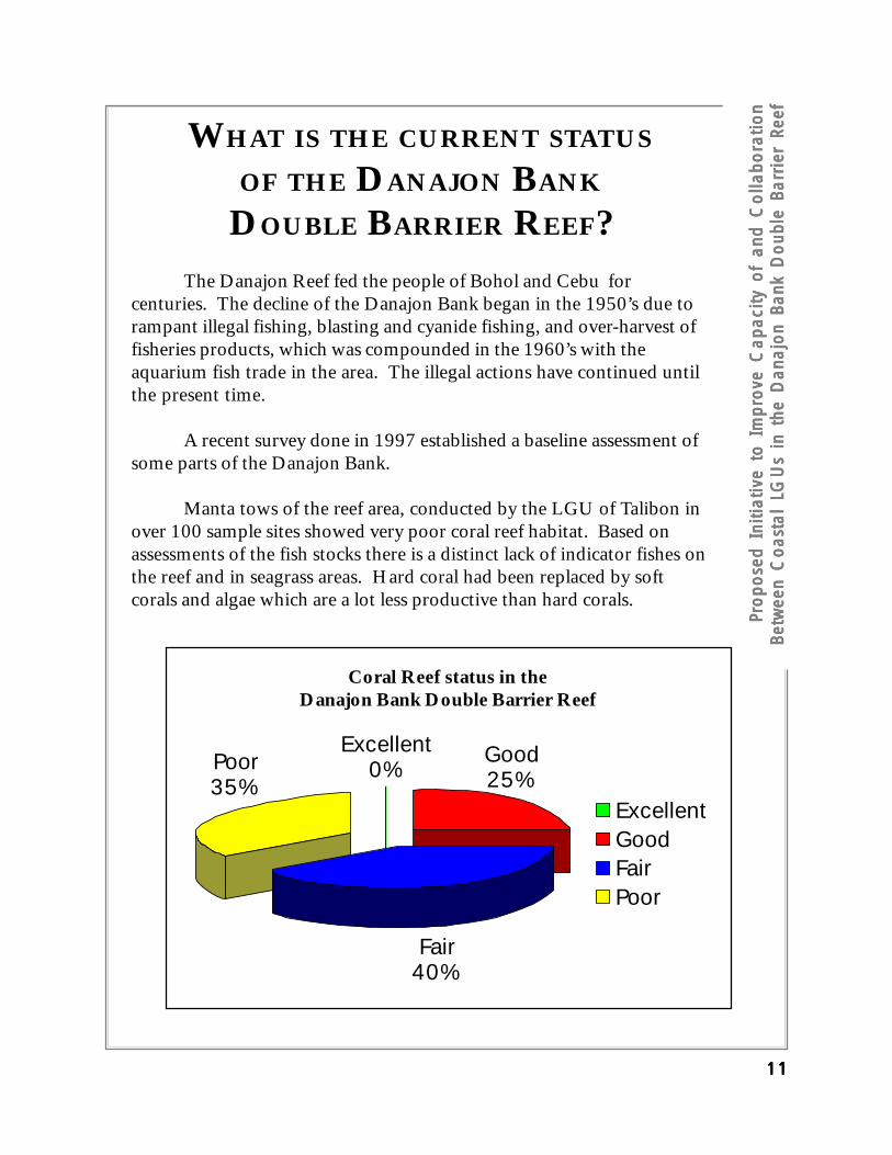
WHAT IS THE CURRENT STATUS
OF THE DANAJON BANK
DOUBLE BARRIER REEF?The Danajon Reef fed the people of Bohol and Cebu for
centuries. The decline of the Danajon Bank began in the 1950’s due torampant illegal fishing, blasting and cyanide fishing, and over-harvest offisheries products, which was compounded in the 1960’s with theaquarium fish trade in the area. The illegal actions have continued untilthe present time.
A recent survey done in 1997 established a baseline assessment ofsome parts of the Danajon Bank.
Manta tows of the reef area, conducted by the LGU of Talibon inover 100 sample sites showed very poor coral reef habitat. Based onassessments of the fish stocks there is a distinct lack of indicator fishes onthe reef and in seagrass areas. Hard coral had been replaced by softcorals and algae which are a lot less productive than hard corals.
Coral Reef status in theDanajon Bank Double Barrier Reef
ExcellentGoodFairPoor
Excellent0%
Good25%
Fair40%
Poor35%

PPPPPrepared by repared by repared by repared by repared by ERICO BERICO BERICO BERICO BERICO B. AUMENT. AUMENT. AUMENT. AUMENT. AUMENTADOADOADOADOADOGovernor of BoholGovernor of BoholGovernor of BoholGovernor of BoholGovernor of Bohol
1212121212
ILLEGAL FISHING IN THE
DANAJON BANK DOUBLE BARRIER REEF
Illegal fishing is without a doubt the number one problem in the Doublebarrier reef.
There are many types of illegal fishing and activities in the Danajon bankarea, these include:
Dynamite fishing, using huge barrels and gallons of dynamite, this isespecially rampant during early morning and evening with the blastingcaps being supplied from Talisay City, Cebu.
Cyanide and chemical use within the area, targeting of aquarium speciesand live fish capture
Trawling, using fine mesh nets which literally ‘plough’ the bottom anddestroy everything in their path.
Use of fine mesh nets and scaring devices, ‘Liba Liba’, ‘hulbot-hulbot’,seine nets with scaring devices and other fine mesh nets which catch allfishes in their path, juveniles and other non target species.
Intrusion of fishing gears defined as “commercial” such as large trawls,De-Ziper (seine nets with scaring devices and others)
All of these illegal activities are killing the reef and habitats of the fishesand the fisheries in the area, causing less and less fish catch in the areaand less food security and more poverty for the residents in the area.
Finally, illegal smuggling of wood and drugs into the area from Surigao,Cebu and other parts of the country.

PPPP P ro
pose
d In
itiat
ive
to I
mpr
ove
Cap
acity
of
and
Co
llabo
ratio
nro
pose
d In
itiat
ive
to I
mpr
ove
Cap
acity
of
and
Co
llabo
ratio
nro
pose
d In
itiat
ive
to I
mpr
ove
Cap
acity
of
and
Co
llabo
ratio
nro
pose
d In
itiat
ive
to I
mpr
ove
Cap
acity
of
and
Co
llabo
ratio
nro
pose
d In
itiat
ive
to I
mpr
ove
Cap
acity
of
and
Co
llabo
ratio
nBe
twee
n C
oas
tal
LGU
s in
the
Dan
ajo
n Ba
nk D
oub
le B
arri
er R
eef
Betw
een
Co
asta
l LG
Us
in t
he D
anaj
on
Bank
Do
uble
Bar
rier
Ree
fBe
twee
n C
oas
tal
LGU
s in
the
Dan
ajo
n Ba
nk D
oub
le B
arri
er R
eef
Betw
een
Co
asta
l LG
Us
in t
he D
anaj
on
Bank
Do
uble
Bar
rier
Ree
fBe
twee
n C
oas
tal
LGU
s in
the
Dan
ajo
n Ba
nk D
oub
le B
arri
er R
eef
1313131313
Map
of C
oast
al L
aw E
nfor
cem
ent I
ssue
s

PPPPPrepared by repared by repared by repared by repared by ERICO BERICO BERICO BERICO BERICO B. AUMENT. AUMENT. AUMENT. AUMENT. AUMENTADOADOADOADOADOGovernor of BoholGovernor of BoholGovernor of BoholGovernor of BoholGovernor of Bohol
1414141414
0
2
4
6
8
10
12
14
16
18
20
1940 1950 1960 1970 1980 1990 2000 2010
Cat
ch p
er d
ay(k
g/fish
er/d
ay)
Year
Poison fishing withthe use of cyanideand other chemicalsstarted
Fine-mesh nets,trawls and intensivebut destructivefishing gearsintroduced
Monofilament netsand fine-mesh netsintroduced
“High-tech” commercialfishing and “high-tech”fishing gears and lightsintroduced
Dynamite fishingintroduced duringSecond World War;plant poisons usedregularly
Graph shows decreasing fish catch of marginal fishers in Talibon and BienUnido as measured by catch per unit effort (kilograms per fisher per day)plotted against time. Proliferation of illegal fishing gears within municipalwaters and subsequent decline in fish catch are common for the rest ofBohol. Data taken from the results of the participatory coastal resourceassessment (PCRA) conducted town-wide in 1997 and from separate interviewswith the fisherfolk to validate the information. Fish catch is standardized asthe average catch of small-scale fisherfolk who use hook-and-line fishing gearand non-motorized (oar-driven) ‘banca’ or fishing boat, and fish for an averageof 6-8 hours per day.
Declining fish catch of marginal fishers in theMunicipalities of Talibon and Bien Unido

PPPP P ro
pose
d In
itiat
ive
to I
mpr
ove
Cap
acity
of
and
Co
llabo
ratio
nro
pose
d In
itiat
ive
to I
mpr
ove
Cap
acity
of
and
Co
llabo
ratio
nro
pose
d In
itiat
ive
to I
mpr
ove
Cap
acity
of
and
Co
llabo
ratio
nro
pose
d In
itiat
ive
to I
mpr
ove
Cap
acity
of
and
Co
llabo
ratio
nro
pose
d In
itiat
ive
to I
mpr
ove
Cap
acity
of
and
Co
llabo
ratio
nBe
twee
n C
oas
tal
LGU
s in
the
Dan
ajo
n Ba
nk D
oub
le B
arri
er R
eef
Betw
een
Co
asta
l LG
Us
in t
he D
anaj
on
Bank
Do
uble
Bar
rier
Ree
fBe
twee
n C
oas
tal
LGU
s in
the
Dan
ajo
n Ba
nk D
oub
le B
arri
er R
eef
Betw
een
Co
asta
l LG
Us
in t
he D
anaj
on
Bank
Do
uble
Bar
rier
Ree
fBe
twee
n C
oas
tal
LGU
s in
the
Dan
ajo
n Ba
nk D
oub
le B
arri
er R
eef
1515151515
OTHER PROBLEMS IN THE AREA
(ILLEGAL FISHING IS ALSO CAUSED BY
OTHER FACTORS)Low access of local people to basic services, health services,potable water, etc.
Low education levels in the area and especially in the islandsaround the area
No common vision or direction for the various LGUs in themanagement and protection of the area
Lack of coordinated coastal law enforcement in the area due tothe large area for coverage and no inter-LGU agreements oncoastal law enforcement
No integrated and coordinated activities of the various agencies incoastal management, Non-Government Organizations, NationalGovernment Agencies, Local Government Units, private sector,etc.
Municipal waters have not been formally delineated
Rapidly increasing population

PPPPPrepared by repared by repared by repared by repared by ERICO BERICO BERICO BERICO BERICO B. AUMENT. AUMENT. AUMENT. AUMENT. AUMENTADOADOADOADOADOGovernor of BoholGovernor of BoholGovernor of BoholGovernor of BoholGovernor of Bohol
1616161616
SECTION THREE: PRESENT EFFORTS,SUCCESSES, AND OPPORTUNITIES
The Local Governments of Cebu, Leyte, Bohol and Southern Leyte andthe City of Lapu-Lapu and LGU of Cordova all have jurisdiction over the area.The boundaries of their jurisdiction will be established after municipal watersare delineated.
There are a variety of other institutions working in the area, includingBFAR, DENR, (several areas are under NIPAS jurisdiction as protectedseascapes and mangrove wilderness areas), such as Banacon Island with SouthAsia’s largest manmade mangrove forest and Mahanay Island, both in Getafe.
Likewise, academic institutions such as Silliman University, University ofSan Carlos and VISCA, in Baybay Leyte are working in certain areaspromoting better management and protection of the area.
The Bohol Environment Management Office and the Bohol Coastal LawEnforcement Councils have also began to work recently in the area, as well asthe Coastal Law Enforcement Alliance for Region-7. There are also variousNGOs working in the area such as Haribon, International Marinelife Alliance,Philippine Business for Social Progress and others.
We also have a variety of sponsors and partners interested in helping uswith the management of the area such as the, German Development Service,GTZ, USAID-CRMP, Foundation for Philippine Environment, United NationsDevelopment Program and the Japanese Embassy.
The Regional Development Council has approved a CRM CertificationSystem, which has been developed by the Coastal Resource ManagementProject in coordination with the DENR, BFAR, DILG, NEDA, and otherpartners. This could be adopted by the various LGUs and help guide them inhow to manage the Double Barrier Reef. This system should be used as guidefor the LGUs in preparing their joint management of the reef area.

PPPP P ro
pose
d In
itiat
ive
to I
mpr
ove
Cap
acity
of
and
Co
llabo
ratio
nro
pose
d In
itiat
ive
to I
mpr
ove
Cap
acity
of
and
Co
llabo
ratio
nro
pose
d In
itiat
ive
to I
mpr
ove
Cap
acity
of
and
Co
llabo
ratio
nro
pose
d In
itiat
ive
to I
mpr
ove
Cap
acity
of
and
Co
llabo
ratio
nro
pose
d In
itiat
ive
to I
mpr
ove
Cap
acity
of
and
Co
llabo
ratio
nBe
twee
n C
oas
tal
LGU
s in
the
Dan
ajo
n Ba
nk D
oub
le B
arri
er R
eef
Betw
een
Co
asta
l LG
Us
in t
he D
anaj
on
Bank
Do
uble
Bar
rier
Ree
fBe
twee
n C
oas
tal
LGU
s in
the
Dan
ajo
n Ba
nk D
oub
le B
arri
er R
eef
Betw
een
Co
asta
l LG
Us
in t
he D
anaj
on
Bank
Do
uble
Bar
rier
Ree
fBe
twee
n C
oas
tal
LGU
s in
the
Dan
ajo
n Ba
nk D
oub
le B
arri
er R
eef
1717171717
SECTION FOUR: PROPOSED
ACTIVITIES AND EXPECTED OUTPUTS
1. Delineate all municipal waters in the Danajon Bank area - Oncethe LGUs municipal waters are delineated, the jurisdiction willbecome a lot clearer and we will be able to start working for thejoint management of the area.
2. Next step is for the different provinces to send requests to theDENR, NGOs and other agencies and LGUs to help startcompiling their resources on the Danajon Bank and start sendingthem to Provinces for consolidation.
3. The provinces should also encourage their LGUs to conductresource assessments and more specifically participatory activitiesinvolving the local communities in mapping out the resources andidentifying the issues and problems in the Danajon Bank area (i.e.Participatory Coastal Resource Asssessment).
4. After the LGUs have begun preparing their information anddelineation of municipal waters in the Danajon Bank area hasbeen conducted, we will conduct a stakeholder’s congress on theDanajon Bank, within year 2002 to concretize what direction wemust take for the Danajon Bank. – Each Province / LGU will beexpected to present papers on what they are doing towards themanagement of the area.
5. Establish / create a special committee in the RDC to focus onprotection and management of the Danajon Bank Double BarrierReef, composition to be decided, but it should be chaired by theRED of DENR.
6. Establish a series of inter-province quarterly meetings to updateeach other on our activities in the Danajon Bank area

PPPPPrepared by repared by repared by repared by repared by ERICO BERICO BERICO BERICO BERICO B. AUMENT. AUMENT. AUMENT. AUMENT. AUMENTADOADOADOADOADOGovernor of BoholGovernor of BoholGovernor of BoholGovernor of BoholGovernor of Bohol
1818181818
7. Establish inter-agency task force which focuses on coordinating thecoastal law enforcement initiatives and activities in the area.
8. Full force law enforcement in the area in coordination with the CoastalLaw Enforcement Alliance for Region 7, the Coastal Law EnforcementCouncil (2nd District) of Bohol and the other Provincial and localinitiatives in the area.
Outer Reef Bien Unido

PPPP P ro
pose
d In
itiat
ive
to I
mpr
ove
Cap
acity
of
and
Co
llabo
ratio
nro
pose
d In
itiat
ive
to I
mpr
ove
Cap
acity
of
and
Co
llabo
ratio
nro
pose
d In
itiat
ive
to I
mpr
ove
Cap
acity
of
and
Co
llabo
ratio
nro
pose
d In
itiat
ive
to I
mpr
ove
Cap
acity
of
and
Co
llabo
ratio
nro
pose
d In
itiat
ive
to I
mpr
ove
Cap
acity
of
and
Co
llabo
ratio
nBe
twee
n C
oas
tal
LGU
s in
the
Dan
ajo
n Ba
nk D
oub
le B
arri
er R
eef
Betw
een
Co
asta
l LG
Us
in t
he D
anaj
on
Bank
Do
uble
Bar
rier
Ree
fBe
twee
n C
oas
tal
LGU
s in
the
Dan
ajo
n Ba
nk D
oub
le B
arri
er R
eef
Betw
een
Co
asta
l LG
Us
in t
he D
anaj
on
Bank
Do
uble
Bar
rier
Ree
fBe
twee
n C
oas
tal
LGU
s in
the
Dan
ajo
n Ba
nk D
oub
le B
arri
er R
eef
1919191919
SECTION FIVE: KEY STRATEGIC
INTERVENTIONS WILL BE BASED
AROUND THIS COMMON FRAMEWORK
FOR THE AREA
Conduct a baselining process and profiling of the whole areaincluding oceanographic study of the area and identification ofcritical issues and habitats.
Identify the source of the illegal fishing activities, supply routes ofblasting caps, cyanide, illegal lumber and drug trafficking in thearea
Strong law enforcement component for the Bank area withregional integration of PNP personnel and training for the area,development of inter-province communication system andlicensing systems for fishers using the Danajon bank areas –Building on the Regional and local law enforcement initiativesalready on-going
Development of an integrated management plan for the Danajonbank area which integrates management of the area between therespective LGUs and provinces
Identification of large marine sanctuaries within the DanajonBank area which will be LGU and community managed andinitiated
Identification of other habitat and fisheries managementinterventions which will be applicable to the area
Develop by the end of this year a technical working group for theDanajon Bank, which will meet quarterly to discuss updates, on-going initiatives, and other activities. (Each Province will take itin turn to host this activity on a rotation basis with Boholconducting the first one this year)

PPPPPrepared by repared by repared by repared by repared by ERICO BERICO BERICO BERICO BERICO B. AUMENT. AUMENT. AUMENT. AUMENT. AUMENTADOADOADOADOADOGovernor of BoholGovernor of BoholGovernor of BoholGovernor of BoholGovernor of Bohol
2020202020
SECTION SIX: ASSUMPTIONS
What is important is that we go through various stages for the DanajonBank activity and it will take time. This will however give each LGUand province time to generate information at the field level, assign andallocate resources and finish off the delineation of their municipal waters.It is also important to note that we will be building on the currentinitiatives in the area and this initiative should work together with thealready initiated activities.
Previously established marine sanctuaries, law enforcement initiatives,and livelihood activities will be built upon. We do not intend to re-invent the wheel with this project but just build on what has alreadybeen done and try to take a more regional approach to the managementof this rare geological feature and rich resource.
We would also like to ensure that these initiatives and management is anLGU driven approach, with the lead agencies implementing theactivities being the Local Government Unit, which is the lead formanagement as defined in the Fisheries Code and Local GovernmentCode of 1991. Provincial Government and NGAs should offer technicalassistance in how to make this a regional initiative and help our LGU’stake advantage of this huge resource, which is in a severely degradedstate.
Each province will assign a point person at the province level and allocatebudget for the various activities required for the integrated management.
Enterprise development options will be considered later on, but byprotecting and managing the reef the livelihood of the local fisherfolks inthe area will be assured.
The area is an important resource and should be managed by the LGUsin the area and there is no need for the declaration of the area as aNIPAS site or other mechanism, the LGU’s should be the ones tomanage this.

PPPP P ro
pose
d In
itiat
ive
to I
mpr
ove
Cap
acity
of
and
Co
llabo
ratio
nro
pose
d In
itiat
ive
to I
mpr
ove
Cap
acity
of
and
Co
llabo
ratio
nro
pose
d In
itiat
ive
to I
mpr
ove
Cap
acity
of
and
Co
llabo
ratio
nro
pose
d In
itiat
ive
to I
mpr
ove
Cap
acity
of
and
Co
llabo
ratio
nro
pose
d In
itiat
ive
to I
mpr
ove
Cap
acity
of
and
Co
llabo
ratio
nBe
twee
n C
oas
tal
LGU
s in
the
Dan
ajo
n Ba
nk D
oub
le B
arri
er R
eef
Betw
een
Co
asta
l LG
Us
in t
he D
anaj
on
Bank
Do
uble
Bar
rier
Ree
fBe
twee
n C
oas
tal
LGU
s in
the
Dan
ajo
n Ba
nk D
oub
le B
arri
er R
eef
Betw
een
Co
asta
l LG
Us
in t
he D
anaj
on
Bank
Do
uble
Bar
rier
Ree
fBe
twee
n C
oas
tal
LGU
s in
the
Dan
ajo
n Ba
nk D
oub
le B
arri
er R
eef
2121212121
A COMMON CRM FRAMEWORK
WHICH SHOULD HELP GUIDE THE
IMPLEMENTATION OF THE PROJECT
Municipal waters delineated by following DENR DAO 17, seriesof 2001Budgets allocated by LGU for CRM and coastal law enforcementMunicipal Fisheries and Aquatic Resource Management Councilsactive and organizedFive year participatory coastal management plans drafted andadoptedMunicipal ordinances on coastal management, passed andimplementedMarine sanctuaries declared and managedEnvironment friendly enterprises implementedMangrove areas declared under Community Based ForestryManagement AgreementsMunicipal fisheries management in place begins wth fisherfolkregistration and licensingCoastal Law enforcement equipment purchased and patrolactivities taking placeOther habitat management and protective measures in place
Island off Baybay, Leyte
