20120613 brockman rail api v3 - epa wa · standards determine that an api should focus on the key...
TRANSCRIPT

JULY 2012
BROCKMAN IRON PTY LTD
RAILWAY INFRASTRUCTURE PROJECT
ASSESSMENT ON PROPONENT INFORMATION

This page has been left blank intentionally
BROCKMAN IRON PTY LTD
RAILWAY INFRASTRUCTURE PROJECT
ASSESSMENT ON PROPONENT INFORMATION

[
Brockman Iron Pty Ltd
Railway Infrastructure Project
July 2012
i
Document Status
Approved for Issue Rev Author Reviewer/s Date
Name Distributed To Date
1 K Critchell 06/06/2012 K Critchell G Firth (Brockman)
06/06/2012
2 K Critchell 18/06/2012 K Critchell G Firth 18/06/2012
ecologia Environment (2012). Reproduction of this report in whole or in part by electronic, mechanical or chemical means including photocopying, recording or by any information storage and retrieval system, in any language, is strictly prohibited without the express approval of Brockman Resources and/or ecologia Environment.
Restrictions on Use
This report has been prepared specifically for Brockman Resources. Neither the report nor its contents may be referred to or quoted in any statement, study, report, application, prospectus, loan, or other agreement document, without the express approval of Brockman Resources and/or ecologia Environment.
ecologia Environment
1025 Wellington Street
WEST PERTH WA 6005
Phone: 08 9322 1944
Fax: 08 9322 1599
Email: [email protected]
[
Brockman Iron Pty Ltd
Railway Infrastructure Project
July 2012
ii
TABLE OF CONTENTS
1 INTRODUCTION ................................................................................................................ 1
1.1 OVERVIEW.................................................................................................................................1
1.2 PURPOSE OF DOCUMENT .........................................................................................................1
1.3 IDENTIFICATION OF PROPONENT .............................................................................................1
2 PROPOSAL DESCRIPTION .................................................................................................. 3
2.1 PROJECT OUTLINE .....................................................................................................................3
2.2 ALTERNATIVES ANALYSIS ..........................................................................................................5
3 ENVIRONMENTAL DESCRIPTION ....................................................................................... 9
3.1 FAUNA.......................................................................................................................................9
3.2 FLORA AND VEGETATION........................................................................................................10
3.3 SHORT RANGE ENDEMIC SPECIES ...........................................................................................10
3.4 ENVIRONMENTALLY SIGNIFICANT AREAS...............................................................................11
4 KEY IMPACTS .................................................................................................................. 13
4.1 FORTESCUE MARSH ................................................................................................................13
4.2 FORTESCUE VALLEY SAND DUNES...........................................................................................14
4.3 SURFACE WATER.....................................................................................................................15
5 MANAGEMENT ............................................................................................................... 19
5.2 OFFSETS...................................................................................................................................21
6 CONSULTATION .............................................................................................................. 23
7 REFERENCES.................................................................................................................... 25
TABLES
Table 2.1 – Key Project Characteristics Table (Corresponds to the spatial example provided in Figure 2.2) .......................................................................................................................................3
Table 2.2 – Related Infrastructure / Approvals ........................................................................................4
Table 3.1 – Priority Ecological Communities in the Project Area ...........................................................11
Table 6.1 – Key Stakeholders..................................................................................................................23

[
Brockman Iron Pty Ltd
Railway Infrastructure Project
July 2012
iii
FIGURES
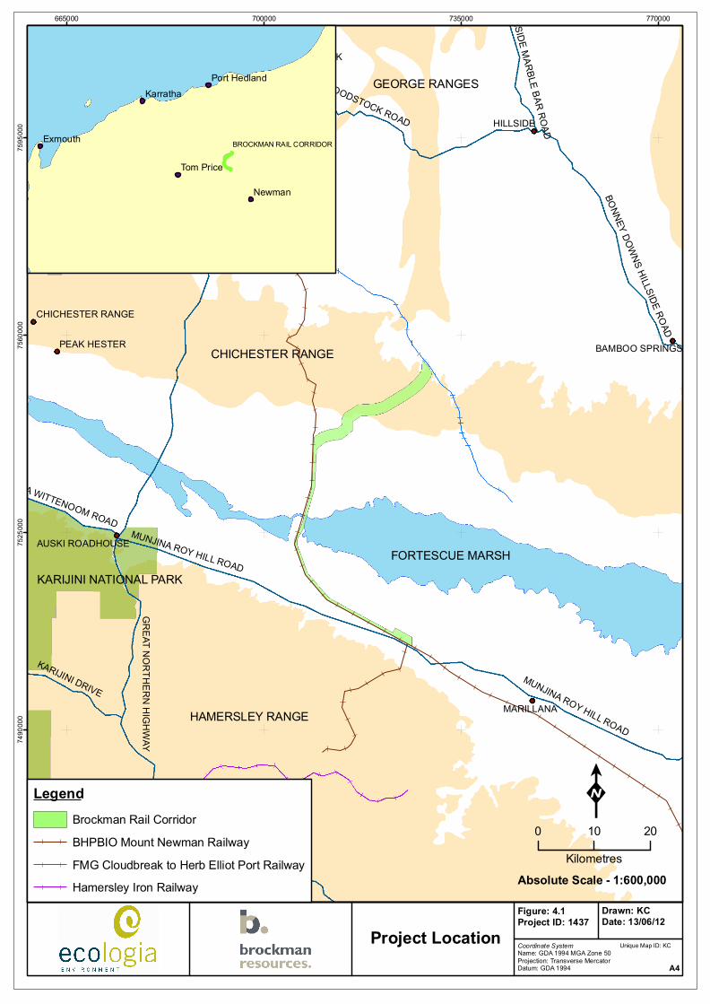
Figure 2.1 – Project Location....................................................................................................................6
Figure 2.2 – Study Corridor Outline and Survey Sites ..............................................................................7
Figure 2.3 – Alternative Rail Options Considered.....................................................................................8
Figure 4.1 – PEC and ESA’s near the Project Area ..................................................................................17
APPENDICES (INCLUDED AS ELECTRONIC ATTACHMENT)
Appendix A Calibre Rail Pty Ltd Preliminary Feasibility Study Report: Marillana Loadout Siding to FMG Tie‐in .....................................................................................................................................
Appendix B Rail Proposal Area Level 2 Vertebrate Fauna Survey............................................................
Appendix C Rail Corridor Northern Quoll Survey.....................................................................................
Appendix D Rail Development Vegetation and Flora Survey ...................................................................
Appendix E Rail Corridor Short Range Endemic Invertebrate Survey......................................................

[
Brockman Iron Pty Ltd
Railway Infrastructure Project
July 2012
iv
ACRONYMS
ACHM Australian Cultural Heritage Management
API Assessment on Proponent Information
BHPBIO BHP Billiton Iron Ore
CEMP Construction Environmental Management Plan
CROW Construction‐Right‐Of‐Way
DMA Decision Making Authority
DEC Department of Environment and Conservation
DoW Department of Water
DSEWPaC Department of Sustainability, Environment, Water, Population and Communities
EAG Environmental Assessment Guideline
EIA Environmental Impact Assessment
EPA Environmental Protection Authority
EPBC Environment Protection and Biodiversity Conservation Act 1950
ESA Environmentally Significant Area
ESD Environmental Scoping Document
FMG Fortescue Metals Group
MIB Martu Idja Banyjima
NWI North West Infrastructure (formerly the North‐West Iron Ore Alliance)
OEPA Office of the EPA
PEC Priority Ecological Community
PER Public Environmental Review
SRE Short Range Endemic
TEC Threatened Ecological Community

[
Brockman Iron Pty Ltd
Railway Infrastructure Project
July 2012
v
This page has been left blank intentionally

[
Brockman Iron Pty Ltd
Railway Infrastructure Project
July 2012
vi
EXECUTIVE SUMMARY
Brockman Iron Pty Ltd (Brockman), a wholly‐owned subsidiary of Brockman Resources Limited, proposes to develop a Railway Infrastructure Project (the Project) to transport ore from the proposed Brockman Marillana Iron Ore Project (Ministerial Statement 855) to the proposed Multi‐User Iron Export (Landside) Facility (Ministerial Statement 891) in Port Hedland. The Multi‐User Iron Export Facility is owned by North West Infrastructure, a joint venture company which represents the interests of its three shareholder companies: Atlas Iron Limited; Brockman Resources Limited; and FerrAus Limited. The Railway Infrastructure Project will be situated within Brockman’s FNA/9098, a Section 91 licence (under the Lands Administration Act 1997) and a Miscellaneous Licence L45/238 (pending) under the Mining Act 1978. The Project will eventually be constructed and operated under a State Agreement.
The Project is located in the Hamersley Iron province in the Pilbara region of Western Australia, approximately 100 km north‐west of the town of Newman. It will connect the Brockman Marillana Iron Ore Mining Project (Ministerial Statement 855) with the existing Fortescue Metals Group (FMG) railway line. The FMG railway currently transports product from FMG’s Cloudbreak mine to the Herb Elliot Port in Port Hedland. In agreement with FMG, and taking advantage of extra capacity in their railway system, Brockman can cost‐effectively boost their transport efficiency and reduce greenhouse gas emissions by negating the use of road haulage.
The Project will include the following infrastructure:
• a 78.4 km railway track;
• drainage structures as appropriate;
• water supply bores approximately every 10 km feeding into turkeys nests; and
• a 200 m wide construction corridor. This will likely be reduced during the detailed design phase.
There is a possibility of a construction camp also being required which will be located within L45/238, otherwise the workforce will be temporarily housed at Brockman’s Marillana mine accommodation camp. Brockman is currently undertaking the preliminary design of the Project, with the intention of commencing construction activities by Q4 2013 and operating the rail line by Q4 2015. Biological surveys have been completed and all results are provided in the Appendix of this document.
As a result of consultation with the Office of EPA (OEPA) and the Department of Environment and Conservation (DEC), it was indicated that the Proposal should require assessment by the EPA under Part IV of the Environmental Protection Act 1986 at the level of ‘Assessment on Proponent Information’ (API).

[
Brockman Iron Pty Ltd
Railway Infrastructure Project
July 2012
vii
This page has been left blank intentionally
[
Brockman Iron Pty Ltd
Railway Infrastructure Project
July 2012
1
1 INTRODUCTION
1.1 OVERVIEW
Brockman Iron Pty Ltd (Brockman), a wholly‐owned subsidiary of Brockman Resources Limited, proposes to develop a Railway Infrastructure Project (the Project) to transport ore from the proposed Brockman Marillana Iron Ore Project (Ministerial Statement 855) to the proposed Multi‐User Iron Export (Landside) Facility (Ministerial Statement 891) in Port Hedland. The Multi‐User Iron Export (Landside) Facility is owned by North West Infrastructure, a joint venture company which represents the interests of its three shareholder companies: Atlas Iron Limited; Brockman Resources Limited; and FerrAus Limited. The Railway Infrastructure Project will be situated within Brockman’s FNA/9098, a Section 91 licence (under the Lands Administration Act 1997) and a Miscellaneous Licence L45/238 (pending) under the Mining Act 1978. The Project will eventually be constructed and operated under a State Agreement.
1.2 PURPOSE OF DOCUMENT
The purpose of this document is to assist the Environmental Protection Authority (EPA) and relevant advisory bodies in assessing this proposal under the Environmental Protection Act 1986. It aims to:
• adequately describe the components of this proposal;
• identify key environmental issues, including cumulative impacts;
• detail environmental management measures to mitigate, minimise or offset these environmental issues; and
• demonstrate communication with relevant stakeholders.
This API was developed after consultation with Mark Jeffries of the EPA in May, 2012. Current EPA standards determine that an API should focus on the key environmental impacts of the Project, acting as a summary Environmental Impact Assessment (EIA) report for Project assessment after biological surveys and stakeholder consultation have been conducted. The API therefore describes the most relevant impacts and characteristics of the Project for assessment, and provides all related biological reports and survey results as Appendices.
1.3 IDENTIFICATION OF PROPONENT
The Brockman key contact for this proposal is Glenn Firth:
Address: 1/117 Stirling Highway, NEDLANDS WA 6009
Telephone: (08) 9398 3000
Fax: (08) 9389 3033
Email: [email protected]
ACN: 122 652 886
ecologia Environment (ecologia) has been engaged by Brockman to facilitate the environmental impact assessment process. The ecologia key contact for this proposal is Kaisan Critchell:

[
Brockman Iron Pty Ltd
Railway Infrastructure Project
July 2012
2
Address: 1025 Wellington St, WEST PERTH WA 6005
Telephone: (08) 9322 1944
Fax: (08) 9322 1599
Email: [email protected]

[
Brockman Iron Pty Ltd
Railway Infrastructure Project
July 2012
3
2 PROPOSAL DESCRIPTION
2.1 PROJECT OUTLINE
The Project extends from Mining Lease M47/1414 at UTM Zone 51 coordinates (726221E/7504890N) to a connection point at the Fortescue Metals Group (FMG) railway line, at approximately UTM Zone 51K (729013E/7554588N). From this point a multi‐user service agreement will enable Brockman ore to reach Port Hedland along the existing FMG Cloudbreak to Herb Elliot Port railway line.
The Project spans 78.4 km and is to be constructed within a 200 m wide corridor, described in Figure 2.2. Biological studies have been carried out within a 8699 ha study corridor which envelopes the Project. A maximum 1588 ha will be cleared for construction. This is based on a maximum clearance width of 200 m; allowing for the construction of borrow pits, laydown areas and passing loops. The exact alignment of the rail line within the study corridor envelope will be finalised following further engineering feasibility studies. The current Preliminary Feasibility Study Report is included as Appendix A of this document.
Incorporated into the 1588 ha disturbance footprint is 20 ha for a temporary construction camp, should one be required. The need and location of the camp is yet to be determined, and if required it will be constructed within the study corridor. However, it is likely that the construction workforce will be temporarily housed at Brockman’s proposed accommodation camp at the Marillana Iron Ore Project (MS 855).
Key Project characteristics are summarised in Table 2.1, and related infrastructure and approvals are described in Table 2.2.
Table 2.1 – Key Project Characteristics Table (Corresponds to the spatial example provided in Figure 2.2)
SUMMARY OF THE PROJECT
Proposal Title Brockman Railway Infrastructure Project
Proponent Name Brockman Iron Pty Ltd
Short Description This proposal is to build a Railway Infrastructure Project (track, communications, crossings, signalling, roads, borrow pits and laydown areas) connecting the Brockman Marillana Iron Ore Mine to the FMG Cloudbreak to Herb Elliot Port Railway.
Tenure FNA/9098, Miscellaneous Licence L45/238 (pending)
Construction commencement 2014
Commissioning 2016
Project life span >20 years
PHYSICAL ELEMENTS
Element Location Proposed Extent Authorised
Rail Project Disturbance Area Figure 2.2 1588 ha of clearing within a 8699 ha study corridor envelope.
Rail Project Disturbance Width
Figure 2.2 The Project will not exceed a width of 200 m, allowing for railway track and associated infrastructure.
Rail Length Figure 2.2 78.4 km
Supporting Infrastructure Figure 2.2 Clearing for communications cabling, communications tower, culverts, level crossings, signalling, access tracks, borrow pits and

[
Brockman Iron Pty Ltd
Railway Infrastructure Project
July 2012
4
laydown areas will be within the 1588 ha clearing limit and within the 200 m Project corridor.
Water Requirements
Bore holes for water extraction will be selected following further engineering and groundwater studies. Existing bores along the BHP Billiton Iron Ore (BHPBIO) rail will be used, under Agreement, where possible.
Approximately 10 ML for the rail head (bulk earthworks) plus approximately 1 ML per day per 15 km of access road for dust suppression.
Table 2.2 – Related Infrastructure / Approvals
Approval/Project Details
BHP Chichester Rail Deviation Described in EPA Report 1336, the BHP Chichester Rail Deviation runs north of the Project through similar terrain.
BHPBIO Rail
The BHPBIO Rail runs past the Marillana Iron Ore Project and through the Fortescue Marsh at its narrowest point, adjacent to the proposed Brockman rail until it reaches the Chichester Ranges.
Brockman Marillana Iron Ore Project PER The Marillana Iron Ore Project was approved by the EPA in February 2011 (Ministerial Statement 855). Construction of the project is expected to commence in Q4 2013.
Brockman Rail EPBC Referral (EPBC2011/5833)
The Project is being assessed as a controlled action by the Department of Sustainability, Environment, Water, Population and Communities (DSEWPaC). Notice of approval was received in June 2012 subject to draft conditions being agreed.
FMG Railway The FMG Railway runs from the Cloudbreak mine site to the Herb Elliot Port at Port Hedland, and will be utilised by Brockman in a multi‐user share agreement (to be finalised).
Works Approval (DEC) Works Approval for supporting facilities to the construction camp (if required) shall be sought. Facilities requiring Works Approval may include a waste water treatment plant and landfill.
Section 91 Licence (DRD&L)
Brockman’s Section 91 licence (Licence No. 00809/2009_1_190) provides right of access and a right to conduct activities related to the Project but does not permit ground disturbance or the development of structures.
State Agreement (DSD)
Drafting of a Term Sheet was initiated with DSD in 2010 and discussions are ongoing with the aim of securing a State Agreement for the rail line from the Marillana mine to NWI’s loading facility at Port Hedland.
File Notation Area 9098
Brockman’s FNA/9098 appears spatially within DMP’s Tengraph system showing the proposed rail corridor which is subject to a future land transaction, alienation from the Crown, or other proposed change in land use.
Miscellaneous Licence (DMP) Brockman’s L45/238 (pending) covers the entire footprint of the proposed project. Negotiations are continuing with underlying tenement holders to lift objections and get the L granted.
Indigenous Heritage Agreement
The Project covers the country of two Native Title groups: the Banjima (M.I.B.) and Palyku. A Heritage Agreement and Native Title Agreement are finalised with Banjima. A Heritage Agreement is finalised with Palyku. A Draft Native Title Agreement with Palyku exists and should be finalised in 2012. Remaining Aboriginal Heritage surveys to be completed for the rail section on Palyku land
Bed and Banks (DoW) The Department of Water in Karratha indicated that the Project

[
Brockman Iron Pty Ltd
Railway Infrastructure Project
July 2012
5
Approval/Project Details
will require a permit application to interfere with the bed and banks of watercourses under the Rights in Water and Irrigation Act 1914. This application will be made upon final Project design and assessment and is expected to take 30‐60 days.
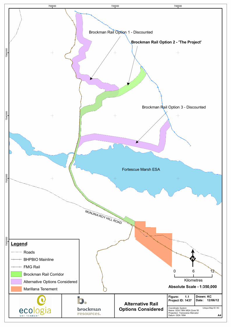
2.2 ALTERNATIVES ANALYSIS
A railway is considered the best transport option as Brockman can cost‐effectively boost their transport efficiency and reduce greenhouse gas emissions by negating the use of road haulage.
Three different rail options were originally considered for referral (Figure 2.3). Environmental surveys spanned each of the three routes; leading to consultation with the OEPA and the DEC (June 2010) which discounted one of the routes due to its proximity and perceived environmental impacts on the Fortescue Marsh as a proposed conservation estate. The remaining two railway routes were further investigated, from which the final option (Option 2) was considered the most feasible and of least impact to the environment.
Option 2 (with a 78.4 km railway line) has a lower footprint than Option 1 (95.3 km) and slightly higher footprint than Option 3 (74.2 km), which borders the proposed Fortescue Marsh conservation area.
MUNJINA ROY HILL ROAD
KARIJINI DRIVE
HILLSIDE MARBLE BAR ROAD
BONNEY DOWNS HILLSIDE ROAD
JUNA DOWNS ROAD
MUNJINA WITTENOOM ROAD
HILLSIDE WOODSTOCK ROAD
MUNJINA ROY HILL ROAD
KARIJINI DRIVE
PILBARA
HILLSIDE
WOODSTOCK
MARILLANA
PEAK HESTER BAMBOO SPRINGS
AUSKI ROADHOUSE
CHICHESTER RANGE
665000 700000 735000 77000074
9000
075
2500
075
6000
075
9500
0
Coordinate SystemName: GDA 1994 MGA Zone 50Projection: Transverse MercatorDatum: GDA 1994
Figure: 4.1Project ID: 1437
Drawn: KCDate: 13/06/12
Project LocationA4
K0 10 20
Kilometres1:600,000Absolute Scale -
LegendBrockman Rail CorridorBHPBIO Mount Newman RailwayFMG Cloudbreak to Herb Elliot Port RailwayHamersley Iron Railway
Unique Map ID: KC
CHICHESTER RANGE
HAMERSLEY RANGE
GEORGE RANGES
KARIJINI NATIONAL PARKFORTESCUE MARSH
Newman
Exmouth
Karratha
Tom Price
Port Hedland
GREAT NORTHERN HIGHWAY
BROCKMAN RAIL CORRIDOR

!!
!
!!
! !
!!!
!
!
!
!
!
!
!
!!
!
!
!
!!
!
!
!!!
!
!
!
!!
!
!
!
!
!
!
!
!!!
!
!
!
!
!
!
!
!!
!
!
!
!
!
!
!
!
!
!
!! !
!
!!
!!!
!!
!!
!!
!!
!!
!!
!!
!
!
!
!!
!
!
!!!!!!!!!
!!!!!
!!
!
!!
!
!
!
!!!
!
!!
!
!
!! ! !
!!
!!!
!! !
!
!! !
!! ! ! ! !!
!
!
!!
!
!!!
!!!
!
! !
! !
!
!
!!!
!
!
!!
!
!
!
!
!!
!
!!!!
!
!
!!!
! !!
!!!!
!!
! !!
!
!
!
!
!
!
!
!!
!!!!
!!!!!
!!
!!
!!!
! !!!
!!!
!!
! !! !
!!!
!!!
!
!!!!
!!!
!!!!
!
!!
!
!!
!
!!!
!!
!! ! !
!! !!!
!!!
!
!! !!!
!
!
!
!
!
!
!
!
!
!!
!!
!!
!
!
!
!
!
!
!
!
!
!
!
!
!
!
!
!!
!
!
!
!
!
!
!
!!
!!
!!!
!!!!!!!!!!!
!!!
!!!!!!!!!!!!!!!!!
!!
690000 705000 720000 73500075
1500
075
3000
075
4500
075
6000
0
Coordinate SystemName: GDA 1994 MGA Zone 50Projecton: Trans ver se Me r cat orDatum: GDA 1994 A4
K0 5 10
Kilometres
Legend! Flora and Vegetation Survey Sites! Northern Quoll Survey Sites! Vertebrate Fauna Survey Sites! SRE Survey Sites
FMG Cloudbreak to Herb Elliot Port RailwayBHPBIO Mount Newman RailwayBrockman Rail Corridor 1:275,000Absolute Scale -
CHICHESTER RANGE
HAMERSLEY RANGE
FORTESCUE MARSH
Figure: 4.2Project ID: 1437
Drawn: KCDate: 13/06/12Study Corridor
Outline and Survey Sites
Unique Map ID: KC
MUNJINA ROY HILL ROAD
700000 720000 74000075
0000
075
2000
075
4000
075
6000
0
Coordinate SystemName: GDA 1994 MGA Zone 50Projection: Transverse MercatorDatum: GDA 1994
Figure: 1.1Project ID: 1437
Drawn: KCDate: 12/06/12Alternative Rail
Options ConsideredA4
K0 6 12
Kilometres1:350,000Absolute Scale -
LegendRoadsBHPBIO MainlineFMG RailBrockman Rail CorridorAlternative Options ConsideredMarillana Tenement
Unique Map ID: KC
Fortescue Marsh ESA
Brockman Rail Option 2 - 'The Project'
Brockman Rail Option 3 - Discounted
Brockman Rail Option 1 - Discounted
[
Brockman Iron Pty Ltd
Railway Infrastructure Project
July 2012
9
3 ENVIRONMENTAL DESCRIPTION
The fauna, flora and vegetation, and short‐range endemics biological reports each define the Project Area as the entire study corridor. To avoid conflict with defining the Project Area within each of the biological reports and this document, the appendices should be read in this context. Hence in the appendices and Section 5 of this document, the ‘Project Area’ and ‘Proposal Area’ refer to the Study Corridor (as represented in Figure 2.2) and the ‘Survey Area’ and ‘Study Area’ refer to an area which extends beyond the Study Corridor (see maps included within each respective biological report).
3.1 FAUNA
An analysis of aerial photography, previous vegetation surveys carried out in the Survey Area, and observations during the current survey revealed there are six main fauna habitats present within the Study Corridor: stony spinifex hills and plains, sandy spinifex plain, low halophytic shrubland bordering the Fortescue Marsh, cracking clay, creek bed and mulga/mixed acacia woodland. All fauna habitats are well represented outside the Study Corridor in the surrounding region.
Based on the results of database searches and a review of surveys previously undertaken in the area, the potential fauna of the Study Corridor comprises 37 native and eight introduced mammal species, 170 bird species, 107 reptile species and eight amphibian species. Of this potential fauna, the current survey recorded 21 native and five introduced mammal species, 65 bird species and 45 reptile species. No amphibian species were recorded during the survey. The species accumulation curves generated from trapping data indicated that the majority of trappable fauna were recorded.
Twenty‐six species of conservation significance have the potential to occur within the Study Corridor. Six of these species were recorded during the current surveys. An additional nine species have a high or medium likelihood of occurrence. Conservation significant fauna recorded during the current survey consisted of:
• four individuals of the Australian bustard (DEC Priority 4) from two locations;
• twenty‐five inactive, two possibly active and one active Western pebble mouse mound (DEC Priority 4) recorded from rocky spinifex hillslopes and plains within or nearby the Study Corridor;
• eight records of Northern short‐tailed mouse (DEC Priority 4) from two sites;
• two sightings of Grey falcons (DEC Priority 4) were observed from different locations;
• Rainbow bee‐eaters (EPBC Act Migratory) at four different locations within the Study Corridor; and
• six recordings of Bush stone curlew (DEC Priority 4) from three locations.
A targeted survey for the Northern quoll was conducted as some suitable denning habitat that was identified during initial surveys. The survey failed to identify any primary or secondary evidence of Northern quolls being resident within this habitat (Appendix C).
The comprehensive Level 2 vertebrate fauna survey report is included as Appendix B. The targeted Northern quoll survey report is included as Appendix C.

[
Brockman Iron Pty Ltd
Railway Infrastructure Project
July 2012
10
3.2 FLORA AND VEGETATION
The first phase of the Level 2 flora and vegetation assessment (Appendix D) was conducted over the three rail options. The subsequent second phase was confined to the Study Corridor (Figure 4.2), as by this stage Brockman had determined that this was the option to be pursued.
The Study corridor consists of:
• thirty four vegetation communities;
• no Declared Rare Flora;
• four Priority Flora;
• one additional unconfirmed Priority taxa Tecticornia globulifera (Priority 1) which required further material for verification;
• six species representing range extensions based on collection records lodged at the WA Herbarium; and
• six weed species recorded at 30 locations.
No declared plants were recorded in the Study Corridor. However, one plant of *Argemone ochroleuca subsp. ochroleuca which is declared in other districts other than East Pilbara Shire was recorded in the Study Corridor.
Two Priority Ecological Communities (PEC) are present within the Study Corridor: Fortescue Marsh (Priority 1) and the Fortescue Valley Sand Dunes (Priority 3). A further Priority 1 PEC, Freshwater Clay Pans of the Fortescue Valley lies to the immediate west of the Study Corridor and has the potential to be indirectly impacted by changes to surface hydrology.
The most regionally restricted unit present within the Study Corridor is Unit 562 (Mosaic of Acacia aneura low woodland in valleys with open low tree steppe of Eucalyptus leucophloia and Triodia wiseana hummock grasslands), of which 1036 km2 has been mapped regionally. This unit comprises 18.9% of the Study Corridor, occurring as a single band at the point where the corridor turns east.
The Study Corridor intersects some mulga vegetation communities and has the potential to indirectly impact this vegetation by altering the surface hydrology. Similarly, changes to surface hydrology have the potential to alter the Fortescue Marsh. These impacts will be mitigated by adequate consideration of hydrology during design and construction and appropriate placement of culverts.
The full vegetation and flora report is included as Appendix D.
3.3 SHORT RANGE ENDEMIC SPECIES
More than 500 invertebrate specimens were collected during the survey, however only 15 individuals represented potential Short‐Range Endemic (SRE) species. These included a single known SRE species (new isopod genus, gen. nov. 2) and four potential SRE species (Succinea sp., Anidiops sp., Eucytops sp. and Aname sp.).
Aname, Anidiops, Eucyrtops and isopod gen. nov. 2 were only present in regional areas and will not be impacted by the Project. Succinea sp. was collected from regional areas as well as within the Study Corridor. Less than 1% of the vegetation association from which Succinea was collected will be impacted and therefore the potential impact to this SRE species is expected to be low.

[
Brockman Iron Pty Ltd
Railway Infrastructure Project
July 2012
11
The main outcomes from the SRE survey of the Study Corridor are:
• The land systems, vegetation communities and habitats are likely to support SRE groups but are not restricted to the Study Corridor.
• A total of 31 species were collected during the survey, of which one species was considered a SRE (Isopod gen. nov. 2) and four were considered potential SREs (Aname sp., Anidiops sp., Eucrytops sp. and Succinea sp.).
• The significance of the impact to Aname sp., Succinea sp., Anidiops sp., Eucyrtops sp. and the new isopod genus, is considered negligible as the species were collected from outside the Study Corridor only.
• The significance of the impact to Succinea sp. is considered low as it was collected in regional areas as well as within the Study Corridor. The species was found within the Vegetation Association 175, which is widespread across the Pilbara, and less than 1% is expected to be impacted by the Project.
The final SRE report is included as Appendix E.
3.4 ENVIRONMENTALLY SIGNIFICANT AREAS
No Threatened Ecological Communities (TEC) will be impacted by the Project. Two PEC’s cross the Study Corridor, and an additional PEC is located adjacent the Study Corridor. These PEC’s and their predicted impacts are presented in Table 3.1.
Table 3.1 – Priority Ecological Communities in the Project Area
PEC Community Description Priority Percent PEC
within Study
Corridor
Area of PEC (ha) within Study
Corridor
Fortescue Marsh
Fortescue Marsh is on the Fortescue River. Endemic Eremophila species and several to near endemic and new to science Samphires are present. Night Parrot, Bilby and restricted aquatic invertebrates are found in this PEC.
Priority 1 0.3 84.5
Fortescue Valley Sand Dunes
Red linear sand dune communities on the Divide land system at the junction of the Hamersley Range and Fortescue Valley, between the Weeli Wolli Creek and the low hills to the west. A small number are vegetated with Acacia dictyophleba scattered tall shrubs over Crotalaria cunninghamii, Trichodesma zeylanicum var. grandiflorum open shrubland. They are regionally rare, small and fragile and highly susceptible to threatening processes.
Priority 3 5.2 5.1
Freshwater Claypans of the Fortescue Valley
Freshwater claypans downstream of the Fortescue Marsh ‐ Goodiadarrie Hills on Mulga Downs Station. Important for water birds, invertebrates and some poorly collected plants. Eriachne spp., Eragrostis spp. grasslands. Unique community that has few Coolabah. Threats include weed invasion, infrastructure corridors, altered hydrological flows, inappropriate fire regimes
Priority 1 0 0

[
Brockman Iron Pty Ltd
Railway Infrastructure Project
July 2012
12
This page has been left blank intentionally

[
Brockman Iron Pty Ltd
Railway Infrastructure Project
July 2012
13
4 KEY IMPACTS
Vegetation clearing and construction activities are envisaged to mainly impact the fauna and flora communities that are dependent on the Fortescue Marsh, Fortescue Valley Sand Dunes and local surface water (Figure 4.1). Therefore key impacts from the Project are focused on these two PEC’s and local drainage flows.
4.1 FORTESCUE MARSH
4.1.1 Environmentally Significant Values
The Fortescue Marsh provides important feeding, roosting and breeding habitat during times of flood to a large number of water birds from across Australia. Whilst the Fortescue Marsh is currently part of pastoral leases and not designated for conservation, there is an agreement in place by the State Government for parts of the Fortescue Marsh area to be excluded from the Pastoral lease renewal for a public purpose (as per s143 6(d) of the Land Administration Act (1997)) and to formally reserve the land as a conservation reserve. There is also the potential for this area to be listed as a RAMSAR wetland in the future.
Australian Cultural Heritage Management (ACHM) conducted an ethnographic survey on behalf of Brockman between the 3rd and 5th August 2010 (ACHM, 2010). No ethnographic sites were found during the cultural heritage survey and the area was ‘Cleared Subject to Conditions’. It was noted that the Fortescue Marsh is an area of cultural significance to the Martu Idja Banyjima (MIB) people. As Traditional Owner and ‘environmental caretakers’, the MIB place a high value on the Fortescue Marsh as major water source and culturally significant area. MIB representative stress the importance of maintaining the integrity of the Fortescue Marsh, and Brockman fully supports this point of view.
4.1.2 Mitigation
The proposal has been designed to avoid, where practicable, serious or irreversible damage to the environment. This includes ceasing all further feasibility studies on alternative railway options that would have greater impacts on the Fortescue Marsh and the proposed conservation estate.
Further, the Project will not create significant additional impact to the area as it crosses the Fortescue Marsh at it narrowest point, adjacent to the existing BHPBIO railway. It then continues parallel to the BHPBIO railway for approximately 10 km past the Fortescue Marsh where it forks north east. Due to its location and the surrounding vegetation at the Marsh (Mulga woodlands of up to 6 m in height), the Project should have a very low visibility to tourists visiting the area.
The following considerations are specific to the Fortescue Marsh and underlie Project planning and construction practices:
• Disturbance of the Marsh is to be kept to a minimum and only in areas approved for work.
• All in‐flowing and out‐flowing creeks and streams are to be preserved, with culverts and drainage structures installed wherever necessary.
• Appropriate scientific studies will be commissioned to monitor water quality and other aspects of possible impact on the Marsh by proposed works.

[
Brockman Iron Pty Ltd
Railway Infrastructure Project
July 2012
14
• Brockman will commit to the long‐term preservation of the marsh by working with the MIB and relevant external organisations to develop, implement and enforce a comprehensive Cultural Heritage Management Plan.
• The prevention of groundwater pollution and contamination will be achieved through appropriate waste management practices.
• Removal of non‐essential Infrastructure will occur post‐construction and rehabilitation of the site undertaken to final land use requirements.
4.1.3 Offsets
The Project will result in a long‐term loss of marsh habitat which cannot be mitigated or rehabilitated. As a result, Brockman will implement an Offset Plan for the Project in liaison with the OEPA and DEC.
4.2 FORTESCUE VALLEY SAND DUNES
4.2.1 Environmentally Significant Values
The Fortescue Valley Sand Dune PEC is regionally rare, small, fragile and highly susceptible to threatening processes. Vegetation is currently of poor quality due to cattle grazing; however the community remains significant due to its unique ecological qualities.
4.2.2 Mitigation
Investigations are underway to delineate the boundary of the Fortescue Valley Sand Dune PEC. There is potential for localised impacts if construction management procedures are not complied with. The CEMP will include the following to minimise the impact to the Fortescue Valley Sand Dune PEC:
• Prevention of groundwater pollution and contamination will be achieved through appropriate waste management practices.
• Detailed design will consider the locations of PECs and other conservation significant areas, and disturbance will be avoided where possible.
• Wherever necessary drainage structures will be put in place to ensure that the surface hydrology of the ESAs and PECs is not adversely affected.
• Further management measures are outlined in previous sections of this report and other specific management strategies developed in consultation with DEC if required.
4.2.3 Offsets
The Project will result in a long‐term loss of sand dune habitat which cannot be mitigated or rehabilitated. As a result, Brockman will implement an Offset Plan for the Project in liaison with the OEPA and DEC.

[
Brockman Iron Pty Ltd
Railway Infrastructure Project
July 2012
15
4.3 SURFACE WATER
4.3.1 Environmentally Significant Values
The Pilbara is characterised by seasonal rivers in response to the erratic nature of rainfall in the region. The two major rivers of the region are the Fortescue and De Grey Rivers which are divided by the Hamersley and Chichester Ranges (van Vreeswyk, Payne et al. 2004). The rivers mostly flow through well‐defined channels; however the channels often become poorly defined in a network of braided tidal creeks toward the coastal areas (van Vreeswyk, Payne et al. 2004). Broad‐scale surface water‐dependant vegetation communities (Mulga) are represented in approximately 18% of the Study Corridor. The Mulga‐dominated vegetation communities are present at a number of locations. The Chichester IBRA sub‐region represents the northern limit of Acacia aneura (Mulga).
Mulga is a bushy shrub or tree ranging in height from 2‐10 m, and comprises a range of taxa with considerable variation in growth form and phyllode morphology. Mulga communities are defined as those that contain and are frequently dominated by Acacia aneura (Fortech, 1999). These communities may occur in patches in valleys, in sheltered sites associated with hills and breakaways, or in distinctive grove arrangements. Mulga occurs on a variety of soils and in a variety of habitats across the semiarid shrublands of Australia (Paczkowska and Chapman, 2000). Mulga in this area of the Pilbara is approaching its northern most extent in Western Australia (Kendrick 2001). Beard (1975) describes a ‘mulga‐in‐groved‐patterns’ unit as mapped in the south of the Project Area which marks the most northerly boundary of this large unit of vegetation.
Mulga has a root system that is adapted for taking up water from thin surface soils and has adaptations that concentrate soil water near the plant and conserve water within the plant. Consequently, the distribution and abundance of mulga is particularly influenced by soil moisture and the pattern of surface drainage (Paczkowska and Chapman, 2000).
The Project has the potential to impact on surface water quality and flow‐patterns as a result of the Project. The impacts of the rail on surface water could include:
• alteration to the natural flow pattern;
• reduction in hydraulic capacity;
• reduction in aquatic fauna and flora habitat;
• increased extent of flooding upstream;
• changes in sheet flow characteristics affecting sensitive downstream species (i.e., Mulga);
• increased erosion and sedimentation;
• increased sedimentation, ponding and nutrient input; and
• removal of riparian and in‐stream vegetation.
4.3.2 Mitigation
Brockman will apply to the DoW for a permit to interfere with the waters, beds or banks of any watercourse within a proclaimed Surface Water Management Area (SWMA) intersected by the proposal.

[
Brockman Iron Pty Ltd
Railway Infrastructure Project
July 2012
16
Erosion and sedimentation impacts during construction are expected to be localised and short‐term. A range of management standards will be implemented during the Project to ensure minimal impacts on the quality of surface water and avoid unnecessary disturbance to natural surface drainage and to minimise the risk of contamination by hydrocarbons.
The following management strategies will be employed to avoid, minimise and/or mitigate impacts:
• Civil engineering designs will include appropriate drainage requirements. Catchment analysis is being carried out in order to determine culvert design.
• Where the risk of erosion is identified in specific areas during construction, erosion control structures such as silt fences, diversion and collection bunds, sediment dams and holding sumps will be installed. Such structures will be temporary in nature and will be completely removed as part of rehabilitation of the construction area.
• Drainage of minor streams and drainage lines that the corridor crosses will be maintained with effective drains and culverts.
• Management of hydrocarbon, chemical and waste products on site will be in accordance with the Construction Environmental Management Plan (CEMP) and relevant regulations for transport, storage and use.
• The camp infrastructure (if required) will be designed to ensure the safe storage and handling of all hazardous and waste materials to prevent contamination.
• Drainage areas will be suitably designed to minimise contamination of surface water.
• Natural surface water flows will be maintained as far as possible during construction and reinstated following completion of construction.

Karijini National Park
Mungaroona Range Nature Reserve
FORTESCUE RIVER
SHAW RIVER
YULE RIVER
MARILLANA CREEK
COONARRIE CREEKBEABEA CREEK
WEELI W
OLLI CR
EEK
COON
DINER
CRE
EK
PILBA
DDY C
REEK
WEST YULE RIVER
WALL
CRE
EK
650000 700000 75000074
5000
075
0000
075
5000
076
0000
0
Coordinate SystemName: GDA 1994 MGA Zone 50Projection: Transverse MercatorDatum: GDA 1994
Figure: 4.3Project ID: 1247
Drawn: KCDate: 15/06/12PEC and ESA's
near the Project AreaA4
K0 20 40
Kilometres1:750,000Absolute Scale -
LegendFortescue Marsh, Priority 1Fortescue Valley Sand Dunes, Priority 3Freshwater claypans of the Fortescue Valley, Priority 1Wona Land System, Priority 3National Parks and ReservesBrockman Rail Corridor
Unique Map ID: KC
CHICHESTER RANGE
HAMERSLEY RANGE
FORTESCUE MARSH
GEORGE RANGESINSET: CROSSING THE
FORTESCUE MARSH

[
Brockman Iron Pty Ltd
Railway Infrastructure Project
July 2012
18
This page has been left blank intentionally

[
Brockman Iron Pty Ltd
Railway Infrastructure Project
July 2012
19
5 MANAGEMENT
The following management actions have or shall be implemented to provide management of impacts with regard to a hierarchy to avoid, mitigate and offset impacts.
5.1.1 Route Selection
Brockman has considered multiple corridor options for the rail. Alternative options resulted in larger overall clearing footprints and/or increased disturbance of identified Quoll and Fortescue Marsh habitat. Thus, the corridor selection in itself has considered the avoidance principal. This process shall continue through maturity of engineering studies. Brockman has undertaken environmental impact assessment for a Study Corridor envelope assessment which will allow some flexibility for sighting the final rail alignment and avoid significant impacts as is practicable.
5.1.2 Administration of Actions
Brockman shall implement a CEMP for the project, which provides for construction environmental aspect identification and risk assessment. Procedures for management will be developed based on the hierarchy of avoidance, substitution, mitigation and reduction. Brockman will develop the CEMP with input from the DEC.
5.1.3 Commitments
Brockman has made the following management commitments for the project. These commitments will form the foundation of the CEMP:
Clearing
• The extent of clearing for construction and operational activities is to be minimised where possible.
• Clearing control procedures will be implemented during construction.
• Where practicable, existing disturbed areas will be utilised in preference to creating additional disturbance.
Flora
• Detailed design will consider the locations of Priority Flora and other conservation significant areas, and disturbance will be avoided where possible.
Invasive Plant Species
• Weed hygiene procedures will be employed according to the Project CEMP.
Topsoil
• Removed topsoil will be stored separately to the trench spoil, and removed at to a (nominal) depth of 100‐150 mm. Cleared areas adjacent to the clearing site will store topsoil and overburden.
[
Brockman Iron Pty Ltd
Railway Infrastructure Project
July 2012
20
• Trench spoil will be stored on the non‐working side of the construction‐right‐of‐way (CROW) and kept separate from the topsoil.
Rehabilitation
• Progressive rehabilitation of disturbed areas will be undertaken where possible to minimise the potential for soil erosion and sedimentation.
• Cleared vegetation will be graded into windrows adjacent to the construction area for later use in rehabilitation.
Fauna
The design will consider the locations of conservation significant fauna habitat and disturbance will be avoided where possible.
• The CEMP will detail procedures for fauna management in order to avoid adverse impacts during construction, including:
ο Fencing will be constructed as needed to reduce stock accessibility to the corridor and to restrict access to environmentally sensitive areas. Fencing may also be required near construction operations to maintain safety standards.
ο Access road safety rules including reasonable speed limits and signage.
ο An Environmental Management System (EMS) will be implemented to ensure that general workforce training and inductions are undertaken and personnel (including contractors) are aware of and compliant with the environmental management strategies and commitments.
Groundwater
• The prevention of groundwater pollution and contamination will be achieved through appropriate waste management practices.
Environmentally Sensitive Areas (ESAs)
• Detailed design will consider the locations of PECs and other conservation significant areas, and disturbance will be avoided where possible.
• Wherever necessary drainage structures will be put in place to ensure that the surface hydrology of the ESA’s and PECs is not adversely affected.
Surface Water
• Natural surface water flows will be maintained as far as possible during construction and reinstated following completion of construction.
• Civil engineering designs will include appropriate drainage requirements. Catchment analysis is being carried out in order to determine culvert design.
• Where the risk of erosion is identified in specific areas during construction, erosion control structures such as silt fences, diversion and collection bunds, sediment ponds and holding sumps will be installed. Such structures will be temporary in nature and will be completely removed as part of rehabilitation of the construction area.

[
Brockman Iron Pty Ltd
Railway Infrastructure Project
July 2012
21
• Drainage of minor streams and drainage lines that the corridor crosses will be maintained with effective drains and culverts.
Chemicals
• Management of hydrocarbon, chemical and waste products on site will be in accordance with the CEMP and relevant regulations for transport, storage and use.
• If constructed, the camp infrastructure will be designed to ensure the safe storage and handling of all hazardous and waste materials to prevent contamination.
• Drainage areas will be suitably designed to minimise contamination of surface water.
• Water conservation and recycling measures will be implemented, where possible.
• Groundwater pollution and contamination will be prevented through appropriate waste management procedures, to be included in the CEMP.
• The CEMP will detail the management of dangerous goods and hazardous substances.
• During construction hazardous substances will be stored in accordance with Australian Standard AS 1940. Bulk fuel will be stored in above ground fuel tanks within bunded, impermeable enclosures, or in double skinned tanks.
• Relevant licences will be obtained under section 26D and 5C of the RIWI Act from the Department of Water (DoW).
5.2 OFFSETS
Brockman has initiated offset discussions with the OEPA, and will continue this discussion to create an agreed offset package that reflects the residual key impacts of the project.

[
Brockman Iron Pty Ltd
Railway Infrastructure Project
July 2012
22
This page has been left blank intentionally

[
Brockman Iron Pty Ltd
Railway Infrastructure Project
July 2012
23
6 CONSULTATION
Throughout the development of the project’s design, Brockman has actively engaged stakeholders. Key outcomes from the consultation process to‐date are:
• Brockman has incorporated stakeholder feedback into the design of investigations and where required, commissioned additional investigations to provide appropriate information to inform the Referral.
• Brockman has formed partnerships with MIB and Nyiyaparli Native Title groups and is establishing a similar relationship with the Palyku People to collaborate on cultural heritage matters throughout the life of its operations. The Nyiyaparli relationship is largely based on the mine site operations as the rail corridor does not pass through their country.
• Brockman has proactively sought advice and input from government departments and knowledgeable individuals.
• Brockman has ensured that the appropriate guidelines and ‘best practice’ techniques have been incorporated into the design of this Project.
Brockman will continue to engage with and consult relevant stakeholders and key interest groups throughout and beyond the construction, operation and decommissioning phases of the Project.
Table 6.1 outlines the stakeholders whom have had an active involvement in the decision making process.
Table 6.1 – Key Stakeholders
Stakeholder Group Stakeholder Contact Communications Summary
BHPBIO Mike Fitzpatrick BHPBIO has been consulted regarding all works within the vicinity of their railway line and access tracks.
Department of Environment and Conservation
Tania Jackson, Bradley Durrant, Nick Woolfrey, Murray Baker, Anthea Jones, Stephen Van
Leeuwin.
‐ Ongoing liaison with the DEC determined suitable timing for vegetation, flora and fauna surveys. In particular, the Phase 2 vegetation and flora survey was delayed until the Pilbara region received adequate rainfall.
‐ Brockman also sought early advice regarding the alternative rail options and the extent of environmental impact for each option.
Department of Health Ryan Janes
The DoH confirmed the applicable legislation, standards and processes for effluent and waste as follows:
‐ Health Treatment of Sewage and Disposal of Effluent and Liquid Waste Regulations 1974, AS1546, AS1547, Code of Practice for the Design Manufacture Installation and Operation of Aerobic Treatment Units 2001.
‐ Details of the system are submitted to the local government authority with an "application to construct or install apparatus for treatment of sewage"
‐ The local government authority completes a report on the proposal to be forwarded to the Department of Health.
Department of Indigenous Affairs
Jaqueline Brienne, Cesar Rodriguez Ongoing liaison with the DIA regarding the requirements for a Cultural Heritage Management Plan, which will be produced prior to Project construction.

[
Brockman Iron Pty Ltd
Railway Infrastructure Project
July 2012
24
Stakeholder Group Stakeholder Contact Communications Summary
Department of State Development
Richard Saviel, Don Edwards
The drafting of a Term Sheet was initiated with DSD in 2010 and discussions are ongoing with the aim of securing a State Agreement for the rail line from the Marillana mine to NWI’s loading facility at Port Hedland.
Department of Sustainability, Environment, Population and Communities
Frances Daniels, Jennifer Pearson, Rochelle Tomkins, Chris Murphy, Erik
van Wyk
After DSEWPaC determined the Project to be a controlled action, with significant impact on listed threatened species (Section 18 & 18A of the EPBC Act 1999), a preliminary document was submitted to DSEWPaC on the 23rd December, 2011. Brockman are currently waiting on a final assessment response with conditions.
Department of Water
Gary Humphries, Darryl Abbott
‐ The DoW provided Brockman with pastoral lease relinquishment files within the Fortescue Marsh area. These were used to determine water availability for the Project.
‐ Modelling results, likely impacts, potential management strategies and monitoring programs were discussed in meetings with the DoW.
Environmental Protection Authority
Mark Jeffries, Vanessa Angus, Ray Claudius
Brockman has consulted with the EPA since Project conception. The most recent consultation with the EPA identified the key characteristics and environmental impacts of the Project which are to be discussed and further investigated as part of this API.
FMG Julian Tapp Brockman and FMG discussed and developed a multi‐user service agreement for use of the FMG railway to the NWI loading facility in Port Hedland.
Hancock Prospecting Propriety Limited
Tim Crossley, John Klepic HPPL was consulted regarding the Brockman corridor alignment, land access and timing of development.
Land Owners Barry Gratte, Lee Bickell (Marillana
Station)
The Marillana and Mulga Downs Station owners were consulted throughout Project development and are kept abreast of issues relating to the land use.
Native Title Claimants
Rick Callaghan (MIB), Adam Slattery (Pilbara Native Title Service),
Nyiyaparli People, Palkyu People
Indigenous consultation is ongoing with the Martu Idja Banyjima (MIB) and Palyku Native Title Claimants. Brockman have executed Mining Compensation Agreements with the MIB and the Palyku, which contain clauses aimed at protecting the natural and cultural environment.
NWI Atlas Iron Limited, Ferraus Limited
Timing of Project construction directly relates to the costs and timing of the NWI port facility in South West Creek, Port Hedland. Brockman, Atlas and Ferraus developed tenure and state agreement options for the construction of the Project.
Rio Tinto Leon Staude, Ian Bell, Ian Shipton,
Neill Turner
Rio Tinto was consulted regarding potential issues near to the Marillana mine site, and Brockman’s plans for its Miscellaneous Licences near Rio Tinto operations.
Shire of East Pilbara
Peter Edward, Oliver Shaer, Bill Hardy
The Shire of East Pilbara (SoEP) does not object to the proposed works, provided there are no costs to the SoEP; agreements have been made with lease holders and traditional land owners; and works meet Australian Design Standards.
WA Museum Bill Humphries, Ron Oliver Ongoing consultation with the WA museum has helped Brockman to gain better regional biological information for the Project area.

[
Brockman Iron Pty Ltd
Railway Infrastructure Project
July 2012
25
7 REFERENCES
Beard, J. S. (1975). "The vegetation of the Pilbara region. Explanatory notes to map sheet 5 of vegetation survey of Western Australia: Pilbara." Nedlands, University of Western Australia Press.
Fortech (1999). Pilbara Mulga Study Stage 1. For the Department of Resources Development, Perth WA.
Kendrick, P. (2001). "Pilbara 2 (PIL2 ‐ Fortescue Plains subregion)." A Biodiversity Audit of Western Australia's 53 Biogeographic Subregions in 2002." From http://www.naturebase.net/science/bio_audit/index.html.
Paczkowska, G. and Chapman, A.R. (2000). "The Western Australian Flora ‐ A Descriptive Catalogue. " Wildflower Society of Western Australia (Inc.), the Western Australian Herbarium, CALM and the Botanic Gardens & Parks Authority, Perth, WA.
Van Vreeswyk, A. M. E., A. L. Payne, et al. (2004). "An inventory and condition survey of the Pilbara region, Western Australia." Department of Agriculture Technical Bulletin No. 92.

[
Brockman Iron Pty Ltd
Railway Infrastructure Project
July 2012
26
This page has been left blank intentionally