winter 2001 the survivior newsletter ~ desert survivors
TRANSCRIPT

SURVIVORThe Quarterly Journal of Desert Survivors
T h e
WINTER 2001 OAKLAND, CALIFORNIA
Inside:
Feature Stories:Desert Trail Relay: Nevada or Bust 2Peril in the Panamints: Dave McMullen 1 0
Spring On the Escalante: Dave Holten 32
Travels in Nevada:Three Mountains: Bill Johansson 2 6Reveille Range: Steve Tabor 2 7
American Ground Zero: Chris Schiller 29
Issues:Briggs Mine Imperils Panamints: Bob Ellis 14Cadiz Groundwater Grab: Bob Ellis 17Wilderness Plan for Inyos: Bob Ellis 24Issues Watch: Janet Johnson 18
DEDICATED TO EXPERIENCING, SHARING AND PROTECTING DESERT LANDS
Twenty one years after the BLM promisedto designate vehicle routes in the CaliforniaDesert, the first “interim” route systems arebeing put into place in the West Mojavedesert. In certain areas the BLM has closedas many as 70 percent of the existing routes.These are in critical desert tortoise habitat.The BLM is finally acting as a result of theCenter for Biological Diversity’s (CBD) lawsuitsettlement, which forced them to admit thatthey had not followed proper procedureregarding protection of endangered species inthe desert.
After years of over-indulgent BLM over-sight, the off-roaders and the ranchers arestarting to feel the pressure of a three-armedsqueeze. The decline of the desert tortoisehas brought on the following: 1) The CBD’slawsuit forced the BLM to implement “interim”restrictions on OHV use and grazing; 2) BLMis being forced to complete managementplans for the Northern and Eastern Colorado(NECO), Northern and Eastern Mojave(NEMO), and Western Mojave (WEMO)deserts, which contain long-term restrictionson OHVs and grazing in favor of the tortoise;and, 3) In spite of all the recent evidenceshowing their obsolescence, the military hasinsisted on expanding the Fort Irwin heavy
tank base which will require greater OHVrestrictions on the remaining tortoise habitat.
As desert protection advocates and non-motorized recreationists, we support the BLMin its efforts to implement these restrictions.However, we are skeptical that these begin-nings will be followed through so as to resultin tortoise recovery. It took a lawsuit to getthe first steps under way. We don’t think theBLM will really be able to enforce the restric-tions they are starting to implement, or that itwiill demand sufficiently strong protection inthe final plans. We don’t trust the US Fishand Wildlife Service and BLM to stand firm on
continued on page 16
Crunch Time in the Mojave: Bring on the SUVsSaving the Tortoise Requires Unlikely Alliance
By Bob Ellis

2 The SURVIVOR Winter 2001
DESERT TRAIL RELAY REACHES NEVADA BORDER
by Steve Tabor
On November 10, 2001, under a clearblue sky, thirteen Desert Survivors sat on theNevada border drinking champagne andcelebrating completion of the second leg ofthe Great Desert Trail Relay. Participants inthe second leg had just crossed 352 miles ofdesert in 38 days, from Kelso Depot in theMojave National Preserve to the northeast-ern tip of Death Valley. Together, the first
and second relays had crossed the entire656 miles of the California Desert Trail fromMexico to Nevada.
Heat was our most significant obstaclethis fall, especially on the early segments.We had decided to start the trips immedi-ately after Labor Day, to beat the snow andcold at the end of the Relay in the higherelevations of Death Valley. Unfortunately,September and October turned out unsea-sonably hot, which made the first three
“This trail is not a
Sunday walk in the park.”
segments especially hard going (and dra-matically demonstrated why we call our-selves Survivors). But the leaders weredetermined, the members were hardy, andthe trips went on.
Fourteen members and seven leadersparticipated in the second Relay, many ofwhom hiked two or more continuous seg-ments. My thanks to all who participated.Despite the extreme heat, sparse atten-dance, long car shuttles and road wash-outs,we didn’t miss a single segment. This waslargely due to the strength and commitmentof the leaders, and I am especially grateful tothem. I only hope that those who come afterus on the Desert Trail will savor the adven-ture as much as we did. As one hiker toldme, “this trail is not a Sunday walk in thepark”. The experience is fluid and uncertain,like the wilderness itself. Most of us, I amsure, would not have it any other way.-Dan Seneres

Winter 2001 The SURVIVOR 3
September 27 began with a seven-milemindless plod along a paved road and jeeptrail, under a relentlessly hot sun. I cursedthe Desert Trail. By 10 a.m. the sun washigh overhead and we began to wilt on theshadeless plain. Our rest stops becamelonger and more frequent, and our walkingspells became shorter and slower. We weregulping down our water at an alarmingrate. At 1:00 we stopped to rig up tarps forshade and wait out the heat. It was 95° inthe shade. We lolled around for 3 hours,listening to the flies buzzing and the tarpsflapping in the breeze. At 4:00 we ven-tured out again and entered the mountainsvia Summit Wash. We camped in thewash below Summit Pass at mile 11.9.
On September 28, we started early tobeat the heat. We found no water atSummit Spring, except for a few muddyteaspoons in the bottom of burro foot-prints. We got to the crest and hurrieddown the other side and up the west sideof Wildhorse Mesa, a pink and white layercake of lava with steep sides all the wayaround. The top is covered with cactusand yucca, and would be stunning in thespring when everything is in bloom. Wesaw lots of wolf spider webs, and Chrismanaged to coax one hairy brown spiderout of its den by vibrating the web.
We cut directly across the top of themesa on a shortcut, since we were low onwater. This ended up being more work,since the mesa is cut by several deepgullies. We dropped off the mesa and intoa steep canyon, but found it to be boulderyand clogged with catclaw. It was a long, hot,
strenuous trip down that wash and out intoWild Horse Canyon. When we got to Hole-in-the-Wall, we were out of water and real-ized that we’d lost a camera and the DesertSurvivors pennant. We were overheated,dehydrated, footsore and exhausted. We layin the shade and gulped down water from thepump. Hole in the Wall is a wonderful place,rhyolite cliffs eroded into fantasticallysculpted holes – but we were too tired toenjoy it. We left a note for Lucy saying thatthe pennant had been lost, then headed forBaker and the cool interior of the Mad Greek.
Providence Mountains (Segment M): MojaveNational Preserve
Jessica Rothhaar, Dan Seneres, Chris Tenney
- Dan Seneres“No Whiners”
The following are taken from the notes preparedby our trip leaders, edited for space.

4 The SURVIVOR Winter 2001
We hiked this segment as two day hikes,with car shuttles both days.
On September 29,because it was so hot, wedrove north to Mid Hillscampground and hikedsouth back to Hole-in-the-Wall, so that we couldtravel downhill. The trailmeandered down a narrow-ing valley to weird andhaunting Banshee Canyon,complete with rings to pullourselves up. We lunchedthere where we toured adelightfully cool cave
September 30 beganwith a steep and rockydescent from the juniperand pinyon pine of the MidHills Campground to awinding wash. Here theyuccas, chollas and otherplants looked well-wateredand healthy, probably fromsummer thundershowers. We followed dirtroads to Cima. The roads passed throughincreasingly thick stands of healthy-lookingJoshua trees. We explored an abandonedranch called Thomas Place and the shafts ofDeath Valley Mine. Burro Spring was onlydamp sand. The only mammals we saw onthis segment were jackrabbits with huge ears,jumping out of every other bush. The lonely,grimy Cima store had a sign saying it wouldbe open at 4:00 pm. It was too hot to wait. Itucked a note and my bandana (as a substi-tute pennant) in the fence for Bob and beganthe long drive home.
Mid Hills (Segment N): Mojave NationalPreserve
Lucy DuPertuis, Hedayat Rasti
Cima Dome (Segment O): MojaveNational PreserveBob Ellis
On the afternoon of September 30, Istopped at the trailhead near the Cima Store.I found a coyote melon wrapped in a ban-
dana with the message: “Theflag is lost. No one from mytrip is continuing on yours.Lucy”. Fortunately, I wasaccompanied by a fellowmember of the BLM DesertDistrict Advisory Council. Heagreed to give me a rideback from dropping my caroff at the end of the segmentso I could do the trip alone ifnecessary.
When my other potentialhiker did not appear on themorning of October 1, Istarted off on a warm butpartly cloudy day for thethirty-five-mile journeyacross Cima Dome andCinder Cones NationalLandmark to I-15. I carriedfour gallons of water, as I
had not been able to cachewater and did not want to trust the springsand possible water tanks. With this waterweight, I could allow myself only one book, soI carried a Tom Clancy novel, which I enjoyedduring my long rest stops.
After a pleasant but warm morning I wasatop Cima Dome, having passed through thenow cattle-free lands of the former Kesslerallotment. This area is going to be importantas a baseline in measuring the effects ofcattle grazing on these hot desert lands. Irested under a juniper tree on the flattoplands and realized I had drunk threequarters of a gallon of water already that day.Oh well, it was downhill from here. I passedup the chance to get water from the cattle-impacted Deer Spring a couple miles along
Hole in the Wall -Lucy DuPertuis

Winter 2001 The SURVIVOR 5
Shadow Mountains (Segment P): KingstonRange BLM WildernessSteve Tabor
The route was easy walking and, by theend of the second day on October 6, I waswithin 5 1/2 miles of the end of the seg-ment. The segment’s chief water source,Francis Spring, was a badly corruptedmudhole when I visited on Day One. I wasable to get water, but used it only for cook-ing. When we did the reconnaissance, ithad been a fresh pool 20 feet long, ten feetwide and four feet deep. On this trip, it was
one tenth the extent andthree inches deep.
Valjean-Amargosa (Segment Q): KingstonRange BLM WildernessBob Lyon, Bill Roff
On October 8 Bill and I met and set upthe car shuttle but could not find the relaybandana. After half an hour we gave up andheaded for the Valjean Hills. We hiked 8miles and camped near the westernmost hill.Saw a jackrabbit and bats at dusk.
I slowly got up to look,
and saw a full-curl bighorn
sheep bounding away!
On October 9 we set out early acrossopen desert for the old Tonopah & TidewaterRailroad grade, following an azimuth of 295as directed by the guidebook. We missedthe Dumont site by 1/4 to 1/2 mile. In thedistance we could see the single wood postthat marks the bend in the railroad. Our routewas too far north and took us into the SperryHills. We corrected by following a washsoutheast until it took us back to the railroadbed. About noon we reached the Amargosa.At this nearly dry end the river was tintedgreen and smelled of sulphur. There wasfresher water upstream in the canyon, underthe vegetation, and we filled our water bags.At the old Sperry siding we found a buildingand porch foundation, cona cistern, a trashdump, and an “Area of Critical Environmental
the way and by five o’clock found a campsiteabout twelve miles into the hike. I did notneed the raingear I had brought in case of athunderstorm. The dark clouds covering thefull moon passed by to the south and all I feltwere a couple of fat drops.
October 2 was clear and warm. I passedup potential water again in the cattle-riddenWater Tank #3 and finished the morningheading down Black Tank Wash, sometimespushing through lush desert willow thicketsin the sandy bottoms between the blacklava-cliff banks. I rested four hours in theheat of the day under ashady lava arch and thenturned north, up and over thelava flows. By six the sunwas setting and I was high on awest-facing lava cliff top: Darlington’s View,hazy now. I watched the sweeping vistanarrow down to the sparkle of the red BunBoy thermometer as the light faded.
By the morning of October 3 I was downto three liters of water. I enjoyed a wonderfulhike north along the cliff tops to HalloranSummit. While resting in the shade of arock, I heard a scuffle ten feet from me. Islowly got up to look, and saw a full-curlbighorn sheep bounding away!
Up here along the cliffs the land had notbeen grazed in recent years. Foot-and-a-half-high grasses of several species werethe dominant plants in some areas andcryptogamic soils were common. Quite achange from grass-poor Cima Dome. Apetroglyph marked the route down from thecliffs and I had a few swallows left when I gotto my car. This route is definitely recom-mended for future travelers.

6 The SURVIVOR Winter 2001
[Editor’s Note: At this point, the Desert Survivors/Desert Trail Pennant was returned to the Relayfollowing Dan Seneres’ solo recovery mission toWildhorse Mesa.]
I was waist deep and the bottom of my packwas floating. There was no possible way toget up on the surface, and I waded throughthe muck. My hat blew off. I retrieved it withmy walking stick and pasted it back on withmy muddy hands. Sandy hadn’t gone sodeep and reached dry ground first. By thetime I arrived she said that only my eyeballswere visible, but she reminded me that some
people payhundreds ofdollars to spasfor mud facials.
We stopped at anearby water pool and washed off some ofthe goo before continuing. With a bit moreattention to where we walked, this segmentof the trail need not have been so hazardous.
October 13 began with a walk westthrough a narrow wash to the crest of theSheepshead Mountains. In the early morningthe temperatures were reasonable and theroute was extremely pleasant. We enjoyedgood views from the crest and then headednorth along the west side of the mountains.There is a moderate amount of up and down,and wonderful views. At about 2:00 p.m., wewere above Salisbury Pass and it was over85 degrees. We rested in the shade until5:00 p.m., when we continued another hourbefore camping on the edge of theGreenwater Valley.
It was warm on October 14, so we werewalking by 7:00 a.m. It was a two or threehour walk north to reach the GreenwaterValley Road, then a walk along the road tothe car. Afterward, Sandy went back to thehot springs at Tecopa to wash away the lastof the mud.
We hadn’t got far when Sandy called
“Mud!” A moment later,
she was up to her knees in it.
Concern” sign punctured with bullet holes.After hiking 13 miles and pushing throughthick growth of tamarisk and mesquite, wecamped below a spectacular 350 foot highwall with fluted columns.
October 10 was a slow, muddy hikeacross the grassy river bottom. For the lasttwo miles, the east wall of the canyon hasseveral springs and seepsand two small creeks. Itis thick with brush, wil-lows, and wild grapes.After a six mile hike wereached the end of our trail about noon.
Ibex Hills (Segment R): Ibex BLM Wildernessand Death Valley NPCraig Deutsche, Sandy Nancarrow
Our walk began on October 12 at theAmargosa Natural Area just south of TecopaHot Springs. The first mile or two is along aroad and passes the only store in this some-what decrepit town, then passes the hotsprings for which the town is named.
The guidebook says to turn left throughthe parking lot and out onto the old berm ofthe Tonopah & Tidewater Railroad. Althoughthe guidebook suggests that there is somewater and mud along this route, we foolishlychose to avoid the grass and walked insteadon the apparently hard and firm ground.
We hadn’t got far when Sandy, who wasahead of me, called “Mud!” A moment later,she was up to her knees in it. Then my rightleg broke through the crust, and I was in upto my thigh. We thought it couldn’t last long,so we struggled ahead to reach firmerground. My walking stick, which I laid flat onthe surface, provided no support, but sunkmy arms in up to the elbows.
Winter 2001 The SURVIVOR 7
Black Mountains (Segment S): Death ValleyHall Newbegin
It’s one of my favorite Desert Survivorrituals - driving all night, stumbling around inthe dark to find a place to sleep, and thenwaking up in an utterly transformed, beauti-ful landscape. I was all aloneon this trip, so I took sometime the morning of October17 to poke around in therocks and hills around mycamp, and soak in the dra-matic, sunrise-lit landscapebefore me. I began to wel-come the freedom the solohike would give me. In theafternoon I found myself alittle slice of shade, put mypack down and snoozedaway. When I woke, it wasstill a little bit hot, so I just laythere and read for a while.Once the cool of the eveningstarted to set in, I got up and started walkingagain. I didn’t knock off 10 miles on the firstday like I had planned, but I had a wonderfulday. I ended the day with a pasta dinner,watching the sun set over the Black Moun-tains, and enjoying the solitude and silenceall around me.
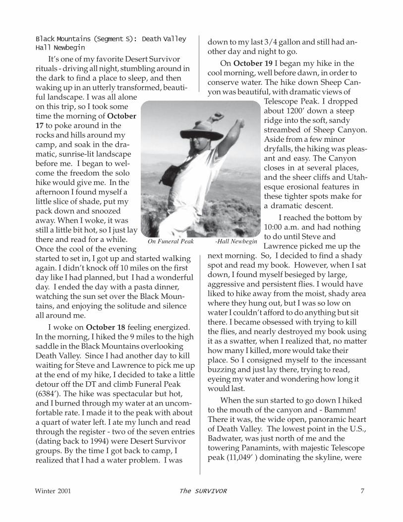
I woke on October 18 feeling energized.In the morning, I hiked the 9 miles to the highsaddle in the Black Mountains overlookingDeath Valley. Since I had another day to killwaiting for Steve and Lawrence to pick me upat the end of my hike, I decided to take a littledetour off the DT and climb Funeral Peak(6384’). The hike was spectacular but hot,and I burned through my water at an uncom-fortable rate. I made it to the peak with abouta quart of water left. I ate my lunch and readthrough the register - two of the seven entries(dating back to 1994) were Desert Survivorgroups. By the time I got back to camp, Irealized that I had a water problem. I was
down to my last 3/4 gallon and still had an-other day and night to go.
On October 19 I began my hike in thecool morning, well before dawn, in order toconserve water. The hike down Sheep Can-yon was beautiful, with dramatic views of
Telescope Peak. I droppedabout 1200’ down a steepridge into the soft, sandystreambed of Sheep Canyon.Aside from a few minordryfalls, the hiking was pleas-ant and easy. The Canyoncloses in at several places,and the sheer cliffs and Utah-esque erosional features inthese tighter spots make fora dramatic descent.
I reached the bottom by10:00 a.m. and had nothingto do until Steve andLawrence picked me up the
next morning. So, I decided to find a shadyspot and read my book. However, when I satdown, I found myself besieged by large,aggressive and persistent flies. I would haveliked to hike away from the moist, shady areawhere they hung out, but I was so low onwater I couldn’t afford to do anything but sitthere. I became obsessed with trying to killthe flies, and nearly destroyed my book usingit as a swatter, when I realized that, no matterhow many I killed, more would take theirplace. So I consigned myself to the incessantbuzzing and just lay there, trying to read,eyeing my water and wondering how long itwould last.
When the sun started to go down I hikedto the mouth of the canyon and - Bammm!There it was, the wide open, panoramic heartof Death Valley. The lowest point in the U.S.,Badwater, was just north of me and thetowering Panamints, with majestic Telescopepeak (11,049’ ) dominating the skyline, were
On Funeral Peak -Hall Newbegin

8 The SURVIVOR Winter 2001
directly in front of me. The sky turned a darkpurple as the sun went down. I went to sleep a little thirsty and, in that foggy transitionalstate between consciousness and sleep, Iimagined that there were glacial streamsrunning out of the Black Mountains, ripplingright by my sleeping bag.
Death Valley (Segment T): Death Valley NPHall Newbegin, Steve Tabor, LawrenceWilson
In the morning of October 20, Steve andLawrence picked me up, and we raced off toa gas station where there were cold rootbeers sitting in a giant barrel of ice - civiliza-tion! The car shuttle took six hours, so wedidn’t start hiking until 3:30 p.m.
It quickly became apparent that thevalley walking would not be as easy as I hadimagined. We made our way over an in-creasingly thick crust of hard, dried mud withfoot-deep crenellations. We crossed acouple of perfectly smooth, salt crustedstreamlets of the Amargosa, which con-trasted beautifully against the fluffy driedmudscape. Crossing the first streamlet,though, we sank ankle deep into the wet silt.After a difficult 3-hour walk across the valley,we were glad to find a lovely sandy areanext to a mesquite grove for our camp.
On October 21, we headed north, follow-ing the west edge of the valley at the foot ofthe magnificent Panamints and enormousbajadas. The temperatures got into the mid-90’s, and it was very humid. We foundourselves resting every 45 minutes or so,even in the relative cool of the morning.
We encountered many different environ-ments along the valley floor: salt crust, wetmud, sand dunes, great flashflood channels,arrowweed thickets, and wonderful mes-quites for shade. We crossed through sev-eral distinct plant communities, which corre-sponded to the salinity gradient moving up
from the valley floor. They began with thetrue, hardcore halophytes (i.e. salt fiends) onthe valley floor, dominated by atriplexes (“saltbushes,” named for their ability to storeexcess salt in their leaves). Higher, lesssaline soil had pure stands of pickleweed.Finally, leaving the salty valley floor entirely,at the edge of the bajadas we found theusual Mojavean suspects including creosoteand burrobush. All along the base of thePanamints we found thick groves of HoneyMesquite, which use their lengthy taproots tofeed from deep springs. One botanicalanomaly was the huge stand of cattails in the(not dry) dry lake around the old Eagle BoraxMine.
We unsuccessfully searched for evidenceof the Bennett-Arcane camp, where stranded‘49-ers spent an unpleasant winter ruing theirdecision to take a “shortcut”. We passed thehottest part of the day at the lovely Eagle
-Hall Newbegin

Winter 2001 The SURVIVOR 9
Borax mine site, laying in the shade of somemesquite trees next to the cattail bog. Wesampled some of the musty, salty water fromTule Spring. The scenery along this seg-ment was absolutely gorgeous and the wideopen beauty of the valley was extremelymemorable.
Salt Creek (Segment U): Death Valley NPSteve Tabor, Lawrence Wilson
After Lawrence and I finished the previ-ous segment with Hall Newbegin, it took usmost of the day to set up our next carshuttle. Finally, at 2:00 p.m. on October 22,we were back on the salt crust. It was 95degrees.
At first, we followed George Huxtable’sroute directly across the pan to the Blackwa-ter fan. But our feet were already blisteredand battered from the previous trip and, afteran hour of hard going, I decided to stay offthe crust and instead hike the pebbly “shore-line” at the interface between crusty salt androcky fan.
For the rest of the day we hiked theeasiest ground we could find, traveling frommesquite tree to mesquite bush, using themfor shade. We used nylon umbrellas to keepthe sun off our heads. We were aided bythe late afternoon shadows from thePanamint Range to the west as the sun fell. We camped in a small mesquite grove andwere treated to a spectacular coyote chorusfrom close range.
On October 23 we were on the trail rightafter sunrise. We continued around the saltpan on pebbly ground, stopping every 45minutes or so to rest at mesquites. We sawseveral foxholes, and a large marsh hawksailed by as we approached Blackwater fan.
It was a tough day rounding the rockyBlackwater fan, threading between rocksbrought down by flashfloods and four-foot-high salt crust and lake mud remnants fromancient Lake Manly. Part of our route was
shadeless, and when we rested we had to situnder our umbrellas. In the intense heat, ona long run, I panicked, and led us full throttleacross the rocks to get into the shade. When we got to the shade, I realized that wecould have stayed on course and followedthe “shore” all the way there. It would havebeen ¼ mile longer, but it would have usedmuch less energy. We arrived at camp atnightfall, tired and sweaty. We’d done 15miles.
Next morning, we were down to ¾ of agallon of water each. We got up early andhiked north toward Salt Creek. George’sroute required a long hike over rocky fansdirectly toward Stovepipe Wells. Neither ofus wanted to undergo that ordeal with oursore feet. Instead, we hiked partway acrossthe fan and into a near-barren landscape ofdesert pavement, then down an easy washto the creek. We crossed the creek at theold gauging station, beneath photogeniccliffs of upturned lakebed. On the east sideof the creek, we followed an old wagon roadalong a marsh of saltgrass, reeds and mes-quites. There was good shade when weneeded it, well-spaced.
At 2:30, we stopped in the shade of somehuge mesquites. If we persisted walking inthe heat of the day directly into the sun, we’drun out of water before we got to town. Werested in the shade for two hours until thesun dropped behind some clouds. An hourbefore sunset, we began the last four milesto Stovepipe. We started by winding alongthe tops of the high Death Valley Dunes, butthat was tiring, so we soon dropped down tothe foredunes, where we had easier going. We reached the ranger station at 7:00 p.m.,with a last pint of water each. We celebratedour ordeal with a big meal at the lodge and abeer at the saloon.
continued on page 20

10 The SURVIVOR Winter 2001
by Dave McMullen
Anyone queer for maps would under-stand. Anyone interested in the history ofminers and Native Americans would alsounderstand. To follow their old footpathsover the crest of the Panamint Mountainshad been my quest since I first saw thesingle dashed line marked on the 1952USGS Telescope Peak 15 minute map.Reading histories of their lives and timesheightened the sense of adventure I feltwhenever I reviewed that map, or passed bythat mountain range. Meeting descendantsof the Timbisha and Panamint Shoshonealso piqued my curiosity about the desertplaces they once called home.
One place in particular, with its promiseof flowing water, fruit trees and grapevines,walls of stone, and terraces drew my atten-tion more than the others: Hungry Bill’sRanch. Named for a local Native American,he, his family, and other tribe members hadused the site to grow fruits and vegetables.They called it Puaitungani, or “mouse cave.”Miners apparently moved in ahead of themcirca 1872 and commandeered its resourcesfor their own agriculture. The canyon cra-dling this site now bears the last name ofone of these men, Albert Johnson. Themines quickly went bust, and the minersmoved on. Hungry Bill returned and contin-ued to use the area for many years after-ward.
Tales from other hikers revealed that aroute from the west up Surprise Canyon andover Panamint Pass to the ranch was wellestablished and well traveled. However, noinformation was forthcoming about a south-western trending route up toward PorterPeak. The ranch is also accessible from the
Peril in the Panamints:
The McMullen Incident
east via a hard rocky road from Death Valleyproper, followed by a short hike along thecanyon bottom.
Coming in that way in early May of 2000, Ieasily found the ranch site, but was thwartedby burro trails etched along the canyon’swalls in my efforts to find the southwest leg .Following several of them led me to deadends high up on bare ridges pockmarkedwith dust wallows and dried burro dung. Thatportion of the route from the ranch to anunnamed pass near Porter Peak remained amystery to me.
Wanting to preview the route in prepara-tion for a DS backpack, I headed out solo inanother attempt to locate the old route andmark its path for my return in October. How-ever, this time I would do it from the upperend via Pleasant Canyon.
Using a borrowed 4WD truck I drove upearly on Saturday, September 1st. The wayin was gnarly at the lower end where theroad follows a water course - very rocky,steep, and slippery. Riparian vegetationcrowded in on both sides as well, obscuringmy view. It took me well over an hour totraverse the nine miles from Ballarat on thefloor of Panamint Valley (1200’) to where Iparked just below the Cooper Mine (6400’).
After breakfast I walked up the mine’saccess road, spent some time inspectingseveral adits (mine entrances) and the inter-esting geology, and then located a USGSbenchmark as a point of reference on themap. Once oriented, I struck off for the trail,but it wasn’t immediately noticeable where Iexpected it to be. I continued in the directionindicated on the map and found only scree,
Winter 2001 The SURVIVOR 11
talus, and a few cairns strewn out amongbrush and trees on a steep slope. Neverthe-less I made it to where the supposed trailcrosses over a saddle into Happy Canyon tothe north.
From there I had a view of all of upperPleasant Canyon and almost the whole ofupper Happy Canyon. The devastationcaused by a forest fire that scorched the areain 1999 was plainly visible. The entire bowl-shaped area of upper HappyCanyon is bare, save for theblackened skeletons of pinionand juniper trees, their darknude trunks and branchespointing skyward. The burnswept upward to the ridge between Happyand Pleasant canyons where I was standing,but didn’t cross over. Pleasant Canyon main-tains its cover of arid verdancy.
Along the ridge among the ebon treeswere patches of wildflowers, their brightcolors offering stark contrast to the charcoaland ashen landscape. I saw scattered standsof yellow Nevada Viguiera (Viguiera multifloranevadensis), dense clusters of Prickly Pop-pies (Argemone intermedia corymbosa) withtheir white crepelike petals dancing in thebreeze, Desert Tobacco (Nicotianatrigonophylla) with its long tubular creamywhite flowers, and dense round clumps of apink and yellow mimulus with pale blue greenleaves that were hairy and sticky.
Following the ridge eastward and keepingthe burned area on my left, I soon came uponthe open quartz dome of Porter Peak at9101’. Flames had licked the top, singeingshrubs and charring rocks. Amazingly, brightgreen Mountain Joint Firs (Ephedra viridis)
burned to the ground only two years ago hadmany new healthy branches up to two feethigh.
After a brief lunch and signing the register,I headed off to resume my trail search, hikingnorthward along the spine of the mountains tothe unnamed pass. The fire had burned alongthis ridge line as well, coursing down theeastern side of the mountains to the lowertimberline. The entire face of the south fork of
Johnson Canyon was burnedclear. An eerie landscape tobe in. At the pass I lookedagain for the route. Withsome difficulty and traipsingback and forth I spotted the
trail. Old, faded, and not maintained, it was abarely visible line along the contour of thehillside. I saw no prints of any kind on it andfollowed it downslope.
At an open area covered with scree thetrail gave out, or perhaps my eyes weren’tsensitive enough to follow it. Picking my wayas best I could along this jumble of looserocks and gravel, I tried to stay true to themap’s representation of the route. Soon arough rock outcrop impeded my way and Iwas forced to ski down the loose rocks in anattempt to get around it. There, several hun-dred feet below, the trail was visible again,and for the next several miles it was relativelyeasy to follow.
As my pace quickened I imagined howdifficult it would have been to see the routebefore the fire cleared the way. Blackenedtree trunks and the charcoaled stumps ofbushes were standing smack dab in themiddle of the trail, and dead branchescrowded in from both sides. The little trodden
Every step was
brutal...It took me
over an hour to finish
that last bit of trail.

12 The SURVIVOR Winter 2001
path was visible as it passed under thesebranches for more than 20 feet in someplaces. At first I tried stepping off the trailand walking around these thickets, but foundthe slope too steep and loose for safety, andopted instead to bust my way through.Those following in my footsteps will have aneasier go at it.
The trail so far had followed a roughlynortheast line along the eastern slope of themountains, dropping easily as it went along.This changed abruptly at 6400’ where theroute began a 1000' plunge straight down asoft drainage channel toward the bottom ofthe canyon. The map shows only a fewswitchbacks near the top. Here the trailagain vanished from my view.
I took a short break for water andsnacks, then began a swift descent, beingmindful the trail is supposed to leave thedrainage before hitting the bottom ofJohnson Canyon and cross over a rise to thenext drainage north. I found no trace of thetrail anywhere along this downward section,the terrain being very steep and tracks easilywashed away.
Near the lower tree line a trail of sortsbecame visible again. But it is confused withmany crisscrossing burro or game trails. Iagain tried to stay true to the map’s course,and soon came out on top of the rise be-tween the two channels. There the trailseemed to vanish once more. I rested again,drinking water and eating snacks, staying fora good twenty minutes, lying on my back,with legs elevated and resting on my pack.
Realizing sunset was rapidly approach-ing, I put away my gear, and consulted the
map. Somewhere on this little rise was oncea path down to the next wash, then aroundthe opposite side straight into the ranch. Forthe life of me, I could not find it. Walkingback and forth across the area several times,I became frustrated. Looking across thewash I could clearly see a well-trodden pathheading in the right direction. Another burrotrail perhaps? In the waning light I saw noother, and elected to make my way into thewash and to that path.
It’s 120 feet from the top of the rise to thebottom of the wash. I saw only two waysdown. A loose dirt and gravel slope filled withthorny brush that would put me in a thicketonce in the wash proper, or a steep rockyface with considerable exposure to fall haz-ards that put me right on the path. Back andforth I paced, examining each as best I couldfrom above. Much to my later regret, I chosethe second option.
Making my way down the rocks was easyat first, sidestepping this way and that, andsometimes doubling back a few paces to finda shorter stretch for my tired legs. I had touse my hands a few times as well, to bracemy body and control my weight as I swungaround points of rock or leaned into a step-off toward the next foothold. About two thirdsof the way down I found myself having tochoose between several undesirable direc-tions. I paused there a moment, grumblinginwardly about how impossible it would befor me to lead folks up this way. In thatmoment the choice was made for me.
The rock I was standing on, about the sizeof a dining room chair, began to roll out fromunder me. I quickly grabbed another rock
Peril in the Panamints, continued...

Winter 2001 The SURVIVOR 13
and putting on my head lamp, I tried to hoistup my pack. It was then I discovered thatduring the fall one of the shoulder straps hadtorn away from an anchor point. I cinched itup as best I could and hobbled off into thenight.
Every step was brutal. The ground wasuneven, and loose rocks I’d have disre-garded before suddenly became obstaclesneeding thoughtful negotiation. Small risesbecame barricades I had to figure out a wayaround or over. It took me over an hour tofinish that last bit of trail.
A full moon was rising and begining toflood the canyon in soft light. In its beamsthe ranch site with its old stone walls was awelcome view. I halted just above it andquietly asked the Timbisha permission tostay there for as long as I needed. Withoutfurther ado, I climbed down and over a breakin the wall, grabbed up a dead branch forsupport and thrashed my way through thebrush to where I hoped the flowing waterwould be.
As I approached, a burro snorted throughthe darkness. “To hell with you,” I replied, “Ineed the water now.” I hardly noticed theretreating sound of its hoofs as I pressedforward. Sure enough, in the location I’dseen over a year ago, beneath overhangingfig trees and grape vines was a steadilyflowing stream about three inches deep andtwo feet wide.
Painfully stepping through the tangle ofbranches, I made my way to the creek’sedge, took the boot and sock off the throb-bing joint and plunged it into the cool water.Damn, that felt good. I lay back on the moist
with my right hand, but it too let go. Exple-tives issuing forth, I crashed hard on theground below, then tumbled further downthe slope toward the bottom. As if in slowmotion I can recall my attempts to avoid allthe rocks falling with me. Twisting andturning to keep an eye on them, yet tryingto watch where I was falling, we somehowmanaged to avoid each other.
When I came to a stop against a smallbush, I curled up, covered my head andlistened for the dirt, gravel, and rocks tohalt as well. They soon did, and I began toassess my condition. Taking off my pack, Istretched out as best I could and elevatedmy legs. I stayed there for a few minutesletting my heart rate and breathing slowdown. Soon I felt a throbbing pain in my leftankle. Still on the slope, and not able tofully stretch out, I decided to scoot down onmy behind to the bottom of the wash.
Luckily this was easily accomplishedacross loose sand and small rocks. Oncethere I reassessed my situation. I hadabout one pint of water left, a very soreankle I couldn’t stand on, darkness wasfalling fast, there was little room to liedown, I was in the bottom of a wash, andthere was approximately 1/4 to 1/2 milebetween me and Hungry Bill’s. I knew therewas water at the ranch. All the reports I’dread or heard indicated there was a peren-nial stream flowing there. Also, I knew therewas plenty of open ground to camp on, withtrees for shelter from the sun.
I decided to not let my adrenaline edgefade and to make my way hastily towardthe ranch. After popping some ibuprofen

14 The SURVIVOR Winter 2001
earth and breathed a sigh of relief. For sometime I simply lay there letting my foot chill inthe water. Then I got out my water filter andbegan refilling my empty jug.
This gave me time to meditate on mysituation. How in the hell did I manage toscrew up my ankle? How bad was the in-jury? Luckily, nothing else was bothering mesave for scrapes on my hands, arms, chest,and legs. Would I be able to walk out tomor-row? The next day? There would be plentyof water for me here if I had to stay. If I didn’treturn home Monday night, when would asearch and rescue mission likely be initi-ated? Thankfully I’d left an itinerary with mywife so if someone had to come looking forme they’d know where to look. How muchfood did I bring? All these thoughts andmany more I reviewed over and over again,but none as much as concern over theankle.
Soon, however, bats began flying aroundme, snatching up bugs attracted by theheadlamp I’d hung on a branch above. I’veonly been that close to a flying bat oncemany years ago in an old mine shaft. Here,two or three were harvesting dinner in midair right before my eyes, seemingly obliviousto my presence, except they were verycareful to avoid hitting me. I could hear theirwingbeats and the air rushing across theirbodies as they glided by my head. One flewso close to my face I could feel the air cur-rents as it passed by. Several times Iwatched as one or two sipped from thestream right next to my foot while in flight.This impromptu aerial ballet brought me
instant calm and gave me a sense of rever-ence for the place.
The bottle filled slowly, but when it wasfull I packed it and the filter away and pre-pared to find a place to sleep. In the processmy support pole shattered. It happened, ofcourse, just when I needed it most. Losingmy balance, I leaned fully on it and quicklyfound myself face to face with the dirt floor ofHungry Bill’s ranch. I laugh about it now, butbelieve me, there was plenty of cursing goingon just then. Out loud. (My apologies to theTimbisha.) When that happened, I justplopped down right there adjacent to one ofthe many surviving fig trees. Not as level asI’d like, but it would have to do, at least forone night. Pulling out my tarp, pad and bag, Istuffed the rest of my gear back in the packand used it to elevate my ankle, then climbedinto the bag and tried to doze off.
To be continued…
Peril in the Panamints, continued...

Winter 2001 The SURVIVOR 15
from the Slate Range pass. Visitors wouldbe confronted with the damage of senselessgold mine scars for the rest of our lifetimes.The BLM generally does not rate dramaticviews as something which would ever bevalued more than the potential return of ashort-lived mine. A large outcry will have tobe heard. The value of a view will have tobe loudly defined, defended, and that valuerepeated over and over again.
By Bob Ellis
An environmental assessment is beingprepared for an application to do extensiveexploratory drilling in the Panamint Moun-tains southwest of Telescope Peak. TheBriggs Mine, operating a heap leach open pitgold mine in the southern Panamint Valley,
now wants to expand northward severalmiles as far as Pleasant Canyon. The drill-ing activity would create roads and drill padswhich will permanently scar the now-un-marked face of the Panamints in full viewfrom the Slate Range Crossing on Highway178.
Few landscapes in California have thevast grandeur of Panamint Valley. Eleventhousand foot Telescope Peak in DeathValley National Park tops the range with the1800' Panamint dry lake at its foot. Morethan nine thousand feet in a few miles. MostDeath Valley visitors are awed as they en-counter the valley driving from Ridgecrestand Trona north over the Slate Range. Justat the pass the range rises ahead, wrinkledcanyon after canyon plunging down from thecrest. Here the Argus Range is to the left,the Panamints to the right, and the valleyopens northward, culminating at thePanamint Dunes, miles and miles away inthe distance. This is an immense land-scape, a colossal viewscape, a preciousnatural aesthetic resource.
Exploratory drilling would cut roads intothis face in several places directly across
PANAMINT VALLEY LANDSCAPE THREATENED
BRIGGS GOLD MINE WANTS TO EXPAND AGAIN
Few landscapes in
California have the vast
grandeur of Panamint Valley.
The value of a view will
have to be loudly defined
and defended.
12345678901234567890123456789012123456789012345678901234567890121234567890123456789012345678901234567890121234567890123456789012345678901212345678901234567890123456789012345678901212345678901234567890123456789012123456789012345678901234567890123456789012123456789012345678901234567890121234567890123456789012345678901234567890121234567890123456789012345678901212345678901234567890123456789012345678901212345678901234567890123456789012123456789012345678901234567890123456789012123456789012345678901234567890121234567890123456789012345678901234567890121234567890123456789012345678901212345678901234567890123456789012345678901212345678901234567890123456789012123456789012345678901234567890123456789012123456789012345678901234567890121234567890123456789012345678901234567890121234567890123456789012345678901212345678901234567890123456789012345678901212345678901234567890123456789012123456789012345678901234567890123456789012123456789012345678901234567890121234567890123456789012345678901234567890121234567890123456789012345678901212345678901234567890123456789012345678901212345678901234567890123456789012123456789012345678901234567890123456789012123456789012345678901234567890121234567890123456789012345678901234567890121234567890123456789012345678901212345678901234567890123456789012345678901212345678901234567890123456789012123456789012345678901234567890123456789012123456789012345678901234567890121234567890123456789012345678901234567890121234567890123456789012345678901212345678901234567890123456789012345678901212345678901234567890123456789012123456789012345678901234567890123456789012123456789012345678901234567890121234567890123456789012345678901234567890121234567890123456789012345678901212345678901234567890123456789012345678901212345678901234567890123456789012123456789012345678901234567890123456789012123456789012345678901234567890121234567890123456789012345678901234567890121234567890123456789012345678901212345678901234567890123456789012345678901212345678901234567890123456789012123456789012345678901234567890123456789012123456789012345678901234567890121234567890123456789012345678901234567890121234567890123456789012345678901212345678901234567890123456789012345678901212345678901234567890123456789012123456789012345678901234567890123456789012123456789012345678901234567890121234567890123456789012345678901234567890121234567890123456789012345678901212345678901234567890123456789012345678901212345678901234567890123456789012123456789012345678901234567890123456789012123456789012345678901234567890121234567890123456789012345678901234567890121234567890123456789012345678901212345678901234567890123456789012345678901212345678901234567890123456789012123456789012345678901234567890123456789012123456789012345678901234567890121234567890123456789012345678901234567890121234567890123456789012345678901212345678901234567890123456789012345678901212345678901234567890123456789012123456789012345678901234567890123456789012123456789012345678901234567890121234567890123456789012345678901234567890121234567890123456789012345678901212345678901234567890123456789012345678901212345678901234567890123456789012123456789012345678901234567890123456789012123456789012345678901234567890121234567890123456789012345678901234567890121234567890123456789012345678901212345678901234567890123456789012345678901212345678901234567890123456789012123456789012345678901234567890123456789012123456789012345678901234567890121234567890123456789012345678901234567890121234567890123456789012345678901212345678901234567890123456789012345678901212345678901234567890123456789012123456789012345678901234567890123456789012123456789012345678901234567890121234567890123456789012345678901234567890121234567890123456789012345678901212345678901234567890123456789012345678901212345678901234567890123456789012123456789012345678901234567890123456789012123456789012345678901234567890121234567890123456789012345678901234567890121234567890123456789012345678901212345678901234567890123456789012345678901212345678901234567890123456789012123456789012345678901234567890123456789012123456789012345678901234567890121234567890123456789012345678901234567890121234567890123456789012345678901212345678901234567890123456789012345678901212345678901234567890123456789012123456789012345678901234567890123456789012123456789012345678901234567890121234567890123456789012345678901234567890121234567890123456789012345678901212345678901234567890123456789012345678901212345678901234567890123456789012123456789012345678901234567890123456789012123456789012345678901234567890121234567890123456789012345678901234567890121234567890123456789012345678901212345678901234567890123456789012345678901212345678901234567890123456789012123456789012345678901234567890123456789012123456789012345678901234567890121234567890123456789012345678901234567890121234567890123456789012345678901212345678901234567890123456789012345678901212345678901234567890123456789012123456789012345678901234567890123456789012123456789012345678901234567890121234567890123456789012345678901234567890121234567890123456789012345678901212345678901234567890123456789012345678901212345678901234567890123456789012123456789012345678901234567890123456789012123456789012345678901234567890121234567890123456789012345678901234567890121234567890123456789012345678901212345678901234567890123456789012345678901212345678901234567890123456789012123456789012345678901234567890123456789012123456789012345678901234567890121234567890123456789012345678901234567890121234567890123456789012345678901212345678901234567890123456789012345678901212345678901234567890123456789012123456789012345678901234567890123456789012123456789012345678901234567890121234567890123456789012345678901234567890121234567890123456789012345678901212345678901234567890123456789012345678901212345678901234567890123456789012123456789012345678901234567890123456789012123456789012345678901234567890121234567890123456789012345678901234567890121234567890123456789012345678901212345678901234567890123456789012345678901212345678901234567890123456789012123456789012345678901234567890123456789012123456789012345678901234567890121234567890123456789012345678901234567890121234567890123456789012345678901212345678901234567890123456789012345678901212345678901234567890123456789012123456789012345678901234567890123456789012123456789012345678901234567890121234567890123456789012345678901234567890121234567890123456789012345678901212345678901234567890123456789012345678901212345678901234567890123456789012123456789012345678901234567890123456789012123456789012345678901234567890121234567890123456789012345678901234567890121234567890123456789012345678901212345678901234567890123456789012345678901212345678901234567890123456789012123456789012345678901234567890123456789012123456789012345678901234567890121234567890123456789012345678901234567890121234567890123456789012345678901212345678901234567890123456789012345678901212345678901234567890123456789012123456789012345678901234567890123456789012123456789012345678901234567890121234567890
ACT NOW
Now is the time to getinvolved. Contact the BLM
about the Briggs Mine Explora-tion Environmental Assessment.
Write, fax or phone:
Hector Villalobos, Field Manager
BLM, Ridgecrest Field Office
300 S. Richmond Road
Ridgecrest, CA 93555
Telephone: (760) 384-5400
Fax: (760) 384-5499
www.ca.blm.gov/ridgecrest

16 The SURVIVOR Winter 2001
Crunch Time in the Mojave...
continued from page 1
demanding necessary recovery measuresunder this administration. We continue tooppose the expansion of Fort Irwin as takingdesert tortoise lands for unnecessary tanktraining.
We also hate to see the desert beingmanaged for the benefit of only one species,even if the measures taken for that speciesbenefit many others aswell. Finally, we’restarting to see somebacklash as the OHVfolks get more orga-nized and as somedeliberately violateclosure areas.
So what can wedo? We need to tellthe story of the tor-toise. We need to letour urban friends withSUVs know that thereis a problem out therein the desert. The BLMmust start to hear from average people whoare concerned. People who go to the desertfor peace and quiet, not vehicular noise anddust. People who want to take back-roaddrives in their SUVs and see untrammeledlandscapes, not eroded “play” routes andthe denuded areas surrounding wateringtroughs for exotic species. People whowant to occasionally camp away from anorganized campground, not a staging areablasted by those emitting their “piss andvinegar.” People who drive out for a day
hike and want to have a chance to see somewildlife, not motorized thrill seekers.
SUV people are our allies. They are notrepresented on BLM Advisory panels, theyare not an organized “partner” in desertmanagement; but they are a growing groupinterested in a peaceful desert. It’s in ourinterest to find ways to engage them.
ACT NOW
Educate yourself andyour friends about thethe threats facing theDesert Tortoise.Useful web sites:
Desert Tortoise Pre-serve Committee,www.tortoise-tracks.orgCenter for BiologicalDiversity,www.sw-center.org/swcbd/goldenstate/cdca
NEMO: Northern and Eastern Mojave -area north of I-40 and east of Baker to theColorado River. Comments closed on draftplan 11/1/01 - Final EIR early 2002.NECO: Northern and Eastern Colorado --area south of I-40 and east of Joshua TreePark to theColorado River. Commentsclosed on draft plan 11/1/01 - Final EIR early2002.WEMO: West Mojave - area west of Bakerand northwest of Joshua Tree to Palmdaleand Ridgecrest. No draft out yet, maybe in ayear.
“We need to tell the story of the tortoise.”
-Janet Johnson

Winter 2001 The SURVIVOR 17
On November 5th, Desert Survivors fileda formal protest of the Cadiz Project FinalEIR with the BLM headquarters in Washing-ton. The BLM’s preferred alternative for thisproject would disturb 12 miles of pristinedesert lands with a pipeline, maintenanceroad, and five story powerline.
Desert Survivors protested that the EIRdid not fully analyze reasonable alternativeroutes which would use existing utility corri-dors and existing disturbed right-of-ways asmandated by the 1980 California DesertProtection Plan. We also protested thescheme used to rank alternative routes,which improperly valued historic landscapesand cultural sites and actually was set up tochoose the cheapest alternative, regardlessof impact. In addition we protested the lackof an alternative which used nearby naturalgas for powering the wells, rather than theproposed 35 mile long five-story electricpowerline.
Desert Survivors also signed on as aparticipant in a multi-group protest filed bythe Western Environmental Law Center.This protest is a fairly comprehensive pack-age which addresses many environmentaland procedural deficiencies in the Final EIR.Once the protests are “resolved” by the BLM,a Record of Decision will be issued. Unless
The next step will be an effort to dissuadethe members of the Board of the Metropoli-tan Water District (MWD) from voting in favorof the Cadiz Project. We feel that it is a badbusiness decision to get involved in a projectwhich will cost the southern California waterrate payers more than twice as much forwater than they are paying now.
It is quite possible that this project willresult in a lawsuit if the very real environ-mental questions about this proposal are notresolved. Desert Survivors has been oppos-ing this project from the inception and willcontinue to do so. Stay tuned.
DESERT SURVIVORS FILES PROTEST ON CADIZ PROJECT
FINAL EIR
123456789012345678901234567890121234567890123456789012345678901212345678901234567890123456789012123456789012345678901234567890121234567890123456789012123456789012345678901234567890121234567890123456789012345678901212345678901234567890123456789012123456789012345678901234567890121234567890123456789012123456789012345678901234567890121234567890123456789012345678901212345678901234567890123456789012123456789012345678901234567890121234567890123456789012123456789012345678901234567890121234567890123456789012345678901212345678901234567890123456789012123456789012345678901234567890121234567890123456789012123456789012345678901234567890121234567890123456789012345678901212345678901234567890123456789012123456789012345678901234567890121234567890123456789012123456789012345678901234567890121234567890123456789012345678901212345678901234567890123456789012123456789012345678901234567890121234567890123456789012123456789012345678901234567890121234567890123456789012345678901212345678901234567890123456789012123456789012345678901234567890121234567890123456789012123456789012345678901234567890121234567890123456789012345678901212345678901234567890123456789012123456789012345678901234567890121234567890123456789012123456789012345678901234567890121234567890123456789012345678901212345678901234567890123456789012123456789012345678901234567890121234567890123456789012123456789012345678901234567890121234567890123456789012345678901212345678901234567890123456789012123456789012345678901234567890121234567890123456789012123456789012345678901234567890121234567890123456789012345678901212345678901234567890123456789012123456789012345678901234567890121234567890123456789012123456789012345678901234567890121234567890123456789012345678901212345678901234567890123456789012123456789012345678901234567890121234567890123456789012123456789012345678901234567890121234567890123456789012345678901212345678901234567890123456789012123456789012345678901234567890121234567890123456789012123456789012345678901234567890121234567890123456789012345678901212345678901234567890123456789012123456789012345678901234567890121234567890123456789012123456789012345678901234567890121234567890123456789012345678901212345678901234567890123456789012123456789012345678901234567890121234567890123456789012123456789012345678901234567890121234567890123456789012345678901212345678901234567890123456789012123456789012345678901234567890121234567890123456789012123456789012345678901234567890121234567890123456789012345678901212345678901234567890123456789012123456789012345678901234567890121234567890123456789012123456789012345678901234567890121234567890123456789012345678901212345678901234567890123456789012123456789012345678901234567890121234567890123456789012123456789012345678901234567890121234567890123456789012345678901212345678901234567890123456789012123456789012345678901234567890121234567890123456789012123456789012345678901234567890121234567890123456789012345678901212345678901234567890123456789012123456789012345678901234567890121234567890123456789012123456789012345678901234567890121234567890123456789012345678901212345678901234567890123456789012123456789012345678901234567890121234567890123456789012123456789012345678901234567890121234567890123456789012345678901212345678901234567890123456789012123456789012345678901234567890121234567890123456789012123456789012345678901234567890121234567890123456789012345678901212345678901234567890123456789012123456789012345678901234567890121234567890123456789012123456789012345678901234567890121234567890123456789012345678901212345678901234567890123456789012123456789012345678901234567890121234567890123456789012123456789012345678901234567890121234567890123456789012345678901212345678901234567890123456789012123456789012345678901234567890121234567890123456789012123456789012345678901234567890121234567890123456789012345678901212345678901234567890123456789012123456789012345678901234567890121234567890123456789012123456789012345678901234567890121234567890123456789012345678901212345678901234567890123456789012123456789012345678901234567890121234567890123456789012123456789012345678901234567890121234567890123456789012345678901212345678901234567890123456789012123456789012345678901234567890121234567890123456789012123456789012345678901234567890121234567890123456789012345678901212345678901234567890123456789012123456789012345678901234567890121234567890123456789012123456789012345678901234567890121234567890123456789012345678901212345678901234567890123456789012123456789012345678901234567890121234567890123456789012123456789012345678901234567890121234567890123456789012345678901212345678901234567890123456789012123456789012345678901234567890121234567890123456789012123456789012345678901234567890121234567890123456789012345678901212345678901234567890123456789012123456789012345678901234567890121234567890123456789012
Background
The Cadiz Project proposes to mine up to two million acre feet of ancient groundwaterfrom beneath the Mojave north of Joshua Tree National Park. USGS and San Bernar-dino County reviewed the proposal and found that recharge rates for the aquiferswould be 10-15 times less than claimed by Cadiz. The role of groundwater in support-ing the Mojave ecosystem is not fully understood.
By Bob Ellis
our protests are successful, this would resultin the BLM approving an amendment in the1980 Desert Plan to allow the Cadiz Projectan exemption from the requirement to usean existing utility corridor for facilities likethis.
1234567890123456789012345678901212345678901234567890123456789012123456789123456789012345678901234567890121234567890123456789012345678901212345678912345678901234567890123456789012123456789012345678901234567890121234567891234567890123456789012345678901212345678901234567890123456789012123456789123456789012345678901234567890121234567890123456789012345678901212345678912345678901234567890123456789012123456789012345678901234567890121234567891234567890123456789012345678901212345678901234567890123456789012123456789123456789012345678901234567890121234567890123456789012345678901212345678912345678901234567890123456789012123456789012345678901234567890121234567891234567890123456789012345678901212345678901234567890123456789012123456789123456789012345678901234567890121234567890123456789012345678901212345678912345678901234567890123456789012123456789012345678901234567890121234567891234567890123456789012345678901212345678901234567890123456789012123456789123456789012345678901234567890121234567890123456789012345678901212345678912345678901234567890123456789012123456789012345678901234567890121234567891234567890123456789012345678901212345678901234567890123456789012123456789123456789012345678901234567890121234567890123456789012345678901212345678912345678901234567890123456789012123456789012345678901234567890121234567891234567890123456789012345678901212345678901234567890123456789012123456789123456789012345678901234567890121234567890123456789012345678901212345678912345678901234567890123456789012123456789012345678901234567890121234567891234567890123456789012345678901212345678901234567890123456789012123456789123456789012345678901234567890121234567890123456789012345678901212345678912345678901234567890123456789012123456789012345678901234567890121234567891234567890123456789012345678901212345678901234567890123456789012123456789123456789012345678901234567890121234567890123456789012345678901212345678912345678901234567890123456789012123456789012345678901234567890121234567891234567890123456789012345678901212345678901234567890123456789012123456789123456789012345678901234567890121234567890123456789012345678901212345678912345678901234567890123456789012123456789012345678901234567890121234567891234567890123456789012345678901212345678901234567890123456789012123456789123456789012345678901234567890121234567890123456789012345678901212345678912345678901234567890123456789012123456789012345678901234567890121234567891234567890123456789012345678901212345678901234567890123456789012123456789123456789012345678901234567890121234567890123456789012345678901212345678912345678901234567890123456789012123456789012345678901234567890121234567891234567890123456789012345678901212345678901234567890123456789012123456789123456789012345678901234567890121234567890123456789012345678901212345678912345678901234567890123456789012123456789012345678901234567890121234567891234567890123456789012345678901212345678901234567890123456789012123456789123456789012345678901234567890121234567890123456789012345678901212345678912345678901234567890123456789012123456789012345678901234567890121234567891234567890123456789012345678901212345678901234567890123456789012123456789123456789012345678901234567890121234567890123456789012345678901212345678912345678901234567890123456789012123456789012345678901234567890121234567891234567890123456789012345678901212345678901234567890123456789012123456789
ACT NOW
If you live in Southern California, pleaseconsider sending a letter to your repre-sentatives on the MWD. For a completelist of MWD Board members by city, goto www.mwd.dst.ca.us/mwdh2o/pages/board/bio01.html. For more informationon the Cadiz project, see the Spring2000 Survivor.

18 The SURVIVOR Winter 2001
Military: Fort Irwin
On October 16th, the Department of De-fense posted a Notice of Intent to Prepare aSupplemental Draft EIS (DEIS) for the FortIrwin expansion. The DEIS is expected to beready by December 2002. Written commentswere being accepted until December 29th.More public comments will be solicited afterthe DEIS is released.
Significant issues include impacts to twolisted endangered species: the desert tor-toise and the Lane Mountain milkvetch.Additional concerns have been raised overthe military’s proposed expansion into partsof the Silurian and Superior Valleys, as well
as impacts to air quality,noise (aircraft/range firing), soilerosion, waterquality, andcultural re-sources. The
DEIS will considernew alternatives
consisting of various configurations of land tothe east, west and south of the existingboundaries and also utilizing land within FortIrwin boundaries that is currently off limits tomechanized training. A no action alternative(continue operations with existing ranges andfacilities) will also be evaluated.
Desert Survivors, in coalition withthirteen other conservation groups, sent aletter to members of the Senate and HouseArmed Services Committees voicing ourconcerns regarding the Defense Authoriza-tion legislation. The coalition stated its oppo-sition to the Fort Irwin expansion as pro-posed, citing the threat to endangered spe-
cies and wilderness areas. Members ofCongress, including Senators DianneFeinstein and Barbara Boxer, and Represen-tative Barbara Lee, were receptive to ourconcerns and also raised concerns of theirown. Representative Susan Davis (D-CA),along with eleven other members of theHouse, sent a letter to those members ofCongress who will be part of the conferencefor the Defense Authorization legislation. Theletter expressed their desire to protect desertwildlife and its critical habitat as well aspotential wilderness areas, while meeting theneeds of specific types of military training.
Military withdrawal of public land willcontinue to be an issue to monitor. Evenbefore the events of September 11th, a move-ment was underway within the DefenseDepartment to ask Congress to rewrite theEndangered Species Act and other laws togive the military greater freedom to train andconduct exercises in areas where there arethreatened or endangered species. Themilitary would like the Secretary of Defenseto be able t o grant exemptions “for reasonsof military readiness.” Military officials aresaid to be frustrated by growing friction be-tween these protections and training exer-cises on California’s military bases – includ-ing Fort Irwin.Mining
Of grave concern is the InteriorDepartment’s recent reversal on the pro-posed Glamis Imperial Mine in ImperialCounty. The proposal would put an open-pit,cyanide heap leach gold mine on 1,571 acresof BLM land near Indian cultural and religioussites. Under Clinton-era mining regulations,
Issues Watch – December 2001
By Janet Johnson
-Janet Johnson

Winter 2001 The SURVIVOR 19
the Interior Secretary had the authority toprohibit new mine sites on federalland where they could causelasting harm to communities andthe environment. Secretary Bab-bitt used this power to block theproposal, stating that sites sacredto the Quechan Tribe would beirreparably harmed by opening themine. The Secretary’s authority tomake that decision has now beenoverturned by the Bush adminis-tration. This action could revivethe proposed gold mine.
The Western Mining ActionProject has filed a protest withthe Department of the Interior tohalt the patenting of 672.5 acresof mining claims associated with the CimaCinder Mine inside the Mojave NationalPreserve. If the Interior Department issues afull patent, the land will leave park ownershipand become private land.Grazing
On November 29th, the director of theDepartment of the Interior’s Office of Hear-ings and Appeals reinstated a grazing ban on500,000 acres of High Desert habitat in theMojave for the threatened desert tortoise.
Landfill
The proposed giant landfill at EagleMountain, covering 2,300 acres directlyadjacent to Joshua Tree National Park, is onhold as project opponents wait for a legalruling giving them standing to sue. If thejudge rules that they have standing, they willfile suit against the National Park Service.Sandboarding
JT Reynolds, new superintendent ofDeath Valley National Park, has informed theCenter for Biological Diversity that he intendsto close the Eureka Dunes to sandboarding.This is a step that the previous superinten-
dent repeatedly refused to take. The dunesare in designated wilderness and are home
to the endangered Swalleniaalexandrae (Eureka Valley dunegrass) as well as the threatenedAstragalus lentiginosus var micans(shining milk vetch).Issues Group
The monthly Issues Group hasceased to meet. Monthly issuesupdates will still be prepared anddistributed to members wishing toreceive them. If you would like tobe placed on the Issues Update
mailing list, please contact SteveTabor at 510-769-1706 [email protected]. Watch alsofor expanded issues coverage on
the Desert Survivors website, which is beingredesigned and should be online by January31.1234567890123456789012345678901212345678901234567890123456789012123456789012345678901234567890123456789012123456789012345678901234567890121234567890123456789012345678901234567890121234567890123456789012345678901212345678901234567890123456789012345678901212345678901234567890123456789012123456789012345678901234567890123456789012123456789012345678901234567890121234567890123456789012345678901234567890121234567890123456789012345678901212345678901234567890123456789012345678901212345678901234567890123456789012123456789012345678901234567890123456789012123456789012345678901234567890121234567890123456789012345678901234567890121234567890123456789012345678901212345678901234567890123456789012345678901212345678901234567890123456789012123456789012345678901234567890123456789012123456789012345678901234567890121234567890123456789012345678901234567890121234567890123456789012345678901212345678901234567890123456789012345678901212345678901234567890123456789012123456789012345678901234567890123456789012123456789012345678901234567890121234567890123456789012345678901234567890121234567890123456789012345678901212345678901234567890123456789012345678901212345678901234567890123456789012123456789012345678901234567890123456789012123456789012345678901234567890121234567890123456789012345678901234567890121234567890123456789012345678901212345678901234567890123456789012345678901212345678901234567890123456789012123456789012345678901234567890123456789012123456789012345678901234567890121234567890123456789012345678901234567890121234567890123456789012345678901212345678901234567890123456789012345678901212345678901234567890123456789012123456789012345678901234567890123456789012123456789012345678901234567890121234567890123456789012345678901234567890121234567890123456789012345678901212345678901234567890123456789012345678901212345678901234567890123456789012123456789012345678901234567890123456789012123456789012345678901234567890121234567890123456789012345678901234567890121234567890123456789012345678901212345678901234567890123456789012345678901212345678901234567890123456789012123456789012345678901234567890123456789012123456789012345678901234567890121234567890123456789012345678901234567890121234567890123456789012345678901212345678901234567890123456789012345678901212345678901234567890123456789012123456789012345678901234567890123456789012123456789012345678901234567890121234567890123456789012345678901234567890121234567890123456789012345678901212345678901234567890123456789012345678901212345678901234567890123456789012123456789012345678901234567890123456789012123456789012345678901234567890121234567890123456789012345678901234567890121234567890123456789012345678901212345678901234567890123456789012345678901212345678901234567890123456789012123456789012345678901234567890123456789012123456789012345678901234567890121234567890123456789012345678901234567890121234567890123456789012345678901212345678901234567890123456789012345678901212345678901234567890123456789012123456789012345678901234567890123456789012123456789012345678901234567890121234567890123456789012345678901234567890121234567890123456789012345678901212345678901234567890123456789012345678901212345678901234567890123456789012123456789012345678901234567890123456789012123456789012345678901234567890121234567890123456789012345678901234567890121234567890123456789012345678901212345678901234567890123456789012345678901212345678901234567890123456789012123456789012345678901234567890123456789012123456789012345678901234567890121234567890123456789012345678901234567890121234567890123456789012345678901212345678901234567890123456789012345678901212345678901234567890123456789012123456789012345678901234567890123456789012123456789012345678901234567890121234567890123456789012345678901234567890121234567890123456789012345678901212345678901234567890123456789012345678901212345678901234567890123456789012123456789012345678901234567890123456789012123456789012345678901234567890121234567890123456789012345678901234567890121234567890123456789012345678901212345678901234567890123456789012345678901212345678901234567890123456789012123456789012345678901234567890123456789012123456789012345678901234567890121234567890123456789012345678901234567890121234567890123456789012345678901212345678901234567890123456789012345678901212345678901234567890123456789012123456789012345678901234567890123456789012123456789012345678901234567890121234567890123456789012345678901234567890121234567890123456789012345678901212345678901234567890123456789012345678901212345678901234567890123456789012123456789012345678901234567890123456789012123456789012345678901234567890121234567890123456789012345678901234567890121234567890123456789012345678901212345678901234567890123456789012345678901212345678901234567890123456789012123456789012345678901234567890123456789012123456789012345678901234567890121234567890123456789012345678901234567890121234567890123456789012345678901212345678901234567890123456789012345678901212345678901234567890123456789012123456789012345678901234567890123456789012123456789012345678901234567890121234567890123456789012345678901234567890121234567890123456789012345678901212345678901234567890123456789012345678901212345678901234567890123456789012123456789012345678901234567890123456789012123456789012345678901234567890121234567890123456789012345678901234567890121234567890123456789012345678901212345678901234567890123456789012345678901212345678901234567890123456789012123456789012345678901234567890123456789012123456789012345678901234567890121234567890123456789012345678901234567890121234567890123456789012345678901212345678901234567890123456789012345678901212345678901234567890123456789012123456789012345678901234567890123456789012123456789012345678901234567890121234567890123456789012345678901234567890121234567890123456789012345678901212345678901234567890123456789012345678901212345678901234567890123456789012123456789012345678901234567890123456789012123456789012345678901234567890121234567890123456789012345678901234567890121234567890123456789012345678901212345678901234567890123456789012345678901212345678901234567890123456789012123456789012345678901234567890123456789012123456789012345678901234567890121234567890123456789012345678901234567890121234567890123456789012345678901212345678901234567890123456789012345678901212345678901234567890123456789012123456789012345678901234567890123456789012123456789012345678901234567890121234567890123456789012345678901234567890121234567890123456789012345678901212345678901234567890123456789012345678901212345678901234567890123456789012123456789012345678901234567890123456789012123456789012345678901234567890121234567890123456789012345678901234567890121234567890123456789012345678901212345678901234567890123456789012345678901212345678901234567890123456789012123456789012345678901234567890123456789012123456789012345678901234567890121234567890123456789012345678901234567890121234567890123456789012345678901212345678901234567890123456789012345678901212345678901234567890123456789012123456789012345678901234567890123456789012123456789012345678901234567890121234567890123456789012345678901234567890121234567890123456789012345678901212345678901234567890123456789012345678901212345678901234567890123456789012123456789012345678901234567890123456789012123456789012345678901234567890121234567890123456789012345678901234567890121234567890123456789012345678901212345678901234567890123456789012345678901212345678901234567890123456789012123456789012345678901234567890123456789012123456789012345678901234567890121234567890123456789012345678901234567890121234567890123456789012345678901212345678901234567890123456789012345678901212345678901234567890123456789012123456789012345678901234567890123456789012123456789012345678901234567890121234567890
Desert Survivors Needs
You!
We need more members to providecontent -- articles and illustrations -- forthe Survivor and the DS website(www.desert-survivors.org).
If you are interested in contributingdesert-related content, design elementsor ideas to The SURVIVOR or thewebsite, please send your articles,artwork, photographs, news, trip re-ports, letters and poems to JessicaRothhaar, Editor.
* Please provide written materialsvia email to:[email protected].
* Photos and artwork may be pro-vided via email or hard copy to: 6710Schmidt Lane, El Cerrito, CA 94530.
Shining Milkvetch-Gerald and Buff Corsi,
California Academy of Sciences

20 The SURVIVOR Winter 2001
Cottonwood Mountains (Segment W): DeathValley NPBob Lyon, Sally Greensill, Skip Smith, MikeYantos
This 16-mile route crosses two valleysand two ridges at the west end of Death
Valley National Park. Thegroup found pictographsat the “petroglyph site”shown on the map at thesouth end of Sand Flat,and enjoyed beautifulviews of the limestonebands on the east side ofthe flat as they climbedabove it on the north sideof the valley. Theycamped on the ridgebetween Sand Flat andHidden Valley. Numerouslimestone, quartzite anddolomite layers and thefaulting and tilting of thelayers give variety to thelandscape.Once again, a long carshuttle slowed thingsdown at the start, but thegroup still finished in lessthan 2 days. This shortsegment would be bestcoupled with the MarbleCanyon Segment, to cutdown on shuttle time.
There is reliable water inDead Horse Canyon, about
two days into the Marble, that would makethings easy.
Racetrack Valley (Segment X): Death ValleyNPSteve Tabor, Bill Spreng, Spencer Berman,Lois Grunwald, Lawrence Wilson, Skip Smith,Theresa Johnson, Dina Robertson
The first few miles on November 2 wereeasy, mostly on sandy valley with few rocks.
Marble Canyon (Segment V): Death Valley NP Bob Lyon, Steve Tabor, Lawrence Wilson
We hiked up the the Cottonwood Canyonfan on October 26, resting underneath ourumbrellas as there was little shade. Thissegment was awash in flashflood evidence. Mudcracks and flowmarks were everywhere.At the mouth of Cotton-wood were giant piles offresh rock, and bigswathes of flood-sweptterraces now encased inhard adobe mud. Wecamped just inside thecanyon mouth.
On October 27, wehiked the length ofMarble Canyon, campingat the confluence withDead Horse Canyon.Marble is an outstandingnine miles of dolomitenarrows, colorful lime-stone layers, faultedcanyon walls, and amaz-ing flashflood deposits,complete with driftwoodpiles several feet high. Close to nightfall, we dida short hike up DeadHorse to get water, whichwas ample, even this latein the season.
On October 28 we hikedup the remainder of MarbleCanyon, enjoying the cottonwood trees andgrapevine patches. More vegetation came intoward the end, with lots of Mojavean andGreat Basin species, such as joshua treesand bitterbrush. When we rounded the lastbend, we saw Sally Greensill’s red 4WDparked on the hill at the road end. By drivingin that far, Sally saved us from an eleven-milehike up onto Hunter Mountain and along itstop on a boring dirt road.
Dolomite Narrows -Paul Brickett
Desert Trail Relay, continued....
Winter 2001 The SURVIVOR 21
The Racetrack is flanked by beautiful bandedlimestone on both sides. The classic Ordovi-cian sequence of Antelope Valley Limestone(gray), Eureka Quartzite (creamy white) andEly Springs Dolomite (black) rose high on theleft near Ubehebe Mine. Wonderful altocu-mulus clouds filled the sky.
Late in the day, we crossed a low passbetween Racetrack Valley and Round Valleyto the north. I wanted to take the group overto another low pass to the west, where wewould have a view down into Corridor Can-yon and across Saline Valley to the NelsonRange. But it was getting late and the groupwas itching to set up camp, so we droppeddown into RoundValley.
On November3, we got up earlyand hiked quicklynorth across Round Valley, heading for “LineCanyon”. In the canyon, we were treated to abeautiful wall of Lost Burro Formation on theleft, banded light and dark gray. It wasstraight as an arrow, with high vaulted cliffsthat got higher as we proceeded. Graylimestone on the right side contained anabundance of fossils.
We hiked the canyon for three miles, thenproceeded eastward along a tributary. Wecame to the top of the Tin Mountain Land-slide, a 50-100 thousand year old agglomera-tion of material that slid off the west face ofTin Mountain, burying Racetrack Valley andthe east side of the Last Chance Range. Thesurface of the slide is hummocky, and thereare several dry lakes on top at almost 6000'.
It was a strange topsy-turvy world ofmixed-up drainage, with plants that seemedout of place. This part of the Park gets 90-degree days during summer, but it snows inwinter and can be bitterly cold. We hikeddown a long canyon as the sun set, andcamped at the edge of huge fans comingdown from Dry Mountain. We had great
would have been easier to hike out the valleyalong Racetrack Road, but we were here forwilderness. The whole morning we clatteredup and down across the rocks. Luckily, therewere no sprained ankles or twisted knees.
Grey clouds hung to the north, andstrange bulbous cloud formations holding agreat deal of water drooped down fromthem. Shadows rose and fell on the peaks to
the west. It wasgreat hikingweather. We
got to the carsat 1:45 p.m., and
the storm broke up as we drove out.
Eureka Dunes (Segment Y): Death Valley NPBob Ellis, Lawrence Wilson, Skip Smith, MikeTedeschi, Lynne Brei
Heading north from Ubehebe Craterunder partly cloudy skies on November 5, wecrossed pumice and ash sands and droppeddown into the main channel of Death ValleyWash. Early September rains had run downthe wash, making the bottom firm anduntracked. New growth foliage was dottedhere and there, brightening the generally drydun-colored landscape. The route was easyto follow and the hiking quite pleasant, al-though warm enough to cause us to con-sume water at a good rate.
That evening we stopped part way up thealluvial fan heading westward up into the LastChance Mountains. By 6:30 p.m. we werewatching the stars from our sleeping bags. Gradually, we became aware that the lowersky to the northeast was turning red in spots. We stared, amazed, as it grew brighter andvertical bands began to appear, pulsing and
views to the east of Tin Mountain rising highabove us.
The next day’s hike was a long oneacross the incredibly rocky fan, then crossingthe soft pumice of the Ubehebe VolcanicField and passing by Little Hebe Crater.. It
Gradually, we became aware that the
lower sky to the northeast was turning red
in spots...It was the Northern Lights!

22 The SURVIVOR Winter 2001
Last Chance Range (Segment Z): DeathValley NPJessica Rothhaar, Lawrence Wilson, SkipSmith, Mike Tedeschi, Lynne Brei, Ron Cohen,Dan Seneres, Nick Vasquez
November 8 brought yet another long carshuttle. A “Road Closed” sign forced us totake the long way around to CucomungoCanyon Road. When we got there, we foundCucomungo Canyon Road washed out, andhad to leave our car 5 miles from the end ofour route. The yellow hazard sign in thecanyon had been modified to read simply“Dang Washout” - our sentiments exactly.
We started walking from the Dunes at1:30 p.m. under a brilliant blue sky. Weheaded straight up the alluvial fan toward alow saddle in the Last Chance Range. Fromthe Dunes, the slopes of the fan seemedcovered in a red mist. As we got closer, we
shifting in posi-tion and bright-ness. Wespeculatedabout a terroristattack on theNevada TestSite and somenew Area 51secret weaponextravaganza. Ihad been luckyenough to see asimilar effect inthe Mojave this lastMarch. It was the northern lights! After anhour or so the reds faded and a white glowremained for quite some time. It was quite atreat.
On November 6, we entered canyoncountry. The Desert Trail twisted upwardthrough two different limestone narrows aswe approached the southern crest of the LastChance Range. In the second narrows, aswe passed a reddish limestone belt of lateCambrian Pogonip formation, we spotted agroup of Dedeckera eurekensis. This mem-ber of the buckwheat family was only discov-ered in 1972 by the late Mary Dedeckera. Only about 15 populations have been re-corded, and this wasn’t one of them. It hadabout forty plants scattered on the steepnorth-facing scree slopes here on the easternside of the Last Chance Range. We tooksome pictures and after the trip I stopped inat the Death Valley botanist’s office to recordthe new finding.
By early afternoon we were over thecrest. We climbed a small rise, hoping for aview of the dunes, but could only see aportion of Eureka Valley. To the south theimposing bulk of Marble Peak filled the sky-line. We made a rapid descent down atwisting wash to Dedeckera Canyon and theEureka Saline jeep corridor, where wecamped.
On themorning ofNovember 7we paradeddown the can-yon for thegrand view ofthe EurekaDunes. Webee-lined to thenortheast cor-ner, got ourboots sandy,
and spotted someof the endangered
Swallenia alexandrae (Eureka Valley dunegrass) as well as the threatened Astragaluslentiginosus var micans (shining milk vetch). The birdcages of prior years’ evening prim-rose were scattered on the benches of thelower dunes. A short march around thenorthern end of the dunes brought us to thecars. This is another good route: washes,canyons, narrows, high views and, best of all,that pile of sand.
Eureka Dunes -Dan Seneres

Winter 2001 The SURVIVOR 23
saw that the mist was actually knee-highthickets of dry desert trumpet, whose manydelicate branches were interlaced in a sea ofcolor. Though we could have driven to theCrater mine site and started our hike fromthere, I would not have missed the beautifulviews back to the golden dunes and the highvalleys around them. From the saddle, wedropped into an unnamed wash and followedit north. Night fell, and we camped at abroad, rocky spot in the wash, just south ofthe road to Crater. The night was clearand cold, and thestars were great.
Next morning,our route took uspast the Cratermine and up acanyon, and westarted our climb inearnest. This wasgood, hard uphillwalking, with plentyof shade frompinyon and juniper.
We made it tothe first saddle, at7200’, by 12:30and took a leisurelylunch, enjoying theviews back to the Dunes and the valleys,lolling about in the shade. From here, wehiked 2.2 hard miles along the ridge over aseries of five peaks, each one higher thanthe last, culminating in Last Chance Moun-tain at 8456’. The hiking was challenging,and the views were glorious. To the west,we could see Eureka Valley and the snow-covered peaks of the Inyos. To the east,valleys and ranges spread as far as wecould see. Thick groves of pinyon and juni-per sometimes made navigation challenging.
We enjoyed the last ½ hour of daylight atthe peak of Last Chance Mountain, admiringthe shadows cast on the ridges below us.
As the light faded, we descended a very steepslope of loose rock in time to make camp inthe next saddle just before dark. Our camphad good views to the east and west andplenty of flat spots. Our water froze that night.
On November 10, we continued alongthe ridge, hiking up and down a series ofshort, steep peaks and saddles. Most of thesaddles would make good camps, havingplenty of flat spots and soft pine duff. Thenavigating got a bit tricky, the guide book a bitunclear, and I took us down the wrong ridge to
Willow Spring,descending moresteeply than weneed have done.When weheaded down themountain wealso lost contactwith Dan, whohad been slowedby knee troubleand who hadgotten off route.He had a GPSand I knew hewould find hisway, but it wasunnerving.
In fact, Dan beat us down to WillowSpring, where Steve Tabor and four otherSurvivors were waiting to join us for the final 2miles to the border. We reached the Nevadaborder at 1:56 pm and cracked a bottle ofchampagne. Then we hoofed it five milesback down the canyon on the jeep trail towhere Steve and the others had parked. Wedrove back to Eureka Dunes in the twilight,tired and footsore but satisfied. This is agreat segment. It has wonderful scenery,huge views and challenging hiking.
In the evening, we enjoyed a potluck mealand celebrated the successful completion ofthe Desert Trail Relay through California.
Lawrence Wilson, Sweetie the Desert Bear, Skip Smith andJessica Rothhaar on Last Chance Mountain - Dan Seneres

24 The SURVIVOR Winter 2001
Recently the BLM proposed to allow acommercial group to run wilderness trips intothe Inyo Mountains Wilderness. The 1964Wilderness Act discourages any commercialuse of wilderness areas unless necessary forrecreational wilderness purposes. In therecent Wilderness Implementation Schedule(WIS) “plan” for managing the Inyo Wilder-ness, the Ridgecrest BLM promised that nocommercial activities would be permitted inthe Inyos until a formal wilderness manage-ment plan with public input was adopted.Based upon this, the commercial groupspermit is being appealed.
The BLM chose not to include wildernessplanning in its recent NEMO, NECO, WEMOplanning process. It currently has no sched-ule to create wilderness management plansfor the 69 wilderness areas created by the1994 Desert Protection Act. Maybe its timeto ask WHY NOT?
BLM, WHERE’S THE WILDERNESS MANAGEMENT PLAN?By Bob Ellis
Planning efforts like this are a big job;they are costly in staff time and money.However not doing plans leaves the interpre-tation of the proper level of protection forwilderness up to the individual manager’slatest interpretation of a fairly complex set ofregulations and precedents. We start to seewilderness protections eroded. More guz-zlers are proposed, more commercial usesare permitted, more areas are developedwithout proper inventory of what is there.Particularly in the Inyos, complete archaeo-logical and historic inventories must be com-pleted before any added activities are permit-ted there. The unique sensitive resources ofthe area are already being carried away byvisitors.
How about it BLM? Where’s the Wilder-ness Plan?
April Nellson, Robert Armstrong andElla Mental atop Waucoba Mountain(11,123’) in the Inyos , pointing to theeastern Sierra (1998)
- Jessica Rothhaar

Winter 2001 The SURVIVOR 25
Our last morning, and we are learningwhat “riparian” means. We are tiptoeingthrough about a half-mile of gorge bottomjungle trail. We tiptoe because of concernabout these fresh new waxy sprouts thatalmost totally cover the trail - a green hell ofpoison ivy ! By mid afternoon, we are high upon the open slickrock. All along the route,one can follow the intermittent telephone line:here it’s carried by an old tree snag through aweather-tarnished porcelain insulator; hereit’s still stretched tight across an open stretchof smooth slickrock; now it lies on the groundsurrounded by many parallel grooves, allworn into the sandstone by the wire’s flappingthrough 75 years of Colorado Plateau winds.Clouds are again building up, soon followedby a light drizzle. Now, through the mist, wecan make out the green fields surroundingEscalante Town, some 1000 ft below us. Whowas it who said “rain enhances?” He’s right!
The final slickrock descent to theEscalante River is a true joy - the smell of wetsandstone, the now vividly colored domes,pinnacles, abutments, drop-offs, and otherlandforms that just don¹t have words to de-scribe them. It’s serious rain by the time wereach the vehicles, but by now it doesn’tmatter: we really own this place, at least inthe memory banks of our minds.
the historic Bowington Road (really a trail)back across the Escalante, and again up asweeping slickrock route to the mesa top;finally, we reached the trailhead.
More of the same on days three and four- down another shallow dry wash calledPhipps. It quickly became Phipps Gorge, andwe walked its whole length to the EscalanteRiver. Along the way were several greatpour-offs and a marvelous arch to climb up to– Phipps Arch, of course. We continuedtracking down the Escalante and severalcrossings later, made camp at the mouth ofDeer Creek. On the morning of day four, weexplored Deer Canyon, and climbed up toand through Bowington Arch. There aresome ghosts in these canyons: Phipps andBowington were friends and ranching part-ners. In 1878, they had a falling out. Theirdisagreement came to a head on this veryupper Escalante, with Phipps attackingBowington and the latter shooting (and killing)Phipps. Bowington was later acquitted ongrounds of self-defense. We thought aboutall this as we exited the Escalante via ahidden exit route (so well hidden we almostdidn’t find it) up to the mesa. After a merefive more miles across the mesa, we didmanage to find our vehicles.
Day six, and it’s 35 degrees F at thetrailhead, but at least it’s stopped snowing.We have just passed the inverted airplanefuselage that marks the Boulder InternationalAirport (and UFO landing site). We are at theupper east end of the Boulder Mail Trail, anancient Indian route across mesa, gorge andslickrock, 16 miles to Escalante. In 1902, itbecame a twice-a-week mail route; the mail-man was paid $200/year: that’s $1.92 perround trip. Lonely cowboys walked the routeto go to dances in Boulder and Escalante. In1924, a telephone line was strung along theroute. The California Conservation Corps
road building programs of the 1930s finallymade the mail trail obsolete, and left it topeople like us. The route, mostly over openslickrock, descends and climbs out of numer-ous washes and canyons. The best of theseis Death Hollow - big time deep, very narrowand, thanks to a perennial creek, choked withriparian growth. As we start our descent intothis awesome maw, right on schedule, theclouds and rain come running out to meet us. Halfway down, a huge alcove gets in ourway. Since it’s already late (3 pm), we crashin this snug dry place. We spend a short butmemorable afternoon watching sheets of rainplay off the vertical gorge walls opposite.
Spring Along the Escalante, continued from back page...

26 The SURVIVOR Winter 2001
Every summer since ’95 I’ve been takingroad trips to Nevada. My interest in Nevadabegan after my 1992 Easter trip to DeathValley via Lida Summit. I was struck by thesnowcapped peaks of Magruder Mountainand the mysterious feel of the land. I’ve comeback again and again, first to climb Magruder,which took 2 tries. Since then I have found itfascinating to discover hidden springs in thedesert, climb other mountains with greatviews, and find petroglyphs, wildflowers, andsemi-precious stones.
This summer, my parents, my friend Louieand I headed out through Fallon to BigKasock Mountain. I had seen this peak on myrelief map and it called me. From U.S. 50 weturned south on route 839 towards the ghosttown of Rawhide. We hiked from below5,800’ to the southeastern peak of the moun-tain at 6,722’. From here we could see themountain’s highest peak at 7,142’. Theclimb was rather steep at times, so westopped short of the summit, but the climbdown was easy!
We continued east on Hwy 50, then tooka detour along picturesque Highway 722, upCarroll Summit to Tonopah. The green alongthe Reese River Valley was amazing.
The next day we hiked from 5400’ to thetop of Monitor Peak (6,374’), southeast ofTonopah. The mountainside was sandy andhard to climb up, but a cushion to the feet onthe way down. From the top we could seeRalston Valley to the west, the Monitor Hillsto the south, Hwy 6 to the north and moun-tains and hills on the horizon. We were highenough to identify all the surrounding peakson the map. From the top our van looked likea little speck.
Next, we headed northeast to look atLunar Crater and Easy Chair Crater, inNevada’s “Moon Country.” Lunar Crater, 6miles on a dirt road from Hwy 6, is impressive– 420 feet deep and nearly 4,000 feet indiameter. The entire area has a purplishhaze, perhaps because of its volcanic nature.On our way back we hiked to Iceberg Spring,which can be seen from the highway.
The following day, we headed to PalmettoMountain. We drove almost to Lida Summit,then started hiking. Our goal was to get highenough to take a panoramic picture ofMagruder Mountain from the north. The viewwas almost perfect. Returning to the car, wethen went to find Kline Spring. We were ableto find the road off the highway without anyproblems, and began following a dry wash“flowing” east. The wash was flowing in thewrong direction, though, so we backtrackedand began following another wash. When weencountered some moss and grass, webecame optimistic that we were on the righttrack. Soon we were following a trickle ofwater! We followed the spring for quite awhile, finally turning back when it becamedifficult to continue. We didn’t go far enoughto find the source, but I believe we had foundKline Spring.
Our last spring was Gap Spring, on ourway to Bishop.. No water here but quite a fewtrees and a marshy area. The only animal wesaw in the area was a skinny jack rabbit withtall ears– the proverbial jackalope.
All in all, this was a satisfying trip— threemountains and three springs, and new ideasfor further exploration.
Road Trip:
Three Mountains and Three Springs in Nevada
By Bill Johansson

Winter 2001 The SURVIVOR 27
REVEILLE RANGE CARCAMP
September 1-3, 2001
By Steve Tabor
Labor Day Weekend - into the heartland!We sought to beat the heat and the crowds,and we did both, with long walks on jeeptrails and washes.
The Reveille Range is 60 miles east ofTonopah, just south of the ghost town ofWarm Springs. Remote and little-known, therange is even mis-labelled on thestate tourist map. Most of the eastside of the Rev-eilles is easily hiked from a paved road,Route 375, the “Extraterrestrial Highway”. Perhaps that is why the range is so little-visited: people are afraid to get out of theircars.
We met at Warm Springs, then drovedown the E.T. Highway to a point just oppo-site Echo Reservoir. We parked the cars bythe side of the road and walked. Nevada islike that. You can just park and walk; no“Adventure Pass” stickers are needed. There’s always the chance that an out-of-control drunk might whack your car on theshoulder, but what the hell. We aimed for agood-looking canyon on the east side andhiked toward it.
As we walked the alluvial fan toward themountains, I was surprised at the greenerythis late in the season. This country hadbeen washed over by the same series ofstorms that had hit Death Valley the last weekof August. We spooked jackrabbits andlizards as we walked. Those of us in the leadcar spotted a couple of coyotes coming downto water at the reservoir. It was in the high70s F. as we hiked, warm but not hot.
We stopped for lunch at the first rockyoutcrop we could use for shade. Here, wefound sagebrush and twist-leaf rabbitbrushgrowing in the rocks. Rubber rabbitbrush anddesert peach grew in the wash. A singlehoneysuckle hid beneath the cliff. On thehillsides were Indian rice grass andcheatgrass.
We hiked up the wash and into a narrowstoward the “Goblin Knobs”, a terrain of pinklatite and rhyolite outcrops called “MonotonyTuff” on the geology map. We negotiated asmall dryfall, above which we found a wideamphitheater with latite knobs (“hoodoos”) all
around. Knobsrose on bothsides, and at thehead of the littlevalley was a
basalt flow, almost horizontal, layered overthe tuff. It was an exquisite little shangri-la,presided over by jackrabbits and coyotes,and the occasional band of wild horses.
After lunch, we took an easy path to thetop, a long broad shadscale and sagebrushflat, gently rolling and quite rocky. We hikedsouthward across the flat, and dropped downthe rim toward the east on a rough switch-backed trail that probably dated from theearly mining days. Its western destinationwas probably Tonopah or the springs in thenext range over.
The trail was a joy to hike as it led down-hill and across the benches. We got back tothe cars early, then headed for Reveille tocamp. When the road began to enter thecanyon, though, I called a halt. If we contin-ued to Reveille, we’d lose a view of the valleyand would miss the rising of the full moon.The group agreed we should stop, so wedid. It was a good camp.
In the evening, we had a delicious potluckmeal. The moon rose orange over the southend of the Quinn Canyon Range. We stayed
tailed on
It was an exquisite little shangri-la,
presided over by jackrabbits and coyotes,
and the occasional band of wild horses.

28 The SURVIVOR Winter 2001
up late, watching and listening for signs ofUFO presence. It was a warm night.
In the morning, we hiked up the roadtoward Reveille, and visited Hyde Spring enroute. I’ve always liked to investigate desertsprings that I’ve seen on maps, and this onewas no disappointment. It had a collapsedbuilding, a broken-down corral, a trough fullof water and algae, and a tromped-upmudhole frequented by wild horses. Nearthe trough was a tub of molasses with adead bird floating in it. Water dripped from a pipeinto the trough and wasprobably drinkable. Thehighlight of the place was a large apple tree with hun-dreds of nearly ripe appleshanging from itsbranches. The tree wasriddled with woodpeckerholes.
We cut cross-countryover the hills toward LostBurro Canyon, a deep cut in the limestone tothe west. Scattered junipers providedshade. Wild horse trails criss-crossed thelandscape. We were solidly in the GreatBasin now, with sagebrush, rabbitbrush,desert peach, matchweed, a few bitterbrush,and four-wing saltbush.
A rough jeep trail led up the canyon. High limestone walls rose on both sides. Weencountered a roofless stone cabin and acouple of mine shafts. Laura Pace and Ihunted for fossils, and found a few. Thegroup rested under a juniper tree for awhile,eating, talking and dozing. Later, weclimbed a low pass to the crest on a crudetrail through the junipers. A refreshingbreeze blew through the pass, tempering the85-degree heat.
At the top, we found the canyon and theridge had been extensively bulldozed byminers, probably during the tax-dodge min-
eral explorations of the late 1970s. Furtherup the canyon to the right, an old cabin ofrough-hewn juniper trunks stood sentinel. Itsroof was of juniper branches and dirt. Therewas handmade furniture inside.
From the mouth of the canyon, a coupleof us hiked the high road to Reveille. The oldsite had a few buildings standing, mostnotably a large white clapboard house datingprobably from the 1950s. A couple stonewalls still stood, but the roofs were long
gone. The spring justdownstream was flow-ing strong. It and HydeSpring to the northeastwould make nice waterstops for a backpacktrip through the rangefrom south to north.
We hiked back tothe cars, arriving justafter sunset. A babyrattlesnake, barely afoot long, frantically
shook its tail at us, but no sound came out. Next morning, we headed west on Route
6 to the Volcanic Hills. There, we hiked in acanyon of extremely fissile green shale.
Later, we drove to the hot springs in FishLake Valley for a dip. By this time, the hu-midity was palpable, and huge thunder-storms were forming over the mountains tothe south and east. From the springs, wehad a great view of showers falling on PiperPeak. Reluctantly, we finally left at 3:00 pmand headed for home. We helped a familyin an overturned car in Adobe Valley, thendrove through a powerful hailstorm nearSagehen Summit. The trip retained its auraof adventure all the way to the end. It was agreat way to finish the summer.

Winter 2001 The SURVIVOR 29
There are many euphemisms used todescribe what happened east of Fallon at10:00 a.m. exactly on October 26, 1963:project, event, device, test or, in the nomen-clature of the times, a shot. It was a smallnuclear bomb, smaller than Trinity or thebombs we dropped on Japan. It produced ayield of about 12 kilotons, equivalent to12,000 tons of TNT. Hundreds of bombs had already been setoff on American soil by 1963, and manyhundreds were to come. As of 1992, theUS had detonated over 1000 nuclear bombs.The vast majority weredetonated at the Ne-vada Test Site in south-ern Nevada, a militaryreservation whereunauthorized trespass-ers are subject to immediate arrest. About100 were atmospheric tests; the rest wereset off underground. In late 1963, the UShad just signed an atmospheric test bantreaty with the USSR. Shot Shoal was partof the new era of underground testing.
While the US government had recog-nized the dangers of fallout from nuclearblasts since the Manhattan Project, it hadnonetheless chosen to sacrifice the health ofUS citizens in the name of expediency,convenience and national security. Not sowith Shot Shoal, at least on the surface. For Shot Shoal, public health officialswere called in to sample milk and water bothbefore and after the blast. Mines werephotographed before the blast to determine
if the detonation would cause any damage.Thousands of gallons of water and largeamounts of equipment were brought to thesite to decontaminate people, clothing andmachinery. A dizzying array of instrumenta-tion was deployed around ground zero torecord the shakes, rattles and rolls resultingfrom the blast. The stated purpose andselected location of the test were to helpdetermine the difference between earth-quakes and underground nuclear blasts.The US wanted to know if the USSR wascheating on the size and type of blasts
covered by the newlyinked treaty. Shoal’sground zero is close tothe Dixie ValleyandFairview Peakfaults, where earth-
quake activity is frequent. By comparing theprofiles of these earthquakes and the artifi-cial quaking caused by a blast, the UShoped to determine the difference in vibra-tions emanating from the Soviet Union. On that October morning, observers lessthan a mile from ground zero reported being“jarred by a severe ground shock” and, afew seconds after detonation, “a loud roarfilled the air and a cloud of dust a thousandfeet long began to rise over ground zero”.Seismometers recorded a 5.2 magnitudetemblor. The shot produced a rubble-filledchimney 170ft in diameter and 460ft high.However, unlike the craters one might find atthe Nevada Test Site from the large bombs
A Visit to an American Ground Zero
By Chris Schiller
In the Nevada desert, just a few hours from San Francisco, ordinary citizens can walk freely around anuclear test site.
continued on page 30
“...with a half day or so to
spare, I decided to engage in a
little nuclear motor tourism.”

30 The SURVIVOR Winter 2001
detonated underground there, the rubblechimney from Shoal did not extend all theway to the surface. After the blast, crewsdrilled several sampling wells, capped them,and by February, 1964, the site was vacatedand the project declared a success. I had long known there was a blast sitenear Fallon but I’d never bothered to seek itout. Last October, finding myself nearby witha half day or so to spare, I decided to engagein a little nuclear motor tourism. Twentyeight years after the blast, almost to the day, Idrove the short spur road to ground zero ofShot Shoal and found…nothing. Well, notnothing. Everything, in a desert sense: shortsage brush, cheat grass and rice grass, ahigh cloud-shot sky, distant brown ranges,memories of secret clefts on nearby moun-tains choked with aspen. But at ground zerothere was only a warm October breeze in theshin-high brush. No crater, no fence, not
even a commemorative plaque. Severalother public land ground zeros at least have aplaque, but at ground zero Shoal there isnothing to mark the event . In the wild stam-pede of late 20th century blasts, Shot Shoalwas nothing but a minor hoofbeat.
A little more reconnoitering of the arearevealed several large drill heads set atopconcrete slabs. The concrete was fresh andthe paint on the 12-inch pipe caps lookednewly dried. The labels on the pipes indi-cated the drilling went deeper than 5000 feet,well below the 1200 foot depth of the centerof the blast. These, and their tailings piles,are the only indication that anything of notehappened at the site. An uninformed ob-server would take them for oil explorationwells.
In fact, the drill heads are part of a groundwater monitoring effort that has been ongoingfor the last few years. The wells were drilled

Winter 2001 The SURVIVOR 31
Sampling wells drilled just after the blastleft “contaminated soil [mixed] with clean soilto reduce concentrations of radioactive mate-rial, and [buried] under several feet of uncon-taminated earth”. Apparently, this contamina-tion is no longer present at the surface. Inthe 1970’s, the soil and plants at ground zeroShoal were sampled and found to have radio-activity no higher than background levels.The same testing was performed in 1996 withsimilar results. But I wondered what radiationmight still lurk underground. Nearly 30 yearson, this small slice of the Nevada desert isunderlain with radionuclides harmful for whoknows how many half lives.
You can easily visit this site in a half hourdiversion on your next trip across Nevada onHwy 50. Take a break from the driving, eat asandwich, wonder at our nuclear past andfuture. There are no gates, no warning signs,and there will likely be no other nuclear tour-ists about.
Directions: 32 miles east of Fallon onHwy 50 take a right on Nevada Hwy 839.There’s a Navy bombing range visible to theleft as you drive south on Hwy 839. Approxi-mately 5 miles south of Hwy 50 on Hwy 839will be a well graded dirt road to the west intothe low Sand Springs Range. Take a right. Alittle less than a mile up the road, on the right,is ground zero Shoal.
and water samples taken, and the results oftesting were used to develop a computermodel for the subsurface water activity in thearea around the site. Further monitoringactivity just last year added tracers to thesubsurface water to aid in the analysis. Thegoal of the effort is to predict groundwaterflows near the site for the next 1000 years.Given what we have done with the last 30years, do we really have the vision to see athousand years hence?
Desert SurvivorsBoard of Directors
Steve Tabor, President
(510) [email protected]
Janet Johnson, Secretary(510) 531-9430
David McMullen, Activities Director(510) 841-9757
Jerry Goss, Managing Director(408) 248-8206
Loretta Bauer, Volunteer Director(510) 799-7489
Jessica Rothhaar, Communications [email protected]
Bob Ellis, At [email protected]
Dave Halligan, At Large(510) 528-3360
David I. Barr, At Largew: (510) 622-2313h: (510) 465-9762
Paul Menkes, At Large(510) 525-9347
Peter Ruddock, At [email protected]
Desert Survivors Bandanas, Capsand Tee-Shirts Available
The Desert Diversity bandana sage or terra-cotta inkon natural-colored cotton cloth is available for $7.00each which includes tax, postage and handling.
Desert Survivor Caps are khaki-green with a blue billand feature the bighorn sheep logo, with the motto,Experience Share Protect. $12 each plus $1 postageand handling.
Designed by Gregor Nelson, the Desert Survivor tee-shirts feature the Survivor Petroglyph in rust with navylettering on a heavyweight tan all-cotton shirt. SpecifySmall, Medium, Large, or Extra-Large (men’s sizes)and send $12.00 per shirt, plus $2.00 postage andhandling per order.
Send Orders to:Desert Survivors
P.O. Box 20991
Oakland, CA 94620-0991

32 The SURVIVOR Winter 2001
NONPROFIT ORG.U.S. POSTAGE PAID
BERKELEY, CAPERMIT NO 648
Desert Survivors
P.O. Box 20991
Oakland, CA 94620-0991
Return Service Requested
Visit Desert Survivors on the Web:www.desert-survivors.org
Thrills and Chills:
Spring along the Upper EscalanteBy David Holten
May 2, 2001. It’s snowing in EscalantePetrified State Park, Southern Utah. Fourpeople sit in their vehicles, reading, thinking,meditating, and watching the ice, rain, andsnow accumulate on their windshields. Wehave a campsite but haven’t gotten out of ourvehicles to use it. Since we have all been soclosely associated with one another the pastfour days, this weather break from each otheris really not too bad. So far, we are in goodspirits , possibly due to the pizza and saladbar lunch we ate in Escalante just two hoursago. More likely though, its because of twogreat overnight backpacks we have justcompleted.
On the first day, we struck out from thehighway and, in a quarter of a mile, hit asmall dry wash leading downhill to the left.Shortly, the wash turned right and began togrow deeper. Next, slickrock on both sides,and several moderate drop-offs. Then, lessthan 30 minutes from the highway pavement,our little dry wash plummeted via an awe-
some drop-off into a 5-star gorge. We couldonly stand on the rim and view this drop,which was stair-stepped all the way downwith deep, dark, and completely inaccessiblepot holes of ink black water. We did, how-ever, persevere by doing exactly as the trailguide told us. We climbed a shelf on theright, to a pinnacle north-northeast of us.Next, we sighted on and climbed to a toad-stool-like rock on the slickrock horizon to ourright, then walked north 50 yards to the lip ofanother cliff edge. All this to gaze and gaspat what we saw: Navajo domes, towers,alcoves, and canyons without limit - thedrainage of the Escalante River.
Next, a 700 foot drop to the river, acrossand up another slickrock drainage on theother side: miles of rolling slickrock. Finally,we made camp along a chain of gently slop-ing water-filled potholes. Walkout the nextday was by another route with even moredomes, cliffs, drop-offs, etc., as we followed
continued on page 25