winter 2006 the survivior newsletter ~ desert survivors
TRANSCRIPT
Desert Survivors HistoryBighorn Logo
Mecca Hills
The quarterly journal of Desert Survivors • Experience, Share, Protect • Winter 2006/7, 25, 4 Survivorthe
2 The Survivor Winter 2006/7
FE
AT
UR
E
Cover: Palm oasis, Anza-Borrego State Park. Article to appear in the Spring, 2007 issue. Photograph by Patrick Dunn.
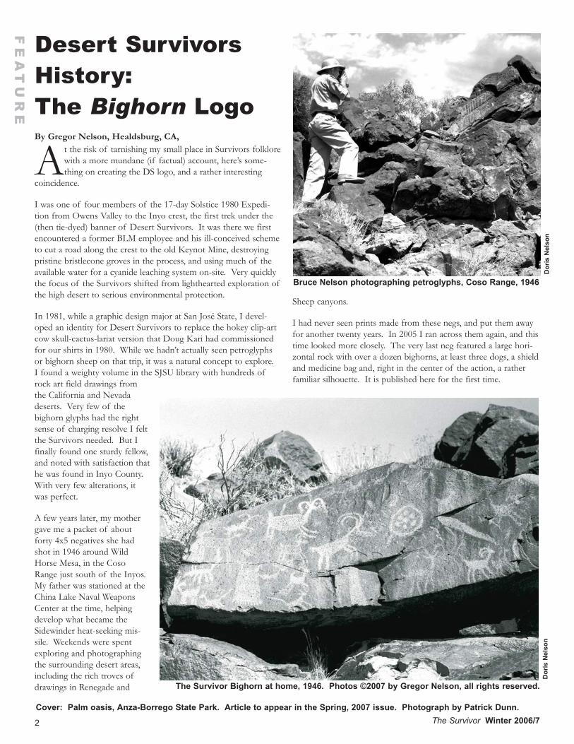
By Gregor Nelson, Healdsburg, CA,
At the risk of tarnishing my small place in Survivors folklorewith a more mundane (if factual) account, here’s some-thing on creating the DS logo, and a rather interesting
coincidence.
I was one of four members of the 17-day Solstice 1980 Expedi-tion from Owens Valley to the Inyo crest, the first trek under the(then tie-dyed) banner of Desert Survivors. It was there we firstencountered a former BLM employee and his ill-conceived schemeto cut a road along the crest to the old Keynot Mine, destroyingpristine bristlecone groves in the process, and using much of theavailable water for a cyanide leaching system on-site. Very quicklythe focus of the Survivors shifted from lighthearted exploration ofthe high desert to serious environmental protection.
In 1981, while a graphic design major at San José State, I devel-oped an identity for Desert Survivors to replace the hokey clip-artcow skull-cactus-lariat version that Doug Kari had commissionedfor our shirts in 1980. While we hadn’t actually seen petroglyphsor bighorn sheep on that trip, it was a natural concept to explore.I found a weighty volume in the SJSU library with hundreds ofrock art field drawings fromthe California and Nevadadeserts. Very few of thebighorn glyphs had the rightsense of charging resolve I feltthe Survivors needed. But Ifinally found one sturdy fellow,and noted with satisfaction thathe was found in Inyo County.With very few alterations, itwas perfect.
A few years later, my mothergave me a packet of aboutforty 4x5 negatives she hadshot in 1946 around WildHorse Mesa, in the CosoRange just south of the Inyos.My father was stationed at theChina Lake Naval WeaponsCenter at the time, helpingdevelop what became theSidewinder heat-seeking mis-sile. Weekends were spentexploring and photographingthe surrounding desert areas,including the rich troves ofdrawings in Renegade and
Sheep canyons.
I had never seen prints made from these negs, and put them awayfor another twenty years. In 2005 I ran across them again, and thistime looked more closely. The very last neg featured a large hori-zontal rock with over a dozen bighorns, at least three dogs, a shieldand medicine bag and, right in the center of the action, a ratherfamiliar silhouette. It is published here for the first time.
Desert SurvivorsHistory:The Bighorn Logo
The Survivor Bighorn at home, 1946. Photos ©2007 by Gregor Nelson, all rights reserved.
Bruce Nelson photographing petroglyphs, Coso Range, 1946
Dor
is N
elso
nD
oris
Nel
son
Contribute to TheSur vivor ; You’ll beGlad You DidDeadline for the summer issue is June 21,2007. Submissions (with maximum wordlength) may include letters-to-the-editor(200), feature articles (4000), trip reports(2000), desert conservation issues, articleson desert natural history, book reviews,backpacking/camping recipes, memberannouncements and original art. All sub-missions which relate to the mission ofDesert Survivors will be considered forpublication. All text must be submittedelectronically. Please send text longer thana paragraph as an attached file. Formatscurrently accepted (in order of preference)are: Word (.doc), WordPerfect (.wpd), RichText Format (.rtf) and text (.txt). Pleaseinclude your full name, city and state ofresidence and phone number with the sub-mission. For photographs, please identifythe people and locations shown. Digitalphotos need to be approximately 1600 pix-els resolution to be printed the full widthof a page (8.5 inches).
Mission Statement forDesert SurvivorsDesert Survivors is a nonprofit organiza-tion dedicated to desert conservation andexploration. Our members enjoy hiking inand learning about America’s desert lands,and seek to protect those areas for futuregenerations.
Desert SurvivorE-Mail, ListservDesert Survivors has two e-mail lists formembers, DSEM and DSOL. DSEMallows members to receive most regularmailings by e-mail rather than paper. Tripschedules, party and meeting announce-ments, alerts – everything except renewalnotices and The Sur v i vor arrive in yourinbox, often days before other membersreceive theirs in the mail. You receive100% of the text contents of the regularmailings (and nothing else). Desert Sur-vivors protects the e-mail addresses of itsmembers fully, never lending, selling or giv-ing them away to others.
DSOL is our listserv, which allows mem-
bers to broadcast e-mail to everyone elsesigned up for the listserv. Recent topicsincluded floods, desert wildflowers, roadconditions, and DS service trips. Be care-ful, though, to not inadvertently send per-sonal e-mail to the entire listserv.
Desert Survivor members may subscribe toeither DSEM or DSOL by e-mailing tor-toise, desert-survivors.org. For the subjectuse “subscribe regular mailings” forDSEM, and “subscribe listserv” for DSOL.Don’t include the quotation marks and doinclude in the body of the message yourname and address so that we can verifyyour membership. Unfortunately, we don’tyet have a completely automated system,and Tortoise can be a little slow, so it mighttake several days.
3The Survivor Winter 2006/7
SH
OR
T T
AK
ES
How to Reach Us
EditorPaul Brickett
(408) 279-3129
Membership InformationSteve Tabor
(510) 769-1706
Desert Survivor Websitewww.desert-survivors.org
Board of Directors
PresidentSteve Tabor
ActivitiesBob Lyon
CommunicationsPaul Brickett
ManagingLoretta Bauer
SecretaryDeborah Schreiber
VolunteerLynne Buckner
At Large Directors:
Jannet Schraer
Judy Kendall
Patrick Dunn
Dan Seneres
Nick Jedenoff
General CounselAlan Siraco
The Sur v i vor is printed byMy Printer, Berkeley, CA,
www.emyprinter.com.
LetterSteens Mistakes
April 16, 2007
Just some comments regarding the SteensMountain Carcamp article in the Fall, 2006issue:
The picture you have as viewing KigerGorge is actually Big Indian Gorge. Alsothe area that they are viewing from is onlyabout 500 yards from the Russ PengellyPlaque, founder of the Desert Trail, butapparently no viewing this or mention.The area viewed from is probably the bestof the Big Indian and near two goodcampsites.
The view you have listed as View downinto Kiger Canyon is actually a view fromthe East Rim to the Alvord Desert below.
It should be noted that after what theyhave called the Shepard’s Cabin, they hadto cross the upper Cirque of Little IndianGorge before dropping into the LittleWildhorse Gorge and Lake area. The LittleIndian was the first route of the DesertTrail before the Big Indian was bought outand land exchanged by the BLM. No men-tion of this.
Ross Edginton, Lake Oswego, OR
[See website for curent information]
FE
AT
UR
E
4 The Survivor Winter 2006/7
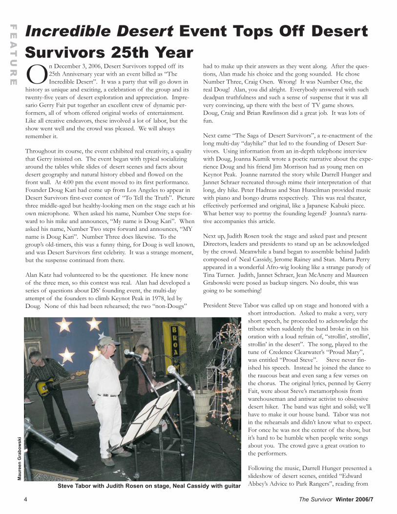
On December 3, 2006, Desert Survivors topped off its25th Anniversary year with an event billed as “TheIncredible Desert”. It was a party that will go down in
history as unique and exciting, a celebration of the group and itstwenty-five years of desert exploration and appreciation. Impre-sario Gerry Fait put together an excellent crew of dynamic per-formers, all of whom offered original works of entertainment.Like all creative endeavors, these involved a lot of labor, but theshow went well and the crowd was pleased. We will alwaysremember it.
Throughout its course, the event exhibited real creativity, a qualitythat Gerry insisted on. The event began with typical socializingaround the tables while slides of desert scenes and facts aboutdesert geography and natural history ebbed and flowed on thefront wall. At 4:00 pm the event moved to its first performance.Founder Doug Kari had come up from Los Angeles to appear inDesert Survivors first-ever contest of “To Tell the Truth”. Picturethree middle-aged but healthy-looking men on the stage each at hisown microphone. When asked his name, Number One steps for-ward to his mike and announces, “My name is Doug Kari”. Whenasked his name, Number Two steps forward and announces, “MYname is Doug Kari”. Number Three does likewise. To thegroup’s old-timers, this was a funny thing, for Doug is well known,and was Desert Survivors first celebrity. It was a strange moment,but the suspense continued from there.
Alan Katz had volunteered to be the questioner. He knew noneof the three men, so this contest was real. Alan had developed aseries of questions about DS’ founding event, the multi-dayattempt of the founders to climb Keynot Peak in 1978, led byDoug. None of this had been rehearsed; the two “non-Dougs”
had to make up their answers as they went along. After the ques-tions, Alan made his choice and the gong sounded. He choseNumber Three, Craig Osen. Wrong! It was Number One, thereal Doug! Alan, you did alright. Everybody answered with suchdeadpan truthfulness and such a sense of suspense that it was allvery convincing, up there with the best of TV game shows.Doug, Craig and Brian Rawlinson did a great job. It was lots offun.
Next came “The Saga of Desert Survivors”, a re-enactment of thelong multi-day “dayhike” that led to the founding of Desert Sur-vivors. Using information from an in-depth telephone interviewwith Doug, Joanna Kumik wrote a poetic narrative about the expe-rience Doug and his friend Jim Morrison had as young men onKeynot Peak. Joanne narrated the story while Darrell Hunger andJannet Schraer recreated through mime their interpretation of thatlong, dry hike. Peter Hadreas and Stan Huncilman provided musicwith piano and bongo drums respectively. This was real theater,effectively performed and original, like a Japanese Kabuki piece.What better way to portray the founding legend? Joanna’s narra-tive accompanies this article.
Next up, Judith Rosen took the stage and asked past and presentDirectors, leaders and presidents to stand up an be acknowledgedby the crowd. Meanwhile a band began to assemble behind Judithcomposed of Neal Cassidy, Jerome Rainey and Stan. Marta Perryappeared in a wonderful Afro-wig looking like a strange parody ofTina Turner. Judith, Jannet Schraer, Jean McAneny and MaureenGrabowski were posed as backup singers. No doubt, this wasgoing to be something!
President Steve Tabor was called up on stage and honored with ashort introduction. Asked to make a very, veryshort speech, he proceeded to acknowledge thetribute when suddenly the band broke in on hisoration with a loud refrain of, “strollin’, strollin’,strollin’ in the desert”. The song, played to thetune of Credence Clearwater’s “Proud Mary”,was entitled “Proud Steve”. Steve never fin-ished his speech. Instead he joined the dance tothe raucous beat and even sang a few verses onthe chorus. The original lyrics, penned by GerryFait, were about Steve’s metamorphosis fromwarehouseman and antiwar activist to obsessivedesert hiker. The band was tight and solid; we’llhave to make it our house band. Tabor was notin the rehearsals and didn’t know what to expect.For once he was not the center of the show, butit’s hard to be humble when people write songsabout you. The crowd gave a great ovation tothe performers.
Following the music, Darrell Hunger presented aslideshow of desert scenes, entitled “EdwardAbbey’s Advice to Park Rangers”, reading from
Incredible Desert Event Tops Off DesertSurvivors 25th Year
Steve Tabor with Judith Rosen on stage, Neal Cassidy with guitar
Mau
reen
Gra
bow
ski
FE
AT
UR
E
5The Survivor Winter 2006/7
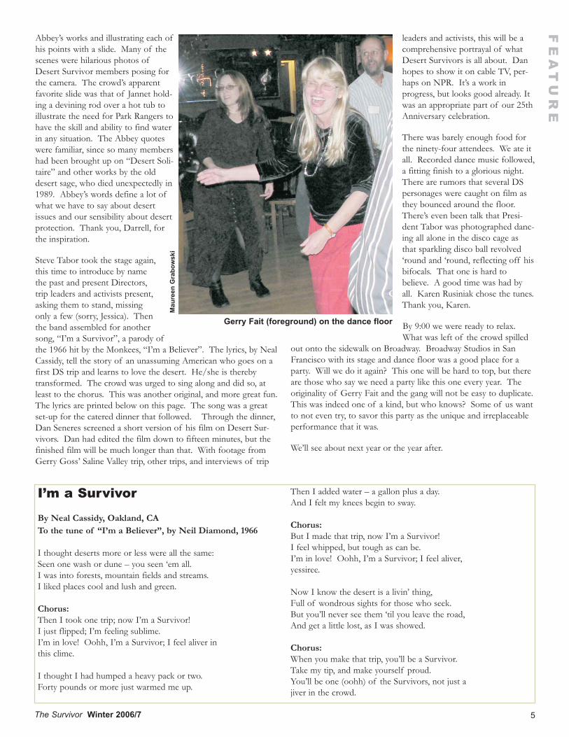
Abbey’s works and illustrating each ofhis points with a slide. Many of thescenes were hilarious photos ofDesert Survivor members posing forthe camera. The crowd’s apparentfavorite slide was that of Jannet hold-ing a devining rod over a hot tub toillustrate the need for Park Rangers tohave the skill and ability to find waterin any situation. The Abbey quoteswere familiar, since so many membershad been brought up on “Desert Soli-taire” and other works by the olddesert sage, who died unexpectedly in1989. Abbey’s words define a lot ofwhat we have to say about desertissues and our sensibility about desertprotection. Thank you, Darrell, forthe inspiration.
Steve Tabor took the stage again,this time to introduce by namethe past and present Directors,trip leaders and activists present,asking them to stand, missingonly a few (sorry, Jessica). Thenthe band assembled for anothersong, “I’m a Survivor”, a parody ofthe 1966 hit by the Monkees, “I’m a Believer”. The lyrics, by NealCassidy, tell the story of an unassuming American who goes on afirst DS trip and learns to love the desert. He/she is therebytransformed. The crowd was urged to sing along and did so, atleast to the chorus. This was another original, and more great fun.The lyrics are printed below on this page. The song was a greatset-up for the catered dinner that followed. Through the dinner,Dan Seneres screened a short version of his film on Desert Sur-vivors. Dan had edited the film down to fifteen minutes, but thefinished film will be much longer than that. With footage fromGerry Goss’ Saline Valley trip, other trips, and interviews of trip
leaders and activists, this will be acomprehensive portrayal of whatDesert Survivors is all about. Danhopes to show it on cable TV, per-haps on NPR. It’s a work inprogress, but looks good already. Itwas an appropriate part of our 25thAnniversary celebration.
There was barely enough food forthe ninety-four attendees. We ate itall. Recorded dance music followed,a fitting finish to a glorious night.There are rumors that several DSpersonages were caught on film asthey bounced around the floor.There’s even been talk that Presi-dent Tabor was photographed danc-ing all alone in the disco cage asthat sparkling disco ball revolved‘round and ‘round, reflecting off hisbifocals. That one is hard tobelieve. A good time was had byall. Karen Rusiniak chose the tunes.Thank you, Karen.
By 9:00 we were ready to relax.What was left of the crowd spilled
out onto the sidewalk on Broadway. Broadway Studios in SanFrancisco with its stage and dance floor was a good place for aparty. Will we do it again? This one will be hard to top, but thereare those who say we need a party like this one every year. Theoriginality of Gerry Fait and the gang will not be easy to duplicate.This was indeed one of a kind, but who knows? Some of us wantto not even try, to savor this party as the unique and irreplaceableperformance that it was.
We’ll see about next year or the year after.
Mau
reen
Gra
bow
ski
Gerry Fait (foreground) on the dance floor
I’m a Survivor
By Neal Cassidy, Oakland, CATo the tune of “I’m a Believer”, by Neil Diamond, 1966
I thought deserts more or less were all the same:Seen one wash or dune – you seen ‘em all.I was into forests, mountain fields and streams.I liked places cool and lush and green.
Chorus:Then I took one trip; now I’m a Survivor!I just flipped; I’m feeling sublime.I’m in love! Oohh, I’m a Survivor; I feel aliver inthis clime.
I thought I had humped a heavy pack or two.Forty pounds or more just warmed me up.
Then I added water – a gallon plus a day.And I felt my knees begin to sway.
Chorus:But I made that trip, now I’m a Survivor!I feel whipped, but tough as can be.I’m in love! Oohh, I’m a Survivor; I feel aliver,yessiree.
Now I know the desert is a livin’ thing,Full of wondrous sights for those who seek.But you’ll never see them ‘til you leave the road,And get a little lost, as I was showed.
Chorus:When you make that trip, you’ll be a Survivor.Take my tip, and make yourself proud.You’ll be one (oohh) of the Survivors, not just ajiver in the crowd.
6 The Survivor Winter 2006/7
The Saga of Desert Survivors
By Joanna Kumic, Oakland, CA
On the eastern side of the Sierra Nevada lies a spectacularvalley rivaled by none in its beauty. Bordered by theInyos to the west, the Saline and Last Chance ranges to
the east, and high passes to the north and the south, the SalineValley offers solitude and a feeling of being very far away. It wasin this rugged land in May of 1978 that Desert Survivors wasfounded. The saga goes something like this.
One sunny hot afternoon, four long shadows suddenly appearedacross the desert floor. Seeking adventure, the young studentshad come to the valley to climb up to the Keynot Mine. Theyquickly set out climbing. Higher and higher they scrambled, final-ly reaching a mine tunnel a day and a half later where, luckily, theyfound water.
The following morning, inspired by the magnificence of the risingsun and fueled by an intense desire for discovery, Doug Kari andJim Morrison set out for a day hike. Dressed in shorts andt–shirts with two quarts of water between them, they maneuveredupward.
Morning soon gave way to afternoon, while adventure turned intostruggle. In their excitement and innocence, they forgot the firstcode of the desert, be prepared and carry a lot of water.Exhausted and thirsty they reached the summit of Keynot Peak atsunset.
Darkness fell, freezing temperatures enveloped them, and theywere out of water. It would be a long, cold, sleepless night. Howto survive until daybreak was the only thought on their minds.
Shivering….. Oh, the unbearable cold! Make a fire, get warm!
Thirsty….. Water, water! Melt snow, soothe dry throats!
In the moonlight they stuffed snow, twigs, dirt, bugs, and all intoan old two gallon metal canteen they had found at the Keynot siteand used it as a cooker to melt snow.
Calm descended over them as their bodies warmed and thirstabated. Overhead the sky shimmered with starlight. The moonwas full. From a perch high above them, an owl gazed down andquietly hooted as if to say “you did well, boys!”
At daybreak, they began their descent. Exhausted and over-whelmed by the vastness of the landscape, they realized howdeceptive distance is. Ridges can turn into rock faces, gentleslopes can end at sheer cliffs. It was important to read the landcarefully, to keep cool and not panic or get hurt, to talk about theroute and make sensible decisions. If only they had marked thetrail on the way up!
Stumbling, rocks slipping away under foot, losing the route,retracing steps, finding it again, the descent continued. Down,down they went discussing the importance of carrying extrawater, food, a daypack with emergency supplies, a flashlight andcompass, extra clothes.
36 hours later, weary but so much wiser, Doug and Jim reachedcamp and found their companions had gone to seek search andrescue help.
The next day they descended to the valley floor and waited until ahelicopter appeared. Triumphant, they refused it proclaimingthemselves to be “desert survivors!”
And that, my fellow Survivors, is how it all began!
FE
AT
UR
E
The Incredible Desert, ADesert Survivors 25th Anniver-sary Event: Credits
Conceived and directed by Gerry Fait Special thanks toCathy Luchetti, Stan Huncilman and Broadway Studios forproviding rehearsal space and artistic support.
Large Visual Presentations Desert Facts by Gerry Fait;Slides of the Namibian and Californian Deserts by Judy KendallSlides of the Coso Petroglyphs by Li Miao Lovett Slide projectionby Ed Anderson To Tell The Truth Moderator played by GerryFait Contestants played by Craig Osen, Brian Rawlinson andDoug Kari Panel Member played by Alan Katz.
The Saga Of Desert Survivors - A Re-Enactment Of The DayHike That Led To The Founding Desert Survivors Written andread by Joanna Kumik Mimes played by Darrell Hunger and Jan-net Schraer Original improvised music by Peter Hadreas (piano)and Stan Huncilman (bongos) Set design (slide of Inyo Moun-
tains) by Bob Ellis Lighting design by Ed Anderson.
Proud Steve Music by John Fogerty Lyrics by Gerry Fait Moder-ated by Judith Rosen Performed by Jerome Rainey (guitar, voice),Neal Cassidy (guitar, voice), Stan Huncilman (bongos), MaureenGrabowski (voice, tambourine), Jannet Schraer (voice), JudithRosen (voice) and Marta Perry in the part of Tina Turner Tina’scostume design by Marta Perry.
Edward Abbey’s Advice To Park Rangers Read and interpretedby Darrell Hunger Slides designed and photographed by DarrellHunger Projection by Ed Anderson.
I’m A Survivor Music by Neil Diamond Lyrics by Neal CassidyPerformed by Neal Cassidy (guitar, voice), Jerome Rainey (guitar,voice), Maureen Grabowski (voice, tambourine), Judith Rosen(voice), Jannet Schraer (voice), Marta Perry (voice) and Jean McA-neny (voice).
Film Preview: Documentary Of Desert Survivors Written anddirected by Dan Seneres Filmed by Jim Grannato and Yun Shin.
Dancing Music selection by Karen Rusiniak.

Thank You To The Organizers OfOur 25th Anniversary Events
Desert Survivors 25thAnniversary events in2006 were a great suc-
cess, thanks primarily to thosewho conceived of and orga-nized them. As with all of ourendeavors, we are dependent onvolunteers to get things done,and done right.
On April 14-17, Craig Deutscheled six Survivors on a rigorousfour-day backpack from SalineValley to the crest of the InyoMountains. This trip wasdesigned as a re-enactment of thefounders’ epic journey to the Inyocrest in 1978, the subject of our “Founders’ Legend”. See theSummer 2006 Survivor for the story. Thank you, Craig.
In the Fall, KarenRusiniak orga-nized the 2006Benton Bash(September 22-24), a three-dayencampment atBenton HotSprings in theEastern Sierrawhich also servedas the group’sAnnual Meeting.
Eighty-seven people attended; fifty stayed for the meeting. Withsuch a large membership present and with many sub-events (hikes,a treasure hunt, a sing-along) to keep track of and details to con-sider, Karen had quite a challenge but came through strong. Ben-ton was a watershed event for the group, unlike any other. It sets astandard for future Annual Meetings, and we plan to do it againthis year. See the Fall 2006 Survivor for the story. Thank you,Karen.
On October 27-29, Gerry Goss led an anniversary trip to SalineValley, Desert Sur-vivors’ spiritualhome along withthe Inyos. Mem-bers visited SalineHot Springs, pluscanyons in theInyos and the Cot-tonwood Moun-tains. To thosewho attended, thesewere inspiring hikesto some of the
amazing placeswhere it all began.Thank you, Gerry,for this tribute to ourheritage.
Gerry Fait con-ceived of our“IncredibleDesert” eventon December 3and carried itthrough to success.With everythingplanned from scratch, dependent on pure creativity, this highlyoriginal event demanded acute attention. It was unique. Read thestory on the event in this issue. Thank you, Gerry, for that phe-nomenal evening. It was a surprise and a joy for everyone.
Year 2006 was a bold one for Desert Survivors. No telling whenwe’ll again reach this level of outstanding events, but we hope it’llbe before our 50th Anniversary. Watch these pages for futureevents like these.We’re already plan-ning another BentonBash for next Falland an Issues Con-ference in Novem-ber 2007. We’ll needyour help as volun-teers. Contact Vol-unteer CoordinatorLynne Buckner ifyou want to helpwith future events orhave ideas for eventsof your own. Herphone is (415) 824-5454..
7The Survivor Winter 2006/7
FE
AT
UR
E
Linda Ryan
Mau
reen
Gra
bow
ski
Odessa Schraer modeling part of TinaTurner costume
Ed Anderson at the controls
Jannet Schraer and Neal Cassidy
Steve as go-go dancer
Mau
reen
Gra
bow
ski
Mau
reen
Gra
bow
ski
Mau
reen
Gra
bow
ski
Mau
reen
Gra
bow
ski
Petroglyphs
By Mimi Merrill
Feb. 2, 1986
My own flawed quick notesAre not like thoseOf the singer who sang of Beowulf,Nor the Bard who graced blue Avon’s shore.No. The poet whose work is most like mineChipped stone, rubbed rock,And worked a wordless tune on granite’s face,In caves or in the desert’s emptiness;Or scratched a feather dipped in dragon’s bloodAcross a drying autumn leaf,And flung it to a nameless wailing windWhose passage brought it to my door.
PO
ET
RY
By Steve Tabor
Desert Survivors histories have been written for the period1981 to 1989 by Don Falk (1990), and for the period1990 to 1994 by Steve Tabor (1994). This article brings
that history up-to-date, 1995 to the end of 2006. The history ofDS’ issues involvement is too complex to be included here. Watchfor an “Issues History” in the next issue of The Sur v i vor.
With the passage of the California Desert Protection Act (CDPA)on October 31, 1994, Desert Survivors and the rest of the desertprotection activist community entered a new era. For the first timethe U.S. Congress recognized the value of the California Desert byprotecting, all at once, millions of acres as Wilderness, NationalParks and a National Preserve. Death Valley and Joshua TreeNational Monuments became National Parks and a new Preservewas created in the East Mojave Desert. Sixty new WildernessAreas were created on Bureau of Land Management land, and adozen more were formed in the National Park Service properties.It had taken eight years of struggle; the CDPA had been intro-duced in 1986. But to those of us who had worked long and hardfor desert Wilderness, the victory was a sweet one.
Celebrations however were short-lived. After the 1994 election,Republican Party leaders, who had fought hard against the bill,sought its revenge by trying to repeal it. They also tried to short-circuit the new Mojave National Preserve by cutting its funding to$1.00 per year. The Clinton Administration supported the Pre-serve by finding money elsewhere in the Interior Department bud-get, but it was clear that environmentalists, and especially publicland protection advocates, were in for a long fight once again.
But with the passage of the CDPA, Desert Survivors suddenlyfound itself an ally of the Bureau of Land Management (BLM)instead of an adversary. For years, the group had been battlingwith the BLM for more protection of Wilderness Study Areas andwildlife, and demanding control of mining, grazing and off-roadvehicles. The group’s relationship with the agency, mildlydescribed as “at loggerheads”, was legendary in the community. Infact, antagonism with various BLM operatives had come to defineDesert Survivors’ reputation as we found, again and again, that theBLM had allowed one and then another outrageous action by thisor that rancher, prospector or vehicle junkie.
In 1995 that all changed. DS Directors and leaders began toreceive calls from BLM land managers asking us to help protect itand to monitor degradation of resources. Part of this was budgetcuts by the Republican-controlled Congress, but part was also dueto a curious role-reversal. The attitude seemed to be, “well, nowthat you’ve got your Wilderness Areas, you’ve got to help us man-age them”. In 1995 and 1996, DS was besieged with requests fromrangers on the ground to help do boundary marking of the newWilderness Areas. We developed healthy relationships with severalBLM ground men. So strapped for cash was the agency that off-duty fire crews, prisoners and environmental groups were beingasked to survey and mark the new boundaries. One of the WAs,
Pahrump Valley, was boundary-marked almost entirely by DesertSurvivors. It was a novel situation.
The group also began to get calls to perform service trips. Therewere boundary signs to put up, old roads to obliterate, springs torestore and trash to be removed. Most leaders refused to performthe latter task, but the former three were attacked with enthusiasm.It felt good to be wanted, also to make positive connections withmany Wilderness Specialists and Volunteer Coordinators, all ofwhom we found were good people. We also found the hard edgeof many a Field Office Manager (the head man in the office)blunted. Our concerns about wildlife and Wilderness integritywere now treated with respect. Several “bad apples”in the agencieswent on to other things, perhaps in states more redneck or cowboythan California.
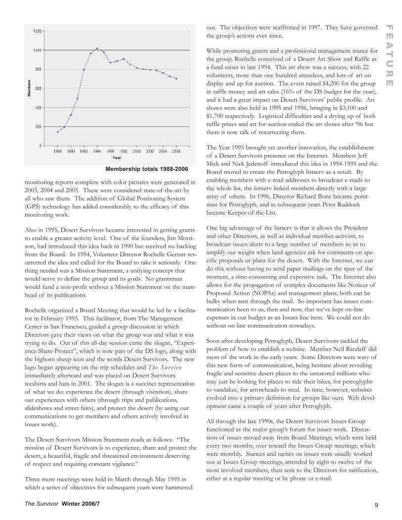
In March of 1995, Desert Survivors membership reached an all-time high: 1,101. It was never to exceed that figure again. Interestin the desert on the part of the general public (and the hiking pub-lic) began to wane after the Protection Act was passed. The antag-onism of the gonzo Republicans in the House of Representatives,their rabid rejection of environmental safeguards and Wildernessprotection, may also have been a factor; as they seemed to cast astrange voodoo on the public. Though the DS trips program wasexpanding, with 1994 totals the highest ever (46 trips with 545 par-ticipants), people stopped calling to join and new member totalsbegan to drop. Neither trip participation nor membership totalshave ever been as high again as they were then. (See the graph ofmembership totals over time on the next page.)
Since then, Desert Survivors has retained most members from yearto year. Membership renewal rates regularly top 70%, and typically,30-40% of those renewing endorse the groups’ efforts throughadditional donations sent in with their membership checks. Afterthe big fall-off in 1995 and 1996, membership figures stabilized at750 to 850 for many years. Only recently has membershipdropped to 700.
Service trips of the type described above have become a feature ofthe Desert Survivors trips program. The group usually offers 10-15 each year; five or ten are actually performed (some service tripsdo not generate enough member interest to justify the leader’sshowing up at the trailhead). Desert Survivors has signed a coop-erative agreement with the BLM at the new Black RockDesert/High Rock Canyon National Conservation Area, enablingmembers to obtain reimbursement if they show up at an NCA-scheduled volunteer project. Proximity to the SF Bay Area has cre-ated a demand for volunteer DS labor. The group has a good rap-port with NCA managers.
Desert monitoring trips have also become important. DS tripleaders are often asked to go into an area, usually a Wilderness, andreport back to land managers about abuses they observe, usuallyoff-road vehicle and grazing abuse. Reports are given, either verbalor written, once the place has been examined. Several good-quality
8 The Survivor Winter 2006/7
FE
AT
UR
E
Desert Survivors History, 1995-2006
9The Survivor Winter 2006/7
monitoring reports complete with color pictures were generated in2003, 2004 and 2005. These were considered state-of-the-art byall who saw them. The addition of Global Positioning System(GPS) technology has added considerably to the efficacy of thismonitoring work.
Also in 1995, Desert Survivors became interested in getting grantsto enable a greater activity level. One of the founders, Jim Morri-son, had introduced this idea back in 1990 but received no backingfrom the Board. In 1994, Volunteer Director Rochelle Gerratt res-urrected the idea and called for the Board to take it seriously. Onething needed was a Mission Statement, a unifying concept thatwould serve to define the group and its goals. No grantsmanwould fund a non-profit without a Mission Statement on the mast-head of its publications.
Rochelle organized a Board Meeting that would be led by a facilita-tor in February 1995. This facilitator, from The ManagementCenter in San Francisco, guided a group discussion in whichDirectors gave their views on what the group was and what it wastrying to do. Out of this all-day session came the slogan, “Experi-ence-Share-Protect”, which is now part of the DS logo, along withthe bighorn sheep icon and the words Desert Survivors. The newlogo began appearing on the trip schedules and The Sur v i voimmediately afterward and was placed on Desert Survivorsteeshirts and hats in 2001. The slogan is a succinct representationof what we do: experience the desert (through visitation), shareour experiences with others (through trips and publications,slideshows and street fairs), and protect the desert (by using ourcommunications to get members and others actively involved inissues work).
The Desert Survivors Mission Statement reads as follows: “Themission of Desert Survivors is to experience, share and protect thedesert, a beautiful, fragile and threatened environment deservingof respect and requiring constant vigilance.”
Three more meetings were held in March through May 1995 inwhich a series of objectives for subsequent years were hammered
FE
AT
UR
Eout. The objectives were reaffirmed in 1997. They have governedthe group’s actions ever since.
While promoting grants and a professional management stance forthe group, Rochelle conceived of a Desert Art Show and Raffle asa fund-raiser in late 1994. This art show was a success, with 22volunteers, more than one hundred attendees, and lots of art ondisplay and up for auction. The event raised $4,200 for the groupin raffle money and art sales (16% of the DS budget for the year),and it had a great impact on Desert Survivors’ public profile. Artshows were also held in 1995 and 1996, bringing in $3,100 and$1,700 respectively. Logistical difficulties and a drying up of bothraffle prizes and art for auction ended the art shows after ‘96 butthere is now talk of resurrecting them.
The Year 1995 brought yet another innovation, the establishmentof a Desert Survivors presence on the Internet. Members JeffMick and Nick Jedenoff introduced this idea in 1994-1995 and theBoard moved to create the Petroglyph listserv as a result. Byenabling members with e-mail addresses to broadcast e-mails tothe whole list, the listserv linked members directly with a largearray of others. In 1996, Director Richard Bone became point-man for Petroglyph, and in subsequent years Peter Ruddockbecame Keeper-of-the-List.
One big advantage of the listserv is that it allows the Presidentand other Directors, as well as individual member-activists, tobroadcast issues alerts to a large number of members so as toamplify our weight when land agencies ask for comments on spe-cific proposals or plans for the desert. With the Internet, we cando this without having to send paper mailings on the spur of themoment, a time-consuming and expensive task. The Internet alsoallows for the propagation of complex documents like Notices ofProposed Action (NOPAs) and management plans; both can bebulky when sent through the mail. So important has issues com-munication been to us, then and now, that we’ve kept on-lineexpenses in our budget as an Issues line item. We could not dowithout on-line communication nowadays.
Soon after developing Petroglyph, Desert Survivors tackled theproblem of how to establish a website. Member Neil Ratzlaff didmost of the work in the early years. Some Directors were wary ofthis new form of communication, being hesitant about revealingfragile and sensitive desert places to the untutored millions whomay just be looking for places to ride their bikes, for petroglyphsto vandalize, for arrowheads to steal. In time, however, websitesevolved into a primary definition for groups like ours. Web devel-opment came a couple of years after Petroglyph.
All through the late 1990s, the Desert Survivors Issues Groupfunctioned as the major group’s forum for issues work. Discus-sion of issues moved away from Board Meetings, which were heldevery two months, over toward the Issues Group meetings, whichwere monthly. Stances and tactics on issues were usually workedout at Issues Group meetings, attended by eight to twelve of themost involved members, then sent to the Directors for ratification,either at a regular meeting or by phone or e-mail.
Membership totals 1988-2006

10 The Survivor Winter 2006/7
Director Helen Wagenvoord, a veteran of the National Parks Con-servation Association and other non-profits, became directlyinvolved in the Issues Group starting in 1996. Other strongactivists were Bob Ellis, Dave McMullen, Dave Halligan, and JanetJohnson, the Chair. From 1993 through the Issues Group’s demisein 2001, Janet chaired the meetings at her home and produced reg-
ular minutes that became the bible for members following ourissues work. The Board of Directors used them to set priorities,members used them to lobby politicians and agency personnel, andthey became a public record of what was happening in the desertfor that whole era.
FE
AT
UR
E
Year/Month Location Leader1994Aug Bodie Hills fencing Dickes1995Apr San Benito Mountains EllisMay Blue Eagle (NV) Wilderness signing EllisMay Owens Peak WA trail maintenance O’RileyOct Inyo Wilderness road survey GossOct San Benito Mountains EllisNov Nopah Wilderness boundary signing Tabor1996Mar Desert Tortoise Natural Area (DTNA) McMullenMar Pahrump Valley Wilderness signing de BellisMar Pahrump Valley Wilderness signing TaborApr Joshua Tree NP trash removal McMullenApr Quartz Spring (DVNP) fence removal McMullenApr Diablo Range (San Benito County) EllisJun Bodie Hills fencing HoltenSep Inyo Mountain road survey EllisSep East Sierra native plant restoration TaborOct DTNA fence removal McMullen1997Mar DTNA fence maintenance McMullenJun Bodie Hills fencing HoltenJun Sheldon Wildlife Refuge fence removal TaborSep Steamboat Rock (BRD) trash removal EllisOct Massacre Rim fire break TaborOct Eureka Valley native plant survey EllisNov DTNA fence maintenance O’Riley1998Mar Desert Tortoise Natural Area (DTNA) McMullenApr Rainbow Talc Mine monitoring TaborJun Bodie Hills fencing de BellisAug Bodie Hills fencing TaborNov DTNA fence maintenance McMullen1999Mar DTNA signage, clean-up & site survey McMullenJun Massacre Rim Wilderness signing HoltenOct Fish Slough native plant restoration TaborNov Nopah Wilderness boundary signing DeutscheNov DTNA signage, clean-up & site survey McMullen2000Feb Palen-McCoy Wilderness road restoration TaborMar DTNA signage, clean-up & site survey McMullenApr Rest Spring Wilderness boundary signing DeutscheApr Black Rock Desert boundary signing O’RileyOct DTNA signage, clean-up & site survey McMullen
2001Jan Little Marias Wilderness road restoration Tabor Mar Selenite Wilderness boundary signing O’RileyApr DTNA signage, clean-up & site survey McMullenApr Black Rock NCA Volunteer Training O’RileyMay Black Rock NCA Leave No Trace training O’RileyMay North Black Rock Range monitoring Ellis2002Jan Mecca Hills Wilderness road restoration Tabor May Carrizo Plain fence removal LyonOct DTNA signage, clean-up & site survey McMullen2003Mar Calumet Water Search (monitoring) TaborMar DTNA signage, clean-up & site survey McMullenApr Golden Valley Wilderness monitoring McMullenApr Bighorn Mtns. Wilderness monitoring TaborSep Black Rock Desert Service Trip DuPertuisOct Steam Wells (Golden Valley) fencing DickesNov Sheephole Mtns. Wilderness monitoring TaborNov Sheephole Mtns. Wilderness monitoring Tabor2004Jan Clipper Mtns. Wilderness monitoring TaborFeb Piutes/Little Piutes Wilderness monitoring TaborMar Carrizo Plain fence removal DeutscheApr Kingston Range RS2477 road survey LyonApr Bright Star Wilderness road concealment DeutscheApr Woods Mtns. WA RS2477 road survey McMullenMay Black Rock Desert road concealment DuPertuisJul Little High Rock Wilderness monitoring TaborSep Little High Rock Wilderness monitoring TaborSep Black Rock Desert Service Trip LyonOct Piper and Sylvania WA boundary blockage DeutscheNov Algodones Dunes ORV monitoring TaborDec Darwin Falls WA road concealment DeutscheDec Little Picacho Pk Wilderness monitoring Tabor2005Jan Bristol Mtns. Wilderness monitoring TaborFeb Piute Mtns. Wilderness monitoring TaborMar Old Woman Mtns. Wilderness monitoring TaborApr DTNA signage, clean-up and site survey McMullenApr Coalinga Mineral Spgs. trail maint. LyonApr El Paso Mtns. Wilderness monitoring TaborApr Surprise Canyon monitoring (DVNP) McMullenSep Black Rock Desert road concealment LyonDec Horsethief Roundup cleanup Deutsche2006Feb Picacho Peak Wilderness Monitoring DeutscheApr Bright Star Wilderness road concealment DeutscheApr Mecca Hills Wilderness monitoring LyonNov Inyo Mountains Tamarisk Removal Lyon
Desert Survivors Service and Monitoring Trips, 1994-2006
11The Survivor Winter 2006/7
FEATURE
When members stopped showing up at meetings, Janet kept up thework as an Issues Chronicle for awhile, then discontinued it. LiMiao rejuvenated the Issues Group in 2003, but since then spo-radic in-line communication and actions by the President andBoard have been substituted. In the environmental communitygenerally, on-line blasts have become the substitute for face-to-facemeetings in issues work. What this portends for the future of ourmovement in this age of SPAM is an open question.
In 1997, another attempt was made to get grants for Desert Sur-vivors. Helen Wagenvoord and Steve Tabor managed to get agrant from San Francisco’s Peradam Foundation in the amount of$10,000. This was originally given as seed money with which tohire a staff person or two, both to build the group’s membershipand do issues work. Over the course of a three-year period, 1997-1999, Steve and Helen wrote three major grant proposals and aseries of minor ones in the hope of increasing the budget by$20,000-30,000 per year. Except for a couple of minor amounts,one for $1500, another for $3500, these efforts were unsuccessful.In 1999 the Board of Directors released the Peradam funds to payfor issues work instead of organization-building. Much of ourwork on the Bodie RV Park and other campaigns were fundedwith this money. Almost all of Desert Survivors work downthrough the years has been funded by membership dues and dona-tions. With the end of the dot-com boom, foundation funds forenvironmental work become harder to get and further DS work ingrants has been shelved..
The Year 1997 also saw an utterly new focus to Desert Survivorsactivities, the Desert Trail. The Desert Trail, or Desert Trail Corri-dor, was designed as a continuous hiking route, in the desert, fromMexico through the Sonoran, Mojave and Great Basin Desertsinto Oregon and eventually to Canada. The route uses existingfoot trails, jeep trails and cross-country travel to get from point topoint. The way is shown with compass bearings and GPS read-ings.
In 1997 Steve Tabor mapped out the route in California and Neva-da and began proving out individual segments using hikes on Sur-vivor trip schedules as the test. Fall and Winter hikes were usedfor California routes, while Nevada routes were done in Spring andSummer. From May 1997 to September 2000, Steve led fortyreconnaissance trips on the Desert Trail route in the two states.From time to time he would fill in the blanks on private excur-sions. Meanwhile member George Huxtable led eight private tripsto map the route in Death Valley. Almost all of these were three-or four-day backpack trips from point-to-point, complete withmap tracings, elevation records and (later) GPS positions. It was aunique, challenging and ultimately satisfying endeavor for both.
Steve and George gained an endorsement of the California routeat the Desert Trail Association (DTA) meeting in May 1999. Oneyear later, Steve, Bob Ellis and Ol’ Creosote (a.k.a. D.W. Tomer,former head of the California DTA) gained approval for theNevada section in May 2000. Since then Steve and George havedocumented the routes in both states in published guidebooks.The Desert Trail routes have gained publicity through numerousnewspaper and magazine articles, putting the Desert Trail “on the
map” as a unique and exciting route for long-distance trekking.
Desert Survivors organized a Desert Trail Relay on the first twelvesegments in California in January-March, 2001. Each segment hada different leader listed in the trip schedule and new memberswould gather at each trailhead to continue the next part of thejourney. A celebration was held at end of the Relay at KelsoDunes. In the fall of 2001, another relay was performed on thelast fourteen California segments, from Kelso through Death Val-ley to the Nevada border. Similar relays were done for the Nevadasegments, the first half in 2004 and the last half in 2005. Thus theDesert Trail was proved out as a viable route for backpackers.Dispatches from the relays made for some of the most excitingtrip reports of those years. A relay on the northern routes in Ore-gon is now contemplated.
Starting in 2000, Desert Survivors received an intense rechargefrom the advancement of Jessica Rothhaar to the Board of Direc-tors. Jessica devised a membership survey in that year, the first forDesert Survivors since 1993. The survey produced many new vol-unteers for the group. Jessica became Membership Director at the2000 Annual Meeting and promptly devoted her considerable ener-gies to the first Desert Trail Relay in early 2001. Through her pub-licity efforts she managed to get a couple of newspaper articlesprinted. She led one segment in the first relay and two segmentsin the second relay in 2001.
At the 2001 Annual Meeting, Jessica was elected CommunicationsDirector. Along with Art Director Hall Newbegin, they changedThe Sur v i vor , Desert Survivors’ quarterly journal, from a brownpaper magazine to glossy white. The heavy white paper wouldallow for good photo reproduction, allowing for pictures at goodresolution to enhance the text. This change was expensive and, asis often the case with new things, was resisted by several Directors.But the new Sur v i vor was a “smash hit”, receiving much positivefeedback from members. The desert’s wide landscapes are tailor-made for photography, and the inclusion of people in the picturespersonalized trip reports as nothing else could. Jessica and Halledited and did layout for two years. Since then, current Communi-cations Director Paul Brickett has continued this process. TheSur v i vor is now one of the group’s most impressive offerings, giv-ing much joy to members and non-members alike.
In 2002 Jessica initiated a new format for the Desert SurvivorsAnnual Meeting. The 2001 meeting was almost a disaster. It washeld on a rainy December Saturday less than two months after the9/11 attacks and lacked a quorum. Some quick phone callsbrought more members in so the meeting could proceed, but thesedifficulties were a wake-up call. Jessica’s plan was to replace thetraditional meeting in 2002 with a Desert Conference. Presenta-tions would be made by desert protection activists, and workshopswould be held afterward. The actual business meeting (bylawsamendments and the election of officers) was relegated to an hourand fifteen minutes. The idea behind this was to give the member-ship a stronger reason to attend. In the process, interest in desertissues would be rekindled, and more member involvement wouldbe fostered.
12 The Survivor Winter 2006/7
The new plan worked. The first desert conference/annual meetingin 2002 drew 56 members. Speakers included Paul Brink of theBLM’s Sacramento State Office, Chris Roholt of the BLM’s DesertDistrict Office in Riverside, and Brendan Cummings of the Centerfor Biological Diversity, plus DS’ own Dave Halligan (speaking onmilitary expansion) and Bob Ellis (speaking on off-road vehicledamage). The speakers were followed by workshops in whichmembers explored how to get involved in various issues. Out ofthis came a rejuvenated Issues Group led by Li Miao.
We continued the format in 2003, 2004 and 2005, with morespeakers, plus a “Desert Jeopardy” game, and dancing in theevening. In 2003 we had Steve Tabor with an explanation of theCalifornia Desert Protection Act, Helen Wagenvoord (WildSpaces) with a overview of the vast array of threats to the desert,and Byron Kahr (California Wilderness Coalition) on the RS2477threat to the desert pursued by off-roaders, followed by DaveLefevre (BLM Winnemucca Office) on the new Black Rock DesertNational Conservation Area. In 2004, speakers were Phil Klasky,who spoke about his community organizing against off-roaders inWonder Valley and the Twenty-nine Palms area, and Gerry Goss,who gave a demonstration of GPS technology and how to use it inthe desert. Speakers in 2005 were Paul McFarland of Friends ofthe Inyo, who spoke about several issues in the Eastern Sierra, andJon Harman, who gave a presentation on the digital enhancementof photographs in archaeology, especially petroglyphs. At all threeconferences, speakers were followed by a potluck dinner and con-tra dancing to the tunes of The Cactus Huggers, a live band.
By 2003, it was clear that the Desert Survivors website neededsome improvement. Jessica, as Communications Director, called ameeting to get feedback on what was needed to make the websitemore representative of the group and more informative to thegeneral public. Out of this meeting, attended by ten members,Dave Launchbury emerged as the new webmaster. He redesignedthe DS website and maintained it regularly from 2003 to 2005, atwhich time it really came into its own. Websites always need reju-venation, so ours is currently undergoing yet another revision atthis writing. The URL is http://desert-survivors.org .
Also in 2003, Desert Survivors amplified its Desert Survivors Elec-tronic Mail (DSEM) capability. This service was conceived anddirected by Director Peter Ruddock in 2001 and 2002 and is stillmaintained by him. Members can sign up to discontinue papercopies and receive Desert Survivors mailings via e-mail, thus savingboth paper and expenses for the group. In excess of 120 mem-bers, 17% of the membership, now receive their mailings, exceptfor The Sur v i vor , in this way. To sign up for this service, send ane-mail to tortoise, desert-survivors.org with the subject line “sub-scribe regular mailings”. Put your name and postal address in thebody of the message.
In 2004 Desert Survivors began accepting payments for dues andteeshirt/hat sales via credit card, using the payment service “Pay-Pal” through the group’s website. For many members this hasbecome a convenient way to pay bills. The group pays for the ser-vice on a per use basis, so no extra funds are taken from the mem-ber’s credit card except as stated. You get what you pay for. We
hope more members will use this service, since it saves us a lot inpaperwork and check clearings, especially for renewals. To use thisservice, go to http://desert-survivors.org click on the RenewMembership button, and then click on the PayPal icon.
Down through the years, Desert Survivors has kept up its outreachprogram and its trips program, two key methods in which thegroup makes contact with the outside world. For many years,Steve Tabor did slideshows at backpack shops and meetings ofenvironmental groups, reaching thousands of citizens with themessage that the desert is beautiful and worth saving. The grouphas staffed tables at environmental fairs since 1990, most notablythe old San Francisco Chronicle Outdoors Fair from 1991 to 1996,the Contra Costa Earth Day Fair from 1991 to 2000, the SolanoStroll in Albany from 2000 to present, and the Berkeley Earth DayFair from 1991 to present. At these fairs, members have handedout some 10,000 pieces of Desert Survivors literature and havespoken directly to several thousand persons. These efforts havemade our group well known to those interested in desert protec-tion in the San Francisco Bay Area. Our liaisons with other envi-ronmental groups statewide and in Nevada have added to thegroup’s reputation for excellence in desert education and protec-tion outside the area.
Further work has been done locally in educating folks about thedesert through our Technical Seminar and Beginner BackpackSeminar. From 1991 to 2003, the group held a Technical Seminareach summer to familiarize members with aspects of conductingtrips in the desert. Anywhere from ten to twenty-four membersgathered in a local park to study trip planning, first aid and map-and-compass. Originally designed for potential trip leaders, thissoon became a way for ordinary members to learn how to designtheir own trips. Starting in 2000, trip leader Bob Lyon beganteaching his Beginner Backpack Seminar at the annual SummerPicnic. Bob focuses on equipment and techniques designed forbackpacking in the desert, especially on how to travel light andeasy. The Beginner Backpack Seminar is now held every year. TheTechnical Seminar, discontinued since 2004, will be brought backin 2007.
Through all these years, Desert Survivors has also continued itstrips program (see Trip Statistics on following page). From 30 to45 trips have been conducted each year, about evenly dividedbetween carcamps and backpacks except for years when we’vedone Desert Trail Relays, which are heavily skewed toward back-packs. Since 1989, the group has led 675 trips with some 5900participants. These trips have concentrated on desert WildernessAreas and Wilderness Study Areas, both BLM and Parks, mostly inCalifornia and Nevada, with a few trips in Utah, Oregon, Arizonaand New Mexico.
A host of leaders have designed and led these trips. This has beenthe “retail” side of Desert Survivors activities, and it has beentremendously successful. A major part of Desert Survivors’ repu-tation is due to the incredible range of exploration conducted bymembers on these trips. These explorations are unsurpassed bothwithin and outside the environmental community. Other groupsand BLM and Park Service personnel themselves come to us when
FE
AT
UR
E
13The Survivor Winter 2006/7
FE
AT
UR
Ethey need information on specific areas. The trips are fun, butthey also bear witness to the land, its beauty and the need to pro-tect it. DS has been a shining light when it comes to knowledgeof the desert.
In 2006, Desert Survivors celebrated its 25th Anniversary withseveral events. In April, Craig Deutsche led a multi-day backpacktrip to the Inyo Mountains on the route used by Founders DougKari and Jim Morrison on their initial trip in 1978. It was out ofthat trip that Desert Survivors was founded. Craig’s group gotwater at the same spring and stayed at the same cabin used by Sur-vivors in the early 1980s in their classic explorations of the Inyos,Desert Survivors spiritual home. This trip was followed in Octo-ber by another classic, Gerry Goss’ carcamp to Saline Valley,another DS haunt from the early days. Gerry is a long-time mem-ber from those early days and he knows Saline Valley and theInyos well. He served on the Board of Directors for many years.
A major Anniversary Celebration was held September 22-24 atBenton Hot Spring. This three-day affair drew 87 members.There were hikes, hot tub soaks, a campfire sing, and addresses byfounder Doug Kari and the current president. On the last day weconducted the 2006 Annual Meeting. With 50 members present,this one was much better attended than the one at the DesertConference in 2005. Seven brand new Directors were elected andnew ideas for rejuvenation of the group were introduced foraction in 2007. It was a new beginning for the group. OrganizerKaren Rusiniak has agreed to head the committee for next year’smeeting at the same place. Perhaps it takes a hot tub to get aDesert Survivor to a meeting. We’ll see if it works again.
The last 25th Anniversary event of the year was Gerry Fait’s“Incredible Desert” party held in San Francisco in December 3.Attended by 94 people, this event was a celebration of the group’spast, its long history. Featured were original songs performed by alive band of Desert Survivor members, a retelling of the Survivorsfounding legend by Joanne Kumik, a “To Tell the Truth” skit(“Who is the real Doug Kari?”), a slideshow by member DarrellHunger with a narration of quotes from Edward Abbey, and apreview of Dan Seneres’ new video on Desert Survivors. Acatered meal and dancing finished the show. It was a great event,not soon to be matched. A lot of work went into it, all volunteer,in keeping with Desert Survivors tradition.
With its 25th Anniversary over, Desert Survivors faces an uncer-tain future. With the 2006 election there is new hope for publiclands protection, but as usual most of the work will have to bedone by volunteers. It’s a lonely struggle sometimes. Other envi-ronments are easy to love, as one can see by looking at the mega-bucks mailings that come past one’s mailbox year after year. Bycontrast, the desert is hard to love, except by special people. It’s aspecial place needing special consideration and special efforts topreserve it and to help it and its special plants and animals along.We in the leadership look forward to working with you in this spe-cial organization called Desert Survivors. The next twenty-fiveyears of Desert Survivors beckons. We dare not fail the desert.
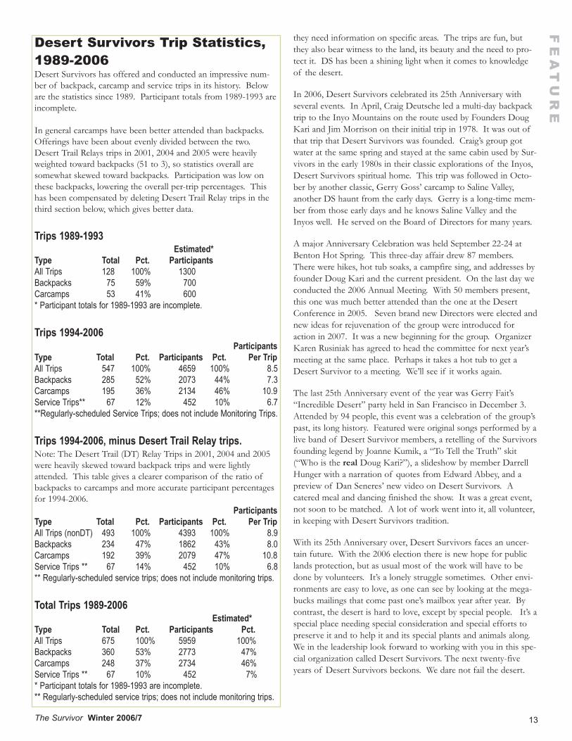
Desert Survivors Trip Statistics,1989-2006Desert Survivors has offered and conducted an impressive num-ber of backpack, carcamp and service trips in its history. Beloware the statistics since 1989. Participant totals from 1989-1993 areincomplete.
In general carcamps have been better attended than backpacks.Offerings have been about evenly divided between the two.Desert Trail Relays trips in 2001, 2004 and 2005 were heavilyweighted toward backpacks (51 to 3), so statistics overall aresomewhat skewed toward backpacks. Participation was low onthese backpacks, lowering the overall per-trip percentages. Thishas been compensated by deleting Desert Trail Relay trips in thethird section below, which gives better data.
Trips 1989-1993Estimated*
Type Total Pct. ParticipantsAll Trips 128 100% 1300Backpacks 75 59% 700Carcamps 53 41% 600* Participant totals for 1989-1993 are incomplete.
Trips 1994-2006Participants
Type Total Pct. Participants Pct. Per TripAll Trips 547 100% 4659 100% 8.5Backpacks 285 52% 2073 44% 7.3Carcamps 195 36% 2134 46% 10.9Service Trips** 67 12% 452 10% 6.7**Regularly-scheduled Service Trips; does not include Monitoring Trips.
Trips 1994-2006, minus Desert Trail Relay trips. Note: The Desert Trail (DT) Relay Trips in 2001, 2004 and 2005were heavily skewed toward backpack trips and were lightlyattended. This table gives a clearer comparison of the ratio ofbackpacks to carcamps and more accurate participant percentagesfor 1994-2006.
ParticipantsType Total Pct. Participants Pct. Per TripAll Trips (nonDT) 493 100% 4393 100% 8.9Backpacks 234 47% 1862 43% 8.0Carcamps 192 39% 2079 47% 10.8Service Trips ** 67 14% 452 10% 6.8** Regularly-scheduled service trips; does not include monitoring trips.
Total Trips 1989-2006Estimated*
Type Total Pct. Participants Pct.All Trips 675 100% 5959 100%Backpacks 360 53% 2773 47%Carcamps 248 37% 2734 46%Service Trips ** 67 10% 452 7%* Participant totals for 1989-1993 are incomplete.** Regularly-scheduled service trips; does not include monitoring trips.
14 The Survivor Winter 2006/7
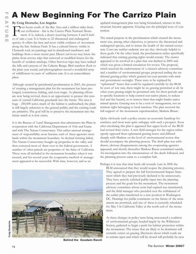
By Craig Deutsche, Los Angeles
Four hours south of the Bay Area and a million miles fromour civilization - this is the Carrizo Plain National Monu-ment. It is, indeed, a desert receiving between 4 and 8 inch-
es of rain a year. It is home to 22 threatened and endangeredspecies. It offers the best and most visible evidence of movementalong the San Andreas Fault. It has a cultural history visible inChumash rock art paintings and in abandoned machinery andbuildings from a more recent past. Desert survivors may know theplains from service trips that removed or modified fences for thebenefit of resident antelope. Other Survivor trips may have walkedthe hills and canyons of the Caliente Range. Bird watchers flock tothe plain year round, and photographers record a wonderful arrayof wildflowers in years of sufficient rain. It is an extraordinaryplace.
Although created by presidential proclamation in 2001, the processof creating a management plan for the monument has been pro-longed, contentious, halting, and even tragic. As planning effortsare now being revived, there is an opportunity to protect this rem-nant of central California grasslands into the future. The area ishuge - 250,000 acres; much of the habitat is undisturbed; the plainis still largely unknown to the general public; and the existing roadsare primitive. The goal will be to preserve the monument into thefuture much as it now exists.
It is the Bureau of Land Management that administers the Plain incooperation with the California Department of Fish and Gameand with The Nature Conservancy. This rather unusual arrange-ment of responsibility arose because each of these agencies ownslands within the monument boundary. As dryland farming failed,The Nature Conservancy bought up properties in the valley andthen conveyed most of them over to the federal government. Anumber of other parcels are properties of the State of California.These were all included in the monument boundary when it wascreated, and for several years the cooperative method of manage-ment appeared to be successful. With time, however, and as an
updated management plan was being formulated, stresses in thisstructure became apparent. Grazing was the principal issue of con-tention.
The stated purpose in the proclamation which created the monu-ment was, among other objectives, to preserve the threatened andendangered species, and to insure the health of the natural ecosys-tem. Cows are neither endemic nor are they obviously helpful tothese goals. On the other hand, the proclamation rather specificallyindicated that existing grazing rights would remain. The matterappeared to be resolved in a plan that was drafted in 2005 andwhich was given a limited circulation for review. The proposal,which received the endorsement of a citizen’s advisory committeeand a number of environmental groups, proposed ending the tra-ditional grazing policy which granted ten-year permits with mini-mal government oversight. These were to be replaced by“ephemeral” leases that could be regulated carefully by the BLM.In years of low rain, there might be no grazing permitted at all. Inother years grazing might be permitted only for short periods andin specific locations to help control non-native plants, to reducefuel and fire hazard, or to remove litter that might hinder nativeanimal species. Grazing was to be a tool of management, not anintrinsic right belonging to local ranchers. The plan received thefull support of the monument superintendent, Marlene Braun.
Quite obviously such a policy creates an economic handicap forranchers, and most were quite unhappy with such a prospect. Soonafter circulating this plan it appeared that upper levels of the BLMhad revised their views. A new field manager for the region ratheropenly opposed these ephemeral grazing leases and differedsharply with Marlene on the level of environmental review thatshould accompany the planning process. The draft plan was with-drawn, obvious disagreements among the cooperating agenciesappeared, and shortly thereafter Marlene Braun committed suicide.An investigation into the circumstances of the death followed, andthe planning process came to a complete halt.
Perhaps it is true that time heals old wounds. Late in 2006 theBLM announced that they would reopen the planning process.They agreed to prepare the full Environmental Impact State-ment which they had previously declared to be unnecessary.They have actively solicited public input into the planningprocess and the goals for the monument. The monumentadvisory committee whose term had expired was reinstituted,and the field manager who presided over the withdrawal ofthe earlier plan transferred to a new position in WashingtonDC. Hearings for public comments on the future of the mon-ument are promised, and one of these is currently scheduledfor May 5 in California Valley at the north end of the monu-ment.
As these changes in policy were being announced a coalitionof environmental groups, headed largely by the WildernessSociety, gathered to begin a push for habitat protection withinthe monument. The issues that are likely to be dominant willcertainly center on grazing. Decisions about which roads areto remain open and which will be closed will probably be next
FE
AT
UR
E
Behind the Goodwin Ranch
A New Beginning For The Carrizo PlainC
raig
Deu
tsch
e
Early Spring in Carrizo PlainBy Elaine Schwimmer, Berkeley
Marching menin identical trousersloop along the hillsover mountains
their wire appendagesdispatch electricityto the dozen doublewidesscattered around arid acresof the prairie.
Earth slit openjagged cleft unfolds for milesSan Andreas roams right angledto the ferrous soldiers.
Each wrought of epic energyone harnessedthe other a remnantof explosionin deep tissuesof earth.
At first glanceseems there’s not much elsebut badger burrows scratched by steel gray brush
and tiny ground holesveiled with spun silk sheltering subterraneantarantulas
they wait for the swell of sun to fadebefore emergingfur paws first.
Small shifting shadows follow ravens flight while great humpbacksfloat grey blue formsalong the land.
Lizards dart under rocksso fastyou’re not quite sureyou’ve seen them.
Frogs announce their greenand fat flying beetles whiz aroundlike huge drunken bees.
I have not fallenflat on my facebut am admiringlow growing five petal flowerswhose perfect symmetry clings close to the earth.
Tule elk movein the distance.Pronghorn, awarethey’re being watchedstand motionlessin the foreground.
Soda Lakedry and chokedlies mirror flat
salt devils hover little white tornadoeswhirl up and disappear
while yellow bellied birdssear the air with songand juniper bushesheavy with blue berriessilently wait for rain.
15The Survivor Winter 2006/7
FE
AT
UR
Ein significance. Decisions about visitor management will becomeincreasingly important as the monument becomes better known -how many visitors are to be accommodated, what kinds of facili-ties will be provided (if any), where visitors might be encouragedto travel, and what activities should be permitted. After these mat-ters will come fire management strategies, hunting restrictions, andprocedures for purchasing the few private properties that remainwithin the boundaries. The opportunities to at last “do thingsright” are exciting.
Perhaps the most unique opportunity of all is the chance tonominate the Carrizo Plain as a World Heritage Site. There are800 such sites world-wide, there are 22 in the United States, andthere are two only in California: Yosemite National Park and theRedwoods National Park. Nominations for such a designation arepossible this year, but are then closed until 2017. Sites having out-standing biological, geological, archeological, and/or cultural sig-nificance are eligible and designation is ultimately made through acommittee within the UNESCO organization. The designationplaces no requirements upon management of the site, but almostuniversally the publicity helps raise money, from both privatefoundations and from government, for management and mainte-nance. The nomination process for the Carrizo Plain is being ledby the Wilderness Society and is being supported by a ratherbroad array of environmental groups, government agencies, busi-ness groups, and individual citizens. The outcome of this effortremains to be seen.
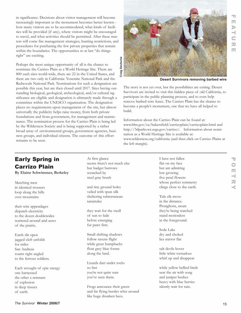
The story is not yet over, but the possibilities are exiting. DesertSurvivors are invited to visit this hidden piece of old California, toparticipate in the public planning process, and to even helpremove barbed wire fence. The Carrizo Plain has the chance tobecome a people’s monument, one that we have all helped tobuild.
Information about the Carrizo Plain can be found at:www.blm.gov/ca/bakersfield/carrizoplain/carrizoplain.html andhttp://3dparks.wr.usgs.gov/carrizo/. Information about nomi-nation as a World Heritage Site is available at:www.wilderness.org/california (and then click on Carrizo Plains atthe left margin).
Desert Survivors removing barbed wire
Cra
ig D
euts
che
PO
ET
RY
16 The Survivor Winter 2006/7
FE
AT
UR
E
By Catherine O’Riley, Grass Valley, CAI started attending the Burning Man (BM) Festival in 1993. At thattime, there were slightly over a thousand participants, tents werescattered randomly about on the Black Rock playa, vehicles wereallowed to roam freely through the event, there was a drive-byshooting range, The Man stood on the ground with a ropeattached to raise and lower him and there were no theme camps,generators or RVs. Anarchy reigned!
As the years went by and the event grew, with more impacts to theplaya, it became apparent to me that there should be better envi-ronmental awareness at the festival. In 1997 I approached the“Mistress Of Who Can Put Up A Sanctioned Structure At BM”and told her of my environmental idea. She informed me thatenvironmentalism did not fit into the philosophy of Burning Man.I then went to Larry Harvy (the founder of the event) andexpressed my idea to make a large free standing collage depictingon one side the destruction of the desert and on the other the pro-tection of the desert. He agreed. The project was well receivedbut not embraced by the Burning Man planners.
The following year I returned with my collage and message and itwas then that I met Mike Bilbo, Recreation Planner for the BLMand the new overseer of Burning Man for the agency. He hadcome to do a 1800s Reenactment but no one at the event had pre-pared for his presentation. Since I was “one of those environmen-tal types” he was assigned to me. Thus began an enduring friend-ship and my introduction to Leave No Trace (LNT).
By now BM was becoming big (relatively speaking) and theimpacts on the playa were being noticed by the BLM whoinformed BM that if they didn’t clean up their act they would nolonger be granted a permit to hold their event on the Black Rockplaya. Burning Man’s answer to this was to form the EarthGuardians, the environmental conscience of BM.
In the meantime, Bilbo started to teach Burners the concepts ofLNT during backpacking trips in the mountains surrounding theBlack Rock playa. This is where I first became aware of the LNTwilderness ethic. Even the person who originally nixed my collageidea was on the bandwagon.
The Earth Guardians grew and became more of a presence at theevent. They now have eight LNT Master Educators and numerousteachers and conduct LNT training and outreach throughout theyear as well as during the event.
FYI: This year’s theme for BM is “The Green Man”. I wouldhighly recommend anyone interested in promoting environmental-ism in the desert to get involved with the Earth Guardians at BMthis year.
Fast forward to March 2007. I decided that this was the year forme to become a LNT Master Educator so that I could more effec-tively train others in the ethic.
The day before I left for Tucson for the week long training it start-ed to snow at my house. By the next morning I was hoping Iwould make it to the airport. “At least it will be warm in Tucson,”I thought. Little did I know!
National Outdoor Leadership School (NOLS) put on the coursewhich was a five day backpack in the Galiuro Wilderness area, atwo and one half hour drive north east of Tucson. The wildernessis called a “sky island” because it is one of many small mountainranges that protrude from the desert floor. It is a classic exampleof fault-block mountains in Arizona’s Basin and Range Province.Predominately volcanic in origin, there are stunning gray and pinkcliff faces and strange rock formations. The wilderness is 4,000 to7,000 feet in elevation with flora consisting mostly of pinon,juniper, oak, manzanita, and a few cactus and succulents.
Not long before the backpack Tucson had a nasty storm and wasnow experiencing unseasonably cold temperatures. So much forbeing warm! Not only was it well below freezing at night (evi-denced by our frozen solid water bottles) but on the north facingsteep slopes we were hiking through snow and ice hoping wewould not fall to our deaths. The shorts and T-shirt I broughtalong never saw the light of day.
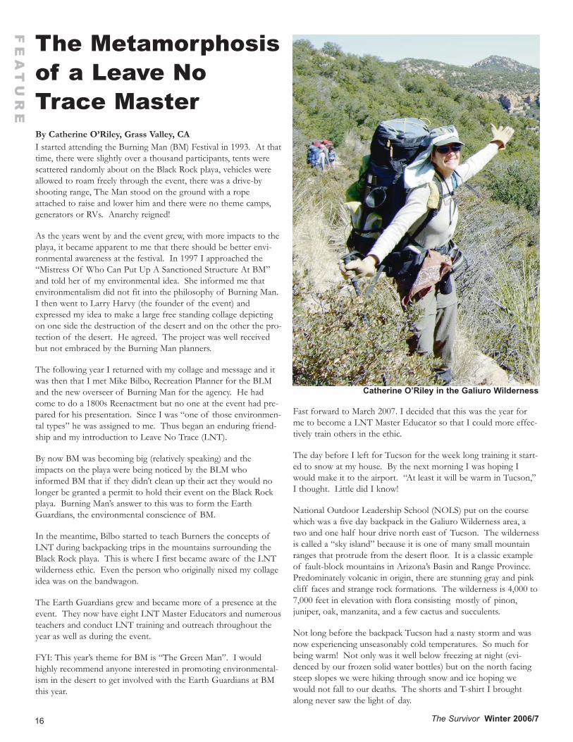
The Metamorphosisof a Leave NoTrace Master
Catherine O’Riley in the Galiuro Wilderness
17
There were two instructors and seven participants on the trip.Except for me, all the others were affiliated with the BLM, NFS ornonprofit environmental groups. During the five days (besidesworking very hard to keep warm) we not only learned the sevenprinciples of LNT in great detail by coming up with clever andsometimes funny or even profound ways to demonstrate the prin-ciples but also how to most effectively train others as well as thenecessary administrative requirements involved in teaching LNT.
It was a great experience with an interesting and eclectic group ofpeople. Most of all, it was fun, as well it should be!
On March 24, 2007 I submitted my LNT Education Proposal atthe DS Trip Leaders’ Forum.
Following are excerpts from my proposal:
Why Teach Leave No Trace (LNT) to Desert Survivors?
We should always be seeking ways to further minimize our impacton the environment.
Despite what you might imagine, there is much to be learned byeven the most experienced outdoor enthusiast. Continuingresearch is constantly changing the ways we look at how to bestprotect the Earth while in the back country. Everything you learnin the course can be passed on to someone else and eventually wecan make a difference.
Desert Survivors is an environmental organization with a missionto protect the desert. LNT fits directly into this conviction andshould, in my opinion, be part of the organization’s ongoing edu-cation of desert ethics.
LNT is big right now and is certainly the way of the future. Thegovernment agencies are training their recreational rangers andpersonnel so that they can then train each other and the generalpublic in LNT. Private non profits are taking the course so thatthey can help educate the public within theregions of their interest.
Having a coordinated LNT ongoing training classand possibly an outreach program could bringmore members into DS and also could be benefi-cial when applying for a grant.
What is LNT, anyway?
LNT is a National Wilderness Ethics program.
Their Mission Statement:
The mission of the Leave No Trace Center forOutdoor Ethics is to promote and inspire respon-sible outdoor recreation through education,research and partnerships.
In their own words:
At its heart Leave No Trace is not about a unifor-mity of behavior or even of thoughts. It is about
a convergence of values.
The principles of LNT are ethics, not rules that are never to bebroken. Many situations require common sense and sometimescompromises need to be made.
Proposal:
All Desert Survivors Trip Leaders should be trained in LNT sothat they can pass the principles on to their trip participants.
I will offer ongoing Desert Survivors Trips to teach LNT to boththe trip leaders and the members at large.
I offer to run LNT Awareness Workshops. This is a formal LNTpresentation that is one day or less in length. It could be a standalone workshop or incorporated into an ongoing seminar.
The course would be run in the Sierra Foothills and the backpackwould be into the wild and wonderful North Fork American River.
I choose the Sierra Foothills because this is about learning LNTnot driving long distances into the desert. This will be more con-venient for all involved and we will have more time to concentrateon LNT. However, the course will be geared toward the desertenvironment.
It is my hope that this article generates some interest in my plan topass along the incredibly important concepts of Leave No Trace.
For more information on LNT: www.lnt.org
How much do you know about Leave No Trace? Can you list theseven principles of LNT.? Number one must be a specific princi-ple. After that the order doesn’t matter. For each principle list atleast three examples of how this goal can be obtained.
(Answers on page 23.)
The Survivor Winter 2006/7
FE
AT
UR
E
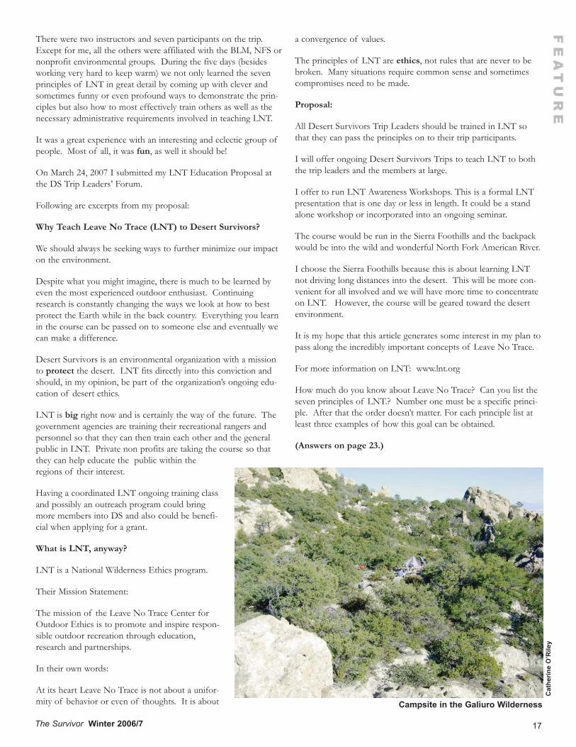
Campsite in the Galiuro Wilderness
Cat
herin
e O
’Rile
y
18 The Survivor Winter 2006/7
TR
IP R
EP
OR
TS
Bill
Joh
anss
on
A Short RoadTrip LoopThrough West-Central Nevada October 12-15, 2006
By Bill Johansson, Stockton, CA
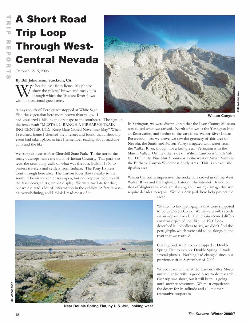
We headed east from Reno. My photosshow the yellow/ brown and rocky hillsthrough which the Truckee River flows,
with its occasional green trees.
A ways south of Fernley we stopped at White SageFlat, the vegetation here more brown than yellow. Ihad visualized a hike by the drainage to the southeast. The sign onthe fence read: “MUSTANG RANGE A FIREARMS TRAIN-ING CENTER LTD. Keep Gate Closed November-May.” WhenI returned home I checked the internet and found that a shootingevent had taken place, in fact I remember reading about machineguns and the like!
We stopped next at Fort Churchill State Park. To the north, therocky outcrops made me think of Indian Country. This park pro-tects the crumbling walls of what was the fort, built in 1860 toprotect travelers and settlers from Indians. The Pony Expresswent through here also. The Carson River flows nearby to thesouth. The visitor center was open, but nobody was there to sellthe few books, shirts, etc. on display. We were too late for that,but we did read a lot of information in the exhibits, in fact, it was-n’t overwhelming, and I think I read most of it.
In Yerington, we were disappointed that the Lyon County Museumwas closed when we arrived. North of town is the Yerington Indi-an Reservation, and farther to the east is the Walker River IndianReservation. As we drove, we saw the greenery of this area ofNevada, the Smith and Mason Valleys irrigated with water fromthe Walker River, though not a lush green. Yerington is in theMason Valley. On the other side of Wilson Canyon is Smith Val-ley. Off in the Pine Nut Mountains to the west of Smith Valley isthe Burbank Canyon Wilderness Study Area. This is an exquisiteriparian area.
Wilson Canyon is impressive; the rocky hills crowd in on the WestWalker River and the highway. Later on the internet I found outthat off-highway vehicles are abusing and causing damage that willrequire decades to repair. Would a new park here help protect the
area?
We tried to find petroglyphs that were supposedto be by Desert Creek. We drove 3 miles southon an unpaved road. The terrain seemed differ-ent than expected, not like the 1960 bookdescribed it. Needless to say, we didn’t find thepetroglyphs which were said to be alongside theriver that we reached.
Circling back to Reno, we stopped at DoubleSpring Flat, to explore Double Spring. I tookseveral photos. Nothing had changed since ourprevious visit in September of 2002.
We spent some time at the Carson Valley Muse-um in Gardnerville, a good place to do research.Our trip was short, but it will keep us goinguntil another adventure. We must experiencethe desert for its solitude and all its otherrestorative properties.
Near Double Spring Flat, by U.S. 395, looking west
Bill
Joh
anss
on
Wilson Canyon
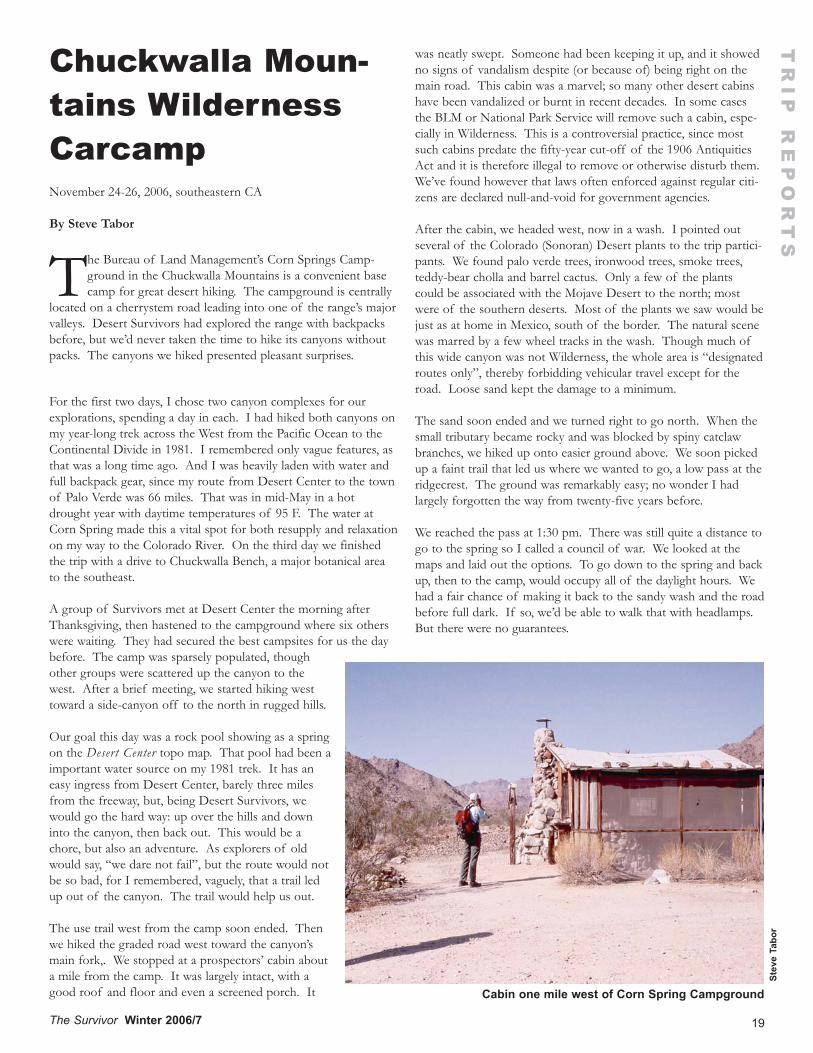
19The Survivor Winter 2006/7
Chuckwalla Moun-tains WildernessCarcampNovember 24-26, 2006, southeastern CA
By Steve Tabor
The Bureau of Land Management’s Corn Springs Camp-ground in the Chuckwalla Mountains is a convenient basecamp for great desert hiking. The campground is centrally
located on a cherrystem road leading into one of the range’s majorvalleys. Desert Survivors had explored the range with backpacksbefore, but we’d never taken the time to hike its canyons withoutpacks. The canyons we hiked presented pleasant surprises.
For the first two days, I chose two canyon complexes for ourexplorations, spending a day in each. I had hiked both canyons onmy year-long trek across the West from the Pacific Ocean to theContinental Divide in 1981. I remembered only vague features, asthat was a long time ago. And I was heavily laden with water andfull backpack gear, since my route from Desert Center to the townof Palo Verde was 66 miles. That was in mid-May in a hotdrought year with daytime temperatures of 95 F. The water atCorn Spring made this a vital spot for both resupply and relaxationon my way to the Colorado River. On the third day we finishedthe trip with a drive to Chuckwalla Bench, a major botanical areato the southeast.
A group of Survivors met at Desert Center the morning afterThanksgiving, then hastened to the campground where six otherswere waiting. They had secured the best campsites for us the daybefore. The camp was sparsely populated, thoughother groups were scattered up the canyon to thewest. After a brief meeting, we started hiking westtoward a side-canyon off to the north in rugged hills.
Our goal this day was a rock pool showing as a springon the Desert Center topo map. That pool had been aimportant water source on my 1981 trek. It has aneasy ingress from Desert Center, barely three milesfrom the freeway, but, being Desert Survivors, wewould go the hard way: up over the hills and downinto the canyon, then back out. This would be achore, but also an adventure. As explorers of oldwould say, “we dare not fail”, but the route would notbe so bad, for I remembered, vaguely, that a trail ledup out of the canyon. The trail would help us out.
The use trail west from the camp soon ended. Thenwe hiked the graded road west toward the canyon’smain fork,. We stopped at a prospectors’ cabin abouta mile from the camp. It was largely intact, with agood roof and floor and even a screened porch. It
was neatly swept. Someone had been keeping it up, and it showedno signs of vandalism despite (or because of) being right on themain road. This cabin was a marvel; so many other desert cabinshave been vandalized or burnt in recent decades. In some casesthe BLM or National Park Service will remove such a cabin, espe-cially in Wilderness. This is a controversial practice, since mostsuch cabins predate the fifty-year cut-off of the 1906 AntiquitiesAct and it is therefore illegal to remove or otherwise disturb them.We’ve found however that laws often enforced against regular citi-zens are declared null-and-void for government agencies.
After the cabin, we headed west, now in a wash. I pointed outseveral of the Colorado (Sonoran) Desert plants to the trip partici-pants. We found palo verde trees, ironwood trees, smoke trees,teddy-bear cholla and barrel cactus. Only a few of the plantscould be associated with the Mojave Desert to the north; mostwere of the southern deserts. Most of the plants we saw would bejust as at home in Mexico, south of the border. The natural scenewas marred by a few wheel tracks in the wash. Though much ofthis wide canyon was not Wilderness, the whole area is “designatedroutes only”, thereby forbidding vehicular travel except for theroad. Loose sand kept the damage to a minimum.
The sand soon ended and we turned right to go north. When thesmall tributary became rocky and was blocked by spiny catclawbranches, we hiked up onto easier ground above. We soon pickedup a faint trail that led us where we wanted to go, a low pass at theridgecrest. The ground was remarkably easy; no wonder I hadlargely forgotten the way from twenty-five years before.
We reached the pass at 1:30 pm. There was still quite a distance togo to the spring so I called a council of war. We looked at themaps and laid out the options. To go down to the spring and backup, then to the camp, would occupy all of the daylight hours. Wehad a fair chance of making it back to the sandy wash and the roadbefore full dark. If so, we’d be able to walk that with headlamps.But there were no guarantees.
TR
IP R
EP
OR
TS
Stev
e Ta
bor
Cabin one mile west of Corn Spring Campground
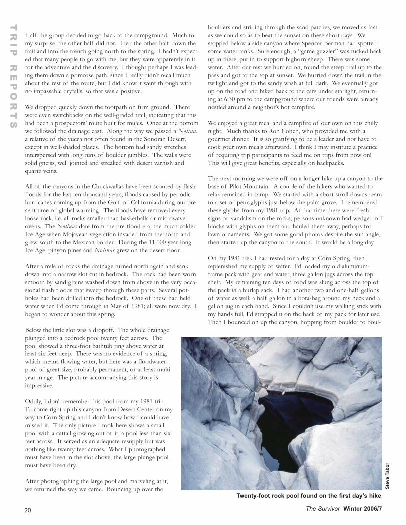
20 The Survivor Winter 2006/7
TR
IP R
EP
OR
TS
Half the group decided to go back to the campground. Much tomy surprise, the other half did not. I led the other half down thetrail and into the trench going north to the spring. I hadn’t expect-ed that many people to go with me, but they were apparently in itfor the adventure and the discovery. I thought perhaps I was lead-ing them down a primrose path, since I really didn’t recall muchabout the rest of the route, but I did know it went through withno impassable dryfalls, so that was a positive.
We dropped quickly down the footpath on firm ground. Therewere even switchbacks on the well-graded trail, indicating that thishad been a prospectors’ route built for mules. Once at the bottomwe followed the drainage east. Along the way we passed a Nolina,a relative of the yucca not often found in the Sonoran Desert,except in well-shaded places. The bottom had sandy stretchesinterspersed with long runs of boulder jumbles. The walls weresolid gneiss, well jointed and streaked with desert varnish andquartz veins.
All of the canyons in the Chuckwallas have been scoured by flash-floods for the last ten thousand years, floods caused by periodichurricanes coming up from the Gulf of California during our pre-sent time of global warming. The floods have removed everyloose rock, i.e. all rocks smaller than basketballs or microwaveovens. The Nolinas date from the pre-flood era, the much colderIce Age when Mojavean vegetation invaded from the north andgrew south to the Mexican border. During the 11,000 year-longIce Age, pinyon pines and Nolinas grew on the desert floor.
After a mile of rocks the drainage turned north again and sankdown into a narrow slot cut in bedrock. The rock had been wornsmooth by sand grains washed down from above in the very occa-sional flash floods that sweep through these parts. Several pot-holes had been drilled into the bedrock. One of these had heldwater when I’d come through in May of 1981; all were now dry. Ibegan to wonder about this spring.
Below the little slot was a dropoff. The whole drainageplunged into a bedrock pool twenty feet across. Thepool showed a three-foot bathtub ring above water atleast six feet deep. There was no evidence of a spring,which means flowing water, but here was a floodwaterpool of great size, probably permanent, or at least multi-year in age. The picture accompanying this story isimpressive.
Oddly, I don’t remember this pool from my 1981 trip.I’d come right up this canyon from Desert Center on myway to Corn Spring and I don’t know how I could havemissed it. The only picture I took here shows a smallpool with a cattail growing out of it, a pool less than sixfeet across. It served as an adequate resupply but wasnothing like twenty feet across. What I photographedmust have been in the slot above; the large plunge poolmust have been dry.
After photographing the large pool and marveling at it,we returned the way we came. Bouncing up over the
boulders and striding through the sand patches, we moved as fastas we could so as to beat the sunset on these short days. Westopped below a side canyon where Spencer Berman had spottedsome water tanks. Sure enough, a “game guzzler” was tucked backup in there, put in to support bighorn sheep. There was somewater. After our rest we hurried on, found the steep trail up to thepass and got to the top at sunset. We hurried down the trail in thetwilight and got to the sandy wash at full dark. We eventually gotup on the road and hiked back to the cars under starlight, return-ing at 6:30 pm to the campground where our friends were alreadynestled around a neighbor’s hot campfire.
We enjoyed a great meal and a campfire of our own on this chillynight. Much thanks to Ron Cohen, who provided me with agourmet dinner. It is so gratifying to be a leader and not have tocook your own meals afterward. I think I may institute a practiceof requiring trip participants to feed me on trips from now on!This will give great benefits, especially on backpacks.
The next morning we were off on a longer hike up a canyon to thebase of Pilot Mountain. A couple of the hikers who wanted torelax remained in camp. We started with a short stroll downstreamto a set of petroglyphs just below the palm grove. I rememberedthese glyphs from my 1981 trip. At that time there were freshsigns of vandalism on the rocks; persons unknown had wedged offblocks with glyphs on them and hauled them away, perhaps forlawn ornaments. We got some good photos despite the sun angle,then started up the canyon to the south. It would be a long day.
On my 1981 trek I had rested for a day at Corn Spring, thenreplenished my supply of water. I’d loaded my old aluminum-frame pack with gear and water, three gallon jugs across the topshelf. My remaining ten days of food was slung across the top ofthe pack in a burlap sack. I had another two and one-half gallonsof water as well: a half gallon in a bota-bag around my neck and agallon jug in each hand. Since I couldn’t use my walking stick withmy hands full, I’d strapped it on the back of my pack for later use.Then I bounced on up the canyon, hopping from boulder to boul-
Stev
e Ta
bor
Twenty-foot rock pool found on the first day’s hike
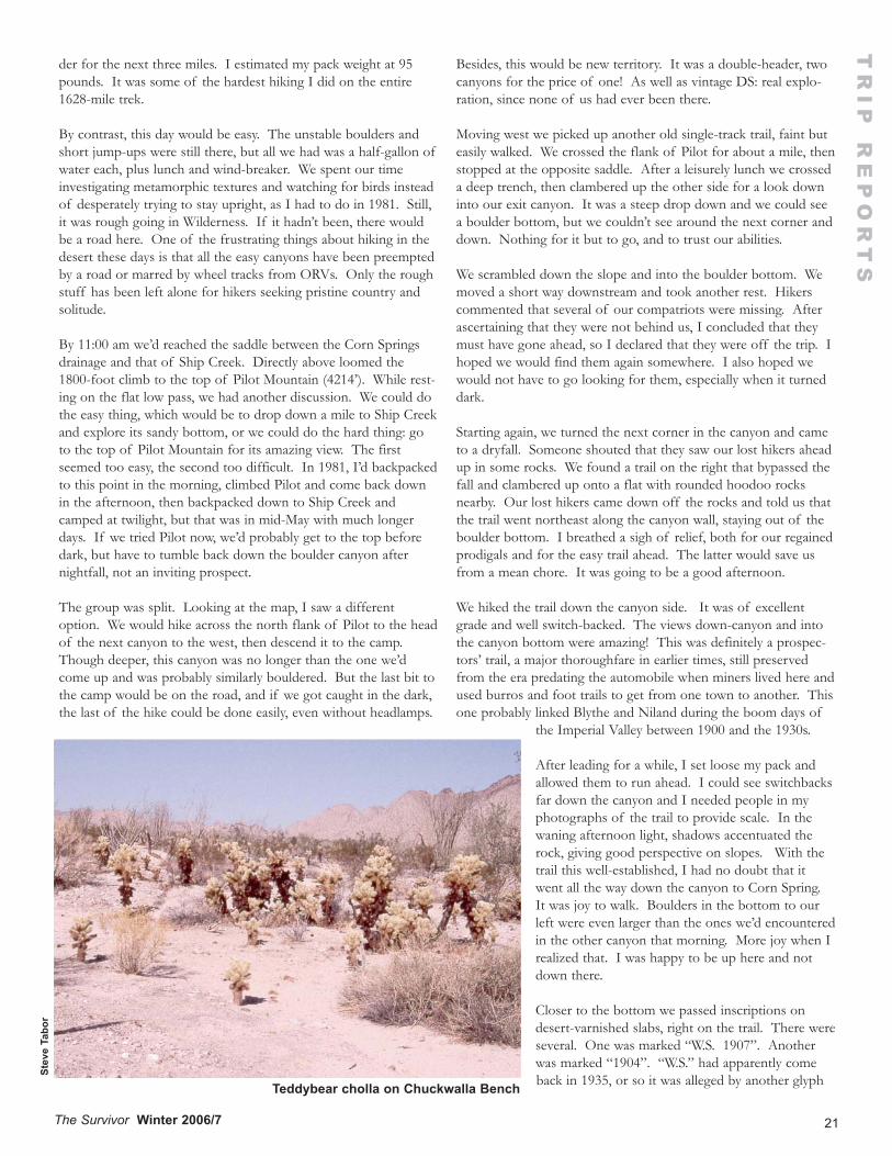
21The Survivor Winter 2006/7
TR
IP R
EP
OR
TS
der for the next three miles. I estimated my pack weight at 95pounds. It was some of the hardest hiking I did on the entire1628-mile trek.
By contrast, this day would be easy. The unstable boulders andshort jump-ups were still there, but all we had was a half-gallon ofwater each, plus lunch and wind-breaker. We spent our timeinvestigating metamorphic textures and watching for birds insteadof desperately trying to stay upright, as I had to do in 1981. Still,it was rough going in Wilderness. If it hadn’t been, there wouldbe a road here. One of the frustrating things about hiking in thedesert these days is that all the easy canyons have been preemptedby a road or marred by wheel tracks from ORVs. Only the roughstuff has been left alone for hikers seeking pristine country andsolitude.
By 11:00 am we’d reached the saddle between the Corn Springsdrainage and that of Ship Creek. Directly above loomed the1800-foot climb to the top of Pilot Mountain (4214’). While rest-ing on the flat low pass, we had another discussion. We could dothe easy thing, which would be to drop down a mile to Ship Creekand explore its sandy bottom, or we could do the hard thing: goto the top of Pilot Mountain for its amazing view. The firstseemed too easy, the second too difficult. In 1981, I’d backpackedto this point in the morning, climbed Pilot and come back downin the afternoon, then backpacked down to Ship Creek andcamped at twilight, but that was in mid-May with much longerdays. If we tried Pilot now, we’d probably get to the top beforedark, but have to tumble back down the boulder canyon afternightfall, not an inviting prospect.
The group was split. Looking at the map, I saw a differentoption. We would hike across the north flank of Pilot to the headof the next canyon to the west, then descend it to the camp.Though deeper, this canyon was no longer than the one we’dcome up and was probably similarly bouldered. But the last bit tothe camp would be on the road, and if we got caught in the dark,the last of the hike could be done easily, even without headlamps.
Besides, this would be new territory. It was a double-header, twocanyons for the price of one! As well as vintage DS: real explo-ration, since none of us had ever been there.
Moving west we picked up another old single-track trail, faint buteasily walked. We crossed the flank of Pilot for about a mile, thenstopped at the opposite saddle. After a leisurely lunch we crosseda deep trench, then clambered up the other side for a look downinto our exit canyon. It was a steep drop down and we could seea boulder bottom, but we couldn’t see around the next corner anddown. Nothing for it but to go, and to trust our abilities.
We scrambled down the slope and into the boulder bottom. Wemoved a short way downstream and took another rest. Hikerscommented that several of our compatriots were missing. Afterascertaining that they were not behind us, I concluded that theymust have gone ahead, so I declared that they were off the trip. Ihoped we would find them again somewhere. I also hoped wewould not have to go looking for them, especially when it turneddark.
Starting again, we turned the next corner in the canyon and cameto a dryfall. Someone shouted that they saw our lost hikers aheadup in some rocks. We found a trail on the right that bypassed thefall and clambered up onto a flat with rounded hoodoo rocksnearby. Our lost hikers came down off the rocks and told us thatthe trail went northeast along the canyon wall, staying out of theboulder bottom. I breathed a sigh of relief, both for our regainedprodigals and for the easy trail ahead. The latter would save usfrom a mean chore. It was going to be a good afternoon.
We hiked the trail down the canyon side. It was of excellentgrade and well switch-backed. The views down-canyon and intothe canyon bottom were amazing! This was definitely a prospec-tors’ trail, a major thoroughfare in earlier times, still preservedfrom the era predating the automobile when miners lived here andused burros and foot trails to get from one town to another. Thisone probably linked Blythe and Niland during the boom days of
the Imperial Valley between 1900 and the 1930s.
After leading for a while, I set loose my pack andallowed them to run ahead. I could see switchbacksfar down the canyon and I needed people in myphotographs of the trail to provide scale. In thewaning afternoon light, shadows accentuated therock, giving good perspective on slopes. With thetrail this well-established, I had no doubt that itwent all the way down the canyon to Corn Spring.It was joy to walk. Boulders in the bottom to ourleft were even larger than the ones we’d encounteredin the other canyon that morning. More joy when Irealized that. I was happy to be up here and notdown there.
Closer to the bottom we passed inscriptions ondesert-varnished slabs, right on the trail. There wereseveral. One was marked “W.S. 1907”. Anotherwas marked “1904”. “W.S.” had apparently comeback in 1935, or so it was alleged by another glyphSt
eve
Tabo
r
Teddybear cholla on Chuckwalla Bench
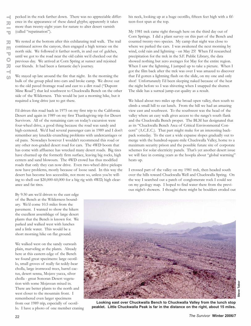
22 The Survivor Winter 2006/7
pecked in the rock farther down. There was no appreciable differ-ence in the appearance of these dated glyphs; apparently it takesmore than twenty-eight years for nature to alter desert varnish(called “repatination”).
We rested at the bottom after this exhilarating trail walk. The trailcontinued across the canyon, then engaged a high terrace on thenorth side. We followed it farther north, in and out of gulches,until we got to the road near the old cabin we’d checked out theprevious day. We arrived at Corn Spring at sunset and rejoinedour friends. It had been a fantastic day’s journey.
We stayed up late around the fire that night. In the morning thebulk of the group piled into cars and broke camp. We drove outto the old paved frontage road and east to a dirt road (“DupontMine Road”) that led southwest to Chuckwalla Bench on the otherside of the Wilderness. This would be just a morning hike, but itrequired a long drive just to get there.
I’d driven this road back in 1975 on my first trip to the CaliforniaDesert and again in 1989 on my first Thanksgiving trip for DesertSurvivors. All of the remaining cars on today’s excursion werefour-wheel drive, a good thing because the road was sandy andhigh-centered. We’d had several passenger cars in 1989 and I don’tremember any knuckle-crunching problems with undercarriages oroil pans. Nowadays however I wouldn’t recommend this road orany other non-graded desert road for cars. The 4WD boom thathas come with affluence has wrecked many desert roads. Big tireshave churned up the formerly firm surface, leaving big rocks, highcenters and sand blowouts. The 4WD crowd has thus modifiedroads that only they can now drive. Even two-wheel drive pickupsnow have problems, mostly because of loose sand. In this way thedesert has become less accessible, not more so, unless you’re will-ing to shell out $20,000-60,000 for a big rig with 4WD, high clear-ance and fat tires.
By 9:30 am we’d driven to the east edgeof the Bench at the Wilderness bound-ary. We’d come 10.5 miles from thepavement. I wanted to show the hikersthe excellent assemblage of large desertplants that the Bench is known for. Weparked and walked west with lunchesand a little water. This would be ashort morning hike on flat ground.
We walked west on the sandy outwashplain, marveling at the plants. Alreadyhere at this eastern edge of the Benchwe found great specimens: large ocotil-lo, small groves of really fat teddy-bearcholla, large ironwood trees, barrel cac-tus, desert senna, Mojave yucca, silvercholla - great Sonoran Desert vegeta-tion with some Mojavean mixed in.There are better plants to the north andwest closer to the mountain front. Iremembered even larger specimensfrom our 1989 trip, especially of ocotil-lo. I have a photo of one member craning
his neck, looking up at a huge ocotillo, fifteen feet high with a fif-teen-foot span at the top.
My 1981 trek came right through here on the third day out ofCorn Springs. I did a plant survey on this part of the Bench andcounted twenty-two species. My camp that night was close towhere we parked the cars. I was awakened the next morning bywind, cold rain and lightning - on May 25! When I’d researchedprecipitation for the trek in the S.F. Public Library, the datashowed nothing but zero averages for May for the entire region.When I saw the lightning, I jumped up to take a picture. When Igot the film back after the trek was over I was amazed to discoverthat I’d gotten a lightning flash on the slide, on my one and onlyshot! Unfortunately I’d been sleeping naked because of the heatthe night before so I was shivering when I snapped the shutter.The slide has a surreal jump-cut quality as a result.
We hiked about two miles up the broad open valley, then south toclimb a small hill to eat lunch. From the hill we had an amazingview east and southwest. To the southwest was the head of thevalley where an easy walk gives access to the range’s south flankand the Chuckwalla Bench proper. The BLM has designated thatas its “Chuckwalla Bench Area of Critical Environmental Con-cern” (A.C.E.C.). That part might make for an interesting back-pack someday. To the east a wide expanse slopes gradually out tomerge with the hundred-square-mile Chuckwalla Valley, home to amaximum security prison and the possible future site of corporateschemes for solar electricity panels. That’s yet another desert issuewe will face in coming years as the hoopla about “global warming”heats up.
I crossed part of the valley on my 1981 trek, then headed southover the hills toward Chuckwalla Well and Chuckwalla Spring. Onthe way I searched out a patch of conglomerate rock I could seeon my geology map. I hoped to find water there from the previ-ous night’s showers. I thought there might be boulders eroded out
TR
IP R
EP
OR
TS
Stev
e Ta
bor
Looking east over Chuckwalla Bench to Chuckwalla Valley from the lunch stoppeaklet. Little Chuckwalla Peak is far in the distance on the right, about 15 miles.
23The Survivor Winter 2006/7
of the conglomerate where water might catch. Sure enough therewas water there, but not in eroded-out spaces formerly holdingboulders. It turned out that the boulders in the conglomerate wereharder than the matrix, so it was the space between the bouldersthat held water. I slept that night below the water, which was upon a terrace. During the night a very angry kit fox came around,barking loudly. He doubtless had the same idea that I had afterthis very unusual shower.
We made it back to the cars just after noon. It had been a pleasantmorning’s jaunt under bright skies. The temperature was 76° F.I’d enjoyed the plants and the openness of the Bench, also thereminiscence, which gave me the opportunity for some storytelling.We then drove out to the highway on the bumpy road. We waitedfor the last cars but they didn’t come. Ron Cohen and Natashadrove back on the road to see if there had been trouble. It turned
out that one of the cars had had a flat tire. Fifty miles on, LenaGogoleva and I also had a flat. The Dupont Mine Road is a roughone on tires.
This Thanksgiving trip was a lot of fun. It just goes to show thatcarcamps can offer inspiring and rigorous hiking in the right cir-cumstance. Most inspiring to me about the trip were the unex-pected trails, still intact and easy to follow after more than onehundred years. I’d like to go back and hike them again. I’d espe-cially like to backpack the second day’s trail in reverse, to follow itwest to see where it goes, perhaps all the way across the range tothe Salton Sea, to hike in the tracks of the old single-blanket jack-ass prospectors, to travel as they did, on foot. Someday I will dothat, perhaps on a Desert Survivors trip. Watch for that trip in afuture trip schedule. Perhaps you too can share in that upcomingorgy of discovery.
TR
IP R
EP
OR
TS
LNT Answers, from page 17.
1) Plan ahead and prepare.2) Travel and Camp on Durable Surfaces3) Dispose of Waste Properly4) Leave What You Find5) Minimize Campfire Impacts6) Respect Wildlife7) Be Considerate to Other Visitors
1)Plan ahead and prepare.Obtain knowledge of the area ahead of time. Avoid situationswhere safety may be jeopardized.Tell someone your itinerary.Have proper equipment for conditions.Repackage food to avoid waste.Know the limits of the participants.Be prepared to abandon the trip if there are problems.Have adequate first aid knowledge and supplies.Have a contingency plan.
2)Travel and Camp on Durable SurfacesIn impacted areas:Stay on trails.Choose durable campsites.Camp away from trails and water.Leave site cleaner than you found it.Don’t increase the size of the campsite.In pristine areas:Disperse when hiking and stay on durable surfaces. Avoid makingnew trails.Short camping stays on durable surfaces.Naturalize the campsite when leaving.Avoid cryptogams.
3)Dispose of Waste ProperlyDispose of food-related garbage properly.Check campsite carefully when leaving for your and previouscampers’ waste.Dispose of human waste so that it decomposes rapidly.
Pack out TP or use “natural” TP.Do not burn TP.Proper use of soap – do not put in water sources.
4)Leave What You FindPreserve archeological and historical artifactsLeave natural features undisturbed.Avoid spreading nonnative plants and animals.
5)Minimize Campfire ImpactsUse of stoves instead of fires.Use of fires:Use only dead and down wood.Keep fire small.Use existing fire rings in impacted areas.Remove signs of multiple rings.Use fire pans, mound fires, nonflammable material under fire.Build on gravel bars and beaches.Manage the campfire properly:Burn out to white ash.Scatter any remaining coals.Never leave fire unattended.Do not burn trash.Restore the area to its natural setting.
6)Respect WildlifeObserve from a distance and don’t startle.Never feed wildlife.Store food and trash properly.Keep camp clean.Control pets on a leash.Don’t camp near water sources.
7)Be considerate to Other VisitorsDiscuss campsites with other groups if necessary.Do not make too much noise.Wear colors that blend with environment.Be cooperative and courteous.Yield right-of-way to equestrians on the downhill side.Take breaks and camp off the trail.
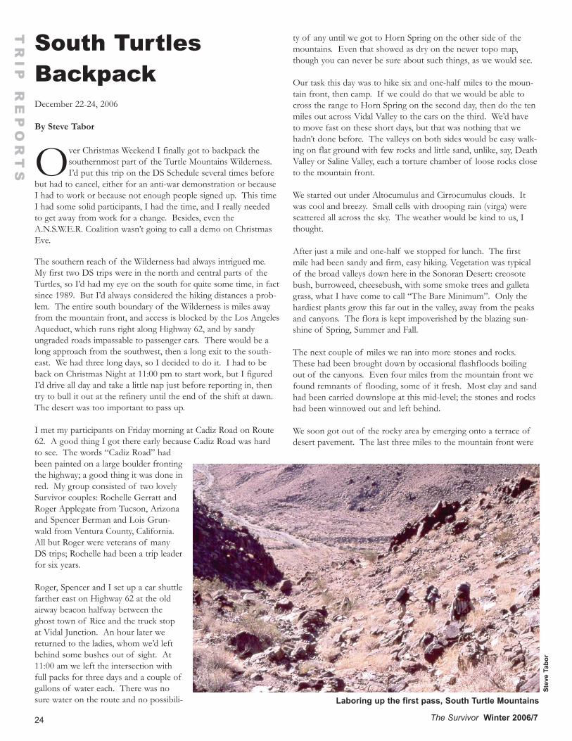
24 The Survivor Winter 2006/7
South Turtles BackpackDecember 22-24, 2006
By Steve Tabor
Over Christmas Weekend I finally got to backpack thesouthernmost part of the Turtle Mountains Wilderness.I’d put this trip on the DS Schedule several times before
but had to cancel, either for an anti-war demonstration or becauseI had to work or because not enough people signed up. This timeI had some solid participants, I had the time, and I really neededto get away from work for a change. Besides, even theA.N.S.W.E.R. Coalition wasn’t going to call a demo on ChristmasEve.
The southern reach of the Wilderness had always intrigued me.My first two DS trips were in the north and central parts of theTurtles, so I’d had my eye on the south for quite some time, in factsince 1989. But I’d always considered the hiking distances a prob-lem. The entire south boundary of the Wilderness is miles awayfrom the mountain front, and access is blocked by the Los AngelesAqueduct, which runs right along Highway 62, and by sandyungraded roads impassable to passenger cars. There would be along approach from the southwest, then a long exit to the south-east. We had three long days, so I decided to do it. I had to beback on Christmas Night at 11:00 pm to start work, but I figuredI’d drive all day and take a little nap just before reporting in, thentry to bull it out at the refinery until the end of the shift at dawn.The desert was too important to pass up.
I met my participants on Friday morning at Cadiz Road on Route62. A good thing I got there early because Cadiz Road was hardto see. The words “Cadiz Road” hadbeen painted on a large boulder frontingthe highway; a good thing it was done inred. My group consisted of two lovelySurvivor couples: Rochelle Gerratt andRoger Applegate from Tucson, Arizonaand Spencer Berman and Lois Grun-wald from Ventura County, California.All but Roger were veterans of manyDS trips; Rochelle had been a trip leaderfor six years.
Roger, Spencer and I set up a car shuttlefarther east on Highway 62 at the oldairway beacon halfway between theghost town of Rice and the truck stopat Vidal Junction. An hour later wereturned to the ladies, whom we’d leftbehind some bushes out of sight. At11:00 am we left the intersection withfull packs for three days and a couple ofgallons of water each. There was nosure water on the route and no possibili-
ty of any until we got to Horn Spring on the other side of themountains. Even that showed as dry on the newer topo map,though you can never be sure about such things, as we would see.
Our task this day was to hike six and one-half miles to the moun-tain front, then camp. If we could do that we would be able tocross the range to Horn Spring on the second day, then do the tenmiles out across Vidal Valley to the cars on the third. We’d haveto move fast on these short days, but that was nothing that wehadn’t done before. The valleys on both sides would be easy walk-ing on flat ground with few rocks and little sand, unlike, say, DeathValley or Saline Valley, each a torture chamber of loose rocks closeto the mountain front.
We started out under Altocumulus and Cirrocumulus clouds. Itwas cool and breezy. Small cells with drooping rain (virga) werescattered all across the sky. The weather would be kind to us, Ithought.
After just a mile and one-half we stopped for lunch. The firstmile had been sandy and firm, easy hiking. Vegetation was typicalof the broad valleys down here in the Sonoran Desert: creosotebush, burroweed, cheesebush, with some smoke trees and galletagrass, what I have come to call “The Bare Minimum”. Only thehardiest plants grow this far out in the valley, away from the peaksand canyons. The flora is kept impoverished by the blazing sun-shine of Spring, Summer and Fall.
The next couple of miles we ran into more stones and rocks.These had been brought down by occasional flashfloods boilingout of the canyons. Even four miles from the mountain front wefound remnants of flooding, some of it fresh. Most clay and sandhad been carried downslope at this mid-level; the stones and rockshad been winnowed out and left behind.
We soon got out of the rocky area by emerging onto a terrace ofdesert pavement. The last three miles to the mountain front were
TR
IP R
EP
OR
TS
Stev
e Ta
bor
Laboring up the first pass, South Turtle Mountains
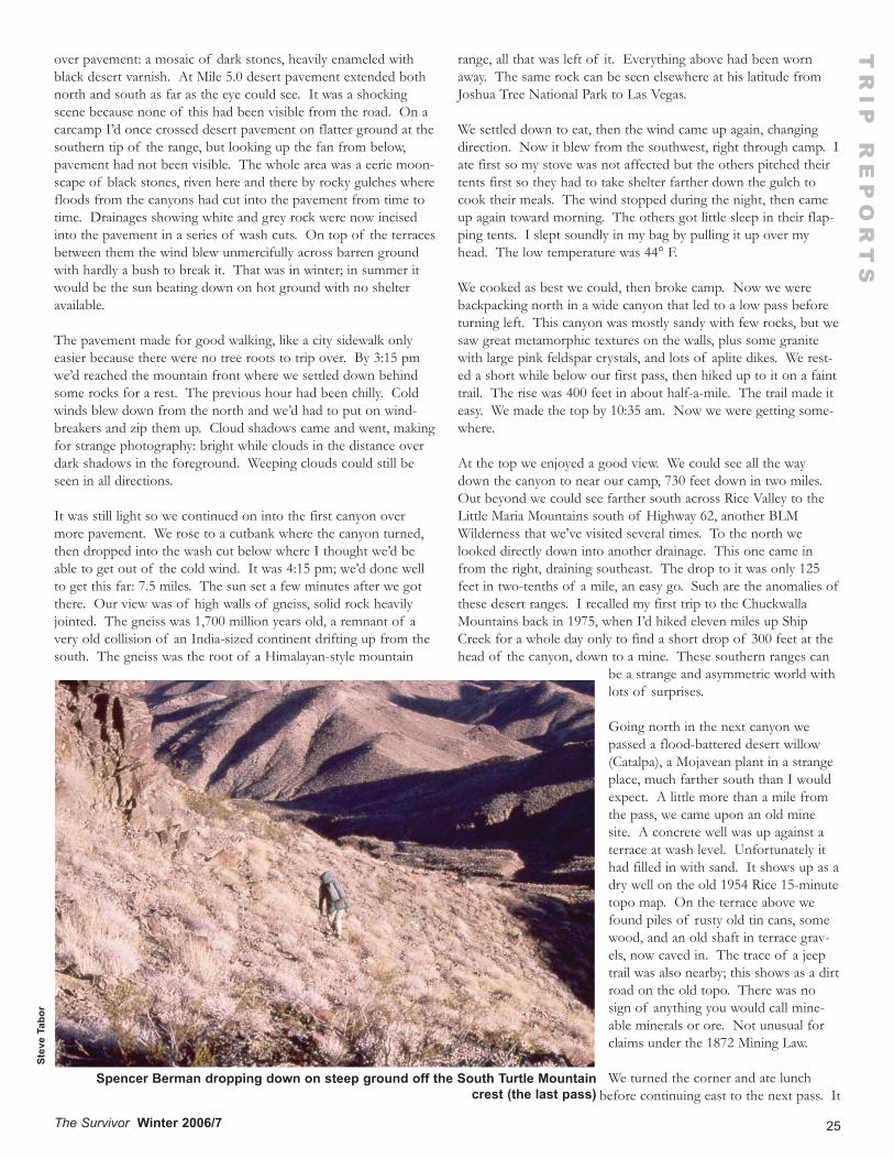
25The Survivor Winter 2006/7
over pavement: a mosaic of dark stones, heavily enameled withblack desert varnish. At Mile 5.0 desert pavement extended bothnorth and south as far as the eye could see. It was a shockingscene because none of this had been visible from the road. On acarcamp I’d once crossed desert pavement on flatter ground at thesouthern tip of the range, but looking up the fan from below,pavement had not been visible. The whole area was a eerie moon-scape of black stones, riven here and there by rocky gulches wherefloods from the canyons had cut into the pavement from time totime. Drainages showing white and grey rock were now incisedinto the pavement in a series of wash cuts. On top of the terracesbetween them the wind blew unmercifully across barren groundwith hardly a bush to break it. That was in winter; in summer itwould be the sun beating down on hot ground with no shelteravailable.
The pavement made for good walking, like a city sidewalk onlyeasier because there were no tree roots to trip over. By 3:15 pmwe’d reached the mountain front where we settled down behindsome rocks for a rest. The previous hour had been chilly. Coldwinds blew down from the north and we’d had to put on wind-breakers and zip them up. Cloud shadows came and went, makingfor strange photography: bright while clouds in the distance overdark shadows in the foreground. Weeping clouds could still beseen in all directions.
It was still light so we continued on into the first canyon overmore pavement. We rose to a cutbank where the canyon turned,then dropped into the wash cut below where I thought we’d beable to get out of the cold wind. It was 4:15 pm; we’d done wellto get this far: 7.5 miles. The sun set a few minutes after we gotthere. Our view was of high walls of gneiss, solid rock heavilyjointed. The gneiss was 1,700 million years old, a remnant of avery old collision of an India-sized continent drifting up from thesouth. The gneiss was the root of a Himalayan-style mountain
range, all that was left of it. Everything above had been wornaway. The same rock can be seen elsewhere at his latitude fromJoshua Tree National Park to Las Vegas.
We settled down to eat, then the wind came up again, changingdirection. Now it blew from the southwest, right through camp. Iate first so my stove was not affected but the others pitched theirtents first so they had to take shelter farther down the gulch tocook their meals. The wind stopped during the night, then cameup again toward morning. The others got little sleep in their flap-ping tents. I slept soundly in my bag by pulling it up over myhead. The low temperature was 44° F.
We cooked as best we could, then broke camp. Now we werebackpacking north in a wide canyon that led to a low pass beforeturning left. This canyon was mostly sandy with few rocks, but wesaw great metamorphic textures on the walls, plus some granitewith large pink feldspar crystals, and lots of aplite dikes. We rest-ed a short while below our first pass, then hiked up to it on a fainttrail. The rise was 400 feet in about half-a-mile. The trail made iteasy. We made the top by 10:35 am. Now we were getting some-where.
At the top we enjoyed a good view. We could see all the waydown the canyon to near our camp, 730 feet down in two miles.Out beyond we could see farther south across Rice Valley to theLittle Maria Mountains south of Highway 62, another BLMWilderness that we’ve visited several times. To the north welooked directly down into another drainage. This one came infrom the right, draining southeast. The drop to it was only 125feet in two-tenths of a mile, an easy go. Such are the anomalies ofthese desert ranges. I recalled my first trip to the ChuckwallaMountains back in 1975, when I’d hiked eleven miles up ShipCreek for a whole day only to find a short drop of 300 feet at thehead of the canyon, down to a mine. These southern ranges can
be a strange and asymmetric world withlots of surprises.
Going north in the next canyon wepassed a flood-battered desert willow(Catalpa), a Mojavean plant in a strangeplace, much farther south than I wouldexpect. A little more than a mile fromthe pass, we came upon an old minesite. A concrete well was up against aterrace at wash level. Unfortunately ithad filled in with sand. It shows up as adry well on the old 1954 Rice 15-minutetopo map. On the terrace above wefound piles of rusty old tin cans, somewood, and an old shaft in terrace grav-els, now caved in. The trace of a jeeptrail was also nearby; this shows as a dirtroad on the old topo. There was nosign of anything you would call mine-able minerals or ore. Not unusual forclaims under the 1872 Mining Law.
We turned the corner and ate lunchbefore continuing east to the next pass. It
TR
IP R
EP
OR
TS
Stev
e Ta
bor
Spencer Berman dropping down on steep ground off the South Turtle Mountaincrest (the last pass)
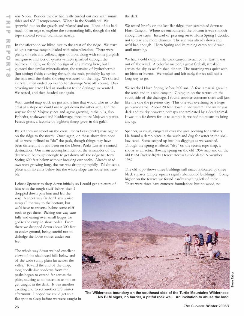
26 The Survivor Winter 2006/7
was Noon. Besides the day had really turned out nice with sunnyskies and 63° F. temperatures. Winter in the Southland! Wesprawled out on the gravels and relaxed and ate. None of us hadmuch of an urge to explore the surrounding hills, though the oldtopo showed several old mines nearby.
In the afternoon we hiked east to the crest of the ridge. We start-ed up a narrow canyon loaded with mineralization. There wereplenty of reds and yellows, signs of iron, along with some purplishmanganese and lots of quartz veinlets splashed through thebedrock. Oddly, we found no sign of any mining here, but Iguessed that similar mineralization, the remains of hydrothermic(hot spring) fluids coursing through the rock, probably lay up onthe hills near the shafts showing westward on the map. We skirteda dryfall, then ended up in another drainage ‘way off course. Dis-covering my error I led us southeast to the drainage we wanted.We rested, and then headed east again.
With careful map work we got into a line that would take us to thecrest at a slope we could use to get down the other side. On theway we found Mojave yucca and agave growing in the hills, alsoEphedra, snakeweed and bladdersage, three more Mojavean plants.Fescue grass, a favorite of bighorn sheep, grew in the gulch.
By 3:00 pm we stood on the crest. Horn Peak (3860’) rose higheron the ridge to the north. Once again, on these short days noneof us were inclined to “do” the peak, though things may havebeen different if it had been on the Desert Peaks List as a nameddestination. Our main accomplishment on the remainder of theday would be tough enough: to get down off the ridge to HornSpring 600 feet below without breaking our necks. Already shad-ows were growing long, the sun was dropping rapidly. I’d chosen aplace with no cliffs below but the whole slope was loose and rub-bly.
I chose Spencer to drop down initially so I could get a picture ofhim with the rough stuff below, then Idropped down past him and led theway. A short way farther I saw a niceramp all the way to the bottom, butwe’d have to traverse below some cliffrock to get there. Picking our way care-fully and easing over small ledges wegot to the ramp in short order. Fromthere we dropped down about 300 feetto easier ground, being careful not todislodge the loose stones under ourfeet.
The whole way down we had excellentviews of the shadowed hills below andof the wide sunny plain far across thevalley. Toward the end of the drop,long needle-like shadows from thepeaks began to extend far across theplain, causing us to hasten so as not toget caught in the dark. It was anotherexciting end to yet another DS winterafternoon. I hoped we could get to aflat spot to sleep before we were caught in
the dark.
We rested briefly on the last flat ridge, then scrambled down toHorn Canyon. Where we encountered the bottom it was smoothenough for tents. Instead of pressing on to Horn Spring I decidednot to take any more chances. The sun was already down andwe’d had enough. Horn Spring and its mining camp could waituntil morning.
We had a cold camp in the dark canyon trench but at least it wasout of the wind. A colorful meteor, a great fireball, streakedacross the sky as we finished dinner. The morning was quiet withno birds or burros. We packed and left early, for we still had along way to go.
We reached Horn Spring before 9:00 am. A few tamarisk grew inthe wash and in a side-canyon. Going up on the terrace on thesouth side of the drainage, I found another concrete-shaft well justlike the one the previous day. This one was overhung by a hugepalo verde tree. About 20 feet down it had water! The water wasdark and murky however, perhaps contaminated by a dead animal.It was too far down for us to sample it, we had no means to bringany up.
Spencer, as usual, ranged all over the area, looking for artifacts.He found a damp place in the wash and dug for water in the shal-low sand. Some seeped up into his diggings as we watched.Though the spring is labeled “dry” on the recent topo map, itshows as an actual flowing spring on the old 1954 map and on theold BLM Parker-Blythe Desert Access Guide dated November1989.
The old topo shows three buildings still intact, indicated by threeblack squares (empty squares signify abandoned buildings). Goinghigher on the terrace we found hardly anything left of these.There were three bare concrete foundations but no wood, no
TR
IP R
EP
OR
TS
Stev
e Ta
bor
The Wilderness boundary on the southeast side of the Turtle Mountains Wilderness.No BLM signs, no barrier, a pitiful rock wall. An invitation to abuse the land.
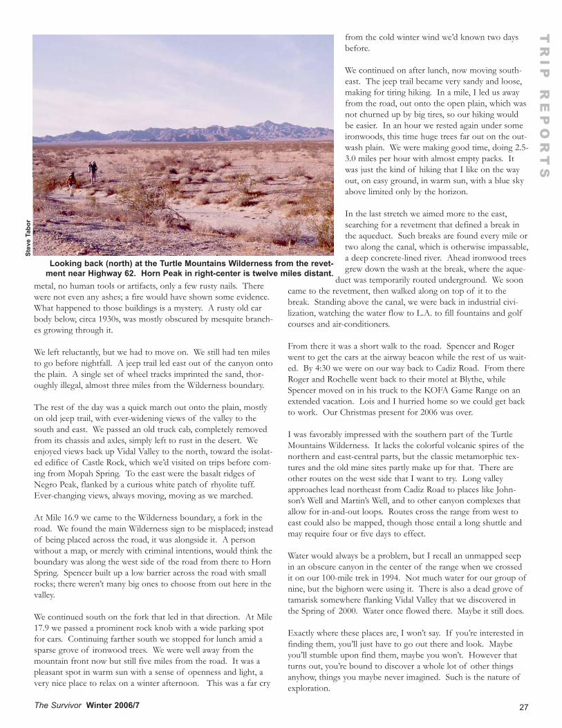
27The Survivor Winter 2006/7
metal, no human tools or artifacts, only a few rusty nails. Therewere not even any ashes; a fire would have shown some evidence.What happened to those buildings is a mystery. A rusty old carbody below, circa 1930s, was mostly obscured by mesquite branch-es growing through it.
We left reluctantly, but we had to move on. We still had ten milesto go before nightfall. A jeep trail led east out of the canyon ontothe plain. A single set of wheel tracks imprinted the sand, thor-oughly illegal, almost three miles from the Wilderness boundary.
The rest of the day was a quick march out onto the plain, mostlyon old jeep trail, with ever-widening views of the valley to thesouth and east. We passed an old truck cab, completely removedfrom its chassis and axles, simply left to rust in the desert. Weenjoyed views back up Vidal Valley to the north, toward the isolat-ed edifice of Castle Rock, which we’d visited on trips before com-ing from Mopah Spring. To the east were the basalt ridges ofNegro Peak, flanked by a curious white patch of rhyolite tuff.Ever-changing views, always moving, moving as we marched.
At Mile 16.9 we came to the Wilderness boundary, a fork in theroad. We found the main Wilderness sign to be misplaced; insteadof being placed across the road, it was alongside it. A personwithout a map, or merely with criminal intentions, would think theboundary was along the west side of the road from there to HornSpring. Spencer built up a low barrier across the road with smallrocks; there weren’t many big ones to choose from out here in thevalley.
We continued south on the fork that led in that direction. At Mile17.9 we passed a prominent rock knob with a wide parking spotfor cars. Continuing farther south we stopped for lunch amid asparse grove of ironwood trees. We were well away from themountain front now but still five miles from the road. It was apleasant spot in warm sun with a sense of openness and light, avery nice place to relax on a winter afternoon. This was a far cry
from the cold winter wind we’d known two daysbefore.
We continued on after lunch, now moving south-east. The jeep trail became very sandy and loose,making for tiring hiking. In a mile, I led us awayfrom the road, out onto the open plain, which wasnot churned up by big tires, so our hiking wouldbe easier. In an hour we rested again under someironwoods, this time huge trees far out on the out-wash plain. We were making good time, doing 2.5-3.0 miles per hour with almost empty packs. Itwas just the kind of hiking that I like on the wayout, on easy ground, in warm sun, with a blue skyabove limited only by the horizon.
In the last stretch we aimed more to the east,searching for a revetment that defined a break inthe aqueduct. Such breaks are found every mile ortwo along the canal, which is otherwise impassable,a deep concrete-lined river. Ahead ironwood treesgrew down the wash at the break, where the aque-
duct was temporarily routed underground. We sooncame to the revetment, then walked along on top of it to thebreak. Standing above the canal, we were back in industrial civi-lization, watching the water flow to L.A. to fill fountains and golfcourses and air-conditioners.
From there it was a short walk to the road. Spencer and Rogerwent to get the cars at the airway beacon while the rest of us wait-ed. By 4:30 we were on our way back to Cadiz Road. From thereRoger and Rochelle went back to their motel at Blythe, whileSpencer moved on in his truck to the KOFA Game Range on anextended vacation. Lois and I hurried home so we could get backto work. Our Christmas present for 2006 was over.
I was favorably impressed with the southern part of the TurtleMountains Wilderness. It lacks the colorful volcanic spires of thenorthern and east-central parts, but the classic metamorphic tex-tures and the old mine sites partly make up for that. There areother routes on the west side that I want to try. Long valleyapproaches lead northeast from Cadiz Road to places like John-son’s Well and Martin’s Well, and to other canyon complexes thatallow for in-and-out loops. Routes cross the range from west toeast could also be mapped, though those entail a long shuttle andmay require four or five days to effect.
Water would always be a problem, but I recall an unmapped seepin an obscure canyon in the center of the range when we crossedit on our 100-mile trek in 1994. Not much water for our group ofnine, but the bighorn were using it. There is also a dead grove oftamarisk somewhere flanking Vidal Valley that we discovered inthe Spring of 2000. Water once flowed there. Maybe it still does.
Exactly where these places are, I won’t say. If you’re interested infinding them, you’ll just have to go out there and look. Maybeyou’ll stumble upon find them, maybe you won’t. However thatturns out, you’re bound to discover a whole lot of other thingsanyhow, things you maybe never imagined. Such is the nature ofexploration.
TR
IP R
EP
OR
TS
Stev
e Ta
bor
Looking back (north) at the Turtle Mountains Wilderness from the revet-ment near Highway 62. Horn Peak in right-center is twelve miles distant.
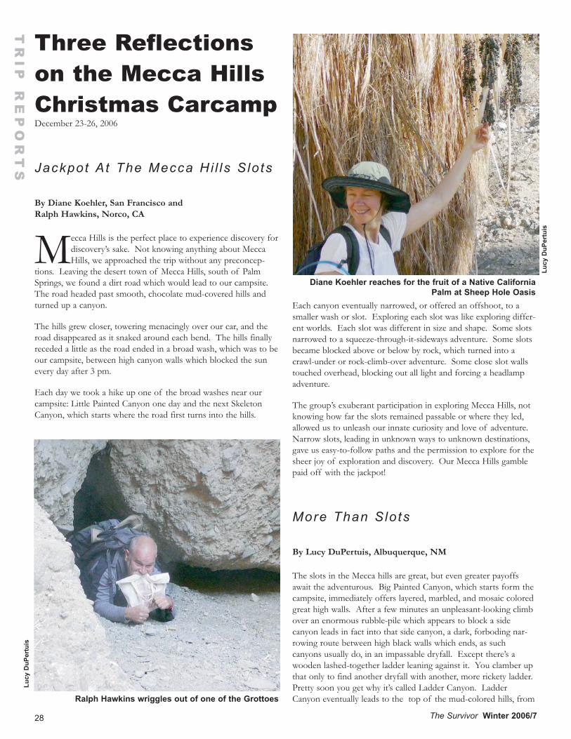
28 The Survivor Winter 2006/7
Three Reflectionson the Mecca HillsChristmas Carcamp December 23-26, 2006
Jackpot At The Mecca Hi l ls S lo ts
By Diane Koehler, San Francisco and Ralph Hawkins, Norco, CA
Mecca Hills is the perfect place to experience discovery fordiscovery’s sake. Not knowing anything about MeccaHills, we approached the trip without any preconcep-
tions. Leaving the desert town of Mecca Hills, south of PalmSprings, we found a dirt road which would lead to our campsite.The road headed past smooth, chocolate mud-covered hills andturned up a canyon.
The hills grew closer, towering menacingly over our car, and theroad disappeared as it snaked around each bend. The hills finallyreceded a little as the road ended in a broad wash, which was to beour campsite, between high canyon walls which blocked the sunevery day after 3 pm.
Each day we took a hike up one of the broad washes near ourcampsite: Little Painted Canyon one day and the next SkeletonCanyon, which starts where the road first turns into the hills.
Each canyon eventually narrowed, or offered an offshoot, to asmaller wash or slot. Exploring each slot was like exploring differ-ent worlds. Each slot was different in size and shape. Some slotsnarrowed to a squeeze-through-it-sideways adventure. Some slotsbecame blocked above or below by rock, which turned into acrawl-under or rock-climb-over adventure. Some close slot wallstouched overhead, blocking out all light and forcing a headlampadventure.
The group’s exuberant participation in exploring Mecca Hills, notknowing how far the slots remained passable or where they led,allowed us to unleash our innate curiosity and love of adventure.Narrow slots, leading in unknown ways to unknown destinations,gave us easy-to-follow paths and the permission to explore for thesheer joy of exploration and discovery. Our Mecca Hills gamblepaid off with the jackpot!
More Than Slots
By Lucy DuPertuis, Albuquerque, NM
The slots in the Mecca hills are great, but even greater payoffsawait the adventurous. Big Painted Canyon, which starts form thecampsite, immediately offers layered, marbled, and mosaic coloredgreat high walls. After a few minutes an unpleasant-looking climbover an enormous rubble-pile which appears to block a sidecanyon leads in fact into that side canyon, a dark, forboding nar-rowing route between high black walls which ends, as suchcanyons usually do, in an impassable dryfall. Except there’s awooden lashed-together ladder leaning against it. You clamber upthat only to find another dryfall with another, more rickety ladder.Pretty soon you get why it’s called Ladder Canyon. LadderCanyon eventually leads to the top of the mud-colored hills, from
TR
IP R
EP
OR
TS
Diane Koehler reaches for the fruit of a Native CaliforniaPalm at Sheep Hole Oasis
Ralph Hawkins wriggles out of one of the Grottoes
Lucy
DuP
ertu
is
Lucy
DuP
ertu
is
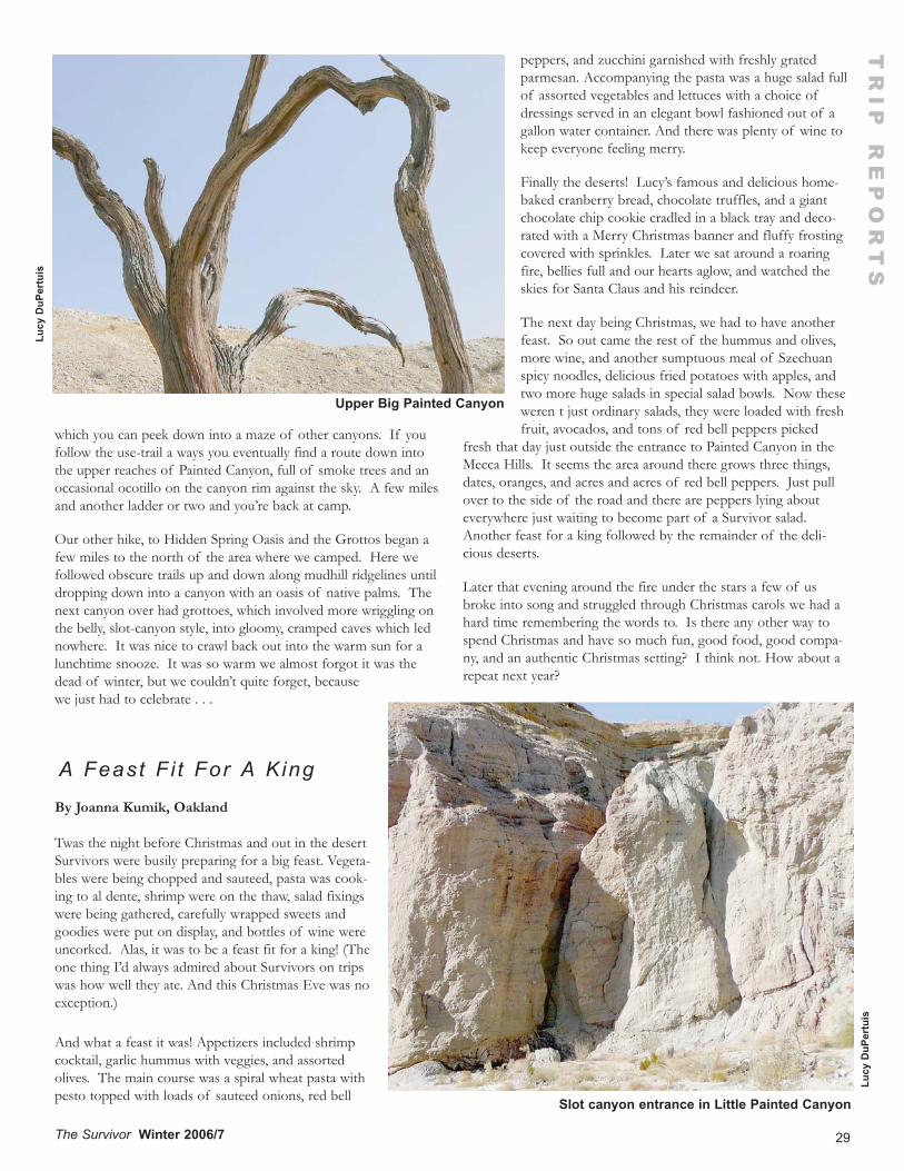
29The Survivor Winter 2006/7
which you can peek down into a maze of other canyons. If youfollow the use-trail a ways you eventually find a route down intothe upper reaches of Painted Canyon, full of smoke trees and anoccasional ocotillo on the canyon rim against the sky. A few milesand another ladder or two and you’re back at camp.
Our other hike, to Hidden Spring Oasis and the Grottos began afew miles to the north of the area where we camped. Here wefollowed obscure trails up and down along mudhill ridgelines untildropping down into a canyon with an oasis of native palms. Thenext canyon over had grottoes, which involved more wriggling onthe belly, slot-canyon style, into gloomy, cramped caves which lednowhere. It was nice to crawl back out into the warm sun for alunchtime snooze. It was so warm we almost forgot it was thedead of winter, but we couldn’t quite forget, becausewe just had to celebrate . . .
A Feast F i t For A King
By Joanna Kumik, Oakland
Twas the night before Christmas and out in the desertSurvivors were busily preparing for a big feast. Vegeta-bles were being chopped and sauteed, pasta was cook-ing to al dente, shrimp were on the thaw, salad fixingswere being gathered, carefully wrapped sweets andgoodies were put on display, and bottles of wine wereuncorked. Alas, it was to be a feast fit for a king! (Theone thing I’d always admired about Survivors on tripswas how well they ate. And this Christmas Eve was noexception.)
And what a feast it was! Appetizers included shrimpcocktail, garlic hummus with veggies, and assortedolives. The main course was a spiral wheat pasta withpesto topped with loads of sauteed onions, red bell
peppers, and zucchini garnished with freshly gratedparmesan. Accompanying the pasta was a huge salad fullof assorted vegetables and lettuces with a choice ofdressings served in an elegant bowl fashioned out of agallon water container. And there was plenty of wine tokeep everyone feeling merry.
Finally the deserts! Lucy’s famous and delicious home-baked cranberry bread, chocolate truffles, and a giantchocolate chip cookie cradled in a black tray and deco-rated with a Merry Christmas banner and fluffy frostingcovered with sprinkles. Later we sat around a roaringfire, bellies full and our hearts aglow, and watched theskies for Santa Claus and his reindeer.
The next day being Christmas, we had to have anotherfeast. So out came the rest of the hummus and olives,more wine, and another sumptuous meal of Szechuanspicy noodles, delicious fried potatoes with apples, andtwo more huge salads in special salad bowls. Now theseweren t just ordinary salads, they were loaded with freshfruit, avocados, and tons of red bell peppers picked
fresh that day just outside the entrance to Painted Canyon in theMecca Hills. It seems the area around there grows three things,dates, oranges, and acres and acres of red bell peppers. Just pullover to the side of the road and there are peppers lying abouteverywhere just waiting to become part of a Survivor salad.Another feast for a king followed by the remainder of the deli-cious deserts.
Later that evening around the fire under the stars a few of usbroke into song and struggled through Christmas carols we had ahard time remembering the words to. Is there any other way tospend Christmas and have so much fun, good food, good compa-ny, and an authentic Christmas setting? I think not. How about arepeat next year?
TR
IP R
EP
OR
TS
Slot canyon entrance in Little Painted Canyon
Lucy
DuP
ertu
is
Upper Big Painted Canyon
Lucy
DuP
ertu
is
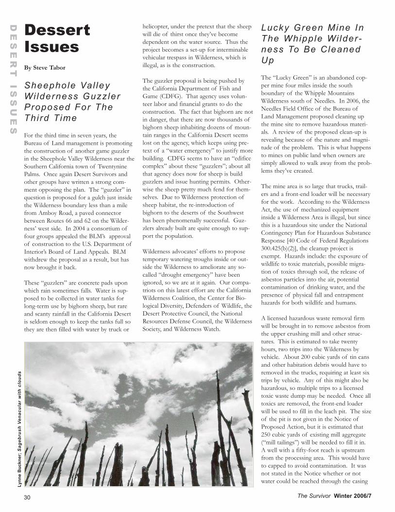
DessertIssuesBy Steve Tabor
Sheephole Val leyWi lderness Guzz lerProposed For TheThi rd Time
For the third time in seven years, theBureau of Land management is promotingthe construction of another game guzzlerin the Sheephole Valley Wilderness near theSouthern California town of TwentyninePalms. Once again Desert Survivors andother groups have written a strong com-ment opposing the plan. The “guzzler” inquestion is proposed for a gulch just insidethe Wilderness boundary less than a milefrom Amboy Road, a paved connectorbetween Routes 66 and 62 on the Wilder-ness’ west side. In 2004 a consortium offour groups appealed the BLM’s approvalof construction to the U.S. Department ofInterior’s Board of Land Appeals. BLMwithdrew the proposal as a result, but hasnow brought it back.
These “guzzlers” are concrete pads uponwhich rain sometimes falls. Water is sup-posed to be collected in water tanks forlong-term use by bighorn sheep, but rareand scanty rainfall in the California Desertis seldom enough to keep the tanks full sothey are then filled with water by truck or
helicopter, under the pretext that the sheepwill die of thirst once they’ve becomedependent on the water source. Thus theproject becomes a set-up for interminablevehicular trespass in Wilderness, which isillegal, as is the construction.
The guzzler proposal is being pushed bythe California Department of Fish andGame (CDFG). That agency uses volun-teer labor and financial grants to do theconstruction. The fact that bighorn are notin danger, that there are now thousands ofbighorn sheep inhabiting dozens of moun-tain ranges in the California Desert seemslost on the agency, which keeps using pre-text of a “water emergency” to justify morebuilding. CDFG seems to have an “edificecomplex” about these “guzzlers”; about allthat agency does now for sheep is buildguzzlers and issue hunting permits. Other-wise the sheep pretty much fend for them-selves. Due to Wilderness protection ofsheep habitat, the re-introduction ofbighorn to the deserts of the Southwesthas been phenomenally successful. Guz-zlers already built are quite enough to sup-port the population.
Wilderness advocates’ efforts to proposetemporary watering troughs inside or out-side the Wilderness to ameliorate any so-called “drought emergency” have beenignored, so we are at it again. Our compa-triots on this latest effort are the CaliforniaWilderness Coalition, the Center for Bio-logical Diversity, Defenders of Wildlife, theDesert Protective Council, the NationalResources Defense Council, the WildernessSociety, and Wilderness Watch.
Lucky Green Mine InThe Whipple Wi lder-ness To Be CleanedUp
The “Lucky Green” is an abandoned cop-per mine four miles inside the southboundary of the Whipple MountainsWilderness south of Needles. In 2006, theNeedles Field Office of the Bureau ofLand Management proposed cleaning upthe mine site to remove hazardous materi-als. A review of the proposed clean-up isrevealing because of the nature and magni-tude of the problem. This is what happensto mines on public land when owners aresimply allowed to walk away from the prob-lems they’ve created.
The mine area is so large that trucks, trail-ers and a front-end loader will be necessaryfor the work. According to the WildernessAct, the use of mechanized equipmentinside a Wilderness Area is illegal, but sincethis is a hazardous site under the NationalContingency Plan for Hazardous SubstanceResponse [40 Code of Federal Regulations300.425(b)(2)], the cleanup project isexempt. Hazards include: the exposure ofwildlife to toxic materials, possible migra-tion of toxics through soil, the release ofasbestos particles into the air, potentialcontamination of drinking water, and thepresence of physical fall and entrapmenthazards for both wildlife and humans.
A licensed hazardous waste removal firmwill be brought in to remove asbestos fromthe upper crushing mill and other struc-tures. This is estimated to take twentyhours, two trips into the Wilderness byvehicle. About 200 cubic yards of tin cansand other habitation debris would have toremoved in the trucks, requiring at least sixtrips by vehicle. Any of this might also behazardous, so multiple trips to a licensedtoxic waste dump may be needed. Once alltoxics are removed, the front-end loaderwill be used to fill in the leach pit. The sizeof the pit is not given in the Notice ofProposed Action, but it is estimated that250 cubic yards of existing mill aggregate(“mill tailings”) will be needed to fill it in.A well with a fifty-foot reach is upstreamfrom the processing area. This would haveto capped to avoid contamination. It wasnot stated in the Notice whether or notwater could be reached through the casing
30 The Survivor Winter 2006/7
DE
SE
RT
ISS
UE
S
Lynn
e B
uckn
er; S
ageb
rush
Ven
acul
ar w
ith
clou
ds
31
DE
SE
RT
ISS
UE
S
The Survivor Winter 2006/7
or if the well was dry.
When I first heard about this project, I wasopposed to disturbance of the site. Oldmine sites in the desert are some of thefew interesting historical human artifactsthat we find when we roam the country.Upon discussion with the BLM operativeresponsible for the cleanup, I discoveredthat the hazmat made the cleanup a prioritythat was going to be done, regardless ofany opinion I might have. I suggested thatthe last owner of record should pay for thecleanup, not the taxpayers, since any activi-ty, hazardous or not, was the responsibilityof that owner in our free enterprise systemof private property. The BLM operativesaid she would look into that.
I regret that I was not able to hike into thissite before it was sanitized. A similar site atthe old mining town of Wonder in Nevadanorth of U.S. Route 50 was similarly“cleaned up”. All structures were removedand the tailings piles were “contoured” intobarren nondescript hills of gravel. Some-thing of the character of the land is lostwhen this is done. To many of us theseold mines are evidence of human failure,an important condition of industrial manthat sometimes occurs, one that should notbe eradicated every time it’s encountered.Human failure is as much a part of theWilderness as the plants, the sky, the birdsand the weather.
Probably the presence of asbestos is whatdoomed the “Lucky Green” historical siteto extermination. A pity, but even more apity is the failure of the failed mining com-pany to clean up its mess. Instead, you andI will have to pay for that. Remember thatthe next time you read about a mine, agrazing structure, a military expansion, orsome other development on your publicland. Unless you’ve got the political powerto stop the development, get ready to beshafted.
Fern ley, Nevada EyesWater Under Grani teSpr ings Val ley
To old hands roaring down Nevada’s U.SRoute 50 on their way to the Stillwaters, theDesatoyas, the Clan Alpines, Middlegate,Great Basin N.P. or Utah, the small town
of Fernley has always been a bit of a joke.Like many old Western towns, Fernley wasonce a real town, then debilitated into amain street of abandoned store frontsanchored by a freeway exit or two with atruck stop and gas stations. Just to ridethrough the downtown was depressing (orliberating, depending on your point ofview). Not any more. Now it has a ware-house district surrounded by brand-newsubdivisions. Now it’s expanding. It evenhas drive-in cappuccino bars for the bleary-eyed commuter. Now it needs water.
A company called “Aqua-Trac” will behappy to oblige. The company has filedmore than 100 permits to drill for subsur-face water in adjacent Pershing County.Many of these are below Granite SpringsValley where the company wants to pullout 88,000 acre-feet per year. Others arebelow Kumiva Valley, intended for 30,000acre-feet. Both are remote and seldom-vis-ited valleys known to Desert Survivors asmain features of the Desert Trail Corridor.Both valleys provide vital water sources forTrail hikers, springs that would likely rundry once the water table starts droppingdue to the deep drilling contemplated.
Fernley’s new expansion is one destinationfor the water, which will sell for $15,000per acre-foot, but there is talk of exportingthe water beyond the Fernley city limits toother places. Reno, Dayton, Gardnervilleand Honey Lake are mentioned in newsreports. Observers doubt there is enoughwater in the basins to feed such a largearea, but with the Truck-ee River already allocat-ed, with limits placed onit by prior water rightsand agreements to pro-tect Pyramid Lake andthe needs of its PaiuteTribe, water has becomea scarce commodity inWestern Nevada. Waste-ful California-style subdi-visions are still beingbuilt in the driest state ofthe union, and there’snot much in the way ofresources, except cheapmoney, to support them.
The City of Las Vegashas already laid claim tosubsurface water belowseveral counties in the
eastern side of the state. It looks like asimilar water grab is on the way in the west.Vegas with its hip cachet is one thing, butFernley? One truth lost in this scenario isthe same one supposedly learned in Cali-fornia in the 1930s through 1950s and inArizona in the ‘60s and ‘70s: When subsur-face water is drawn down, the land sinksbecause pore space in the aquifer belowcollapses. Parts of California’s Central Val-ley are known to have dropped twenty-seven feet in as many years. When thathappens, no more water can sink down tocollect; the aquifer is ruined. Any watertaken out is water that accumulated inmuch wetter times during the Ice Age,when rain and snowfall were heavier. Theprocess of deep-drilling is known to geolo-gists as “mining the water”. Once it’s gone,it’s gone.
The lessons of deep-drilling have beenlearned in California, apparently not yet inNevada. But after all, Granite Springs andKumiva are “just worthless desert” com-pared to Fernley and environs. It’s that sickattitude that makes a scheme like this possi-ble. It’s an attitude Desert Survivors hasbeen fighting all along in many localities onmany issues. We still have a lot of educa-tion to do.
So far, only farmers and ranchers in nearbyLovelock have raised an alarm about this.They’ve been spurred on by a publicationcalled The Nevada Rancher(http://nevadarancher.com). We’ll reportmore on this as we learn more.
Dan
Sen
eres
; Tw
o B
uck
Big
horn
32
In This IssueDesert Survivors History: The Bighorn Logo........................2How to Reach Us...............................................................................3Contribute to The Survivor..............................................................3Mission Statement for Desert Survivors.........................................3Desert Survivor E-Mail, Listserv....................................................3Letter: Steens Mistakes.....................................................................3Desert Conference November 3.....................................................3Incredible Desert 25th Anniversary Event...................................4I’m a Survivor (song).........................................................................5The Saga of Desert Survivors..........................................................6Organizers Of 25th Anniversary Events.......................................7Petroglyphs (poetry)..........................................................................7Desert Survivors History, 1995-2006..........................................8Service and Monitoring Trips, 1994-2006...............................10Trip Statistics, 1989-2006.............................................................13A New Beginning For The Carrizo Plain.....................................14Early Spring in Carrizo Plain (poetry............................................15The Metamorphosis of a Leave No Trace Master......................16A Short Road Trip Loop Through West-Central Nevada..........18Chuckwalla Mountains Wilderness Carcamp...............................19South Turtles Backpack..................................................................24Reflections on the Mecca Hills Christmas Carcamp........28Desert Issues....................................................................................30
The Survivor Winter 2006/7
Non-ProfitOrganizationU.S. Postage
PAID
Berkeley, CAPermit 648
Experiencing, sharing and protecting the desert since 1978
Join Desert Survivors Today!Members of Desert Survivors become part of a nation-widenetwork of savvy desert hikers and activists. Benefits include:• Four more-or-less quarterly issues of The Surv ivor .• Over 40 free trips per year to explore desert locations. Trips
range in difficulty and include backpacking and dayhik-ing/carcamping. For a copy of our current trip schedule,call (510) 769-1706 or go to www.desert-survivors.org.
• Social events including potluck parties, picnics and slideshows.• Opportunity to participate in all aspects of Desert Survivors,
including preservation campaigns, hands-on desert conser-vation projects, and directing the organization.
Name____________________________________
Address__________________________________
City_____________________State____Zip______
Phone/E-mail_____________________________Membership Fee/Donation Enclosed:
$20 $30 $50 $100 Other $___________Make checks payable to Desert Survivors. Desert Survivors is a501©3 organization; dues and donations are fully tax-deductible.
I can help with: PR newsletter website events
other:__________________________________________
RETURN SERVICE REQUESTED
DESERT SURVIVORSP.O. Box 20991 • Oakland, CA 94620-0991
Mail this form to: Desert Survivors, P.O. Box 20991,Oakland, CA 94620-0991