winslow township livable community action plan
TRANSCRIPT
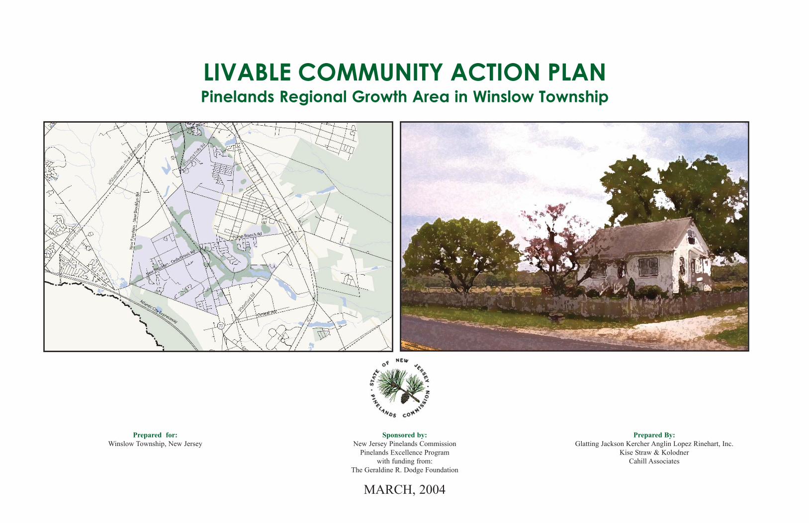
Prepared for: Winslow Township, New Jersey
Sponsored by:New Jersey Pinelands Commission
Pinelands Excellence Programwith funding from:
The Geraldine R. Dodge Foundation
MARCH, 2004
Prepared By:Glatting Jackson Kercher Anglin Lopez Rinehart, Inc.
Kise Straw & KolodnerCahill Associates
LIVABLE COMMUNITY ACTION PLANPinelands Regional Growth Area in Winslow Township

Livable Community Action Plan - Winslow Township, NJ i
Winslow Township Visioning Team:
• Sue Ann Metzner, Mayor, Winslow Township• Barbara Holcomb, Deputy Mayor, Winslow Township• Andrew Mair, Administrator, Winslow Township• Barry Wright, Winslow Township Committee• Ben Blair, Churchill Engineers• Chuck Flamini, Economic Development Liaison, Winslow
Township Committee• Edward McGlinchey, Superintendent DPW/Zoning Officer,
Winslow Township• Timothy Bell, Developer, Heritage Builders• Jack Sworaski, Director of Environmental Affairs, Camden
County• Patricia Parker, Youth Recreation Center• Elizabeth Capoferri, Historical Society• Peter Karabashian, Planner, Peter Karabashian & Associates• Brett Ingram, Engineer, Adams, Rehmann, & Heggan• Michael Belknap, Developer, Belknap and Associates• Clarence White, Realtor, Rotary Club• Gothrie Short Jr., Planning Board Chair and Economic
Development Council, Winslow Township
New Jersey Pinelands Commission:
• John Stokes, Executive Director• Larry Liggett, Director of Land Use and Technology Programs• Kim Beidler, Principal Resource Planner• David Kutner, Director of Special Programs
Consultant Team:
Glatting Jackson Kercher Anglin Lopez Rinehart, Inc.Walter Kulash, Principal-in-ChargeIan Lockwood, Transportation Engineer
Kise Straw & KolodnerShawn McCaney, Project ManagerJoe Clemens, Assistant Project ManagerPierrette Kalogeropoulos Yeo, Public Involvement/Project Planner
Cahill AssociatesWesley Horner, Principal Planner
LIVABLE COMMUNITY ACTION PLANPinelands Regional Growth Area in Winslow Township

TABLE OF CONTENTS
Introduction 1
Opportunities and Challenges
• Background 2• Existing Conditions 3
Community Vision
• CBOT Results and Conclusions 6• Draft Long Range Vision Statement 8
Livable Community Action Plan - Winslow Township, NJ ii
Strategies
• Issues/Strategies Analysis 9• Adopt Build-To Commercial Building Siting 10• Revise Parking Regulations 12• Obtain Street Connectivity through Subdivision Regulation 13• Revise Stormwater Regulation 14• Adopt Open Space Plan and Regulations 18• Designate Village and Town Center Locations 21• Adjust Zoning to Support Centers on Route 73 22• Map Additional Street Network 23• Revise Street Design Guidelines 25• Adopt Rural Appearance Measures 26• Implementation Recommendations 28
Appendix
A. Proposed Design Guidelines 30B. Tree Removal Ordinance 36C. Community Based Observation 39
Technique (CBOT) PhotographsD. Pinelands Excellence Program - Creating Livable Communities 51

Livable Community Action Plan - Winslow Township, NJ 1Introduction
IntroductionUnder a grant funded by the Geraldine R. Dodge Foundation, the PinelandsCommission initiated the Pinelands Excellence Program to take an in-depth lookat some of the critical problems facing fast-growing communities and developtargeted strategies to address them. For more than 20 years, development in thePinelands has been guided by the Pinelands Comprehensive Management Plan(CMP). The CMP protects the region's most sensitive natural resources by strict-ly limiting development in certain areas while allowing for varying amounts andtypes of development in other more appropriate locations. The most substantialamount of development is permitted in Pinelands Regional Growth Areas(RGAs), which are located predominantly along the Pinelands eastern and west-ern borders. While the RGAs comprise less than 10% of the overall PinelandsArea, they were zoned in 1980 to accommodate more than 100,000 new homesover the coming decades. Without the RGAs, the rest of the Pinelands cannot beprotected. Yet unless the RGAs are desirable places to live, they will not func-tion well.
The long-term success of the CMP depends upon the creation of "livable"growth area communities - communities that are vibrant and attractive, andwhere important natural values and recreation areas are preserved for the resi-dents' benefit. Yet, the pace of development in some RGAs and the lack of finan-cial resources to comprehensively plan at the local level have made it extreme-ly difficult for towns to stay ahead of the curve in effectively accommodatingthese housing demands. The result, in some cases, is ordinary suburban sprawl,poor neighborhood design, overburdened transportation systems, little or noopen space and other amenities, and conflicts with natural resource protection.Simply reducing the amount of development permitted in these areas will notsolve all the problems, since less development does not inherently lead to goodcommunity design. Moreover, the accommodation of less development in thesegrowth areas may exert pressure to open up other areas of the Pinelands to sat-isfy unmet housing demands.
The Pinelands Excellence Program provides an opportunity to examine some ofthese issues that fall outside of the CMP's scope but nonetheless can have sub-stantial impacts on a community's character and functioning. To implement theProgram, the Commission invited the Pinelands communities with the largestRGAs to participate and then selected two based on an evaluation of writtenrequests that they submitted: Hamilton Township in Atlantic County andWinslow Township in Camden County. Next, the Commission, with input fromHamilton and Winslow, hired a team of consultants to lead each municipality ina comprehensive community visioning effort, culminating in the development ofinnovative zoning and design recommendations. These recommendations arepresented in this community action plan.
ment are not significantly different from what was already called for underTownship zoning at the outset of the project. Rather, the recommendations pro-vided here are designed primarily to make the new development function andlook better. The relationship of that new development to existing populationcenters, most notably Sicklerville, however, was an issue that was raised repeat-edly by the Township's visioning team. In particular, the need to establish bet-ter connections - both physically and in terms of community identity - was cit-ed as an area requiring further work. A somewhat related issue is recognizinghow the compact settlement forms of Sicklerville and West Atco contribute tothe Township's overall character and exploring options to promote reinvestmentin deteriorated areas and new investment in yet-to-be-developed areas. The roleof the Township's villages outside of the Pinelands Regional Growth Area inaccommodating growth and their need for supporting infrastructure such aswater and sewer lines are also issues for additional consideration.Consequently, an overall recommendation for the Township is to use the resultsof this project as a catalyst to seek funding for additional planning efforts on acommunity-wide scale.
The information presented in this community action plan is structured similarlyto the process followed by the Pinelands Excellence Program, beginning with ananalysis of existing conditions (e.g., land uses, street network, environmentalconstraints, and zoning) in Winslow Township’s RGA. Much of the data used forthis analysis was supplied by the Pinelands Commission. The results were usedto determine the amount and location of land available for development inWinslow's RGA.
While the analyses were underway, the consultants began work in the township.First, they conducted a series of interviews with key stakeholders selected byWinslow to supplement the information provided by the data analyses and to gainadditional insight into local concerns and issues. The Township was then askedto form a "visioning team" representative of the community to work with the con-sultants on the development of a vision statement to guide preparation of thecommunity action plan for the RGA. Members of the visioning team wereinstructed in a community-based observation technique (CBOT), in which theywere provided with cameras and asked to document, in pictures and words, whatthey liked and did not like in Winslow Township and surrounding areas. Inputreceived during the CBOT process helped ensure that the resulting visioningstatements are grounded in reality and not just abstractions from a more theoret-ical exercise. Results from the CBOT process are summarized on page 6 andmore fully detailed in Appendix C.
The translation of the issues identified during the stakeholder interviews andCBOT exercise into elements of a vision statement and ultimately, individualstrategies, is represented by the diagram shown on page 9. This "big picture" setsthe stage for the detailed strategies that follow, beginning on page 10. To theextent possible, these strategies were designed to facilitate implementation. Forexample, model ordinances are provided to address community design issues(commercial building siting and design, street design, and parking), land clear-ing, and stormwater. Other discussions provide the foundation for complemen-tary actions including the mapping of street corridors, and revising of streetdesign guidelines.
The community action plan concludes with an implementation strategy thataddresses priorities, responsibilities, pre-requisites, and resources. The intent ofthis section is to help ensure that the recommendations presented in this planmove from the page to reality, thereby improving the lives of current and futureresidents in Winslow Township. Actual implementation of the strategy, howev-er, will demand support and effort from the Township's residents and businesses.Only with this broad-based commitment will the key components of the planadvance.
Given the geographic focus of this project (i.e., Winslow's Pinelands RegionalGrowth Area) and available resources, not all issues related to growth and devel-opment could be addressed within the scope of this plan. Because the plan is nec-essarily focused on new development and, at the request of the visioning team,does not contemplate major rezonings, the location and mix of future develop-

Opportunities and ChallengesThe character of new development in the New Jersey Pinelands designated growthareas is disappointing at times. The disappointment is felt from a number ofviewpoints. Existing residents of the Pinelands are not seeing, much new growththat complements the "town and country" qualities that have kept them in ordrawn them to the Pinelands. To the contrary, they see an erosion of these quali-ties. Instead of development of unusual quality, utterly conventional suburbansprawl has occurred in many locations. Environmentalists, rightfully pleased withthe boldness of the Pinelands Comprehensive Management Plan and hoping for adevelopment ethic correspondingly advanced, are disturbed with the consump-tiveness of development in the growth areas. The vigorous level of investment inthe growth areas is, to some viewpoints, the main strength. However, even in thiscase, the rare advantage of a "captive" market is yielding nothing special or inter-esting.
There is every reason for Winslow to intervene in this pattern. The boldness ofthe Pinelands Comprehensive Management Plan and the monumental achieve-ment in designating growth areas deserves better than just a new eruption of con-ventional suburban sprawl. The residents of the Pinelands, and particularly in thegrowth areas such as Winslow, parties to one of the boldest "town and country"visions in the United States, have every right to expect that the growth areas be asremarkable as the preservation areas. Investors in Winslow should be able to ben-efit, far more than at present, from the concentration of investment opportunityinto growth areas embedded within a remarkable nature preserve.
Livable Community Action Plan - Winslow Township, NJ 2Background

Livable Community Action Plan - Winslow Township, NJ
Aerial Photograph
The characteristic view from the road in Winslow Township - large fields in active agricultural use - is clearly illustrated bythe large number of cultivated parcels, many of them fronting on major highways such as Route 73. The regional growth areais the area that is targeted for more intensive residential and commercial development, and is the subject of this plan. Theconcentration of residences around the Route 73/Pump Branch Road/Cedarbrook Road area underscores the appropriatenessof a town center or village center area on Route 73 at this point. The residential concentrations just outside the growth area- in Waterford Township and in the Borough of Chesilhurst - underscore the challenge of linking these concentrations to newactivity along Route 73, without damaging the rural qualities of the area.
Existing Street Network
The historic pattern of longer distance roads in New Jersey, straight segments of road radiating from town centers, is evidentin this map. Recent development has added little new mileage of major road, and has instead depended on the inherited sys-tem for all of its connectivity. The freeway-like alignment of Route 73 to the north of the Winslow growth area raises animportant issue of the future of Route 73: does it eventually become an expressway, does it become an arterial lined withstrip commercial as Route 73 is to the north of the township, a suburban boulevard, or does it retain its pristine "town andcountry" atmosphere.
3Existing Conditions

Livable Community Action Plan - Winslow Township, NJ
Developed Lands
Much of the growth area is already developed (or committed to development) in low-density (i.e., less than 1 unit per acre)residential patterns. Next in quantity of land area within the growth area, is high-density residential, (i.e., up to slightly morethan 5 units per acre) with the bulk of it located in the northern part of the growth area. Almost all commercial and indus-trial activity is focused along the Route 73 corridor, in scattered sites fronting on Route 73.
Developable Lands
The remaining developable area for low-density residential development is scattered throughout the growth area, typically inparcels of 20-60 acres. The developable commercial land is either in the town center area in the northern part of the growtharea, or in parcels along the entire length of Route 73 in the growth area.
4Existing Conditions

Livable Community Action Plan - Winslow Township, NJ
Existing Zoning Regions
The southern half of the growth area is lower-density residential (approximately 0.7 du/acre), with the exception of the nar-row corridor along Route 73, which is zoned for commercial.
The mid-section of the growth area is higher-density residential (ranging from 0.7 du/acre - 1.4 du/acre) to the east of Route73, and a large area of industrial business park to the west.
The northern segment of the growth area is largely wetlands, with the remaining developable land zoned as high-density res-idential (1.4 - 2.25 du/acre) and two concentrations of commercial: the intended town center at the northern end of thegrowth area, and another major concentration at the Route 73/Coopers Folly Road location.
5Existing Conditions
Land Use Summary (in Acres)Pinelands Growth Area, Winslow Township
Livable Community Action Plan - Winslow Township, NJ
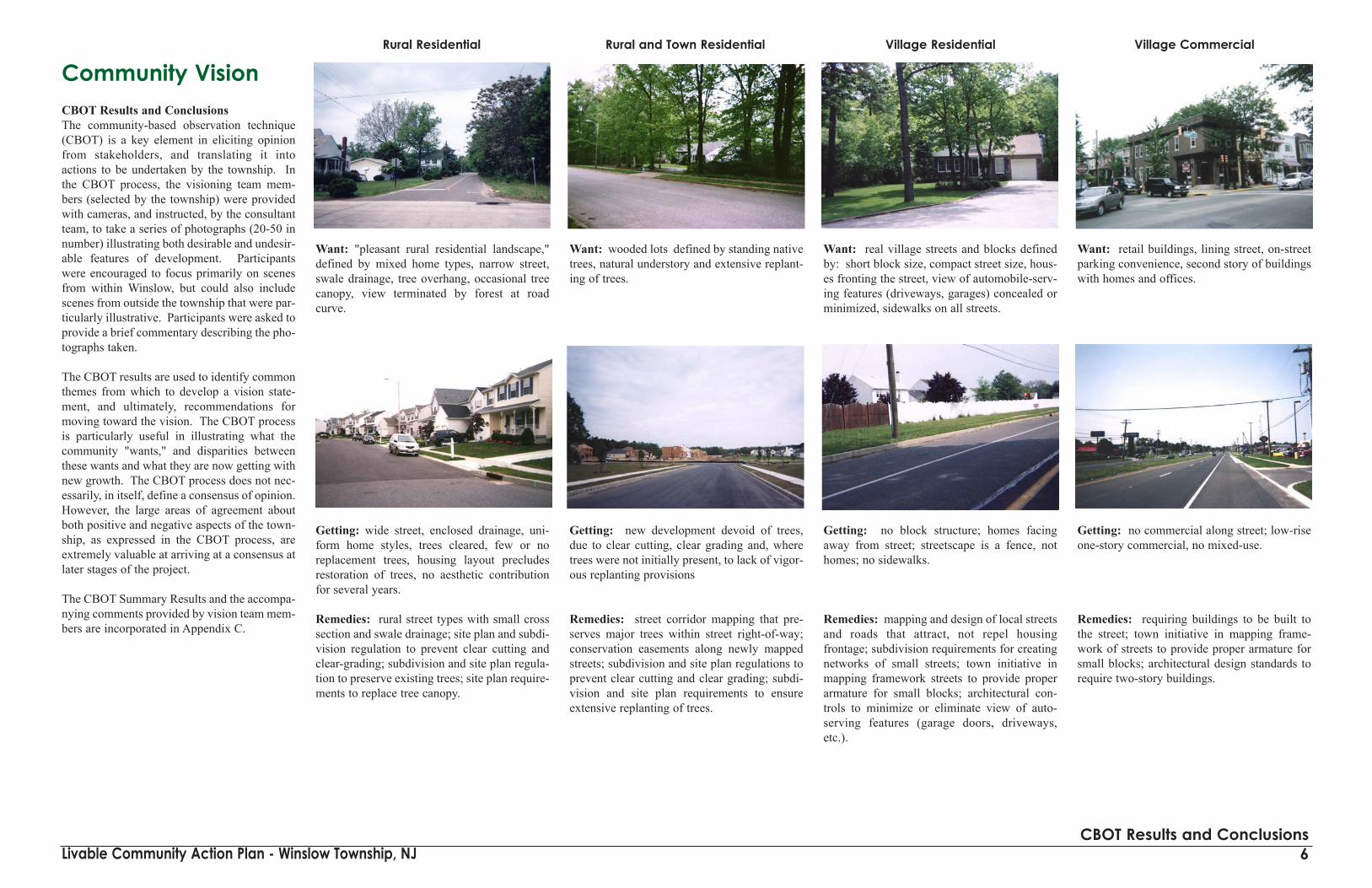
Community VisionCBOT Results and ConclusionsThe community-based observation technique(CBOT) is a key element in eliciting opinionfrom stakeholders, and translating it intoactions to be undertaken by the township. Inthe CBOT process, the visioning team mem-bers (selected by the township) were providedwith cameras, and instructed, by the consultantteam, to take a series of photographs (20-50 innumber) illustrating both desirable and undesir-able features of development. Participantswere encouraged to focus primarily on scenesfrom within Winslow, but could also includescenes from outside the township that were par-ticularly illustrative. Participants were asked toprovide a brief commentary describing the pho-tographs taken.
The CBOT results are used to identify commonthemes from which to develop a vision state-ment, and ultimately, recommendations formoving toward the vision. The CBOT processis particularly useful in illustrating what thecommunity "wants," and disparities betweenthese wants and what they are now getting withnew growth. The CBOT process does not nec-essarily, in itself, define a consensus of opinion.However, the large areas of agreement aboutboth positive and negative aspects of the town-ship, as expressed in the CBOT process, areextremely valuable at arriving at a consensus atlater stages of the project.
The CBOT Summary Results and the accompa-nying comments provided by vision team mem-bers are incorporated in Appendix C.
Want: "pleasant rural residential landscape,"defined by mixed home types, narrow street,swale drainage, tree overhang, occasional treecanopy, view terminated by forest at roadcurve.
Getting: wide street, enclosed drainage, uni-form home styles, trees cleared, few or noreplacement trees, housing layout precludesrestoration of trees, no aesthetic contributionfor several years.
Remedies: rural street types with small crosssection and swale drainage; site plan and subdi-vision regulation to prevent clear cutting andclear-grading; subdivision and site plan regula-tion to preserve existing trees; site plan require-ments to replace tree canopy.
Want: wooded lots defined by standing nativetrees, natural understory and extensive replant-ing of trees.
Getting: new development devoid of trees,due to clear cutting, clear grading and, wheretrees were not initially present, to lack of vigor-ous replanting provisions
Remedies: street corridor mapping that pre-serves major trees within street right-of-way;conservation easements along newly mappedstreets; subdivision and site plan regulations toprevent clear cutting and clear grading; subdi-vision and site plan requirements to ensureextensive replanting of trees.
Want: real village streets and blocks definedby: short block size, compact street size, hous-es fronting the street, view of automobile-serv-ing features (driveways, garages) concealed orminimized, sidewalks on all streets.
Getting: no block structure; homes facingaway from street; streetscape is a fence, nothomes; no sidewalks.
Remedies: mapping and design of local streetsand roads that attract, not repel housingfrontage; subdivision requirements for creatingnetworks of small streets; town initiative inmapping framework streets to provide properarmature for small blocks; architectural con-trols to minimize or eliminate view of auto-serving features (garage doors, driveways,etc.).
Want: retail buildings, lining street, on-streetparking convenience, second story of buildingswith homes and offices.
Getting: no commercial along street; low-riseone-story commercial, no mixed-use.
Remedies: requiring buildings to be built tothe street; town initiative in mapping frame-work of streets to provide proper armature forsmall blocks; architectural design standards torequire two-story buildings.
6CBOT Results and Conclusions
Rural Residential Rural and Town Residential Village Residential Village Commercial

Livable Community Action Plan - Winslow Township, NJ
Want: Landscaped big box, landscaped park-ing lot, articulated building facade; building ofapparent two-story height.
Getting: vast sea of parking; no landscaping;building fronts not articulated; buildings clear-ly one-story only.
Remedies: architectural design guidelines torequire articulation and building height; park-ing area landscaped and buffering require-ments.
Want: Historical retail uses continued; histor-ical context (street, grounds) preserved; build-ing massing and shape reflecting historical con-text.
Getting: building appearance that does notconvey historical character, even though thebuilding use itself could be accomodated in astructure incorporating some elements of char-acter.
Remedies: architectural design guidelines; sitedesign guidelines that form structures, of alltypes, into village and town centers.
Want: historical "main street" atmosphere,closely-spaced buildings, real streets andblocks, on-street parking, well-placed streettrees.
Getting: strip commercial development domi-nated by parking; no block and street structure;no ability to walk between adjacent uses; nostreet trees.
Remedies: site design guidelines to formbuildings into street blocks; framework streetplan to form real streets and blocks; streetdesign guidelines to provide "main street" envi-ronment; building architectural guidelines;street tree guidelines.
Want: commercial activity that reflects agri-cultural and rural routes of community; smallscale ("small town" or "village") retail activity.
Getting: loss of farmland to commercialdevelopment; commercial development thathas no aspect of rural, small town or villageatmosphere.
Remedies: consolidate commercial into vil-lage and hamlet centers along major highways;remove vehicular parking as dominant siteaspect through site plan regulation; architectur-al design guidelines; restore or institute treecanopy through tree regulation.
Want: Parks to be a gathering spot.
Getting: Disjointed fragments of a park system.
Remedies: Build strong central public spacefeatures into town and village clusters.
7CBOT Results and Conclusions
BIg Box Commercial Historical Retail Districts Main Street Atmosphere Rural Commercial Parks

Livable Community Action Plan - Winslow Township, NJ
Want: Well designed, not fenced basins,appearing to be part of the landscape.
Getting: Fenced, poorly screened basinsblighting the landscape.
Remedies: Overhaul of storm water require-ments in subdivision and site plan regulations.
Want: Retention features that are unfenced,attractive additions to the landscape, or eventhe central features of important public spaces.
Getting: Retention areas that are not only iso-lated and have no scenic or recreational value,but are also barricaded to all other potentialuses.
Remedies: Overhaul of storm water require-ments in subdivision and site plan regulations,to encourage or even mandate that storm waterretention facilities do "double duty" as attrac-tive centerpieces of new development, or atleast as unfenced, landscaped additions to thescenic value of the project.
8Long Range Vision Statement
Storm Water Treatment Appearance Storm Water Retention as Aesthetic Feature
Draft Long-Range Strategic Vision Statement:
Within the framework of the existing zoning plan of the township, respect the rural heritage of the township and open space by encouraging the development ofpedestrian-oriented town and village centers with a strong sense of place along theRoute 73 corridor through:
• The development and implementation of a conceptual development framework for the Pinelands Town Center Zoning District and other mixed-use centers;
• The development and implementation of innovative stormwater management practices that serve as passive open space or parks;
• The development and implementation of pedestrian-oriented building and site design guidelines;
• The development and implementation of livable street and block design guide-lines; and
• The expansion of the existing public street network and construction of complementary new roads to encourage multi-modal transportation (driving, transit, biking, and walking).

Livable Community Action Plan - Winslow Township, NJ 9Issues/Strategies Analysis
Issues/Strategies AnalysisKey issues and challenges identified by stakeholders are grouped and summarizedon the left-hand side of this diagram. Next, the long range vision statement ele-ments are listed and associated with the issues and opportunities.
The strategies that translate the "vision elements" into town actions are identifiedin the matrix in the right-hand side of the diagram. These strategies are then dis-cussed in further detail, throughout the remainder of this report. Shaded circlesdenote higher priority strategies, while the open circles indicate complementaryactions that will help realize each element of the vision statement.
Note the high degree of interrelationship between issues and the strategies thataddress them. Most issues are addressed by several vision elements, which in turntranslate to multiple strategies. Thus, most issues are ultimately addressed by sev-eral of the recommended strategies. Conversely, each recommended strategyaccomplishes a number of vision elements, and therefore addresses a number ofdifferent issues. The chart gives a graphical idea of the most effective measures;they are the ones that advance multiple vision elements and therefore address thegreatest number of issues.

Livable Community Action Plan - Winslow Township, NJ
Adopt Build-To Commercial Building SitingThis simple site plan regulation action, which requires that commercial buildings belocated on or near the street right-of-way line, is absolutely essential to the characterof all levels of center - town center, village center and rural hamlet. Without the build-to requirement, no amount of other amenities - buffering, architectural design reviews,landscaping, etc. - will provide the desired "smart growth" environment. Conversely,the build-to requirement alone, even in the absence of many of the supporting ameni-ties, will in itself provide most of the desired village qualities.
The build-to ordinance assures the presence of the single most important characteris-tic of towns and villages; namely the arrangement of destinations in a valuable civicpattern, rather than a pattern dictated by the speed and convenience of automobileaccess.
With buildings placed forward, walking distances between building entrancesdecrease below the 500-foot threshold for convenient walking. Further, the environ-ment for this walking is along attractive streets fronted by buildings. Under conven-tional building layout, building entrances are almost always separated by distancesgreater than the 500-foot threshold. Further, these longer distances are comprised ofparking lots and multi-lane arterial streets, two of the most hostile environments imag-inable for walking.
Buildings placed forward on the site bring a sense of enclosure to the street, a primecharacteristic of towns and villages. Conventional development, with the buildingsdeeply set back, on the other hand, provides no sense of enclosure. The pattern ofdriving and parking activity is fundamentally different in the building-forwardarrangement, compared to the conventional sprawl arrangement. With buildings for-ward and parking consolidated toward the rear of buildings, visitors no longer attemptto park on the premises of their final destination and make repeated driving tripsbetween destinations within the same town center. Rather, drivers accept a parkingspace at any of a number of comparable locations, and make an extended "walking"tour, visiting multiple destinations from a single parking space. The result is a great-ly reduced need for parking spaces, fewer vehicle trips and less vehicle miles of trav-el within the town center.
The building-forward design is inherently favorable to business, particularly smallretailers. Typically, the most burdensome requirement, for businesses (new, expand-ing, relocating, etc.) in a town center is providing parking. In conventional suburbanlayouts, with no possibility of walking between destinations, local codes typicallyrequire that all of the parking for a given destination be contained on the premises ofthat destination. Further, the parking requirements are generally sized to not onlyaccommodate the daily peak or parking demand for that individual destination, butalso the annual peak. The result, therefore, is a parking requirement, for mixed-usecommercial areas, of 5-6 spaces per 1,000 square feet. Not only is this quantity ofparking burdensome for the businesses involved, but it becomes almost impossible toprovide in an arrangement that preserves the qualities of the town. Inevitably, pro-viding 5-6 spaces per 1,000 square feet results in parking lots becoming the dominantfeature of the site, as seen from the road or any other viewpoint.
The retail exposure to passing traffic (a primary measure of effectiveness of retailareas) is vastly better if buildings are arranged forward, rather than rearward. Withbuildings forward, the entire building frontage is within the 20 degree vision cone of
10Adopt Build-To Commercial Building Siting
the passing driver; with buildings rearward, the building is not visible within thisvision cone. With buildings arranged forward in a solid street front or road front, the"impression" on the passing motorist is continuous and first-hand; motorists see andeven look into the final destination. With buildings rearward, buildings are not onlyremoved from the 20 degree vision cone, but also become sporadic, rather than a con-tinuous building front. Further, since the interior of the building (and usually thebuilding itself) is no longer visible from the street, the site must rely on "secondary"ways of communicating, such as signs, logos, streamers, bizarre building shape, andso forth.
Comparison, Conventional Vs. Build-To Development
Conventional Same Use, Build-To Siting
Crossroads Hamlet Retail
Examples of Build-To Siting
Grocery Store
Gas Station/Mini Mart

Livable Community Action Plan - Winslow Township, NJ
Concerns and Solutions
Site developers frequently argue (sometimes strenuously) that "modern retailing"such as chain drugstores and banks, does not lend itself to a build-to building sit-ing because of the need for parking, drive-thru service windows and so forth.However, the build-to site configuration does not diminish, in the least, any ofthese "modern" requirements of site design. To the contrary, meeting two of themost pressing auto related needs - parking and access from the street is generallyenhanced, not diminished by the build-to requirement.
Legal action, on the part of developers or their would-be tenants, is occasionallythreatened, typically on the argument that the build-to requirement is "depriving"the owner of the ability to use the land to its maximum value. This threat is rarelypursued, due to the likelihood of it being dismissed since the build-to requirementcannot be shown to produce any detriment to business advantage. To the contrary,consistent application of the build-to requirement will produce a superior, andtherefore more valuable, business environment for all owners involved. Further,the large number of build-to requirements now successfully in effect throughoutthe U.S. is daunting to a protesting site owner considering legal action.
Another threat often made in response to build-to requirements - that the businesswill abandon the proposed site and locate outside the town - is seldom credible.More often than not, protesting businesses are committed to developing on theoriginally intended site, and will comply, perhaps grudgingly, with the build-torequirement.
Proximity to the street, and therefore to noise, vibration, fumes, salt spray and soforth, is sometimes cited as an argument against the build-to requirement.However, this concern is addressed by a proper street design with on-street park-ing, thereby buffering the building and its sidewalk by parked vehicles. Also, cur-rent building code requirements for soundproofing, insulation and so forth great-ly mitigate the noise, fume and vibration impacts of passing traffic. Finally, somevariation in setback is possible (up to ten feet), giving businesses some option inremoving themselves from the street.
Recommended Actions
Adopt the simple requirement that the maximum setback for commercial build-ings be no greater than five to thirty (5-30) feet from the front property line.Specifically exclude any vehicular accommodation (driveway, drive-in window,parking, etc.) from the space between building and sidewalk. Require doorwaysonto the street or, if on the side of building, within a short distance (less than 30feet, for example) of sidewalk. Make the build-to requirement applicable to allcommercial and retail sites, whether in designated town/village centers or outsideof them. Apply the regulation to all types of commercial and retail activity,including "big box" sites. Detailed ordinance language is presented in AppendixA.
11Adopt Build-To Commercial Building Siting
Conventional siting: mixed use, but nothing within 500 feet
Build-to siting: same uses, but everything within 500 feet
Before: Roadside Strip; parking dominates view; no shared parking; no walkingenvironment
After: New buildings sited on street; old businesses remain; village buildingsdominate view; sharing parking; superior walking environment
Typical crossroads commercial; viewdominated by parking lots
Streetscape by itself does little tochange character
Character starts to change when nextgeneration of building fronts the street
Opportunities for important publicspace become self-evident

Revise Parking RegulationsCurrent site plan regulations for Winslow Township require that new commercialdevelopment provide a designated number of parking spaces (the parking "ratio")for each thousand feet of building floor area. While intended to assure an ade-quate supply of off-street parking in support of new growth, these regulations, inactual practice, are producing unintended consequences. Foremost among theseare the large number of spaces required, since the parking ratios reflect the maxi-mum number of spaces needed during peak period for that particular user, leavingthe user with many unused spaces throughout most of the year. Another unin-tended consequence of the current regulations is the inability for neighboring des-tinations to share their parking. Rather than promoting shared parking, and con-sequently a reduction in total number of spaces, the regulations tend to fosterparking that is dedicated exclusively to the retail destination. Any sharing of thisparking is out of the question, because of the excessive walking distances betweendestinations (partly as a result of the parking itself) and further by the design ofthe parking that signals, to the driver, that sharing is not welcome and in someinstances prohibited outright.
With all parking self-contained on the premise of the final destination, the park-ing need is typically 5-6 spaces per thousand square feet of building area, as eachindividual site attempts to provide not only for its daily peak need, but even itsannual peak need. At this level of parking supply (i.e., 5-6 spaces per thousandsquare feet), the parking areas become the dominant feature of the view from theroad, and it is practically impossible to design sites otherwise.
With shared parking, in a town center or village center, the combined need forparking reduces to 3-4 spaces per thousand square feet of commercial buildingfloor area. At this level of parking demand, parking can be easily concealedbehind buildings fronting the street, or contained in small "vest pocket" parkinglots, occupying only small amounts of street frontage and therefore largely con-cealed from the view from the street.
For all town and village districts, it is recommended that the township modify theminimum parking requirements to 60% of the existing levels. For example,Winslow’s current ordinance requires one space for every 400 square feet ofrentable office floor area and one space for every 250 square feet of retail floorarea. These requirements should be changed to approximately one space every forevery 650 square feet for office and one space for every 400 square feet for retail.Further, it is recommended that the township, at the subdivision site plan approvalprocess, require full cross-access easements across all commercial parking. It isrecommended that, as part of the site plan approval process for commercial landuses, the applicant prepare an analysis of the potential for shared parking with oth-er existing or committed projects within reasonable walking distance.
Two other proposed actions are highly interrelated with the revision to the park-ing requirement. The "build-to" building siting requirement is a key factor inproperly locating parking for smart growth, and is a key prerequisite for success-ful joint use of parking. Forming new blocks, bounded by real streets, as part ofthe subdivision approval process is also a key factor in creating the street networkessential to shared parking.
Detailed ordinance language is presented in Appendix A.
Livable Community Action Plan - Winslow Township, NJ 12Revise Parking Regulations
Shared parking can be completely hidden from view in typical town center. Retail buildings fronting on street andbordering higher-density housing surround the parking area.

Obtain Street Connectivity Through SubdivisionRegulationConnectivity, both external and internal, makes it possible for most travel for dai-ly needs to be made on the local street system, without being channeled ontomajor roads. The resulting smaller street size, lower driving speed, decreasedimpact on fronting properties, improved driving experience, multiplicity of driv-ing routes, reduction of travel on arterial highways, and variety of pedestrian andbicycle routes directly advance the vision goals of "preserving rural character" andfostering "pedestrian-oriented" development..
Challenges and Solutions
Better connectivity requires more route-miles of street. On the other hand, well-connected streets should be smaller and simpler in design than those called for bycurrent guidelines (see "Revise Street Design Guidelines" Action).
Isolated subdivisions may not have adjacent streets to join, thereby creating"stubs" that prove to be politically impossible to connect in the distant future. Theanswer is the mapped system of framework streets (see "Map Additional StreetNetwork" Action).
Subdivision applicants may claim that connectivity requirements are "depriving"them of the ability to use the property to the best advantage. However, connec-tivity produces public benefits that overwhelm whatever private advantages areclaimed. Further, connectivity is, in many respects, a device for minimizing the"exporting" of costs of development from a particular subdivision to the public atlarge. This "exporting" of development costs is a major cause of residents' dis-satisfaction with new growth.
A simple, fair and very effective device for assuring a desired level of street con-nectivity is the connectivity index. This is the simple a ratio of the number ofstreet links (road sections between intersections and cul-de-sacs) divided by thenumber of street nodes (intersections and cul-de-sac heads). The illustration pro-vides an example of how to calculate the index. Street links on existing adjacentstreets that are not part of the proposed subdivision are not included in the con-
nectivity index calculation.
Any residential development shallbe required to achieve a connecti-vity index of 1.2 or greater unlessthe town determines that thisrequirement is impractical due totopography and/or natural features.In the event that this requirement is waived, a six (6) foot pedestriantrail shall be provided to link anydead-end streets within a residentialdevelopment in which the requiredconnectivity index has been waived.
All non-residential development shall be designed to allow for cross access (bothvehicular and pedestrian) to compatible adjacent properties to encourage sharedaccess points on public or private streets. This requirement may be waived if thetown determines that cross access is impractical.
The proposed public or private street system shall be designed to provide vehicu-lar interconnections to all similar or compatible adjacent uses (existing andfuture). Such connections shall be provided approximately every 1,000 linear feetfor each direction (north, south, east, west) in which the subject property abutssimilar or compatible uses. If the common property boundary in any direction isless than 1,000 linear feet, the subject property will be required to provide aninterconnection if it is determined by the town that the interconnection in thatdirection can best be accomplished through the subject property. When the towndeems a vehicular connection impractical, it can increase the length requirementand/or, require pedestrian connections.
Require External Street Connectivity
Require that subdivisions connect with the external "framework" street system atintervals not to exceed 1,000 feet along the perimeter of the site. Further, requirethat subdivisions connect to the designated framework street system in all fourmajor directions. Require connection for non-vehicular travel at intervals not toexceed 500 feet along the perimeter of the property. Although often called a“grid,” the arrangement of the highly connected network can take many forms,only one of which is the rectangular block pattern. Regardless of pattern, theimportant feature - connectivity of streets - is accomplished. At dead-end streets,serving properties at the subdivision border, require that pedestrian connection (orright-of-way for pedestrian connection) be provided from the cul-de-sac to thesubdivision boundary. Exceptions: topographical constraints (wetlands, streams,etc.) and limited-access highway right-of-way.
Internal Connectivity
Adopt a connectivity index, defined as the ratio of street links to nodes (intersec-tions and dead-ends). The connectivity index assures the desired level of connec-tion for walking trips, and also assures that traffic is well dispersed over the streetnetwork, rather than being focused onto a few links. At the same time, a connec-tivity index gives the site developer a wide degree of latitude in laying out thestreet system. The connectivity index allows for a reasonable number of dead-endstreets ("cul-de-sacs"), leaving their placement and design to the discretion of thesite developer.
In computing the connectivity index, include all internal intersections and dead-end street endings. (cul-de-sacs) as a node. Also, count, as a node, intersectionswith existing streets. Count as links, all segments of streets between nodes asdefined above. Street lengths extending to the subdivision boundary, and intend-ed to connect with future streets in adjacent subdivisions, are counted as one-halfof a link.
Guidelines for connectivity index are:• For subdivisions of less than 100 dwelling units: minimum connectivity index
of 1.1.• For subdivisions of 100 through 500 dwelling units: connectivity index of
1.25.• For subdivisions of more than 500 dwelling units: connectivity index of 1.3.
Detailed ordinance language for connectivity is presented in Appendix A.
Livable Community Action Plan - Winslow Township, NJ 13Obtain Street Connectivity Through Subdivision Regulation

Livable Community Action Plan - Winslow Township, NJ
Revise Stormwater RegulationsComprehensive Stormwater Management - Problems, Options, andRegulationsThe Pinelands Comprehensive Management Plan has served to protect many thou-sands of acres from the impacts of development through re-direction of new devel-opment into growth areas. But the good news of conservation also has beenaccompanied by the bad news of a variety of environmental impacts occurring asthe result of this growth area development. Although both the PinelandsCommission itself and the New Jersey Department of Environmental Protection(NJDEP) have enacted regulatory programs (discussed below) to help minimizethese adverse effects of development, growth area municipalities such as WinslowTownship have both suffered from problems associated with unsightly and unsuc-cessful stormwater management systems and other elements of growth infrastruc-ture such as massive wastewater management collection and treatment systems thatdrain critical aquifers and discharge polluted effluents.
Advances in technologies and development of an evolving array of BestManagement Practices or BMPs are dramatically improving stormwater manage-ment, as part of "smart growth" planning. The "D" words of Development andDensity no longer need to be equated with Disaster in terms of stormwater and oth-er infrastructure. Smart growth means smarter stormwater management techniqueswhich maintain hydrologic balance and minimize pollutant loadings. Smart growthmeans smarter wastewater management which recycles wastewater effluents, uti-lizing nutrients such as phosphorus and nitrogen in the process. Smart growthmeans conservation-oriented water supply which can be sustained and balancedover the long term. In short, with the application of new techniques in all of theseareas, more land development can occur with significantly less impact.
Curiously, although innovations in technology have revolutionized so much of theworld in the last 30 to 40 years, the building industry has lagged in its approach toland development infrastructure. Stormwater and wastewater practices in so manyNew Jersey municipalities in 2003 remain remarkably similar to practices 40 ormore years ago. A major impetus for change has certainly been the emergence ofrequirements as set forth by the Pinelands Commission, and more recently byNJDEP (see discussion below), in response to the new NPDES Phase II programrequirements pursuant to the federal Clean Water Act. Though these programs arenot without their bureaucratic flaws, both NJDEP and the Pinelands Commissionhave been leaders in stormwater management nationwide and deserve credit forinnovation.
Reasons for the ProblemSpecial regulations and man-agement notwithstanding,many stormwater manage-ment systems have becomeproblem-prone eyesores, evenwith the extra scrutinyimposed by the municipalitiesthemselves as well as theState and PinelandsCommission. A common complaint registered against so many stormwater man-agement systems is an aesthetic one: they quickly deteriorate and become ugly
blemishes on the landscape.To some extent, the problemcan be related to the fact thatstormwater management typ-ically takes the form of somesort of highly centralizedbasin squeezed into whateversite area is leftover after thebuilding program has beenfully planned out and accom-modated on the site. Assuch, locations of the conven-tional stormwater basins areoften less than ideal andsomething of an afterthought,emerging in visually promi-nent positions such as majorentrances or open space.Rarely are the stormwatersystems carefully integratedinto overall site design,reflective of optimal loca-tions from either a functionalor aesthetic perspective.Rarely is stormwater man-agement even taken into con-sideration up front in the sitedesign process.
As a consequence, manystormwater management sys-tems do not work as intended.Managers now recognize thatstormwater managementmeans not only control ofpeak rates of runoff, but alsocontrol of total runoff vol-umes, with control of ground-water (and aquifer) rechargeas well. In so many cases,we've seriously imbalancedthe water cycle and significantly increased runoff and downstream floodingthrough peak rate-focused detention basin systems. The corollary losses in infil-tration and recharge then translate into depleted wells, streams, wetlands, and oth-er critical water features when the rain stops.
Closely linked to the water quantity management issues is water quality, bestserved by preventive approaches as well as mitigative practices which are opti-mized through soil- and vegetation-based infiltration practices. So often thesecomprehensive objectives of groundwater recharge and water quality are not beingachieved, either by design or by accident. Systems malfunction, which in turn cre-ates eyesores such as clogged outlets, reduced infiltration, eutrophic standing waterthat quickly degenerates into potential mosquito breeding pools. Because of their
unsavory character which has emerged over time, added security measures are typ-ically taken to prevent or at least minimize human interaction and contact withstormwater basins. Unsightlychain-linked fences areinstalled around basin perime-ters, making them even moreforeboding. Stormwatergrows even uglier.
Maintenance requirements,whether imposed by home-owners, homeowners associa-tions, or the municipalitiesthemselves, mount. Evenunder the best of conditions, thenatural tendency is to cut main-tenance short. As various mal-functions increase, mainte-nance requirements increaserapidly, and problems (and theircosts) snowball.
14Revise Stormwater Regulation
Excessive land disturbance
Ineffective stormwater management
Constructed wetlands maintain water quality andcan be aesthetically pleasing.

Livable Community Action Plan - Winslow Township, NJ 15Revise Stormwater Regulation
Comprehensive Stormwater Management OptionsOption Set 1: Preventive Nonstructural Conservation Design and LowImpact DevelopmentThrough optimal blends of preventive nonstructural site design approaches andmitigative structural practices, higher density development can be accommodatedwith substantially reduced stormwater and other impacts, provided that basicwater quantity and quality principles are respected. The rapidly emerging SmartGrowth sub-fields of Conservation Design and Low Impact Development (con-cepts sometimes used interchangeably) are showing us that through applying anumber of conservation-oriented low impact site design approaches, significantstormwater generation can be prevented.
First, minimize total site disturbance; maximize preservation of undisturbedsite soils and site vegetation, even as the building program (such as number ofdwelling units or commercial square footage or other building activity) is heldconstant. Typically, minimizing disturbance can be achieved through any numberof clustering techniques and, more broadly, through Neo-Traditional (or NewUrbanist) site development. These approaches to site design usually entail con-siderably reduced setbacks which allow for reduction in lot size and total amountof land area "consumed" by any particular building program, though not a reduc-tion in the building program itself. Municipal ordinances should define MinimumDisturbance/Minimum Maintenance provisions compatible with the physicalcharacteristics of the municipality together with the type of development beingaccommodated. When maximized, Minimum Disturbance/MinimumMaintenance also translates into a reduction in the artificially maintained land-scape with application of fertilizers and pesticides, significantly reducing non-point source water quality loadings year after year. Areas of undisturbed vegeta-tion can then be used as part of the active stormwater management plan itself.
Stormwater generation can be reduced by minimizing the creation of impervi-ous cover, as well as site disturbance. Consider vertical development, compati-ble with new-traditional multi-story town themes, featuring retail shops and officeand apartment units located in upper floors, where feasible, in contrast to one-floor big boxes. The same building programs can be accommodated with lessimpervious cover, less stormwater generated. Downsize and "skinny" the streetsystem, where appropriate, avoiding oversized subdivision road system with 30-foot wide streets on small residential cul-de-sacs (e.g., the "green" street systemsas advocated by the Center for Watershed Protection). Use vegetated circles thatreduce impervious area and incorporate vegetated stormwater management treat-ment at the same time, as well as downsized turnarounds. Use shared parkingwith the correct blend of uses; consider use of maximum parking ratios, not min-imums. Structured parking, though costly, means less disturbance, less impervi-ous areas, less stormwater generation.
Another nonstructural method of preventative stormwater management is toprotect areas that provide water quality benefits, including vegetated areasnear waterbodies that are particularly susceptible to erosion and sediment loss.Finally, engineers should design to minimize the decrease in pre-construction timeof concentration. Reduction in the time of concentration will result in stormwa-ter leaving the site faster and in greater quantity resulting in higher peak flows inthe receiving waterbody. Any decrease in the time of concentration must there-fore be minimized to control the negative impacts downstream.
Preserve existing site vegetation...
...through minimum disturbance/maximum maintenance...
Reduce paved and other impervious surfaces...
...with an array of low impact development techniques.
For aesthetic and functional stormwater management. ...at both residential and commercial sites...

Livable Community Action Plan - Winslow Township, NJ 16Revise Stormwater Regulation
Comprehensive Stormwater Management OptionsOption Set 2: Mitigative and StructuralStormwater cannot be totally avoided; some disturbance, some impervious surface isgoing to result as development occurs, even if preventive approaches are embracedthoroughly. The More with Less philosophy also translates into a broad array ofinnovative practices which mitigate both stormwater quantity and quality impactsthrough reliance on structured soil- and vegetation-based systems.
To make this work, the first critical step is a thorough site analysis which identifiesareas of site stormwater management opportunity and areas of site constraint. Sitesoils and vegetation play an important role in this analysis and indicate where oppor-tunities for infiltration, the optimal management approach for both water quantityand quality, can occur. All else being equal, this infiltration should be integratedinto the overall site plan in a way that is as decentralized and distributed as possi-ble, occurring as close to the source or point of generation as possible.
In lower density residential subdivisions, stormwater may be directed into land-scaped recharge gardens (also called rain gardens); these vegetated recharge gardenscan be integrated into higher density applications and provide attractive landscapefeatures which accomplish stormwater objectives as well. Stormwater can be direct-ed along vegetated swales - vegetated open channel conveyance systems - avoidingcurbs and gutters, and diverted into level spreading berms on contour, carefullythreaded through wooded areas.
In higher intensity commercial areas, stormwater management may take the form ofinfiltration chambers located beneath porous-paved parking lots; parking areas notonly accommodate their own stormwater but also can receive runoff from buildingroof areas and other paved surfaces. Where more centralized management cannot beavoided, subtle and shallow basins planted with appropriate wildflower mix can beintegrated into infiltration-conducive areas in the site. If natural conditions prohibitinfiltration, wet ponds, properly designed and engineered and enhanced with wetlandvegetation (i.e., constructed wetlands), offer water quality treatment; these wet pondfeatures can add significant aesthetic value to the overall development, though mustbe large enough to sustain a successful aquatic community.
Use vegetated swales and filter strips for quantity and quality control.
Porous pavement over recharge beds optimize site use with excellent envi-ronmental performance.
Use both soil and vegetative-based “structures,” such as these rechargeor rain gardens
Integrate stormwater elements into site design, close to the source...

Comprehensive Stormwater ManagementNew Jersey Regulatory IssuesPoor stormwater management has increased pollution in surface waters andgroundwater and made droughts and flooding more severe. This has been recog-nized as a significant problem at the state level. Accordingly, NJDEP has pro-posed new regulations - that NJ townships can adopt at minimum - designed tobetter protect water quality and quantity. These Stormwater Management Rules(N.J .A.C. 7:8 avai lable onl ine at http://www.state.nj.us/dep/watershed-mgt/DOCS/BMP_DOCS/stormwater_management_plan.pdf) recommend andrequire both structural (preventative) and nonstructural (mitigative) stormwatermanagement strategies as discussed in Option Set 1 and Option Set 2, above. Theguiding principles for comprehensive stormwater management outlined anddiscussed above are reflected in the new state regulations.
The new rules aim to improve performance objectives and methods of mitigatingthe negative impacts of post-construction stormwater runoff with the intent torequire implementation of better site design techniques that prevent disturbancesthrough use of nonstructural stormwater strategies or Low Impact Development.In addition, the new regulations include design and performance standards devel-oped for groundwater recharge and stormwater runoff quantity (volume) control.For example, N.J.A.C. 7:5.4(a)2 provides two options for satisfying the rechargeperformance standard. First, maintain 100% of the average annual pre-construc-tion groundwater recharge volume for the site. Second, infiltrate the net increaseof the 2-year stormwater runoff volume from pre-construction to post-construc-tion. (Note: Not all of DEP’s proposed requirements are more stringent than thePineland’s CMP; in such instances, the CMP’s requirements will still need to bemet.)
Pursuant to the New Jersey Stormwater Management Act N.J.S.A 40:55d - 93 to99, every municipality in the State is required to prepare a stormwater manage-ment plan and a stormwater management ordinance to implement that plan.Details and general requirements for Stormwater Management Planning are pro-vided in Subchapters 2, 3, and 4 of the new state regulations N.J.A.C. 7:8.Regional Stormwater Management Plans on a watershed or drainage area basis areacceptable, provided that the municipalities in the study area adopt the plan andordinance.
Current stormwater regulations for Winslow Township focus on stormwater ratecontrol and volume control, like most New Jersey municipalities. The new Stateregulations are refocusing stormwater engineering on volume control and waterquality. When the stormwater volume is mitigated, i.e. infiltrated and/or retained,stormwater management facilities can be designed that mitigate peak rates ofrunoff for even the larger storms. By designing facilities for runoff volume con-trol, stormwater runoff rates are subsequently managed. The State's ResidentialSite Improvement Standards will be modeled to reflect the New Jersey Stormwater Management Act.
Given the fact that much of Winslow's Regional Growth Area remains to be devel-oped, the Township is faced with a unique opportunity to consider a regionalapproach to stormwater management. This is particularly true for the town centerand other center/village locations that may be designated along Route 73 as dis-cussed on page 20. The Township should work with the Pinelands Commission
to identify candidate site(s) for regional treatment and potential sources of fund-ing for plan development. Stormwater management can also help further openspace preservation goals as described on page 19.
Other techniques that the Township may want to consider to improve stormwatermanagement include:
• Adding a provision to the Township's ordinance to require measures tominimize soil compaction during construction that can contribute to basinfailure, including: • Cordon off the area where the basin is to be sited to prevent heavy
equipment from compacting the underlying soils • Excavate the basin with light earthmoving equipment, preferably
with tracks or over-sized tires located outside of the basin bottom • Deeply till the floor of the basin with a rotary tiller or disc harrow
and smooth over with a leveling drag or equivalent grading equip-ment.
• Cordon off the finished basin to prevent heavy equipment from com-pacting soils for the remainder of the construction period.
• Strengthen maintenance requirements by adopting the procedures for infil-tration basins described in the New Jersey Stormwater BMP Manual, suchas: • All infiltration basin components expected to receive and/or trap
debris and sediment must be inspected for clogging and excessivedebris and sediment accumulation at least four times annually as wellas after every storm exceeding one inch of rainfall. Such componentsmay include bottoms, riprap or gabion aprons, and inflow points.
• Sediment removal should take place when the basin is thoroughly dry.Disposal of debris and trash should be done at suitable disposal/recy-cling sites and in compliance with all applicable local, state and fed-eral waste regulations.
• Mowing and/or trimming of vegetation must be performed on a reg-ular schedule based on specific site conditions. Grass should bemowed at least once a month during the growing season. Vegetatedareas must also be inspected at least annually for erosion and scour.The structure must be inspected for unwanted tree growth at leastonce a year.
• When establishing or restoring vegetation, biweekly inspections ofvegetation health should be performed during the first growing sea-son or until the vegetation is established.
• Once established, inspections of vegetation health, density and diver-sity should be performed at least twice annually during both thegrowing and non-growing season. If vegetation has greater than 50percent damage, the area should be reestablished in accordance withthe original specifications and the inspection requirements presentedabove.
• All structural components must be inspected for cracking, subsidence,spalling, erosion, and deterioration at least annually.
• Consider techniques to encourage good practices such providing credit forthe nonstructural methods described earlier in this section and alternativesmanagement strategies for potential problem areas or "hot spots" such aslocations where petroleum products are loaded and unloaded.
Livable Community Action Plan - Winslow Township, NJ 17Revise Stormwater Regulation

Adopt Open Space Plan and Regulations
In its application to participate in the Pinelands Excellence Program, open spacewas listed as Winslow's first priority. Emphasizing Winslow's role as a "Gatewayto the Pinelands", the Township's Excellence Program application noted theimportance of preserving "the basic character of the area" and "protecting thequality and quantity of ground and surface waters and ecosystems in the PRGA".Through the visioning process that preceded the development of this plan, com-munity stakeholders highlighted a number of issues relating to open space, parksand recreation facilities. Among these issues was the feeling that the Township'sparks and open spaces are not functioning as community focal points or providingopportunities for community socialization. Also expressed was the further per-ception that due to a lack of coordinated planning, the parks and public spaces thathave been developed are disjointed, fragmentary and do not provide importantcommunity linkages or interconnections. Another concern that was raised sug-gested that there is a sense that while "the Pinelands is all around us" the poten-tial of the Pinelands as an environmental education and recreation resource islargely untapped. Finally, it was suggested that better designed stormwater man-agement basins could function as multi-purpose facilities, providing flood controlas well as passive open space, when they are not inundated.
This section of the Action Plan will seek to identify strategies to enhance openspace, parks and recreation opportunities for the residents of Winslow Township.These initiatives are organized along a descending scale from the regional strate-gies to suggested initiatives for individual neighborhoods. Implementation ofthese recommendations should be coordinated with the recently completedCamden County Open Space Plan that was prepared by the Delaware ValleyRegional Planning Commission.
Improving Connections to Regional Environmental Resources
As the map to the right illustrates, the Regional Growth Area is surrounded by sig-nificant natural resources. The natural resources include the Mullica River, HayesMill Creek, and the Pump Branch Creek, which reach out like so many fingers ofthe open hand of the Wharton State Forest touching along the entire length of thegrowth area. However, despite the immediate proximity of such significantresources, there is a sense among some members of the community that theseresources are little understood, appreciated or exploited for their potential asrecreational/educational resources. There are a number of physical and program-matic improvements that could be undertaken to improve public understandingand appreciation of the Pinelands resource. These include providing opportunitiesfor user/visitor orientation, creating a school-based Pinelands education curricu-lum, and enhancing opportunities for meaningful direct physical access.
Joint Winslow Heritage Center and Pinelands Orientation Facility
To reinforce and enhance Winslow's role as a "Gateway to the Pinelands", theTownship, Camden County, and the Pinelands Commission could work togetherto develop a Pinelands Visitors Center or orientation facility. The complexity ofsuch a facility could range from a fairly simple "trailhead" type facility with inter-pretive signage to a staffed educational center providing programming and serv-ices. An ideal approach would be for the Township to link the interpretation of its
own heritage with that of the Pinelands. A joint Winslow heritage center andPinelands interpretive facility could be a significant way to reinforce communityidentity while linking Winslow to the larger environmental context.
The Pinelands Curriculum
Perhaps one of the least expensive, but quite possibly most effective strategies tobetter link the people of Winslow to the environmental context of the Pinelandswould be to create a local school-based Pinelands Education curriculum. ThePinelands Commission has developed detailed curriculum guides for grades 4-6and grades 7-8. These guides provide detailed lesson plans for topics and cate-gories of soil, water, fire, people, plants, and animals. The curriculum guides areavailable on-line at www.nj.gov/pinelands (under Pinelands Educational andRecreational materials) and can be readily integrated into existing school pro-grams (the lessons were designed to meet New Jersey Core Curriculum stan-dards). Proximity to the Pinelands would make field trips, in-class visits byPinelands scientists and other interactive pedagogical approaches possible, result-ing in a potentially rich and stimulating educational experience.
Livable Community Action Plan - Winslow Township, NJ 18Adopt Open Space Plan and Regulations

Access and Interpretation
Direct contact with Pinelands resources along with effective interpretation is anessential component of enhancing local understanding and appreciation. Whilethis is an initiative that would primarily be the responsibility of the PinelandsCommission, Winslow should be directly involved in planning any access or inter-pretation improvements to ensure that they fulfill the potential of achieving strongconnections between the Township and the broader environmental context as wellas linkages to Winslow's unique history and heritage.
Developing an Open Space and Community Interconnectivity Plan
Focusing on a more sub-regional level, the map to the right suggests three specif-ic conceptual initiatives for strengthening both linkages between the people ofWinslow Township and the natural environment.
The Pump Branch Greenway
The wetland buffers along the length of the Pump Branch Creek offer an idealgreenway alignment cutting across the Regional Growth Area and linking a seriesof existing and future neighborhoods. Though the development of greenway withactive uses is not contemplated here, a low-intensity informal recreation corridor(e.g., hiking paths, access for fishing and interpretative displays) would providethe Township with a phenomenal recreational asset and begin to weave togethersome of the isolated neighborhoods that are located in this area of the Township.The greenway could be achieved by allowing the wetland buffers to be includedas part of a development’s open space requirement, and dedicating this open spaceas a public anemity through a recreational easement. The easement, maintenance,and improvement responsibilities could rest with or be shared by the Township,the County, or the State.
The School-to-Pinelands Trail
An initiative that could be developed in conjunction with the "PinelandsCurriculum" suggested earlier, would be to create a trail along Coopers FollyRoad that links the Township's educational facilities to Pinelands resources via agreenway along the Hays Mill Creek. Obviously, the trail would serve a numberof functions including enhancing pedestrian accessibility in the area of theTownship schools and improving community interconnectivity to West Atco via asouthward trail spur. The extension of other linkages from this initial spine couldserve to further interconnect neighborhoods throughout the growth area and makewalking and biking to school more feasible.
A "Green" Town Center
Considering that the Town Center Zoning District appears to contain a significantamount of wetlands and that it adjoins an environmentally sensitive area, a cuttingedge development approach may be to make it South Jersey's first "green" towncenter - incorporating green design techniques - both in terms of site layout andorientation and building design. This approach could raise the regional andstatewide profile of Winslow Township and generate significant civic pride. Agreen town center would also be the ideal location for a Pinelands visitor centeror orientation facility and possibly the setting for local Eco-tourism. At the very
least, connecting the Town Center to nearby open space could result in a veryunique physical environment for the area that would distinguish it from othermore conventional commercial areas.
Livable Community Action Plan - Winslow Township, NJ 19Adopt Open Space Plan and Regulations
Winslow Township Open Space & Community Interconnectivity Plan
Middle School
High School
TownshipBuilding
Wetlands buffers shouldbe used as ROW - Intensity Greenways for residents' enjoyment
Connect students with the Pinelandsenvironmental resources
Connect the town centerto nearby open space
New Town / Village Squares or Parks Greenways Pedestrian Access
Hayayeyes iillll rreeeeekkk
Pum Br ek

Public Space in the Town and Village CentersA concern that was raised frequently by community stakeholders regarded the lackof community focal points and gathering places - the "centers" and spaces inwhich community life occurs. To address this concern very specific revisions havebeen recommended later in the Action Plan to the zoning regulations of the TownCenter District. These revisions include specific design guidance requiring thedevelopment of a hierarchy of public spaces in the Pinelands Town CenterDistrict, ranging from a town square or green to neighborhood parks for residen-tial areas. The planning and design of new public spaces cannot be left to thewhim of private developers or to the vagaries of the market place. To achievemeaningful and useful civic spaces, detailed guidance must be provided, includ-ing the size, location, orientation, and design of these facilities. Moreover, own-ership and maintenance responsibility must be carefully considered to ensure thatnew park spaces are truly public and adequately maintained.
Neighborhood Parks and Open SpaceIncreasingly in post-war suburbanizing communities, like Winslow Township,open space has been provided in essentially two forms, either as private openspace contained in the backyards of large lot, low density single-family zoningdistricts or as residual or "waste" land (that is usually environmentally constrainedanyway) dedicated by a developer as some required percentage of the total tractarea as mandated by local zoning. Some communities have attempted to improveon the latter by increasing the required percentage of open space and stipulatingthat only a certain amount of the dedicated open space can be environmentallyconstrained. Nevertheless, this approach generally results in a haphazard, uncoor-dinated assemblage of disjointed open spaces that rarely functions as true parksystem. Moreover, the spaces that emerge are usually perceived as semi-private -that is, belonging to or serving only the development in which they are located. Insome cases this perception is reinforced by the fact that open spaces in residentialsubdivisions are often owned and maintained by homeowners. Following are threealternative approaches that can be employed to obtain more useable and accessi-ble public space.
Using the Official Map to Plan Parks and Open SpacesParks and open spaces are essential to community infrastructure, just as importantas roads, sewers and public schools. Recognizing their necessity in the develop-ment of a healthy community, the New Jersey Official Map law allows communi-ties to identify and reserve sites for public parkland in the same way that rights-of-way for future roads are established. This tool enables communities to plan anddesign in advance a coordinated and equitably distributed system of parks andopen spaces that will meet the needs of their community as it develops. Ratherthan relying on the traditional approach of accepting whatever open spaceemerges from the subdivision development process, the mapping of parklandsensures that every neighborhood is adequately served with recreation space andthat connections between these facilities can be developed. Elsewhere in this plan,the township has been urged to create a network of new rights-of-way to providea livable framework for future development. Using the official map law, the town-ship should likewise create a well-coordinated network of parkland reservationsto provide for the future recreation needs of its growing population.
Using the Cluster Option to Achieve Quality Public Open SpacesAnother useful alternative that is available to Winslow is to consider permitting acluster option or overlay in the township's residential districts. Currently, the res-
idential zoning districts in the Pinelands - except for the Planned UnitDevelopments - do not require an open space dedication. In the Planned UnitDevelopment District, a 35% dedication is mandated, however, this open space isactually private "common space" owned and maintained by the property owner.Communities should explore potential of requiring common open space to havepublic access. Under a cluster ordinance, the overall gross density of a particularzoning district would not change. However, the net "developable density" wouldbe increased substantially. For example, in a zoning district that requires a mini-mum lot size of 3 acres, the actual development lot sizes could be reduced to 1.25acres or less, and the remaining land would become public open space. In addi-tion to generating much more useable open space, clustering or concentratingdevelopment is generally more efficient since infrastructure investments arereduced. Clustering options are useful in preserving significant natural featuresand historic resources. Perhaps most importantly, a well-designed cluster ordi-nance can yield high quality residential neighborhoods that are more integratedinto context and that are more desirable because of their natural setting. (See alsothe "Open Space-Stormwater Connection" below).
Using Design to Enhance Access and Visibility of Open SpaceThe design of public spaces - whether they are publicly owned or privately main-tained can also influence the extent to which they are "perceived" as public spaceand enjoyed by all residents of the community. Perhaps one of the most effectiveways to ensure that open space functions as public parkland is to locate them onmultiple street frontages. Open spaces that are tucked away or have minimal pub-lic street frontage will often be perceived as private open space and their utiliza-tion will usually be limited to local residents. However, by making as much of thepubic space as possible visible through generous street frontage requirement willsignificantly enhance the "publicness" of the park space. Ideally, parks and publicspaces should be required to obtain frontage on at least two public streets. In addi-tion to generous street frontage, the simple gesture of providing an official-look-ing sign identifying the space as a public park and inviting and welcoming userswill reinforce the public access. Finally, external linkages in the form of hikingpaths, bike paths or shared use paths that provide connections between communi-ty parks and other neighborhoods, recreation facilities and schools, are an essen-tial part of enhancing the visibility of park and promoting their use by all resi-dents.
The Open Space-Stormwater Management ConnectionAs discussed, earlier in this plan, the Township is increasingly disappointed in theappearance and function of stormwater management basins built for new devel-opments in Winslow. Often appearing as deep gashes that are visually prominentin the landscape, these basins are not only unattractive but also a potential nui-sance. Deep basins are obviously preferred by the development community sincethey consume less developable land area while meeting run-off control regula-tions. However, steep side slopes often limit landscaping options and the lack ofvegetation reinforces the "crater" appearance of deep basins. The need to providefencing - usually chain link - for public safety around the perimeter of deep basinsfurther adds to their lack of appeal. An obvious alternative would be to requireflatter or shallower basins that appear (and to some extent) function as open spacewhen they are not inundated. The principal obstacle to this is that shallower basinsconsume valuable land area that would otherwise be devoted to developmentactivity. A further obstacle is that while shallower basins could qualify as passiveopen space, currently, separate open space reservations are not required in the res-
idential zones of the Pinelands in an effort to meet required residential densities.A further complication is that stormwater management facilities are usuallyexcluded from open space calculations.
To make shallow basins a feasible alternative, a series of revisions to theTownship's residential zoning would have to be undertaken. Using Winslow's PR-2 zoning district as an example, the following approach may be feasible:
- Require an open space reservation of 10% of the gross tract area (sameas required for the RL District)
- Reduce the minimum lot size (but not the overall density) in the zoningdistrict to allow for the open space set-aside without eliminating deve-lopment potential. In the PR-2 district, the minimum lot size would be reduced from 1.25 acres/dwelling to 1.10. Under this scenario the development potential of the tract would be equalized as illustrated below:
CurrentRequirement Proposed Requirement(Min. Lot Size:1.25 Ac) (Min. Lot Size:1.10 Ac(1))
Gross Tract Area 100 Acres 100 AcresApprox. Net Tract Area(2) 80 Acres 80 AcresOpen Space Reservation 0 Acres 10 AcresApprox # of Developable Lots 64 lots 64 lots(1) 1-acre minimum required for developments relying on on-site septic(2) Subtract 20% for roads, environmentally constrained land, etc
- Permit any portion of a stormwater management facilities that is under a cer-tain slope, say 10:1 to be counted toward open space.
- Require that basins be extensively landscaped (with appropriate plant materi-al) to visually integrate them with the rest of the development and eliminatethe need for fencing.
Through this approach, new public open space can be provided without sacrific-ing density and developers will be provided with incentives to build much shal-lower and aesthetically attractive stormwater management facilities.
In summary, the township is strongly urged to adopt an open space plan thatincludes the following:- Development of improved linkages to the regional Pinelands
context- Development of a township-wide coordinated open space and commun-
ity interconnectivity plan (in coordination with County open space plan)- Identification and reservation of future parklands and tail linkages on
the township's Official Map- Revisions to the Pinelands Town Center District to include specific
requirements for new public space- Promote the use of a cluster development option for residential subdivi-
sions- Adopt public park and open space design standards and guidelines- Revision of the Township's residential open space requirements to
encourage the development of much more attractive stormwater basins that can function as passive open space.
Livable Community Action Plan - Winslow Township, NJ 20Adopt Open Space Plan and Regulations

Designate Village and Town Center Locations
The concentration of commercially-zoned land at the northern end of the growtharea has already been designated as a town center, by both Winslow and thePinelands Commission. This location was deemed appropriate given its proxim-ity to already developed areas along Route 73 in adjacent municipalities to thenorth, its position as a "gateway" to Winslow Township, and its ease of access(both auto and rail). The potential presence of wetlands as indicated on the mapbelow, indicates that careful planning will be required to fully develop this loca-tion (a detailed wetlands survey will be required by the Pinelands Commissionbefore any development is permitted to take place; to date, no survey results havebeen submitted to the Commission). As a next step in planning for developmentalong Route 73, the Township should designate of three other locations as eithertown or village center.
Designating town and village centers is critical to focusing the commercial activ-ity into well defined nodes, thereby reducing or eliminating the "rural sprawl" typ-ically caused by this activity. The resulting "town and country" atmosphere -comprised of well defined town and village centers separated by a unspoiled ruralatmosphere - is supported by all of the received stakeholder input. Further, thisconcept is supported in both the Pinelands Comprehensive Management Plan andin the Winslow Township Master Plan.
The Winslow Township Zoning Ordinance already designates a town center areain the northern part of the Route 73 corridor. While the mere designation of “towncenter” does not assure all the qualities of a true town center, it is nevertheless theessential underlying regulatory step.
The remainder of the Route 73 corridor within the Pineland’s growth area, a dis-tance of some four miles, does not have any other designated centers along it. Tothe contrary, most of the frontage of Route 73 throughout this area is in elongatedstrips of retails and industrial zoning. While the concept of focusing commercialgrowth along the Route 73 corridor is reasonable and supportable, the current sit-uation (i.e., thinly spread continuous frontage of these activities) is a recipe forsuburban sprawl, similar to that now blighting the Route 73 corridor to the northof the township.
Designating additional town and village centers along the Route 73 corridor with-in the Pineland’s Regional Growth Area, and taking the necessary regulatoryactions as described in this action plan, will assure that the level of growth antic-ipated for the Route 73 corridor is maintained, but that this growth is channeledinto a well defined series of town and village centers.
Principles of Town and Village Centers
Two overarching principles of forming a town center are illustrated above: (1)clustering of the commercial activity into a node of several town blocks in depth,as contrasted to sprawl along Route 73 and (2) arrangement of the commercialbuildings along streets. The armature essential for this pattern of development isa web of small, local new streets, forming a cluster of town blocks.
The web of small streets in the town center permits access to Route 73 at careful-ly selected points, primarily new intersections of public streets. The proliferationof driveways, typical of highway corridor strip development, is avoided. In sharpcontrast to typical strip development, the parking is concealed by view, and isjointly used by many destinations within the center. This contrasts sharply withthe strip development pattern, in which highly visible parking, located in front ofthe buildings, is used only for visitors to that particular destination.
Storm water treatment within a town center can be managed to provide a publicamenity, such as, a greenway connecting to adjacent residential areas. This pat-tern contrasts strongly with the usual approach to storm water management, whichinvolves retaining storm water within each building site, frequently in an unsight-ly retention basin.
Town centers inherited from past eras of growth are highly valued, even after hun-dreds of years. These qualities can be readily recreated in new growth. Whilesuch centers often reflect a concentration of commercial activity, the "crossroads"location at the intersection of Coopers Folly Road with Route 73 is well suited toserve as a center for local government services. The foundation for this conceptis already in place, with the high school, senior center and library serving a broad
cross section of the community. To complement the existing mix of uses, mem-bers of the visioning team endorsed development of a new, multi-story municipalbuilding at the intersection of Route 73 and Coopers Folly Road as a replacementfor the current building located further south on Route 73 (and off-site annex inTansboro). This location would be natural fit for a new building, given its visi-bility and access from Route 73, the opportunity to consolidate currently scatteredmunicipal offices in one building, and the need for additional space for municipalservices and staff.
The two remaining centers, at the intersection of Route 73 and New Brooklyn-Cedarbrook Road, and Route 73 and Coopers Folly Road, are more traditionallocations for concentrated development.
The former train station depot of Cedarbrook, at the intersection of Route 73 andNew Brooklyn-Cedarbrook Road, would be an ideal location for a village orneighborhood center. A good percentage of new residential development inWinslow Township is being constructed along New Brooklyn-Cedarbrook Roadand along Pump Branch Road. In addition, there is an existing commercial areaon Route 73 north of Pump Branch Road that requires additional retail and serv-ices in order to become viable again. Due to the location of this commercial areaand new residential densities, it would be feasible to connect these areas with apedestrian-friendly village center framework.
Another potential village or neighborhood center could occur in the vicinity of theWinslow Township municipal complex, provided that it is relocated at Route 73and Coopers Folly Road as recommended. There are already residential areas inthis vicinity, as well as some minor commercial areas. It would be prudent for thetownship to "envision" the potential redevelopment of the current municipal com-plex as a higher-density village or neighborhood center, and to leverage thispotential as one way to finance the construction of the new municipal complex atCoopers Folly Road.
Suburban strip development, the antithesis of town building, abounds along Route73 to the north of Winslow, and on many other arterial highways near thePinelands. Although universally disliked, this pattern of development isinevitable under existing land development regulations. Small changes in theseregulations, all of them prerogatives of Winslow Township, can fundamentallychange the ability to build real town and village centers.
Recommended Actions
Delineate a boundary (comparable to that already established for the proposedtown center) for three other town or village centers along Route 73. Develop adetailed area plan for each town center, with the first priority being the currentlydesignated center at the northern end of the corridor. Include, in town centerplans, the extension and connection of streets, new streets and blocks; provisionand conceptual design for public open spaces; and stormwater treatment designsthat not only observe best practice but also provide an amenity for the site. Bycreating a detailed center plan, Winslow Township may apply for “plan endorse-ment” through the State Department of Community Affairs, which may provideplanning and funding assistance to aid development.
Livable Community Action Plan - Winslow Township, NJ 21Designate Village and Town Center Locations

Adjust Zoning to Support Center on Route 73
Route 73 to the north of Winslow is a catalog of the undesirable consequences ofstrip development along highways. Although the overall quantity is not large, thearrangement of this retail activity in a thin veneer of frontage along Route 73 total-ly obliterates the rural atmosphere. Although a fully rural atmosphere usuallyexists a few hundred feet away from the road, this atmosphere is not experiencedby travelers on the road.
Simply arranging the commercial activity into centers and safeguarding (throughzoning) the openness of the land between centers creates a distinctive "town andcountry" atmosphere.
The amount of commercial zoning along Route 73 reflects a great deal of delib-eration and consensus on the part of the Township. This zoning, which calls forsome 75% of the frontage of Route 73 to be in commercial use accepts theinevitable tendency of major highways to attract most, if not all, of the commer-cial development in their regions.
The anticipation, on the part of the town, that the bulk of new commercial activi-ty will (and should) occur along Route 73, is well founded. With some smalladjustments in zoning, however, the detailed location and form of new commer-cial activity can be enhanced considerably. These small adjustments do not affectthe total amount of commercial activity zoned for the corridor. However, thedetailed location of this zoning would be modified somewhat, to "shift" the com-mercial zoning into the areas designated as "centers," and, correspondingly, awayfrom those areas not in centers. The result is further support for the "town andcountry" concept, in which the frontage along Route 73 would vary between dis-tinctive qualities of open land or town centers. The Township’s commitment tothis concept was clearly demonstrated when the new town center zone was recent-ly created in the northern portion of the RGA. Further, the length of the commer-cial strip in the Township (six miles or so) is unsustainable economically. Thecharacteristic of Route 73 to the north of Winslow - continuous commercialsprawl bordering the entire highway frontage - would therefore be prevented.
Principles of Zoning Adjustments
Shifting zoning within the Route 73 corridor can be accomplished in a number ofdifferent ways. The appropriate method depends on the specifics of the sitesinvolved.
Perhaps the simplest method of"shifting" zoning is simply to real-locate the intensity within a singleproperty, permitting more inten-sive use for that part of the proper-ty that falls within any center area,and, correspondingly, reducing theintensity permitted elsewhere.This method is particularly appli-cable where large parcels undersingle ownership fall both withinand without the designated towncenter areas.
The standard method for transferof development rights within thePinelands can be used as a modelto create a new program thatwould include commercial proper-ties, to transfer intensity into towncenters from those parcels imme-diately adjacent to, or otherwiselocated within the RGA’s commer-cial zones, to the town center.While this transfer will not usuallyoccur within a single owner, it willmaintain the same level of intensi-ty permitted within the Route 73corridor, and will therefore be ful-ly in keeping with the town's zon-ing for commercial activity alongthe Route 73 corridor.
Required Zoning Shifts are Not Extensive
Although the majority of the Route 73 frontage is now zoned commercial, a lim-ited effort at rezoning would largely accomplish the shifting of intensity into towncenters, and would set the stage for a true “town and country” atmosphere throughthe corridor. Intervention in 12 parcels is all that is required. Of these parcels,five interventions involve simply shifting the existing zoning within the property,focusing it on those parts of the properties within the town centers. The remain-ing seven properties, whose zoning would have to be purchased by transfer ofdevelopment rights, account for only 2% of the entire commercial zoning alongthe Route 73 corridor. Therefore, a relatively small shift in zoning activity willproduce a large impact in the environment along Route 73.
Recommended Actions
Rearrange the existing commercial and industrial zoning along Route 73, to formfour well defined town and village centers. Maintain the existing overall level ofzoning in the corridor. Accomplish shifts by two methods: (1) shifts of intensitywithin existing parcels, and (2) shifts to town/village centers from nearby or adja-cent parcels.
Livable Community Action Plan - Winslow Township, NJ 22Adjust Zoning to Support Center on Route 73

Livable Community Action Plan - Winslow Township, NJ
Map Additional Street Network
Mapping Guidelines
Using their existing authority to create an official map (pursuant to NJS40:55D-32), map the initial corridor (1,000 feet in width) for a system of collector streetsthroughout those areas of the town containing or anticipating growth. As an expe-dient first step, the system of collector streets can be mapped as part of theTownship’s Master Plan Circulation Element. This system of mapped streetsserves the following functions:
• Traffic Function - The mapped streets are "collectors," serving as the frame-work that joins the most local of residential streets ("local" streets) with the majorstreets serving longer distance travel ("arterial" streets) such as Route 73. A well-connected system of collector roads is critical to the function of the entire streetsystem. For much of routine travel to community destinations (e.g., school, gro-cery shopping), a well-connected collector system can accommodate the entiretrip. A full collector system offers parallel reliever routes to existing arterial sys-tem. Further, they provide a means for routing traffic to preferred junctions (forexample, signalized intersections) on the arterial system. A full collector networkpostpones or, more frequently, eliminates entirely the need for widening of thearterial system.
• Property Fronting Function - Collector streets are small, low speed and har-monious with the environment. They are therefore fully suitable for residentialfrontage. At selected locations, such as crossroads and hamlets, collector streetscan also serve as the armature for retail development and can feature on-streetparking.
Challenges and Remedies
The official map, as envisioned in New Jersey planning law, calls for precise loca-tion of street right-of-ways, with little deviation permitted without strong cause.However, designation of a large mileage of collector streets necessarily calls foran approximate early location, to be refined later, with deviations in route freelyconsidered as property development plans unfold. A remedy to this need for pre-cision would be for the town to designate, on their official map, a corridor at anaccuracy adequate to identify traversed or adjacent properties, and to thereby per-mit the proper notification of property owners and their inclusion in the routealignment process. More precise designation of the roadway alignment, fully incompliance with NJS40:55D-32, can then occur at a number of future "bench-mark" points; for example, as development activity increases in an area, as utili-ties are extended, as the subdivision process is initiated, and so forth.
New Jersey planning law confers large advantages to a town producing a mapwith a full network of connecting streets. Property owners have a clear indication,far in advance of property development, of the intention of the town, and are ableto shape their plans to both conform to this intention and to benefit from it. Thetown's ability to steer growth toward "smart growth" objectives during all stagesof the planning process (subdivision approval as well as site plan approval) isgreatly enhanced with an adopted map giving a full web of collector streets.Traffic from new growth can be dispersed to numerous routes, arterial wideningcan be eliminated, the quality of life for existing residents improved, and proper-ty values increased.
23Map Additional Street Network
How Mapping Shapes Growth

To date, the township has been developing on a sparse road network that datesback to the area's rural roots. There are few parallel routes to the arterial high-ways. Further, the existing arterial highway has several areas where roads con-verge and which hamper the network's ability to handle increased motor vehicleuse brought on by local land development, the suburban nature of the new devel-opment, and increased through trips. Furthermore, the rural character of the area,which most people appreciate while driving, is being diminished as the roads arealtered to accommodate more traffic.
The additional network should be legally required through the use of the OfficialMap and development regulations. As a first step, the Township should revise thecirculation element of its Master Plan. Work with the County Engineer andDelaware Valley Regional Planning Commission to adopt a framework for newstreets (see suggested framework, opposite). As part of this process, establish aroad hierarchy to specify road character, right-of-way width, sidewalk/ parking/drainage requirements and ownership. In finalizing the framework consider thefollowing functions and forms for roads in the Township:
Recommended Actions:
1. Provide redundancy/parallel routes. This will allow a network of rural charac-ter roads to handle the loads rather than just a few, multi-lane roads.
2. Connect the parts of the township together. A better network of roads will per-mit multiple routing options to and from the various places in the Township onroads designed to suit the context and community aspirations.
3. Help shape and support desirable "town and country" land use patterns. Theidea is to avoid the a sparse network of big roads which attract large format retail-ing and cul-de-sac developments. The intent is to encourage connected develop-ment of a scale suitable for the area and with a high quality of life.
4. Add new parallel links at areas of confluence (where two or more roads meet,continue as one road, and then split apart again). These areas worked fine whenthe roads were lightly traveled, but they will be increasingly problematic overtime.
5. In the town center and crossroads, streets should be connected in an urban fash-ion, with blocks, alleys, and multiple connections to the main framework ofstreets.
Livable Community Action Plan - Winslow Township, NJ 24Map Additional Street Network

Livable Community Action Plan - Winslow Township, NJ
Revise Street Design Guidelines
Revise the existing street design guidelines, as containedwithin the subdivision ordinance. The actions decrease thesize of street, and provide for street types with swaledrainage.
Challenges and Solutions
There may be concern, from public officials, that the swaleand drainage street, with its lack of "discipline" will bedegraded by frequent parking in the swale, leading to ero-sion of the swale as well as an unsightly appearance. Thisconcern is addressed through site plan regulations that per-mit convenient off-street parking (circle drives, hammer-head turnarounds) in addition to driveways, a drivewaydesign that permits easy turnaround, and a detailing that per-mits occasional segments of designated parking on paved orotherwise treated segments of pavement.
The pavement width of 24 feet for a minor residential streetallows for parking on either side of the street, and a singlelane of traffic in the center of the street. Typically, the park-ing will require 7 feet on either side, leaving a 10-foot trav-el lane in the center of the street. As carefully explained inthe AASHTO Greenbook, “opposing conflicting traffic willyield and pause on the parking lane area” until the drivinglane is clear of opposing traffic. This “yield” operation, withonly a single moving lane for traffic in both directions, isappropriate for all single family residential development inwhich off-street parking (driveway, garage, alley or combi-nation thereof) is provided.
With a 24-foot pavement and a 50-foot right-of-way, a five-foot sidewalk can be provided on both sides of the street.With sidewalks located at the edge of the right-of-way line,the 50-foot right-of-way allows for an 8-foot planting stripbetween curb and sidewalk, a width adequate for properplanting of major street trees.
New roads and other infrastructure (e.g., parking, sidewalks,and sewers) within strictly residential developments (asopposed to mixed use developments) must adhere to the res-idential site improvement standards (RSIS) developed byNew Jersey's Department of Community Affairs (NJ DCA).Smaller streets and related design considerations as shownopposite may not always be permitted under NJ DCA's reg-ulations. Because this concept provides several advantages(e.g., slower vehicular speeds, less impervious surface, moreaesthetically pleasing) while still safely accommodatingtraffic needs, the Township should pursue long-term, com-prehensive strategies to enable its application. Options for
the Township and the Pinelands Commission to considerinclude:
1. Explore creation of a generic approval process by thePinelands Commission. NJ DCA's RSIS are notallowed to modify or otherwise affect regulations adopt-ed by the Pinelands Commission. The Commissioncould therefore adopt requirements that would apply toall regional growth areas in the Pinelands.
2. Work with NJ DCA's Office of Smart Growth to craftnew requirements that would be implemented under theState Development and Redevelopment Plan.
3. Apply to NJ DCA's RSIS program for Special AreaStandards. The RSIS provide a procedure whereby amunicipality can work with NJ DCA to develop supple-mentary or alternative standards for areas such as thoseaddressed by this community action plan.
Local Street, Swale Drainage
Adopt this design as the basic residential street for residen-tial densities of four units to the acre or less, where on-streetparking is not likely to be regularly needed.
Twenty-Four Foot, Swale Drainage
This design is appropriate for residential densities greaterthan 4-5 units per acre, where the need for regular (i.e., dai-ly) on-street parking becomes apparent.
Twenty-Four Foot Local Street, Curb and GutterDrainage
Same use as the twenty-four foot open drainage street (pre-vious), but where curb is desired, either for storm watermanagement, for a more assured containment of parkingwithin the street, or for appearance considerations.
This street type (open swale version in particular) is the pri-mary street type for the mapped road network (see MapAdditional Street Network Action).
The Thirty-Six Foot Collector Street, Curb and Gutter
This is the basic street type for town and village commercialcenters, where full-time on-street parking on both sides ofthe street is anticipated. The design permits a marked lanefor each direction of traffic, as well as marked lanes forparking.
25Revise Street Design Guidelines

Adopt Rural Appearance Measures
A number stakeholders commented on their disappointment associated with thequality of housing developments that are being built in Winslow and the loss ofthe rural appearance of the Township, resulting from standard subdivision prac-tices that involve clear cutting of lots, construction of wide roads with a urbanized"curb" edges, and suburban house styles that are not sympathetic to the rural/agri-cultural heritage of the Township. The rural appearance of the Township is morethan just a discussion of aesthetics. Quite to the contrary, the rural/agriculturalcharacter of Winslow - its extensive farm vistas, roadside farm markets, woodedlands and many historic crossroads settlements - is central to the identity of theTownship and is principally what distinguishes this community from the sprawl-ing suburbs on its edges.
There are a number of initiatives that the Township can undertake to preserve andreinforce the rural appearance and character of Winslow.
1. Adopt a tree preservation ordinance
To avoid clear cutting of individual house sites, the Township can adopt a treepreservation ordinance as part of its subdivision and land development ordinance.Tree preservation ordinances typically establish "tree preservation zones" that areessentially the territory contained in the required setback areas of residential lots.However, considering the larger lot sizes required by lower allowable densities inthe Pinelands areas of the Township and being mindful that the Pinelands are a fireprone environment, it may be more effective to create a tree preservation zone thatis related to the actual house site. For example, limit clearing to within 30' of allsides of the dwelling. Limiting the clearing along lot street frontages is critical topreserving the rural appearance of the community, and therefore, only an approx-imately 10 foot wide clearing should be allowed for driveway access. In additionto community aesthetics, tree preservation is critical to limiting storm water runoff(and thus reducing the need to rely on "engineered" storm water managementfacilities) and soil erosion and, therefore, plays an important role in conserving thelocal environment.
Tree preservation ordinances, are only effective, however, when they are very spe-cific. Section 246-21 of the Township's subdivision ordinance and Section 296-82of "Zoning within the Pinelands" contains vague requirement referring to preser-vation of natural features, however, these are difficult to interpret and enforce.Therefore, if the Township adopts a tree preservation ordinance, it should requirethe submission of a "clearing line plot" for each house that established on a planand in the field (using temporary construction fencing) the actual limits of clear-ance that can be reviewed and evaluated by the Township Code Official. By incor-porating the tree preservation ordinance into Section 296-82, any deviation fromthe regulations would require a "C" variance. Alternatively, the Township couldrequire submission of a landscaping plan which would need to address all areaswhere clearing limits cannot be met and replanting is necessary. Additionally, thetree preservation ordinance could require compensatory planting matching thecaliper size of the tree removed with an equal number of new tree plantings.
Finally, while not common, there is no reason why a tree preservation ordinancecannot also be applied to nonresidential districts in the Regional Growth Area,applying basically the same principles, with perhaps some modifications toaddress higher levels of access and parking lots. A model tree removal ordinancedeveloped by the Pinelands is contained in Appendix B for the township’s con-sideration.
2. Adopt a reforestation ordinance
Few sights are as depressing as a new crop of subdivision homes or office parksrising in a former farm field. Conventional subdivision practices usually involvestripping of topsoil, massive regrading to facilitate engineered storm water man-agement facilities and the insertion of street network, and landscape gestures, suchas the occasional street tree and foundation planting. As an alternative to the con-ventional subdivision design approach, the Township may wish to adopt a refor-estation ordinance. Working in a similar way to a tree preservation ordinance, thisregulation would require substantial replanting of native species within specificreforestation zones. The reforestation zone may include the territory of buildingsetbacks a established based a certain distance from the actual house site, beingmindful, of course of the fire prone nature of the Pineland forest.
Plantings within the reforestation zone should be native species and consistentwith the recommendations of "Pinescape - Landscaping in New Jersey'sPinelands", which suggests, for example, the following species:
Shrubs:• Bayberry• Bearberry• Amelanchier• Winterberry Holly
Trees:• White Oak• American Holly
As with tree preservation ordinances, to be effective, reforestations plans for eachlot of a subdivision must be prepared. Additionally, a residential reforestationordinance can also be adapted for use in nonresidential areas.
3. Protect Wooded Edges and Scenic Farmland Vistas
As indicated above, the edge of a roadway, whether it is wooded or offers dramaticvistas, is the primary distinction between the vinyl siding and rooftop landscapeof suburban sprawl and the rural heritage of communities like Winslow Township.To maintain wooded edges, the Township can develop and adopt roadway bufferrequirements along with rural road design standards. The preservation of farmfield vistas - an essential characteristic of Winslow's agricultural heritage - how-ever, will require a combination of initiatives, including compact communitydesign, prohibitions against development along roadway edges and, possiblyfarmland conservation easements. All of these initiatives should be addressed inthe form of a coordinated conservation plan.
Livable Community Action Plan - Winslow Township, NJ 26Adopt Rural Appearance Measures

Livable Community Action Plan - Winslow Township, NJ
4. Adopt rural residential design standards
A number of stakeholders who provided comments during the public involvementphase of this project expressed concerns regarding the aesthetics and quality ofdwellings that have been built in the Township in recently years. Stakeholderssuggested the need for "architectural guidance" for new residential developments.Fortunately, there are a numerous excellent models of housing types and designsthat are appropriate to the rural/agricultural heritage of the township. Although themodels shown here date from the turn of the century or early 20th century, thedesign elements that make them unique to Winslow Township are readily adapt-able to modern construction and could easily be codified into design standards fornew residential neighborhoods with single family housing.
Architectural Styles
Generally vernacular in style and using simple traditional forms and design, thearchitectural styles that have historically been used in Winslow appear to includeFolk Victorian, Colonial Revival and Bungalow.
Major Design Elements
The major architectural characteristics that define the traditional pattern of homebuilding in Winslow include:
• Spacious and functional front porches• Clapboard siding• Brick chimneys• Significant
articulation of building mass• Gable and cross gable roofs• Dormers and shed dormers• Substantial roof overhangs and well defined eaves• Architectural detailing, such as brackets, porch columns and railings, and
shutters• Detached garages or attached garages that are not prominent• Well landscaped and shady house sites
27Adopt Rural Appearance Measures
Traditional residential design prototypes in Winslow Township.

Livable Community Action Plan - Winslow Township, NJ 28Implementation Recommendations
Priority Strategies Implementation Tasks Responsible Parties Estimated Timeframe Estimated Cost Funding Sources
Revise Stormwater Regulations
Adopt Open Space Plan & Regulations
Designate Additional Centers
Adjust Zoning to SupportCenters
Map Framework Street Corridors
Revise Street Design Guidelines
Adopt Build-To Commercial Building Siting
Revise Site Plan ParkingRequirements
Obtain Street Connectivitythrough Subdivision Regulations
1.
2.
3.
4.
5.
1. All three recommended actions may be implemented simultaneously by revising current regulations using draft language provided in appendix
2. Request review comments/approval fromPinelands Commission
3. Adopt revised regulations
1. Adopt open space requirements that credit shallow stormwater basins.
2. Strengthen provisions for stormwater basinconstruction and maintenance.
3. Encourage use of best management practices.
1. Create an Open Space Plan using strategiesprovided; revise open space requirements for newdevelopment using draft language provided in appendix
2. Request review comments/approval from Pinelands Commission
3. Adopt plan and revised regulations
1. These two recommended actions may be implemented simultaneously; create detailed plansfor town center and three other centers; revise current zoning using draft language provided in appendix
2. Request review comments/approval from Pinelands Commission
3. Adopt plans and revised regulations
1. These two recommended actions may be implemented simultaneously; create detailed street network plan and design guidelines. As afirst step, revise Circulation Element of MasterPlan.
2. Request review comments/approval from Pinelands Commission
3. Amend Official Map
1. Winslow's Land Use Subcommittee
2. Pinelands Commission
3. Winslow's Governing Body
1. Winslow's Planning Board and Land UseSubcommittee; Township Engineer; CountyEngineer
2. Pinelands Commission
3. Winslow's Governing Body
1. Winslow's Land Use Subcommittee; CountyDivision of Environmental Affairs
2. Pinelands Commission
3. Winslow's Governing Body
1. Qualified Consultant; Winslow's Land UseSubcommittee
2. Pinelands Commission
1. Winslow's Planning Board and County Engineer, Land Use Subcommittee; Township engineer or qualified consultant
2. Pinelands Commission
1. three to six months
2. two months
3. one month
1. six months
2. two months
3. one month
1. six months
2. two months
3. one month
1. six months; one to two years,due to funding requests
2. two months
3. one month
1. one year
2. two months
3. one month
Township manhours
Township staffing
Township staffing;$25,000 if use consultant
Township staffing;$50,000 for consultant
Township staffing;$25,000 - $50,000 for consultant
Township
Township;Camden County
Township;Camden County;State Green Acres Program
Township; N.J. Dept. of CommunityAffairs (Office of SmartGrowth)
Township; N.J. Dept. of CommunityAffairs (Office of SmartGrowth)
IMPLEMENTATION RECOMMENDATIONS

Livable Community Action Plan - Winslow Township, NJ29
Priority Strategies Implementation Tasks Responsible Parties Estimated Timeframe Estimated Cost Funding Sources
IMPLEMENTATION RECOMMENDATIONS
Implementation Recommendations
Revise Master Plan6. 1. Revise support/achieve consistency with aboverecommendations.
1. Winslow's Land Use Subcommittee
2. Pinelands Commission
3. Winslow's Governing Body
1. three to six months
2. two months
3. one month
Township staffing and planner Township

Proposed Design GuidelinesIntroductionThe following section of the Action Plan contains a series of recommendations toimplement the strategies recommended in the prior chapter of the plan.Collectively, these revisions are intended to enhance the overall design quality ofnew development in Winslow Township, however, they are not intended to alterthe fact that residential densities as specified in the Pinelands ComprehensiveManagement Plan must still be achievable. This section includes model languagethat can be used as a guide for developing these revised and new regulations.Following is a summary of the recommended ordinance revisions:
- Zoning definitions have been provided for new and revised terms- The legislative purpose of nonresidential zoning in the RGA has been revised
to reflect the desire to encourage the development of pedestrian-orientedtown centers and commercial crossroads
- Mixed use buildings - an essential ingredient to viable town centers - havebeen added to the list of permitted land uses
- Build-to regulations have been introduced to support pedestrian-orientedbuilding siting
- Pedestrian-oriented architectural guidelines for non-residential and mixeduse development are proposed
- Recommended park and open space standards have been included- Suggested shared parking regulations are included- Enhanced street and intersection design standards have been provided- Architectural design standards for multi-family buildings are suggested- Model storm water management regulations have been provided
These recommendations will require careful review by the Township's code offi-cial, solicitor, design professionals and the Pinelands Commission to ensure theyare appropriately integrated within theTownship's existing zoning laws as well asother local and state regulations, such asthe state Residential Site ImprovementStandards. Note that strike through repre-sents words or phrases that are being elim-inated and underlining represents words orphrases that are being added. Following isan overview of the recommended ordi-nance revisions.
Town and Village Centers DesignGuidelines
To ensure that commercial development within the Route 73 corridor takes theform of pedestrian-oriented town and village centers, a series of strategic changesto the zoning districts along the corridor and other relevant land use regulationsand design guidelines are recommended. It is strongly recommended that theseregulations incorporate illustrative images and sketches, such as those usedthroughout the following document, to clearly illustrate and define proposed plan-ning and design concepts.
Recommended Zoning Code Revisions
1. Definitions.
Section 296.7 of the Zoning Code should be revised to include the fol-lowing additional definitions:
BUILD-TO LINE - A line parallel to the street (right-of-way) line that establish-es the maximum front yard setback of a building.
BUILD-TO LINE ENCROACHMENT - Pedestrian-oriented features of build-ings, such as one story porches, entrance hoods, stoops, awnings, canopies, roofoverhangs and arcades with occupied or unoccupied floor space above, that arepermitted to encroach into the area between the build-to line and curb.
SHARED PARKING - The sharing of parking facilities by two or more land usesfor which peak parking demands occur at different times of the day, such as officebuildings and residential units or restaurants and entertainment facilities. Underthe concept of shared parking, minimum parking requirements are not calculatedexclusively for each use, but rather for the combined total, shared need of all uses.
SHARED PARKING AGREEMENT - An agreement between two or more prop-erty owners to share parking as defined herein. A shared agreement must be filedat the time of site plan review and include permanent cross-access easementsbetween the participating parties. A shared parking agreement can be createdbetween existing and proposed developments that are adjoining or adjacent.
STREET CONNECTIVITY INDEX - The ratio of the number of street links (sec-tions of roadway between intersections and cul-de-sacs) divided by the numberof street nodes (intersections and cul-de-sac heads).
2. Districts
A review of the land uses permitted in the PTC and PC-2 Districts revealsa great deal of overlap and the potential for competition between the twocontiguous districts for essentially many of the same uses, especiallyoffice buildings and retail shopping centers. Additionally, many of the uses permitted in the PC-2 District would be appropriate for a TownCenter. However, based on current zoning and design standards, it appearsthat development in the PC-2 would take the form of suburban-style shop-ping centers and office parks. Encouraging the development of suburban-style shopping and office center next to a proposed town center wouldseem to be highly counter-productive. Given the apparent presence of sig-nificant environmental constraints within the PTC District and the avail-ability of existing place making, "town center"-type uses along CoopersFolly Road in the PC-2 District, it appears that to maximize the potentialamount and quality of development within the Route 73 corridor that theTownship should explore consolidating the PC-2 into the PTC District.Therefore, Section 296-3 of the Zoning Code and the Zoning Map shouldbe revised accordingly. Additionally, to further distinguish the PC-1Minor Commercial District from the Pinelands Town Center and to rein-force its function as locally-oriented village centers, it is recommendedthat the zoning district be renamed "Crossroads Commercial District".
3. Purpose
Section 296-26. "Purpose" of the PC-1 Minor Commercial District shouldbe revised to state:
The PC-1, or Minor Crossroads Commercial Zoning District, occurs atselected locations in those areas of the Township designated in thePinelands Comprehensive Management Plan as regional growth areas andvillages. These locations are adjacent to a public road or intersection ofroads where it is desirable to encourage the emergence of a commercialcrossroads or village center retail or convenience shopping facilitieswould be suitable. The Crossroads Commercial District is intended toprovide within walking and biking distance the daily Minor commercialuses are designed to meet the convenience shopping and service needs ofthe nearby population.
Section 296-51.23 "Purpose" of the Pinelands Town Center should berevised as follows:
The purpose of this district is to encourage permit the development of apedestrian-oriented mixed use town center concept including residentialand commercial uses and to provide for the orderly and balanced devel-opment of these lands as well as places for public gathering, such asparks, greens, plazas and open spaces.
4. Mixed-Use Buildings
Section 296-27. "Permitted Uses" of the PC-1 District should be revised to include:
E. Mixed Use Buildings
Buildings with first floor retail, personal service, or office uses, asdescribed in Subsection "B" above and residential apartments orcondominiums or office uses on the upper floors. Residential den-sity of upper floor apartments or condominium in a mixed-usebuilding shall not exceed [to be determined in consultation withthe Township and the Pinelands Commission] units per acre.
5. Build-to Line
Section 296-28. "Area, Yard and Bulk Requirements". of the PC-1 District should be revised to include the following additional provisions:
C. Build-to Line: Within the PC- 1 District, a minimum of 75% of the facade of any building along a public street must be con-structed at the Build-to Line as established in Schedule 3 of this ordinance.
Livable Community Action Plan - Winslow Township, NJ 30Appendix A - Proposed Design Guidelines
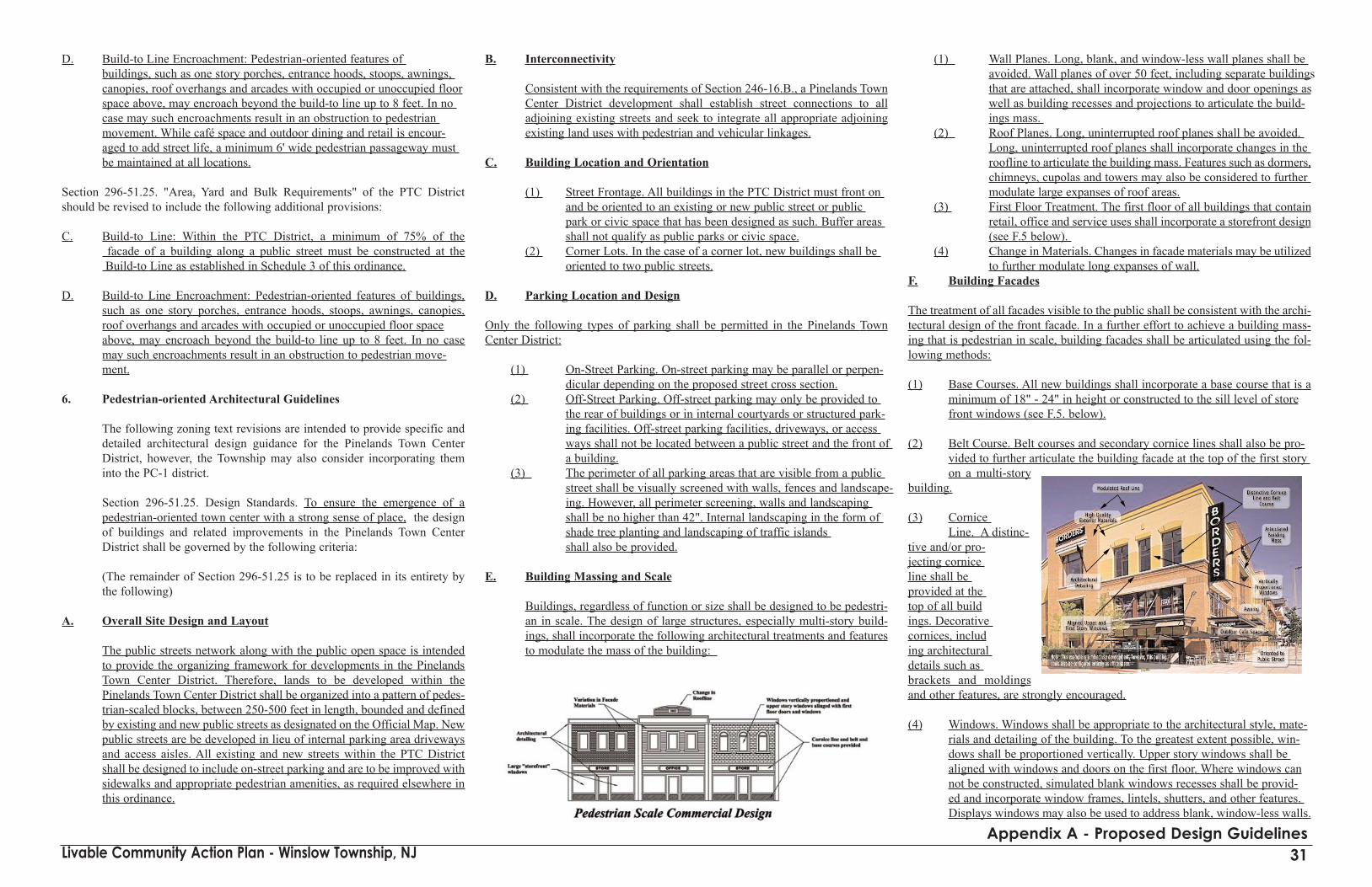
D. Build-to Line Encroachment: Pedestrian-oriented features of buildings, such as one story porches, entrance hoods, stoops, awnings, canopies, roof overhangs and arcades with occupied or unoccupied floorspace above, may encroach beyond the build-to line up to 8 feet. In no case may such encroachments result in an obstruction to pedestrian movement. While café space and outdoor dining and retail is encour-aged to add street life, a minimum 6' wide pedestrian passageway must be maintained at all locations.
Section 296-51.25. "Area, Yard and Bulk Requirements" of the PTC Districtshould be revised to include the following additional provisions:
C. Build-to Line: Within the PTC District, a minimum of 75% of the facade of a building along a public street must be constructed at the Build-to Line as established in Schedule 3 of this ordinance.
D. Build-to Line Encroachment: Pedestrian-oriented features of buildings,such as one story porches, entrance hoods, stoops, awnings, canopies,roof overhangs and arcades with occupied or unoccupied floor spaceabove, may encroach beyond the build-to line up to 8 feet. In no casemay such encroachments result in an obstruction to pedestrian move-ment.
6. Pedestrian-oriented Architectural Guidelines
The following zoning text revisions are intended to provide specific anddetailed architectural design guidance for the Pinelands Town CenterDistrict, however, the Township may also consider incorporating theminto the PC-1 district.
Section 296-51.25. Design Standards. To ensure the emergence of apedestrian-oriented town center with a strong sense of place, the designof buildings and related improvements in the Pinelands Town CenterDistrict shall be governed by the following criteria:
(The remainder of Section 296-51.25 is to be replaced in its entirety bythe following)
A. Overall Site Design and Layout
The public streets network along with the public open space is intendedto provide the organizing framework for developments in the PinelandsTown Center District. Therefore, lands to be developed within thePinelands Town Center District shall be organized into a pattern of pedes-trian-scaled blocks, between 250-500 feet in length, bounded and definedby existing and new public streets as designated on the Official Map. Newpublic streets are be developed in lieu of internal parking area drivewaysand access aisles. All existing and new streets within the PTC Districtshall be designed to include on-street parking and are to be improved withsidewalks and appropriate pedestrian amenities, as required elsewhere inthis ordinance.
B. Interconnectivity
Consistent with the requirements of Section 246-16.B., a Pinelands TownCenter District development shall establish street connections to alladjoining existing streets and seek to integrate all appropriate adjoiningexisting land uses with pedestrian and vehicular linkages.
C. Building Location and Orientation
(1) Street Frontage. All buildings in the PTC District must front on and be oriented to an existing or new public street or public park or civic space that has been designed as such. Buffer areas shall not qualify as public parks or civic space.
(2) Corner Lots. In the case of a corner lot, new buildings shall be oriented to two public streets.
D. Parking Location and Design
Only the following types of parking shall be permitted in the Pinelands TownCenter District:
(1) On-Street Parking. On-street parking may be parallel or perpen-dicular depending on the proposed street cross section.
(2) Off-Street Parking. Off-street parking may only be provided to the rear of buildings or in internal courtyards or structured park-ing facilities. Off-street parking facilities, driveways, or access ways shall not be located between a public street and the front of a building.
(3) The perimeter of all parking areas that are visible from a public street shall be visually screened with walls, fences and landscape-ing. However, all perimeter screening, walls and landscaping shall be no higher than 42". Internal landscaping in the form of shade tree planting and landscaping of traffic islands shall also be provided.
E. Building Massing and Scale
Buildings, regardless of function or size shall be designed to be pedestri-an in scale. The design of large structures, especially multi-story build-ings, shall incorporate the following architectural treatments and featuresto modulate the mass of the building:
(1) Wall Planes. Long, blank, and window-less wall planes shall be avoided. Wall planes of over 50 feet, including separate buildings that are attached, shall incorporate window and door openings as well as building recesses and projections to articulate the build-ings mass.
(2) Roof Planes. Long, uninterrupted roof planes shall be avoided. Long, uninterrupted roof planes shall incorporate changes in the roofline to articulate the building mass. Features such as dormers,chimneys, cupolas and towers may also be considered to further modulate large expanses of roof areas.
(3) First Floor Treatment. The first floor of all buildings that contain retail, office and service uses shall incorporate a storefront design(see F.5 below).
(4) Change in Materials. Changes in facade materials may be utilizedto further modulate long expanses of wall.
F. Building Facades
The treatment of all facades visible to the public shall be consistent with the archi-tectural design of the front facade. In a further effort to achieve a building mass-ing that is pedestrian in scale, building facades shall be articulated using the fol-lowing methods:
(1) Base Courses. All new buildings shall incorporate a base course that is aminimum of 18" - 24" in height or constructed to the sill level of storefront windows (see F.5. below).
(2) Belt Course. Belt courses and secondary cornice lines shall also be pro-vided to further articulate the building facade at the top of the first story on a multi-story
building.
(3) Cornice Line. A distinc-
tive and/or pro-jecting cornice line shall be provided at the top of all buildings. Decorative cornices, including architectural details such as brackets and moldingsand other features, are strongly encouraged.
(4) Windows. Windows shall be appropriate to the architectural style, mate-rials and detailing of the building. To the greatest extent possible, win-dows shall be proportioned vertically. Upper story windows shall be aligned with windows and doors on the first floor. Where windows cannot be constructed, simulated blank windows recesses shall be provid-ed and incorporate window frames, lintels, shutters, and other features. Displays windows may also be used to address blank, window-less walls.
Livable Community Action Plan - Winslow Township, NJ 31Appendix A - Proposed Design Guidelines

(5) Storefronts. The first floor of all buildings that contain retail, office, or service uses shall have a continuous storefront windows. The bottom of storefront windows shall be no more than 3 feet above the side walk and shall be at least 8 feet in height, but shall not exceed 75% of the facade areaof the first floor. Shop fronts shall also not be more than one story inheight. In the case of a corner building, shopfront windows shall be required onboth facades.
(6) Doors. Principal building entrances shall be provided at the street front ofall buildings; however, secondary access to rear or internal parking areasis also permitted. Doors and entryways shall be defined by appropriate architectural treatment, such as pediments, porticoes, overhangs, and other appropriate features.
(7) Awnings, Canopies and Arcades. To further articulate the building facadeand increase architectural interest while facilitating all-weather comfort of pedestrians, continuous awnings (both permanent and retractable), canopies and building overhangs, including arcade structures with occu-pied space above, are strongly encouraged along the street frontage of allbuildings in the PTC District.
G. Roof Types
The following roof types are encouraged: gable, cross gable and flat roofswith a decorative cornice line or parapet.
H. Building Materials
(1) The following building materials shall be permitted for exterior walls that are visible to the public: wood, brick, stone, stucco, glass, and concrete masonry units that have a dressed or textured finish.
(2) The following building materials shall not be permitted for exterior walls that are visible to the public: aluminum siding, vinyl siding, undecorated concrete masonry units, tilt-up concrete panels or highly reflective or mirrored glass.
(3) The color of building materials shall be primarily earth-toned and natural and consistent with the rural/agricultural context of the
Pinelands. Highly reflective materials, high intensity colors, and metallic colors and finishes are prohibited. Building trim and accents may incorporate brighter colors. Neon tube lighting may not be used for building trim or accent.
I. Streetscapes/Landscaping
Consistent with the requirements of proposed Section 232-12, SubsectionQ, both sides of all public streets within the Pinelands Town CenterDistrict shall incorporate the following improvements:
(1) Public sidewalks. A minimum width of 15' to be provided in com-- mercial areas and lesser width in residential neighborhoods as
specified elsewhere in this ordinance.(2) Street shade trees shall be planted at a maximum spacing of 30'
on center. Street shade trees may be planted in tree pits, a mini-mum of 4' wide and 6' long, or in a continuous tree lawn, a min-imum of 3' in width, located between the curb and the sidewalk.
(3) Pedestrian-oriented lighting at a maximum spacing of 50 feet or as recommended by the manufacturer to achieve adequate levels of sidewalk illumination. Lighting fixtures shall be adequately shielded to limit off-site impacts to nearby residential land uses.
(4) Benches and other street furniture at appropriate locations, sub-ject to the review and approval of the Planning Board.
(5) Landscape plantings and other beautification improvements shall be provided in the town square, neighborhood park ,or other loca-
- tions and shall be subject to the review and approval of the Planning Board.
J. Signage
All signage within the Pinelands Town Center District shall conform tothe requirements of 296-80 and the following additional design standards:
(1) All signs in the PTC District shall be pedestrian-oriented and not distract from the overall appearance of the building.
(2) All signs in the PTC District shall be constructed of high quality materials.
(3) All signs in the PTC District shall be indirectly illuminated with incandescent lighting.
(4) Lettering on awnings shall be limited to the vertical surface or edge.
(5) Internally illuminated plastic signboards are prohibited in the PTC District.
(6) Billboard signs of any kind are expressly prohibited in the PTC District.
K Lighting
All building lighting shall be incandescent down lighting. Each storefrontshall have a maximum of three external lighting fixtures.
L. Mechanical SystemsAll HVAC and mechanical equipment, whether roof mounted or located on the ground shall be completely screened from public view by architectural enclosures, parapet walls, fences or walls.
M. Loading and Utility Areas
All loading and service areas shall be located to the rear or side of build-ings. All loading and service areas shall be screened to the greatest extentpossible from public views by walls, fences and landscaping to limit noiseand odor.
7. Parks and Open Space in the Pinelands Town Center District
Public open space along with the public street network is intended to pro-vide the organizing framework for developments in the Pinelands TownCenter District. To ensure the useable, new public open space in the formof parks, greens and town squares are developed as part of a PTC devel-opment, it is recommended that Section 296-51-.27 "Buffers" of the PTCDistrict be replaced in its entirety by the following:
296-51-27 Public Open Space and Buffer Requirements
A. Parks and Civic Space
Every Pinelands Town Center Development that contains a tract area of 10 ormore acres shall provide the following civic and park spaces:
1. A town square or green
a. The town square or green shall be located, to the greatest extent possi-ble, in the center of the Pineland Town Center Development and shall func tion as a central focal point for the development.
b. It is intended that the town square or green shall function as a place ofcommunity gathering and socialization for all residents of theTownship. Therefore, the town square or green shall be deeded in per-petuity to Winslow Township as public open space. At the discretion ofthe Township, maintenance responsibility may be retained by the pro-perty owner.
c. The town square or green shall be fronted on all sides by existing or proposed public streets or public sidewalks.
d. At least three (3) sides of the town square or green shall be occupied by buildings.
d. The dimensions of the town square or green shall be consistent with therecommended typical block size as specified in Section 246-17 of theSubdivision Ordinance, but shall have a width of not less than between 150-200 feet and a length of not less than 1.5 - 2.5 times the width.
e. To ensure a satisfactory sense of enclosure for the town square or green, the ratio of heights of buildings that front the green to the width of the green, notwithstanding requirements elsewhere in this ordinance, shall
Livable Community Action Plan - Winslow Township, NJ 32Appendix A - Proposed Design Guidelines

be between 1:3 and 1:4.
f. The landscaping and design of the town square or green, as well as improvements therein, shall be subject to the review and approval of the Planning Board.
g. In the event that a significant residential population is located within or adjoining the town square, a town square may be developed jointly with a neighborhood park (see A.2. below).
2. A neighborhood park
a. A neighborhood park shall be provided for every residential develo-pment proposed as a part of Pinelands Town Center District develo-pment.
b. It is intended that the neighborhood park shall function as a place ofpublic recreation for the residents of the development and/or employees of businesses. Therefore,the neighborhood park shall be deeded in perpetuity to a homeowners association or to Winslow Township as public openspace. If deeded to the Township, maintenance responsibility may beretained by the property owner.
c. A neighborhood park must be fronted by public streets or sidewalks onat least two sides.
d. The size of the neighborhood park shall be determined by the PlanningBoard in consideration of the number of residential dwelling units thatare proposed, but shall be equal to 10% of the gross acreage of the over-all development site.
3. Other public recreation facilities
Depending on the scale and size of the proposed development, thePlanning Board may require additional public recreation facilities, suchas: scenic overlooks, interpretive information, public restrooms, etc.
B. Open Space and Park Network
1. All public parks and open spaces shall form a network of interconnected recreation facilities linked by public sidewalks, pathways, and shareduse lanes. This network shall provide interconnections between both the residential neighborhoods and commercial areas of a PinelandsTownCenter District development as well as any agricultural buffer areas andadjoining areas of the Township.
8. Schedule 3 Revisions"Schedule 3" should be revised to substitute a "Build-to Line" require-ment for Front Yard Setback, with the following dimensions:
Use Front YardBuild-ToLine(feet)
Commercial (Except PTC District)
Retail and Service Establishments 40' 10'
Office Buildings 40' 10'Hospital and health Care 100' 25'Hotel or motel 50' 25'
Commercial (PTC District)
Regional Shopping Centers 150' 10'Professional Office Buildings 150' 10'
Under build-to line requirements, sidewalks will generally fall within the publicright-of-way, however, portions of sidewalks may also extend beyond the right-of-way. 9. Off-Street Parking Reduction for Shared Parking
Section 296.77. "Off-street parking and loading", Subsection B. "Off-street park-ing requirements for nonresidential uses." should be revised to include the fol-lowing:
(17) A shared parking arrangement shall be used for every new developmentin the PC-1 and PTC districts that contain two or more land uses that havepeak parking demands that occur at different times of the day. Where newdevelopment is proposed within 500 feet of an existing land use with anon-competing peak parking demand, a shared parking arrangement mayalso be utilized. Parking requirements in the PC-1 and PTC zoning dis-tricts may be reduced to 60% of the amount required above when a shareduse parking arrangement is established.
10. Off-Street Parking Location
Section 297-77. "Off-street parking and loading", Subsection C "Size, access andlocation" should be revised as follows:
(4) Off-street parking spaces, driveways, or vehicular access ways of anykind for all uses shall not be located between the front building line andthe right-of-way line. On corner lots, this restriction shall also apply tothe space between the side street right-of-way line and the side buildingline.
Recommended Subdivision and Site Plan Ordinance Revisions:1. Site Design
(Note: The following section includes recommended revisions to theTownship's subdivision and site plan ordinances. These ordinances arerequired to be consistent with N.J.A.C. 5:21 "Residential SiteImprovement Standards". The following recommended revisions havebeen developed to be consistent with these standards, however, as men-tioned previously, this suggested text is intended as model language thatmust be carefully reviewed to ensure that it is properly integrated with theTownship's existing ordinances and codes.)
Section 232-12 "Design Standards", Subsection G "Building and SiteDesign" should be revised as follows:
(b)Orientation and siting. In the case of freestanding buildings or
structures and depending on individual site characteristics, considerationshall be given to positioning that provides desirable visual composition,avoids blocking natural vistas, provides desirable space enclosure, doesnot unnecessarily alter existing topography and vegetation and otherwiserespects established natural conditions and surrounding buildings andstructures. Proposed nonresidential and multi-family buildings shall besited and oriented according to the following principles:
(1) Proposed buildings shall be oriented to a public street pursuant to the build-to line requirements specified in Schedule 3 of this ordinance.
(2) In the case of a corner lot, proposed buildings shall be oriented toaddress two public streets pursuant to the build-to line requirementsspecified in Schedule 3 of this ordinance.
(3) In the case of large development tracts (3 or more acres), the site shallbe divided into blocks, approximately 250 feet in length, by new inte-rnal public streets, which are to be provided in lieu of parking lot accessaisles or driveways.
(4) Off-street parking areas shall be located to the rear of proposed build-ings. In the case of large development tracts, parking lots shall be loca-ted internally to the block.
(5) In no case may parking spaces, parking access aisles, driveways, or adrive-thru lane be located between a building and a public street.
Section 232-12 "Design Standards" should be revised to include the followingadditional subsection:
Q. Streetscape improvements shall be provided along all public streets incommercial district on which a site subject to site plan approval obtainsfrontage. These improvements shall include at a minimum:
(1) Street shade trees, a minimum of 3 ½" - 4" in caliper shall be planted ata maximum spacing of 30' on center. Street shade trees may be plantedin tree pits, a minimum of 4' wide and 6' long, or in a continuous treelawn, a minimum of 3' in width, located between the curb and the sid-ewalk.
(2) Pedestrian-oriented lighting at a maximum spacing of 50 feet or as re-commended by the manufacturer to achieve a minimum of .5 foot candlesof illumination shall be maintained along all sidewalks. Sidewalk lightingshall be provided by pedestrian oriented lighting with a fixture mountingheight not exceeding 12 feet.
(3) Benches and other street furniture at appropriate locations, subject to the review and approval of the Planning Board.
2. Street Design and Street Connectivity
Section 246-16 "Streets" should be revised as follows:
B. Minor streets shall be so designed as to discourage through traffic.
B. All residential subdivisions and nonresidential developments that involvethe construction of new streets shall connect with the existing external
Livable Community Action Plan - Winslow Township, NJ 33Appendix A - Proposed Design Guidelines

street system at intervals not exceeding 1000 feet for each direction(north, south, east, and west) in which the subject property abuts similaror compatible uses. Non-vehicular connections shall similarly be provid-ed every 500 feet along the entire perimeter of the property. Exceptionsfor this subsection include topographic and environmental constraints( w e t l a n d s ,streams, etc.) andlimited accesshighway right-of-way.
C. Subdivisions abut-ting arterial streetsshall provide amarginal serviceroad or reversefrontage with abuffer strip forplanting, or some other means of separation of through and local traffic asthe Planning Board may determine appropriate.
C. All residential subdivisions and nonresidential developments that involvethe construction of new streets shall have a minimum street connectivityindex of 1.2 as defined herein.
D.1.Cartway widths. The cartway width shall be measured from curb to curband if there is no curb, it shall be measured from the edge to edge of thepavement. The minimum maximum cartway width shall be 30 of MinorStreets shall be 24'. The maximum cartway width of Collector Streetsshall be 36' and shall include 8' wide, designated on-street parking laneson both sides of the street.
H. All street intersections shall be nearly at right angles ninety (90°)degrees as possible and in no case shall be less than sixty (60°) degrees. The block corners at intersections shall be rounded at the curb lines with a curve having a radius of not less more than ten (10) fifteen (10) feet. Curb extensions of not less than eight (8) feet in width shall be providedat all intersections wherever on-street parking is provided. In commer-cial areas special pavement treatment shall be used in pedestrian crosswalk areas.
3. Minimum Sidewalk Width
Section 232-12. "Site plan details" should be revised as follows:
I. Sidewalks
(1) Each land development subject to site plan approval that abutsan arterial or collector streets shall provide a sidewalk within the road right-of-way as required by the Zoning Ordinance. In commercial districts the sidewalk shall be provided between the curb line and the Build-to Line and shall be a minimum of 15' wide.
4. Block Size
Section 246-17. "Blocks" should be revised as follows:B. Block length shall be between 250-500' and width or acreage
within the bounding roads shall be such as to accommodate the size of lot required in the area of by the Zoning Ordinance and to provide for convenient access, circulation control and safety of street traffic. When existing block lengths exceed 500', wher-ever possible, new streets or non-vehicular connections should be inserted to reduce the block size.
Multi-Family Residential Design Guidelines
To ensure that multi-family dwellings, whether part of PTC development or locat-ed elsewhere in the Regional Growth Area, take the form of attractive, pedestrian-oriented neighborhoods, the following revisions to the PR-4 zoning district andother relevant site plan regulations are recommended:
1. Build-to Line
Section 296-24 "Area, Yard and Bulk requirements" of the PR-4 Districtshould be revised as follows:
Residential dwellings units proposed for development within the PR-4District shall be subject to the area, yard and bulk requirements listed inSchedule 2, Area, Yard and Bulk Requirements for Residential Uses,found at the end of this chap-ter. In addition to theserequirements, garden apart-ments shall be subject to a15' build-to line requirement,as defined herein.
2. Schedule 2 Revisions
The Front Yard Setback forgarden apartments should bedeleted and the followingnote (12) added to the sched-ule: See Section 296-24.
3. Design Standards
Section 232-12 "DesignStandards", Subsection O"Multi-family Housing"should be revised to includethe following additional pro-vision:
(8) Architectural Design Standards
1. Overall Site Design, Layout and Building Orientation
Multi-family developments shall be planned and designed as pedestrian-orientedresidential neighborhoods. Public streets, pedestrian-scale blocks, and open spaceis intended to provide the organizing framework for multi-family developments.Therefore, multi-family developments shall be designed according to the follow-ing principles:
a. The front of multi-family residential buildings must be oriented to an existing or a new public street or public open space. Multi-family dwellings that are located on corner lots shall be oriented to two public streets.
b. In the case of a group of multi-family buildings, and where sufficient land area exists, the development shall be organized into a pattern of pedestrian-scaled blocks, between 250-500 feet in length, bounded and defined by existing and new public streets .
c. New public streets are to be developed in lieu of internal parking area driveways and access aisles. All existing and new streets within a multi-family development shall be designed to include on-street parking and areto be improved with sidewalks and appropriate pedestrian amenities, as required elsewhere in this ordinance.
2. Parking Location
No off-street parking lots, driveways, or access aisles may be locatedbetween the front of a multi-family building and a public street. All park-ing for multi-family buildings shall be located to the rear of the building,or in the case of a grouping of buildings, in the interior of the grouping.Multi-family buildings shall not be oriented toward parking areas. Theperimeter of all parking areas that are visible from a public street shall bevisually screened with walls, fences and landscaping. Internal landscap-ing in the form of shade tree planting and landscaping of traffic islandsshall also be provided.
3. Building Massing and Style
Multi-family residential buildings shall incorporate simple and tradition-al building forms and should be designed so as to appear as a grouping ofattached homes or a large estate dwelling. Long, monotonous wall planesshall be avoided. Articulation of the wall plan shall be provided by pro-jecting bays, recesses, porches, balconies, ornamental door surrounds,stairs, stoops, balustrades and other appropriate architectural design fea-tures. When used, porches and balconies shall have a minimum width ofsix (6) feet to ensure that they are functional.
4. Roof Types and Form
The roof shape and roofline of multi-family shall vary in form and heightto reinforce the perception that the building is a grouping of individual
Livable Community Action Plan - Winslow Township, NJ 34Appendix A - Proposed Design Guidelines

structures or a single large residential structure. A continuous or unbrokenroofline shall be avoided. Gable, and cross-gable and hip roof forms arepreferred and shall incorporate features such as dormers and chimneysthat are appropriate to the architectural design of the building. Roof pitchshould be between 6/12 and 14/12. Overhanging eaves shall be providedon all appropriate sides . Flat roofs are to be avoided.
5. Facade Treatments
The elevation of a multi-family building along any public street mustinclude changes in facade material and sufficient articulation to reinforcethe perception that the building is a grouping of individual structures.Changes in materials and facade articulation should occur at regular inter-vals. Front facade treatment shall be continued on all visible sides of abuilding. Blank walls visible from a public street are to be avoided.
6. Doors and Entry Points
Multi-family buildings shall have multiple doorways and entry points atthe front of the building providing each dwelling with direct access to thepublic street. A minimum of one doorway shall be provided at the front ofa multi-family building for every three- (3) dwelling units.
7. Windows
All windows should be vertical in proportion and upper story windowsshould be aligned with windows or door openings occurring on the firstfloor. Window form, size, and materials shall be compatible with thearchitectural style, scale, and materials of the building. Blank, window-less walls visible from a public street are to be avoided.
8. Treatment of Building Openings
All windows, doors, and building opening shall be emphasized by the useof architectural features and ornamentation such as lintels, pediments,porches, columns, and other appropriate design features.
9. Building Materials
Building materials for multi-family residential buildings shall be limitedto brick, wood or vinyl siding, or stucco. The materials used on all visiblefacades shall be consistent with the architectural design of the front of thebuilding.
10. Open Space
a. A public open space shall be provided for every multi-family residential development, in the form of a lawn, terrace or courtyard area.
b. It is intended that this open space shall function as a place of public recre-ation for both the residents of the development and the community; however, maintenance responsibility shall be retained by the developer unless that development is a condominium association
c. Area devoted to open space shall not be less than 10% of the total gross
acreage of the development.
Implementing ordinance language for the Pump Branch Greenway
The Open Space, Parks and Recreation section of this plan suggests that the wet-lands buffers along the length of the Pump Branch Creek offer an ideal greenwayalignment that cuts across the Regional Growth Area and links a series of existingand future neighborhoods. While the wetlands buffers along the Pump Branch areregulated by the state, they are privately owned. Therefore, to provide publicaccess through these lands, a continuous public access easement will be required.The proposed alignment of the Pump Branch Greenway appears to fall entirelywithin the PR-2 Zoning District. Following is suggested language that could beincorporated into the PR-2 Zone to require the desired public access
296-18 Public Access through the Pump Branch Greenway
Purpose
A. As indicated on the Township's Official Map, a public access greenwayalignment has been designated within the wetlands buffers associatedwith the Pump Branch Creek. Therefore, all development adjoining andcontiguous to the Pump Branch Creek shall provide a public access ease-ment conforming to the following conditions:
1. The public access easement shall be granted in perpetuity to theTownship of Winslow (or Camden County, or the State of New Jersey).
2. The public access easement shall extend to the limits of the wetlandbuffers associated with the Pump Branch Creek as shown on theOfficial Map of the Township.
3. The Township of Winslow shall be responsible for maintenance of the greenway.
4. Signage, approved by the Township (or County, or State,) shall be installed indicating that the greenway is public open space.
To enhance the quality of life and health of local residents, it is the intention ofthis ordinance to provide residents with direct public access to natural lands andopen space associated with the wetlands adjoining the Pump Branch Creek. Thisaccess shall take the form of continuous linear public open space within the lim-its of wetland buffers designed to provide opportunities for passive recreation andto enable residents to enjoy and experience the unique natural environment of thePinelands. Public access shall be provided via an easement coterminous with thewetlands buffer and the area of all private lands contained in the greenway shallcontinue to be counted toward minimum lot size requirement.
Livable Community Action Plan - Winslow Township, NJ 35Appendix A - Proposed Design Guidelines
Livable Community Action Plan - Winslow Township, NJ
Tree Removal Ordinance
MODEL TREE CLEARING ORDINANCE ORDINANCE NO. __ -Amended 2003
AN ORDINANCE TO AMEND THE CODE OF THE TOWNSHIP______,CHAPTER ___ THEREOF ENTITLED ________.
SECTION 1. Purpose. It is recognized that there is a strong relation-ship between ________Township's quality of life and the integrity of the region'swater quality, air quality, natural Pinelands landscape and aesthetic amenities.Destruction of the Township's existing trees, woodlands and vegetation con-tributes to increased soil erosion and sedimentation, increased stormwater runoffand costs to control runoff, degradation of water resources, decreased groundwa-ter recharge, increased buildup of atmospheric carbon, decreased wildlife habitat,increased dust and decreased property values, all of which negatively affect thecharacter of the Township. The appropriate management of existing vegetationresources are an important health, safety and welfare concern.
Therefore, it is the intent of this ordinance to protect and preserve the air, water,natural Pinelands landscape and aesthetic quality of the Township by preservingthe maximum possible number of trees and in the course of development of a site,ensuring that the health of trees and vegetation used for landscaping on a site ismaintained throughout the development process and protecting larger, older spec-imens of trees.
SECTION 2. Chapter ___ of the Code of the Township of _____, Section ___,Definitions, is hereby amended to add and modify the following definitions:
COMPATIBLE TREE OR SHRUB: Trees and shrubs authorized by N.J.A.C.7:50-6.25 to be used for revegetation or landscaping purposes, or other trees andshrubs not listed under N.J.A.C. 7:50-6.25 but adapted to the droughty, nutrient-poor conditions found in the New Jersey Pinelands.
CRITICAL ROOT ZONE (CRZ): The minimum area surrounding an establishedtree which must be left undisturbed in order to preserve sufficient root mass toprovide the tree with a reasonable chance of survival. Defined as a circular areasurrounding an established tree, of which the center is the center of the tree trunkand the radius is the distance from the outside of the trunk to any point eighteen(18) times the diameter at breast height (DBH). The CRZ shall extend to a depthof five (5) feet below surface ground level.
FRONT YARD: An open unoccupied space (except as permitted herein) on thesame lot with a principal building and extending across the width of the lotbetween the front lot line and the front walls or supports of the principal building,regardless of its configuration.
HAZARDOUS TREE: A dead tree, or one so affected by a significant structuraldefect or disease that falling or failure appears imminent and that poses a threat tolife or property, or a tree that impedes safe vision or traffic flow, or that otherwisecurrently poses a threat to life or property, all as determined by a Certified Arboristat the applicant's expense.
LOT DISTURBANCE: Clearing, cutting, grading, excavating, filling, transport-ing, or any other activity that alters, eliminates or removes trees of six (6) inchesDBH or larger on a lot.
NEW JERSEY BIG TREE: A tree formally designated by the New Jersey ForestService's New Jersey's Big Tree Program, New Jersey Division of Parks andForestry, which identifies and catalogues the largest individual trees in the stateaccording to species. A listing of such trees and a map showing their location ismaintained at the principal offices of the Division.
NON-TURF VEGETATION: Includes compatible trees of a minimum size of twoand one-half (1.5) inches DBH and compatible shrubs.
PRESERVED TREE: A tree of 6" DBH or larger which is not removed from a loton which development is occurring.
PROTECTION MEASURE: A practice or combination of practices (e.g., con-struction barriers, protective fencing, tree wells, etc.) used to control constructionor development impacts to vegetation.
REMOVE, REMOVAL: The direct or indirect removal of a tree(s) or vegetationthrough actions including, but not limited to: clearing, cutting, causing irreversibledamage to roots or trunks; poisoning; destroying the structural integrity of trees orvegetation; filling, excavating, grading or trenching in the Critical Root Zone;relocating an existing tree to a new planting location; or the removal through anyof these processes of greater than thirty percent of the height, size or bulk of anestablished tree.
UNDERSTORY VEGETATION: Small trees, shrubs, and groundcover plants.
SECTION __. Chapter ___ of the Code of the Township of ___, Section ___, ishereby amended to add a new subsection A to read as follows:
Maximum Lot Disturbance Requirements for Residential Lots. A.1. Residential development shall comply with the following sched-
ule of lot disturbance limitations:
Lot Size Max. Lot Disturbance Permitted (to be measured in SF)
æ 10,000 SF 85%> 10,000 SF no lot disturbance permitted outside of a
10 foot buffer of any existing or pro-posed structure on the lot
All town homes, 55% of overall tract/parcelcondominiums, garden apartments and zero lot line applications
A.2. In addition to the maximum lot disturbance requirements described in A1., no lot disturbance shall be permitted within 10 feet of the rear lot line of any lot over 10,000 SF.
A.3. In addition to the requirements above, if the applicant proposes toremove any "New Jersey Big Trees" from the lot, regardless of their location, the applicant is required to apply to the Planning Board for a permit to do so. The permit application must include a site plan clearly marking the location of each New Jersey Big Tree.
A.4. The applicant may remove any hazardous trees on the lot provid-ed they have been verified by a Certified Arborist and approval has been given for the removal by the Planning Board.
SECTION ___. Chapter ___ of the Code of the Township of _____,Section ___, is hereby amended to add a new subsection B to read as follows:
B. Minimum Non-Turf Landscaping Requirement for front yards. B.1. Applicant is required to ensure that the amount of non-turf vege-
tation in the front yard meets the following schedule:
Lot Size Min. Non-Turf Vegetation in the Front Yardæ 7,000 SF 3.0% of lot size7,001 - 10,000 SF 7.0% of lot size10,001 - 20,000 SF 9.0% of lot size20,001 - 40,000 SF 12.0% of lot size> 40,000 SF 16.0% of lot size
B.2. The non-turf landscaping requirement shall be met according to the following specifications:
B.2.1. This requirement may be met with existing vegetation; orB.2.2. Where a shortfall exists, replacement plantings must be
used according to both of the following two schedules:
Schedule A: Mix by Size: per 400 sq. ft. = 40 points (with at least 1 tree) 1. Understory deciduous shrub = 2 points2. Understory evergreen shrub = 3 points3. 1.5" DBH tree = 2 points4. 2.5" DBH tree = 6 points5. 4" DBH tree = 12 points6. 6" DBH tree = 18 points
Schedule B: Mix by Point Type1. Maximum 90% deciduous2. Minimum 10% evergreen3. Maximum 50% shrubs4. Maximum 25% any one species
B.2.3.If the shortfall(s) is less than a multiple of 400 SF, applicant mustt round up to the next multiple of 400 SF (e.g., 500 SF shortfall =
800 SF requirement), and
B.2.4.The replacement trees and understory vegetation shall be com-posed of compatible trees and shrubs as authorized by N.J.A.C. 7:50-6.25. Other trees and shrubs may be used in the following
36Appendix B -Tree Removal Ordinance

circumstances, with the approval of the Planning Board:
B2.4 (i)When the parcel to be developed or its environs con--tain a predominance of shrubs and tree species notauthorized by N.J.A.C. 7:50-6.25; or
B2.4 (i)For limited ornamental purposes around buildingsand other structures; or
B2.4 (iii) When limited use of other shrubs or tree species inrequired for proper screening or buffering.
B.2.5.To the extent practicable, replacement plantings shall be done in clusters, consistent with what occurs naturally. In any case, the shortfall square footage should be covered with a mulch of hard-wood chips at least two (2) inches deep and no more than four (4)inches deep.
B.2.6.Replacement trees, shrubs and understory vegetation shall be nursery-grown and comply to American Association of Nurserymen (AAN) standards. Replacement trees must be plan-ted according to the following standards:
(i) Planting hole must be two (2) times wider than root ball of tree; and
(ii) Native soil must be used for backfill and tamped lightly to avoidsoil compaction; and
(iii) Where appropriate, trees must be staked for trunk support androot anchorage.
B.2.7.For lots equal to or smaller than 10,000 SF, credits for shortfalls may be taken off-lot for clusters of plantings on islands in streets in front of homes, perimeters around the subdivision, plantings between homes in front of the minimum building setback line, and percentages exceeding the minimum on corner lots and other appropriate areas. Off-lot plantings must follow both schedules in B.2.2.
B.2.8.Any replacement plantings that die within 2 years from the time of planting must be replaced by the applicant.
SECTION ___.Chapter ___ of the Code of the Township of ___, Section ___, ishereby amended to add a new subsection C to read as follows:
1. Lot Landscaping Plan. A landscaping plan shall be submitted to the PlanningBoard for approval. All landscaping plans must show:
C.1. The footprint(s) of all existing or proposed structuresC.2. Either the proposed lot clearance for lots under 10,000 SF, or the
10-foot buffer(s) of all existing or proposed structures for lots over 10,000 SF
C.3. The location of each tree of 6" DBH or largerC.4. The location of any hazardous trees on the lot which the applicant
proposes to remove; and
C.5. How the required schedules of non-turf vegetation will be met in the front yard.
SECTION ___.Chapter ___ of the Code of the Township of ___, Section ___, ishereby amended to add a new subsection D to read as follows:
D. Critical Root Zone Protection.D.1 Most trees can tolerate only a small amount of root damage. Prior
to any land disturbance, all trees of six (6) inches DBH and larg-er to be preserved shall be protected from damage during con- struction using protection measures that protect the Critical Root Zones. These protection measures shall be done according to the following standards:
D.1.1.Protective tree fencing shall be installed along the out-er edge of and completely surrounding the Critical RootZones of all preserved trees. These fences shall be self-supporting wooden snow fences or orange plastic con-struction fences a minimum of four (4) feet high and shallbe accompanied by "Tree Preservation Area" signage;and
D.1.2. Clearing within the Critical Root Zone shall be doneonly by hand-operated equipment; and
D.1.3. Excavation or storage of materials or equipment,including soil, shall not be conducted within the CriticalRoot Zone; and
D.1.4. The grade of the land located within the Critical RootZone of all preserved trees shall not be raised or loweredmore than six (6) inches unless compensated by wellingor retaining wall methods; and in no event shall wellingor retaining wall methods occur within the Critical RootZone; and
D.1.5. Where utilities must be installed though a CriticalRoot Zone, such installation shall be done using tunnel-ing rather than trenching; and
D.1.6. Physical damage to trunks, branches, foliage androots of preserved plant material must be avoided; and
D.1.7. Nothing shall be nailed or tied to preserved trees orunderstory vegetation; and
D.1.8. The removal of trees adjacent to preserved trees cancause inadvertent damage to the roots of preserved trees.Whenever possible, trenches of a minimum width of two(2) feet shall be cut along the limits of land disturbanceso that roots are cut rather than torn. Tunneling may berequired for the protection of New Jersey Big Trees.
D.2. Appropriate protection measures shall be implemented to protect understory vegetation and other plant material to be preserved.
D.3. Where the Planning Board has determined that irreparable dam-age has occurred to preserved trees and/or understory vegetation, the damaged plant materials must be removed and replaced.
SECTION ___.Chapter __ of the Code of the Township of ___, Section __, ishereby amended to add a new subsection E to read as follows:
E. Non-Residential Lot Disturbance and Landscaping Plan Requirements. E.1. On non-residential lots, no disturbance beyond the following areas of
the lot shall be permitted:
E.1.1. The building envelope; andE.1.2. Required parking, driveways, loading areas and utility access;
and
E.1.3. A ten (10) foot construction zone beyond the building and anyother existing or proposed structures on the lot.
E.2. A landscaping plan for all non-residential lots shall be submitted to the Planning Board for approval prior to any vegetation removal or land disturbance. The landscaping plan shall demon-strate compliance with all non-turf landscaping requirements described in subsection B; however, those requirements may be met on any portion(s) of the lot.
[OPTIONAL: SECTION ?. TREE REMOVAL PERMIT PROGRAM. Thiswould basically require homeowners who wish to remove a tree from their prop-erty to apply for a permit, and the number of trees they are allowed to remove peryear would be limited to some number. Exceptions could include removal of"hazardous trees," which as defined above would need to be verified by a CertifiedArborist. There are many examples of municipal tree removal permit programs(Princeton Twp. has a good one), and in fact most tree preservation ordinancesseem to follow this model.]
SECTION __. Nothing in this ordinance or within the shall be deemed to imposeany liability for damages or a duty of care and maintenance upon the Township orupon any of its officers or employees. The owner of any private property shallhave a duty to keep the trees upon the property and under their control in a safe,healthy condition. Any person who feels a tree located on property possessed,owned or controlled by them is a danger to the safety of themselves, others orstructural improvements on-site or off-site shall have an obligation to secure thearea around the tree, support the tree, or to verify with the Planning Board that thetree is hazardous and remove it to safeguard both persons and improvements fromharm.
SECTION __. All Ordinances and parts of Ordinances inconsistent herewith arehereby repealed.
SECTION __. If any section, subsection, sentence, clause, phrase or portion ofthis Ordinance is for any reason held invalid or unconstitutional by a Court ofcompetent jurisdiction, such portion shall be deemed a separate, distinct and inde-pendent provision, and such holding shall not affect the validity of the remainingportions hereof.
Livable Community Action Plan - Winslow Township, NJ 37Appendix B -Tree Removal Ordinance

SECTION 16. This Ordinance shall take effect upon final passage, adoption andpublication in the manner prescribed by law.
Dated: April 1, 2003
Livable Community Action Plan - Winslow Township, NJ 38Appendix B -Tree Removal Ordinance

Livable Community Action Plan - Winslow Township, NJ 39Appendix C- Community Based Observation Technique (CBOT) Photographs

Livable Community Action Plan - Winslow Township, NJ 40Appendix C- Community Based Observation Technique (CBOT)

Livable Community Action Plan - Winslow Township, NJ 41Appendix C- Community Based Observation Technique (CBOT) Photographs

Livable Community Action Plan - Winslow Township, NJ 42Appendix C- Community Based Observation Technique (CBOT) Photographs
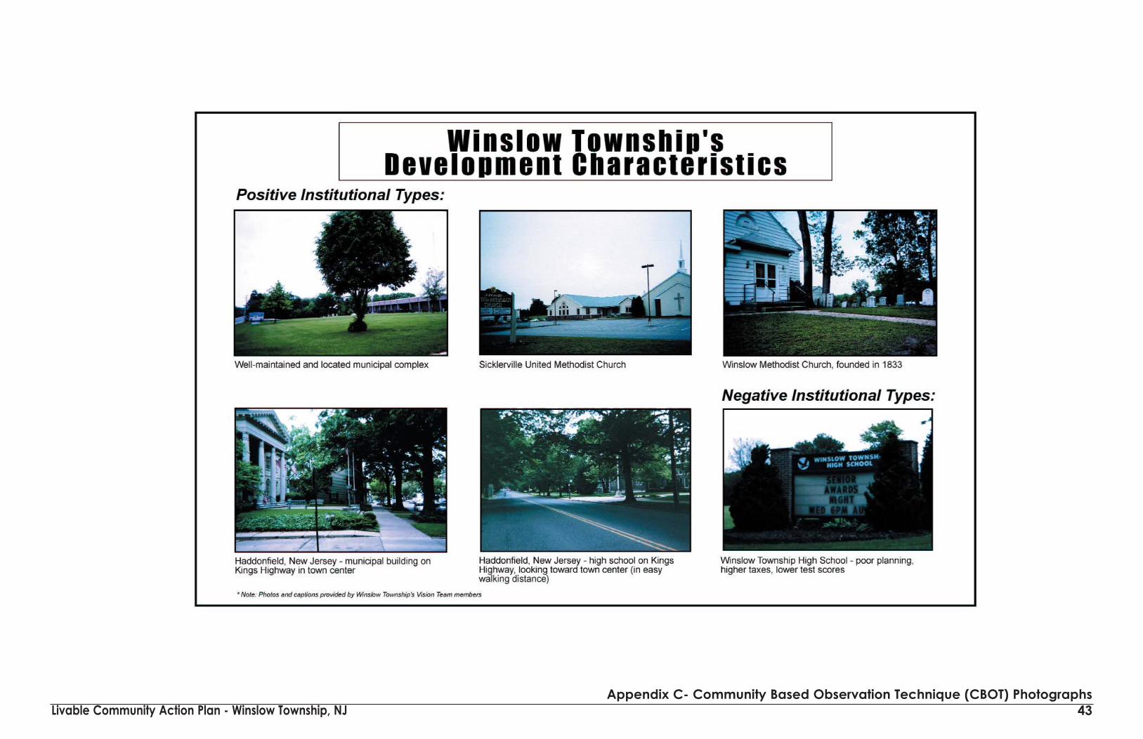
Livable Community Action Plan - Winslow Township, NJ 43Appendix C- Community Based Observation Technique (CBOT) Photographs

Livable Community Action Plan - Winslow Township, NJ 44Appendix C- Community Based Observation Technique (CBOT) Photographs

Livable Community Action Plan - Winslow Township, NJ 45Appendix C- Community Based Observation Technique (CBOT) Photographs

Livable Community Action Plan - Winslow Township, NJ 46Appendix C- Community Based Observation Technique (CBOT) Photographs

Livable Community Action Plan - Winslow Township, NJ 47Appendix C- Community Based Observation Technique (CBOT) Photographs

Livable Community Action Plan - Winslow Township, NJ 48Appendix C- Community Based Observation Technique (CBOT) Photographs

Livable Community Action Plan - Winslow Township, NJ 49Appendix C- Community Based Observation Technique (CBOT) Photographs

Livable Community Action Plan - Winslow Township, NJ 50Appendix C- Community Based Observation Technique (CBOT) Photographs

Livable Community Action Plan - Winslow Township, NJ 51Appendix D - Pinelands Excellence Program - Creating Livable Communities
The Pinelands
Excellence
Program is about
Achieving Excellence in
Community Design and
Livable Places
Instead of building places . . .we’ve been building no-places . . .
The Symptoms of Sprawl:
We are developing open space inexcess of our population growth.
Segregation of land uses Segregation of people by limitedhousing choices
Congestion Environmental Degradation
Loss of community and social interaction
Loss of local character and defining features
Very cost inefficient
How do we fix it?
By insisting on excellence incommunity design
What does it mean?
“Places are spaces you can remember,that you can care about,
and make a part of your life.”Charles W. Moore
Its about legacy . . .
Are we building the kind of places that aregrandchildren will want to live in?
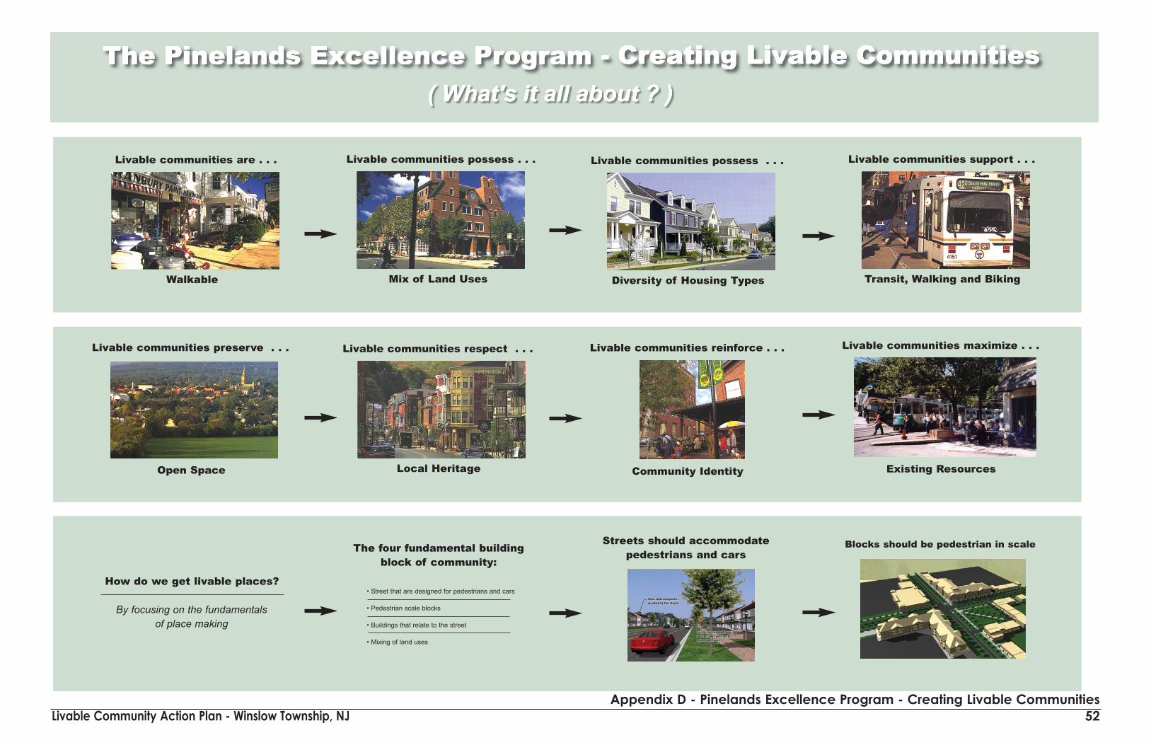
Livable Community Action Plan - Winslow Township, NJAppendix D - Pinelands Excellence Program - Creating Livable Communities
52
• Street that are designed for pedestrians and cars
• Pedestrian scale blocks
• Buildings that relate to the street
• Mixing of land uses
Livable communities are . . .
Walkable
Livable communities possess . . .
Mix of Land Uses
Livable communities possess . . .
Diversity of Housing Types
Livable communities support . . .
Transit, Walking and Biking
Livable communities preserve . . .
Open Space
Livable communities respect . . .
Local Heritage
Livable communities reinforce . . .
Community Identity
Livable communities maximize . . .
Existing Resources
How do we get livable places?
By focusing on the fundamentals of place making
The four fundamental buildingblock of community:
Streets should accommodate pedestrians and cars
Blocks should be pedestrian in scale

Livable Community Action Plan - Winslow Township, NJ 53Appendix D - Pinelands Excellence Program - Creating Livable Communities
• Street that are designed for pedestrians and
cars
• Pedestrian scale blocks
• Buildings that relate to the street
Washington Township, Mercer County
Marlton Town Center, Burlington County, NJGarden State Race Track, Camden County, NJ
Streets need to become public “outdoor rooms”
Land uses should be mixed withinbuilding and district
Can it happen in New Jersey?
it already is . . . .
Livable Communities Case Study:New Town Center
Livable Communities Case Study:Redevelopment
Livable Communities Case Study:Village Extension
How do we make it work?
its all about the code. . . .
Create a vision and codify it
Emphasize the four fundamentalbuilding blocks of community.