wind power geoplanner™ off-air tv analysis wtkj-lp cp ld 19 watertown ny 10.70 8 wnyf-ca lic ca 28...
TRANSCRIPT

Prepared on Behalf of OwnEnergy
January 15, 2013
Wind Power GeoPlanner™
Off-Air TV Analysis
Copenhagen Wind Farm, LLC

OwnEnergy Wind Power GeoPlanner™
Off-Air Television Report Copenhagen Wind Farm, LLC
Comsearch Proprietary - 0 - January 15, 2013
Table of Contents
1. Introduction - 1 -
2. Summary of Results - 1 -
3. Impact Assessment - 5 -
4. Conclusions and Recommendations - 6 -
5. Contact Us - 6 -
6. Appendix A - 7 -

OwnEnergy Wind Power GeoPlanner™
Off-Air Television Report Copenhagen Wind Farm, LLC
Comsearch Proprietary - 1 - January 15, 2013
1. Introduction In this report, Comsearch analyzed the off-air television stations whose service could potentially be affected by the proposed Copenhagen Wind Farm project in Lewis County, New York. Off-air stations are television broadcasters that transmit signals that can be received directly on a television receiver from terrestrially located broadcast facilities. Comsearch examined the coverage of the off-air TV stations and the communities in the area that could potentially have degraded television reception because of the location of the proposed wind energy projects. Since there were two off-air TV Stations located in the project area-of-interest Comsearch also examined whether the coverage of these stations will be affected by the wind turbines once they are installed.
2. Summary of Results The proposed wind energy project area and local communities are depicted in Figure 1, below.

OwnEnergy Wind Power GeoPlanner™
Off-Air Television Report Copenhagen Wind Farm, LLC
Comsearch Proprietary - 2 - January 15, 2013
Figure 1: Wind Farm Project Area and Local Communities
OwnEnergy Wind Power GeoPlanner™
Off-Air Television Report Copenhagen Wind Farm, LLC
Comsearch Proprietary - 3 - January 15, 2013
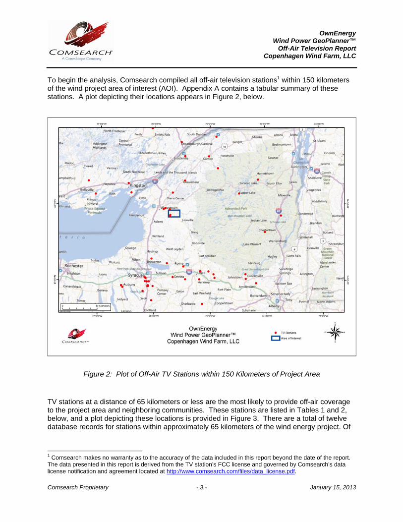
To begin the analysis, Comsearch compiled all off-air television stations1 within 150 kilometers of the wind project area of interest (AOI). Appendix A contains a tabular summary of these stations. A plot depicting their locations appears in Figure 2, below.
Figure 2: Plot of Off-Air TV Stations within 150 Kilometers of Project Area
TV stations at a distance of 65 kilometers or less are the most likely to provide off-air coverage to the project area and neighboring communities. These stations are listed in Tables 1 and 2, below, and a plot depicting these locations is provided in Figure 3. There are a total of twelve database records for stations within approximately 65 kilometers of the wind energy project. Of
1 Comsearch makes no warranty as to the accuracy of the data included in this report beyond the date of the report. The data presented in this report is derived from the TV station’s FCC license and governed by Comsearch’s data license notification and agreement located at http://www.comsearch.com/files/data_license.pdf.

OwnEnergy Wind Power GeoPlanner™
Off-Air Television Report Copenhagen Wind Farm, LLC
Comsearch Proprietary - 4 - January 15, 2013
these stations, eight are currently licensed and operating, four of which are low-power stations or translators. Translator stations are low-power stations that receive signals from distant broadcasters and retransmit the signal to a local audience. These stations serve local audiences and have limited range, which is a function of their transmit power and the height of their transmit antenna. The four remaining operational stations broadcast at full power and are licensed under call signs WWTI, WPBS-DT, and WWNY-TV in the United States and CKWS-TV in Canada. WWTI and WPBS-DT are located within the project area on towers at a distance of 0.6 and 2.36 kilometers from the closest wind turbine, respectively.
Figure 3: Plot of Off-Air TV Stations within 65 Kilometers of Project Area

OwnEnergy Wind Power GeoPlanner™
Off-Air Television Report Copenhagen Wind Farm, LLC
Comsearch Proprietary - 5 - January 15, 2013
ID Call Sign Status Service2 Channel City State Distance to
Nearest Turbine (km)
1 WWTI LIC DT 21 WATERTOWN NY 0.60
2 WPBS-DT LIC DT 41 WATERTOWN NY 2.36
3 WPBS-DT CP DT 41 WATERTOWN NY 2.36
4 WWNY-TV LIC DT 7 CARTHAGE NY 5.14
5 WNYF-CD LIC LD 35 WATERTOWN NY 5.14
6 WTKJ-LP LIC TX 19 WATERTOWN NY 10.70
7 WTKJ-LP CP LD 19 WATERTOWN NY 10.70
8 WNYF-CA LIC CA 28 WATERTOWN NY 11.69
9 NEW APP LD 45 WATERTOWN NY 27.48
10 W09CV LIC TX 9 GOUVERNEUR NY 48.65
11 W09CV APP LD 9 GOUVERNEUR NY 48.65
Table 1: Off-Air TV Stations within 65 Kilometers of Project Area (U.S.)
ID Call Sign Status Class3 Channel City Province Distance to
Nearest Turbine (km)
CAN-1 CKWS-TV OP R 11 KINGSTON ON 64.03
Table 2: Off-Air TV Stations within 65 Kilometers of Project Area (Canada)
3. Impact Assessment The four full-power digital stations may have their reception disrupted in and around the Copenhagen Wind Farm project area, primarily in locations on the opposite side of the project area, relative to the station antennas. Communities and homes directly to the north and east of the project may have degraded reception of stations WWTI and WPBS, which broadcast from southwest of the project area, after the wind turbines are installed. Similarly, WWNY, low power stations WNYF and WTKJ, and the Canadian station CKWS-TV, which broadcast from
2 Definitions of U.S. service and status codes: DT – Digital television broadcast station LD – Low power digital television broadcast station TX – Translator station CA – Class A analog television broadcast station DC – Class A digital television broadcast station LIC – Licensed and operational station CP – Construction permit granted CP MOD – Modification of construction permit APP – Application for construction permit, not yet operational 3 Definitions of Canadian service and class codes: R – Regular VHF television broadcast station OP – Licensed and operational station
OwnEnergy Wind Power GeoPlanner™
Off-Air Television Report Copenhagen Wind Farm, LLC
Comsearch Proprietary - 6 - January 15, 2013
northwest of the project area, may have diminished reception in communities directly to the southeast. However, based on the low number of full-power TV channels available in the immediate vicinity of the project area and recent surveys, it is unlikely that off-air television stations are the primary mode of television service for the local communities. TV cable service, where available, and direct broadcast satellite service (DBS) are more likely the dominant modes of service delivery. To further examine the TV stations located inside the project area, the antenna heights of WWTI and WPBS were obtained from the FCC database. They were found to be 700 and 754 meters above mean sea level respectively. The dimensions of the wind turbines to be installed in this project are at a hub height of 96 meters and a blade diameter of 100 meters. Comsearch examined the planned locations of the wind turbines within the project area to determine the highest wind turbine blade tip taking into account the dimensions of the wind turbines and the ground elevation above mean sea level where the wind turbine will be installed. The highest wind turbine blade tip height was found to be 587.7 meters above mean sea level which is well below the height of the WWTI and WPBS antennas. This means that the transmitted signal of these two stations will pass well above the wind turbine blades and the overall coverage of the stations should be unaffected by the presence of the wind turbines.
4. Conclusions and Recommendations Due to the overall height of the transmit antennas, the coverage of the two licensed TV stations in the project area should be unaffected by the wind turbines. Regarding the other TV stations providing off-air service to the local communities, both cable service and direct broadcast satellite service should be unaffected by the presence of the wind turbine facility and may be offered to those residents who can show that their off-air TV reception has been disrupted by the presence of the wind turbines after they are installed.
5. Contact Us
For questions or information regarding the Off-Air TV Analysis, please contact:
Contact person: Lester Polisky Title: Senior Principal Engineer Company: Comsearch Address: 19700 Janelia Farm Blvd., Ashburn, VA 20147 Telephone: 703-726-5860 Fax: 703-726-5595 Email: [email protected] Web site: www.comsearch.com
OwnEnergy Wind Power GeoPlanner™
Off-Air Television Report Copenhagen Wind Farm, LLC
Comsearch Proprietary - 7 - January 15, 2013
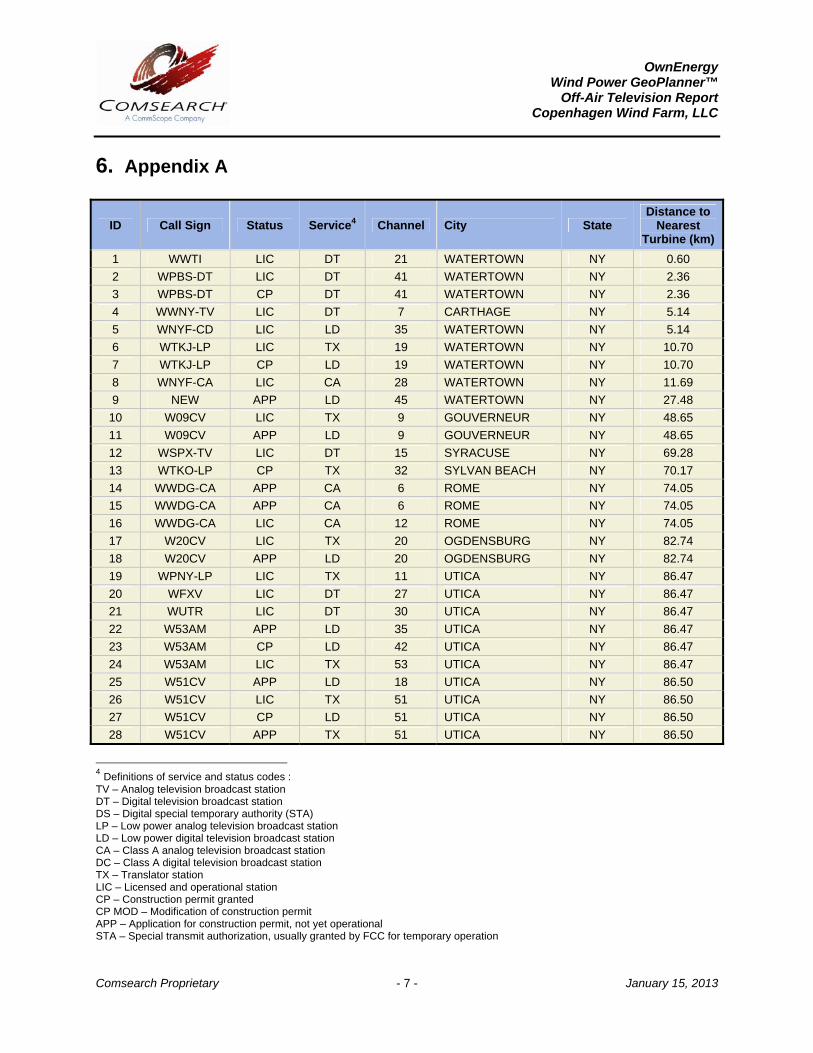
6. Appendix A
ID Call Sign Status Service4 Channel City State Distance to
Nearest Turbine (km)
1 WWTI LIC DT 21 WATERTOWN NY 0.60
2 WPBS-DT LIC DT 41 WATERTOWN NY 2.36
3 WPBS-DT CP DT 41 WATERTOWN NY 2.36
4 WWNY-TV LIC DT 7 CARTHAGE NY 5.14
5 WNYF-CD LIC LD 35 WATERTOWN NY 5.14
6 WTKJ-LP LIC TX 19 WATERTOWN NY 10.70
7 WTKJ-LP CP LD 19 WATERTOWN NY 10.70
8 WNYF-CA LIC CA 28 WATERTOWN NY 11.69
9 NEW APP LD 45 WATERTOWN NY 27.48
10 W09CV LIC TX 9 GOUVERNEUR NY 48.65
11 W09CV APP LD 9 GOUVERNEUR NY 48.65
12 WSPX-TV LIC DT 15 SYRACUSE NY 69.28
13 WTKO-LP CP TX 32 SYLVAN BEACH NY 70.17
14 WWDG-CA APP CA 6 ROME NY 74.05
15 WWDG-CA APP CA 6 ROME NY 74.05
16 WWDG-CA LIC CA 12 ROME NY 74.05
17 W20CV LIC TX 20 OGDENSBURG NY 82.74
18 W20CV APP LD 20 OGDENSBURG NY 82.74
19 WPNY-LP LIC TX 11 UTICA NY 86.47
20 WFXV LIC DT 27 UTICA NY 86.47
21 WUTR LIC DT 30 UTICA NY 86.47
22 W53AM APP LD 35 UTICA NY 86.47
23 W53AM CP LD 42 UTICA NY 86.47
24 W53AM LIC TX 53 UTICA NY 86.47
25 W51CV APP LD 18 UTICA NY 86.50
26 W51CV LIC TX 51 UTICA NY 86.50
27 W51CV CP LD 51 UTICA NY 86.50
28 W51CV APP TX 51 UTICA NY 86.50
4 Definitions of service and status codes : TV – Analog television broadcast station DT – Digital television broadcast station DS – Digital special temporary authority (STA) LP – Low power analog television broadcast station LD – Low power digital television broadcast station CA – Class A analog television broadcast station DC – Class A digital television broadcast station TX – Translator station LIC – Licensed and operational station CP – Construction permit granted CP MOD – Modification of construction permit APP – Application for construction permit, not yet operational STA – Special transmit authorization, usually granted by FCC for temporary operation
OwnEnergy Wind Power GeoPlanner™
Off-Air Television Report Copenhagen Wind Farm, LLC
Comsearch Proprietary - 8 - January 15, 2013
ID Call Sign Status Service4 Channel City State Distance to
Nearest Turbine (km)
29 W22DO-D LIC LD 22 UTICA NY 86.57
30 WNYF-LD LIC LD 18 MASSENA NY 89.06
31 WNPI-DT LIC DT 23 NORWOOD NY 89.06
32 WNPI-DT APP DT 23 NORWOOD NY 89.06
33 WCUL-CA LIC CA 13 ONEIDA NY 89.44
34 WTKO-LP LIC TX 15 ONEIDA NY 89.44
35 W46DY LIC TX 46 UTICA NY 91.92
36 WFXV APP DT 27 UTICA NY 92.71
37 W25AT-D LIC LD 25 TUPPER LAKE NY 93.80
38 NEW APP LD 26 POTSDAM NY 95.80
39 WVVC-LD APP LD 28 UTICA NY 97.20
40 WVVC-LD LIC LD 33 UTICA NY 97.20
41 WMBO-LP LIC TX 6 WESTVALE NY 98.21
42 WMBO-LP CP TX 6 WESTVALE NY 98.21
43 WONO-CA LIC CA 11 SYRACUSE NY 98.21
44 WBLZ-LP LIC TX 13 SYRACUSE NY 98.21
45 WSTQ-LP LIC TX 14 SYRACUSE NY 98.21
46 WTVU-LP LIC CA 22 SYRACUSE NY 98.21
47 WTVU-LP CP MOD DC 22 SYRACUSE NY 98.21
48 WTVU-LP APP DC 22 SYRACUSE NY 98.21
49 NEW APP LD 34 SYRACUSE NY 98.21
50 WOBX-LP LIC TX 35 SYRACUSE NY 98.21
51 WHSU-CA LIC CA 51 SYRACUSE NY 98.21
52 WHSU-CA CP DC 51 SYRACUSE NY 98.21
53 W42EB-D CP TX 31 SYRACUSE NY 98.60
54 W42EB-D APP LD 42 SYRACUSE NY 98.60
55 W42EB-D LIC LD 42 SYRACUSE NY 98.60
56 WKTV LIC DT 29 UTICA NY 99.25
57 WIXT-CA LIC CA 40 DEWITT NY 101.54
58 WIXT-CA CP DC 40 DEWITT NY 101.54
59 WNDR-LP LIC TX 49 SYRACUSE NY 102.66
60 WNDR-LP CP LD 49 SYRACUSE NY 102.66
61 W07BA LIC TX 7 SYRACUSE NY 103.21
62 W04AE LIC TX 4 HERKIMER NY 104.41
63 WSYR-TV LIC DT 17 SYRACUSE NY 106.60
64 WTVH LIC DT 47 SYRACUSE NY 107.40
65 WDSS-LD APP LD 38 SYRACUSE NY 108.27
66 WDSS-LD APP LD 38 SYRACUSE NY 108.28
67 WDSS-LD LIC LD 38 SYRACUSE NY 108.28
68 WCNY-TV LIC DT 25 SYRACUSE NY 108.71
69 WSTM-TV LIC DT 24 SYRACUSE NY 108.72
70 WSYT LIC DT 19 SYRACUSE NY 117.63

OwnEnergy Wind Power GeoPlanner™
Off-Air Television Report Copenhagen Wind Farm, LLC
Comsearch Proprietary - 9 - January 15, 2013
ID Call Sign Status Service4 Channel City State Distance to
Nearest Turbine (km)
71 WNYS-TV LIC DT 44 SYRACUSE NY 117.63
72 WNNY-LD CP LD 31 AUBURN NY 125.02
73 WNNY-LP LIC TX 6 AUBURN NY 125.06
74 DW20BA LIC TX 20 MASSENA NY 125.83
75 W48AO LIC TX 48 AUBURN NY 126.04
76 WNMN CP MOD DT 40 SARANAC LAKE NY 127.04
77 WNMN APP DT 40 SARANAC LAKE NY 127.04
78 WNYI CP MOD DT 20 ITHACA NY 127.20
79 WNYI LIC DT 20 ITHACA NY 127.20
80 W07BH LIC TX 7 NORTH CREEK NY 127.64
81 W09AZ LIC TX 9 NORTH CREEK NY 127.64
82 W11AW LIC TX 11 NORTH CREEK NY 127.64
83 DWFNY-CA LIC TX 49 GLOVERSVILLE NY 129.17
84 WFNY-CD LIC DC 48 GLOVERSVILLE NY 129.26
85 WFNY-CD LIC DC 48 GLOVERSVILLE NY 129.26
86 W31BP LIC TX 31 BURLINGTON NY 132.77
87 W21CP-D LIC LD 21 GLOVERSVILLE NY 134.03
88 W07BI LIC TX 7 SCHROON LAKE NY 148.76
89 W09BB LIC TX 9 SCHROON LAKE NY 148.76
90 WYPX-TV LIC DT 50 AMSTERDAM NY 149.41
Table A: Off-Air TV Stations within 150 Kilometers of Project Area (U.S.)

OwnEnergy Wind Power GeoPlanner™
Off-Air Television Report Copenhagen Wind Farm, LLC
Comsearch Proprietary - 10 - January 15, 2013
ID Call Sign Status Class5 Channel City Province Distance to
Nearest Turbine (km)
CAN-1 CKWS-TV OP R 11 KINGSTON ON 64.03
CAN-2 CBLFT-14 OP C 32 KINGSTON ON 74.88
CAN-3 CICO-TV-38 OP C 38 KINGSTON ON 74.88
CAN-4 CKWS-TV-2 OP A 26 PRESCOTT ON 101.77
CAN-5 CJOH-TV-6 OP R 6 DESERONTO ON 111.69
CAN-6 CKWS-TV-3 OP A 36 SMITHS FALLS ON 124.54
CAN-7 CBLFT-13 OP C 15 BELLEVILLE ON 127.42
CAN-8 CICO-DT-53 OP R 26 BELLEVILLE ON 127.42
CAN-9 CITY-DT-3 OP R 17 OTTAWA ON 144.06
CAN-10 CHCH-TV-1 OP R 11 OTTAWA ON 144.06
CAN-11 CFMT-DT-2 OP C 27 OTTAWA ON 144.06
CAN-12 CFMT-DT-2(2) AU R 27 OTTAWA ON 144.06
CAN-13 CJMT-DT-2 OP R 20 OTTAWA ON 144.06
CAN-14 CITS-DT-1 OP R 42 OTTAWA ON 144.06
CAN-15 CHRO-DT-43 OP R 43 OTTAWA ON 144.06
CAN-16 CHCH-DT-1 AU R 22 OTTAWA ON 144.06
Table A-2: Off-Air TV Stations within 150 Kilometers of Project Area (Canada)
5 Definitions of class codes: R – Regular VHF Television Broadcast Station S – Super-power VHF Television Broadcast Station LP – Low Power Television Broadcast Station VU – Digital Class VU Broadcast Station VL – Digital Class VL Broadcast Station A – Class A Television Broadcast Station B – Class B Television Broadcast Station C – Class C Television Broadcast Station D – Class D Television Broadcast Station