wildlife conservation strategy for the crowned ridge i
TRANSCRIPT

Wildlife Conservation Strategy for the Crowned Ridge I Wind Facility, Grant and Codington Counties, South Dakota AUGUST 2019
PREPARED FOR
Crowned Ridge Wind, LLC
PREPARED BY
SWCA Environmental Consultants


WILDLIFE CONSERVATION STRATEGY FOR THE CROWNED RIDGE I WIND FACILITY, GRANT AND CODINGTON
COUNTIES, SOUTH DAKOTA
Prepared for
Crowned Ridge Wind, LLC 700 Universe Blvd
Juno Beach, Florida 33408
Prepared by
SWCA Environmental Consultants 116 North 4th Street, Suite 200 Bismarck, North Dakota 58501
(701) 258-6622 www.swca.com
SWCA Project No. 53378
August 2019


Wildlife Conservation Strategy for the Crowned Ridge I Wind Facility, Grant and Codington Counties, South Dakota
i
CONTENTS 1 Introduction ........................................................................................................................................... 1
1.1 Statement of Purpose ................................................................................................................... 1 1.2 Corporate Policy ........................................................................................................................... 1 1.3 Agency Coordination History ........................................................................................................ 1
2 Regulatory Framework ......................................................................................................................... 2 2.1 Migratory Bird Treaty Act .............................................................................................................. 2 2.2 Bald and Golden Eagle Protection Act ......................................................................................... 2 2.3 Endangered Species Act .............................................................................................................. 3 2.4 State Protection ............................................................................................................................ 3 2.5 Non-regulatory Framework ........................................................................................................... 3
3 Project Description ............................................................................................................................... 4 3.1 Project Components ..................................................................................................................... 4 3.2 Site Description ............................................................................................................................. 4
3.2.1 Tier 1 Evaluation Area ........................................................................................................ 4 3.2.2 Tier 2 Project Area .............................................................................................................. 5 3.2.3 Baseline Habitat Management ............................................................................................ 6
4 Project History of Bird, Bat, and Species of Concern Presence and Risk Assessments ............. 6 4.1 Tier 1: Preliminary Site Evaluation................................................................................................ 6
4.1.1 Decision to Abandon or Move Forward............................................................................... 6 4.2 Tier 2: Site Characterization ....................................................................................................... 11
4.2.1 Abandon Site or Advance to Field Surveys? .................................................................... 11 5 Tier 3: Field Studies ........................................................................................................................... 13
5.1 Prairie Butterflies Assessment .................................................................................................... 14 5.2 Bird Status Assessments ............................................................................................................ 14
5.2.1 Survey Methods ................................................................................................................ 14 5.2.2 Survey Results .................................................................................................................. 15
5.3 Bat Status Assessment ............................................................................................................... 18 5.3.1 Survey Methods ................................................................................................................ 18 5.3.2 Survey Results .................................................................................................................. 18
6 Potential Project Impacts ................................................................................................................... 19 6.1 Project Risk Assessment ............................................................................................................ 19
6.1.1 Avian Impacts .................................................................................................................... 19 6.1.2 Bat Impacts ....................................................................................................................... 28 6.1.3 Dakota Skipper Impacts .................................................................................................... 29 6.1.4 Cumulative Impacts........................................................................................................... 30
6.2 Risk Assessment Decisions ........................................................................................................ 30 6.2.1 Decision Criteria to Either Abandon or Advance .............................................................. 30 6.2.2 Decision of Need for Other Bird and Bat Conservation Plans .......................................... 31
7 Conservation Measures to Avoid and Minimize Adverse Impacts ................................................ 32 7.1 Siting and Design Measures to Avoid/Minimize Impacts ............................................................ 32 7.2 Construction Measures to Avoid/Minimize Impacts .................................................................... 32 7.3 Operational Measures to Avoid/Minimize Impacts ..................................................................... 33 7.4 Measures to Offset and/or Compensate for Habitat Related Impacts ........................................ 35
8 Tier 4: Post-construction Studies to Estimate Impacts .................................................................. 35 8.1 Carcass Surveys ......................................................................................................................... 35
8.1.1 Project Permits Addressing Birds and Bats ...................................................................... 36
Wildlife Conservation Strategy for the Crowned Ridge I Wind Facility, Grant and Codington Counties, South Dakota
ii
8.2 Grouse Lek Monitoring ............................................................................................................... 36 8.3 Other ........................................................................................................................................... 36
8.3.1 Wildlife Response and Reporting System......................................................................... 36 9 Tier 5: Other Post-construction Studies and Adaptive Management ........................................... 37 10 Reporting Formats and Schedule ..................................................................................................... 37
10.1 Pre-construction Survey Data ..................................................................................................... 37 10.2 Post-construction Mortality Reporting ......................................................................................... 37 10.3 Post-construction Grouse Lek Reporting .................................................................................... 37 10.4 Other ........................................................................................................................................... 38
11 Personnel Training ............................................................................................................................. 38 12 Decommissioning ............................................................................................................................... 38 13 Literature Cited ................................................................................................................................... 39
Appendices Appendix A. Agency Coordination Appendix B. Dakota Skipper Habitat and Survey Area Mapbook Appendix C. Post-construction Fatality Monitoring Protocol Appendix D. Wildlife Response and Reporting System
Figures Figure 1. Project area and location. ............................................................................................................ 58 Figure 2. Project layout. .............................................................................................................................. 59 Figure 3. NLCD land cover within the project area. .................................................................................... 60 Figure 4. Project area location proximity to whooping crane migration corridor. ........................................ 61 Figure 5. Avian count and bat detector locations. ....................................................................................... 62 Figure 6. Raptor nest locations. .................................................................................................................. 63 Figure 7. Grouse lek locations. ................................................................................................................... 64 Figure 8. Overhead transmission line segments marked for avian flight diverter installation. .................... 65
Tables Table 1. Chronology of Resource Agency Contacts for the Project ........................................................... 48 Table 2. NLCD Land Cover Types at the Project........................................................................................ 50 Table 3. Species and Average Counts for the SDWA CBC from 2008 to 2017 ......................................... 50 Table 4. Species Encountered and Their Abundance on the Wilmot BBS Route ...................................... 52 Table 5. USFWS BCC Species for BCR 11 ................................................................................................ 54 Table 6. Summary of Survey Efforts to Date Within the Project Area and Vicinity ..................................... 55 Table 7. Estimated Mean Bird Fatalities for All Birds per Turbine and per Megawatt at Wind
Facilities in the Midwest with Similar Habitat to the Project ..................................................... 56 Table 8. Estimated Mean Bat Fatalities per Turbine and per Megawatt at Wind Facilities in the
Midwest .................................................................................................................................... 56

Wildlife Conservation Strategy for the Crowned Ridge I Wind Facility, Grant and Codington Counties, South Dakota
iii
This page intentionally left blank.

Wildlife Conservation Strategy for the Crowned Ridge I Wind Facility, Grant and Codington Counties, South Dakota
1
1 INTRODUCTION Crowned Ridge Wind, LLC (Crowned Ridge), a wholly-owned, indirect subsidiary of NextEra Energy Resources, LLC (NextEra), is developing the Crowned Ridge I Wind Facility (Project) in Grant and Codington counties, South Dakota (Figure 1). Crowned Ridge is committed to environmental due diligence and contracted SWCA Environmental Consultants (SWCA) to assess potential wildlife impacts resulting from Project construction and operation. Crowned Ridge has voluntarily developed and implemented this Wildlife Conservation Strategy (WCS) in its continued efforts to demonstrate due diligence in avoiding and minimizing impacts to wildlife in association with the development, construction, and operation of the Project. This WCS describes Crowned Ridge’s strategy to address wildlife conservation in all phases of Project development.
1.1 Statement of Purpose There are potential wildlife impacts resulting from construction and operation of a wind energy facility. This WCS outlines various processes that Crowned Ridge has employed or will employ to:
1. Comply with all state and federal wildlife conservation and protection laws and regulations at the Project;
2. Ensure that impacts to wildlife resources, particularly birds and bats, are identified, quantified, and analyzed; and
3. Implement various avoidance and minimization measures to address unanticipated impacts that result from the operation of the Project.
Reducing impacts on birds, bats, and other wildlife that occur as a result of the Project is important to Crowned Ridge as both a regulatory and natural resource conservation priority.
1.2 Corporate Policy Crowned Ridge is committed to siting, constructing, operating, and decommissioning the Project in an environmentally responsible and sustainable manner. This includes minimizing impacts to natural resources, including local wildlife and the habitats they use. As part of this commitment, Crowned Ridge has developed this WCS for the Project. The objective of this WCS is to ensure that:
• All Project-related actions comply with federal and state regulations pertaining to wildlife;
• All Project-related actions comply with conditions of existing permits with respect to wildlife;
• Avoidance and minimization measures designed for Project-specific wildlife species concerns are implemented;
• Effective documentation of bird and bat injuries and fatalities will occur to provide the basis of ongoing adaptive management and development of wildlife protection procedures; and
• Crowned Ridge staff and all relevant subcontractors will receive the appropriate training pursuant to avian, bat, and other wildlife monitoring and reporting.
1.3 Agency Coordination History Crowned Ridge has coordinated with the South Dakota Game, Fish, and Parks (SDGFP) and South Dakota field office of the U.S. Fish and Wildlife Service (USFWS) as part of the development of the

Wildlife Conservation Strategy for the Crowned Ridge I Wind Facility, Grant and Codington Counties, South Dakota
2
Project and the permitting process required by the South Dakota Public Utilities Commission (SDPUC) (Table 1). Copies and records of correspondence are in Appendix A.
2 REGULATORY FRAMEWORK Native birds are protected under a variety of federal and state laws and regulations. With regard to the Project, these laws and regulations include the Endangered Species Act (ESA), Migratory Bird Treaty Act (MBTA), and the Bald and Golden Eagle Protection Act (BGEPA).
2.1 Migratory Bird Treaty Act The MBTA implements the Unites States’ obligations under four treaties for the protection of migratory birds. The MBTA is administered by the USFWS, which maintains a list of all species protected by the MBTA (50 Code of Federal Regulations [CFR] 10.13). This list includes over 1,000 species of migratory birds, including eagles and other raptors, waterfowl, shorebirds, seabirds, wading birds, and passerines.
The MBTA makes it unlawful “by any means or in any manner, to pursue, hunt, take, capture, kill … possess, offer for sale, sell … purchase … ship, export, import …transport or cause to be transported… any migratory bird, any part, nest, or eggs of any such bird …” except as otherwise permitted under the regulations. (16 United States Code [USC] 703). The USFWS has interpreted the MBTA to be a strict liability statute, meaning that proof of intent, knowledge, or negligence is not an element of an MBTA violation. Actions resulting in the “take” of a protected species, in the absence of a USFWS permit or regulatory authorization, are a violation.
The word “take” is defined by regulation as “to pursue, hunt, shoot, wound, kill, trap, capture, or collect, or attempt to pursue, hunt, shoot, wound, kill, trap, capture, or collect” (50 CFR 10.12). The MBTA does not have a provision directly prohibiting incidental takes and the definition of “take” does not include the broader terms of “harass” or “harm” that have been found to prohibit incidental take.
2.2 Bald and Golden Eagle Protection Act Under authority of the BGEPA (16 USC 668–668d), bald eagles (Haliaeetus leucocephalus) and golden eagles (Aquila chrysaetos) are afforded additional legal protection. The BGEPA states that “no person shall knowingly, or with wanton disregard for the consequences of his act take, possess, sell, purchase, barter, offer for sale, purchase or barter, transport, export, or import, at any time or in any manner any bald eagle commonly known as the American eagle or any golden eagle, alive or dead, or any part, nest or egg thereof of the foregoing eagles…”. The BGEPA defines take to include “pursue, shoot, shoot at, poison, wound, kill, capture, trap, collect, molest, or disturb” (16 USC 668c), and includes criminal and civil penalties for violating the statute (16 USC 668). The term “disturb” is defined as agitating or bothering an eagle to a degree that causes, or is likely to cause, injury to an eagle, or a decrease in productivity or nest abandonment by substantially interfering with normal breeding, feeding, or sheltering behavior (50 CFR 22.3).
BGEPA authorizes the Secretary of the Interior to permit the take of bald or golden eagles for several defined purposes, including when “necessary to permit the taking of such eagles for the protection of wildlife or of agricultural or other interests in any particular locality.” Based on this authority, the USFWS published a final rule (Eagle Permit Rule) on September 11, 2009 (see 50 CFR Parts 13 and 22) establishing two new permit types: 1) individual permits that can be authorized in limited instances of disturbance and in certain situations where other forms of take may occur, such as human or eagle health

Wildlife Conservation Strategy for the Crowned Ridge I Wind Facility, Grant and Codington Counties, South Dakota
3
and safety; and 2) programmatic permits that may authorize incidental take that occurs over a longer period of time or across a larger area (USFWS 2009). On December 16, 2016, the USFWS issued a revised Eagle Permit Rule that includes changes to the regulations for eagle incidental take permits and eagle nest take permits. The revisions to the Eagle Permit Rule went into effect on January 17, 2017, and include changes to permit issuance criteria, duration (including a maximum permit term of 30 years), compensatory mitigation standards, and permit application requirements.
2.3 Endangered Species Act Certain species at risk of extinction are protected under the federal Endangered Species Act of 1973 (ESA; 16 USC §1531 et seq., as amended). The ESA defines and lists species as “endangered” or “threatened” and provides regulatory protection for the listed species. The federal ESA also provides a program for the conservation and recovery of threatened and endangered species and for the conservation of designated critical habitat. Section 9 of the federal ESA prohibits the “take” of species listed by USFWS as threatened or endangered.
. “Take” is defined as “harass, harm, pursue, hunt, shoot, wound, kill, trap, capture, or collect, or to attempt to engage in any such conduct” (16 USC 1532). Significant modification or degradation of listed species’ habitats where the modification actually kills or injures wildlife by significantly impairing essential behavioral patterns is considered “harm” under ESA regulations. Section 10(a) of the federal ESA includes provisions for the authorization of take that is incidental to, but not the purpose of, otherwise lawful activities. Under Section 10(a)(1)(B), an Incidental Take Permit may be issued if take is incidental and does not jeopardize the survival and recovery of the species.
2.4 State Protection South Dakota’s Endangered and Threatened Species law (SDCL Chapter 34A-8) prohibits the take, possession, and transportation of “wildlife and plants indigenous to the state determined to be endangered or threatened within the state” as determined by the SDGFP.
2.5 Non-regulatory Framework In addition to regulatory drivers, the WCS also briefly discusses bird species included on the USFWS list of Birds of Conservation Concern (BCC). Although these species are not formally protected under any regulatory laws, BCC species are closely monitored by USFWS due to population declines and/or rare occurrences in a specific region. As a result, BCC species that might be encountered at the Project are included in this WCS. Development of the BCC category for birds was the result of a 1988 amendment to the Fish and Wildlife Conservation Act that mandates the USFWS identify species, subspecies, and populations of all migratory nongame birds that, without additional conservation actions, are likely to become candidates for listing under the ESA. The overall goal is to prevent or remove the need for additional ESA bird listings by implementing proactive management and conservation actions. The BCC categorization is intended to stimulate coordinated and collaborative proactive conservation actions among federal, state, tribal, and private partners (USFWS 2008a). The proposed Project Area is located in the Prairie Potholes Bird Conservation Region (BCR 11) and only BCC species for this region are discussed in the WCS.

Wildlife Conservation Strategy for the Crowned Ridge I Wind Facility, Grant and Codington Counties, South Dakota
4
3 PROJECT DESCRIPTION
3.1 Project Components The Project will be situated within an approximately 53,186-acre Project Area (Figure 2), and the total installed capacity of the Project will not exceed 300 MWs. Project components will include:
• Up to 130 wind turbine generators;
• Access roads to turbines and associated facilities;
• Underground 34.5-kilovolt (kV) electrical collector lines connecting the turbines to the collection substation;
• Underground fiber-optic cable for turbine communications co-located with the collector lines;
• The low-side of a 34.5 to 345-kV collection substation;
• One permanent meteorological (met) tower;
• An operations and maintenance (O&M) facility; and
• Additional temporary construction areas, including laydown and batch plant areas.
The Project will utilize the Crowned Ridge 34-mile 230 kV generation tie line and a new reactive power compensation substation to transmit the generation from the Project’s collector substation to the Project’s point of interconnection located at the Big Stone South 230 kV Substation.
3.2 Site Description 3.2.1 Tier 1 Evaluation Area Crowned Ridge conducted a desktop analysis consistent with Tier 1-Preliminary Site Evaluation recommendations of the USFWS Wind Energy Guidelines (WEG) (USFWS 2012) to assess the potential for adverse effects on species of concern and their habitat. The results were evaluated to further inform the location determination process for the proposed Project. As part of the initial site screening, Crowned Ridge evaluated existing, publicly available Geographic Information System (GIS) data on the proposed Project Area, including land ownership, National Land Cover Data (NLCD), US Department of Agriculture (USDA) National Agriculture Statistics Service data, U.S. Geological Survey (USGS) Ecoregions, the National Wetlands Inventory, the National Hydrography Database, Federal Emergency Management Agency floodplains, high resolution aerial imagery, data available from South Dakota State University’s Public Research Access Institutional Repository and Information Exchange, and known species occurrence and habitat data provided by USFWS and SDGFP, as well as results from field evaluations performed for previous iterations of the Project Area. The location of the proposed Project Area was selected over other evaluated areas based on the evaluation of these factors. Other factors that influenced the selection of the proposed Project Area were wind resource, interested landowners, and proximity to a transmission line for interconnection.
The Project lies within three ecoregions, namely the Prairie Coteau Escarpment, the central Prairie Coteau, and the Big Sioux Basin (Bryce et al. 1996). Land within the Project Area is characterized by tilled agriculture and a well-developed drainage network across the Big Sioux Basin, hummocky topography with no distinct drainage pattern in the Prairie Coteau, and relatively gradual slopes with eastern flowing perennial streams along the Prairie Coteau Escarpment. Vegetation is primarily cropland

Wildlife Conservation Strategy for the Crowned Ridge I Wind Facility, Grant and Codington Counties, South Dakota
5
and grassland with small patches of planted trees in shelterbelts around farmsteads/homesteads, and near natural streams. Two active sand and gravel pits are located in T118N R51W Sections 15 and 16. Project elevations range from approximately 1,040 to 2,050 feet above mean sea level. The Project is located entirely on private land, which includes undeveloped rural areas, agricultural lands, and residential farmsteads.
The Tier 1 Preliminary Site Evaluation and coordination with USFWS and SDGFP identified species of concern with the potential to occur within the Project Area.
The following species are evaluated in detail to determine the likelihood of occurrence within the Project Area in Section 4.1:
• Bald eagle and golden eagle (federally protected; BGEPA),
• Osprey (Pandion haliaetus) (state threatened),
• Piping plover (Charadrius melodus) (federally threatened),
• Prairie grouse – greater prairie-chicken (Tympanuchus cupido) and sharp-tailed grouse (Tympanuchus phasianellus) (neither species is federally or state-listed but leks are of concern to USFWS and SDGFP),
• Red knot (Calidris canutus) (federally threatened),
• Whooping crane (Grus americana) (federally endangered),
• Northern long-eared bat (Myotis septentrionalis; NLEB) (federally threatened),
• Northern river otter (Lontra canadensis) (state threatened),
• Prairie butterflies – Dakota skipper (Hesperia dacotae) (federally threatened) and Poweshiek skipperling (Oarisma poweshiek) (federally endangered),
• Blacknose shiner (Notropis heterolepis) (state endangered),
• Northern redbelly dace (Chrosomus eos) (state threatened), and
• Topeka shiner (Notropis topeka) (federally endangered).
3.2.2 Tier 2 Project Area Consistent with Tier 2-Project Area Evaluation recommendations of the WEG, field evaluations were conducted at the proposed Project Area. During ground-based surveys completed for previous iterations of the Project, biologists observed habitats and site conditions, which were then used to evaluate the initial results of the desktop study and to inform the assessment of the potential occurrence of sensitive wildlife resources. Subsequent Project re-designs modified the Project Area to avoid non-wildlife constraints, wetlands, and high-quality native prairie to the extent possible. The site visits confirmed that the existing land use in the Project Area is primarily grassland, cropland, and hay/pasture. There are rural residences and farmsteads located within the Project Area.
There are no major rivers or lakes within the Project Area; however, the Project Area contains numerous streams and wetlands that vary from shallow vegetated depressions to man-made cattle ponds and intermittent creeks. Three named streams and multiple unnamed tributaries to these streams are located within the Project Area (Crowned Ridge 2019). There are few wetlands evident that are not associated with a stream system. Trees and forested areas are sparsely scattered throughout the Project Area and are restricted mainly to riparian areas and to windbreaks around fields and residences. The topography within the Project Area primarily consists of rolling plains, and lacks prominent landscape features (e.g., hills,

Wildlife Conservation Strategy for the Crowned Ridge I Wind Facility, Grant and Codington Counties, South Dakota
6
valleys); the elevation within the Project Area ranges from approximately 1,040 to 2,050 feet above mean sea level.
3.2.3 Baseline Habitat Management The habitat within the Project Area is primarily agriculture and pasture vegetation typical of South Dakota. According to the NLCD, the majority of the Project Area is herbaceous (47 percent) and cultivated crops (36 percent) (Table 2, Figure 3), all of which is managed by private landowners. Crop sales in Grant and Codington counties are primarily grains, oil seeds, dry beans, and dry peas, while cattle, hogs, and sheep comprise the majority of livestock sales (USDA 2012). The NLCD shows 5,885 acres (11 percent) of pasture/hay (Table 2, Figure 3). There are no federally managed habitats within the Project Area.
4 PROJECT HISTORY OF BIRD, BAT, AND SPECIES OF CONCERN PRESENCE AND RISK ASSESSMENTS
4.1 Tier 1: Preliminary Site Evaluation 4.1.1 Decision to Abandon or Move Forward
4.1.1.1 ARE SPECIES OR HABITATS OF CONCERN PRESENT?
Native prairie and the following special-status wildlife species were identified as potentially present within the Project Area and were therefore evaluated in detail to determine the likelihood of occurrence within the proposed Project Area and potential risks to these species and their habitats.
Habitat
Native Prairie
The NLCD class “herbaceous” includes land currently not used for hay/pasture or cropland, but that may or may not have been disturbed in the past. These areas likely provide suitable habitat for grassland and some prairie species. However, Bauman et al. (2016) conducted a GIS exercise to quantify undisturbed lands in eastern South Dakota that are most likely to support native, undisturbed prairie that, in turn, are more likely to support prairie obligate and sensitive species. This exercise is described below.
Bauman et al. (2016) utilized South Dakota Farm Service Agency’s 2013 Common Land Unit data layers, and the 2012 USDA National Agriculture Imagery Program county mosaic aerial imagery, to evaluate approximately 22.6 million acres of land in the 44 counties that comprise eastern South Dakota. Land currently under crop production, or that has in the past been used for crop production, was removed from consideration for the exercise. This was followed by manual removal of other disturbed areas. The remaining land tracts were then categorized as potentially “undisturbed grassland” or “undisturbed woodland.” Water bodies larger than 40 acres as defined by the SDGFP’s Statewide Water Bodies layer were then removed to allow a more accurate interpretation of the remaining undisturbed grassland/wetland complex. The resulting dataset provides an indication of the location of likely undisturbed grasslands that may support native prairies and provide habitat for prairie species (Bauman et al. 2016). These areas may overlap with the cover types “herbaceous” and/or “hay/pasture” (Table 2).
4.1.1.1.1

Wildlife Conservation Strategy for the Crowned Ridge I Wind Facility, Grant and Codington Counties, South Dakota
7
According to Bauman et al. (2016), there are 505 discrete tracts of land that may support native prairie within the Project Area. These tracts range in size from less than 0.1 to 631.0 acres, with an average size of 35.4 acres. The total acreage of land that may contain native prairie habitat within the Project Area, according to Bauman et al., is approximately 17,889.4 acres.
USFWS and SDGFP identified native prairie as a habitat of concern because it may support the Dakota skipper, Poweshiek skipperling, or grassland bird species of concern. See Section 5.1 for additional assessment results.
Insects
Prairie Butterflies – Dakota Skipper and Poweshiek Skipperling
The Dakota skipper is an obligate of undisturbed, native prairies, and generally inhabits wet lowlands dominated by bluestem grasses, or dry uplands that are a mix of bluestem and needle stem grasses (Vaughn 2005). Larvae have been observed feeding on several grasses, although little bluestem (Schizachyrium scoparium) is the preferred food source; the preferred nectar source for adults is purple coneflower (Echinacea angustifolia) (Vaughn 2005), in addition to other prairie flowering species. As of 2002, Dakota skippers had been recorded at 53 sites in 10 counties in South Dakota, including two sites in Codington County (USFWS 2002). Of the Dakota Skipper sites recorded in Codington County, none are within the Project Area. The closest occurrence is approximately 15 miles west of the Project Area. There is no designated critical habitat for the Dakota skipper within the Project Area. The nearest critical habitat is in Grant County, adjacent to the western boundary of the northeastern portion of the Project Area. Dakota skippers have not been recorded in the Project Area (USFWS 2017a).
The Poweshiek skipperling lives in high quality tallgrass prairie in both upland, dry areas and low moist areas (USFWS 2014). Nectar species for the Poweshiek skipperling include purple coneflower, black-eyed Susan (Rudbeckia hirta), palespike lobelia (Lobelia spicata), and other flowering prairie species. There is no definitive research available regarding which plant species are necessary for larvae to develop, but they appear to select fine-stemmed grasses and sedges, such as slender spike rush (Eleocharis elliptica), prairie dropseed (Sporobolis heterlepis), and little bluestem (Shepherd 2005; USFWS 2014). Skadsen (2015) suggests the Poweshiek skipperling may be extirpated from South Dakota.
See Section 5.1 for additional assessment results.
Birds
Bald Eagle and Golden Eagle
Bald eagles typically occupy habitat near large rivers, lakes, and marshes with available food sources (USFWS 2007). They build stick nests as large as 10 ft. in diameter in trees and occasionally on human-made structures (USFWS 2007). Skadsen (2017) identifies the bald eagle as an “uncommon migrant” in northeast South Dakota. The golden eagle nests primarily west of the Missouri River in South Dakota, usually on cliffs, rocky outcrops, and in large trees (Kochert et al. 2002; Pulkrabek and O’Brien 1974). Skadsen (2017) lists the golden eagle as a “rare migrant” in northeast South Dakota. See Section 5.2 for additional assessment results.
Osprey
Ospreys inhabit areas near large water bodies that support their prey, which consists almost exclusively of fish (SDGFP 2017a). Their nest sites include large trees on or near water bodies, with preference
4.1.1.1.2
4.1.1.1.3

Wildlife Conservation Strategy for the Crowned Ridge I Wind Facility, Grant and Codington Counties, South Dakota
8
to locations that offer separation from surrounding vegetation to avoid predators (SDGFP 2017a). The Project Area contains lakes and streams which have the potential to support osprey prey resources, though forested areas with available nesting sites are limited throughout the Project Area. See Section 5.2 for additional assessment results.
Piping Plover
Within South Dakota, piping plovers breed and nest on open beaches, alkaline wetlands, and sandflats (Aron 2005). In the Northern Great Plains, the nesting season extends from late April through August, with peak activity in May and June (Aron 2005). Nests consist of shallow scrapes in the sand lined with rocks or small shells (Aron 2005). The SDGFP (2016) lists the piping plover as known to have occurred in Codington County but not Grant County; however, the USFWS (2017a) does not list the species as a known or potential occurrence in Codington County. The Platte River Recovery Implementation Program (PRRIP) (2017) indicates that the species nests primarily on the Missouri River, downstream of the Gavins Point (approximately 150 miles south of Project Area) and Fort Randall Dams (approximately 154 miles southwest of Project Area), with some nesting on tributaries of the Missouri. The PRRIP (2017) also states that piping plovers have been observed at Horseshoe Lake in western Codington County, approximately 14 miles west of the Project Area. See Section 5.2 for additional assessment results.
Prairie Grouse
The greater prairie-chicken and sharp-tailed grouse may be present in the Project Area. These species are not federally or state-listed as threatened or endangered. Current research suggests that certain grouse species may avoid anthropogenic structures (Hagen et al. 2011; USFWS 2012); however, long-term data sets are still needed to assess wind energy impacts (Johnson et al. 2012). Regardless, state and federal wildlife agencies have regularly expressed concern about the locations of wind turbines with respect to grouse leks. Leks are breeding grounds where grouse congregate, and males engage in communal breeding displays during the spring (Connelly et al. 1998). See Section 5.2 for additional assessment results.
Red Knot
The red knot is a shoreline species that breeds in drier Arctic tundra areas that generally are sparsely vegetated. Nests are cup-shaped depressions lined with vegetation and located on the ground. Outside of the breeding season, the species primarily is found in marine habitats, especially near coastal inlets, estuaries, and bays (Harrington 2001). The species may be present in South Dakota as a migrant or accidental occurrence but breeding or wintering populations have not been observed (Harrington 2001). See Section 5.2 for additional assessment results.
Whooping Crane
The USFWS indicates that South Dakota is within the whooping crane migration corridor and that the species may stopover in suitable habitat including cropland and pastures, wet meadows, shallow marshes, shallow portions of large water bodies, and both freshwater and alkaline basins (Appendix A). The Project Area is approximately 30 miles east of the 95% core migration corridor (as delineated by Pearse et al. 2018a and 2018b; Figure 4) at its closest, indicating that it is relatively less likely for the species to be present within the Project Area than in areas closer to the migration corridor. According to the USFWS Whooping Crane Tracking Project Database, the closest whooping crane observation is from spring 2015, approximately 16 miles northwest of the Project Area. See Section 5.2 for additional assessment results.

Wildlife Conservation Strategy for the Crowned Ridge I Wind Facility, Grant and Codington Counties, South Dakota
9
Mammals
Northern Long-eared Bat
Summer habitat for NLEB consists of forested areas with trees greater than 3 inches in diameter at breast height (USFWS 2017b). NLEB roost in live trees and/or snags that have exfoliating bark, cracks, crevices, and/or cavities (USFWS 2017b). The species typically forages in forest interiors. These wooded areas may be dense or loose aggregates of trees with variable amounts of canopy closure (USFWS 2017b). NLEB also may roost in human-made structures such as buildings, barns, bridges, and bat houses (USFWS 2017b). The species hibernates in caves, mines, or other cave-like structures during the winter. The USFWS lists NLEB as possibly present in Codington and Grant Counties, indicating that the Counties are within the range of the species and may contain suitable habitat. However, there are no records of the species being present in these counties (USFWS 2017a). The nearest county records published by USFWS indicating known presence of NLEB are in Brookings County to the south of the Project and in Roberts County to the north (USFWS 2017a).
The USFWS cites White Nose Syndrome, a fungal pathogen specific to bats, as the primary cause for the decline of the species, rather than habitat removal (USFWS 2016a). NLEB was listed as a threatened species with a final 4(d) rule on April 2, 2016 (USFWS 2016a). The 4(d) rule prohibits purposeful take of the species range-wide. Within the “WNS Zone” (counties within 150 miles of known occurrences of the pathogen that causes white-nose syndrome) incidental take resulting from specified activities is prohibited during certain times of year. The Project Area is within the WNS Zone, therefore incidental take that results from operation of utility-scale wind-energy turbines currently is not prohibited. Additionally, incidental take that results from tree-clearing activities is not prohibited, unless it occurs within 0.25 mile of a known NLEB hibernacula or within 150 feet of a known maternity roost tree between June 1 and July 31. See Section 5.3 for additional assessment results.
Northern River Otter
Northern river otters can occupy many types of habitat; however, riparian vegetation along a wetland margin is a key habitat feature (SDGFP 2012). This species is more prevalent in areas with abundant food and limited disturbance (SDGFP 2012). Northern river otters and beavers are closely associated; the northern river otter exploits dens, downed trees, ponds, and prey that thrive in beaver ponds (SDGFP 2012). The northern river otter was reintroduced into the Minnesota River valley in 1980 and 1981 (Skadsen 2016a). Since then, Skadsen (2016a) reports that the population has expanded its range and the species now is frequently observed in Grant County along the Yellowbank River drainages, which cross through the Project Area, and along other tributaries and lakes within the Minnesota River valley, which lies approximately 16 miles northeast of the Project Area. The Project Area contains lakes and streams which have the potential to support northern river otters. However, it is unknown whether northern river otters frequently utilize these tributaries in Codington County (SDGFP 2012). The closest documented observation of the northern river otter was along an unnamed tributary approximately 13.8 miles east of the Project Study Area (South Dakota Natural Heritage Database spatial data accompanying correspondence shown in Appendix A). Due to the limited habitat, it is unlikely that northern river otters would occur within the Project Area and no significant impacts to suitable habitat are anticipated from the Project; therefore, this species was eliminated from further consideration in this WCS.
Fish
Blacknose Shiner
The blacknose shiner is a small minnow native to eastern South Dakota, and is found in tributaries to the Minnesota, Big Sioux, James and Keya Paha River drainages. The species prefers cool, clear streams with
4.1.1.1.4
4.1.1.1.5

Wildlife Conservation Strategy for the Crowned Ridge I Wind Facility, Grant and Codington Counties, South Dakota
10
deep pools, abundant vegetation and sandy to gravel substrates (SDGFP 2017b). Historical records exist for the Little Minnesota River and Lake Traverse, neither of which are in Grant County (Bailey and Allum 1962). Skadsen (2016b) lists the blacknose shiner as likely extirpated from northeast South Dakota. Additional tributaries to the Minnesota River do occur in the Project Area, and the SDGFP (2016) indicates that the species is known from Grant County. However, there is no information available to determine whether the blacknose shiner currently inhabits streams in the Project Area. Due to the limited habitat, it is unlikely that blacknose shiners would occur within the Project Area and no significant impacts to suitable habitat are anticipated from the Project; therefore, this species was eliminated from further consideration in this WCS.
Northern Redbelly Dace
The northern redbelly dace is a small olive to dark brown-colored fish native to eastern South Dakota that prefers quiet spring-fed areas of streams, bogs, and beaver ponds with aquatic vegetation (SDGFP 2017c). It is found within tributaries to the Missouri, Minnesota, Big Sioux, White, Niobrara, and Keya Paha River drainages. McCoy and Hales (1974) observed the northern redbelly dace in both the North and South Forks of the Yellowbank River in Grant County in 1973 (SDNHD spatial data accompanying correspondence shown in Appendix A), but the species was not observed during subsequent surveys (Burgess and Shearer 2008; Dieterman and Berry 1996). It is hypothesized that the species may be extirpated from northeast South Dakota (Skadsen 2016b). Tributaries to the North Fork of the Yellow Bank River are present within the Project Area. However, there is no information available to determine whether the northern redbelly dace currently inhabits streams within the Project Area. Due to the limited habitat, it is unlikely that northern redbelly dace would occur within the Project Area and no significant impacts to suitable habitat are anticipated from the Project; therefore, this species was eliminated from further consideration in this WCS.
Topeka Shiner
The Topeka shiner is a small minnow native to eastern South Dakota, and is found within tributaries to the James, Vermillion, and Big Sioux drainages. The species prefers a variety of habitats including runs, pools, and backwater areas in cool, perennial streams. Occupied streams typically are groundwater-fed; and have high water quality, clean gravel substrates, and vegetated banks (Shearer 2003). Shearer (2003) synthesized available occurrence data and identified 16 streams where the Topeka shiner was observed before 1997, and 38 streams where the species was observed between 1997 and 2002. None of those streams are in Grant or Codington Counties. However, additional tributaries to the Big Sioux River do occur in the Project Area, and the USFWS (2017a) lists the species as known from Codington County. There is no information available to determine whether the Topeka shiner currently inhabits streams in the Project Area. Due to the limited habitat, it is unlikely that northern redbelly dace would occur within the Project Area and no significant impacts to suitable habitat are anticipated from the Project; therefore, this species was eliminated from further consideration in this WCS.
4.1.1.2 DOES THE LANDSCAPE CONTAIN AREAS PRECLUDED BY LAW OR AREAS THAT ARE DESIGNATED AS SENSITIVE?
USFWS, the U.S. Forest Service, and SDGFP maintain conservation areas to help preserve habitats critical to migratory birds and other sensitive species (e.g., recreation areas, National Wildlife Refuges [NWRs], National Grasslands, state parks, and state wildlife areas). Public lands within the Project Area consist of privately-owned lands that are leased by the SDGFP as Waterfowl Production Areas, Game Production Areas, and Walk-in Areas (WIAs) (Crowned Ridge 2019). Waterfowl Production Areas are managed to protect habitat for waterfowl and migratory birds. Game Production Areas are managed to provide wildlife habitat, improve production of wildlife, and provide opportunities for wildlife viewing

Wildlife Conservation Strategy for the Crowned Ridge I Wind Facility, Grant and Codington Counties, South Dakota
11
and hunting. WIAs allow public hunting on private lands with agreements lasting one to three years. Conservation easements within the Project Area include USFWS wetland easements, grassland easements, wetland/grassland combination easements, and Farmers Home Administration (FHA) easements. There are approximately 8,901.6 acres of wetland, grassland, or wetland/grassland combination easements in the Project Area (Crowned Ridge 2019). Within wetland easements, the USFWS and private landowners agree to avoid impacts to specific wetlands. These wetlands are referred to as protected basins.
4.1.1.3 ARE THERE CRITICAL AREAS OF WILDLIFE CONGREGATION?
There are no critical areas of wildlife congregation within the Project Area.
4.1.1.4 IS THERE POTENTIAL TO FRAGMENT LARGE, INTACT HABITATS FOR SPECIES THAT ARE SENSITIVE TO HABITAT FRAGMENTATION?
To date USFWS has not identified any specific species of habitat fragmentation concern for the Project (Appendix A). Much of the Project Area is already fragmented and in use as pasture or crop production. A network of county roads exists throughout the Project Area; although these roads are not barriers to most wildlife movement, their presence disrupts the continuity of the landscape, contributing to habitat fragmentation. There are patches of native prairie that could be sensitive to further habitat fragmentation; however, due to the existing fragmented nature of the Project Area, impacts are unlikely. In addition, Crowned Ridge has avoided siting turbines and other associated Project facilities in areas of high-quality native prairie to the extent possible and will restore impacts to native prairie using native vegetation (weed-free) seed mixes (see Sections 5.1 and 6.1 regarding Dakota skipper).
4.2 Tier 2: Site Characterization 4.2.1 Abandon Site or Advance to Field Surveys?
4.2.1.1 ARE PLANT COMMUNITIES OR VEGETATION HABITATS OF CONSERVATION PRESENT?
Native prairie was the only plant community of conservation concern detected within the Project Area during the Tier 1 Site Evaluation or Tier 2 Site Characterization. Crowned Ridge determined that high quality native prairie could be avoided by the Project to the extent possible and any impacts to native prairie habitat will be restored using native vegetation (weed-free) seed mixes.
4.2.1.2 WHAT SPECIES OF BIRDS AND BATS ARE LIKELY TO USE THE PROPOSED SITE?
Birds
South Dakota has 438 documented bird species (South Dakota Ornithologists’ Union [SDOU] 2018), and is situated within the Central Flyway, one of several broad bird migratory routes in North America (USFWS 2011). During fall migration, most birds that move along the Central Flyway travel from breeding grounds as far away as Alaska and northern Canada through the central states, eventually reaching wintering grounds near the Gulf of Mexico, and as far away as South America (USFWS 2011). Resident and migratory birds use the Project Area for foraging, hunting, shelter, breeding and nesting, and possibly as a stopover site during migration.
4.2.1.2.1

Wildlife Conservation Strategy for the Crowned Ridge I Wind Facility, Grant and Codington Counties, South Dakota
12
Species present within the Project Area are likely to be common grassland/agriculture species of South Dakota. Waterfowl and waterbird species are likely to use the wetlands as breeding and migratory stopover areas. Raptor species breeding in the Project Area are likely to be in low numbers, and mostly restricted to species adapted to open grassland and agriculture habitats such as great-horned owl, red-tailed hawk, and northern harrier. Grassland species have the potential to occur within the native prairie that occurs within the Project Area. To determine the species that are likely to use the Project Area, Crowned Ridge reviewed the results from the closest National Audubon Society Christmas Bird Count (CBC) count circle and USGS Breeding Bird Survey (BBS) route, summarized below.
Christmas Bird Count
The closest CBC is the Waubay NWR (abbreviated SDWA) centered approximately 26 miles northwest of the Project Area (National Audubon Society 2018). There are 70 species that have been observed during the SDWA CBC over the last 10 years, including two BCC species (2008–2017) (Table 3). There have been no federally listed threatened or endangered species observed during the SDWA CBC over the last 10 years.
Breeding Bird Survey
The nearest USGS BBS is the Wilmot Survey Route (#81017), approximately 15 miles to the north-northeast of the Project Area (near the town of Wilmot) and situated along similar agriculture and grassland habitats. The Wilmot Survey Route has documented 84 species of birds that potentially breed in the area over the last five years (Table 4). Most of these species prefer grassland habitat, agricultural areas, or wetland habitat. The Project Area is 47 percent cultivated crops/pasture/hay (36 percent cultivated crops and 11 percent pasture/hay), 47 percent grassland/herbaceous habitat, and less than 2.15 percent wetland habitat (woody wetlands, emergent herbaceous wetlands, open water), indicating that similar species could breed in the Project Area. The exception to this involves species that prefer wetlands, which may occur in fewer numbers due to the paucity of wetlands within the Project Area. Six BCC species were observed along the survey route (Table 4).
Birds of Conservation Concern
The Project Area is in BCR 11 (USFWS 2008a). There are 27 BCC species listed within BCR 11 meaning they may also occur within the Project Area (Table 5). None of the BCC species are listed as federally endangered or threatened; however, two species are ESA delisted (bald eagle and peregrine falcon). Five species (solitary sandpiper, Hudsonian godwit, buff-breasted sandpiper, shot-billed dowitcher, and Smith’s longspur) are non-breeding migrants that may pass through the region, and possibly the Project Area, during spring and fall migration. Five BCC species for BCR 11 were observed during 2017 avian surveys (peregrine falcon, marbled godwit, chestnut-collard longspur, grasshopper sparrow, and red-headed woodpecker; see Section 5.2.2). Three additional species were observed during 2017 avian surveys that are considered BCC within USFWS Region 6 (ferruginous hawk, prairie falcon, and willow flycatcher) but not specifically for BCR 11.
BCC species were detected on nearby CBC and BBS surveys. Two BCC species (bald eagle, short-eared owl) have been observed within the last 10 years during the SDWA CBC. Six BCC species (American bittern, bald eagle, upland sandpiper, marbled godwit, red-headed woodpecker, and grasshopper sparrow) have been detected along the nearby BBS route over the last five years, only one of which (grasshopper sparrow) prefers grassland habitat and therefore also could be found within the Project Area. The remaining five BCC species mostly prefer wetlands and/or woodland habitat, which each comprise less than 2.15 percent of the Project Area, so therefore it is not expected that these species would occur within the Project Area.

Wildlife Conservation Strategy for the Crowned Ridge I Wind Facility, Grant and Codington Counties, South Dakota
13
Bats
Six bat species have potential to occur within the Project Area: eastern red bats, silver-haired bats, hoary bats, NLEB, little brown bats, and big-brown bats. SWCA cross-referenced these species’ requirements with availability of suitable habitat in the Project Area, reviewed occurrence records, and coordinated with USFWS to determine seasonal likelihood of occurrence for each species.
The only federally listed species with potential to occur within the Project Area is NLEB. There is limited suitable habitat for NLEB within the Project Area, typically in the form of wooded riparian corridors, small woodlots, and isolated forest patches. As a forest interior species, NLEB requires contiguous forest blocks of 15 or greater acres and prefers forested blocks of greater than 114 acres (Crowned Ridge 2019: Appendix F). The Project Area contains 246 total acres of forested blocks that individually are between 15 and 114 acres, and 341 total acres of forested blocks that individually are 114 acres or greater (Crowned Ridge 2019: Appendix F). These acreages represent a combined 1.1 percent of the Project Area qualifying as suitable roosting and/or foraging habitat. The habitat available within the Project Area is similar in availability and density to the surrounding landscape, indicating that there is no regionally unique habitat that could serve as an attractant for NLEB to the Project Area. Furthermore, the USFWS has stated that there is low likelihood of NLEB occurring within the Project Area as a summer resident (USFWS personal communication, 2018) (Crowned Ridge 2019: Appendix F). There is potential for NLEB to occur within the Project Area as a migrant during the spring and fall, though migration behavior of the species is poorly understood.
Based on habitat suitability and availability, the remaining species with potential to occur have varying likelihoods of occurrence throughout the year (Crowned Ridge 2019: Appendix F).
4.2.1.3 IS THERE POTENTIAL FOR SIGNIFICANT ADVERSE IMPACTS TO THOSE SPECIES?
The Tier 1 and Tier 2 evaluation results show low potential for significant adverse impacts regarding birds, bats, or other wildlife species or their habitats within the Project Area. Based on the habitat present, abundance of cultivated crops, and the distance from major waterbodies and other wildlife attractants, no significant, unavoidable adverse impacts to species or habitats of concern were identified.
4.2.1.4 IS THERE A HIGH PROBABILITY OF SIGNIFICANT ADVERSE IMPACTS THAT CANNOT BE AVOIDED OR MINIMIZED?
The site-specific characterization was consistent with the Tier 1 Site Evaluation in that there was a low probability of significant adverse impacts on wildlife or their habitats. Therefore, Crowned Ridge decided to move forward with focused field studies of the Project Area to further evaluate the presence of bird and bat species. The data from those studies are used to inform this WCS.
5 TIER 3: FIELD STUDIES Based on the results of the Tier 1 and Tier 2 analysis, Crowned Ridge conducted Tier 3 field studies in accordance with the USFWS Land-based WEG (USFWS 2012) to better understand risks to wildlife from development of the Project. Surveys conducted at the Project are summarized in Table 6 and described in detail in this section.
4.2.1.2.2

Wildlife Conservation Strategy for the Crowned Ridge I Wind Facility, Grant and Codington Counties, South Dakota
14
5.1 Prairie Butterflies Assessment Crowned Ridge completed a thorough desktop and field-verified habitat assessment for potentially suitable Dakota skipper and Poweshiek skipperling habitat in the Project Area (Crowned Ridge 2019: Appendix C). Based on habitat assessment results, “adult presence/absence survey areas” were identified (Appendix B). In these areas, the Applicant completed three rounds of Dakota skipper and Poweshiek skipperling adult presence/absence surveys between June 28 and July 12, 2018, with 48 hours’ spacing between each survey round and in accordance with the USFWS’s 2018 Dakota Skipper Protocol. The surveys fell within the adult flight period of both species.
Prior to the survey, Crowned Ridge obtained USFWS concurrence with proposed survey methods. All observed butterfly species were documented, and a general count of flowering plants was conducted. No Dakota skippers or Poweshiek skipperlings were observed.
5.2 Bird Status Assessments The following surveys were conducted to assess bird presence and use of the Project Area.
5.2.1 Survey Methods
5.2.1.1 AVIAN USE SURVEYS
Avian use surveys for the Project Area were completed April 1, 2017 through November 30, 2017 with the objective of characterizing activity, spatial distribution, and relative abundance of avian species (Crowned Ridge 2019: Appendix E). Study methods included large bird use surveys and small bird use surveys in accordance with recommendations set forth in the WEGs. Point count surveys were conducted at 29 locations throughout the Project Area with 800-meter and 100-meter buffers for large and small bird surveys, respectively (Figure 5). A total of 232 surveys across the 29 points were completed during the survey.
5.2.1.2 RAPTOR NEST SURVEYS
Two raptor nest aerial surveys were completed in 2017 and one was completed in 2018 to identify nesting raptors and to provide spatial and species information (Crowned Ridge 2019: Appendix D). Biologists surveyed for all raptor nests within the Project Area and a 2-mile (3.2-kilometer) buffer. Biologists surveyed specifically for eagle nests with the Project Area and a 10-mile (16-kilometer) buffer.
5.2.1.3 WHOOPING CRANE HABITAT ASSESSMENT
A desktop assessment was conducted to identify potentially suitable whooping crane habitat in the Project Area plus a 1-mile buffer (Crowned Ridge 2019: Appendix E). The assessment followed methods outlined in The Watershed Institute’s (TWI’s) Potentially Suitable Habitat Assessment for the Whooping Crane (TWI 2013).

Wildlife Conservation Strategy for the Crowned Ridge I Wind Facility, Grant and Codington Counties, South Dakota
15
5.2.2 Survey Results
5.2.2.1 SPECIES PRESENCE BY SEASON/BIRD USE PATTERNS
Large and Small Birds
SWCA recorded 356 large bird observations. Flight altitudes for 209 of the 356 observations occurred at 0–200-meters (m) above ground level (agl); however, 172 of the 209 observations (48.3%) occurred at a height below 30 m, which is outside of the typical turbine rotor-swept area. Surveyors recorded four large bird species recognized by the USFWS as BCC within the Project Area: ferruginous hawk, peregrine falcon, prairie falcon, and marbled godwit; however, ferruginous hawk and prairie falcon are BCC within USFWS Region 6 but not specifically within BCR 11 (USFWS 2008a). Twelve raptor species were observed: American kestrel, Cooper’s hawk, ferruginous hawk, merlin, northern harrier, peregrine falcon, prairie falcon, rough-legged hawk, red-shouldered hawk, red-tailed hawk, sharp-shinned hawk, and Swainson’s hawk. No bald or golden eagles were observed within the Project Area. Twenty-three non-raptor species were recorded: American crow, American white pelican, blue-winged teal, California gull, Canada goose, double-crested cormorant, Franklin’s gull, gadwall, great blue heron, great egret, greater prairie-chicken, greater yellowlegs, marbled godwit, mallard, northern pintail, ring-billed gull, ring-necked pheasant, snow goose, sharp-tailed grouse, turkey vulture, Wilson’s snipe, wild turkey, and wood duck. All species observed during the 8-month survey period are considered typical for the region and seasons of observation.
A total of 644 small bird observations of 54 species were made during surveys. Flight altitudes for 643 of the 644 observations occurred at 0–200 m agl; however, 625 of the 643 observations (97.2%) occurred at a height below 30 m, which is outside the turbine rotor-swept area. Biologists recorded four small bird species recognized by the USFWS as BCC within the Project Area: the chestnut-collard longspur, grasshopper sparrow, willow flycatcher, and red-headed woodpecker; however, willow flycatcher is a BCC within USFWS Region 6 and National but not specifically within BCR 11 (USFWS 2008a). Western meadowlark, red-winged blackbird, and American robin accounted for 238 (36.9%) of all observations. A complete list of observed species is provided in the Avian Use Survey Report (Crowned Ridge 2019: Appendix E). All species observed during the 8-month survey period are considered typical for the region and seasons of observation.
Non-Eagle Raptor Nests
The 2017 surveys identified 22 non-eagle raptor nest structures within the 2-mile buffer survey area (Figure 6). Eight of these nests were considered occupied and fourteen nests were considered unoccupied. Five occupied non-eagle raptor nests (four red-tailed hawk nests, one great-horned owl nest) were observed within the Project Area. Three occupied non-eagle raptor nests (two red-tailed hawk nests, one Swainson’s hawk nest) were observed outside the Project Area within the 2-mile buffer.
The 2018 survey identified 47 non-eagle raptor nest structures within the 2-mile buffer survey area (Figure 6). Sixteen nests were considered occupied, and thirty-one nests were considered unoccupied. Eight occupied non-eagle raptor nests (six red-tailed hawk nests, two great-horned owl nests) were observed within the Project Area. Likewise, eight occupied non-eagle raptor nests (six red-tailed hawk nests, two great-horned owl nests) were observed outside the Project Area within the 2-mile buffer (Crowned Ridge 2019: Appendix D).
5.2.2.1.1
5.2.2.1.2

Wildlife Conservation Strategy for the Crowned Ridge I Wind Facility, Grant and Codington Counties, South Dakota
16
Eagle Nests
During the 2017 surveys, two occupied bald eagle nests were observed within the 2-mile buffer (Figure 6). No bald eagle nests were observed within the Project Area.
During the 2018 surveys, two occupied bald eagle nests and one (likely) unoccupied eagle nest were observed within the 2-mile buffer and outside the Project Area. Three occupied bald eagle nests were identified within the 10-mile buffer and beyond the 2-mile buffer. No bald eagle nests were observed within the Project Area (Crowned Ridge 2019: Appendix D; Figure 6).
5.2.2.2 SPECIES OF CONCERN
No federally listed threatened or endangered species were observed during avian use surveys, raptor nest surveys, or as incidental observations. Observations of BCC species are summarized Section 5.2.2.1.1. Species of concern with the potential to occur within the Project Area are discussed below.
Bald Eagle and Golden Eagle (Federally Protected Under BGEPA)
Several avian use and raptor nest surveys have been completed for nearby study areas, or for earlier iterations of the Project Area. Surveys indicate the presence of bald eagles near the Project; however, no golden eagles were observed during these recent surveys. In 2015, studies in a nearby study area indicated bald eagles were present; however, no golden eagles were observed (Tetra Tech 2015). A total of 453 hours of survey were conducted over all four seasons during the 2015 survey, during which four bald eagles and zero golden eagles were observed (Tetra Tech 2015). The timing of the sightings suggests that observed individuals likely were migrants and not resident breeding adults (Tetra Tech 2015). In the spring and fall of 2008, avian surveys were conducted for an earlier iteration of the Project in Grant, Codington, Deuel, and Brookings Counties (Tetra Tech 2008a, 2008b). Three golden eagles and zero bald eagles were observed (Tetra Tech 2008a, 2008b).
Most recently, large bird use surveys were completed for the current Project Area from April through November 2017. A total of 232 surveys across 29 points were completed. No bald or golden eagles were observed within the Project Area. Raptor nest aerial surveys conducted in 2017 and 2018 identified three bald eagle nests within 10 miles of the Project Area. No nests were observed within the Project Area (Crowned Ridge 2019: Appendix D). The closest occupied bald eagle nest observed was in 2017 approximately 530 ft from the Project Area boundary. In 2018, the closest occupied bald eagle nest observed was approximately 4,360 ft from the Project Area boundary. No golden eagles were observed during 2017–2018 Project Area surveys.
Although the landscape within the Project Area does not support any large waterbodies or an abundance of smaller waterbodies that would attract bald eagles for nesting or foraging, the presence of occupied bald eagle nests in the vicinity of the Project Area suggests that the species may occasionally hunt or pass through the Project Area during the breeding season. Based on the distance of the bald eagle nests from the Project Area, there is a low likelihood of bald eagle occurrence.
Golden eagles have a low likelihood of breeding within the Project Area due to a lack of suitable nesting habitat; however, the species may hunt or pass through the Project Area during any time of the year. The combination of no golden eagle sightings during the avian use surveys with no habitat features that would concentrate golden eagles within the Project Area compared to the surrounding area suggests a low likelihood of golden eagle occurrence in the Project Area.
5.2.2.1.3
5.2.2.2.1

Wildlife Conservation Strategy for the Crowned Ridge I Wind Facility, Grant and Codington Counties, South Dakota
17
Osprey (State Threatened)
Several avian use surveys have been completed for nearby study areas, or for earlier iterations of the Project Area. No ospreys were observed during those surveys. Avian use surveys were completed in the Project Area from April through November 2017. A total of 232 surveys across 29 points were completed. No ospreys were observed within the Project Area. Raptor nest aerial surveys were conducted in 2017 and 2018; no osprey nests were identified within the Project Area or within 2 miles of the Project Area.
Osprey have a low likelihood of breeding within the Project Area due to a lack of suitable nesting habitat; this combined with no osprey sightings during the avian use surveys suggest a low likelihood of osprey within the Project Area.
Piping Plover (Federally Threatened)
Several avian use surveys have been completed for nearby study areas, or for earlier iterations of the Project Area. No piping plovers were observed during these surveys. Avian use surveys were completed for the current Project Area from April through November 2017. Point count surveys were conducted at 29 locations throughout the Project Area. A total of 232 surveys were completed. No piping plovers were observed.
Piping plover have a low likelihood of breeding within the Project Area due to a lack of suitable nesting habitat; this combined with no piping plover sightings during the avian use surveys suggest a low likelihood of piping plover within the Project Area.
Prairie Grouse (Not Federally or State-Listed)
During spring 2007-2008 avian surveys, several active greater prairie-chicken leks were observed within a nearby study area. Four active leks were recorded during spring 2016 surveys in or near an earlier iteration of the Project Area, including two greater prairie-chicken leks and two unknown leks. Throughout agency coordination on the current Project Area, the Applicant has requested and received lek occurrence data from the SDGFP (Appendix A). These locations have been documented spatially in the Applicant’s Project planning databases to ensure consideration during Project siting (Figure 7). During most recent avian use studies in the Project Area, one greater-prairie chicken and one sharp-tailed grouse, and no leks, were observed.
Red Knot (Federally Threatened)
Several avian use surveys have been completed for nearby study areas, or for earlier iterations of the Project Area. No red knots were observed during these surveys. Avian use surveys were completed for the current Project Area from April through November 2017. Point count surveys were conducted at 29 locations throughout the Project Area. A total of 232 surveys were completed. No red knots were observed.
Red knots have a low likelihood of breeding within the Project Area due to a lack of suitable nesting habitat; this combined with no red knot sightings during the avian use surveys suggest a low likelihood of red knots within the Project Area.
Whooping Crane (Federally Endangered)
Several avian use surveys have been completed for nearby study areas, or for earlier iterations of the Project Area. No whooping cranes were observed during these surveys. Avian use surveys were
5.2.2.2.2
5.2.2.2.3
5.2.2.2.4
5.2.2.2.5
5.2.2.2.6

Wildlife Conservation Strategy for the Crowned Ridge I Wind Facility, Grant and Codington Counties, South Dakota
18
completed for the current Project Area from April through November 2017. Point count surveys were conducted at 29 locations throughout the Project Area. A total of 232 surveys were completed. No whooping cranes were observed. Additionally, the desktop whooping crane habitat assessment found that wetlands considered potentially suitable habitat comprised only 0.75% of the total Project Area.
The combination of no whooping crane sightings during the avian use surveys with no habitat features that would concentrate whooping cranes within the Project Area compared to the surrounding area suggests a low likelihood of whooping crane occurrence in the Project Area.
5.2.2.3 SPECIES OF HABITAT FRAGMENTATION CONCERN
To date, USFWS has not identified any specific species of habitat fragmentation concern for the Project (Appendix A).
5.3 Bat Status Assessment 5.3.1 Survey Methods A desktop bat habitat assessment was conducted with the purpose of assessing the availability and suitability of bat habitat within the Project Area, and to determine the potential for presence of state-listed and federally listed bat species (Crowned Ridge 2019: Appendix F).
A long-term, passive, acoustic bat monitoring survey was conducted within the Project Area between April 6 and December 1, 2017 in accordance with the recommendations set forth in the WEGs (Crowned Ridge 2019: Appendix G). Two acoustic detectors were deployed on a meteorological tower within the Project Area. Data were analyzed to determine bat passes per detector night of recording, where a “detector night” is equal to one detector deployed for one calendar night.
5.3.2 Survey Results
5.3.2.1 SPECIES PRESENCE BY SEASON/BAT USE PATTERNS
Nearly 80% of the calls recorded occurred in the fall. Although the dynamics of bat migration are not fully understood, one factor that could contribute to this difference is recruitment of juveniles into the fall migration population. Seasonal differences in the data collected suggest that the Project Area experiences limited bat migration in spring. However, if 2017 data are indicative of an overall pattern, spring bat populations are sparse when compared with other regions of the United States. The highest levels of activity observed correlated with fall migration, though even these spikes of activity were low when compared with other fall migration events.
Overall, the level of bat activity may suggest that bat use of the Project Area is relatively low. The annual mean passes the per detector night recorded during the study at 1.6. For comparison, Jain (2005) documented a mean activity level in 2003 and 2004 of 34.9 and 36.6 passes per detector-night, respectively, in Iowa. Because of the lack of suitable roosting and foraging habitat in the project area, the number of bats is likely much lower than what might be observed in other, more ecologically diverse, parts of the country.
Wildlife Conservation Strategy for the Crowned Ridge I Wind Facility, Grant and Codington Counties, South Dakota
19
5.3.2.2 SPECIES OF CONCERN
A desktop bat habitat assessment was conducted with the purpose of assessing the availability and suitability of bat habitat, including that of NLEB, within an earlier iteration of the Project Area in summer 2015. This assessment identified only marginal potential NLEB habitat. A desktop bat habitat assessment was completed for the current Project Area in September 2018 (Crowned Ridge 2019: Appendix F). The assessment concluded that there is limited suitable NLEB habitat within the Project Area and that USFWS considers the species unlikely to occur except as an occasional migrant (USFWS personal communication 2018) (Crowned Ridge 2019: Appendix F).
Several passive bat acoustic surveys have been completed on previous iterations of the Project Area. These surveys indicated a low likelihood of NLEB presence in the study areas. A passive bat acoustic survey was completed on the current Project Area in April through November 2017 (Crowned Ridge 2019: Appendix G).
There is little suitable roosting or foraging habitat in the Project Area for NLEB. The small size and small number of wooded parcels in the Project Area likely limits the density and diversity of bats in the Project Area. Because of this lack of forested habitat within the Project Area, combined with no detections during our surveys, NLEB have a low likelihood of occurring in the Project Area.
5.3.2.3 SPECIES OF HABITAT FRAGMENTATION CONCERN
To date, USFWS has not identified any specific species of habitat fragmentation concern for the Project (Appendix A).
6 POTENTIAL PROJECT IMPACTS This section outlines potential risks to wildlife related to the construction and operation of the Project.
6.1 Project Risk Assessment In the following sections, the field data collected to date were analyzed to assess potential Project impacts. Impacts to the species under discussion can be short-term (one or two reproductive seasons), or long-term (affecting several generations). They can be direct (an immediate effect to an individual, population or its habitat), or indirect (an effect that may occur over time or result from other actions). Direct impacts may include collisions with Project infrastructure such as turbine blades or transmission lines; electrocution; disturbance from construction or operations activities; displacement due to loss of suitable habitat; and habitat loss and fragmentation that creates a barrier to dispersal, regular movements, or migration. Indirect impacts may include loss or change of population vigor; attraction to modified habitats, and increased exposure to predation as a result of altered habitat use. Additionally, the Project may contribute to cumulative impacts that may affect certain species, in conjunction with impacts from other future development.
6.1.1 Avian Impacts Birds have been identified as a group at risk because of collisions with wind turbines and power lines (Arnett et al. 2007; Drewitt and Langston 2006; Erickson et al. 2005). Specifically, migrant passerines (e.g., songbirds) are found more often in post-construction mortality monitoring compared to other groups of birds (Arnett et al. 2007). In fact, at newer generation wind energy facilities outside of California, approximately 80 percent of documented mortalities have been songbirds, of which 50 percent are often

Wildlife Conservation Strategy for the Crowned Ridge I Wind Facility, Grant and Codington Counties, South Dakota
20
nocturnal migrants (Drewitt and Langston 2006; Erickson et al. 2001; Johnson et al. 2002; Strickland and Morrison 2008).
Songbirds, raptors, waterfowl, and gulls were the most commonly observed species groups during 2017 avian use surveys and are likely to use the Project Area (Crowned Ridge 2019: Appendix E). The most commonly observed species were western meadowlark, red-winged blackbird, northern harrier, red-tailed hawk, Franklin’s gull, Canada goose, and American robin (Crowned Ridge 2019: Appendix E).
6.1.1.1 DIRECT IMPACTS ON BIRDS
General Avian Species
The avian community detected within the Project Area during avian surveys was characterized by species typical of agricultural lands and grassland/pastures in South Dakota. Within disturbed habitats such as these, the greatest potential impact of wind facilities to avian species is risk of collisions with turbines. Nationally, reported avian fatality rates at wind energy facilities average 2.43 birds/MW/year and range from 0.15 to 11.02 birds/MW/year. Publicly available avian fatality rates at wind facilities in the mid-west of North America with similar habitat to that of the Project average 2.00 birds/MW/year (2.43 birds/turbine/year; Table 7). Recent meta-analyses relevant to the Project have estimated an average all-bird (mostly small birds) fatality rate of 1.81 birds/MW/year in the Great Plains (Loss et al. 2013) and 2.29 small birds/MW/year in the Prairie biome (Erickson et al. 2014). The meta-analysis provided by other studies and the publicly available fatality rates indicate that any Project-related bird fatalities, should the occur, may be reasonably expected to be within the range defined by these studies and the publicly available fatality rates in Table 7.
Collision
Locally breeding songbirds may experience lower mortality rates than migrants because many of these species tend not to fly at turbine heights during the breeding season. However, some breeding songbird species have behaviors that increase the risk of collisions with turbines. For example, horned larks have been commonly found as fatalities at wind farms, and mortality may be partially attributed to the breeding flight displays within the rotor-swept area (RSA) (Johnson and Erickson 2011; Pickwell 1931).
The western meadowlark (Johnson and Erickson 2011; Thelander et al. 2003) and red-winged blackbird (Kerlinger et al. 2006; Thelander et al. 2003) have been documented as fatalities at other wind energy projects according to publicly available data. The western meadowlark and red-winged blackbird were among the 25 most commonly detected collision fatalities at wind energy facilities (Erickson et al. 2014). American robin was another species observed in Project Area point counts that was among the 25 most commonly detected collision fatalities. Although risk of turbine-related fatalities at the Project exists for each of these species, should they occur, they are unlikely to have population-level impacts because South Dakota populations for each species are large and relatively stable (7.5 million—western meadowlark, 6.7 million—red-winged blackbird, 4.1 million—American robin) (PIFSC 2019).
Although non-raptor mortality due to collision is expected to be low, collision fatalities are a cause of concern to Crowned Ridge. To monitor and minimize collision fatalities as a result of operation of wind turbines to the extent possible, Crowned Ridge will implement fatality monitoring for one year (Section 8) and adaptive management for the life of the Project (Section 9). Section 6.1.1.1.5 describes how Crowned Ridge will mark the associated generation tie-line to reduce the likelihood of avian collision with the powerline.
6.1.1.1.1

Wildlife Conservation Strategy for the Crowned Ridge I Wind Facility, Grant and Codington Counties, South Dakota
21
Electrocution
Utility lines, particularly distribution lines, can potentially result in electrocution of large raptors because their wingspan is large enough that the bird can simultaneously contact two conductors or a conductor and grounded hardware (APLIC 2006). Utility lines generally pose less of a threat to non-raptors because of their smaller wing spans. However, any structures that allow for circuit completion (i.e., flesh-to-flesh contact between energized parts or an energized and grounded part) pose an electrocution risk. Avian electrocutions typically occur on distribution lines with voltages less than 60 kilovolts. The risk of electrocution at the Project is likely to be low due to measures Crowned Ridge will undertake to prevent electrocution. See Section 7.0 for details of avoidance and minimization measures.
Disturbance/Displacement
In addition to mortality associated with wind farms, concerns have been raised that some bird species may avoid areas near turbines after the wind farm is in operation (Drewitt and Langston 2006). For example, at the Buffalo Ridge wind energy facility in Minnesota, densities of male songbirds were significantly lower in CRP grasslands containing turbines than in CRP grasslands without turbines though the causal mechanism was not studied (Leddy et al. 1999). Reduced abundance of grassland songbirds was found within 50 m of turbine pads for a wind farm in Washington and Oregon, and the investigators attributed displacement to the direct loss of habitat or reduced habitat quality and not the presence of the turbines (Erickson et al. 2004). Research at three sites in North and South Dakota (Shaffer and Buhl 2016) suggests that certain grassland songbird species (seven of nine studied; one species was unaffected, one species was attracted) may avoid turbines by as much as 300 m. Displacement and attraction were observed to continue through the five-year study period. None of these studies have addressed whether these avoidance effects are temporary (i.e., the birds may habituate to the presence of turbines over time) or permanent. Pearce-Higgins et al. (2012) found little evidence for a post-construction decline for ten species of birds at wind projects in upland habitats in the United Kingdom.
Project construction activities and the presence of turbines and other Project features may disturb or displace birds, particularly species of habitat fragmentation concern. Many of the species detected during bird surveys likely breed in the Project Area, suggesting potential for impact to breeding birds. However, the impacts to birds from disturbance or displacement from the Project are likely to be low based on the relatively low bird use in the Project. The heavy agricultural use within the Project Area suggests that the additional disturbance and habitat loss caused by construction and operation of the Project will not cause birds to avoid the Project Area, nor should it alter the current use of habitat by bird species within the Project Area. The risk of disturbance/displacement will be further reduced through avoidance and minimization measures taken during the design, construction, and operational phases of the Project (Section 7.0).
Birds of Conservation Concern
The five BCR 11 BCC species (peregrine falcon, marbled godwit, chestnut-collard longspur, grasshopper sparrow, and red-headed woodpecker) observed within the Project Area are expected to occur in low numbers and therefore any risk of fatalities are also expected to be low. Direct impacts to BCC species observed within the Project Area, are expected to be similar to impacts identified under general avian species and/or raptors. The risk of direct impacts will be reduced through avoidance and minimization measures implemented during the design, construction, and operational phases of the Project (Section 7.0).
6.1.1.1.2

Wildlife Conservation Strategy for the Crowned Ridge I Wind Facility, Grant and Codington Counties, South Dakota
22
Raptors (non-eagle)
Despite the observation that most bird fatalities at wind farms are songbirds, raptor mortality historically has received the most attention. Raptor mortality at newer wind projects has been low relative to older-generation wind farms, although there is substantial regional variation in raptor mortality rates (Erickson et al. 2002; Erickson et al. 2004; Jain et al. 2007; Johnson et al. 2002; Kerns and Kerlinger 2004).
Collision
While a recent meta-analysis suggests that pre-construction studies may be poor indicators of post-construction mortality (Ferrer et al. 2012), high raptor use has been associated with high raptor mortality at wind farms (Strickland et al. 2011). Conversely, raptor mortality has been low where raptor use was low.
Northern harriers and red-tailed hawks were the most frequently detected raptor specie during the 2017 avian use surveys (Crowned Ridge 2019: Appendix E). These species are commonly associated with agricultural and grassland prairie habitats, which are present within the Project Area and provide opportunities for foraging, an activity associated with susceptibility to turbine collisions (Thelander et al. 2003).
Northern harrier and red-tailed hawk fatalities have been recorded at operating wind facilities (Erickson et al. 2002; Erickson et al. 2004; Gritski et al. 2010, Johnson and Erickson 2011; Young et al. 2003). Red-tailed hawk nests were found within the Project Area and 2-mile buffer during 2017 and 2018 raptor nest surveys; this may increase the risk for collisions during nesting activities. Project-related fatalities of northern harrier, should they occur, are unlikely to have population-level impacts because populations in South Dakota are relatively large and stable (29,000) (PIFSC 2019).
In a study of raptor response to wind farms, red-tailed hawks were observed engaging in high-risk flight behaviors at operational wind facilities whereas northern harriers were identified as having a low risk flight behavior for collisions (Garvin et al. 2011). Results from post-construction mortality monitoring studies indicate that red-tailed hawks are frequently found as turbine-related fatalities (Grodsky and Drake 2011; Garvin et al. 2011; Johnson and Erickson 2011). Drewitt and Langston (2006) summarized that bird activity is typically higher near active nests than areas without active nests, as a result, red-tailed hawks may have increased potential for collision if they repeatedly fly within the Project Area during nesting activities and during the time when young begin to fledge from the nests. Red-tailed hawk nests were found within the Project Area and 2-mile buffer; the presence of occupied raptor nests within and near the Project Area may increase the risk for collisions during nesting activities. However, Project-related fatalities are unlikely to have population-level impacts because red-tailed hawk populations in South Dakota are relatively large and stable (61,000) (PIFSC 2019).
Although raptor mortality due to collision is expected to be low, collision fatalities have potential to occur at Crowned Ridge. To monitor and minimize collision fatalities to the extent possible, Crowned Ridge will implement fatality monitoring for one year (Section 8) and adaptive management for the life of the Project (Section 9). Section 6.1.1.1.5 describes how Crowned Ridge will mark the associated generation tie-line to reduce the likelihood of avian collision with the powerline.
Electrocution
Fatalities of large raptors have occurred as a result of electrocution and collisions with utility lines and structures, particularly distribution lines (APLIC 2006). Due to their large size, raptors are able to bridge conductive elements to complete a circuit (APLIC 2006). Therefore, any structures that allow for circuit completion (i.e., flesh-to-flesh contact between energized parts or an energized and grounded part) pose
6.1.1.1.3

Wildlife Conservation Strategy for the Crowned Ridge I Wind Facility, Grant and Codington Counties, South Dakota
23
an electrocution risk. To protect birds from possible electrocution, the Avian Power Line Interaction Committee (APLIC) recommends that lines have a horizontal separation of 60 inches and a vertical separation of 40 inches between phase conductors or between a phase conductor and grounded hardware (APLIC 2006). Therefore, the risk of electrocution for raptors from the Project is likely to be low because all collection lines will be buried and all overhead lines and the generation interconnection tie line will be constructed following a manner consistent with APLIC guidelines for the design of overhead lines (see Section 7.0).
Disturbance and Displacement
Raptors may be vulnerable to disturbance from many types of human activity. Human disturbance may result in direct and indirect impacts to raptor habitat, occupancy, and nesting success (USFWS 2008b). Direct impacts may include the loss of foraging or nesting habitat within the Project Area, direct mortality (e.g., due to collisions with wind turbines, electrocution by power lines), sound disturbance (e.g., construction sound), and loss of nest sites or winter roost sites (USFWS 2008b).
Disturbance or displacement nesting raptors is possible if birds are nesting or have preferred foraging areas within line-of-sight of the Project facilities. A number of studies conducted at western wind energy facilities suggest that wind energy facilities do not have long term impacts on raptor nest densities (Erickson et al. 2004; Gritski et al. 2008; Howell and Noone 1992; Johnson et al. 2003; Young et al. 2006). For example, post-construction studies at an Oregon project found that raptor nests more than 0.5 miles from turbines were not impacted by project disturbance (Gritski et al. 2008). Studies have also found no clear relationship between nest occupancy and distance from turbines (Johnson et al. 2003; Young et al. 2006). Suitable raptor nesting habitat within the Project Area is limited. There are few trees sufficient to support raptor nests, there are no cliff nesting habitat, and there are no large waterbodies within the Project Area that would attract nesting bald or golden eagles. Given the number of known raptor nests within the Project Area and two-mile buffer, some nesting raptors may be disturbed or displaced by construction activities. However, disturbance and displacement of raptors will be minimized through the implementation of avoidance and minimization measures described in Section 7.0.
Eagles
Collision
No bald eagles or their nests were found within the Project Area during the 2017 and 2018 nest surveys; however, there were two occupied bald eagle nests observed within the 2-mile buffer in 2017 and there were two occupied bald eagle nests and one (likely) unoccupied bald eagle nests observed within the 2- mile buffer and outside the Project Area and three bald eagle nests within the 10-mile buffer and beyond the 2-mile buffer in 2018 (Crowned Ridge 2019: Appendix D). The nearest bald eagle nest to the Project Area is over 1.5 miles from the nearest turbine. Although bald eagles have a low likelihood of breeding within the Project Area due to a lack of suitable nesting habitat, bald eagles nesting in the vicinity of the Project could occur in the Project Area when foraging or migrating.
Six bald eagle mortalities associated with wind energy facilities within the United States were reported from 1997 through June 2012 (Pagel et al. 2013). Bald eagles are believed to be at less risk of turbine collision than golden eagles because they tend to focus their hunting efforts for fish and waterfowl in lakes and rivers (Buehler 2000). Although bald eagle collisions with turbines may be possible, the likelihood of collisions are already substantially reduced due to the lack of nests and suitable nesting habitat within the Project Area and will be further minimized through the implementation of avoidance and minimization measures described in Section 7.0. Section 6.1.1.1.5 describes how Crowned Ridge will mark the associated generation tie-line to reduce the likelihood of avian collision with the powerline.
6.1.1.1.4
Wildlife Conservation Strategy for the Crowned Ridge I Wind Facility, Grant and Codington Counties, South Dakota
24
No golden eagles or their nests were found within the Project Area or 10-mile buffer surrounding the Project Area during the 2017 and 2018 nest surveys (Crowned Ridge 2019: Appendix D). Although golden eagles have a low likelihood of breeding within the Project Area due to a lack of suitable nesting habitat, golden eagles could occur in the Project Area when foraging or migrating.
Seventy-nine golden eagle mortalities associated with wind energy facilities within the United States were reported from 1997 through June 2012, excluding the Altamont Pass Wind Resource Area in California (Pagel et al. 2013); however, to date no golden eagle mortalities have been reported at wind energy facilities in South Dakota. Golden eagles are believed to be more at risk of turbine collision than bald eagles because they hunt for land-based prey along topographic contours where turbines are often located (Kochert et al. 2002). Potential collision impacts on golden eagles will be minimized through the implementation of avoidance and minimization measures described in Section 7.0. Section 6.1.1.1.5 describes how Crowned Ridge will mark the associated generation tie-line to reduce the likelihood of avian collision with the powerline.
Electrocution
Potential impacts to eagles are the same as described for raptors above.
Disturbance and Displacement
Due to the lack of foraging habitat (large bodies of water) and nests less than 1.5 miles from any turbines, it is unlikely that foraging or nesting bald eagles will be displaced or disturbed by the Project. There is some evidence that bald eagles avoid operating wind turbines (Sharp et al. 2012), but this avoidance appears to be over short distances rather than displacement from the entire wind farm.
It is unlikely that nesting golden eagles will be disturbed or displaced due to the lack of nesting habitat and absence of golden eagle nests within the Project Area. However, golden eagles may be disturbed or displaced from the Project Area if infrastructure interferes with hunting or availability of prey.
Whooping Cranes
Collision
Whooping cranes may be directly affected by the Project through collision with wind turbines or associated power lines. No whooping crane observations were documented in the Project Area and the Project is located approximately 30 miles east of the 95 percent isopleth of the whooping crane migration corridor (Figure 4).
To date, no whooping crane mortality has been attributed to collision with wind turbines at any facility. Whooping cranes typically fly at altitudes higher than the tallest proposed turbine height (431 feet at the tip of an upright turbine blade) during migration; however, individuals fly at lower altitudes in response to climate conditions (e.g., low cloud cover), while searching for a stopover location and while landing, taking off, and moving between roosting and foraging locations. It is during these low flight times that the cranes are at the highest risk for collision with turbines and power lines. Although collision with turbines or transmission lines is a risk, cranes have been documented altering flight direction in response to turbines at a wind facility in South Dakota (Nagy et al. 2012), and multiple studies have documented sandhill cranes gradually climbing as they approach marked power lines (Morkill and Anderson 1991; Murphy et al. 2009).
Crowned Ridge will mark a total of 14.4 miles along the associated generation tie line. Of the total 14.4 miles to be marked, 8.8 miles were identified using the approach recommended in The Watershed
6.1.1.1.5

Wildlife Conservation Strategy for the Crowned Ridge I Wind Facility, Grant and Codington Counties, South Dakota
25
Institute’s (TWI) Potentially Suitable Habitat Assessment for the Whooping Crane. An additional 5.6 miles were identified for marking based on locations where the overhead line spanned a mapped aquatic resource or where proximate mapped aquatic resources may expand to combine in high rain events per USFWS recommendations (USFWS personal communication, 2019) (Figure 8). In segments identified for line marking, bird diverters will be installed every 50 feet.
Electrocution
Electrocution is unlikely for whooping cranes because they are a ground-nesting bird, adapted to foraging on the ground, and are not known to perch or nest on or near the conductive elements of power lines.
Disturbance and Displacement
Land use within the Project Area consists mainly of grassland/pasture or agricultural production with a limited extent of wetlands within the Project Area. The wetland-agricultural habitat matrix preferred by whooping cranes as stopover habitat exists within the Project Area; however, it also exists in the surrounding landscape. Therefore, it is unlikely that whooping cranes will be displaced from the Project Area or that Project operations will disturb them.
6.1.1.2 INDIRECT IMPACTS ON BIRDS
General Avian Species
Habitat Loss and Fragmentation
Birds may be indirectly affected by habitat loss and fragmentation due to Project development. Habitat fragmentation can exacerbate the problem of habitat loss for birds by decreasing patch area and increasing edge habitat. Habitat fragmentation can reduce bird productivity through increased nest predation and parasitism and reduced pairing success of males (Robinson et al. 1995). However, the increase in the amount of habitat loss and fragmentation as a result of Project construction will be minimized by the use of existing roads to the extent possible and lands already altered by agriculture, as well as restoring any native prairie impacts using native vegetation (weed-free) seed mixes. Additionally, Crowned Ridge will follow all requirements of the Project’s construction stormwater authorization including the Storm Water Pollution Prevention Plan to control erosion and potential pollutants.
Decreases to Population
The avian community detected within the Project Area during avian surveys was characterized by species typical of agricultural lands and pastures in South Dakota. The primary species observed during Project surveys were Western meadowlark, red-winged blackbird, and American robin. Project-related fatalities of these species, should they occur, are unlikely to have population-level impacts because South Dakota populations for each species are large (7.5, 6.7, and 4.1 million each, respectively) (PIFSC 2019). In addition, locally breeding birds may experience lower mortality rates than migrants because many of these species tend not to fly at turbine heights during the breeding season. However, some breeding bird species have behaviors that increase the risk of collisions with turbines. For example, horned larks have been commonly found as fatalities at wind farms, and mortality may be partially attributed to the breeding flight displays within the RSA (Johnson and Erickson 2011; Pickwell 1931). Most songbirds, doves, and gamebirds are short-lived and have high reproductive output, and their population growth rates are more sensitive to reproductive failure than to adult survival (Arnold and Zink 2011; Stahl and Oli 2006). A recent meta-analysis of wind-energy impacts concluded that collisions with wind turbines have negligible cumulative impacts on small bird populations such as passerine, with mortality rates due to these collisions ranging from 0.008 to 0.0043 percent of the continental population per year (Erickson et
I
6.1.1.2.1

Wildlife Conservation Strategy for the Crowned Ridge I Wind Facility, Grant and Codington Counties, South Dakota
26
al. 2014). Therefore, collision mortality for most bird species is expected to have negligible effects on population dynamics.
Avoidance and minimization measures will be implemented during all phases of the Project to reduce the possibility of population-level impacts on all bird species (see Section 7.0).
Birds of Conservation Concern
The five BCR 11 BCC species (peregrine falcon, marbled godwit, chestnut-collard longspur, grasshopper sparrow, and red-headed woodpecker) observed within the Project Area are expected to occur in low numbers and therefore any risk of fatalities are also expected to be low. Indirect impacts to BCC species observed within the Project Area, are expected to be similar to impacts identified under general avian species and/or raptors.
Habitat Loss and Fragmentation
Indirect impacts to the five BCR 11 BCC species observed within the Project Area are similar to the impacts identified under general avian species and/or raptors. Crowned Ridge will avoid areas of high-quality grassland to the extent possible in order to minimize habitat loss for grassland dependent species and impacts to native grassland habitat will be restored with native vegetation (weed-free) seed mixes. Less than 1 percent of both temporary and permanent impacts will occur to grassland habitat due to Project Development. Grassland fragmentation will be avoided and minimized through implementation of mitigation measures during the design, construction, and operation phases of the Project (Section 7.0).
Decreases to Population
Indirect impacts to the five BCR 11 BCC species observed within the Project Area are similar to the impacts identified under general avian species and/or raptors. Crowned Ridge will avoid impacting these species and their habitat to the extent possible, as outlined in Section 7.0.
Raptors (non-eagle)
Habitat Loss and Fragmentation
Raptors that use the Project Area may be indirectly impacted by the Project. Indirect impacts may include habitat degradation and fragmentation and reduction or changes in available prey species (USFWS 2008b). The Project Area is primarily cropland and pastureland, which offers habitat for small mammals that are prey sources for raptors. The permanent habitat impacts within the Project footprint will be small, and as a result, impacts on availability of prey species are expected to be minimal. Overall, habitat degradation and fragmentation due to Project construction will be minimal due to the existing disturbed nature of the Project Area and the small permanent footprint of the Project. Impacts to native grassland will be avoided and minimized according to the mitigation measures in Section 7.0.
Decrease to Population
Indirect impacts to raptor species observed within and in the vicinity of the Project Area are similar to the impacts identified under direct impacts to raptor species. Avoidance and minimization measures will be implemented during all phases of the Project to reduce the possibility of population-level impacts on all bird species (see Section 7.0).
6.1.1.2.2
6.1.1.2.3

Wildlife Conservation Strategy for the Crowned Ridge I Wind Facility, Grant and Codington Counties, South Dakota
27
Eagles
Habitat Loss and Fragmentation
Indirect impacts on bald and golden eagles relating to habitat loss and fragmentation are similar to those discussed for other raptors (see Section 6.1.1.2.3). Indirect impacts on bald eagles’ prey species may differ slightly as turbine operation may cause bald eagles to avoid some areas where they may have foraged for carrion in the past.
Decrease to Population
Bald and golden eagle populations appear to be generally increasing or stable. However, their population sizes are relatively small when compared to other raptors and they are fairly uncommon; the USFWS estimated that there were 128 nesting pairs of bald eagles in South Dakota in 2012 (USFWS 2016b). An estimate of the golden eagle breeding population in South Dakota was not found to be available. Due to their protected status, Crowned Ridge will avoid impacting these species and their habitat to the extent possible, as outlined in Section 7.0.
Whooping Cranes
Habitat Loss and Fragmentation
Because cranes may avoid turbines by altering flight paths, the USFWS (2009) holds the opinion that such avoidance will lead to avoidance of stopover in areas with operational wind turbines. It has been assumed that whooping cranes prefer areas isolated from human disturbances when available. Studies on whooping crane migration habitat and use, and the diminution of this habitat with increasing development, point to an inverse relationship between disturbance level and habitat value (Austin and Richert 2001; USFWS 2009). As a result, potential indirect effects to the whooping crane posed by the Project include avoidance of structures (e.g., turbines, meteorological towers, and transmission lines), habitat loss and fragmentation, and disturbance caused by anthropogenic activities. Behavioral avoidance of wind farms by whooping cranes, while reducing the probability of direct impacts through collision, may amount to loss of stopover habitat. The loss of stopover habitat use through avoidance, however, may be relatively small given the large amount of suitable habitat present within the migration corridor (Western Area Power Administration [WAPA] and USFWS 2015) and the paucity of suitable habitat within the Project Area. Placing wind turbine structures in already developed areas, would likely have less impact than placement in areas where there are no existing disturbances. The Project turbines are sited close to existing section line roads and many of the turbines are sited within lands already altered by agriculture. Although none of these factors excludes the possibility of crane use of the Project Area, in combination it is likely that they make the attractiveness of the location less appealing than habitats surrounding the Project Area.
Decrease to Population
The population of whooping cranes is estimated at 505 birds (95 percent Confidence Interval = 439.2–576.6) as of the 2017/2018 winter whooping crane survey conducted by USFWS at Aransas National Wildlife Refuge [USFWS 2018]). Due to the small population, any Project-related fatalities would have population-level impacts. Crowned Ridge will avoid impacting whooping cranes and their habitat to the extent possible, as outlined in Section 7.0.
6.1.1.2.4
6.1.1.2.5
Wildlife Conservation Strategy for the Crowned Ridge I Wind Facility, Grant and Codington Counties, South Dakota
28
6.1.2 Bat Impacts
6.1.2.1 DIRECT IMPACTS ON BATS
General Bat Species
Collision
Bats have been identified as a wildlife group at risk due to collisions or other interactions with wind turbines (Arnett et al. 2007; Arnett et al. 2008; Drewitt and Langston 2006; Erickson et al. 2001). Bat collision mortality at wind farms is a widespread phenomenon, commonly exceeding avian collision mortality (Kunz et al. 2007). Of 46 species of bats in North America, 11 species have been identified among fatalities at wind farms. Migratory foliage or tree-roosting bat species (hoary bat, eastern red, and silver haired bat) appear to be most susceptible to collision with wind turbines. These species have experienced the highest fatality rates at wind energy facilities in North America, particularly during the spring (March – May) and fall (August – October) season when activity levels increase as these species migrate (Arnett et al. 2008; Cryan 2003; Kunz et al. 2007). Studies of wind energy facilities in the Midwest with similar agriculture/grassland habitat have documented Brazilian free-tailed (not found in South Dakota), hoary, eastern red, silver-haired, little brown, big brown, and tricolored bats as fatalities during mortality surveys (Table 8).
The relationship between activity and mortality has yet to be clearly identified, but we assume that regional fatality patterns are indicative of potential risk at the Project Area. Recent research has shown that mean wind speed and mean ambient temperature have the greatest effects on bat activity patterns but may differ seasonally with bat activity generally lower at low mean nightly temperatures of approximately less than 10 degrees Celsius (°C; 50°F) in the spring and less than 16°C (61°F) in fall at wind speeds greater than 5 meters/second (Weller and Baldwin 2012). However, results of the study have not been replicated for verification. Bat fatality rates at wind energy facilities in the Midwest region average 17.25 ± 12.05 (90-percent confidence interval) bats/turbine/year or 13.4 ± 9.00 bats/MW/year (Table 8). Of the six bat species that may occur in the Project Area discussed in Section 4.2.1.2.2, hoary, eastern red, silver-haired, little brown, and big brown bats have been found during mortality searches at operating wind farms in agricultural/grassland habitat (Table 8). Of these species, the migratory tree bats are considered to be at the greatest risk from wind energy projects (Tierney 2009).
The limited roosting habitat within the Project Area is a major limiting factor for use of the Project Area by migrating bats. Therefore, bat migration through the Project Area is likely low in magnitude. To better understand Project impacts on bats, Crowned Ridge will conduct 1 year of post-construction fatality monitoring.
Disturbance/Displacement
Disturbance and displacement have not been identified as risks associated with bats and operational wind farms in reviews of bat-wind turbine impacts (Kunz et al. 2007), and bats are known to habituate to anthropogenic structures (Keeley and Tuttle 1999). Given the history of agricultural activity in the Project Area, we expect that the local bat community would remain in the area at similar population levels after construction of the Project. Although activity may change the sound environment in the Project Area during daylight hours; Project-related sound levels are not anticipated to have deleterious effects on resident or migrant bats due to bats’ nocturnal nature.
6.1.2.1.1
Wildlife Conservation Strategy for the Crowned Ridge I Wind Facility, Grant and Codington Counties, South Dakota
29
Northern Long-eared Bat
NLEB is the only listed bat species with the potential to occur within the Project Area. The 4(d) rule prohibits purposeful take of the species range-wide. Within the “WNS Zone” (counties within 150 miles of known occurrences of the pathogen that causes white-nose syndrome) incidental take resulting from specified activities is prohibited during certain times of year. The Project Area is within the WNS Zone; therefore, incidental take that results from operation of utility-scale wind-energy turbines currently is not prohibited. Additionally, incidental take that results from tree-clearing activities is not prohibited, unless it occurs within 0.25 mile of a known NLEB hibernacula or within 150 feet of a known maternity roost tree between June 1 and July 31.
No NLEBs were detected during the acoustic monitoring. If present, direct impacts could include collision with turbine blades, habitat disturbance by removal of roost trees, or disturbance to hibernacula. The Project Area only contains approximately 0.7 percent of forested habitat (based on NLCD data) that would be desirable for roosting and breeding by NLEB. Based on the limited quantity of suitable habitat and the lack of documented detections within the Project Area, the potential for direct impacts on NLEB or their habitat are expected to be low.
6.1.2.2 INDIRECT IMPACTS ON BATS
General Bat Species
Habitat Loss and Fragmentation
Indirect impact on bats are generally the same as the direct impacts outlined above. The impacts of habitat fragmentation from wind development on bats are not well-known (Kuvlesky et al. 2007). Both roosting and foraging habitat within the Project Area are limited in availability due to large amounts of open-land agriculture and few large permanent sources of surface water. In addition, the Project has a relatively small footprint of temporary and permanent disturbance. For these reasons, the risk of habitat loss and fragmentation is low.
Northern long-eared Bat
Indirect impacts on NLEB are generally the same as the direct impacts outlined above. The lack of known occurrences or hibernacula of NLEB within the Project Area, the existing fragmented nature of the Project Area, and lack of large tracts of forested habitat, indirect impacts are not expected.
6.1.3 Dakota Skipper Impacts
6.1.3.1 DIRECT IMPACTS ON DAKOTA SKIPPER
The Dakota skipper is known to occur in Codington County and there is designated critical habitat for the species in Grant County. Potentially suitable habitat for the Dakota skipper was identified within the Project Area. Therefore, it is possible the Dakota skipper could be present with the Project Area within areas of suitable habitat. However, adult presence/absence surveys within the Project Area did not observe Dakota skippers. If present, direct impacts on the Dakota skipper could include collision with Project vehicles or disturbance and/or displacement from preferred habitat. Crowned Ridge has avoided locating Project facilities on lands classified as potentially suitable Dakota skipper habitat to the extent possible (Appendix B).
6.1.2.1.2
6.1.2.2.1
6.1.2.2.2
Wildlife Conservation Strategy for the Crowned Ridge I Wind Facility, Grant and Codington Counties, South Dakota
30
6.1.3.2 INDIRECT IMPACTS ON DAKOTA SKIPPER
Indirect impacts on the Dakota skipper are generally the same as the direct impacts outlined above.
6.1.4 Cumulative Impacts Activities that currently exist within the proposed Project Area and vicinity are primarily limited to agriculture. Wind energy development removes less total land from agricultural use than other forms of development. Except for the physical locations of the turbines, access roads, and other permanent facilities, all the land surrounding the Project facilities will be available for agriculture. In addition to the proposed Project, there are nine other proposed wind farms in the vicinity of the proposed Project and wind energy development is expected to continue in South Dakota.
With regard to the potential cumulative impacts to wildlife resources, there is potential for the Project to affect local wildlife both directly (mortality) and indirectly (habitat loss and fragmentation). Both direct and indirect potential impacts would be avoided and minimized to the extent possible, and therefore, are not expected to cause cumulative impacts. Although the wind turbines would contribute to the utility/industrial component of the existing landscape, the area would remain primarily agricultural in nature. As these agricultural lands are of minimal value to wildlife compared to native vegetation, the Project is not expected to result in a cumulative loss of quality wildlife habitat. Based on the existing land use, location of existing and planned facilities, and known impacts from similar wind facilities in the area, it is expected that the Project would have minimal cumulative impacts to wildlife.
6.2 Risk Assessment Decisions 6.2.1 Decision Criteria to Either Abandon or Advance
6.2.1.1 TIER 1/TIER 2 QUESTIONS
Results of the Initial Site Evaluation indicate the majority of the Project Area is disturbed, fragmented, and managed lands for agriculture and pasture (Section 3.2.3). Grasslands have been tilled, mowed, and/or used for livestock grazing making them low quality prairie habitats for most breeding birds. The anticipated avian community using the Project Area is composed of common species typically associated with agricultural and pasture lands of South Dakota. There are no plant communities or vegetation habitats of conservation concern designated within the Project Area other than the concerns expressed by USFWS and SDGFP regarding native prairie. Further, there are no critical areas of wildlife congregation within the Project Area. There are 15 species of concern potentially occurring within the Project Area; these species’ potential use of the Project Area and Project risks were evaluated in Sections 4.0 and 6.0. For many of these species, risk is likely low and can be managed through best management practices and avoidance and minimization measures (Section 7.0).
Based on the results of the Tier 1 Preliminary Site Evaluation (Section 4.1) and Tier 2 Site Characterization (Section 4.2), Crowned Ridge concluded the Project is viable for development within the Project Area.

Wildlife Conservation Strategy for the Crowned Ridge I Wind Facility, Grant and Codington Counties, South Dakota
31
6.2.1.2 WHAT ARE THE DISTRIBUTIONS, ABUNDANCE, BEHAVIORS, AND SITE USE OF BIRDS AND BATS, AND WHAT PROJECT ELEMENTS EXPOSE THESE SPECIES TO RISK?
Field studies (Section 5.0) were designed to document avian and bat use of the Project Area. The results of these studies will be used to predict the overall Project impacts to the avian and bat community, particularly during the migratory seasons when impacts would be the highest risk. The results of the studies indicate a low potential risks from Project development to the species documented or identified as potentially occurring as discussed in Sections 5.0 and 6.0, respectively.
Based on the results of the Tier 1 Preliminary Site Evaluation, Tier 2 Site Characterization, and Tier 3 Field Studies, Crowned Ridge concluded the Project is viable for development within the Project Area.
6.2.1.3 WHAT ARE THE POTENTIAL RISKS TO INDIVIDUALS AND LOCAL POPULATIONS OF BIRDS AND BATS AND THEIR HABITATS?
Based on the wildlife species that occur and are likely to occur, potential Project risks include direct and indirect impacts. Direct impacts include mortality due to collision with Project structures and electrocution, disturbance, and displacement. Indirect impacts could be adverse effects due to habitat fragmentation or habitat loss. A detailed risk assessment is presented above, in Section 6.1. No significant impacts to local populations of wildlife are anticipated from development of the Project.
Based on the results of the risk assessment, Crowned Ridge concludes that there will be no significant, unavoidable impacts on birds, bats, or other wildlife species and the Project is viable for development within the Project Area.
6.2.1.4 HOW CAN IMPACTS TO BIRDS AND BATS BE AVOIDED AND MINIMIZED?
Crowned Ridge understands that the construction and operation of a wind energy facility may pose risks to birds, bats, and other wildlife. Crowned Ridge is committed to minimizing potential impacts on these resources and will implement conservations measures throughout the construction and operations phases of the Project. Conservation measures that will be implemented by the Project are detailed in Section 7.0.
6.2.1.5 WHAT STUDIES SHOULD BE INITIATED AND CONTINUED POST-CONSTRUCTION TO EVALUATE PREDICTIONS OF IMPACTS TO BIRDS AND BATS?
Post-construction studies are essential to understanding whether pre-construction predictions of impacts and risks to birds, bats, and other wildlife are accurate. Therefore, Crowned Ridge will conduct formal post-construction fatality monitoring and implement an employee-based routine monitoring program. Details of this monitoring are presented in Section 8.0.
6.2.2 Decision of Need for Other Bird and Bat Conservation Plans Crowned Ridge does not anticipate the need for additional bird or bat conservation plans based on the data collected to date. Crowned Ridge will coordinate with USFWS regarding ongoing surveys and assessments and further evaluate the need for additional plans as needed.
Wildlife Conservation Strategy for the Crowned Ridge I Wind Facility, Grant and Codington Counties, South Dakota
32
7 CONSERVATION MEASURES TO AVOID AND MINIMIZE ADVERSE IMPACTS
7.1 Siting and Design Measures to Avoid/Minimize Impacts This section identifies impact avoidance and minimization measures that will be incorporated into the final design for the Project. These measures were derived from the voluntary WEG (USFWS 2012) and industry Best Management Practices (BMPs). All avoidance and minimization measures implemented during the planning and design phase demonstrate practical means to reduce impacts to bird and bat species and their habitats.
• Utility lines will be designed following APLIC (2006, 2012) guidelines to prevent bird collisions and electrocution. Crowned Ridge will maintain a horizontal separation of 60 inches and a vertical separation of 40 inches between phases and between phases to ground to protect birds from possible electrocution from the overhead transmission line as recommended by APLIC (2006). Additionally, the principles of isolation and insulation will be considered when retrofitting any overhead electrical equipment and Crowned Ridge will use pad-mounted transformers. In addition, utility poles will be of monopole design instead of lattice design to minimize opportunities for perching and nesting wherever feasible.
• Birds and bats could collide with electrical collection lines and redundant overhead telecommunication lines. Crowned Ridge will bury these lines.
• All turbines will sit on a tubular tower, and not a lattice structure, to minimize perching opportunities for raptors such as eagles and other birds.
• Met towers will not be located in sensitive habitats or in areas where ecological resources known to be sensitive to human activities are present.
• Access roads and turbines will be located away from wetlands and waterbodies to the greatest extent possible to minimize impacts on aquatic species, semiaquatic species, birds, bats, and their habitat.
• Impacts to potentially jurisdictional wetland areas will be below NWP thresholds. Avoiding wetland impacts will generally reduce potential impacts to migratory birds and bats and sensitive habitat.
7.2 Construction Measures to Avoid/Minimize Impacts • To reduce habitat disturbance and minimize the potential for wildlife mortality, equipment and
vehicle travel will be limited to roads or specific construction pathways during construction. Construction traffic, parking, and laydown areas will be located within previously disturbed lands to the extent feasible. The construction footprint will be minimized in areas of native vegetation. Restoration of disturbed areas will include the replacement of the original pre-construction topsoil, or equivalent quality topsoil, to its original elevation, contour, and compaction. Disturbed soil, if not replanted with crops, will be reclaimed with native vegetation (weed-free) seed mixes, if approved by the landowner.
• All trash and food-related waste will be placed in self-closing containers and removed daily from the site. This prevents trash from being exposed or blown around the Project Area and reduces attraction of wildlife to the Project Area.

Wildlife Conservation Strategy for the Crowned Ridge I Wind Facility, Grant and Codington Counties, South Dakota
33
• To minimize vehicle collisions with wildlife, vehicular speed will be limited to 15 miles per hour on turbine or transmission line access roads; vehicular speed will be limited to 35 miles per hour on county roads within the Project Area boundary. Crowned Ridge will follow posted speed limits on county roads outside of the Project Area boundary.
• A site-specific worker environmental training program will be developed and implemented throughout the construction of the Project to inform workers of the biological resources present on-site to minimize wildlife impacts. All employees and contractors working in the field will be required to attend the environmental training session prior to working on-site. This training includes information regarding the sensitive biological resources, restrictions, protection measures, individual responsibilities associated with the Project, and the consequences of non-compliance. Written material will be provided to employees at orientation and participants sign an attendance sheet documenting their participation.
• To avoid habitat destruction, BMPs for fire prevention during construction will be implemented to minimize wildfire potential.
• Crowned Ridge will work closely with landowners or land management agencies to devise and implement a plan to control noxious weeds. Any use of pesticides, herbicides, fertilizers, and other chemicals will be in accordance with federal and state laws to minimize drift and other impacts on native habitat.
• Actual construction footprints and surface disturbance areas will be minimized during construction to minimize wildlife habitat disturbance. In addition, all native prairie will be avoided to the extent possible to minimize impacts on native prairie and the bird and wildlife species that rely on it. Native prairie will be reclaimed with native vegetation (weed-free) seed mixes, if approved by the landowner.
• Removal of vegetation will be avoided within the peak bird nesting season to the extent feasible to avoid removing or disturbing any nests. If not possible, pre-construction nest surveys will be implemented and any nests of ground-nesting birds (e.g., killdeer) will be flagged and a 50-foot non-disturbance buffer placed around nests while it is occupied.
• Crowned Ridge will minimize impacts to existing trees and shrubs. If impacts to trees or shrubs cannot be avoided, the individual trees or shrubs will be replaced.
• Disturbance to raptor nests within the Project Area will be avoided by establishing a 300-foot radius non-disturbance buffer on the center of each active nest during the nesting season.
• To avoid injury or mortality of wildlife due to poisoning, an appropriately-sized emergency spill containment kit will be available to contain and remove spilled fuels, hydraulic fluids, and other potential pollutants when working within or near streams, lakes, or ponds.
• A Storm Water Pollution Prevention Plan will be developed for the construction site to prevent contamination of natural water resources, minimize erosion, storm water runoff, and transport of sediment and other contaminants.
7.3 Operational Measures to Avoid/Minimize Impacts • Crowned Ridge will design the transmission line to conform to APLIC suggested practices to the
extent possible (APLIC 2006, 2012). These standards are intended to protect raptors and other birds from collision and electrocution. These measures are sufficient to protect even the largest birds that may perch or roost on transmission lines or towers.
Wildlife Conservation Strategy for the Crowned Ridge I Wind Facility, Grant and Codington Counties, South Dakota
34
• Crowned Ridge will mark the associated, overhead generation tie line to reduce the potential for whooping crane, waterfowl, or other avian collision.
• Avian and bat fatalities will be evaluated during standardized post-construction fatality monitoring for two years following construction.
• Crowned Ridge will implement an Adaptive Management Program (Section 9) for avoidance, minimization, and mitigation of impacts to birds, bats, and other sensitive wildlife.
• A site-specific worker environmental training plan will be developed and implemented throughout the Project operating life to inform workers of the biological resources present on-site to minimize wildlife impacts. All employees and contractors working in the field will be required to attend the environmental training session prior to working on site. This training will include information regarding the sensitive biological resources (with an emphasis on eagles and whooping cranes), restrictions, protection measures, individual responsibilities associated with the Project, and the consequences of non-compliance. Written material will be provided to employees at orientation and participants will sign an attendance sheet to document their participation.
• “Good housekeeping” procedures will be developed to keep the site clean of debris, garbage, carrion, fugitive trash or waste, and graffiti; to prohibit scrap heaps and dumps; and to minimize storage yards. This will prevent trash from being exposed or blown around the Project Area and will avoid attracting predators and potential food sources for eagles and other predators (i.e. rodents and other small mammals) to the Project.
• To minimize vehicle collisions with wildlife, vehicular speed will be limited to 15 miles per hour on turbine or transmission line access roads; vehicular speed will be limited to 35 miles per hour on county roads within the Project Area boundary. Crowned Ridge will follow posted speed limits on county roads outside of the Project Area boundary.
• Crowned Ridge will contact local game managers to remove road-killed animals on state and county roadways within the Project Area. Road-killed animals or other carcasses (excluding eagles and other migratory birds) detected by personnel on actual Project service roadways will be removed promptly by Crowned Ridge personnel under guidance and/or assistance from local game managers to avoid attracting eagles or other raptors to the Project Area.
• To avoid habitat destruction, BMPs for fire prevention during operation will be implemented to minimize wildfire potential.
• Crowned Ridge workers and subcontractors will not be allowed to have firearms or pets at the Project and will be instructed to not disturb or harass wildlife.
• Lighting of the turbines will be pursuant to Federal Aviation Administration aviation hazard lighting standards. Crowned Ridge is proposing in its lighting plan to use radar activated hazard lights acceptable to the Federal Aviation Administration. Crowned Ridge may also install motion activated timed lighting on tower entrances and other facilities that require lighting at night to avoid the potential to attract insects that may draw birds and bats toward the facility.
• Crowned Ridge has voluntarily agreed to develop and implement this WCS in its continued efforts to demonstrate due diligence in avoiding and minimizing impacts to avian and bat species in association with development and operation of the Project.
Wildlife Conservation Strategy for the Crowned Ridge I Wind Facility, Grant and Codington Counties, South Dakota
35
7.4 Measures to Offset and/or Compensate for Habitat Related Impacts
Approximately 86.0 acres of the total Project Area will be permanently affected due to conversion to turbine sites, access roads, junction boxes, and the permanent meteorological towers, and approximately 2,134.4 acres of land will be temporarily disturbed during construction for turbine installation, road construction, collection line trenching, temporary meteorological tower installation, and temporary crane paths. Approximately 95 percent of the area that is temporarily disturbed will be reclaimed. These impacts represent a minor portion of the land area available for agricultural production. As a result, the Project would not result in significant permanent impacts to agricultural production or the habitat that it offers to birds, bats, and other wildlife.
Land where the turbines will be sited is primarily undeveloped pasture/hay, cropland, and grassland. Areas of highest quality native prairie were avoided to the extent possible. Access road construction would result in the greatest effects to native vegetation, resulting in permanent loss of these habitats where they occur along selected routes. Installation of the buried collection lines would result in some temporary effects to native and non-native grasslands. Any temporary impacts to native prairie will be offset by reseeding using a native vegetation (weed-free) seed mix in accordance with landowner preferences. Other temporarily disturbed areas will be reseeded or restored to crop, depending on original conditions and landowner preference.
Additionally, Crowned Ridge has voluntarily elected to develop an offset package intended to mitigate for the Project’s potential impacts to native habitats. The offset package will address direct and indirect impacts to native habitats by assessing wetlands within 0.5 miles of turbines and native grasslands within 300 m from turbines or roads. Crowned Ridge will factor in all other avoidance and minimization measures previously committed, including permit conditions related to post-construction grouse lek monitoring and mitigation if impacts are detected.
8 TIER 4: POST-CONSTRUCTION STUDIES TO ESTIMATE IMPACTS
8.1 Carcass Surveys Crowned Ridge will conduct standardized post-construction fatality monitoring for two years following construction (Appendix C). The objective of the fatality monitoring is to identify the bird and bat species found as fatalities at the Project and to statistically estimate fatality rates. The monitoring framework consists of standardized carcass searches conducted at a sample of the Project turbines. The number of fatalities found during searches represents a minimum number of fatalities at a project because not all fatalities that occur are found by observers. Therefore, carcass persistence trials and searcher efficiency trials will be conducted concurrently with standardized fatality monitoring to account for the bias attributable to carcass removal by scavengers and searcher efficiency. Fatality rates (e.g., birds/turbine/year and birds/operational MW/year) will then be estimated using statistical methods that adjust the number of carcasses found for detection biases. Per-turbine and per-megawatt estimates provide different ways of scaling fatality information to be comparable to other projects. Annual fatality rates will be calculated for all bird species combined, small (less than or equal to 10 inches) and large (greater

Wildlife Conservation Strategy for the Crowned Ridge I Wind Facility, Grant and Codington Counties, South Dakota
36
than10 inches) birds, raptors, and sensitive species (collectively). For further information on this protocol, see Appendix C: Post-construction Fatality Monitoring.
Crowned Ridge will follow the reporting protocol described in Appendix D, pages 16-17, regarding discovery of any eagle or federally listed species fatality or injury.
8.1.1 Project Permits Addressing Birds and Bats To collect, transport, and temporarily possess migratory birds found as fatalities on properties that generate electricity, a USFWS Special Purpose Utility permit must be obtained. Additionally, a state scientific collector permit from SDGFP is required to kill, take, or possess wildlife and their parts when conducting research or for other scientific purposes, including education and information.
Crowned Ridge will not collect fatalities detected during post-construction monitoring. As a result, Crowned Ridge will not obtain permits for scientific collecting purposes. Crowned Ridge will follow the reporting protocol described in Appendix D, pages 16-17, regarding discovery of any eagle or federally listed species fatality or injury.
8.2 Grouse Lek Monitoring Crowned Ridge will conduct ground-based grouse lek monitoring of known leks that are located less than one mile from a wind turbine for two years following construction. Known leks include SDGFP-confirmed lek locations and leks documented during pre-construction wildlife studies. The objective of the grouse lek monitoring is to gain additional information on the effect that operating wind turbines may have on grouse leks, if any. Crowned Ridge will consult with SDGFP and USFWS to develop an appropriate lek monitoring protocol.
Additionally, Crowned Ridge will develop a mitigation plan within 90 days of the SDPUC’s final order for the Project. The plan will describe measures to mitigate potential impacts to grouse leks as a result of operation of the Project during post-construction grouse lek monitoring, if such impacts are observed. For example, if impacts to known leks differ significantly as compared to the control sites SDGFP plans to monitor in conjunction with the Sweetwater Wind project, Crowned Ridge may commit to contributing to ongoing SDGFP studies intended to understand the potential impacts of wind development on prairie grouse species. During development of the mitigation plan, Crowned Ridge will collaborate with the SDGFP to document existing landscape conditions, document man-made and natural disturbance and factors, and establish a process by which any observed effects will be attributed to causes.
8.3 Other Crowned Ridge does not have any additional surveys planned for post-construction monitoring. However, an adaptive management plan will be used in coordination with USFWS and SDGFP to maintain the effectiveness of this WCS to minimize any future impacts not already foreseen.
8.3.1 Wildlife Response and Reporting System In addition to the carcass surveys, a standard protocol called the WRRS is used at all NextEra energy facilities. The purpose of the WRRS is to standardize the actions taken in response to any wildlife fatalities and/or injuries found within the Project’s boundaries. Personnel will be trained to follow the search procedure and fill out the reporting form. Wildlife surveys/inspections will be completed each time

Wildlife Conservation Strategy for the Crowned Ridge I Wind Facility, Grant and Codington Counties, South Dakota
37
a turbine is visited. For further information on this protocol, see Appendix D: Wildlife Response and Reporting System.
9 TIER 5: OTHER POST-CONSTRUCTION STUDIES AND ADAPTIVE MANAGEMENT
The United States Department of Interior defines adaptive management as a decision-making process that promotes flexible decision making and adjustment of management decisions as information is collected (Williams et al. 2007). Crowned Ridge has adopted an adaptive management approach to assessing and responding to the impacts of its wind energy facility on birds and bats. Crowned Ridge is committed to adaptively managing impacts to birds and bats for the life of the Project. Based on experience from the operating wind farms in the region, significant unanticipated impacts to species of concern are not expected. In the event that the Crowned Ridge detects a significant unanticipated impact, such as mortality or injury to a federally listed species or higher than expected migratory bird or bat mortality for the region, Crowned Ridge will contact the USFWS South Dakota Field Office to discuss additional potential avoidance, minimization, or mitigation measures to be considered. Crowned Ridge is committed to developing an approach that facilitates understanding any unanticipated significant issues and collaboratively working with the USFWS to develop additional avoidance, minimization, or mitigation measures that may be appropriate.
10 REPORTING FORMATS AND SCHEDULE
10.1 Pre-construction Survey Data Pre-construction survey data have been, and will continue to be, compiled and analyzed in a report for each survey and/or survey season. Reports are in standard scientific format or in memorandum format, as appropriate based on the amount of data collected. Reports have been and will be submitted to USFWS and SDGFP.
10.2 Post-construction Mortality Reporting Crowned Ridge will prepare annual post-construction mortality reports. The reports will include a detailed description of the survey methods; results from carcass searches, carcass persistence trials, and searcher efficiency trials; an estimate of fatalities on a per-turbine and per-megawatt basis; and discussions of the results in the context of adaptive management. Annual reports will be provided to USFWS and SDGFP.
10.3 Post-construction Grouse Lek Reporting Annual reports will be prepared for the post-construction grouse lek monitoring. Reports will include a detailed description of survey methods and results. Annual reports will be provided to USFWS and SDGFP.

Wildlife Conservation Strategy for the Crowned Ridge I Wind Facility, Grant and Codington Counties, South Dakota
38
10.4 Other Crowned Ridge will inform the appropriate agencies of any new critical habitat of threatened or endangered species in the Project Area, should Crowned Ridge become aware of critical habitat that was not previously reported to the SDPUC. Crowned Ridge will relay this information via telephone and email communications if needed.
11 PERSONNEL TRAINING Crowned Ridge will develop a site-specific worker environmental training program that will be administered to all employees and contractors working in the field during construction. The training will be implemented to inform workers of the biological resources present on-site to minimize wildlife impacts. All employees and contractors working in the field will be required to attend the environmental training session prior to working on-site. This training includes information regarding identification of the sensitive biological resources, restrictions, protection measures, individual responsibilities associated with the Project, and the consequences of non-compliance. Written material will be provided to employees at orientation and participants will sign an attendance sheet documenting their participation. The training will be performed by qualified consultants or in-house environmental staff qualified to conduct the training.
12 DECOMMISSIONING Crowned Ridge has entered into lease and easement agreements with private landowners within the Project Area for the placement of Project infrastructure. Crowned Ridge anticipates that the life of the Project will be approximately 25 years, which is consistent with the Project’s contracted term. At the end of the Project’s contracted life there may be opportunities to extend the life of the Project by repowering the Project by retrofitting the turbines and power system with upgrades based on new technology, which may allow the wind farm to produce efficiently and successfully for many more years.
In the event the Project’s contracted life is not extended, the Project will be decommissioned in accordance with applicable state and county regulations. Current decommissioning requirements in Grant and Codington Counties require that all towers, turbine generators, transformers, overhead collector and feeder lines, foundations, buildings, and ancillary equipment be dismantled and removed to a depth of 4 feet. To the extent possible, the site shall be restored and reclaimed to its pre-project topography and topsoil quality. All access roads shall be removed, unless written approval is given by the landowner requesting roads be retained. Crowned Ridge will comply with all decommissioning and restoration requirements in both Codington and Grant County as listed within section 9 of the Codington County ordinance and section 10 of the Grant County ordinance, which also includes requirements on financial assurances that are specific to each county. The Decommissioning Plan for the Project is included in Appendix L of the South Dakota Public Utilities Commission (SDPUC) Application submitted for the Project (Crowned Ridge 2019).

Wildlife Conservation Strategy for the Crowned Ridge I Wind Facility, Grant and Codington Counties, South Dakota
39
13 LITERATURE CITED Avian Power Line Interaction Committee (APLIC). 2006. Suggested practices for raptor protection on
power Lines; the State of the Art in 2006. Edison Electric Institute, APLIC and the California Energy Commission Washington, D.C and Sacramento, CA.
———. 2012. Reducing Avian Collisions with Power Lines: The State of the Art in 2012. Edison Electric Institute and APLIC. Washington, D.C.
Arnett, E.B., W.K. Brown, W.P. Erickson, J.K. Fiedler, B.L. Hamilton, T.H. Henry, A. Jain, G.D. Johnson, J. Kerns, R.R. Koford, C.P. Nicholson, T.J. O'Connell, M.D. Piorkowski, and R.D. Tankersley Jr. 2008. Patterns of Bat Fatalities at Wind Energy Facilities in North America. Journal of Wildlife Management 72:61–78.
Arnett, E.B., D.B. Inkley, D.H. Johnson, R.P. Larkin, S. Manes, A.M. Manville, J.R. Mason, M.L. Morrison, M.D. Strickland, and R. Thresher. 2007. Impacts of wind energy facilities on wildlife and wildlife habitat. Wildlife Society Technical Review 07-2. The Wildlife Society, Bethesda, MA.
Arnold, T.W. and R.M. Zink. 2011. Collision mortality has no discernible effect on population trends of North American birds. PloS One 6 (9): e24708. Available at: www.plosone.org.
Aron, C. 2005. South Dakota Interior Least Tern (Sterna antillarum athalassos) and Piping Plover (Charadrius melodus) Management Plan. Wildlife Division Report No. 2005-02. Pierre: South Dakota Department of Game, Fish and Parks.
Austin, J.E., and A.L. Richert. 2001. A comprehensive review of observational and site evaluation data of migrant whooping cranes in the United States, 1943-1999. U.S. Geological Survey, Northern Prairie Wildlife Research Center, Jamestown, ND. Northern Prairie Wildlife Research Center Online. Available at: http://www.npwrc.usgs.gov/resource/birds/wcdata/index.htm.
Bailey, R.M., and M.O. Allum. 1962. Fishes of South Dakota. Miscellaneous Publication No. 119. Ann Arbor: Museum of Zoology, University of Michigan.
Bauman, P., B. Carlson, and T. Butler. 2016. Quantifying Undisturbed (Native) Lands in Eastern South Dakota: 2013. Brookings: South Dakota State University Extension.
Brown, W.K. and B.L. Hamilton. 2006. Monitoring of Bird and Bat Collisions with Wind Turbines at the Summerview Wind Power Project, Alberta: 2005-2006. Prepared for Vision Quest Windelectric, Calgary, Alberta by TAEM Ltd., Calgary, Alberta, and BLH Environmental Services, Pincher Creek, Alberta. September 2006. Available at: http://www.batsandwind.org/pdf/Brown2006.pdf
Bryce, S.A., J.M. Omernik, D.A. Pater, M. Ulmer, J. Schaar, J. Freeouf, R. Johnson, P. Kuck, and S.H. Azevedo. 1996. Ecoregions of North Dakota and South Dakota, (color poster with map, descriptive text, summary tables, and photographs): Reston, Virginia, U.S. Geological Survey (map scale 1:1,500,000).
Buehler, D.A. 2000. Bald Eagle (Haliaeetus leucocephalus), The Birds of North America Online (A. Poole, Ed.). Ithaca: Cornell Lab of Ornithology; Retrieved from the Birds of North America Online: http://bna.birds.cornell.edu/bna/species/506.

Wildlife Conservation Strategy for the Crowned Ridge I Wind Facility, Grant and Codington Counties, South Dakota
40
Burgess, A., and J. Shearer. 2008. A Comprehensive Aquatics Survey of Minnesota River Tributaries. Unpublished report, South Dakota Department of Game, Fish and Parks, Pierre.
Connelly, J.W., M.W. Gratson and K.P. Reese. 1998. Sharp-tailed Grouse (Tympanuchus phasianellus), The Birds of North America Online (A. Poole, Ed.). Ithaca: Cornell Lab of Ornithology; Retrieved from the Birds of North America Online: http://bna.birds.cornell.edu.bnaproxy.birds.cornell.edu/bna/species/354doi:10.2173/bna.354.
Cornell Lab of Ornithology. 2019. All about birds. Available at: https://www.allaboutbirds.org/. Accessed May 2019.
Crowned Ridge Wind, LLC (Crowned Ridge). 2019. Application to the Public Utilities Commission of the State of South Dakota for a facility permit to construct a 300 megawatt wind facility.
Cryan, P.M. 2003. Seasonal distribution of migratory tree bats (Lasiurus and Lasionycteris) in North America. Journal of Mammalogy 84:579–593.
Derby, C., A. Dahl, W. Erickson, K. Bay, and J. Hoban. 2007. Post-Construction Monitoring Report for Avian and Bat Mortality at the NPPD Ainsworth Wind Farm. Unpublished report prepared by Western EcoSystems Technology, Inc. (WEST), Cheyenne, Wyoming, for the Nebraska Public Power District.
Dieterman, D.J., and C.R. Berry, Jr. 1996. The Distribution and Relative Abundance of Fishes in Seven Streams of the Minnesota River Basin of Northeastern South Dakota. Special Report Federal Aid F-21-R-27. Prepared for South Dakota Department of Game, Fish and Parks, Pierre.
Drewitt, A.L. and R.H.W. Langston. 2006. Assessing the impacts of wind farms on birds. Ibis 148:29-42.
Erickson, W.P., G.D. Johnson, M.D. Strickland, D.P. Young Jr., K.J. Sernka, and R E. Good. 2001. Avian collisions with wind turbines: a summary of existing studies and comparisons to other sources of avian collision mortality in the United States. National Wind Coordinating Committee, Washington, DC.
Erickson, W.P., G.D. Johnson, D.P. Young, Jr., D. Strickland, R. Good, M. Bourassa, K. Bay, and K. Sernka. 2002. Synthesis and Comparison of Baseline Bird and Bat Use, Raptor Nesting and Mortality Information from Proposed and Existing Wind Developments. Technical report prepared for Bonneville Power Administration, Portland, Oregon by WEST, Inc., Cheyenne, Wyoming. December 2002. Available at: http://www.bpa.gov/Power/pgc/wind/Bird_and_Bat_Study_12-2002.pdf. Accessed February 2013.
Erickson, W.P., J. Jeffrey, K. Kronner, and K. Bay. 2004. Stateline Wind Project Wildlife Monitoring Annual Report. July 2001 - December 2003. Technical report peer-reviewed by and submitted to FPL Energy, the Oregon Energy Facility Siting Council, and the Stateline Technical Advisory Committee. Western EcoSystems Technology, Inc.(WEST), Cheyenne, Wyoming. December 2004.
Erickson, W. P., G. D. Johnson and D. P. Young Jr. 2005. A summary and comparison of bird mortality from anthropogenic causes with an emphasis on collision. U.S. Department of Agriculture Forest Service General Technical Report 191:1029–1042.

Wildlife Conservation Strategy for the Crowned Ridge I Wind Facility, Grant and Codington Counties, South Dakota
41
Erickson, W.P., M.M. Wolfe, K.J. Bay, D. H. Johnson, and J.L. Gehring. 2014. A comprehensive analysis of small-passerine fatalities from collision with turbines at wind energy facilities. PLOS One 9 (9): e107491. Doi: 10.1371/journal.pone.0107491.
Ferrer, M., M. de Lucas, G.F.E. Janss, E. Casado, A.R. Muñoz, M.J. Bechard, and C.P. Calabuig. 2012. Weak relationship between risk assessment studies and recorded mortality in wind farms. Journal of Applied Ecology. 49(1): 38-46. Available at: http://onlinelibrary.wiley.com/doi/10.1111/j.1365-2664.2011.02054.x/pdf.
Garvin, J.C., Jennelle, C.S., Drake, D. and Grodsky, S.M. 2011, Response of raptors to a windfarm. Journal of Applied Ecology 48:199–209.
Gritski, B., S. Downes, and K. Kronner. 2010. Klondike III (Phase 1) Wind Power Project Wildlife Monitoring Study October 2007–October 2009. Prepared for Iberdrola Renewables, Klondike Wind Power III, LLC, Portland, OR. Prepared by Northwest Wildlife Consultants, Inc. (NWC), Pendeleton, Oregon. April 21, 2010.
Gritski, B., K. Kronner, and S. Downes. 2008. Leaning Juniper Wind Power Project: 2006—2008 Wildlife Monitoring Final Report. Technical Report for and Peer-reviewed by PacifiCorp Energy, Portland Oregon; and Northwest Wildlife Consultants, Inc., Pendleton, Oregon. December 30, 2008.
Grodsky, S.M. and D. Drake. 2011. Assessing Bird and Bat Mortality at the Forward Energy Center. Final Report. Public Service Commission (PSC) of Wisconsin. PSC REF#:152052. Prepared for Forward Energy LLC. Prepared by Department of Forest and Wildlife Ecology, University of Wisconsin-Madison, Madison, Wisconsin. August 2011.
Gruver, J., M. Sonnenburg, K. Bay, and W. Erickson. 2009. Post-Construction Bat and Bird Fatality Study at the Blue Sky Green Field Wind Energy Center, Fond Du Lac County, Wisconsin July 21 - October 31, 2008 and March 15 - June 4, 2009. Unpublished report prepared by Western EcoSystems Technology, Inc. (WEST), Cheyenne, Wyoming. December 17, 2009.
Hagen, C.A., J.C. Pitman, T.M. Loughin, B.K. Sandercock, and R.J. Robel. 2011. Impacts of anthropogenic features on lesser prairie-chicken habitat use. Studies in Avian Biology 39:63–75.
Harrington, B.A. 2001. Red Knot (Calidris canutus). In The Birds of North America, No. 563, edited by A. Poole and F. Gill. Philadelphia, Pennsylvania: The Birds of North America, Inc.
Homer, C.G., J.A. Dewitz, L. Yang, S. Jin, P. Danielson, G. Xian, J. Coulston, N.D. Herold, J.D. Wickham, and K. Megown, 2015. Completion of the 2011 National Land Cover Database for the conterminous United States-Representing a decade of land cover change information. Photogrammetric Engineering and Remote Sensing, v. 81, no. 5, p. 345-354. Available at: http://www.mrlc.gov/nlcd2011.php.
Howe, R.W., W. Evans, and A.T. Wolf. 2002. Effects of Wind Turbines on Birds and Bats in Northeastern Wisconsin. Prepared by University of Wisconsin-Green Bay, for Wisconsin Public Service Corporation and Madison Gas and Electric Company, Madison, Wisconsin. November 21, 2002. 104 pp.
Howell, J.A., and J. Noone. 1992. Examination of Avian Use and Mortality at a U.S. Windpower, Wind Energy Development Site, Montezuma Hills, Solano County, California: Final Report. Fairfield, CA: Solano County, Department of Environmental Management. 41pp.

Wildlife Conservation Strategy for the Crowned Ridge I Wind Facility, Grant and Codington Counties, South Dakota
42
Huso, M.M.P. 2011. An estimator of wildlife fatality from observed carcasses. Environmetrics 22:318–329.
Jain, A. 2005. Bird and bat behavior and mortality at a northern Iowa windfarm. Thesis. Iowa State University, Ames, USA.
Jain, A., P. Kerlinger, R. Curry, and L. Slobodnik. 2007. Annual report for the Maple Ridge wind power project post-construction bird and bat fatality study–2006. Prepared for PPM Energy, Horizon Energy, and Technical Advisory Committee for the Maple Ridge Project. Prepared by Curry and Kerlinger, LLC.
Jain, A.A., R.R. Koford, A.W. Hancock, and G.G. Zenner. 2011. Bat mortality and activity at a northern Iowa wind resource area. American Midland Naturalist 165:185–200.
Johnson, G.D. and W.P. Erickson. 2011. Avian, bat and habitat cumulative impacts associated with wind energy development in the Columbia Plateau Ecoregion of eastern Washington and Oregon. Prepared for Klickitat County, Washington, USA. Prepared by Western EcoSystems Technology, Inc., Cheyenne, Wyoming, USA.
Johnson, G.D., W.P. Erickson, M.D. Strickland, M.F. Shepherd, and D.A. Shepherd. 2000. Avian Monitoring Studies at the Buffalo Ridge Wind Resource Area, Minnesota: Results of a 4-Year Study. Final report prepared for Northern States Power Company, Minneapolis, Minnesota, by Western EcoSystems Technology, Inc. (WEST), Cheyenne, Wyoming. September 22, 2000. 212 pp.
Johnson, G.D., W.P. Erickson, M.D. Strickland, M.F. Shepherd, D.A. Shepherd, and S.A. Sarappo. 2002. Collision mortality of local and migrant birds at a large-scale wind power development on Buffalo Ridge, Minnesota. Wildlife Society Bulletin 30:879–887.
Johnson, G.D., W.P. Erickson, and J. White. 2003. Avian and bat mortality at the Klondike Oregon Phase I Wind Plant, Sherman County, Oregon. Technical Report prepared for Northwestern Wind Power. Prepared by WEST, Cheyenne, WY.
Johnson, G.D., C. LeBeau, R. Neilsen, T. Rintz and J. Eddy. 2012. Greater Sage-Grouse Habitat Use and Population Demographics at the Simpson Ridge Wind Resource Area, Carbon County, Wyoming. Final Report prepared for EBP Renewables, Houston, Texas.
Keeley; B.W., and M.D Tuttle. 1999. Bats in American Bridges. Bat Conservation International. Resource Publication No. 4. 40pp. Available at: http://www.batcon.org/pdfs/bridges/ BatsBridges2.pdf.
Kerlinger, P., R. Curry, L. Culp, A. Jain, C. Wilkerson, B. Fischer, and A. Hasch. 2006. Post-Construction Avian and Bat Fatality Monitoring for the High Winds Wind Power Project, Solano County, California: Two Year Report. Prepared for High Winds LLC, FPL Energy by Curry and Kerlinger, LLC. April 2006.
Kerns, J., and P. Kerlinger. 2004. A study of bird and bat collision fatalities at the Mountaineer Wind Energy Center, Tucker County, West Virginia: Annual report for 2003. Technical report prepared for FPL Energy and Mountaineer Wind Energy Center Technical Review Committee. Prepared by Curry and Kerlinger, LLC.
Wildlife Conservation Strategy for the Crowned Ridge I Wind Facility, Grant and Codington Counties, South Dakota
43
Kochert, M.N., K. Steenhof, C.L. McIntyre, and E.H. Craig. 2002. Golden Eagle (Aquila chrysaetos). The Birds of North America Online (A. Poole, editor). Ithaca, New York: Cornell Lab of Ornithology.
Kunz T.H., E.B. Arnett, B.M. Cooper, W.P. Erickson, R.P. Larkin, T. Mabee, M.L. Morrison, M.D. Strickland, and J.M. Szewczak. 2007. Assessing impacts of wind-energy development on nocturnally active birds and bats: A guidance document. Journal of Wildlife Management 71:2449–2486.
Kuvlesky, W.P., L.A. Brennan, M.L. Morrison, K.K. Boydston, B.M. Ballard, and F.C. Bryant. 2007. Wind energy development and wildlife conservation: challenges and opportunities. Journal of Wildlife Management 71:2487–2498.
Leddy, K.L., K.F. Higgins, and D.E. Naugle. 1999. Effects of wind turbines on upland nesting birds in CRP grasslands. Wilson Bulletin 111:100–104.
Loss, S.R., T. Will, S.S. Loss, P.P. Mara. 2013. Estimates of bird collision mortality at wind farms in the contiguous United States. Biological Conservation 168:201–209.
McCoy, R.W. and D.C. Hales. 1974. A survey of eight streams in eastern South Dakota: physical and chemical characteristics, vascular plants, insects and fishes. Proceedings of the South Dakota Academy of Science 53:202–219.
Miller, A. 2008. Patterns of Bird and Bat Mortality at a Utility-scaled Wind Farm on the Southern High Plains. M.S. Thesis. Texas Tech University, Lubbock, Texas Oklahoma City Audubon Society. 2011.
Morkill, A.E. and S.H. Anderson. 1991. Effectiveness of marking powerlines to reduce sandhill crane collisions. Wildlife Society Bulletin 19:442–449.
Murphy, R.K, S.M. McPherron, G.D. Wright, and K.L. Serbousek. 2009. Effectiveness of avian collision averters in preventing migratory bird fatality from powerline strikes in the central Platte River, Nebraska. 2008-2009 Final Report.
Nagy, L., B. Gibson, K.L. Kosciuch, J. Jones, and J. Taylor. 2012. Whooping and Sandhill Crane Behavior at an Operating Wind Farm. Poster presented at National Wind Coordinating Committee Annual Research Meeting, Denver, CO.
National Audubon Society. 2018. The Christmas Bird Count Historical Results [Online]. Available at: http://www.christmasbirdcount.org
Pagel, J.E., K.J. Kritz, B.A. Millsap, R.K. Murphy, E.L. Kershner, and S. Covington. 2013. Bald eagle and golden eagle mortalities at wind energy facilities in the contiguous United States. J. Raptor Res. 47:311–315.
Pardieck, K. L., D. J. Ziolkowski, Jr., M. Luterding, and M.-A. R. Hudson. 2018. The North American Breeding Bird Survey, Results and Analysis 1966 - 2017. Version 2017.0 USGS Patuxent Wildlife Research Center, Laurel, MD.
Partners in Flight Science Committee (PIFSC) 2019. Population Estimates Database, version 3.0. Available at http://pif.birdconservancy.org/PopEstimates/.

Wildlife Conservation Strategy for the Crowned Ridge I Wind Facility, Grant and Codington Counties, South Dakota
44
Pearse, A.T., M. Rabbe, L.M. Juliusson, M.T. Bidwell, L. Craig-Moore, D.A. Brandt, and W. Harrell. 2018a. Delineating and identifying long-term changes in whooping crane (Grus americana) migration corridor. PLoS ONE 13: e0192737. Available at: https://doi.org/10.1371/journal.pone.0192737. Accessed November 5, 2018.
———. 2018b. Map of whooping crane migration corridors. U.S. Geological Survey data release. Available at: https://doi.org/10.5066/F7FT8K74. Accessed November 5, 2018.
Pearce-Higgins, J.W., L. Stephen, A. Douse, and R.H.W. Langston. 2012. Greater impacts of wind farms on bird populations during construction than subsequent operation: results of a multi-site and multi-species analysis. Journal of Applied Ecology 49:386–394.
Pickwell, B. 1931. The prairie horned lark. St. Louis Academy of Sciences Transactions 27:1–153.
Platte River Recovery Implementation Program (PRRIP). 2017. (Charadrius melodus). Available at: https://www.platteriverprogram.org/AboutPRRIP/Pages/PipingPlover.aspx. Accessed December 12, 2018.
Pulkrabek, M., and D. O’Brien. 1974. An inventory of raptor nesting in Harding County, South Dakota-1974. Pittman-Robertson Project W-95-R-8. Pierre: South Dakota Department of Game, Fish and Parks.
Robinson, S.K, F.R. Thompson, T.M. Donovan, D.R. Whitehead, J. Faaborg. 1995. Regional forest fragmentation and the nesting success of migratory birds. Science 267:1987–90.
Shearer, J.S. 2003. Topeka Shiner (Notropis topeka) Management Plan for the State of South Dakota. Wildlife Division Report No. 2003-10. Pierre: South Dakota Department of Game, Fish and Parks.
Shaffer, J.A. and D. Buhl. 2016. Effects of wind‐energy facilities on breeding grassland bird distributions. Conservation Biology 30 (1):59–71.
Sharp, L., C. Herrmann, R. Friedel, K. Kosciuch, and R. MacIntosh. 2012. Bald eagle behavior before and after the construction of the Pillar Mountain Wind Project, Kodiak, Alaska, 2007-2011. Presented at the Wildlife Society Oregon Chapter Meeting, Portland, OR February 10, 2012.
Shepherd, M.D. 2005. Species Profile: Oarisma poweshiek. In Red List of Pollinator Insects of North America, edited by M.S. Shepherd, D.M. Vaughan, and S.H. Black. CD-ROM Version 1 (May 2005). Portland, Oregon: The Xerces Society for Invertebrate Conservation.
Skadsen, D.R. 2015. Butterflies. Northeast Glacial Lakes Watershed. Available at: http://www.neglwatersheds.org/images/Butterflies.pdf. Accessed December 12, 2018.
———. 2016a. Mammals. Northeast Glacial Lakes Watershed. Available at: http://www.neglwatersheds.org/images/Mammals.pdf. Accessed December 12, 2018.
———. 2016b. Fish. Northeast Glacial Lakes Watershed. Available at: http://www.neglwatersheds.org/images/Fish.pdf. Accessed December 12, 2018.
———. 2017. Birds. Northeast Glacial Lakes Watershed. Available at: http://www.neglwatersheds.org/images/Birds.pdf. Accessed December 12, 2018.

Wildlife Conservation Strategy for the Crowned Ridge I Wind Facility, Grant and Codington Counties, South Dakota
45
South Dakota Department of Game, Fish and Parks (SDGFP). 2012. South Dakota River Otter Management Plan. Wildlife Division Report Number 2012-07. Pierre: South Dakota Department of Game, Fish and Parks.
———. 2016. State and Federally Listed Threatened, Endangered and Candidate Species Documented in South Dakota by County. Updated on July 19, 2016. Available at: https://gfp.sd.gov/userdocs/docs/ThreatenedCountyList.pdf. Accessed December 12, 2018.
———. 2017a. Osprey Recovery in Southeastern SD. Available at: https://gfp.sd.gov/wildlife/management/diversity/osprey-recovery.aspx. Accessed July 11, 2017.
———. 2017b. Blacknose Shiner Characteristics. Available at: https://gfp.sd.gov/wildlife/critters/fish/rare-fish/blacknose-shiner.aspx. Accessed July 7, 2017.
———. 2017c. Northern Redbelly Dace Characteristics. Available at: https://gfp.sd.gov/wildlife/critters/fish/rare-fish/northern-redbelly-dace.aspx. Accessed July 7, 2017.
South Dakota Ornithologists’ Union (SDOU). 2018. South Dakota Official State Checklist - 438 total species. Available at: https://sdou.org/Birds/Checklist.aspx.
Stahl, J.T., and M.K. Oli. 2006. Relative importance of avian life history variables to population growth rate. Ecological Modeling 198:23–39.
Strickland, M.D., and M.L. Morrison. 2008. A summary of avian/wind facility interactions in the U.S. Federal Guidelines Committee for Wind Siting Guidelines, February 26, 2008, Washington, DC.
Strickland, M.D., E.B. Arnett, W.P. Erickson, D.H. Johnson, G.D. Johnson, M.L. Morrison, J.A. Shaffer, and W. Warren-Hicks. 2011. Comprehensive guide to studying wind energy/wildlife interactions. Prepared for the National Wind Coordinating Collaborative, Washington, D.C.
Tetra Tech. 2008a. Spring Avian Survey, Bemis Wind Resource Area Grant, Codington, Deuel, and Brookings Counties, South Dakota. Prepared for FPL Energy, LLC. July.
———. 2008b. Fall Avian Survey, Bemis Wind Resource Area Grant, Codington, Deuel, and Brookings Counties, South Dakota. Prepared for FPL Energy, LLC. December.
———. 2015. Fall Avian Survey, Bemis Wind Resource Area Grant, Codington, Deuel, and Brookings Counties, South Dakota. Prepared for FPL Energy, LLC. December.
The Watershed Institute (TWI). 2013. Potentially Suitable Habitat Assessment for the Whooping Crane (Grus americana). Topeka, Kansas: The Watershed Institute, Inc.
Thelander, C.G., K.S. Smallwood, and L. Rugge. 2003. Bird Risk Behaviors and Fatalities at the Altamont Pass Wind Resource Area: Period of Performance: March 1998-December 2000.
Tierney, R. 2009. Buffalo Gap 2 Wind Farm Avian Mortality Study: July 2007 - December 2008. Final Survey Report. Submitted by TRC, Albuquerque, New Mexico. TRC Report No. 151143-B-01. June 2009.

Wildlife Conservation Strategy for the Crowned Ridge I Wind Facility, Grant and Codington Counties, South Dakota
46
U.S. Department of Agriculture (USDA), National Agriculture Statistics Service, Census of Agriculture. 2012 Census Volume 1, Chapter 2: County Level Data. Available online at https://www.nass.usda.gov/Publications/AgCensus/2012/Full_Report/Volume_1,_Chapter_2_County_Level/South_Dakota/st46_2_001_001.pdf. Accessed October 11, 2018.
U.S. Fish and Wildlife Service (USFWS). 2002. Status Assessment and Conservation Guidelines – Dakota Skipper, Iowa, Minnesota, North Dakota, South Dakota, Manitoba, and Saskatchewan. April 2002. Available at: https://www.fws.gov/midwest/endangered/insects/pdf/dask-status.pdf. Accessed December 12, 2018.
———. 2007. Bald Eagle (Haliaeetus leucocephalus). Fact Sheet. Available at: https://www.fws.gov/migratorybirds/pdf/management/bald-eagle-fact-sheet.pdf. Accessed December 12, 2018.
———. 2008a. Birds of Conservation Concern 2008. United States Department of Interior, Fish and Wildlife Service, Division of Migratory Bird Management, Arlington, Virginia. 85 pp. Available at: https://www.fws.gov/migratorybirds/pdf/grants/birdsofconservationconcern2008.pdf.
———. 2008b. Guidelines for raptor conservation in the western United States. United States Department of Interior, Fish and Wildlife Service, Division of Migratory Bird Management, Washington DC.
———. 2009. Whooping Cranes and Wind Development – An Issue Paper. Available at: http://www.fws.gov/southwest/es/Documents/R2ES/Whooping/Crane/and/Development/FWS/issue/paper/final/April/2009.pdf.
———. 2011. Flyways. Retrieved from: http://flyways.us/flyways/info.
———. 2012. U.S. Fish and Wildlife Service Land-Based Wind Energy Guidelines. Available at: http://www.fws.gov/windenergy/docs/WEG_final.pdf.
———. 2013. Eagle Conservation Plan Guidance Module 1 – Land Based Wind Energy Version 2. U.S. Fish and Wildlife Service Division of Migratory Bird Management. April 2013.
———. 2014. Poweshiek Skipperling (Oarisma poweshiek) Fact Sheet. Available at: https://www.fws.gov/midwest/endangered/insects/posk/pdf/poskFactSheetOct2014.pdf. Accessed December 12, 2018.
———. 2016a. 50 CFR Part 17 Endangered and Threatened Wildlife and Plants; Threatened Species Status for the Northern Long-eared Bat with 4(d) rule; Final Rule and Interim Rule. 80 Federal Register 63: 17973-18033.
———. 2016b. Bald and Golden Eagles: Population demographics and estimation of sustainable take in the United States, 2016 update. Division of Migratory Bird Management, Washington D. C., USA.
———. 2017a. South Dakota Listed Species by County List (updated January 11, 2017). Available at: https://www.fws.gov/southdakotafieldoffice/SpeciesByCounty_Jan2017.pdf. Accessed: September 26, 2018.

Wildlife Conservation Strategy for the Crowned Ridge I Wind Facility, Grant and Codington Counties, South Dakota
47
———. 2017b. 2017 Range-Wide Indiana Bat Summer Survey Guidelines. May 9, 2017. Available at: https://www.fws.gov/midwest/endangered/mammals/inba/surveys/pdf/2017INBASummerSurveyGuidelines9May2017.pdf. Accessed July 17, 2017.
———. 2018. Whooping Crane Survey Results: Winter 2017–2018. Available at https://www.fws.gov/uploadedFiles/Region_2/NWRS/Zone_1/Aransas-Matagorda_Island_Complex/Aransas/Sections/What_We_Do/Science/Whooping_Crane_Updates_2013/WHCRUpdateWinter2017-2018.pdf. Accessed March 2019.
Vaughn, D.M., and M.D. Shepherd. 2005. Species Profile: Hesperia dacotae. In Red List of Pollinator Insects of North America, edited by M.D. Shepherd, D.M. Vaughan, and S.H. Black. CD-ROM Version 1 (May 2005). Portland, Oregon: The Xerces Society for Invertebrate Conservation.
The Watershed Institute. 2013. Potentially Suitable Habitat Assessment for the Whooping Crane (Grus americana). Topeka, Kansas: The Watershed Institute, Inc.
Western Area Power Administration (WAPA) and U.S. Fish and Wildlife Service (USFWS). 2015. Programmatic Biological Assessment for the Upper Great Plains Region Wind Energy Program. Western Area Power Administration and the U.S. Fish and Wildlife Service. April 2015.
Weller; T.J. and J.A. Baldwin. 2012. Using echolocation monitoring to model bat occupancy and inform mitigations at wind energy facilities. The Journal of Wildlife Management 76:619–631.
Williams, B.K., R.C. Szaro, and C.D. Shapiro. 2007. Adaptive Management: The U.S. Department of the Interior Technical Guide. Adaptive Management Working Group, U.S. Department of the Interior, Washington, D.C.
Young, D., J. Jeffrey, W. P. Erickson, K. Bay, V. Poulton, K. Kronner, B. Gritski, J. Baker. 2006. Eurus Combine Hills Turbine Ranch Phase I Post Construction Wildlife Monitoring First Annual Report. Prepared by for Eurus Energy America Corporation by WEST, Inc., Cheyenne, Wyoming and Northwest Wildlife Consultants, Inc., Pendleton, Oregon.
Young; D.P. Jr., W.P. Erickson, R.E. Good, M.D. Strickland, and G.D. Johnson. 2003. Avian and Bat Mortality Associated with the Initial Phase of the Foote Creek Rim Windpower Project, Carbon County, Wyoming, Final Report, November 1998 - June 2002. Prepared for Pacificorp, Inc. Portland, Oregon, SeaWest Windpower Inc. San Diego, Ca.

Wildlife Conservation Strategy for the Crowned Ridge I Wind Facility, Grant and Codington Counties, South Dakota
48
Table 1. Chronology of Resource Agency Contacts for the Project
Date Agency Event and Participant
November 26, 2007 Department of the Interior, United States Fish and Wildlife Service (USFWS) - Ecological Services
Letter - Wind Energy Project Coordination, Eastern and North Central South Dakota; from Pete Grober, Field Supervisor, South Dakota Field Office, USFWS to Erik W. Jansen, Biologist, Tetra Tech EC, Inc.
December 3, 2007 South Dakota Game, Fish, and Parks (SDGFP)
Letter - Environmental review of Eastern and North-central Wind Resource Area as potential wind power project areas; from Silka L. F. Kempema, Wildlife Biologist, SDGFP to Erik W. Jansen, Biologist, Tetra Tech EC, Inc.
February 5, 2010 USFWS Letter - Proposed Crowned Ridge Wind Energy Center, Codington and Grant Counties, South Dakota; from Pete Grober, Field Supervisor, South Dakota Field Office, USFWS to Anne-Marie Griger, Tetra Tech EC, Inc.
February 11, 2015 SDGFP Letter - Crowned Ridge Wind Energy Center in Codington and Grant Counties, South Dakota; from Anne-Marie Griger, Tetra Tech, Inc., to Jeff Vonk, Secretary of SDGFP.
February 11, 2015 USFWS Letter - Crowned Ridge Wind Energy Center in Codington and Grant Counties, South Dakota; from Anne-Marie Griger, Tetra Tech, Inc., to Scott Larson, Field Supervisor, South Dakota Field Office, USFWS.
March 23, 2014 (date is incorrect and is actually March 23, 2015)
USFWS Letter - Crowned Ridge Wind Energy Center, Codington and Grant Counties, South Dakota; From Scott Larson, Field Supervisor, South Dakota Field Office, USFWS to Anne-Marie Griger, Tetra Tech, Inc.
April 19, 2017 USFWS and SDGFP Technical memorandum re: Project Background. Delivered via email.
April 20, 2017 USFWS and SDGFP Conference call. Participants were Natalie Gates, USFWS Biologist, South Dakota Field Office; Natoma Hansen, USFWS Refuge Manager, Madison Wetland Management District; Connie Mueller, USFWS Project Leader, Waubay National Wildlife Refuge Complex; Silka Kempema, Wildlife Biologist, SDGFP; Kim Wells, Senior Manager, Environmental Services, NextEra; Tyler Wilhelm, Project Manager – Wind Development, NextEra; Kely Mertz, Senior Project Manager, SWCA Environmental Consultants (SWCA).
June 15, 2017 SDGFP Project email - data request from Kely Mertz, Senior Project Manager, SWCA to Travis Runia, Upland Game Biologist, SDGFP.
July 11, 2017 SDGFP Email data response to June 15, 2017 project email; from Travis Runia, Upland Game Biologist, SDGFP to Kely Mertz, Senior Project Manager, SWCA.
July 12, 2017 SDGFP Project letter - Crowned Ridge I and II Wind Energy Projects in Codington, Deuel, and Grant Counties, South Dakota; from Kely Mertz, Senior Project Manager, SWCA to Silka Kempema, Wildlife Biologist, SDGFP.
July 12, 2017 USFWS Project letter - Crowned Ridge I and II Wind Energy Projects in Codington, Deuel, and Grant Counties, South Dakota; from Kely Mertz, Senior Project Manager, SWCA to Natalie Gates, Biologist, South Dakota Field Office, USFWS.
August 1, 2017 SDGFP Email data response to July 12, 2017 project letter; from Casey Heimerl, SDGFP to Kely Mertz, Senior Project Manager, SWCA. Spatial data were provided as an attachment to the email.
April 20, 2018 SDGFP Project email - data request from Kely Mertz, Senior Project Manager, SWCA to Casey Heimerl, SDGFP.
April 24, 2018 SDGFP Email data response to April 20, 2018 project email; from Casey Heimerl, SDGFP to Kely Mertz, Senior Project Manager, SWCA. Spatial data were provided as an attachment to the email.
April 3, 2019 USFWS Online USFWS IPaC Official Species List generated for the Project Area by Becky Braeutigam, Natural Resources Project Manager, SWCA.

Wildlife Conservation Strategy for the Crowned Ridge I Wind Facility, Grant and Codington Counties, South Dakota
49
Date Agency Event and Participant April 3, 2019 SDGFP Project letter - Crowned Ridge I Wind Energy Project in Codington
and Grant Counties, South Dakota; from Kely Mertz, Senior Project Manager, SWCA to Silka Kempema, Wildlife Biologist, SDGFP.
April 26, 2019 SDGFP Email data response to April 3, 2019 project letter; from Casey Heimerl, SDGFP to Becky Braeutigam, Natural Resources Project Manager, SWCA. Spatial data were provided as an attachment to the email.
July 2, 2019 USFWS Letter from Scott Larson, Field Supervisor, North and South Dakota Field Offices, USFWS to Kimberly Wells, Senior Manager, Environmental Services, NextEra Energy Resources, LLC (NextEra) and Darren Kearney, South Dakota Public Utilities Commission (SDPUC).
July 8, 2019 USFWS Letter responding to July 2, 2019 USFWS letter; from Kimberly Wells, Senior Manager, Environmental Services, NextEra to Kristen N. Edwards, Staff Attorney, SDPUC.
July 9, 2019 USFWS Project email delivering copy of July 8, 2019 letter; from Kimberly Wells, Senior Manager, Environmental Services, NextEra to Natalie Gates, Biologist, South Dakota Field Office, USFWS.
July 9, 2019 USFWS Project email delivering copy of July 8, 2019 letter; from Kimberly Wells, Senior Manager, Environmental Services, NextEra to Scott Larson, Field Supervisor, North and South Dakota Field Offices, USFWS.
July 16, 2019 USFWS and SDGFP Conference call to discuss topics in July 2 and 8, 2019 letters. Participants were Scott Larson, Field Supervisor, North and South Dakota Field Offices, USFWS; Natalie Gates, Biologist, South Dakota Field Office, USFWS; Hilary Meyer, Environmental Review Senior Biologist, SDGFP; Kimberly Wells, Senior Manager, Environmental Services, NextEra; Tyler Wilhelm, Project Manager – Wind Development, NextEra; Michelle Philips, Environmental Specialist, NextEra; Kely Mertz, Senior Project Manager, SWCA; Sarah Sappington, Director, SWCA,
July 17, 2019 USFWS and SDGFP Project email with attachment containing Natalie Gates’ comments on July 16, 2019 conference call topics; from Natalie Gates, Biologist, South Dakota Field Office, USFWS to Kristen N. Edwards, Staff Attorney, SDPUC.
July 31, 2019 SDGFP Conference call to collaborate on post-construction grouse lek monitoring protocol. Participants were Hilary Meyer, Environmental Review Senior Biologist, SDGFP; Tyler Wilhelm, Project Manager – Wind Development, NextEra; Kim Wells, Senior Manager, Environmental Services, NextEra; and Kely Mertz, Senior Project Manager, SWCA.
August 6, 2019 USFWS and SDGFP Project email with attachment from Kim Wells, Senior Manager, Environmental Services, NextEra to Natalie Gates, Biologist, South Dakota Field Office, USFWS; Hilary Meyer, Environmental Review Senior Biologist, SDGFP; and Scott Larson, Field Supervisor, North and South Dakota Field Offices, USFWS. Email attachments included draft minutes for review and SDPUC final order for Crowned Ridge I Wind Farm.
August 15, 2019 USFWS and SDGFP Project email with attachment from Kimberly Wells, Senior Manager, Environmental Services, NextEra to Hilary Meyer, Environmental Review Senior Biologist, SDGFP. Attachment included figure with additional information regarding pre-construction Dakota skipper survey effort.
August 16, 2019 SDGFP Project email with attachment from Kimberly Wells, Senior Manager, Environmental Services, NextEra to Hilary Meyer, Environmental Review Senior Biologist, SDGFP. Email attachment included resume for NextEra’s proposed post-construction lek monitoring lead biologist.

Wildlife Conservation Strategy for the Crowned Ridge I Wind Facility, Grant and Codington Counties, South Dakota
50
Table 2. NLCD Land Cover Types at the Project
Land Cover Acreage in Project Area Percent of Project Area
Herbaceous 24,816.30 46.66 Cultivated Crops 19,049.25 35.82 Hay/Pasture 5,885.28 11.07 Developed, Open Space 1,681.38 3.16 Emergent Herbaceous Wetlands 853.4 1.60 Deciduous Forest 370.24 0.70 Open Water 273.95 0.52 Developed, Medium Intensity 149.49 0.28 Developed, Low Intensity 40.55 0.08 Shrub/Scrub 25.58 0.05 Developed, High Intensity 21.97 0.04 Woody Wetlands 15.53 0.03 Barren Land 1.91 <0.01 Evergreen Forest 1.33 <0.01 Total 53,186.16 100.00
Source: Homer et al. (2015)
Table 3. Species and Average Counts for the SDWA CBC from 2008 to 2017
Species Group Average Count/Year*
Waterfowl
Canada Goose 416.2
Mallard 131.3
Snow Goose 3.0
Lesser Scaup 1.6
Common Merganser 0.7
Hooded Merganser 0.3
Ruddy Duck 0.3
Gadwall 0.2
Northern Pintail 0.2
Redhead 0.2
Wood Duck 0.1
Green-winged Teal (American) 0.1
Common Goldeneye 0.1
Gamebirds
Ring-necked Pheasant 113.8
Wild Turkey 94.2
Sharp-tailed Grouse 46.4
Gray Partridge 3.2
Raptors
Great Horned Owl 3.0
Bald Eagle† 2.6
Prairie Falcon 2.6
Northern Harrier 1.4
Rough-legged Hawk 1.4

Wildlife Conservation Strategy for the Crowned Ridge I Wind Facility, Grant and Codington Counties, South Dakota
51
Species Group Average Count/Year*
Snowy Owl 1.4
Short-eared Owl† 0.5
American Kestrel 0.4
Cooper's Hawk 0.3
Red-tailed Hawk 0.2
Prairie Falcon 0.2
Merlin 0.2
Sharp-shinned Hawk 0.1
Barred Owl 0.1
Others
American Coot 0.2
Belted Kingfisher 0.2
Pigeons/Doves
Rock Pigeon (Feral Pigeon) 102.7
Eurasian Collared-Dove 11.6
Mourning Dove 0.4
Woodpeckers
Downy Woodpecker 7.7
Hairy Woodpecker 3.1
Red-bellied Woodpecker 0.9
Northern Flicker 0.3
Northern Flicker (Yellow-shafted) 0.1
Pileated Woodpecker 0.1
Songbirds
Lapland Longspur 1026.8
American Robin 407.0
American Crow 289.3
Common Redpoll 134.0
Cedar Waxwing 88.2
Bohemian Waxwing 40.5
Horned Lark 32.0
Snow Bunting 21.5
Blue Jay 20.8
Song Sparrow 17.3
American Tree Sparrow 11.4
Red-breasted Nuthatch 10.1
Purple Finch 8.0
Northern Shrike 6.0
Western Meadowlark 5.3
American Goldfinch 5.1
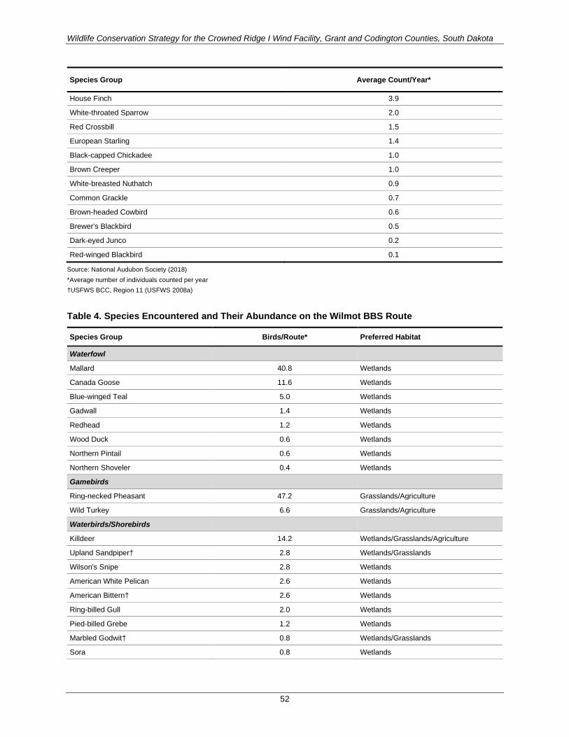
Wildlife Conservation Strategy for the Crowned Ridge I Wind Facility, Grant and Codington Counties, South Dakota
52
Species Group Average Count/Year*
House Finch 3.9
White-throated Sparrow 2.0
Red Crossbill 1.5
European Starling 1.4
Black-capped Chickadee 1.0
Brown Creeper 1.0
White-breasted Nuthatch 0.9
Common Grackle 0.7
Brown-headed Cowbird 0.6
Brewer's Blackbird 0.5
Dark-eyed Junco 0.2
Red-winged Blackbird 0.1
Source: National Audubon Society (2018) *Average number of individuals counted per year †USFWS BCC, Region 11 (USFWS 2008a)
Table 4. Species Encountered and Their Abundance on the Wilmot BBS Route
Species Group Birds/Route* Preferred Habitat
Waterfowl
Mallard 40.8 Wetlands
Canada Goose 11.6 Wetlands
Blue-winged Teal 5.0 Wetlands
Gadwall 1.4 Wetlands
Redhead 1.2 Wetlands
Wood Duck 0.6 Wetlands
Northern Pintail 0.6 Wetlands
Northern Shoveler 0.4 Wetlands
Gamebirds
Ring-necked Pheasant 47.2 Grasslands/Agriculture
Wild Turkey 6.6 Grasslands/Agriculture
Waterbirds/Shorebirds
Killdeer 14.2 Wetlands/Grasslands/Agriculture
Upland Sandpiper† 2.8 Wetlands/Grasslands
Wilson's Snipe 2.8 Wetlands
American White Pelican 2.6 Wetlands
American Bittern† 2.6 Wetlands
Ring-billed Gull 2.0 Wetlands
Pied-billed Grebe 1.2 Wetlands
Marbled Godwit† 0.8 Wetlands/Grasslands
Sora 0.8 Wetlands

Wildlife Conservation Strategy for the Crowned Ridge I Wind Facility, Grant and Codington Counties, South Dakota
53
Species Group Birds/Route* Preferred Habitat
American Coot 0.6 Wetlands
Willet 0.2 Wetlands/Grasslands
Belted Kingfisher 0.2 Wetlands
Raptors
Red-tailed Hawk 3.4 Grasslands/Agriculture/Woodlands
Northern Harrier 0.4 Grasslands
Bald Eagle† 0.2 Wetlands/Woodlands
Great Horned Owl 0.2 Grasslands/Shrub/Woodlands
American Kestrel 0.2 Grasslands
Pigeons/Doves
Mourning Dove 56.6 Shrub/Open Areas
Rock Pigeon 5.4 Urban Areas
Eurasian Collared-Dove 0.2 Urban Areas
Nightjars/Swifts
Chimney Swift 1.2 Urban Areas
Common Nighthawk 1.0 Grasslands
Woodpeckers
(Yellow-shafted Flicker) Northern Flicker 2.0 Woodlands
Downy Woodpecker 0.8 Woodlands
Red-headed Woodpecker† 0.6 Woodlands
Pileated Woodpecker 0.2 Woodlands
Songbirds
Red-winged Blackbird 91.8 Grasslands/Agriculture/Wetlands
Common Grackle 66.8 Grasslands/Agriculture
Cliff Swallow 49.6 Grasslands/Agriculture
Brown-headed Cowbird 40.0 Grasslands/Agriculture/Urban
American Robin 31.2 Grasslands/Agriculture/Woodlands
Western Meadowlark 27.8 Grasslands/Agriculture
Common Yellowthroat 23.4 Grasslands/Agriculture/Wetlands
American Goldfinch 22.0 Grasslands/Agriculture/Shrub
Yellow Warbler 20.4 Grassland/Agriculture/Shrub
Song Sparrow 20.0 Grasslands/Agriculture/Shrub
Vesper Sparrow 17.2 Grasslands/Agriculture
Yellow-headed Blackbird 16.6 Grasslands/Agriculture/Wetlands
Clay-colored Sparrow 16.2 Grasslands
Barn Swallow 15.6 Grasslands/Agriculture/Urban
Horned Lark 15.4 Grasslands/Agriculture
House Wren 15.2 Grasslands/Agriculture
European Starling 13.0 Urban Areas
Bobolink 11.8 Grasslands
Marsh Wren 10.6 Wetlands
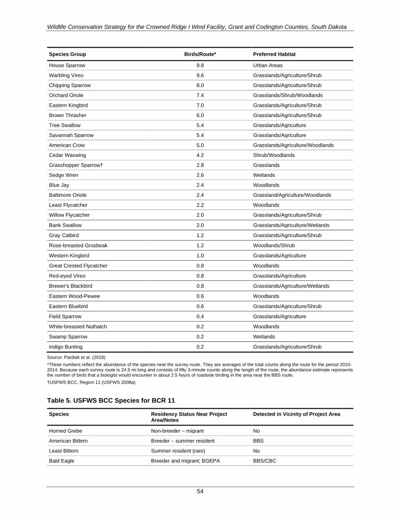
Wildlife Conservation Strategy for the Crowned Ridge I Wind Facility, Grant and Codington Counties, South Dakota
54
Species Group Birds/Route* Preferred Habitat
House Sparrow 9.8 Urban Areas
Warbling Vireo 9.6 Grasslands/Agriculture/Shrub
Chipping Sparrow 8.0 Grasslands/Agriculture/Shrub
Orchard Oriole 7.4 Grasslands/Shrub/Woodlands
Eastern Kingbird 7.0 Grasslands/Agriculture/Shrub
Brown Thrasher 6.0 Grasslands/Agriculture/Shrub
Tree Swallow 5.4 Grasslands/Agriculture
Savannah Sparrow 5.4 Grasslands/Agriculture
American Crow 5.0 Grasslands/Agriculture/Woodlands
Cedar Waxwing 4.2 Shrub/Woodlands
Grasshopper Sparrow† 2.8 Grasslands
Sedge Wren 2.6 Wetlands
Blue Jay 2.4 Woodlands
Baltimore Oriole 2.4 Grassland/Agriculture/Woodlands
Least Flycatcher 2.2 Woodlands
Willow Flycatcher 2.0 Grasslands/Agriculture/Shrub
Bank Swallow 2.0 Grasslands/Agriculture/Wetlands
Gray Catbird 1.2 Grasslands/Agriculture/Shrub
Rose-breasted Grosbeak 1.2 Woodlands/Shrub
Western Kingbird 1.0 Grasslands/Agriculture
Great Crested Flycatcher 0.8 Woodlands
Red-eyed Vireo 0.8 Grasslands/Agriculture
Brewer's Blackbird 0.8 Grasslands/Agriculture/Wetlands
Eastern Wood-Pewee 0.6 Woodlands
Eastern Bluebird 0.6 Grasslands/Agriculture/Shrub
Field Sparrow 0.4 Grasslands/Agriculture
White-breasted Nuthatch 0.2 Woodlands
Swamp Sparrow 0.2 Wetlands
Indigo Bunting 0.2 Grasslands/Agriculture/Shrub
Source: Pardiek et al. (2018) *These numbers reflect the abundance of the species near the survey route. They are averages of the total counts along the route for the period 2010-2014. Because each survey route is 24.5 mi long and consists of fifty 3-minute counts along the length of the route, the abundance estimate represents the number of birds that a biologist would encounter in about 2.5 hours of roadside birding in the area near the BBS route. †USFWS BCC, Region 11 (USFWS 2008a)
Table 5. USFWS BCC Species for BCR 11
Species Residency Status Near Project Area/Notes
Detected in Vicinity of Project Area
Horned Grebe Non-breeder – migrant No
American Bittern Breeder – summer resident BBS
Least Bittern Summer resident (rare) No
Bald Eagle Breeder and migrant; BGEPA BBS/CBC

Wildlife Conservation Strategy for the Crowned Ridge I Wind Facility, Grant and Codington Counties, South Dakota
55
Species Residency Status Near Project Area/Notes
Detected in Vicinity of Project Area
Swainson's Hawk Breeder – summer resident No
Peregrine Falcon Non-breeder – migrant Project Avian Use Surveys
Yellow Rail Non-breeder – migrant No
Mountain Plover Project outside of its range No
Solitary Sandpiper Non-breeder – migrant No
Upland Sandpiper Breeder – summer resident BBS
Long-billed Curlew Project outside of its range No
Hudsonian Godwit Non-breeder – migrant No
Marbled Godwit Breeder – summer resident (rare) BBS/Project Avian Use Surveys
Buff-breasted Sandpiper Non-breeder – migrant No
Short-billed Dowitcher Non-breeder – migrant No
Black Tern Breeder – summer resident No
Black-billed Cuckoo Breeder – summer resident No
Short-eared Owl Breeder – year-round resident CBC
Red-headed Woodpecker Breeder – summer resident BBS/Project Avian Use Surveys
Sprague's Pipit Non-breeder – migrant No
Grasshopper Sparrow Breeder – summer resident BBS/Project Avian Use Surveys
Baird's Sparrow Project outside of its range No
Nelson's Sharp-tailed Sparrow Non-breeder – migrant No
McCown's Longspur Project outside of its range No
Smith's Longspur Non-breeder – migrant No
Chestnut-collared Longspur Breeder – summer resident (rare) Project Avian Use Surveys
Dickcissel Breeder – summer resident (rare) No
Sources: USFWS (2008a), Cornell Lab of Ornithology (2019) (residency status)
Table 6. Summary of Survey Efforts to Date Within the Project Area and Vicinity
Date Survey Survey Area
Mar. 2007 – June 2008 avian use surveys (spring) Earlier iteration of Project Area
June 2008 Dakota skipper habitat delineation Earlier iteration of Project Area
Aug. – Nov. 2008 avian use survey (fall) Earlier iteration of Project Area
June – July 2009 Dakota skipper habitat delineation Earlier iteration of Project Area
Aug. – Nov. 2014 avian use surveys (fall) Earlier iteration of Project Area
Mar. – Nov. 2014; Nov – Mar. 2015
eagle survey Earlier iteration of Project Area
2015 Dakota Skipper habitat evaluation Earlier iteration of Project Area
Summer 2015 bat habitat assessment Nearby study area
Aug. – Oct. 2015; Apr. – Oct. 2016
bat acoustic survey Earlier iteration of Project Area
Mar. – Apr. 2016 raptor nest survey Earlier iteration of Project Area
Apr. – May 2016 lek surveys Earlier iteration of Project Area
Apr. – Oct. 2016 bat acoustic survey Earlier iteration of Project Area

Wildlife Conservation Strategy for the Crowned Ridge I Wind Facility, Grant and Codington Counties, South Dakota
56
Date Survey Survey Area
July 2016 bat acoustic survey Earlier iteration of Project Area
Sept. 2016 Dakota skipper and Poweshiek skipperling habitat assessment
Earlier iteration of Project Area
Apr. 2016 – Feb. 2017 avian use survey Earlier iteration of Project Area
Apr. and May 2017 raptor nest aerial survey Project Area
Apr. – Nov. 2017 avian point count surveys Project Area
Apr. – Nov. 2017 bat acoustic monitoring Project Area
Spring 2018 raptor nest aerial survey Project Area
June – July 2018 Dakota skipper and Poweshiek skipperling adult survey
Project Area
Summer 2018 desktop whooping crane habitat assessment Project Area
Sep. 2018 desktop bat habitat assessment Project Area
Table 7. Estimated Mean Bird Fatalities for All Birds per Turbine and per Megawatt at Wind Facilities in the Midwest with Similar Habitat to the Project
Wind Facility State Habitat Estimated Mean Bird Fatality/
turbine/year
Estimated Mean Bird Fatality/ MW/year
Source
Blue Sky Green Field WI Agricultural cropland 11.83 7.17 Gruver et al. 2009
Buffalo Ridge Phase I (1996-1999) MN Agricultural cropland 0.98 2.86 Johnson et al. 2000
Forward Energy WI Agricultural cropland 3.27 2.18 Grodsky and Drake 2011
Kewaunee County WI Agricultural cropland 1.29 1.95 Howe et al. 2002
Ainsworth NE Mixed grass prairie 2.68 1.63 Derby et al. 2007
Summerview AB, Canada
Mixed grass prairie 1.9 - Brown and Hamilton 2006
Red Canyon TX Short-grass prairie 0.77 0.50 Miller 2008
Top of Iowa IA Agricultural cropland 0.44 (2003) 0.96 (2004)
0.49 (2003) 1.07 (2004)
Jain 2005 Jain et al. 2011
Buffalo Gap II TX Mixed-grass prairie 0.22 0.15 Tierney 2009
Regional Mean (90-percent Confidence Interval) 2.43 (±1.80) 2.00 (±1.17)
Table 8. Estimated Mean Bat Fatalities per Turbine and per Megawatt at Wind Facilities in the Midwest
Wind Facility State Habitat Estimated Mean Bat Fatality/
turbine/year
Estimated Mean Bat Fatality/ MW/year
Documented Bat Species Fatalities* Source
Blue Sky Green Field
WI Agricultural cropland
40.54 24.57 Little brown, silver-haired, big brown, hoary, eastern red, and unidentified bat
Gruver et al. 2009
Forward Energy
WI Agricultural cropland
23.44 15.63 Hoary, silver-haired, eastern red, unknown, little brown, big brown bat
Grodsky and Drake 2011
Kewaunee County
WI Agricultural cropland
4.26 6.45 Eastern red and hoary bat Howe et al. 2002

Wildlife Conservation Strategy for the Crowned Ridge I Wind Facility, Grant and Codington Counties, South Dakota
57
Wind Facility State Habitat Estimated Mean Bat Fatality/
turbine/year
Estimated Mean Bat Fatality/ MW/year
Documented Bat Species Fatalities* Source
Top of Iowa IA Agricultural cropland
4.45 (2003) 7.14 (2004)
4.94 (2003) 7.94 (2004))
Hoary, little brown, eastern red, big brown, silver-haired bat
Jain 2005 Jain et al. 2011
Ainsworth NE Mixed grass prairie
1.91 1.16 Hoary, unidentified species, big brown and eastern red bat
Derby et al. 2007
Summerview AB, Canada Mixed grass prairie
18.48 - Hoary, silver-haired, little brown, big brown, eastern red bat
Brown and Hamilton 2006
Buffalo Ridge Phase I (1996-1999)
MN Agricultural cropland
0.26 - Hoary, eastern red, silver-haired, tricolored bat
Johnson et al. 2000
Regional Mean (90-percent Confidence Interval)
17.25 (±12.05) 13.4 (±9.00)
* In order of decreasing frequency

Wildlife Conservation Strategy for the Crowned Ridge I Wind Facility, Grant and Codington Counties, South Dakota
58
Figure 1. Project area and location.
La!\loure
Dickey
Bl'OWII
Spink
Beadle
llltnsom
Sargent
N:,n~ Oakot~
- - ~ ~w"o.-k!ta
® MardrnlJ
Clark
®-
Codington
Wa1ertown
Hamlin r,,
u,o,n..----+ ---1!1!!4il""! • rl\i:~ffllll'----'"i
lUchlam
Bi~ Stone
Deuel
"
l.incoln
Broo g~
Grant
@ Ste\'ens
5
@)
O(!irTail
1-------:8:t ... ,,, . .,, •. ,---,
Project Area Crowned Ridge Wind Farm
i=:J Project Boundary
i=:J County Boundary
State Boundary
1\lincr Lake
(l•
Moody Pipestone Murray
@}
Kilometers 0 25 50
Miles 0 25
Base Map: World Street Map Sources: Esri , HERE, Garmin , USGS, lntermap, INCREMENT P. NRCan, Esri Japan , METI. Esri China (Hong Kong), Esri Korea , Esri (Thailand) , NGCC, © OpenStreetMap contributors , and the GIS User Community Codington and Grant Counties, South Dakota
Projection: NAO 1983 UTM Zone 14N
50
Pope
N
w@c . 'f s
SWCA
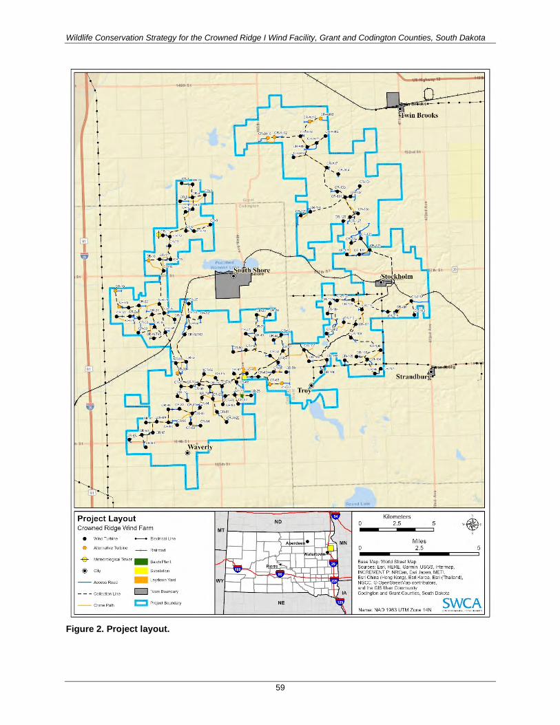
Wildlife Conservation Strategy for the Crowned Ridge I Wind Facility, Grant and Codington Counties, South Dakota
59
Figure 2. Project layout.
., 164t1St •
Project Layout Crowned Ridge Wind Farm
• Wind Turbine Electrical line
e Allcmallve Turbine ~ Rail road
-$- Meteorotog1ca1 Tower - Batch Plant
@ Ctty
-- Access Road
- - - Collection Line
-- Crane Path
Substation
.. Laydown Yard
C:J Town Boundary
CJ Project Boundary
Waverly @
f Ill
0
0
152ndSI
Kilometers 2.5
Miles 2.5
Base Map: World Street Map
5
Sources: Esri, HERE, Garmin, USGS, lntermap, INCREMENT P, NRCan, Esri Japan, METI. Esri China {Hong Kong), Esri Korea, Esri (Thailand), NGCC. © OpenStreetMap contributors, and the GIS User Community Codington and Grant Counties, South Dakota
5
Name: NAD 1983 UTM Zone 14N SWCA
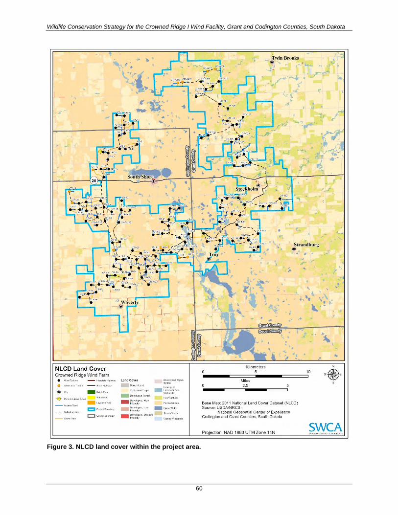
Wildlife Conservation Strategy for the Crowned Ridge I Wind Facility, Grant and Codington Counties, South Dakota
60
Figure 3. NLCD land cover within the project area.
l_
NLCD Land Cover Crowned Ridge Wind Farm
• Wind Turbine - lnt11rs1011e Highway
• Akllf<1abveTurbine -- S1;,teHi9hw11y
@ City 1111 Batch Plan1
4 ~'\e1eorologu::31 Tower Substatioo
.. laydowriYard -- Acc:essRood
1::1 Projec1 Bounda,y
c:J County Br,undary
Land Cover
Barren land
Cul1ivated Cmps
1111 Deciduous Forest
1111 ~~;:::;d, High Developed, low lnums,ty
-
Developed, Medium lntenSlly
Developtid. Open S pace
Emergent Herb€1Ce\lOU5 Wetla.nds
Hay.'Paslure
1111 Open W;,i ter
Woody Wellands
0
0
Kilometers 5
Miles 2.5
,Twin Brooks @
..
5
Base Map: 2011 National Land Cover Dataset (NLCD) Source: USDA/NRCS -
National Geospatial Center of Excellence Codington and Grant Counties, South Dakota
Projection: NAO 1983 UTM Zone 14N
,. N
10 IV*!' s
SWCA

Wildlife Conservation Strategy for the Crowned Ridge I Wind Facility, Grant and Codington Counties, South Dakota
61
Figure 4. Project area location proximity to whooping crane migration corridor.
Potter Faulk
Buffo lo Jerauld
J,yman
Hruh.• Aurora
Whooping Crane Migration Corridor Crowned Ridge Wind Farm Pecentage of Sightings within th e Whooping Crane Migration Corridor:
95
c:J Project Boundary
c:J County Boundary
C State Boundary
Brow11
Spink
@-
S,ugc-nt
@ l\lnrshall
W.1tenown
Clark
Hamlin
J\tincr Lake
0
0
Ki lometers 25 50
Miles 25
Base Map: World Street Map Sources : Esri , HERE, Garmin , USGS, lntermap, INCREMENT P. NRCan, Esri Japan , METI,
50
Esri China (Hong Kong), Esri Korea , Esri (Thailand) , NGCC. © OpenStreetMap contributors , and the GIS User Community Codington and Grant Counties, South Dakota
Projection: NAO 1983 UTM Zone 14N
Rkhlan
Brooking
B ngs
l\ oody
i\linneh lrn
N
"'* I' s
SWCA

Wildlife Conservation Strategy for the Crowned Ridge I Wind Facility, Grant and Codington Counties, South Dakota
62
Figure 5. Avian count and bat detector locations.
- - - - I I
I I - - - -
'- - - - : Willa-t' Cree,._
Avian Count and Bat Detector Locations Crowned Ridge Wind Farm
@ City
EB
*
Bat Monitor Location
Point Count Location
Interstate Highway
U.S. Highway
D I - - -1
I I
D CJ
State Highway
800-meter Search Radius
Study Area
Project Boundary
County Boundary
Twm Brooks
,_ -I
I - I
I - - - ._ -.
•---- -
0
0
I
1 1 __ 1
Roun1 L,ak
Ki lometers 5
Miles 2.5
Base Map: World Topographic Map
1--------1 1782ff
- - 1
10
5
Sources: Esri , HERE, Garmin , lntermap, increment P Corp ., GEBCO, USGS, FAO, NPS, NRCAN, GeoBase, IGN , Kadaster NL, Ordnance Survey, Esri Japan, METI, Esri China (Hong Kong) , swisstopo, © OpenStreetMap contributors, and the GIS
W~ E \(lt./· s
User Community Codington and Grant Counties, South Dakota
Projection: NAD 1983 UTM Zone 14N SWCA

Wildlife Conservation Strategy for the Crowned Ridge I Wind Facility, Grant and Codington Counties, South Dakota
63
Figure 6. Raptor nest locations.
0
<O
0
0
0
• CR•ALT42
CR-5S CR-53 • •
Waverly @
Raptor Nests Crowned Ridge Wind Farm
• Wind Turbine -- Interstate Highway
• Alternative Turbine
CJ ~:~t!~~i1~ance @ City
c::J Project Boundary
• Bald Eagle Nest
Non-Eagle IC) County Boundary
0 Raptor Nest
CR-Alt16 · CR•A1112
0
GRAN T
COD IN GTO N
CR-50 .
0 • CR.48
CR- t8 CR. 17. CR-l'\Jt14 • • CR-All9 e c R-AI 1 •
cf.wiu,Brnoks - @
0
CR-Al!8 • CR-All7
• CR-S<'
• 0
CR-134 • CR-133 • CR-132 CR-131 ••
0
Jt().~!,.holm
0 CR-119 •
CR-115 CR-A.lt1 • • •
0
0 O
0 ,
., .. •
0
0
0 0
0
Roun1 La Ot: t ' F: I. l'O l 'NT J"
0
0
Kilometers 2.5
Miles 2.5
Base Map: World Topographic Map
Strnndburg @ 0
178H
0
5
Source: Esri , HERE, Garmin, lntermap, increment P Corp., GEBCO. USGS, FAQ, NPS. NRCAN, GeoBase, IGN , Kadaster NL. Ordnance Survey, Esri Japan, METI, Esri China (Hong Kong ), swisstopo. © OpenStreetMap contributors , and the GIS User Community Codington and Grant Counties, South Dakota
5
SWCA Projection: NAO 1983 UTM Zone 14N 1.,..v11:i~ ... t,.11'1L(o,.~ut1"'"~

Wildlife Conservation Strategy for the Crowned Ridge I Wind Facility, Grant and Codington Counties, South Dakota
64
Figure 7. Grouse lek locations.
Waverly @ •
Grouse Leks Crowned Ridge Wind Farm
Q Grouse Lek Location -- Interstate Highway
• Wind Turbine
• Alternative Turbine
@ City
-- Access Road
- - - Collection Line
-- Crane Path
t=J Seasonal Avoidance Buffer
- Batch Plant
Substation
- Laydown Yard
c::I StudyArea
t::J County Boundary
GRANT
COD INGTO N
South.Shore @ ).)(.I U111 .'.:> ,1.1, ,;;,
© Li
0
0
;J:win,Brooks - @
DE l'EL corxrr
Kilometers
Sti,andburg @
2.5 5
Miles 2.5
Base Map: World Topographic Map Source: Esri , HERE, Garmin, lntermap, increment P Corp., GEBCO. USGS, FAO. NPS. NRCAN, GeoBase. IGN, Kadaster NL. Ordnance Survey, Esri Japan, METI, Esri China (Hong Kong), swisstopo, © OpenStreetMap contributors , and the GIS User Community Codington and Grant Counties, South Dakota
5
. . SWCA Projection. NAO 1983 UTM Zone 14N t>1vi1:i~ ... t,. 11'1L(o .. ~u ti"'"\

Wildlife Conservation Strategy for the Crowned Ridge I Wind Facility, Grant and Codington Counties, South Dakota
65
Figure 8. Overhead transmission line segments marked for avian flight diverter installation.
.., "' RoWrt
Summit
1"91h S1
6 1 Bl
od
81
St
( 'oc.lington
. 1691' S < ,,
i Project Area Crowned Ridge Wind Farm
Avian Fl ight Diverter Segments
~ ~~~,~~=t~~CR Habitat TWI habitat assessed wetlands
Proximate to c:::::= Aquatic Resource
-- Transmission Line
f::J Project Boundary
c:J County Boundary
- ~~~::t~:=t~~~) Assessed Wetland {habitat score :S 12)
LJ Unsuitable
. > <
t "
t ◄ht l Robl'rb
1~th s,
Twin Br ock& . > <
Corona
.. " Ii. .,
Crnnt
. <
s,trandburg 161&1S t Labol1
Deuel
@ • obtrl < ron
~
. .. .., C
i
Revillo
144th S
158 !Sllh St
20 1641h St
-·--~2.!_z,..------
0
0
0
Ki lometers 5 10
Miles 5
Base Map: World Street Map Sources : Esri , HERE, Garmin , USGS, lntermap, INCREMENT P, NRCan, Esri Japan , METI, Esri China (Hong Kong), Esri Korea , Esrr (Thailand) , NGCC, © OpenStreetMap contributors , and the GIS User Community Codington and Grant Counties, South Dakota
Projection: NAO 1983 UTM Zone 14N
N
"'*" 10 s
SWCA