what’s state of the data?
TRANSCRIPT

1
What’s State of the Data?
1
ESRI Federal GIS Conference 2015
08 February 2015
Derek Silva – NGA, Greg Brunner – ESRI

2
Agenda
2
• Background
• Principle Functions
• Development Objectives
• Quality Elements
• Web Application Demo
3
Background
3
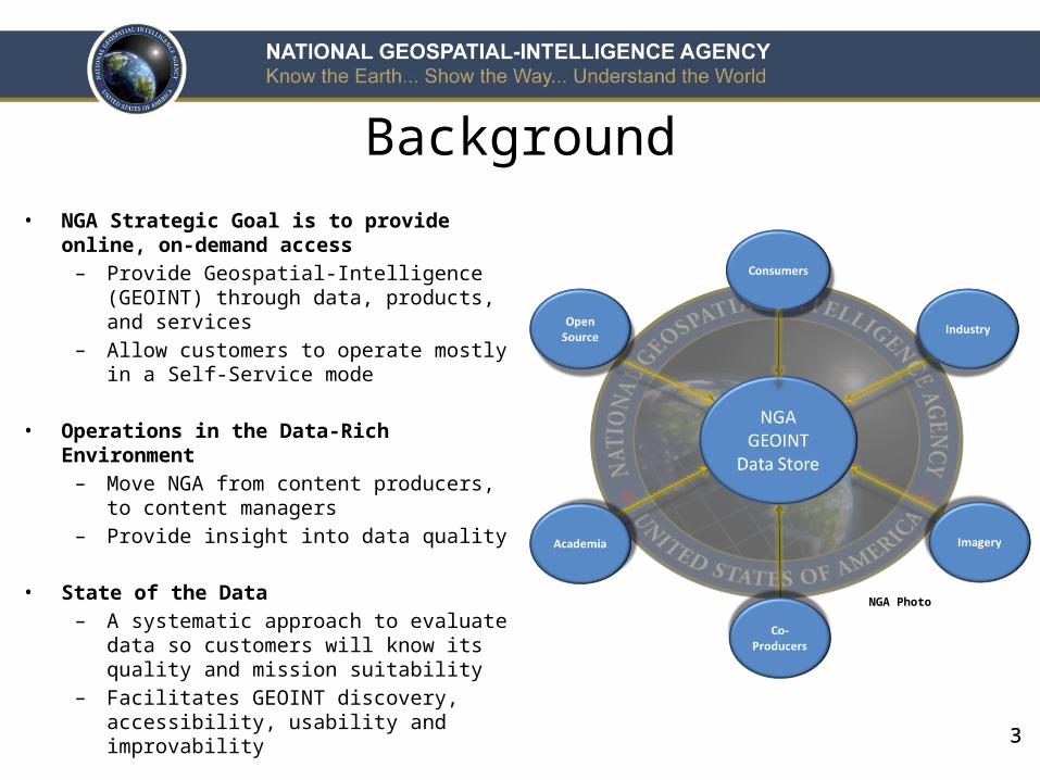
• NGA Strategic Goal is to provide online, on-demand access
– Provide Geospatial-Intelligence (GEOINT) through data, products, and services
– Allow customers to operate mostly in a Self-Service mode
• Operations in the Data-Rich Environment – Move NGA from content producers, to
content managers– Provide insight into data quality
• State of the Data– A systematic approach to evaluate data so
customers will know its quality and mission suitability
– Facilitates GEOINT discovery, accessibility, usability and improvability
NGA Photo

4
Principle Functions• Develop automated processes to
capture quality elements
4
• Apply statistics and science to content management
• Anticipatorily alert of potential enrichment areas
• Compare data to current ground truth activities
• Incorporate formulas/models to generate on-the-fly statistics
Commercial
NGA (in-house)
International
Academia
Industry
TODAYPAST

5
SituationUnderstand the current State
of the Data
• No global assessment capabilities regarding data density, accuracy & currency
• No systematic approach to data maintenance or enrichment
• No centralized application for user/customer interaction
BehaviorDevelop metrics to measure
data quality
• Develop analytic methodology to assign rankings/values to data
• Enhancement of the six quality elements established by the NGA Content Maturity Model
• Create graphic user interface effectively allowing interaction between NGA and its external customer base
ImpactUnderstand the desired future
end state of the data
• Identify the likely mission required: Humanitarian Aid & Disaster Relief (HADR), Offensive/Defensive Operations)
• Determine density requirements (Global, Regional, Local, Urban)
• One-stop-shop with a dynamically enabled service for data evaluation and quality transparency
Developmental Objectives

6
Quality Elements Matrix
6
Quality Elements Measure Description Data Sources
Completeness Feature Density per Specified Area Data Source A / Data Source B
Logical Consistency Average Number of Attribution Deficiencies per Feature over a Specified Area Data Source A / Attribution Requirements
Source Lineage Primary Data Source used in the Conflation / Integration Production Process Multiple Vector Data Sources
Positional Accuracy Spatial Relationship between Multiple Vector Data Sources Data Source A / Data Source B
Thematic Accuracy Scale Suitability and Density Requirements Population Data / Completeness Quality Element
Temporal Accuracy Vector Data Currency Data Source A / Change Detection Data Source
7
Web Application Demo

8
• State of the Data application benefits:
– A baseline to content management on a global scale
– A diagnostic tool to direct analyst to potential enrichment areas
– A systematic approach to data evaluation and quality transparency
– Statistical approach to the removal of subjective analysis
– Decrease in resources necessary to perform quality assurance
Summary

99
nga.mil | @nga_geoint | facebook.com/natlgeointagency