wetland policy statement - city of wanneroo
TRANSCRIPT
1
Planning and Sustainability Local Planning Policy Framework
[ Local Planning Policy 4.20: Split Coded Areas ]
Objective To ensure infill residential development contributes has a positive impact on the streetscape and does not detract from the amenity of existing residents of the locality.
Application This Policy applies to all subdivision applications and grouped dwelling and multiple dwelling development applications on residential zoned land that is subject to a split residential density code under the City of Wanneroo District Planning Scheme No. 2.
Related Policies and Documents
This Policy should be read in conjunction with the following:
State Planning Policy 3.1: Residential Design Codes (R-Codes)
The City’s District Planning Scheme No. 2 (DPS 2)
City of Wanneroo’s Nature Strip (Verge) Treatment Guidelines
City of Wanneroo’s Standard Drawing TS 07-9-1 – Crossovers and Verges: Residential Verge Hardstanding Layouts and Sections
City of Wanneroo’s Development Design Specification WD 11 – Vehicular Crossover Design
State Government’s Draft Apartment Design Policy
State Planning Policy 5.4: Road and Rail Transport Noise and Freight Considerations in Land Use Planning (SPP 5.4)
Policy Provisions 1 Assessment of Development Applications and Imposition of Conditions 1.1 Where the ‘Deemed to Comply’ provisions of the R-Codes refer to a requirement that is to
be assessed by reference to the density code of the adjoining property (such as for Lot Boundary Setbacks and Solar Access for Adjoining Sites), the development shall be assessed against the higher split density code of the adjoining property (if applicable), irrespective of whether the adjoining property has been developed at the higher split density code.
1.2 The City may impose the conditions outlined in Appendix 1 for any development
application or subdivision application received for the split coded areas.
Owner Planning and Sustainability
Implementation xx 2018
Next Review xx 2023
2
Planning and Sustainability Local Planning Policy Framework
[ Local Planning Policy 4.20: Split Coded Areas ]
2 Vehicle Access 2.1 A maximum of one vehicle crossover is permitted from each street frontage to service all
proposed dwellings on the lot. Vehicle access to each dwelling shall be shared via common property or a right of carriageway easement.
2.2 Where a lot has already been the subject of a green-title or survey-strata subdivision (see
Appendix 2 (a) and 2 (b), respectively), a maximum of one vehicle crossover is permitted from each street frontage to service all proposed dwellings on the parent lot.
2.3 New crossovers shall:
Be constructed in accordance with the City’s Development Design Specification WD 11, including having the necessary setbacks from existing road reserve infrastructure; and
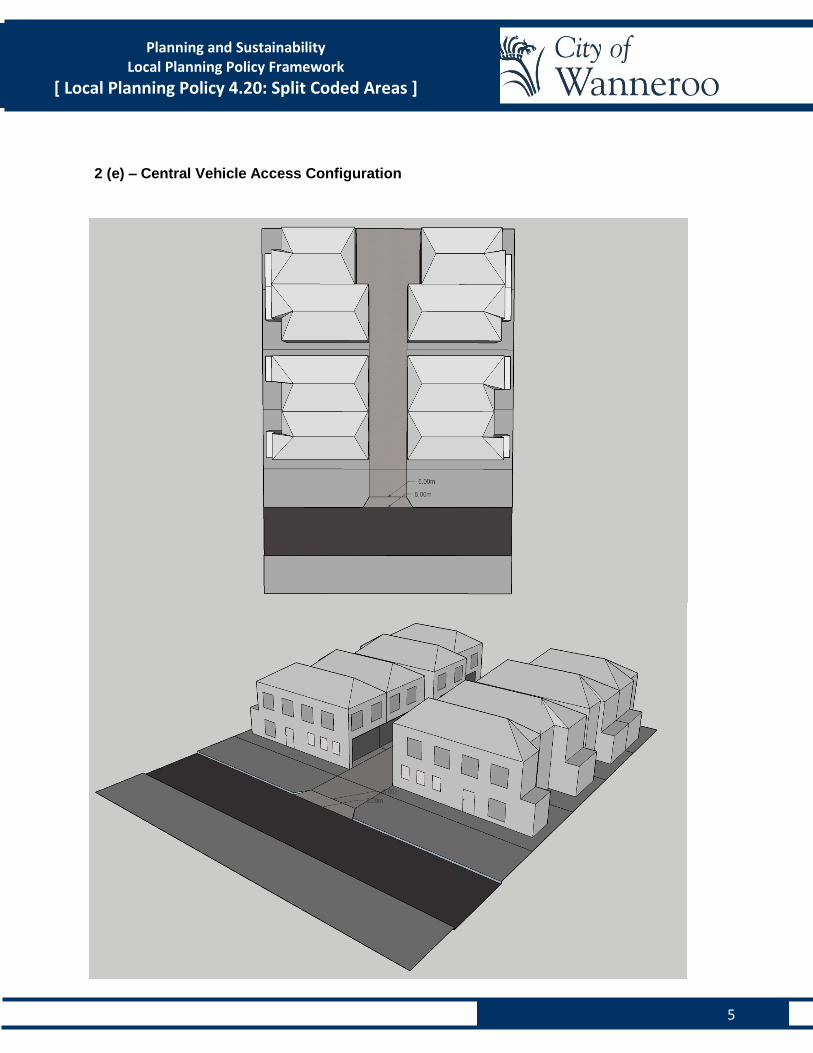
Be setback a maximum of 1.0m from the side lot boundary, except where the development proposes a central vehicle access way (Appendix 2 (e)), or where setbacks are required from existing road reserve infrastructure.
2.4 Where the location of a proposed crossover conflicts with existing road reserve
infrastructure assets, any costs required to alleviate that conflict shall be borne by the property owner/applicant.
2.5 Garages shall be setback a minimum of 0.5m behind the alignment of any dwelling that has
street frontage, as defined in the R-Codes. 2.6 In accordance with the WAPC’s Development Control Policy 5.1 Regional Roads (Vehicle
Access), where a lot adjoins a Primary Regional Road (PRR) additional vehicle access is not permitted from the PRR.
2.7 The maximum width of a new crossover shall be in accordance with the following:
Form of Proposed Development Maximum width of
new crossovers at the lot boundary
Grouped dwelling (1 – 4 dwellings) 3m
Grouped dwellings (5 or more dwellings) 6m
Multiple dwellings 6m
Grouped dwellings or multiple dwellings which are required to take vehicle access from a district distributor road
6m
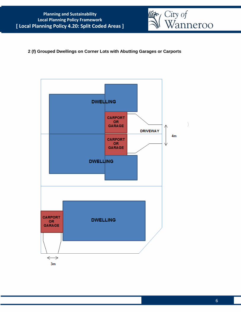
Grouped dwellings which address the same street and have abutting garages and carports (Appendix 2 (f)).
4m
3
Planning and Sustainability Local Planning Policy Framework
[ Local Planning Policy 4.20: Split Coded Areas ]
3 Landscaping 3.1 A minimum of 12% of the lot area is to be deep soil area, which is defined as: Soft landscape area on a lot with no impeding building structure or feature above or below,
which supports growth of medium to large canopy trees. Deep soil areas exclude basement car parks, services, swimming pools, tennis courts and impervious surfaces including car parks, driveways and roof areas.
3.2 The deep soil area requirement may be reduced to 8% of the lot area where existing
vegetation, which is of a particular size and significance, as determined by the City’s Landscaping Service unit, is retained on the development site. Where a tree is being retained within the lot, a minimum 9.0m2 soil space is required around each tree and to have no impeding building structure or feature above or below.
3.3 Verges shall be upgraded to comply with the City’s Nature Strip (Verge) Treatment
Guidelines and Standard Drawing TS 07-9-1 (where not already compliant). 3.4 Where a front fence is proposed within the primary street setback area, a strip of
landscaping with a minimum width of 0.5m shall be provided within the verge, abutting the fence. This landscaping strip is to be composed of non-grass species (such as shrubs).
4 Built Form 4.1 Pedestrian Entries 4.1.1 Pedestrian entry ways shall be highlighted through the use of colours, materials and form,
so that it is clearly recognisable from the street.
4.1.2 An awning shall be provided over any pedestrian entry way, and shall project a minimum of 1.0m from the building line.
4.1.3 The ground floor of the dwelling closest to the primary street shall be provided with its own
pedestrian entry from the street, the design of which shall incorporate the use of colour, materials and form, so that it is clearly recognisable from the street.
4.1.4 Where external stairs are proposed to provide access to pedestrian entries to dwellings or
communal areas, the stairs and walkways shall be covered.
4.2 Primary Street Façades (Ground Floor and Upper Floors)
4.2.1 The provisions in this section do not apply where an existing dwelling is being retained at the front of the lot.
4.2.2 The primary street façade shall incorporate at least three (3) of the following design
elements:
At least three (3) different colours in proportions which add visual interest to the façade;
4
Planning and Sustainability Local Planning Policy Framework
[ Local Planning Policy 4.20: Split Coded Areas ]
At least three (3) different materials (excluding window glazing and framing) in proportions which add visual interest to the façade;
Awnings, with a depth between 0.45m and 0.75m, directly above all major openings;
A blade feature wall extending perpendicular to the façade;
One or more balconies (subject to Lot Boundary Setback and Visual Privacy provisions of the R-Codes);
Upper floors setback 0.5m behind the floor below, as viewed from the primary street; or
A roof pitch of between 27 degrees and 33 degrees.
4.2.3 Each habitable room which faces the primary street shall incorporate a minimum of one major opening, as defined in the R-Codes, towards the primary street.
4.2.4 Where balconies are provided within the primary street façade, balcony balustrades shall be visually permeable, as defined in the R-Codes, above 0.5m of the balcony floor level, except where necessary to comply with the Visual Privacy provisions of the R-Codes.
4.3 Secondary Street Facades (Upper Floors Only) 4.3.1 The upper floor portions of the secondary street façade shall incorporate at least two (2) of
the following design elements:
At least three (3) different colours in proportions which add visual interest to the façade;
At least three (3) different materials (excluding window glazing and framing) in proportions which add visual interest to the façade;
One or more balconies (subject to Lot Boundary Setback and Visual Privacy provisions of the R-Codes); or
Upper floors setback a minimum of 0.5m behind the floor below, as viewed from the secondary street.
4.3.2 All habitable rooms which face the secondary street shall incorporate a minimum of one
major opening, as defined in the R-Codes, towards the secondary street. 4.3.3 Where balconies are provided within the secondary street façade, balcony balustrades shall
be visually permeable, as defined in the R-Codes, above 0.5m of the balcony floor level, except where necessary to comply with the visual privacy provisions of the R-Codes.
4.4 Side and Rear Facades (Upper Floors Only) The upper floor portions of the side and rear facades shall incorporate at least two (2) of the following design elements:
At least three (3) different colours in proportions which add visual interest to the façade;
At least three (3) different materials (excluding window glazing and framing) in proportions which add visual interest to the façade;
Major and non-major openings (subject to Lot Boundary Setback and Visual Privacy provisions of the R-Codes); or
Upper floors setback a minimum of 0.5m behind the floor below, as viewed from the side and rear lot boundaries (subject to Lot Boundary Setback and Visual Privacy provisions of the R-Codes).
5
Planning and Sustainability Local Planning Policy Framework
[ Local Planning Policy 4.20: Split Coded Areas ]
4.5 Appearance of Retained Dwellings
Where an existing dwelling is retained as part of grouped or multiple dwelling developments, the appearance of the retained dwelling shall be upgraded externally to an equivalent standard of the new development. Upgrades to the existing dwelling may include the following, as deemed appropriate by the City:
Rendering or painting external walls;
Replacing or repainting and repairing damaged or dilapidated windows and frames; and/or
Replacing or repainting and repairing gutters and downpipes. 4.6 Appearance of Carports and Garages
Proposed carports and garages shall complement the associated dwelling/s with respect to materials, roof design, roof pitch and colour.
5 Utilities
5.1 Along with any development application, applicants must provide written confirmation from
the Water Corporation that sufficient capacity exists in their service network to adequately
meet the needs of the proposed development.
5.2 Storerooms and bin stores shall be located so that they are:
Enclosed;
Not visible from the adjoining street/s; and
Setback an appropriate distance from side and rear lot boundaries so as to minimise
potential odour and noise issues for adjoining properties.
6 Noise Management
Along with any development or subdivision application for a lot that directly abuts Wanneroo Road
or Mirrabooka Avenue, applicants shall provide a Screening Assessment (as detailed in SPP 5.4).
Where a Screening Assessment determines that the expected noise levels received at the subject
site exceed the day period noise target (as detailed in SPP 5.4), a Noise Management Plan (NMP)
shall be undertaken by a suitably qualified acoustic consultant. The NMP shall recommend noise
mitigation measures where appropriate.
7 Advertising of Applications Where a proposal comprises multiple dwellings, regardless of whether it is capable of being approved under the ‘Deemed to Comply’ provisions of the R-Codes, the proposal shall be advertised in accordance with Clause 64 of the Deemed Provisions of DPS 2.

6
Planning and Sustainability Local Planning Policy Framework
[ Local Planning Policy 4.20: Split Coded Areas ]
8 Additional Information to be Provided with Application Along with any development application, applicants shall provide the additional supporting information specified in Appendix 3, where appropriate.
1
Planning and Sustainability
Local Planning Policy Framework
[ Local Planning Policy 4.20: Split Coded Areas ]
Appendix 1 – Conditions of Approval
1 Any Subdivision Application
Where a subdivision application is received, the assessing officer may recommend in its response to the Western Australian Planning Commission’s referral that:
a) A right of carriageway easement is established between the lots created to ensure that all lots are serviced by one consolidated vehicle access point;
b) Redundant vehicle crossover(s) to be removed and the kerbing, verge and footpath (where
relevant) reinstated with grass or landscaping to the satisfaction of the Western Australian Planning Commission and to the specifications of the Local government;
c) Verges shall be upgraded to comply with the City’s Nature Strip (Verge) Treatment Guidelines and Standard Drawing TS 07-9-1 (where not already compliant).
d) A restrictive covenant is placed on the certificates of title preventing vehicle access from the remainder of the lot(s);
e) A notification, pursuant to Section 70A of the Transfer of Land Act 1983 is place on the
certificate(s) of title of the proposed lot(s). Notice of this notification is to be included on the diagram or plan of survey (deposited plan). The notification is to state as follows:
“The lot’s is/are situated in the vicinity of a transport corridor and is currently affected, or may in
the future be affected by transport noise.”
2 Any Development Application
Where a development application is received, the assessing officer may impose one or more of the
following conditions on the approval:
a) Existing crossovers that are not required for this approval must be closed, kerbs reinstated and
verges graded, stabilised and landscaped;
b) Verges shall be upgraded to comply with the City’s Nature Strip (Verge) Treatment Guidelines and Standard Drawing TS 07-9-1 (where not already compliant);
c) The development is to comply with the noise attenuation measures specified in <Consultant name> ‘Environmental Acoustic Assessment’ dated <date>.
1
Planning and Sustainability Local Planning Policy Framework
[ Local Planning Policy 4.20: Split Coded Areas ]
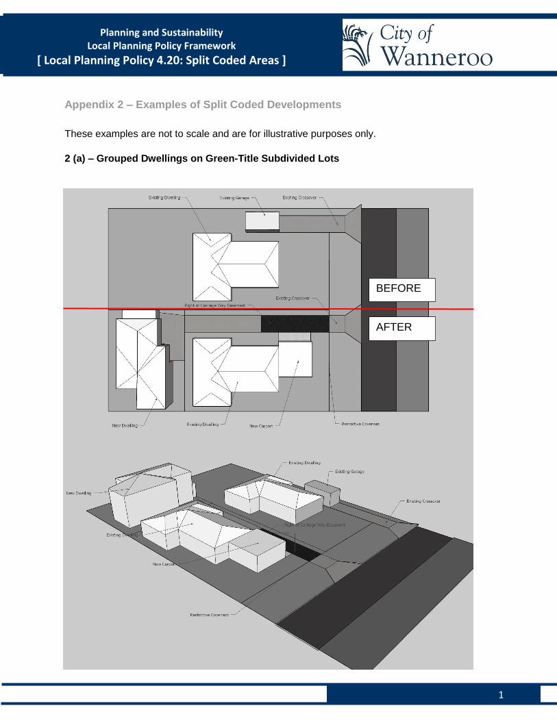
Appendix 2 – Examples of Split Coded Developments
These examples are not to scale and are for illustrative purposes only.
2 (a) – Grouped Dwellings on Green-Title Subdivided Lots
BEFORE
AFTER
2
Planning and Sustainability Local Planning Policy Framework
[ Local Planning Policy 4.20: Split Coded Areas ]
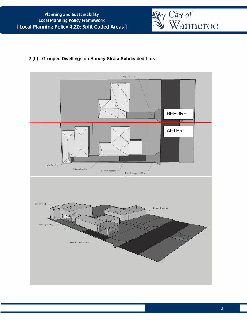
2 (b) - Grouped Dwellings on Survey-Strata Subdivided Lots
BEFORE
AFTER
3
Planning and Sustainability Local Planning Policy Framework
[ Local Planning Policy 4.20: Split Coded Areas ]
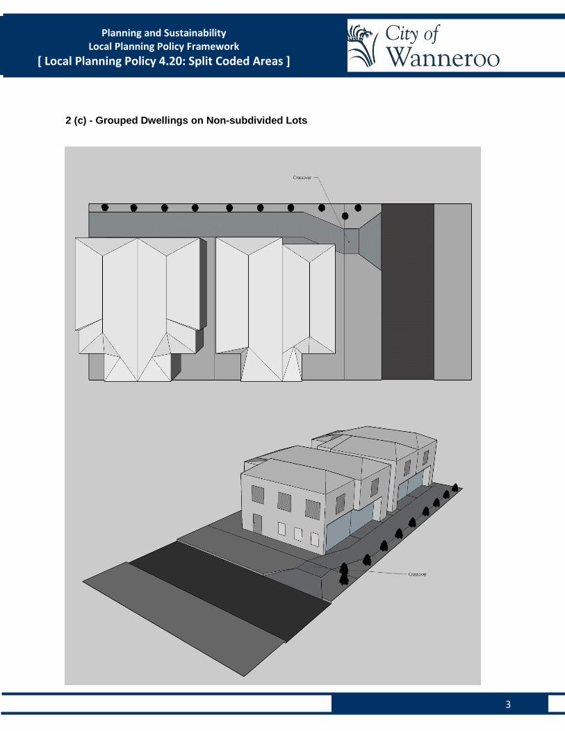
2 (c) - Grouped Dwellings on Non-subdivided Lots
4
Planning and Sustainability Local Planning Policy Framework
[ Local Planning Policy 4.20: Split Coded Areas ]
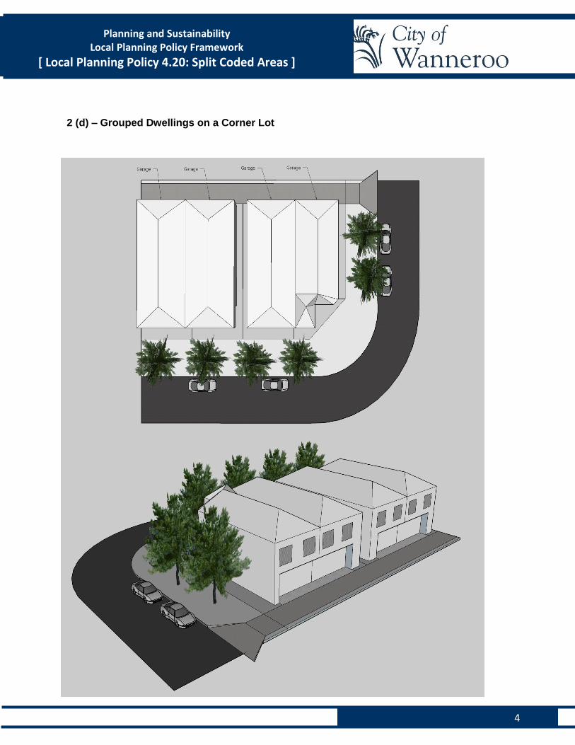
2 (d) – Grouped Dwellings on a Corner Lot
5
Planning and Sustainability Local Planning Policy Framework
[ Local Planning Policy 4.20: Split Coded Areas ]
2 (e) – Central Vehicle Access Configuration
6
Planning and Sustainability Local Planning Policy Framework
[ Local Planning Policy 4.20: Split Coded Areas ]
2 (f) Grouped Dwellings on Corner Lots with Abutting Garages or Carports
1
Planning and Sustainability Local Planning Policy Framework
[ Local Planning Policy 4.20: Split Coded Areas ]
[ Local Planning Policy 4.20: Split Coded Areas ] Appendix 3 – Checklist (Supporting Information)
In addition to the supporting information required as part of an Application for Approval to
Commence Development, the applicant shall provide the following:
o Written confirmation from the Water Corporation that sufficient capacity exists in their
service to adequately meet the needs of the proposed development;
o A Landscaping Plan, which:
o Is drawn to scale, at not less than 1:200;
o Shows areas of existing and proposed landscaping within the lot, including a
species list; and
o Areas of existing and proposed landscaping in the adjoining verge areas, including
a species list.
o Elevation Plans for every face of the proposed building/s and structures (such as carports,
bin stores and storerooms) showing materials and colours keyed to elevations.
o Perspective Drawings, illustrating every face of the proposed building/s.
o A Roof Plan showing the proposed roof pitch (as a percentage) as well as proposed
materials and colours.
o A Swept Path Diagram, showing how vehicles will be able to access/egress the existing
and/or proposed car parking spaces.
o A Screening Assessment (as detailed in SPP 5.4) for any lot which directly abuts
Wanneroo Road or Mirrabooka Avenue. Where a Screening Assessment determines that
the expected noise levels received at the subject site exceed the day period noise target
(as detailed in SPP 5.4), a Noise Management Plan (NMP) shall be undertaken by a
suitably qualified acoustic consultant. The NMP shall recommend noise mitigation
measures where appropriate.