western association of map libraries
TRANSCRIPT
Volume 43 Number 2 March 2012
Western Association of Map Libraries“. . . to encourage high standards in every phase of organization and
administration of map libraries . . .”

WAML Executive Board (July 1, 2011 - June 30, 2012)PresidentCynthia MoriconiHead, Maps UnitScience & Engineering LibraryUniversity of California, Santa Cruz1156 High StreetSanta Cruz, CA 95064Phone: (831) 459-3187Email: [email protected]
Vice President/President ElectJohn RidenerGIS Specialist/Map CatalogerEarth Sciences and Map Library50 McCone HallUniversity of CaliforniaBerkeley, CA 94720-4767Ph: (510) 643-9350Fax: (510) [email protected]
Past PresidentMichael L. SmithMap LibrarianSocial Sciences & Humanities LibraryUniversity of California, San Diego9500 Gilman Drive, 0175RLa Jolla, CA 92093-0175
Phone: (858) 534-1248Email: [email protected]
TreasurerYvonne WilsonOrange County & California State Documents LibrarianReference DepartmentLangson LibraryP.O. Box 19557Irvine, CA 92623-9557Phone: (949) 824-7362FAX: (949) 824-3644Email: [email protected]
SecretaryBrian QuigleyInterim Head, Earth Sciences and Map Library50 McCone HallUniversity of California, BerkeleyBerkeley, CA 94720-6000Phone: (510) 768-7627Email: [email protected]
Subscription ManagerGreg ArmentoUniversity LibraryCalifornia State University, Long Beach1250 Bellflower BoulevardLong Beach, California 90840-1901Phone: (562) 985-4367Email: [email protected]
Business ManagerMelissa (Lisa) LamontLibrary and Information AccessSan Diego State UniversitySan Diego, CA 92182-8050(619) [email protected]
Membership ManagerKathy StroudDavid and Nancy Petrone Map/GIS Librarian Knight Library1299 University of OregonEugene, OR 97403-1299(541) [email protected]
The Western Association of Map Libraries is an independent association of persons. The Membership has defined its Principal Region for meeting locations as: the Provinces of Alberta and British Columbia, and the States of Alaska, Ari-zona, California, Colorado, Hawaii, Idaho, Montana, Nevada, New Mexico, Oregon, Utah, Washington and Wyoming.
Membership in WAML is open to any individual interested in furthering the purpose of the Association, which is “to encourage high standards in every phase of the organization and administration of map libraries.” Membership includes receipt of all issues of the Information Bulletin and Electronic News & Notes (if an email address is provided), mail an-nouncements of WAML meetings, voting privileges and receipt of WAML ballots.
Dues are US$30 per year and all memberships begin July 1. You may join any time of the year by sending your name, address, phone, fax, email address and US$30 to the WAML Treasurer at the address below. Make checks payable to “WAML” or the “Western Association of Map Libraries.” Lifetime membership is open to any individual for a one-time payment of US$500. In addition to all membership privileges listed above, Lifetime Members also receive a copy of each volume published in the WAML Occasional Paper series. For more information about WAML, its purpose, meetings and membership, see the WAML Web site at http://www.waml.org or contact an officer listed below.
WAML and its Information Bulletin operate on a membership/volume-year basis. Subscriptions begin July 1 and end on June 30 the following year. Mid-year joiners/subscribers will receive back issues for that year. Back issues of the Infor-mation Bulletin are available for US$10/volume, or portion thereof, from the Subscription Manager.
Subscriptions to the Information Bulletin are US$35 per volume year. The Information Bulletin is issued three times each year: Issue #1 in November, Issue #2 in March, and Issue #3 in July. In addition to the subscription cost, US$3 is charged for postage to Canada and US$10 is charged for mailing to countries outside of the US and Canada.
WAML Appointed Positions

US ISSN 0049-7282 © 2012 by The Western Association of Map Libraries LC #72-625238
Western Association of Map Libraries
Volume 43, No. 2 INFORMATION BULLETIN March 2012
Table of Contents
WAML Membership Directory 2011-2012 .................................................................................50
Map Displays and Exhibits by Katherine L. Rankin .............................................................................54
Reviews of Atlases, Books and Digital Resources edited by John Russell...........................................63 Historical Atlas of the American West: With Original Maps reviewed by Greg Armento
New Mapping of Western North America compiled by Ken Rockwell...................................64
News and Notes compiled by Michael SmithCataloging News..............................................................................................................................73Conferences, Classes & Exhibitions...............................................................................................75General News...............................................................................................................75Internet Resources.................................................................................................................76New Publications..........................................................................................................................77

WAML Information Bulletin 43 (2) March 2012
46
Information Bulletin and Electronic News & Notes EDITORIAL STAFF
News & Notes EditorMichael SmithMap Librarian
Social Sciences & Humanities Library
Univ. of California, San Diego9500 Gilman Drive, 0175RLa Jolla, CA 92093-0175
(858)[email protected]
Atlas & Book Review EditorJohn Russell
141 Knight LibraryUniv. of Oregon Libraries
1299 Univ. of OregonEugene, OR 97403-1299
(541) [email protected]
New Mapping of Western North America EditorKen Rockwell
Marriott LibraryUniversity of Utah
Salt Lake City, UT [email protected]
Information Bulletin EditorTom BrittnacherGIS Librarian
University of British Columbia Walter C. Koerner Library
1958 Main Mall Vancouver, BC V6T 1Z2
Canada(604) 827-4450
Photo Essay EditorRoss Togashi
Map CollectionUniversity of Hawaii Libraries
2550 The MallHonolulu, HI 96822
(808) 956-6199Fax (808) 956-5968
Information Bulletin Production Editor
Jon JablonskiMap & Imagery Laboratory
Davidson LibraryUniversity of California
Santa Barbara, CA 93106-9010(805) 893-4049
Editorial Advisor and Micrographics/Technology
Editor[Vacant]

WAML Information Bulletin 43 (2) March 2012
47
Instructions for Authors
The Western Association of Map Libraries Information Bulletin publishes feature articles, photoessays, asso-ciation business and selected news and notes related to all forms of cartographic information, including maps, spatial data, GIS, and all aspects of map librarianship. Articles are invited that will address the interests of the publications’ audience. Individuals are encouraged to submit unsolicited articles for consideration.
Length: Articles should be submitted to the Information Bulletin Editor via email or on disk in either Micro-soft Word or ASCII text format. Submissions should be accompanied by a printed copy which is no more than 20 double-spaced printed pages. Do not include any special formatting, such as page breaks and indentations in the article. Paragraphs should be separated by two line breaks. When submitting articles on disk, please note the author(s) name(s), the word processing program, a brief title of your article and the file name(s) on the disk. Cartographic information is, for the most part, a visual medium, so illustrations should be included whenever possible. Note the approximate location of illustrations by inserting a separate sentence in the text of the article:
Insert Figure 1 Here
The Editor will place the image based on the text flow and page layout of the article.
Illustrations: Illustrations and graphic material should be submitted in scanner-ready or computer-readable form (gif, jpg or tiff). If it is absolutely impossible to submit scanned images, photographic prints and photocop-ies may be submitted. All photocopies, even copies of black and white illustrations, should be copied on a color copy machine, as they have a higher resolution than standard black and white copiers. Tables should be word processed and saved as a separate file on the disk.
References: References should be included in the text in Author Date format (Jones, 1998). References Cited should be listed at the end of the article in a separate section titled REFERENCES CITED. Citations should be listed alphabetically and written in Author Date style. References to web sites should be written:
Author’s Last Name, First Name, Month, Day & Year Updated. Title of the web site. <URL> (Date site ac-cessed).
Author Information: The author should include a brief title before the text of the article. Information about the author(s) should also be included: author’s name, position, address and e-mail address, if available.
Editing: The editors reserve the right to make minor copy-editing changes.
Acceptance of manuscripts: The WAML Information Bulletin editors reserve the right to accept or reject articles.
Book, Atlas & Media Reviews
Atlas and book reviews and reviews of digital cartographic products, software and data are welcome. Contact the Atlas & Book Review Editor or the IB Editor. For more information on atlas and book reviews, see the in-structions for reviewers in the Book Review section of the Information Bulletin.

WAML Information Bulletin 43 (2) March 2012
48
Contribution Guidelines for News & Notes
News & Notes contains information on: Benchmarks (major events related to people or Map Libraries, specifi-cally map library events in or about the principal region), Canadian News, Cataloging News, Conferences and Classes, Digital Spatial Data, Employment, General News, Internet Resources, New Publications and carto-graphic materials, Periodical Articles and news from US Federal, State and Local Government agencies related to map librarianship and the principal region. Submit items to the News & Notes Editor or the appropriate State or Province editor at any time for inclusion in WAML News & Notes (N & N).
N & N is a bimonthly publication that is compiled and posted on the WAML web site at http://www.waml.org. The N & N Editor appreciates receiving contributions via e-mail, but will accept regular mail as well. Please flag time-sensitive items in the subject line. Back issues of N & N can be viewed on the WAML Web site. Selected N & N items also appear in the Information Bulletin. Potential sources for news items include: communication with colleagues, listservs (please acknowledge original author and list), Web sites (use search engines to search for maps, atlases, cartography, geospatial data, GIS and your state, county or city), automated notification services, journals and newspapers, vendor publisher and agency catalogs, newsletters and confer-ence announcements.
N & N includes the regular feature “New Mapping of Western North America.” Submit citations for new print and digital maps and atlases of the Western United States and Canadian Provinces to Ken Rockwell, New Map-ping Editor. Include ordering information if possible.

WAML Information Bulletin 43 (2) March 2012
49
Lists for 2011/12 Membership Year Committees and Representatives
Nominating Committee Matthew Parsons (2010 - ) Michael Smith, Chair (2011 - )
Publications Advisory Committee (PAC): Riley Moffat (2004 - ) Ken Rockwell, Chair (2006 - ) Ex Officio: Tom Brittnacher, IB Ed. (2009 - ) Melissa Lamont, Bus. Mgr (2011 - ) Jon Jablonski, IB Prod. Ed. (2011 - )
Rules and Procedures Committee Cynthia Moriconi, Chair (2006 - ) Michael Smith (2011 - ) Chris Thiry (2006 - )
Web Site Committee daniel Brendle-Moczuk, Webmaster, Chair (2011 - ) Melissa Lamont (2009 - ) Tami Morse McGill (2009 - ) Michael Smith, News & Notes Ed. (2009 - ) Linda Zellmer, Map Librarians’ Toolbox Ed. (2005 - )
Representatives/Liaisons To AACCCM Mary Larsgaard (1992 - ) To ACMLA Tim Ross (1991 - ) To ALA/MAGERT Kathy Rankin (2004 -) Michael Smith (2009 - ) To CCISA Linda Zellmer (1999 - ) To CUAC Katie Lage (2008 - 2011) Julie Sweetkind-Singer (2009 - 2012) To GSIS Linda Newman (2002 - ) To IFLA Dorothy McGarry (2002 - ) To SLA/G&M Dorothy McGarry (2005 - )
Executive Board President Cynthia Moriconi Vice President/President Elect John Ridener Secretary Brian Quigley Treasurer Yvonne Wilson Past President Michael Smith
Appointees Archivist Jane Ingalls (2007 - ) Business Manager Melissa Lamont (2011 - ) Membership Manager Kathy Stroud (2011 - ) Subscriptions Manager Greg Armento (2011 - ) Webmaster daniel Brendle-Moczuk (2011 - )
Continuing Education Committee Paige Andrew (2009 - ) Mary Douglass (2005 - ) Jon Jablonski, Chair (2010 - ) Kathy Rankin (2005 - ) Julie Sweetkind-Singer (2005 - )
Membership/Hospitality Committee: April Love (2011 - ) Yvonne Wilson, Chair (2002 - )

50 WAML Membership 2011-2012
WAML Information Bulletin 43 (2) March 2012
WAML Membership Directory2011-2012
LAST FIRST EMAIL AFFILIATIONAllen David [email protected] Stony Brook University (retired)Andrew Paige [email protected] Pennsylvania State UnivArmento Greg [email protected] California State University, Long BeachBender Sylvia [email protected] California Energy CommissionBertuca David [email protected] University at Buffalo, SUNYBrendle-Moczuk daniel [email protected] Univ. of Victoria LibrariesBrittnacher Thomas [email protected] Univ. of British ColumbiaCaratto Carla [email protected] Melissa [email protected] University of Redlands, Armacost LibraryCase James [email protected] Retired - DMACollins Janet [email protected] RetiredConner Colleen [email protected] Esri Library Coombs Jim [email protected] Missouri State University LibrariesCrotts Joe [email protected] California State University ChicoDalphin George Sandia National Labs (retired)Davis Harry [email protected] Southern Illinois UnivDeckelbaum David [email protected] Charlotte [email protected] Stanford University, RetiredDouglass Mary [email protected] Seattle Public LibraryDoyle Carol [email protected] California State University FresnoDvorzak Marie [email protected] University of Wisconsin-MadisonEllis Aimee [email protected] Yukon Energy, Mines, and Resources LibraryFolkner Cheri [email protected] Boise State UniversityFriedman Frank Retired geography teacherGardner Sue Ann [email protected] University of Nebraska, LincolnGelfand Julia [email protected] University of California IrvineGlanz Liz [email protected] Bruce [email protected] University of Idaho Coeur d’AleneGreen Austin [email protected] U.S. Geological SurveyGreenberg Gerald [email protected] USGS National Mapping Division (retired);
USGS Library, Menlo Park, volunteerGunther David [email protected] Susanne [email protected] California State University, Fresno (retired)Hansen Joanne [email protected] Eastern Michigan UnivHelms Wendie [email protected] University of California Riverside (retired)Herman Alfred [email protected] Library of Congress, Geog. & Maps - RetiredHert Tamsen [email protected] University of Wyoming Libraries

WAML Information Bulletin 43 (2) March 2012
51WAML Membership 2011-2012
LAST FIRST EMAIL AFFILIATIONHoehn Philip [email protected] University of California, Berkeley (retired)Hoff Julie [email protected] Arizona State ArchivesIngalls Jane [email protected] Stanford UniversityJablonski Jon [email protected] UC Santa BarbaraJacobsen LaVonne [email protected] San Francisco State University LibraryJones David [email protected] University of AlbertaJoseph Lura [email protected] University of Illinois at Urbana-ChampaignKasianovitz Kris [email protected] Stanford UniversityKawula John [email protected] University of AlaskaKilander Ginny [email protected] American Heritage Center, University of
WyomingKnecht Bob [email protected] April [email protected] U.S. Geological Survey LibraryLage Kathryn [email protected] University of Colorado BoulderLamont Melissa [email protected] San Diego State UniversityLangston Lizbeth [email protected] University of California Riverside Larsgaard Mary [email protected] UCSB Map & Imagery Lab, Library (retired)LaRussa Carol [email protected] University of California DavisLightwood Diane [email protected] DeLaMare Library, University of Nevada,
RenoLopresti Rob [email protected] Western Washinton UniversityLowery Rebecca [email protected] University of Illinois at ChicagoLowrie Reed [email protected] Cabot Library - Harvard CollegeMajerowicz EugeneMalcomb Lou [email protected] Indiana UniversityMatthews Greg [email protected] Washington State University LibrariesMcGarry Dorothy [email protected] University California Los AngelesMcKee Susan [email protected] University of CalgaryMcLaughlin Glen [email protected] Harry [email protected] San Jose State University (emeritus)Miller Rosanna Arizona State Univ. (retired)Moffat Riley [email protected] Brigham Young UnivesityMohammed G. Salim [email protected] Stanford University LibrariesMoore Susan [email protected] University of Northern IowaMoriconi Cynthia [email protected] University of California Santa CruzMorse McGill Tami [email protected] University of Wyoming LibrariesMorton Cheryl [email protected] Washington University in St. LouisNeville Karen [email protected] Colorado Christian UniversityNewman Linda [email protected] University of Nevada, Reno (retired)Noga Michael [email protected] MIT Libraries, Collections StrategistO’Donnell Jim [email protected] CaltechOser Anita [email protected] retired -- Western Carolina UniversityParsons Matthew [email protected] University of Washington

52 WAML Membership 2011-2012
WAML Information Bulletin 43 (2) March 2012
LAST FIRST EMAIL AFFILIATIONPaulus Liz [email protected] Cedar Mill Community LibraryPrince Emily [email protected] San Jose State SLISQuigley Brian [email protected] University of California, BerkeleyRankin Katherine [email protected] University of Nevada Las VegasRapoport Barbara [email protected] California Institute of Technology (retired)Ratliff Louise [email protected] UCLA Library, Cataloging & Metadata CenterRaynes Ilene [email protected] University of Colorado BoulderRidener John [email protected] University of California, BerkeleyRockwell Ken [email protected] University of UtahRoss Tim [email protected] University British ColumbiaRussell John [email protected] University of Oregon LibrariesSarjeant Bruce [email protected] Northern Michigan UniversitySchaeffer Deborah [email protected] CSU Los AngelesScott Mary [email protected] The Ohio State UniversitySeldin Daniel [email protected] Indiana University Libraries (retired)Shkurkin Vlad [email protected] RetiredShovers Brian [email protected] Montana Historical SocietySmith Michael [email protected] University of California, San DiegoSoares Richard [email protected] California State University ChicoStark Peter [email protected] Library of Congress U.S./Anglo Division,
ABASteele Dale [email protected] Arizona Transportation Research CenterStevens Stanley [email protected] University of California, Santa Cruz, Special
CollectionsStevens John [email protected] Robert [email protected] Asbury Park Public LibraryStrickland Muriel [email protected] San Diego Historical SocietyStroud Kathleen [email protected] University of Oregon LibrariesSuzuki Mabel [email protected] University of Hawaii at Manoa LibrarySweetkind-Singer
Julie [email protected] Stanford University
Tacsik Kris [email protected] California State University NorthridgeThiry Christopher [email protected] Colorado School of MinesThompson Thelma [email protected] University of New HampshireTogashi Ross [email protected] University of Hawaii LibraryTraichel Rudolf [email protected] University of British ColumbiaVanburen Fatemah [email protected] UC Berkeley (retired)Walton Dean [email protected] Univ. of OregonWeber Joe [email protected] Rose [email protected] Alaska State LibraryWilson Yvonne [email protected] University California IrvineWinford Ryan E. [email protected] Humboldt State UniversityWinkler Hannah [email protected] University of North CarolinaWomble Kathryn [email protected]
WAML Information Bulletin 43 (2) March 2012
53WAML Membership 2011-2012
LAST FIRST EMAIL AFFILIATIONWood Alberta [email protected] Memorial University of Newfoundland (re-
tired)Wurtz Michael [email protected] University of the Pacific, Special CollectionsZellmer Linda [email protected] Western Illinois University

WAML Information Bulletin 43 (2) March 2012
54 Map Displays and Exhibits
Map Displays and Exhibitsby
Katherine L. Rankin
Special Collections [and Maps] Catalog LibrarianBibliographic & Metadata Services Dept.
University LibrariesUniversity of Nevada, Las Vegas
4505 Maryland Parkway Box 7034Las Vegas, NV 89154-7034
IntroductionMany patrons do not even know libraries have map collections, let alone what kinds of maps are in them or how they could use those maps. Map displays and exhibits can help increase interest in map collections. Muriel Strickland wrote an article on casual map displays with the title “Map Displays: a Means of Promoting Map Use” in volume 17, number 3 of the WAML IB (June 1986). One of the purposes of my writing this article is to reprise some of the valuable information in Muriel’s article; because it was published so long ago, many of the present WAML members will not have read it. The other is to add information on preservation issues involved in exhibits and information on more formal exhibits. I have also included ideas from a discussion group on map displays and exhibits held at the spring 2011 WAML meeting at the University of British Columbia. I would like to thank those who contributed ideas at that meeting. I would also like to thank Thelma B. Thompson, Gov-ernment Documents and Maps Librarian at Dimond Library at the University of New Hampshire, who sent me photos of a hybrid exhibit composed of an exhibit on historic maps created by the Osher Map Library at the University of Southern Maine, copies of some of her library’s local maps, and an exhibit of eighteenth to twentieth century surveying instruments, and photos of students from vari-ous eras using them as they did in conjunction with their civil engineering and earth sciences depart-ments. I would also like to thank Naomi Heiser at the Jerry Crail Johnson Earth Sciences & Map Library at the University of Colorado in Boulder who sent me photos of an exhibit about fairy tales that was part of a series of exhibits on geography and literature that displays maps and other items such as aerial photos along with fiction and poetry that reference places. This exhibit was done in conjunction with a lecture series on fairy tales in the humanities department of their libraries and the digitization of some fairy tales volumes in their special collections department.
DefinitionsIn Muriel Strickland’s article, she says that map exhibits are “usually presentations of a more formal nature, often in glass cases with items carefully labeled and annotated, and the whole not directly

WAML Information Bulletin 43 (2) March 2012
55Map Displays and Exhibits
related to the Map Library.” She talks in her article about more casual displays of maps, usually on the walls or the tops or sides of map cases in the map library. I am going to talk about both map displays and exhibits. Most of the map exhibits I do are in glass cases, but they are still fairly casual with a few simple captions printed out on my computer, maps simply laid in the cases or thumbtacked to the back of the case, and done with little research. Here are pictures of a formal exhibit at the Dimond Library at the University of New Hampshire (Figures 1-2) and of a casual exhibit in my library (Figure 3).
Figure 1: Formal exhibit, Dimond Library, University of New Hampshire
Figure 2: More of formal exhibit, Dimond Library
Figure 3: Casual display on Pearl Harbor

WAML Information Bulletin 43 (2) March 2012
56 Map Displays and Exhibits
Why make maps displays and exhibitsMuriel Strickland says in her article that map displays (or exhibits) are “to catch the attention; to lead people to or further into the Map Room and a realization of what a map library might be able to do for them.” I also want to tell students that they can check out the maps, so for that reason and to call attention to the exhibits I have in a small horizontal case, I have a sign on top of the case that says “Wonderful world of maps. Check them out.” (See figure 4) I also sometimes have exhibits in a vertical case on the first floor of the library (figure 5). If a person’s map collection is off the beaten path, it may be better to have exhibits in higher traffic areas.
Problems with displaying maps:
SecurityMaps on display have to be protected from theft. A person could display only maps in the open that are superseded or are duplicates or could display copies of maps. Copies of maps can be made by scanning and printing them, printing out digital maps, making copies of small maps on a color copier, or taking photos of the maps and enlarging and printing the photos. Of course, putting the maps in locking glass cases is another way to protect them. A framed map could be secured with a cable lock to keep it from being stolen.
Size issues Maps take up a lot of room, but they have to be close enough to patrons so they can read them. If they are put up high enough that patrons cannot reach them, then they are probably too high for patrons to read. Maps are also often so big it is hard to get them to stay on walls or map cases. If they are not too
Figure 4: Sign for map exhibit case Figure 5: Exhibit in vertical case: geological maps

WAML Information Bulletin 43 (2) March 2012
57Map Displays and Exhibits
big, they can be hung on metal whiteboards or map cases with magnets.
Damage from hanging maps If the maps are expendable because they are duplicates or superseded or are copies, they can be taped to map cases, which are usually smoother than walls and therefore easier to get tape to stick to, plus there is less of a chance of the tape pulling paint off a cabinet. Expendable maps or cop-ies of maps can be thumbtacked to bulletin boards. If a person does not want to make holes in the map, it is possible to hold it with a row of thumbtacks put along the edge of the map. Maps can also be hung from a picture rail with clips (see figure 6 for a map display hanging from a picture rail at Southern Missouri University in Springfield, Missouri).
Tops of horizontal maps cases are another place to display maps if the cases are not too high. A map can also be encapsulated before it is hung to keep from putting holes in the map itself and to keep it from having something spilled on it. It is better to use ultrasound or sewing instead of tape in the encapsulation process to keep maps that are hung from sliding down to the bottom of the encapsula-tion film. Other preservation considerations:
Damage from lightLight can fade maps if they are hung for a long time. Light can also weaken paper and make it more
Figure 6: Maps hanging from picture rail at Southern Missouri University

WAML Information Bulletin 43 (2) March 2012
58 Map Displays and Exhibits
brittle. Not displaying maps where sunlight will fall on them as well as limiting the time maps are hung in the light will help keep them from fading. Blinds, shades, curtains, film, or filters available as plastic sheeting or rigid panels can be put over windows. There are filters that can be put over ul-traviolet lights, and it may be possible to dim lights near maps on exhibit, although florescent lights cannot be dimmed. It is possible to buy fluorescent bulbs that put out a low amount of UV radiation. Incandescent (tungsten) light bulbs give off little or no UV radiation. Tungsten-halogen lights can be dimmed but give off lots of UV radiation, so they would need UV filters.
Dust and excess moistureHumidity can make maps curl. Cases can be sealed to keep out dust and excess moisture, and silica gel can be put in cases to absorb excess moisture in high-humidity areas. Air conditioning and de-humidification can also protect maps on display from excess moisture.
Damage from materials in cases and framesFrames and exhibit cases made out of wood and mat board not made for preservation have acid and lignins in them that can damage the maps. Plywood and other composite materials that exhibit cases are often made from can also give off harmful gases. There is acid-free and lignin-free mat board, and again maps can be encapsulated. Wood can be sealed with moisture-borne polyurethanes or two-part epoxy sealants. Wooden cases can be lined with something such as Mylar, polyethyl-ene foam sheeting, or acid-free ragboard. Fabrics such as silk are acidic, and wool gives off sulphur compounds. Better fabrics to line cases with would be undyed cotton, linen, polyester, and cotton-polyester blends. Fabric should be washed to remove sizing, and if dyed fabric is used it should be washed until no dye comes out in the water (see figure 7 for fabric being used in a case). Acid-free ragboard can be used to both protect maps from harmful materials and to support them.
Figure 7: Use of fabric to line wooden case
WAML Information Bulletin 43 (2) March 2012
59Map Displays and Exhibits
The Northeast Document Conservation Center has a website with much more information on preser-vation concerns and solutions for exhibits at: http://www.nedcc.org/resources/leaflets/2The_Environment/05ProtectingCollections.php
What to display
Kinds of maps for permanent or semi-permanent displayAs Muriel Strickland says in her article, maps on permanent or semi-permanent display should have universal appeal. If a person has room, they should include a world map, a United States map, maybe a map of Europe, a map of Canada or Mexico for states that border those countries, a map of the local state, maybe a map of the local city, and a campus map for academic libraries.
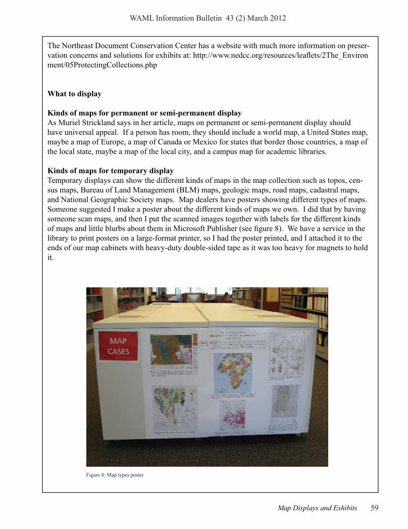
Kinds of maps for temporary displayTemporary displays can show the different kinds of maps in the map collection such as topos, cen-sus maps, Bureau of Land Management (BLM) maps, geologic maps, road maps, cadastral maps, and National Geographic Society maps. Map dealers have posters showing different types of maps. Someone suggested I make a poster about the different kinds of maps we own. I did that by having someone scan maps, and then I put the scanned images together with labels for the different kinds of maps and little blurbs about them in Microsoft Publisher (see figure 8). We have a service in the library to print posters on a large-format printer, so I had the poster printed, and I attached it to the ends of our map cabinets with heavy-duty double-sided tape as it was too heavy for magnets to hold it.
Figure 8: Map types poster

WAML Information Bulletin 43 (2) March 2012
60 Map Displays and Exhibits
A display could bring together different types of maps of one area. Some areas that Muriel Strick-land suggests that might make interesting displays are Africa, Oceania, the polar regions, Japan, Ireland, and the region around the library a person works in.
A temporary display can center on a news event. I did displays on the earthquake in Japan and on the uprising in Egypt (see figure 9). Once the news event is over, the exhibit should be taken down.
Displays can center on an environmental topic such as where hurricanes occurred in one year. A map display could center on a feature such as maps of islands. Map displays could be done for a cultural feature like national parks and monuments. Another possible theme is maps in literature (see figures 10-11 for an exhibit on maps in fairy tales)
Figure 9: News event theme for exhibit: earthquake in Japan
Figure 10: Fairy tales formal exhibit Figure 11: Fairy tales exhibit bronze pig

WAML Information Bulletin 43 (2) March 2012
61Map Displays and Exhibits
An anniversary could be the subject of a display. 2011 through 2015 is the sesquicentennial of Civil War battles, so a person could have a display with maps of battles from the Civil War year be-ing commemorated. I did a display for the seventieth anniversary of the attack on Pearl Harbor (see figure 12). A person could do an exhibit for a state, county, or city centennial or sesquicentennial by displaying maps from the history of that area.
Other special events could be the focus of a display. This year the summer Olympics will be held in London. Actually there are Olympic events all over England, and there are maps showing the different ven-ues on the web, and there are also maps of the venues in London. Muriel Strickland suggested a vacation in Europe as a dis-play subject. A person could mark the cit-ies most often visited by tourists. Exhibits can be centered on other sports events. I showed where the elite eight teams in the NCAA basketball tournament were from. For the National Finals Rodeo, which is held in Las Vegas, I labeled the towns the cowboys competing for all-around cow-boy were from (see figure 13).
Figure 12: Pearl Harbor 70th anniversary exhibit
Figure 13: Event as exhibit theme: National Finals Rodeo

WAML Information Bulletin 43 (2) March 2012
62 Map Displays and Exhibits
Another possibility is to show how symbols on maps have changed or to show how pictures on maps have changed through the years. Changes to a river channel over a period of time could be the subject of an exhibit. Maps new to the collection could be displayed as could maps requested by patrons or colorful maps.
Other hintsCaptions should not be too technical. A plastic stand that can hold a piece of paper can be used to display the title of the exhibit. A tent made with a folded piece of paper can display the captions, they can be displayed with plastic book stands, or they can be laid flat on the map.
Other things besides maps such as books from the stacks on the topic of an exhibit or three-dimen-sional objects can be included in exhibits. The Japanese earthquake exhibit included newspaper clippings, a sake set, a cup and saucer from Japan with Mt. Fuji on them, and a couple of Japanese dolls. The Egyptian uprising exhibit had bookmarks that were made to look like papyrus with hieroglyphics on then. One display involved a world map and currency and small objects from dif-ferent countries. Besides pictures of the attack from the National World War II Museum, the Pearl Harbor exhibit had a “Remember Pearl Harbor” replica button and some metal miniature World War II-era battleships. A collection of dolls wearing the native costumes of different countries were matched with the small CIA maps of the countries they represent. The Final Four NCAA basketball exhibit had a teddy bear in a basketball uniform, a tiny basketball, and newspaper articles on the championship. The display on geological maps included rock and mineral specimens and things made from rocks and minerals such as talc, gemstone jewelry, and metal objects. The current dis-play on the Yukon Quest dog sled race includes the official map of the route of the race, a book on sled dog racing, the race poster, a teddy bear in a parka, and a tiny wooden sled with an Inuit doll musher pulled by a stuffed sled dog pup in harness (see figure 14).
Map exhibits can be publicized in library blogs, newsletters, webpages, and digital picture frames. In conclusion, map displays and simple exhibits can be done quickly and can promote interest in a map collection.
Figure 14: Yukon Quest exhibit
WAML Information Bulletin 43 (2) March 2012
63Reviews of Atlases, Books and Digital Resources
Reviews of Atlases, Books and Digital Resourcesedited by
John RussellUniversity of Oregon
Hayes, Derek. Historical Atlas of the American West: With Origi-nal Maps. Berkeley: University of California Press, 2009. 288 p. $39.95. ISBN: 978-0-520-26562-1
This is another in a series of enter-taining recompilations of historic maps, many colored, of the United States. In a similar vein, Mr. Hayes has produced several other titles, among them Historical Atlas of the Pacific Northwest : Maps of Exploration and Discovery: British Columbia, Washington, Oregon, Alaska, Yukon, (Sasquatch Books, 1999); America Discovered: A Historical Atlas of North American Exploration, (Publishers Group West, 2004); Historical Atlas of the United States: With Original Maps, (University of California Press, c2007); and Historical Atlas of California: With Original Maps, (University of California Press, 2007).
Mr. Hayes must be a prodigious researcher and writer because most of the content of this current work, and presumably in his other publications, appears to be mostly his, in addition to the assistance of a copy editor and jacket de-signer. He does acknowledge the aid of many libraries, archives and online repositories in helping him reproduce the maps in this title. The atlas is comprised of eighteen thematic sections of varying length with expository essays accompa-nying the numerous, oftentimes colored maps and occasional pho-
tographs. The maps are generally presented in chronological order from the Era of Discovery to the 1990s and cover a region spanning Texas to Alaska. Concluding the work is a “map catalog:” being a bibliographic inventory referencing the map figures inside; a bibliogra-phy of scholars cited; and an index.
I particularly enjoyed the “Politi-cal Evolution of the West” section, which highlighted the remarkably different ways California and its neighbors could have looked had it not been for quirks of history. A particularly interesting map was “Nouvelle Carte du Mexique, du Texas et d’une Partie des Etats Limitrophes,” from 1845, which depicted the various negotiating proposals for the boundaries of the final component of the cur-rent continental U.S., the Gadsden Purchase. Of course there are many other examples in this title that made it fun to peruse.
I really have only two critiques of the atlas. 1) As was the case with Mr. Hayes’ earlier works, some enormous map originals have been scaled down in order to fit on the 10 x 14 inch pages. Therefore it is inevitable that some map details and legends become indecipherable. 2) Some maps straddle the book’s gutter, which is frustrating when peering into a center seam to make out details. However I understand it would be impossible to produce a book with a bundle of large fold-outs; the book would be unmanage-
able and expensive.
The atlas covers such a sweep of history and an amount of map detail as to necessarily make it a work of entertainment or introduc-tion to the topic. As such I would recommend it for the armchair geographer or historian, or for the introductory college student researcher.
Greg ArmentoGeography LibrarianCalifornia State University, Long Beach

64 New Mapping of Western North America
WAML Information Bulletin 43 (2) March 2012
New Mapping of Western North Americacompiled by
Ken RockwellUniversity of Utah Library Catalog Department
ALASKA
Burns, L. E. Iditarod survey area: magnetic and electromag-netic line, grid, and vector data, and maps, Innoko, Iditarod, and McGrath mining districts, Iditarod and Ophir quadrangles, western Alaska. 1 DVD, in-put scale 1:63,360. Fairbanks: Alaska Division of Geological & Geophysical Surveys, Geo-physical report no. 2011-2, pub. 2011. Web access: http://www.dggs.alaska.gov/pubs/id/22842
MyTopo (Firm). Terrain naviga-tor pro, Alaska. 2 DVDs, input scales differ. Billings, Mont.: MyTopo, edition 4.02, pub. 2012. OCLC: 776690729
Szumigala, David James, et al. Alaska’s mineral resources, 2012. 1 map, scale 1:4,000,000. Fairbanks, Alaska: Alaska Divi-sion of Geological and Geo-physical Surveys, Miscellaneous publication 142, pub. 2012. OCLC: 774063539. Web access: http://www.dggs.dnr.state.ak.us/pubs/id/23343
Till, Alison B. Bedrock geo-logic map of the Seward Penin-sula, Alaska, and accompanying conodont data. 2 maps, scale 1:500,000. Reston, Va.: U.S. Geological Survey, Scientific in-vestigations map no. 3131, pub.
2011. ISBN: 9781411331327; OCLC: 759596946. Web ac-cess: http://www.arlis.org/docs/vol1/C/759596946/index.html or http://pubs.usgs.gov/sim/3131/
ALBERTA
Alberta Energy Resources Conservation Board. Edmonton-Calgary Corridor groundwater atlas. 1 atlas (v, 90 p.), scale ca. 1:1,310,000. Edmonton: Alberta Geological Survey, ERCB/AGS information series no. 140, pub. 2011. OCLC: 777758470
Canadian Cartographics Cor-poration. Alberta, British Co-lumbia: road map. 1 map, scale 1:2,000,000. Markham, Ont.: Canadian Cartographics Cor-poration, pub. 2010. ISBN: 9781553683056; OCLC: 777143034
Elections Alberta. Provincial electoral divisions of Alberta as defined by the Electoral Divi-sions Act, 2010. 1 map, scale 1:945,000. Edmonton: Elections Alberta, pub. 2010.
MapArt (Firm). Central Alberta: range & township road map. 1 map, scale 1:500,000. Whitby, Ont.: Peter Heiler Ltd., distribution by MapArt Pub. Corp., pub. 2011. ISBN: 9781553685968; OCLC:
772583551
Willmore Widerness Park. 1 map, scale 1:125,000. [Al-berta?: s.n.], pub. 2010. OCLC: 773346092
ARIZONA
Benchmark Maps (Firm). Arizo-na road & recreation atlas. 1 at-las (111 pages), scale 1:400,000. Medford, Oregon: Benchmark Maps, 6th ed., pub. 2010. ISBN: 9780929591971; OCLC: 764558535
Ferguson, Charles A. Bedrock geologic map of the northern part of the Empire Ranch 7 1/2’ quadrangle, Pima County. 1 map, scale 1:24,000. Tucson, AZ : Arizona Geological Sur-vey, Arizona Geological Survey open-file report no. 09-05, pub. 2009. OCLC: 778374518
Ferguson, Charles A. Geologic map of the Helvetia 7 1/2’ quad-rangle, Pima County, Arizona. 1 map, scale 1:24,000. Tucson, AZ : Arizona Geological Sur-vey, Arizona Geological Survey open-file report no. 09-06, pub. 2009. OCLC: 778374183
Joyce, Lan. International travel maps, Vancouver’s northshore hiking trails. 1 map, scale 1:40,000. Richmond, B.C.:

WAML Information Bulletin 43 (2) March 2012
65New Mapping of Western North America
International Travel Maps, 6th ed., pub. 2011. ISBN: 9781553418962; OCLC: 764558497
MyTopo (Firm). Terrain navi-gator pro, Arizona. 3 DVDs, input scales differ. Billings, Mont.: MyTopo, edition 4.02, pub. 2012. OCLC: OCLC: 776689028
BRITISH COLUMBIA
Canadian Cartographics Cor-poration. Vancouver Island, sunshine coast, Gulf Islands : road map. 2 maps on 1 sheet, scale 1:550,000. Markham, Ont.: Canadian Cartograph-ics Corporation, pub. 2010. ISBN: 9781553682189; OCLC: 777143077
Carson, J. M. Geophysical series NTS 82-L/13, airborne geophysical survey, Kamloops, British Columbia. 10 maps, scale 1:50,000. col. Ottawa: Geological Survey of Canada, Open file no. 5992, pub. 2009. OCLC: 775859889
Carson, J. M. Geophysical series NTS 92-I/15 and part of 92-I/14, airborne geophysi-cal survey, Kamloops, Brit-ish Columbia. 10 maps, scale 1:50,000. col. Ottawa: Geologi-cal Survey of Canada, Open file no. 5998, pub. 2009. OCLC: 775859962
Carson, J. M. Geophysical se-ries 93 G/8 and part of 93 G/1, airborne geophysical survey, Quesnel, British Columbia.
10 maps, scale 1:50,000. col. Ottawa: Geological Survey of Canada, Open file no. 6000, pub. 2009. OCLC: 775859861
Carson, J. M. Geophysical series 93 G/10 and part of 93 G/15, airborne geophysical sur-vey, Quesnel, British Columbia. 10 maps, scale 1:50,000. col. Ottawa: Geological Survey of Canada, Open file no. 6002, pub. 2009. OCLC: 775859886
Carson, J. M. Geophysical se-ries 93 H/5, airborne geophysical survey, Quesnel, British Colum-bia. 10 maps, scale 1:50,000. col. Ottawa: Geological Survey of Canada, Open file no. 6004, pub. 2009. OCLC: 775859884
Centre for Topographic Infor-mation. Buttle Lake, British Columbia (92 F/12). 1 map, scale 1:50,000. Ottawa: Natural Resources Canada, Ed. 06, pub. 2011. ISBN: 9780660656366; OCLC: 766384844
Centre for Topographic Informa-tion. Elko, British Columbia (82 G/6). 1 map, scale 1:50,000. Ottawa: Natural Resources Canada, Ed. 05, pub. 2011. ISBN: 9780660660660; OCLC: 768534270
Centre for Topographic Infor-mation. Fernie, British Colum-bia (82 G/11). 1 map, scale 1:50,000. Ottawa: Natural Resources Canada, Ed. 04, pub. 2011. ISBN: 9780660660714; OCLC: 768534264
Centre for Topographic Informa-
tion. Forbidden Plateau, British Columbia (92 F/11). 1 map, scale 1:50,000. Ottawa: Natural Resources Canada, Ed. 07, pub. 2011. ISBN: 9780660656359; OCLC: 766384864
Centre for Topographic Infor-mation (Canada). Moyie Lake, Kootenay Land District, Brit-ish Columbia (82 G/5). 1 map, scale 1:50,000. Ottawa: Natural Resources Canada, Ed. 05, pub. 2011. ISBN: 9780660660653; OCLC: 771915558
Centre for Topographic Infor-mation. Quinn (Queen) Creek, Kootenay Land District, British Columbia (82 G/14). 1 map, scale 1:50,000. Ottawa: Natural Resources Canada, Ed. 05, pub. 2011. ISBN: 9780660660745; OCLC: 766384881
Centre for Topographic Infor-mation. Tofino, British Co-lumbia (92 F/4). 1 map, scale 1:50,000. Ottawa: Natural Resources Canada, Ed. 07, pub. 2011. ISBN: 9780660656304; OCLC: 766384877
Centre for Topographic In-formation. Upper Campbell Lake, British Columbia (92 F/13). 1 map, scale 1:50,000. Ottawa: Natural Resources Canada, Ed. 04, pub. 2011. ISBN: 9780660656373; OCLC: 766384834
CALIFORNIA
California Dept. of Forestry & Fire Protection, Mendocino Unit. Jackson Demonstra-

66 New Mapping of Western North America
WAML Information Bulletin 43 (2) March 2012
tions State Forest. 1 map, scale 1:36,000. Sacramento: Cali-fornia Department of Forestry and Fire Protection, pub. 2009. OCLC: 773840486
Chapman, Alan Daniel. Geo-logic map of the San Emigdio Mountains, southern California. 1 map, scale 1:40,000. Boulder, Colo.: Geological Society of America, Map and chart series no. 101, pub. 2012. OCLC: 775796840
Du Bray, E. A. Geochemi-cal database for igneous rocks of the ancestral Cascades arc, southern segment, California and Nevada. 1 CD-ROM, input scale not given. Reston, Va.: U.S. Geological Survey, Data series no. 439, pub. 2009. OCLC: 759354731 [Abstract: This report is a compilation of all available chemical data for igneous rocks that constitute the southern segment of the an-cestral Cascades magmatic arc and complement a previously completed companion compila-tion that pertains to rocks that constitute the northern segment of the arc.]
Fort Tejon State Historic Park (Agency : Calif.). Fort Tejon State Historic Park 1854-1864. 1 map, scale [ca. 1:1,800]. Lebec, Calif.: Fort Tejon State Historic Park, [2011?] Folded title: Dragoon walk, Fort Tejon State Historic Park : a self-guid-ed trail. Web access.https://picasaweb.google.com/115621908103754069820/Maps --reported by Phil Hoehn
Geographic Publishers (Mu-nich, Germany). Californie. 1 map, scale 1:800,000. Mu-nich: Berlitz, Série internatio-nale no. 180223 distributed by Blay-Foldex, 2009. ISBN: 9782400180223; OCLC: 762845301
Grossinger, Robin. Historical wetlands of the southern Califor-nia coast: an atlas of US Coast Survey T-Sheets, 1851-1889. 1 atlas (55, A3, B39 p.), scales differ. San Francisco, Calif.: San Francisco Estuary Institute ; Southern California Coastal Water Research Project, Techni-cal report no. 589, pub. 2011. OCLC: 772276151. Web access: http://www.sfei.org/projects/So-CalTSheets
Moomey, Kristi. Los Gatos, Saratoga, and Santa Cruz Moun-tains wineries. 2 maps on 1 sheet, not drawn to scale. La Conner, Wash.: Starr Map Com-pany, 10th anniversary ed., pub. 2010. OCLC: 778611980
MyTopo (Firm). Terrain navi-gator pro, California. 3 DVDs, input scales differ. Billings, Mont.: MyTopo, edition 4.02, pub. 2012. OCLC: OCLC: 776688779
U.S. Forest Service, Pacific Southwest Region. Ansel Adams Wilderness and Owens River headwaters wilderness, Sierra and Inyo National Forests, Cali-fornia. 1 map, scale 1:63,360. Vallejo, Calif.: U.S. Forest Service, pub. 2011. ISBN: 9781593515188; OCLC:
778099075
U.S. Forest Service, Southwest-ern Region. Sequoia National Forest and Giant Sequoia National Monument, Califor-nia. 2 maps, scale 1:126,720. [San Francisco, Calif.?]: U.S. Forest Service, pub. 2011. ISBN: 9781593515096; OCLC: 767885337
COLORADO
Ave, Raymond. Eastern Rocky Mountain National Park trail map and guide to the best Estes Park hikes. 1 map, scale ca. 1:42,240. Fort Collins, Colo.: Mountain Jay Media, pub. 2010. OCLC: 772533010
Ave, Raymond. Western Rocky Mountain National Park trail map and guide to the best Grand Lake hikes. 1 map, scale ca. 1:42,240. Fort Collins, Colo.: Mountain Jay Media, pub. 2010. OCLC: 772536263
Benchmark Maps (Firm). Colo-rado road & recreation atlas. 1 atlas (143 p.), scale 1:200,000. Medford, Oregon: Benchmark Maps, 3rd ed., pub. 2011. ISBN: 9780929591919; OCLC: 760053074
Colorado Division of Parks and Outdoor Recreation. Chat-field State Park. 1 map, scale ca. 1:29,746. Littleton, Colo.: Colorado State Parks, pub. 2010. OCLC: 774596611
DeLorme (Firm). Colorado atlas & gazetteer. 1 atlas (104

WAML Information Bulletin 43 (2) March 2012
67New Mapping of Western North America
p.), scale 1:160,000. Yarmouth, Me.: DeLorme, 10th ed., pub. 2011. ISBN: 9780899332888; OCLC: 767736654
Kappa Map Group. Denver metro Colorado street atlas. 1 atlas (various pagings), scale ca. 1:31,000. Blue Bell, Penn.: Kappa Map Group, pub. 2011. ISBN: 9780762572632; OCLC: 753978680
Kellogg, Karl S. Geologic map of the eastern half ot the Vail 30’ x 60’ quadrangle, Eagle, Sum-mit, and Grand Counties, Colo-rado. 1 map, scale 1:100,000. Reston, Va.: U.S. Geological Survey, Scientific investiga-tions map no. 3170, pub. 2011. ISBN: 9781411331846; OCLC: 771939586
Livaccari, Richard. Geologic map of the Fruita Quadrangle, Mesa County, Colorado. 1 CD-ROM, input scale 1:24,000. Denver, Colo.: Colorado Geo-logical Survey, Open-file report no. 09-04, pub. 2009. OCLC: 777246242
Motion Pixel Lab (Firm). The beer drinker’s guide to Colo-rado: breweries, brewpubs, historic taverns, national & state parks, ski areas, 14ers, & much more. 1 map, scale ca. 1:89,040. Colorado Springs, Colo.: Motion Pixel Lab, 5th ed. Updated, pub. 2011. ISBN: 9780980195002; OCLC: 759121387 MyTopo (Firm). Terrain navi-gator pro, Colorado. 2 DVDs,
input scales differ. Billings, Mont.: MyTopo, edition 4.02, pub. 2012. OCLC: OCLC: 776686411
Ruleman, Chester A. Geologic map of the Bailey 30’ by 60’ quadrangle, north-central Colo-rado. 1 map, scale 1:100,000. Reston, Va.: U.S. Geological Survey, Scientific investiga-tions map no. 3156, pub. 2011. ISBN: 9781411331259; OCLC: 771927345. Web access: http://purl.access.gpo.gov/GPO/gpo15571 and http://pubs.usgs.gov/sim/3156/
U.S. Forest Service, Rocky Mountain Region. San Isabel National Forest, Colorado. 1 map, scale 1:126,720. Salt Lake City, Utah: U.S. Forest Service, Rocky Mountain Region, pub. 2011. ISBN: 9781593511432; OCLC: 767886846
HAWAII
Eureka Cartography (Firm). Is-land of Oahu, travel map: Hono-lulu, Waikiki, urban areas, places of interest. 4 maps, scale ca. 1:140,000. Morro Bay, Calif.: Kerry L. McCants, pub. 2010. ISBN: 9780972371605; OCLC: 769641070
IDAHO
Benchmark Maps (Firm). Idaho road & recreation atlas. 1 atlas (95 p.), scales differ. Medford, Or.: Benchmark Maps, 3rd ed., pub. 2012. ISBN: 9780929591063; OCLC: 775672781
Breckenridge, Roy M., et al. Geologic map of the Copeland quadrangle, Boundary County, Idaho. 1 map, input scale 1:24,000. Moscow, Idaho: Idaho Geological Survey, Digi-tal web map no. 139, pub. 2011. OCLC: 764702478.
Burmester, Russell F., et al. Geologic map of the Badger Spring Gulch quadrangle, Lemhi County, Idaho. 1 map, input scale 1:24,000. Moscow, Idaho: Idaho Geological Survey, Digital web map no. 132, pub. 2011. OCLC: 765505749.
Burmester, Russell F. Geologic map of the Eastport quadrangle, Boundary County, Idaho. 1 map, input scale 1:24,000. Moscow, Idaho: Idaho Geo-logical Survey, Digital web map no. 140, pub. 2011. OCLC: 764691662.
Burmester, Russell F. Geo-logic map of the Hall Mountain quadrangle, Boundary County, Idaho. 1 map, input scale 1:24,000. Moscow, Idaho: Idaho Geological Survey, Digi-tal web map no. 138, pub. 2011. OCLC: 764691812.
Embree, G. F., et al. Geologic map of the Linderman Dam quadrangle, Fremont, Madison, and Teton Counties, Idaho. 1 map, input scale 1:24,000. Moscow, Idaho: Idaho Geo-logical Survey, Digital web map no. 133, pub. 2011. OCLC: 765499514.
Garwood, Dean L., et al. Geo-

68 New Mapping of Western North America
WAML Information Bulletin 43 (2) March 2012
logic map of the Picabo quad-rangle, Camas County, Idaho. 1 map, input scale 1:24,000. Moscow, Idaho: Idaho Geologi-cal Survey, Digital web map no. 131, pub. 2011. OCLC: 765489040.
Kauffman, John D., et al. Geo-logic map of the Corral quad-rangle, Camas County, Idaho. 1 map, input scale 1:24,000. Moscow, Idaho : Idaho Geo-logical Survey, Digital web map no. 130, pub. 2011. OCLC: 765472316.
Kauffman, John D., et al. Geo-logic map of the Dairy Moun-tain quadrangle, Idaho County, Idaho. 1 map, input scale 1:24,000. Moscow, Idaho: Idaho Geological Survey, Digi-tal web map no. 129, pub. 2011. OCLC: 765472208.
Kauffman, John D., et al. Geologic map of the McKinzie Creek quadrangle, Idaho Coun-ty, Idaho. 1 map, input scale 1:24,000. Moscow, Idaho: Idaho Geological Survey, Digi-tal web map no. 127, pub. 2011. OCLC: 765472048.
Keeley, Joshua A., et al. Geo-logic map of the Thatcher Hill quadrangle and portions of the Treasureton and Cottonwood Creek quadrangles, Franklin, Bannock, and Caribou Coun-ties, Idaho. 1 map, scale 1:24,000. Moscow, Idaho: Idaho Geological Survey, University of Idaho, Techni-cal report no. 11-2, pub. 2011. OCLC: 765976007.
Lewis, Reed S. Geologic map of the Goldstone Mountain quadrangle, Lemhi County, Idaho and Beaverhead County, Montana. 1 map, input scale 1:24,000. Moscow, Idaho: Idaho Geological Survey, Digital web map no. 134, pub. 2011. OCLC: 764754356.
Lewis, Reed S. Geologic map of the John Day Mountain quad-rangle, Idaho County, Idaho. 1 map, input scale 1:24,000. Moscow, Idaho: Idaho Geo-logical Survey, Digital web map no. 128, pub. 2011. OCLC: 765467492.
Lewis, Reed S. Geologic map of the Lucile quadrangle, Idaho County, Idaho. 1 map, input scale 1:24,000. Moscow, Idaho: Idaho Geological Survey, Digital web map no. 126, pub. 2011. OCLC: 765467492.
MyTopo (Firm). Terrain navi-gator pro, Idaho. 2 DVDs, input scales differ. Billings, Mont.: MyTopo, edition 4.02, pub. 2012. OCLC: OCLC: 775008786
Othberg, Kurt L. Geologic map of the Baker quadrangle, Lemhi County, Idaho. 1 map, scale 1:24,000. Moscow, Idaho: Idaho Geological Survey, Digital web map no. 141, pub. 2011. OCLC: 764691595.
Phillips, William M., et al. Geologic map of the Lewisville quadrangle, Jefferson and Bonn-eville Counties, Idaho. 1 map, input scale 1:24,000. Moscow,
Idaho: Idaho Geological Survey, Digital web map no. 135, pub. 2011. OCLC: 764728344.
Phillips, William M., et al. Geologic map of the Menan Buttes quadrangle, Jefferson and Madison Counties, Idaho. 1 map, input scale 1:24,000. Moscow, Idaho: Idaho Geo-logical Survey, Digital web map no. 137, pub. 2011. OCLC: 764698904.
Phillips, William M., et al. Geologic map of the Rigby quadrangle, Jefferson and Bonn-eville Couties, Idaho. 1 map, input scale 1:24,000. Moscow, Idaho: Idaho Geological Survey, Digital web map no. 136, pub. 2011. OCLC: 764745716. U.S. Forest Service, Northern Region. Idaho Panhandle Na-tional Forests (Kaniksu National Forest) Idaho, 2011: America’s great outdoors. 1 map, scale 1:126,720. Missoula, Mont.: U.S. Forest Service, pub. 2011. ISBN: 9781593510978; OCLC: 773170463
MONTANA
Beartooth Publishing. Beartooth Mountains, Montana-Wyoming, outdoor recreation map: topographic, shaded relief. 1 map, scale 1:50,000. Bozeman, Mont.: Beartooth Publishing, 2nd ed., pub. 2010. ISBN: 9781887460132; OCLC: 769124022
Montana Audubon. Gold west country birding trails. 1
WAML Information Bulletin 43 (2) March 2012
69New Mapping of Western North America
U.S. Bureau of Land Man-agement, Ely District. South Steptoe Valley travel manage-ment plan. 1 map, scale ca. 1:100,000. Ely, Nevada: U.S. Bureau of Land Management, Ely District Office, pub. 2011. OCLC: 775357721
NEW MEXICO
Benchmark Maps (Firm). New Mexico road & recreation atlas. 1 atlas (95 p.), scale 1:400,000. Medford, Oregon: Benchmark Maps, 6th ed., pub. 2010. ISBN: 9780929591117; OCLC: 764558533
Friends of Archaeology (Muse-um of New Mexico Foundation). Roads to the past: highway map and guide to New Mexico archaeology. 1 map, scale 1:998,000. Santa Fe, N.M.: High Desert Field Guides, pub. 2011. ISBN: 9780976683940; OCLC: 776906702
MyTopo (Firm). Terrain naviga-tor pro, New Mexico. 3 DVDs, input scales differ. Billings, Mont.: MyTopo, edition 4.02, pub. 2012. OCLC: OCLC: 774698092
Thompson, Ren A. Geologic map of the Montoso Peak quadrangle, Santa Fe and San-doval counties, New Mexico. 1 map, scale 1:24,000. Reston, Va.: U.S. Geological Survey, Scientific investigations map no. 3179, pub. 2011. OCLC: 775361028. Web access: http://purl.access.gpo.gov/GPO/gpo15807 or http://pubs.usgs.
gov/sim/3179/
OREGON
Burns, William J. Landslide inventory maps of the Linnton quadrangle, Multnomah and Washington counties, Or-egon. 1 CD-ROM, input scale 1:8,000. Portland, Or.: Oregon Dept. of Geology and Mineral Industries, Interpretive map se-ries no. 35, pub. 2011. OCLC: 775360741 Web access: http://www.oregongeology.org/pubs/ims/p-ims-035.htm
Burns, William J., et al. Land-slide inventory maps of the Beaverton quadrangle, Wash-ington County, Oregon. 1 CD-ROM, input scale 1:8,000. Portland, Or.: Oregon Dept. of Geology and Mineral Industries, Interpretive map series no. 34, pub. 2011. OCLC: 775359950Web access: http://www.oregongeology.org/pubs/ims/p-ims-034.htm
Eugene (Or.) The Eugene Springfield bicycle map and resource guide. 1 map, scale ca. 1:27,399. Eugene, Or.: City of Eugene, pub. 2011. OCLC: 768763790
Fisher, John E. Guide to Wil-lamette Valley wineries, 2011-2012. 1 map, not drawn to scale. Portland, Or.: Willamette Val-ley Wineries Association., pub. 2010. OCLC: 760313925
MyTopo (Firm). Terrain navi-
map, scale not given. Helena, Montana?: Montana Office of Tourism, pub. 2010. OCLC: 764416680
Montana Dept. of Transporta-tion, Road Inventory and Map-ping Section. Bicycling the big sky, Montana: traffic data for bicyclists 2010. 1 map, scale 1:1,774,080. Helena, Mont.: Montana Dept. of Transpor-tation, pub. 2010. OCLC: 774411814
MyTopo (Firm). Terrain navi-gator pro, Montana. 3 DVDs, input scales differ. Billings, Mont.: MyTopo, edition 4.02, pub. 2012. OCLC: OCLC: 774863864
NEVADA
Bell, John W., et al. Geologic map of the Grimes Point quad-rangle, Churchill county, Ne-vada. 1 map, scale 1:24,000. Reno, Nev.: Nevada Bureau of Mines and Geology, Map 173, pub. 2010. OCLC: 773732130
MyTopo (Firm). Terrain navi-gator pro, Nevada. 3 DVDs, input scales differ. Billings, Mont.: MyTopo, edition 4.02, pub. 2012. OCLC: OCLC: 774706046
Unique Media Incorporated. Las Vegas, Grand Canyon, Arizona, Lake Mead Country. 1 view, not drawn to scale. Don Mills, Ont.: Unique Media, pub. 2010. ISBN: 9780921338529; OCLC: 756740303

70 New Mapping of Western North America
WAML Information Bulletin 43 (2) March 2012
gator pro, Oregon. 3 DVDs, input scales differ. Billings, Mont.: MyTopo, edition 4.02, pub. 2012. OCLC: OCLC: 774591935
National Geographic Maps (Firm). Oregon TOPO! out-door recreation mapping soft-ware. 1 DVD-ROM, input scale 1:24,000. Evergreen, Colo.: National Geographic Maps, v. 4.6, pub. 2010. ISBN: 9781566955676; OCLC: 773821789
Pollock, Tracy. Mount Hood geologic guide and recreation map. 2 maps on 1 sheet, scale 1:91,000. Portland, Or.: Oregon Dept. of Geology and Mineral Industries, pub. 2012. OCLC: 776924067
U.S. Forest Service, Pacific Northwest Region. McKen-zie River National Recreation Trail, McKenzie River Ranger District, Willamette National Forest, Oregon. 1 map, scale ca. 1:79,200. [Portland, Or.]: USDA Forest Service, pub. 2011. ISBN: 9781593515744; OCLC: 759355488
U.S. Forest Service, Pacific Northwest Region. Willamette Pass winter recreation, Willa-mette and Deschutes National Forests, Oregon. 1 map, scale 1:31,680. [Portland, Or.]:U.S. Forest Service, pub. 2012. ISBN: 9781593515751; OCLC: 778611862
SOUTHWESTERN STATES
G.M. Johnson & Associates Ltd. Historic Route 66 travel map, including Grand Canyon panoramic map: California, Arizona, New Mexico, Texas, Oklahoma, Kansas, Missouri & Illinois. 1 map and 1 view on 1 sheet, scale ca. 1:4,200,000. Burnaby, B.C.: GM Johnson & Associates, Ltd. ; Oceanside, CA : Global Graphics, pub. 2009. ISBN: 9781770680845; OCLC: 773614846
UTAH
MyTopo (Firm). Terrain naviga-tor pro, Utah. 2 DVDs, input scales differ. Billings, Mont.: MyTopo, Ed. 4.02, pub. 2012. OCLC: 774407545
U.S. Bureau of Land Manage-ment, Kanab Field Office. Recreation opportunities and transportation routes in the Kanab Field Office. 2 maps on 1 sheet, scale 1:67,575. Kanab, Utah: Bureau of Land Manage-ment, Utah State Office and the Kanab Field Office, pub. 2011. OCLC: 773789190
WASHINGTON
Benchmark Maps (Firm). Washington road & recreation atlas. 1 atlas (127 p.), scale 1:200,000. Medford, Oregon: Bench-mark Maps, 6th ed., pub. 2010. ISBN: 9780929591988; OCLC: 764558534
Boyd, Gregory A. Family maps of Douglas County, Washing-ton: with homesteads, roads, waterways, towns, cemeteries, railroads, and more. 1 atlas (800 p.), scales differ. Nor-man, Okla.: Arphax Pub. Co., 1st ed., pub. 2011. ISBN: 9781420320350; OCLC: 778367854
Dragovich, Joe D. Analytical data from the Monroe 7.5-min-ute quadrangle, King and Snohomish Counties, Wash-ington. 3 maps on 2 sheets, scale 1:30,000, + 1 CD-ROM. Olympia, Wash.: Washing-ton Division of Geology and Earth Resources, Supplement to Open-file report no. 2011-1, pub. 2011. OCLC: 772214166
Dragovich, Joe D. Geologic map of the Monroe 7.5-minute quadrangle, King and Snohom-ish Counties, Washington. 1 map, scale 1:24,000. Olympia, Wash.: Washington Division of Geology and Earth Resources, Open-file report no. 2011-1, pub. 2011. OCLC: 772214235
MyTopo (Firm). Terrain naviga-tor pro, Washington. 2 DVDs, input scales differ. Billings, Mont.: MyTopo, Ed. 4.02, pub. 2012. OCLC: 774405172
National Geographic Maps (Firm). Olympic National Park, Washington USA: Trails Illustrated map : outdoor rec-reation map. 1 map, scale ca. 1:100,000. Evergreen, Colo.: National Geographic Maps, rev. 2011. ISBN: 9781566954020;
WAML Information Bulletin 43 (2) March 2012
71New Mapping of Western North America
OCLC: 769125872
Newbold, Ed., et al. The great Washington State birding trail, Puget loop. 1 map, scale not given. Seattle, Wash.: Audu-bon Washington, pub. 2011. ISBN: 9780930698997; OCLC: 770742968. Web access: http://wa.audubon.org/birds_GreatWABirdingTrail_Puget-Loop.html
Wolff, Fritz E., et al. Inactive and abandoned mine lands: Ruby Hill Mining District, Okanogan County, Washington. 1 atlas (iv, 35 p.), scales differ. Olympia, Wash.: Washington Division of Geology and Earth Resources, Information circu-lar no.112, pub. 2011. OCLC: 760053159
WESTERN CANADA
Canadian Cartographics Cor-poration. Western Canada: British Columbia, Alberta, Saskatchewan, Manitoba : road map. 2 maps on 1 sheet, scale 1:2,000,000. Markham, Ont.: Canadian Cartograph-ics Corporation, pub. 2010. ISBN: 9781553682486; OCLC: 777143080
WESTERN N. AMERICA
Blakey, Ronald. Paleogeogra-phy of Western North America. 1 DVD-ROM, input scale not given. Flagstaff, Ariz.: Colo-rado Plateau Geosystems, Inc., pub. 2011. OCLC: 775359806
WESTERN UNITED STATES
Blakey, Ron. Paleogeography of the Colorado Plateau. 1 DVD-ROM, input scale not given. Flagstaff, Ariz.: Colorado Plateau Geosystems, Inc., pub. 2010. OCLC: 775350250
Colorado Basin River Forecast Center (U.S.). Colorado Ba-sin River Forecast Center, Salt Lake City, Utah. 1 map, scale ca. 1:1,550,000. Salt Lake City, Utah: The Center, pub. 2011. OCLC: 768850621. Web access: Note: Related web page: http://www.cbrfc.noaa.gov/
Universal Map. Central & western United States interstate highway map: including Alaska, Arizona, Arkansas, California ... Wisconsin, & Wyoming. 1 map, scale ca. 1:3,100,000. DeLand, Florida: Univer-salMAP, pub. 2010. ISBN: 9780762570614; OCLC: 759436570
WYOMING
Benchmark Maps (Firm). Wyo-ming recreation map: public lands & hunting units, Yel-lowstone & Grant Teton, Na-tional Park maps, extensive background detail. 3 maps on 1 sheet, scales 1:750,000 and 1:250,000. Medford, Or.: Benchmark Maps, pub. 2011. ISBN: 9780783499024; OCLC: 775608835
Big Horn Mountain Country Coalition. Visit Big Horn Moun-tain Country, Wyoming. 1 map,
not drawn to scale. Sheridan, Wyo.: Big Horn Mountain Country Coalition, pub. 2010. OCLC: 761039296
Case, James C., et al. Prelimi-nary surficial geologic map of the Rattlesnake Hills 30’ x 60’ quadrangle, Natrona and Fremont counties, Wyoming. 1 map, scale 1:100,000. Lara-mie, Wyo.: Wyoming State Geological Survey, Open File Report no. 11-3, pub. 2011. OCLC: 760127754
Hallberg, Laura L., et al. Preliminary surficial geologic map of the Bairoil 30’ x 60’ quadrangle, Carbon, Sweet-water, Fremont, and Natrona counties, Wyoming. 1 map, scale 1:100,000. Laramie, Wyo.: Wyoming State Geologi-cal Survey, Open File Report no. 11-4, pub. 2011. OCLC: 775377205
Hallberg, Laura L., et al. Preliminary surficial geologic map of the Lysite 30’ x 60’ quadrangle, Natrona, Fremont, Hot Springs, and Johnson counties, Wyoming. 1 map, scale 1:100,000. Laramie, Wyo.: Wyoming State Geologi-cal Survey, Open File Report no. 11-2, pub. 2011. OCLC: 775376712 Jones, Nicholas R., et al. Preliminary geologic map of the Shirley Basin 30’ x 60’ quadrangle, Carbon, Natrona, Albany, and Converse coun-ties, Wyoming. 1 map, scale 1:100,000. Laramie, Wyo.:

72 New Mapping of Western North America
WAML Information Bulletin 43 (2) March 2012
Wyoming State Geological Sur-vey, Open File Report no. 11-8, pub. 2011. OCLC: 760133069
MyTopo (Firm). Terrain naviga-tor pro, Wyoming. 3 DVDs, input scales differ. Billings, Mont.: MyTopo, Ed. 4.02, pub. 2012. OCLC: 774402970
Seeger Map Co. Yellowstone, Grand Teton National Parks, Wyoming special area se-ries. 2 maps on 1 sheet, scales 1:252,000 and 1:126,000. Heathrow, Fla.: AAA, pub. 2010. OCLC: 761010505
Ver Ploeg, Alan J., et al. Pre-liminary geologic map of the Best Ranch quadrangle, Albany County, Wyoming. 1 map, scale 1:24,000. Laramie, Wyo.: Wyoming State Geological Sur-vey, Open File Report no. 11-7, pub. 2011. OCLC: 774626366
Wittke, Seth. Geologic map of the Farson 30’ x 60’ quad-rangle, Sweetwater, Sublette, and Fremont Counties, Wyo-ming. 1 map, scale 1:100,000. Laramie, Wyo.: Wyoming State Geological Survey, Map series no. MS-8, pub. 2011. OCLC: 760131549
Wittke, Seth. Preliminary surfi-cial geologic map of the South Pass 30’ x 60’ quadrangle, Sweetwater, and Fremont coun-ties, Wyoming. 1 map, scale 1:100,000. Laramie, Wyo.: Wyoming State Geological Sur-vey, Open File Report no. 11-5, pub. 2011. OCLC: 775377480
Worman, Brett N., et al. Surface geology of the Pavillion ground-water investigation. 1 photo-map, scale 1:16,000. Laramie, Wyo.: Wyoming State Geologi-cal Survey, pub. 2011. OCLC: 774626574
Wyoming Business Council Tourism & Travel Division. Public lands recreation op-portunities, Wyoming. 1 map, scale ca. 1:1,000,000. Chey-enne, Wyo.: Wyomig Travel & Tourism, pub. 2010. OCLC: 761045911
Wyoming Dept. of Transporta-tion. The Togwotee Trail to Yellowstone. 1 map, scale not given. Dubois, Wyo.: Togwotee Trail ; Wyoming Department of Trans-portation, pub. 2010. OCLC: 761033436
Wyoming State Trails Program. Bighorn, Wyoming 2010 ORV trail map: includes Bighorn National Forest. 1 map, scale 1:120,000. Cheyenne, Wyo.: Wyoming State Trails Program, State Parks & Historic Sites, pub. 2010. OCLC: 761020793
Wyoming State Trails Program. Blackhills, Wyoming 2010 ORV trail map: includes the Black Hills and Bear Lodge Moun-tain. 1 map, scale 1:120,000. Cheyenne, Wyo.: Wyoming State Trails Program, State Parks & Historic Sites, pub. 2010. OCLC: 761028621

WAML Information Bulletin 43 (2) March 2012
73News and Notes
News and Notescompiled by
Michael SmithUniv. of California-San Diego
CATALOGING NEWS
I recently returned from the 2012 ALA Midwinter Meeting in Dallas where, unfortunately, I did not find very much time to devote to cataloging-related programs. Instead, a lot of energy went into Map and Geospatial Round Table (MAGIRT) activities, particularly as the new MAGIRT Treasurer. That said, generally-speaking there was only a couple broad areas of cataloging that were being addressed at Midwinter, including Bibliographic Framework Transition (future cataloging without the MARC structure) and education/training of catalogers. Of course, RDA continues to move forward but there was not a lot of overall discussion on the topic, instead the grind-it-out work of the various ALA committees continues. I did learn, while attending and participating in the MAGIRT Cataloging & Classification Committee meeting, that very few map catalogers have yet to begin working with RDA, in fact out of a room of about twenty individuals I was the only one present doing so. I am certain that a major shift will happen
starting in the Fall of 2012 and accelerating into and through 2013 however.
So, this will be a relatively short listing of cartographic materials cataloging activities. And, as usual, I ask that you send map cataloging information either to me or directly to the News & Notes Editor, Mike Smith for inclusion in future issues.
Recent Cataloging-Related Information from the Library of Congress
One of the programs at the recent ALA Midwinter meeting was titled “What Lies Beyond MARC?” which was sponsored by the LITA/ALCTS MARC Formats Interest Group. As the title suggests, the cataloging community is straining to see what is ahead as metadata, FRBR, and RDA provide impetus to move away from the Anglo-American Cataloguing Rules and into a new future of descriptive cataloging and metadata creation.
The major initiative and group that is working hard to create a new content standard is the Library of Congress’ Working
Group on the Future of Bibliographic Control. The goal of this group, as stated in the document “A Bibliographic Framework for the Digital Age (October 31, 2011)” is that LC is “...committed to developing, in collaboration with librarians, standards experts, and technologists a new bibliographic framework that will serve the associated communities well into the future.” http://www.loc.gov/marc/transition/news/framework-103111.html. And towards that end the Bibliographic Transition Framework Initiative (BTFI) was launched in the fall of 2011, http://www.loc.gov/marc/transition/.
Presentations in the program noted above, “What Lies Beyond MARC?” addressed and/or updated the work of the BTFI. See http://connect.ala.org/node/163477 to read a summary or go to a copy of the presentation slides. The speakers provided information on the following questions: What problems do we want the new framework to solve? How might new technologies influence our practices? How do these developments relate to the

74 News and Notes
WAML Information Bulletin 43 (2) March 2012
introduction of RDA?
The best place to keep up with ongoing efforts of the Bibliographic Transition Framework Initiatives is at the above URL, where one can sign up for a BTFI Forum listserv. Additionally, the minutes of the LC Bibliographic Framework Transition Initiative Update Forum held Jan. 22nd at ALA Midwinter in Dallas are now posted on the Transition Initiative Website at http://www.loc.gov/marc/transition/news/minutes-alamw-2012.html.
Resource Description and Access (RDA) Update
1. The Joint Steering Committee for Resource Discovery and Access (JSC) announced the release of RDA Carrier Type, Content Type and Media Type Vocabularies just before Midwinter. These are part of the Open Metadata Registry now: http://metadataregistry.org/vocabulary/show/id/46.html
2. The Library of Congress’ PCC program, at its webpage “RDA: Resource Discovery & Access and the PCC” http://www.loc.gov/catdir/pcc/RDA-PCC.html now contains information about implementing RDA in authority records. Two documents in particular provide information about when one can begin to see the LC authority files being changed to include RDA-based information; PCC Day One for RDA Authority Records and an accompanying
FAQ on the same topic. If you work with NACO in particular this is something you need to be following because for now we are not allowed to include RDA elements in the creation or updating of authority records. A date for “Day One”, after which “all new authority records entering the LC/NACO Authority File must be coded RDA and all access points on bibliographic records coded “pcc” must be RDA” has not been established but will probably happen in January 2013. Stay tuned.
Also on this webpage is the “PCC and RDA Frequently Asked Questions” document that was updated on January 13, 2012. See http://www.loc.gov/catdir/pcc/PCC-RDA-FAQ.html
3. The U.S. RDA Test Group that put the standard through its paces last year also formed a coordinating committee with a website presence and is continuing to work with the RDA Toolkit; additionally those members of the test group who are at the Library of Congress are continuing to catalog using RDA and now are keeping the rest of us informed through regular reports. From an email I recently received via the RDA-L list, “the first quarterly update from the US RDA Test Coordinating Committee is available on the new LC Website for preparating to implement RDA. The URL for the update is http://www.loc.gov/aba/rda/rda_implementation_updates.
html.” This is an important site for catalogers to refer to because it provides updates to the nine things that the U.S. national libraries said must be done, or have shown enough evidence that they will be done in the near future, before these libraries will formally implement the RDA standard. As of this writing three are “completed” and six are “on track”. 4. RDA workforms: in the News from OCLC report that Jay Weitz delivered at several meetngs, under the section titled “Future Enhancements to Connexion Client” is an exciting note (to me at least) about a forthcoming option to set your computer to open a RDA-based workform for whatever format you are cataloging. “Set an option for the Client using Tools>Options>RDA tab (formerly the RDA Toolkit tab) to use RDA versions of the existing AACR2 workforms to create records. Set the option separately for bibliographic and/or authority workforms. Existing workforms open by default when you create new records unless you set the RDA workform option(s).” Cool!
Paige AndrewPennsylvania State University

WAML Information Bulletin 43 (2) March 2012
75News and Notes
CONFERENCES, CLASSES & EXHIBITIONS
The BIG List of GIS, Mapping, and Geo Tech Events to Consider in 2012 can be found on GISuser.com at http://www.gisuser.com/content/view/25499/222/
Exhibitions in the West via Cartography - Calendar of Exhibitions (http://home.earthlink.net/~docktor/exhibit.htm) and Cartography - Calendar of Meetings and Events (http://home.earthlink.net/~docktor/index.htm)
January 6, 2012 - May 4, 2012 - Santa FeBetween the Lines: Culture and Cartography on the Road to Statehood, an exhibition of thirty maps commemorating the centennial of New Mexico statehood, is located in the State Capitol building, right outside the governor’s office in the Governor’s Gallery. (http://www.santafe.org/New_Mexico_State_Capitol/index.html) The maps date from 1564 to 2011 with more than half of them detailing the history and culture of the state in the twentieth and twenty-first centuries. The maps are drawn from the holdings of the Fray Angélico Chávez History Library of the Palace of Governors of The New Mexico History Museum and private collections across New Mexico, Arizona, and Mexico. The exhibition is curated by
Dr. Tomas Jaehn, Director of the Fray Angélico Chávez History Library, and Dr. Dennis Reinhartz, Emeritus Professor of History at The University of Texas at Arlington, among others.
The Society for the History of Discoveries 53rd Annual Meeting will be held in Pasadena from September 27-30, 2012. Call for Papers:
The Program Committee of the Society for the History of Discoveries invites those wishing to make a presentation at this meeting to submit a proposal to the chair of the committee at their earliest convenience: [email protected], Imre Josef Demhardt, University of Texas at Arlington, Department of History, Box 19529, Arlington, Texas 76019, USA / Tel: 817-272-0122.
GENERAL NEWS
WAML NEWS
Dear WAMLites,I hope you’re all doing well, and hanging in there during this busy part of the school year. I’m writing to pass along some updates:
* Planning continues for our meeting in Hawaii, to be held from October 31 - November 3rd. Our friends at the University of Hawaii, Manoa, will be letting us know more
details soon.* The WAML Executive Board is appointing Katie Lage (University of Colorado), to another term as a WAML representative to CUAC. We are grateful that she will be able to carry on her liaison work on our behalf.
* Planning has begun for WAML’s 2013 meeting, which is tentatively scheduled at Tenaya Lodge on the outskirts of Yosemite National Park, October 30 - November 3rd. John Ridener, WAML V.P., is doing a great job of pulling this together. More information will be out next month. Pleases let John or me know if you’d like to be part of the planning group. Also, it’s not too soon to volunteer to host a WAML meeting in 2014!
* Please consider running for a WAML office. We’ll be looking for a Vice-President/President-elect, a new Treasurer (2-year term), and a new Secretary (1-year term). Past President Mike Smith, chair of the Nominating Committee, would love to hear from you. He’s at 858-534-1248 or [email protected] Terms of office begin July 1st.
Best regards,CynthiaWAML President, 2011-12
The program and executive minutes from the Vancouver and Oakland meetings have been added to the WAML Meetings page (http://www.waml.org/

76 News and Notes
WAML Information Bulletin 43 (2) March 2012
mtgspast.html).
Future WAML Meetings:
Hawaii, Oct. 30 - Nov. 2, 2012
Yosemite, Oct. 30 - Nov. 3, 2013
See the WAML Meetings Web Page for more information: http://www.waml.org/meetings.html
OTHER NEWS
‘Wikipedia of Maps’ Challenges Google: Google starts charging for its maps, and developers jump ship: OpenStreetMap is exactly what its name implies—a wiki of maps and location data to which anyone can contribute, just like Wikipedia. With the help of some deep-pocketed boosters, including MapQuest and Microsoft, it’s suddenly a legitimate challenger to the hegemony of Maps.Google.Com.... See the article here: http://www.technologyreview.com/blog/mimssbits/27443/ OpenStreetMap URL: http://www.openstreetmap.org/ For more information, see http://www.osmfoundation.org/wiki/Main_Pageand http://arstechnica.com/open-source/news/2010/06/crowd-sourced-world-map.ars
The MapHist listerv, begun in 1994, has ended and become MapHist Forum (http://www.
maphist.nl/forum/). It remains concerned with any aspect of the making and using of non-current maps.
What happened in 2011 for Google Maps? See the year in review at http://google-latlong.blogspot.com/2012/01/explore-your-world-start-here.html.
This Mindblowing Photo of a World Map In a Water Drop Is Real. See the image at Gizmodo: http://gizmodo.com/5872456/this-mindblowing-photo-of-a-world-map-in-a-water-drop-is-real
City maps are displayed on t-shirts at CityFabric’s website: http://cityfabric.net/collections/t-shirts (no San Diego, though)
The Best Data Visualization Projects of 2011 are on the FlowingData website: http://flowingdata.com/2011/12/21/the-best-data-visualization-projects-of-2011/
If your budget has about, oh...., $40,000 to spare, why not consider the Churchill Globe from Bellerby Globemakers? See it at http://bellerbyandco.com/globes/the-churchill/
INTERNET RESOURCES
Locating London’s Past is a website that allows you to search a wide body of digital resources relating to early modern and
eighteenth-century London, and to map the results on to a fully GIS compliant version of John Rocque’s 1746 map. See the website at http://www.locatinglondon.org/ See also: Interactive maps reveal London’s history in unprecedented detail at http://www.jisc.ac.uk/news/stories/2011/12/locatinglondonspast.aspx
The Wisconsin Historical Society has added 350 Civil War maps to their Wisconsin in the Civil War website, http://www.wisconsinhistory.org/civilwar/. The new maps can be seen here: http://www.wisconsinhistory.org/highlights/archives/2011/12/civil_war_maps.asp
Endonym Map is a world map which shows endonyms: the name for a place, site or location in the language of the people who live there. See: http://endonymmap.com/
Strange Maps is always worth a visit; for example, the recent Missouri Pukes and Illinois Suckers: a ‘Pignominious’ Map of the States can be seen at http://bigthink.com/ideas/42006. Note the much larger image of Nicknames of the States available at the Library of Congress website, http://www.loc.gov/pictures/item/2003671557/.
Some fun map quizzes to Test Your Geography Knowledge

WAML Information Bulletin 43 (2) March 2012
77News and Notes
can be found at http://lizardpoint.com/fun/geoquiz/index.html.Google Earth Library: Historic Topos has grown to collection of over 2,000 USGS topographic maps and has been converted to view in Google Earth. See: http://www.gelib.com/historic-topographic-maps.htm
Here’s something similar, only all types of maps and pertaining to Greater Philadelphia Geo-History, found at http://www.philageohistory.org/tiles/viewer/.
Shhh… Don’t tell the librarians... Combining books and landscapes to create art: Carved Book Landscapes by Guy Laramee. See: http://www.thisiscolossal.com/2011/12/carved-book-landscapes-by-guy-laramee/?src=footer
Mapstagram is a super-fast real-time Google Map of photos taken with the Instagram iPhone app. See: http://www.mapstagram.com/
Patchwork Nation is gearing up for the 2012 election. It is a reporting project of the Jefferson Institute (http://www.jeffersoninst.org/) that aims to explore what is happening in the United States by examining different kinds of communities over time. The effort uses demographic, voting and cultural data to cluster and organize communities into
“types of place.” Patchwork divides America’s 3,141 counties into 12 community types based characteristics, such as income level, racial composition, employment and religion. It also breaks the nation’s 435 congressional districts into nine categories, using the same data points and clustering techniques. See the maps at http://patchworknation.org/ You can read about the methodology of the project on the methodology page, http://patchworknation.org/content/patchwork-nation-methodology.
Recent addtions at DavidRumsey.com: 1,163 new maps and images have been added to the David Rumsey Map Collection, bringing the online collection to 29,004 maps and images. Included in this addition is Emma Willard’s 1829 History of the United States, one of the first historical school atlases published in the United States; all the illustrations, maps, and plates from the 1861 Ives Expedition up the Colorado River; the 1873 Beers Atlas of Long Island, New York; a fascinating Hieroglyphic Atlas of the U.S.; images and plates from the Macomb 1859 Exploring Expedition in the U.S. West; and a scarce 1878 Atlas of Marion and Lynn Counties, Oregon. Also the 1880 Atlas of Prince Edward Island, Canada; the final composite and remaining maps of the Karte des Deutschen Reiches 1893 series; the complete Composite
Image and all 164 aerial photographs of San Francisco in 1938; and Herbert Bayer’s important World Atlas from 1953. All titles may be viewed on the David Rumsey website at http://www.davidrumsey.com/luna/servlet/s/7q3555. (December 21, 2011)
Ha Ha: View the map Places I haven’t Been (North America) at http://www.thisiscolossal.com/2011/07/places-i-havent-been-north-america/
A Map of New Jersey can be found at http://blogfiles.wfmu.org/KF/2011/12/07/newjerseymap.jpg (there’s plenty here to offend).
NEW PUBLICATIONS
Dear WAMLites:
As you are no doubt aware, the “New Articles about Mapping” section of News & Notes includes so few citations that its usefulness is questionable. No longer working in a map library, I see only these publications on a regular basis: Association of Canadian Map Libraries and Archives Bulletin, California Map Society Newsletter and Professional Surveyor.
“New Articles about Mapping” could be much better if members contributed citations from other periodicals. I’ll include them and give you

78 News and Notes
WAML Information Bulletin 43 (2) March 2012
proper credit, of course.
Thanks for your consideration.
Philip HoehnSan Francisco -- [email protected]
The Greatest Paper Map of the United States You’ll Ever See (Slate) is a profile of Don Imus’ The Essential Geography of the United States of America.See: http://www.slate.com/articles/arts/culturebox/2012/01/the_best_american_wall_map_david_imus_the_essential_geography_of_the_united_states_of_america_.html
See also: Cartography and Geographic Information Society for “Best of Show” winners: http://www.cartogis/.org
Two recent editions to MAGIRT’s Electronic Publications Series: There’s a Map for That! Maps and tools you did not know about; handout from the MAGIRT Program presented June 25, 2011 (http://www.ala.org/magirt/sites/ala.org.magirt/files/content/publicationsab/There%27s%20A%20Map%20for%20That_EP10v2b.pdf) and The Founding of ALA’s Map and Geography Roundtable by Katherine H. Weimer (http://www.ala.org/magirt/sites/ala.org.magirt/files/content/Weimer_MAGERT_Founding.pdf).
A Carto-Bibliography of the Maps in Eighteenth-Century British and American Geography Books by Barbara McCorkle is now online at KU ScholarWorks (The University of Kansas). This cartobibliography contains descriptions of approximately 6700 maps found in 470 books. See: http://kuscholarworks.ku.edu/dspace/handle/1808/5564
Map design considered in Google Maps: Designing the Modern Atlas (Core 77, design magazine and resource). See: http://www.core77.com/blog/case_study/google_maps_designing_the_modern_atlas_21486.asp
Empowering Citizen Cartographers (New York Times op-ed) at http://www.nytimes.com/2012/01/14/opinion/empowering-citizen-cartographers.html?_r=2&emc=eta1. For other stories about maps see the Times’ topic page for Maps: http://topics.nytimes.com/topics/reference/timestopics/subjects/m/maps/index.html
Map Apps: The Race to Fill in the Blanks (Business Week) See: http://www.businessweek.com/magazine/map-apps-the-race-to-fill-in-the-blanks-01122012.html
Reported by Phil Hoehn, December 2011:
Brewer, J. Craig. 2011. Carlson Surveyor+ with SurvCE. Professional Surveyor Magazine, v. 31, no 12, p. 32-33.
Cloutier, Barb. 2011. NRCan Library’s Historical Topographic Maps Project. Association of Canadian Map Libraries and Archives Bulletin, no. 139, p. 43-46.
Financial Times. 2012. Over to Myanmar: Why it is Time to Switch from Burma to its Official Name. Financial Times, Jan. 6, p. 8.
Glantz, Aaron. 2011. Map: Bay Area’s Rich, Poor Live Side by Side, Poverty Has Increased in Neighborhoods That Were Once Solidly Middle Class. The Bay Citizen, Dec. 8. http://www.baycitizen.org/poverty/story/map-bay-areas-rich-poor-live-side-side/
Glantz, Aaron. 2011. Map: Where the Jobless Are, Bay Area Unemployment Rates Remain Double What They Were Before the Recession. The Bay Citizen, Dec. 16. http://www.baycitizen.org/jobs/story/unemployment-map-bay-area/
Hindmarch, Leanne. 2011. Introducing Scholars Geoportal. Association of Canadian Map Libraries and Archives Bulletin,

WAML Information Bulletin 43 (2) March 2012
79News and Notes
no. 139, p. 47-53.
Kraus, Sibella and Charles, Jacoba. 2011. Urban Farms to Open Range: Putting Bay Area Food Landscapes on the Map. Bay Nature, v. 11, no. 4, between p. 20-21.
Moulder, Cathy, Eyles, Carolyn and Mercier, Michael. 2011. Wikis Work: Enhancing Student Engagement with Collaborative Technology. Association of Canadian Map Libraries and Archives Bulletin, no. 139, p. 3-16.
Musselman, Curt. 2011. In the Footsteps of the Topographic Engineers at Gettysburg. Professional Surveyor Magazine, v. 31, no 12, p. 10-15 and v. 32, no. 1, p. 14-16, 18-20.
Nicholson, Andrew. 2011. Mississauga Data. Association of Canadian Map Libraries and Archives Bulletin, no. 139, p. 58-60.
Stricklan, Rudy. 2011. The GeoWeb Mindset: a Veteran Surveyor … Discusses a New Kind of Mapping that Requires a New Kind of Mapper. Professional Surveyor Magazine, v. 31, no 12, p. 18-22.

Western Association of Map Libraries
Microform Publications Information Bulletin Western Association of Map Libraries Information Bulletin v. 1-20. 99 fiche. ISBN 0-939112-20-5 $40.00
Occasional Papers 1976 Union List of Sanborn Fire Insurance Maps Held by Institutions in the United States and Canada, vol. 1, Alabama to Missouri by R. Philip Hoehn. OP2. LC #76-6129 ISBN 0-939112-16-7 $4.00 1983 Index to the Information Bulletin (Volumes 1-10, 1969-1979) of the Western Association of Map Libraries by Frances M. Woodward. OP9. LC #83-4880 ISBN 0-939112-10-8 $5.00
Paper Publications Occasional Papers 1973 Catalogue of Sanborn Atlases at California State University, Northridge by Gary W. Rees and Mary Hoeber. OP1. LC #73-5773 ISBN 0-939112-01-9 $4.00 1977 Union List of Sanborn Fire Insurance Maps held by Institutions in the United States and Canada, vol. 2, Montana to Wyoming; Canada and Mexico by William S. Peterson-Hunt and Evelyn L. Woodruff; with a Supplement and Corrigenda to Volume 1, by R. Philip Hoehn. OP3. LC #76-2129 Rev. ISBN 0-939112-03-5 $4.00 1978 Index to Early Twentieth-Century City Plans Appearing in Guidebooks: Baedeker, Muirhead-Blue Guides, Murray, I.J.G.R., etc., Plus Selected Other Works to Provide Worldwide Coverage of over 2,000 Plans to over 1,200 Communities, Found in 74 Guidebooks by Harold M. Otness. OP4. LC #78-15094 ISBN 0-939112-05-1 $6.00 1978 The Maps of Fiji: A Selective and Annotated Cartobibliography by Mason S. Green. OP5. LC #78-24066 ISBN 0-939112-06-X $4.00 1980 Index to Nineteenth-Century City Plans Appearing in Guidebooks: Baedeker, Murray, Joanne, Black, Appleton, Meyer, Plus Selected Other Works to Provide Coverage of over 1,800 Plans to Nearly 600 Communities, Found in 164 Guidebooks by Harold M. Otness. OP7. LC #80-24483 ISBN 0-939112-08-6 $6.00 1981 Microcartography: Applications for Archives and Libraries edited by Larry Cruse, with the assistance of Sylvia B. Warren. OP6. LC #81-19718 ISBN 0-939112-07-8 $6.00 1981 Printed Maps of Utah to 1900; An Annotated Cartobibliography by Riley Moore Moffat. OP8. LC #81459 ISBN 0-939112-09-4 $10.00 1984 Nevada Directory of Maps and Aerial Photo Resources by Mary B. Ansari and Linda P. Newman. OP11. LC #83-26068 ISBN 0-939112-13-2 $15.00 1986 Map Index to Topographic Quadrangles of the United States, 1882-1940 by Riley Moore Moffat. OP10. LC #84-21984 ISBN 0-939112-12-4 $40.00 1990 Cartobibliography of Separately Published U.S. Geological Survey Special Maps and River Surveys by Peter L. Stark. OP12 LC #89-14684 ISBN 0-939112-15-9 (hard cover) $40.00 1993 Topographic Mapping of Africa, Antarctica and Eurasia by Mary L. Larsgaard. OP 14. LC #92-39327 ISBN 0-939112-29-9 $45.00
Send Check (payable to WAML) or Purchase Order to:
Western Association of Map LibrariesMelissa Lamont
Library and Information AccessSan Diego State UniversitySan Diego, CA 92182-8050