west santa ana branch transit corridor - metro · acronyms and abbreviations west santa ana branch...
TRANSCRIPT

17-2
243b
g ©
2017
lac
mta
West Santa Ana Branch Transit CorridorNorthern Alignment Options Screening Report - Executive Summary April 2017

Table of Contents
West Santa Ana Branch Transit Corridor Environmental Study
Final Executive Summary March 21, 2017 | ES i
TABLE OF CONTENTS
EXECUTIVE SUMMARY ........................................................................................................ ES 1 ES.1 WSAB Transit Corridor Study Area Overview ............................................................. ES 2 ES.2 Purpose and Need Statement .................................................................................... ES 4 ES.3 Goals, Objectives, and Evaluation Criteria ................................................................. ES 5 ES.4 Northern Alignment Options ..................................................................................... ES 7 ES.5 Screening Evaluation ................................................................................................ ES 16 ES.6 Summary and Recommendations ............................................................................ ES 23 ES.7 Recommendations and Next Steps .......................................................................... ES 24
Tables
Table ES-1. Goals, Objectives, and Evaluation Criteria .......................................................... ES 6
Table ES-2. Characteristics of the Northern Alignment Options ........................................... ES 8
Table ES-3. Scoring Methodology ........................................................................................ ES 16
Table ES-4. Goal 1: Provide Mobility Improvements .......................................................... ES 17
Table ES-5. Goal 2: Support Local and Regional Land Use Plans and Policies .................... ES 19
Table ES-6. Goal 3: Minimize Environmental Impacts during Construction and Operation ...................................................................................................................... ES 20
Table ES-7. Goal 4: Ensure Cost Effectiveness and Financial Feasibility .............................. ES 21
Table ES-8. Goal 5: Ensures Equity ...................................................................................... ES 22
Table ES-9. Summary of Results .......................................................................................... ES 24
Figures
Figure ES-1. WSAB Transit Corridor Study Area .................................................................... ES 3
Figure ES-2. Evaluation Process ............................................................................................ ES 5
Figure ES-3. WSAB Transit Corridor ...................................................................................... ES 9
Figure ES-4. East Bank Alignment Option ........................................................................... ES 10
Figure ES-5. West Bank 3 Alignment Option ....................................................................... ES 11
Figure ES-6. Pacific/Alameda Alignment Option ................................................................. ES 12
Figure ES-7. Pacific/Vignes Alignment Option .................................................................... ES 13
Figure ES-8. Alameda Alignment Option ............................................................................. ES 14
Figure ES-9. Alameda/Vignes Alignment Option ................................................................ ES 15

Acronyms and Abbreviations
West Santa Ana Branch Transit Corridor Environmental Study
Final Executive Summary March 21, 2017 | ES ii
ACRONYMS AND ABBREVIATIONS
AA Alternatives Analysis
EJ Environmental Justice
Environmental Study
West Santa Ana Branch Transit Corridor Environmental Study
LA County Los Angeles County
LRT light rail transit
Metro Los Angeles County Metropolitan Transportation Authority
PEROW/WSAB Pacific Electric Right-of-Way/West Santa Ana Branch
Project West Santa Ana Branch Transit Corridor
ROW right-of-way
SCAG Southern California Association of Governments
Study Area West Santa Ana Branch Transit Corridor Study Area
TOD transit-oriented development
TRS Technical Refinement Study
VMT vehicle miles traveled
WSAB West Santa Ana Branch
Executive Summary
West Santa Ana Branch Transit Corridor Environmental Study
Final Executive Summary March 21, 2017 | ES 1
EXECUTIVE SUMMARY
The West Santa Ana Branch (WSAB) Transit Corridor (the Project) is a proposed light rail transit (LRT) line that would extend approximately 20 miles from downtown Los Angeles through southeast Los Angeles County (LA County), traversing densely populated, low-income, and heavily transit-dependent communities. The Project would provide reliable, fixed guideway transit service that would increase mobility and connectivity for historically underserved transit-dependent and environmental justice (EJ) communities; reduce travel times on local and regional transportation networks; and accommodate substantial future employment and population growth.
The Project is one of the many transit projects funded by Measure R (approved in November 2008) and Measure M (approved in November 2016). The Project is identified in the Los Angeles County Metropolitan Transportation Authority’s (Metro) 2009 Long-Range Transportation Plan.
In March 2010, the Southern California Association of Governments (SCAG) initiated the Pacific Electric Right-of-Way (PEROW)/WSAB Alternatives Analysis (AA) Study in coordination with the relevant cities, the Orangeline Development Authority (now known as Eco-Rapid Transit), the Gateway Cities Council of Governments, Metro, the Orange County Transportation Authority, and the owners of the right-of-way (ROW). The AA Study evaluated a wide variety of transit connections and modes for the 34-mile corridor from Union Station in downtown Los Angeles to the City of Santa Ana in Orange County. In February 2013, SCAG completed the PEROW/WSAB AA Study and recommended LRT with two northern alternatives for further study: the East Bank and the West Bank Option 3 (West Bank 3).
In January 2014, following the completion of the AA Study, Metro initiated a Technical Refinement Study (TRS) of the WSAB Transit Corridor, focusing on five key issue areas along the 20-mile portion of the corridor within LA County:
Access to Union Station
Northern Alignment Options
Huntington Park Alignment and Stations
New Green Line Station
Southern Terminus at Pioneer Station
In addition to the East Bank and West Bank 3 alignments recommended in the PEROW/WSAB AA Study, the TRS identified and recommended four variations of the West Bank 3 alignment between the City of Huntington Park and downtown Los Angeles: 1) the Pacific/Alameda and Pacific/Vignes alignment options that followed Pacific Boulevard through the cities of Huntington Park and Vernon, and 2) the Alameda and Alameda/Vignes alignment options that followed the existing Metro Blue Line ROW from Slauson Avenue to Washington Boulevard and headed north along Alameda Street (see Section ES.4 for Northern Alignment Option maps). The TRS concluded with the recommendation that the East Bank and West Bank 3 alternatives be dropped from further consideration and that the other four alignment options undergo additional study during the next phase of work.
Executive Summary
West Santa Ana Branch Transit Corridor Environmental Study
Final Executive Summary March 21, 2017 | ES 2
In September 2016, Metro initiated the WSAB Transit Corridor Environmental Study (Environmental Study) with the goal of environmentally clearing the Project under the California Environmental Quality Act and the National Environmental Policy Act. The purpose of this Northern Alignment Options Screening Report is to screen the Project’s northern alignment options that were analyzed in the TRS, which are defined as the alignment between downtown Los Angeles and the City of Huntington Park, and to identify the Project alternative(s) to be carried forward into scoping for the environmental process.
ES.1 WSAB Transit Corridor Study Area Overview
Stretching over 20 miles from Elysian Park on the north to the Los Angeles/Orange County line on the south, the WSAB Transit Corridor Study Area (Study Area) encompasses downtown Los Angeles, southeast Los Angeles, and much of the Gateway Cities subregion (Figure ES-1). The Study Area is approximately 98 square miles and incorporates 20 individual cities—the Cities of Los Angeles, Vernon, Maywood, Huntington Park, Commerce, Bell, Cudahy, Bell Gardens, South Gate, Lynwood, Compton, Downey, Paramount, Bellflower, Long Beach, Lakewood, Norwalk, Artesia, Cerritos and Hawaiian Gardens—as well as portions of unincorporated LA County. The Study Area traverses some of LA County’s most densely developed and low-income residential neighborhoods and encompasses major regional employment centers, including the industrial and manufacturing backbone of the County.
The Study Area is currently home to 1.2 million residents and 584,000 jobs, which equates to 12 percent of the residents and 14 percent of the jobs in LA County. The Study Area’s population and employment are both projected to increase by 2040—with population increasing by 25 percent to 1.5 million persons and employment increasing by 14 percent to 670,000 jobs. Many of the Study Area communities are characterized by heavily transit-dependent populations that currently lack access to a reliable transit network. The Study Area is also comprised of EJ communities. EJ communities are commonly identified as communities with a high combination of minority populations and/or low-income populations.
The Study Area is served by seven major freeways and a grid of north-south and east-west arterials. Much of this network is currently operating at level-of-service E or F during peak periods, indicating that the roadway network is already at or beyond capacity. Roadway congestion affects travel time and speed for all vehicles using the roadway, including buses. As a result of these reoccurring congestion levels, drivers encounter an increase in travel times associated with the low travel speeds. Exacerbating the issue is the low degree of travel time reliability, as travel speeds and travel times have significant daily variation.
Most of the transit service in the Study Area is provided by local and limited/express buses operating on the congested roadway network. While there are many bus routes serving the Study Area, most do not serve the predominant north-south direction of travel. In addition, traveling through the length of the Study Area requires several transfers between transit routes. Current regional commuter rail service is largely peripheral to the Study Area with Metrolink stations located at the edge of the Study Area (Union Station at the north end, Commerce to the east, and Norwalk to the south). Within the Study Area, there are six Metro Rail Lines (Red, Gold, Blue, Expo, Green, and Purple Lines); five of the six lines have stations in downtown Los Angeles (only the Green Line does not have a station downtown).

Executive Summary
West Santa Ana Branch Transit Corridor Environmental Study
Final Executive Summary March 21, 2017 | ES 3
Figure ES-1. WSAB Transit Corridor Study Area
Source: WSP | Parsons Brinckerhoff (2016)

Executive Summary
West Santa Ana Branch Transit Corridor Environmental Study
Final Executive Summary March 21, 2017 | ES 4
However, south of downtown Los Angeles, only two Metro Rail Lines (Blue and Green) have stations located within the communities that comprise the Study Area. The Metro Green Line service runs east-west through the Study Area, primarily along the I-105 freeway (from the Redondo Beach Station to the Norwalk Station). The Metro Blue Line service runs north-south through the Study Area along Flower Street, Washington Boulevard, and Long Beach Avenue (from Union Station to Long Beach Station). Although the Metro Green Line provides regional rail connections in the east-west direction and the Metro Blue Line in the north-south direction, both serve a limited portion of the Study Area.
The freeway, roadway, and rail network within the Study Area is also instrumental in supporting goods movement. The Study Area is home to the Alameda Corridor and intermodal rail yards, truck depots, warehouses, and distribution centers. Although these facilities that are used to move goods provide significant economic benefits within the Study Area, they also result in significant community and regional impacts from truck and train activity, such as historically poor air quality and congestion on arterials and freeways.
As population and employment continue to increase within the Study Area, daily travel also will increase. Under current (2012) conditions, the Study Area has 6.45 million daily person trips. Of these trips, 32 percent are within the Study Area; 31 percent are from the Study Area to destinations outside the Study Area; and 37 percent are into the Study Area from points outside the Study Area. By the year 2040, the Study Area’s total daily person trips are projected to increase by 19 percent to approximately 7.67 million daily person trips. Of the 2040 daily person trips, 34 percent are trips within the Study Area; 30 percent are trips from the Study Area to destinations outside the Study Area; and 36 percent are trips into the Study Area from points outside the Study Area.
This increase of 1.22 million daily person trips between 2012 and 2040 in the Study Area will further burden the existing transportation network. Although auto travel is the predominant travel mode (with 78 percent of home-based work trips made by automobile), there is significant transit demand given the high proportion of transit-dependent populations. Overall, around 12 percent of the home-based work trips made by Study Area residents are currently made by transit, which is twice as high as the transit mode share of LA County as a whole.
ES.2 Purpose and Need Statement
As population and employment in the WSAB Transit Corridor Study Area continues to grow, the already congested roadway network will become even more congested. This congestion effects not only automobiles but also the travel time, speeds, and reliability of the buses that operate in mixed-flow traffic. As the Study Area is home to communities that are heavily reliant on transit as their primary mode of travel to access jobs and other key destinations, this increasingly unreliable bus network will be insufficient to meet their mobility needs. Rail transit that operates in a dedicated ROW provides greater reliability and faster travel times during peak periods than buses because this service is not as affected by roadway congestion. However, the existing rail network only provides service along the periphery of the Study Area, thereby requiring transfers to reach the rail stations.
The purpose of the Project is to provide reliable transit service to meet the future mobility needs of residents, employees, and visitors who travel within the Study Area, which includes downtown Los Angeles, parts of southeast Los Angeles, and portions of the Gateway Cities

Executive Summary
West Santa Ana Branch Transit Corridor Environmental Study
Final Executive Summary March 21, 2017 | ES 5
subregion. This new transit service will increase mobility and connectivity for historically underserved transit-dependent and EJ communities; reduce travel times on local and regional transportation networks; and accommodate substantial future employment and population growth.
More specifically, the Project’s purpose is as follows:
Establish a reliable transit service that will enhance the connectivity of the existing transit network and reduce transit travel times to local and regional destinations
Accommodate future travel demand, including the high number of transit trips made by Study Area residents
Improve access for the densely populated neighborhoods, major employment centers, and other key regional destinations where future growth is forecasted to occur within the Study Area
Address mobility and access constraints faced by transit-dependent communities, thereby improving transit equity
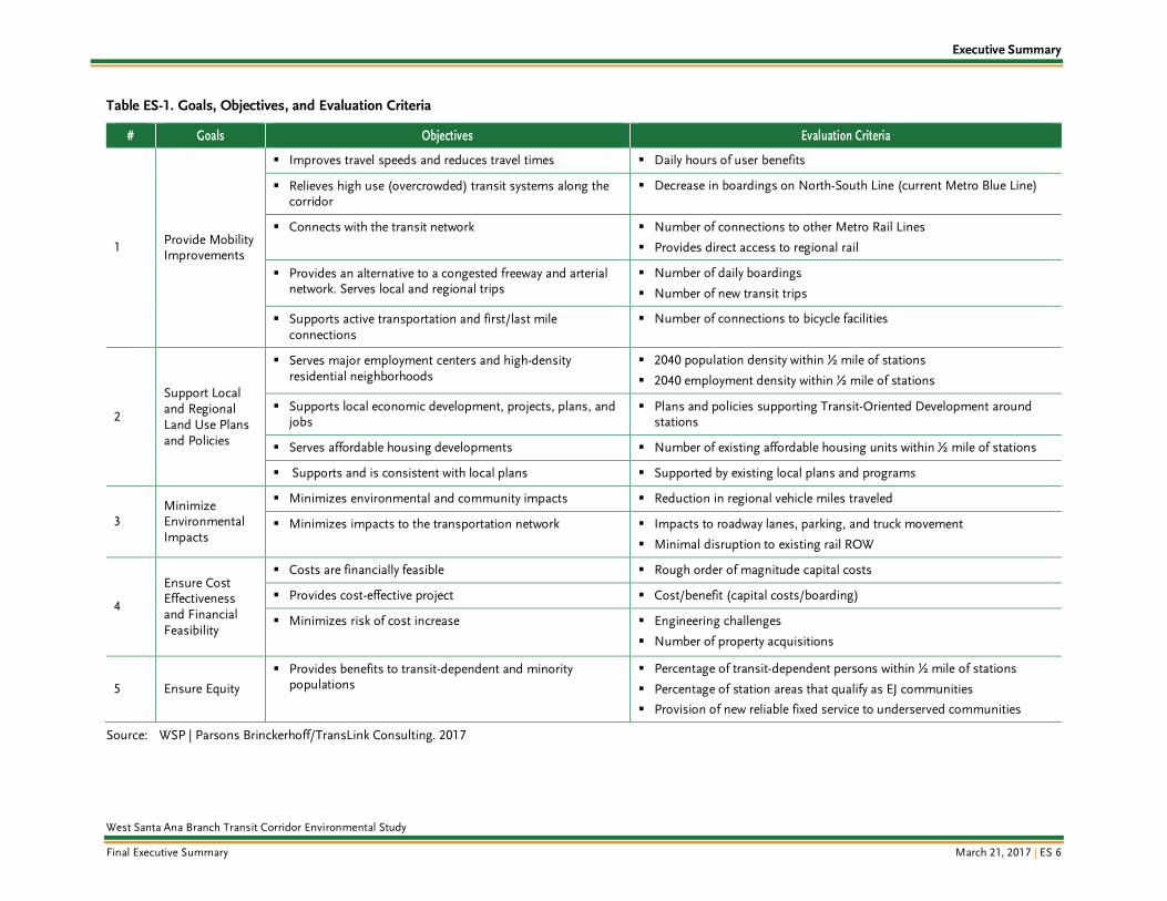
ES.3 Goals, Objectives, and Evaluation Criteria
Based on the purpose and need statement, a set of goals and objectives were established to guide development of the Project. During the development of the AA Study, goals and objectives were identified through a 24-month period of public meetings and work sessions with elected officials, stakeholders, advisory committee members, and communities. In 2015, as part of the TRS Report, goals of the project were further confirmed through technical meetings with key stakeholders, including Eco-Rapid Transit, corridor cities, and the California Department of Transportation.
The development and evaluation of the Project alternatives generally followed a six-step process. Figure ES-2 presents a flow chart of the evaluation process for the Project. Table ES-1 provides a list of the evaluation criteria established for each goal and set of objectives.
Figure ES-2. Evaluation Process
Update Purpose and
Need
Refine Goals and Objectives/
Develop Screening
Methodology
Define Alignment Options
Evaluate Alignment Options
Present Recom-
mendations to Metro Board
Initiate Environmental
Scoping
Stakeholder and Agency Participation
Executive Summary
West Santa Ana Branch Transit Corridor Environmental Study
Final Executive Summary March 21, 2017 | ES 6
Table ES-1. Goals, Objectives, and Evaluation Criteria
# Goals Objectives Evaluation Criteria
1 Provide Mobility Improvements
Improves travel speeds and reduces travel times Daily hours of user benefits
Relieves high use (overcrowded) transit systems along the corridor
Decrease in boardings on North-South Line (current Metro Blue Line)
Connects with the transit network Number of connections to other Metro Rail Lines
Provides direct access to regional rail
Provides an alternative to a congested freeway and arterial network. Serves local and regional trips
Number of daily boardings
Number of new transit trips
Supports active transportation and first/last mile connections
Number of connections to bicycle facilities
2
Support Local and Regional Land Use Plans and Policies
Serves major employment centers and high-density residential neighborhoods
2040 population density within ½ mile of stations
2040 employment density within ½ mile of stations
Supports local economic development, projects, plans, and jobs
Plans and policies supporting Transit-Oriented Development around stations
Serves affordable housing developments Number of existing affordable housing units within ½ mile of stations
Supports and is consistent with local plans Supported by existing local plans and programs
3 Minimize Environmental Impacts
Minimizes environmental and community impacts Reduction in regional vehicle miles traveled
Minimizes impacts to the transportation network Impacts to roadway lanes, parking, and truck movement
Minimal disruption to existing rail ROW
4
Ensure Cost Effectiveness and Financial Feasibility
Costs are financially feasible Rough order of magnitude capital costs
Provides cost-effective project Cost/benefit (capital costs/boarding)
Minimizes risk of cost increase Engineering challenges
Number of property acquisitions
5 Ensure Equity
Provides benefits to transit-dependent and minority populations
Percentage of transit-dependent persons within ½ mile of stations
Percentage of station areas that qualify as EJ communities
Provision of new reliable fixed service to underserved communities
Source: WSP | Parsons Brinckerhoff/TransLink Consulting. 2017

Executive Summary
West Santa Ana Branch Transit Corridor Environmental Study
Final Executive Summary March 21, 2017 | ES 7
ES.4 Northern Alignment Options
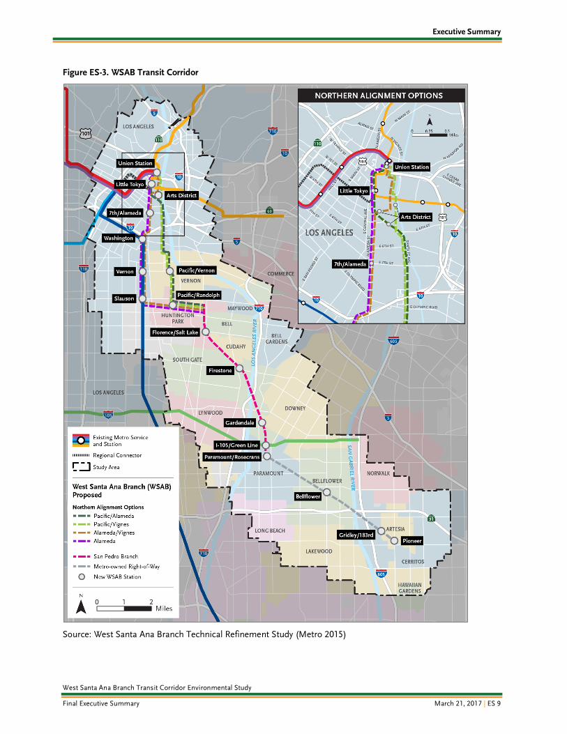
The Project would provide light rail service for approximately 20 miles from downtown Los Angeles to the City of Artesia (Figure ES-3). The Project would be primarily at-grade with grade-separated (i.e., aerial or underground) portions in areas of constraint. Six alignment options for the northern portion of the Project (Union Station to the Florence/Salt Lake Station1) were identified through the initial alternative development documented in the AA Study and further studied in the TRS. These six northern alignment options are summarized in Table ES-2 and described as follows:
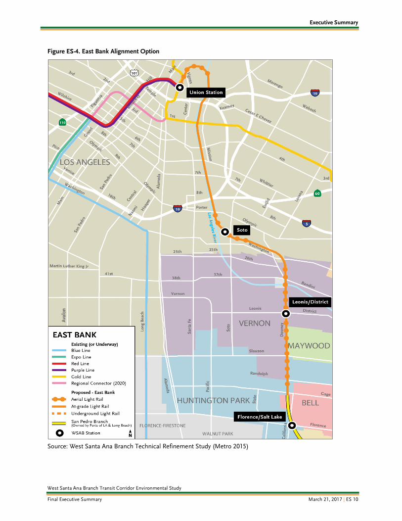
East Bank: Extends approximately 7.7 miles between Union Station and the Florence/Salt Lake Station along the east side of the LA River (Figure ES-4). This alignment option would provide three stations north of Florence/Salt Lake: Union Station, Soto, and Leonis/District. The East Bank alignment option was originally developed as part of the AA Study.
West Bank 3: Extends approximately 6.9 miles between the Little Tokyo Station and the Florence/Salt Lake Station along the west side of the LA River (Figure ES-5). This alignment option would provide four stations north of Florence/Salt Lake: Little Tokyo, 7th/Alameda, Pacific/Vernon, and Pacific/Randolph. The West Bank 3 alignment option was originally developed as part of the AA Study.
Pacific/Alameda: Extends approximately 7.4 miles between Union Station and Florence/Salt Lake Station (Figure ES-6). This alignment option uses Alameda Street, Santa Fe Avenue, and Pacific Boulevard and would provide five stations north of Florence/Salt Lake: Union Station, Little Tokyo, Arts District, Pacific/Vernon, and Pacific/Randolph. The Pacific/Alameda alignment option was developed during the TRS as a variation of the West Bank 3 alignment option but with a direct connection to Union Station on the north.
Pacific/Vignes: Extends approximately 7.2 miles between Union Station and the Florence/Salt Lake Station (Figure ES-7). This alignment option uses Vignes Street, Santa Fe Avenue, and Pacific Boulevard and would provide four stations north of Florence/Salt Lake: Union Station, Arts District, Pacific/Vernon, and Pacific/Randolph. The Pacific/Vignes alignment option was developed during the TRS as a variation of the West Bank 3 alignment option but with a direct connection to Union Station on the north.
Alameda: Extends approximately 8.0 miles between Union Station and the Florence/Salt Lake Station along Alameda Street and the Metro Blue Line ROW (Figure ES-8). This alignment option would provide seven stations north of Florence/Salt Lake: Union Station, Little Tokyo, 7th/Alameda, Washington, Vernon, Slauson, and Pacific/Randolph. This alignment option was developed during the TRS.
Alameda/Vignes: Extends approximately 8.1 miles between Union Station and the Florence/Salt Lake Station along Vignes Street, Alameda Street, and Metro Blue Line ROW (Figure ES-9). This alignment option would provide seven stations north of the Florence/Salt Lake Station: Union Station, Arts District, 7th/Alameda, Washington, Vernon, Slauson, and Pacific/Randolph. This alignment option was developed during the TRS.
South of the Florence/Salt Lake Station, all six northern alignment options converge and follow a single alternative 11 miles from the City of Huntington Park to the City of Artesia (Figure ES-3). The alternative would use the San Pedro Subdivision Branch, owned by the Ports of Long Beach and Los
1 The TRS recommended shifting the Florence/Gage Station identified in the SCAG AA Study south to the Florence/Salt Lake intersection.
Executive Summary
West Santa Ana Branch Transit Corridor Environmental Study
Final Executive Summary March 21, 2017 | ES 8
Angeles. Along this portion, three stations are proposed at Firestone Boulevard, Gardendale Street, and I-105/Metro Green Line. The I-105/Metro Green Line Station would provide transfers and connections between the Project and the Metro Green Line2. South of the I-105/Metro Green Line Station, the alternative would transition to the Metro owned PEROW. Along this southern portion, four stations are proposed at Paramount/Rosecrans, Bellflower, Gridley/183rd, and Pioneer3.
Table ES-2. Characteristics of the Northern Alignment Options
Alignment Option
Length
(Northern Terminus to Florence/Salt Lake
Station)
Preliminary Proposed Configuration
(Northern Terminus to Florence/Salt Lake Station)
# of Proposed Stations (Northern Terminus to
Florence/Salt Lake Station)
East Bank 7.7 miles 3.7 miles aerial; 4.0 miles at-grade 3
West Bank 3 6.9 miles 1.9 miles aerial; 3.3 miles at-grade; 1.7
miles underground 4
Pacific/Alameda 7.4 miles 2.7 miles aerial; 3.3 miles at-grade; 1.4
miles underground 5
Pacific/Vignes 7.2 miles 2.4 miles aerial; 3.2 miles at-grade; 1.6
miles underground 4
Alameda 8.0 miles 6.0 miles aerial; 2.0 miles at-grade 7
Alameda/Vignes 8.1 miles 5.5 miles aerial; 1.9 miles at-grade; 0.7
miles underground 7
Source: TRS Report, 2015
2 Building from the SCAG AA Study, the feasibility of the I-105/Metro Green Line Station was assessed during the TRS, which concluded that siting a station in the I-105 median was feasible and recommended. 3 The TRS analyzed the potential new terminus at the Pioneer Station in the City of Artesia in lieu of the Bloomfield Station in the City of Cerritos, which was part of the SCAG AA Study. The TRS concluded that the Pioneer Station terminus is feasible and recommended.
Executive Summary
West Santa Ana Branch Transit Corridor Environmental Study
Final Executive Summary March 21, 2017 | ES 9
Figure ES-3. WSAB Transit Corridor
Source: West Santa Ana Branch Technical Refinement Study (Metro 2015)
Executive Summary
West Santa Ana Branch Transit Corridor Environmental Study
Final Executive Summary March 21, 2017 | ES 10
Figure ES-4. East Bank Alignment Option
Source: West Santa Ana Branch Technical Refinement Study (Metro 2015)

Executive Summary
West Santa Ana Branch Transit Corridor Environmental Study
Final Executive Summary March 21, 2017 | ES 11
Figure ES-5. West Bank 3 Alignment Option
Source: West Santa Ana Branch Technical Refinement Study (Metro 2015)

Executive Summary
West Santa Ana Branch Transit Corridor Environmental Study
Final Executive Summary March 21, 2017 | ES 12
Figure ES-6. Pacific/Alameda Alignment Option
Source: West Santa Ana Branch Technical Refinement Study (Metro 2015)

Executive Summary
West Santa Ana Branch Transit Corridor Environmental Study
Final Executive Summary March 21, 2017 | ES 13
Figure ES-7. Pacific/Vignes Alignment Option
Source: West Santa Ana Branch Technical Refinement Study (Metro 2015)

Executive Summary
West Santa Ana Branch Transit Corridor Environmental Study
Final Executive Summary March 21, 2017 | ES 14
Figure ES-8. Alameda Alignment Option
Source: West Santa Ana Branch Technical Refinement Study (Metro 2015)

Executive Summary
West Santa Ana Branch Transit Corridor Environmental Study
Final Executive Summary March 21, 2017 | ES 15
Figure ES-9. Alameda/Vignes Alignment Option
Source: West Santa Ana Branch Technical Refinement Study (Metro 2015)
Executive Summary
West Santa Ana Branch Transit Corridor Environmental Study
Final Executive Summary March 21, 2017 | ES 16
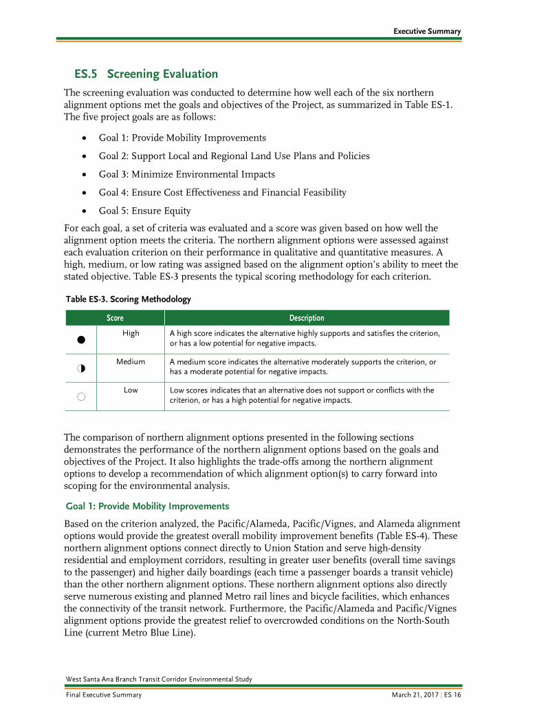
ES.5 Screening Evaluation
The screening evaluation was conducted to determine how well each of the six northern alignment options met the goals and objectives of the Project, as summarized in Table ES-1. The five project goals are as follows:
Goal 1: Provide Mobility Improvements
Goal 2: Support Local and Regional Land Use Plans and Policies
Goal 3: Minimize Environmental Impacts
Goal 4: Ensure Cost Effectiveness and Financial Feasibility
Goal 5: Ensure Equity
For each goal, a set of criteria was evaluated and a score was given based on how well the alignment option meets the criteria. The northern alignment options were assessed against each evaluation criterion on their performance in qualitative and quantitative measures. A high, medium, or low rating was assigned based on the alignment option’s ability to meet the stated objective. Table ES-3 presents the typical scoring methodology for each criterion.
Table ES-3. Scoring Methodology
Score Description
4 High
A high score indicates the alternative highly supports and satisfies the criterion, or has a low potential for negative impacts.
2 Medium
A medium score indicates the alternative moderately supports the criterion, or has a moderate potential for negative impacts.
0 Low
Low scores indicates that an alternative does not support or conflicts with the criterion, or has a high potential for negative impacts.
The comparison of northern alignment options presented in the following sections demonstrates the performance of the northern alignment options based on the goals and objectives of the Project. It also highlights the trade-offs among the northern alignment options to develop a recommendation of which alignment option(s) to carry forward into scoping for the environmental analysis.
Goal 1: Provide Mobility Improvements
Based on the criterion analyzed, the Pacific/Alameda, Pacific/Vignes, and Alameda alignment options would provide the greatest overall mobility improvement benefits (Table ES-4). These northern alignment options connect directly to Union Station and serve high-density residential and employment corridors, resulting in greater user benefits (overall time savings to the passenger) and higher daily boardings (each time a passenger boards a transit vehicle) than the other northern alignment options. These northern alignment options also directly serve numerous existing and planned Metro rail lines and bicycle facilities, which enhances the connectivity of the transit network. Furthermore, the Pacific/Alameda and Pacific/Vignes alignment options provide the greatest relief to overcrowded conditions on the North-South Line (current Metro Blue Line).

Executive Summary
West Santa Ana Branch Transit Corridor Environmental Study
Final Executive Summary March 21, 2017 | ES 17
The East Bank and Alameda/Vignes alignment options provide overall average mobility improvements. The West Bank 3 alignment option would provide the fewest mobility improvement benefits primarily because this alignment option does not have a direct connection to the regional mobility hub of Union Station. By terminating at Little Tokyo instead of Union Station, this alignment option provides little relief to the overcrowded North-South Line and results in the least amount of user benefits and daily boardings.
Table ES-4. Goal 1: Provide Mobility Improvements
Evaluation Criteria
Northern Alignment Options
East Bank West Bank 3 Pacific/
Alameda Pacific/ Vignes Alameda
Alameda/ Vignes
Estimated daily hours of user benefits
4
17,240 hours
0
14,320 hours
4
18,580 hours
4
17,000 hours
2
15,380 hours
0
14,770 hours
Decrease in boardings on North-South Line (current Metro Blue Line)
2
5% to 9% relief
0
Less than 5% relief
4
Higher than 10% relief
4
Higher than 10% relief
2
5% to 9% relief
2
5% to 9% relief
Number of connections to other Metro Rail Lines
2
3 connections
2
2 connections
4
4 connections
2
3 connections
4
4 connections
4
4 connections
Provides direct access to regional rail
4
Yes
0
No
4
Yes
4
Yes
4
Yes
4
Yes
Number of daily boardings
2
50,760 daily boardings
0
43,390 daily boardings
2
59,660 daily boardings
2
52,550 daily boardings
4
75,310 daily boardings
2
61,770 daily boardings
Number of new transit trips
4
16,560 new trips
0
13,450 new trips
4
17,480 new trips
4
16,150 new trips
2
14,640 new trips
2
14,250 new trips
Number of connections to bicycle facilities
0
5 connections
0
3 connections
2
6 connections
0
3 connections
4
10 connections
2
7 connections
Overall Rankings and Scores
Medium
4.5
Low
0.5
High
6.0
High
5.0
High
5.5
Medium
4.0

Executive Summary
West Santa Ana Branch Transit Corridor Environmental Study
Final Executive Summary March 21, 2017 | ES 18
Goal 2: Support Local and Regional Land Use Plans and Policies
Overall, the Pacific/Alameda, Pacific/Vignes, Alameda, and Alameda/Vignes alignment options provide the greatest compatibility with existing and planned land uses (Table ES-5). The West Bank 3, Pacific/Alameda, and Pacific/Vignes alignment options serve a corridor with high employment density through the City of Vernon, while the Alameda and Alameda/Vignes alignment options would operate along a densely populated corridor bordering southeast Los Angeles. The northern alignment options with stations that serve the core of downtown Los Angeles (Union Station and Little Tokyo) have higher average population and employment densities than the northern alignment options that do not.
These downtown station areas, along with the Arts District Station, are also areas primed for future transit-oriented development (TOD) with policies already in place to encourage mixed-use, high-density development. The proposed stations along the Alameda and Alameda/Vignes alignment options overlap with the existing Metro Blue Line stations, which also have TOD plans and policies already in place to encourage transit-friendly development. The northern alignment options along Pacific Boulevard provide little opportunity for future TOD due to the industrial nature of the corridor. Likewise, the East Bank alignment option passes through primarily industrial areas with limited TOD plans and policies in place. While the West Bank 3 alignment option is similar to the Pacific/Alameda alignment option, it does not connect to Union Station, which is a major planned TOD center. Most of the existing affordable housing units are concentrated along the Alameda and Alameda/Vignes alignment options, as well as in downtown Los Angeles, with an especially high number within a half-mile of the Little Tokyo Station. The northern alignment options that serve more industrial areas have fewer affordable housing units around the station areas.
All of the northern alignment options meet the goals and objectives set forth in adopted plans and polices of the local jurisdictions. However, due to the lack of connection into Union Station or the Metro Blue Line, West Bank 3 only meets the goals set forth in the City of Vernon General Plan.

Executive Summary
West Santa Ana Branch Transit Corridor Environmental Study
Final Executive Summary March 21, 2017 | ES 19
Table ES-5. Goal 2: Support Local and Regional Land Use Plans and Policies
Evaluation Criteria
Northern Alignment Option
East Bank West Bank 3 Pacific/
Alameda Pacific/ Vignes Alameda
Alameda/ Vignes
2040 population densities within ½ mile of stations
2
10,580 persons/
square mile
0
8,880 persons/
square mile
4
13,570 persons/
square mile
2
12,310 persons/
square mile
4
14,140 persons/
square mile
4
13,400 persons/
square mile
2040 employment densities within ½ mile of stations
2
14,970 jobs/
square mile
2
14,830 jobs/ square mile
4
15,250 jobs/ square mile
4
15,370 jobs/ square mile
0
13,800 jobs/ square mile
0
13,280 jobs/ square mile
Plans and policies supporting TOD around stations
0
Stations located in primarily industrial
station areas
2
One downtown LA station, and stations in
commercial and industrial
areas
4
Three downtown
LA stations, and stations
in commercial
and industrial
areas
4
Two downtown
LA stations, and stations
in commercial
and industrial
areas
4
Three downtown LA stations
and adopted TOD station areas along the Metro Blue Line
4
Three downtown LA stations
and adopted TOD station areas along the Metro Blue Line
Number of existing affordable housing units within ½ mile of stations
0
954 affordable housing
units
2
1,713 affordable
housing units
4
2,107 affordable housing
units
2
1,659 affordable housing
units
4
2,825 affordable housing
units
4
2,798 affordable housing
units
Supported by existing local plans and programs
4
Effectively meets local
plans
2
Moderately meets local
plans
4
Effectively meets local
plans
4
Effectively meets local
plans
4
Effectively meets local
plans
4
Effectively meets local
plans
Overall Rankings and Scores
Low
2.0
Low
2.0
High
5.0
High
4.0
High
4.0
High
4.0

Executive Summary
West Santa Ana Branch Transit Corridor Environmental Study
Final Executive Summary March 21, 2017 | ES 20
Goal 3: Minimize Environmental Impacts
The Pacific/Alameda alignment option provides the greatest overall potential to minimize environmental impacts during both construction and operations (Table ES-6). The Pacific/Alameda, Pacific/Vignes, and East Bank alignment options result in the largest reduction in vehicle miles traveled during operation, resulting in improved air quality and other associated health and environmental benefits. With the exception of the East Bank alignment option, all northern alignment options may result in some impacts to the roadway network by either requiring the removal of parking or traffic lanes. These impacts are most likely to occur where the alignment is aerial or transitioning from aerial to underground. While the East Bank alignment option would not affect the roadway network, over a third of the alignment would overlap with active freight routes, which would potentially disrupt service.
Table ES-6. Goal 3: Minimize Environmental Impacts during Construction and Operation
Evaluation Criteria
Northern Alignment Options
East Bank West Bank 3 Pacific/
Alameda Pacific/ Vignes Alameda
Alameda/ Vignes
Reduction in vehicle miles traveled (VMT)
4
289,960 VMT reduced
0
162,510 VMT
reduced
4
312,150 VMT
reduced
4
283,710 VMT
reduced
2
214,930 VMT
reduced
2
216,820 VMT
reduced
Impacts to roadway lanes, parking, and truck movement
4
No removal of parking or traffic lanes and minimal impacts to
truck movement
2
Minimal removal of parking or
traffic lanes and minimal impacts to
truck movement
2
Minimal removal of parking or
traffic lanes and minimal impacts to
truck movement
0
Moderate removal of parking or
traffic lanes and minimal impacts to
truck movement
2
Minimal removal of parking or
traffic lanes and minimal impacts to
truck movement
2
Minimal removal of parking or
traffic lanes and minimal impacts to
truck movement
Minimal disruption to existing rail ROW (% of miles overlap with existing rail ROW)
0
38%
4
11%
4
11%
4
11%
2
25%
2
25%
Overall Rankings and Scores
Medium
2.0
Low
1.5
High
2.5
Medium
2.0
Low
1.5
Low
1.5

Executive Summary
West Santa Ana Branch Transit Corridor Environmental Study
Final Executive Summary March 21, 2017 | ES 21
Goal 4: Ensure Cost Effectiveness and Financial Feasibility
Overall, the Alameda alignment option would be the most cost-effective and poses the smallest risk to cost with the fewest engineering challenges (Table ES-7). In part, this is due to the aerial and at-grade configurations, which reduce costs when compared to the costs for an underground alignment. The East Bank alignment option presents the greatest engineering challenges with the need to address crossing existing LA River bridges, ROW constraints from adjacent established properties and utilities, and securing third-party agreements with Union Pacific Railroad and Metrolink to share the ROW. These engineering challenges result in significant risks, which could decrease the cost-effectiveness of this alignment option even further. In addition, when comparing the northern alignment options that require tunneling, the West Bank 3 alignment option has the highest risk due to the longest length of tunneling required.
Table ES-7. Goal 4: Ensure Cost Effectiveness and Financial Feasibility
Evaluation Criteria
Northern Alignment Option
East Bank West Bank 3 Pacific/
Alameda Pacific/ Vignes Alameda
Alameda/ Vignes
Capital cost (rough order of magnitude in millions $2015)
2
$3,796.3 4
2
$4,315.5
2
$4,420.5
2
$4,416.2
2
$4,309.4
0
$4,624.4
Cost/benefit (capital costs per boarding)
2
$75
0
$99
2
$74
2
$84
4
$59
2
$75
Engineering challenges
0
Extensive potential
conflicts with infrastructure and requires
numerous third-party approvals
2
Risk associated
with tunneling
2
Risk associated
with tunneling
2
Risk associated
with tunneling
4
Minimal risk as entirely aerial or at-
grade
4
Minimal risk associated
with shortest tunneling segment
Number of property acquisitions (initial estimate)
0
Significant ROW
constraints
4
Sufficient ROW
2
Limited ROW
2
Limited ROW
4
Sufficient ROW
4
Sufficient ROW
Overall Rankings and Scores
Low
1.0
Medium
2.0
Medium
2.0
Medium
2.0
High
3.5
Medium
2.5
4 ROW costs were not factored during the TRS Capital Cost estimates. The substantial length of the East Bank alignment requires obtaining easements or purchasing the ROW.

Executive Summary
West Santa Ana Branch Transit Corridor Environmental Study
Final Executive Summary March 21, 2017 | ES 22
Goal 5: Ensure Equity
All of the northern alignment options meet the goal of ensuring equity in the provision of new transit service by serving highly transit-dependent and EJ communities. The proportion of transit-dependent households is slightly higher along the Alameda and Alameda/Vignes alignment options because of the corridor’s proximity to southeast Los Angeles. However, these communities are already served by the Metro Blue Line; therefore, the Alameda and Alameda/Vignes alignment options would not provide new service to an underserved community. All station areas surpass the LA County averages of 17 percent of people living below poverty and 57 percent of the population being minorities and therefore would be considered EJ communities.
Table ES-8. Goal 5: Ensures Equity
Evaluation Criteria
Northern Alignment Options
East Bank West Bank 3 Pacific/
Alameda Pacific/ Vignes Alameda
Alameda/ Vignes
Percentage of transit-dependent persons within ½ mile of stations
2
15% to 19%
2
15% to 19%
2
15% to 19%
2
15% to 19%
4
Over 20%
4
Over 20%
Percentage of station areas that qualify as EJ communities
4
100% of station areas
4
100% of station areas
4
100% of station areas
4
100% of station areas
4
100% of station areas
4
100% of station areas
Provision of new reliable fixed service to underserved communities
4
New service
4
New service
4
New service
4
New service
2
Overlaps with existing Metro Blue Line and existing
Metro Gold Line Little
Tokyo Station
4
Overlaps with existing Metro Blue Line and provides new Arts District Station
Overall Rankings and Scores
High
2.5
High
2.5
High
2.5
High
2.5
High
2.5
High
3.0

Executive Summary
West Santa Ana Branch Transit Corridor Environmental Study
Final Executive Summary March 21, 2017 | ES 23
ES.6 Summary and Recommendations
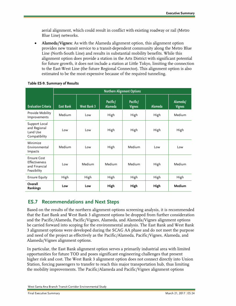
Each of the northern alignment options provides a unique set of benefits that must be considered against the potential costs and challenges. Table ES-9 presents the results for each alignment option considered, and the following bullets summarize the key findings for each alignment option:
East Bank: Because of its direct connection into Union Station, the East Bank alignment option provides substantial mobility benefits; however, the stations along this alignment serve predominantly industrial areas with lower population and employment densities and limited opportunities for future TOD. Most importantly, this alignment option presents significant engineering challenges because of the constrained ROW from adjacent established properties and utilities, conflicts with existing infrastructure (such as LA River bridges), and requires securing third-party agreements with rail agencies. Combined, these are likely to result in higher costs.
West Bank 3: This alignment option provides limited mobility benefits because of its northern terminus in Little Tokyo instead of Union Station. The lack of connection to Union Station also limits TOD opportunities and connections to a major population and employment center. Furthermore, while the benefits of West Bank 3 are substantially lower than the other northern alignment options, the associated costs and engineering challenges are not significantly lower and thus do not offset the lack of connection into Union Station.
Pacific/Alameda: By serving both an Arts District and a Little Tokyo Station, this alignment option provides significant mobility benefits, presents numerous TOD opportunities, and meets the needs of the local communities and stakeholders. By serving Pacific Boulevard, this alignment option introduces new transit service to a currently underserved area while also providing congestion relief along the Metro Blue Line (North-South Line). However, by serving Santa Fe Avenue and Pacific Boulevard, this alignment option provides service to a primarily industrial area rather than enhancing transit service along the Metro Blue Line, which is heavily residential and presents promising TOD opportunities in the future.
Pacific/Vignes: The Pacific/Vignes alignment option provides many of the same benefits as the Pacific/Alameda alignment option. However, by not connecting to the Little Tokyo Station, this alignment option misses a key connection to the East-West Line (the future Regional Connector) thereby limiting mobility benefits and a heavily populated area with numerous TOD opportunities. Furthermore, the estimated capital cost is not significantly lower than the Pacific/Alameda alignment option, but the benefits are lower.
Alameda: The Alameda alignment option provides connections to the Union Station, Little Tokyo, and Metro Blue Line (North-South Line), resulting in significant mobility benefits. By following the Metro Blue Line, this alignment option serves low-income and densely populated areas that would benefit from additional transit service and helps to address overcrowding on the Metro Blue Line. By avoiding tunneling, this alignment option is also estimated to be one of the lower cost options. However, this alignment option does not minimize environmental impacts as effectively as other alignment options because of a moderate reduction in VMT and an exclusively
Executive Summary
West Santa Ana Branch Transit Corridor Environmental Study
Final Executive Summary March 21, 2017 | ES 24
aerial alignment, which could result in conflict with existing roadway or rail (Metro Blue Line) networks.
Alameda/Vignes: As with the Alameda alignment option, this alignment option provides new transit service to a transit-dependent community along the Metro Blue Line (North-South Line) and results in substantial mobility benefits. While this alignment option does provide a station in the Arts District with significant potential for future growth, it does not include a station at Little Tokyo, limiting the connection to the East-West Line (the future Regional Connector). This alignment option is also estimated to be the most expensive because of the required tunneling.
Table ES-9. Summary of Results
Evaluation Criteria
Northern Alignment Options
East Bank West Bank 3 Pacific/
Alameda Pacific/ Vignes Alameda
Alameda/ Vignes
Provide Mobility Improvements
Medium Low High High High Medium
Support Local and Regional Land Use Compatibility
Low Low High High High High
Minimize Environmental Impacts
Medium Low High Medium Low Low
Ensure Cost Effectiveness and Financial Feasibility
Low Medium Medium Medium High Medium
Ensure Equity High High High High High High
Overall Rankings
Low Low High High High Medium
ES.7 Recommendations and Next Steps
Based on the results of the northern alignment options screening analysis, it is recommended that the East Bank and West Bank 3 alignment options be dropped from further consideration and the Pacific/Alameda, Pacific/Vignes, Alameda, and Alameda/Vignes alignment options be carried forward into scoping for the environmental analysis. The East Bank and West Bank 3 alignment options were developed during the SCAG AA phase and do not meet the purpose and need of the project as effectively as the Pacific/Alameda, Pacific/Vignes, Alameda, and Alameda/Vignes alignment options.
In particular, the East Bank alignment option serves a primarily industrial area with limited opportunities for future TOD and poses significant engineering challenges that present higher risk and cost. The West Bank 3 alignment option does not connect directly into Union Station, forcing passengers to transfer to reach this major transportation hub, thus limiting the mobility improvements. The Pacific/Alameda and Pacific/Vignes alignment options

Executive Summary
West Santa Ana Branch Transit Corridor Environmental Study
Final Executive Summary March 21, 2017 | ES 25
follow the general alignment of the West Bank 3, but provide the valuable direct connection to Union Station.
By providing a direct connection into Union Station, the Pacific/Alameda, Pacific/Vignes, Alameda, and Alameda/Vignes alignment options provide a reliable transit service that connects southeastern LA County to the regional transportation network. The Pacific/ Alameda, Pacific/Vignes, Alameda, and Alameda/Vignes alignment options increase mobility and connectivity for historically underserved transit-dependent and EJ communities; reduce travel times on local and regional transportation networks; and accommodate substantial future population and employment growth. Therefore, it is recommended that the Pacific/ Alameda, Pacific/Vignes, Alameda, and Alameda/Vignes alignment options be carried into scoping for the environmental analysis.