west central british columbia - related information · xxx. biotite-hornblende quartz diorite,...
TRANSCRIPT

Geology and Mineral Deposits of the Tahtsa Lake District West Central British Columbia
By Don C. Maclntyre
Ministry of Energy, Mines and Petroleum Resources
Hon. Stephen Rogers, Minister
1985
Bulletin 75

Canadian Cataloguing in Publication Data Maclntyre, Donald George, 1949-
District, west central British Columbia Geology and mineral deposits of the Tahtsa Lake
(Bulletin, ISSN 0226-7497 ; 75)
Bibliography: p. ISBN 0-7718-8491-5
1. Geology - British Columbia - Tahtsa Lake Region. 2. Geology, Economic - British Columbia - Tahtsa Lake Region. 3. Mines and mineral resources - British Columbia - Tahtsa Lake Region. I. British Columbia. Ministry of Energy, Mines and Petroleum Resources. 11. Title. 111. Series: Bulletin (British Columbia. Ministry of Energy, Mines and Petroleum Resources) ; 75.
Ql3187.M33 1985 557.11'2 c85-092209-7
GEOLOGY AND MINERAL DEPOSITS OF THE TAHTSA LAKE DISTRICT,
By Don G. Maclntyre WEST-CENTRAL BRITISH COLUMBIA
TABLE OF CONTENTS
TABLE OF CONTENTS-Continued
Page
CHAPTER 3-GEOCHEMISTRY . . . . . . . . . . . . . . . . . . . . . . . . . . . . . . . . . . . . . . . . . . . . . . . . . . . . . . . . . . . . . . . . . . . . . . . . . . . . . . . . . . . . . . . . . . . . . . . . . . . . . . . . . . . . . . . . . . . . . . . . . . . . . . . . 43 Kasalka Group . . . . . . . . . . . . . . . . . . . . . . . . . . . . . . . . . . . . . . . . . . . . . . . . . . . . . . . . . . . . . . . . . . . . . . . . . . . . . . . . . . . . . . . . . . . . . . . . . . . . . . . . . . . . . . . . . . . . . . . . . . . . . . . . . . . . . . . . . . . . . . . . . . . . . . . . . . . . . . . . . . . . . . 43
Bulkley Intrusions 46 Kasalka Intrusions 46
Rhyolitic Intrusions ........................................................................................................................................................... 47 Mount Bolom Intrusion ................................................................................................................................................. 47 Comparison of Late Cretaceous and Tertiary Plutonic Rocks ............................................... 48
............................................................................................................................................................
..............................................................................................................................................................
CHAPTER 5-INTERPRETATION . . . . . . . . . . . . . . . . . . . . . . . . . . . . . . . . . . . . . . . . . . . . . . . . . . . . . . . . . . . . . . . . . . . . . . . . . . . . . . . . . . . . . . . . . . . . . . . . . . . . . . . . . . . . . . . . . . . . . . . . . . . . . 71 Tahtsa Lake Cauldron Subsidence Complex ......................................................................................... 71 Timing of Igneous and Hydrothermal Events ......................................................................................... 72 Genetic Model ....................................................................................................................................................................... 75 Summary . . . . . . . . . . . . . . . . . . . . . . . . . . . . . . . . . . . . . . . . . . . . . . . . . . . . . . . . . . . . . . . . . . . . . . . . . . . . . . . . . . . . . . . . . . . . . . . . . . . . . . . . . . . . . . . . . . . . . . . . . . . . . . . . . . . . . . . . . . . . . . . . . . . . . . . . . . . . . . . . . . . . . . . . . . . . . . . . . . . 75
APPENDIX A-FOSSIL IDENTIFICATIONS ................................................................................................... 77
APPENDIX 6-KASALKA GROUP TYPE SECTIONS . . . . . . . . . . . . . . . . . . . . . . . . . . . . . . . . . . . . . . . . . . . . . . . . . . . . . . . . . . . . . . . . . . . . . . . 78
APPENDIX C-WHOLE ROCK ANALYTICAL DATA ............................................................................ 80
TABLES 1 . Table of formations. Tahtsa Lake district ...................................................................................................... 8 2 . Modal analyses, plutonic rocks .. . . . . . . . . . . . . . . . . . . . . . . . . . . . . . . . . . . . . . . . . . . . . . . . . . . . . . . . . . . . . . . . . . . . . . . . . . . . . . . . . . . . . . . . . . . . . . . . . . . . . . . . . . . . . . . . . . . . . . . . . . . 16 3 . Potassium-argon age dates, Tahtsa Lake district .............................................................................. 25 4 . Mineral occurrences, Tahtsa Lake district .................................................................................................. 52 5 . Plutonic-hydrothermal relationships, Tahtsa Lake district . . . . . . . . . . . . . . . . . . . . . . . . . . . . . . . . . . . . . . . . . . . . . . . . . . . . . . . . . . 73
iv

TABLE OF CONTENTS-Continued

TABLE OF CONTENTS-Continued
Plates I
VI. Poorly sorted boulder conglomerate that apparently underlies amyg- daloidal basalt flows at base of Skeena Group ..............................................................
VII. Typical sample of amygdaloidal basalt with trachytic texture, amygdaloidal basalt unit, Skeena Group (black amygdule filled with chlorite; white amygdule filled with zeolite) . . . . . . . . . . . . . . . . . . . . . . . . . . . . . . . . . . . . . . . . . . . . . . . . . . . . . . . . . . . . . . . . . . . . . . . . . . . . . . . . . . . . . . . . . . . . . . . . . . . . . . . . . . . . . .
VIII. Flaser-bedded silty mudstone with dewatering structures, marine sedi-
IX. Red poorly sorted polymictic pebble conglomerate, basal unit, Kasalka mentary unit, Skeena Group
Group X. Felsic lapilli tuff with white crystal fragments in matrix, felsic fragmental
XI. Partly welded ash flow tuff, felsic fragmental unit, Kasalka Group unit, Kasalka Group
XII. Typical coarse-grained porphyritic hornblende-augite andesite, por-
XIII. Typical exposure of crudely stratified lahar, lahar unit, Kasalka Group XIV. Bedding surface of very coarse bed within lahar unit, showing size of
XV. Typical sample of lahar with subangular to rounded clasts of porphyritic porphyrltlc andesite boulders
andesite in muddy crystal rich matrix ...................................................................................... XVI. View west toward Mt. Ney showing contact between amygdaloidal basalt
(IKv) and marine sedimentary rocks of Skeena Group and overlying porphyritic andesite (uKp), lahar (uKI), and rhyolite (uKr) of the Kasalka Group (location of following plate indicated by "x") .....................................................
XVII. Columnar jointedporphyritic andesite flow (uKp) and lahar (uKI) of
of the Skeena Group (IKs). Sequence is cut by late feldspar porphyry Kasalka Group unconformably overlying marine sedimentary rocks
dyke (fp) ................................................................................................................................................................ XVIII. View of south slope of Swing Peak, showing contact between lahar unit
and overlying basalt unit, Kasalka Group ..............................................................................
XIX. View of Rhine Crag, a prominent volcanic neck of porphyritic hornblende-
XX. Tuff-breccia pipe cutting lahar unit on Swing Peak ridge (note angular
XXI. Typical sample of fine-grained porphyritic hornblende-augite andesite or nature of porphyritic andesite clasts)
XXII. Intrusive dacite or quartz porphyry, Coles Creek microdiorite, Kasalka Intrusions
XXIII. Contact between quartz porphyry and granodiorite, Whiting Creek; black band is magnetite (note late pyrite veinlet cutting across contact) .............
XXV Biotite-orthoclase-altered porphyritic hornblende-biotite granodiorite with quartz-pyrite vein stockwork, Coles Creek .. . . . . . . . . . . . . . . . . . . . . . . . . . . . . . . . . . . . . . . . . . . . . . . . . . . . . . . . . . . .
XXVI. Sharp, flat-lying contact between granodiorite (uKgd) of Troika stock and overlying rusty hornfels; late feldspar porphyry dykes (fp) cut across the contact . . . . . . . . . . . . . . . . . . . . . . . . . . . . . . . . . . . . . . . . . . . . . . . . . . . . . . . . . . . . . . . . . . . . . . . . . . . . . . . . . . . . . . . . . . . . . . . . . . . . . . . . . . . . ; .............................................
XXVII. Typical sample of biotite-hornblende granodiorite, Whiting stock, Bulkley Intrusions . . . . . . . . . . . . . . . . . . . . . . . . . . . . . . . . . . . . . . . . . . . . . . . . . . . . . . . . . . . . . . . . . . . . . . . . . . . . . . . . . . . . . . . . . . . . . . . . . . . . . . . . . . . . . . . . . . . . . . . . . . . . . . . . . . . . . . . . . . . . . . . . . . . . . . . . . . . . . .
............................................................................................................
. . . . . . . . . . . . . . . . . . . . . . . . . . . . . . . . . . . . . . . . . . . . . . . . . . . . . . . . . . . . . . . . . . . . . . . . . . . . . . . . . . . . . . . . . . . . . . . . . . . . . . . . . . . . . . . . . . . . . . . . . . . . . . . . . . .
..........................
...................................................................................... phyritic andesite unit, Kasalka Group ...............
. . . . . . . . . . . . . . . . . . . . . . . . . . . . . . . . . . . . . . . . . . . . . . . . . . . . . . . . . . . . . . . . . . . . . . . . . . . . . . . . . . . . . . . . . . . . . . . . . . . . . . . . . . . . .
augite microdiorite typical of the Kasalka Intrusions .................................................
........................................................................................
....................................................................................................
.....................................................................
XXIV Drill core sample of quartz porphyry breccia, Whiting Creek .......................................
vi
'age
29
30
30
31
31 32
32 33
33
34
34
35
35
36
36
37 37
30 38
39
39
40

TABLE OF CONTENTS-Continued
Plate$ Page
XXVIII. Typical sample of porphyritic hornblende-biotite quartz monzonite, Bergette stock, Bulkley Intrusions ............................................................................................... 40
XXIX. Porphyritic hornblende-biotite granophyre, Mt. Bolom stock ........................................ 41 XXX. Biotite-hornblende quartz diorite, Coast Intrusions, Berg property ........................ 41 XXXI. Porphyritic hornblende-biotite quartz monzonite, Berg stock ...................................... 42
XXXIII. Quartz-molybdenite vein stockwork cutting quartz porphyry, Whiting XXXII. Typical post-mineral hornblende-feldspar porphyry dyke, Whiting Creek ........ 42
Creek . . . . . . . . . . . . . . . . . . . . . . . . . . . . . . . . . . . . . . . . . . . . . . . . . . . . . . . . . . . . . . . . . . . . . . . . . . . . . . . . . . . . . . . . . . . . . . . . . . . . . . . . . . . . . . . . . . . . . . . . . . . . . . . . . . . . . . . . . . . . . . . . . . . . . . . . . . . . . . . . . . . . . . . . 59 XXXIV Pyrite veinlets with bleached alteration envelopes cutting biotite hornfels,
Whiting Creek .................................................................................................................................................. 59
vii
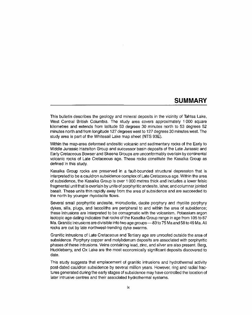
SUMMARY
This bulletin describes the geology and mineral deposits in the vicinity of Tahtsa Lake, West Central British Columbia. The study area covers approximately 1000 square kilometres and extends from latitude 53 degrees 30 minutes north to 53 degrees 52 minutes north and from longitude 127 degrees west to 127 degrees 30 minutes west. The study area is part of the Whitesail Lake map sheet (NTS 93E).
Within the map-area deformed andesitic volcanic and sedimentary rocks of the Early to Middle Jurassic Hazelton Group and successor basin deposits of the Late Jurassic and
volcanic rocks of Late Cretaceous age. These rocks constitute the Kasalka Group as Early Cretaceous Bowser and Skeena Groups are unconformably overlain by continental
defined in this study.
Kasaika Group rocks are preserved in a fault-bounded structural depression that is
of subsidence, the Kasalka Group is over 1 000 metres thick and includes a lower felsic interpreted to be a cauldron subsidence complex of Late Cretaceous age. Within the area
fragmental unit that is overlain by units of porphyritic andesite, lahar, and columnar jointed basalt. These units thin rapidly away from the area of subsidence and are succeeded to the north by younger rhyodacite flows.
Several small porphyritic andesite, microdiorite, dacite porphyry and rhyolite porphyry dykes, sills, plugs, and laccoliths are peripheral to and within the area of subsidence; these intrusions are interpreted to be comagmatic with the volcanism. Potassium argon isotopic age dating indicates that rocks of the Kasalka Group range in age from 105 to 87 Ma. Granitic intrusions are divisible into two age groups"83to 75 Ma and 58 to 49 Ma. Ail rocks are cut by late northwest-trending dyke swarms.
Granitic intrusions of Late Cretaceous and Tertiary age are unroofed outside the area of subsidence. Porphyry copper and molybdenum deposits are associated with porphyritic phases of these intrusions. Veins containing lead, zinc, and silver are also present. Berg,
date. Huckleberry, and Ox Lake are the most economically significant deposits discovered to
This study suggests that emplacement of granitic intrusions and hydrothermal activity post-dated cauldron subsidence by several million years. However, ring and radial frac- tures generated during the early stages of subsidence may have controlled the location of later intrusive centres and their associated hydrothermal systems.
ix

INTRODUCTION
LOCATION AND ACCESS
The Tahtsa Lake porphyry copper district is in west-central British Columbia between latitudes 53 degrees 30 minutes and 53 degrees 32 minutes north, and longitudes 127 degrees and 127 degrees 30 minutes west (Fig. 1); it is part of the Whitesail Lake map- area (93Eil1, 14). Tahtsa Lake is at the geographiccentre of this area and is accessible via
Figure 1. Tahtsa Lake district'location map.
1

forestryaccess roads from the town of Houston, adistanceof 85 kilometres. Terranesouth of Tahtsa Lake can only be reached by helicopter, or by boat across the lake and then on foot.
PHYSIOGRAPHY, OUTCROP DISTRIBUTION, AND GLACIATION
The Tahtsa Lake district is part of a transitional zone between the Coast Mountains to the west and the Interior Plateau to the east. This area is characterized by ridges and peaks rising to 2 400 metres above an average base elevation of 900 metres. In spite of pronounced relief, outcrops are generally restricted to the steeperslopes and peaks, and to downcutting stream valleys. Broad, U-shaped valleys between the ranges are filled with fluvioglacial debris and generally lack outcrop. The best and most easily accessible outcrops are on the shorelines of Tahtsa and Troitsa Lakes.
The Tahtsa Lake area has had several episodes of continental and alpine glaciation. Remnant icefields and small alpine glaciers are common, particularly in cirque valleys surrounding the higher peaks. Remnants of a once continuous upland surface are preserved above 1 800 metres in the Sibola Range (Church, 1971) suggesting that this area may have been part of a plateau prior to glaciation.
PREVIOUS WORK
The northern half of the Tahtsa Lake area was first mapped by M. S. Hedley of the Geological Survey of Canada in 1935, at a scale of 1:250 000. From 1947 to 1952, S.
sheet. In 1961 the Berg porphyrycopperdeposit wasdiscovered by Kennco Explorations, Duffell mapped the remainder of the area as part of the Whitesail Lake (NTS 93E) map
(Canada) Limited, generating considerable interest in the economic potential of the area. In the following years, six more porphyry copper occurrences were discovered. Geologic information on these occurrences has been published by the British Columbia Ministry of Energy, Mines and Petroleum Resources (Sutherland Brown, 1966, 1969; Carter, 1970,
Richards,l974; Panteleyev, 1976) have also been completed on individual deposits. 1974; Church, 1971). Several thesis studies (Cawthorn, 1973; Maclntyre, 1974;
Detailed assessment reports summarizing exploration work on major properties have also provided valuable information (for example, Cann, 1981; Goldsmith and Kallock, 1981).
PROJECT SUMMARY
The Tahtsa Lake porphyry copper district, an area of approximately 1 000 square kilo-
of this work are presented on Figure 2 (in pocket). A total of 525 rock samples were metres, was mapped at a scale of 1 :50 000 in the summers of 1973 and 1974. The results
collected from this area: from these. 186 thin sections were prepared and studied in detail. In addition, the whole rock chemical compositions of 42 samples of Upper Cretaceous volcanic and plutonic rocks were determined by the author using X-ray fluorescence spectroscopy. The WAr isotopic ages of three whole rock samples were determined by Teledyne Isotopes Inc.
ACKNOWLEDGMENTS
This bulletin incorporates part of a Ph.D. dissertation completed at the University of Western Ontario in 1976. Asarco Exploration Company of Canada, Limited generously provided field and financial support for field studies and Dr. R. W. Hodderof the University of Western Ontario provided many helpful suggestions during thesis research and writing. I would also like to thank Dr. W. J. McMillan for critical reading of the revised manuscript.
2

The author was ably assisted in the field by J. Wedley in 1973, and R. Woods and the late R. MacGregor in 1974.
REFERENCES
Age6 J. and Holland, R. (1983): Geological Diamond Drilling and Road Construction Report on the Lean-To Group of Mineral Claims, B.C. MinistryofEnergy, Mines & Pet. Res., Assessment Report 11237.
Armstrong, J. E. (1944): Hazelton Map-Area, British Columbia, Geol. Sum, Canada, Paper 44-24.
Bateman, I? C. and Dodge, F. C. W. (1970): Variations of Major Chemical Constituents Across !he Central Sierra Nevada Batholith, Geol. SOC. Am., Bull., Vol. 81, pp. 409-420.
Cann, R. (1981): Whiting Creek Property, B.C. Ministry of Energy, Mines & Pet. Res., Assessment Report 9897.
Carter, N. C. (1970): Len, B.C. Ministry of Energy, Mines & Pet. Res., GEM, 1970, pp. 104-1 07.
Deposits in West-Central British Columbia, unpub. Ph.D. thesis, UniversifyofBritish ~ (1974): Geology and Geochronology of Porphyry Copper and Molybdenum
Columbia.
lumbia, B.C. Ministry of €nergx Mines & Pet. Res., Bull. 64, 150 pp. __ (1981): Porphyry Copper and Molybdenum Deposits, West-Central British Co-
Cawthorn, N. G. (1973): Geology and Petrology of the Troitsa Property, Whitesail Lake Map-Area, British Columbia, unpub. MSc. thesis, University of British Columbia.
Church, 8. N. (1970): Geology of the Owen Lake, Parrott Lakes, and Goosly Lake Area, B.C. Ministry of Energy, Mines & Pet. Res., GEM, 1970, pp. 119-125.
~ (1971): Bergette, B.C. Ministry of Energx Mines & Pet. Res., GEM, 1971, pp. 147-1 57.
Duffell, S. (1959): Whitesail Lake Map-Area, British Columbia, Geol. Sum, Canada, Mem. 299.
Goldsmith, L. B. and Kallock, P. (1981): Geological Investigation ofthe Sam, Swing, Long, Short, and Deuce Mineral Claims, Tahtsa Lake Area, British Columbia, B.C. Ministry of Energy; Mines & Pet. Res., Assessment Report 10261.
Goodz, M. D., Jonasson, I. R., and Cann, R. M. (1983): Geochemistry and Hydrothermal Alteration Studies of the Whiting Creek Stockwork Molybdenum Deposit, Tahtsa Lake Area, British Columbia, in Current Research, Part B, Geol. Sum, Canada, Paper
Hanson, G. (1935): Portland Canal Area, British Columbia, Geol. Sum, Canada, Mem. 175.
Hedley, M. S. (1935): Tahtsa-Morice Area, Coast District, British Columbia, Geol. Sum, Canada, Map 367A.
Hutchison, W. W. (1970): Metamorphic Framework and Plutonic Styles in the Prince Rupert Region of the Central Coast Mountains, British Columbia, Cdn. Jour: Earth Sci., Vol. 7, pp. 376-405.
James, D. H. (1976): Huckleberry in Porphyry Deposits of the Canadian Cordillera, A. Sutherland Brown, editor, C.I.M., Special Vol. 15, pp. 284-288.
Katz, H. R. (1971): Continental Margin in Chile - Is Tectonic Style Compressional or Extensional? Am. Assoc. Pet. Geol., Bull., Vol. 55, pp. 1753-1758.
83-1 B, pp. 135-1 44.
3

Kennedy, W. Q. (1933): Trends of Differentiation in Basaltic Magmas, Am. Jou,: Sci., Vol.
Lambert, M. B. (1 974): The Bennett Lake Cauldron Subsidence Complex, British Colum-
Larsen, E. S. (1948): Batholiths of Southern California, Geol. SOC. Am., Mem. 29, Leach, W. W. (1910):TheSkeena River District, Geol. Sum, Canada, Summ. Rept., 1909,
Lipman, P. W., Fisher, F. S., Mehner, H. H., Naeser, C. W., Luedke, R. G., and Steven, T: A. (1976): Multiple Ages of Mid-Tertiary Mineralization and Alteration in the Western San Juan Mountains, Colorado, Econ. Geol., Vol. 71, pp. 571-586.
Maclntyre, D. G. (1974): Zonation of Alteration and Metallic Mineral Assemblages, Coles Creek Copper Prospect, West-Central British Columbia, unpub. M.Sc. thesis, University of Western Ontario.
Associated Porphyry Copper Occurrences, Tahtsa Lake Area, British Columbia, ~ (1976): Evolution of Upper Cretaceous Volcanic and Plutonic Centers and
unpub. Ph.D. thesis, Universityof Western Ontario, 149 pp.
25, pp. 239-256.
bia and Yukon Territory, Geol. Sum, Canada, Bull. 227.
pp. 61-68.
Minister of Mines, B.C., Ann. Rept., 191 6, 1945. Nockolds, S. R. (1 954): Average Chemical Compositions of Some Igneous Rocks, Geol.
Panteleyev, A. (1976): Berg Porphyry Copper-Molybdenum Deposit, unpub. Ph.D. thesis, University of British Columbia. - (1981 j: Berg Porphyry Copper-Molybdenum Deposit, B.C. Ministry of Energy,
Richards, G. G. (1974): Geology of the Ox Lake Cu-Mo Porphyry Deposit, unpub. M.Sc. Mines & Pet. Res., Bull. 66, 158 pp.
thesis, University of British Columbia. - (1976): Ox Lake in Porphyry Deposits of the Canadian Cordillera, A. Sutherland
Robinson, G. D., Klepper, M. R., and Obradovich, J. D. (1968): Overlapping Plutonism, Brown, editor, C.I.M., Special Vol. 15, pp. 289-298.
Volcanism, and Tectonism in the Boulder Batholith Region, Western Montana, in Studies in Volcanology, R. R. Coats, R. L. Hay, and C. A. Anderson, editors, Geol.
Sillitoe, R. H. (1977): Metallic Mineralization Affiliated to Subaerial Volcanism: A Review, SOC. Am., Mem. 11 6, pp. 557-576.
Steven, T A. and Lipman, P. W. (1974): Calderas of the San Juan Volcanic Field, Geol. SOC. London, Special Pub. No. 7, pp. 99-1 16.
Streckeisen, A. L. (1967): Classification and Nomenclature of Igneous Rocks, N. Jb. Southwestern Colorado, U.S.G.S., Prof. Paper 958, 35 pp.
Sutherland Brown, A. (1960): Geology of the Rocher Deboule Range, B.C. Ministry of Mine,: Abh., Vol. 107, pp. 144-214.
Energy, Mines & Pet. Res., Bull. 43. ~ (1966): Berg, MinisferofMines, B.C., Ann. Rept., 1966, pp. 105-111. ~ (1967): Emerald Glacier Mine, Minister of Mines, B.C., Ann. Rept., 1967, pp.
Tilley, C. E. (1 950): Some Aspects of Magmatic Evolution, Quart. Jou,: Geol. SOC. London, ~ (1969): Ox, B.C. Ministryoffnergy, Mines & Pet Res., GEM, 1969, pp. 93-97.
SOC. Am., Bull., VOl. 65, pp. 1007-1032.
110-113.
Tipper, H. W. (1955): Nechako River Map-Area, Geol. Sum, Canada, Paper 54-1 1 Vol. 106, pp. 37-61.
A (197;): Smithers Map-Area, British Columbia, in Rept. of Activities, Part A, Geol.
Tipper, H. W. and Richards, T: A. (1976): Jurassic Stratigraphy and History of North- Sum, Canada, Paper 71 -1, pp. 34-37.
Central British Columbia, Geol. Sum, Canada, Bull. 270, 73 pp.
4
Wheeler, J. O., Aitken, J. D., Berry, M. J., Gabrielse, H., Hutchison, W. W., Jacoby, W. R., Monger, J. W. H., Nibletl, E. R., Norris, D. K., Price, R. A., and Stacey, R. A. (1972): The Cordillera Structural Province in Variations in Tectonic Styles in Canada, R. A. Price and R. J. W. Douglas, editors, Geol. Assoc. Can., Special Paper No. 2, pp. 1-82.
Williams, H. (1942): The Geology of Crater Lake National Park, Oregon, Carnegie Inst., Washington Pub. 540.
Williams, H., Turner, F. J., and Gilbert, C. M. (1954): Petrography- An Introduction to the Study of Rocks in Thin Section, !A! H. Freeman and Co., San Francisco, 406 pp.
Woodsworth, G. J. (1980): Geologyof the Whitesail Lake Map-Area, Geol. Sum, Canada, Open File 708.
5

128' 'C p
127' 126-
Figure 3. General geology of west-central British Columbia.
6
GENERAL GEOLOGY
REGIONAL SETTING
The Tahtsa Lake district is near the centre of the Pacific Orogen (Wheeler, eta/., 1972), just east of the boundary between the Coast Crystalline and Intermontane Tectonic Belts (Fig.
granitic and metamorphic rocks bounded by northwest-trending transverse faults; the 1). The Coast Crystalline Belt is essentially an uplifted terrane of Permian to Tertiary
Intermontane Belt is composed mainly of folded eugeosynclinal rocks of Early to Middle Mesozoic age. In west-central British Columbiathe Intermontane Belt includes successor basin deposits of the Bowser basin and Late Mesozoic to Early Cenozoic continental sedimentary, volcanic, and plutonic rocks.
The distribution of major geologic formations in west-central British Columbia is shown on Figure 3. The most areally extensive of these is the Hazelton Group (Leach, 1910; Hanson, 1935; Armstrong, 1944; Tipper, 1955,1971; Tipper and Richards, 1976) which is basement for most of the area. The Hazelton Group consists mainly of folded andesitic volcanic and sedimentary rocks that probably represent remnants of ancient volcanic island arcs. The Hazelton Group is unconformably overlain by successor basin deposits of the Late Jurassic Bowser Lake and Early Cretaceous (Albian) Skeena Groups. East of Babine Lake, Late Cretaceous continental sedimentary rocks occur in the Sustut basin. Continental volcanic rocks of Late Cretaceous to Tertiary age crop out in the vicinity of Francois and Ootsa Lakes where they constitute the Tiptop Hill and Ootsa Lake volcanic rocks respectively. A younger (Eocene) sequence of volcanic rocks, known as the Endako and Goosly Lake Groups, occurs in the Houston area. The eastern half of the Interior Plateau is largely covered by late Tertiary plateau basalts.
The Intermontane Belt has been the site of major episodes of plutonic activity from Late Triassic until Tertiary time. Carter (1 974) has shown that these intrusive rocks form groups with distinctive isotopic ages, chemical compositions, associated metal concentrations, and spatial distribution. Although most of the intrusions are Late Cretaceous or Tertiary in age, a few are older. These are the Topley, Omineca, Francois Lake, and Kitsault intrusions which range from Triassic to Late Jurassic in age. The distribution of the Late Cretaceous Bulkley intrusions defines a north-trending belt which includes the Tahtsa Lake area (Fig. 3). The Alice Arm and Nanika intrusions, which are Eocene in age, occur in a belt parallel to the eastern margin of the Coast Crystalline Belt; several of these
are restricted to the Babine Lake area. intrusions occur in the Tahtsa Lake area. The Babine intrusions are also Eocene in age but
7

TABLE 1. TABLE OF FORMATIONS, TAHTSA LAKE DISTRICT
PERIOD EPOCH FORMATION SYMBOLS LITHOLOGY MAP
QUATERNARY 1 Pleistocene and Recent 1 1 Qal 1 Till. alluvium. colluvium
TERTIARY Basalt, rhyolite, andesite, lamprophyre, IeMspar Late dykes, sills, Eocene and younger (may include Cretaceous) porphyry, aplite and plugs
Intrusive Contact
Eocene Porphyritic biotite-quartz monzonite Tpqm Nanika Intrusions
Intrusive Contact
Coast Intrusions Biotite-hornblende quartz diorite Tqd
Not in Contact
Mount Bolom Porphyritic hornblende-biotite granophyre Tpgr Intrusion
Not in Contact
CRETACEOUS Late Cretaceous
quartz diorite uKgd granodiorite, biotite-hornblende granodiorite, and uKpgd
Porphyritic hornblende-biotite quartz monzonite and uKpqm Bulkley Intrusions
uKad ~I~ ,
Intrusive Contact
Rhvolitic Intrusions I UKQD 1 Quartz DOrDhvrv. dacite DOrDhvrv. breccia
Not in Contact
:asalka Intrusions Porphynlic andesite and dionte uKdr
i
Kasalka Group uKTb uKr uKI
UKP
T
! lUKf
luxc
Inlrwive Contact
BASALT UNIT: Basalt, andesite
LAHAR UNIT Lahar, slump breccia, volcanic RHYOLITE UNIT Rhyolite
sandstone. minor andesite flows
~ ~~
dacite
1 Angu/ar Unconformity
BASAL PEBBLE CONGLOMERATE UNIT. Pebble conolnmmte~ sandstone
Early Cretaceous MARINE SEDIMENTARY UNIT Micaceous wacke, IKs Skeena Group (Albian) argillite, minor conglomerate
IKv AMYGDALOIDAL BASALT UNIT Spililized amygdaloidal basalt
Unconformity
JURASSIC (Upper Bathonian -
Middle Jurassic
(may include Smithers Formation) Formation) feldspathic wacke, conglomerate, argillite, tuff (Ashman
Lower Callovian)
MARINE SEDIMENTARY UNIT: Lithic and mJs Bowser Lake Group
tlnconhrmitv . . . . -. . . . Lower to Middle Jurassic FELSIC VOLCANIC AND CHERT UNIT Chert, lmJc Hazelton Group
.-,
(Sinemurian to Middle rhyolite, ash flow, welded tuft, argillite, volcanic (WhitesailISmithers Baiocianl wacke Formations) ,~~ ~ I
~~
(Teikwa Formation) Hazelton Group ANDESITIC FRAGMENTAL UNIT Red and green IJf
breccia, minor tuffaceous sandstone, porphyritic andesite flows
ash, crystal, and lapilli tun, agglomerate, volcanic
8

"
GEOLOGY OF THE TAHTSA LAKE DISTRICT Jurassic and Early Cretaceous volcanic and sedimentary rocks underlie most of the Tahtsa Lake map-area (Fig. 2, in pocket). These rocks have been folded and faulted; they are unconformably overlain by relatively flat-lying Late Cretaceous volcanic rocks. The entire sequence is cut by plutons of Late Cretaceous to Early Tertiary age - several have spatially associated porphyry copper deposits. The major map units recognized in the Tahtsa Lake district are summarized in Table 1. Stratigraphic and intrusive relationships are illustrated on Figure 4. Figure 5 shows the general geology of the district.
HAZELTON GROUP
The oldest rocks in the Tahtsa Lake area are Early Jurassic in age and belong to the Hazelton Group. These rocks, which crop out in the eastern half of the map-area, form a terrane of glacially rounded hills and ridges (Fig. 5). Good exposures of these rocks also occur on the western slope of the Tahtsa Range and on the shores of Tahtsa and Troitsa Lakes.
ANDESlTlC FRAGMENTAL UNlT (TELKWA FORMATION; lJf)
the Telkwa Formation as defined by Tipper and Richards (1 976). These rocks are predomi- In the Tahtsa Lake area andesitic fragmental rocks of the Hazelton Group are assigned to
nantly fragmental in nature, and are characteristically red and green in colour due to hematitic and chloritic alteration. Individual beds range from several centimetres (Plate I ) to as much as 100 metres in thickness. Lapilli tuff, lithic tuff, crystal tuff, and tuff breccia predominate; there are minor intercalations of porphyritic augite andesite, dacite, tuffaceous siliceous argillite, and pebble conglomerate. The fragmental rocks are poorly sorted and contain mainly angular clasts of andesite and tuff with lesser amounts of chert
fragments cemented by sericite and microcrystalline silica. and rhyolite (Plate 11). The matrix is largely composed of quartz and plagioclase crystal
I / '
Figure 4. Schematic diagram of stratigraphic and intrusive relationships, Tahtsa Lake district (see Table 1 for explanation of symbols).
9

A B 2 L"
KS Jh Kb
STRUCTURAL CROSS SECTION A - B
Figure 5. General geology, Tahtsa Lake district; structural cross-section A-6,
10

FELSlC VOLCANIC - CHERT UNlT [SMITHERS AND/OR WHITESAIL FORMATION (?): ImJc]
Siliceous light grey, greenish grey, and dark grey volcanic rocks conformably overlie, and are, in part, interbedded with red and green volcanic units of the Telkwa Formation. These rocks are typically thin bedded, and in places are finely laminated. The predominant rock types are welded lapilli tuff (Plate Ill), mottled cherty tuff, and banded or massive dacite and rhyodacite. Eutaxitic textures are common in the more siliceous fragmental rocks. These felsicvolcanic rocks grade upward into alternating beds of mottled and banded grey chert, siliceous argillite, and siltstone which may be part of the Smithers Formation. Stratabound lenses of pyrite and pyrrhotite, up to several centimetres thick, are common in this part of the section.
BOWSER LAKE GROUP
MARINE SEDlMENTARY UNlT (ASHMAN FORMATION; mJs)
Marine sedimentary rocks of the Bowser Lake Group occur in a fault-bounded block northwest of Sweeney Lake (Woodsworth, personal communication). Up to 800 metres of interbedded dark grey pebble conglomerate (Plate IV), sandstone, siltstone, shale, and minor tuff are exposed along the old Emerald Glacier mine road. Shelly fauna, particularly large coiled ammonites (Plate V), occur in the clastic sedimentary units; they indicate a
this age, these rocks can be correlated with the Ashman Formation of the Bowser Lake Late Bathonian age (Woodsworth, personal communication; Appendix A). On the basis of
Grouo.
SKEENA GROUP
The Early Cretaceous succession is comprised of distal turbidites; such rocks are typical of the successor basin deposits of the Skeena Group. In the Tahtsa Lake area Skeena Group rocks are well exposed on the south shore of Tahtsa Lake, in the core of the Tahtsa Range, and on Swing Peak ridge.
Duffell (1959) first recognized sedimentary rocks of Early Cretaceous age in the Tahtsa Lake area; he suggested a twofold division into a lower sedimentary unit and an upper volcanic unit. However, the contact between these units is an angular unconformity that represents a major depositional hiatus. Duffell's upper volcanic unit is, in fact, the Late Cretaceous Kasalka Group as defined in this study.
In several localities throughout the map-area, Early Cretaceous sedimentary rocks con- formably overlie amygdaloidal basalt flows. These flows unconformably overlie Hazelton Group strata and therefore are included with the Skeena Group. The combined thickness of the Skeena Group is estimated to be at least 1 500 metres.
BASAL CONGLOMERATE UNIT (/Kc)
faults. However, a relatively flat-lying boulder conglomerate (Plate VI) exposed on the east The base of the Skeena Group is not well exposed; contacts with older rocks are generally
bank of Rhine Creek, approximately 700 metres upstream from the access road bridge, appears to conformably underlie nearby columnar-jointed, amygdaloidal basalt flows. This conglomerate may be the basal member of the Skeena Group.
11
- IETRES 2000-
1 1500 -
2000 -
1500-
1500 4
SWING PEAK RIDGE SECTIONS I
WELDED TUFF
A A LAPILLI TUFF BRECCIA
'ii 'j PORPHYRITIC a VOLCANIC ANDESITE SANDSTONE
- - aCONGLOMERATE
luKc c (See Table 1 far explanation of unit symbols.)
HAZELTON GROUP
Figure 6. Stratigraphic columnsfor ihe Kasalka Group (for locations see Fig. 5).
12

AMYGDALOIDAL BASALT UNIT (IKv)
Massive volcanic flows at the base of the Skeena Group (map unit IKv) range from dark green to light grey in colour and are characteristically amygdaloidal (Plate VII). Discon-
the flows are typical basalts with euhedral andesine and labradorite phenocrysts set in a tinuous lenses of flow breccia are common at the top of individual flows. Petrographically,
matrix of divergent microlites of albite and interstitial chlorite, clay, calcite, and magnetite. Primary pyroxenes are pseudomorphed by chlorite and/or epidote. Amygdules are filled with concentric layers of calcite, chlorite, epidote, and chalcedony, occasionally surround- ing a core of pyrite and pyrrhotite grains.
MARINE SEDIMENTARY UNIT (lKs)
The amygdaloidal basalt is overlain by at least 1 000 metres of interbedded wacke and shale. These rocks weather fawn grey to black and range from thin to thick bedded. The predominant rock type is fine-grained, flaggy lithic wacke; it locally contains iron-rich concretions and carbonaceous plant fragments. Intercalations of shale are common, particularly near the base of the sedimentary division: these rocks locally contain poorly preserved shelly marine fauna of Albian age (Duffell, 1959). Locally, the wacke is flaser (Plate VIII) or crossbedded.
because they are better sorted and have greater amounts of microcline, muscovite, and Early Cretaceous wackes can be distinguished from their Middle Jurassic equivalents
metamorphic rock fragments.
KASALKA GROUP
Prior to the present study, no volcanic or sedimentary rocks younger than Early Cre- taceous (Albian) were known to be present in the Tahtsa Lake area. However, the Skeena and Hazelton Groups are unconformably overlain by a sequence of volcanic rocks that are cut by Late Cretaceous intrusions; these rocks constitute the Kasalka Group (Maclntyre, 1976).
The Kasalka Group is well exposed in the Kasalka Range, particularly on Swing Peak
Range. Stratigraphic sections for the Kasalka Group are shown on Figure 6 and type ridge and Mount Baptiste; to the north, similar rocks are found capping peaks in the Tahtsa
sections are given in Appendix B. Figure 2 shows the distribution of the major units of the Kasalka Group in the Tahtsa Lake district.
The contact between the Kasalka Group and older rocks is an angular unconformity.
the Kasalka Range. Faulted contacts are also common, particularly on the north and northwest perimeter of
BASAL CONGLOMERATE UNIT (IuKc)
A thin unit of red to reddish brown pebble conglomerate is the basal member of the Kasalka Group. This unit is well exposed on the south side of Mount Baptiste, at the eastern end of Swing Peak ridge, on ridge crests in the vicinity of Mount Ney, and near the Bergette porphyry copper prospect.
The basal pebble conglomerate unit of the Kasalka Group is strikingly red in colour and
thickness, are conformable with overlying volcanic rocks. The conglomerate unit is provides an easily recognizable marker horizon. Individual beds, which are of variable
generally between 5 to 10 metres thick, although it thickens to as much as 50 metres
13
where it fills channels in the underlying erosion surface. Lenses of red sandstone are locally interfingered with the conglomerate. The pebble conglomerate is a poorly sorted rock, containing rounded to subangular clasts of oxidized Hazelton and Skeena Group
oxide and silica. rock types set in a fine-grained sandy matrix (Plate IX); the cementing media are iron
FELSIC FRAGMENTAL UNIT (IuKf)
variably welded, siliceous pyroclastic rocks. Individual layers range from a few metres to On Mount Baptiste the basal pebble conglomerate is overlain by grey to cream-coloured,
as much as 100 metres in thickness; lithologic changes up section are frequent. Locally, large blocks and bombs disrupt stratification. The predominant rock type of the felsic fragmental unit is a partly welded to nonwelded lithic lapilli tuff (Plate X). Fragments in these rocks are generally angular, somewhat compressed, and mainly rhyolitic to dacitic in composition. Dark grey clasts of Hazelton Group andesite are also common. The groundmass of the lapilli tuffs is predominantly microcrystalline quartz, muscovite, and feldspar; in places it contains minute, devitrified glass shards.
lnterbedded with the lapilli tuffs are massive flows of fragmental and Porphyritic rhyodacite, dacite, and andesite, as well as partly welded crystal ash flow tuff (Plate XI), tuff breccia, and minor amounts of volcanic sandstone. The porphyritic flows contain euhedral, oscillatory-zoned andesine, brown biotite, with or without augite, green hornblende, and, in the more siliceous rocks, embayed quartz phenocrysts. The phe-
feldspar, and minor plagioclase. Apatite, angular quartz and feldspar crystal fragments, nocrysts are set in a microcrystalline to cryptocrystalline groundmass of quartz, K-
flows are comprised of quartz, K-feldspar, and plagioclase-rich bands with few or no rock and rhyolitic rock fragments are common in these rocks. By contrast, aphanitic rhyodacite
or crystal fragments. Alteration of plagioclase to epidote and chloritization of mafic minerals is widespread.
PORPHYRITIC ANDESITE UNIT (uKp)
green, fine-grained flows or sills of porphyritic andesite (Plate XII) to dacite (Fig. 6). On Swing Peak felsic fragmental rocks are overlain by massive, greenish grey to dark
Columnar jointing is typically well developed. The texture of the flows varies from sparse coarse-grained to crowded fine-grained porphyritic. Plagioclase (An 35.50), hornblende,
with interstitial K-feldspar and minor quartz. Moderate to intense alteration of plagioclase and augite phenocrysts are set in a microgranular or pilotaxitic groundmass of plagioclase
to clay, with or without epidote, and alteration of mafic minerals to fine-grained mixtures of chlorite, microcrystalline quartz, and iron oxide is ubiquitous. Following the classification schemeof Streckeisen (1967),flowson Swing Peakclassify as latite-andesitesordacites; generally they contain too much K-feldspar to be true andesites.
LAHAR UNIT (uKI)
Andesitic flows at the base of Swing Peak are conformably overlain by a chaotic assemblage of volcanic debris that is up to 600 metres thick. These rocks are crudely stratified (Plate XIII) with alternating coarse and fine-grained beds; they are interpreted to be lahars and mass flow or scarp slump deposits. Clasts are generally rounded to subangular and range from afew centimetres up to several metres (Plate XIV) in diameter. Most are porphyritic andesite, identical to underlying flows and sills. The clasts are
14

suspended in a fine-grained muddy matrix which contains abundant angular plagioclase and quartz crystal fragments (Plate XV). A few thin, discontinuous lenses of crystal tuff, volcanic sandstone, tuff breccia, and andesite occur in the lahar unit.
RHYOLlTE UNIT (uKr)
Light grey to cream-coloured rhyolite flows and fine-grained siliceous tuffs cap peaks to the north and northwest of the Bergette porphyry copper prospect, where they unconfor- mably overlie either porphyritic andesite or basal pebble conglomerate (Plates XVI and XVII). Outcrops of rhyolite are highly fractured and covered by talus. The rhyolitic flows are essentially microcrystalline aggregates of quartz, K-feldspar, muscovite, and albite, very similar to flows in the felsic fragmental unit exposed on Mount Baptiste. According to the modal classification scheme of Streckeisen (1967) these flows are rhyodacites.
BASALT UNlT (uKTb)
Columnar-jointed basalt flows cap Swing Peak ridge. These flows apparently conformably overlie the lahar unit of the Kasalka Group as indicated by the well-exposed, relatively flat- lying contact on the south face of Swing Peak ridge (Plate XVIII). Basalt dykes that cut the
on Swing Peak are the youngest extrusive rocks in the Tahtsa Lake area. The age of these KasalkaGroup may have been feedersfortheseflows. As far as is known, the basalt flows
flows is not certain: they are included with the Kasalka Group in this study but may be significantly younger.
AGE AND CORRELATION
The Kasalka Group volcanic rocks are believed to be mainly of Late Cretaceous age
taceous (Albian) fauna (Duffell, 1959). In addition, a whole rock WAr isotopic age of because they unconformably overlie sedimentary rocks containing latest Early Cre-
Coles Creek, a porphyritic granodiorite stock dated at 83.8 2 2.8 Ma cuts the base of the 10525 Ma was determined for a dacitic lapilli tuff near the base of the Kasalka Group. At
Cretaceous. On Swing Peak ridge a porphyritic andesite laccolith dated at 87? 4 Ma Kasalka Group suggesting the felsic fragmental unit there is no younger than Late
earliest Late Cretaceous in age. intrudes lahar of the Kasalka Group, again implying most of the group is latest Early or
Volcanic rocks of similar age and lithology to the Kasalka Group are not widespread in other parts of west-central British Columbia. Possible correlatives to the Kasalka Group are the Tip Top Hill volcanic rocks of the Parrotl Lake area (Church, 1970) and the Brian Boru Formation of the Hazelton area (Sutherland Brown, 1960). Tip Top Hill rocks are described as porphyritic andesite, dacite, and rhyolite flows which have yielded a WAr date of 77 Ma (Carter, 1981). Brian Boru flows are also very similar to those of the Kasalka Group and may be of a similar age. On the basis of apparent age and lithology, the Kasalka Group may correlate with the Mount Nansen and Hutshi Grouljs in Yukon Territory and with the Kingsvale Group in southern British Columbia.
PLUTONIC ROCKS
Volcanic and sedimentary rocks of Jurassic to earliest Late Cretaceous age are intruded by a wide variety of plutonic rock types. Mapping and petrographic studies suggest that these rocks can be subdivided on the basis of modal composition, isotopically determined age, and mode of occurrence (Table 2). Group names conform to those used by Carter (1974) where noted.
15
TABLE 2. MODAL ANALYSES, PLUTONIC ROCKS
MAP UNIT
No.
QZ KF PL BT HB OP OT
AC MF
n
uKqd
1 2
27.5 26.2 5.8 4.8
53.2 48.8 12.5 16.8
3 4 5 6 7 1 8 9 10
11.3 20.3 19.2 23.1 20.3 18.8 20.3 15.3 15.2 20.9 24.0 26.9 21.0 24.0 19.0 20.0
56.6 47.7 47.6 43.6 46.4 40.8 44.2 57.0 7.1 3.3 3.3 2.4 3.3 9.0 8.7 3.4 6.8 7.0 4.7 2.4 7.1 1.0 6.0 - 2.0 1.7 1.2 0.9 1.9 2.5 1.7 0.9 t 11 12
29.8 26.2
36.9 40.0 21.3 17.1
4.8 6.2 6.2 - 1.0 1.0 - 9.5 - - - - 8 1
15 16 17
26.1 25.8 26.7
35.6 32.2 41.4 27.1 26.7 15.1
18
20.2 10.4 43.0 - - -
19.9 6.0
-
-
2-Quartz diorite, Coles Creek; Maclntyre, 1974 1-Border (Camp) phase, Sibola stock; Church, 1971
3-Contact zone, Troitsa s t o k , Cawthorn, 1973 4-Intermediate zone, Troitsa stock; Cawthorn. 1973 5-Core zone, Troitsa stock; Cawthorn, 1973 6"Granodiorite, Whiling stock; this study 7"Granodiorite, Sibola slock; Church, 1971 8"Porphyritic granodiorite, Coles Creek; Maclntyre, 1974 9"Porphyritic granodiorite, Ox Lake; Sutherland Brown, 1969
10-Porphyritic granodiorite, Huckleberry; this study 11-Porphyritic quartz monzonite, Bergelte; Church, 1971 12-Porphyritic quartz monzonite, Whiting Creek, this study 13-Porphyritic granophyre, Mount Bolom; this study 14-Quartz diorite, Berg; Panleieyev, 1981 15-Porphyritic quartz monzonite, Berg slock; Panteleyev, 1981 16-Sericitic quartz-plagioclase porphyry, Berg stock; Panteleyev, 1981 17-Plagioclasebiotite-quartz porphyry, Berg stock; Panteleyev, 1981 18-Hornblende quartz feldspar porphyry dyke, Berg; Panteleyev, 1981

/
\ GRANITE
5 K f
SYENITE
a uKqd (1 -2)
0 uKgd (3-7) uKpgd (8-10)
A uKpqrn( l1-12)
v T g r ( l 3 )
0 Tqd (14)
= Tpqm (1 5-1 7) - fp (18)
,/ QUARTZ MONZONITE GRANODIORITE \ - \ 0
MONZONITE MONZOOIORITE DIORITE 65 35 10 PI
ion
Figure 7. Ternary plot of average modal K-feldspar (Kf), plagioclase (PI), and quartz (Qz) abundances for Cretaceous and Tertiary plutonic rocks (data recalculated to 100 per cent, from Table 2).
scheme of Streckeisen (1967) is used (Fig. 7). Furthermore, in the naming of granitoid In the following discussion of plutonic rocks a modified version of the classification
rocks the order of minerals is from least to most abundant. For example, a hornblende- biotite granodiorite would contain more biotite than hornblende. The term 'porphyritic' is
is applied to fine-grained crystalline rocks with some ('sparse') free-floating phenocrysts used for rocks with closely packed ('crowded') euhedral phenocrysts; the term 'porphyry'
(for example, quartz porphyry, feldspar porphyry).
KASALKA INTRUSIONS (uKdr)
The term 'Kasalka intrusions' is applied to a group of intrusive rocks which are petrographically and compositionally similar to volcanic rocks of the Kasalka Group. Volcanic rock names are used for some of these fine-grained intrusions because they have textural features like those of volcanic rocks, for example, pilotaxitic groundmass.
Subvolcanic dykes, sills, and small irregular stocks of porphyritic augite-hornblende microdiorite and andesite are common in the Kasalka and Tahtsa Ranges (Plate XIX). Locally, these intrusions grade into tuff breccia dykes (Plate XX), particularly on Swing Peak ridge. On the north slope of Swing Peak ridge a series of andesite sills radiate outward from a small stock and intrude strata of the Skeena and Kasalka Groups.
17

Contacts are sharp and rarely show evidence of contact metamorphism. Bedding at- titudes in the Skeena Group diverge from regional trends near these crosscutting intrusions.
The intrusive hornblende-augite andesite is a fine-grained, green to dark grey porphyritic rock (Plate XXI); petrographically it is identical to andesite flows at the base of Swing Peak
quite often augite and hornblende phenocrysts are fresh; magnetite is an abundant ridge. In general, mafic minerals are less chloritized than those in extrusive equivalents;
accessory mineral. Albite, clay, and epidote alteration of plagioclase is locally intense.
Small, elongate stocks of microdiorite intrude Hazelton Group rocks at the western end of Kasalka Butte. Finer grained equivalents of these stocks occur as dykes on Mount Baptiste, and form a small plug on Rhine Crag. These intrusions cut both Jurassic and Early Cretaceous strata. Typically, wallrocks are folded on a small scale and closely fractured within 20 metres of the contacts.
Diorites of the Kasalka intrusions are coarse to medium-grained, dark greenish grey, equigranular to subporphyritic rocks composed of a mesh of interlocking, oscillatory- zoned andesine phenocrysts with intersertal augite, hornblende, and biotite. Minor K-feldspar and quartz occupy the interstices between the larger grains. The diorite has a modal composition similar to that of andesitic rocks of the Kasalka Group; however, it contains biotite in addition to hornblende and augite. These minerals are generally partly to completely pseudomorphed by chlorite. Albite and clay alteration of plagioclase is also widespread. Primary magnetite is restricted to the least altered samples; in most samples it is oxidized to hematite.
RHYOLITIC INTRUSIONS (uKqp)
Sills and laccoliths of porphyritic dacite are common within the felsic fragmental unit of the Kasalka Group. Field relationships are often ambiguous; many may actually be flows.
Group; these may be feeders to overlying intrusive and extrusive bodies. The best Porphyriticdacite dykes arecommon in rocks which liestratigraphically belowthe Kasalka
exposures of porphyritic dacite are in creeks cutting the eastern slope of the ridge west of Coles Creek. Here, the dacite appears to be a relatively flat-lying laccolith with radiating dyke-like extensions (Maclntyre, 1974) that cut both Hazelton and Kasalka Group strata.
Intrusive dacite is a fine-grained, medium to dark grey, siliceous rock. The most charac- teristic feature of this rock type is the presence of bipyramidal, rounded and embayed quartz phenocrysts (Plate XXII). In addition, phenocrysts of euhedral andesine, plates of biotite, and minor euhedral hornblende are present; all are set in a microgranular to granular groundmass consisting of equal proportions of quartz, plagioclase, and K- feldspar. Plagioclase and quartz also occur as angular fragments or shards.
Small, irregular dykes and sills of rhyolitic quartz 'eye' porphyry intrude the Sibola, Whiting, and Troitsa stocks (Fig. 2). The contacts are sharp and lack chilled margins (Plate XXIII). Inclusions of host rocks are common, particularly adjacent to the contacts. At the
grades into breccia pipes (Plate XXIV) and dykes. Similar breccia pipes are located along Bergette and Whiting Creek porphyry copper prospects the rhyodacite or quartz porphyry
the south contact of the quartz diorite at Coles Creek and on the new Lean-To property.
Rhyolitic intrusions within the Sibola and Troitsa stocks are white and siliceous; locally they are flow banded. These rocks characteristically contain 10 to 15 per cent subhedral quartz eyes and 1 to 2 per cent pyrite cubes set in a microgranular intergrowth of quartz with subordinate K-feldspar and muscovite, and a minor amount of albite. The muscovite
18
appears to be a primary component of these rocks. Phenocrysts of other minerals are absent. Associated breccias contain angular rhyolitic clasts in a microcrystalline quartz- muscovite matrix.
Quartz 'eye' porphyry dykes parallel the northwest shore of Troitsa Lake, where they crop out as distinctive white cliffs. Similar dykes crop out on Mount Baptiste and on the south and north shores of Tahtsa Lake. Dyke contacts are generally sharp: most are steeply dipping.
to weathering. Porphyritic phases contain quartz, plagioclase, and K-feldspar phe- Rhyolitic dykes are white to cream-coloured and siliceous; they are exceptionally resistant
nocrysts set in a microcrystalline groundmass of quartz and muscovite. Plagioclase phenocrysts are invariably pseudomorphed by fine-grained aggregates of clay, sericite, and albite. Pyrite cubes are also common in these rocks.
BULKLEY INTRUSIONS
The Bulkley intrusions, as defined by Carter (1974, 1981), comprise granodioritic stocks and dykes of earliest Late Cretaceous age (70 to 84 Ma). In the Tahtsa Lake area, three subdivisions of the Bulkley intrusions are recognized. These are: (1) small isolated stocks of porphyritic hornblende-biotite granodiorite such as the Coles Creek, Huckleberry Mountain, and Ox Lake stocks, (2) large compositionally zoned intrusions of equigranular
Whiting, and Troitsa stocks, and (3) late porphyritic hornblende-biotite quartz monzonite biotite-hornblende granodiorite and biotite-hornblende quartz diorite such as the Sibola,
dyke swarms and stocks that cut both (1) and (2). The areal distribution of these rocks is shown on Figure 2.
PORPHYRlTlC HORNBLENDE-BIOTITE GRANODlORlTE (uKpgd)
vicinity of Ox Lake, Huckleberry Mountain, and Coles Creek (Fig. 2). The stocks are Small, subcircular stocks of porphyritic hornblende-biotite granodiorite crop out in the
exposed at various stratigraphic levels within the Hazelton Group. The Coles Creek stock also intrudes a laccolith of porphyritic dacite. Contacts are generally sharp and steeply dipping. Biotite hornfels aureoles are well developed around the Ox Lake and Huckleberry Mountain stocks, but are absent at Coles Creek. The latter is surrounded by an extensive zone of pervasive hydrothermal alteration (Maclntyre, 1974). In general, Hazelton Group strata dip more steeply adjacent to the stocks, suggesting that doming and uplift accom- panied intrusion.
The stocks at Coles Creek, Ox Lake, and Huckleberry Mountain are essentially simple, single phase intrusions of light to dark grey, porphyritic, hornblende-biotite granodiorite
densely porphyritic with greater than 50 per cent euhedral phenocrysts. Coarse-grained, (Plate XXV). The texture of these rocks ranges from fine-grained sparsely porphyritic to
subporphyritic to equigranular textures characterize the core zones of the stocks, par- ticularly at depth. Phenocrysts are mainly 2 to 6-millimetre, oscillatory-zoned andesine with subordinate brown biotite, green hornblende, and minor anhedral quartz; all are set in a microgranular interlocking groundmass of quartz, K-feldspar, and minor plagioclase. Apatite and magnetite are important accessory minerals. The average modal composition of each of the stocks is presented in Table 2. A plot of these values (Fig. 7), recast to 100 per cent, illustrates the relatively small compositional range for these plutons; all fall within the granodiorite field as defined by Streckeisen (1967).
19

BIOTITE-HORNBLENDE GRANODIORITE AND QUARTZ DlORlTE (uKgd)
Large, compositionally zoned stocks with a granodiorite to quartz diorite bulk composition
which intrude rocks of the Hazelton and Skeena Groups in the core of the Sibola Range occur in the Tahtsa Lake area. The largest of these are the Sibola and Whiting stocks,
fault. The western contact appears to dip moderately east. Hazelton Group rocks along (Fig. 5). The eastern contact of the Sibola stock is sharp and steeply dipping: it may be a
the eastern contact are steeply dipping, parallel to the trend of the contact.
A similar stock forms the core of a prominent peak south of the west end of Troitsa Lake. This stock, which is roughly circular in plan, intrudes west-dipping Hazelton Group strata and flat-lying porphyritic andesite of the Kasalka Group. The northern contact of the stock is steeply dipping and crosscuts bedding; the south contact is relatively flat (Plate XXVI).
trends (Cawthorn, 1973). Unlike the Sibola stock, this intrusion produced only minor disruption of regional structural
The quartz diorite stock on Mount Baptiste and the quartz diorites at Coles Creek and Ox Lake are texturally and compositionally similar to the border phases of the Troitsa and Sibola stocks. Aureoles of biotite hornfels enclose both the granodiorite and quartz diorite intrusions; they extend several hundred metres into surrounding wallrocks.
Detailed petrographic study of the Troitsa Lake stock by Cawthorn (1973) indicates textural and compositional zoning from a coarse-grained biotite-hornblende quartz monzonite in the core to a finer grained biotite-hornblende granodiorite at the margins.
The Sibola stock is also zoned. A narrow marginal zone of mafic-rich, medium to fine- grained biotite-hornblende quartz diorite (camp phase of Church, 1971) encloses a core of coarse-grained subporphyritic biotite-hornblende granodiorite (Plate XXVII). Similarly, the quartz diorite at Coles Creek has a greater quartz and K-feldspar content toward the centre of the intrusion, where it approaches granodiorite in compositon (Maclntyre, 1974). Sampling of the Mount Baptiste stock was too limited to define any systematicvariations in composition.
to pinkish grey in colour, according to the relative proportions of biotite and K-feldspar Equigranular phases of the Bulkley intrusions in the Tahtsa Lake area vary from dark grey
texture, consisting of closely packed, 2 to 5-millimetre, subhedral to euhedral, oscillatory- present. The rocks are characterized by a hypidiomorphic granular to subporphyritic
zoned oligoclase and andesine phenocrysts, many of which are partly resorbed. Smaller, subhedral biotite and hornblende grains, and anhedral quartz occupy the spaces between the plagioclase phenocrysts. K-feldspar and fine-grained granular quartz are interstitial to the larger grains. Magnetite, apatite, and sphene are ubiquitous accessory minerals.
The modal composition of samples from the Sibola and Troitsa stocks have been deter- mined by Church (1971) and Cawthorn (1973), respectively. The average values for various zones of the intrusions are listed in Table 2 and clearly illustrate the progressive increase in modal K-feldspar and quartz toward the core zones. When recast to 100 per cent, the relative proportions of K-feldspar, quartz, and plagioclase for the main phases ofthe Sibola and Troitsa stocks are very close to those determined for porphyritic granodiorite at Ox Lake, Coles Creek, and Huckleberry Mountain (Table 2; Fig. 7). The average modal composition of the quartz diorite border phase of the Sibola stock is nearly identical to that of the Coles Creek quartz diorite.
20

PORPHYRITIC HORNBLENDE-BIOTITE QUARTZ MONZONITE (uKpqm)
Northwest-trending dykes of porphyritic hornblende-biotite quartz monzonite, which locally coalesce to form irregular elongate stocks, intrude the Sibola, Whiting, and Troitsa stocks (Fig. 2). The dykes rarely have chilled margins and contacts with wallrocks are usually sharp. By contrast, dykes which extend outside the stocks typically have fine- grained mafic-rich border zones and coarse-grained porphyritic cores.
The coarse-grained porphyritic quartz monzonite (Plate XXVIII) intrusions at the Bergette and Whiting Creek prospects are pinkish grey to buff-coloured rocks. The quartz monzonite contains a greater percentage of anhedral quartz phenocrysts and has more groundmass K-feldspar than the porphyritic granodiorite at Ox Lake, Coles Creek, and
Creek intrusions is given in Table 2 (Nos. 11, 12). These rocks straddle the quartz Huckleberry Mountain. The average modal composition of the Bergette and Whiting
monzonite-granodiorite boundary on Figure 7.
MOUNT BOLOM INTRUSION
The Mount Bolom stock forms the core of Mount Bolom and of ridges to the north in the southwest corner of the map-area, west of Troitsa Lake. It is roughly circular in plan and underliesan areaof approximately54 square kilometres. Thestockintrudes metamorphic rocks of the Coast Plutonic Complex on the west and the Hazelton, Skeena, and Kasalka Groups on the east. The contacts are sharp and discordant: contact metamorphism is restricted to rocksimmediatelyadjacent to thestock. KasalkaGroupstrataalong the north contact are isoclinally folded, and Hazelton Group strata dip steeply, parallel to the south contact. Dykes of similar composition and texture to the Mount Bolom stock are common in the Kasalka Range and are believed to be related to the stock.
Only the eastern half of the Mount Bolom stock was mapped during this study. In this area the stock consists largely of pink, porphyritic, hornblende-biotite granophyre (Plate XXIX). Thegranophyre istexturallyzonedfromasparselyporphyritic,fine-grained borderphase, to a coarser grained, more porphyritic core. In thin section the rock contains euhedral unzoned oligoclase, and fewer, subhedral biotite and hornblende phenocrysts, set in a groundmass of interlocking laths of plagioclase with interstitial granophyric intergrowths of K-feldspar and quartz. The groundmass plagioclase is typically altered to clay and albite. Clusters of hornblende, biotite, and plagioclase crystals characterize the granophyre. Dark grey to black wallrock inclusions are also common. Similar features are found in dykes peripheral to the Mount Bolom stock. However, in contrast to the stock, these dykes contain more biotite and little or no hornblende. The Mount Bolom stock differs from the Bulkley and Kasalka intrusions; it has significantly more K-feldspar and less quartz.
COAST INTRUSIONS
the western part of the map-area. The largest of these is a north-trending body of quartz Several plutonic bodies, believed to be satellitic to the Coast Plutonic Complex, occur in
diorite that intrudes rocks of the Hazelton and Skeena Groups in the western part of the Tahtsa Range. This body is sometimes referred to as the Berg quartz diorite because it is
structural trends near the intrusion. Biotite hornfels is well developed around the intrusion near the Berg porphyry copper deposit. There is no obvious disruption of regional
and extends up to 100 metres from the contact.
21

The Berg quartz diorite is zoned: a mafic-rich, fine-grained border phase grades into a coarser grained, more quartz-rich core. The rock is typically equigranular (Plate XXX); it consists mainly of interlocking, tabular laths of oscillatory-zoned andesine and
sions. Biotite is subordinate to hornblende and occurs as random, anhedral grains. Border labradorite. Elongate, subhedral to euhedral poikilitic hornblende has plagioclase inclu-
phases of the quartz diorite contain minor amounts of pyroxene, in part pseudomorphed by hornblende. The latter, in turn, is replaced by biotite, particularly near the younger Berg quartz-monzonite stock. Quartz and K-feldspar occupy interstices between the larger grains and, in places, appear to replace plagioclase. Magnetite is a common accessory
deposit; sericite replaces plagioclase and pyrite replaces magnetite. mineral. The quartz diorite is hydrothermally altered near the Berg porphyry copper
Quartz diorite of the Coast intrusions contains more hornblende and somewhat less quartz than quartz diorites of the Bulkley intrusions. The modal composition of the Berg quartz diorite (Sutherland Brown, 1966) is very similar to the average values for quartz diorites of the Coast Plutonic Complex (Hutchison, 1970). WAr isotopic determinations confirm that the age of the quartz diorite is approximately 50 Ma (Carter, 1981)Jhe same age as the eastern zone of the Coast Plutonic Complex.
NANIKA INTRUSIONS
The term Nanika intrusions is applied by Carter (1981) to a group of stocks of quartz monzonite composition which have WAr isotopic ages circa 50 Ma, that is, Eocene. The only known intrusion of this composition and age in the Tahtsa Lake area is the Berg porphyritic quartz monzonite stock which is located on the western slope of the Tahtsa Range (Fig. 5). This intrusion is cut by a later, northeast-trending dyke of porphyritic quartz latite. A breccia zone occurs south of the stock.
The Berg porphyritic biotite-quartz monzonite stock intrudes moderately east-dipping Hazelton Group pyroclastic rocks (Panteleyev, 1981). Emplacement of the stock has not produced any major disruption of regional structural trends. A biotite hornfels contact metamorphic aureole encloses the stock and is superimposed on both Hazelton Group rocks and the Berg quartz diorite to the east.
The Berg stock is pinkish grey and coarsely porphyritic (Plate XXXI). In outcrop the rock is rusty brown because of oxidation of abundant sulphide minerals. Phenocrysts constitute 35 to 50 per cent of the rock, the most abundant is euhedral, oscillatory-zoned oligoclase to andesine; crystals are up to 6 millimetres in diameter. Smaller plates and books of biotite, elongate hornblende needles, anhedral corroded quartz eyes, and scattered euhedral perthitic K-feldspar are also present. The groundmass is essentially a mosaic of microcrystalline quartz, orthoclase, and plagioclase in varying proportions. Magnetite is rarely preserved in these rocks; it is usually pseudomorphed by pyrite or goethite. The Berg quartz monzonite is readily distinguishable from Late Cretaceous quartz monzonite and granodiorite by its greater K-feldspar content.
Northeast-trending dykes of hornblende-quartz-feldspar porphyry occur within and mar- ginal to the Berg quartz monzonite. The dykes are texturally similar to the quartz monzonite and contain a similar assemblage of phenocryst minerals. However, they are readily distinguished in thin section by a general lack of groundmass quartz. The modal quartz content of the dykes is apparently less than 10 percent (Sutherland Brown, 1966). This rock type is generally unmineralized and apparently postdates formation of the Berg porphyry copper deposit.
22

LATE DYKES, SILLS, AND PLUGS (Im, mf, fp, ap, rh, bx)
Northwest-trending swarms of basaltic to rhyolitic dykes are common throughout the map- area; they intrude all rocks of earliest Late Cretaceous age and older. Five major groups of dykes are recognized -these are: (1) lamprophyre, (2) basalt or andesite, (3) porphyritic andesite and feldspar porphyry, (4) pink aplite porphyry, and (5) rhyolite porphyry.
XXXII) dykes cut granodiorite, quartz 'eye' porphyry, and porphyritic quartz monzonite of Porphyritic hornblende-biotite andesite and hornblende-biotite-feldspar porphyry (Plate
the Troitsa and Whiting stocks. These dykes are usually unaltered relative to their pervasively altered host rocks suggesting that they are mainly post-mineral. Similar dykes
biotite and lack augite, features that distinguish them from andesitic dykes of the Kasalka intrude the quartz diorite at Coles Creek. The dykes contain abundant hornblende and
intrusions.
Andesite and feldspar porphyry dykes are cut by basalt and lamprophyre dykes within the Troitsa stock and at Coles Creek. Basalt dykes are also very common in the Kasalka Range, where they occur as a northwest-trending, vertical dyke swarm cutting rocks of the
greater than 10 metres in width. Kasalka Group; northeast and easterly trends are common. Individual dykes are rarely
features have been destroyed. The most characteristic feature of these rocks is the Basaltic dykes are very susceptible to weathering; in most cases, original petrographic
presence of calcite-filled amygdules and numerous, pipe-like vesicles.
Lamprophyre dykes are relatively rare in the Tahtsa Lake area, and generally occur as isolated dykes rather than swarms. Lamprophyre dykes cut andesite dykes within the Troitsa stock, the quartz 'eye' porphyry dyke on the south slope of Mount Baptiste, and the
consisting of to 60 per cent biotite and chlorite phenocrysts in an aphanitic, plagioclase- Mount Bolom stock southeast of Laventie Mountain. The lamprophyre is a dark grey rock
Williams, et a/. (1954). rich groundmass. Lamprophyres of this mineralogy are classified as kersantites by
Tahtsa Lake and white rhyolite porphyry dykes cut Hazelton Group rocks north of the Pink aplite porphyry dykes commonly cut Skeena Group rocks on the southwest shore of
Whiting Creek deposit. Both types of dykes trend northwest and dip steeply. The rhyolite porphyry dykes are relatively fresh and appear to be largely post-mineral. Locally aplite porphyry dykes are pervasively altered to clay and K-feldspar.
POTASSIUM/ARGON AGE DATING
The British Columbia Ministry of Energy, Mines and Petroleum Resources, in conjunction with the geochronology laboratory at the University of British Columbia, has determined
Table 3; Fig. 8).The only WAr isotopic age available for the Kasalka Group is from a sample WAr isotopic ages for many of the intrusive bodies in the Tahtsa Lake area (Carter, 1981 ;
of dacitic lapilli tuff collected from the felsic fragmental unit on the south side of Swing Peak ridge. The whole rock WAr age, as determined by Teledyne Isotopes Inc., is 105 i 5 Ma. A porphyritic andesite dyke that cuts Skeena Group rocks on the north slope of Swing Peak gave a whole rock age of 104k 8 Ma.
The porphyritic granodiorite stocks at Whiting Creek, Ox Lake, Coles Creek, and Huckleberry Mountain have all been dated and yield ages of 84.1 k2.9, 83.4k3.2, 83.8e2.8, and 82.0+3.0 Ma, respectively. These ages are slightly younger than the
23

87i4 Ma whole rock age determined for the porphyritic andesite laccolith of the Kasalka intrusions that cuts lahar of the Kasalka Group on Swing Peak ridge. The Troitsa stock and the Bergette porphyritic quartz monzonite have younger ages of 75.7 i 2.3 and 76.7k 2.5 Ma.
Figure 8. Geological map showing location of WAr age dale samples; numbers refer to samples listed in Table 3.
24
NO. SAMPLE
I M211 2 DE0 3 Dl31 4 WC53A 5 NC8 5 NC69.5 7 NC67-44 8 8-3M 8 awc1.140
10 887 1 1 M72 12 - 13 GSC78-72 14 NC57.8 15 NC57.11 16 NC57-12 17 NC57.13 18 NC67-9
18 NC67-IO
TABLE 3. POTASSIUMIARGON AGE DATES, TAHTSA LAKE DISTRICT
LOCATION ROCK TYPE %A,* APP. LABOR-
MATERIAL %K OmXlW AGE ATORY H.
Swing Peak laplilt tun Swlng Peak porphyrilic andesite
whole ioCk 1.78 0.776 1 0 5 ~ 5 Teledyne whole m k 1.27 0.544 l W f 8 Teledyne
Swing Peak popihyrilic 8ndesi:e Whole mck 1.05 0.378 87.034 Teledyne Whiting Creek porphynllcmanzonile MleS Creek porphynlic granodiorlle
biotite 6.38 2.097 8 4 l ~ 2 . 8 U.8.C.
Ox lake biotite
porphynlic granodionle biotite 6.88 2.337 83.6r2.8 U.8.C. 4.25 1.435 83.423.2 U.0.C.
Huckleberry porphyrllic granmiorlle Whlling Creek wrphyntic granodlonle
bloflfe 5.29 2.079 82.0~3 U.B.C. bioflte
Whiting Creek QloflIe hornleis 6.12 1.858 81.3r2.7 U.0.C.
0ergene porphydticquare monzonite bloflfe whole rock 1.99 0.620 7 5 . 5 ~ 3 U.B.C.
N.A. N.A. 78.7r2.5 U.B.C. Whiling Creek qYartl-biofifs.leidspai porphyry biotite 5.76 2.038 7 5 . 0 ~ 2 . 2 U.0.C. T,DlISa porphyntic granod1on18 biotite 7.08 2.169 75.7-2.3 U.B.C. Mount 8Olom POrphyntiC granophyre biaflts Berg
5.38 N.A. 57.9r1.9 U.0.C. qmtU diorlfe biotite 2.30 0.497 54.023 U.0.C.
80rg prphyritic quartz monzonife biome Berg
6.76 1.413 52.0r2 U.B.C.
Berg blofife hornfels whole W k 2.92 0.617 52.0+3 U.B.C. q u m u diorlfe
0erg biotite 6.97 1.386 49.812.1 U.8.C.
holnbiBndB-qYarll-18Id5par biotite 8.68 1.263 4 6 . 0 ~ 3 U.B.C.
0erg WrDhYW porphyntic quare monmnlte biolile 6.55 1.249 4 7 . 0 ~ 3 U.B.C.
REFERENCEi COLLECTOR
The Mount Bolom stock has recently been dated by the Geological Survey of Canada at 57.9 * 1.9 Ma. This is slightly older than the porphyritic quartz monzonite and quartz diorite intrusions at the Berg porphyry copper deposit which have yielded ages of 52.0 i 2 and 49.9k2.1 Ma, respectively. Biotite from a late porphyritic dyke cutting the Berg porphyritic quartz monzonite stock gave the two youngest ages in the district at 48.0 i 3 and 47.0 ? 3 Ma.
STRUCTURE
The Tahtsa Lake area has a complex history of faulting and regional uplift related to evolution of the Pacific Orogen and, in particular, to formation of the Coast Crystalline Belt. The major structural elements in the area are high-angle normal and reverse faults which bound uplifted, down-faulted, and tilted blocks. No major thrust faults are recognized, but they may be present, particularly in older Hazelton Group rocks.
The predominant trend of faulting is northwest with subordinate northeast and north trends. Aerial photograph linears, fractures, and late stage dykes also have a predominant northwest orientation and subordinate northeast trend (Fig. 9).
folds generally trend northerly in the north and south parts of the map-area, but trends Broad open to tight folds occur in both Hazelton Group and Skeena Group rocks. These
swing to westerly around the perimeter of the Kasalka Range. By contrast, deformation of Late Cretaceous volcanic rocks is restricted to gentle warping of strata.
Late Cretaceous volcanic rocks of the Kasalka Group are cut by numerous northwest and northeast-trending faults, particularly within the Kasalka Range. Offset along these faults is variable, the greatest occurring along faults on the north slope of Swing Peak ridge and Mount Baptiste; fault blocks south of Swing Peak ridge have been down thrown by as
Group volcanic rocks preserved in the Kasalka Range. This area appears to have been a much as 1 000 metres. These movements account for the great thickness of Kasalka
major structural depression possibly of a volcanic origin; that is, a caldera or cauldron subsidence complex. Rocks near faults are typically brecciated and pervasively altered to sericite, quartz, and pyrite.
25

The Bulkley intrusions and associated porphyry copper deposits are peripheral to the Kasalka Range structural depression. Late porphyritic dykes and fractures that cut these intrusions have a predominant northwest trend consistent with those observed in both older and younger rocks. Subordinate northeast trends are also present, although north- east-trending dykes are relatively uncommon compared to the number that trend northwest.
Northwest-trending shear zones cut the Troitsa and Coles Creek stocks. At Coles Creek,
alteration assemblages (Maclntyre, 1974). Steeplydipping shear zones also occur within, intense sericitic alteration centred on these shears has been superimposed on earlier
and adjacent to, the Ox Lake and Huckleberry Mountain stocks; these have north and northeast trends, respectively. Similarly, porphyritic quartz monzonite dykes within the
shears. Sibola stock, which are northwest trending, are cut and locally offset by northeast-trending
W L I - LE 332 MEASUREMEI
72 MEASUREMEI
~
UTS
VTS
Figure 9. Frequency diagram for trends of joints and dykes, Tahtsa Lake area.
26

I .. . cm
plate I. Thin-bedded ash and crystal tuff, Telkwa Formation, Hazelton Group.
Plate II. Typical lapilli luff, Telkwa Formation, Hazelton Group
27

Crn
Plate 111. Felsic lapilli tuff with rounded clasts in siliceous matrix, felsic volcanic-chert unit, Hazelton G r o w
Plate IV Poorly sorted pebble conglomerate with cherty clasts, Ashman Formation, BOwSer Lake Group.
28

n
. .
cm
Plate V Large ammonite in siltstone, Ashman Formation, Bowser Lake Group.
, . . . , i i . . i _^'
Plate VI. Poorly sorted boulder conglomerate that apparently underlies amygdaloidal basalt flows at base of Skeena Group.
29

0 L
Plate VII. Typical sample of amygdaloidal basalt with trachytic texture, amygdaloidal basalt unit, Skeena Group (blackamygdulefilled with chlorite; white amygdulefilled with zeolite).
0 f2 em
Plate VIII. Fiaser-bedded silty mudstone with dewatering structures, marine sedimentary unit, Skeena Group.
30

cm
Plate IX. Red poorly sorted polymictic pebble conglomerate, basal unit, Kasalka Group
Plate X. Felsic lapilli tuff with white crystal fragments in matrix, felsic fragmental unit, Kasalka Group.
31

Plate XI. Partly welded ash flow luff, felsic fragmental unit, Kasalka Group.
Plate XII. Typical coarse-grained porphyritic hornblende-augite andesite, porphyritic andesite unit, Kasalka Group.
32
Plate XIii. Typical exposure of crudely stratified lahar, lahar unit, Kasalka Group.
Plate XIV Bedding surface of very coarse bed within lahar unit, showing size of porphyritic andesite boulders.
33
Plate XV Typical sample of lahar with subangular to rounded clasts of porphyritic andesite in muddy crystal rich matrix.
MT NEY il...r,
Plate XVI. View west toward Mt. Ney showing contact between amygdaloidal basalt (I v) and marine sedimentary rocks of Skeena Group and overlying porphyriticandesit$uKp), lahar (uKI), and rhyolite (uKr) of the Kasalka Group (location of following plate indicated by "x").
34

Plate XVII. Columnar jointed porphyritic andesite flow (uKp) and lahar (uKI) of Kasalka Group unconformably overlying marine sedimentary rocks of the Skeena Group (IKs). Sequence is cut by late feldspar porphyry dyke (fp).
PlateXVIII. ViewofsouthslopeofSwingPeak,showingcontactbetweenlaharunitandoverlying basalt unit, Kasalka Group.
35

Plate XIX. View of Rhine Crag, a prominent volcanic neck of porphyritic hornblende-augite microdiorite typical of the Kasalka Intrusions.
Piate XX. Tuff-breccia pipe cutting lahar unit on Swing Peak ridge (note angular nature of porphyritic andesite clasts).
36

Plate XXI. Typical sample of fine-grained porphyritic hornblende-augite andesite or micro diorite, Kasalka Intrusions.
Plate XXII. Intrusive dacite or quartz porphyry, Coles Creek.
37

0 2 - cm
magnetite (note late pyrite veinlet cutting across contact). Plate XXIII. Contact between quartz porphyry and granodiorite, Whiting Creek; black band is
0 L* cm
Plate XXIV Drill core sample of quartz porphyry breccia, Whiting Creek
38

Plate XXV Biotite-orthoclase-altered porphyritic hornblende-biotite granodiorite with quartz- pyrite vein Stockwork, Coles Creek.
x .~
Plate XXVI. Sharp, flat-lying contact between granodiorite (uKgd) of Troitsa stock and overlying rusty hornfels; late feldspar porphyry dykes (fp) cut across the contact.
39
0 2 - cm
Plate XXVII. Typical sample of biotite-hornblende granodiorite, Whiting stock, Bulkley Intrusions.
Plate XXVIII. Typicalsampleof porphyritichornblende-biotitequartzmonzonite,Bergettestock, Bulkley Intrusions.
40
0 - 2
cm
Plate XXIX. Porphyritic hornblende-biotite granophyre, Mi. Bolorn stock.
Crn
Plate XXX. Biotite-hornblende quartz diorite, Coast Intrusions, Berg property.
41
Plate XXXI. Porphyritic hornblende-biotite quartz monzonite, Berg stock
Plate XXXII. Typical post-mineral hornblende-feldspar porphyry dyke, Whiting Creek.
42
GEOCHEMISTRY
The whole rock chemical composition of representative samples of Late Cretaceous volcanic and plutonic rocks from the Tahtsa Lake area were determined by the author using X-ray fluorescence spectroscopy at the University of Western Ontario. Analytical results and calculated ClPW molecular norms are given in Appendix C; sample locations are shown on Figure 10.
variation diagram (Fig. 11). The data points cover a range of SiO, values from 58 to 80 per The major oxide compositions of analysed rock samples are plotted on a Harker silica-
cent, and define normal trends with AI, Fe, Mg, Ca, and Ti decreasing, K increasing, and Na remaining approximately constant for increasing SiO, content. The scatter of data
and Dodge, 1970) and reflects varying degrees of alteration and differentiation for the points about the trend lines is typical for such plots (for example, Larsen, 1948; Bateman
different rock units sampled. The trend lines for Late Cretaceous rocks in the Tahtsa Lake area parallel those determined by Williams (1942) for volcanic rocks of the Crater Lake area, Cascades volcanic province (Fig. 11).
The relative proportions of alkalies (Na,O+ K,O), total Fe as FeO, and MgO recalculated to 100 percent, are plotted on Figure 12. All data points plot within the calc-alkaline field as defined by Kennedy (1933) and Tilley (1950). The AFM trend line for rocks of the Tahtsa
volcanic province, northwestern United States. These trends are typical for calc-alkaline Lake area parallel those for the Lower California batholith and lavas from the Cascades
rocks and are characterized by a general lack of iron enrichment toward more mafic compositions.
KASALKA GROUP
Whole rock chemical analyses of Kasalka Group volcanic rocks are presented in Appen- dix C. In general, there is atrend from earlysiliciccompositions in thefelsicfragmental unit to intermediate compositions in the porphyritic andesite and lahar units to mafic composi- tions in the late basalt unit. SiO, values are between 57 and 64 per cent for mafic and intermediate units, and between 70 and 80 per cent for rhyolites, with corresponding ranges of K,O values between 1.5 to 2.4, and 2.7 to 4.2 per cent, respectively. The more rhyolitic volcanic rocks are characteristically corundum normative.
The relative proportions of normative orthoclase, plagioclase, and quartz, recalculated to 100 per cent for analysed Kasalka Group rocks, are plotted on a ternary diagram (Fig. 13). Samplesof intermediatevolcanic rocksfrom thefelsicfragmental and porphyritic andesite
43

Figure 10. Geological map showing location of whoie rock anaiysis sampies listed in Appendix C.
44

units, plot mainly within the latite-andesite field, as defined by Streckeisen (1967); felsic volcanic rocks from these units plot within the dacite and rhyodacite fields. The lack of samples in the lower part of the dacite field corresponds to an absence of samples with SiO, values between 64 and 70 per cent. This suggests that volcanic rocks of the Kasalka Group are bimodal. More detailed sampling is required to determine if this feature is real.
Andesite Formation of Chile (compare analyses 5 and 6 to A in Appendix C). The rhyolitic Andesitic rocks of the Kasalka Group have chemical compositions similar to those of the
rocks are similar to the average rhyolite of Cascade volcanos (6 in Appendix C).
n b RHYOLITIC INTRUSIONS v MT BOLOM INTRUSIONS m BULKLEY INTRUSIONS-PORPHYRITIC
BULKLEY INTRUSIONS-GRANITOID A KASALKA INTRUSIONS n KASALKA GROUP
4.0
2.0 . . . a r . .e . D
WEIGHT PERCENT Si02
~ i g ~ r e 11. Harker silica variation diagram for volcanic and PlUtOniC rock SamPies. showing Cascades trend line, Tahtsa Lake area (analytical data given in Appendix c).
45

F
Figure 12. Ternary polt of alkalies, iron, and magnesium for volcanic and plutonic rock samples (for base data see Appendix C).
KASALKA INTRUSIONS
Chemical analyses of five typical samples of the Kasalka intrusions are presented in AppendixC. These rocks have chemical compositionsverysimilarto intermediateflows of the Kasalka Group, especially in terms of K,O content (Fig. 14). As expected, the Kasalka intrusions also fall within Streckeisen's latite-andesite field.
BULKLEY INTRUSIONS
Chemical analyses of typical samples of the Bulkley intrusions in the Tahtsa Lake area are given in Appendix C. These samples contain between 60 and 71 per cent SiO, with 2.0 to 3.6 per cent K,O (Fig. 14). The Bulkley intrusions differ from the Kasalka Group volcanic
exception is the quartz diorite at Coles Creek which has a composition similar to that of rocks and Kasalka intrusions by having greater K,O at any given SiO, content. The only
porphyritic andesite of the Kasalka Group.
The relative proportions of normative quartz, plagioclase, and orthoclase, recalculated to
the exception of the two samples of quartz diorite, all data points fall within the field for the 100 per cent for analysed samples of the Bulkley intrusions, are plotted on Figure 13. With
granodiorites. Data points forthe porphyritic intrusions cluster about the trend line defined Bulkley intrusions as defined by Carter (1981). On a normative basis, these rocks are
by analyses of the Sibola stock; this suggests that there is no significant difference in the
46

relative proportions of major oxides for porphyritic and equigranular phases of the Bulkley intrusions. All these rocks have compositions similar to average granodiorite as deter- mined by Nockolds (1954; C in Appendix C).
Q TERTIARY IEOCENEI 0 NANIKA INTRUSIONS
COAST INTRUSIONS 0 MT BOLOM INTRUSIONS LATECRETACEOUS
0 RHYOLITIC INTRUSIONS BULKLEY INTRUSIONS
A KASALKAINTRUSIONS n KASALKAGROUP
RANGE OF BULKLEY INTRUSIONS AS DEFINED BY CARTER, 1981
K P
I
Figure 13. Ternary plot of normative quartz, plagioclase, and K-feldspar for volcanlc and plutonic rock samples (for base data see Appendix C).
RHYOLITIC INTRUSIONS
Three samples of the Whiting Creek quartz porphyry and two samples of the quartz porphyry dyke on the north shore of Troitsa Lake were analysed (Appendix C). The Whiting Creek samples (analyses 32,33,36, Appendix C), have SiO, values between 70 and 81 per cent with variable K,O and Na,O contents. This variability reflects different
Appendix C) are very similar in composition to the rhyolitic flows capping peaks near the intensities of hydrothermal alteration. The samples from Troitsa Lake (analyses 34, 35,
the Whiting Creek and Troitsa Lake quartz porphyries are corundum normative. Bergette prospect (for example, analysis 1 l), particularly in K,O content (Fig. 14). Both
MOUNT BOLOM INTRUSION
The chemical compositions of five samples of porphyritic granophyre from the Mount Bolom stock and a related dyke on Swing Peak, are given in Appendix C. These samples
47
have between 65 and 75 per cent SiO,, with a corresponding range of K,O from 2.9 to 4.7 per cent. The more differentiated phases of the Mount Bolom intrusions tend to be more silicic than those of the Bulkley intrusions, falling within the quartz monzonite field. This is also shown on the K,O-SiO, variation diagram (Fig. 14) where the trend line for the Mount Bolom intrusions overlaps and appears to be a continuation of that determined for the
that the latter tends to be corundum normative. Bulkley intrusions. Another difference between the Bulkley and Mount Bolom intrusions is
COMPARISON OF LATE CRETACEOUS AND TERTIARY PLUTONIC ROCKS
Carter (1981) has shown that the Late Cretaceous Bulkley intrusions are less potassic than the Eocene Nanika intrusions for any given SiO, content. This is best shown on the K,O-SiO, variation diagram (Fig. 14) where data points for two analyses of the Berg quartz monzonite (data from Carter, 1981) fall well above the trend line for the Bulkley intrusions. By contrast, two analyses of the Berg quartz diorite (Appendix C), which is believed to be part of the Coast intrusions, plot within the fields defined for the Bulkley and Kasalka intrusions (Fig. 14). On a chemical basis, these rocks cannot be distinguished from their older counterparts
4- o n
0
00 0
. v n .
Q v . n
I , I I 60
Si02 70 80
Figure 14. Plot of K,O versus SiO, for chemically anaiysed Cretaceous and Tertiary volcanic and plutonic rock samples.
48

MINERAL DEPOSITS
The most economically important mineral deposits in the Tahtsa Lake district are exten- sive zones of disseminated and fracture-controlled chalcopyrite and molybdenite that are spatially associated with porphyritic granodiorite and quartz monzonite of the Buikley and
Berg, Huckleberry Mountain, Ox Lake, and Whiting Creek. Similar types of mineralization Nanika intrusions. The most extensively explored of these porphyry copper deposits are
occur at the Troitsa, Coles Creek, Sylvia, Wee, Lean-To, and Bergette properties. High- grade lead-zinc-silver veins also occur in the district, the most significant of these is the
occurrences in the Tahtsa Lake district are given on Figure 15 and Table 4, respectively. Emerald Glacier mine. Locations and a summary of the main mineral deposits and
BERG (MI 93E-46) The Berg deposit (No. 1 , Fig. 15) is in the northwest corner of the map-area. A prominent gossan outlines the mineralized zone which is near the head of a west-draining cirque valley. This gossan attracted prospectors to the area as early as 1914. in 1929 lead-zinc- silver-copper veins peripheral to the deposit were discovered but, because of surface leaching, the porphyry system was not recognized until 1961 when Kennco Explorations
the periods 1964 to 1967 and 1971 to 1975; a total of 17 846 metres were drilled in 103 (Western), Limited staked the Berg claims. Diamond drilling was done on the property in
holes. This work has defined geological reserves of 400 million tonnes averaging 0.4 per cent copper and 0.05 per cent molybdenite (Panteleyev, 1981).
The Berg porphyry copper deposit is spatially associated with a small stock of porphyritic biotite-quartz monzonite that intrudes hornfelsed andesitic fragmental rocks of the Hazelton Group (Fig. 16). Biotite extracted from samples of this stock has given potassium-argon isotopic ages in the range 47.0 to 52.0 Ma (seeTable 3). Carter (1974)
quartz monzonite in composition and occur immediately east of the Coast Crystalline Beit. has included the Berg stock as part of the Eocene Nanika intrusions, which are typically
The Berg stock is the only example of this group of intrusions in the map-area.
Panteieyev (1981) has subdivided the Berg stock into several phases. The earliest phase appears to be the quartz monzonite porphyry, which constitutes the core and south- eastern portions of the stock. Possibly younger phases are sericitized quartz plagioclase
biotite-quartz porphyry, which comprises the northern half of the stock. A relatively porphyry, which occurs as an irregular southeastern tail to the stock, and plagioclase-
stock. Biotite from this dyke gave a potassium-argon age of 48.0i3 Ma. unaltered, northeast-trending dyke of hornblende-quartz-feldspar porphyry cuts the
49

Figure 15. Geological map showing the location of mineral deposits and occurrences, Tahtsa Lake district.
50

Hb-qr-fd PORPHYRY EOCENE >O.Z%Ccu.. . . , , , , , . . . . '
.?$q;h PORPHYRITIC QUARTZ K-Ar AGE DATE SAMPLE
(SEE TABLE 3). . . . . . . . . 14. MONZONITE
QUARTZ DIORITE
BRECCIA
JURASSIC a HAZELTON GROUP
ROCKS ANDESITIC FRAGMENTAL
0 200 400 600
SCALE-METRES
AFlERWNTELEYEV.1981
Figure 16. Geologic setting of the Berg deposit (after Panteleyev, 1981)
~ ~~ ~
51
TABLE 4. MAJOR MINERAL OCCURRENCES VI Iu
MAP No.
1
2
NAME BERG (93E-46)
BERGETTE (93E-52)
SYLVIA (93E-89)
WHITING CREEK
(93E-49, 50) (WHIT)
WEE (93E-86)
HUCKLEBERRY
(93E-37, 38, 39) (LEN)
OX LAKE (OX) (93E-4)
REA, TL, LEAN-TO (93E-40)
COLES CREEK (FAB) (93E-41, 42, 43, 44)
MOST RECENT OPERATOR
Placer Development, 1980
Granges Exploration, 1973
Hudson's Bay Oil and Gas, 1976
Saskatchewan Mining and Development Corp., 1981
Hudson's Bay Oil and Gas, 1979
Granby Mining Corp., 1974
ASARCO Exploration Co. of Canada, 1982
Lansdowne Oil and Minerals, 1983
Amax Potash Corp., 1972
COMMODITY Cu, Mo
Cu, Mo
CU
Mo, Cu
c u
Cu. Mo
Cu. Mo
Cu, Mo, Ag
Pb, Zn, Ag Cu, Mo,
RESERVES
0.4% Cu 400 rn.t.
0.05% MoS2
non-defined
non-defined
0.043% MoS, 123.5 m.t.
(Ridge Zone) 0.062% cu
non-defined
0.408% Cu 0.025% MoS2
23.6 rn.t. 0.35% Cu
equiv.
87 m.t.
non-defined
non-defined
DESCRIPTION Annular zone about Eocene porphyritic quartz monzonite stock, supergene enriched.
Quartz porphyry breccia pipe contains mo- lybdenite, pyrite, and chalcopyrite. Pyritic veinlets occur in hornfels adjacent to the main stock.
taceous (uK) quartz diorite and Jurassic vol- Pyrite and chalcopyrite occur in Upper Cre-
canic rocks
Quartz-molybdeniteveinletsoccurin altered
denite veinlets occur in potassic altered uK uKquartz porphyry; chalcopyrite and molyb-
granodiorite and porphyritic quartz monzonite.
Pyrite and chalcopyrite occur in breccia in- truded by small uK(?) quartz diorite stocks.
Annular zone of disseminated and veinlet sulphides in hornfels adjacent to uK por- phyritic granodiorite stock.
Zone of disseminated and veinlet sulphides in hornfefs and breccia adjacent to small uK porphyritic granodiorite stock.
Pyrite, chalcopyrite, arsenopyrite, pyrrhotite, marcasite, sphalerite, and tetrahedriteoccur in quartz porphyry breccia pipe.
Quartz vein stockwork with chalcopyrite and minor molybdeniteoccurs in potassicaltered
and sphalerite occur in argillic altered uK uK porphyritic granodiorite stock; galena
volcaniclastic rocks and dacite porphyry; chalcopyrite, molybdenite, galena, sphalerite, and magnetite occur in quartz porphyry breccia pipe.
REFERENCE
Panteleyev, 1981
Church, 1971
GEM 1974, p. 246
Cann, 1980
GEM 1974, pp. 243-244
James. 1976
Richards, 1976
GEM 1972, p. 340; Ager and Holland,
1983
Maclntyre, 1974

MAP No. NAME
10 TROITSA (OVP) (93E-3, 5, 9)
11 EMERALD GLACIER
also GLACIER, (93E-1)
STANLEY (93E-47, 48)
12 SWANNELL, CAPTAIN (SWING, SAM) (93E-35)
13 LEAD EMPIRE (SET, LOST, ICE) (93E-8)
14 WESTVIEW (93E-74)
15 OMENTAL (93E-51)
16 RIVERSIDE (93E-36)
17 GLORY (93E-7)
TABLE 4. MAJOR MINERAL OCCURRENCES - Continued
MOST RECENT OPERATOR
Cerro Mining Co. of Canada, 1971
Emerald Glacier Mines, 1982
Tahtsa Mines, 1981
Sierra Empire Mines, 1971
?
?
GEM = Geology, Exploration and Mining in British Columbia. MMAR = British Columbia Minister of Mines Annual Report.
0 m.t. = million tonnes.
COMMODITY
c u
Pb, Zn, Ag
Pb, Zn, Ag
Pb, Zn, Ag
Zn. Pb. Ag, Au
As, AU
Au, Ag, Cu, Zn
Ag. Pb, Cu, Au
RESERVES
non-defined
non-defined
1951-1953 producer,
4200 tonnes averaging 12.1% Pb
408 gltonne Ag 1 1.5% Zn
0.27 gltonne Au
non-defined
non-defined
non-defined
non-defined
non-defined
non-defined
DESCRIPTION
Chalcopyrite occurs in altered feldspar por- phyry dykes cutting uK granodiorite.
North-trending, steep-dipping shear zone with quartz, calcite, galena, sphalerite, and minor chalcopyrite and pyrite.
Galena, sphalerite, pyrite, and minor tetrahedrite occur in steep northwest-trend- ing shear zones cutting uK volcanic rocks.
sphaleriteoccurinshearzonesnearEocene Pyrite and quartz with variable galena and
quartz diorite.
Quartz sphalerite, minor galena, and pyrite in veins.
Minor pyrite in quartz veins.
Pyriteandarsenopyriteoccurinquartzveins with minor chalcopyrite and sphalerite.
Pyrite, chalcopyrite, galena, and specular hematite occur in quartz stringers.
REFERENCE
Cawthorn, 1973
Sutherland Brown, 1967
Goldsmith and Kallock, 1981
Duffell, 1959
MMAR 1916, p. K163
May be Gold Crown, Bellecini, Golden Chest,
Jollimont claims described in MMAR
1916
Duffell, 1959
Duffell. 1959

200 400 600 - I SCALE-METRES
I AFTERCHURCH. 1971
LATE CRETACEOUS FELDSPAR PORPHYRY
PORPHYRITIC QUARR MONZONITE
BRECCIA
D uKqp; RHYOLITIC QUARTZ
n uKqd' QUARR DIORITE
PORPHYRY APLITE
PORPHYRITICANDESITE uvp'd KASALKA GROUP
JURASSIC HAZELTON GROUP
HORNFELSED ARGILLITE
MINERALOCCURRENCE. . . . c"* I
Figure 17. Geologic setting of !he Bergette property (after Church, 1971).
54
An elliptical breccia pipe, which cuts quartz diorite and Hazelton Group rocks, is located southeast of the Berg stock. This breccia is composed of small (less than 3-centimetre), subangular to subrounded fragments of porphyry that are carbonate, clay, sericite, and chlorite altered (Panteleyev, 1981). Breccias related to emplacement of various phases of the Berg stock and fault-related breccias have also been observed in drill core.
The Berg porphyry copper deposit is defined by concentric, annular zones of hydrother- mal alteration and sulphide deposition that enclose the Berg stock. A classic zonal
alteration (quartz-K-feldspar-biotite-sericite) occurs in the core of the stock and grades arrangement has been documented by Panteleyev (1 981) and others. Pervasive potassic
outward through zones of phyllic (quartz-sericite-pyrite) and propylitic (epidote-chlorite) alteration. Local argillic (clay) alteration is present.
The Berg deposit is essentially a multistage vein stockwork that has been superimposed on pervasively altered biotite hornfels surrounding the Berg stock. The earliest veins are quartz-pyrite-chalcopyrite-molybdenite with or without alteration envelopes of quartz- sericite, chlorite, or K-feldspar. Quartz-molybdenite veins are slightly younger and are
developed (Panteleyev, 1981). Quartz-pyrite and pyrite veins with or without alteration more abundant near the contact of the Berg stock where quartz vein stockworks are best
envelopes represent the third stage of vein development; these veins are cut by late quartz-carbonate and quartz-anhydrite-carbonate veins with minor amounts of pyrite, chalcopyrite, sphalerite, tetrahedrite, galena, and epidote. The pyritic and base metal- bearing veins are most common in the propylitic alteration zone that encloses the Berg
cleavage that cuts all alteration zones and sulphide-bearing veins. porphyry copper deposit. Gypsum-filled fractures define a late, subhorizontal fracture
One of the unique features of the Berg deposit relative to other porphyry deposits of the Canadian Cordillera is the presence of a leached capping and a supergene-enriched
38 metres (Panteleyev, 1981). The supergene-enriched blanket is up to 91 metres thick blanket. The leached capping, which is essentially barren of copper, extends to a depth of
(Fig. 16); it is characterized by a 1.25 times increase in copper over primary grade. The bottom of the supergene-enriched zone is marked by the appearance of gypsum-bearing veinlets.
BERGETTE (MI 93E-52)
The Bergette porphyry copper prospect (No. 2, Fig. 15) is in the north-central part of the map-area, near the northern contact of the Sibola stock. Like other porphyry prospects in the area, a prominent gossan led prospectors to the area in the early 1960's. The property was first staked by Kennco Explorations, (Western) Limited; it was restaked by G.O.M.
tioned the property in 1971; six diamond-drill holes totalling 1 222 metres were subse- Stewart in 1970 for Frontier Exploration Limited. Granges Exploration Aktiebolag op-
quently completed. Results were encouraging and in 1972, 14 percussion holes totalling 1 219 metres were drilled. A further 1 220 metres of diamond drilling was completed in 1973. The property has remained relatively inactive since that time.
Several intrusive phases have been described at the Bergette property by Church (1 971). These include the relatively fine-grained biotite-hornblende quartz diorite border phase of the Sibola stock, a triangular-shaped stock of porphyritic biotite-hornblende quartz monzonite, that occurs along the margin of the Sibola stock, a small breccia pipe of rhyolitic quartz porphyry within the Sibola stock, and late northwest-trending feldspar porphyry dykes (Fig. 17). The mineralized zones at Bergette appear to be spatially
55

associated with the porphyritic quartz monzonite stock and the western margin of the Sibolastock. Biotitefrom porphyriticquartzmonzoniteyieldedapotassium-argon isotopic age of 76.7k2.5 Ma (Table 3).
The main exploration targets on the Bergette property have been the breccia pipe, and fracture-controlled mineralization along the western margin of the Sibola stock. The
extends from the southwest tip of the porphyritic quartz monzonite stock southward to a breccia zone is approximately 500 metres in length. It cuts the Sibola quartz diorite and
small plug of rhyolitic quartz porphyry (Fig. 17) that is within the Sibola stock.
Although strongly oxidized on surface, in drill core the breccia is seen to vary from pervasively altered and crackled rock to rock with abundant interfragment cavities and rotated fragments (Church, 1971). Within the breccia gypsum, pyrite, uncommon molyb- denite, and fluorite occur as fracture coatings and veinlets. Vugs are partly filled with calcite, pyrite, chalcopyrite, magnetite, epidote, biotite, chalcocite, and zeolites. Late northwest-trending feldspar porphyry dykes cut the breccia zone.
Reticulate fractures containing pyrite, chalcopyrite, and minor molybdenite with varying amounts of quartz and adularia, occur in the western margins of the Sibola stock and in adjacent hornfelsed Hazelton Group rocks. Sericitic alteration envelopes are common,
and sulphide mineralization no systematic zoning pattern has been documented at the especially within the volcanic sequence. Because of the sporadic nature of the alteration
Bergette property.
SYLVIA (MI 93E-89)
The Sylvia prospect (No. 3, Fig. 15) is at the north-central edge of the map-area at approximately 1 040 metres elevation. This area is relatively flat with sparse outcrop and thick forest cover. Access to the claims is by means of the Berg exploration road, which connects to the Tahtsa Lake forest access road at Twinkle Lake. Exploration on the Sylvia claims was done by Hudson's Bay Oil and Gas Company Limited in the period 1974 to
induced polarization, magnetometer, and soil geochemical surveys. 1976. The company completed 16 percussion drill holes totalling 875 metres and several
tal rocks; these contain disseminated and fracture-controlled pyrite, chalcopyrite, and Percussion drilling on the Sylvia claims intersected quartz diorite and andesitic fragmen-
minor molybdenite. The extent and grade of this mineralization is not known. The host rocks are believed to be Late Cretaceous in age. The quartz diorite may be the border phase of a compositionally zoned stock that underlies the northern edge of the map-area.
WHITING CREEK (MI 93E-49,50)
The Whiting Creek property (Whit claims) is located between Mount Sweeney and Sweeney Lake in the east-central part of the map-area (No. 4, Fig. 15). Avery pronounced
Sweeney. This gossan, which covers an area roughly 5 kilometres by 2 kilometres, is red to orange-coloured gossan has developed on the south-facing slope of Mount
visible for tens of kilometres and attracted prospectors to the area as early as 1914. However, like the Berg prospect, high-grade lead-zinc-silver veins peripheral to the
claims were staked by Kennco Explorations, (Western) Limited. Kennco diamond drilled porphyry deposits were the original exploration targets; it was not until 1963 that the Whit
21 holes totalling 988 metres in 1964 and 1965. The property was optioned by Quintana Minerals Corporation in 1972 and a single 457-metre diamond-drill hole completed.
56

In 1980 and 1981 the Saskatchewan Mining and Development Corporation actively explored the Whiting Creek properly, completing 26 diamond-drill holes totalling 5 598 metres. This work outlined drill-inferred reserves of 123.5 million tonnes averaging 0.043 per cent molybdenite and 0.062 per cent copper in the Ridge zone (Cann, 1981). These reserves include approximately 40 million tonnes that average 0.10 per cent molybdenite and 0.17 per cent copper (Goodz, eta/., 1983).
The Whiting Creek hydrothermal system is centred on a cluster of intrusions that have been exposed by down-cutting creeks draining the south slope of Mount Sweeney (Fig. 18). The largest intrusive body is the Whiting hornblende-biotite granodiorite stock which crops out in the valley of Whiting Creek. This stock probably represents the top of a large intrusive body that underlies most of the Sibola Range. The Whiting stock is cut by a later porphyritic hornblende-biotite granodiorite to quartz monzonite phase.
A small plug of feldspar-quartz porphyry to quartz porphyry is exposed on the ridge north of Whiting Creek at the north contact of the Whiting stock. This plug is cut in half by an east-trending body of porphyritic hornblende-biotite granodiorite that may be a late stage offshoot of the nearby Whiting stock.
A pervasively altered zone occurs on the west side of the Whiting Creek property. Within this zone is an intrusive body that appears to have been a porphyritic granodiorite or quartz monzonite, as indicated by relic textures in the altered rock. This pre-alteration
that are texturally similar to intrusive rocks cutting the Whiting stock and quartz porphyry intrusion is cut by several smaller, weakly altered stocks of hornblende-biotite granodiorite
plug. Several small breccia pipes comprised of fragments of both porphyritic and non- porphyritic hornblende-biotite granodiorite (Plate XXIV) occur within and adjacent to the porphyritic granodiorite intrusions (Fig. 18).
Late, predominantly northwest-trending biotite-hornblende-feldspar porphyry (Plate XXXII) and feldspar-quartz porphyry or rhyolite porphyry dykes cut all intrusive phases at Whiting Creek. The dykes are relatively unaltered to weakly, quartz-epidote-chlorite altered (propylitic alteration assemblage). They are relatively resistant and form prominent outcrops that form the cores of spurs and ridges on the south slope of Mount Sweeney.
episodes of magmatic activity. The earliest is represented by emplacement and crys- Potassium-argon isotopic age dating at Whiting Creek (Table 3) suggests two main
tallization of the Whiting stock and the associated porphyritic granodiorite phase in the period 84 to 81 Ma (Nos. 4 and 8, Table 3). These ages are very close to those obtained for the Huckleberry, Ox Lake, and Coles Creek stocks. The pervasively altered porphyritic granodiorite or quartz monzonite stock at Whiting Creek is probably also of the same vintage. A younger episode of magmatic activity is inferred from the 76.0?2.2 Ma age obtained on a late, northwest-trending, quartz-biotite-feldspar porphyry dyke that cuts the Whiting stock. This age is similar to those obtained for quartz-biotite-feldspar porphyry intrusions at the Bergette and Troika prospects. The quartz porphyry plug appears to post date the Whiting granodiorite stock but predate the porphyritic granodiorite.
Four mineralized zones are recognized at Whiting Creek (Cann, 1981). These are: the Sweeney zone, which occurs in biotite hornfelsed Hazelton Group rocks south of the Whiting stock; the Creek zone, which occurs within the Whiting stock; the Ridge zone, which is associated with the quartz porphyry plug; and the Rusty zone, located in hornfelsed rocks south of the altered porphyritic quartz monzonite stock (Fig. 18). To date
extensively drill tested. reserves have been defined only for the Ridge zone; the other zones have not been
57
BRECCIA
LAMPROPHYRE OR ANDESITE (lm)
RHYOLITE DYKE (rh)
bt-hb-fd PORPHYRY (fp)
PORPHYRY hb-bt GRANOOIORITE
LATE CRETACEOUS LATECRETACEOUS (CONT/NlJ€D)
QUARTZ PORPHYRY
0 uKgd GRANODIORITE
JURASSIC HAZELTON GROUP BIOTITE HORNFELS
QUARTZ MONZONITE/GRANODIORITE uKpqrn ALTERED PORPHYRY K-Ar AGE DATE SAMPLE (SEE TABLE 3). . . .8.
Figure 18. Geologic setting of the Whiting Creek properly (after Cann, 1981).
58

Plate XXXIII. Quartz-molybdenite vein Stockwork cutting quartz porphyry, Whiting Creek.
59

The Sweeney zone was defined by an induced polarization survey and subsequently percussion drilled. The zone occurs around a small plug of granodiorite which may be satellitic to the Whiting stock. The mineralization occurs in biotite hornfelsed Hazelton Group fragmental rocks: it comprises disseminated pyrite and veinlets of pyrite or quartz- epidote-pyrite-chalcopyrite with bleached alteration selvages. Minor disseminated chal- copyrite and molybdenite occur within the granodiorite plug.
Diamond and percussion drilling in the Creek zone intersected veinlets and dissemina- tions of chalcopyrite and pyrite in hornblende-biotite granodiorite. The best drill intersec- tion averaged 0.244 per cent copper and 0.026 per cent molybdenite over 196 metres.
by pink K-feldspar-rich alteration envelopes on quartz-sulphide veinlets and fine-grained Higher grade intersections occur within zones of potassic alteration that are characterized
either side of a late porphyritic granodiorite phase of the Whiting stock. Crosscutting vein secondary biotite after primary biotite. The potassic alteration zones apparently occur on
chlorite formed earliest; these were followed by chalcopyrite, quartz-chalcopyrite, quartz- relationships within the Creek zone indicate that pyrite veinlets with or without epidote and
molybdenite, and finally gypsum veinlets (Cann, 1981).
The Ridge zone comprises molybdenite-bearing quartz vein stockworks within the per- vasively altered quartz porphyry (Plate XXXIII) plug and adjacent hornfelsed Hazelton Group rocks. Low-grade copper mineralization similar to that in the Creek zone occurs in a moderate to pervasive phyllic to potassic altered, porphyritic hornblende-biotite gra- nodiorite that cuts the quartz porphyry plug. Copper grades increase toward a small breccia pipe at the west side of the quartz porphyry plug. Highest grade zones within the quartz porphyry are characterized by pervasive quartz flooding, and development of
appear to be barren quartz followed by veins of pyrite, quartz-chalcopyrite-pyrite, molyb- banded quartz-molybdenite veins and closely spaced vein stockworks. The earliest veins
with or without calcite and quartz (Cann, 1981). denite with or without quartz, pyrite with or without quartz, quartz, and finally anhydrite
The Rusty zone, which has mainly been tested by wide-space percussion drill holes, is located along the southern contact of the altered porphyritic quartz monzonite stock; it is mineralogically similar to the Ridge zone. Molybdenite occurs in quartz vein stockworks within biotite hornfelsed volcanic rocks (Plate XXXIV); chalcopyrite is concentrated in biotite-hornblende-feldspar porphyry dykes that cut the zone. Potassic alteration envel- opes are common on chalcopyrite-bearing veinlets.
WEE (MI 93E-86)
The Wee property (No. 5, Fig. 15), which is currently owned by Hudson's Bay Oil and Gas Company Limited, is at the east end of Sweeney Lake. Geochemical and geophysical surveys were conducted on the property in 1974, 1976, and 1978. Four diamond-drill
holes was done in 1979. This drilling intersected sporadic concentrations of chalcopyrite holes were completed in 1973 and an additional 365 metres of diamond drilling in two
andesite, granodiorite, and quartz monzonite clasts; they occur within a southerly dipping and pyrite as open space fillings in small breccia bodies. The breccias contain tuff,
granodiorite, which are probably offshoots of a larger intrusive body at depth, are also sequence of Hazelton Group fragmental rocks. Several small, weakly altered stocks of
present on the property. These intrusions are assumed to be of Late Cretaceous age.
60

HUCKLEBERRY (LEN; MI 93E-37,38,39)
The Huckleberry porphyry copper deposit (No. 6, Fig. 15) underlies a poorly drained valley at the foot of Huckleberry Mountain. Although exposures on the south face of the
well exposed. The deposit was discovered by Kennco Explorations, (Western) Limited mountain contain disseminated pyrite and are rusty weathering, the main deposit is not
who were attracted to the area by anomalous stream sediment samples collected during a regional reconnaissance program. Subsequent work led to the discovery of outcrops with low-grade copper mineralization on the top of a small knoll protruding from the swampy valley floor. The Len claims were staked in 1962 and in the same year nine diamond-drill holes totalling 290 metres were completed. An additional 1 41 7 metres of diamond drilling in nine holes was completed in 1964. The property was relatively inactive until 1970 and
ration subsequently optioned the property from Kennco and in 1973 and 1974 they did 1971 when Kennco drilled 14 more holes totalling 2 259 metres. Grandby Mining Corpo-
77.7 million tonnes grading 0.40 per cent copper and 0.025 per cent molybdenite at a 16 191 metres of diamond drilling in 65 holes. This work has defined mineable reserves of
waste-to-ore ratio of 1 .I 7 to 1 (James, 1976).
The geology of the Huckleberry porphyry copper deposit is relatively simple. A small,
fragmental rocks of the Hazelton Group. Drill intersections indicate that the contact of the subcircular stock of hornblende-biotite granodiorite intrudes and has hornfelsed andesitic
stock is moderately dipping with local irregular offshoots (Fig. 19). Biotite extracted from relatively fresh granodiorite yielded a potassium-argon isotopic age of 82.0 t- 3 Ma (No. 7, Table 3), that is, Late Cretaceous. Some post-mineral dykes of diabase composition cut the deposit (James, 1976).
The Huckleberry stock is texturally similar to porphyritic phases of the larger Whiting and Sibola stocks, which are believed to underlie most of the Sibola Range. The Huckleberry stock may be an offshoot of these larger intrusive bodies. This hypothesis is partially supported by a flattening of the stock contact with depth, and also the observation that biotite hornfelsing of volcanic rocks is far more extensive than would be expected from such a small intrusive body.
A zone of weak to moderate potassic alteration centred on the Huckleberry stock extends outward into surrounding volcanic rocks. Pervasive sericite-quartz-carbonate-pyrite al- teration that occurs near the margins of the stock may be superimposed on the potassic alteration. Alteration of biotite hornfels away from the stock is largely restricted to bleached sericitic alteration envelopes on sulphide veinlets and fractures. Metamorphic biotite is generally replaced by chlorite within the Huckleberry pyritic zone, which extends for considerable distance east of the stock (Fig. 19). This chloritic alteration may represent a broad propylitic alteration zone established during the final stages of hydrothermal alteration.
The Huckleberry deposit is hosted by altered volcanic rocks on the east side of the Huckleberry stock (Fig. 19). The mineralized zone contains narrow fractures, patches, and blebs of chalcopyrite and minor molybdenite, with variable amounts of associated quartz, pyrite, magnetite, orthoclase, carbonate, chlorite, and sericite. Molybdenite- bearing veinlets appear to postdate chalcopyrite (James, 1976). Grade is largely control- led by the density of fracturing in the brittle, hornfelsed host rocks. The geometry of the deposit is defined by the 0.3 per cent copper isograd on Figure 19. The deposit is roughly tabular and elongated in a northerly direction. Porphyritic granodiorite apparently under- lies most of the deposit, although the distance from the contact to the deposit is variable.
61
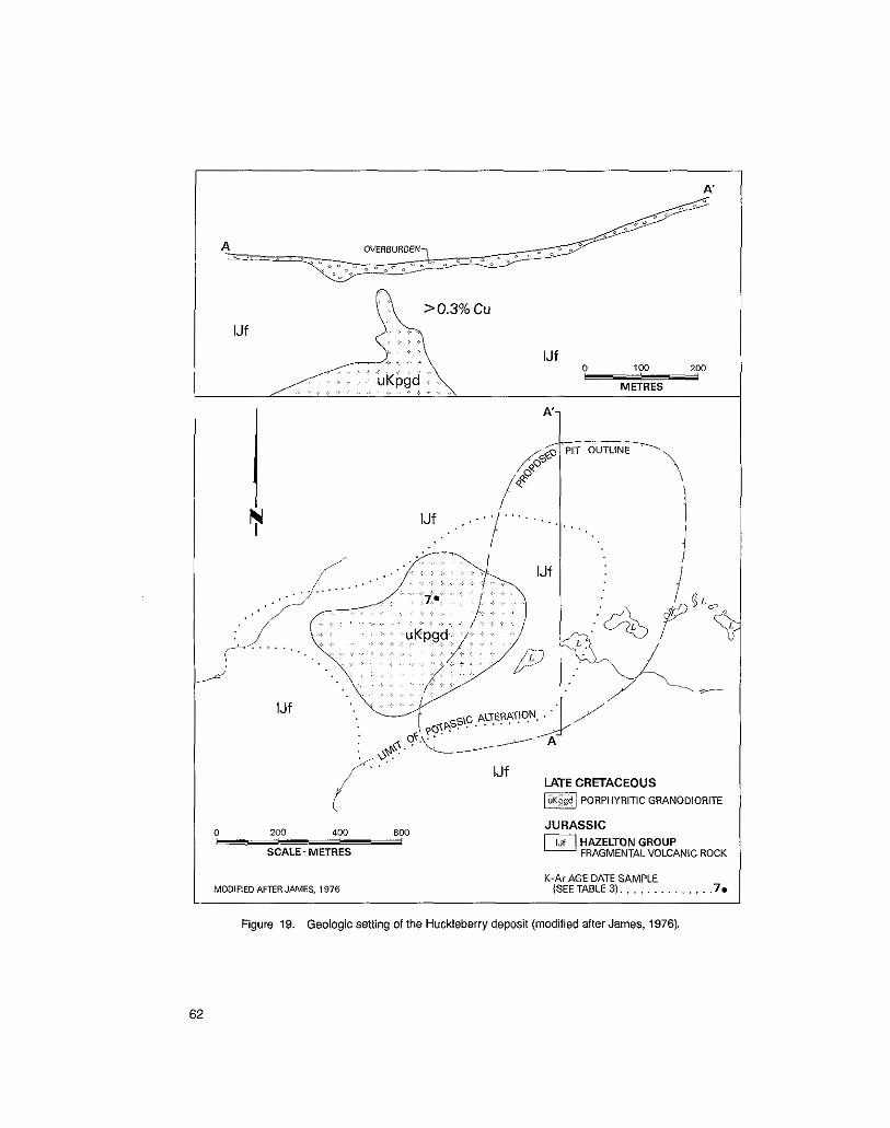
* < .' IJf ' , ~ ,. .> .I
+ c uKpgd:, 0 100 P
200
METRES _ . i , , .... . . * / . ~ ,
IJf LATE CRETACEOUS PORPHYRITIC GRANODIORITE
0 200 400 600 i
SCALE-METRES
JURASSIC HAZELTON GROUP FRAGMENTALVOLCANIC ROCK
MODIFIED AFTER JAMES, 1976 K-Ar AGE DATE SAMPLE
(SEE TABLE 3). . . , . . . . . , . . . .7r
Figure 19. Geologic setting of the Huckleberry deposit (modified after James, 1976).
62

OX LAKE (MI 93E-4) The Ox Lake occurrence (No. 7, Fig. 15) was located in 1968 by a regional prospecting program conducted by Silver Standard Mines Limited and American Smelting and Refin-
forest cover. Surficial expression of the deposit is limited to a small gossan on the bluff ing Company. The deposit is located in an area of subdued topography with extensive
overlooking Ox Lake. The property was tested in 1968 and 1969 by 4 850 metres of diamond drilling in 35 drill holes. Thiswork defined reserves of 29 million tonnes averaging 0.35 per cent copper equivalent (Richards, 1976). The geology of the Ox Lake property, like Huckleberry Mountain, is relatively simple. A
trudes and has hornfelsed felsic to intermediate tuffs of the Hazelton Grow (Fia. 20). small subcircular, single phase stock of porphyritic hornblende-biotite granodiorite in-
63
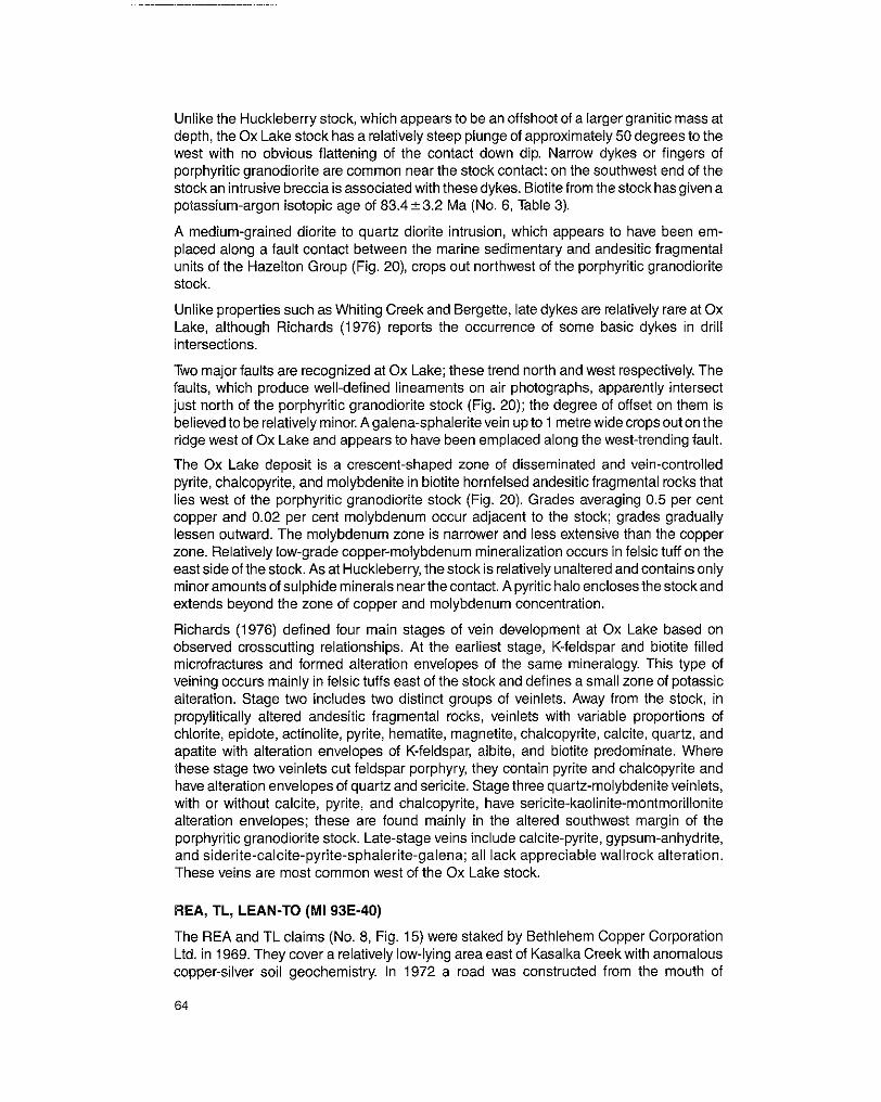
depth, the Ox Lake stock has a relatively steep plunge of approximately 50 degrees to the Unlike the Huckleberry stock, which appears to be an offshoot of a larger granitic mass at
west with no obvious flattening of the contact down dip. Narrow dykes or fingers of porphyritic granodiorite are common near the stock contact; on the southwest end of the stock an intrusive breccia is associated with these dykes. Biotite from the stock has given a potassium-argon isotopic age of 83.4 k3.2 Ma (No. 6, Table 3).
A medium-grained diorite to quartz diorite intrusion, which appears to have been em- placed along a fault contact between the marine sedimentary and andesitic fragmental units of the Hazelton Group (Fig. 20), crops out northwest of the porphyritic granodiorite stock.
Unlike properties such as Whiting Creek and Bergette, late dykes are relatively rare at Ox Lake, although Richards (1976) reports the occurrence of some basic dykes in drill intersections.
Two majorfaults are recognized at Ox Lake; these trend north and west respectively. The faults, which produce well-defined lineaments on air photographs, apparently intersect just north of the porphyritic granodiorite stock (Fig. 20); the degree of offset on them is believed to be relatively minor. A galena-sphalerite vein up to 1 metre wide crops out on the ridge west of Ox Lake and appears to have been emplaced along the west-trending fault.
The Ox Lake deposit is a crescent-shaped zone of disseminated and vein-controlled pyrite, chalcopyrite, and molybdenite in biotite hornfelsed andesitic fragmental rocks that lies west of the porphyritic granodiorite stock (Fig. 20). Grades averaging 0.5 per cent copper and 0.02 per cent molybdenum occur adjacent to the stock; grades gradually lessen outward. The molybdenum zone is narrower and less extensive than the copper zone. Relatively low-grade copper-molybdenum mineralization occurs in felsic tuff on the east side of the stock. As at Huckleberry, the stock is relatively unaltered and contains only minor amounts of sulphide minerals near the contact. A pyritic halo enclosesthe stock and extends beyond the zone of copper and molybdenum concentration.
observed crosscutting relationships. At the earliest stage, K-feldspar and biotite filled Richards (1976) defined four main stages of vein development at Ox Lake based on
veining occurs mainly in felsic tuffs east of the stock and defines a small zone of potassic microfractures and formed alteration envelopes of the same mineralogy. This type of
alteration. Stage two includes two distinct groups of veinlets. Away from the stock, in propylitically altered andesitic fragmental rocks, veinlets with variable proportions of chlorite, epidote, actinolite, pyrite, hematite, magnetite, chalcopyrite, calcite, quartz, and apatite with alteration envelopes of K-feldspar, albite, and biotite predominate. Where these stage two veinlets cut feldspar porphyry, they contain pyrite and chalcopyrite and have alteration envelopes of quartz and sericite. Stage three quartz-molybdenite veinlets, with or without calcite, pyrite, and chalcopyrite, have sericite-kaolinite-montmorillonite alteration envelopes; these are found mainly in the altered southwest margin of the porphyritic granodiorite stock. Late-stage veins include calcite-pyrite, gypsum-anhydrite, and siderite-calcite-pyrite-sphalerite-galena; all lack appreciable wallrock alteration. These veins are most common west of the Ox Lake stock.
REA, TL, LEAN-TO (MI 93E-40)
The REA and TL claims (No. 8, Fig. 15) were staked by Bethlehem Copper Corporation Ltd. in 1969. They cover a relatively low-lying area east of Kasalka Creek with anomalous copper-silver soil geochemistry. In 1972 a road was constructed from the mouth of
64

Kasalka Creek to the area of interest, and eight percussion drill holes totalling 454 metres were completed. In 1980 the property was restaked as the LEAN-TO claims by Lans- downe Oil and Minerals Limited. A moderately strong copper anomaly with coincident gold, silver, lead, and zinc anomalies was outlined by soil sampling east of the area explored by Bethlehem Copper Corporation Ltd. In 1982, 38 shaiiow diamond-driii holes totalling 91 7 metres were completed in this area (Ager and Holland, 1983). This work led to the discovery of a mineralized breccia pipe.
The LEAN-TO property is underlain by volcanic and sedimentary rocks of the Hazelton Group. Fine-grained monzonite and quartz porphyry intrude these rocks east of the main creek valley on the old REA claims. A zone of disseminated pyrite with minor copper, molybdenum, and silver values is associated with these intrusions.
A small knoll 2 kilometres northeast of the area explored by Bethlehem Copper is underlain by a resistant quartz porphyry plug and an adjacent stock of medium-grained granodiorite. These rocks apparently intrude and metamorphose andesitic fragmental rocks of the Hazelton Group and, to the south, fine to medium-grained porphyritic dacite which might be part of the Kasalka Group.
Within the quartz porphyry plug is a pervasively quartz-carbonate-altered breccia zone that is composed of angular clasts of quartz porphyry and hornfels. This breccia is host to significant copper-silver mineralization. The best drill intersection to date is 18 metres averaging 1.59 per cent copper and 42.2 grams silver per tonne (1.24 ounces per ton) (Ager and Holland, 1983).
The Lean-To breccia contains pervasive pyrite that is associated with intense quartz veining and silicification. Pyrrhotite, arsenopyrite, chalcopyrite, sphalerite, and marcasite, which are later, are associated with carbonate veining and alteration. A late stage of pyrite veining is also present within the breccia. Tetrahedrite occurs as a replacement of chalcopyrite. Minor molybdenite and native gold have also been reported. The Lean-To breccia is similar to other breccias associated with quartz porphyry intrusions, such as at Bergette, Whiting Creek, and Coles Creek.
COLES CREEK (FAB; MI 93E-41,42,43,44)
The original claims on the Coles Creek property (No. 9, Fig. 15) were simultaneously staked in 1966 by Kennco Explorations, (Canada) Limited and Amax Exploration, Inc. to
south of Troitsa Lake. Kennco completed several X-ray diamond-drill holes in 1967 but cover a prominent gossan exposed by an east-flowing creek that drains a cirque valley
tested the property in 1972 with seven diamond-drill holes totalling 853 metres. dropped their claims in 1969. Amax, after several geochemical and geophysical surveys,
The Coles Creek property, like Ox Lake and Huckleberry Mountain, has porphyry copper- type mineralization associated with a single phase, subcircular porphyritic hornblende- biotite granodiorite stock (Fig. 21). This stock intrudes and has hornfelsed Hazeiton Group andesitic fragmental rocks along its western contact. A north-trending fault cuts the stock
porphyry (Plate XXII) laccolith that was emplaced along the Hazelton Group-Kasalka near its western margin: east of this fault porphyritic granodiorite intrudes a dacite
Group contact (Maclntyre, 1974). Lapilli tuff, pebble conglomerate, and volcanic sand- stone beds of the lower part of the Kasalka Group are preserved within a graben south of the stock: to the west a northeast-trending quartz diorite intrudes and has hornfelsed
65

LATE CRETACEOUS FELDSPAR PORPHYRY
PORPHYRITICGMNOOIORITE
D,4;;,',:;;$4RZ:F
W A R E DIORITE
LIMIT OF PERVASIVE CLAY i SERICITE-PYRITE
~ ~ ~ L ~ G R O V P LI\PILLI TUFF: VOLCANIC WACKE
BEDDING.. . . . . . . . . . . . . 15/
Figure 21. Geologic setting of the Coles Creek property (after Maclntyre, 1974).
Hazelton Group andesitic fragmental rocks. Potassium-argon analyses of biotite from the porphyritic granodiorite stock indicate an isotopic age of 83.8k 2.8 Ma (No. 5, Table 3). The quartz diorite is probably of similar age.
The main exploration target on the Coles Creek property is a zone of low-grade copper and molybdenum concentration within the porphyritic granodiorite stock. This zone is comprised of chalcopyrite, pyrite, and molybdenite in quartz vein stockworks and SUI- phide-filled microfractures (Plate XXV). Pervasive biotite-orthoclase alteration is associ-
with biotite selvages and pyrite-tourmaline stringers and veinlets with sericite-quartz- ated with this mineralization (Maclntyre, 1974). Chalcopyrite-magnetite-biotite stringers
pyrite alteration envelopes are also present; these crosscut early quartz vein stockworks. Late calcite and ankerite veinlets occur below the zone of weathering.
66

Rocks within the graben and peripheral to the porphyritic granodiorite stock are per- vasively altered, A zone of sericite-quartz-pyrite alteration encloses the stock and grades outward into sericite-carbonate-kaolinite alteration. Permeable Kasalka Group volcanic- sandstone beds south and east of the stock have been cemented with silica and contain very fine-grained disseminations of pyrite with variable amounts of sphalerite and galena. These rocks have anomalous silver concentrations up to 26 grams per tonne (Maclntyre, 1974). Gold concentrations were not determined.
The type of alteration and metal concentrations within the graben at Coles Creek is similar to that found in modern geothermal systems. This suggests that an epithermal environ- ment has been preserved within the graben. To date this target has not been tested by drilling. Crosscutting veins and shear zones containing pyrite, sphalerite, and galena are also present; these may have been major conduits for hydrothermal fluid circulation within the graben.
A small west-dipping breccia pipe is located along the southeast contact of the quartz diorite intrusion (Fig. 21). The breccia iscomprised of angulartotabularclastsof pervasive sericite-carbonate-kaolinite-altered quartz diorite, quartz porphyry, and hornfelsed ar- gillite; these are suspended in a coarse-grained and vuggy matrix of quartz, calcite, sericite, chalcopyrite, magnetite, and minor molybdenite. Variable amounts of galenaand sphalerite are also present and are associated with a late stage of carbonate-kaolinite
the best intersection containing 1.02 per cent copper and 5 grams silver per tonne over 3 alteration and vug filling. The breccia was tested by two diamond-drill holes in 1972 with
metres.
Small zones of biotite-orthoclase alteration with attendant low-grade copper mineraliza- tion also occur within the quartz diorite intrusion. This exploration target has not been tested by drilling.
contain pervasive and vein-controlled chlorite and epidote, typical of propylitic alteration Hazelton Group andesitic fragmental rocks peripheral to the Coles Creek intrusions
assemblages. Magnetite is common within these rocks and there are local, small stringers of galena and sphalerite.
TROITSA (OVP; MI 93E-3,5,9)
The OVP claims (No. 10, Fig. 15) were staked in 1966 by the Silver Standard Mines Limited-American Smelting and Refining Company exploration joint venture. The show- ings on the property were apparently discovered during a follow-up of anomalous silt geochemistry. The original claims covered a prominent peak immediately south of the west end of Troitsa Lake. In 1967 and 1968, the property was tested by 827 metres of
to lapse. The area was restaked in 1969 by Aston Resources Limited and in 1972 diamond drilling in six drill holes. Results were discouraging and the claims were allowed
Quintana Minerals Corporation optioned the property and completed a single 457-metre diamond-drill hole.
The geology of the Troitsa Lake property was described by Cawthorn (1973) as part of a Master of Science thesis study. The property is underlain by a compositionally zoned,
the Hazelton, Skeena, and Kasalka Groups (Fig. 2). The Troitsa stock appears to have a circular stock of hornblende-biotite granodiorite to quartz monzonite that intrudes rocks of
Troitsa Peak (Plate XXVI). Athick, lensoid-shaped mass of quartz porphyryor rhyolite with relatively flat top, as indicated by the horizontal contact visible on the south-facing side of
sill-like extremities intrudes the stock along its western margin. Northwest and rarely
67

northeast-trending dykes of quartz porphyry, lamprophyre, andesite, and feldspar por-
sample of porphyritic granodiorite collected near the centre of the stock gave a potassium- phyry cut both the granodiorite and quartz porphyry intrusions. Biotite extracted from a
argon isotopic age of 75.7t2.3 Ma (No. 12, Table 3).
Azone of low-gradecopper concentration iscentred on feldspar porphyrydykes within the
with quartz, pyrite, chalcopyrite, and rarely molybdenite. Some of the fractures have thin central part of theTroitsastock. The mineralization occursas widelyspacedfracturesfilled
alteration envelopes. Minor galena, sphalerite, and stibnite have also been observed. The host granodiorite is propylitically altered; mafic minerals are replaced by chlorite and feldspars are partly saussuritized. Epidote, calcite, and biotite also occur along fractures. Feldspar porphyry dykes are locally pervasively altered to quartz-sericite and biotite- orthoclase. The best grades of copper are associated with biotite-orthoclase alteration.
EMERALD GLACIER (MI 93E-1,47,48)
The Emerald Glacier deposit (No. 11, Fig. 15) is located on the south slope of Sweeney Mountain at an elevation of 1 950 metres. The showings were originally staked by W. J. Sweeney in 1915. James Cronin leased the property from 1917 to 1919 and drove an exploration adit along the main vein. This adit was advanced and two new adits were added by The Consolidated Mining and Smelting Company of Canada, Limited in the period 1927 to 1931. In 1951, Emerald Glacier Mines Limited reopened the earlier workings and between 1951 and 1953,4 200 tonnesof ore averaging 12.1 per cent lead, 11.5 percent zinc, 408 grams silver per tonne, and 0.27 gram gold pertonne were shipped to a custom mill in Nelson. In 1966, the old Silver Standard mill at Hazelton was dismantled and moved to the Emerald Glacier property. In the same year approximately 450 tonnes of ore was mined producing 129 tonnes of concentrate containing 34 836 kilograms of zinc,
milled in 1967 producing 392 tonnes of zinc concentrate and 142 tonnes of lead concen- 15 382 kilograms of lead, and 69 608 grams of silver. A further 2 200 tonnes of ore was
trate (Sutherland Brown, 1967). From 1968 to 1973 some minor underground develop-
at elevations of 5400,6000,6250, and 6400 feet. All production to date has come from the ment work was done but no ore was shipped. The mine currently consists of four adit levels
6400 level.
The geology of the Emerald Glacier mine has been described by Sutherland Brown (1967). The deposit is a northwest-trending, steeply east-dipping sheared quartz vein system containing galena, sphalerite, chalcopyrite, and pyrite. Minor amounts of calcite, rhodochrosite, and altered rock fragments also occur in the veins. The vein system is
with older andesitic fragmental rocks of the Hazelton Group. Several northwest-trending mainly hosted by volcanic sandstones of the Bowser Lake Group close to the fault contact
dykes that cut the section near the Emerald Glacier deposit appear to postdate the vein mineralization.
Although the Emerald Glacier vein system is comprised of an en echelon group of veins occupying a braided shear, all production has come from a single oreshoot. This main oreshoot is approximately 120 metres long and up to 3 metres wide. Wallrocks are strongly kaolinized; they are locally silicified and pyritized at the contact of the oreshoot.
The proximity of the Emerald Glacier veins to the Sibola stock suggests a genetic relationship.
68

SWANNELL, CAPTAIN (SWING, SAM; MI 93E-35)
The Captain and Swannell groups of claims (No. 12, Fig. 15) were staked on the northeast slope of Swing Peak, just south of Tahtsa Reach, to cover several lead-zinc-silver vein showings. Recently, the property has been restaked by Tahtsa Mines Limited as the Sam and Swing claims. The Tahtsa Mining Company did the first exploration work on the property in 1929 and 1930, driving a 11 6-metre adit on the 1 520-metre level. Four short diamond-drill holes were completed in 1962. A lower, 27-metre adit and 24-metre vertical raise were driven in 1980. Tahtsa Mines Limited has also constructed a four-wheel-drive road from their camp and barge landing on the shores of Tahtsa Reach to the lower workings.
The main exploration target on the property is a north-trending, steeply east-dipping shear zone containing galena, sphalerite, pyrite, arsenopyrite, and tetrahedrite in a gangue of quartz, minor calcite, and wallrock fragments (Duffell, 1959). Goldsmith and Kallock
the vein assayed 12.4 per cent lead, 5.42 per cent zinc, 2 155 grams silver per tonne (1 981) also report the occurrence of chalcopyrite and jamesonite. A selected sample from
(63.07 ounces per ton), and a trace of gold. In addition to the Captain vein, several parallel subsidiary veins or shear zones are also present. The Captain vein is hosted by a fine to medium-grained porphyritic diorite that intrudes the felsic fragmental unit of the lower Kasalka Group.
LEAD EMPIRE (SET, LOST, ICE; MI 93E-8)
William Sweeney first located and staked lead-zinc-silver veins peripheral to the Berg porphyry copper deposit in 1929. W. H. Patmore restaked the showings in 1948 as the
recently, in the period 1969 to 1971, Sierra Empire Mines Ltd. completed 25 diamond-drill Lead Empire group (Duffell, 1959) and some trenching was done in 1951 and 1952. More
holes totalling 2 505 metres on the Set, Lost, and Ice claims (No. 13, Fig. 15). This work concentrated on lead-zinc-silver and copper-molybdenum veins and shear zone replace-
zones cut both quartz diorite and hornfelsed Hazelton Group fragmental rocks. During ments located near the northern boundary of the Berg property. These veins and shear
mapping an occurrence of galena in the basal red pebble conglomerate of the Kasalka Group was also noted.
WEST VIEW (MI 93E-74)
The West View claim (No. 14, Fig. 15) was apparently located on the ridge between Comb and Whiting Creeks, immediately east of the Whiting Creek porphyry prospect. The showing is described in the 1916 Minister of Mines, B.C., Annual Report (p. K163) as a 'rather irregular vein about 4 feet wide, in which the filling is partly quartz and partly wall- rock.' Sphalerite, pyrite, and galena occur in the vein. One sample of high-grade material was reported to contain 'gold, 0.64 02.; silver, 5.7 02.; copper, trace: lead 3.3 per cent; zinc 48.6 per cent' (op. cif.). The West View vein may be related to the Whiting Creek porphyry copper system.
ORIENTAL (MI 93E-51)
Several showings in the vicinity of Sibola Peak are described in the 1916 Minister of Mines, B.C., Annual Report under the names Lone Star, Gold Crown, Bellecini, Golden Chest, and Jolimont. The location of these showings is uncertain but they may have been
69

on or close to the Oriental group of Crown-granted claims that are now situated on the
trending pyrite-quartz veins that iocaliy contain gold and silver. ridge east of Comb Creek (No. 15, Fig. 15). The showings are mainly steep, northwest-
RIVERSIDE (MI 93E-36)
The Riverside showing (No. 16, Fig. 15) was located on the north side of the now-flooded Tahtsa River, immediately east of Huckleberry Mountain (Duffell, 1959). The showing is described in the 1945 Minister of Mines, B.C., Annual Report as a steep-dipping, east- trending fracture containing quartz, arsenopyrite, and minor pyrite, sphalerite, and chal- copyrite. The vein is hosted by andesitic fragmental rocks of the Hazelton Group. A sample of arsenopyrite-rich material is reported to have assayed 0.13 ounce gold per ton and 0.2 ounce silver per ton (Minister of Mines, B.C., Ann. Rept., 1945, p. A67). Similar veins occur to the west on the south-facing slope of Huckleberry Mountain: they are typically less than 10 centimetres in width.
GLORY (MI 93E-7)
The Glory occurrence (No. 17, Fig. 15) is included in the mineral inventory for the Whitesaii map-area (93E) and is apparently the same as the Tahtsa Range occurrence described by Duffell (1959). The showing, which is located south of the Berg porphyry copper deposit, is comprised of several northeast-trending narrow quartz stringers con- taining pyrite, chalcopyrite, galena, specular hematite, and minor gold. The stringers cut
Group. both Eocene quartz diorite and adjacent andesitic fragmental rocks of the Hazeiton
70

5 INTERPRETATION
The most significant result of this study is the discovery that Late Cretaceous continental
Tahtsa Lake area. This Late Cretaceous succession, which has been given the informal volcanic rocks unconformably overlie rocks of the Skeena and Hazelton Groups in the
Columbia. Limited potassium-argon age dating in the Tahtsa Lake district indicates that name Kasalka Group (Maclntyre, 1976), is now widely recognized in west-central British
the base of the Kasalka Group may be as old as 105 Ma. Upper parts of the succession are apparently older than 87 Ma as indicated by an isotopic age determined on a crosscutting intrusion. The Kasalka Group is correlative in age with the Kingsvale Group in southern British Columbia and the Mount Nansen Group in the Yukon.
TAHTSA LAKE CAULDRON SUBSIDENCE COMPLEX
In the Kasalka Range, a 1 500-metre-thick section of the Kasalka Group is preserved in a
tyre, 1976). Evidence supporting this hypothesis includes the presence of high angle, fault-bounded area that is believed to be part of a cauldron subsidence complex (Macln-
thinning and fining of explosive volcanic units away from the area of subsidence, the inward dipping normal faults that bound successively more downthrown fault blocks,
presence of peripheral rhyolitic and dioritic ring dykes, and the occurrence of numerous andesitic feeder dykes and necks within the area of subsidence. Subsidence appears to have been asymmetric; the maximum downward movement of approximately 1 000 metres occurred along the north side of Swing Peak ridge. This type of asymmetric subsidence was also noted by Lambert (1974) in the younger Bennett Lake cauldron subsidence complex.
and pervasively altered to phyllic and argillic alteration assemblages. Small plugs and Rocks near major faults within the cauldron subsidence complex are typically brecciated
fault zones: the faults may have been conduits for andesitic flows deposited within the dykes of fine-grained porphyritic diorite and andesite have been emplaced along these
subsided area. Thick beds of chaotic breccia and conglomerate occur within the Kasalka Group sequence adjacent to the faults on Swing Peak ridge: these rocks, which are interbedded with lahar and volcanic sandstone, are interpreted to be landslides and slumps off steep fault scarps. Basalt flows cap this sequence and may represent late- stage moat volcanic rocks.
71
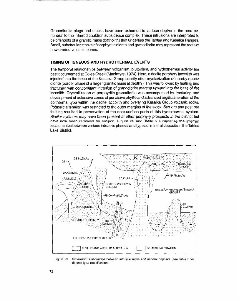
Granodioritic plugs and stocks have been exhumed to various depths in the area pe-
be offshoots of a granitic mass (batholith) that underlies the Tahtsa and Kasalka Ranges. ripheral to the inferred cauldron subsidence complex. These intrusions are interpreted to
Small, subcircular stocks of porphyritic diorite and granodiorite may represent the roots of now-eroded volcanic cones.
TIMING OF IGNEOUS AND HYDROTHERMAL EVENTS
The temporal relationships between volcanism, plutonism, and hydrothermal activity are best documented at Coles Creek (Maclntyre, 1974). Here, a dacite porphyry laccolith was injected into the base of the Kasalka Group shortly after crystallization of nearby quartz diorite (border phase of a larger granitic mass at depth?). This was followed by faulting and fracturing with concomitant intrusion of granodiorite magma upward into the base of the laccolith. Crystallization of porphyritic granodiorite was accompanied by fracturing and development of extensive zones of pervasive phyllic and advanced argillic alteration of the epithermal type within the dacite laccolith and overlying Kasalka Group volcanic rocks.
faulting resulted in preservation of the near-surface parts of this hydrothermal system. Potassic alteration was restricted to the outer margins of the stock. Syn-ore and post-ore
Similar systems may have been present at other porphyry prospects in the district but have now been removed by erosion. Figure 22 and Table 5 summarize the inferred relationships between various intrusive phases and tyoes of mineral deposits in the Tahtsa Lake district.
I 0 PHYLLIC AND ARGlLLlC ALTERATION 0 POTASSIC ALTERATION
Figure 22. Schematic relationships between intrusive rocks and mineral deposits (see Table 5 for deposit type classification).
72

TABLE 5. PLUTONIC-HYDROTHERMAL RELATIONSHIPS, TAHTSA LAKE DISTRICT
1. DEPOSITS RELATED TO SUBCIRCULAR STOCKS OF PORPHYRITIC GRANODIORITE AND QUARTZ MONZONITE
A. Annular zones of disseminated and fracture-controlled pyrite, chalcopyrite, and molybdenite surrounding stock
B. Zones of quartz veining with chalcopyrite, molybdenite, and attendant po- tassic alteration within stock
C. Psrvasive argillic altered zones with fine-grained disseminated and fracture- controlled pyrite, galena, and sphalerite; silver and gold (?) bearing; high-level epithermal system
D. Veins and veinlets of pyrite and quartz with galena and sphalerite in propylitic zone peripheral to stock
2. DEPOSITS RELATED TO QUARTZ DIORITE AND GRANODIORITE STOCKS
A. Low-grade zones of disseminated and fracture-controlled pyrite and chal- copyrite with potassic alteration near contact of stock
E. Quartz veins and veinlets with pyrite, galena. sphalerite; minor arsenopyrite, tetrahedrite, specular hematite, and chalcopyrite; veins peripheral to stock
BERG
OX LAKE HUCKLEBERRY
WHITING CREEK (RUSTY ZONE)
COLES CREEK WHITING CREEK (CREEK ZONE)
COLES CREEK (GRABEN)
LEAD EMPIRE
WHITING CREEK
BERGETTE (SWEENEYZONE)
SYLVIA COLES CREEK
WEE
EMERALD GLACIER CAPTAIN WEST VIEW OMENTAL GLORY RIVERSIDE (?)
3. DEPOSITS RELATED TO FELDSPAR PORPHYRY DYKES
A. Low-grade zones of disseminated and fracture-controlled pyrite, chalcopyrite, TROITSA and molybdenite adjacent and within potassic and phyllic altered dykes WHITING CREEK
4. DEPOSITS RELATED TO QUARTZ PORPHYRY PLUGS, PIPES, AND LACCOLITHS
A. Zones of pervasive phyllic alteration with quartz flooding with disseminated WHITING CREEK and vein-controlled pyrite, molybdenite, and minor chalcopyrite (RIDGE ZONE)
B. Brecciated and phyllic altered quartz porphyry with superimposed breccia- COLES CREEK healing phases of chalcopyrite, molybdenite, magnetite, pyrite, galena, LEAN-TO sphalerite, and minor arsenopyrite and tetrahedrite; locally high grade; silver BERGETTE bearing
73
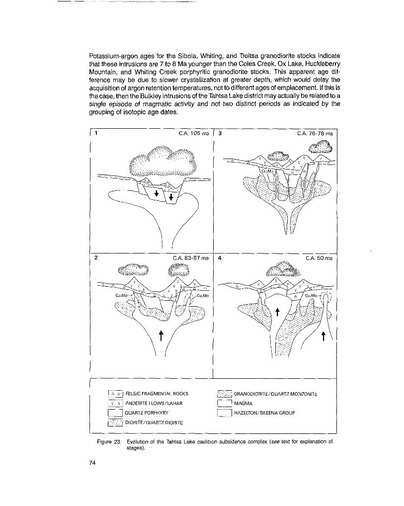
Potassium-argon ages for the Sibola, Whiting, and Troitsa granodiorite stocks indicate that these intrusions are 7 to 8 Ma younger than the Coles Creek, Ox Lake, Huckleberry Mountain, and Whiting Creek. porphyritic granodiorite stocks. This apparent age dif- ference may be due to slower crystallization at greater depth, which would delay the acquisition of argon retention temperatures, not to different ages of emplacement. If this is the case, then the Bulkley intrusions of the Tahtsa Lake district may actually be related to a single episode of magmatic activity and not two distinct periods as indicated by the grouping of isotopic age dates.
l 1 C.A. 105 m a T
2 c . A . s ~ - s ~ ma I
I
3 C.A. 76-78 ma 1
I a C.A. 50 ma I
3 GRANODIORITE/QUARTZ MONZONITE
3 MAGMA I FELSIC FRAGMENTAL ROCKS
ANDESITE FLOWS/LAHAR
E [ - a QUART2 PORPHYRY 0 HAZELTON/SKEENA GROUP
OIORITE/QUARTZDlORlTE
Figure 23, Evolution of the Tahtsa Lake cauldron subsidence complex (see text for explanation of stages).
74

GENETIC MODEL
A genetic model for evolution of the Tahtsa Lake district is presented on Figure 23. This
construction of the Late Cretaceous volcanic arc. In the initial stages explosive rhyolitic model depicts the various episodes of volcanic and plutonic activity that took place in
volcanism was followed by subsidence into vacated magma reservoirs (Stage 1, Fig. 23). Perhaps some 20 million years later, extrusion of andesitic magma produced volcanic cones peripheral to and within the area of subsidence (Stage 2, Fig. 23). The subvolcanic Kasalka intrusions and early quartz diorite phase of the Bulkley intrusions represent the plutonic component of this volcanism. The elongate nature of several of these intrusions and their orientation parallel to the inferred boundary of the Tahtsa Lake cauldron subsidence complex implies that they were emplaced along ring fractures that formed during subsidence. Lahar, landslide deposits, and, finally, basalt flows partially filled the subsided area in Late Cretaceous time.
The first major episode of post-subsidence magmatic resurgence and associated hydro- thermal activity occurred between 87 and 83 Ma. Rupturing of magma reservoirs resulted in violent escape of highly differentiated volatile-rich magma that formed small plugs, dykes, and breccia pipes of quartz porphyry and dacite porphyry. This was followed by upwelling and possible extrusion of magma to form stocks and dykes of porphyritic granodiorite to quartz monzonite. Extensive hydrothermal systems, which involved cir- culation and mixing of both meteoric and magmatic fluids, developed about these intru- sions. Both epithermal lead-zinc-silver veins and disseminations and zoned porphyry copper depositsformed. Most of the mineralized zones and associated intrusions lie in an arcuate belt about the area of subsidence: their localization may have been controlled by radial and concentric faults formed during volcanic collapse. An episode of extension and emplacement of northwest-trending porphyritic dyke swarms occurred around 78 to 76 Ma (Stage 3, Fig. 23).
The Tahtsa Lake cauldron subsidence complex was again the site of magmatic activity in Late Paleocene and Early Eocene time (Stage 4, Fig. 23). The initial event was emplace- ment of the Mount Bolom stock accompanied by doming of volcanic strata within the cauldron subsidence complex. Magmatic activity continued well into the Eocene with
of the Berg intrusions; this was accompanied by formation of the Berg porphyry copper intrusion of northwest-trending dyke swarms of various compositions, and emplacement
deposit. Extrusive activity may have accompanied these plutonic episodes.
SUMMARY
deposits are associated with periods of magmatic resurgence that post dated cauldron In the Tahtsa Lake district of west-central British Columbia porphyry copper-molybdenum
volcanic and plutonic activity are similar to those derived by Lipman, et al. (1976) and subsidence. The inferred sequence of events and apparent time-space relationships of
for the Andean volcanic arc, and by Robinson, et al. (1968) for the Boulder batholith area. Steven and Lipman (1974) for the San Juan volcanic field of Colorado, by Sillitoe (1 977)
In all these areas major episodes of hydrothermal activity postdate the main period of volcanism and are genetically related to short-lived periods of magmatic resurgence that
episodes of volcanic activity and caldera collapse, such as radial and ring fractures, had a relatively minor extrusive component. Structures established during the initial
appear to have been extremely important in localizing these post-volcanicor post-caldera plutonic centres and their attendant hydrothermal systems.
75

Although the temporal and spatial relationships of volcanism and plutonism are well established in many areas, reasons for periodic episodes of magmatic resurgence in the evolution of volcanic terranes are not clearly understood. Perhaps fluctuations in the
the most important causative factors. Certainly in the Tahtsa Lake area there is evidence regional stress regime related to changes in the direction and rate of plate subduction are
that several periods of extension and dyke emplacement postdate the main volcanic event. A similar trend has been documented by Katz (1971) in evolution of the Andean volcanic arc, where the tectonic style at any given point oceanward of the arc became progressively more extensional as the locus of volcanism migrated eastward.
76

APPENDIX A - FOSSIL IDENTIFICATIONS
REPORT 5-6-1978
H. Frebold, Geological Survey of Canada, Ottawa Field No. 8-78TD-F3, GSC loc. 6-80131
Ashman Formation, Bowser Lake Group. On road to Emerald Glacier mine, Mount Sweeney, second lowest west-pointing switch back. 53”43’35”N, 127”15‘15W. Whitesail Lake area. H. W. Tipper coll. July 26, 1978.
Identifications The ammonites collected at this locality are very poorly preserved. There are some small specimens which cannot be determined safely. Some of them may be inner whorls of a species of the genus lniskinifes Imlay, which is represented by a fragment of a larger specimen. The shape of this specimen is globose and the ribs of the preserved parts of the last and penultimate whorls are strong. At a comparable size l . magniformis (Imlay) is more globose, has a lower cross-section, and finer ribs. 1. abruptus (Imlay) is apparently similar in shape to the Whitesail Lake specimen but has much finer ribs at comparable stages of growth. The Whitesail Lake specimen is here listed as lniskinites sp. nov.
Two other genera are present in this collection:
Oppelia (Oxycerifes) sp. indet. Perisphinctid gen. et species indet. Both ammonites are extremely poorly preserved
Conclusions The presence of the genus lniskinifes lmlay in this collection indicates a Late Bathonian age.
REPORT Km-4-1979
J.A. Jeletzky, Geological Survey of Canada, Ottawa Field No. 62C-78RW, GSC loc. 96261
From Skeena Group 609250E, 5963780N. North Sibola Range, northwest of Mount Sweeney, UTM-9U.
Fragments of ammonites resembling Brewericerasor Cleoniceras (Grycia) but not identi- fiable generically with any degree of certainty.
Pecten (Entoliurn) sp. indet. TOxasfe(?) sp. indet. (an irregular echinoid)
Nucula (s. lato) sp. indet.
Age and Correlation Poor ammonites of the lot 96261 suggest, but do not prove, its early to mid-Albian age. Poorly preserved irregular echinoids, presumably belonging to the genus Toxaster, ap- pear to be the same form as that commonly associated with Cleoniceras (Grycia) perezianum fauna in the Whitesail Lake area and elsewhere in northwestern British Columbia. It is suggested accordingly that lot 96261 represents this mid-Albian fauna and is correlative with the lots 96252 and 96253. Lot 96261 can only be dated definitively as of a general Cretaceous age on the basis of its poorly preserved fossils alone.
77
APPENDIX B - KASALKA GROUP TYPE SECTIONS
METRES FELSIC FRAGMENTAL UNIT
200
100
0
MASSIVE FINE-GRAINED MEDIUM TO LIGHT GREY PORPHYRITIC RHYDDACITE
a,,'"," n ~ '.. n
MASSIVE POORLY SORTED GREENISH GREY VOLCANIC BRECCIA; MAINLY RHYOLITIC CLASTS
_ . % . ~. . n . - STRATIFIED FINE-GRAINED MEDIUM GREY LITHIC
' .* A . .. ~ %
.- p "' TUFF; NON TO PARTLY WELDED
3 % 0 -'
/ o m - 0 o o MASSIVE COARSE-GRAINED MEDIUM GREY VOLCANIC
BRECCIA; RHYOLITIC, ANDESITIC, AND SEDIMENTARY CLASTS; MINOR CRYSTAL, LAPILLI, AND ASH TUFF INTERBEDDED WITH THE BRECCIA
"
" " 0 "
2 0 0 0
DAClTlC CRYSTAL TUFF; MODERATE TO DENSELY FINELY LAMINATED LIGHT TO DARK GREY RHYD-
WELDED. PROMINENT EUTAXITIC TEXTURES; VERY SILICEOUS IN PLACES
n r n " . r 2 - 0 5 0 -
MASSIVE MEDIUM-GRAINED PORPHYRITIC ANDESITE
MASSIVE LIGHT GREY PORPHYRITIC RHYODACITE; FLOW BANDED IN PLACES; GRADES INTO DACITE AND ANDESITE UP SECTION
"X.."^. . n D n * A
STRATIFIED MEDIUM TO COARSE-GRAINED LIGHT GREY RHYODACITIC LAPILLI TUFF; NDN TO PARTLY WELDED
- POORLY SORTED RED PEBBLE CONGLOMERATE WITH ~ MINOR SANDSTONE
SKEENA GROUP IALBIAN) ARGILLITE, MICACEOUS WACKE
LOCATION: NORTHWEST SPUR OF MT BAPTJSTE
78

APPENDIX B - KASALKA GROUP TYPE SECTIONS - Continued
METRES
r
600
400
200
0 i
............
...............
BASALT UNIT
MASSIVE DARK GREY, FINE-GRAINED AUGITE- HORNBLENDE-BASALT; RELATIVELY FRESH WITH PROMINENT COLUMNAR JOINTING
LAHAR UNIT
"_ _ ~ _ PURPLISH GREY PORPHYRITIC ANDESITE
MASSIVE STRATIFIED LAHAR AND MASS FLOW
GRAINED BEDS; CLASTS IN LAHAR MAINLY DEPOSITS: MIXED VERY COARSE AND FINE-
PORPHYRITIC ANDESITE: MINOR CRYSTAL TUFF, TUFF-BRECCIA, AND SANDSTONE INTERBEDDED WITH LAHAR
PORPHYRITIC ANDESITE UNIT
TO MEDIUM-GRAINED PORPHYRITIC AUGITE- MASSIVE GREENISH GREY TO LIGHT GREY FINE
HORNBLENDE ANDESITE; MINOR DACITE TOWARD BASE OF SECTION
\ FELSIC FRAGMENTAL U N I l
LOCATION: SOUTH SLOPE OF SWING PEAK RIDGE
79

m 0
APPENDIX C
CHEMICAL ANALYSES (OXIDES, WT O h ) AND ClPW MOLECULAR NORMS OF TYPICAL SAMPLES OF KASALKA GROUP VOLCANIC ROCKS
. Total Fe 8s Fe,O,: L.O.I. = Loss on ignition.
2-Porphyritic hornblende andesite, 4.4 km southeast of Laventie Mountain. I-Lapilli-tuft Mt. Baptiste.
3-Parphyritic andesite, Swing Peak. 4-Porphyritic homblende biotite andesite, south Slope Swing Peak ridge. 5-Porphyritic hornblende andesite, 5.8 km southwest of Swing Peak. 6-Porphyritic hornblende andesite, Swing Peak ridge. 7-Porphyritic andesite, 5 km northwest Of MI. Baptiste. 8-Rhyolitic lapilli-tuff, Mi. Baptiste. 9-Porphyritic dacite. north slope of Swing Peak.
lo-Banded rhyodacite flow, 4.5 km southeast of Laventie Mountain 11 -TURaCeOUS rhyodacite flow, 3.1 km east of Berg Peak. 12-Rhwlitictufl, 8.1 km east Of Berg Peak 13-Mebium.grained hornblende-biolite-augite diorite, Ox Lake. 14-Hornblende-augite andesite dyke, north slope. Swing Peak. Sample. IS-Porohv~iBc hornblende-awite andesite stock (71 northwest of Mi. BaDtiste. 16-P~;phyiitic hornblende-augite andesite dyke, "drth slope, Swing Peak.
MAP UNIT
NO. 1 17 18 1 19 20 21 22 1 23 I 24 25 26 27 I 28
....................................................................
. . . . . . . . . . . . . . . . . . . . . . . . . . . . . . . . . . . . . . . . . . . . . . . . . . . . . . . . . . . . . . . . . . . .
..................................................................
SiO, 64.35 Ti02 0.45 A1203 16.41
'Fe,O, : 4.81 MoO 0.13 MgO .................................................................... 1.91 CaO . . . . . . . . . . . . . . . . . . . . . . . . . . . . . . . . . . . . . . . . . . . . . . . . . . . . . . . . . . . . . . . . . . . . 3.71 NaO .................................................................. 4.84 K,O . . . . . . . . . . . . . . . . . . . . . . . . . . . . . . . . . . . . . . . . . . . . . . . . . . . . . . . . . . . . . . . . . . . . . 2.09 P . 4 ................................................................... 0.26
..................... ............................................ . . . . . . . . . . . . . . . . . . . . . . . . . . . . . . . . . . . . . . . . . . . . . . . . . . . . . . . . . . . . . . . . . . . .
it . . . . . . . . . . . . . . . . . . . . . . . . . . . . . . . . . . . . . . . . . . . . . . . . . . . . . . . . . . . . . . . . . . . . . . . . . . .
ap . . . . . . . . . . . . . . . . . . . . . . . . . . . . . . . . . . . . . . . . . . . . . . . . . . . . . . . . . . . . . . . . . . . . . . . .
c ..........................................................................
An . . . . . . . . . . . . . . . . . . . . . . . . . . . . . . . . . . . . . . . . . . . . . . . . . . . . . . . . . . . . . . . . . . .
12.48 15.85
43.91 16.90 0.00 7.55 2.06 0.63 0.55 0.06
27.79
64.47
16.17
4.08
0.26
18.47
37.13 13.29
19.52
0.55
34.45
60.58 0.76
15.94 5.16 0.11 4.18
4 9 7 5.18
2.09 0.30
99.70
1.03 - -
9.87 12.45 39.56 17.86
11.82 4.88
1.87 1.07 0.63
31.10
62.96 0.69
15.51 4.97 0.09 2.78 4.52 4.21 2.62 0.32
99.50
0.63 __ __
13.60 16.88 38.29 15.29 4.26 8.23
0.97 1.80
0.68
28.54
63.06 0.72
16.04 4.55
2.77 0.08
4.25 4.21 2.90 0.29
99.69
1 .02 __ __
13.56 17.32 38.22 16.49 2.35 8.78 1.65 1.01 0.61
30.14
* Total Fe as Fe,O,; L.O.I.=Loss on ignition.
17-Medium-grained hornblende augite diorite plug, south slope, Rhine Ridge. 18"Same as M203. 19-Medium-grained porphyritic biotite quam diorite, Coles Creek prospect. 20-Medium-grained hornblende-biotite granodiorite, east mntad Siboia Stock, 1.9
21-Medium-grained biotite quwf2 diorite. Mt. Baptiste. Sample 0-255. 22-Medium-grained hornblende-biotitegranadiorite, SibolaStock, 3.5 km northoiMt.
km northwest d Sibala Peak.
23-Medium-grained porphyritic hornblende-biolite granodiorite. Coles Creek. 24-Medium-grained hornblende-bime granodiorite, Siboia Stock, Mt. Sweeney.
sweeney:
66.23 0.66
66.30 64.23
4.17 3.92 4.09 2.91 2.69 2.83 0.08 0.05 0.10 4.14 4.29 4.38
15.33 15.76 15.31 0.59 0.64
4.07 I 4.0; 1 4.03
E+?@ 100.08 101.25 99.73
15.65
36.93 17.64
14.98
0.93 0.63
28.82
ij 15.67 18.12 36.71 16.11
0.90 0.55
30.51
15.35 18.34 36.59 14.84 3.40 8.56 1.50 0.63 0.83
28.85
19.28 18.55 38.79 13.01 0.92 7.14 1.15 0.66 0.51
25.12
20.52 18.76 37.59 12.89 2.13 5.93 1.15 0.61 0.42
25.54
20.50 20.30 37.57 12.61
6.64 0.28
1.13 0.58 0.40
25.12
19.56 16.83 36.87 15.46 3.27 5.51 1.37 0.69 0.45
29.54
tpqm ukpgm ukpqm ukqp
66.91 68.77 70.25 70.62
14.67 14.25 13.81 16.76 0.58 0.49 1 0.42 1 0.22
4.02 3.58 3.17 1.50
2.31 1.77 1.84 0.71 2.85 2.77 2.28 1.08
0.041 o.06 1 0.13 1 0.23
0.06
25-Medium-urained hornblende-biotite clraoodiorite. Sibola Stock. 3.2 km northwest
28-Medium-grained hornblende-biotite granodiorite, Whiting Stock, Whiting Creek. 27"Mediumqrained hornblende-biotite granodiorite, Whiting Stock, Whiting Creek. 28-Medium-urained Dorohvrilic hornblende-bolile Ciranodiorite. Ox Lake. 29-Coarse-grainedpdrphyritic hornblende-biocte quartz monzonite, Bergelte
30-Medium-grained porphyritic hornblende-biotite quartz monzonite, Bergene
31-Medium-grained porphyritic q u a m monzonite dyke, 3.2 km nolthWBst of Mt.
32-Quarb porphyry dyke, Whiting Creek.
Prospect.
Prospect.
Sweeney.

m N CHEMICAL ANALYSES (OXIDES, WT YO) AND ClPW MOLECULAR NORMS OF TYPICAL SAMPLES OF
KASALKA GROUP VOLCANIC ROCKS-Continued
* Total Fe as Fe,O,; L.O.I.= Loss an ignition ' total pyroxene
33"Aphanitic rhyolite, Whiting Creek. 34-Quark porphyry dyke, Whiting Creek. 35-Fine-grained quartz porphyry dyke, north shore, Troirsa Lake. 36-Quartz porphyry. north shore, Troitsa Lake. 37-Medium-grained porphyritic hornblende-biotitegranophyre. MI. BolomStock,
38-Medium-grained porphyritic hornblende-biotite granophyre. MI. Bdom Stock, 7.8
39-Medium-grained porphyritic hornblende-biotitegranaphym, MI. BofomStock5 krn
40-Medium-grained porphyritic hornblende-biotite granophyre, MI. Boiom Stock 5 km
41 -Fine-grained porphyritic hornblende-biotite granophyre. Mt. Bolom Stock, 2.5 km
north tip of Blanket Lakes.
km north-northemiof Mt. Bolom.
north of Mt. Boiom.
north of Mt. Bolom.
east of MI. Bolom.
Tpqm
45 46
67.54 62.50 0.51 0.51
15.62 15.12 2.00 2.58 0.02 0.06 1.04 1.49
2.76 3.13 1.02 2.39
5.06 4.55 0.30 0.18 n.d. n.d.
30.50 24.70 31.20 29.10 25.90 30.40 3.20 7.70 3.007 4.80
1.40 2.00 0.30 0.10
A B C
0.70 0.24 0.61 1.50 73.23 65.50
7.00 14.03 15.65 5.40 2.47 4.70 0.09 0.02 0.09
5.30 1.32 4.10
0.23 0.05 0.23 1.90 4.08 3.01
1.30 - 0.69 9.42 - 100.28
2.30 0.35 1.86
3.90 3.94 3.84
42-Fine-grained porphyritic biotite granophyre dyke, 1.5 km south of Swing Peak. 43-Medium-grained hornblende-biotite quark diorite, 0.5 km emt of Berg prospect. 44-Medium-grained hornblende-biotite quartz diorite, 2 km South of Berg prospect. 45"Po~phyritic quartz monzonite. Berg Stock. Carter, 1961. 46"Plagiociase biotite quark porphyry, Berg Stock. Carter, 1981, A-Quark bearing iatite-andesite. north volcano Tumisa, Chile. Seigers etal., 1969. B-Average rhyoiite, Cascade Volcanos. Carmichael el al., 1874. C-Average hornblende-biotitegranodiorite. Nockoids, 1954