wednesday 16 august, bowmore icci forgoeen lives of...
TRANSCRIPT
ISLAYARCHAEOLOGYWEEK10-16August2017
Wednesday16August,BowmoreICCIForgoEenlivesoftheIleachThearchaeologyofIronAgeDunFhinnandlaterseElementsofKintourProfessorStevenMithen

ISLAYARCHAEOLOGYWEEK10-16August2017
IslayHeritageisacharitydevotedtofurtheringknowledgeaboutIslay’spast,andthemanywaysinwhichitcanbeexploredandenjoyedbyeveryoneRESEARCHEDUCATIONRECREATIONCONSERVATION
www.islayheritage.org

ISLAYARCHAEOLOGYWEEK10-16August2017
TheIslayShow10August
WalkstotheGiant’sGrave11,12,13August
ImaginingKildalton,PortEllen7pmMonday,14August
FirstfootstepsonIslay,PortCharloEe,7.00pmTuesday14August

ISLAYARCHAEOLOGYWEEK10-16August2017
Palaeolithic??-9,600BC
Mesolithic9,600–3800BC
Neolithic3800–2000BC
BronzeAge2000–500BC
IronAge600BC–AD400
EarlyMedievalAD400–1100ArrivalofVikingsat800
LateMedievalAD1100-1600TreatyofPerth1266,whenNorwegianKinghandedcontrolofHebridestoKingofScotland
Post-MedievalAD1600–presentday
PREHISTORIC HISTORIC

TheKintourLandscapestudyarea
Kintour

TheKintourLandscapeSurvey
RoddyRegan

ArchaeologicalsiteslistedonCanmore
Virtuallynosystema;carchaeologicalworkinmodern;mes• Cupmarkedstone• Cistburial• Standingstones• Hutcircles,Enclosures,and
Homesteads–BronzeandIronAge?
• FiveFortsandnineDuns:IronAgeandMedieval?
• Medievalsites:chapelsandburials
• Sheilings,onthehigherground
• SeElements

AverybriefhistoryoflandholdingonIslay
• DuringmedievalperiodmuchofIslaywasdominatedbyvariousbranchesoftheMacDonaldsofIslay
• Betweenlate15thandearly16thcenturiesMacDonaldsforfeitedtheisland
• In1493JohnIILordoftheIsles,JohnMaclanofArdnamurchanwasawardedextensivelandsonIslaybyJamesIV,includingthoseforfeitedbyJohnMacDonaldofDunyvaig,andthecastleofDunyvaigitself
• In1510Maclanwasmurdered,leavinghisyoungsonsundertheguardianshipofhisbrotherinlawtheEarlofArgyllwhopassedtheadministra;onoftheirIslayestatestoCampbellofCawderunblhissonAlexandercameofageandtookpossessionofhisfather’sestatein1528
• TheMaclaninfluencecametoanendwhenJamesMacDonaldofDunyvaigwasgrantedhisfamilylandsin1545
• FamilydebtseventuallyledtothelandsbeingmortgagedtoJohnCampbellThaneofCawderin1612,whileinternalfamilyfeudinganddisorderintheislesledtoIslay’slandsbeinggiventoCawderbythecrownin1614.FollowingsiegesatDunyvaigandLochGorme,Cawdertookpossessionin1615

AverybriefhistoryoflandholdingonIslay
• DespitetryingtoselltotheEarlofAntrimin1627,IslayremainedinCawder’shandsunbl1723whenitwasmortgagedtotheCampbell’sofShawfield
• TheCampbellsbroughtinnewtacksmentosupplantforformersupportersofClanDonald– tacksmenwerelandholdersofintermediatelegalandsocialstatus,whosub-lettheirlandtotenants
• Inordertomaximiseprofitsthetacksmenincreasednumberoftenantsonsomelandholdings,includingthoseofArdtallaandClaggainin1644
• BecauseIslaycouldnotprovidetheincomerequiredfortheCawderfamilyitwasmortgagedtoDanielCampbellofShawfield,whoboughttheestatein1726
• DanielCampbellandhisdescendantstriedtointroduceimprovements,suchasdrainage,enclosuresandnewcrops(potatoes)
• BankruptcyofWalterFrederickCampbellforcedthesaleofhisIslayEstatetotheVictorianentrepreneurJamesMorrisonin1853,whosoldtheKildaltonEstatetoJohnRamseyin1855
• KildaltonHouseandthe16,000acreestatewasthenacquiredin1922bytheadventurerJohnTalbotClifon,andremainedwithhisfamilyunbltheleasewaspurchasedbytheMactaggartfamilyin1938.ThelandsarenowpartoftheArdtallaEstate.

Cartographicevidence:Blaeu’sAtlas1654
• ThefirstAtlasofScotland• PublishedinAmsterdam,inLabn,Dutch,FrenchandGerman,Spanishonelateradded• Basedoncartographicworkundertakeninlate16thcentury• DepictsaseriesofseElementsrunningdownSEcoastofIslay,northofArdilistryBay
(Clagintarroch)
(Trudernish)
(Ardtalla)
(CnocRhaonasbl)
(Kildalton)
(Proag)
(Kintour)

StephenMacDougall’smapofIslay1749-51
• AseriesoflinerNW/SEorientedfarmsorlandholdingswithinthenorthernendoftheKildaltonparish
• ThesecontainseElementsthatroughlyequatetotheposibonsofknownseElements
(Ardtalla)
(Kildalton)
(Ardmoir)
(Proag)
(Kintour)
Craigfin
Staoin

Landdivisions
• ThelanddivisionsandtheirseElementslikelyestablishedbytheendofthe15thcentury
• Kintourestablishedasanestatecentreconsisbngof10marklands
• Staoin,CreagfinandBallorepartofthelandholdingofKintour
Amarklandwastwelveouncelands.Themarklandderiveditsnamefromtheoldcoin,theMerk,whichwastheannualrentpaidonit,andsoitwascalculatedbythis,ratherthanitsactualarea.OriginallyaScotsMerkScotswas13s4d(160pence),buttheScojshcoinagedepreciatedagainsttheEnglish,andbythe18thcenturyaScotsmerkwasworthonly131/3dsterling–one-twelfhofitsoriginalvalue.

GeorgeLanglands’mapofArgyll1802

Cartographicevidence:FirstedibonofOrdnanceSurveyMap1878
Muchgreaterdetail,withseveralnamedseElements,andseveralunnamedseElements
DunFhinn
StaoinCreagfinn Ballore

Archaeologicalsurvey,April2017
• April1-72017• Walkoversurvey,ledbyRoddyRegan• Recorded19sites,rangingfromdeserted
townshipstoisolatedsheilings

FirstedibonofOrdnanceSurveyMap1878
DunFhinn
StaoinCreagfinn Ballore

DunsandFortsonIslay
• Islayhas92structuresclassifiedasfortsandduns,andoneidenbfiedasabroch
• TheKintoursurveyareahasfivefortsandnineduns,oneofthehighestdensityofthesestructuresinArgyll
• AssumedtodatetotheIronAgec.800BC–400AD–butnodunsorfortshavebeenexcavatedonIslay
• DunFhinnoccupiesthenorthernendofofaprominentSW/NEorientednaturalridge,withextensiveviewstothenorth,eastandwest,withmorelimitedviewstothesouth.

DunNosebridge
Anatypicaldun,potenballyearlyMedieval.Itasaresemblancetotheringworksassociatedwith
maraudingarmiesinEnglandandIreland,butfollowingaScandinaviantradibon.Alternabvely,aitmightbeaHebrideaninterpretabonofmoEes
orAnglo-Normanringworks

Similarly,DunGuaidhre

WalkingtoDunFhinn,April2017

CaptainMacDonalds’expedibontoDunFhinn,recordedinvolume2oftheFounda'onsofIslaybyDomhnullGruamach(1970),whichisinIanMitchell'scollecbonintheIslayMuseum.
AnotherwalktoDunFhinnon7April1964

DunFhinn,April2017

FionnmacCumhaillsomebmestranscribedinEnglishasMacCoolorMacCoul,wasamythicalhunter-warriorofIrishmythology,occurringalsointhemythologiesofScotlandandtheIsleofMan.
DunFhinn

TheRCAHMSdescribeDunFhinnas:‘Thisdunissituatedonarockyknollinroughmoorland1.6kmWNWofKintour.Theknollrises15mabovethesurroundinggroundbuthasli?lenaturaldefensivestrength.Thedunmeasures18mby11mwithinwhatwasamassivewallvaryinginthicknessfrom3.5montheNEto2.0montheWSW.Largeinnerandouterfacing-stonesremaininposi'onintermi?ently,andwalldebriscoverstheSEflankoftheknollinascree-likespread.AttheSWendthereisapar'cularlyheavyspreadofjumbledstones,andwhilewithoutexcava'onitisnotpossibletobesure,itseemsmostlikelythat,asindicatedontheplan,thewallsplitintotwosec'ons;theinnersec'onfollowedthemarginofthesummittocompletethedunwall,whiletheoutersec'onbrancheddowntowardsthefootoftheknoll,throughadropofabout3m,toformacurvingoutwork.Theentrancethroughtheoutworkis2.7minaveragewidth,andashortlengthofeachoftheside-wallsofthepassageisexposed.Theentrancethroughtheinnerwallisobscuredbydebris.Withintheinteriorthereisalaterintrusiveenclosureformedbyawall1mthickwithanentrancefacingNE’(RCAHMS1984).
DunFhinn

SurveyofDunFhinn
ThetopographicsurveyofDunFhinnwasconductedusingaLeicaGS09/CS09GNSSSmartNetsystem,whichisabletorecordX,Y,andheight(Z)locabondatatowithin2cmaccuracy.Thesystemcollectssatellitedatawhichiscorrectedinreal-bme,fromaknownbasestabononthemainlandviaaninternetlink.Thesurveytookthreedays,overwhich3000datapointswerecollectedwithinthelocallandscapeoftheDun.ThisincludedthesurveyoftheDunitself,andthesurroundinglandscapeinwhichitsits.OverandclosetothemoundoftheDunitself,thespabalresolubonofthesurveyisapproximately2m.Thebroaderlandscapesurveywassurveyedtoapproximately10mresolu;on(Figure5).Amicro-topographicalsurveyacrosstheplateauoftheDunwasalsoundertaken(Figures6&7),withasurveyresolubonofapproximately0.5m,sothatfinerdetailofthetopographyandupstandingarchaeologywithinthisareacouldbefurtherunderstood.

SurveyingofDunFhinn,lookingnorth

SurveyingofDunFhinn,lookingeast

SurveyofDunFhinn

Topographyoftheplateauandimmediatesurroundinglandscape

Micro-topographyofthedunplateau

Micro-topographyofthedunplateau

CircularstructurewithinDunFhinn
• Measures6.6–6.4minternaldiameter,wallsupto1.2mthink,upstandingto0.6m
• RCAHMSarguesthisisalateraddibontothestructure
• Mightthisbeashieling?Whatdateisit?

CircularstructurewithinDunFhinn

Rubblefilledlowerentrancethroughthedunoutwork
Theeasternsideoftheentrance
DunFhinn:entrance
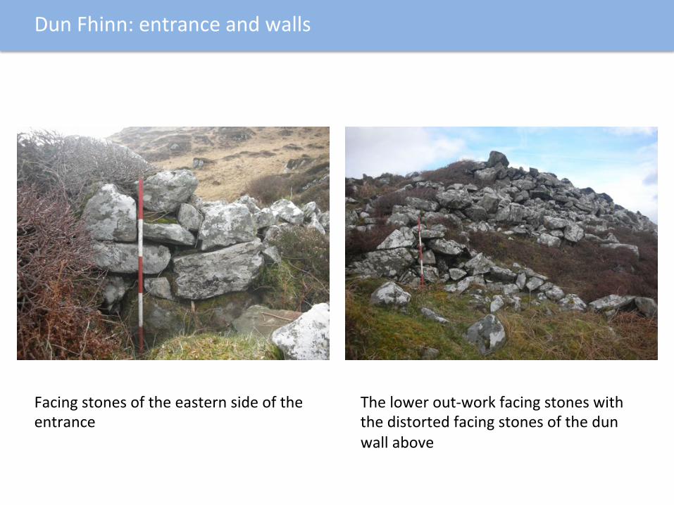
Facingstonesoftheeasternsideoftheentrance
Thelowerout-workfacingstoneswiththedistortedfacingstonesofthedunwallabove
DunFhinn:entranceandwalls

ThefacingstonesontheSWsideofthedun ThefacingstonesontheNWsideof
thedun
SWandNWwalls

Nextsteps:excavabontoestablishchronologyofinterior
2018excavabon?

FirstedibonofOrdnanceSurveyMap1878
DunFhinn
StaoinCreagfinn Ballore

ViewofStaoin,fromthenorthflankofDunFhinn,April2017
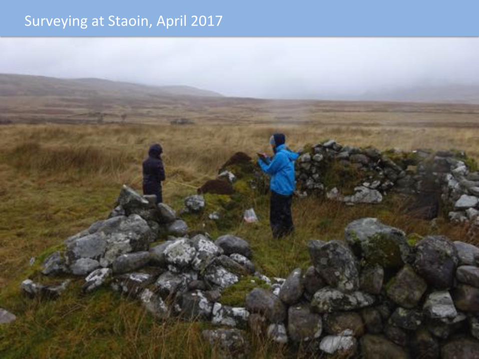
SurveyingatStaoin,April2017
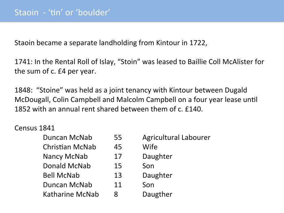
Staoin-‘bn’or‘boulder’
StaoinbecameaseparatelandholdingfromKintourin1722,1741:IntheRentalRollofIslay,“Stoin”wasleasedtoBaillieCollMcAlisterforthesumofc.£4peryear.1848:“Stoine”washeldasajointtenancywithKintourbetweenDugaldMcDougall,ColinCampbellandMalcolmCampbellonafouryearleaseunbl1852withanannualrentsharedbetweenthemofc.£140.Census1841
DuncanMcNab 55 AgriculturalLabourer ChrisbanMcNab 45 Wife NancyMcNab 17 Daughter DonaldMcNab 15 Son BellMcNab 13 Daughter DuncanMcNab 11 Son KatharineMcNab 8 Daugther

Staoin-‘bn’or‘boulder’
In1851and1861:NoseparateentriesinCensusforStaoin,includedandlistedas‘Kintur’.Howeveran‘AccountofPopulaboninParishofKildalton’drawnupin1860liststhoseat‘Staoine’.
AnneMorrison 54 DonaldMorrison 25 JohnMorrison 22 JessieMorrison 18 ChrisbnaMorrison 16 ArchibaldMorrison 13 CatherinMorrison 10
Census1871:
DonaldMorrison 36 Shepherd BellaMorrison 25 WifeofShepherd AgnesMorrison 2 Daughter
• DonaldMorrisonmovedwithhiswifetoIslayfromDunoonsomebme
between1861and1869.HisdaughterwasbornanIleach.• Staoinappearstohavebeenunoccupiedafer1871.

StructuresatStaoin
• OnlytheareaofsouthoftheKintourRiverwassurveyed,althoughseElementextendedtothenorthoftheriver
• Areatothesouthwasboundedbyaturfandearthendyke,enclosingextensiverigandfurrowculbvabon
• Fivestructuresandthreeenclosureswererecorded

StaoinStructure1• 10.8mlongX6.6mwide,orientedEW
• Wallsinpartstandtoprobablefullheightof2.1m
• Twoopposedentrances
• Clayandsand/mortarpackingwithinthewalls
StaoinStructure2• Rectangular,rubblebuiltorientedEW
• 13.8mlongX7mwide
• Denuded/robbedwallsstandto0.6mhigh
• TwoopposedentrancesatWendofstructure
StructuresatStaoin

StaoinStructure3• Rectangular,rubblebuiltorientedNW/SE
• 6.0mlongX5.4mwide
• Wallsstandignto1.5mhigh
• Buildingappearstohavebeenshortenedbecausefoobngsappeartoextendanearlierversionofthebuilding2mtotheNW
StaoinStructure5• Kiln
• 7mX5m,withmainovalkilmmeasuring5mX4m,1.3minheight
• FlueonEside
• Foobngsofanearlierkilnextendtothewest
StructuresatStaoin

Cartographicevidence:FirstedibonofOrdnanceSurveyMap1878
Muchgreaterdetail,withseveralnamedseElements,andseveralunnamedseElements
DunFhinn
StaoinCreagfinn Ballore

AtCreagfinn,April2017

Creagfinn(’Finn’sRock)
CreagfinnappearsintheIslayRentalRollsof1541asCraggin,in1545asCragfyne,andisinthe1686rollsasCraigfinn.1694:IntheHearthTax,CraigfinwasoccupiedbythefamiliesofRobertCampbellandJohnMcMillan,bothtenantfarmers.1741:TheRentalRollsof1741showCraigfinnleasedtoJohnCampbellofAskomellforarentofc.£34peryear.1829-1848:CraigfinandArdmeanach(alandholdingthatnolongerexistsbutwasontheoppositesideoftheroadeastoftoday’sKintourFarm)wereona19yearleasetoAlexanderCampbell,atenantfarmer.In1848thisbecameayeartoyearleaseatc.£140peryear.

Creagfinn(’Finn’sRock)
CENSUSRETURNS:1841: AlexanderCampbell 55 AgriculturalLabourer
MaryCampbell 50 WifeofAg.Lab. JohnCampbell 15 Son JanetWilson 7 Granddaughter AnnWilson 5 Granddaughter
JohnMcDuffie 50 AgriculturalLabourer CathrinMcDuffie 50 Wife AlexanderMcDuffie 12 Son IsabellaMcDuffie 9 Daughter
1851,1861and1871:NoseparateentriesinCensusforCreagfinn,includedandlistedas‘Kintur’.

Creagfinn(’Finn’sRock)
1881: PeterSinclair 66(?) Shepherd DuncanSinclair 37 Son,Shepherd SusanSinclar 33(?) SisterofShepherd
1891: PeterSinclair 85(?) RebredShepherd
SusanShepherd 55(?) Sister,Housekeepher • PeterSinclair,hissisterandsoncametoIslaysomebmebetween1861and
1871fromDalavichnearOban.
• Peterwasalreadyawidowerandhewaslistedinthe1871CensusasashepherdatArdtalla.Peterdiedin1897,hissister,Susan,movedbacktothemainlandshortlyaferhisdeathassheislistedin1901CensusaslivinginOban.
• TheyarethelastrecordedoccupantsofCreagfinn.
CENSUSRETURNS

• Sixrectangularbuildings(Structures1,2,3,4,5,6and9),aseventhirregularbuildings(8)andtwokils(2and7)
• SituatedonabroadbendintheKintourRiversurroundedbyenclosureswithrigandfurrow
• Structure9wasroofedon1stedibonofOSmap,suggesbngitwasthelastoccupied
ThearchaeologyofCreagfinn

• 18mX6m,with0.6mwidewalls,standingto1.7msuggesbnggableend
• Buildingdividedintothreeparts,withtwoopposingentrances
• TracesofanaEached10mwideenclosureaEachedtoitswesternside
• Twotwinningpenswithinnorthernroom
Creagfinn:Structure1

• Sub-circular,5.5mX5m,standsto2.4m
• Wallsupto1.4mthick,aroundacentralchamber,accessedfromtheSWside
Creagfinn:Structure2,Kiln
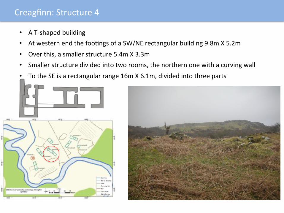
• AT-shapedbuilding
• AtwesternendthefoobngsofaSW/NErectangularbuilding9.8mX5.2m
• Overthis,asmallerstructure5.4mX3.3m
• Smallerstructuredividedintotworooms,thenorthernonewithacurvingwall
• TotheSEisarectangularrange16mX6.1m,dividedintothreeparts
Creagfinn:Structure4

• NW/SEoriented,15.6mlongX5.8mwide
• Walls0.8mwide,standingto1.15mhigh
• Dividedintothreeparts
• Smallerstructuredividedintotworooms,thenorthernonewithacurvingwall
• TwoentrancesontheSsidegiveaccesstotheEandWrooms
Creagfinn:Structure9

Creagfinn:rigandfurrow

Cartographicevidence:FirstedibonofOrdnanceSurveyMap1878
Muchgreaterdetail,withseveralnamedseElements,andseveralunnamedseElements
DunFhinn
StaoinCreagfinn Ballore

Ballore,April2017

Ballore,April2017
• Baille=Township• ‘Odhar’=dun,meaninglight
browncolour
• In1686ChurchlandsofIslay,thereisreferencetoa‘Ballindeor’,beingpartoftheholdingsofCreagfinnandknownastheTownshipoftheDewar
• ADewarisalocallyappointedofficerinchargeofasacredrelic
• TheseElementconsistoffivedefinitestructuresandonepossiblestructure,withtwoenclosures

Ballore,Structure1• Oval,E/Worientedrubble
builtstructure
• Roundedends,7.8mlongX4.3mwide
• Wallsstandingto1.7minheight
Ballore,Structure2• Oval,SW/NEorientedrubble
builtstructure
• Roundedends,8.7mlongX5.0mwide
• Wallsstandingto1.6minheight
Ballore,Structures1and2

Ballore,Structure3• Oval,SW/NEorientedrubble
builtstructure
• Roundedends,9.5mlongX3.2mwide
• Wallsstandingto0.6minheight
• EntranceonSEside
Ballore,Structure4• Oval,E/Worientedrubble
builtstructure
• Roundedends,12.4mlongX6.7mwide
• Wallsstandingto1.9minheight
• Opposedentrancesonlongsidesandinternallydividedbyacrosswall
Ballore,Structures3and4

Ballore,Enclosure2
IrregularshapedstoneandturfencloseaEachedtoStructure4withinternalrigandfurrow

FirstedibonofOrdnanceSurveyMap1878

FurthersiteswiththeKintoursurveyarea
Sheilings
Site15Wellandtwo
structureswithinanenclosure
Site14Acircularandarectangularenclosure

• ExtensivelyseEledfromIronAgeonwards
• FocusofseElementsonorneartothebanksoftheriver,whichcanbetracedbacktothe15thcenturyfromhistoricdocuments
• SeElementmayhavebeenmoredispersedatanearlierdatebecauseofthenumberofsmallandunnamedseElements,withthelargerconcentrabons,suchasCreagfinn,beinglaterdevelopments
• StructuresdifferentatBalloreandCreagfinn
• Ballore:curvedorroundedendssuggesbnghippedroofs,relabvelysmall.Suggestspre-18thcentury
• Creagfinn:longrectagularstructures,rubblebuiltwalls,probablygableends.Suggests18thand19thcentury
Summary

Nextsteps:testexcavabonatasampleofsitesandstructurestoestablishabsolutechronology.April2018?
Ballore Creagfinn
Staoin Site14

Andfinally,andwithfurtherexcavabon…
Willweeverfindthetracesof:TheCampbells,Wilsons,McDuffiesandSinclairsofCreagfinn?OrtheNcNabsandtheMorrisonsofStaoinOrtheDewarofBallore?Orwillthesealwaysremainforgo`enlives?

Withthanksto…
Roddy… …andtheteam
• TheArdtallaEstate• TomDun,DebBaker• TheIanMactaggartTrust

www.islayheritage.org | [email protected] /islayheritage @islayheritage @islayheritage
FEEDBACK
Islay Heritage would really value your
feedback to help it plan future events
for the community.
Please complete this card and leave in
the box provided.Which event did you attend?
Islay Show Stone Age exhibition and demonstration | 10 AugWalk to the Giant’s Grave excavation | 11/12/13 AugLecture: Imagining Kildalton | 14 AugLecture: First footsteps on Islay | 15 Aug
Lecture: Forgotten lives of the Illeach | 16 Aug
How enjoyable did you find the event?1 2 3 4 5How informative did you find the event?1 2 3 4 5Please provide a comment:
Please circle a number:
Are you: A resident of Islay? A visitor to Islay?Thank you very much for your valuable feedback
PleasecompleteanIslayHeritagefeedbackpostcard