weather conditions can change rapidly in caring for the...
TRANSCRIPT
pa
rkn
ote
s
For more information call the Parks Victoria Information Centre
on 13 1963 or visit our website at www.parkweb.vic.gov.au
Healthy Parks Healthy People
Visiting a park can improve your health, mind, body and
soul. So, with over four million hectares of parkland available to Victorians, why not escape
to a park today!
Tour guides
A number of commercial tour operators run 4WD
and horseriding tours in this area. Contact the
Parks Victoria Information Centre or visit the
website.
Take care!
All visitors, and especially walkers, should realise
that weather conditions can change rapidly in
mountain and alpine areas. Cold wet weather can
be experienced at any time of the year and water
can be extremely scarce in summer.
Always be prepared with:
Warm clothing
Wind and waterproof jacket
Gloves, hat and strong footwear
First aid kit and sunscreen
Energy food and water
Compass and relevant topographical map
Before you go, let someone know where you are
going, and when you expect to return. Also,
please keep your group small.
Please keep to walking tracks, particularly in old
gold mining areas where there may be mine
shafts or unsafe cliff edges.
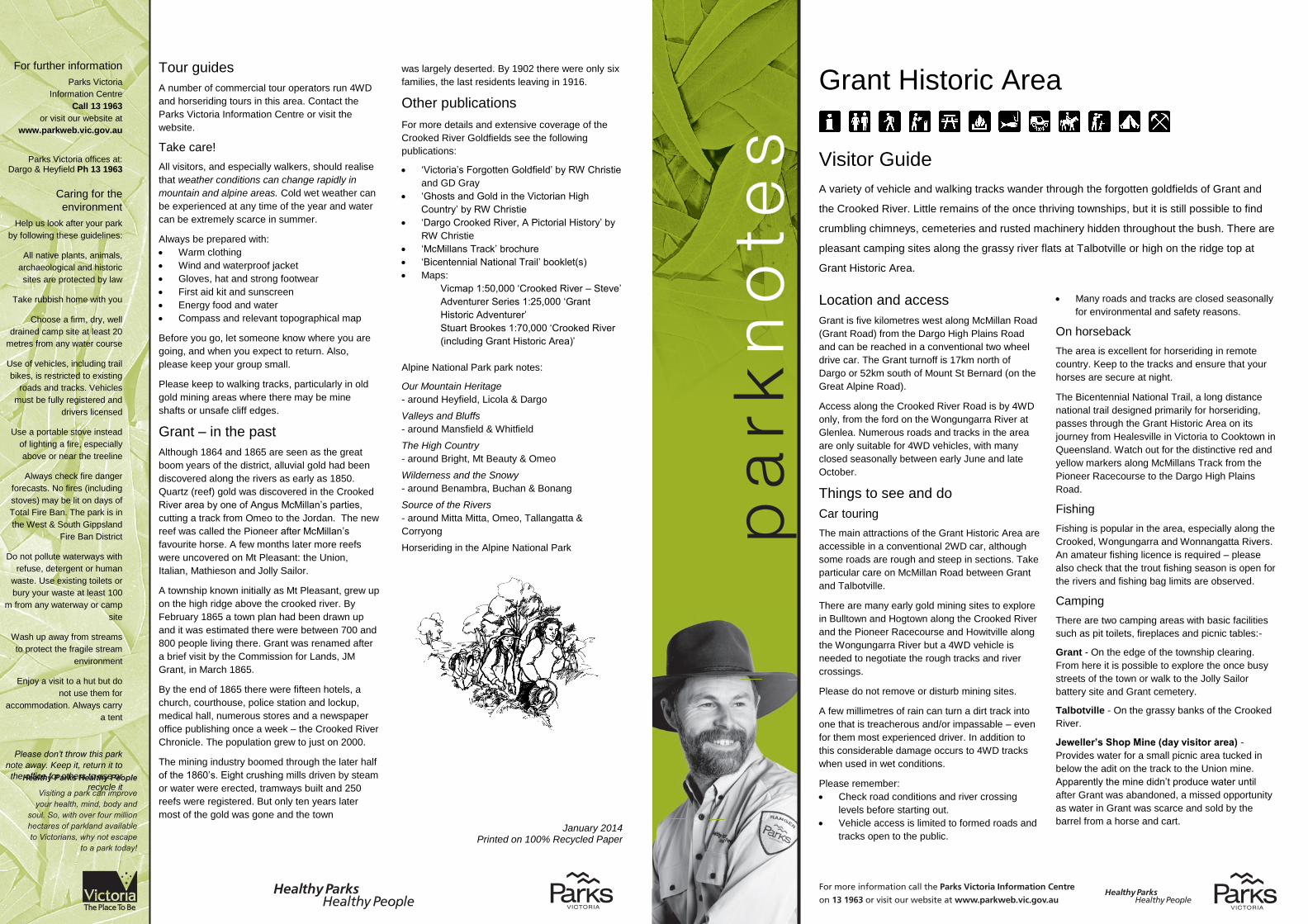
Grant – in the past
Although 1864 and 1865 are seen as the great
boom years of the district, alluvial gold had been
discovered along the rivers as early as 1850.
Quartz (reef) gold was discovered in the Crooked
River area by one of Angus McMillan’s parties,
cutting a track from Omeo to the Jordan. The new
reef was called the Pioneer after McMillan’s
favourite horse. A few months later more reefs
were uncovered on Mt Pleasant: the Union,
Italian, Mathieson and Jolly Sailor.
A township known initially as Mt Pleasant, grew up
on the high ridge above the crooked river. By
February 1865 a town plan had been drawn up
and it was estimated there were between 700 and
800 people living there. Grant was renamed after
a brief visit by the Commission for Lands, JM
Grant, in March 1865.
By the end of 1865 there were fifteen hotels, a
church, courthouse, police station and lockup,
medical hall, numerous stores and a newspaper
office publishing once a week – the Crooked River
Chronicle. The population grew to just on 2000.
The mining industry boomed through the later half
of the 1860’s. Eight crushing mills driven by steam
or water were erected, tramways built and 250
reefs were registered. But only ten years later
most of the gold was gone and the town
Grant Historic Area
Visitor Guide
A variety of vehicle and walking tracks wander through the forgotten goldfields of Grant and
the Crooked River. Little remains of the once thriving townships, but it is still possible to find
crumbling chimneys, cemeteries and rusted machinery hidden throughout the bush. There are
pleasant camping sites along the grassy river flats at Talbotville or high on the ridge top at
Grant Historic Area.
Location and access
Grant is five kilometres west along McMillan Road
(Grant Road) from the Dargo High Plains Road
and can be reached in a conventional two wheel
drive car. The Grant turnoff is 17km north of
Dargo or 52km south of Mount St Bernard (on the
Great Alpine Road).
Access along the Crooked River Road is by 4WD
only, from the ford on the Wongungarra River at
Glenlea. Numerous roads and tracks in the area
are only suitable for 4WD vehicles, with many
closed seasonally between early June and late
October.
Things to see and do
Car touring
The main attractions of the Grant Historic Area are
accessible in a conventional 2WD car, although
some roads are rough and steep in sections. Take
particular care on McMillan Road between Grant
and Talbotville.
There are many early gold mining sites to explore
in Bulltown and Hogtown along the Crooked River
and the Pioneer Racecourse and Howitville along
the Wongungarra River but a 4WD vehicle is
needed to negotiate the rough tracks and river
crossings.
Please do not remove or disturb mining sites.
A few millimetres of rain can turn a dirt track into
one that is treacherous and/or impassable – even
for them most experienced driver. In addition to
this considerable damage occurs to 4WD tracks
when used in wet conditions.
Please remember:
Check road conditions and river crossing
levels before starting out.
Vehicle access is limited to formed roads and
tracks open to the public.
Many roads and tracks are closed seasonally
for environmental and safety reasons.
On horseback
The area is excellent for horseriding in remote
country. Keep to the tracks and ensure that your
horses are secure at night.
The Bicentennial National Trail, a long distance
national trail designed primarily for horseriding,
passes through the Grant Historic Area on its
journey from Healesville in Victoria to Cooktown in
Queensland. Watch out for the distinctive red and
yellow markers along McMillans Track from the
Pioneer Racecourse to the Dargo High Plains
Road.
Fishing
Fishing is popular in the area, especially along the
Crooked, Wongungarra and Wonnangatta Rivers.
An amateur fishing licence is required – please
also check that the trout fishing season is open for
the rivers and fishing bag limits are observed.
Camping
There are two camping areas with basic facilities
such as pit toilets, fireplaces and picnic tables:-
Grant - On the edge of the township clearing.
From here it is possible to explore the once busy
streets of the town or walk to the Jolly Sailor
battery site and Grant cemetery.
Talbotville - On the grassy banks of the Crooked
River.
Jeweller’s Shop Mine (day visitor area) -
Provides water for a small picnic area tucked in
below the adit on the track to the Union mine.
Apparently the mine didn’t produce water until
after Grant was abandoned, a missed opportunity
as water in Grant was scarce and sold by the
barrel from a horse and cart.
For further information
Parks Victoria
Information Centre
Call 13 1963
or visit our website at
www.parkweb.vic.gov.au
Parks Victoria offices at:
Dargo & Heyfield Ph 13 1963
Caring for the
environment
Help us look after your park
by following these guidelines:
All native plants, animals,
archaeological and historic
sites are protected by law
Take rubbish home with you
Choose a firm, dry, well
drained camp site at least 20
metres from any water course
Use of vehicles, including trail
bikes, is restricted to existing
roads and tracks. Vehicles
must be fully registered and
drivers licensed
Use a portable stove instead
of lighting a fire, especially
above or near the treeline
Always check fire danger
forecasts. No fires (including
stoves) may be lit on days of
Total Fire Ban. The park is in
the West & South Gippsland
Fire Ban District
Do not pollute waterways with
refuse, detergent or human
waste. Use existing toilets or
bury your waste at least 100
m from any waterway or camp
site
Wash up away from streams
to protect the fragile stream
environment
Enjoy a visit to a hut but do
not use them for
accommodation. Always carry
a tent
Please don’t throw this park
note away. Keep it, return it to
the office for others to use or
recycle it
was largely deserted. By 1902 there were only six
families, the last residents leaving in 1916.
Other publications
For more details and extensive coverage of the
Crooked River Goldfields see the following
publications:
‘Victoria’s Forgotten Goldfield’ by RW Christie
and GD Gray
‘Ghosts and Gold in the Victorian High
Country’ by RW Christie
‘Dargo Crooked River, A Pictorial History’ by
RW Christie
‘McMillans Track’ brochure
‘Bicentennial National Trail’ booklet(s)
Maps:
Vicmap 1:50,000 ‘Crooked River – Steve’
Adventurer Series 1:25,000 ‘Grant
Historic Adventurer’
Stuart Brookes 1:70,000 ‘Crooked River
(including Grant Historic Area)’
Alpine National Park park notes:
Our Mountain Heritage
- around Heyfield, Licola & Dargo
Valleys and Bluffs
- around Mansfield & Whitfield
The High Country
- around Bright, Mt Beauty & Omeo
Wilderness and the Snowy
- around Benambra, Buchan & Bonang
Source of the Rivers
- around Mitta Mitta, Omeo, Tallangatta &
Corryong
Horseriding in the Alpine National Park
January 2014 Printed on 100% Recycled Paper
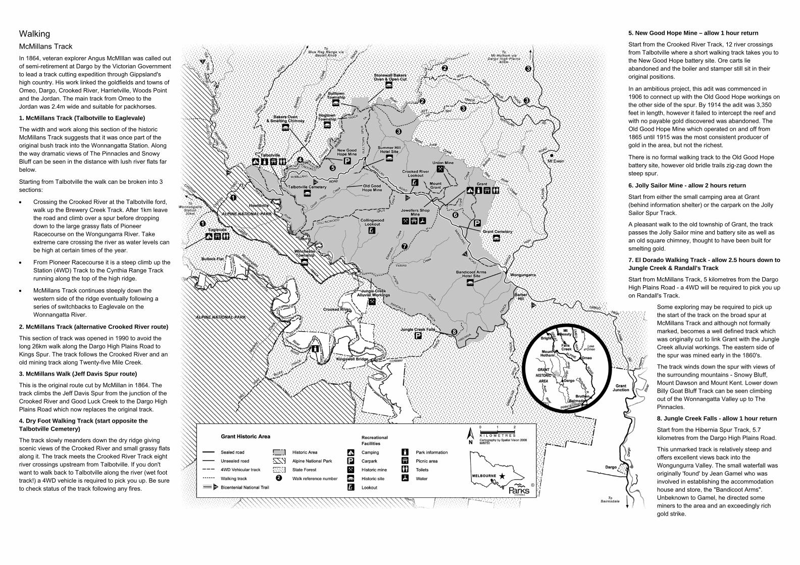
Walking
McMillans Track In 1864, veteran explorer Angus McMIllan was called out of semi-retirement at Dargo by the Victorian Government to lead a track cutting expedition through Gippsland's high country. His work linked the goldfields and towns of Omeo, Dargo, Crooked River, Harrietville, Woods Point and the Jordan. The main track from Omeo to the Jordan was 2.4m wide and suitable for packhorses.
1. McMillans Track (Talbotville to Eaglevale)
The width and work along this section of the historic McMillans Track suggests that it was once part of the original bush track into the Wonnangatta Station. Along the way dramatic views of The Pinnacles and Snowy Bluff can be seen in the distance with lush river flats far below.
Starting from Talbotville the walk can be broken into 3 sections:
• Crossing the Crooked River at the Talbotville ford, walk up the Brewery Creek Track. After 1km leave the road and climb over a spur before dropping down to the large grassy flats of Pioneer Racecourse on the Wongungarra River. Take extreme care crossing the river as water levels can be high at certain times of the year.
• From Pioneer Racecourse it is a steep climb up the Station (4WD) Track to the Cynthia Range Track running along the top of the high ridge.
• McMillans Track continues steeply down the western side of the ridge eventually following a series of switchbacks to Eaglevale on the Wonnangatta River.
2. McMillans Track (alternative Crooked River route)
This section of track was opened in 1990 to avoid the long 26km walk along the Dargo High Plains Road to Kings Spur. The track follows the Crooked River and an old mining track along Twenty-five Mile Creek.
3. McMillans Walk (Jeff Davis Spur route)
This is the original route cut by McMillan in 1864. The track climbs the Jeff Davis Spur from the junction of the Crooked River and Good Luck Creek to the Dargo High Plains Road which now replaces the original track.
4. Dry Foot Walking Track (start opposite the Talbotville Cemetery)
The track slowly meanders down the dry ridge giving scenic views of the Crooked River and small grassy flats along it. The track meets the Crooked River Track eight river crossings upstream from Talbotville. If you don't want to walk back to Talbotville along the river (wet foot track!) a 4WD vehicle is required to pick you up. Be sure to check status of the track following any fires.
5. New Good Hope Mine – allow 1 hour return
Start from the Crooked River Track, 12 river crossings from Talbotville where a short walking track takes you to the New Good Hope battery site. Ore carts lie abandoned and the boiler and stamper still sit in their original positions.
In an ambitious project, this adit was commenced in 1906 to connect up with the Old Good Hope workings on the other side of the spur. By 1914 the adit was 3,350 feet in length, however it failed to intercept the reef and with no payable gold discovered was abandoned. The Old Good Hope Mine which operated on and off from 1865 until 1915 was the most consistent producer of gold in the area, but not the richest.
There is no formal walking track to the Old Good Hope battery site, however old bridle trails zig-zag down the steep spur. 6. Jolly Sailor Mine - allow 2 hours return
Start from either the small camping area at Grant (behind information shelter) or the carpark on the Jolly Sailor Spur Track.
A pleasant walk to the old township of Grant, the track passes the Jolly Sailor mine and battery site as well as an old square chimney, thought to have been built for smelting gold.
7. El Dorado Walking Track - allow 2.5 hours down to Jungle Creek & Randall's Track
Start from McMillans Track, 5 kilometres from the Dargo High Plains Road - a 4WD will be required to pick you up on Randall's Track.
Some exploring may be required to pick up the start of the track on the broad spur at McMillans Track and although not formally marked, becomes a well defined track which was originally cut to link Grant with the Jungle Creek alluvial workings. The eastern side of the spur was mined early in the 1860's.
The track winds down the spur with views of the surrounding mountains - Snowy Bluff, Mount Dawson and Mount Kent. Lower down Billy Goat Bluff Track can be seen climbing out of the Wonnangatta Valley up to The Pinnacles.
8. Jungle Creek Falls - allow 1 hour return
Start from the Hibernia Spur Track, 5.7 kilometres from the Dargo High Plains Road.
This unmarked track is relatively steep and offers excellent views back into the Wongungurra Valley. The small waterfall was originally 'found' by Jean Gamel who was involved in establishing the accommodation house and store, the "Bandicoot Arms". Unbeknown to Gamel, he directed some miners to the area and an exceedingly rich gold strike.