wcs canada - wilderness northwildernessnorth.com/pdf/wcs-boreal-forest-report.pdfwcs canada...
TRANSCRIPT

�Wildlife Conservation Society canada
WCS canadaFreshwater Fish in Ontario’s Boreal
Freshwater ecosystems are among the most threatened ecosystems on the planet. Physical alteration, water with-drawal, overexploitation, pollution, and the introduction of non-native species have caused widespread habi-tat loss, degradation in water quality, declines in the abundance of aquatic animals, and biodiversity loss. More than 20 percent of the world’s 10,000 freshwater fish species have become threatened, endangered or extinct in recent decades.
In Ontario, the area north of the current limit for forestry activities (roughly straddling the 51st parallel) is one of the largest swaths of largely undisturbed boreal forest in Canada. This landscape is characterized as much by the network of lakes, rivers, swamps, and bogs that make up a large part of the surface area as it is by the coniferous forest expanses that the region is more commonly known for.
In fact, the lakes and rivers of northern Ontario are part of the
executive summary of Freshwater fish in Ontario's boreal: Status, conservation and potential impacts of developmentFull report available at www.wcscanada.org
Just
ina
Ray
single largest area of high fish biodiversity that has experi-enced the least human alteration of the natural landscape in Canada. Five of the 12 remaining undammed and unregu-lated watersheds in North America south of 55 degrees occur in northern Ontario, which also contains the third largest wetland on the planet — the Hudson Bay Lowlands, covering 25% of Ontario’s land surface.
Unlike in more developed regions in southern Ontario, fish communities of the northern part of the province remain largely unal-tered by species introductions, stock-ing, overexploitation, or pollution. In fact, the current intact condition of fisheries in this region provides a virtually unprecedented opportunity to conserve fish communities in their original abundance and diversity — a challenge that will require proactive land use planning and information gathering to be successful.
These freshwater ecosystems also have great cultural and economic importance: Approximately 10,000 people live in remote First Nations communities situated on the lakes and rivers of far northern Ontario with the water courses serving as the highways of the region in summer and winter and residents relying on plentiful walleye and whitefish popu-lations as a major food source.
Top: Brook trout are ubiquitous throughout the region occurring in everything from small streams a few centimetres deep to large lakes. Bottom: The area north of roughly 51 degrees latitude has remained largely undeveloped and is currently unallocated for forestry.
Eng
bREt
son
un
dER
wat
ER P
ho
tog
RaP
hy
CaR
RiE
sad
ow
ski,
oM
nR

� Freshwater fish in Ontario's boreal: executive summary
The high concentration of lakes containing walleye and northern pike in the region has also made it a top destination for fly-in sport fishing. The resource-based tourism industry is a major component of the northern Ontario economy. The total annual economic activity from resource-based tourism for all of northern Ontario is approximately $306 million with remote fly-in operations accounting for 25% of the tourism businesses in the region.
At the same time, the natural resources of far northern Ontario offer significant potential for eco-nomic development and commercial exploitation. The development of these resources — hydroelectricity, forestry, and mineral — is now of growing interest to industry, First Nations and the province This north-ern boreal landscape is therefore both an ecological gem, as yet largely unaffected by industrial development, and a likely target for much greater development pressures in the near future.
Due to recent efforts to plan for increased economic development in the region, such as the provincially-led Northern Boreal Initiative, scientists, resource managers, and conservationists have begun to identify priorities for conservation of the unique flora and fauna of the area. To date, these efforts have largely focused on terrestrial mam-mals, with a particular emphasis on wide-ranging terrestrial mammals native to the region, such as woodland caribou.
And while general life history and status information on
Eng
bREt
son
un
dER
wat
ER P
ho
tog
RaP
hy
Healthy populations of northern pike and walleye support a valuable sport fishing industry and as top predators, play an important ecological role.
northern boreal fisheries is available, one of the key impediments to ecosys-tem-based planning in the region is the profound lack of comprehensive baseline information on most species that have a demonstrated vulner-ability to the land-use changes being contemplated. In the case of the region’s fish species, very little infor-mation exists on their distribution, abundance, life history, and the his-tory of harvesting or other impacts. Additionally, much of the knowledge about the region’s fish communities lies with local residents and those involved in sport fisheries, such as remote tourism operators. As a conse-quence, fish are rarely given sufficient consideration in land use or resource planning initiatives.
This report represents a first step in expanding the dialogue on Boreal
conservation to include aquatic ecosystems. The objectives of this report are to:
I. present information on the region’s fish species with a particular focus on those of high economic or cul-tural importance;
II. review what is known and what remains unknown regarding the effects of various types of resource development activities on freshwater environments and fish; and
III. offer policy and research recommendations toward the enhancement of freshwater fish conservation and management in the region.
LyLE
waL
ton
, oM
nR
Just
ina
Ray
Left: The watery expanse of the Hudson Bay Lowlands is noted for its small ponds and wetlands while the Boreal Shield region (right) con-tains more lakes and rivers.

�Wildlife Conservation Society canada
Freshwater Fishes of Northern Ontario
The freshwater environments of northern Ontario can be divided into two major ecozones: the Boreal Shield zone and the Hudson Plains. The Boreal Shield is underlain by the bed-rock of the Precambrian Canadian Shield and important fish habitat extends across its matrix of lake, river, and wetland habitats. The Hudson Bay lowlands are also dominated by freshwater, although because most of the thousands of bogs and ponds that dot the landscape are shallow and freeze to the bottom in winter, fish diversity is mostly concentrated in the streams and rivers that dissect the area.
Fifty-three species of fish in 15 families occur in the region making it one of the more diverse regions of Canada. The distribution of 11 of these species is limited to the south-ern edge of the area or along the Hudson Bay coast, while 42 species are widely distributed throughout the lakes and rivers of the roadless portion of northern Ontario. Together, this diversity of fish species creates a mosaic of different fish communities distributed among the thousands of ponds, lakes, streams and rivers of northern Ontario.
At a regional scale, this diversity can be summarized into community types based on which top predator species are present in the environment. Three communities types — Walleye/Northern Pike, Lake trout/Whitefish/Cisco, and Brook trout — are profiled in this report, with descriptions of their distribution, ecology, life history, and current con-servation status. Lake sturgeon — a species that migrates through rivers and lakes — is an additional focus here due to its status as a threatened species throughout much of North America.
Walleye and northern pike occur in most lakes and rivers of the region with most populations in a relatively
unharvested, pristine state. The slow-grow-ing northern walleye and pike populations are more vulnerable to overexploitation than their counterparts to the south, with populations in the north likely less able to withstand the increased exploitation that may accompany increased access due to their slower matura-tion in environments characterized by shorter growing seasons.
Small tributary streams and rivers through-out the area host abundant brook trout popu-lations. Sea-run brook trout are also common in the rivers draining into Hudson and James Bay. Lake trout, a coldwater species inhabit-ing deep lakes with limited nutrients, are rela-tively rare in the northern region. Meanwhile, lake trout are in decline in southern Ontario, largely due to species introductions, eutrophi-cation and fishing pressure.
Lake sturgeon occur in all of the major rivers of northern Ontario and, given the plight of most populations in the south, these may be the last populations remaining in the province that have not yet been affected by intensive human harvesting and habitat altera-tion. Lake sturgeon populations require large unfragmented watersheds to thrive, due to their lifetime migratory patterns. This is why
populations located downstream from dams have, in par-ticular, experienced negative impacts.
Impacts of forestry, hydroelectric develop-ment, mining, and roads on fish populations
The combined potential for forestry, hydroelectricity, and mineral extraction in the northern boreal region may represent a major economic opportunity for the prov-
The report ranks Ontario watersheds based on level of human disturbance and fish diversity. The darker the colour, the higher the level of disturbance.

� Freshwater fish in Ontario's boreal: executive summary
Top: Clearcutting can lead to the release of mercury from soils into waterbodies, where it bioaccumulates in fish. Consumption of fish with high mercury levels poses a health risk to both people and wildlife. Centre: Forestry can change water flow regimes, lead to sedimentation of waterways and increase access to previously remote water bodies. Bottom: Improperly constructed water cross-ings lead to erosion and fragmentation of aquatic habitat.
ince of Ontario. All three types of development, how-ever, also affect aquatic eco-systems and fish thanks to a variety of associated impacts, including increased sedimenta-tion in waterways, changes in water flow, habitat fragmen-tation, release of pollutants, and increased access for recre-ational fishing.
Forestry results in two major changes to the land-scape that affect aquatic habi-tats:
• Forest removal alters groundwater flow and sur-face runoff, which can lead to the release of mercury, nutrients, dissolved organic carbon, and sediment to adjacent water bodies.
• Logging roads may result in fragmented (artificially divided) aquatic habitat due to poorly constructed water crossings, increased sedimentation due to the erosion of roads, and increased human exploita-tion of fish populations as a result of easier “drive in” access to lakes and rivers.
Clearcutting of boreal for-est has been linked to increas-es in mercury concentrations in fish such as walleye and pike. This linkage is particu-larly strong in relatively flat landscapes with poor drainage and extensive wetland areas — the kind of landscape found in much of northern Ontario. Forest removal commonly leads to an influx of nutrients, minerals, and organic matter to lakes and rivers with signifi-cant differences between the effects of forest loss due to fire versus logging. Fire, for example, does not disturb soils or lead to the creation of roads and water crossings. Logging may also increase total runoff and change the flow regime of forest streams, thereby altering the physical stream habi-
tat, species distributions and productivity.
Stream crossings (bridges and culverts) — of which there may be hundreds of thousands along the tens of thousands of kilometers of forestry roads in Ontario — have been shown to cause significant fragmenta-tion of aquatic habitats. Such crossings can, for example, block upstream movement by fish, thereby causing habitat disconnections or fragmenta-tion.
In the watersheds of the boreal forest of northern Ontario, species likely to be adversely affected by barriers in small streams include brook trout, white sucker, minnows, and darters. In large streams and rivers, species likely to be affected by poorly constructed water crossings include lake sturgeon, walleye, and brook trout.
While certain impacts may be mitigated by “best prac-tices” and regulations — such as reducing sedimentation by leaving vegetated buffer strips around water bodies or mini-mizing barriers to fish move-ment by building appropri-ate water crossings — other impacts are more difficult to mitigate, such as the accumu-lation of mercury in surface waters of logged watersheds or increased human access due to logging road networks. Overall, the consequences of all such changes to aquatic
environments for fish habitats and communities vary from minimal to severe, and most remain poorly understood.
Hydroelectric dams alter river systems in three primary ways:
• Reservoir creation: The creation of a reservoir above the dam has two main fisheries impacts: the loss of river
sLd
F/w
iLd
Lan
ds
LEag
uE
LoR
i Lab
att

�Wildlife Conservation Society canada
Acid mine drainage and other contaminated runoff from mine sites can destroy aquatic habitat over large areas.
habitat, and the release of mercury from the flooded land into the river ecosystem.
• Barriers to fish movement: Blocking the upstream and downstream movement of species affects populations in a number of ways: it blocks upstream migration to spawn-ing grounds, prevents downstream migration of juveniles to rearing areas, prevents seasonal movement between winter and summer habitats, and isolates populations.
• Alteration of flow regime: Alteration of the magnitude, frequency, duration, timing, and rate of water flow below the dam has a wide variety of impacts on downstream aquatic systems, including changes in sediment accumu-lation or scouring of the river bed, and reduced spawn-ing success through the loss or degradation of spawning habitat.
Northern Ontario contains a number of large rivers whose combined hydroelectric potential is over 4000 mega-watts. Many of these sites are too distant from transmission lines to make development viable in the near future; how-ever, two sites on the Albany River and several sites on the already highly developed Mattagami, Abitibi, and Moose rivers have been proposed for future development.
Hydroelectric dams result in long-term impacts to river ecosystems. In Ontario, lake sturgeon and brook trout are particularly sensitive to the effects of habitat fragmentation and changes in water flow caused by dams. River-spawning populations of cisco and lake whitefish from Hudson and James Bay may also be affected by hydroelectric develop-ment. The effects on walleye and pike appear to be mixed with some populations increasing and others suffering declines. For lake sturgeon, it is unclear whether popula-tions can survive following dam construction: In the Moose River watershed, where dam construction occurred 40 to 60 years ago, many lake sturgeon populations appear to be in decline.
A second impor-tant effect of hydro-electric development is the associated increase in mercury concentrations of commonly consumed fish such as walleye. For remote northern community residents who rely on fish for a significant portion of their diet, the effects
of increased mercury exposure are a serious concern.Mining operations can adversely affect the aquatic envi-
ronment in several ways:
• Release of mine effluent into lakes and rivers in the form of water pumped from the mine or used for processing the ore;
• Storage of resulting waste rock and processing waste, referred to as mine tailings, in piles or ponds on the mine site where precipitation and processing waste water leaches metals and other contaminants into adjacent sur-face water and groundwater;
• Physical alteration or destruction of aquatic habitat resulting from mine construction and operation in areas with abundant surface waters;
• Increased access to surrounding lakes and rivers through the construction of roads to the mining site.
Compared to forestry or hydroelectric development, mining has the potential for much greater acute and chron-ic environmental impacts when toxic contaminants are released into the environment. In northern Ontario, gold will likely continue to be the most common type of mineral being mined and the continued use of cyanide in the extrac-tion of the gold will continue to pose a threat to aquatic ecosystems.
Left: Hydroelectric dams change water flows and fragment habitats by blocking fish movement. Right: Lake stur-geon's migratory needs puts them in conflict with hydroelectric development.
LEFt
: JEn
ni M
Cd
ERM
id; R
igh
t: u
.s. F
ish
an
d w
iLd
LiFE
sER
viC
E
JaM
iE k
nEE
n/M
inin
gw
atC
h C
anad
a;

� Freshwater fish in Ontario's boreal: executive summary
Mining operations also commonly leave behind large amounts of contaminated ore and acid generating rock, which both pose a long-term threat to aquatic biota. Monitoring and maintenance of waste-containment systems (e.g. tailings ponds) in remote northern locations will pose an important challenge to those monitoring the impacts of mining on remote northern ecosystems.
Meanwhile, Canadian law requires that aquatic habitat destruction caused by mine construction be mitigated by the creation of equivalent habi-tat. However, after 20 years of implementation there are insuf-ficient data to determine if this has been an effective approach to preventing negative impacts on fish populations. Likewise, it is too early to determine if the new regulations and mon-itoring programs will reduce the future impacts of mines on aquatic ecosystems.
New road networks can have a number of negative impacts on fish populations:
• “drive in” recreational fishing may lead to overharvesting and declining fish populations;
• stocking may be used to increase angler success with potential impacts on native populations (increased com-petition, introduction of non-native species, etc.); and
• increased access may reduce the economic viability of “fly in” or other remote fishing operations that rely on limited access to high-value fisheries.
Strategies to limit increased access due to resource road building must be considered to protect fisheries. Lakes accessible by logging or other resource roads may come under intense recreational fishing pressure.
bRu
CE
PEtE
RsE
ng
REg
oR
bEC
k
There is a pressing need for better information on fish popula-tions in the northern boreal.
All types of resource operations commonly lead to increased access to previously remote areas through new road construction. The network of primary, secondary and tertiary roads created during logging operations has the most widespread impact, but roads for other types of opera-tions (mines, hydro facilities) may have dramatic local or regional impacts.
The status of sport fish populations across the prov-ince of Ontario ranges from collapsed to pristine, with three factors driving this gra-dient: ease of access; distance from human settlements; and regional population density. As road networks expand and human populations increase, the extent to which remote-ness will serve to maintain quality fishing opportunities — defined as fish populations with large mean size and high
catch rates per unit of effort — will decline. This reduction in fishing quality, i.e., smaller fish, lower catch rates or both, can take anywhere from years to decades in a given area depending on fish population size, fishing intensity, and the reproductive capacity of the species.
The likely outcome of increased access to lakes and riv-ers in northern Ontario can be surmised from looking at the status of sport fisheries in the south. In general, increased fishing pressure will lead to declines in the abundance and mean size of walleye, northern pike, lake trout, brook trout, and lake sturgeon. Development in previously roadless areas may therefore indirectly result in a loss of abundant fish populations and world class sport fisheries that are
LoR
i Lab
att
�Wildlife Conservation Society canada
individual populations will be adversely or positively affect-ed in myriad ways by climate-driven changes to aquatic environments even in the absence of human development.
Recommendations and Information Needs
This report has highlighted a growing body of research that documents the potential for traditional resource-based industries and activities to have a serious negative impact on fish populations in one of the world’s most intact areas for freshwater ecosystems.
Mitigation measures and policies meant to address these potential impacts have been subjected to little testing and their effectiveness remains, at best, unclear. Therefore, in the face of the steady north-ward march of development, we simply cannot be assured that we have the knowledge and regulatory systems to adequately safeguard globally significant aquatic systems.
Basic research is needed to determine the impact thresh-olds for various development activities. We currently can-not accurately predict, for example, the risk of mercury accumulation in aquatic eco-systems due to clearcutting or whether lake sturgeon popu-lations can persist following habitat fragmentation caused by dams. Equally seriously, we cannot currently proj-ect the potential cumulative impacts on fish populations and habitats as new devel-opment projects follow on others.
In fact, we lack even the baseline information on distribu-tions and population status of many fish species across the region that will be needed to monitor the impacts of future development projects, to say nothing of informing current planning processes (while some key attributes of fish com-munity needs are known, much more site and species-spe-cific work needs to be undertaken).
an important source of income for communities across the north.
Mapping current impacts
The health of freshwater ecosystems is largely determined by the presence and intensity of human impacts, including resource extraction, land transformation, human settlement, and industrial development.
In order to gauge the current threat to northern freshwa-ter environments, we created a province-wide map of cumu-lative impacts on watersheds. We also mapped cumulative impacts for a larger number of factors specifically for northern watersheds.
The maps highlight the current low level of watershed impacts north of the managed forest boundary in Ontario, particularly compared to what has happened in the industrially allocated southern regions. They also help us identify northern watersheds where increased development may also have a major impact on freshwater ecosystems south of the boundary.
Climate change
An additional overarching threat to freshwater ecosystems in the boreal region is global climate change. Significant cli-matic changes, including warm-ing and decreased precipita-tion, are expected in northern Ontario over the next 50 to 100 years. Climate change will influence boreal freshwater eco-systems by affecting ice cover, water temperatures, total water volumes, and the water quality of freshwater bodies, with the magnitude of these impacts differing depending on waterbody characteristics.
In particular, fish are directly affected by the temperature of their environment, as it plays a role in the regulation of all of their physiological processes. Therefore, fish species and
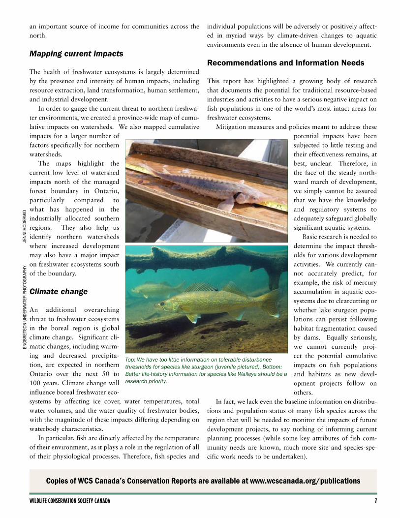
Top: We have too little information on tolerable disturbance thresholds for species like sturgeon (juvenile pictured). Bottom: Better life-history information for species like Walleye should be a research priority.
JEn
ni M
Cd
ERM
idEn
gbR
Etso
n u
nd
ERw
atER
Ph
oto
gR
aPh
y
Copies of WCS Canada’s Conservation Reports are available at www.wcscanada.org/publications

� Freshwater fish in Ontario's boreal: executive summary
Therefore, our review leads us to the following recom-mendations:
• Establish a Fisheries Research and Assessment Unit for the area of northern Ontario above the current managed forest boundary;
• Enhance knowledge of the distribution and status of fish in the region, particularly those exhibiting demonstrated vulnerability to development in order to incorporate fish and aquatic considerations into conservation-based plan-ning;
• Avoid piecemeal decisions on development projects by undertaking a comprehensive landscape-level assessment of lake sturgeon, brook trout, lake trout, walleye, and northern pike values north of the managed forest bound-ary and put in place adequate protection measures before development projects are initiated;
• Develop an understanding of the threshold for damag-ing effects, such as the impact of clearcutting on mer-cury accumulation in aquatic ecosystems of boreal forest regions, and develop forest management guidelines that will prevent cumulative effects of mercury contamina-tion;
• Determine whether lake sturgeon can persist in dammed rivers, and, if so, the threshold of disturbance popula-tions can tolerate.
WCS Canada's mission is to save wildlife and wildlands by improving our understanding of — and seeking solutions to — critical issues that threaten key species and large wild ecosystems throughout Canada. It both implements and supports comprehensive field studies that gather information on wildlife needs and seeks to resolve key conservation problems by working with a broad array of stakeholders, including local community members, conservation groups, regulatory agencies, and commercial interests. It also provides technical assistance and biologi-cal expertise to local groups and agencies that lack the resources to address complex conservation issues. Major issues addressed to date include protected-area design, conservation-based land use planning, monitoring and management of wildlife and fish populations, recovery of endangered species, and impacts of climate change upon wildlife.
WCS Wildlife Conservation Society Canada720 Spadina Avenue, Suite 600Toronto, Ontario, M5S 2T9(t) 416-850-9038 (f) [email protected]
!(
!(
!(
!(
!(
!(!(
!(!(
!(
!(
!(
!( !(
!(
!(
!(
!(
!(!(
!(
!(
!(
!(
!(
!(
!(
!(
!(
!(
!(
!(
!(
!(
!(
!(
!(
!(
!(
!(
!(
!(
!(
!(
!(
!(!(
Webequie
Lac Seul
Cat Lake
NibinamikDeer Lake
Peawanuck
Kasabonika
Moose Cree
Sandy Lake
Pikangikum
Fort Severn
Poplar Hill
Slate Falls
Kashechewan
Eabamatoong
Muskrat Dam
Attawapiskat
Marten Falls
Wunnumin Lake
Bearskin LakeBig Trout Lake
Mishkeegogamang
North Caribou Lake
Nakina
Hearst
KenoraDryden
MoosoneeRed Lake
Ear Falls
Armstrong
Geraldton
Pickle Lake
Sioux Lookout
Grassy Narrows9
8
7
6
5
4
3
2
1
1211
10
!( Communities
Primary roads
51st Parallel
Northern extent for licensed timber harvesting
Large Rivers
Large Lakes
Boreal Shield Ecozone
Boreal Plains Ecozone
Protected Areas
I
Hudson Bay
JamesBay
100 0 10050
Kilometers
Polar Bear Provincial Park
Woodland CaribouProvincial Park
Highway 11
!( 1 - Lake Nipigon2 - Big Trout Lake3 - Winisk Lake4 - Sandy Lake5 - Attawapiskat Lake6 - Deer Lake7 - Cat Lake8 - Lake St. Joseph9 - Lac Seul10 - Red Lake11 - Culverson Lake12 - McFaulds Lake
Attawa piskat River
Alba
ny R
iver
Winisk R iver
Berens River
Pipe stone
Rive
r
Fawn River
Ekwan River
Missinaibi R
iver
Mattag
ami R
ive
r
Abitib
i Rive
rOgo
ki
Riv
er
Sut
ton
Riv
er
Moose
River
Nay
shkootay aow
Riv
er
Ashe
wei
g
River
Severn
River
Northern Ontario is an area of as much water as land. Laced with rivers and streams and dotted with lakes, the region remains largely unprotected, although much of the more northern part is currently off limits to industrial forestry. Planning to protect aquatic habitats before development will be crucial to maintaining the region’s ecological health.
• Maintain the current morato-rium on hydroelectric develop-ment over 25 MW north of the managed forest boundary and undertake a comprehensive landscape-level assessment of lake sturgeon values north of the managed forest boundaries in order to ensure that adequate protection measures are put in place before development proj-ects are initiated
• Improve the collection of fish production data prior to mine development to allow for an assessment of the effectiveness of habitat compensation measures.
• Investigate the relationship between logging road devel-opment and fishing pressure, including the effect of distance from human settlements and dis-tance between roads and water
bodies, to better understand how increased access affects species and populations
• Incorporate knowledge about high-quality fisheries into landscape-scale land use planning in order to identify areas that should be kept roadless and access-free;
• Establish restricted access fisheries in newly logged areas in partnership with anglers, local communities, and tourism operators, and plan road networks to allow for restricted access by constructing easily monitored single entry and exit points.