water quality monitoring to empower wanaque supply system
TRANSCRIPT

Water Quality Monitoringto Empower
Wanaque Supply System Management
Water Environment FederationNational Monitoring Conference
Atlantic City, New JerseyMay 22, 2008
Pen C. Tao and Dag MadaraNorth Jersey District Water Supply Commission
Wanaque, New Jersey


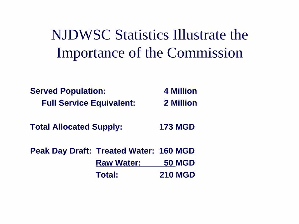
NJDWSC Statistics Illustrate the Importance of the Commission
Served Population: 4 MillionFull Service Equivalent: 2 Million
Total Allocated Supply: 173 MGD
Peak Day Draft: Treated Water: 160 MGDRaw Water: 50 MGDTotal: 210 MGD

Source Water QualityMonitoring & Applications
– Stream Flow Quality Test Program
• Flow Mass Balance and Nutrient Loading Analyses
– Reservoir Depth Sampling Program
• LAWATERS Model
– Real Time Water Quality Data Collection
• Data Visualization Charts
– Passaic River Basin Water Quality Information System
• Monitor TMDL Implementation

Stream Flow QualityTest Program
MONITORINGMONITORING
Parameters TestedTemperature
pH
Turbidity
Conductivity
Color
Dissolved Oxygen
Total Organic Carbon
Ammonia
Nitrite
Nitrate
Orthophosphate
Total Phosphorus
Chlorophyll-a
UV - 254
Alkalinity
Calcium Hardness
Total Hardness
Sulfate
Chloride
ICP Metals – Al, Cu, Fe,
Mn, Na, Zn, Ca, Mg, Si
GFAA Metals – Pb
Total Suspended Solids
Total Dissolved Solids
Total Coliform
Fecal Coliform
Fecal Streptococcus

Flow Mass Balance& Nutrient Loading
Stream Flow QualityTest Program
MONITORINGMONITORING APPLICATIONAPPLICATION
8.3444
Flow1 (mg)TP TN TSS TP TN TSS
InflowsMK02 Monsville Reservoir outflow 1,135.4 0.0100 0.2293 5.0 94.7 2,172.4 47,370.3RG01 Ringwood Creek USGS 526.8 0.0312 0.3539 6.5 136.9 1,555.6 28,572.0L18 Cupsaw Brook (4.37 sq. mi.) 0.0205 0.3975 6.5WB01 West Brook USGS (11.8 sq. mi.) 0.0200 0.5195 4.5 Watershed Area (34.9 sq. mi.) 1,157.1 0.0201 0.4865 5.0 194.4 4,697.2 48,666.8WS01 Wanaque South Intake3 0.0 0.0000 0.0000 0.0 0.0 0.0 0.0
P01 Ramapo River at Pompton Lakes 0.0 0.0616 0.9169 10.0 0.0 0.0 0.0Direct Precipitation 356.9 - - - 0.0 0.0 0.0
Inflow Subtotal 3,176.2 426.1 8,425.2 124,609.1
Inflow DIN:TP Ratio 19.8Outflows
L4 Water Treatment Plant 3,003.3 0.0100 0.4489 4.0 250.6 11,249.8 100,242.9L1 Spillway Release 6.6 0.0100 0.3053 5.0 0.5 16.7 274.3L4 Mid-intake Release 0.0 0.0100 0.4489 4.0 0.0 0.0 0.0L2 Bottom Release 381.3 0.0100 0.4490 14.0 31.8 1,428.6 44,544.1L4 UWR Draft from Reservior 185.0 0.0100 0.4489 4.0 15.4 693.0 6,174.9
Outflow Subtoal 3,576.2 298.4 13,388.1 151,236.1
Net Gain or (Loss) (400.0) 127.7 (4,962.9) (26,627.0)
Wanaque Reservoir Nutrient Loading AnalysisMay 2003
Location Nutrient Concentration2 (ppm) Nutrient Loading (lb)

Wanaque Reservoir Monthly Total Phosphorus Balance Chart
-4
1
6
11
16
Jan-2002
Feb-2002
Mar-2002
Apr-2002
May-2002
Jun-2002
Jul-2002
Aug-2002
Sep-2002
Oct-2002
Nov-2002
Dec-2002
Jan-2003
Feb-2003
Mar-2003
Apr-2003
May-2003
Jun-2003
Jul-2003
Aug-2003
Thou
sand
Pou
nds
Gain Loss Net Gain (Loss)

Reservoir Depth Sampling Program
MONITORINGMONITORING
Parameters TestedTemperature
pH
Turbidity
Conductivity
Color
Dissolved Oxygen
Total Organic Carbon
Ammonia
Nitrite
Nitrate
Orthophosphate
Total Phosphorus
Chlorophyll-a
Manganese

Laterally Averaged Wind And Temperature Enhanced Reservoir Simulation
• Period simulated: 1/1/1993 to 12/31/2002.
• Time step of simulation: 90 seconds.• Node points simulated: 10 vertical layers with 11
longitudinal cross-sections.• Water quality parameters: temperature, dissolved
oxygen, NBOD, CBOD and total phosphorus.• LAWATERS model was the primary tool used by
NJDEP to set the Wanaque Reservoir and Passaic River TMDL target.
Wanaque ReservoirLAWATERS Model
MONITORINGMONITORINGReservoir Depth
Sampling Program
APPLICATIONAPPLICATION

June 10th, 1997 June 10th, 1997 Wanaque ReservoirWanaque Reservoir
Total Phosphorus ContoursTotal Phosphorus Contours
No River DiversionNo River DiversionIn 11 MonthsIn 11 Months
June 20th, 1997 June 20th, 1997 Wanaque ReservoirWanaque Reservoir
Total Phosphorus ContoursTotal Phosphorus Contours
1,323 MG River Diversion1,323 MG River DiversionIn 9 DaysIn 9 Days

July 1st, 1999July 1st, 1999Wanaque ReservoirWanaque Reservoir
Total Phosphorus ContoursTotal Phosphorus Contours
6,621MG River Diversion6,621MG River DiversionIn Previous Two MonthsIn Previous Two Months
HypotheticalHypotheticalJuly 1st, 1999 July 1st, 1999
Wanaque ReservoirWanaque ReservoirTotal Phosphorus ContoursTotal Phosphorus Contours
80% TP Reduction80% TP ReductionIn Diverted River WaterIn Diverted River Water
50% TP Reduction50% TP ReductionIn Watershed RunoffIn Watershed Runoff
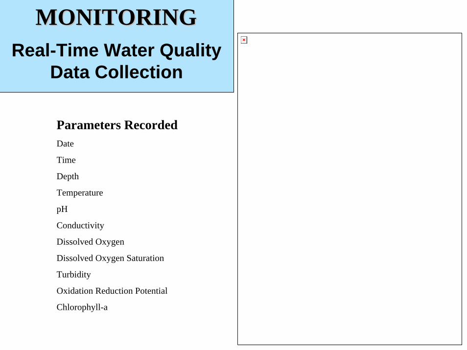
Real-Time Water Quality Data Collection
MONITORINGMONITORING
Parameters RecordedDate
Time
Depth
Temperature
pH
Conductivity
Dissolved Oxygen
Dissolved Oxygen Saturation
Turbidity
Oxidation Reduction Potential
Chlorophyll-a
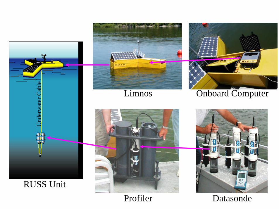
Limnos Onboard Computer
RUSS UnitProfiler Datasonde
Und
erw
ater
Cab
le

Upper Intake
Lower Intake
Intermediate Intake
Reservoir Data Visualization
Real-Time Water Quality Data Collection
MONITORINGMONITORING APPLICATIONAPPLICATION

Aeration System
Aeration of water column prevents release of sediment bound nutrientsReduces algal blooms and prevents more problematic algaeMaintains manageable levels of ammonia and other respiration by-products
WaterReturn
WaterIntake
WaterIntake

Dep
th (M
eter
s)
Depth (Ft.)


Despite optimum conditions for algae growth there were no blooms in 2002
Number of days over 90 degrees FNumber of days over 90 degrees F
1010--year year AvgAvg
2002 Drought2002 Drought
9 9 days/yrdays/yr
32 days/yr32 days/yr
River Water DiversionsRiver Water Diversions
1010--year year AvgAvg
2002 Drought2002 Drought
17.6 BG/yr 17.6 BG/yr
38 BG/yr38 BG/yr
Phosphorus LoadPhosphorus Load
1010--year year AvgAvg
2002 Drought2002 Drought
57,600 lbs/yr57,600 lbs/yr
106,000 lbs/yr106,000 lbs/yr

Passaic River Basin Water Quality Information System
MONITORINGMONITORING
• Build a more coordinated and comprehensive basin-wide sampling program– Re-design and expand upon the Commission’s
existing sampling program to address current and future needs throughout the basin
• Intensive stormwater sampling effort to establish present level non-point source pollution loading and monitor TMDL implementation

MONITORINGMONITORING PRODUCTPRODUCTData Repository &
Non-Point Source ModelPassaic River Basin Water Quality Information System
• New data repository and retrieval system– Consistent sampling protocols, quality control,
sampling frequencies, and data storage• GIS-based non-point source pollution model
– Monitor TMDL implementation– Assess impacts of existing watershed stressors– Evaluate the potential benefit of various BMP
strategies

Conclusions• Water quality monitoring built a baseline dataset
– Nutrient loading analysis– Reservoir water quality model– NJDEP establishment of TMDL
• Real-time continuous monitoring provides instantaneous information– Optimize water treatment to assure water quality– Detect sudden water quality changes (safety and
security)• Implementation of basin-wide depository
– Support TMDL implementation resulting in long-term source water quality improvement

Thank YouPen C. Tao
[email protected] Madara
[email protected] Jersey District Water Supply Commission
www.njdwsc.com