water balance calculation method for urban areas examples
TRANSCRIPT

A new water balance calculation has been worked out that considers the effect of urbanization. Thiscalculation method was applied to evaluate the water balance of the historic center of Budapest, theBuda Castle Hill, where an intensive network of cellars is found. The method, a combination ofhydrogeologic tests and field measurements, was also tested in other Hungarian cities whereunderground structures are common, such as Eger, Pécs and Veszprém.
The calculation considers both natural and anthropogenic water sources. Beside the commonly-used natural factors such as precipitation, evaporation, runoff, infiltration, etc. it also employs inputparameters such as broken pipelines and sewer systems. The water losses of these waterworkssignificantly influence the natural water balance and provide additional and very often significantwater input into the water system. The new method is of great importance in designing and planningremedial actions for historic cities, where the built environment, cellars and natural caves areendangered by infiltrating water. Another feedback of the method is the application of the results inthe long-term planning strategy of public works supplying or using water (water works, sewersystem and energy sector).
Key words: hydrogeology, waterways, water wells, water balance calculation, infiltration, public-utility loss
Introduction
The classical method of water balance calculations considers precipitation onthe input side and runoff, evaporation and infiltration on the output one. Thismethod, however, does not provide satisfactory results in settlements, due to the
Address: G. Hajnal: H-1111 Budapest, Stoczek u. 2, Hungary, e-mail: [email protected]: November 5, 2007; accepted January 2, 2008
1788-2281/$ 20.00 © 2007 Akadémiai Kiadó, Budapest
Central European Geology, Vol. 50/4, pp. 331–341 (2007)DOI: 10.1556/CEuGeol.50.2007.4.3
Water balance calculation method for urban areasexamples from Hungary
Géza HajnalDepartment of Construction Materials and Engineering Geology,Budapest University of Technology and Economics, Budapest

fact that the effects of urbanization – primarily those of public utilities – maysignificantly change the water system. Below are published the results ofcalculations carried out in Hungarian cities, using the method (Hajnal 2002, 2003)that was elaborated for the Castle Hill, Buda.
Groups of water types
The first step of the water balance calculation method that takes into accountthe effects of urbanization is to collect and structure all possible water data. Thesefall into the domain of geology, geotechnology, meteorology and (thedevelopment of) public utilities. In a given settlement the following water types of natural sources may occur:
– precipitation, – runoff,– evaporation,– infiltration.
Anthropogenic water types are the losses by public utilities:– water pipelines,– sewage,– district heating systems.
The form of appearance of both types of water can be very diverse:– springs and water overflows,– water in boreholes for geotechnical purposes,– cellar water (regular and constant flooding),– water of drilled and dug wells,– water of ground-water level observation wells (Fig. 1),– water of draining-channels.
It is notable that these groups are not based on the classic hydrologic system(surface, subsurface, ground, confined, etc. waters), but are set up according tothe simplest groups of measurable and observable data. The origins of certainwater types may be partially or totally correlatable. For example, water of anatural spring in a city hillside might be joined by that from public utility losses;it can also occur in the opposite fashion at a water overflow, whereby waterderiving from a long unobserved break in the pipeline system can mix with watercoming from infiltration of precipitation (Fig. 2).
The importance of water losses by public utilities
The measurements and calculations carried out during this study proved thatthe water system of a given settlement, or that of a city quarter that can bedistinguished from others from a morphological and geologic point of view, isbasically influenced by the losses by public utilities.
332 G. Hajnal
Central European Geology 50, 2007

Before presenting the essentials ofthis method, a few examples thatjustify this statement are presented:
– Examining the data series ofground-water level observation wells(Budapest, Pécs and Eger) it can bestated that the water level diagramnever mimics changes of annualprecipitation (not even with any delay;Hajnal 2005).
– The annual total amount ofchanges in water level in individualwells significantly exceeds the annualamount of precipitation.
– In Hungarian settlements it ishardly possible to find any ground-water level observation wells, whichcan be considered as having a free flowregime, when examined with thehydrologic-statistic method (examinations of consistency and homogeneity;Rétháti 1974).
Water balance calculation method for urban areas examples from Hungary 333
Central European Geology 50, 2007
Fig. 1Measuring water level, temperature and pHvalue of the ground-level observation well inPécs
Fig. 2Periodic water outflow in a retaining wall (Veszprém)
In water supply, that amount of water is regarded as lost, which is not usefullyemployed (e.g. flushing of the pipeline network). A spectacular but smallproportion of this loss is generated by pipe ruptures, whereby a large amount ofwater increases water loss with great intensity but for a short period of time.Compared to these losses, smaller-sized defective sites (connections to houses,defects at junctions) cause the filtration of small amounts of water, but becausethere are so many of them and they go unnoticed for a long time (possibly evenover several years), this may correspond to 60% of the sales balance. As anexample, at a defective site with a diameter of 5 mm, water leakage amounts to25 l/min, and such anomalies can occur at one or two places within a 1 km-stretchof pipeline. When not measuring the loss in a given area, the Hungarianwaterworks companies apply a rule of thumb, which determines the loss as 10%of the water amount piped into (pipelines) or drained away (drains) from thearea (Hajnal 2002, 2003; there are areas though which this proportion might be ashigh as 50%.)
Water balance calculation
This calculation method was elaborated for the Castle Hill quarter of Buda. Theextent of the catchment territory of the Castle Hill totals 920,000 m2; of this, thearea of the Plateau is 400,000 m2 and that of the Castle Slope 520,000 m2. Thecalculation takes into account the pipeline input proportional to area. The area ofthe continuous cave system below the Plateau is 18,000 m2 and the area ofindividual cavities can reach up to 4.000 m2.
The schematic cross-section of the Plateau is shown in Fig. 3 and the flowchartof the calculation is presented in Fig. 4.
Calculation steps
Draining was calculated with a weighted draining factor α = 0.8.Precipitation on the area: P (m3/year) = Ap (m2) × P (mm/year);The following initial losses from P are by: evaporation [E = 1/3×P]; drainage
[D = α×(P–E)]; if α = 0.8, D = 8/15×P;Therefore, infiltration of precipitation is [Ip = P–E–D] or Ip = 2/15×P.Loss by water-mains in the Plateau/(Plateau + Slope) area ratio:
Iwm = (40/92 ×W)/10 or Iwm = W/23;Amount of water infiltrating from the loss of district heating: Iwdh = 2/3×Wdh;Waste water loss from precipitation: Ipcp = (0.9×D)/10, Ipcp = 0.048×P;Waste water loss from the water-mains:
Iwmcp = (40/92×W–Iwm)/10, Iwmcp = 9/230×W;Loss from all the waste water: Icp = Ipcp+Iwmcp;All the infiltration into the Plateau: ΣIp = Ip+Iwm+Iwdh+Icp;Infiltration into Polgárváros in the ratio of the areas: Ipol = 31/40×Ip;
334 G. Hajnal
Central European Geology 50, 2007

Water balance calculation method for urban areas examples from Hungary 335
Central European Geology 50, 2007
Fig. 3Schematic figure of the waterbalance for the Castle HillPlateau, Budapest
Fig. 4 ↓Flow sheet of the water balancecalculation that takes intoconsideration the effects ofurbanization
C – precipitationP – evaporationBe – infiltrationL – drainageVv – water conduitVta – district-heasting waterVcsa – channellVcse – dripping watersVbk – cave wellsVki – water outlets
All the water amount getting into the cavities: Idc = 22/310×Ipol;Out of this, infiltration into the Great Labyrinth: Igl = 9/11×Idc;Water amount getting into the separate cavities: Isc = Idc–Igl;
Results
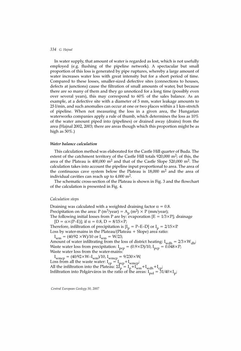
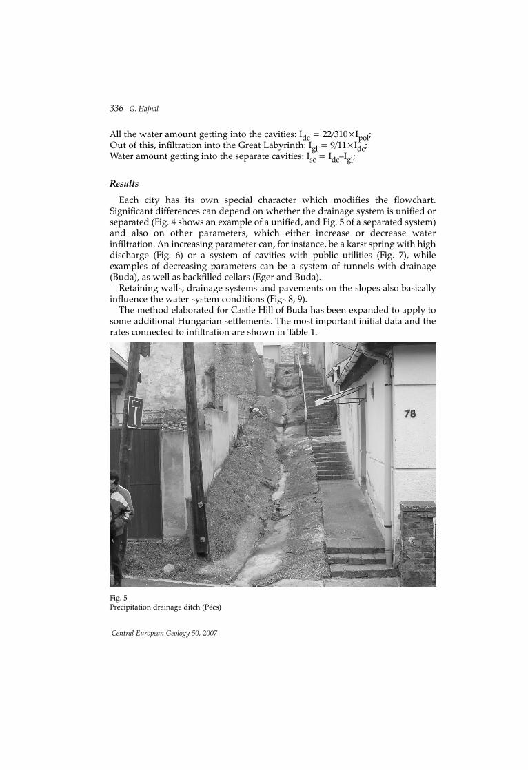
Each city has its own special character which modifies the flowchart.Significant differences can depend on whether the drainage system is unified orseparated (Fig. 4 shows an example of a unified, and Fig. 5 of a separated system)and also on other parameters, which either increase or decrease waterinfiltration. An increasing parameter can, for instance, be a karst spring with highdischarge (Fig. 6) or a system of cavities with public utilities (Fig. 7), whileexamples of decreasing parameters can be a system of tunnels with drainage(Buda), as well as backfilled cellars (Eger and Buda).
Retaining walls, drainage systems and pavements on the slopes also basicallyinfluence the water system conditions (Figs 8, 9).
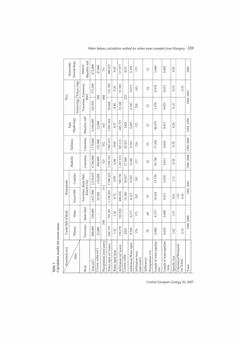
The method elaborated for Castle Hill of Buda has been expanded to apply tosome additional Hungarian settlements. The most important initial data and therates connected to infiltration are shown in Table 1.
336 G. Hajnal
Central European Geology 50, 2007
Fig. 5Precipitation drainage ditch (Pécs)
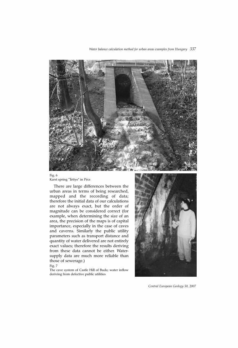
There are large differences between theurban areas in terms of being researched,mapped and the recording of data;therefore the initial data of our calculationsare not always exact, but the order ofmagnitude can be considered correct (forexample, when determining the size of anarea, the precision of the maps is of capitalimportance, especially in the case of cavesand caverns. Similarly the public utilityparameters such as transport distance andquantity of water delivered are not entirelyexact values; therefore the results derivingfrom these data cannot be either. Water-supply data are much more reliable thanthose of sewerage.)
Water balance calculation method for urban areas examples from Hungary 337
Central European Geology 50, 2007
Fig. 6Karst spring "Tettye" in Pécs
Fig. 7The cave system of Castle Hill of Buda; water inflowderiving from defective public utilities

338 G. Hajnal
Central European Geology 50, 2007
Fig. 8Soaked retaining walls in the castle of Veszprém
Fig. 9Wet narrow passage in Veszprém
Water balance calculation method for urban areas examples from Hungary 339
Central European Geology 50, 2007
Tabl
e 1
Cal
cula
tion
resu
lts fo
r sev
en a
reas
Water input data was provided by the waterworks of the cities. The examinedareas did not overlap with the input ones (zones), so the quantity of water in ourareas has been determined by scaling (in all cases proportional to the area size,except for Pécs, where the length of the pipeline was used).
Table 1 shows that the ratio of input divided by the area is highest on CastleHill (1.42) and on Rose Hill (0.72, 0.99), while the lowest is in the Tettye Valley(0.26). This figure (input/input area) basically depends on the conditions of thebuilt-up environment. It is interesting to compare the input/input area figureswith the length of pipelines/area quotients; these are quite similar in the differentareas. In percentage terms we can say that the length of pipelines covers 1% ofthe built-up areas (in summary: water must be delivered everywhere, but indifferent quantities.)
Correlating total infiltration to water input has been found to be important,due to the fact that water input is of the highest importance among all the inputdata; this is because it basically determines pipelines losses as well as wastewaterlosses. Infiltration/water input values are very close to each other; generally theyare around 0.3 and 0.4. The distinct value in Veszprém might have been causedby inexact initial data, while in Pécs the special location of the area and theoperation of the karst spring might be the reason behind the high figure. It is alsoshown that when the water input/area value is high, then the infiltration/waterinput is low and vice versa: if the former value is low, the latter is high. This has asimple computational reason: in both quotients there is water input, first in thenumerator, then in the denominator.
Specific losses are measured by specialized companies; therefore, where suchdata was available they were compared with our calculations. This figure reflectsthe condition of the pipeline (thus only infiltration coming from the water lossesis taken into consideration); therefore a possible repair job can significantlychange the situation. In the period of our examinations the pipelines in worstcondition were on Castle Hill, on Rose Hill, and in Szentendre; there have beenmajor reconstruction works performed in the Castle area since then, so todaymuch better results would be obtained.
The table also shows total infiltration (mm/year) divided by precipitation. Thisratio expresses to what extent urbanization (public utilities) influences infiltrationconditions, and consequently water balance. The urban character of thesettlement does not cause significant changes in Kõbánya, Budafok and Pécs,while in the case of Castle and Rose Hills, as well as in Veszprém Castle, theamount of infiltration could double. In Szentendre and in Eger the value isspecifically low.
Due to the increasing building density and area of pavements it is necessary totake higher runoff factors into account, which reduce direct infiltration;simultaneously, however, public utilities are also being expanded, the losses ofwhich increase infiltration. The joint rate of the two influences is expressed in thepercentage ratio.
340 G. Hajnal
Central European Geology 50, 2007

The significance of the types of rocks in the areas would be much higherwithout road surfaces, but in small areas, in the case of damaged buildings andmovements of supporting walls, it might still be important to be aware of theperviousness, structure and the fracturing network of the rocks.
Summary
The water system of a given settlement is basically determined by the losses ofthe public utilities. Anthropogenic waters endanger the built-up environment,the monuments, as well as the natural values of a city. A water calculationmethod that takes into consideration the effects of urbanization can provideuseful data for the necessary regional planning, environmental protection actionsand the establishment of a monitoring system.
Acknowledgements
I wish to express my thanks to the students of the Budapest University ofTechnology and Economics – Anita Bódi, Ildikó Barsi, Réka Jobbágy, János Kraft,Tamás Vida, Attila Jáger, Péter Szász, and László Tokodi – who participated in thehydrogeologic measurements and data processing.
The author has been awarded the "Bolyai János" research scholarship thatcontributed to the compilation of this paper.
ReferencesHajnal, G. 2002: New method of calculating water balance for the Castle Hill, Buda. – Acta
Geologica Hungarica, 45/4, pp. 385–402.Hajnal, G. 2003: A budai Várhegy hidrogeológiája (Hidrogeology of the Castle Hill, Budapest). –
Akadémiai Kiadó, Budapest, 129 p.Hajnal, G. 2005: Talajvíz és közmû, Természetes és mesterséges hatások a talajvízjárásra Budapest
területén (Groundwater and public utilities, Natural and artifical influences on ground waterlevel in Budapest). – Mélyépítés, 3, pp. 16–21.
Hajnal, G. 2006: Water balance calculation method for urban areas, examples from Hungary. – IAEG2006.
Rétháti, L. 1974: Talajvíz a mélyépítésben (Ground water in civil engineering). – Akadémiai Kiadó,Budapest.
Water balance calculation method for urban areas examples from Hungary 341
Central European Geology 50, 2007