walk thirteen: st. andrew’s and ashley down
TRANSCRIPT

Mike’s Bristol Walks Walk Thirteen: St. Andrew’s and Ashley Down
1
Walk Thirteen: St. Andrew’s and Ashley Down
Last updated: October 2020
This walk explores the area just to the north of that explored in Walk Twelve ‘St. Paul’s and St. Weburgh’s’. Starting with a visit to the bustling Gloucester Road, this walk then winds up through the pleasant Victorian suburb of St Andrew’s to Ashley Down and the former Müller Orphanage. From there, the walk dips down into the northern end of Ashley Vale and makes a return visit to St. Werburgh’s City Farm before exploring the Narroways Hill nature area. From St. Werburgh’s, the walk climbs steeply back uphill to the upper part of Montpelier, where there is an opportunity to explore a couple of Montpelier’s unique hillside terraces.
Useful Information
Terrain: Hilly; includes steps. Ground: Paved and unpaved. Steps and unpaved sections can be avoided by taking an accessible route, at the cost of missing out on the Narroways Hill area.
Key Attractions: Gloucester Road shops, St. Andrew’s Park, Ashley Down Green, Ashley Vale allotments, St. Werburgh’s City Farm, Narroways Millennium Green, Montpelier hillside routes, Montpelier Park.
Refreshments: Gloucester Road and Cheltenham Road offer a variety of food and drink options at the start and finish of the walk. There is a café kiosk at St. Andrew’s Park. Pubs and cafés available on the St. Werburgh’s / Montpelier section of the route.
Starting point: Zetland Road Junction Getting there: Five minutes’ walk from Redland and Montpelier Stations, with trains at least hourly from Temple Meads Station and suburban stations on the Severn Beach Line. Thirty minutes’ walk from Centre Promenade and forty minutes’ walk from Temple Meads Station. Accessible by bus routes running via Gloucester Road and also route No.9 running to Redland Station. On-street car parking available in surrounding
streets, subject to residents’ parking restrictions on weekdays.
Approx. Time: 2 hours 15 minutes Approx. Distance: tbc
The Route
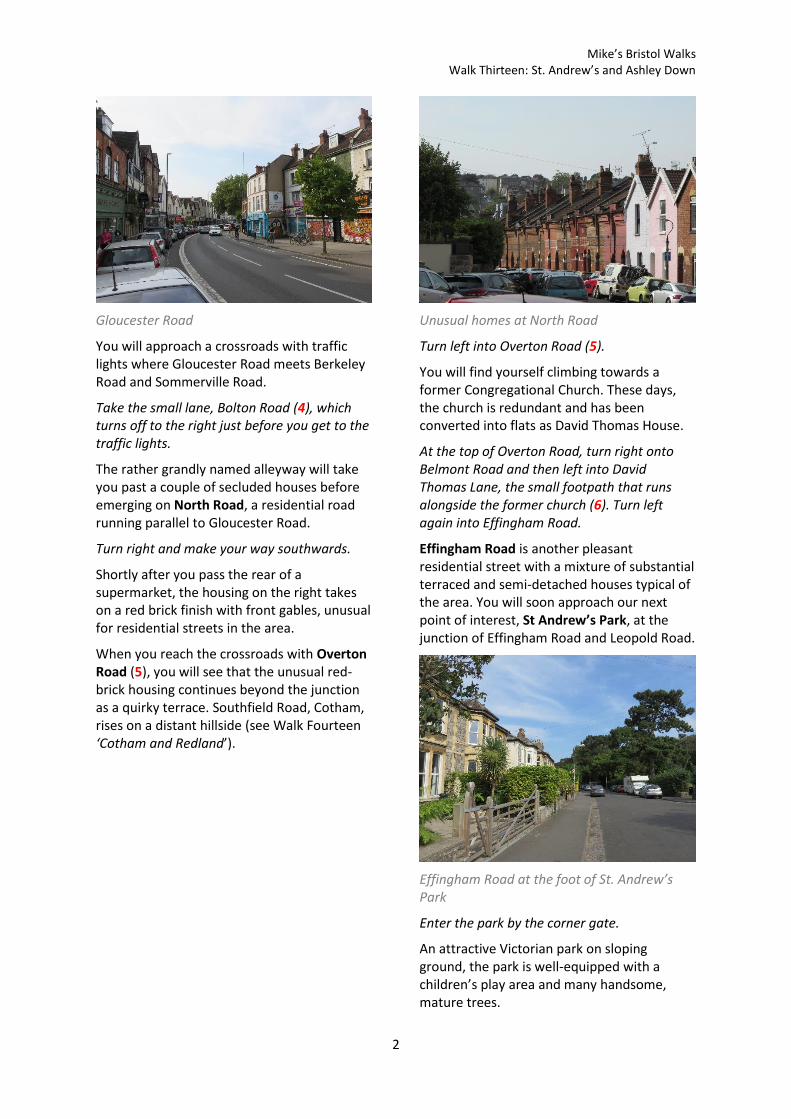
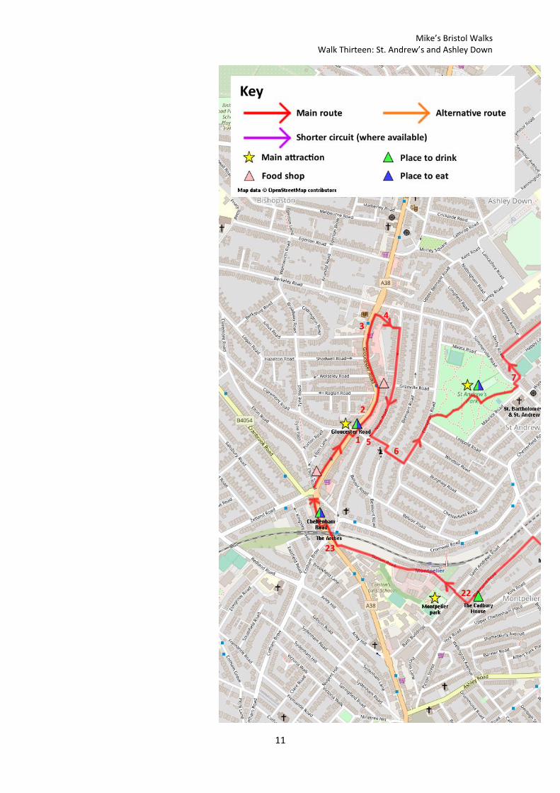
Our walk starts at the busy Zetland Road junction, where Cheltenham Road turns into Gloucester Road. This junction has long been a key hub in the area, being a major tram junction at one time and now a major interchange for car traffic and buses.
You are also at the southern end of the most successful part of Gloucester Road in retail terms. Where many local high streets have seen a decline over the years with the rise of the supermarkets and online shopping, Gloucester Road has bucked the trend.
Make your way north along the left hand side of Gloucester Road. Cross over at the traffic lights by the junctions with Claremont Road and Overton Road (1).
Note the lively mix of shops and cafés that line the street. Gloucester Road’s shops are housed in an eclectic mix of Victorian and Edwardian buildings. Side turnings to either side lead up into the comfortable suburbs of Bishopston and St. Andrew’s, communities which help to make Gloucester Road the lively place that it is today through their support for the local shops. Just before the road bends round to the left note Meridian Terrace, a row of raised houses perched improbably above a steep access road with a stone retaining wall (2).
As you continue along Gloucester Road you will pass banks and pubs as well as popular butchers, bakers and greengrocers. Shortly after the junction with Shadwell Road you will pass the former Bristol North Baths, an attractive Victorian building now no longer in use as a swimming pool (3).
Gloucester Road is one of the main places to obtain refreshments for this walk. A thriving local high street, it offers a range of food stores and cafés along with other shops.
Mike’s Bristol Walks Walk Thirteen: St. Andrew’s and Ashley Down
2
Gloucester Road
You will approach a crossroads with traffic lights where Gloucester Road meets Berkeley Road and Sommerville Road.
Take the small lane, Bolton Road (4), which turns off to the right just before you get to the traffic lights.
The rather grandly named alleyway will take you past a couple of secluded houses before emerging on North Road, a residential road running parallel to Gloucester Road.
Turn right and make your way southwards.
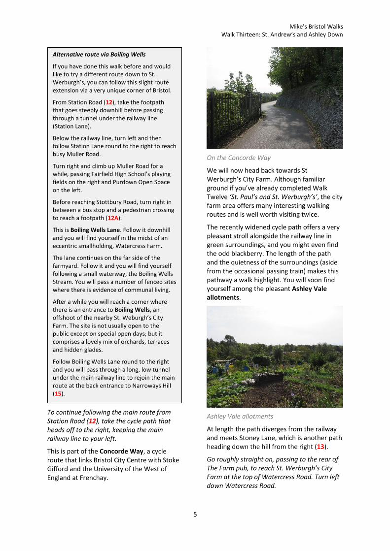
Shortly after you pass the rear of a supermarket, the housing on the right takes on a red brick finish with front gables, unusual for residential streets in the area.
When you reach the crossroads with Overton Road (5), you will see that the unusual red-brick housing continues beyond the junction as a quirky terrace. Southfield Road, Cotham, rises on a distant hillside (see Walk Fourteen ‘Cotham and Redland’).
Unusual homes at North Road
Turn left into Overton Road (5).
You will find yourself climbing towards a former Congregational Church. These days, the church is redundant and has been converted into flats as David Thomas House.
At the top of Overton Road, turn right onto Belmont Road and then left into David Thomas Lane, the small footpath that runs alongside the former church (6). Turn left again into Effingham Road.
Effingham Road is another pleasant residential street with a mixture of substantial terraced and semi-detached houses typical of the area. You will soon approach our next point of interest, St Andrew’s Park, at the junction of Effingham Road and Leopold Road.
Effingham Road at the foot of St. Andrew’s Park
Enter the park by the corner gate.
An attractive Victorian park on sloping ground, the park is well-equipped with a children’s play area and many handsome, mature trees.

Mike’s Bristol Walks Walk Thirteen: St. Andrew’s and Ashley Down
3
St. Andrew’s Park
One of the park’s most unusual features is its five-sided shape, which makes it easy to lose your bearings as from most approaches it appears to be square.
Make your way diagonally across the five-sided park so that you approach its highest corner, keeping the children’s play area to your left.
As you pass by the children’s play area, you will see to the right one of this park’s more unusual features: a built-in paddling pool, which is popular with local families during the summer months.
You will emerge on Sommerville Road close to a pedestrian crossing. Off right, note the local parish church of St. Bartholomew and St. Andrew, which lacks a tower.
Cross Sommerville Road at the pedestrian crossing and take the nearby turning for Derby Road (7).
Derby Road immediately bears left past the Bristol St. Andrew’s Bowling Club, running along the backs of the houses on Sommerville Road.
After passing an alleyway, Happy Lane, turn right onto Sefton Park Road.
Sefton Park Road is an attractive tree-lined avenue of terraced houses running along the top of the hill. Although it is a long, straight road, it offers plenty to interest the passer-by
as, unsually, every single house has a unique name carved into the stonework above the front door.
Sefton Park Road, Ashley Down
Make your way along the road to the far end.
At length, you will emerge on Ashley Down Road. Just before you do so, one quirky local feature is a garage door to the right on which “No Parking” has been written in just about every language you could think of.
Ashley Down Road is the main road in this area and takes its name from the ridge of raised land that you are currently walking along. Much further down to the right, Ashley Down Road becomes Ashley Hill, which we encountered in Walk Twelve ‘St. Paul’s and St. Werburgh’s’.
In front of you are the looming stone buildings of the former Müller Orphanage.
The orphanage, which has now been converted into flats, occupies a prominent skyline position overlooking Eastville. The Christian evangelist George Müller’s philanthropic gesture in founding the orphanage in the 19th Century is commemorated in the naming of the nearby Muller Road.
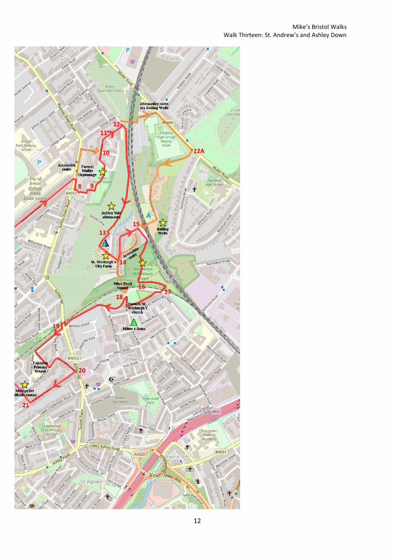
Carefully cross Ashley Down Road and then turn right. Turn left at the end of the orphanage buildings into Pople Walk (8).
There is a café kiosk at the centre of St. Andrew’s Park where you can pause for refreshments.

Mike’s Bristol Walks Walk Thirteen: St. Andrew’s and Ashley Down
4
The pleasantly landscaped Pople Walk was created as part of the residential redevelopment of the orphanage, leading to some new-build flats at the rear.
Follow Pople Walk past the end of the orphanage buildings. Turn left towards an internal courtyard, then turn right down a flight of steps in between the new-build flats and the historic buildings (9).
Ashley Down Green
You will emerge on Ashley Down Green, a pleasant, peaceful park on a sloping site that offers panoramic views out over east Bristol. As a public park, the space is a relatively new addition to the city’s offer, being contemporary with the conversion of the orphanage to flats. The stone orphanage buildings dominate the site to the rear.
Turn left and follow the path at the top of the green so that you reach the modern houses of Dirac Road. Bear left to reach a crossroads, where the Accessible Route rejoins from the left (10).
The orphanage dominates Ashley Down Green
Continue north along Dirac Road, which curves right and then descends towards a stone wall. Go through the gap in the wall to reach Lilstock Avenue (11).
Lilstock Avenue is a residential cul-de-sac that descends to meet Station Road (12). Station Road is so-called because there used to be a station on the main railway line here, which passes the bottom of the road on its way out from Bristol Temple Meads, Lawrence Hill and Stapleton Road stations. It is hoped that a station can be reopened here within the next few years.
View of Lockleaze and Purdown from Lilstock Avenue
Accessible Route
To avoid the steps at Pople Walk, turn left along Ashley Down Road instead. After the orphanage buildings, turn right into Dirac Road to rejoin the main route at a crossroads within that street (10).
Mike’s Bristol Walks Walk Thirteen: St. Andrew’s and Ashley Down
5
To continue following the main route from Station Road (12), take the cycle path that heads off to the right, keeping the main railway line to your left.
This is part of the Concorde Way, a cycle route that links Bristol City Centre with Stoke Gifford and the University of the West of England at Frenchay.
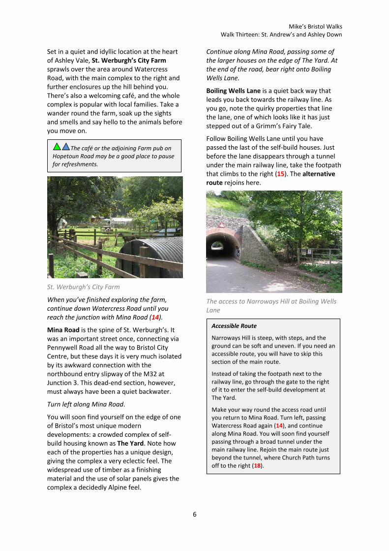
On the Concorde Way
We will now head back towards St Werburgh’s City Farm. Although familiar ground if you’ve already completed Walk Twelve ‘St. Paul’s and St. Werburgh’s’, the city farm area offers many interesting walking routes and is well worth visiting twice.
The recently widened cycle path offers a very pleasant stroll alongside the railway line in green surroundings, and you might even find the odd blackberry. The length of the path and the quietness of the surroundings (aside from the occasional passing train) makes this pathway a walk highlight. You will soon find yourself among the pleasant Ashley Vale allotments.
Ashley Vale allotments
At length the path diverges from the railway and meets Stoney Lane, which is another path heading down the hill from the right (13).
Go roughly straight on, passing to the rear of The Farm pub, to reach St. Werburgh’s City Farm at the top of Watercress Road. Turn left down Watercress Road.
Alternative route via Boiling Wells
If you have done this walk before and would like to try a different route down to St. Werburgh’s, you can follow this slight route extension via a very unique corner of Bristol.
From Station Road (12), take the footpath that goes steeply downhill before passing through a tunnel under the railway line (Station Lane).
Below the railway line, turn left and then follow Station Lane round to the right to reach busy Muller Road.
Turn right and climb up Muller Road for a while, passing Fairfield High School’s playing fields on the right and Purdown Open Space on the left.
Before reaching Stottbury Road, turn right in between a bus stop and a pedestrian crossing to reach a footpath (12A).
This is Boiling Wells Lane. Follow it downhill and you will find yourself in the midst of an eccentric smallholding, Watercress Farm.
The lane continues on the far side of the farmyard. Follow it and you will find yourself following a small waterway, the Boiling Wells Stream. You will pass a number of fenced sites where there is evidence of communal living.
After a while you will reach a corner where there is an entrance to Boiling Wells, an offshoot of the nearby St. Weburgh’s City Farm. The site is not usually open to the public except on special open days; but it comprises a lovely mix of orchards, terraces and hidden glades.
Follow Boiling Wells Lane round to the right and you will pass through a long, low tunnel under the main railway line to rejoin the main route at the back entrance to Narroways Hill (15).
Mike’s Bristol Walks Walk Thirteen: St. Andrew’s and Ashley Down
6
Set in a quiet and idyllic location at the heart of Ashley Vale, St. Werburgh’s City Farm sprawls over the area around Watercress Road, with the main complex to the right and further enclosures up the hill behind you. There’s also a welcoming café, and the whole complex is popular with local families. Take a wander round the farm, soak up the sights and smells and say hello to the animals before you move on.
St. Werburgh’s City Farm
When you’ve finished exploring the farm, continue down Watercress Road until you reach the junction with Mina Road (14).
Mina Road is the spine of St. Werburgh’s. It was an important street once, connecting via Pennywell Road all the way to Bristol City Centre, but these days it is very much isolated by its awkward connection with the northbound entry slipway of the M32 at Junction 3. This dead-end section, however, must always have been a quiet backwater.
Turn left along Mina Road.
You will soon find yourself on the edge of one of Bristol’s most unique modern developments: a crowded complex of self-build housing known as The Yard. Note how each of the properties has a unique design, giving the complex a very eclectic feel. The widespread use of timber as a finishing material and the use of solar panels gives the complex a decidedly Alpine feel.
Continue along Mina Road, passing some of the larger houses on the edge of The Yard. At the end of the road, bear right onto Boiling Wells Lane.
Boiling Wells Lane is a quiet back way that leads you back towards the railway line. As you go, note the quirky properties that line the lane, one of which looks like it has just stepped out of a Grimm’s Fairy Tale.
Follow Boiling Wells Lane until you have passed the last of the self-build houses. Just before the lane disappears through a tunnel under the main railway line, take the footpath that climbs to the right (15). The alternative route rejoins here.
The access to Narroways Hill at Boiling Wells Lane
Accessible Route
Narroways Hill is steep, with steps, and the ground can be soft and uneven. If you need an accessible route, you will have to skip this section of the main route.
Instead of taking the footpath next to the railway line, go through the gate to the right of it to enter the self-build development at The Yard.
Make your way round the access road until you return to Mina Road. Turn left, passing Watercress Road again (14), and continue along Mina Road. You will soon find yourself passing through a broad tunnel under the main railway line. Rejoin the main route just beyond the tunnel, where Church Path turns off to the right (18).
The café or the adjoining Farm pub on Hopetoun Road may be a good place to pause for refreshments.

Mike’s Bristol Walks Walk Thirteen: St. Andrew’s and Ashley Down
7
To continue following the main route, take the path that climbs next to the railway line from Boiling Wells Lane (15).
The leafy by-way climbs steadily, winding through young woodland, until it eventually brings you out in a green space at the top of the hill. This is Narroways Hill, also known as the Narroways Millennium Green, a unique wildlife space that has been created from the leftover land between two railway cuttings.
Narroways Hill
Follow the path around the right hand edge of the green. Do not turn off into the woods. Instead, climb up onto the steep embankment ahead of you (16), making your way up and to the left.
As you climb to the top of the open space, impressive views begin to open out across east Bristol.
At the far side of the open space, you are given a choice of two bridges over railway lines. Take the one on the right, which crosses the Severn Beach branch line (17).
The bridge back to St. Werburgh’s
The creeper-covered bridge will lead you to a paved footpath leading back down the hill past the backs of the houses on St. Werburgh’s Park. A church tower will come into view, with some of the city centre buildings of the University of Bristol and the hospital precinct visible in the far distance.
Descending from Narroways Hill
St. Werburgh’s Church was declared redundant some years ago. It originally stood in Corn Street, in the city centre, but was moved to this location during the Victorian era. It is now in use, innovatively, as a climbing centre.
The path will deposit you back on Mina Road. Turn right towards a railway tunnel. Just before the tunnel entrance, make a hard left onto Church Path (18). The accessible route rejoins here.
Church Path is a pleasant leafy route which will take you back up the hill towards Montpelier alongside the Severn Beach line, passing the remains of some old gas lamps. Be warned that the path gets quite steep as you leave Ashley Vale.
A bit further down Mina Road, past church, you can find the Miner’s Arms, the local pub.

Mike’s Bristol Walks Walk Thirteen: St. Andrew’s and Ashley Down
8
The remains of a gas lamp at Church Path
You will emerge on the main road, Ashley Hill.
Cross the road at the traffic lights and take the footpath opposite (19), continuing alongside the railway, to emerge in Fairlawn Road.
Fairlawn Road welcomes you to the Victorian part of upper Montpelier. Pleasant terraced houses predominate.
Take the first left, Falkland Road.
You will pass Fairlawn Primary School, a Victorian school building built in red brick and grey sandstone. The palette of materials and rounded parapets give it a singular appearance. This used to be Fairfield High School before its move to a larger site in Stottbury Road.
At the end of Falkland Road, turn left into Fairfield Road and then right into Old Ashley Hill.
Old Ashley Hill is a quiet route which will take you back down towards Ashley Hill itself.
As soon as you hit the main road (20), turn right again into Cobourg Road.
The incredibly narrow Cobourg Road has the width of an alleyway but has houses on both sides. The gaps between the houses on the left-hand side offer views out over lower Montpelier. As you continue along the road, note how the architecture to the left changes from Victorian to Georgian. You are entering the older part of upper Montpelier, which, with its grid of streets following the contours of the hill, resembles historic Kingsdown in some respects.
Cobourg Road, Montpelier
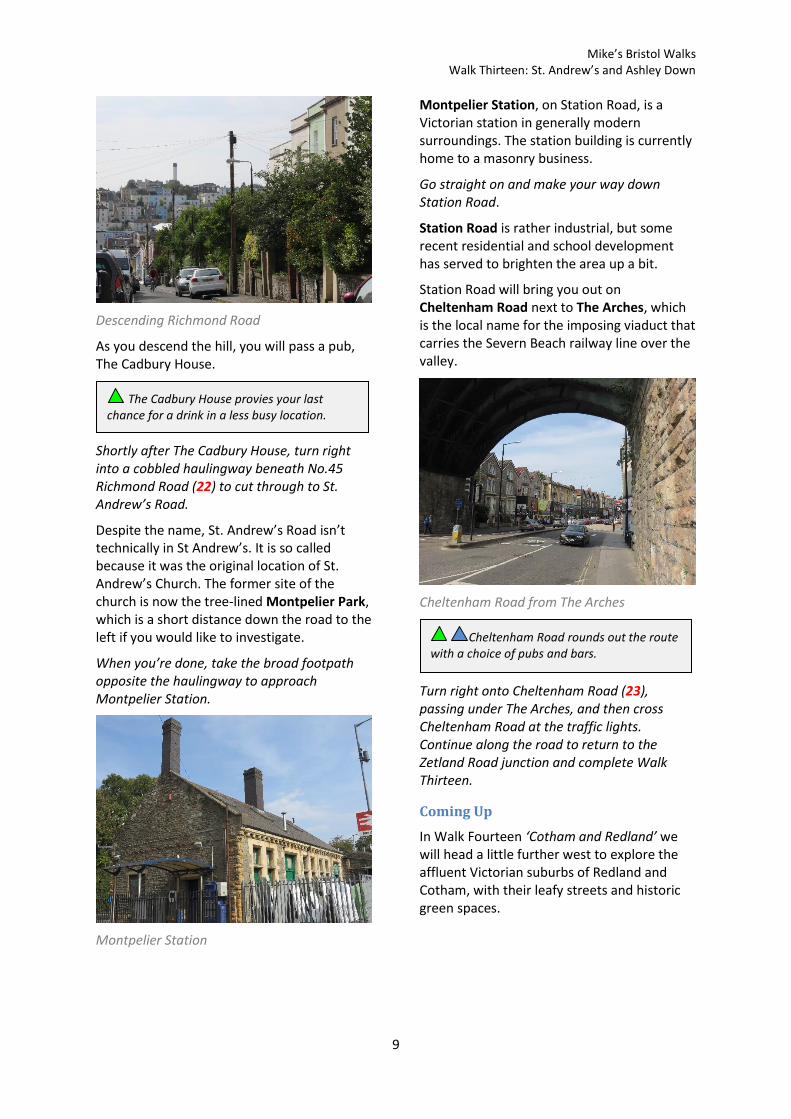
When you reach a point where Cobourg Road starts to drop downhill, turn right onto Richmond Road (21).
Richmond Road is a T-shaped street with three ends. This part, the shorter section, climbs steeply past side streets lined with Georgian and Victorian villas.
Take the second left, onto the long section of Richmond Road.
This section of Richmond Road has a high concentration of historic buildings, many of them individual in design. The colourful Georgian houses on the right have pleasant front gardens to take advantage of the southerly aspect.
Georgian houses at Richmond Road
At length the road begins to slope down the hill, and you will get an impressive view of the Cotham hillside on the far side of the valley (see Walk Fourteen ‘Cotham and Redland’).
Mike’s Bristol Walks Walk Thirteen: St. Andrew’s and Ashley Down
9
Descending Richmond Road
As you descend the hill, you will pass a pub, The Cadbury House.
Shortly after The Cadbury House, turn right into a cobbled haulingway beneath No.45 Richmond Road (22) to cut through to St. Andrew’s Road.
Despite the name, St. Andrew’s Road isn’t technically in St Andrew’s. It is so called because it was the original location of St. Andrew’s Church. The former site of the church is now the tree-lined Montpelier Park, which is a short distance down the road to the left if you would like to investigate.
When you’re done, take the broad footpath opposite the haulingway to approach Montpelier Station.
Montpelier Station
Montpelier Station, on Station Road, is a Victorian station in generally modern surroundings. The station building is currently home to a masonry business.
Go straight on and make your way down Station Road.
Station Road is rather industrial, but some recent residential and school development has served to brighten the area up a bit.
Station Road will bring you out on Cheltenham Road next to The Arches, which is the local name for the imposing viaduct that carries the Severn Beach railway line over the valley.
Cheltenham Road from The Arches
Turn right onto Cheltenham Road (23), passing under The Arches, and then cross Cheltenham Road at the traffic lights. Continue along the road to return to the Zetland Road junction and complete Walk Thirteen.
Coming Up
In Walk Fourteen ‘Cotham and Redland’ we will head a little further west to explore the affluent Victorian suburbs of Redland and Cotham, with their leafy streets and historic green spaces.
Cheltenham Road rounds out the route with a choice of pubs and bars.
The Cadbury House provies your last chance for a drink in a less busy location.

Mike’s Bristol Walks Walk Thirteen: St. Andrew’s and Ashley Down
10
Walk Thirteen: Map
Mike’s Bristol Walks Walk Thirteen: St. Andrew’s and Ashley Down
11
Mike’s Bristol Walks Walk Thirteen: St. Andrew’s and Ashley Down
12