volcano heights sector development plan • iiineighborhoodplanning.org/pdf/vhsdp part5.pdf ·...
TRANSCRIPT

IIILand Use
1. INTENT
Mixed-Use Districts. The Volcano Heights Plan locates mosthomes and jobs within walking distance of retail, commercialand community services. Within a comfortable walking dis-tance, village and town centers are surrounded by residential andoffice uses at urban intensities. While complementary urbanuses are critical to encourage walking for many trips, it is alsocritical to make comfortable and inviting walking environmentsas described in the Urban Design Element.
Diagram 8, Mixing Retail, Housing, and Employment showsways to organize a mix of retail, housing, and employment toachieve diversity and balance in a town center.
Residential Diversity. The Volcano Heights Area Plan encour-ages a range of housing opportunities for various ages andincomes. Apartments, townhouses and small-lot single-familywill occur within and immediately adjacent to Village Centersand the Town Center. Single-family homes on larger lots are per-mitted farther from Village and Town Centers, where greaterreliance on the car is expected. Along the western edge ofVolcano Heights, rural lots will be maintained and create a natural edge to the publicopen space.
Neighborhood and Regional Retail Centers. Convenience stores and other neighbor-hood retail, like a grocery store, drugstore and hardware store, will be located withinVillage Centers, although not every Village Center may have all of these uses.Commercial and entertainment uses, such as department stores, bookstores, cinemas,restaurants, office buildings, and business services (uses that serve a broader area) will beconcentrated within the Town Center. Locations where retail is permitted are limited toensure that retail convenience is attained for these Village and Town Centers. Someentertainment and retail uses arereserved solely for the TownCenter to assure the creation of adowntown-like environment thatcan support transit and attractoffice campuses to Albuquerque’sWest Side. To make more livableand transit-supportive centers,retail destinations must be pairedwith housing, employment, andpedestrian-supportive design.
Volcano Heights Sector Development Plan • 65
Mixed Use Town Center
Diagram 8Mixing retail, housing,and employment
StableUnderutilized + Vacant Land
RetailAmenity + Parking Housing + Employment Diversity + Balance

Westside Employment Center. Office areas are designated to attain a better balance ofjobs and housing on the Westside. While office uses have not been built alongAlbuquerque’s western edge, a sufficient level of developer interest is expected becauseof the Town Center’s superior regional access (Bus Rapid Transit and arterial boule-vards), and because of exceptional urban amenities, recreational features, and housingopportunities in the area.
2. LAND USE PLAN
Exhibit 25, Land Use Plan establishes a framework for future growth that encourageswalkable, transit-supportive districts, while also maintaining many of the Plan Area’sscenic qualities and conserving the Area’s unique ecological and archeological assets.The Land Use Plan plays a vital role in realizing the broad vision for the VolcanoHeights summarized in the Fundamental Goals.
SU-2 zoning is established for each land use category. Portions ofdevelopments that had received preliminary plat approval at theplan’s inception received final plat approval during the planningprocess. These areas (SAD 227, portions of Longford and VistaVieja) retain their existing zoning at the time of platting.
A general description of each land use designation is provided here.Specific requirements are contained in the standards that follow.
Town Center. The Town Center will create a major urban center thatwill bring employment, comparison shopping, and entertainment tothe West Side. Housing, civic facilities (like a library), and attractivestreets and plazas will provide lifestyle options especially well suited to“empty nesters” and young professionals. Access to both Unser andPaseo del Norte will help attract a range of retail and entertainmentuses, while future Bus Rapid Transit service will support the higheremployment and housing intensities anticipated.
Office. Office campuses will bring new job opportunities to theWest Side. Because many workers will travel in a “reverse commutedirection,” office development in Volcano Heights will reduce projected congestion onbridges crossing the Rio Grande. Paseo del Norte offers a visible address.
Village Centers. Village Centers will put local retail, conveniences, schools and a “senseof place” within walking distance of most homes. Besides shops, each Village Center willinclude housing, a small park, and civic uses, such as day care and community facilities.
Neighborhood Mixed-Use. Mixed-use areas at the neighborhood scale extend a senseof neighborhood center to locations that may not be able to support major retail, butmight support small offices, shops, community facilities, or townhouses with ground-floor home occupations including office, retail, and service activities.
Urban Residential. A variety of urban housing types are permitted within a networkof livable, pedestrian-friendly streets, including: courtyard housing, loft apartments,patio homes, townhouses, duplexes and detached single-family homes on small lots.
Suburban Residential–Small Lot. Typical modern suburban lot sizes but with rearaccess alleys, houses moved up to the sidewalk, and front porches and other features tocreate a more pedestrian-friendly environment.
Volcano Heights Sector Development Plan • 66
Land Use
Mixed-Use Village Center

Volcano Heights Sector Development Plan • 67
Land Use
Exh
ibit
25

Volcano Heights Sector Development Plan • 68
Land Use
Suburban Residential–Large Lot. Homes on larger lots (+11,000 sq. ft.), respecting theexisting Volcano Cliffs residential platting, built in a way that protects the natural envi-ronment, preserves signficant view corridors, and contains visible private open space.
Executive Residential. Bigger homes on larger lots will be provided as an amenity tohelp recruit skilled professionals to Volcano Heights, which will encourage employers tolocate to the Town Center and the greater West Side. Clustered housing is encouragedto conserve the area’s natural terrain and beauty.
Rural Residential. Rural uses and open space will form a backdrop to Volcano Heights,where limited urban services also suggest very large lots, when consistent with currentplatting.
Schools and Parks. Park and school locations are recommended in anticipation of theArea’s population. Elementary schools will share facilities with parks, and in order toencourage walking, will be located adjacent to the Village Centers, trail systems or openspace.
Open Space / Buffer. Land will be set aside to protect arroyos and sensitive lands abut-ting Petroglyph National Monument. These open spaces will include hiking trails, andwill help conserve important ecological and archeological features.
3. REQUIRED USES IN MIXED-USE AREAS
To function well, mixed-use centers need to offer walk-to destinations including civic,retail and entertainment—along centrally-located housing; in the Town Center officeuses help meet regional employment and transportation goals. While the extent ofmajor retail will be determined by market forces, walk-to commercial should accompa-ny all mixed-use centers, as provided in the minimum use requirements in Table 4,Required Uses in Mixed-use Areas. Note that the mixed-use designations provide mar-ketplace flexibility.

4. DEVELOPMENT DENSITIES AND INTENSITIES
Minimum densities and intensities are needed to support transit and to provide marketsupport for local retail and conveniences; maximum densities and intensities are neededto maintain an appropriate scale for development and to assure that roadways and otherinfrastructure have adequate capacity. Note that 3.0 FAR will be difficult to attainunless parking is provided off-site or in structures.
“Average densities” are used to encourage higher density near centers and lower densityaway from centers, while permitting a range of housing types and lots sizes; doing sobroadens housing options, adds visual variety, and allows responsive site plans that con-centrate housing near local destinations and locate urban activity away from ecologicaland archeological assets.
The average residential density is calculated for each site plan for two or more parcelsand the average calculated must fall within the range of “Minimum Average” and“Maximum Average” contained in the Residential Densities table above. For an indi-vidual parcel (or a lot without subdivision) the Minimum Average is the Minimum den-sity and the Maximum Average is the Maximum density allowed.
Within the range of residential and non-residential densities provided as indicated inTable 5, Development Densities and Intensities and Table 6, Residential Densities,the lower densities of the range and less intense uses shall border the open space.
Volcano Heights Sector Development Plan • 69
Land Use

Average Density–Urban Residential (Diagram 9)
Standards for average densities permit a greater variety of housing types, ashas been depicted for Urban Residential areas. Minimum average densitieshelp ensure that the overall amount of development will support retail con-veniences and frequent transit service. Maximum average densities assurethat development will not exceed the capacity of planned infrastructure.Standards for average density also encourage housing diversity in SuburbanResidential areas, because a range of single-family lot sizes are permitted.
Volcano Heights Sector Development Plan • 70
Land Use
Diagram 9
Diagram 10
Intensifying Platted Lots (Diagram 10)
Permitted average densities sometimes exceed the density of previously platted areas.While intensification is not required, it can occur in a variety of ways: by splitting lots,by adding accessory units, and by combining lots so that higher density housing typescan be accommodated.
Open Space Requirements for Urbanand Mixed-Use Residential (Table 7)
Requirements are placed on higher density resi-dential development to provide both private andshared open space. Shared open spaces are impor-tant in urban settings to expand opportunities forpassive recreation, to bring people together and tohelp create a sense of community. Courtyards andplazas are especially encouraged to create a south-western character, and roof gardens can takeadvantage of the outstanding views and naturalsetting.

5. ACCEPTABLE RESIDENTIAL BUILDING TYPES
The following table describes which residential building types are acceptable within eachland use designation. The illustrations on Exhibit 26, Illustrations of Higher DensityBuilding Types and Exhibit 27, Illustrations of Lower Density Bulding Types are notmeant to be an exhaustive list but rather to help clarify what is meant by the type cate-gories below.
Volcano Heights Sector Development Plan • 71
Land Use

Volcano Heights Sector Development Plan • 72
Land Use
Exhibit 26
Illustrations of Higher Density Residential Building Types

Volcano Heights Sector Development Plan • 73
Land Use
Exhibit 27
Lower Density Residential Building TypesIllustrations of Lower Density Residential Building Types

The following table describes which non-residential building types are acceptable with-in each land use designation; these building types are derived from standards describedin “IV. Urban Design”; see illustrations provided on the following page.
To the right is an illustration of a building that provides two stories of living spaceabove work or retail space. Other illustrations of non-residential or mixed-usebuildings are found on the following page. Civic buildings tend to be “object”rather than “fabric” buildings.
Volcano Heights Sector Development Plan • 74
Land Use
Figure 3Live-Work Unit

Volcano Heights Sector Development Plan • 75
Land Use
Exhibit 28
Illustrations of Non-Residential Building Types
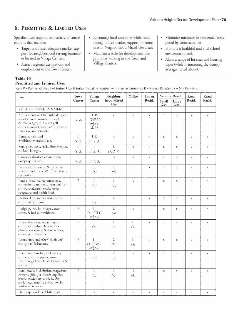
Specified uses respond to a variety of consid-erations that include:
• Target and foster adequate market sup-port for neighborhood serving business-es located in Village Centers;
• Attract regional destinations andemployment to the Town Center;
• Encourage local amenities while recog-nizing limited market support for someuses in Neighborhood Mixed Use areas;
• Maintain a scale for development thatpromotes walking in the Town andVillage Centers;
• Minimize nuisances in residential areasposed by some activities;
• Promote a healthful and vital schoolenvironment; and,
• Allow a range of lot sizes and housingtypes (while maintaining the densityaverages noted above).
6. PERMITTED & LIMITED USES
Volcano Heights Sector Development Plan • 76

Volcano Heights Sector Development Plan • 77
Land Use

7. RURAL RESIDENTIAL—PRIVATE COMMONS DEVELOPMENT
A “Private Commons Development (PCD)” is a permitted use in the SU-2 RuralResidential Zone in order to achieve a greater amount of private open space, privatecommons, clustering of homes, and smaller Building Envelopes.
A Private Commons Development may be established on a lot 4 acres or more in sizewithin the Rural Residential Zone. The use is limited to single family residential withno accessory unit. The Public Trail / Linear Park Dedication shall be 3%. The privateopen space in the Conservation Easement shall be 65% of parcel size after the Trail /Linear Park Dedication. The Minimum Lot Size / Development Envelope shall be nolarger than 15,000 sq. ft. and no smaller than 14,000 sq. ft. with 50% maximum imper-meable surface.
Building Envelopes shall be clustered on two sides if possible. The area outside theDevelopment Envelopes is the Conservation Easement, as provided in “6. ConservationDevelopment and Development Envelopes” in “IV Urban Design” section, and shall bea private commons and shall not be fenced internally except at the periphery of the par-cel. The maximum building heights, setbacks, architectural design standards, placementof mechanical units, grading and drainage plan, landscape design standards, parking,lighting, design of walls and fences, and other design standards shall be as provided forthe Rural Residential Zone in this Sector Plan.
A PCD is created through a Site Development Plan utilizing the approval process pro-vided in Section 14-16-2-22 ROA 1994 SU-1 Special Use Zone and specifically forPlanned Residential Development (PRD).
Volcano Heights Sector Development Plan • 78
Land Use

Volcano Heights Sector Development Plan • 79
Land Use
8. UTILITY EASEMENTS AND FACILITIES
The adopted Rank II Facility Plan Electric Service Transmission and SubtransmissionFacilities 1995-2005 (as amended 2000) sets standards for locations and design of elec-tric facilities. These standards are referenced for location of future electric facilities(EFP).
In Suburban Residential–Large Lot, Rural Residential and Executive Residential zones,10 foot utility easements for electric, gas, telephone and cable shall be dedicated instreet-facing setbacks behind the curb on private property. In other zones, 10 foot util-ity easements shall be dedicated in alleys. Easements in parkways and open space areaswill be used where practical and street easements will be used when the above referencedcorridors are not feasible or practical.
Exhibit 2, Built or Approved Projects and Exhibit 25, Land Use Plan show the loca-tions of utility easements in the Plan Area. PNM has a 115kV electric transmission linealong Universe Blvd and plans a new substation on the west side of Universe adjacent tothe Vista Vieja subdivision to support growth in the area through electric feeder linesfrom the substation. The existing 115kV major transmission line on Universe can servefuture development within an approximately three-mile radius with additional substa-tions.
9. AREAS PREVIOUSLY OMITTED FROM THE VOLCANOHEIGHTS DEVELOPMENT MORATORIUM
These are the locations as identified in Bill No. R-06-44, Enactment No. R-2006-025where development approvals had been received and relied upon to such an extent thatthe Planning Director determines that a right has been created to a particular develop-ment element.
In specific instances below, the regulatory provisions of this subsection shall apply tothese areas that have not received Final Plat approval by the City of Albuquerque. Areasthat have received Final Plat approval are exempt from the Volcano Heights SectorDevelopment Plan.
A. La Cuentista. For the portions of La Cuentista outside of the area with Final PlatApproval, the owners / developers have agreed to accept the zoning contained in theVolcano Heights Sector Development Plan.
B. Vista Vieja—Tracts with Approved Preliminary Plats.
Given the advanced states of projects with approved preliminary plats, only the require-ments of this subsection affect the Vista Vieja subdivision. No other portions of theVolcano Heights Sector Development Plan can be imposed on the property owners of theseparcels.
• In Phase 3 of the Vista Vieja subdivision, all 45 foot frontage lots shall haveno front garages.
• In Phase 3, no less than 10% of the 50 foot and 60 foot frontage lots shallhave a maximum of one car garage visible on front façade.

Volcano Heights Sector Development Plan • 80
Land Use
• Within Vista Vieja Phases 1-3, on the 50 foot and 60 foot frontage lots, thereshall be no required sideyard setback for any side-facing garage.
• In Phase 4, on the 70 foot lots, a minimum of 80% of the lots shall have nomore than 2 car garages visible from the street.
• In Phases 3 & 4, the Planning Director shall review the wall and landscapingtreatment of the north and west edges of the Vista Vieja subdivision for con-formance with the approved Vista Vieja Preliminary Plat (wall) and SiteDevelopment Plan for Subdivision (Conceptual Landscape Plan) as approvedby the Development Review Board. Additionally, in Phases 3 & 4, the exte-rior wall of the subdivision shall be the approved style with wrought ironpanels as indicated on the approved Vista Vieja Preliminary Plat. There shallbe at least one pedestrian / bicycle gate on each of the north and west edgesubdivision perimeter walls which would provide for connection to the openspace, bicycle trails, and multi-use trails systems proposed in the VolcanoHeights Plan, which access points either are indicated or will be indicated onthe approved Vista Vieja Site Development Plan for Subdivision.
C. The Trails.
The following Volcano Heights Sector Development Plan regulations shall apply to allTracts within the Trails properties.
• The design provisions of the Volcano Heights Sector Development Plan ascontained in the “Grading” subsection of “4. Landscape Design Standards”of section “V. Architectural and Landscape Design” of the Plan shall applyexcept in situations where the City Engineer and the City Planning Directordetermine that infrastructure properly approved by the City (design and con-struction) make the design provisions contained in the “Grading” subsectionimpractical. In these situations, the City Engineer and Planning Directorshall negotiate with agents of The Trails to achieve the intent of the VolcanoHeights Plan to the extent practical. This approach applies to only someparts of Units 3 and 4 that are materially impacted by drainage improve-ments such that they only can be changed at great cost. In Units 3 and 4,waivers from the “Grading” subsection requirements should be provided onlyin a limited way. Where the natural vegetation has been disturbed in thedevelopment process, property must be revegetated according to the designstandards in the Plan. Areas within Conservation Easements must be reveg-etated with plants contained in “Native Plant List A”.
• Unit 3-Tract 2 shall be zoned Village Center.
• Unit 2-Tract 3 shall be zoned Neighborhood Mixed Use.
• Unit 2-Tract 2, Unit 2-Tract 5, Unit 3-Tract 4, Unit 3-Tract 1, and Unit 3-Tract 3 shall be zoned Urban Residential.
• Unit 2-Tract 1, Unit 2-Tract 7, Unit 2-Tract 10, Unit 2-Tract 9 (except forthe eastern 150’), Unit 3-Tract 3, Unit 3-Tract 6 shall be zoned SuburbanResidential–Small Lot.

Volcano Heights Sector Development Plan • 81
Land Use
• In all Suburban Residential–Small Lot zoned parcels in Units 1 and 2,garages may be either off alleys or accessed via a side drive where one of thegarage sides abuts the back yard setback or is attached to the back of thehouse. For Suburban Residential–Small Lot zoned parcels in Units 1 and 2,lots may have a zero foot (0’) side yard set-back on one side.
• Unit 2-Tract 4 shall be exempt from the Volcano Heights Sector DevelopmentPlan except that approximately every third house shall be access via a sidedrive where one of the garage sides abuts the back yard setback or is attachedto the back of the house.
• A 30 foot dedicated and landscaped trail and open space area, measured fromthe curb, shall be provided along the west side of Universe within Unit 2-Tract 5. Unit 2-Tract 7, and Unit 2-Tract 8.
• Unit 2-Tract 9 shall be zoned Suburban Residential–Small Lot. The backs ofthe parcels facing the High School site shall use the perimeter wall designapproved by the City.
• Unit 2-Tract 8, shall be zoned Suburban Residential–Large Lot. The backsof houses shall not face the City Open Space to the immediate south asshown in the Sector Plan. In addition, on lots to the north of the City OpenSpace, walls facing the open space shall be view walls.
• Unit 2-Tract 11, Unit 3-Tract 7, and Unit 3-Tract 8 shall be zoned SuburbanResidential–Large Lot.
• The OS-4 park in the open space area may be amended so as to accommo-date a 3 acre park area without decreasing the amount of open space dedicat-ed.
• Street C, now on the south boundary of Unit 2-Tract 11, shall be moved tothe proposed City Open Space area and connect from Rainbow to the mid-dle school site. Street C shall be removed to the west of this point.
• The ultimate location of Street D may be changed based on the size and loca-tion of park / school site in Unit 2-Tract 12 and Unit 3-Tract 6.
• A new street connection shall be shown from Woodmont to the NorthGeologic Window adjacent to the open space shown in the land use plan.

10. ILLUSTRATIVE PLANS FOR ACTIVITY CENTERS
Illustrative PlansIllustrative Plans depict ways that mixed-use Town Center and Village Centers can becreated by taking advantage of specific conditions and features unique to each setting.They explore important design relationships for each of the major mixed-use centerswithin the Plan Area. Important considerations include:
• allowable arterial intersection spacing;
• available existing street rights-of-way;
• street and trail network connectivity standards;
• permitted land uses;
• property ownership patterns;
• open space dedication and acquisition priorities;
• potential retail access and visibility;
• Bus Rapid Transit routing and station spacing;
• taking advantage of view-lines to the volcanoes and Sandia Mountains; and
• using buildings to frame streets and open spaces to encourage urban vitalityand a sense of place.
Urban Form DiagramsEssential urban form attributes are depicted in the Illustrative Plans for each Center.
Street Network. Each Diagram shows a network of major streets, which will distributetraffic adequately. Each Diagram recognizes arterial intersection spacing needs and takesadvantage of existing rights-of-way where available. Street alignments may be altered,but must conform to network and block size standards in “II. Transportation”.
Required Storefronts. The Diagram also shows locations where buildings must be builtwithin 5 feet of the public sidewalk, and where storefronts are strongly encouraged.Defined in “IV. Urban Design”, storefronts include retail shops as well as other activeground-floor uses. The “Build-to” locations offer good access and visibility from majorroads—a prerequisite for most retail.
Village Greens & Town Squares. Small urban parks should be created near the centerof Villages and the Town Center. The Diagrams suggest the location of small urbanparks. These locations acknowledge likely street alignments. Land dedication require-ments as part of Special Assessment Districts (SAD), Public Improvement Districts(PID), Tax Increment for Development Districts (TIDD), or other vehicles are pre-sumed to implement greens and squares. Plazas and Parks under 2 acres are to be main-tained privately or through TIDD resources, unless otherwise established.
Architectural Focal Points. Building height should be increased at important arrivalpoints and at the end of prominent views. Open space and generous setbacks should beavoided where architectural focal points are called for. Building designers should givespecial attention to the place-making potential of these locations.
Volcano Heights Sector Development Plan • 82
Land Use

Town CenterThe intersection of Paseo del Norte (PdN) and Unser will bring together two of theregion’s most-traveled roadways. The Town Center takes advantage of this exceptionalaccess to bring a new regional center to the West Side, which offers a unique mix ofregional retail, entertainment, employment, cultural facilities, and housing. The eastern“corner” of the Paseo del Norte—Unser, where the Town Center is located, has the mostfavorable access (“right in” and “right out” in the PM commute direction), a less frag-mented ownership pattern, and exceptional views.
While the mixed-use Town Center designation offers flexibility, the Illustrative Planshows how smaller stores and retail anchors might be arranged around a town square.Importantly, two Bus Rapid Transit routes (running north-south on Unser and east-weston PdN) would converge at the heart of the Town Center and enliven the town square.As envisioned in the “Transportation” element, the Town Center’s transit station wouldoffer exceptional transit access and would provide the primary point of transfer betweenthe two BRT routes.
To help balance jobs and housing and reduce traffic congestion on the West Side, thePlan encourages employment within the Town Center and in Office areas along PdN.The Illustrative Plan shows office buildings facing streets with mid-block parking. Toestablish a major job center, office development must rely on multi-level parking garagesto meet minimum intensity requirements.
Buildings should face PdN to the extent possible. Access lanes with on-street parkingwill create a boulevard and a unique urban place near its intersection with Unser. Localstreets might also be used to accommodate street-facing office buildings farther east.
Housing is another important ingredient for making a vibrant Town Center with round-the-clock activity. A variety of housing types are illustrated, including larger apartment /condominium projects with mid-block courtyards that have parking below. Also shownare attached townhouses. East of the Town Center, single-family homes would be builtand could deliver up-scale housing for executives within walking distance of new corpo-rate offices. An elementary school will serve the area with educational and recreationalfacilities.
A linear park extends between housing (to the north) and employment (to the south).The park will offer passive recreation to the abutting neighborhoods, and BRT will runalong the linear park with a station that offers convenient transit access to many resi-dents and workers. Importantly, the linear park will maintain views of the SandiaMountains, which have scenic and cultural importance. Trails and a new park near PdNwill provide public access and avoid the visual intrusion of development along the edgeof PNM. A small resort is permitted where the linear park meets the Monument, andshould possess exceptionally high design quality because of its visual prominence. Landmay be acquired through one or more of the following mechanisms: private owner con-tributions, as part of Special Assessment Districts (SAD), Public Improvement Districts(PID), Tax Increment for Development Districts (TIDD), the City’s Capital program,Federal and State grants, or other vehicles.
Volcano Heights Sector Development Plan • 83
Land Use

Volcano Heights Sector Development Plan • 84
Land Use
Illustrative PlanTown Center
Illustrative Plan

Volcano Cliffs Village CenterIn the Volcano Cliffs area, a mixed-use main street is called for along Rosa Parks (for-merly Squaw Road) because of this street’s direct access to Unser Parkway and UniverseRoad, and because a larger parcel just south of Rosa Parks can offer larger anchor retailto support the small shops along Rosa Parks. A village green is shown on the larger par-cel. At the main street’s western edge, a recreation center associated with the high schooland community uses associated with an elementary school will also provide anchorstores. Bus Rapid Transit willhelp anchor uses at the mainstreet’s eastern end.
It is expected that propertyowners will assemble somesmaller parcels along RosaParks’ Main Street andthroughout the Volcano Cliffsarea, where higher-densityhousing like townhouses andapartments can be built. Asthe extent of lot assemblagecannot be predicted, theIllustrative Plan also showsareas where the existing lotpattern is retained—but withlot “splits” where two homesare built on the existing one-third acre lots.
Kimmick is expected to have alimited “right-in / right-out”intersection with Unser. Apedestrian overpass is pro-posed at this intersection toprovide reasonably directaccess to retail in the VillageCenter. Residents east of Unsermight also be served by a smallconvenience store or caféwhere Rainbow meets theMonument. Services in thisexceptional location mightalso serve visitors attracted byviews and trails, and a smallbed & breakfast might also bepossible.
Volcano Heights Sector Development Plan • 85
Land Use
Illustrative PlanVolcano Cliffs Village Center
Illustrative Plan

Volcano Heights Sector Development Plan • 86
Land Use
Universe Village CenterThe corner of PdN and Universe may support neighborhood retail. While anchor retail,like a grocery store, might face a parking lot, small shops should face the street and aproposed village green. Anchor retail might also be placed at the eastern end of the vil-lage green, which has a “Town Center” designation and a high-intensity mixed-usebuilding is permitted. Farther east, high-intensity office development is shown, withexceptional visibility from PdN. High-density housing, like townhouses and apart-ments, are encouraged within walking distance of retail and the village green. “Live-work” housing with at-home businesses are encouraged where housing faces the villagegreen or office uses. An ideal Bus Rapid Transit station location is shown near retail usesand the center of Universe Village.
Illustrative PlanUniverse Village
Illustrative Plan

Rainbow Village CenterRainbow Village will bring retail and civic uses to the southwestern portion of the AreaPlan. The future alignment of Rainbow will bring drive-by traffic volumes necessary tosupport neighborhood retail. While a retail anchor, like a grocery, may face parking,retail shops should face streets. Retail frontage along Rainbow is especially advantages.Rainbow is slated to have six travel lanes. Pedestrians will be able to cross Rainbow moreeasily if a narrow linear park is used in lieu of a median. The park might contain urbanfeatures and amenities that support street-facing retail. Street-facing retail also relies onon-street parking. High-density housing, like townhouses and apartments, are encour-aged within walking distance of retail and the village green.
Volcano Heights Sector Development Plan • 87
Land Use
Illustrative PlanRainbow Village
Illustrative Plan