v. new york state geology and its relationship to oil. gas …
TRANSCRIPT
V. NEW YORK STATE GEOLOGY AND ITS RELATIONSHIP TO OIL. GAS AND SALT PRODUCTION
A. GEOLOGIC PROVINCES IN NEW YORK STATE
1. Adirondacks and Hudson Highlands: Igneous and Metamorphic
Terrains
Geologic time is hard for most people to comprehend, and the pro-
found changes which have occurred in the earth's landscape are hard to
imagine. The rocks of New York State were formed over a period which extends
over billions of years. The Adirondack Mountains were formed during a
mountain-building event more than 1,000,000,000 years ago, while some deposits
in western New York were left in the wake of melting glacial ice less than
10,000 years ago. The environments in which these rocks formed, and the
geologic conditions which existed at the time they were deposited, determine if
they will contain significant amounts of oil, gas, or salt.
The oldest rocks within New York State formed during the Precambrian Era,
a period of time extending from 4 112 billion years ago to about 600 million
years ago. Because of their great age, the Precambrian rocks seen today are
only the eroded roots of ancient mountain chains, and form the basement upon
which younger sediments were deposited. The Adirondack Mountains and the
Hudson Highlands are exposed Precambrian basement forming southern extensions
of the Grenville Province of Canada.
Since their formation, Precambrian rocks have undergone extensive change,
or metamorphism, as they were buried at great depths, and subjected to intense
pressures and elevated temperatures for long periods of time. From their
origins as volcanic lavas, intrusions of molten or igneous rock, and
sedimentary limestones and sandstones, these rocks have been changed by
metamorphic processes which altered their chemical compositions and physical
structures, and obliterated many of the clues to their beginnings.
Metamorphosed igneous rocks have been converted to amphibolite, the most
widespread type of rock within the Adirondacks. Metamorphosed sedimentary
rocks are extensively exposed in the Northwest Lowlands of the Adirondacks
where they compose 80 percent of the bedrock, and along the eastern margin of
the Hudson Highlands (Broughton, and others, 1976). Anorthosite, a compara-
tively rare type of rock consisting mostly of plagioclase feldspar, is found
in few places on the earth's surface. Anorthosite underlies the Adirondacks'
High Peaks region and its excellent exposure at Whiteface Mountain gives that
locality its name.
The ohysical and chemical changes these ancient rocks have undergone have
"cooked out" any oil or gas they once contained, unlike the younger, less
deformed sedimentary rocks of western and central New York. Along a narrow
zone in the eastern part of the state and beneath the Hudson Highlands,
however, thin slices of metamorphic and igneous rocks have been thrust over
the underlying sedimentary rocks. Recent improvements in geophysical
techniques allow us to see beneath the severed slices and recognize that
younger rocks lie beneath. The potential oil and gas reserves in these over-
thrust areas are still largely unexplored, and are discussed in more detail in
Section 5.E.
2. Western and Central New York: Paleozoic Sedimentary Rocks
Although some evidence of early life is found in rocks more than three
billion years old, living organisms became abundant and widespread about 600
million years ago. The time corresponding to the boundary between rocks
containing few fossils and those with abundant fossils marks the beginning of
the Paleozoic Era. The sea inundated the land many times during the Paleozoic
Era, creating ideal conditions for preserving large numbers of marine fossils.
The Paleozoic depositional record within New York State is nearly continuous.
A period of uplift and erosion occurred during the Middle Cambrian, about 550
million years ago, and several mountain-building events occurred during the
Middle and Upper Paleozoic Era.
The Paleozoic rocks of central and western New York State, with their
abundance of living organisms, are ideal source rocks for the formation of oil
and gas.
B. GEOLOGIC FACTORS WHICH DETERMINE THE EXISTENCE OF OIL, GAS, AND SALT IN
SEDIMENTARY ROCKS
Small quantities of hydrocarbons exist in all living things, from the
simplest algae to the most complex organisms on earth. When organic debris is
incorporated in muddy sediment and deposited in oceanic basins, oxygen is
quickly depleted from the stagnant water. Normal processes of decay cease
under these hostile conditions, and anaerobic bacteria begin to transform the
large, complex organic molecules into fatty and waxy substances and other
simpler compounds. As sediment is buried deeper, temperature and pressure
increase, and organic decomposition continues. Over geologic time, bacterial
activity may create a large range of gaseous, liquid, and solid organic
compounds. Petroleum is the general name given to this complex mixture of
hydrocarbons.
Under favorable conditions, large quantities of organic matter buried
with sediment are transformed by slow chemical reactions into liquid and
gaseous hydrocarbons. Although this process occurs more rapidly at elevated
temperatures, too much heat destroys the organic precursors of petroleum so
that only a thin carbon film remains. Over millions of years, fluids are
squeezed out of muddy sediments by compaction, and migrate upward to fill the
pore spaces or fractures of adjacent permeable beds. Limestones, dolostones,
and sandstones commonly contain void spaces and these voids may become filled
with migrating hydrocarbons and water. The low density of the migrating
fluids causes them to rise to the highest possible level. If a porous bed
crops out at the surface these ascending fluids may form an oil or gas seep.
Several other conditions must exist before an accumulation of
hydrocarbons becomes large enough to be of commercial interest. If an
impermeable barrier such as a shale or siltstone layer lies above the
reservoir rocks, large volumes of hydrocarbons may accumulate in a structure
called a trap. Typically, faulting or folding will deform permeable beds to
create structural traps. The crests of anticlines or domes will create
structural traps if the proper sequence of source beds, permeable rocks and
impermeable layers are found there. If structural deformation is too intense,
however, the fractures may act as conduits, allowing the hydrocarbons to leak
out. Stratigraphic traps may be produced by the conditions which existed at
the time the sediments were deposited. If a porous sand pinches out in an
updip direction, or a beach sand grades into a silty shale in the offshore
direction, a stratigraphic trap may be formed. In addition, regional
deformation must not be so intense or the rocks heated so strongly that only a
carbon-bearing residue remains within the trap. The beds must remain buried
so that the hydrocarbons do not seep out, and the pore spaces of the reservoir
beds must not become clogged with late forming minerals.
If all these requirements are met, then hydrocarbons migrating from
source beds may accumulate in porous reservoir rocks. Because hydrocarbons
are less dense than water, they migrate upwards and float on top of the water
within the pores of the rock matrix. As they collect within the trap, hydro-
carbon species of different densities will separate into layers. Gas, being
least dense, will collect in a zone nearest the surface above the oil, and
water will saturate the zone below the oil at the base of the trap.
Geologists have discovered thousands of traps, but not all of these
contain producible quantities of oil or gas. New York ranks 21st of 32 states

which produce commercially marketable gas, and 27th of the 31 oil producing
states (Independent Petroleum Association of America, 1986-1987). The
structural and stratigraphic traps in New York's rocks have yielded
hydrocarbons for more than 150 years at numerous locations throughout the
state.
1. Factors Which Affect Producibility
If all the requirements discussed previously are met, the reservoir may
still not be of commercial interest. Several other factors will determine the
likelihood that a particular reservoir will be commercially developed.
To evaluate a prospective oil or gas well, an engineer or geologist must
first determine the porosity, the fluid and gas saturation of the interstitial
spaces, and the permeability. Porosity is the total voluae of void space
within a unit volume of rock, expressed as a percentage. For instance, if
perfect spheres are packed in a cubic arrangement, over 47 percent of the bulk
volume is empty pore space. Compared to this theoretical maximum value, real
oil and gas reservoirs have porosity values ranging from 3 to 35 percent.
Clay particles or minerals which later form within the pore spaces after the
rock is deposited, will reduce the initial porosity.
Permeability is a measurement of how "interconnected" the pore spaces
are, and is expressed in units called darcies or millidarcies. A darcy is
defined as the rate of flow in milliliters per second of a homogeneous fluid
with a viscosity of one centipoise which passes through a porous medium of one
square centimeter in cross section under a pressure differential of one
atmosphere per centimeter of length. The permeability of a reservoir controls
the rate at which fluids and gases can move through the interconnected pore
spaces and thus, the quantity which can be recovered through a well. Some
rocks, like shales, have very high porosities, but their low permeabilities
make them poor oil and gas producers. Rocks with very low permeabilities are
known as tight formations.
The pore spaces of all sedimentary rocks contain some water which has
remained since the time of deposition. Some connate water forms a thin film
around the individual mineral grains, and typically occupies about 20 percent
of the pore space. Because of the surface tension between the water and the
mineral grains, the water is more immobile, and the rock is considered to be
11 water-wet." Some rocks are oil-wet but these are more rare. If a well is
drilled into a water-wet rock which contains a sufficient volume of oil, the
more tightly held water will remain in the reservoir and the oil will flow
toward the wellbore. If the volume of water within the pore spaces is too
great, the droplets of oil are physically separated and cannot flow easily.
The relative saturation of both the wetting and nonwetting phases within the
pore spaces of the potential reservoir are very important in determining its
production potential.
The size, thickness, and lateral extent of the reservoir rock also
determine the commercial potential of a reservoir. An oil-bearing blanket
sandstone which is only 20 feet thick, but laterally continuous over several
square miles may be a better production target than a 100-foot thick sand bar
of limited areal extent. Within a specific area, the thickness of the
productive zone, or thickness of pay, may be less critical to the overall
producibility than the lateral extent of the reservoir.
2. Economic Factors Affecting Producibility
Oil and gas exploration and development programs are capital-intensive,
high risk ventures. Any risk analysis of drilling investments must consider
the uncertainty of discovery and the economics of recovery. Uncertain
economic trends in factors such as production allowables and fluctuations in
price have major effects on drilling activities. Currently, natural gas
production is restricted in New York State because of the recent
deliverability surplus. An additional 5-10 billion cubic feet of gas could
have been produced in 1986. Volumes of proven reserves of crude oil and
natural gas are increased only by exploration and drilling. These activities,
which account for a major share of all production expenses, suffer during
times of excessive supplies.
The market price is a critical factor influencing the supply of gas and
oil because it reflects the demand for the resource and provides an incentive
for exploring and developing marginal reserves. Oil and gas conservation
practices beginning in the 1970's decreased the rate of demand and still
affect the oil and gas market today. Low demand and high deliverability
surplus has adversely affected the market in recent years. Declining prices
of gas and oil, as much as 50 to 60 percent at the well head in 1986, have
triggered a decline in permit applications and drilling activity.
The increase in Canadian gas imports has exacerbated the gas
deliverability surplus and has also helped to keep prices down. Proposed
changes in the federal tax structure could further reduce or remove incentives
for national oil and natural gas exploration and production, and this will be
unfortunate if oil and gas production decreases as expected by the end of the
decade. The United States, and New York in particular, may again be importing
greater and ultimately more costly foreign supplies of oil and gas.
The National Gas Policy Act of 1978 (NGPA) established maximum sale
prices for one MCF of gas depending on the age of the well, the type of
formation into which it is drilled, and its location. Deregulation occurred
as of January 1. 1985 for onshore wells with NGPA section 102 determination
(new onshore or offshore wells, or wells in new onshore reservoirs). Those
wells producing from tight formations with the 107 determination (high cost
gas wells) may be deregulated if they also meet 102 qualifications. Members
of the gas industry, however, have set various agreements and restricting
conditions which cause variations in the price of gas, and under surplus
conditions, many gas producers have not obtained the higher prices expected by
deregulation.
New York State's crude oil is paraffin-based, and rates as premium
Pennsylvania-grade oil for motor oil use. Producers of Pennsylvania-grade oil
pay more attention to the lubricating oil market than to the market for fuels.
Although oil price increases of the last decade produced increased activity
levels, in 1983 Pennsylvania-grade oil sold for less than the black oils for
the first time (OGJ, January 10, 1983). The current worldwide surplus of oil
has caused prices in New York and northern Pennsylvania to drop 33 percent
from their peak.
The motor oil market has been affected by motor oil additives which
reduce consumption, and by automotive technology which increases the interval
of time between required oil changes. The demand for quality lubricating oil
remains high, however, and producers continue to look for ways to enhance
production.
The lives of depleted wells have been extended with advances in
technology. Improved methods of discovery and production of oil and gas have
made additional reserves available. The investment in equipment per unit of
production has increased because of inflation and deeper well depths, but the
cost of extraction depends on the type of recovery method used. Usually,
primary recovery using the natural reservoir energy has the lowest operating
costs and requires minimum maintenance. Adding extraction equipment such as
pumps cause the production expenses to increase. Secondary recovery which
requires fluid injection demands even higher operating costs. Although wells
in the Appalachian Basin produce less oil and gas than those in the southern
or western United States, they are less expensive to drill because they are
not nearly as deep and the formation pressures are lower. However, the oil
producing wells in the "Bass Island" area which still produce through primary
recovery, have high operating costs due to special maintenance problems such
as paraffin buildup and strict operating requirements imposed by the State.
Most operators worry about other economic factors which increase their
costs and decrease their profits. Environmental concerns have added
additional expenses for oil and gas operators as the State Environmental
Quality Review Act (SEQRA) requires that environmental factors be taken into
consideration. Since "Bass Island" regulations became effective on May 25.
1986, all wells operating in the "Bass Island" trend have strict reporting and
testing requirements to adhere to and allowable production limits are also set
to prevent waste and increase ultimate recovery within this complex structure.
Concern over the restoration of oil and gas drilling sites and plugging
of abandoned wells caused the Department of Environmental Conservation to
increase the financial security required from operators in January, 1985. In
addition, new cementing requirements and brine disposal restrictions have
increased drilling and production costs in New York State.
C. PRODUCING FORMATIONS
Many geologic formations have produced oil and gas within New York State,
some more abundantly than others. A stratigraphic chart for southwestern New
York State is shown in Figure 5.1. Only those formations which have yielded
oil or gas, or which may contain significant reserves will be discussed in
this section. This discussion will begin with the oldest rocks of the
Cambrian Period and continue to the youngest producing Devonian units.
1. Cambrian Period
The oldest rocks which have yielded small quantities of oil and gas in
New York State are Upper Cambrian sandstones and sandy dolomites. They formed
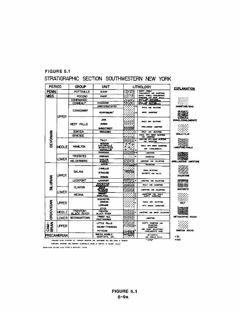
FIGURE 5.1
STRATIGRAPHIC SECTION S-TERN W YORK
FIGURE 5.1 5-9a
of places. The large salt water flows, which frequently occur when wells
penetrate these horizons, indicate that good porosity and permeability exist
within these rocks. Gas production from the Potsdam is also reported in some
early publications (Hartnagel, 1938, in Kreidler. 1953). Near Parish in
Oswego County a well drilled 2,140 feet into the Precambrian encountered gas
in the Potsdam with a measured pressure of 340 pounds per square inch (psi).
Another well drilled 3.580 feet to the Potsdam near Warners in Onondaga County
produced an initial flow of 100,000 cubic feet of gas per day (MCFId) and had
a pressure of 800 psi. In Clinton County, a well near Morrisonville reported
a show of oil in the Potsdam Sandstone.
Recent seismic work has indicated the possibility of deep structural
traps within the Theresa and Potsdam Formations. Robinson (1983) has
estimated gas reserves within the Theresa in Onondaga County based on his
analysis of log data from nearby Cayuga County. He believes that the Theresa
contains significant reserves of gas within the updip pinchout of the Theresa.
He places the downdip limit of the gas-oil contact south of Syracuse. Van
Tyne and Copley (1983) report that small commercial quantities of gas have
been produced from the Theresa at three places in western New York: in
northern Chautauqua County near Lake Erie, in the City of Buffalo, and in
northeastern Wyoming County.
Only recently has exploration begun to take place for the deeper
Cambrian-Ordovician strata. Of the few wells that have been drilled, 90
percent have been in shallow drilling areas of relatively low pressure and
high leakage where the Cambrian-Ordovician is exposed or is just below the
surface. Only the recent advent of seismic technology has allowed exploration
activity to begin for the deep structural traps that are potentially
productive from the Cambrian-Ordovician carbonates. Some geologists and
companies believe that the random drilling in the past has not adequately
accessed the hydrocarbon potential of the Cambro-Ordovician carbonates of the
New York Southern Tier (Patenaude. 1986, personal communication 152).
2. Ordovician Period
Overlying the Cambrian sandstones and dolostones in New York State is a
sequence of Ordovician deposits ranging up to 5,000 feet in thickness
(Broughton and others, 1976). The geographic extent of the Ordovician
limestones and dolostones is shown in the sketch map of bedrock in New York
State shown in Figure 5.2. These rocks were deposited between 430 and 500
million years ago, and record the change in environment from a warm, shallow
sea which existed at the beginning of the period, through the Taconic Orogeny,
a major mountain-building episode which reached a climax at the end of the
Ordovician.
The Beekmantown Group forms the lowest part of the sequence. Deposited
during the Lower Ordovician, these rocks are composed almost entirely of
limestone and contain no known oil or gas within New York State. Middle
Ordovician deposits include the Trenton and Black River Groups. Upper
Ordovician units are, in ascending order, the Utica Shale, the Lorraine
Formation, the Oswego Sandstone, and the Queenston Formation. The changing
composition or lithology of these Upper Ordovician deposits reflect the
increasing volumes of clastic sediment shed from the growing Taconic Mountains
in the east. Within the state, only the Trenton and Queenston Formations have
produced any significant quantities of gas.
The Trenton formed in a wide, shallow sea which occupied a linear seaway
along the eastern margin of North America. This seaway began to deepen in
Middle Ordovician time, restricting the zone of limestone deposition to the
western side of the basin. The Trenton is thickest along the axis of the
basin in central New York, and thins to the east, where it grades into sandy
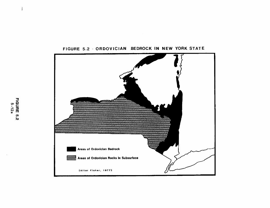
FIGURE 5.2 - ORDOVICIAN BEDROCK I N NEW YORK STATE
Areas of Ordovician Bedrock
Areas of Ordovician Rocks in Subsurface
silts and shales (the Austin Glen and Schenectady Formations), or black muds
(the Canajoharie and Utica Shales). Trenton Limestone probably covered the
peaks of the Adirondacks, and extended well north into Canada (Rickard, 1973).
To the west, it interfingers with the limestone and dolostone shelf deposits of
the Black River Formation.
The Trenton is typically a light gray or brown, finely crystalline,
fossiliferous limestone which attains a thickness of more than 800 feet in
central New York near Seneca County. The five members which colapose the
Trenton reflect its changing position from slope deposits with abundant clay
and sparse fossil faunas, to relatively pure nearshore limestones containing
cross-beds. horn corals, and trilobite fragments (Fisher. 1977).
The Taconic Orogeny began in Middle Ordovician time, as the proto-
Atlantic ocean began to close from Newfoundland to the Carolinas. As the
Taconic Mountains were formed in the east, a vast delta shed sediment into the
wide shallow sea to the west. At its maximum extent the Queenston delta
stretched well onto the midcontinent, and reached as far south as Virginia.
Four major environments of deposition migrated westward as the Taconic
highlands rose in the east: (1) deepwater gray muds with minor sand and silt
(Whetstone Gulf and Frankfort Formations); (2) marine fossiliferous silts
(Pulaski Formation); (3) sparsely fossiliferous white to tan quartz sandstones
(Oswego); and ( 4 ) nomarine, brackish, or continental red muds, silts and
sands (Queenston Formation). By the end of the Ordovician, uplift had exposed
almost the entire state above sea level. Some of the Ordovician deposits were
then removed by erosion. This erosional surface or unconformity can be seen
in the Niagara Gorge, where the Lower Silurian Whirlpool Sandstone rests
directly upon Queenston Shale.
Although the Trenton has not been a major producing horizon within New
York State, Trenton wells were first developed in the 1880's. The first

successful wells were drilled in the Sandy Creek and Pulaski Fields in Oswego
County in 1888. The Pulaski Field produced between one and two BCF of gas
until it was abandoned in 1946 (Drazan, 1984). Interest in the Trenton was
revived with the discovery of the Blue Tail Rooster Field in Cayuga County in
1966. Initial testing of the discovery well, the Ripley No. 1, indicated an
initial deliverability of 6.900 MCF/d and recorded an initial shut-in pressure
of 1519 psi. Thirteen Trenton gas fields have been discovered to date in
Oswego, Onondaga, Cayuga, Oneida, Lewis, and Wayne counties (Van Tyne and
Copley. 1983).
Altogether about 400 wells averaging less than 1,000 feet in depth have
been drilled in search of Trenton production. Initial production in Trenton
wells is characterized by high gas flows which decline rapidly. Although
known primarily for gas production, scattered Trenton wells have indicated
shows of oil. Because the production rates from the older wells were based on
naturally-occurring gas flows, modern techniques of well stimulation and
better reservoir management could recover more of the resource in place.
Recent estimates of Trenton reserves indicate that about 14.5 BCF of gas may
remain to be discovered (Van Tyne and Copley, 1983).
Other Ordovician formations have produced minor amounts of gas in the
past. The Oswego Sandstone overlies marine shales and sandstones below the
Queenston delta deposits. Some geologists have suggested that where the
Oswego sands were deposited in a nearshore environment, they may be thicker,
cleaner and potentially productive (Henderson and Tim, 1985). The Lebanon
Field in Madison County is thought to produce from a recently defined Oswego
sand trend. In east-central and eastern New York occasional shows of gas have
been reported from the Utica and Lorraine black shale sequences overlying the
Trenton. Although no studies of potential reserves have been made, scattered
farm wells in eastern New York have used gas from these rocks for local
farm wells in eastern New York have used gas from these rocks for local
heating. The Queenston is a reddish-gray silty shale in western New York, but
becomes sandier toward the east, nearer its source. In some places it grades
upward into the Oswego Sandstone, and has produced gas in Cayuga, Ontario, and
Seneca counties. Probable gas reserves for the Queenston in central New York
are estimated to be 90 BCF (Van Tyne and Copley, 1983).
3. Silurian Period
The Silurian rocks of New York were deposited during a major period of
inundation lasting from 430 to 395 million years ago. They reach their
maximum thickness of 2,000 feet in south-central New York, and dip slightly to
the south at less than one degree. A sketch map shown in Figure 5.3 shows the
extent of Silurian rocks in New York State. The four groups comprising the
Silurian sequence in New York are, in ascending order, the Medina, Clinton.
Lockport, and Salina Groups. The thin Akron and Cobleskill Formations above
the top of the Salina are Silurian deposits which are not accorded group
status.
At the end of the Ordovician period, the Queenston delta reached its
maximum extent and most of New York was above sea level. The lowest Silurian
formation, the white to grayish-white Whirlpool Sandstone, was probably
deposited on this relatively flat, eroded surface by wind and water. Known to
oil and gas drillers as the "White Medina," it is a very fine- to coarse-
grained quartz sandstone containing scattered shale pebbles and local
concentrations of accessory minerals. Extensive secondary silica and rare
zones of calcareous cement are present. The Whirlpool thins to the east from
a maximum thickness of 25 feet in the Niagara Gorge. Although a few feet of
Whirlpool Sandstone may be present in the subsurface at the northeastern edge
of Erie County, it is absent in Genesee County. Gamma ray logs indicate that
the Whirlpool probably extends about five miles into northwestern Wyoming

FIGURE 5.3 - SILURIAN BEDROCK IN NEW YORK STATE
Areas of Sllurlan Bedrock
Areas of Silurlan Rocks in Subsurlace

County in the subsurface, where its maximum thickness is about 15 feet, but
pinches out within a very short distance to the east. A few feet of Whirlpool
may be present in western Wyoming County, but it also pinches out in
Cattaraugus County along a line from Ashford to South Valley.
As sea level rose during the early Silurian, the white sands of the
Whirlpool spread eastward, creating a blanket-like deposit across parts of
western New York. In the deep waters to the west, mud and shale of the Power
Glen Formation accumulated. Also known as the Cabot Head Shale, the Power
Glen contains thin, scattered interbeds of grayish-white, fine-grained sand-
stone which may produce limited amounts of gas. The Power Glen is 36 feet
thick in the Niagara Gorge, but thins to the east in the same manner as the
Whirlpool.
As the rate of sediment shed from the Taconic Highlands in the east
increased, the Grimsby Formation--the driller's "Red Medinat'--was deposited.
The sandstones and shales of the Grimsby Formation are characterized by
hematitic, very fine- to medium-grained, grayish-red, pale green, and grayish-
white quartz sandstones interbedded with grayish-red and green shales. The
Grimsby lies directly upon the Queenston in the area east of Erie County where
the underlying Whirlpool and Power Glen units pinch out. The Grimsby is 52
feet thick in the Niagara Gorge. 65 feet thick in the Buffalo area, and
increases to more than 100 feet in thickness near Avon in Livingston County.
The Grimsby and Whirlpool Formations were deposited in an environment of
sandy strand plains and muddy shallow marine complexes which formed on the top
of the Queenston sediments. Meandering streams drained a coastline of low
relief, and sea level was quite shallow. Fossil clams, snails, and worm
burrows, and sedimentary structures such as crossbeds, ripple marks and mud
cracks are common in the Grimsby. Data gathered from modern gas well drilling

indicate that structure in the Medina Group appears to be limited to features
of low relief, such as terraces, and minor thrust faults formed by deformation
late in the Paleozoic Era.
To the east, the Grimsby-Queenston contact is less clearly defined
because the sand content increases in the underlying Queenston. Gamma ray
logs and well sample studies have not helped to define this contact, but the
Grimsby appears to be 80 feet thick near Auburn in Cayuga County, 40 miles to
the east. The Grimsby thickens to the southeast of Buffalo in Wyoming,
Livingston, and Allegany counties. From a thickness of 75 feet in
southwestern Wyoming County, it increases to more than 150 feet in
southeastern Allegany County (Van Tyne, 1981).
Above the Medina, the rocks of the Clinton Group represent a transition
from a shallow, nearsbore environment to true marine conditions. Offshore,
diverse faunas flourished in the warm, shallow sea. Clinton deposits commonly
contain thin, extensive bands of hematite, a reddish iron ore, which have been
mined in commercial deposits elsewhere in the Appalachians.
In western New York, the Grimsby is overlain by the Thorold, a five-to
ten-foot thick grayish-white sandstone near the base of the Clinton Group.
This unit marks the transition from the Medina Group to the overlying Clinton
Group. The lithologic equivalent of the Thorold in the east is the Kodak
Sandstone; both formations were probably derived from reworked Grimsby
deposits. A small amount of gas has been produced from the Thorold in Ontario,
Canada, west of Buffalo.
The sands, shales and limestones of the Clinton Group in New York State
are not highly productive of oil and gas. Approximately 52 Clinton wells have
been drilled in Oneida and Madison Counties, to depths ranging from 1600 to
3400 feet (Van Tyne and Copley. 1983). Some gas has been produced from sandy
zones within the Clinton in Madison County where the Group thickens to contain
more shale and sandstone. Minor amounts of gas have also been produced from
the Irondequoit Limestone in Erie County. Wells drilled near the towns of
Tonawanda and Amherst encountered gas in small reef mounds in the Irondequoit.
Above the Clinton Group lie the limestones and dolomites of the Lockport
Group. Honeycomb, chain, and tube corals built massive reefs in the warm
shallow seas which existed during that time. The Lockport forms the cap rock
at Niagara Falls, and at the Niagara Escarpment, a bluff on the south shore of
Lake Ontario. In east-central New York, some gas production from the Lockport
has occurred from stromatolite mounds, reef-like masses formed by an ancient
algae.
The Salina Group forms a 1,000-foot thick sequence of red and green silty
shales and evaporite salt deposits, which accumulated in a series of broad mud
flats and isolated lagoons during late Silurian time. Sediment shed from a
highland to the east formed the Bloomsberg delta, and a shallow arm of the sea
toward to the west was isolated from normal marine conditions. The
environment which existed there was similar to the Dead Sea or Utah's Great
Salt Lake, and few living organisms could survive the harsh conditions. The
massive salt deposits mined in New York, Pennsylvania. Ohio and Michigan were
formed by precipitation from the supersaline waters of this isolated sea. In
New York the four formations within the Salina Group are, in ascending order,
the Vernon, Syracuse, Camillus and Bertie, and reflect the changing
environments of deposition at this time.
The Vernon Formation can be divided into three parts which correspond to
the Salina A, B, and C units defined in other states (Rickard, 1969). The
lowest unit in the Vernon consists of red and green siltstones and shales and
contains no salt beds. The gray and green shales in the central portion of
the Vernon Formation contain from six to seven salt beds which attain an
aggregate thickness of about 75 feet west of Seneca Lake. The highest salt 1 bed is 15 to 20 feet in thickness, and is mined at Retsof and through brine
wells at Silver Springs in Wyoming County. Known as the Retsof salt bed, it
appears to be the thickest and purest of the Vernon Formation salt beds. The
uppermost of the three Vernon units grades from gray and green shale in the
east to dolomite with thin anhydrite and salt beds west of Seneca Lake.
The basal portion of the Syracuse Formation consists of dolomite, clay,
and evaporite minerals with several thin beds of salt. Three to five separate
salt beds reach a maximum aggregate thickness of more than 80 feet in Schuyler
and Steuben counties. The upper contact of the Syracuse Formation is placed
at the highest salt bed in that formation, within the Salina F horizon. Upper
Syracuse salt beds are solution mined at Watkins Glen at the south end of
Seneca Lake, and from wells near Tully for the Solvay Process Division of
Allied Chemical Company. F-horizon salts were formerly mined near Myers and
from brine wells at Ludlowville. Gypsum within the F-horizon of the Syracuse
Formation is mined in Erie, Genesee and Monroe counties.
The Camillus and Bertie Formations consist of green shales, anyhydrite,
and dolostone interbeds and together reach a maximum thickness of almost 300
feet in northeastern Pennsylvania. Minable salts do not occur in either
formation.
The target of the majority of the State's wells drilled during the last
few years has been the Lower Silurian Medina Group. No commercial oil
production has ever occurred from Medina rocks in New York, although both oil
and gas are produced from equivalent sandstones in Ohio and Pennsylvania.
Occasional small shows of light oil or condensate have been reported from a
few wells in southwestern Chautauqua County (Van Tyne, 1981).
Gas exploration in the Medina Group is not entirely without risk,
although 95% n f the wells drilled are completed to production. Producing
depths of Medina wells vary from less than 1,000 feet in northern Erie and
Genesee counties to over 4,500 feet in southern Cattaraugus County.
Nonproductive areas may lie adjacent to, and may be surrounded by, productive
areas. Gas occurs in scattered areas where the original porosity has not been
destroyed by secondary silica cement and clay minerals. Scattered structures
of low relief do enhance gas accumulation and production slightly, and several
gas fields are located on structural terraces. Known as a low-permeability
tight sand, the average in situ permeability throughout the pay zone is
typically less than 0.1 millidarcy. The combination of low porosity and
extremely low permeability account for low hut stable gas production rates
over periods up to 20 years for Medina wells. In addition, most Medina gas
production qualifies for special pricing under the Natural Gas Policy Act
(NGPA) provisions for tight sands (Section 107) (Van Tyne, 1981).
Most of New York's gas reserves are contained in Silurian deposits. Data
to estimate Clinton Group reserves are scarce and, although the rocks cover a
very large area, few wells produce from them. Recent estimates suggest that
perhaps 20 billion cubic feet (BCF) of gas remains to be discovered in the
Clinton Group (Van Tyne and Copley. 1983). Better data are available for
estimating both Medina gas production and reserves. Total probable and
possible reserves of Medina Group gas are estimated to be more than 2500 BCF,
which represents 66 percent of the total probable and possible gas reserves
for the State (Van Tyne and Copley, 1983).
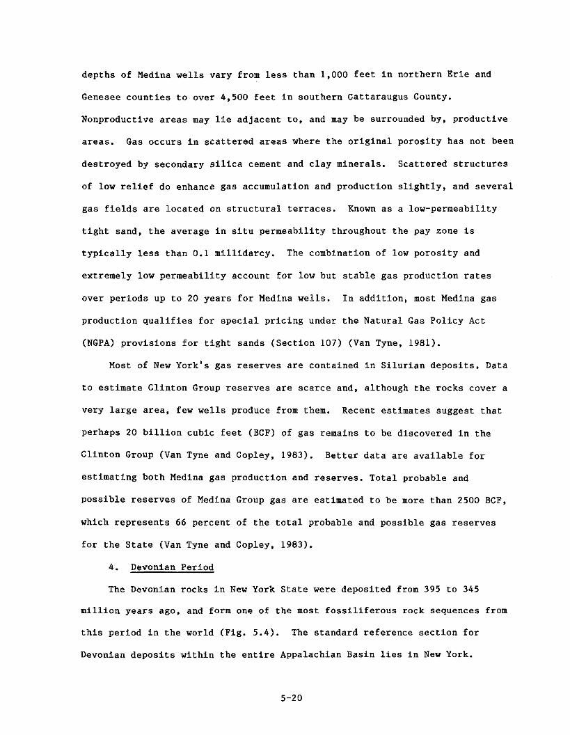
4. Devonian Period
The Devonian rocks in New York State were deposited from 395 to 345
million years ago, and form one of the most fossiliferous rock sequences from
this period in the world (Pig. 5.4). The standard reference section for
Devonian deposits within the entire Appalachian Basin lies in New York.
Almost all of the State south of the Mohawk River and west of the Hudson River
is underlain by Devonian rocks. The Devonian System in New York. is
represented by, in ascending sequence, the Helderberg Group, Tristates Group,
Onondaga Formation, Hamilton Group, Tully Formation, Genesee Group, Sonyea
Group, West Falls Group, Canadaway Group and Conewango Group. The youngest
groups, the Canadaway and Conewango, occur only in western New York and the
oldest, the Helderberg and Tristates Groups occur throughout New York.
By earliest Devonian time a land barrier to the east had eroded
sufficiently to permit a fresh influx of seawater into the landlocked
supersaline sea which persisted during the late Silurian Period. The
decreased salinity produced an environment in which marine life was abundant,
with almost unrestricted growth of carbonate-producing organisms such as
corals and bryozoans. The earliest Devonian rocks in the Aelderberg Group
were deposited at this time, and contain well-preserved fossils of this early
life. This thick sequence of limestone is prominently exposed as the
Helderberg Escarpment southwest of Albany.
The Helderberg Group in central and southeastern New York may be divided
into two formations: the underlying Rondout Dolomite and the Manlius
Limestone. In the subsurface, the thin Rondout is commonly mistaken for, or
considered to be part of the Upper Silurian Akron Dolomite. The combined
Rondout and Akron are lateral equivalents of the Bass Islands Formation
elsewhere. Through repeated use of this driller's misnomer, the Rondout and
Akron have become known as New York's "Bass Islands Formation," and are
considered to be the reservoir beds for the oil and gas produced throughout
the Bass Island trend. This complex, faulted reservoir is discussed in detail
in section 5.D.1. After deposition of the Helderberg Group the sea withdrew
and the period of erosion which followed removed these early Devonian deposits
in many places.
When the level of the sea rose again, the Oriskany Sandstone was
deposited upon the eroded top of the underlying limestones. Near Oriskany
Falls in Oneida County this sandstone is a white quartz sandstone, but it is more
commonly light to dark gray in color. The Oriskany, part of the Tristates
Group, is the only early Devonian formation which contains significant amounts
of gas. It has also been used in manufacturing glass. The Oriskany Sandstone
was deposited in a fluctuating shoreline of a rising sea but the distribution
and thickness of the Oriskany Sandstone is very irregular, because erosion at
the end of Oriskany time removed the sand from formerly high areas to the
north. A thick interbedded sequence of sandstone and shale comprises the
Tristates Group which overlie the Oriskany Sandstone. The environment in
which the upper Tristates Group was deposited was so muddy and turbid that few
marine organisms could survive.
By Middle Devonian time. New York State was covered by a warm shallow
sea. In this environment the Onondaga Limestone was deposited, and contains
well-preserved fossils, including reef-building corals, trilobites and the
remains of primitive marine fish. In the eastern portion of the State, the
underlying early Devonian rocks grade upward into the Onondaga without
noticeable breaks, but in the western portion, the Onondaga Limestone rests
disconformably on late Silurian rocks. Both oil and gas occur in the Onondaga
Limestone in central and western New York, and some gas is produced from reefs
which flourished along the margins of the basin.
Following the deposition of the Onondaga, a period of uplift and mountain
building occurred. Known as the Acadian Orogeny, it was centered in the east,
off the coast of what is presently New England. Thick sands and shales were
deposited across New York, and the entire Middle and Upper Devonian sequence
was probably formed as a series of coalescing deltas draining this eastern
chain of mountains. Fan-shaped deposits of mud, sand and silt accumulated in

fresh or brackish water environments in the east, and spread out across the
State to encroach upon and fill the sea lying to the west.
The base of the Hamilton Group of Middle Devonian age is marked by the
Marcellus Formation. The first of several massive black shale formations of
Middle and Upper Devonian age, the Marcellus will produce natural gas where it
is sufficiently fractured to create a network of cracks, allowing the gas to
migrate to the wellbore. The Marcellus Formation is the most strongly
radioactive of the Devonian shales and is a good marker bed on gamma ray logs.
The remainder of the Hamilton Group is a series of gray shales,
siltstones, sandstones, accumulations of shell debris, and flat pebble
conglomerates. These rocks have abundant cross-bedding and ripple marks, and
were deposited in shallow water near the margin of the continental shelf and
in near-shore environments (Rickard, 1975).
A change in relative sea level in the west and central part of New York
caused an abrupt break in deposition and a withdrawal of the sea to the west.
In the west, the top of the Hamilton Group was exposed and partially eroded.
In the restricted western basin which developed, iron-bearing nodules of
pyrite and marcasite formed on the sea floor.
The Tully Limestone was deposited when the sea again rose to inundate the
eroded surface of the Hamilton Group at the beginning of Upper Devonian time.
The Tully Formation which is thickest near the central portion of this eroded
plain, is absent in the east because of the deltaic deposition and thins
toward the west because of subsequent erosion. The Tully Formation forms a
continuous limestone deposit extending from Virginia to New York.
During the erosion of the Hamilton Group, and subsequent deposition of
the Tully Limestone in Western and Central New York, normal deltaic deposition
was continuing without interruption in Eastern New York. After the deposition
of the Tully, deltaic deposition resumed in the western part of the State.
The black muds of the Genesee Group lie above the Tully Limestone, and
were deposited in a deep basin environment. With little wave activity to
generate currents, much of the organic debris incorporated with the muds was
preserved under the anaerobic (reducing) conditions which existed in the deep
water covering western New York. The entire Genesee Group is composed of a
series of black and gray shales, mudstones, siltstones, and muddy limestones,
and represents a deltaic wedge migrating westward. As part of the Catskill
Delta, the sedimentary units of the Genesee Group pinch out to the west.
Underwater distributary channels, sediment fans, and local thinning of units
due to upward movement in the underlying Salina salt deposits, also occur
within the Genesee Group. Overlying the basal Geneseo black shales of the
Genesee Group, is a zone of silty nodular limestone.
The Sonyea Group overlies the Genesee Group without interruption in the
depositional record, and in turn is overlain by the West Falls Group. Both
groups contain interbedded shales and siltstones and are similar to the
Genesee Group.
Upper Devonian rock units are characterized by cycles of black shales and
intervening gray shales, which are separated by great thicknesses of clastic
sediment derived from the highlands to the east. These cycles were probably
controlled by episodic Acadian mountain-building activity and subsidence along
the young Appalachian Basin. The Middle and Upper Devonian sequences of
interbedded marine and non-marine clastic sediments, and marine limestone beds,
represent the interplay of these forces with changes in climate, to produce a
changing sequence of rock types.
Rocks younger than Devonian occur only in scattered places along the
Pennsylvania border. A quartz. pebble conglomerate preserved near Olean
records the brief return of the sea during Early Pennsylvanian time. During

the remainder of the Paleozoic Era, a rugged chain of mountains, the ancestral
Appalachians, were formed. Although the Appalachian Orogeny produced folding
and faulting in the eastern portion of the State, only regional uplift
occurred throughout the rest of New York (Broughton, 1966).
The structural configuration of the Devonian strata above the Late
Silurian salt beds changes significantly. Because salt is readily deformed
and flows plastically under compression, it forms a poor base for overlying
sediments. During the Appalachian Orogeny, Silurian strata were subjected to
strong compression, as a collision between two continents destroyed the proto-
Atlantic Ocean. These intense forces created a zone of decollement, or
detachment, within these strata as the overlying sequence was thrust to the
west, sliding over the weaker salt beds. Different styles of deformation
occur in the rocks above and below the zone of detachment. The faults, folds
and associated fracture systems formed during the Appalachian Orogeny have
been of primary importance in trapping oil and gas in the overlying Devonian
strata. The major oil and gas producing Devonian strata are detailed from
oldest to youngest.
a. -any Sandstone Formation
The discovery of gas in 1930 in the Wayne-Dundee Field in Schuyler
County, and other Oriskany development throughout the early 19301s, helped to
bring New York's natural gas production to an all time high of over 39 billion
cubic feet in 1939. The discovery well in this field was less than 2,000 feet
in depth but had an initial open flow of 6,000 MCF per day at a pressure of
730 psi. Very high pressures and reservoir capacities are typical of Oriskany
production. Many of the older depleted Oriskany gas fields, such as the
Wayne-Dundee, are now used for gas storage. The porosity of the Oriskany
sandstone averages only 7 percent but permeability is commonly quite high due
to fractures.
Thirty-six Oriskany gas fields have been discovered in New York (Van
Tyne, 1981), and Oriskany wells are most productive in Allegany, Steuben,
Yates, Schuyler and Chemung counties. The regional dip averages 40 to 50 feet
per mile, but a series of anticlinal folds trending northeast to southwest in
western New York, and east to west in central New York, are superimposed on
the regional dip. Commercial Oriskany production is found in structural traps
at the top of faulted anticlines, or along the updip limit where erosion has
removed the Oriskany. The axes of the anticlines parallel the direction of
the faulting in the central part of the State, but where the axial directions
of the anticlines change from northeast to east, the faults appear to cut
across the folds. Faulting associated with domes and anticlines makes the
Oriskany more porous and productive in these areas.
Some gas fields also occur where the Oriskany pinches out updip to the
north. Intergranular porosities average only 6 percent in these field and
they are less productive than fields producing from the faulted and fractured
anticlines. Although the pinchout boundary is difficult to locate, several
fields have been found along it. The largest Oriskany pinchout field in New
York lies in the Allegany State Park.
b. Onondaga Limestone Formation
The Onondaga Formation is a fossiliferous, massive gray limestone.
Porosity in this formation is either primary porosity preserved in fossil reef
organisms, or occurs along fractures associated with faulting. A hiatus in the
sedimentary record separates the Onondaga Formation from the underlying Late
Silurian rocks in western New York, but no evidence for this gap exists in the
eastern part of the state.
Good gas flows have been encountered in the Onondaga. Gas production has
been scattered throughout western New York and was usually found by accident.

One early Onondaga well, drilled in Erie County in 1880, was reported to have
an initial open flow of 25 million cubic feet a day.
Some good production has occurred where reef mounds in the basal Onondaga
formed near the basin margin. The first productive reef field was discovered
in the Cornell No. 1 well near Jasper in Steuben County in 1967. Other
subsurface reefs, capped by overlying shales, have since been discovered
elsewhere in Steuben and Cattaraugus Counties. The reefs are as much as 200
feet thick, and have excellent porosity and permeability, allowing the
reservoir to be drained efficiently by few wells. Although no additional reef
fields have been discovered since 1974, future discoveries along this trend
are expected.
c. Tully Limestone Formation_
The Tully Limestone is a thin zone of gray-brown limestone which forms an
important marker bed dividing the Upper and Middle Devonian rocks in New York.
The Tully Limestone typically has low permeability except where intense
faulting has created a network of interconnecting fractures.
Limited gas production has been found in the Tully, primarily in one
small gas field in Allegany County. Some production potential exists in the
Tully and other Upper Devonian limestone beds where faulting has created
interconnecting fracture porosity and permeability.
d. Devonian Black Shale Production
The first natural gas well in the United States was drilled in Fredonia,
New York, in 1821, and produced a few thousand cubic feet a day for over 35
years from Upper Devonian black shales. Low productivity but long well life
characterize Devonian black shale production.
Gas in the Devonian black shales is trapped where it formed because of
the low porosity and permeability of the rock matrix. Production can occur

only where fractures create pathways which allow the gas to migrate.
Five of the Devonian shales have been identified as potential gas
producers and these are, in ascending order, the Marcellus Formation in the
lower part of the Hamilton Group and the Genesee, Middlesex, Rhinestreet and
Dunkirk Formations. Eight small Devonian shale gas fields exist in the State.
although presently most are shut-in. Although none form large fields, the
huge area underlain by gassy shales makes them a significant contributor to
New York's resource base.
The first black shale gas field, the Lakeshore Field near Lake Erie, is
still operating, but most of the gas production now comes from deeper Medina
gas wells. The original development of the black shales took place during the
1880's and early 1900's when these wells were drilled to depths of 100 to 300
feet, and completed in the Dunkirk Shale of the Canadaway Group.
Three additional black shale gas fields, the Naples, Rushville and
Dansville fields, were first produced in the late 1800's. In the 1900'9, the
Rathbone, Bristol, and Genegantslet shale gas fields were discovered.
Although production from these last three fields was lower than production
from the Lakeshore Field, they exhibit excellent fracture permeability,
probably created by the loading and subsequent removal of glacial ice and
overburden.
In 1976, the U.S. Department of Energy (DOE) began to evaluate the
potential of Devonian shale gas in the Appalachian Basin under the Eastern Gas
Shales Project. These studies attempted to develop improved methods for
producing shale gas reserves toward a long term goal of increasing the
ultimate resource recovery, enhancing local gas supplies, and lessening
national dependency on foreign energy imports. Studies in this program found
that the Devonian shales in western New York contained from 10.6 MCF of
recoverable gas per acre-foot in the Rhinestreet Shale, to 16.3 ~CF/acre-feet

i n t h e Java Shale (Van Tyne, 1980).
More r ecen t ly , t h e Independent O i l and Gas Associat ion of New York
published t h e i r es t imates of t h e Devonian sha le gas r e se rves f o r t h e S t a t e .
While admi t t ing t h a t t h e economic j u s t i f i c a t i o n s preclude development on a
massive s c a l e a t t h i s time, t h e au thor s conclude t h a t New York's s h a l e gas
reserve i s 50 b i l l i o n cubic f e e t (Van Tyne and Copley, 1983).
e . Upper Devonian O i l Producing Sands
Oil-producing Upper Devonian sands a r e concentrated i n t h e southwestern
p a r t of t h e S t a t e along t h e northern Allegany Pla teau province. S t r u c t u r a l l y ,
t h i s province i s a broad r eg iona l t rough whose a x i s t r ends no r theas t t o
southwest, and forms t h e nor thern extens ion of t h e Appalachian Synclinorium.
The prominent f o l d s of t h e Appalachian Basin become very broad and g e n t l e and
d i e out i n New York. Most of t h e o i l i n New York i s produced from
stratigraphic t r a p s although t h e two l a r g e s t o i l f i e l d s , t h e Bradford and
Allegany, a r e s l i g h t l y folded. The loca t ion of o i l pools i s c o n t r o l l e d
pr imar i ly by changes i n t h e environment of depos i t ion , which e f f e c t s po ros i ty
and permeability. Most of t h e Upper Devonian o i l f i e l d s occur i n Allegany,
Cat taraugus, Chautauqua, and Steuben count ies .
The Upper Devonian sands producing t h e most o i l a r e t h e Chipmunk, Scio,
Bradford Second, Penny, Richburg, Bradford Third, C l a r k s v i l l e , and Waugh and
Por t e r . The Bradford Third may be l a t e r a l l y equiva lent t o t h e Richburg Sand,
and extends over 400 square miles. These sands a r e minera logica l ly q u i t e
va r i ed , and con ta in abundant, s c a t t e r e d l enses and channels. The Bradford
Third Sand and o the r Upper Devonian sands a r e proper ly c l a s s i f i e d a s f ine -
grained graywackes o r s c h i s t a r e n i t e s based on t h e i r mineral composition and
g r a i n s i ze .
P o r o s i t i e s and pe rmeab i l i t i e s i n t h e main Upper Devonian producing zones

are good for New York, but quite poor when compared to other oil producing
areas in the country. Richburg Sand porosity varies from 12 to 14 percent and
the average permeability ranges from 3 to 10 millidarcies. The average
thickness of the net production zone is 18 feet. Porosity in the Bradford
Third Sand ranges from 11 to almost 18 percent, and permeability varies from 5
to 15 millidarcies. The net sand thickness of the Bradford Third ranges from
25 to 55 feet. The Chipmunk and Bradford Second Sands are fine-grained
sandstones with average porosities of 22.5 percent and 16.1 percent
respectively in the better fields.
The producing sand bodies commonly grade into shale near the boundaries
of the sand body. or contain gas at the limits of oil production. The oil is
typically high grade, paraffin-base oil with A.P.I. gravities ranging from 39'
to 45". The interbedded and underlying black and gray shales were probably
the source beds for the oil.
New York's oil fields have had very long lives, and most were discovered
prior to 1900. Although many are substantially depleted and economically
marginal under current conditions, waterflooding and improved hydraulic
fracturing techniques have extended their lives.
D. OTHER AREAS OF OIL AND GAS INTEREST
Some areas have unknown or highly speculative potential for oil and gas
production. The first discovery well in the highly productive "Bass Island"
structure was drilled in 1981, yet many wells drilled today within the "Bass
Island" fairway will not be productive within that horizon. The deep
sedimentary strata beneath the eastern overthrust are still largely
unexplored, and their production potential awaits testing by the drill.
1. "Bass Island" Trend
The complex "Bass Island" structure was discovered in 1978 when it was
mapped as part of the U.S. Department of Energy's Eastern Gas Shales Project

(Van Tyne, 1980). The map in Figure 5.5 indicates the location and extent of
this trend in New York. Only after the Torrey No. 1 test well blew out and
caught fire after encountering unexpectedly high gas flows above the Medina
Formation, did the real nature of the reservoir become apparent. Several
subsequent rig fires caused the DEC to impose strict safety requirements for
11 Bass Island" wells, including the use of blow-out preventers, and drilling
through the target zones during daylight hours.
Production in this structure is found primarily in the Lower Devonian
Onondaga Limestone, and Upper Silurian Akron and Bertie Dolomites. To local
oil and gas operators, the Akron is known as the Bass Island Formation, the
name of the laterally equivalent formation in Ohio and Michigan. Through
repeated use, the structure became known as New York's "Bass Island" trend.
Two geological models of the "Bass Island" trend have been proposed. One
model proposes that it is actually a series of thrust faults originating from
a decollement, or detachment surface in the Vernon Formation of the Lower
Salina Group. Detachment surfaces like this occur throughout the Allegheny
Plateau, and are typically associated with intense deformation of the
overlying rocks. Comparing maps of the areal extent of the dolomite and
anhydrite beds within the Vernon Formation indicates that this fault zone
corresponds to the updip pinchout of the salt beds. The "Bass Island" trend
has been interpreted as the farthest expression of the Appalachian decollement
within the continental interior of New York. A second model proposes that the
It Bass Island" trend was created by density adjustments causing vertical
movements within the sedimentary deposits above the salt which resulted in
high angle reverse faults forming multiple horst-graben, or high-low,
Structures.
Electric logs can be used to trace this narrow zone of faults for at
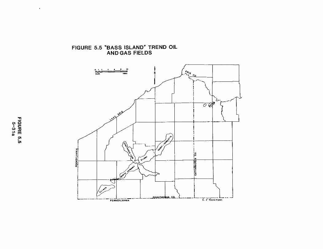
FIGURE 5.5 "BASS ISLAND" TREND OIL AND GAS FIELDS
least 60 miles across the state, extending into Pennsylvania toward the
southwest and terminating in the northeast at the Zoar gas field in Erie
County. Repeated stratigraphic sections on electric well logs indicate that
the thrust faults originate in the Vernon Formation at the base of the
sequence, cut upward at steep angles through the overlying rocks, and die out
in the Hamilton Group shales. Vertical displacement along these faults ranges
from only a few feet to more than 200 feet. Traps for oil and gas can occur at
almost any level within a structure of this complexity: in the roll-overs of
drag folds on the hanging walls of the faults, below permeability barriers
which intersect the faults in the foot wall, or in zones of intersecting
fractures. Unlike classical oil and gas reservoirs, the best production is
found in the intersecting network of fractures and faults rather than the rock
matrix itself.
Wells producing from the "Bass Island" trend, average 3,000 feet in depth,
and may produce gas, paraffin-base crude oil, or both. Typical "Bass Island"
open flow rates can be 600 bblsld of oil, or 10 MMCF/d (million cubic feet per
day). or both. However, production rates average 50 to 150 bblsld of oil, and
100 MCP/d to 1 MMCFId of gas, depending on the producing capability of each
individual well. Development is spotty, with dry holes offsetting good
producers in this complex, faulted structure. Recoverable reserves are esti-
mated to be over 2 million barrels of oil (Oil and Gas Journal. June 6, 1983).
and from 40 to 60 billion cubic feet of gas (Van Tyne and Copley, 1983).
2. Eastern Overthrust
One of the largest and least explored areas potentially productive of oil
and gas is the 60,000 square mile Appalachian overthrust (Fig. 5.6). AS
geologists learned to interpret the complex folding and faulting of overthrust
belts and discovered numerous oil and gas fields in the western overthrust
extending from Canada to New Mexico, they became increasingly interested in

FIGURE 5.6 THE EASTERN OVERTHRUST BELT IN NEW YORK STATE
0 10 20 YI 10 50 - SCALE-MILES

the "barren" Appalachian overthrust.
The former edge of the proto-Atlantic shelf is roughly aligned with the
New York-Vermont border. Oil and gas which form in the organic-rich deposits
of the slope, continental rise, and basin margin, will migrate upward and be
trapped in shelf edge sediments over time. Intense thrusting during the
Taconic Orogeny of the late Ordovician and the Appalachian Orogeny in the
Triassic transported the slope, rise, and basin margin deposits well to the
west of their original location. Thick slices of impermeable shale and
metamorphic rocks were thrust westward over the less metamorphosed and
unmetamorphosed Paleozoic reservoir beds. Repeated many times, this creates
an imbricate, or layered, sequence of older rocks stacked above younger,
relatively undeformed basement rocks. An overthrust margin can be an ideal
structure for trapping large volumes of oil and gas.
In the early 1980's several companies conducted seismic studies in the
northeast, from northern Vermont to southern Pennsylvania. Improved
geophysical methods allowed geologists to "see" through the older, overlying
strata and evaluate potential reservoirs below. Meanwhile, deep overthrust
wells drilled in Tennessee and West Virginia have been productive.
Although some shallow wells were drilled in Greene and Ulster counties in
the early 1960's. New York's most recent deep test of the eastern overthrust
was the Finnegan No. 1, drilled in 1983 by Columbia Gas Transmission Company.
Located in Easton Township in Washington County, the well was more than 160
miles east of the nearest known production in Oneida County's Rome field.
After drilling to 7.764 feet, the well proved to be a dryhole. Stating that
data from the well indicated "limited potential for commercial quantities of
oil and gas in the eastern New York area," Columbia plugged and abandoned the
well in October, 1983 (Appalachian Basin Report, Petroleum Information Corp.,

March 9, 1984).
Columbia drilled a subsequent well, the Burnor No. 1, near St. Albans in
Franklin County, Vermont, in 1984. After drilling to 6,969 feet at this
location, the company also plugged and abandoned this well.
Although the most recent tests of New York's overthrust have been dry
holes, a history of drilling many dry holes prior to discovery /in the western
overthrust suggests that more wells may be drilled in the near future.
E . GEOTHERMAL RESOURCES The temperatures underground (geothermal gradient) normally increase with
depth at a rate of roughly 15°C per kilometer (km) or 10°F per 1,000 feet.
However, certain geologic conditions can increase the temperature gradient
creating a reservoir of natural heat close enough to the surface to make it
economically recoverable. One of the best known examples is the Geysers
geothermal area in California where the temperature in the producing zone
reaches 500'F. The most likely source of this heat is a large siliceous
igneous body located below the Clear Lake Volcanic field (Goff and Donnelly,
1977).
There are primarily low temperature geothermal resources in the eastern
United States (below 212°F). According to the American Association of
Petroleum Geologists (AAPG) 1979 temperature gradient map of the United
States, two of the most prominent geothermal anomalies in the eastern U.S. are
located in central and western New York (NYS Energy Research and Development
Authority, 1983). Regionally, central and western New York consists of a
sequence of flat-lying carbonates, dolomites and sandstones. The basal
Cambrian age Galway (also called Theresa) and Potsdam formations are believed
to possess the greatest potential for geothermal energy recovery in New York
State (Seg 5.C.1 for detailed formation descriptions). These formations /
contain water bearing horizons which are heated by the Pre-Cambrian basement

beneath. The hot brine can be pumped out, the heat extracted and the waste
brine returned to the reservoir.
In 1981. Hodge et. al., used revised temperature gradient maps, Bouger
gravity maps and estimated heat flows from Silica geothermometry to confirm
the existence of the two anomalies identified by the AAPG and better define
their locations. The East Aurora anomaly is southeast of Buffalo and has a
gradient estimated as high as 27'Cfkm or 24.6'F/1,000'. The Cayuga County
anomaly is located between Rochester and Penn Yan. The center of this anomaly
is near Cayuga Lake, and its geothermal gradient is estimated to be as high as
3O0C/km or 26.2"F/1.000'. The authors attributed the high temperatures and
negative gravimetric anomalies at East Aurora to a granitic pluton located
near the top of the Pre-Cambrian basement. They concluded that the radiogenic
heat from the granitic rocks in the Pre-Cambrian is the source of the thermal
anomalies. More recently, Hodge contends that the anomalies result in part
from hydrothermal convection in the fractured Pre-Cambrian basement rock
(Hodge, 1983).
In 1982, New York's first geothermal well was drilled south of Auburn
near the Cayuga County anomaly. The Auburn No. 1 encountered major geothermal
water bearing zones in the Theresa and Potsdam formations at depths of 4,740'
and 4,950'. The temperature of the water at the wellhead is in excess of
125"~. and it is used for space and domestic hot water heating requirements at
Cayuga Community College and Auburn City Schools. This experimental well was
sponsored by the New York State Energy Research and Development Authority
(NYSERDA) as part of their ongoing geothermal research program.